7 coastal and offshore conservation sites · pdf filethis report identifies and locates...
TRANSCRIPT

SEA 5 – Offshore Oil and Gas Licensing
September 2004 Page 113 Conservation Sites
7 COASTAL AND OFFSHORE CONSERVATION SITES
7.1 Regional overview The SEA 5 area displays a wide variety of habitat types such as coastal cliffs, rock platforms, sandy beaches and dunes. The area also includes major estuaries such as the Tay and the Forth. Some of these habitats are internationally and/or nationally rare, and many support important numbers of bird colonies, common seal, otter and, in the Moray Firth, bottlenose dolphins. This report identifies and locates coastal and nearshore sites within the SEA 5 area which are protected by international, national and local conservation designations as well as describing the sites and reasons for their protected status.
7.2 Existing coastal conservation sites within the SEA 5 area This section identifies those coastal and nearshore sites protected by international, national and local conservation designations. Much of the information for this section comes from the international site description and data sheets held on the JNCC website (which can be found at http://www.jncc.gov.uk/idt/default.htm). Regional SNH offices and the JNCC Coastal Directory series also proved a useful source of information (Barne et al. 1996, 1997a, b). The coastal zone of SEA 5 has been divided into four sections, moving north to south as follows:
The Northern Isles - Shetland, Fair Isle and Orkney Moray Firth - Duncansby Head to Fraserburgh Northeast coast - Fraserburgh to Fife Ness Firth of Forth and Borders – Fife Ness to the Scottish border
The northern boundary of SEA 5 transects the Orkney and Shetland Islands and strictly includes only the eastern coastline of the islands. For the purpose of this assessment, however, sites of conservational importance throughout the isles will be included and therefore also includes the SEA 4 component of Orkney and Shetland. These islands were taken as a whole and described fully in the previous SEA report and, as such, the underpinning SEA 4 Conservation Report (which can be found at http://www.offshore-sea.org.uk/) should be referred to for further detailed information regarding the conservation designations of these regions. The North Northumberland Coast (SEA 3), which shares a boundary with SEA 5 to the south, has been briefly described here to provide continuity of geographical context. Further detailed information regarding the coastal and offshore conservation designations of SEA 3 can also be found at http://www.offshore-sea.org.uk/.
7.2.1 The Northern Isles The Shetland Islands The coastline of Shetland is long, intricate and dominated by rocky formations. Soft shorelines are rare and, therefore, have added environmental and ecological interest. The coast contains large, diverse and spectacular lengths of cliff and cliff-top habitat, of considerable landscape and nature conservation value. The highest vertical cliffs reach 370m at The Kame of Foula on the west coast of the island. The extensive cliff habitat provides important nesting sites for a large number of seabirds.

SEA 5 – Offshore Oil and Gas Licensing
Conservation Sites Page 114 September 2004
Overall, the coastline is among the most wave-exposed in Britain, although in places the high west-facing vertical cliffs give way to sheltered inlets or voes. There are also numerous stacks and islets, some of them connected to the islands by thin stretches of sand or shingle, known as tombolos. Areas of sand dunes are small and few in number due not only to the steeply shelving offshore seabed, which limits sand supply but also the frequent exposure to gales which prevents significant accumulation. The Shetland Islands also include Fair Isle which lies about 40km south of Sumburgh Head, mid-way between Shetland and Orkney. Nature and landscape conservation The Shetland Islands play host to a variety of important coastal habitats and species, as well as bird areas, which are protected under international, national and local designations (Table 7.1). In-depth descriptions of these sites and species can be found in the SEA 4 Conservation Report (http://www.offshore-sea.org.uk/). Table 7.1– Coastal protected sites on Shetland International Candidate Special Areas of Conservation (cSAC) 10 Special Protection Area (SPA) 12 Ramsar 1 Important Bird Area (IBA) 11 National and Local National Nature Reserve (NNR) 3 Site of Special Scientific Interest (SSSI) 49 National Scenic Area (NSA) 1 Marine Consultation Area (MCA) 4 Environmentally Sensitive Area (ESA) 1 National Trust for Scotland site 8 Royal Society for the Protection of Birds (RSPB) reserve 7
Sites of international importance The principal European designations are Special Protection Areas (SPAs) established under the 1979 EC Directive on the Conservation of Wild Birds and Special Areas of Conservation (SACs) under the 1992 EC Habitats and Species Directive. Ramsar sites are designated mainly for their important waterfowl populations but also rare or endangered plant and animal species. Sites of international importance on Shetland are highlighted in Figure 7.1.

SEA 5 – Offshore Oil and Gas Licensing
September 2004 Page 115 Conservation Sites
Figure 7.1 – Coastal sites of international importance in the Shetland region
Shetland is internationally important for its cliff and island nesting seabirds, particularly fulmar, gannet, arctic skua, kittiwake, puffin and guillemot. During the breeding season, the coastal waters near the breeding colonies support large concentrations of seabirds and sheltered areas of the islands are important for wintering birds, especially eiders and black guillemot. The area is also important for migrant waterfowl in spring and autumn as it lies on the migratory flyway for birds of the east Atlantic moving between southern wintering areas and northern breeding grounds. Fair Isle is of major importance as a breeding area for seabirds, including skuas, terns, gulls and auks. It is also notable for its endemic race of wren. There are a number of sites designated for their internationally important bird assemblages (Table 7.2). Table 7.2 - Sites of international importance for birds in the Shetland region Map Ref
Site Area (ha)
Status Conservation interest
1 Sumburgh Head 39 SPA/IBA Breeding seabirds 2 Lochs of Spiggie and Brow 141 SPA/IBA Wintering wildfowl

SEA 5 – Offshore Oil and Gas Licensing
Conservation Sites Page 116 September 2004
Table 7.2 - Sites of international importance for birds in the Shetland region Map Ref
Site Area (ha)
Status Conservation interest
3 Foula 1,323 SPA/IBA Breeding seabirds and divers 6 Papa Stour 569 SPA/IBA Breeding seabirds and waders 8 Ronas Hill-North Roe and
Tingon 5470 SPA/IBA/
Ramsar Breeding birds of prey, seabirds and moorland birds
10 Ramna Stacks and Gruney 12 SPA/IBA Breeding seabirds 13 Otterswick and Graveland N/A* SPA Breeding divers 14 Hermaness, Saxa Vord and
Valla Field 1038 SPA/IBA Breeding seabirds and divers
17 Fetlar 2595 SPA/IBA Breeding seabirds 18 Noss 344 SPA/IBA Breeding seabirds 19 Mousa 198 SPA/IBA Breeding seabirds 21 Fair Isle 561 SPA/IBA Breeding seabirds
Note: * Area to be confirmed upon site classification Shetland also supports a range of important coastal and marine habitats as well as important populations of common seal. The large rocky tidal pools of Mousa cSAC are of particular importance, as they are frequently used by seals for pupping, breeding and moulting, and provide shelter from the exposed conditions of the open coast. Habitats of international importance within the SEA 5 component of Shetland include the European dry heaths and alkaline fens found at North Fetlar cSAC and the vegetated sea cliffs of Fair Isle cSAC. Table 7.3 provides details of the coastal and marine cSACs on Shetland. cSACs are a more recent initiative, hence their status as candidate sites at the present time. Nevertheless, UK Government policy is that they should be treated as designated sites once details are registered with the European Commission. Table 7.3 - cSACs in the Shetland region Map Ref Site Area
(ha) Qualifying features
4 The Vadills 63 Coastal lagoons 5 Papa Stour 2077 Reefs
Submerged or partially submerged sea caves 7 Tingon 570 Blanket bogs 9 Ronas Hill-North Roe 4901 Oligotrophic to mesotrophic standing waters with
vegetation of the Littorelletea uniflorae and/or of the Isoëto-Nanaojunctea
Natural dystrophic lakes and ponds Alpine and boreal heaths Blanket bogs 11 Sullom Voe 2699 Large shallow inlets and bays 12 Yell Sound Coast 1540 Otter Lutra lutra
Common seal Phoca vitulina 15 Keen of Hamar 38 Calamarian grasslands of the Violetalia calaminariae Calcareous and calcshist screes of the montane to alpine
levels (Thlaspietea rotundifolii) 16 North Fetlar 1584 European dry heaths Alkaline fens 20 Mousa 531 Common seal Phoca vitulina 22 Fair Isle 561 Vegetated sea cliffs of the Atlantic and Baltic coasts

SEA 5 – Offshore Oil and Gas Licensing
September 2004 Page 117 Conservation Sites
Landscape conservation is recognised at a European level by the identification of Environmentally Sensitive Areas (ESAs), which have the restoration of traditional landscapes as one of their objectives. The Shetland Islands (as a whole and including Fair Isle) were designated an ESA in 1987. Fair Isle has also been awarded the Council of Europe Diploma, an accolade to acknowledge the European interest of the site and the quality of protection and management.
Sites of national and local importance National conservation designations provide underpinning protection for most of the European sites, as well as safeguarding sites of national and local importance. Noss National Nature Reserve (NNR), for example, provides protection for thousands of seabirds such as guillemots, gannets, fulmars and kittiwakes. While 49 sites along Shetland’s coastline have been designated as Sites of Special Scientific Interest (SSSI), predominantly due to their ornithological and geological interests, the importance of Shetland’s coastal geology is also reflected by the occurrence of numerous Geological Conservation Review sites (GCRs) in the area. The scenic value of Shetland is reflected in the designation of a National Scenic Area (NSA) which comprises seven separate locations (including Fair Isle) all of which are coastal and total just over 11,600ha. There are also a number of areas with a distinctive aesthetic appeal, heritage and character, where tourism and recreation take priority over major industrial processes which have been included in the Shetland Preferred Conservation Zone (PCZ). These areas include sections of Yell’s coastline and the northeastern side of the mainland. Marine Consultation Areas (MCAs) are considered by SNH to deserve particular distinction in respect of quality and sensitivity of the marine environment within them. There are four MCAs in Shetland, one of which, Swinster Voe and the Houb of Fora Ness, lies within the SEA 5 boundary. Non-government organisations (NGOs) such as the National Trust and RSPB also protect a range of sites in the area.
The Orkney Islands The group of islands forming the Orkney archipelago is generally low-lying with gentle slopes and rounded topography. The most southerly island lies less than 10km from the Scottish mainland. The exception is the west Atlantic coastline of the main island (Mainland) and Hoy, which is characterised by some of the most spectacular cliff and rock formations in Britain, including the much photographed stack, the Old Man of Hoy. There are almost ninety islands and numerous rocks and skerries, all of which are separated by shallow and often narrow strands and inlets. Some of these, in response to their position between different tidal regimes in the Atlantic, North Sea and Pentland Firth, have strong tidal currents. The eastern coasts of many of the islands are predominantly rocky shorelines interspersed with sandy and shingle beaches and sand dunes. Many of the shingle beaches are important for migrant and wintering waders. Along the west coast of Mainland there are numerous geos and caves, features also found on other islands within the archipelago. Many of the islands support internationally important numbers of both common and grey seals, and the otter is also common in coastal and inland waters.

SEA 5 – Offshore Oil and Gas Licensing
Conservation Sites Page 118 September 2004
Estuarine habitat is limited in Orkney but remains undisturbed and supports breeding waders and wildfowl populations, as well as tern breeding colonies. There are also a number of coastal lagoons although the only one of any significant size is the Loch of Stenness, the largest brackish lagoon in the UK. Nature and landscape conservation The nature conservation importance of the Orkney coast is acknowledged through the designation of a range of internationally and nationally recognised conservation sites (Table 7.4). Table 7.4 – Coastal protected sites on Orkney International Candidate Special Areas of Conservation (cSAC) 5 Special Protection Area (SPA) 11 Ramsar 1 Important Bird Area (IBA) 12 World Heritage site 1 National and Local Site of Special Scientific Interest (SSSI) 22 National Scenic Area (NSA) 1 Local Nature Reserve (LNR) 1 Royal Society for the Protection of Birds (RSPB) reserve 8 Scottish Wildlife Trust (SWT) reserve 2 Sites of international importance Conservation sites of international importance on Orkney are highlighted on Figure 7.2.
Fig 7.2 – Coastal sites of international importance on Orkney
The Orkney Islands are internationally important for breeding seabirds and wintering waterfowl. Seabirds colonise much of the coastline with some sections housing contiguous colonies, while the nearshore waters of the region hold vulnerable concentrations of seabirds and seaduck species such as eiders and long-tailed duck throughout the year. Several sites are designated as Special Protection Areas (SPAs) for their internationally important bird assemblages. Current coastal SPAs, IBAs and Ramsar sites in the Orkney region are highlighted in Table 7.5.

SEA 5 – Offshore Oil and Gas Licensing
September 2004 Page 119 Conservation Sites
Table 7.5 – Coastal sites of international importance for birds in the Orkney region
Map Ref Site Area (ha) Status Conservation Interest
1 Pentland Firth Islands
170 SPA/IBA Breeding seabirds
2 Switha 57 SPA/IBA Wintering wildfowl 3 Hoy 9500 SPA/IBA Breeding birds of prey
and seabirds 7 Marwick Head 9 SPA/IBA Breeding seabirds 8 Rousay 633 SPA/IBA Breeding sea and
moorland birds 9 South Westray
Coast 530 IBA Wintering waders
10 West Westray 351 SPA/IBA Breeding seabirds 11 Papa Westray
(North Hill and Holm)
246 SPA/IBA Breeding seabirds
13 Calf of Eday 238 SPA/IBA Breeding seabirds 15 East Sanday
Coast 1515 SPA/IBA/Ramsar Wintering seabirds
and waders Passage waders
16 Auskerry 102 SPA/IBA Breeding seabirds 17 Copinsay 125 SPA/IBA Breeding seabirds Orkney supports a large and diverse spectrum of marine and coastal habitats in addition to nationally scarce species, with many reaching the most northern limits of their distribution. Marine habitats between the islands include areas of bedrock, boulders, gravel and sand with occasional deposits of mud. Biogeographically, Orkney lies in the boundary between the rich marine life of the western British Isles and the less diverse area of the North Sea. Those areas of international importance for habitats and/or non-avian species are described in Table 7.6. Table 7.6 - cSACs in the Orkney region Map Ref Site Area
(ha) Qualifying features
4 Hoy 9500 Vegetated sea cliffs of the Atlantic and Baltic coasts Natural dystrophic lakes and ponds Northern Atlantic wet heaths with Erica tetralix, alpine and boreal heaths Blanket bogs
5 Loch of Stenness 792 Coastal lagoons 6 Stromness Heaths
and Coasts 636 Vegetated sea cliffs of the Atlantic and Baltic coasts
European dry heaths 12 Faray and Holm of
Faray 786 Grey seal (Halichoerus grypus)
14 Sanday 10977 Reefs Common seal (Phoca vitulina)
World Heritage Sites are listed by the World Heritage Committee of UNESCO to provide recognition that a site is of "outstanding universal value" and also that the national Government has provided it with an especially high level of assured protection. There are

SEA 5 – Offshore Oil and Gas Licensing
Conservation Sites Page 120 September 2004
both natural and cultural categories of site. The Heart of Neolithic Orkney is included as a World Heritage Site and the citation includes archaeological sites, which are located at the coastline, such as 'Skara Brae'. Sites of national and local importance There are a number of sites of national and local importance along Orkney’s coastline, including 28 SSSIs, a NSA and Scottish Wildlife Trust reserves (SWTs). A large number of GCRs can also be found in the region. The majority of the non-statutory protection in the area is provided by the RSPB (there are 8 reserves in total). Two such sites, Mill Dam RSPB and Copinsay RSPB, lie within the SEA 5 boundary. Similarly, the Hill of White Hamars SWT, Holm of Burghlee SWT and Mull Head LNR can also be found in the SEA 5 component of Orkney.
7.2.2 Moray Firth 7.2.2.1 Overview The Moray Firth is one of the largest and most conspicuous features of the British coastline. It is roughly symmetrical in outline though there are stark contrasts between the southeast and north facing coastlines. The geological structure of the southeast coastline, in particular, has produced considerable local variation in coastal types. Accordingly, this coastline is almost a continuous succession of Sites of Special Scientific Interest for geological reasons. Great masses of sands and gravels lie both offshore and onshore. At Morrich More near Tain and Cuthill Links south of Dornoch there is an exceptionally large dune and sand ridge system at the entrance to the Dornoch Firth. From Fort George eastwards to Burghead there are massive sand dune and beach systems including Culbin. Further east, the powerful River Spey has provided shingle for a series of fossil and active shingle ridges which have no equivalent anywhere in Europe. Except where there are rock cliffs, coastal plains (raised beaches) or degraded old cliff lines cut in glacial deposits can be traced almost continuously along the entire coastline of the Moray Firth. Such ‘text-book’ examples occur around the Dornoch Firth, Spey Bay and eastwards, at Portsoy and near Fraserburgh. The Moray Firth itself is shallow with many sand and gravel banks. In places it is relatively sheltered. 7.2.2.2 Nature and landscape conservation The Moray Firth plays host to a variety of important coastal habitats and species as well as bird areas, which are protected under international, national and local designations (Table 7.7). Table 7.7 – Coastal protected sites in the Moray Firth International Candidate Special Areas of Conservation (cSAC) 6 Special Protection Area (SPA) 6 Ramsar 4 Important Bird Area (IBA) 4 National and Local National Nature Reserve (NNR) 3 Site of Special Scientific Interest (SSSI) 30

SEA 5 – Offshore Oil and Gas Licensing
September 2004 Page 121 Conservation Sites
Table 7.7 – Coastal protected sites in the Moray Firth Local Nature Reserve (LNR) 1 National Scenic Area (NSA) 1 Geological Conservation Review (GCR) Site 26 Regional Landscape Designation (RLD) 8 Preferred Conservation Zone (PCZ) 6 Royal Society for the Protection of Birds (RSPB) Reserve 3 Scottish Wildlife Trust (SWT) Reserve 2 Sites of international importance Coastal sites of international importance in the Moray Firth are highlighted in Figure 7.3.
Figure 7.3 - Coastal sites of international importance in the Moray Firth
The Moray Firth is internationally important for its breeding seabirds, particularly guillemot, herring gull, kittiwake, razorbill, shag and common tern. Sheltered areas of the coast are important for wintering birds, especially bar-tailed godwit and greylag goose. The common scoter (red listed as a bird of conservation concern) can be found on the Moray and Nairn Coast. Table 7.8 describes those sites designated for their internationally important bird assemblages.

SEA 5 – Offshore Oil and Gas Licensing
Conservation Sites Page 122 September 2004
Table 7.8 - Sites of international importance for birds in the Moray Firth region Map Ref
Site Area (ha) Status Conservation interest
2 East Caithness Cliffs 443 SPA/IBA Breeding seabirds 5 Dornoch Firth and Loch Fleet 7,836 SPA/Ramsar Breeding birds of prey
Wintering wildfowl and waders
7 Cromarty Firth 3,666 SPA/Ramsar Breeding seabirds and birds of prey Wintering waterfowl and waders
8 Inner Moray Firth 2,339 SPA/Ramsar Breeding seabirds and birds of prey Wintering wildfowl and waders
9 Moray Basin, Firths and Bays
134,660 IBA Breeding seabirds Wintering wildfowl and waders Passage waterfowl
11 Moray and Nairn Coast 2,410 SPA/Ramsar Breeding birds of prey Wintering wildfowl and waders
13 Troup, Pennan and Lion Heads
174 SPA/IBA Breeding seabirds
14 Rosehearty to Fraserburgh coast
130 IBA Wintering waders
The Moray Firth also supports a range of important coastal and marine habitats as well as a number of non-avian species of international conservation importance. Table 7.9 provides details of the coastal and marine cSACs in the area. Table 7.9 – Coastal cSACs in the Moray Firth region Map Ref. Site Area (ha) Qualifying features
1 East Caithness Cliffs 443 Vegetated sea cliffs of the Atlantic and Baltic coasts 3 Mound Alderwoods 297 Alluvial forests with Alnus glutinosa and Fraxinus
excelsior (Alno-Padion, Alnion incanae, Salicion albae) 4 Dornoch Firth and
Morrich More 8,701 Estuaries
Mudflats and sandflats not covered by seawater at low tide Salicornia and other annuals colonising mud and sand Atlantic salt meadows (Glauco-Puccinellietalia maritimae) Embryonic shifting dunes Shifting dunes along the shoreline with Ammophila arenaria (`white dunes`) Fixed dunes with herbaceous vegetation (`grey dunes`) Decalcified fixed dunes with Empetrum nigrum Atlantic decalcified fixed dunes (Calluno-Ulicetea) Humid dune slacks Coastal dunes with Juniperus spp Otter (Lutra lutra) Common seal (Phoca vitulina)
6 Moray Firth (marine) 151,342 Bottlenose dolphin (Tursiops truncatus) 10 Culbin Bar 613 Perennial vegetation of stony banks 12 Lower River
Spey/Spey Bay 653 Perennial vegetation of stony banks
Residual alluvial forests

SEA 5 – Offshore Oil and Gas Licensing
September 2004 Page 123 Conservation Sites
Important coastal and marine habitats include the sea cliffs of the East Caithness Cliffs cSAC and the dune and estuarine systems of the Dornoch Firth and Morrich More cSAC. The Culbin Bar and the Lower River Spey–Spey Bay cSACs represent the two largest shingle sites in Scotland. The Moray Firth supports the only known resident population of bottlenose dolphin (Tursiops truncatus) in the North Sea. The Dornoch Firth and Morrich More consist of an estuarine system with extensive areas of bordering natural habitat including sand dune, woodland and small lochans which combine to provide important otter (Lutra lutra) habitat. The Dornoch Firth also supports a significant proportion of the inner Moray Firth population of the common seal (Phoca vitulina). Sites of national and local importance National conservation designations provide underpinning protection for most of the European sites, as well as safeguarding sites of national importance. There are National Nature Reserves (NNRs) at Mound Alderwoods, Loch Fleet and Nigg and Udale Bays and also 28 SSSIs that have been designated for predominantly geological and ornithological interest in the region. The geological interests in the area are also represented by the 26 GCR sites which occur along this section of coastline. The Dornoch Firth NSA covers an area of 7,500ha and highlights the outstanding scenic value of the firth. There are also a series of Regional Landscape Designations (RLDs) and PCZs along the Moray Firth coast and, at a local level, the intertidal mudflats, dunes and saltmarshes of Findhorn Bay have been designated as a LNR. In addition to managing some of these nationally important sites, non-government organisations (NGOs), including the Scottish Wildlife Trust and the RSPB, also protect a range of coastal sites.
7.2.3 Northeast coast 7.2.3.1 Overview The northeast coast stretches from Kinnairds Head, near Fraserburgh, to Fife Ness which is the northern limit of the Firth of Forth. Several small to medium-sized rivers create small inlets and larger tidal basins which, from a conservational perspective, are important, i.e. the Ythan, Montrose Basin and the Eden at St. Andrews. Many extensive sand dune systems, in association with extensive beaches, e.g. Sands of Forvie, St. Cyrus-Montrose, Barry Links and Tentsmuir can be found in this area and all have significant conservational status. The major inlet, however, is the Tay Estuary. Partly due to the importance of the port at Dundee, this estuary has a long history of physical and biological research, especially by the University of Dundee. Cliff sections are less common but are locally important both for geological and ornithological purposes, e.g. Bullers of Buchan and Fowlsheugh. Low rock platforms are found in north Fife where key sites occur in the Scottish Carboniferous Series. 7.2.3.2 Nature and landscape conservation The nature conservation importance of the northeast coast is acknowledged through the designation of international and nationally recognised conservation areas (Table 7.10).

SEA 5 – Offshore Oil and Gas Licensing
Conservation Sites Page 124 September 2004
Table 7.10 – Coastal protected sites on the northeast coast International Candidate Special Areas of Conservation (cSAC) 4 Special Protection Area (SPA) 6 Ramsar 4 Important Bird Area (IBA) 7 National and Local National Nature Reserve (NNR) 3 Site of Special Scientific Interest (SSSI) 28 Local Nature Reserve (LNR) 4 Country Park 1 Geological Conservation Review (GCR) Site 21 Regional Landscape Designation (RLD) 9 Preferred Conservation Zone (PCZ) 5 Biogenetic Reserve 1 Royal Society for the Protection of Birds (RSPB) Reserve 2 Scottish Wildlife Trust (SWT) Reserve 4 Sites of international importance Coastal sites of international importance on the northeast coast are highlighted in Figure 7.4.
Figure 7.4 - Coastal sites of international importance on the northeast coast

SEA 5 – Offshore Oil and Gas Licensing
September 2004 Page 125 Conservation Sites
The northeast coast of Scotland is home to a number of internationally important bird populations, such as terns, razorbill, and geese. Several areas have been designated Special Protection Areas (SPAs) to provide protection for such species (see Table 7.11). The red listed birds of conservation concern, the common scoter and black-tailed godwit, can be found in the Firth of Tay and Eden Estuary. Table 7.11 - Sites of international importance for birds on the northeast coast
Map Ref. Site Area (ha) Status Conservation Interest
1 Loch of Strathbeg 616 SPA/IBA/Ramsar Breeding waders Wintering wildfowl
3 Buchan Ness to Collieston coast
209 SPA/IBA Breeding seabirds
5
Ythan Estuary, Sands of Forvie and Meikle Loch
1,016
SPA/IBA/Ramsar
Breeding waders Wintering wildfowl
6 Fowlsheugh 10 SPA/IBA Breeding seabirds 7
Montrose Basin
SPA/IBA/Ramsar
Wintering wildfowl & waders
10 Firth of Tay and Eden Estuary
6,923 SPA/IBA/Ramsar Breeding waders & birds of prey Wintering wildfowl & waders
A number of sites have been designated candidate Special Areas of Conservation (cSACs), for containing important coastal habitats including vegetated sea cliffs and a variety of dune habitats (Table 7.12). The Sands of Forvie is one of the most geomorphologically active dune systems in the UK. Barry Links is an extensive, triangular dune system on the north side of the Firth of Tay which is nourished by shifting, but extensive, sandbanks. The Firth of Tay and the Eden Estuary are two high quality estuarine areas which support a nationally important breeding colony of common seal (Phoca vitulina). Table 7.12 - cSACs along the northeast coast of Scotland Map Ref. Site Area
(ha) Qualifying features
2 Buchan Ness to Collieston
208 Vegetated sea cliffs of the Atlantic and Baltic coasts
4 Sands of Forvie 734 Embryonic shifting dunes Shifting dunes along the shoreline with Ammophila arenaria ('white dunes') Decalcified fixed dunes with Empetrum nigrum Humid dune slacks
8 Barry Links 790 Embryonic shifting dunes Shifting dunes along the shoreline with Ammophila arenaria (`white dunes`) Fixed dunes with herbaceous vegetation (`grey dunes`) Atlantic decalcified fixed dunes (Calluno-Ulicetea) Humid dune slacks.
9 Firth of Tay and Eden Estuary
15,413 Estuaries Common seal (Phoca vitulina)

SEA 5 – Offshore Oil and Gas Licensing
Conservation Sites Page 126 September 2004
Sites of national and local importance National conservation designations provide underpinning protection for most of the European sites, as well as safeguarding sites of national importance. The northeast coast of Scotland contains a number of areas designated as nationally and locally important, including 28 SSSIs the majority of which have been designated for their ornithological, geological and botanical interest. There are also 4 National Nature Reserves, one of which (Forvie NNR) has been included in the Biogenetic Reserve network. While at a local level, Donmouth, Montrose Basin, the Inner Tay Estuary and the Eden Estuary all contain LNRs. Nine RLDs and five PCZs extend along this section of the coast. NGOs, including the Scottish Wildlife Trust and the RSPB, also protect a range of coastal sites.
7.2.4 Firth of Forth and Borders 7.2.4.1 Overview This part of SEA 5 contains two different coastal types – the major estuary of the south side of the Forth and the open northeast facing coastline from North Berwick to Berwick-upon-Tweed at the English border. The Firth of Forth extends 70km inland from its outermost limit at Fife Ness. Both geological structures and rock types are variable in the region. Ancient volcanic features are locally prominent on both sides of the Firth and give rise to rocky outcrops and distinctive coastal “high points”. As is typical of Scotland, raised shorelines are common and in this region take the form of flat carse lands and marginal plains in the inner estuary west of the “Bridges”, but further east old shorelines are distinctive and often found at two levels. From a conservational perspective many sites are geological. Beaches and dunes are less common – only Largo Bay is important on the north side, and on the south side dunes and links only occur east of Gullane, with most areas being golf courses. The inner Firth of Forth is almost entirely mud with occasional sandy and gravely patches. The coastline from North Berwick to Berwick-upon-Tweed is relatively short – approximately 50km – but has more than ten different geological series which create considerable coastal diversity. Of particular interest is the Southern Boundary Fault which reaches the coast at Dunbar. The most prominent conservational area, St. Abb’s Head, is a local outcrop of basaltic lavas of Old Red Sandstone Age. For the most part, however, this is a coastline of platforms and low cliffs with an absence of well defined or extensive sand beaches. At North Berwick, several volcanic islands – notably Bass Rock, are major conservational sites for breeding sea birds. Further south, Barns Ness is also a conservational area with a coastal “geology trail” and seabird interests. The coastline also contains several features called “nesses”, best described as low promontories of rock platforms, boulders and shingle. A cross-border European Marine Site has been identified recently and is developing as a significant UK example of a managed marine site with several different types of marine habitats. This is a varied coastline with equally varied usage – small harbours, local tourist attractions (often historical), cliffs, inlets, offshore islands and small sandy bays offer diversity, with the John Muir Country Park and the extensive Marine Conservation Area (MCA) which stretches southwards from St. Abb’s Head to the Farne Islands in Northumberland being of particular conservational interest. 7.2.4.2 Nature and landscape conservation The nature conservation importance of the southeast coast is acknowledged through the designation of international, European and nationally recognised conservation areas (Table 7.13).

SEA 5 – Offshore Oil and Gas Licensing
September 2004 Page 127 Conservation Sites
Table 7.13 – Coastal protected sites on the Firth of Forth and Borders region International Candidate Special Areas of Conservation (cSAC) 3 Special Protection Area (SPA) 3 Ramsar 1 Important Bird Area (IBA) 3 National and Local National Nature Reserve (NNR) 2 Site of Special Scientific Interest (SSSI) 17 Local Nature Reserve (LNR) 2 Areas of Special Protection (AoSP) 1 Country Park 1 Nature Conservation Review (NCR) site 1 Geological Conservation Review (GCR) site 35 Marine Consultation Area (MCA) 1 Voluntary Marine Reserve (VMR) 1 Regional Landscape Designation (RLD) 7 Preferred Conservation Zone (PCZ) 2 National Trust for Scotland site 2 Royal Society for the Protection of Birds (RSPB) reserve 1 Scottish Wildlife Trust (SWT) reserve 5 Sites of international importance Sites of international importance on the southeast coast are highlighted on Figure 7.5.
Figure 7.5 - Sites of international importance in the Firth of Forth and Borders region

SEA 5 – Offshore Oil and Gas Licensing
Conservation Sites Page 128 September 2004
The Firth of Forth and Borders is internationally important for breeding seabirds (especially terns, gannets, lesser black-backed gulls, puffins and shags) and wintering wildfowl and waders (particularly bar-tailed godwit and golden plover). Several sites are designated as Special Protection Areas (SPAs) for their internationally important bird assemblages. There are two bird species in the region which are red listed as birds of conservation concern: the roseate tern on the Firth of Forth Islands and the common scoter in the Firth of Forth. Current coastal SPAs, IBAs and Ramsar sites in the northeast region are highlighted in Table 7.14. Table 7.14 - Sites of international importance for birds in the Firth of Forth and Borders region Map Ref. Site Area
(ha) Status Conservation Interest
2 Firth of Forth Islands 105 SPA/IBA Breeding seabirds
3 Firth of Forth N/A* SPA/IBA/Ramsar Migrating seabirds Wintering wildfowl and waders
5 St. Abb’s Head to Fast Castle
248 SPA/IBA Seabird assemblage
Note: *Area to be confirmed upon classification. There are three candidate Special Areas of Conservation (cSACs) in the region (Table 7.15). St. Abb’s Head to Fast Castle is an area of cliff coastline comprising high cliffed sections and rich vegetated areas. The Isle of May, lying at the entrance to the Firth of Forth supports a breeding colony of grey seals (Halichoerus grypus), the largest east coast breeding colony of grey seals in Scotland and the fourth largest in the UK. Important populations of grey seals can also be found in the Berwickshire and North Northumberland Coast cSAC which straddles the Scottish and English border. This site also contains internationally important marine habitats such as reefs and sea caves. Table 7.15 - cSACs in the Firth of Forth and Borders region Map Ref. Site Area
(ha) Qualifying features
1 Isle of May 357 Grey seal (Halichoerus grypus) 4 St. Abbs Head to Fast
Castle 128 Vegetated sea cliffs of the Atlantic and Baltic coasts
6 Berwickshire and North Northumberland Coast
65,335 Mudflats and sandflats not covered by seawater at low tide Large shallow inlets and bays Reefs Submerged or partially submerged sea caves Grey seal (Halichoerus grypus)
Sites of national and local importance There are NNRs at the Isle of May and St. Abb’s Head and 17 SSSIs that have been designated for predominantly geological and ornithological interest in the region. The 35 GCR sites along this section of coast also highlight the geological importance of the area. The Firth of Forth NCR represents the only designation of this kind in SEA 5. Seven RLDs and two PCZs extend along this section of coast and there is a Marine Consultation Area at Berwickshire covering 4,838ha.

SEA 5 – Offshore Oil and Gas Licensing
September 2004 Page 129 Conservation Sites
The SWT have reserves at Kilminning Coast, Dumbarnie Links, Carlingnose Point, Long Craig Island and Pease Dean, while the RSPB protect an area of 4ha at Inchmickery. Inchmickery has also been designated as an Area of Special Protection (AoSP) in light of the important population of birds found there. There are also two coastal National Trust sites in the region at St. Abb’s Head and The Royal Burgh of Culross. At a local level, Torry Bay and Aberlady Bay have LNR status.
7.3 Species conservation within the SEA 5 area In addition to the designation of specific conservation sites within the SEA 5 area, a number of individual marine species have been afforded protection. At a European level, marine species including all cetacean species and otters, a number of fish species and a range of marine invertebrates are listed on Annex IV (Animal and Plant Species of Community Interest in Need of Strict Protection) of the Habitats Directive. Under this Annex, the deliberate capture, killing or disturbance of such species is banned, as is their keeping, sale or exchange. Several marine species are also protected in UK waters under Schedule 5 of The Wildlife and Countryside Act, 1981. These include all cetacean species, otters, all turtle species, a range of fish including sturgeon, allis shad, twaite shad and basking shark, and a number of marine invertebrates. The management and monitoring of protected species, as well as many additional marine species, is co-ordinated through the implementation of individual and grouped species action plans under the UK Biodiversity Action Plan (http://www.ukbap.org.uk/).
7.4 Coastal and marine nature conservation initiatives
7.4.1 Management plans for marine cSACs A management group, facilitated by the Moray Firth Partnership, was set up for the Moray Firth marine cSAC in November 1999. The management scheme produced in 2003 sets out a framework for the co-operative management of activities affecting the cSAC. The scheme covers six broad areas: boat traffic; fishing; noise; environmental contaminants; oil related development and activity and monitoring (Moray Firth Partnership website - http://www.morayfirth-partnership.org). A management scheme for the Berwickshire and North Northumberland Coast European marine site was produced in 2001 and covers the Berwickshire and North Northumberland Coast cSAC and Lindisfarne SPA. The scheme outlines a framework for the effective management of the marine site, identifies activities with the potential to affect the site, and assesses the effectiveness of current management measures (http://www.xbordercurrents. com/management_scheme.html).
7.4.2 Initiatives to establish offshore conservation sites Initiatives at both national and European level are in the process of identifying potential offshore sites which may warrant protection. These initiatives include the Offshore Natura 2000 Project and OSPAR's Marine Protected Areas programme. These initiatives have been reviewed previously in the Conservation Reports for SEAs 3 and 4. Given their ongoing nature, this section will review progress and identify important sources of information.

SEA 5 – Offshore Oil and Gas Licensing
Conservation Sites Page 130 September 2004
Progress in identifying offshore Natura 2000 sites JNCC have completed an assessment to inform the selection of Natura 2000 sites in offshore waters (Johnston et al. 2002). The report describes selection criteria and identifies potential areas which may qualify for protection. The most recent update on the selection criteria and potential areas for SACs and SPAs is provided in the JNCC paper (Johnston et al. 2003). This paper identifies areas of Annex I habitat within the 12-200 nautical mile zone which could be classified into Group 1 or Group 2 depending (respectively) on the confirmation/suspicion of the presence of Annex I habitat, adequacy/inadequacy of biological information, and absence/presence of sites of such character in territorial waters (0-12nm). It is possible to determine which areas wholly in UK offshore waters can be considered against Annex III selection criteria immediately (Group 1) and those which require new survey or consideration before an assessment against selection criteria can be made (Group 2). Sites will be selected from Group 2 as well as areas of habitat in Group 1 to fully represent the range of marine habitat types under Annex I of the Directive in UK waters (Johnston et al. 2003). Guidance from JNCC (Johnston & Reid 2002) indicates that there are likely to be three main types of marine SPA, namely:
Seaward extensions of existing seabird breeding colony SPAs beyond low water mark. Inshore marine areas used by birds in the non-breeding seasons (e.g. divers, grebes and seaduck). Marine feeding areas.
Current JNCC recommendations (Johnston & Reid 2002) indicate that all existing colony SPAs at which guillemot, razorbill and puffin are qualifying species, be extended by 1km from mean low water mark. Similarly, colony SPAs at which fulmar, shag and kittiwake are qualifying species should be extended by 1km. It is also recommended that existing colony SPAs at which gannet are a qualifying species be extended by 2km.
Qualifying habitats and species in the SEA 5 area In SEA 5, the East Shetland shelf and Pobie Bank have been classified as Group 2 for bedrock and stony reef habitats. The area is composed of bedrock with a thin, patchy veneer of mainly gravely sand. The location of bedrock outcrops is scattered and limited to small patches which occur from inside Scottish territorial waters into the offshore (BGS 1984, cited by Johnston et al. 2003). Pockmarks with carbonate structures formed by leaking gases are the only features known to occur in UK offshore waters that may conform to the Annex I habitat 'Submarine structures made by leaking gases'. To date, a number of areas where pockmarks may occur have been identified in the northern North Sea including the Forties Field, the Fladen and Witch Grounds (Johnston et al. 2002). Two examples of the pockmark variant of this habitat are currently known in UK waters, both outwith the SEA 5 area. These are Scanner pockmark (Block 15/25) and a number of unnamed pockmarks near the Braemar oil field (Block 16/3); both sites having sufficient data to be classified as Group 1 (Johnston et al. 2003). The SEA 5 area supports a number of Annex II species for which offshore SACs may possibly be designated including grey seal, common seal, bottlenose dolphin and harbour

SEA 5 – Offshore Oil and Gas Licensing
September 2004 Page 131 Conservation Sites
porpoise. Further research is needed to clarify the offshore distributions of these species but it is likely, given the importance of the area for seal breeding and foraging as well as our current knowledge of cetacean distribution, that offshore areas within SEA 5 may be protected in the future. JNCC recommendations (see above - Johnston & Reid 2002) could result in the extension of a number of colony SPAs within the SEA 5 area (Table 7.16). Table 7.16 – Coastal SPAs in SEA 5 that may be extended due to their qualifying species SPA Guillemot Razorbill Puffin Gannet Shag Kittiwake Shetland Hermaness, Saxa Vord & Valla Field
Noss Fair Isle Orkney Marwick Head West Westray East coast East Caithness Cliffs Troup, Pennan and Lion Heads
Fowlsheugh Firth of Forth Islands Farne Islands Coquet Islands JNCC consider in principle that the guidelines for the designation of terrestrial SPAs can be applied to inshore areas used by birds such as seaduck, divers and grebes in the non-breeding seasons. Given the importance of a number of areas within the SEA 5 area, including the Moray Firth, Montrose Basin, and the Firths of Tay and Forth as over-wintering areas for such species, it is likely that inshore areas of SEA 5 could be protected in the future. Darwin Mounds Although well to the west of the SEA 5 area, the Darwin Mounds represent the only offshore conservation site that has so far been identified in UK waters and as such provides a useful example of the issues associated with the designation of offshore SACs. The Darwin Mounds are an area of sandy mounds on the Wyville Thomson Ridge to the northwest of Scotland which currently supports the best known natural occurrence of the cold water coral (Lophelia pertusa) in UK waters. Formal proposing of the site by the UK Government will proceed when regulations are in place to implement the EC Habitats Directive in UK offshore waters. A public consultation on The Offshore Marine Conservation (Natural Habitats &c.) Regulations 2003 was launched by DEFRA in August 2003. This set out the proposed Regulations to apply the Habitats and Birds Directives to the UKCS and waters beyond 12 nautical miles over which the UK exercises sovereignty (DEFRA website - http://www.defra.gov.uk/corporate/consult/offshore-marine/index.htm). In August 2003 the European Commission adopted emergency measures banning the use of bottom trawled gear over the Darwin Mounds. These measures were applicable for 6

SEA 5 – Offshore Oil and Gas Licensing
Conservation Sites Page 132 September 2004
months and allowed time for the Commission to adopt a Council Regulation permanently banning the use of the fishing gear concerned. The measures were extended to August 2004 and in March 2004 the EC Fisheries Council adopted a Council Regulation making the protection measures for the Darwin Mounds permanent (EUROPA website – http://europa.eu.int/). Progress in identifying OSPAR Marine Protected Areas (MPAs) This section provides details of progress since the previous review of the MPA initiative (Section 6 of the SEA 4 Conservation report). The OSPAR 2003 meeting (Bremen) agreed an Initial OSPAR List of Threatened and/or Declining Species and Habitats, those present within the Greater North Sea are highlighted in Table 7.17. Justifications for the inclusion of species and habitats on the initial list have been published and these provide information on the current status and threats to the species/habitats in the OSPAR maritime area (OSPAR Commission 2004). The initial list has not been finalised and additional species and habitats may be added following further research and discussion. Much of this discussion will be channelled through the Working Group on Marine Protected Areas and Species and Habitats (MASH) set up by OSPAR 2003 under its Biodiversity Committee. Table 7.17 – Initial OSPAR list of threatened and/or declining species and habitats in the Greater North Sea Species Habitats Invertebrates Description Arctica islandica (Ocean quahog) Intertidal mudflats Nucella lapillus (Dog whelk) Littoral chalk communities Ostrea edulis (Flat oyster) Lophelia pertusa reefs Birds Ostrea edulis beds Sterna dougallii (Roseate tern) Sea-pen and burrowing megafauna communities Fish Zostera beds Acipenser sturio (Sturgeon) Alosa alosa (Allis shad) Cetorhinus maximus (Basking shark) Coregonus lavaretus oxyrinchus (Houting) Dipturus batis (Common skate) Raja montagui (Spotted ray) Gadus morhua (Cod) Petromyzon marinus (Sea lamprey) Salmo salar (Salmon) Reptiles Dermochelys coriacea (Leatherback turtle) Mammals Balaenoptera musculus (Blue whale) Eubalaena glacialis (Northern right whale) Phocoena phocoena (Harbour porpoise) The Working Group on Marine Protected Areas and Species and Habitats (MASH) reported to a recent meeting of the OSPAR Biodiversity Committee held in Bruges, Belgium in February 2004. Following a MASH proposal, the Biodiversity Committee agreed to recommend to OSPAR 2004 that two fish (seahorse) species, Hippocampus hippocampus

SEA 5 – Offshore Oil and Gas Licensing
September 2004 Page 133 Conservation Sites
and Hippocampus guttulatus, and three habitats, maerl beds, Modiolus modiolus beds and Sabellaria spinulosa reefs should be added to the initial list of threatened and/or declining species and habitats. The Committee will also recommend, subject to a reservation by the EC, that the habitat intertidal Mytius edulis beds on sediment should also be added to the list. In relation to MPAs, OSPAR 2003 adopted OSPAR Recommendation 2003/3 on a Network of Marine Protected Areas, together with the Guidelines for the Identification and Selection of MPAs in the OSPAR Maritime Area (2003-17) and the Guidelines for the Management of MPAs in the OSPAR Maritime Area (2003-18). OSPAR Ministers agreed in the Bremen Statement that, working with HELCOM and the European Community, OSPAR will identify the first set of MPAs by 2006, establish what gaps then remain and complete by 2010 a joint network of well managed marine protected areas that, together with the Natura 2000 network, is ecologically coherent. The Contracting Parties’ status on designation of MPAs was presented at the first meeting of MASH (November 2003) held in Tavira, Portugal. The UK has yet to propose areas but aims to do so to MASH 2004. Potentially up to 60 inshore Natura 2000 sites may be submitted as OSPAR MPAs. The UK has yet to submit offshore Natura 2000 sites to the EC (the Darwin Mounds will be submitted once regulations implementing the EC Habitats Directive in UK offshore waters are in place) but hopes to consider these sites against the OSPAR MPA criteria by MASH 2005. Further details of the Initial OSPAR List, MASH and the MPA initiative can be found on the OSPAR website (http://www.ospar.org/eng/html/welcome.html).
7.4.3 Review of marine nature conservation Final report of the Irish Sea Pilot The purpose of the Irish Sea Pilot was to help develop a strategy for marine nature conservation that could be applied to all UK waters and, with international collaboration, the waters of the northeast Atlantic. The Pilot was commissioned by DEFRA as part of the Review of Marine Nature Conservation (RMNC) and undertaken by the JNCC. A proposed framework for marine nature conservation, developed as part of the RMNC, envisaged the need to take action at a range of scales; i) the Wider Sea, ii) the Regional Sea, iii) Marine Landscapes and iv) Nationally important habitats and species. The proposed framework anticipated that a range of measures would be needed to conserve marine biodiversity, including protected areas, spatial planning and other measures. The Pilot tested the practicality and potential method of operation of the proposed framework and the additional measures needed to put it into effect (Vincent et al. 2004). Published in April 2004, the final report of the Irish Sea Pilot made 64 recommendations for consideration by the RMNC. Some background details are given below, as are the primary conclusions of the Pilot and their operational scale (Vincent et al. 2004). The Wider Sea - The seas make an important contribution to the economy and quality of life of the UK through their contribution to a wide range of human activities. The regulation of many of these activities is determined or influenced by international Conventions and by EU legislation.

SEA 5 – Offshore Oil and Gas Licensing
Conservation Sites Page 134 September 2004
Primary conclusions:
Ensure that international and national policy, legislation and financial incentive measures support the achievement of the strategic goals set for the marine environment. Human activity should be managed effectively at the national level to achieve the maintenance, or restoration, of good ecological conditions, and the conservation and sustainable use of the marine environment. National system of co-ordinated environmental monitoring, together with the monitoring of human activities, should be implemented.
Regional Sea – The Pilot proposed boundaries for a series of UK Regional Seas, determined initially in terms of biogeography. Regional Seas provide an appropriate scale at which to map and describe biodiversity and at which to manage human activities within the marine environment. Primary conclusions:
A system of biogeographical Regional Seas should be developed for the northeast Atlantic. These Regional Seas should be considered as a basis for marine strategic planning and management. Consideration should be given to the establishment of fora at the Regional Sea level to improve co-ordination and collaboration in management planning, data collection, survey and research.
A map of proposed Regional Seas around the UK indicates that the SEA 5 area would likely form part of the Northern North Sea Regional Sea, although its northern extent is under debate. Marine Landscapes - The Pilot tested the concept of 'Marine Landscapes' which is based on using geophysical and hydrographical data to identify habitat types in the absence of biological data. The Pilot successfully applied this approach to the Irish Sea, identifying and mapping 18 coastal and seabed marine landscape types, and 4 water column marine landscape types. Primary conclusions:
The marine landscape approach should be adopted as a key element for marine nature conservation and utilised in spatial planning and the marine environment. A list of internationally agreed marine landscapes for the northeast Atlantic should be developed and work to map these should be undertaken in collaboration with other countries.
Nationally important marine features - A draft set of criteria for the identification of nationally-important marine landscapes, habitats and species was tested. Primary conclusions:
Slightly modified criteria could be adopted by the UK for the identification of nationally important marine landscapes, habitats and species. Further work should be undertaken to determine which marine nationally important features would benefit from specific Action Plans, and a unified process (incorporating the work undertaken under the UK Biodiversity Action Plan) should be operated.

SEA 5 – Offshore Oil and Gas Licensing
September 2004 Page 135 Conservation Sites
Nationally important marine areas - The Pilot investigated the concept of ecologically coherent networks of important marine areas, as envisaged under the EC Habitats Directive and under OSPAR, tested draft criteria for the identification of important marine areas and investigated a range of methods to develop a network of areas for the Irish Sea. Primary conclusions:
The identification and appropriate management of an ecologically coherent network of important marine areas is a crucial element of the framework for marine nature conservation. Such a network should be identified at the Regional Sea level. Appropriate measures should be taken to manage areas within the network, including measures which will ensure that the areas develop and sustain the full range of biodiversity characteristic of those habitats.
Other important recommendations of the Pilot included:
A statutory process of marine spatial planning involving national planning guidelines, strategic plans at the Regional Sea scale and more detailed local plans should be introduced. Additional legislation needed to ensure that an ecologically coherent network of nationally important areas can be established and conserved. The revised marine nature conservation framework should be adopted for the UK and promoted with other countries in the northeast Atlantic.
The Pilot’s final report, as well as details of underpinning reports, can be found on the JNCC Irish Sea Pilot website (http://www.jncc.gov.uk/marine/irishsea_pilot/default.htm).
7.4.4 Mapping European seabed habitats (MESH) JNCC are to lead an EU Interreg-funded international marine habitat mapping programme entitled ‘Development of a framework for Mapping European Seabed Habitats’ (MESH), which started in spring 2004 and will last for three years. MESH has 12 partners across the UK, Ireland, the Netherlands, Belgium and France and aims to produce seabed habitat maps covering the marine waters of northwest Europe, together with the development of international standards for seabed mapping. Further information on MESH can be found on the JNCC website (www.jncc.gov.uk/).
7.4.5 Biodiversity initiatives At both a national and local level, Biodiversity Action Plans (BAPs) are an important element of the UK’s efforts to conserve biodiversity (UKBAP website - www.ukbap.org.uk). A key component of the UKBAP is the creation and implementation of Local Biodiversity Action Plans (LBAPs). LBAPs relevant to SEA 5 are presented in Table 7.18, details of each plan can be accessed through the relevant link. Table 7.18 - LBAPs of relevance to SEA 5 Plan name: Living Shetland Project Plan coverage: Shetland Details of plan: http://www.ukbap.org.uk/asp/lbap.asp?ID=459

SEA 5 – Offshore Oil and Gas Licensing
Conservation Sites Page 136 September 2004
Table 7.18 - LBAPs of relevance to SEA 5 Plan name: Orkney’s Community Biodiversity Project Plan coverage: Orkney Details of plan: http://www.ukbap.org.uk/asp/lbap.asp?ID=441 Plan name: Undecided Plan coverage: Highland Details of plan http://www.ukbap.org.uk/asp/lbap.asp?ID=421 Plan name: North East Scotland Biodiversity Partnership Plan coverage: North East Scotland Details of plan: http://www.ukbap.org.uk/asp/lbap.asp?ID=431 Plan name: Tayside Biodiversity Action Plan Plan coverage: Tayside (Perth & Kinross, Angus and Dundee) Details of plan: http://www.ukbap.org.uk/asp/lbap.asp?ID=486 Plan name: Fife Plan coverage: Fife Details of plan: http://www.ukbap.org.uk/asp/lbap.asp?ID=391 Plan name: Edinburgh Biodiversity Partnership Plan coverage: Edinburgh Details of plan: http://www.ukbap.org.uk/asp/lbap.asp?ID=381 Plan name: East Lothian Biodiversity Plan coverage: East Lothian Details of plan: http://www.ukbap.org.uk/asp/lbap.asp?ID=380 Plan name: Scottish Borders Biodiversity Action Plan Plan coverage: Scottish Borders Details of plan: http://www.ukbap.org.uk/asp/lbap.asp?ID=445
Source: UKBAP website – http://www.ukbap.org.uk
7.5 Marine and coastal archaeological resources and sites
7.5.1 Overview A review of the coastal and submarine prehistoric archaeology of the SEA 5 area was commissioned for SEA 5 (Flemming 2004). Similar reviews were also produced for the SEA 3 and SEA 4 areas (Flemming 2002, 2003). A series of archaeological assessment surveys of the Scottish coast were commissioned by Historic Scotland between 1996 and 1999 to provide information on the state of the coastal archaeological resource and its sensitivity to coastal erosion (Historic Scotland 2003).

SEA 5 – Offshore Oil and Gas Licensing
September 2004 Page 137 Conservation Sites
Coastal archaeology Shetland and Orkney contain a wealth of coastal archaeolgical sites dating back to prehistoric times, including standing stones, burial chambers (cairns), Iron Age forts (brochs) and neolithic farms. The sophistication of many of these sites suggests that earlier coastal settlements are likely to have existed in areas that have since been drowned by the sea. Archaeological evidence of these sites may exist in suitable areas of the present seabed (Flemming 2003). Surveys of the inner Moray Firth have uncovered evidence of Mesolithic shell middens in the Inverness area (Hale & Cressey 2003). The remains of a number of late Bronze Age and Iron Age marine crannogs in the Beauly Firth represent almost 50% of the total number of known crannogs in intertidal waters (Hale 2000, cited by Hale & Cressey 2003). Fishtraps built during the 17th-19th century to catch salmon are relatively common in the intertidal zone and concentrated in the Beauly Firth and Cromarty Firth. Early 20th century monuments include WWI and WWII military complexes on the North and South Sutors, the remains of an airfield at Evanton and the RAF seaplane base at Alness Point. The heavy military presence attests to the importance of the Cromarty Firth, especially as a naval base during both wars (Hale & Cressey 2003). The Fife survey found evidence of fossilised trees on the shore near Crail as well as prehistoric land exposures on the muddy foreshore of the Tay Estuary which may date to around 5,500 years ago. A series of temporary camps discovered at Fife Ness and Tentsmuir provide evidence of Mesolithic settlement. Prehistoric shell and pottery middens as well as fishtraps may also be present. Evidence of Roman activity is limited to scattered finds (e.g. Boat Haven pottery and finds from Constantine’s Cave). Pictish burial sites (e.g. Old Haiks Long Cist; Lundin Links) and carvings within cave systems (Constantine’s Cave; Randerston Castle Cave; Kinkell Cave) are found in raised beach deposits to the southeast of St. Andrews. Salmon fishing on the Tay has probably taken place since at least Roman times and evidence of structures associated with the industry are commonplace, particularly on the south shore of the Tay. The majority of sites identified were of post-medieval date reflecting the considerable development and industrialisation which has taken place since the 19th century. The majority of 20th century coastal sites were military defences from World War I or II (Robertson 2003). Similarly, the majority of coastal sites found during a survey of the Firth of Forth were attributed to the post-medieval period and included industrial, commercial and domestic buildings, harbours, docks, piers, wartime defences, designed landscapes, wooden structures, wrecks, sea-wall defences, and outdoor swimming pools. Prehistoric sites found included a Mesolithic shell midden (Kinneil Kerse) and an antler implement; Neolithic pottery and a stone axe; Bronze Age burial chambers and Iron Age forts, caves, burial sites, middens and jewellery. A number of Roman forts and other structures, as well as a brooch and a Roman coin, have been described, as have Early Christian burial sites, chapels and monastic settlements. A number of medieval castles, religious sites, battle sites, harbours, and settlements have also been recorded (James 2003). Offshore archaeology The discovery of a single flint tool off the Viking Bank (150km northeast of Lerwick) has been the only deep water prehistoric find close to SEA 5. The discovery is unique not just for its depth, but also for its distance from the shore. The flint could be as old as 11,000BP and implications of such a find are discussed in Dr Flemming's report (2003).

SEA 5 – Offshore Oil and Gas Licensing
Conservation Sites Page 138 September 2004
Flemming (2004) indicates that prehistoric submarine archaeological remains back to a date of about 12,000 years ago could occur with low probability anywhere in the SEA 5 area, between the northern mainland coast and the eastern boundary of SEA 5. Known submerged prehistoric sites in Orkney, Shetland, Viking Bank, the Yorkshire coast and Denmark show that prehistoric sites from the last 5-10,000 years can survive marine transgression. However, the strong current conditions in the SEA 5 area, the exposure to North Atlantic storms, the thin sediment cover in many places and the large areas of exposed bedrock make the exposed areas of the shelf statistically poor prospects for the survival of prehistoric deposits in situ, other than in submerged caves and gullies. Within sheltered sea lochs and enclosed bays of the east coast of the Shetlands, Orkney and Fair Isle, in submerged gullies and locally thick sediments, survival is quite likely. Deposits in open shelf gullies are likely to have been transported and re-deposited (Flemming 2004). The strategic importance of the SEA 5 area to the navy during WWI and WWII; the concentration of much of the North Sea fishing fleet in coastal ports; the importance of maritime trade routes in the area and the treacherous nature of nearshore waters, has lead to a large number of ship and aircraft wrecks in the area. Many of these wrecks have been identified and the UK Hydrographic Office maintains a register of their locations; the Wrecks Database contains over 60,000 records, of which approximately 20,000 are named vessels (http://www.hydro.gov.uk/wrecks.html). However, the locations of many more remain uncharted. The identification of known aircraft and shipwreck sites, and the potential locations of as yet undiscovered sites, forms an important part of the project-specific EIA process. Site survey at the EIA stage would be expected to mitigate against disturbance of any wreck site.
7.5.2 Marine and coastal archaeological sites in SEA 5 The Historic Scotland archaeological surveys covered about 2,350km of the Scottish coast and details of the sites surveyed within the SEA 5 region are provided in Table 7.19 and Figure 7.6. Table 7.19 – Number of sites found in Historic Scotland coastal assessment surveys
Survey Length (km) Sites Period uncertain Pre-medieval Medieval to
modern Shetland 441 846 251 169 426 Orkney 339 843 266 166 411 Moray Firth 160 375 141 6 228 Fife 193 1041 138 26 877 Firth of Forth 170 423 - 61 362
Source: Ashmore (2003), James (2003).

SEA 5 – Offshore Oil and Gas Licensing
September 2004 Page 139 Conservation Sites
Figure 7.6 – Marine and coastal archaeological sites in SEA 5
National Monuments Record The National Monuments Record of Scotland can be accessed through the CANMORE database which contains details of many thousands of archaeological sites, monuments, buildings and maritime sites in Scotland. The database can be found on the Royal Commission on the Ancient and Historical Monuments of Scotland website (http://www.rcahms.gov.uk/canmoreintro.html). For the purpose of this report, a CANMORE search of the ‘Maritime’ records of relevant Council areas revealed a large number of matches (Table 7.20). The records are diverse and include a large number of sunken cargo, fishing and whaling vessels as well as military vessels and coastal defences.
SEA 5 – Offshore Oil and Gas Licensing
Conservation Sites Page 140 September 2004
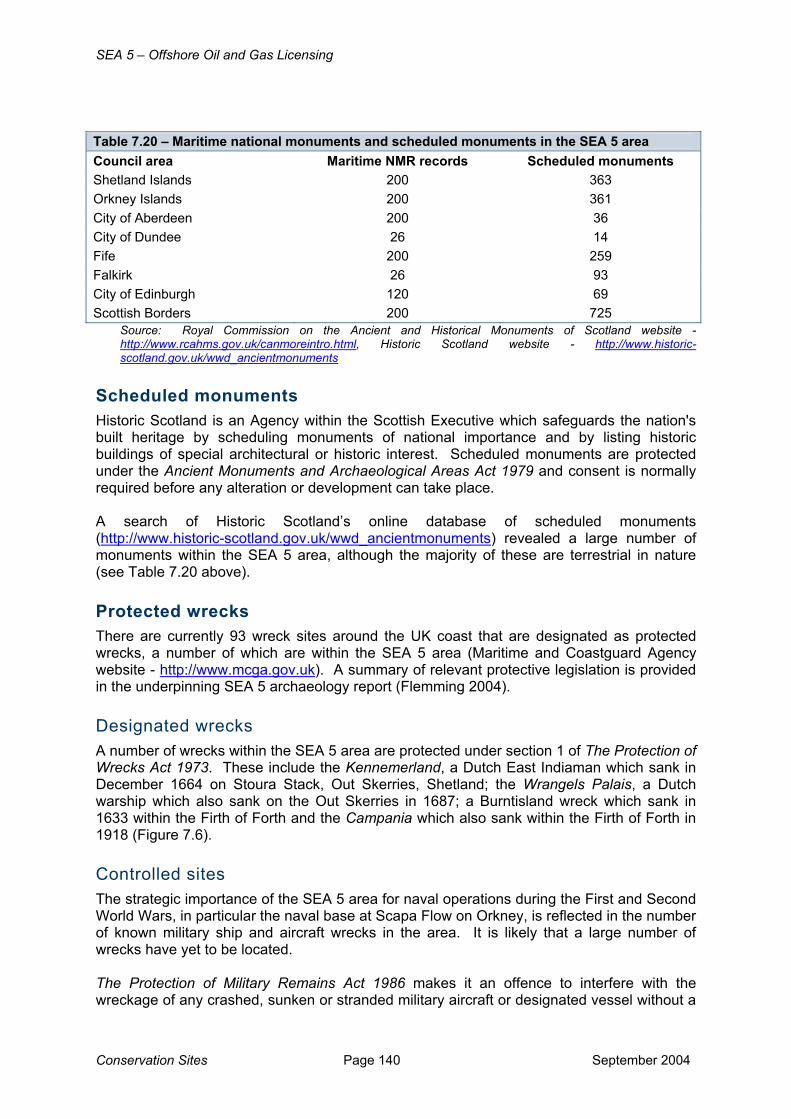
Table 7.20 – Maritime national monuments and scheduled monuments in the SEA 5 area Council area Maritime NMR records Scheduled monuments Shetland Islands 200 363 Orkney Islands 200 361 City of Aberdeen 200 36 City of Dundee 26 14 Fife 200 259 Falkirk 26 93 City of Edinburgh 120 69 Scottish Borders 200 725
Source: Royal Commission on the Ancient and Historical Monuments of Scotland website - http://www.rcahms.gov.uk/canmoreintro.html, Historic Scotland website - http://www.historic-scotland.gov.uk/wwd_ancientmonuments
Scheduled monuments Historic Scotland is an Agency within the Scottish Executive which safeguards the nation's built heritage by scheduling monuments of national importance and by listing historic buildings of special architectural or historic interest. Scheduled monuments are protected under the Ancient Monuments and Archaeological Areas Act 1979 and consent is normally required before any alteration or development can take place. A search of Historic Scotland’s online database of scheduled monuments (http://www.historic-scotland.gov.uk/wwd_ancientmonuments) revealed a large number of monuments within the SEA 5 area, although the majority of these are terrestrial in nature (see Table 7.20 above). Protected wrecks There are currently 93 wreck sites around the UK coast that are designated as protected wrecks, a number of which are within the SEA 5 area (Maritime and Coastguard Agency website - http://www.mcga.gov.uk). A summary of relevant protective legislation is provided in the underpinning SEA 5 archaeology report (Flemming 2004). Designated wrecks A number of wrecks within the SEA 5 area are protected under section 1 of The Protection of Wrecks Act 1973. These include the Kennemerland, a Dutch East Indiaman which sank in December 1664 on Stoura Stack, Out Skerries, Shetland; the Wrangels Palais, a Dutch warship which also sank on the Out Skerries in 1687; a Burntisland wreck which sank in 1633 within the Firth of Forth and the Campania which also sank within the Firth of Forth in 1918 (Figure 7.6). Controlled sites The strategic importance of the SEA 5 area for naval operations during the First and Second World Wars, in particular the naval base at Scapa Flow on Orkney, is reflected in the number of known military ship and aircraft wrecks in the area. It is likely that a large number of wrecks have yet to be located. The Protection of Military Remains Act 1986 makes it an offence to interfere with the wreckage of any crashed, sunken or stranded military aircraft or designated vessel without a

SEA 5 – Offshore Oil and Gas Licensing
September 2004 Page 141 Conservation Sites
licence. This is irrespective of loss of life or whether the loss occurred during peacetime or wartime. There are two levels of protection offered by this Act, designation as a Protected Place or as a Controlled Site. Protected Places include the remains of any aircraft which crashed while in military service or any vessel designated (by name, not location) which sank or was stranded in military service after 4th August 1914. Controlled Sites are specifically designated areas which encompass the remains of a military aircraft or a vessel sunk or stranded in military service within the last two hundred years. Within the SEA 5 area, five shipwrecks have been designated as Controlled Sites under The Protection of Military Remains Act 1986. These include HMS Hampshire, HMS Vanguard, HMS Royal Oak (within Scapa Flow), HMS Exmouth and HMS Natal (within the Moray Firth) (Figure 7.6). All sank with considerable loss of life. Scheduled wrecks The seven remaining wrecks of the German High Seas Fleet, scuttled at Scapa Flow on 21st June 1919 have been protected as maritime Scheduled Ancient Monuments. Also within the SEA 5 area, the remains of eight Fife fishing vessels in Aberlady Bay have been scheduled as they represent boats engaged in the Scottish fishing industry at the turn of the 20th Century (Figure 7.6).
7.5.3 Relevance for SEA 5 The SEA 5 area contains a large number of known coastal and marine archaeological sites. Of particular relevance are the large number of wrecks, both of aircraft and ships, which have been identified, although it is likely that the locations of many more remain unknown. Activities resulting from licensing of the SEA 5 area are unlikely to significantly impact upon either the known or unknown archaeological resource, as identification of wrecks through consultation and site survey forms an important part of the project-specific EIA process.

SEA 5 – Offshore Oil and Gas Licensing
Conservation Sites Page 142 September 2004
This page is intentionally blank