69396 dbasso 1 front - ultra electronics · ocean systems t-1630 sepirb submarine emergency...
TRANSCRIPT
Ocean Systems
T-1630 SEPIRBSubmarine Emergency Position Indicating Radio Beacon
Multi-national
NOAA
Navy
Submarine
1
Search and rescue satellites
Ground receiving station
Mission control center
Rescue coordination center
Distress call utilizing emergency beacon
2
3
4
5
Ocean Systems
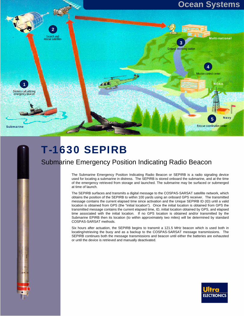
The Submarine Emergency Position Indicating Radio Beacon or SEPIRB is a radio signaling device used for locating a submarine in distress. The SEPIRB is stored onboard the submarine, and at the time of the emergency retrieved from storage and launched. The submarine may be surfaced or submerged at time of launch.
The SEPIRB surfaces and transmits a digital message to the COSPAS-SARSAT satellite network, which obtains the position of the SEPIRB to within 100 yards using an onboard GPS receiver. The transmitted message contains the current elapsed time since activation and the Unique SEPIRB ID (ID) until a valid location is obtained from GPS (the "initial location"). Once the initial location is obtained from GPS the transmitted message contains the current elapsed time, ID, initial location obtained by GPS, and elapsed time associated with the initial location. If no GPS location is obtained and/or transmitted by the Submarine EPIRB then its location (to within approximately two miles) will be determined by standard COSPAS-SARSAT methods.
Six hours after actuation, the SEPIRB begins to transmit a 121.5 MHz beacon which is used both in locating/retrieving the buoy and as a backup to the COSPAS-SARSAT message transmissions. The SEPIRB continues both the message transmissions and beacon until either the batteries are exhausted or until the device is retrieved and manually deactivated.

SEPIRB Features & Specifications
Simple and rugged single unit assembly
COSPAS/SARSAT (406 MHz) compatible function and 121.5 MHz beacon using McMurdo Marine EPIRB electronics
406 MHz satellite message (national user format)
121.5 MHz beacon (6 hour delay)
COSPAS-SARSAT data transmission of unique submarine ID, GPS information, elapsed time from activation, initial GPS position fix, and a special encoded message
GPS positioning using Rockwell receiver
CG/CB separation optimized to ensure performance in high sea states
Shelf life: 5+ years
Operating life: 48+ hours
Stowage temperature:
Short term; -20 ºC to 55ºC
Long term; -5 ºC to 40ºC
Operating temperature: -20 to 55ºC
Submarine launched certified - survives launch from a submarine in transit
Designed to survive severe shock and vibration requirements
Shock: Type I Table 1 of MIL-STD-167
Vibration: 110 G 1/2 sine wave of eleven milliseconds
Bending moment requirement (200 lb end load)
No lanyard, no strobe
Launch from a 3 or 4 inch launcher (with adapter sleeve) or manual release via an emergency escape trunk
100% tested for survival for 8 hours
BIT function and autonomous operating modes
Easily replaceable battery pack at depot level; LiMnO2chemistry, NSWC battery safety instruction S9310 approval for use on a submarine
Ultra Electronics Ocean Systems Inc.115 Bay State DriveBraintree, MA 02184-5203, USATel: +1 781 794 3777Fax: +1 781 843 2153 e-mail: [email protected]
Ultra Electronics Ocean Systems reservethe right to vary these specificationswithout notice.© Ultra Electronics Ocean Systems Inc. 2005Printed in USA
TMSS oundolutionsS
Ocean Systems
Physical Properties
Diameter: 3 in (7.6 cm)Length: 39.5 in (100 cm)Weight (approx.): 8 lbs (3.6 kg)Buoyancy: 20.7%CG/CB separation (submerged): 5.21 in (13.2 cm)CG-CB separation (surfaced, static): 0.98 in (2.5 cm)
Nose cap / radome for COSPAS-SARSAT, 121.5 MHz, and GPS antenna performance- Low cost/low dielectric material- Joint design based on over 40 years of experience
in expendable device design and manufacture
Rockwell GPS receiver(COTS)
McMurdo EPIRB electronics and 406.025/121.5 MHz
Aluminum drawn tube - based on sonobuoy design
and manufacture experience
BIT push-button access hole
Dual O-ring seal- User serviceable
for battery replacement
Ultralife battery packGPS patch antenna (COTS)
Water line
Antenna 406.025/121.5 MHz(center loaded)
Cleared for Open Publication (12/13/05)Directorate for Freedom of Information and Security Review
US Department of Defense