6 the continents - worldarcstudiorichmond-elt/files/essentialgeographyandhistorys… · 6 the...
TRANSCRIPT
60
The continents6U N I T
What do you remember?
• Which is the largest continent in the world? And the smallest?
• Do you know anything about their relief and climates?
• Can you name at least three countries on each continent (except Antarctica)?
• What different kinds of physical features are there around the world?
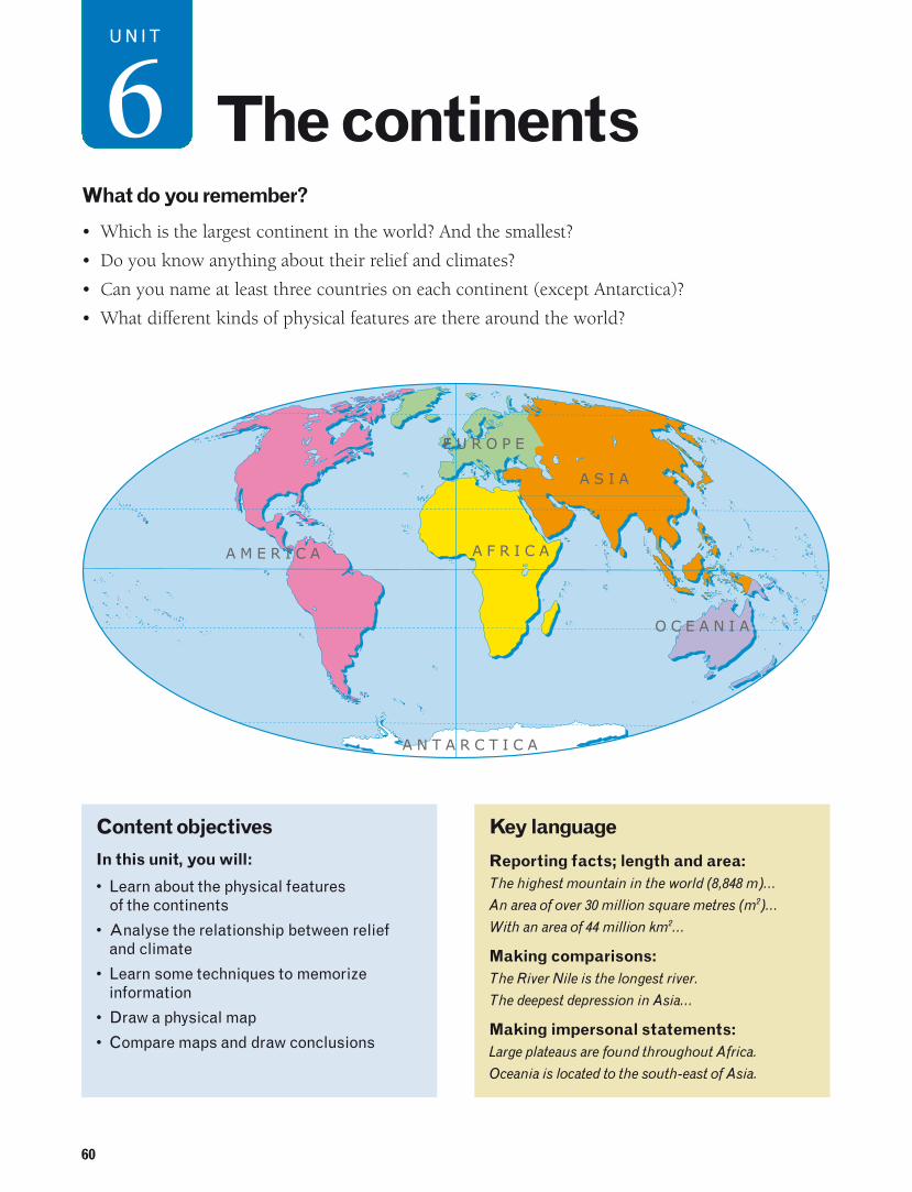
E U R O P E
A S I A
A F R I C A
O C E A N I A
A M E R I C A
A N T A R C T I C A
Content objectives
In this unit, you will:
• Learn about the physical features of the continents
• Analyse the relationship between relief and climate
• Learn some techniques to memorizeinformation
• Draw a physical map
• Compare maps and draw conclusions
Key language
Reporting facts; length and area:The highest mountain in the world (8,848 m)…
An area of over 30 million square metres (m2)…
With an area of 44 million km2…
Making comparisons:The River Nile is the longest river.
The deepest depression in Asia…
Making impersonal statements:Large plateaus are found throughout Africa.
Oceania is located to the south-east of Asia.

61
1. Where are these physical features found?
Activities
1. What continents are these physical features in?
Mount Fuji the Mississippi River Ayers Rockglaciers the Great Rift Valley the Andes
2. Investigate.
Find out more about Antarctica: its area, its relief,its climate and its plant and animal life. You can usewebsites such as www.nationalgeographic.com
A. The Andes mountain range in South America is 7,200 km long and 240 km wide. There are many high volcanoes (over 5,000 m).
D. Japan is an Asian country in the Pacific Ocean. It is formedby over three thousand islands. The highest mountain,Mount Fuji, is a volcano.
B. The Mississippi River in North America is 1.6 km wide atits widest point. It has 250 tributaries. A total of 25,900 km in the Mississippi River basin are navigable.
E. The Great Rift Valley is a fracture which started to be formedabout 50 million years ago. It is approximately 6,000 km longand runs from Southwest Asia to Mozambique in East Africa.
C. Ayers Rock, also known as Uluru, is a large sandstonerock in central Australia. It is 340 m high. It is sacred to the Aboriginal people of the region.
F. Antarctica is the continent with the highest averagealtitude: 2,000 m. However, ice covers 98 % of the continentand hides its relief. There are many glaciers.
9
62
2. What are Africa’s relief and climate like?
0º20º 20º 40º
20º
20º
40º20º 60º
20º
M e d i t e r r a n e a nSeaStrait of Gibraltar
Cape Espartel
Jbel Toubkal4,165
AT L A S
M O U N T A I N S
SA
H A R A D E S E R T
Tropic of Cancer
CAPE VERDEISLANDS
RiverSeneg
al
Cape Bon
Gulf ofGabes
Gulf ofSidra
L I B Y A N
D E S E R T
T I B E S T IA H A G G A R
Tahat3,003
MO U N T A I N S M O U N T A I N SEmi Koussi
3,415
River
Nig
er
NigerBasin
ChadBasin
LakeChad P la teau
Dar fu r
Riv
erV
olta
CapeVerde
LakeVolta
Gulf ofGuineaCape Palmas
ATLANTIC
OCEAN BiokoIsland
São ToméIsland
CapeLopez
M O U N T A I N S
Cameroon4,070
C A M E R O O N
River
Chari
Riv
er Ubangi
Riv
erCon
go
River CongoCongoBasin
NileDelta
SuezCanal
NILE
RIV
ER
Re
dS
ea
A S I A
Ras Dashan4.620
Gulf of AdenSocotraIsland
N U B I A N
D E S E R T
E T H I O P I A N CapeGuardafui
SOMALIAPENINSULA
INDIAN
OCEAN
H I G H L A N D S
Blu
eN
ile
River
Whit
eNile
Riv
er
LakeTurkana
Equator 0º
SEYCHELLESISLANDS
Mount Kenya5,199
AlbertLake
GREA
TRIF
TVA
LLEY
Rwenzori 5,119
Mo
un
tain
s
Karisimbi4,507
Kilimanjaro5,895
Pemba IslandZanzibar Island
LakeVictoria
LakeTanganyica
Riv
er
Kasai COMORO
ISLANDSCape Amber
GREA
TR
IFTV
ALLEY
Lake Malawi(Nyasa)SOUTH AFRICAN
River ZambeziVictoriaFalls
River
Okavango
Moz
ambi
que
Cha
nnel Maromokotro
2,876
Madagascar
Tropic of Capricorn
CapeSainte Marie
Ri
ver
Limpopo
DRAKENSBER
GM
OU
NT
AIN
S
ThabanaNtlenyana
3,482
PLATEAU
KALAHARI
DESERT
NA
MI B
DE
SE
RT
Ponta daMarca
Orange RiverGreatKaroo
Cape ofGood Hope
Mauritius
Mit
um
ba
Kilometres
0 557 1,114SCALE
0
200
500
1,000
2,000
metresALTITUDE
Depression
7,000
4,000
3,000
2,000
1,000
0
6,000
Nile
Longest rivers(in km)
5,000Congo Niger
Zambezi
OrangeOkavango
JbelToubkal
4,000
6,000
3,000
2,000
1,000
0
5,000
Kilimanjaro
Mount Kenya
Rwenzori
Ras Dashan
Mount Karisimbi
Highest mountains(in m)
The landscape of Africa
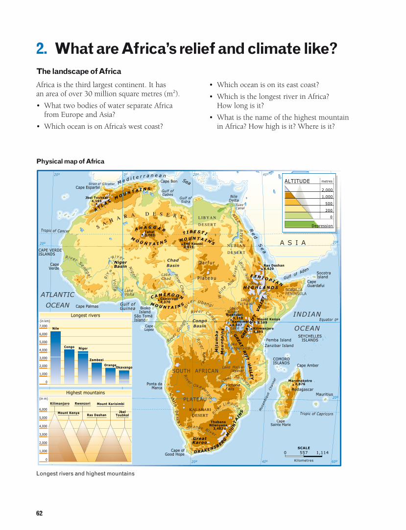
Africa is the third largest continent. It has an area of over 30 million square metres (m2).
• What two bodies of water separate Africa from Europe and Asia?
• Which ocean is on Africa’s west coast?
• Which ocean is on its east coast?
• Which is the longest river in Africa? How long is it?
• What is the name of the highest mountain in Africa? How high is it? Where is it?
Physical map of Africa
Longest rivers and highest mountains
63
Tropic of Cancer
Tropic of Capricorn
Equator
Prim
e M
erid
ian
Equatorial
HOT CLIMATES
Humid tropical
Dry tropical
Desert
OceanicMediterranean
and similar
Mountain
TEMPERATE CLIMATES
COLD CLIMATES
Rivers and lakes
Many African rivers are long with large flows.Some rivers, such as the Congo and the Zaire, arenavigable for long distances. The River Congo hasthe largest flow in Africa and the second largest inthe world. The River Nile is the longest river in the world.
Africa has some very large lakes. The largest is Lake Victoria. The region of African Great Lakes (Victoria, Tanganyika,Turkana) is in the Great Rift Valley.
Relief
Large plateaus are found throughout Africa. Africa’s average altitude is high (750 m).
• Several deserts, such as the Sahara andKalahari, are found on these plateaus.
• Several mountain ranges are also found on theplateaus. The east of the continent is thehighest part. The volcano Mount Kilimanjaro,the highest mountain in Africa, is located herenear the Great Rift Valley.
• Some depressions, such as the Congo andNiger basins, are found between the centralplateaus.
There are not many islands off the coast of Africa. The largest is Madagascar.
Activities
1. Study the map opposite and the text above. Answer these questions.
a. What is Africa’s relief like?b. Which is the highest part of the continent?c. Which is the largest island?
Where is it?
2. Study the climate map and answer thesequestions.
a. What type of climate – hot, temperate or cold –predominates in Africa?
b. What type of climate is found near the Tropic of Cancer? What is the landscape like in this part of Africa?
c. What climates are found near the Tropic ofCapricorn? What is the landscape like here?
3. Draw a line across Africa from north to south.
a. Describe the changes to the climate next to the line.
b. Look at the map on page 62 again. Describe the physical features next to the same line.
Did you know?
The Sahara is the biggest desert in the world. It covers 9,000,000 km2. Eight thousand yearsago it was a fertile area. However, it is nowvery dry, and temperatures reach 54 °C. In afew areas, fruits, dates and corn are grown.
Africanclimates
64
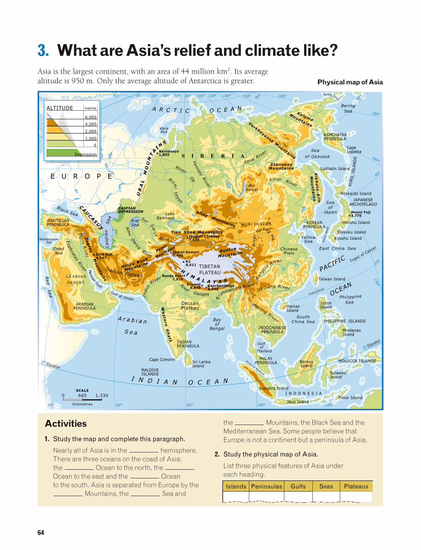
3. What are Asia’s relief and climate like?Asia is the largest continent, with an area of 44 million km2. Its averagealtitude is 950 m. Only the average altitude of Antarctica is greater.
Bering Strait
KolymaMountains
A R C T I C O C E A N
S I B E R I A
E U R O P E River
Irtysh
River
Ob
UR
AL
MO
UN
TA
I NS
Narodnaya1,895
Yenisey
River
KaraSea
VerkhoyanskM
ountains
StanovoyMountains
Sik
ho
te-A
lin
Amur River
Lena River
BeringSea
Seaof Okhotsk
Seaof
Japan
KAMCHATKAPENINSULA
Philippine
Sea
SouthChina Sea
PACIFIC
OCEAN
Black Sea
Red
Sea
MediterraneanSea
Euphrates
RiverTig
risR
iver
ARABIANPENINSULA
ANATOLIANPENINSULA
Za
gro
sM
ou
nta
ins
Hindu KushZard Kuh4,547
CAU
CASU
S
Iranian Plateau
Pamir
Mountains
ARABIAN
DESERT
Gulf of Oman
PersianGulf
A r a b i a n
S e a
Casp
ian
Sea
AralSea
River GangesIndus
River
Syr
Dary
a
River
Am
uDarya
RiverW
este
rnG
ha
ts
HI M A L A Y A S
Nanda Devi7,816
K28,611
Tien Shan Mountains
I N D I A N O C E A N
Everest8,848
Jengish Chokusu7,439
Kunlun
Mountains
AltayMountains GOBI DESERT
Tropic of C
ancer
Equator
Kor
eaS
trai
t
Luzon Strait
Strait of Malacca
Yang
tze
River
Xi Jiang River
MekongRiver
B
rahmaputra River
Riv
er
Huang
He
KOREANPENINSULA
MALAYPENINSULA
INDOCHINESEPENINSULA
INDIANPENINSULA
LakeBaikal
LakeBalkhash
East China Sea
YellowSea
PLATEAU
ChinesePlain
TIBETAN
DeccanPlateau
Gulfof
Thailand
Bayof
Bengal
Equator
DeadSea Ismoil Somoni
7,495
Kanchenjunga8,598
Mount Fuji3,776
CASPIANDEPRESSION
MindanaoIsland
Java Island
Sumatra Island
BorneoIsland
SulawesiIsland
Timor Island
MOLUCCA ISLANDSSri LankaIsland
MALDIVEISLANDS
Sakhalin Island
KU
RIL
ISLA
ND
S
Hokkaido Island
Honshu Island
Shikoku Island
Kyushu Island
Taiwan Island
PHILIPPINE ISLANDS
LuzonIsland
CapeLopatka
HainanIsland
Cape Comorin
JAPANESEARCHIPELAGO
I N D O N E S I A
Mo
un
tain
s
Mountains
140º 160º 80º80º 100º 120º60º40º20º 180º0º80º60
º
180º
160º
40º
140º
20º
0º
100º 120º80º40º 60º
0º
20º
40º
20º
0 665
Kilometres
SCALE
1,330
0
1,000
2,000
4,000
6,000
metresALTITUDE
Depression
Physical map of Asia
Activities
1. Study the map and complete this paragraph.
Nearly all of Asia is in the hemisphere.There are three oceans on the coast of Asia: the Ocean to the north, the Ocean to the east and the Ocean to the south. Asia is separated from Europe by the
Mountains, the Sea and
the Mountains, the Black Sea and theMediterranean Sea. Some people believe thatEurope is not a continent but a peninsula of Asia.
2. Study the physical map of Asia.
List three physical features of Asia under each heading.
Islands Peninsulas Gulfs Seas Plateaus
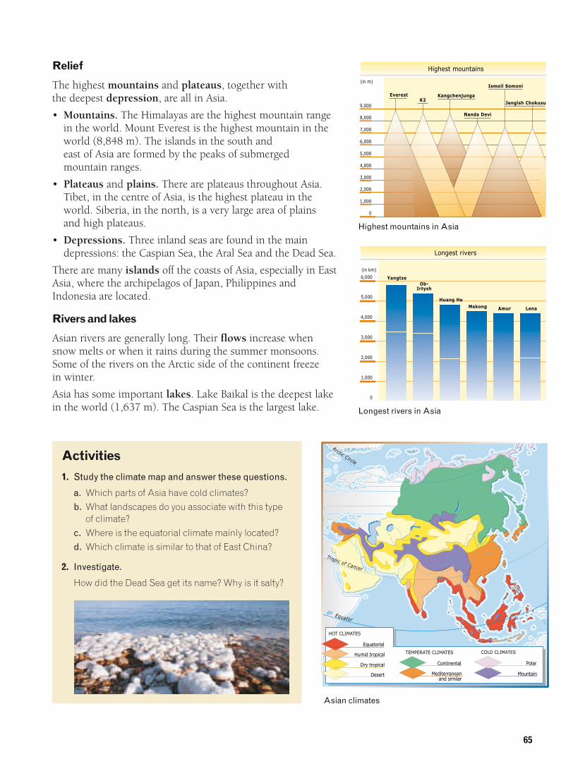
Relief
The highest mountains and plateaus, together with the deepest depression, are all in Asia.
• Mountains. The Himalayas are the highest mountain rangein the world. Mount Everest is the highest mountain in theworld (8,848 m). The islands in the south and east of Asia are formed by the peaks of submerged mountain ranges.
• Plateaus and plains. There are plateaus throughout Asia.Tibet, in the centre of Asia, is the highest plateau in theworld. Siberia, in the north, is a very large area of plains and high plateaus.
• Depressions. Three inland seas are found in the maindepressions: the Caspian Sea, the Aral Sea and the Dead Sea.
There are many islands off the coasts of Asia, especially in EastAsia, where the archipelagos of Japan, Philippines andIndonesia are located.
Rivers and lakes
Asian rivers are generally long. Their flows increase whensnow melts or when it rains during the summer monsoons.Some of the rivers on the Arctic side of the continent freeze in winter.
Asia has some important lakes. Lake Baikal is the deepest lakein the world (1,637 m). The Caspian Sea is the largest lake.
65
4,000
3,000
2,000
1,000
5,000
9,000
8,000
7,000
6,000
0
EverestK2
Kangchenjunga
Ismoil Somoni
Highest mountains
Nanda Devi
Jengish Chokusu
(in m)
6,000
4,000
3,000
2,000
1,000
0
5,000
Yangtze
Longest rivers
(in km)
Ob-Irtysh
Huang HeMekong Amur Lena
Highest mountains in Asia
Longest rivers in Asia
Tropic of Cancer
Arctic Circle
0º Equator
Equatorial
HOT CLIMATES
Humid tropical
Dry tropical
Desert
Continental
Mediterraneanand similar
TEMPERATE CLIMATES
Polar
COLD CLIMATES
Mountain
Activities
1. Study the climate map and answer these questions.
a. Which parts of Asia have cold climates? b. What landscapes do you associate with this type
of climate?c. Where is the equatorial climate mainly located?d. Which climate is similar to that of East China?
2. Investigate.
How did the Dead Sea get its name? Why is it salty?
Asian climates

66
4. What are Oceania’s relief and climate like?
Oceania
Oceania is located to the south-east of Asia, and is almost entirely in the southernhemisphere. With a size of around 9 million km2, it is the smallest continent.
150°140°130°120°
20°
0°
10°
30°
10°
20°
120° 130° 140° 150° 160° 170° 160°180° 170° 150° 140° 130°
20°
10°
180° 170°170°160° 160° 150°
120°
140° 130° 120°
10°
20°
0°
30°
40°
Equator
TimorSea
INDIAN
OCEAN
GREAT SANDY
DESERT
A U S T R A L I A
GREAT VICTORIA
DESERT
GREA
TDIVID
ING
RA
NG
EGreat
Australian Bight TasmanSea
INDIAN OCEAN
A U S T R A L A S I A
CoralSeaG
reat Barrier Reef
Riv
erDa
rling
River Murray
Solomon Sea
M I C R O N E S I A
ME
LA
NE
SI
A
BismarckSea
FijiSea
Tropic of Capricorn
P A C I F I C O C E A N
P O L Y N E S I A
Southe
rnAl
ps
Cook3,764
Wilhelm4,509
Puncak Jaya5,030
Tropic of Cancer
Challenger Deep11,034 m
VANUATU
SOLOMONISLANDS
PALAU
TUVALU
NAURU
FEDERATED STATESOF MICRONESIA
SAMOA
MARSHALL ISLANDS
K I R I B A T I
PAPUANEW
GUINEA
FIJI TONGA
NEWZEALAND
North Island
South IslandTasmaniaIsland
Hawaiian Islands(USA)
Island of Guam
TUAMOTU
0
200
500
1,000
2,000
metresALTITUDE
0 678
Kilometres
SCALE
1,356
Physical map of Oceania
Activity
1. Study the map and find the following:
a. The oceans surrounding Oceaniab. The four largest islandsc. The names of three large groups of
islandsNow read the text on the next page andcheck your answers.
Part of Oceania seen from space

67
The landscape
Oceania is formed by thousands of islands and is inthe Indian and Pacific Oceans.
• There are four large islands: Australia, New Guinea(which is divided between Asia and Oceania) andNew Zealand (formed by North Island and SouthIsland).
• Australia occupies 86% of Oceania and is the largest island on Earth. Many peopleconsider it to be an island-continent.
• There are thousands of small islands in the PacificOcean. Most of them originate from coral orvolcanoes. These islands are grouped into threelarge areas: Micronesia, Melanesia and Polynesia.
The average altitude of Oceania is low: 340 m.However, there are great differences between islands.
Climate
Most of Oceania is between the Tropics, so it haswarm climates. Climates are temperate in the northand south of the continent.
• New Guinea has an equatorial climate.• Hawaii has a tropical climate.• Inland Australia has a desert climate.
Cyclones and typhoons are common in the tropicalregion.
The islands are isolated. Consequently, they havemany plants which do not grow anywhere else.
The Tuamotu archipelago, in Polynesia
An Australian beach
Activities
1. Study the map on page 66 and complete the texts.
a. In , plains and low plateauspredominate, although there is a long mountainrange called the . It is the only island with two major rivers,the Murray and the .
b. New and New aremountainous. Their rivers are short, and some of them receive water from glaciers.
c. Some islands in the Ocean aremountainous and have active volcanoes (Samoa, Hawaii).
2. Interpret the documents.
Study the map and write the names of islands in each group.
3. Classify the information.
Melanesia
Micronesia
Polynesia
Islands in Oceania
Large islands Small islands

68
5. What are America’s relief and climate like?America is in thewestern hemisphere. It is the second largestcontinent (42 millionkm2). It is the longestcontinent: it stretchesfrom the Arctic Circle to the Antarctic Circle.Three oceans surroundit: the Atlantic, thePacific and the Arctic.
0
200
500
1,000
1,500
metresALTITUDE
0 1,532
Kilometres
SCALE
3,064Strait of
Magellan Cape Horn
Cape SãoRoque
CapeSão TomeIguazu
Falls
São
Franci
sco
River
Para
na R
iver
6,959Aconcagua
Huascaran6,768
Chimborazo6,310
6,520Sajama
6,880Ojos delSalado
6,682NevadoIllimani
Uru
guay
Rive
r
Riv
er
PA
TA
GO
NIA
AT
AC
AM
AD
ES
ER
T
Gulfof Arica
FALKLANDISLANDS
TIERRA DEL FUEGO
Para
guay
River Plate
A
NDES
MO
UN
TA
IN
S
PAMPAS
LakeTiticaca Bolivian
Alt iplano
MATO GROSSOPLATEAU
Amazon Plains
Amazon River
Equator
Cape Orange
M
arañon River
Mariñas Point
Tropic of Capricorn
PACIF IC
OCEAN
Pico de Orizaba5.700
Popocatepetl5,452 Sierra Madre del Sur
COLUMBUS ARCHIPELAGO(Galapagos Islands)Equator
YUCATANPENINSULA
Cuba
PanamaCanal
GuianaHighlands
PuertoRico
Jamaica
Caribbean Sea
Trinidad and Tobago IslandsGrenada Island
Antigua and Barbuda IslandsLESSER ANTILLES
Gulfof Mexico BAHAMAS
ISLANDS
FLORIDAPENINSULA
Mag
dale
na
Riv
er
Ori
noco
RiverLakeMaracaibo
Tropic of Cancer
ATLANTIC
OCEAN
Hispaniola
RioGrand
e
Sie
rraM
ad
re
Californ
iaG
ulf
of
Cape Hatteras
Niagara falls
Appal
achi
an
Mou
ntain
s
Ohio
Saint Lawre
nce
Rive
r
River
LakeMichigan
GREATLAKES
LakeSuperior Lake
Huron
LakeWinnipeg
Newfoundland
Cape Farewell
LABRADORPENINSULA
LabradorSea
DavisStrait
Mis
siss
ippiR
iver
Misso
uri R
iver
CapeSan Lucas
CapeMendocino
VancouverIsland
Whitney4,418
Colo
rado River
COLORADODESERT
HudsonBay
BaffinBay
BaffinIsland
Greenland
Great BearLake
Great SlaveLake
BeaufortSea
ARCTICOCEAN
Mack
enzi e
Riv
er
G r e a t
P l a i n s
Arct
icCi
rcle
RO
CK
YM
OU
NT
AI
NS
AlaskaPeninsula
BeringSea
Bering Strait
6,194McKinley
Gulf ofAlaska
Yukon
Ri v e rR a n g eA l a s k a
Tro pic of Cancer
MartiniqueDominica
Guadaloupe
GREATERANTILLES
160º
140º
120º
20º
60º
140º
160º
40º
20º
0º
0º
0º
20º
20º
40º
40º80º 60º100º
20º
40º
60º
0º
40º
40º
60º100º 80º
20º
Activity
1. Write the mountainranges, plains andplateaus of theAmerican continent.
Mountain ranges
Plains
Plateaus
7,000
4,000
3,000
2,000
1,000
0
5,000
Aconcagua
Ojos del Salado
Huascaran
Nevadodel Illimani
McKinley
Chimborazo
Highest mountains
6,000
(metres)
7,000
3.000
4,000
3,000
2,000
1,000
0
5,000
Amazon
Longest rivers(km)
Mississippi-Missouri
Parana
Yukon
SãoFrancisco
6,000
Mackenzie
Physical mapof America

69
Relief
America has a high average altitude. The main physicalfeatures are mountain ranges, plains and plateaus.
• Mountain ranges. The youngest, highest mountainsrun down the Pacific coast. The Rocky Mountainsare the highest mountain range in North America.The Andes are the highest in South America. Older, lower mountains, such as the Appalachians,are found in the East.
• Plains. The Great Plains of North America are closeto the mountain ranges and rivers, such as theMississippi. The Amazon River runs through thelargest plain in South America.
• Plateaus. The highest plateau is the Altiplano of Bolivia.
The Antilles archipelago is found in the Caribbean Sea in Central America.
Rivers and lakes
America has some very long rivers with large flows.Both the Mississippi in North America and the Amazonin South America are very long. The Amazon is theriver with the largest flow in the world.
There are many lakes, especially in North America.The Great Lakes are a group of big lakes betweenCanada and the United States. Lake Titicaca in SouthAmerica is the highest lake in the world.
Climate and vegetation
America stretches from pole to pole, so it has all the different climates and landscapes. Cold andtemperate climates predominate in North America.Tropical climates predominate in Central America. Hot and temperate climates predominate in SouthAmerica. However, in all three regions, mountainousareas have cold climates.
Equator 0º
Tropic of Capricorn
Tropic of Cancer
Arctic
Circ
le
A T L A N T I C
O C E A N
P A C I F I C
O C E A N
Mediterraneanand similar
Equatorial
HOT CLIMATES
Humid tropical
Dry tropical
Desert
Oceanic
Continental
TEMPERATE CLIMATES
Mountain
Polar
COLD CLIMATES
American climates
Bison on the plains of North America
Activity
1. Study the map and answer the questions.
a. Are there any islands in the Pacific Ocean?b. Where in America are there cold climates?c. What parts of America have temperate climates?
d. Are there deserts in America? Where?e. What is the climate like in most of Canada?f. Are there any areas in America with
a Mediterranean type of climate?

70
Activities1. Memorizing information
Here are some tricks to help you memorizeinformation. Use the ones that work best for you. If you have other tricks, share them with yourteacher and your classmates.• Look carefully at maps to create an image of the
continents in your mind.• Memorize the boundaries of territories by making
a diagram like this one.
• Associate names with something you alreadyknow. For example, learn the capitals of Europeby thinking of football teams, such as Arsenal and Chelsea in London.
1• Use initials to make words. For example,
the Great Lakes are HOMES (Huron, Ontario,Michigan, Erie, Superior).
• Study names systematically. For example, learn the names of mountains with mountainranges, such as Mount Everest in the Himalayas.
• Remember names in a particular order, such as mountains by height, rivers by length and lakes from north to south.
• Invent a trip through all the places you have tolearn. For example, I’m going on a trip to Asia.First, I’m going to…
• If you find something very difficult to remember, write it on a piece of paper. Keep it in your room, and look at it every day.
But don’t forget: the best way to remembersomething is to understand it properly!
N
W E
S
←⎯⎯⎯→
←⎯
→
Now try this!
a. What continent are we referring to?• It looks like two triangles joined by a line.• It looks like an upside-down triangle.
b. Remember the boundaries of the continents.• Make a diagram which shows the boundaries of Oceania,
America, Asia and Africa.• Make a card with the boundaries of Antarctica.
c. Look for the following information. Organize it systematically.
d. Invention.
• Plan a trip along African rivers. • Invent a story to remember the relief and rivers of America.
e. Describe the distribution of the climates of America. Relate them to their latitude.
AustraliaNew Zealand and
New Guinea
Relief
Rivers
Climates
71
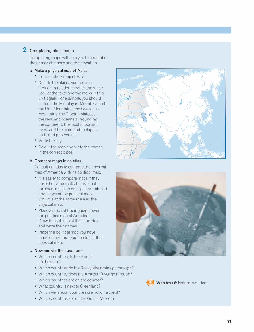
2. Completing blank maps
Completing maps will help you to remember the names of places and their location.
a. Make a physical map of Asia.• Trace a blank map of Asia.• Decide the places you need to
include in relation to relief and water. Look at the texts and the maps in this unit again. For example, you should include the Himalayas, Mount Everest, the Ural Mountains, the Caucasus Mountains, the Tibetan plateau, the seas and oceans surrounding the continent, the most important rivers and the main archipelagos, gulfs and peninsulas.
• Write the key.• Colour the map and write the names
in the correct place.
b. Compare maps in an atlas.
Consult an atlas to compare the physical map of America with its political map.• It is easier to compare maps if they
have the same scale. If this is not the case, make an enlarged or reduced photocopy of the political map until it is at the same scale as the physical map.
• Place a piece of tracing paper over the political map of America. Draw the outlines of the countries and write their names.
• Place the political map you have made on tracing paper on top of the physical map.
c. Now answer the questions.
• Which countries do the Andes go through?
• Which countries do the Rocky Mountains go through?• Which countries does the Amazon River go through? • Which countries are on the equator?• What country is next to Greenland?• Which American countries are not on a coast?• Which countries are on the Gulf of Mexico?
Web task 6: Natural wonders.