6. public transportation services - alamo area mpo
TRANSCRIPT

MOBILITY 2040 6 - 1 Adopted on December 8, 2014
6. Public Transportation Services
Accomplishments Over the Past Five Years
In December 2012, VIA Metropolitan launched its first bus rapid transit (BRT) service called VIA Prímo in the Fredericksburg Road corridor. The service connects the two largest employment centers in the region, San Antonio’s Central Business District and the South Texas Medical Center, along a route approximately nine miles long. In conjunction with the new service, VIA constructed major transit centers at each end of the corridor, which serve multiple VIA routes and numerous customers in the region.
One of the new transit centers was the Westside Multimodal Transit Center at historic Cattleman’s Square. The first phase of the transit center was completed in Fall 2013, and as of Fall 2014, the facility now also serves as VIA’s administrative offices.
Existing Public Transportation Providers
Two public transportation providers serve the Alamo Area MPO study area: VIA Metropolitan Transit and the Alamo Regional Transit System. The Lone Star Rail District is another existing public transportation entity, but it does not yet operate service. Alamo Regional Transit
Alamo Regional Transit (ART), a rural public transit providers operated through the Alamo Area Council of Governments (AACOG), provides public transportation to the 11,255 square miles cover 12 rural counties overlapping the MPO study area. These counties include Atascosa, Bandera, Comal, Frio, Gillespie, Guadalupe, Karnes, Kendall, Kerr, Medina, McMullen and Wilson. Figure 6.1 shows the service area for ART. ART provides its service to the public using a predominately demand-response, curb-to-curb format during weekdays. Trips may originate anywhere within the 12-county service area. The service transports riders between all points within that service area, as well as into and out of Bexar County. In Fiscal Year 2014, ART provided 112,861 one-way trips.
In April 2013, ART launched Connect Seguin, a deviated fixed-route bus system
serving major designation in Seguin and Guadalupe County on weekdays. The Connect Seguin system is in addition to the established demand-response service for Seguin and is funded with City of Seguin general funds and ART local funds.
Until 2013, the Cities of New Braunfels, Cibolo, Marion, Schertz Selma, and
Garden Ridge, as well as the McQueeney census designed place, fell within ART’s rural

MOBILITY 2040 6 - 2 Adopted on December 8, 2014
service area. However, the designation of these areas as urbanized by the US Census Bureau changed the eligibility for rural transportation services and funding.
During 2013 and 2014, VIA Metropolitan Transit contracted with ART, through
AACOG, to continue the demand-response service in these areas as a result of this change. Service for these areas is now for with VIA urban transit funding which is matched by local funds from ART and the seven newly designated urbanized service areas. For FY 2014, 16.26%, or 18,349, of ART”s total trips originated within these areas.
Though ART serves the entire public, it places special emphasis on serving the
needs of low-income individuals, senior citizens, persons with disabilities, and veterans who have limited or no means of personal transportation. Nearly 55% of the total ridership of ART are senior citizens.
While ART’s demand-response service takes riders directly to destinations for
any purpose, approximately 53% of the trips are for medical appointments, including dialysis treatments. Other frequently requested destinations include shopping, school, child and adult day care, nutrition centers and participation in senior center activities.

MOBILITY 2040 6 - 3 Adopted on December 8, 2014
Figure 6.1 ART Service Area

MOBILITY 2040 6 - 4 Adopted on December 8, 2014
VIA Metropolitan Transit
VIA Metropolitan Transit (VIA) is a political subdivision of the State of Texas, authorized by state enabling legislation, to receive locally-generated sales tax income at a rate not to exceed one percent (1%) and subject to approval by voters within the VIA service area. VIA is governed by a Board of Trustees with eleven appointees. Board members are appointed to staggered two-year terms by the following entities: San Antonio City Council (appoints five), Bexar County Commissioners Court (appoints three), and the Suburban Mayors (appoints two). The Chair of the Board is elected by the Board members and serves a two-year term. The 11-member VIA Board of Trustees meets monthly to discuss policy issues and hear comments from the community. VIA Board meetings are generally held on the 4th Tuesday of each month.
The VIA service area depicted in Figure 6.2, is 1,226 square miles and represents 98% of the Bexar County area. It currently includes the City of San Antonio, the unincorporated areas of Bexar County, and 13 suburban cities: Alamo Heights, Balcones Heights, Castle Hills, China Grove, Cibolo, Converse, Elmendorf, Kirby, Leon Valley, Olmos Park, Shavano Park, St. Hedwig, and Terrell Hills. While the unincorporated cities may be labeled as ‘suburban,’ many of them are now entirely encircled by the City of San Antonio. Despite their integrated geography, suburban cities may vote to exclude themselves from the VIA service area. Currently, cities that are either entirely or partially located within Bexar County, but which are not part of the VIA service area, include Cibolo (Bexar County portion), Fair Oaks Ranch, Grey Forest, Helotes, Hill Country Village, Hollywood Park, Live Oak, Lytle, Somerset, Universal City, Von Ormy and Windcrest.
Advanced Transportation District
In 2004 San Antonio citizens voted to improve traffic, streets and public transit by creating the Advanced Transportation District (ATD). The ATD funds are distributed as follows: ½ to VIA, ¼ to the City of San Antonio (CoSA), and ¼ to the Texas Department of Transportation (TxDOT). In 2005, funding began and so did the improvements. The ATD is governed by the identical board members as the VIA Board of Trustees.
The Advanced Transportation District (ATD) purpose is to develop a regional multimodal vision and strategic plan for managed and/or transit priority lanes on high capacity and express bus route corridors.

MOBILITY 2040 6 - 5 Adopted on December 8, 2014
Figure 6.2 VIA Metropolitan Transit Service Area

MOBILITY 2040 6 - 6 Adopted on December 8, 2014
The Importance of Public Transportation
Public transportation benefits all persons who live, work, or travel in the service area, whether or not they use it. Public transportation plays an important role in the regional transportation system and hence, the regional economy. The additional automobile volume and congestion that the area would experience without transit, would cause an increase in on-road air emissions, resulting in negative impacts to air quality for the entire region. Beyond these indirect benefits, for people who chose to utilize public transportation versus their personal vehicles, public transportation provides a direct benefit reducing operating and maintenance costs of personal vehicles, the cost of parking and congestion on the roadways.
According to the American Community Survey’s 2008-2012 five year estimate, 8.1% of households in Bexar County do not have an automobile available and must rely on another form of transportation. More recently, VIA’s 2013 “Who is the Rider” survey showed that 26% of riders are in households with an automobile and only 16% of riders say they personally have an automobile. Furthermore, if no bus was available 35% of riders said they couldn’t make their trip. Therefore, VIA is providing an invaluable mobility choice for many.
The Census also reflects that 19% of the Bexar County population is below the poverty threshold, while 52% of VIA’s riders are under the poverty threshold. A recent VIA survey found that 33.7% of bus riders have an annual household income of less than $10,000 (Who is the Rider Survey, 2013).
In addition to income, both age and health conditions also affect the community’s need for public transportation. According to the American Community Survey’s 2008-2012 five year estimate, 13% of the Bexar County population reported having at least one disability. VIA provided more than 1.04 million trips in fiscal year 2013 to those disabled individuals that met VIA’s paratransit criteria.
For Bexar County, according to the Census Bureau’s American Community Survey, it is estimated that 10.7% of the population is age 65 and older. The Texas state demographer (0.5 scenario), projects the population of Bexar County age 65+ will more than double by 2035, as follows: 204,740 in 2014, 401,473 in 2035 and 466,459 in 2045. That will make the proportion of age 65+ “seniors” 11% of the county’s population in 2014, 17% in 2035 and 18% in 2045. The aging of the population in Bexar County is a recognized trend.
About 24% of Bexar County’s population is younger than 16, and therefore too young to drive. Without public transportation, the younger population misses opportunities to personally develop or participate in community activities. Often they must rely on parental or other adult support for transportation.

MOBILITY 2040 6 - 7 Adopted on December 8, 2014
VIA Public Transportation Services Fixed Route Service
VIA currently operates 91 fixed bus routes along 1,000 miles of roadway. These routes are depicted in Figure 6.3. In fiscal year 2013, totals for vehicle hours and passenger trips for VIA’s scheduled services were 1,619,682 and 44,635,608, respectively. These figures include the downtown circulation service as described below.
As part of the fixed route bus service, VIA also operates a Bike & Ride program, which allows riders to transport their bicycles for no extra cost on racks attached to the fronts of buses or inside VIA Primo vehicles.
VIA’s major transit activity centers include the San Antonio central business district, San Antonio College, North Star Mall, the South Texas Medical Center, the Deco District, Las Palmas, Naco Pass, University Family Health Center - Southwest, Southwest General Hospital, and both campuses of the University of Texas at San Antonio.
Downtown Circulation
VIA operates two downtown circulator routes. These routes are operated with rubber-tired, propane-powered replica trolleys as well as compressed natural gas buses and battery-powered electric buses. These routes operate on a fifteen-minute average frequency.
VIA Primo also provides circulator service in the San Antonio central business district along Market Street and Commerce Street.

MOBILITY 2040 6 - 8 Adopted on December 8, 2014
Figure 6.3 VIA Metropolitan Transit Fixed Route Service, April 2014

MOBILITY 2040 6 - 9 Adopted on December 8, 2014
VIAtrans Service
As a complementary service to fixed route bus service, VIA operates VIAtrans, an advance reservation, shared-ride, demand-response paratransit service for people with disabilities who cannot navigate the fixed route bus service for some or all of their trips. VIAtrans currently operates with a fleet of over 200 directly operated and contracted vehicles, which provide approximately one million trips each year. Currently 12,200 people are registered for VIAtrans service. Facilities and Fleet As of 2014, VIA serves 7,173 bus stops and 13 transit centers and park & ride facilities, as depicted in Figure 6.3.
VIA’s fleet, shown in Figure 6.3, consists of 450 buses, comprising 217 North American Bus Industries (NABI) diesel buses, four NABI compressed natural gas busses, 176 New Flyer diesel buses, 30 New Flyer diesel-electric hybrid buses, 3 Proterra electric buses, and 14 Optima streetcars. All buses purchased by VIA are low-floor, kneeling vehicles with ramps to accommodate patrons with limited mobility, and the replica trolleys in the downtown area are equipped with lifts.
The NABI and New Flyer buses are 40-foot vehicles that have a low-floor design and a retractable ramp for wheelchair access. The VIA Primo vehicles are 60 feet long with an articulated middle section.
The active VIAtrans fleet consists of 104 vehicles owned by VIA, all of which are equipped with wheelchair lifts. Each vehicle has the capacity to carry 5 ambulatory and 2 wheelchair patrons or 4 ambulatory and 3 wheelchair patrons.
Figure 6.4 VIA Fleet Vehicles

MOBILITY 2040 6 - 10 Adopted on December 8, 2014
All of VIA’s service vehicles are equipped with an automated vehicle location and secure voice communication system, allowing VIA to provide efficient service by making adjustments for delays, overloading, or unforeseen occurrences.
VIA’s High Capacity Transit Service – Primo
In 2005, the MPO, through the Northwest Corridor Alternatives Analysis determined that roadway expansion alone is not a viable option to handle future travel demand on the Northwest corridor. The study concluded that there were no plans for major capacity expansion in the area. Furthermore, given these constraints, it was determined that an alternative to auto travel would be required to increase trip capacity through the congested corridor. As auto travel time increases and auto trip capacity becomes more constrained, alternative transportation options become more attractive, thus shifting travel modes from single-occupant vehicles (SOV) to VIA Primo, enabling greater trip capacity through the corridor. Furthermore, the proposed VIA Primo would improve transportation services to the numerous employment centers located within the corridor.
In December 2012, VIA launched Primo service on the Fredericksburg Road corridor. The VIA Primo is defined as an alignment approximately nine miles long from the South Texas Medical Center (STMC), southeast to the west side of downtown San Antonio via Fredericksburg Road and IH 10. Service has also been extended to UTSA’s Loop 1604 campus and the City of Leon Valley.
Eight paired in-line stations
(16 platforms, see Figure 6.4) were constructed curbside in the Medical Center (on Medical Drive) and along the Fredericksburg Road corridor. In addition to constructing in-line stations at key intersections along the Fredericks-burg Road corridor, VIA has constructed major transit centers at each end of the corridor – the South Texas Medical Center Transit Center (as shown in Figure 6.6) at the intersection of Babcock Road and Medical Drive and the Westside Multi-modal Transit Center (shown in Figure 6.7) in the Cattleman Square Historic District. Both of these transit centers serve multiple VIA routes and numerous customers in the region.
Figure 6.5 VIA Primo Station

MOBILITY 2040 6 - 11 Adopted on December 8, 2014
Figure 6.6 South Texas Medical Center Transit Center
Figure 6.7 Westside Multimodal Transit Center in the Cattleman Square Historic District

MOBILITY 2040 6 - 12 Adopted on December 8, 2014
Ridership
VIA measures ridership based on the number of boardings, also known as unlinked passenger trips. All of VIA’s services carried 45.9 million passenger trips during FY 2012-13, see Table 6.1.
Table 6.1 Transit Ridership for Fiscal Year 2012-13
Type of Service Total Ridership Weekday Average
Scheduled Line 44,635,608 139,335
VIATrans 1,046,552 N/A
Primo (began Dec. 2012) 1,465,773 5,623
Environmental Commitment
VIA continually seeks out ways to reduce pollution, waste, and energy demands. As an operator of a fleet of buses and vans, the agency’s primary environmental efforts are focused on the reduction of vehicle emissions. VIA will continue to monitor the development of fuel and propulsion technologies that can help reduce local air pollution. VIA employs rigorous recycling efforts, focusing on waste oil and lubricants, batteries, paint solvents, office paper, cardboard, scrap metals, refrigerant, and plastics.
Conservation is also a high priority. VIA has retrofitted its facilities with energy efficient lighting, installed upgrades to the HVAC systems and windows, and reduced the energy requirements for the climate control system of the maintenance garage.
VIA is also exploring the use of renewable energy, where feasible. The agency obtains 100 percent of its electricity from CPS Energy’s Windtricity program. Solar panels power the lighting at new bus shelters, and solar-panel systems have been installed to provide power at five transit centers and over 550 bus shelters. A small solar farm is also in use at the South Texas Medical Center Transit Center to provide power to the site. VIA also uses E10 ethanol/gasoline blends.
VIA is also working to reduce water pollution through the use of an on-site industrial wastewater treatment facility and the installation of stormwater interceptors, in order to prevent contaminated bus yard runoff from infiltrating the local watershed.

MOBILITY 2040 6 - 13 Adopted on December 8, 2014
Public Transportation Needs and Issues
The San Antonio region faces many challenges in the public transportation arena. While VIA has long been one of the most financially efficient transit systems in the country, its fiscal constraints and service area characteristics have limited its offerings to the community. Land Use Patterns
The suburban development patterns prevalent in San Antonio areas of high growth pose a challenge for efficient operation of bus service. Gated communities and residential subdivisions with low-density and poor street connectivity are not conducive to efficient transit service for either the pedestrian or VIA and, therefore, not “transit friendly”. Poor street connectivity and low-density development patterns create longer, indirect distances between destinations, making transit options less viable for potential riders, and transit service more expensive to provide, when not impossible to do so, thus creating ‘auto-dependent’ communities.
Transit access to commercial development also poses challenges. Development on one-way frontage roads, as experienced along many portions of IH 10 West, Loop 410, and Loop 1604, are difficult to serve by transit, due to the circuitous routing that is required. In addition, riders are forced to decide whether to either ride ‘out of direction’ for much longer distances to reach their destination, in order to stay on the same side of an expressway, or, to walk long distances under expressway ‘turnarounds,’ in generally very pedestrian-unfriendly environments, in order to arrive at the opposing (returning) direction bus stop. Pedestrian Infrastructure
The region’s pedestrian network lags behind that of its road network. A short trip that can be completed relatively quick and safe by vehicle may be more difficult and less safe if travelled on foot. Transit service, although delivered through the use of a vehicle and operated on a roadway, is dependent upon use by the pedestrian.
The current trend of regional land use patterns, along with the lack of pedestrian facilities and amenities, create conditions that are uninviting, and oftentimes, unsafe to pedestrians. Wide streets with narrow sidewalks placed against a curb, the absence of trees or building awnings for shade, and deep building setbacks, represent a streetscape designed to the scale of the automobile, not the pedestrian. Auto-oriented frontage-road development, in which storefronts are separated from the street by vast, non-shaded parking lots are not ideal pedestrian environments and serve as additional incentives to choose driving over pedestrian and/or transit modes. A non-existent or

MOBILITY 2040 6 - 14 Adopted on December 8, 2014
unsafe pedestrian system is a barrier to the walking experience and hence, a barrier to transit use.
Narrow streets with wide sidewalks, separated from the curb by
landscaping/street trees, pedestrian islands or medians, buildings close to the street with shading devices and parking areas located behind buildings, are design considerations that provide safer pedestrian environments and are incentives for increased pedestrian and transit use. Without a safe, comfortable, and continuous pedestrian network that links origins and destinations, transit use will never reach its full potential, and driving will continue to be the travel mode of choice for those who can afford it or have no other viable travel mode option. Addressing the Challenges and Issues
Efforts to address some of the pedestrian network challenges are already underway. The Advanced Transportation District (ATD) allows for additional investment in public transportation, more sidewalks, and other infrastructure projects. As described in Chapter 5 (Pedestrian System), other initiatives are being developed to improve the pedestrian infrastructure within the region. Alternative approaches to current development patterns, as outlined in the City of San Antonio Unified Development Code, may lead to urban conditions that are more conducive to transit use. However, many improvements and policy changes are still needed in order to make transit a travel mode of choice for residents in the San Antonio metropolitan area, and to reduce the level of impending environmental challenges facing the region. Together with local partners, VIA is facilitating planning efforts to identify opportunities where implementation of pedestrian infrastructure improvements can make the greatest gains in addressing a pedestrian network that supports increased transit use. Goals: VIA’s Long Range Plan
The VIA Long Range Comprehensive Transportation Plan (LRCTP), branded as SmartwaySA, was formally adopted by the VIA Board of Trustees (Board) in July 2011 and is shown in Figure 6.8.

MOBILITY 2040 6 - 15 Adopted on December 8, 2014
The plan, which was prefaced by almost two years of intense public participation
by citizens, organizations and community leaders across the region, embraced the community’s visioning process, coupled with the comprehensive analysis of long-term regional mobility requirements, and established a need for alternative modes of transportation in the region. Furthermore, the LRCTP provides a comprehensive framework for directing transit investments, and identifies potential financial resources and tools necessary to implement and sustain the Plan goals. The Plan incorporated the MPO’s Transit Oriented Development and Infill Scenario as adopted in the Metropolitan Transportation Plan for 2035. Long Range Transit Projects
Derived from VIA’s Long Range Comprehensive Transportation Plan 2035 (LRCTP) are a number of key projects that make up VIA’s Capital Program. Following are updates of several of the projects in progress.
Figure 6.8 SmartwaySA Long Range Plan

MOBILITY 2040 6 - 16 Adopted on December 8, 2014
Westside Multimodal Transit Center
Phase I of the project serves as a customer service center, a passenger waiting facility and a point of intersection between several existing bus routes, a suburban Express route, and the Primo bus rapid transit 100 route. As of Fall 2014, the facility is home to VIA’s administrative offices. This facility will accommodate a critical mass of bus activity, allowing patrons to make transfers from one route to another at this location with improved amenities relative to their present-day experience. Phase II is currently underway and will include the construction of improved amenities, a transit plaza, as shown in Figure 6.9, and area for private sector retail and office opportunities. The longer-term goals include multiple modes of transit to include high capacity, intercity bus and passenger rail (such as LoneStar).
Figure 6.9 Westside Multimodal Transit Center Phase II
MOBILITY 2040 6 - 17 Adopted on December 8, 2014
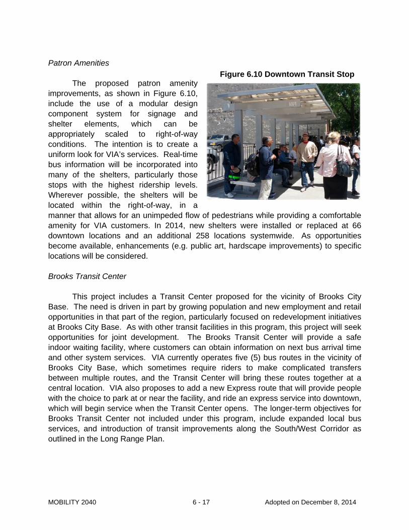
Patron Amenities
The proposed patron amenity improvements, as shown in Figure 6.10, include the use of a modular design component system for signage and shelter elements, which can be appropriately scaled to right-of-way conditions. The intention is to create a uniform look for VIA’s services. Real-time bus information will be incorporated into many of the shelters, particularly those stops with the highest ridership levels. Wherever possible, the shelters will be located within the right-of-way, in a manner that allows for an unimpeded flow of pedestrians while providing a comfortable amenity for VIA customers. In 2014, new shelters were installed or replaced at 66 downtown locations and an additional 258 locations systemwide. As opportunities become available, enhancements (e.g. public art, hardscape improvements) to specific locations will be considered. Brooks Transit Center
This project includes a Transit Center proposed for the vicinity of Brooks City Base. The need is driven in part by growing population and new employment and retail opportunities in that part of the region, particularly focused on redevelopment initiatives at Brooks City Base. As with other transit facilities in this program, this project will seek opportunities for joint development. The Brooks Transit Center will provide a safe indoor waiting facility, where customers can obtain information on next bus arrival time and other system services. VIA currently operates five (5) bus routes in the vicinity of Brooks City Base, which sometimes require riders to make complicated transfers between multiple routes, and the Transit Center will bring these routes together at a central location. VIA also proposes to add a new Express route that will provide people with the choice to park at or near the facility, and ride an express service into downtown, which will begin service when the Transit Center opens. The longer-term objectives for Brooks Transit Center not included under this program, include expanded local bus services, and introduction of transit improvements along the South/West Corridor as outlined in the Long Range Plan.
Figure 6.10 Downtown Transit Stop

MOBILITY 2040 6 - 18 Adopted on December 8, 2014
Stone Oak Park & Ride
The communities adjacent to US 281 north of Loop 1604 represent one of the fastest growing areas in Bexar County. This area also has some of the highest household transportation costs in the region due to the average length of commutes by residents in the vicinity. A new Park & Ride facility offers residents the choice to relieve some of that expense by choosing to use transit to make longer daily commutes. This project offers a more convenient option for existing and potential riders, and for VIA, provides the ability to invest in expanded services for the area. The project was initially slated to be a two phased project, but with the recent influx of $15 million in Surface Transportation Program and Metropolitan Mobility (STP-MM) funds from the MPO, VIA now is able to construct the full build-out of the complete project. The project is a 4-Level Parking Garage with a Transit Facility on the ground level as shown in Figure 6.11. The facility also has a ramp that will allow for direct access to the Managed Lanes being constructed with the expansion of US 281 by the Alamo Regional Mobility Authority (RMA) and Texas Department of Transportation (TxDOT). The project has an area for joint development which will be developed in a subsequent phase. VIA staff is in close coordination with both the RMA and TxDOT to ensure both projects complement each other.
Figure 6.11 Stone Oak Park & Ride Rendering

MOBILITY 2040 6 - 19 Adopted on December 8, 2014
Robert Thompson Transit Center
The Robert Thompson Transit Station facility was originally designed to accommodate special event transit service for attendees at the Alamodome. The future plan is to transform the Transit Station into a full service multimodal Transit Center, serving as a transfer location for daily transit service, special events service, and be known in the future as the Robert Thompson Transit Center (RTTC). In addition to the required transit operations on VIA property, there is an opportunity for prospective developers to propose a larger transit oriented development (TOD) project to be located above the station and/or on nearby parcels. Upgrades are planned for pedestrian facilities along Montana Street, in order to accommodate customer transfer activity and the increased foot traffic. Specific improvements include updates to the exhaust ventilation system, real-time bus arrival information, an indoor conditioned waiting area, and landscaping and pedestrian amenity upgrades. In the future, Primo service and accommodations for future rail transit service will provide for additional connections to/from the eastside and Downtown. Naco Pass Transfer Center
Naco Pass has been an area that has become an unofficial transfer location for VIA passengers. Due to the current activity at the on street locations, VIA is seeking to provide passengers with more amenities on a permanent site. VIA staff is working to identify the optimal site to accommodate the 1,430 daily passengers, and then will proceed with due diligence. Possible passenger amenities include interior waiting area, security, restroom facilities, automatic ticket vending machines, real time bus arrivals, and public art. Five Points Transfer Center
In order to serve the high passenger volume at the Five Points location (Fredericksburg Road/Cypress/Flores Street/Laredo Street intersection) VIA acquired the adjacent parcel in July 2014. The enhanced Five Points development will include four (4) next generation shelters, improved pedestrian and bicyclist access, and bicycle storage. Potential long term plans for the development include ticket vending machines (TVM), long term bicycle storage, a B-Cycle station, a shaded Plaza, additional paving, additional benches and picnic tables, public art, and enhanced low maintenance landscaping.

MOBILITY 2040 6 - 20 Adopted on December 8, 2014
IH 10 West Park and Ride
The proposed IH 10 West facility, as identified in the LRCTP, will serve as a collector to serve commuters coming from outlying cities such as Boerne and Fair Oaks Ranch and north/west counties such as Kendall, Kerr, Gillespie and potentially portions of Comal and Bandera. This planned facility will have major connections to other activity centers such as the South Texas Medical Center, UTSA, the San Antonio central business district, and the greater airport area; and support the other major activity centers identified as a part of the City of San Antonio’s Comprehensive Plan development. SH 151 Park and Ride
The proposed SH 151 Park and Ride facility, as identified in the LRCTP, is proposed to serve commuters originating in the western suburbs destined for the San Antonio central business district; and positioned to tie in to service major activity centers. This facility will potentially serve routes 64 US 90 Express and 65 Lackland AFB/USO Express, as well as other possible metro routes. The site selection process will include studying sites near the Loop 1604 and SH 151 area in order to study opportunities of commuters traveling from the area and providing reliable trips on the managed lanes to the San Antonio central business district. Northeast Park and Ride
The proposed park and ride, as identified in the LRCTP, will help reduce congestion along the IH 35 corridor. The study area for this facility falls within the boundary of an emerging activity center as identified by the City of San Antonio in their work done for the Comprehensive Plan. These areas were identified in the Comprehensive Planning process as major activity centers and have experienced tremendous growth in recent years making travel demand greater in the area. The Northeast facility will also have access to the managed lanes along Loop 1604 and IH 35 South which will make it attractive to users’ travel needs as congestion continues to grow. South/West Corridor Transit Improvements
As identified in the LRCTP, VIA is conducting a study on the south/west corridor. The corridor study area includes SW Military Drive from IH 37 on the east to General McMullen Drive/Bynum on the west; and General McMullen Drive/Bynum and Zarzamora Street from Military Drive on the south to Babcock/Fredericksburg Road on the north. This corridor improvement will use the South Texas Medical Transit Center and the future Brooks Transit Center as end of line destinations for passengers. The

MOBILITY 2040 6 - 21 Adopted on December 8, 2014
Plan will recommend a set of PRIMO bus service and capital improvements in segments of the corridor. The implementation plan is a financially constrained plan and will include design elements and technical specifications that will guide the implementation of the project leading up to the launch of service. VIA has been coordinating with our current riders and potential new riders, the MPO, the City of San Antonio and other stakeholder and community groups on the project. The objectives of the improvements are to improve the quality and convenience of existing transit service to meet current and future travel needs, attract new riders, and support sustainable growth and development in the corridor. High Capacity Transit
The LRCTP identified a number of High Capacity Transit corridors for implementation by the year 2035. Funding is allocated to provide flexibility with developing the appropriate investment. All of the transit technologies represented in the LRTCP will continue to be explored, to maximize the investment. Level of Public Investment: Transit Financial Forecast
Financial projections through 2040 show that sources of transit funds are essentially equal to uses of funds, as shown in Table 6.2. Sales taxes account for more than 70% of VIA’s funding. VIA receives sales taxes totaling 5/8-cent per dollar (1/2-cent MTA tax and a 1/8-cent share of the Advanced Transportation District tax); peer transit agencies in Houston, Dallas, and Austin all receive the full 1-cent tax. The uses of funds figures show that operating expenses account for 78% of total uses, with capital expenditures and related debt service accounting for the remaining amount.
Recently, VIA began utilizing debt to finance some capital projects, so that transit benefits can be delivered to the community more quickly. VIA will be using debt to finance transit facility projects and the replacement of its bus fleet over the next several years. VIA will also be replacing diesel-powered buses with buses powered by compressed natural gas.
VIA’s financial projections reflect the agency continuing to remain a very cost-efficient organization. VIA’s cost per hour for delivering bus service is lower than that of most peer agencies, in some cases by 25% or more. VIA has received a variety of awards in recent years recognizing the dedication and commitment of the agency’s employees.
VIA is committed to continue seeking additional funding so that services to a rapidly growing community can be expanded. VIA actively pursues various federal and other grant opportunities, and has been successful in the past at competing for

MOBILITY 2040 6 - 22 Adopted on December 8, 2014
discretionary grants. “Formula funds” (grant apportionments) that VIA receives have been included in financial projections. Discretionary grant awards are not as predictable, have been greatly reduced by the federal government in recent years, and are not reflected.
Table 6.2 VIA Financial Projections

MOBILITY 2040 6 - 23 Adopted on December 8, 2014
Lone Star Rail District
Lone Star Rail District (LSRD) is an independent special district authorized by the Texas Legislature. The Rail District encompasses five counties — Bexar, Comal, Hays, Travis and Williamson — and the cities of San Antonio, Schertz, New Braunfels, San Marcos, Austin and Georgetown. The Rail District’s governing board of 20 members includes elected and appointed officials from those counties and cities as well as representatives of the Alamo Area and Capital Area Metropolitan Planning Organizations (AAMPO and CAMPO), local transportation providers, and the San Antonio and Austin business communities.
The Lone Star Rail passenger rail project is a key initiative to help alleviate the congestion and safety problems on IH 35 due to extraordinary population growth and increased NAFTA traffic. The locally preferred alternative—adopted in 2005 by the Rail District Board as well as the Austin and Alamo Area MPOs—is a 112-mile regional passenger rail system located in the existing Union Pacific rail corridor for most of its length. Fifteen stations are planned along the route, which is anchored by the Austin and San Antonio metropolitan areas with additional stations in Schertz, New Braunfels, San Marcos, Kyle/Buda, Round Rock and Georgetown. A 16th station in south San Antonio is being studied in the environmental clearance process which is currently underway.
Intercity rail service will offer relaxing, stress-free travel that allows riders the freedom to make the most of their travel time by studying, working, or simply enjoying the scenery. Travel times will be competitive with, if not faster than, travel by automobile; but the key element is that rail travel is predictable and dependable, while accidents, weather conditions, and other variables can often cause unexpected delays for drivers.
Significant technical work has been completed for the regional passenger rail project, including: conceptual engineering, alternatives analysis, station location studies, station economic impact analyses, capital and operating cost estimates, operating plans, ridership studies, and financial and economic benefits studies.
In October 2010, Lone Star Rail and Union Pacific Railroad (UPRR) executed a
Memorandum of Understanding that states the Rail District and UPRR will study the feasibility of relocating UPRR’s through freight to a new route. If an appropriate route is identified, UP will consider moving its “through” freight, which makes up the bulk of the freight traffic, to a new line in exchange for the existing freight line. In November 2010, the Rail District launched the initial study in the freight rail relocation effort—a fatal flaw analysis of alternative routes for the through freight. UPRR’s local freight will remain on the existing mainline, but the relocation of UPRR’s through-freight operations will allow

MOBILITY 2040 6 - 24 Adopted on December 8, 2014
the Rail District to provide passenger rail service on the existing mainline. The Lone Star Rail District believes this project to:
Improve mobility throughout the Austin-San Antonio Corridor Provide a predictable, reliable travel choice Divert trucks from IH 35 to new freight bypass, thus improving speed and
efficiency of NAFTA trade flows Improve safety in the IH 35 corridor Maintain air quality status (Austin and San Antonio both near-non-attainment
areas) Create a regional, seamless, multi-modal transportation system
Texas-Oklahoma Passenger Rail Study
The Texas-Oklahoma Passenger Rail Study (TOPRS) is an evaluation of a range of passenger rail service options in an 850-mile corridor from Oklahoma City to South Texas. The study began in 2013 and is expected to conclude by the end of 2014. It will document the costs, benefits and impacts of potential rail service alternatives compared to a no-build alternative in a service-level environmental impact statement (EIS).
This rail corridor, shown in Figure 6.12, could potentially be a high-speed rail corridor and could complement the aforementioned commuter rail system as a whole. The study will consider the corridor as a whole, as well as three discrete portions of the corridor:
Northern: Oklahoma City to Dallas/Fort Worth Central: Dallas/Fort Worth to San Antonio Southern: San Antonio to Rio Grande Valley/Corpus Christi/Laredo

MOBILITY 2040 6 - 25 Adopted on December 8, 2014
Figure 6.12 Texas-Oklahoma Passenger Rail Study

MOBILITY 2040 6 - 26 Adopted on December 8, 2014
Conclusion
In the past five years, VIA has opened two new major transit centers connecting the region’s largest employment centers - the Westside Multimodal Transit Center and the South Texas Medical Center Transit Center, and implemented the region’s first high-capacity transit line, VIA Primo/BRT on the Fredericksburg Road corridor. In addition, VIA has updated its fleet with new all-electric vehicles, low-emission, low-floor, bicycle accessible, wheel-chair accessible buses, and in total has accumulated a fleet that’s 33% non-diesel. With an unprecedented local public involvement campaign, VIA completed the Long Range Comprehensive Transportation Plan for 2035 - SmartWaySA. The Plan established an integrated blueprint for future high capacity transit options, new facilities and bus service enhancements throughout the region and enhanced bus service options. VIA forged new partnerships with local partners and was successful in some obtaining federal grant awards to fund new innovative projects in the region - SmartMove. VIA has developed a joint development program in an effort to explore opportunities with the private sector for mixed-use development at locations where higher densities can be appropriate and can support live, work and play opportunities. In addition, VIA has developed a public art program for integration into capital projects to enhance the customer experience at their facilities.
Despite these numerous accomplishments, public transportation is still not a mode of choice among most commuters in the metropolitan area. Land development patterns, the lack of an accessible pedestrian system, the relatively low cost of owning and operating a vehicle, and limited transit options continue to make travel by automobile the preferred mode of choice.
However, future scenarios indicate, that by the year 2040, increases in
population and employment, as well as the regional costs associated with increased congestion, reduced air quality and water sources, will affect an increase in demand for public transportation services. Financial projections through 2040 show that current revenue sources are insufficient to meet any public transportation demand beyond that currently experienced. It is evident that new, creative and non-traditional revenue sources are needed to guarantee that increased public transportation service and modes will continue to play a vital role in the regional economy as San Antonio continues to establish itself as a desirable location for high-tech and creative class opportunities, and compete on a national scale.