6 - alternatives of alternatives this chapter contains the following sections: 6.1 approach to...
TRANSCRIPT

EBMUD WTTIP 6-1 ESA / 204369 Environmental Impact Report June 2006
CHAPTER 6 Analysis of Alternatives
This chapter contains the following sections:
6.1 Approach to Analysis and Overview 6.2 No Project Alternative 6.3 Membrane Filtration Alternative 6.4 Modified Orinda WTP Site Plan 6.5 Lafayette Reclaimed Water Pipeline Alternative 6.6 Highland Reservoir Alternative Site 6.7 Moraga Road Pipeline Alternative 6.8 Happy Valley Pumping Plant Alternative Site 6.9 Tice Pumping Plant Alternative Site 6.10 Alternatives Screening Process and Alternatives Eliminated from Consideration 6.11 Comparison of Alternatives
6.1 Approach to Analysis and Overview Chapters 2 through 5 of this environmental impact report (EIR) present detailed evaluations of Alternative 1 – Supply from Orinda and Lafayette WTPs (the preferred alternative) and Alternative 2 – Supply from the Orinda WTP. This chapter (Chapter 6) describes and evaluates other alternatives to the Water Treatment and Transmission Improvements Program (WTTIP) (including the required No Project Alternative), describes the alternatives screening process and alternatives eliminated from consideration, and compares the environmental merits of the alternatives.
The California Environmental Quality Act (CEQA) Guidelines require EIRs to describe and evaluate a reasonable range of alternatives to a project, or to the location of a project, which would feasibly attain most of the basic project objectives and avoid or substantially lessen significant project impacts. The CEQA Guidelines, Section 15126.6, set forth the following criteria for alternatives:
Identifying Alternatives. The range of alternatives is limited to those that would avoid or substantially lessen any of the significant effects of the project, are feasible, and would attain most of the basic objectives of the project. Factors that may be considered when addressing the feasibility of an alternative include site suitability, availability of infrastructure, general plan consistency, other plans or regulatory limitations, jurisdictional boundaries, economic viability, and whether the proponent can reasonably acquire, control, or otherwise have access to an alternative site. An EIR need not consider an alternative whose impact cannot be reasonably ascertained and whose implementation is remote and speculative. The specific alternative of “no project” must also be evaluated along with its impact.

6. Analysis of Alternatives
EBMUD WTTIP 6-2 ESA / 204369 Environmental Impact Report June 2006
Range of Alternatives. An EIR need not consider every conceivable alternative, but must consider a reasonable range of alternatives that will foster informed decision-making and public participation. The “rule of reason” governs the selection and consideration of EIR alternatives, requiring that an EIR set forth only those alternatives necessary to permit a reasoned choice. The lead agency (EBMUD) is responsible for selecting a range of project alternatives for examination and must publicly disclose its reasons for selecting those alternatives.
Evaluation of Alternatives. EIRs are required to include sufficient information about each alternative to allow meaningful evaluation, analysis, and comparison with the project. Matrices may be used to display the major characteristics of each alternative and environmental effects of each alternative. If an alternative would cause one or more significant effects not caused by the project as proposed, the significant effects of the alternative must be discussed but in less detail than the significant effects of the project.
The WTTIP is the result of a six-year planning effort that entailed consideration of over 60 alternatives. Sources of alternatives to be considered included background reports prepared for the WTTIP (described in Section 6.10), suggestions made in responses to the notice of preparation (NOP) and at public meetings held for the WTTIP, and EIR preparers (based on the environmental impacts described in Chapter 3). Table 6-1 lists the alternatives considered, indicates whether the alternatives are evaluated in the EIR or were eliminated, and the source of the alternative. Numerous alternatives were eliminated from consideration based on inability to meet most of the project’s basic objectives, infeasibility, or inability to reduce the project’s environmental impacts. Those alternatives retained for consideration (in addition to Alternatives 1 and 2) are presented in Sections 6.3 through 6.9. The alternatives screening process, alternatives eliminated and the reasons for their elimination are discussed in Section 6.10.
The information contained in this EIR will be reviewed and considered by the East Bay Municipal Utility District (EBMUD) Board of Directors prior to the ultimate decision to approve, disapprove, or modify the project. As part of its deliberations, the Board of Directors will decide whether to approve all or part of Alternative 1 or 2, or whether to defer action on some elements. The Board could adopt one of the alternatives described in Sections 6.3 through 6.9 in lieu of a proposed project. For each alternative evaluated in the EIR, the Board will adopt findings concerning its feasibility and environmental merits based on the contents of this EIR and the administrative record.
6.2 No Project Alternative
6.2.1 Description Under the No Project Alternative, the proposed project would not be implemented. None of the proposed facility improvements described in Chapter 2 would occur.
6.2.2 Environmental Impacts If the WTTIP were not implemented, none of the needs for the project would be achieved, and none of the benefits associated with the project would occur. The WTTIP responds to a variety of needs, summarized as follows and detailed in Section 2.2 of Chapter 2:

6. Analysis of Alternatives
a Includes alternatives suggested in responses to the Notice of Preparation, alternatives suggested at public meetings, alternatives developed by Jacobs Associates for the Orinda-Lafayette Aqueduct, and alternatives developed by EBMUD and EIR preparers. EBMUD WTTIP 6-3 ESA / 204369 Environmental Impact Report June 2006
TABLE 6-1 SUMMARY OF ALTERNATIVES CONSIDERED
Evaluated or Eliminated? Source
Proposed Project/Alternative Evaluated in EIR
Chapters 2–5 Evaluated in EIR
Chapter 6
Eliminated (see Section 6.10
for reasons)
Lamorinda Facilities
Plan
Pressure Zone Planning
Program Studies Othera
ALTERNATIVES INVOLVING WATER TREATMENT PLANTS
Alternative 1 – Supply from Orinda and Lafayette WTPs x x Alternative 2 – Supply from Orinda WTP x x Alternative 3 – Supply from Walnut Creek WTP X x Alternative 4 – Supply from Lafayette and Orinda WTPs X x Alternative 5 – Supply from Lafayette and Walnut Creek WTPs X x Al
terna
tives
Inv
olving
Sy
stem
wide
Ch
ange
s
Alternative 6 – Supply from Orinda and Walnut Creek WTPs X x Membrane Filtration Alternative (Lafayette WTP) x X Relocate Orinda WTP to Scow Canyon X X Relocate Orinda WTP near Briones Dam X X Eliminate Transmission of Treated Water to West of Hills from Orinda WTP X X Expand Lafayette WTP and Decommission Orinda WTP X X Continued Use of West of Hills Reservoirs as Remote Clearwell Storage X X Modified Orinda WTP Site Plan x X Alternative Haul Routes to and/or from the Walnut Creek WTP X X Leland Pumping Plant No. 2 – Proposed Site at Walnut Creek WTP x x Leland Pumping Plant No. 2 – North California Boulevard x X Leland Pumping Plant No. 2 – northwest of South Broadway/Newell Avenue x X Ot
her W
ater
Tre
atm
ent P
lant
Impr
ovem
ent A
ltern
ative
s
Leland Pumping Plant No. 2 – southeast of South Broadway/Newell Avenue x X Orinda–Lafayette Aqueduct – Proposed Route x X Conversion of Existing Lafayette Aqueduct No. 1 x X Modified Long Tunnel Alignment x X Full Length Tunnel Alignment x X Or
inda
–La
faye
tte
Aque
duct
Long Tunnel Alignment Alternative x X
DISTRIBUTION SYSTEM PROJECTS/ALTERNATIVES
Fay Hill Pumping Plant Proposed Project x x New pumping plant near St. Mary’s Road/Rheem Boulevard, Moraga x x
Fay Hill Reservoir Proposed Project x x Construction of a single tank in existing reservoir basin x x Rehabilitation of the existing reservoir’s liner x x
Glen Pipeline Improvements and Reservoir Decommission Proposed Project x x Replace reservoir and construct pipeline improvements x x

6. Analysis of Alternatives
TABLE 6-1 (Continued) SUMMARY OF ALTERNATIVES CONSIDERED
EBMUD WTTIP 6-4 ESA / 204369 Environmental Impact Report June 2006
Evaluated or Eliminated? Source
Proposed Project/Alternative Evaluated in EIR
Chapters 2–5 Evaluated in EIR
Chapter 6
Eliminated (see Section 6.10
for reasons)
Lamorinda Facilities
Plan
Pressure Zone Planning
Program Studies Othera
Happy Valley Pumping Plant and Pipeline Proposed Project (previously known as Site 3) x x Expand Sleepy Hollow, Valory and Las Aromas Pumping Plants x x Build Proposed Project with More Capacity x x Site 1 – Pumping Plant eastern portion of 42 Haciendas Road parcel x x Site 2 – Pumping Plant at 1 Miner Road x x
Lafayette Reclaimed Water Pipeline Proposed Project x X Alternative – Package Plant at Lafayette WTP x X
Highland Reservoir and Pipelines Proposed Project (previously known as Site 9) x x Reservoir Site North of Proposed Site x X Site 1 – Lafayette Reservoir Recreation Area east of the dam x x Site 2 – west of Moraga Road, Lafayette x x Site 3 – east of Moraga Road, Lafayette x x Site 4 – east of Moraga Road, Lafayette x x Site 5 – east of Moraga Road, Lafayette x x Site 6 – east of Saint Mary's Drive, Lafayette x x Site 7 – Caltrans property north of Highway 24 x x Site 8 – near end of Crestmont Drive x x
Sunnyside Pumping Plant Proposed Project (previously known as Site 2) x x Site 1 – Sundown Terrace, Orinda, x x Site 3 – northwest of proposed site, Orinda. x x Site 4 – Honeywood Road, Orinda x x
Tice Pumping Plant and Pipeline Proposed Project (previously known as Site 3) x x Site 1 – Pumping Plant southeast of Tice Valley Boulevard/Olympic Boulevard x x Site 2 – Pumping Plant north of Olympic Boulevard x x Site 4 –Pumping Plant near Boulevard Way/Boulevard Court x x
Withers Pumping Plant Proposed Project (at Grayson Reservoir, previously known as Site 1) x x Site 2 –Pumping Plant at portion of 1024 Grayson Road, Contra Costa County x x Site 3 – Pumping Plant at parcel subdivided from 3182 Withers Avenue, Contra Costa
County x x New Leland Pressure Zone Reservoir (Program-Level Project)
Proposed Project (previously known as Site 3) x x Site 1 – near Craddock Court and Summit Road, Walnut Creek. x x Site 2 – in Shell Ridge Open Space, Walnut Creek x x Site 4 – near Cielo Via and Arbol Via, Walnut Creek and Contra Costa County x x Site 5 – at East Bay Regional Park District parcel, Lafayette x x Site 6 – northwest of Highway 24/I–680 interchange, Contra Costa County, Walnut Creek x x Site 7 – south of Olympic Boulevard, Contra Costa County x x

6. Analysis of Alternatives
EBMUD WTTIP 6-5 ESA / 204369 Environmental Impact Report June 2006
Meeting future regulatory standards related to water quality Complying with permit conditions Meeting existing and future water demands Improving aging infrastructure Correcting hydraulic constraints
The District is obligated to comply with water quality regulations and permit conditions and to provide adequate water service to its customers. Consequently, if the WTTIP were not implemented, EBMUD would have to implement other strategies to meet these needs (where other strategies exist). Such strategies could include implementing some of the alternatives listed later in this chapter which were considered and rejected. As explained in this chapter, implementation of these alternatives would generate environmental impacts and would take multiple years to implement.
In the meantime, EBMUD would continue to operate the system as it does today. The current supply and hydraulic deficiencies will result in water shortages, reduced customer service pressure, and reduced fire fighting capacity during peak summertime demand periods. Existing problems, such as system capacity deficiencies in the Walnut Creek/Lamorinda area during peak-use periods (summer) would persist and worsen over time. Without additional water treatment, storage, pumping, and pipeline transmission capacities provided by the project, the service areas will experience water shortages during summer and reduced customer service pressure, possibly requiring that the District impose water rationing even under nondrought conditions and constraining the amount of water available for emergencies. These water shortages would occur due to a lack of treatment and distribution capacity, not a lack of water supply. This condition could become worse with planned growth in the area if no system improvements were made. At the Orinda Water Treatment Plant (WTP), discharges of backwash water to San Pablo Creek would continue and periodic violations of the WTP’s National Pollution Discharge Elimination System (NPDES) permit would continue. If the project were not implemented, infrastructure problems at the Lafayette WTP plant would continue, impairing the reliability of water service to the Lamorinda area. The District would also have an increased potential for future non-compliance with disinfection by-products and surface water treatment rules.
6.3 Membrane Filtration Alternative
6.3.1 Description This alternative involves modifications to Alternative 1 to incorporate a different water treatment technology, membrane filtration,1 at the Lafayette WTP. Since much of the Lafayette WTP would be reconstructed under Alternative 1, there is an opportunity to consider whether a different treatment technology that would reduce environmental impacts could be implemented at the plant
1 The U.S. Environmental Protection Agency defines membrane filtration as a pressure- or vacuum-driven separation
process in which particulate matter larger than 1 micron is rejected by an engineered barrier, primarily through a size exclusion mechanism, and which has a measurable removal efficiency of a target organism (e.g., cryptosporidium). The definition includes the following membrane processes used in drinking water treatment: microfiltration, ultrafiltration, nanofiltration, and reverse osmosis.

6. Analysis of Alternatives
EBMUD WTTIP 6-6 ESA / 204369 Environmental Impact Report June 2006
while also reducing environmental impacts. (Lafayette WTP is also the only plant where full-scale replacement of filtration and other treatment processes implementation of the would be cost-effective.) The U.S. Environmental Protection Agency (U.S. EPA) has determined that membrane filtration is one of several effective strategies to remove cryptosporidium and other microbial pathogens from drinking water, consistent with the Long Term 2 Enhanced Surface Water Treatment Rule. The typical filtration process used at most water treatment plants (and all of EBMUD’s plants) works as follows: coagulated water flows by gravity through a granular filter media (e.g., layers of sand and anthracite) and particles get trapped. Membrane filtration works by forcing raw water through extremely small hollow fiber membrane filters assembled in cartridges. The number of treatment plants in the U.S. that use membrane filtration to produce drinking water is not known but several exist, including a similarly sized facility in Valley Home, California.
Figure 6-1 shows the proposed WTP layout for the Lafayette WTP under the Membrane Filtration Alternative. The demand capacity of the Lafayette WTP would be the same as proposed under Alternative 1 (34 million gallons per day [mgd]). Improvements at all other WTPs would be the same as those proposed under Alternative 1. This alternative would involve less construction than under Alternative 1: fewer changes would be needed to the existing backwash water handling facilities; the existing filters would not be rehabilitated; only one clearwell would be needed; and no new chemical feed building or chlorine contact basin would be constructed. The Leland and Bryant Pumping Plant layouts and pipelines and the raw water bypass would be the same as under Alternative 1. Design elements of the membrane filtration system are described below.
The existing water treatment plant process flow train is shown in Figure 2-8 in Chapter 2. Under this alternative, the membrane filtration plant would use a two-stage, low-pressure ultrafiltration membrane system. The first stage would treat the raw water and remove particulate and microbiological contaminants and would require no process chemicals. The membrane cartridges would be pulse-backwashed with a combination of air and water every few minutes. Next, the backwash water would be treated by a second-stage membrane system. The backwash water from the second-stage membranes would then be discharged to the existing backwash water equalization basin. The existing Lafayette WTP backwash system would generally be sufficient to treat the backwash water from the second stage membrane filtration system; modifications that would be needed include an ultraviolet disinfection system and replacement of existing pumps and piping to route the recycled backwash water to the head of the plant. A new building would be constructed to house the membrane plant, as shown on Figure 6-1. The building would be 25 feet above grade and 15 feet below grade. The existing sodium hypochlorite storage and feed systems would be replaced and modified in the existing chemical building.
The existing clearwell at the Lafayette WTP would be replaced with one new clearwell at the west end of the plant. (Under Alternative 1, two new clearwells [operational capacities of 4.0 and 2.0 million gallons] would be constructed; the membrane filtration system would reduce the amount of treated water storage capacity needed.) The clearwell would be partially buried, with 25 feet above grade (as opposed to the clearwells proposed under Alternative 1, which would be buried). As under Alternative 1, a new clearwell overflow discharge pipe between the clearwell and Lafayette Creek would be constructed for emergency use only.

VALVE STRUCTURE
VALVESTRUCTURE
VALVESTRUCTURE
ULTRAVIOLETDISINFECTION
BUILDING
MORAGA ROADPIPELINE
LAFAYETTERECLAIMED WATER
PIPELINE
HIGHLANDRESERVOIR PIPELINE
STOCK PILE
AREA
EIR PROJECT LEVELANALYSIS
EIR PROGRAM LEVELANALYSIS
30” LELANDPIPELINE
36” BRYANTPIPELINE
LELAND
PUMPING
PLANT
BRYANT
PUMPING
PLANT
CLEARWELL
ELECTRICAL
SUBSTATION
MEMBRANE BUILDING
M T. D I A B L O B O U L E V A R D
EBMUD Water Treatment and Transmission Improvements Program . 204369
Figure 6-1Membrane Filtration Alternative
SOURCE: EBMUD
0 100
Feet

6. Analysis of Alternatives
EBMUD WTTIP 6-9 ESA / 204369 Environmental Impact Report June 2006
There would be numerous changes to piping within the site, and a new electrical substation would be constructed. The substation would be configured to supply the added power needs associated with membrane filtration processes.
While the duration of construction of the Membrane Filtration Alternative has not been determined, it would be less than under Alternative 1 (four to six years) because construction would be less extensive.
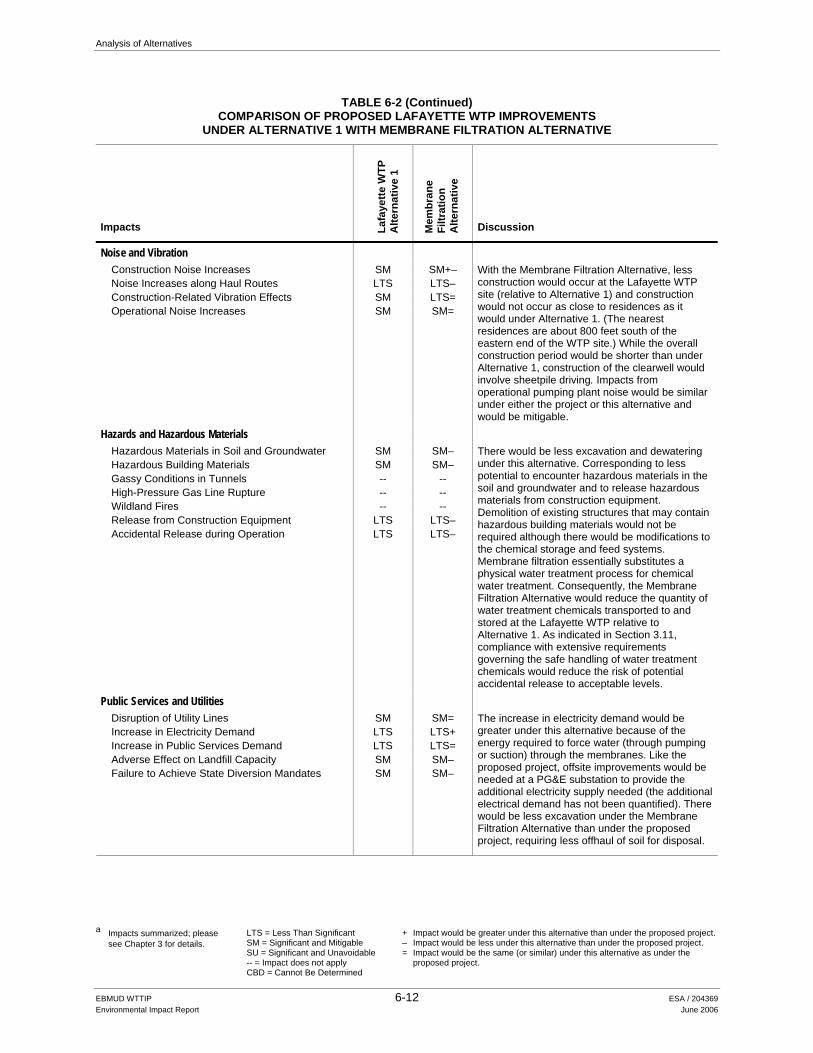
6.3.2 Environmental Impacts Table 6-2 compares the impacts of implementing Alternative 1 at the Lafayette WTP to those of implementing the Membrane Filtration Alternative. Overall, the Membrane Filtration Alternative is considered environmentally superior to the upgrades proposed at the Lafayette WTP under Alternative 1.
The magnitude of numerous impacts would be less under the Membrane Filtration Alternative than under Alternative 1, although there would be no change in the significance designation of any impacts. Some impacts related to hydrology and water quality, traffic and circulation, air quality, noise along haul routes, and solid waste disposal would be less because there would be less excavation and fewer total truck trips. There would be fewer protected trees removed under the Membrane Filtration Alternative, although the construction of above-ground structures (the clearwell and the membrane filtration building—both would be about 25 feet above ground) could be incrementally more visible in views from Mt. Diablo Boulevard than structures proposed under Alternative 1 until replacement trees and landscaping at pipe crossings of Lafayette Creek mature.
Impacts related to long-term demand for electricity would be greater under this alternative than under Alternative 1 (but still less than significant) because the Membrane Filtration Alternative would consume more power than conventional filtration. With respect to noise, while the overall construction period would be shorter, construction of the clearwell would require sheetpile driving, which would be more disruptive than conventional shoring to residents and other sensitive receptors. Implementation of Measure 3.10-1a would reduce the duration of pile-driving by requiring predrilling.
There are few large water treatment plants using this water treatment technology in the US, but its usage has been increasing for several years. EBMUD has only limited experience with membrane treatment via a very small package plant unit serving a few buildings at the Pardee Reservoir. The technology has not been investigated or pilot-tested by EBMUD for use at its large water treatment plants. Testing of the alternative treatment technology would require a year or more; the California Department of Health Services would need to review and approve the pilot test results. EBMUD will defer consideration of the Membrane Filtration Alternative until this technology is more fully investigated. If Alternative 1 is selected, membrane technology may be reviewed at the predesign stage of the project.

Analysis of Alternatives
a Impacts summarized; please
see Chapter 3 for details. LTS = Less Than Significant SM = Significant and Mitigable SU = Significant and Unavoidable -- = Impact does not apply CBD = Cannot Be Determined
+ Impact would be greater under this alternative than under the proposed project. – Impact would be less under this alternative than under the proposed project. = Impact would be the same (or similar) under this alternative as under the
proposed project.
EBMUD WTTIP 6-10 ESA / 204369 Environmental Impact Report June 2006
TABLE 6-2 COMPARISON OF PROPOSED LAFAYETTE WTP IMPROVEMENTS
UNDER ALTERNATIVE 1 WITH MEMBRANE FILTRATION ALTERNATIVE
Impacts Lafa
yette
WTP
A
ltern
ativ
e 1
Mem
bran
e Fi
ltrat
ion
A
ltern
ativ
e
Discussion
Land Use, Planning, and Recreation Divide an Established Community -- -- Agricultural Resources Impacts -- -- Recreation Resources Impacts LTS LTS=
Like Alternative 1, this alternative would not result in any significant land use impacts. The Walter Costa Trail would be relocated as proposed under Alternative 1.
Visual Quality Short-Term Visual Effects during Construction LTS LTS= Alteration of Appearance of WTTIP Sites SM SM+ Effects on Views SM SM= Effects on Scenic Vistas LTS LTS= New Sources of Light and Glare SM SM=
This alternative would significantly alter the appearance of the Lafayette WTP. Although fewer trees would be removed relative to Alternative 1, two additional above-ground structures—the clearwell and the membrane filtration building—would be constructed. The height above grade of both structures would be approximately 25 feet, which is similar to the height of the pumping plants depicted in the visual simulations (Figures 3.3-LWTP-5 through 3.3-LWTP-8 in Section 3.3). These structures would likely be partially or wholly screened by the pumping plants and intervening vegetation in the viewpoints depicted in the simulations (the Walter Costa trail west of the plant and Highway 24). Tree loss associated with pipeline construction across Lafayette Creek could open up new views of these facilities from Mt. Diablo Boulevard. The measures identified to mitigate impacts associated with Alternative 1 could likewise reduce visual impacts at the Lafayette WTP under the Membrane Filtration Alternative to a less-than-significant level.
Geology, Soils, and Seismicity Slope Stability LTS LTS= Groundshaking SM SM= Expansive Soils SM SM= Liquefaction SM SM= Squeezing Ground -- --
The issues related to slope stability, groundshaking, and soil characteristics would be similar under Alternative 1 and the Membrane Filtration Alternative (and could be similarly mitigated).
Hydrology and Water Quality Degradation of Water Quality during Construction SM SM– Groundwater Dewatering LTS LTS– Diversion of Flood Flows -- -- Discharge of Chloraminated Water during
Construction LTS LTS=
Operational Discharge of Chloraminated Water LTS LTS– Change in Impervious Surfaces LTS LTS–
Surface water quality issues would be similar under Alternative 1 and the Membrane Filtration Alternative. Less excavation, stockpiling, and grading would occur adjacent to Lafayette Creek under the Membrane Filtration Alternative, incrementally lessening the likelihood of erosion and sedimentation. There would be less dewatering under this alternative because excavation would be shallower and less extensive than under Alternative 1. There would be less discharge of chloraminated water because there would be only one clearwell and less use of sodium hypochlorite generally. Less new impervious surfaces would be created.

Analysis of Alternatives
a Impacts summarized; please
see Chapter 3 for details. LTS = Less Than Significant SM = Significant and Mitigable SU = Significant and Unavoidable -- = Impact does not apply CBD = Cannot Be Determined
+ Impact would be greater under this alternative than under the proposed project. – Impact would be less under this alternative than under the proposed project. = Impact would be the same (or similar) under this alternative as under the
proposed project.
EBMUD WTTIP 6-11 ESA / 204369 Environmental Impact Report June 2006
TABLE 6-2 (Continued) COMPARISON OF PROPOSED LAFAYETTE WTP IMPROVEMENTS
UNDER ALTERNATIVE 1 WITH MEMBRANE FILTRATION ALTERNATIVE
Impacts Lafa
yette
WTP
A
ltern
ativ
e 1
Mem
bran
e Fi
ltrat
ion
A
ltern
ativ
e
Discussion
Biological Resources Loss of or Damage to Protected Trees SM SM– Degradation to Streams, Wetlands, and Riparian
Habitats SM SM–
Loss of or Damage to Special-Status Plants SM SM= Disturbance to Special-Status Birds SM SM= Disturbance to Special-Status Bats SM SM= Disturbance to San Francisco Dusky-Footed
Woodrat SM SM=
Degradation of Special-Status Aquatic Species Habitat
SM SM=
Disruption to Wildlife Corridors LTS LTS=
Impacts to protected trees would be reduced under the Membrane Filtration Alternative. Under Alternative 1, an estimated 15–25 oaks and riparian trees considered protected would be removed. Under the Membrane Filtration Alternative, fewer trees would be removed because no construction (or associated tree removal) would occur near the existing backwash water facilities, south of the Lafayette Aqueducts. Other impacts to biological resources would be similar to Alternative 1.
Cultural Resources Archaeological Resources, including Unrecorded
Cultural Resources SM SM=
Paleontological Resources SM SM= Historic Settings LTS LTS=
Like Alternative 1, excavation and grading activities near Lafayette Creek for the Membrane Filtration Alternative could result in the discovery of unrecorded resources. (The existing Bryant Pumping Plant, a potential historic resource at the Lafayette WTP, would be decommissioned but retained.)
Traffic and Circulation Increased Traffic SM SM– Reduced Road Width SM SM= Parking SM SM= Traffic Safety SM SM= Access -- -- Transit -- -- Pavement Damage/Wear LTS LTS–
Like Alternative 1, implementation of the Membrane Filtration Alternative would result in significant construction-phase traffic impacts related to increased traffic on local roadways, reduced road width (from construction of the Bryant and Leland Pipelines in Mt. Diablo Boulevard), parking, and traffic safety. The total number of truck trips for the Membrane Filtration Alternative would be less overall because excavation and construction would be less extensive than under Alternative 1.
Air Quality Construction Emission SM SM– Diesel Particulate Emissions along Haul Routes LTS LTS– Tunnel-Related Emissions -- -- Operational Pollutant Emissions at Treatment
Facilities LTS LTS=
Operational Odor Emissions LTS LTS= Secondary Emissions from Electricity Generation LTS LTS+
Short-term construction-related air quality impacts would be less under the Membrane Filtration Alternative relative to Alternative 1 because excavation and construction would be less extensive. The construction duration would be shorter than under Alternative 1 and total criteria air pollutant emissions and particulate would be less. Diesel particulate emissions along haul routes would also be less (and, like Alternative 1, less than significant). Secondary emissions from electricity generation would be greater than under Alternative 1 because the membrane filtration process is more energy-intensive.
Analysis of Alternatives
a Impacts summarized; please
see Chapter 3 for details. LTS = Less Than Significant SM = Significant and Mitigable SU = Significant and Unavoidable -- = Impact does not apply CBD = Cannot Be Determined
+ Impact would be greater under this alternative than under the proposed project. – Impact would be less under this alternative than under the proposed project. = Impact would be the same (or similar) under this alternative as under the
proposed project.
EBMUD WTTIP 6-12 ESA / 204369 Environmental Impact Report June 2006
TABLE 6-2 (Continued) COMPARISON OF PROPOSED LAFAYETTE WTP IMPROVEMENTS
UNDER ALTERNATIVE 1 WITH MEMBRANE FILTRATION ALTERNATIVE
Impacts Lafa
yette
WTP
A
ltern
ativ
e 1
Mem
bran
e Fi
ltrat
ion
A
ltern
ativ
e
Discussion
Noise and Vibration Construction Noise Increases SM SM+– Noise Increases along Haul Routes LTS LTS– Construction-Related Vibration Effects SM LTS= Operational Noise Increases SM SM=
With the Membrane Filtration Alternative, less construction would occur at the Lafayette WTP site (relative to Alternative 1) and construction would not occur as close to residences as it would under Alternative 1. (The nearest residences are about 800 feet south of the eastern end of the WTP site.) While the overall construction period would be shorter than under Alternative 1, construction of the clearwell would involve sheetpile driving. Impacts from operational pumping plant noise would be similar under either the project or this alternative and would be mitigable.
Hazards and Hazardous Materials Hazardous Materials in Soil and Groundwater SM SM– Hazardous Building Materials SM SM– Gassy Conditions in Tunnels -- -- High-Pressure Gas Line Rupture -- -- Wildland Fires -- -- Release from Construction Equipment LTS LTS– Accidental Release during Operation LTS LTS–
There would be less excavation and dewatering under this alternative. Corresponding to less potential to encounter hazardous materials in the soil and groundwater and to release hazardous materials from construction equipment. Demolition of existing structures that may contain hazardous building materials would not be required although there would be modifications to the chemical storage and feed systems. Membrane filtration essentially substitutes a physical water treatment process for chemical water treatment. Consequently, the Membrane Filtration Alternative would reduce the quantity of water treatment chemicals transported to and stored at the Lafayette WTP relative to Alternative 1. As indicated in Section 3.11, compliance with extensive requirements governing the safe handling of water treatment chemicals would reduce the risk of potential accidental release to acceptable levels.
Public Services and Utilities Disruption of Utility Lines SM SM= Increase in Electricity Demand LTS LTS+ Increase in Public Services Demand LTS LTS= Adverse Effect on Landfill Capacity SM SM– Failure to Achieve State Diversion Mandates SM SM–
The increase in electricity demand would be greater under this alternative because of the energy required to force water (through pumping or suction) through the membranes. Like the proposed project, offsite improvements would be needed at a PG&E substation to provide the additional electricity supply needed (the additional electrical demand has not been quantified). There would be less excavation under the Membrane Filtration Alternative than under the proposed project, requiring less offhaul of soil for disposal.

6. Analysis of Alternatives
EBMUD WTTIP 6-13 ESA / 204369 Environmental Impact Report June 2006
6.4 Modified Orinda WTP Site Plan
6.4.1 Description The Orinda Historic Landmarks Committee requested that this EIR take into consideration the historical importance of the Orinda Filter Plant (O’Connell-Nye, 2005). This alternative responds to that comment, and involves relocating some structures associated with the backwash water recycle facilities and the potential future high-rate sedimentation unit. The Modified Orinda WTP Site Plan alternative could be implemented under either Alternative 1 or Alternative 2. Figure 6-2 shows the proposed layout for the Orinda WTP under the Modified Orinda WTP Site Plan alternative.
As described in Section 3.7 (Cultural Resources), EBMUD constructed the Orinda Filter Plant in 1936. The building, which appears in the center of Photo O5 on Figure 3.3-4b in Section 3.3 (Visual Quality), was one of three buildings at the site designed by architect Mark Daniels in 1934 (the main building, chemical building, and grounds/maintenance building) in an Art Deco style of architecture. In November 1988, the Orinda Filter Plant was designated Orinda’s first historic landmark. The City Council found the Orinda Filter Plant to be significant for the following reasons:
It is part of the development and heritage characteristics of Orinda. It is located on a site of significant historic events. It represents a distinctive example of an architectural period of style. It is associated with important governmental and social developments in the city.
EBMUD also identifies the Orinda WTP as a historic architectural resource.
Under Alternative 1 or 2, several new structures would be constructed in the vicinity of the historic building: a backwash water recycle system facility, an emergency generator building, a solids pumping plant, a solids storage tank, and high-rate sedimentation unit facility. (The latter facility is a potential future project evaluated at a program-level of detail in this EIR.) The solids pumping plant, emergency generator building and solids storage tank would be visible from the historic building, and would also be visible in views of the historic building from close range (e.g., the main entrance gate). These facilities would be about 16 feet tall and located approximately 100 feet southeast of the entrance gate on Manzanita Drive, and about 150 feet northwest of the front entrance of the Orinda WTP. The facilities would be visible when looking southeast from the entrance gate of the treatment plant, as well as when looking northwest from the front entrance of the Orinda WTP.
Although these changes are unlikely to result in a significant impact to the Orinda Filter Plant, to the extent that it would no longer qualify as a historic resource, this alternative proposes relocating the emergency generator building, solids pumping plant, and solids storage tank (and, if implemented in the future, the high-rate sedimentation unit) to diminish any adverse effect on its historic setting. The emergency generator and solids pumping plant would be integrated with the above-grade portion of the backwash water recycle system, closer to Camino Pablo. The height of this structure will be the same as that of the main building (15 feet). The solids storage

6. Analysis of Alternatives
EBMUD WTTIP 6-14 ESA / 204369 Environmental Impact Report June 2006
tank would be between the backwash water facilities and the chemical building, as shown in Figure 6-2. The dimensions of this tank would be the same as under Alternative 2.
Regarding program-level elements at the Orinda WTP, in planning studies the District will consider two alternatives to reduce impacts at/near the plant: siting the large clearwell farther from the Wagner Ranch Elementary School, as shown on Attachment 5 of the Revised Notice of Preparation (feasible only under Alternative 1), and reconstructing the San Pablo WTP as an alternative to constructing the San Pablo Pumping Plant and Pipeline.
6.4.2 Environmental Impacts There would be no change in the significance determination of any impacts under the Modified Orinda WTP Site Plan. There are several environmental trade-offs that distinguish the Modified Orinda WTP Site Plan from the site plan for the backwash water recycle facilities proposed under either Alternative 1 or Alternative 2. Although the Modified Alternative Orinda WTP Site Plan would improve the historic setting of the main building, impacts to views along Camino Pablo would incrementally worsen, as would noise impacts to residents west of Camino Pablo. As such, the Modified Orinda WTP Site Plan is not considered environmentally superior to the proposed project.
This alternative would not materially alter the magnitude or severity of impacts associated with Alternatives 1 or Alternative 2 for the following environmental issues: Land Use and Recreation; Geology, Soils and Seismicity; Hydrology and Water Quality; Biological Resources; Traffic and Circulation; Air Quality; Hazards and Hazardous Materials; and Public Services and Utilities.
Although these changes in the site layout would improve the integrity of the Orinda filter plant’s historic setting, impacts on views of the site from Camino Pablo, a designated scenic route, could be worse under the Modified Orinda Site Plan alternative than under Alternative 1 or 2.
As proposed under Alternative 1 or Alternative 2, the above-grade portion of the backwash water facilities would be about 100 feet by 75 feet and about 15 feet tall. The western façade of the building, paralleling Camino Pablo, would be about 100 feet long. As shown in the Figure 3.3 S3a simulation (in Section 3.3), the new building would be similar in appearance to the existing chemical building and within five years, landscaping would substantially screen the new facilities in views from Camino Pablo. With the Modified Orinda WTP Site Plan, the western façade of the building would be about 120 long and 15 feet tall. No tree removal would be expected for the larger building, but the larger building would be more visually prominent in views from Camino Pablo. Additional landscaping would be needed near the southwestern corner of the building. Noise impacts affecting residents to the west (along Camino Pablo, near Claremont Avenue) would be incrementally worse because construction of the structure to house the solids pumping plant and emergency generator would be about 100 feet closer to Camino Pablo.
EBMUD prefers to implement the proposed site plan instead of this alternative because the proposed layout provides easier truck access to the emergency generator building and the solids storage tank.

CLEARWELLBACKWASH
WATERRECYCLESYSTEM
HIGH RATESEDIMENTATION UNIT -
LOCATION TO BE DETERMINED
SOLIDS STORAGE
MICRO-TUNNEL
FILTER GALLERY BUILDING
HISTORIC FILTERPLANT BUILDING
S A N PA B L O C R E E K
CLEARWELL
CHLORINECONTACT
BASIN
ULTRAVOIOLETDISINFECTION BUILDING
BALLFIELDS
TUNNEL ENTRY SHAFT
TUNNEL
ORINDA-LAFA
YETTE
AQUEDUCT
MICRO-TUNNELMICRO-TUNNEL
SAN PABLO PIPELINE
CAMINO PABLO
LOW
LIF
TPU
MPI
NGPL
ANT
SAN
PABL
OPU
MPI
NGPL
ANT
ELEC
TRIC
ALSU
BSTA
TIO
N
LOS
ALTO
SPU
MPI
NGPL
ANT
NO. 2
CHEMICAL BUILDING
EBMUD Water Treatment and Transmission Improvements Program . 204369
Figure 6-2Modified Orinda WTP Site Plan Alternative
SOURCE: EBMUD
EIR PROJECT LEVELANALYSIS
EIR PROGRAM LEVELANALYSIS
0 200
Feet

6. Analysis of Alternatives
EBMUD WTTIP 6-17 ESA / 204369 Environmental Impact Report June 2006
6.5 Lafayette Reclaimed Water Pipeline Alternative
6.5.1 Description This alternative involves implementing a prefabricated backwash water treatment plant in place of the Lafayette Reclaimed Water Pipeline (proposed under both Alternative 1 and 2) to reduce impacts associated with pipeline construction and operation.
As described in Section 2.4 (Chapter 2), filter backwash water from the Lafayette WTP is currently discharged into the Lafayette Aqueducts, which are the raw water supply for the Orinda WTP. EBMUD has agreed to discontinue that practice by 2008 pursuant to discussions with the California Department of Health Services (DHS). The DHS’ concern is associated with the potential reintroduction of pathogens into the raw water supply of the Orinda WTP. In order to eliminate the discharge into the aqueducts, the District proposes to discharge the settled, dechlorinated backwash water into the Lafayette Reservoir via the Lafayette Reclaimed Water Pipeline. Under Alternative 1, the District would construct new backwash water recycle facilities at the Lafayette WTP to allow the backwash water to be reused (recycled to the head of the plant); under Alternative 2, the Lafayette WTP would be decommissioned (so no backwash water would be generated at the Lafayette WTP). But the facilities needed to make these long-term changes would take many years to design, construct, and bring into operation, whereas the Lafayette Reclaimed Water Pipeline could be constructed in 2007.
As an alternative to the Lafayette Reclaimed Water Pipeline, the District could install a prefabricated backwash water treatment facility (referred to herein as the package plant) at the Lafayette WTP to treat backwash water such that it could be recycled to the head of the plant. The package plant would essentially accomplish the same backwash water treatment processes as proposed under Alternative 1 (flocculation, sedimentation, and ultraviolet disinfection), but because the facility is prefabricated and would not involve below-ground construction, it could be installed much more quickly. Existing operational problems at the Lafayette WTP (e.g., small clearwell capacity and high elevation) would continue to constrain the overall WTP performance and reliability. The package plant would be constructed just west of the existing regulating basin, as shown in Figure 6-3). The process flow would be the same as shown in the bottom half of Figure 2-8. The system would also include pumps and associated piping to connect to existing WTP facilities.
The District would prefer to implement the Lafayette Reclaimed Water Pipeline instead of the package plant because of the benefits of adding water to the Lafayette Reservoir, and because the package plant would have substantially higher capital and operating costs than the Lafayette Reclaimed Water Pipeline and would be more maintenance-intensive. Further, most of the pipeline would be constructed at the same time as and in a joint trench with the Highland Reservoir Pipelines.

6. Analysis of Alternatives
EBMUD WTTIP 6-18 ESA / 204369 Environmental Impact Report June 2006
6.5.2 Environmental Impacts Most of the impacts associated with constructing the Lafayette Reclaimed Water Pipeline would happen whether the project is implemented or not, because most of the pipeline alignment coincides with other pipeline alignments that would still be built. The one segment of the Lafayette Reclaimed Water Pipeline that does not coincide with another pipeline is the Lafayette Creek crossing. A pipe bridge would be constructed across the creek. The impacts associated with construction of the pipe bridge include loss of or damage to a 20-foot-wide by 150-foot-long area of riparian vegetation due to construction, removal of 15 trees (8 of which are considered protected trees), degradation of stream and riparian habitat, and visual impacts associated with vegetation removal. Implementation of Measure 3.6-2a would require that the District avoid or minimize effects on streams and riparian habitat by (for example) using trenchless construction techniques where feasible. The feasibility of Measure 3.6-2a to avoid impacts to riparian habitat would be determined during the design phase (if avoidance is determined to be infeasible, Measures 3.6-2b and 3.6-2c would reduce the impact to a less-than-significant level by minimizing the size of the construction zone and restoring habitat following construction). The package plant would avoid impacts at the Lafayette Creek crossing.
Under the proposed Lafayette Reclaimed Water Pipeline project, an average of about 0.3 mgd of dechlorinated water (maximum of 0.5 mgd) from the Lafayette WTP filter backwash water recycle system would be discharged to Lafayette Reservoir, resulting in potential impacts on water quality and/or aquatic organisms. The discharge would consist of supernatant from the backwash water recycle system that has undergone treatment by flocculation and sedimentation to remove solids. As described in Section 3.5, Hydrology and Water Quality, compliance with either the general or individual National Pollutant Discharge Elimination System (NPDES) permit requirements would ensure that the discharge meets Basin Plan water quality objectives and that the existing beneficial uses and water quality in Lafayette Reservoir are maintained and protected. Therefore, adverse water quality impacts related to discharge of the filter backwash water effluent would be less than significant, and water quality in the reservoir would be expected to improve in some respects (e.g., dissolved oxygen and turbidity). Under the package plant alternative, the reclaimed water would instead be recycled to the head of the WTP and reused.
This alternative is considered environmentally superior to the proposed Lafayette Reclaimed Water Pipeline if impacts at the Lafayette Creek crossing cannot be avoided through trenchless construction.
6.6 Highland Reservoir Alternative Site
6.6.1 Description
This alternative would involve constructing the Highland Reservoir at a site north of the proposed site to avoid impacts to a grove of large-diameter valley and coast live oaks. The 2.5-acre reservoir site is located atop a ridge, within undeveloped oak woodland on a hillside north of the Lafayette Reservoir within EBMUD watershed lands. The site is adjacent to and north of the

DECANT PUMPAND ULTRAVIOLET
DISINFECTION BUILDING
ACTIFLO UNITS
M T. D I A B L O B O U L E V A R D
EIR PROJECT LEVELANALYSIS
EBMUD Water Treatment and Transmission Improvements Program . 204369
Figure 6-3Lafayette Reclaimed Water Pipeline Alternative
SOURCE: EBMUD
0 100
Feet

6. Analysis of Alternatives
EBMUD WTTIP 6-21 ESA / 204369 Environmental Impact Report June 2006
Rim Trail, which would be permanently realigned as part of the project. The tank design (e.g., diameter, height, elevation), construction and permanent access routes, and pipeline alignments would be the same as under the proposed project. Development of the tank at this location would require less excavation than at the proposed site. Figure 6-4 shows the location of the alternative site for the Highland Reservoir.
6.6.2 Environmental Impacts Table 6-3 indicates the severity and magnitude of impacts associated with the alternative site relative to impacts of the proposed project. Overall, there would be a tradeoff between impacts to biological resources and impacts to visual quality.
The alternative site supports a mixed oak woodland with coast live oak, valley oak, black oak, and bay trees, whereas the proposed site is primarily comprised of multi-stemmed, very large-diameter valley oaks (30–40 inches diameter at breast height). Although the alternative location would result in removal of more protected trees overall (approximately 50–55 trees instead of 30–35 trees), the trees at the alternative location are smaller and younger. The alternative location would not result in the removal of a large number of multi-stemmed, very large-diameter trees, which provide high-quality habitat for upland special-status species; therefore, the loss of protected trees at the alternative site is considered mitigable with implementation of measures 3.6-1a through 3.6-1e in Section 3.6 (replacement of removed trees at a 3:1 ratio, etc).
The alternative location would substantially alter the site’s appearance, but would be less visually prominent in views from the Rim Trail relative to the project because the trail would go past (rather than around) the tank. However, overall impacts to visual quality would worsen because the tank would be atop the ridge (rather than on the southern slope of the ridge), and therefore visible from points north. Trees along the ridge would be removed and trees down slope of the alternative site are not tall enough to sufficiently screen the tank from viewpoints along Highway 24 and some neighborhoods north of Highway 24. The degree of visibility cannot be fully ascertained without computer modeling and preparation of visual simulations, but based on the designation of this ridge as scenic resource, and designation of Highway 24 as a scenic route, significant and unavoidable visual impacts associated with the alternative site are considered more adverse than with the proposed site.
Some “volume-sensitive” impacts (e.g., traffic, emissions of criteria air pollutants, and truck noise along haul routes) would be incrementally less under this alternative because less excavation and off-hauling of soil would occur. Potential impacts associated with disruption of utilities is considered more adverse with the alternative site because a high-pressure gas main traversing the tank site would have to be relocated.

6. Analysis of Alternatives
EBMUD WTTIP 6-22 ESA / 204369 Environmental Impact Report June 2006
6.7 Moraga Road Pipeline Alternative
6.7.1 Description This alternative would alter the proposed construction method and alignment for the Moraga Road Pipeline to address traffic impacts, loss of protected trees, and visual quality impacts. With the proposed project, the pipeline would be constructed almost entirely by the open-trench method. The Moraga Road Pipeline Alternative involves constructing a tunnel between the Lafayette Reservoir Recreation Area just west of Moraga Road, adjacent to Nemea Court, and a location to the south near Sky-Hy Drive. The tunneling method would depend on the substrate likely to be encountered; for analysis purposes, it is assumed that construction methods would be similar to those described for the Orinda-Lafayette Aqueduct.
This alternative, shown in Figures 6-5a and 6-5b, includes the following elements:
Open-Trench Segments. Two alignment variants in the Lafayette Reservoir Recreation Area are included in this alternative: one just northeast of the Lafayette Reservoir dam, and one along the Rim Trail further southeast (see Figure 6-5a).
Tunnel Entry Shaft. The entry shaft would be in an open space area near the Nemea Court/Moraga Road intersection. The entry shaft would be 20 feet deep (between 580 feet and 560 feet above mean sea level).
Tunnel. The tunnel would be approximately 13 feet in diameter and 2,000 feet long. The amount of cover for the first 800 feet would be approximately 20 feet. The tunnel would pass beneath a hill south of Nemea Court and would have approximately 85 feet of cover for the next 300 to 400 feet. The amount of cover would decrease from 85 feet to approximately 30 feet at the exit shaft at Nemea Court.
Tunnel Exit Shaft. The exit shaft would be on the east side of Moraga Road south of Sky-Hy Drive and Via Granada. The exit shaft would be 30 feet deep (between 660 feet and 630 feet above mean sea level). Construction staging would mainly occur at the tunnel entry shaft site.
With the exception of the elements described above, the rest of the proposed alignment would be as described in Chapter 2.
6.7.2 Environmental Impacts Table 6-4 indicates the severity and magnitude of impacts associated with the Moraga Road Pipeline Alternative relative to impacts of the proposed project. Overall, this alternative would reduce impacts related to visual and biological resources. Tunneling operations would concentrate impacts at the tunnel shafts, lessen some traffic impacts but worsen other impacts (traffic volumes, noise and vibration). In addition, tunneling operations would cause some significant impacts related to geology and soils that would not be caused by the project as proposed. Impact trade-offs are summarized below:
In general, tunneling this segment of the pipeline alignment would take about seven months; trenching the pipeline in this segment would take about one month.

Permanent Access RoadPermanent Access Road
Overflow PipeOverflow PipeOverflow Pipe
Construction Access RoadConstruction Access RoadConstruction Access Road
Joint Pipe AlignmentJoint Pipe AlignmentJoint Pipe Alignment
StockpileStockpileAreaArea
StockpileArea
Inlet/Outlet LineInlet/Outlet LineInlet/Outlet Line
ReservoirReservoirReservoir
Permanent Access Road
Lafayette Reclaimed Water PipelineLafayette Reclaimed Water PipelineLafayette Reclaimed Water Pipeline
EBMUD Water Treatment and Transmission Improvements Program . 204369
Figure 6-4Highland Reservoir Site Alternative
SOURCE: EBMUD
0 300
Feet

Analysis of Alternatives
a Impacts summarized; please
see Chapter 3 for details. LTS = Less Than Significant SM = Significant and Mitigable SU = Significant and Unavoidable -- = Impact does not apply CBD = Cannot Be Determined
+ Impact would be greater under this alternative than under the proposed project. – Impact would be less under this alternative than under the proposed project. = Impact would be the same (or similar) under this alternative as under the
proposed project.
EBMUD WTTIP 6-25 ESA / 204369 Environmental Impact Report June 2006
TABLE 6-3 COMPARISON OF PROPOSED HIGHLAND RESERVOIR AND PIPELINES PROJECT WITH
HIGHLAND RESERVOIR ALTERNATIVE
Impacts Hig
hlan
d R
eser
voir
and
Pipe
lines
Hig
hlan
d R
eser
voir
Alte
rnat
ive
Discussion
Land Use, Planning, and Recreation
Divide an Established Community LTS LTS= Agricultural Resources Impacts LTS LTS= Recreation Resources Impacts LTS LTS=
Like the proposed project, the alternative Highland Reservoir site would not divide an established community or affect agricultural resources. (Like the project, a segment of the Rim Trail would be temporarily closed during construction and permanently realigned.)
Visual Quality Short-Term Visual Effects during Construction LTS LTS= Alteration of Appearance of WTTIP Sites SU SU= Effects on Views SU SU+ Effects on Scenic Vistas SU SU+ New Sources of Light and Glare SM SM=
The alternative location would substantially alter the site’s appearance, but would be less visually prominent in views from the Rim Trail relative to the project because the trail would go past (rather than around) the tank. However, with the alternative site the tank would be located atop the ridge, a scenic vista. Consequently, the tank would be visible from points north, including Highway 24 and (in longer range views) some neighborhoods north of Highway 24. Trees along the ridge would be removed, and trees downslope of the site that would remain are not tall enough to provide effective screening. This impact would remain significant and unavoidable. Like the proposed site, the alternative site also would be in the Hillside Overlay District and would involve development within 250 feet of a Class II ridgeline. Under either the project or this alternative nighttime construction for the Highland Reservoir Inlet/Outlet Pipeline would occur, requiring lighting.
Geology, Soils, and Seismicity Slope Stability SM SM= Groundshaking SM SM= Expansive Soils SM SM= Liquefaction SM SM= Squeezing Ground -- --
The topography at the alternative site consists of a moderate slope at the crest of the ridge. The tank site is outside of a mapped landslide on the northern slope of the ridgeline. Like the proposed site, the alternative site contains upland soils. Slope stability, groundshaking, and soils impacts would be similar under this alternative to those at the proposed site.
Hydrology and Water Quality Degradation of Water Quality during Construction SM SM– Groundwater Dewatering LTS LTS= Diversion of Flood Flows -- -- Discharge of Chloraminated Water during
Construction -- --
Operational Discharge of Chloraminated Water LTS LTS= Change in Impervious Surfaces SM SM=
Hydrology and water quality issues would be similar under the proposed project and this alternative because the site is in the same area, would require similar construction, and would result in a similar net change in impervious surfaces. Less excavation, stockpiles, and grading would occur with a related decrease in the potential for erosion and siltation of Lafayette Reservoir.

Analysis of Alternatives
a Impacts summarized; please
see Chapter 3 for details. LTS = Less Than Significant SM = Significant and Mitigable SU = Significant and Unavoidable -- = Impact does not apply CBD = Cannot Be Determined
+ Impact would be greater under this alternative than under the proposed project. – Impact would be less under this alternative than under the proposed project. = Impact would be the same (or similar) under this alternative as under the
proposed project.
EBMUD WTTIP 6-26 ESA / 204369 Environmental Impact Report June 2006
TABLE 6-3 (Continued) COMPARISON OF PROPOSED HIGHLAND RESERVOIR AND PIPELINES PROJECT WITH
HIGHLAND RESERVOIR ALTERNATIVE
Impacts Hig
hlan
d R
eser
voir
and
Pipe
lines
Hig
hlan
d R
eser
voir
Alte
rnat
ive
Discussion
Biological Resources Loss of or Damage to Protected Trees SU SM– Degradation to Streams, Wetlands, and Riparian
Habitats SM SM=
Loss of or Damage to Special-Status Plants SM SM– Disturbance to Special-Status Birds SM SM– Disturbance to Special-Status Bats SM SM– Disturbance to San Francisco Dusky-Footed
Woodrat SM SM–
Degradation of Special-Status Aquatic Species Habitat
SM SM=
Disruption to Wildlife Corridors LTS LTS=
Construction at the alternative site would result in the removal of numerous oaks and other protected trees. Oak woodland at both locations supports a healthy understory and numerous oak seedlings and saplings indicating woodland regeneration. Both locations provide quality wildlife habitat. The alternative site supports a mixed oak woodland with coast live oak, valley oak, black oak, and bay trees, whereas the proposed site is primarily comprised of multi-stemmed, very large-diameter valley oaks (30–40 inches diameter at breast height). Though the alternative location would result in removal of more protected trees overall (approximately 50–55 trees instead of 30–35 trees), trees at the alternative location are smaller and younger. The alternative location would not result in the removal of a large number of multi-stemmed very large-diameter trees, which provide high-quality habitat for upland special-status species.
Cultural Resources Archaeological Resources, including Unrecorded
Cultural Resources SM SM=
Paleontological Resources SM SM= Historic Settings LTS LTS=
There are no known cultural resources at the alternative site. Like the proposed project, this alternative could result in the discovery of unrecorded resources. Construction of pipelines would be near Bryant Pumping Plant, a potentially historic resource. No adverse impacts would be associated with pipeline construction.
Traffic and Circulation Increased Traffic SM SM– Reduced Road Width SM SM= Parking SM SM= Traffic Safety SM SM= Access LTS LTS= Transit LTS LTS= Pavement Damage/Wear LTS LTS–
The estimated maximum number of one-way trips per day would be the same for the alternative site and the proposed site (because it is based on truck capacity and the rate at which trucks can be filled during the peak construction phase: excavation). However, only half as much soil would be off-hauled so, overall, fewer total truck trips would occur. Otherwise, traffic and circulation impacts would be the same as for the proposed project.
Air Quality Construction Emission SM SM– Diesel Particulate Emissions along Haul Routes LTS LTS– Tunnel-Related Emissions -- -- Operational Pollutant Emissions at Treatment
Facilities -- --
Operational Odor Emissions LTS LTS= Secondary Emissions from Electricity Generation LTS LTS=
The haul route for the alternative site would be the same as for the proposed site. Construction-related emissions, including diesel particulate from trucks, would be less under the alternative because less excavation would occur (18,000 cubic yards [cy] versus 25,600 cy for the proposed tank site).
Noise and Vibration Construction Noise Increases SM SM= Noise Increases along Haul Routes LTS LTS– Construction-Related Vibration Effects LTS LTS= Operational Noise Increases LTS LTS=
Noise impacts would be similar to the proposed project (overall, there would be fewer truck trips with this alternative).

Analysis of Alternatives
a Impacts summarized; please
see Chapter 3 for details. LTS = Less Than Significant SM = Significant and Mitigable SU = Significant and Unavoidable -- = Impact does not apply CBD = Cannot Be Determined
+ Impact would be greater under this alternative than under the proposed project. – Impact would be less under this alternative than under the proposed project. = Impact would be the same (or similar) under this alternative as under the
proposed project.
EBMUD WTTIP 6-27 ESA / 204369 Environmental Impact Report June 2006
TABLE 6-3 (Continued) COMPARISON OF PROPOSED HIGHLAND RESERVOIR AND PIPELINES PROJECT WITH
HIGHLAND RESERVOIR ALTERNATIVE
Impacts Hig
hlan
d R
eser
voir
and
Pipe
lines
Hig
hlan
d R
eser
voir
Alte
rnat
ive
Discussion
Hazards and Hazardous Materials Hazardous Materials in Soil and Groundwater SM SM= Hazardous Building Materials -- -- Gassy Conditions in Tunnels -- -- High-Pressure Gas Line Rupture SM SM+ Wildland Fires -- -- Release from Construction Equipment LTS LTS– Accidental Release during Operation -- --
There is no known contamination at the existing or alternative site. Impacts would be similar to the proposed project. The inlet/outlet pipeline alignment for both alternatives is the same (the proposed alignment crosses a high-pressure gas line). However, the alternative requires relocation of this gas line because the gas line crosses directly under the alternative tank site.
Public Services and Utilities Disruption of Utility Lines SM SM+ Increase in Electricity Demand LTS LTS= Increase in Public Services Demand LTS LTS= Adverse Effect on Landfill Capacity SM SM– Failure to Achieve State Diversion Mandates SM SM–
Impacts would be similar to the proposed project except that an 8-inch transmission pressure gas main (over 60 psi) and a buried telephone conduit would need to be relocated at the alternative site. The inlet/outlet pipeline alignment for both alternatives is the same. There would be less soil hauled offsite under this alternative (10,500 cy versus 20,400 cy for the proposed site).

HHIGHLAND COURT
MOSSWOOD DRIVE
MOSSWOOD DRIVE
HIGHLAND COURT
Lafayette ReservoirLafayette ReservoirLafayette Reservoir
RIM
TR
AILLafayette ReservoirLafayette Reservoir
Recreation AreaRecreation Area
RIM
TR
AILLafayette Reservoir
Recreation Area
MOUNTAIN VIEW LN
MOUNTAIN VIEW LN
MOUNTAIN VIEW LN
Moraga Road Moraga Road PipelinePipeline(Proposed)(Proposed)
Moraga Road Pipeline(Proposed)
AlternateAlternatePipelinePipelineAlignmentAlignment
AlternatePipelineAlignment
AlternateAlternatePipelinePipelineAlignmentAlignment
AlternatePipelineAlignment
EBMUD Water Treatment and Transmission Improvements Program . 204369
Figure 6-5aMoraga Road Pipeline Alternative
SOURCE: ESA; Aerial Photos: Contra Costa County, 2004
0 300
Feet
MAT
CH
LIN
EM
ATC
H L
INE
MAT
CH
LIN
E

MO
RA
GA
RO
AD
MO
RA
GA
RO
AD
MO
RA
GA
RO
AD
VIA GRANADA
VIA GRANADA
VIA GRANADA
NEMEA
CO
URT
NEMEA
CO
URT
NEMEA
CO
URT
Moraga Road Moraga Road Pipeline AlternativePipeline Alternative(Tunnel Portion)(Tunnel Portion)
Moraga Road Pipeline Alternative(Tunnel Portion)
EBMUD Water Treatment and Transmission Improvements Program . 204369
Figure 6-5bMoraga Road Pipeline Alternative
SOURCE: ESA; Aerial Photos: Contra Costa County, 2004
0 300
Feet
TunnelTunnelExit ShaftExit ShaftTunnelExit Shaft
TunnelTunnelEntry ShaftEntry Shaft
TunnelEntry Shaft

Analysis of Alternatives
a Impacts summarized; please
see Chapter 3 for details. LTS = Less Than Significant SM = Significant and Mitigable SU = Significant and Unavoidable -- = Impact does not apply CBD = Cannot Be Determined
+ Impact would be greater under this alternative than under the proposed project. – Impact would be less under this alternative than under the proposed project. = Impact would be the same (or similar) under this alternative as under the
proposed project.
EBMUD WTTIP 6-30 ESA / 204369 Environmental Impact Report June 2006
TABLE 6-4 COMPARISON OF PROPOSED MORAGA ROAD PIPELINE PROJECT WITH
MORAGA ROAD PIPELINE ALTERNATIVE
Project-Level Element / Impacts Mor
aga
Roa
d Pi
pelin
e
Mor
aga
Roa
d Pi
pelin
e A
ltern
ativ
e
Discussion
Land Use, Planning, and Recreation Divide an Established Community LTS LTS= Agricultural Resources Impacts LTS LTS= Recreation Resources Impacts LTS LTS+
Like the proposed project, the Moraga Road Pipeline Alternative would not divide an established community or affect agricultural resources. The alternative would require closure of a longer segment of the Rim Trail for a longer period of time than under the proposed project; however, this would not lead to a substantial deterioration in trails that might be used in lieu of the affected segment of the Rim Trail.
Visual Quality Short-Term Visual Effects during Construction LTS LTS = Alteration of Appearance of WTTIP Sites SM SM– Effects on Views SM SM– Effects on Scenic Vistas LTS LTS– New Sources of Light and Glare LTS LTS =
Long-term visual effects would be less under the alternative than under the proposed project because about 60 fewer trees within the Lafayette Reservoir Recreation Area (including trees within a Hillside Overlay District and on a Class II Ridgeline) would be removed.
Geology, Soils, and Seismicity Slope Stability SM SM+ Groundshaking SM SM= Expansive Soils SM SM= Liquefaction SM SM= Squeezing Ground -- LTS+ Subsidence -- SM+
The proposed alternative alignments near the ridge would intersect previously identified landslides. The tunnel would pass beneath two houses, 3763 and 3764 Via Granada. With tunneling, there is a potential that the ground surface could settle (referred to as subsidence) in response to removal of subsurface materials. Subsidence occurs when the overlying earth materials lose the capacity to support the overlying weight as tunneling progresses. Deepening the tunnel, realigning the tunnel, and constructing adequate interior tunnel supports are ways to avoid adverse consequences to structures from subsidence. Interior tunnel supports prevent subsidence while geotechnical instrumentation monitors its occurrence and rate.
Hydrology and Water Quality Degradation of Water Quality during Construction SM SM= Groundwater Dewatering LTS LTS+ Diversion of Flood Flows SM SM = Discharge of Chloraminated Water during
Construction -- --
Operational Discharge of Chloraminated Water -- -- Change in Impervious Surfaces LTS LTS+
Degradation of water quality would be similar under the proposed project and this alternative. Tunneling would likely require dewatering. Dewatered groundwater could require treatment (e.g., settling) prior to discharge into a storm drain or sanitary sewer. Tunnel shafts would require permanent concrete pads, incrementally increasing the net change in impervious surface area. Otherwise, hydrology and water quality impacts would be the same as or similar to the proposed project.

Analysis of Alternatives
a Impacts summarized; please
see Chapter 3 for details. LTS = Less Than Significant SM = Significant and Mitigable SU = Significant and Unavoidable -- = Impact does not apply CBD = Cannot Be Determined
+ Impact would be greater under this alternative than under the proposed project. – Impact would be less under this alternative than under the proposed project. = Impact would be the same (or similar) under this alternative as under the
proposed project.
EBMUD WTTIP 6-31 ESA / 204369 Environmental Impact Report June 2006
TABLE 6-4 (Continued) COMPARISON OF PROPOSED MORAGA ROAD PIPELINE PROJECT WITH
MORAGA ROAD PIPELINE ALTERNATIVE
Project-Level Element / Impacts Mor
aga
Roa
d Pi
pelin
e
Mor
aga
Roa
d Pi
pelin
e A
ltern
ativ
e
Discussion
Biological Resources Loss of or Damage to Protected Trees SM SM– Degradation to Streams, Wetlands, and Riparian
Habitats SM SM+
Loss of or Damage to Special-Status Plants SM SM– Disturbance to Special-Status Birds SM SM– Disturbance to Special-Status Bats SM SM– Disturbance to San Francisco Dusky-Footed
Woodrat SM SM–
Degradation of Special-Status Aquatic Species Habitat
SM SM=
Disruption to Wildlife Corridors LTS LTS=
Implementation of the alternative would reduce the total number of trees by about 60. The number of protected oaks and pines requiring removal would be reduced by up to 35 but the alternative route would also require removal of an additional 10-20 protected riparian trees. Removing fewer large-diameter trees would reduce impacts to the habitat of upland special-status species.
Cultural Resources Archaeological Resources, including Unrecorded
Cultural Resources SM SM
Paleontological Resources SM SM Historic Settings LTS LTS=
There are no known cultural resources along the alternative alignment segments. Like the proposed project, this alternative could result in the discovery of unrecorded resources. The tunnel would pass beneath two houses, 3763 and 3764 Via Granada. Neither house is old enough to be considered a historic resource. Construction of the pipeline would be near Bryant Pumping Plant, a potentially historic resource. No adverse impacts would be associated with pipeline construction.
Traffic and Circulation Increased Traffic SM SM+ Reduced Road Width SM SM– Parking SM SM= Traffic Safety SM SM= Access SM SM– Transit SM SM– Pavement Damage/Wear LTS LTS+
The primary benefit of the tunneling portion of this alternative is that it would avoid trenching and allow two-way traffic flow in the narrowest section of Moraga Road that the pipeline alignment follows: Nemea Court to Sky-Hy Drive. Under the proposed project, the northbound lane of this roadway segment would be closed for about a month. Under the Moraga Road Pipeline Alternative, lane closure would be avoided in this section of Moraga Road because the pipeline would be tunneled. The total number of truck trips (as well as the maximum number of vehicles per day) would be greater with tunneling because there would be more total excavation and more excavation per day. With tunneling, there would be three times as many one-way vehicle trips per day (about 300 trips versus about 100) relative to open-trench construction. The production rate (feet per day) for tunneling is much lower than with trenching, and tunnel construction would take about seven months.
Air Quality Construction Emissions SM SM+ Diesel Particulate Emissions along Haul Routes LTS LTS+ Tunnel-Related Emissions -- SM+ Operational Pollutant Emissions at Treatment
Facilities -- --
Operational Odor Emissions LTS LTS = Secondary Emissions from Electricity Generation LTS LTS =
The alternative probably would generate more dust and criteria air pollutants than the proposed project because there would be more excavation and more truck trips would occur. Methane and hydrogen sulfide gases could be encountered during tunneling (and could be mitigated with implementation of Measure 3.9-3, which requires the addition of water scrubbers to tunnel ventilation systems).

Analysis of Alternatives
a Impacts summarized; please
see Chapter 3 for details. LTS = Less Than Significant SM = Significant and Mitigable SU = Significant and Unavoidable -- = Impact does not apply CBD = Cannot Be Determined
+ Impact would be greater under this alternative than under the proposed project. – Impact would be less under this alternative than under the proposed project. = Impact would be the same (or similar) under this alternative as under the
proposed project.
EBMUD WTTIP 6-32 ESA / 204369 Environmental Impact Report June 2006
TABLE 6-4 (Continued) COMPARISON OF PROPOSED MORAGA ROAD PIPELINE PROJECT WITH
MORAGA ROAD PIPELINE ALTERNATIVE
Project-Level Element / Impacts Mor
aga
Roa
d Pi
pelin
e
Mor
aga
Roa
d Pi
pelin
e A
ltern
ativ
e
Discussion
Noise and Vibration Construction Noise Increases SM SM or
SU+ Noise Increases along Haul Routes LTS LTS+ Construction-Related Vibration Effects SM SM+ Operational Noise Increases LTS LTS=
The magnitude of noise and vibration impacts would be greater under the alternative than under the proposed project. Tunneling involves 24-hour construction. Tunneling construction activities would be concentrated at the entry shaft. The nearest homes to the entry shaft are 250 to 300 feet away. Whether implementation of Measures 3.10-1a, 3.10-d, and 3.10-1e could reduce nighttime noise from construction to a less-than-significant level cannot be determined without more information on existing nighttime ambient noise conditions, but in any case would be worse than with the project as proposed. (The small size, topography, and orientation of the entry shaft site likely would limit the effectiveness of a noise barrier.) With the tunnel alignment, the tunnel crown would pass about 70 feet beneath two houses. Vibration and groundborne noise from tunneling equipment could pose a significant impact. The impact could be mitigated by deepening the tunnel, realigning the tunnel, and implementing the performance standard and controls in Measures 3.10-3a and 3.10-3b to ensure that vibration levels were sufficiently attenuated.
Hazards and Hazardous Materials Hazardous Materials in Soil and Groundwater SM SM= Hazardous Building Materials -- -- Gassy Conditions in Tunnels -- LTS High-Pressure Gas Line Rupture SM SM= Wildland Fires -- -- Release from Construction Equipment LTS LTS= Accidental Release during Operation -- --
No areas of contamination are known to occur along the alternative segments of the pipeline. The potential for gassy conditions or squeezing ground to be encountered are unknown; however, impacts related to these would be reduced to less than significant through compliance with existing regulations or implementation of standard project procedures, similar to the Orinda-Lafayette Aqueduct. Otherwise hazards and hazardous materials impacts would be the same as under the proposed project.
Public Services and Utilities Disruption of Utility Lines SM SM= Increase in Electricity Demand LTS LTS+ Increase in Public Services Demand LTS LTS= Adverse Effect on Landfill Capacity SM SM+ Failure to Achieve State Diversion Mandates SM SM+
The potential for existing utility lines to be disrupted would not increase under the alternative. There would likely be a greater increase in demand for electricity during construction to support tunneling. There would be more soil excavated for this alternative.

6. Analysis of Alternatives
EBMUD WTTIP 6-33 ESA / 204369 Environmental Impact Report June 2006
The primary traffic benefit of the tunneling portion of this alternative is that it would avoid trenching and allow two-way traffic flow in the narrowest section of Moraga Road that the pipeline alignment follows. Under the proposed project, the northbound lane of this roadway segment would be closed for about a month. Therefore, tunneling would reduce traffic delays relative to the proposed construction method. However, tunneling generates more truck trips (on a daily basis and overall) relative to open-trench construction.
Impacts related to loss of trees (biological resources and visual quality) would be less under this
alternative because fewer trees would be removed. With the alternative alignment segments in the in the Lafayette Reservoir Recreation Area, 60 fewer trees would be removed, and 15 fewer trees considered protected would be removed.
The size and topography of the tunnel entry shaft site, combined with the location and
proximity of nearby residences, would limit the effectiveness of mitigation measures to reduce nighttime noise (tunneling involves 24-hour construction).
Noise and vibration impacts would be worse under the alternative compared with the proposed
project not only because tunneling involves 24-hour construction but also because vibration and groundborne noise could significantly affect two residences above the tunnel. With this tunnel alignment, the top of the tunnel could pass within approximately 70 feet of two houses. This impact could be avoided or mitigated by deepening the tunnel, realigning it (if feasible) and implementing vibration performance standards and controls identified in the EIR.
With tunneling, there is a potential that the ground surface could settle (referred to as
subsidence) in response to removal of subsurface materials. Subsidence occurs when the overlying earth materials lose the capacity to support the overlying weight as tunneling progresses. Deepening the tunnel, realigning the tunnel, and constructing adequate interior tunnel supports are ways to avoid adverse consequences to structures from subsidence.
Some volume-sensitive impacts (e.g., traffic, emissions of criteria air pollutants, truck noise
along haul routes, solid waste disposal) would be incrementally greater under this alternative because more excavation and off-hauling of soil would occur.
Because of the severity and duration of the impacts associated with the tunneling aspect of this alternative, the proposed construction method (open trench) is considered environmentally preferable. Implementing the proposed project with the realignments through the Lafayette Reservoir Recreation Area identified under this alternative is considered environmentally preferable to the proposed alignment through that area.
6.8 Happy Valley Pumping Plant Alternative Site
6.8.1 Description Figure 6-6 shows the alternative site for the Happy Valley Pumping Plant. The alternative site is the west side of Miner Road near the Miner Road/Camino Sobrante intersection, although the parcel extends between Miner Road and Haciendas Road (the address of the parcel is 42 Haciendas Road). Neighboring land uses are residential; the Orinda Country Club Golf Course is across Miner Road from the site. The parcel is surrounded by trees, except for a gap facing Miner Road, and is therefore visually well shielded. The parcel is split by the steep ravine of Lauterwasser Creek. The

OOAK ARBOR ROAD
Laut
erw
asse
r Cre
ek
LOM
BA
RD
Y L
AN
E
LOM
BA
RD
Y L
AN
E
OAK ARBOR ROAD OrindaOrindaCountryCountry
ClubClub
OrindaCountry
Club
Happy Valley PipelineHappy Valley PipelineHappy Valley Pipeline
Happy ValleyHappy ValleyPumping PlantPumping PlantAlternative SiteAlternative Site
Happy ValleyPumping PlantAlternative Site
Laut
erw
asse
r Cre
ek
LOM
BA
RD
Y L
AN
E
MIN
ER
RO
AD
MIN
ER
RO
AD
MIN
ER
RO
AD
EBMUD Water Treatment and Transmission Improvements Program . 204369
Figure 6-6Happy Valley Pumping Plant Alternative Site
SOURCE: ESA; Aerial Photos: Contra Costa County, 2004
Note: The pipeline under this alternative would be 450’ shorter at the Lombardy Lane end.
Trees/Shrubs Potentially Disturbed During Construction
Potentially Jurisdictional Perennial Stream
Potentially Jurisdictional Seasonal Drainage
0 300
Feet

6. Analysis of Alternatives
EBMUD WTTIP 6-35 ESA / 204369 Environmental Impact Report June 2006
parcel is vacant on the east side of the creek and is occupied by a residence on the west side of the creek. Under this alternative, the parcel would be subdivided and the pumping plant would be constructed on the undeveloped portion east of the creek. Space for construction would be more constrained at this site, potentially requiring that some construction staging (equipment and materials storage) occur at an offsite location. Under this alternative, the Happy Valley Pumping Plant Pipeline would be shorter than under the preferred project, terminating 450 feet short of the Happy Valley Pumping Plant site on Lombardy Lane.
6.8.2 Environmental Impacts Table 6-5 indicates the severity and magnitude of impacts associated with the alternative site relative to impacts of the proposed project. As Table 6-5 indicates, there would be no change in the overall significance determination of any impact with the alternative site. In general, the magnitude of impacts to biological resources would be incrementally less under this alternative. Site development would require removal of numerous trees, although none of the trees are as large as the coast live oaks to be removed at the proposed site. Some volume-sensitive impacts (e.g., traffic, noise, and air quality) would be incrementally less because the haul route would be shorter and less pipe would be constructed, although traffic safety and parking issues would be a greater concern at the alternative site. The alteration of the alternative site would be visually prominent (and visual impacts incrementally worse than at the proposed site) because all of the trees bordering Miner Road would be removed, Miner Road receives more traffic than Lombardy Lane, and the site would be visible from a recreation facility. Overall, although some impacts (e.g., impacts to protected trees) would be less under this alternative, the Happy Valley Pumping Plant Alternative is not considered environmentally superior to the proposed project.
EBMUD prefers the proposed site to the alternative site because development of the alternative site would require dividing a residential parcel.
6.9 Tice Pumping Plant Alternative Site
6.9.1 Description The alternative site for the Tice Pumping Plant is located directly across (north of) Olympic Boulevard and the proposed site. The alternative site (shown in Figure 6-7) is within a rectangular-shaped field bordered on most sides by trees. Neighboring land uses are residential and commercial. The parcel has recently been subdivided by the current owner, Bay Area Rescue Missions (Anderson, 2005). The parcel of interest for construction of the pumping plant would be east of the existing house on the parcel. A small seasonal drainage ditch supporting riparian habitat borders the northern portion of the site. The site would be accessed from Olympic Boulevard either at the west end of the parcel or through a gap in the trees along Olympic Boulevard. The pumping plant would have the same dimensions as the plant at the proposed location but because the alternative site is flat, some design features would differ (e.g., there would be no need for a retaining wall). The pipeline alignment would largely be the same as under the proposed project, but slightly less pipe would be installed in Olympic Boulevard for the alternative site (because the pipes would not have to cross the eastbound lanes).

Analysis of Alternatives
a Impacts summarized; please
see Chapter 3 for details. LTS = Less Than Significant SM = Significant and Mitigable SU = Significant and Unavoidable -- = Impact does not apply CBD = Cannot Be Determined
+ Impact would be greater under this alternative than under the proposed project. – Impact would be less under this alternative than under the proposed project. = Impact would be the same (or similar) under this alternative as under the
proposed project.
EBMUD WTTIP 6-36 ESA / 204369 Environmental Impact Report June 2006
TABLE 6-5 COMPARISON OF PROPOSED HAPPY VALLEY PUMPING PLANT AND PIPELINE PROJECT WITH
HAPPY VALLEY PUMPING PLANT ALTERNATIVE
Impacts Hap
py V
alle
y Pu
mpi
ng P
lant
an
d Pi
pelin
e
Hap
py V
alle
y A
ltern
ativ
e
Discussion
Land Use, Planning, and Recreation Divide an Established Community LTS LTS= Agricultural Resources Impacts -- -- Recreation Resources Impacts LTS LTS=
Like the proposed site, the alternative site would not divide an established community or affect agricultural resources. (Construction activities would be noticeable at the golf course across Miner Road.)
Visual Quality Short-Term Visual Effects during Construction LTS LTS+ Alteration of Appearance of WTTIP Sites SM SM+ Effects on Views SM SM+ Effects on Scenic Vistas LTS LTS= New Sources of Light and Glare SM SM=
The alteration of the alternative site would be more visually prominent because all of the trees bordering Miner Road would be removed, Miner Road receives more traffic than Lombardy Lane, and the site would be visible from a recreation facility (the golf course). These impacts could be mitigated with landscaping.
Geology, Soils, and Seismicity Slope Stability SM SM= Groundshaking SM SM= Expansive Soils SM SM= Liquefaction SM SM= Squeezing Ground -- --
Like the proposed site, Lauterwasser Creek traverses the parcel and a drainage abuts the parcel to the west. The topography is nearly level at the proposed plant location and steepens considerably toward the creek. Like the proposed site, the alternative site contains lowland soils. Slope stability, groundshaking, liquefaction and soils impacts would similar under this alternative as for the proposed site.
Hydrology and Water Quality Degradation of Water Quality during Construction SM SM= Groundwater Dewatering LTS LTS= Diversion of Flood Flows SM SM= Discharge of Chloraminated Water during
Construction -- --
Operational Discharge of Chloraminated Water -- -- Change in Impervious Surfaces LTS LTS=
Hydrology and water quality issues would be similar under the proposed project and this alternative because both sites are bordered by creeks, would require similar excavation and construction, and would result in a similar net change in impervious surfaces.
Biological Resources Loss of or Damage to Protected Trees SM SM– Degradation to Streams, Wetlands, and Riparian
Habitats SM SM=
Loss of or Damage to Special-Status Plants SM SM– Disturbance to Special-Status Birds SM SM– Disturbance to Special-Status Bats SM SM– Disturbance to San Francisco Dusky-Footed Woodrat SM LTS– Degradation of Special-Status Aquatic Species
Habitat SM SM
Disruption to Wildlife Corridors LTS LTS–
Like the proposed site, the alternative site contains protected trees (alongside Miner Road) and is bordered by Lauterwasser Creek and a drainage. Site development would require removal of numerous trees, although none of the trees are as large as the coast live oaks to be removed at the proposed site. The site is less suitable for special-status species than the proposed site but, given the adjacent riparian habitat, their potential presence cannot be ruled out.
Cultural Resources Archaeological Resources, including Unrecorded
Cultural Resources SM SM=
Paleontological Resources SM SM= Historic Settings -- --
There are no structures and no known cultural resources at the alternative site. Like the proposed project, this alternative could result in the discovery of unrecorded resources.

Analysis of Alternatives
a Impacts summarized; please
see Chapter 3 for details. LTS = Less Than Significant SM = Significant and Mitigable SU = Significant and Unavoidable -- = Impact does not apply CBD = Cannot Be Determined
+ Impact would be greater under this alternative than under the proposed project. – Impact would be less under this alternative than under the proposed project. = Impact would be the same (or similar) under this alternative as under the
proposed project.
EBMUD WTTIP 6-37 ESA / 204369 Environmental Impact Report June 2006
TABLE 6-5 (Continued) COMPARISON OF PROPOSED HAPPY VALLEY PUMPING PLANT AND PIPELINE PROJECT WITH
HAPPY VALLEY PUMPING PLANT ALTERNATIVE
Impacts Hap
py V
alle
y Pu
mpi
ng P
lant
an
d Pi
pelin
e
Hap
py V
alle
y A
ltern
ativ
e
Discussion
Traffic and Circulation Increased Traffic SM SM– Reduced Road Width SM SM= Parking SM SM+ Traffic Safety SM SM+ Access SM SM= Transit SU SU= Pavement Damage/Wear SM SM–
The estimated maximum number of one-way trips per day would be the same for the alternative site and the proposed site (because it is based on truck capacity and the rate at which trucks can be filled during the peak construction phase: excavation). There would be less truck traffic on Lombardy Lane east of the alternative site. Traffic safety and parking issues would be incrementally greater because the alternative site is smaller than the proposed site (1.6 acres versus 1.9 acres), has less room for construction staging, and is adjacent to a road that receives more traffic. Impacts to roadway width and transit are related to pipeline construction (which would be the same under the alternative and the project).
Air Quality Construction Emission SM SM– Diesel Particulate Emissions along Haul Routes LTS LTS– Tunnel-Related Emissions -- -- Operational Pollutant Emissions at Treatment
Facilities -- --
Operational Odor Emissions LTS LTS= Secondary Emissions from Electricity Generation LTS LTS=
The haul route for the alternative site would be shorter than for the proposed project, and therefore construction emissions would be incrementally less, and receptors would be exposed to less diesel particulate. Excavation quantities would be similar.
Noise and Vibration Construction Noise Increases SM SM= Noise Increases along Haul Routes LTS LTS– Construction-Related Vibration Effects LTS LTS= Operational Noise Increases SM SM=
The alternative site is adjacent to and within 100 feet of residences. Like the project, implementation of noise controls and installation of a noise barrier would reduce construction noise to a less-than-significant level. Like the project, design considerations (e.g., vent location) would ensure that operational-phase noise is less than significant. There would be less truck traffic on Lombardy Lane east of the alternative site. Impacts from pumping plant operational noise would be similar under either the proposed project or this alternative and would be mitigable.
Hazards and Hazardous Materials Hazardous Materials in Soil and Groundwater SM SM= Hazardous Building Materials -- -- Gassy Conditions in Tunnels -- -- High-Pressure Gas Line Rupture SM SM= Wildland Fires LTS LTS= Release from Construction Equipment LTS LTS= Accidental Release during Operation -- --
There are no structures and no known contamination at the alternative site. The alignment for the Happy Valley Pipeline would be the same under the alternative (and is proximate to a high-priority utility). Hazards and hazardous materials impacts would be the same as for the proposed project.
Public Services and Utilities Disruption of Utility Lines SM SM= Increase in Electricity Demand LTS LTS= Increase in Public Services Demand LTS LTS= Adverse Effect on Landfill Capacity SM SM= Failure to Achieve State Diversion Mandates SM SM=
Impacts would be similar to the proposed project.

KINNEY D
RIVE
KINNEY D
RIVE
WARREN ROADWARREN ROAD
CALVIN COURT
CALVIN COURT
RICHARD LANE
RICHARD LANE
MELROSE COURT
MELROSE COURT
BO
ULEVA
RD
WAY
BO
ULEVA
RD
WAY
FREEMAN ROADFREEMAN ROAD
FREEMAN COURTFREEMAN COURT
WEST NEWELL AVENUEWEST NEWELL AVENUE
OLYMPIC BOULEVARD
OLYMPIC BOULEVARD
COTTAGE LANE
COTTAGE LANE
WHYLE PARK AVENUE
WHYLE PARK AVENUE
TICE
VALLE
Y B
OU
LEVA
RD
TICE
VALLE
Y B
OU
LEVA
RD
BO
ULE
VAR
D W
AYB
OU
LEVA
RD
WAY
FireFireStationStation
Las T
rampas Creek
KINNEY D
RIVE
WARREN ROAD
CALVIN COURT
RICHARD LANE
MELROSE COURT
BO
ULEVA
RD
WAY
FREEMAN ROAD
FREEMAN COURT
WEST NEWELL AVENUE
OLYMPIC BOULEVARD
COTTAGE LANE
WHYLE PARK AVENUE
TICE
VALLE
Y B
OU
LEVA
RD
BO
ULE
VAR
D W
AY
FireStation
Las T
rampas Creek
Tice PipelineTice PipelineTice Pipeline
Tice Pumping PlantTice Pumping PlantAlternative SiteAlternative SiteTice Pumping PlantAlternative Site
EBMUD Water Treatment and Transmission Improvements Program . 204369
Figure 6-7 Tice Pumping Plant Alternative Site
SOURCE: ESA; Aerial Photos: Contra Costa County, 2004
Trees/Shrubs Potentially Disturbed During Construction(Project-Level Improvements Only)
Trees/Shrubs Proposed for Removal(Project-Level Improvements Only)
Potentially Jurisdictional Perennial Stream
0 400
Feet

6. Analysis of Alternatives
EBMUD WTTIP 6-39 ESA / 204369 Environmental Impact Report June 2006
6.9.2 Environmental Impacts Table 6-6 indicates the severity and magnitude of impacts associated with the alternative site relative to impacts of the proposed project. As shown in the table, development of the pumping plant at the alternative site would not require removal of any protected trees (as indicated in Table 3.6-4, Section 3.6, Biological Resources, the proposed project would require the removal of 7 to 10 protected trees with a diameter at breast height of 6.5 inches or greater). A number of volume-sensitive impacts (e.g., traffic, noise along haul routes, and air quality) would be less under this alternative because there would be less earthwork and construction associated with construction of the pumping plant as the alternative site is flat. The nearest residence to the proposed site is about 200 feet to the west; there are residences located to the east, north, and west of the alternative site. Consequently, construction- and operation-phase noise impacts are considered incrementally worse with the alternative site for the Tice Pumping Plant than under the proposed project but, like the proposed site, could be mitigated to a less-than-significant level with implementation of noise controls (e.g., installation of a noise barrier opening toward Olympic Boulevard) and design considerations (e.g., vent location and transformer facing Olympic Boulevard). In total, the magnitude of over 20 impacts would be less with the alternative site than with the proposed site. Consequently, the alternative site for the Tice Pumping Plant is considerably environmentally superior to the proposed site. As stated above, the owner of the alternative site, Bay Area Rescue Missions, recently received approval to split the parcel into three parcels (Anderson, 2005). Development of the site as a pumping plant could conflict with development plans for the site. If the property owner proceeds with development of the parcel as residences, the site would no longer be a suitable location for a pumping plant.
6.10 Alternatives Screening Process and Alternatives Eliminated
This section summarizes the alternatives screening processes for the WTTIP, discusses the screening criteria used, and identifies alternatives that were eliminated. Scores of alternatives have been considered, many of which were eliminated based on inability to meet most of the project’s basic objectives, infeasibility, or inability to reduce the project’s environmental impacts. Sources of alternatives to be considered included background reports prepared for the WTTIP, suggestions made in responses to the NOP and at public meetings held for the WTTIP, and EIR preparers (based on the environmental impacts described in Chapter 3). Background reports used to develop potentially feasible alternatives that could meet the objectives of and engineering constraints associated with the WTTIP projects include the Lamorinda Water System Improvement Program Facilities Plan (Facilities Plan) (EBMUD, 2005a, 2006) and related reports, draft Pressure Zone Planning Program (PZPP) studies (EBMUD, 2003a, 2003b, 2004, and 2005b–2005f), and the Draft Water Treatment and Transmission Improvements Program Lamorinda Tunnel Conceptual Study (Jacobs Associates, 2005).
Consistent with CEQA, a major factor in considering potential alternatives is the environmental impacts associated with a proposed project. As described throughout Chapter 3, implementation of either Alternative 1 or Alternative 2 would result in numerous significant impacts. The severity

Analysis of Alternatives
a Impacts summarized; please
see Chapter 3 for details. LTS = Less Than Significant SM = Significant and Mitigable SU = Significant and Unavoidable -- = Impact does not apply CBD = Cannot Be Determined
+ Impact would be greater under this alternative than under the proposed project. – Impact would be less under this alternative than under the proposed project. = Impact would be the same (or similar) under this alternative as under the
proposed project.
EBMUD WTTIP 6-40 ESA / 204369 Environmental Impact Report June 2006
TABLE 6-6 COMPARISON OF PROPOSED TICE PUMPING PLANT AND PIPELINE PROJECT WITH
TICE PUMPING PLANT ALTERNATIVE
Impacts Tice
Pum
ping
Pl
ant a
nd
Pipe
line
Tice
Pum
ping
Pl
ant a
nd
Pipe
line
Alte
rnat
ive
Discussion
Land Use, Planning, and Recreation Divide an Established Community LTS LTS= Agricultural Resources Impacts -- -- Recreation Resources Impacts LTS LTS–
Like the proposed site, the alternative site would not divide an established community or affect agricultural resources. The owner of the alternative site, Bay Area Rescue Missions, recently received approval to split the parcel into three parcels (Anderson, 2005). Development of the site as a pumping plant could conflict with development plans for the site. This alternative would avoid disruption of the trail adjacent to the proposed site.
Visual Quality Short-Term Visual Effects during Construction LTS LTS– Alteration of Appearance of WTTIP Sites SM LTS– Effects on Views SM LTS– Effects on Scenic Vistas LTS LTS– New Sources of Light and Glare SM SM=
The alternative site is less visible than the proposed site and is well screened from most directions by trees that would preserved. Development of the proposed site would require modification of a hillside adjacent to a trail and removal of 10 trees. The alternative site is flat, largely screened from the trail and Olympic Boulevard, and would not require removal of trees. Consequently, the magnitude of impacts to visual quality would be less.
Geology, Soils, and Seismicity Slope Stability SM LTS– Groundshaking SM SM= Expansive Soils SM SM= Liquefaction SM SM= Squeezing Ground -- --
The proposed site is located at the foot of a moderate- to steep-sloping hillside with evidence of soil instability. The alternative site is flat. Soil characteristics, groundshaking potential, and liquefaction susceptibility are otherwise similar between the sites.
Hydrology and Water Quality Degradation of Water Quality during Construction SM SM= Groundwater Dewatering LTS LTS= Diversion of Flood Flows SM SM+ Discharge of Chloraminated Water during
Construction -- --
Operational Discharge of Chloraminated Water -- -- Change in Impervious Surfaces LTS LTS=
Hydrology and water quality issues would be similar under the proposed project and this alternative because the site is in the same area, would require similar construction, and would result in a similar net change in impervious surfaces. The alternative pumping plant would be constructed in a zone of minimal flood hazards (a 500 year flood zone or an area where the depth of the 100-year would be less than one-foot). Although this would not be significant, there would be a minimal increase in flood hazards.
Biological Resources Loss of or Damage to Protected Trees SM SM– Degradation to Streams, Wetlands, and Riparian
Habitats SM SM=
Loss of or Damage to Special-Status Plants SM SM– Disturbance to Special-Status Birds SM SM– Disturbance to Special-Status Bats SM SM– Disturbance to San Francisco Dusky-Footed
Woodrat LTS LTS=
Degradation of Special-Status Aquatic Species Habitat
SM SM=
Disruption to Wildlife Corridors LTS LTS–
The alternative site (shown in Figure 6-7) is within a rectangular-shaped field bordered on most sides by trees, primarily valley oaks. A small seasonal drainage ditch supporting valley oaks and other riparian tree species borders the northern portion of the site. With the exception of some disturbance within the dripline of several of the larger valley oaks, the ditch and riparian habitat could be avoided by construction activities. The site would be accessed from Olympic Boulevard either at the west end of the parcel or through a gap in the trees along Olympic Boulevard; the alternative site is incrementally less favorable to wildlife (the

Analysis of Alternatives
a Impacts summarized; please
see Chapter 3 for details. LTS = Less Than Significant SM = Significant and Mitigable SU = Significant and Unavoidable -- = Impact does not apply CBD = Cannot Be Determined
+ Impact would be greater under this alternative than under the proposed project. – Impact would be less under this alternative than under the proposed project. = Impact would be the same (or similar) under this alternative as under the
proposed project.
EBMUD WTTIP 6-41 ESA / 204369 Environmental Impact Report June 2006
TABLE 6-6 (Continued) COMPARISON OF PROPOSED TICE PUMPING PLANT AND PIPELINE PROJECT WITH
TICE PUMPING PLANT AND PIPELINE ALTERNATIVE
Impacts Tice
Pum
ping
Pl
ant a
nd
Pipe
line
Tice
Pum
ping
Pl
ant a
nd
Pipe
line
Alte
rnat
ive
Discussion
Biological Resources (cont.) proposed site is contiguous with an open space area). (Potential impacts to aquatic species like red-legged frog are associated with the pipeline alignment, which is the same under the project and the alternative.)
Cultural Resources Archaeological Resources, including Unrecorded
Cultural Resources SM SM=
Paleontological Resources SM SM= Historic Settings -- --
There are no known cultural resources at the alternative site. Like the proposed project, this alternative could result in the discovery of unrecorded resources.
Traffic and Circulation Increased Traffic SM SM– Reduced Road Width SM SM– Parking SM SM– Traffic Safety SM SM– Access SM SM= Transit SU SU= Pavement Damage/Wear SM SM–
The estimated maximum number of one-way trips per day would less for the alternative site relative to the proposed site because there would be considerably less earthwork and less construction (e.g., no retaining wall would be needed). Impacts to travel lanes on Olympic Boulevard would also be less than with the proposed site because there would be less pipe installed in the road. The alternative site provides more space for off-street parking. Otherwise, traffic and circulation impacts would be the same as for the proposed project.
Air Quality Construction Emission SM SM– Diesel Particulate Emissions along Haul Routes LTS LTS– Tunnel-Related Emissions -- -- Operational Pollutant Emissions at Treatment
Facilities -- --
Operational Odor Emissions LTS LTS= Secondary Emissions from Electricity Generation LTS LTS=
The haul route for the alternative site would be the same as for the proposed site. Construction-related emissions, including diesel particulate, would be less under the alternative because less excavation would occur.
Noise and Vibration Construction Noise Increases SM SM+ Noise Increases along Haul Routes LTS LTS= Construction-Related Vibration Effects SM LTS= Operational Noise Increases SM SM+ Accidental Release during Operation -- --
The nearest residence to the proposed site is about 200 feet to the west; there are residences located to the east, north, and west of the alternative site. Like the project, implementation of noise controls and installation of a noise barrier (opening toward Olympic Boulevard) would reduce construction noise to a less-than-significant level. Operational phase noise impacts could be greater with the alternative site than with the proposed project because of the proximity of multiple residences, but design considerations (e.g., vent location) would ensure that operational-phase noise is less than significant.

Analysis of Alternatives
a Impacts summarized; please
see Chapter 3 for details. LTS = Less Than Significant SM = Significant and Mitigable SU = Significant and Unavoidable -- = Impact does not apply CBD = Cannot Be Determined
+ Impact would be greater under this alternative than under the proposed project. – Impact would be less under this alternative than under the proposed project. = Impact would be the same (or similar) under this alternative as under the
proposed project.
EBMUD WTTIP 6-42 ESA / 204369 Environmental Impact Report June 2006
TABLE 6-6 (Continued) COMPARISON OF PROPOSED TICE PUMPING PLANT AND PIPELINE PROJECT WITH
TICE PUMPING PLANT AND PIPELINE ALTERNATIVE
Impacts Tice
Pum
ping
Pl
ant a
nd
Pipe
line
Tice
Pum
ping
Pl
ant a
nd
Pipe
line
Alte
rnat
ive
Discussion
Hazards and Hazardous Materials Hazardous Materials in Soil and Groundwater SM SM– Hazardous Building Materials -- -- Gassy Conditions in Tunnels -- -- High-Pressure Gas Line Rupture SM SM= Wildland Fires -- -- Release from Construction Equipment LTS LTS=
The alternative pumping plant location would be located farther from known leaking underground storage tank sites with a related decrease in the potential to encounter hazardous materials in the soil and groundwater. The alignment for the Tice Pipeline up Boulevard Way would be the same under the alternative (and is proximate to a high-priority utility). Hazards and hazardous materials impacts would be the same as for the proposed project.
Public Services and Utilities Disruption of Utility Lines SM SM– Increase in Electricity Demand LTS LTS= Increase in Public Services Demand LTS LTS= Adverse Effect on Landfill Capacity SM SM– Failure to Achieve State Diversion Mandates SM SM–
Disruption of utilities would be incrementally less for the alternative site because existing PG&E facilities at the proposed site would not require relocation and there would be less pipeline installation in Olympic Boulevard. There would be less excavation and more room to spoil onsite (and, therefore, possibly less soil off-hauled).

6. Analysis of Alternatives
EBMUD WTTIP 6-43 ESA / 204369 Environmental Impact Report June 2006
of an impact is a function of whether the impact can be mitigated or is considered unavoidable, as well as impact duration. An unavoidable significant impact that is permanent is considered to be more severe than a short-term impact that can be mitigated to a less-than-significant level. Although most of the project’s impacts would occur only during construction, some impacts would last for weeks while other impacts would occur over a period of up to several years.
This section is divided as follows:
Alternatives involving the water treatment plants Alternatives to the Orinda-Lafayette Aqueduct Alternatives to other WTTIP projects
6.10.1 Alternatives Involving the Water Treatment Plants
Lamorinda Water System Improvements Program Facilities Plan The Facilities Plan developed concepts initially identified in EBMUD’s Water Treatment and Transmission Master Plan (WTTMP) (EBMUD, 2003c).2 The purpose of the Facilities Plan was to:
Identify feasible alternative projects that would achieve project objectives
Develop the alternatives in sufficient detail to permit analysis and evaluation
Analyze and evaluate the alternatives using a systematic approach
Screen the alternatives using objective screening criteria
Provide a range of alternatives for environmental review prior to selection and approval of a specific project
Table 6-7 lists the six alternatives evaluated in the Facilities Plan, indicates the water treatment plant capacities associated with each, and describes their general characteristics.
2 Prior to drafting the Facilities Plan, the District underwent a long-term planning process known as the Water
Treatment and Transmission Master Plan (WTTMP). The WTTMP recommended that the San Pablo and Lafayette WTPs be decommissioned and new pumping and transmission facilities be constructed, and that other improvements be made at the remaining WTPs. The WTTMP also recommended that this concept be further evaluated through detailed planning studies. The Facilities Plan served as the detailed planning and decision-making milestone for the WTTMP recommendations. The two leading concepts from the WTTMP—one that serves the Lamorinda area from the Orinda and Walnut Creek WTPs and decommissions the Lafayette WTP (Alternative 4 in the WTTMP), and the other that leaves the Lafayette WTP in service (Alternative 5 in the WTTMP)—provided the basis for six detailed alternatives that were evaluated in the Facilities Plan.

6. Analysis of Alternatives
EBMUD WTTIP 6-44 ESA / 204369 Environmental Impact Report June 2006
Description of Screening Process The Facilities Plan alternatives analysis was a systematic process that reexamined overall project objectives established in the WTTMP and identified a range of alternatives for environmental review. Alternatives were evaluated by their performance relative to project objectives. Table 6-8 shows the project objectives that were developed based on major considerations such as reliability.
Screening criteria were developed to serve as indicators of an alternative’s ability to meet project objectives. In total, 24 criteria (listed in Table 6-9) were developed from the objectives, including nine fatal-flaw criteria, which together served as measurable indicators of the ability of an alternative to meet all of the project objectives. For example, one criterion was the minimum level of water service met by each alternative during an emergency at a water treatment plant. The District evaluated each alternative based on its ability to provide a minimum level of service for an average summer day (high demand), average day (medium demand), and average winter day (lower demand). For each criterion, the possible responses were then converted to a common rating scale (0 to 10, where 0 was the worst score and 10 was the best score3) so that the alternatives could be compared to one another across all the criteria.
Weighting factors were developed to measure the relative importance of the different categories of project objective: reliability, regulatory and water quality, operations, environment, and economics. The District established five different weighting scenarios to evaluate the sensitivity of the alternative ranking to the weighting scenario, as shown in Table 6-10. In each scenario, different weighting factors were applied to each category.
Results of Facilities Plan Alternatives Evaluation Table 6-11 shows the rank and total weighted score of each alternative for each weighting scenario. Alternatives 1 and 2 had the best performance in four out of five of the weighting scenarios and were selected for more detailed study and for analysis in this EIR. The remaining four alternatives were eliminated from further study for reasons summarized below.
Facilities Plan Alternatives 3 through 6: Description and Reasons for Rejection
Alternative 3 – Supply from Walnut Creek WTP Description. Alternative 3 involves decommissioning the Lafayette WTP and constructing the necessary facilities at and from the Walnut Creek WTP to make up the shortfall in water supply. Project-level upgrades at the Walnut Creek WTP would be much more extensive than under either Alternative 1 or 2, including construction of a 23-million gallon (mg) clearwell and 93-mg Leland Pumping Plant No. 2 (see Table 6-7 for details). This alternative would include construction of major distribution system improvements in Walnut Creek and Lafayette, including a tunnel, several miles of pipeline, and a new pumping plant. Upgrades at the Orinda, Sobrante, and Upper San Leandro WTPs would be similar to Alternative 1 (see Table 6-7).
3 To avoid giving more weight to categories that contained more criteria and associated metrics, the total score for
each category was normalized by converting to a 0 to 10 scale; then the normalized scores were added to get a raw score for the alternative. Each category is worth a normalized 10 points. Categories that only contained fatal-flaw criteria were not scored.

6. Analysis of Alternatives
EBMUD WTTIP 6-45 ESA / 204369 Environmental Impact Report June 2006
TABLE 6-7 FACILITIES PLAN ALTERNATIVES
Water Treatment Plant Capacities under Facilities Plan Alternatives
Water Treatment Plant
Current Sustained Operating Capacity
Forecast (2030) Maximum Day Demands
Alternative 1 Supply From Lafayette WTPa
Demand Capacity/ Operational Capacityb
Alternative 2 Supply from Orinda WTP
Demand Capacity/ Operational Capacityb
Alternative 3 Supply from Walnut Creek WTP
Demand Capacity/ Operational Capacityb
Alternative 4 Supply from Lafayette and Orinda WTPs (with Tunnel)
Demand Capacity/ Operational Capacityb
Alternative 5 Supply from Lafayette and
Walnut Creek WTPs
Demand Capacity/ Operational Capacityb
Alternative 6 Supply from Orinda and
Walnut Creek WTPs
Demand Capacity/ Operational Capacityb
Lafayette 25c 34 34/44 Decommissioned Decommissioned 25/35 18/27 Decommissioned
Orinda 175 175 175 175/180 175 174/180 175 180
Walnut Creek 91 96 96/115 96/115 130/141 96/115 112/120 112/120
Sobrante 45d 33 33 49 33 38 33 46 Upper San Leandro 55d 25 25 44 25 30 25 30
Water Treatment Plant Improvements under Facilities Plan Alternatives
Water Treatment Plant Alternative 1 Supply From Lafayette WTPa
Alternative 2 Supply from Orinda WTP
Alternative 3 Supply from Walnut Creek WTP
Alternative 4 Supply from Lafayette and Orinda WTPs (with Tunnel)
Alternative 5 Supply from Lafayette and Walnut Creek WTPs
Alternative 6 Supply from Orinda and Walnut Creek WTPs
Lafayette Plant improvements for a demand capacity of 34 mgd
Two Clearwells – one 4 mg; one 2 mg (operating capacity)
Chlorine Contact Basin
Blower Building
Backwash Water Recycle System
Sodium Hypochlorite and Feed Building (for WTP and Lafayette Aqueducts)
Raw Water Bypass Pipe
Leland (27 mgd) and Bryant (32 mgd) Pumping Plants and Pipelines
Electrical Substation
Filter Rehabilitation
Potential Future Improvements:
High-Rate Sedimentation Unit
Ultraviolet Disinfection (UV) Building
Ozonation
Decommission
Sodium Hypochlorite and Feed System (for Lafayette Aqueducts)
Decommission
Sodium Hypochlorite and Feed System (for Lafayette Aqueducts)
Plant improvements for a demand capacity of 25 mgd. Improvements are similar to Alternative 1 but several facilities would be smaller (the new Leland and Bryant Pumping Plants). Only one clearwell (3.6-mg operating capacity) would be constructed. The Lafayette WTP serves mostly the Colorados Pressure Zone. Most of the Bryant Pressure Zone is supplied by Orinda WTP.
Potential Future Improvements:
Same as Alternative 1
Plant improvements for a demand capacity of 18 mgd. Similar to Alternative 4 with the same proposed clearwell (3.6-mg operating capacity). The new Bryant Pumping Plant would be larger at 32 mgd. The Lafayette WTP serves the Bryant Pressure Zone.
Decommissioned
Sodium Hypochlorite and Feed System (for Lafayette Aqueducts)

6. Analysis of Alternatives
TABLE 6-7 (Continued) FACILITIES PLAN ALTERNATIVES
EBMUD WTTIP 6-46 ESA / 204369 Environmental Impact Report June 2006
Water Treatment Plant Improvements under Facilities Plan Alternatives
Water Treatment Plant Alternative 1 Supply From Lafayette WTPa
Alternative 2 Supply from Orinda WTP
Alternative 3 Supply from Walnut Creek WTP
Alternative 4 Supply from Lafayette and Orinda WTPs (with Tunnel)
Alternative 5 Supply from Lafayette and Walnut Creek WTPs
Alternative 6 Supply from Orinda and Walnut Creek WTPs
Orinda 175 mgd capacity (no change)
Backwash water recycle system
Potential Future Improvements:
Two clearwells – one 9 mg; one capacity TBD (approximately 35 mg operating capacity)
Chlorine contact basin
UV Building
Low-lift pumping plant
San Pablo pumping plant and clearwell (separate)
San Pablo Pipeline
Electrical substation
High-rate sedimentation unit
175 mgd capacity (no facilities change - but WTP will need operational capacity of 180 mgd during short term peak demand periods)
One clearwell – 9 mg (operating capacity)
Los Altos Pumping Plant No. 2 (60 mgd)
Tunnel/Pipeline (see below)
Backwash Water Recycle System
Electrical Substation
Potential Future Improvements:
One clearwell - capacity TBD (approximately 35 mg operating capacity)
Chlorine Contact Basin
UV Building
Low-lift Pumping Plant
San Pablo Pumping Plant and clearwell
San Pablo Pipeline
High Rate Sedimentation Unit
Same as Alternative 1
Potential Future Improvements:
Same as Alternative 1
Similar to Alternative 2 but new Los Altos Pumping Plant No. 2 would be smaller (19 mgd) as would the clearwell (5 mg)
Project- and program-level facility layout would be essentially the same as Alternative 2.
Potential Future Improvements:
Same as Alternative 2
Same as Alternative 3
Potential Future Improvements:
Same as Alternative 1
Similar to Alternatives 2 and 4 but new Los Altos Pumping Plant No. 2 would be 32 mgd and clearwell would be 7 mg.
Potential Future Improvements:
Same as Alternative 2
Walnut Creek Increase demand capacity to 96 mgd and operational capacity to 115 mgd for short term peak demands
Leland Pumping Plant (34 mgd)
One new filter
Potential Future Improvements:
UV Building
High Rate Sedimentation Units
Ozone Generator
Same as Alternative 1
Potential Future Improvements:
Same as Alternative 1
Increase demand capacity to 130 mgd and operational capacity to 141 mgd.
Leland Pumping Plant (93 mgd)
One clearwell – 23 mg (operating capacity)
Two new filters
New pumps for filter-to-waste (2) and backwash water processing (2).
New UV reactor for backwash water disinfection.
Potential Future Improvements:
Same as Alternative 1 but sized for 141 mgd.
Same as Alternative 1
Potential Future Improvements:
Same as Alternative 1
Increase demand capacity to 112 mgd and operational capacity to 120 mgd
Leland Pumping Plant (62 mgd)
One 16.8-mg clearwell (operating capacity)
Potential Future Improvements:
Same as Alternative 1 but sized for 118 mgd.
Same as Alternative 5
Potential Future Improvements:
Same as Alternative 5

6. Analysis of Alternatives
TABLE 6-7 (Continued) FACILITIES PLAN ALTERNATIVES
EBMUD WTTIP 6-47 ESA / 204369 Environmental Impact Report June 2006
Water Treatment Plant Improvements under Facilities Plan Alternatives
Water Treatment Plant Alternative 1 Supply From Lafayette WTPa
Alternative 2 Supply from Orinda WTP
Alternative 3 Supply from Walnut Creek WTP
Alternative 4 Supply from Lafayette and Orinda WTPs (with Tunnel)
Alternative 5 Supply from Lafayette and Walnut Creek WTPs
Alternative 6 Supply from Orinda and Walnut Creek WTPs
Sobrante 33 mgd capacity (with taste and odor control)
Ozone Upgrades
Filter-to-Waste Equalization Basin
Backwash Water Equalization Basin
High Rate Sedimentation Units
Chlorine Contact Basin
Same as Alternative 1, but taste and odor facilities (ozone upgrades), backwash water recycle system and chlorine contact basin are sized to provide 49 mgd instead of 33 mgd (current sustained capacity is 45 mgd)
Same as Alternative 1 Same as Alternative 1, but ozone upgrades, backwash water recycle system and chlorine contact basin are sized to provide 38 mgd instead of 33 mgd (current sustained capacity is 45 mgd)
Same as Alternative 1 Same as Alternative 1, but ozone upgrades, backwash water recycle system and chlorine contact basin are sized to provide 46 mgd instead of 33 mgd (current sustained capacity is 45 mgd)
Upper San Leandro 25 mgd capacity (with taste and odor control)
Ozone Upgrades
Filter-to-Waste Equalization Basin
Same as Alternative 1, but ozone upgrades, filter-to-waste equalization basin are sized to provide 44 mgd instead of 25 mgd (current sustained capacity is 55 mgd)
Same as Alternative 1 Same as Alternative 1, but ozone upgrades, filter-to-waste equalization basin are sized to provide 30 mgd instead of 25 mgd (current sustained capacity not including ozone processes is 55 mgd)
Same as Alternative 1 Same as Alternative 1, but ozone upgrades, filter-to-waste equalization basin are sized to provide 30 mgd instead of 25 mgd (current sustained capacity not including ozone processes is 55 mgd)
Offsite Distribution System Improvements (excluding pressure zone projects)
Limited to construction of proposed Bryant and Leland Pressure Zone Pipelines partially in right-of-way of Mt. Diablo Boulevard in front of Lafayette WTP.
Orinda-Lafayette Tunnel/Pipeline from Orinda WTP to Lafayette WTP (tunnel: 1.9 miles; open-cut pipeline: 1.7 miles)
1.6-mile tunnel (48-inch-diameter pipe) from Walnut Creek WTP to new Grizzly Pumping Plant at Pleasant Hill Road/Mt. Diablo Boulevard intersection
2.5 miles of 42-inch-diameter pipeline from new Grizzly Pumping Plant to Lafayette WTP
3-mile long, 24-inch-diameter pipeline from new Grizzly Pumping Plant along Pleasant Hill Road, Glenside Drive, and St. Mary’s Road to Rohrer Drive.
Same as Alternative 2 (open cut pipeline portion would have smaller diameter pipeline)
1.4-mile tunnel (24-inch-diameter pipe required except tunnel may be larger to facilitate maintenance) from Walnut Creek WTP to Pleasant Hill Road, 0.2-mile open-trench pipeline south along Pleasant Hill Road to Leland Reservoir.
Orinda-Lafayette Tunnel/Pipeline from Orinda WTP to Lafayette WTP (tunnel: 1.9 miles; open-cut pipeline: 1.7 miles)
0.7 mile tunnel (24-inch-diameter pipe required except tunnel may be larger to facilitate maintenance) from Walnut Creek WTP to Pleasant Hill Road, 0.9-mile open-trench pipeline south along Pleasant Hill Road to Leland Reservoir.
a LWSIP Alternative 1 – Supply from Lafayette WTP is the same as WTTIP Alternative 1 – Supply from Lafayette and Orinda WTPs. b Demand capacity is the 24-hour maximum day demand served by the WTP; operational capacity is the instantaneous capacity required to meet short term operational demands during peak demand periods. c The Lafayette WTP currently must operate all available filters to produce 25mgd. EBMUD design standards are to produce required capacity with one filter out of service. d The Sobrante and Upper San Leandro WTPs sustainable treatment capacity are 45 and 55 mgd respectively to support Claremont Tunnel outages and other emergency operations. However, normal operations include ozonation processes for taste and odor issues (caused by algae) which limit each plant’s production to about 30 mgd during
summer operations.

6. Analysis of Alternatives
EBMUD WTTIP 6-49 ESA / 204369 Environmental Impact Report June 2006
TABLE 6-8 PROJECT OBJECTIVES
Category Project Objectives
Reliability Provide reliable water treatment, transmission, and distribution infrastructure that meets long-term operational needs under average and maximum-day demand conditions
Meet EBMUD standards for planned, unplanned, and emergency outages Meet security initiatives
Regulatory & Water Quality Continue to meet drinking water and environmental regulations with a margin of safety and achieve EBMUD internal long-term water quality goals
Operations Ensure project will meet short-term peak demand periods in excess of projected demands
Minimize the risk of service disruption and meet demands during construction
Implementation Minimize implementation issues by considering the complexity of public and local agency issues
Environmental Minimize environmental impacts during construction Minimize environmental impacts after construction and during operations
Economics Minimize life-cycle costs (capital, operating, and maintenance) to EBMUD customers
Reasons for Elimination from Further Study. This alternative ranked no higher than third in the various weighting scenarios, indicating that it did not meet the objectives of the WTTIP as well as Alternative 1 or 2. The Facilities Plan environmental screening process used six criteria (listed in Table 6-9) as indicators of, for example, the number of sensitive receptors (e.g., residences) affected during and after construction, the level of traffic disruption, and the degree of disturbance in environmentally sensitive areas. This approach provided a quantitative means of comparing the relative magnitude of potentially significant environmental effects among the alternatives. Alternative 3 had the longest identified construction period (five years), the greatest number of residents and businesses located near construction areas, and the most pipeline construction in commercial areas and along arterial roadways; consequently, Alternative 3 had the lowest environmental score of all the alternatives.
Alternative 4 – Supply from Lafayette and Orinda WTPs Description. Alternative 4 is a hybrid of Alternatives 1 and 2. Upgrades at the Lafayette WTP would be similar to those proposed under Alternative 1 but somewhat less extensive (e.g., demand capacity would only be 25 mgd, so only one smaller clearwell would be constructed). All of the facilities proposed at the Orinda WTP under Alternative 2 are included in Alternative 4, but the capacity (and size) of the new Los Altos Pumping Plant No. 2 and associated clearwell would be smaller. Proposed changes at the Walnut Creek, Sobrante, and Upper San Leandro WTPs would essentially be the same as under Alternatives 1 and 2. Similar to Alternative 2, Alternative 4 includes the Orinda-Lafayette Aqueduct, but with a smaller (36-inch-diameter) pipeline in the open-cut section.

6. Analysis of Alternatives
EBMUD WTTIP 6-50 ESA / 204369 Environmental Impact Report June 2006
TABLE 6-9 ALTERNATIVES SCREENING CRITERIA
Project Objective Category / Screening Criteria
Reliability Alternative meets average annual demands for the service area (fatal-flaw criterion) Alternative meets maximum-day demands for the service area (fatal-flaw criterion) Alternative meets service level goals for emergency raw water transmission (fatal-flaw criterion) Minimum level of service achieved by the alternative during emergency treated water transmission scenarios
supplies adequate raw water under emergency conditions (fatal-flaw criterion) Minimum level of service achieved by the alternative during emergency treatment outage (at one-half capacity)
scenarios is adequate for: an average summer day (10 points); average annual demand (5 points); average winter day (0 points)
Alternative upgrades the WTP to achieve security initiatives (fatal-flaw criterion)
Regulatory and Water Quality Alternative meets existing and currently foreseeable water quality regulations (fatal-flaw criterion) Alternative utilizes strategies or technologies that will assist in meeting the District’s long-term water quality goals
(fatal-flaw criterion)
Operations Total increase of 51 to 61 mgd in deliverable capacity that can be provided by the alternative using the standby
filter(s), compared to statistically unusual demands of an additional 8 mgd (5 points) WTPs meet standard design criteria for operating at maximum-day demand with one filter out of service (fatal-flaw
criterion)
Implementation Number of Caltrans and BART permits: 0 permits (10 points); 2 permits (5 points); 4 permits (0 points) Number of other agency permits, easements, and rights-of-way: <5 permits (10 points); 5-8 permits (5 points);
>8 permits (0 points) Number of cities requiring significant outreach: 3 cities (5 points) Number of years between proposed and most recent major WTP construction in the same region: >15 years
(10 points); 10–15 years (5 points); <10 years (0 points) Number of years between proposed and most recent EBMUD major pipeline construction in the same or nearby
pipeline corridor: >15 years (10 points) Alternative meets projected demands during construction (fatal-flaw criterion)
Environmental Impacts Construction-related Impacts: Number of years of construction: ~ 3 years (10 points); ~ 4 years (5 points); ~ 5 years (0 points) Number of residences or businesses within 500 feet of treatment plant and pipeline construction: <500 services
(10 points); 500–1,200 services (5 points); >1,200 services (0 points) Number of residences or businesses within 500 to 1,000 feet of treatment plant and pipeline construction:
<800 services (10 points); 800–1,200 services (5 points); >1,200 services (0 points) Miles of new pipeline in commercial areas or arterial roads: none (10 points); 1 to 5 miles (5 points); >5 miles
(0 points) Miles of new pipeline in potentially environmentally sensitive areas: none (10 points)
Operations-related Impacts: Number of services within 500 feet of treatment plants: 200–250 services (5 points) Number of services within 500 to 1,000 feet of treatment plants: 400–500 services (5 points)
Economics Estimated present-value lifecycle costs of improvements to meet 2030 demands
SOURCE: EBMUD, 2005a.
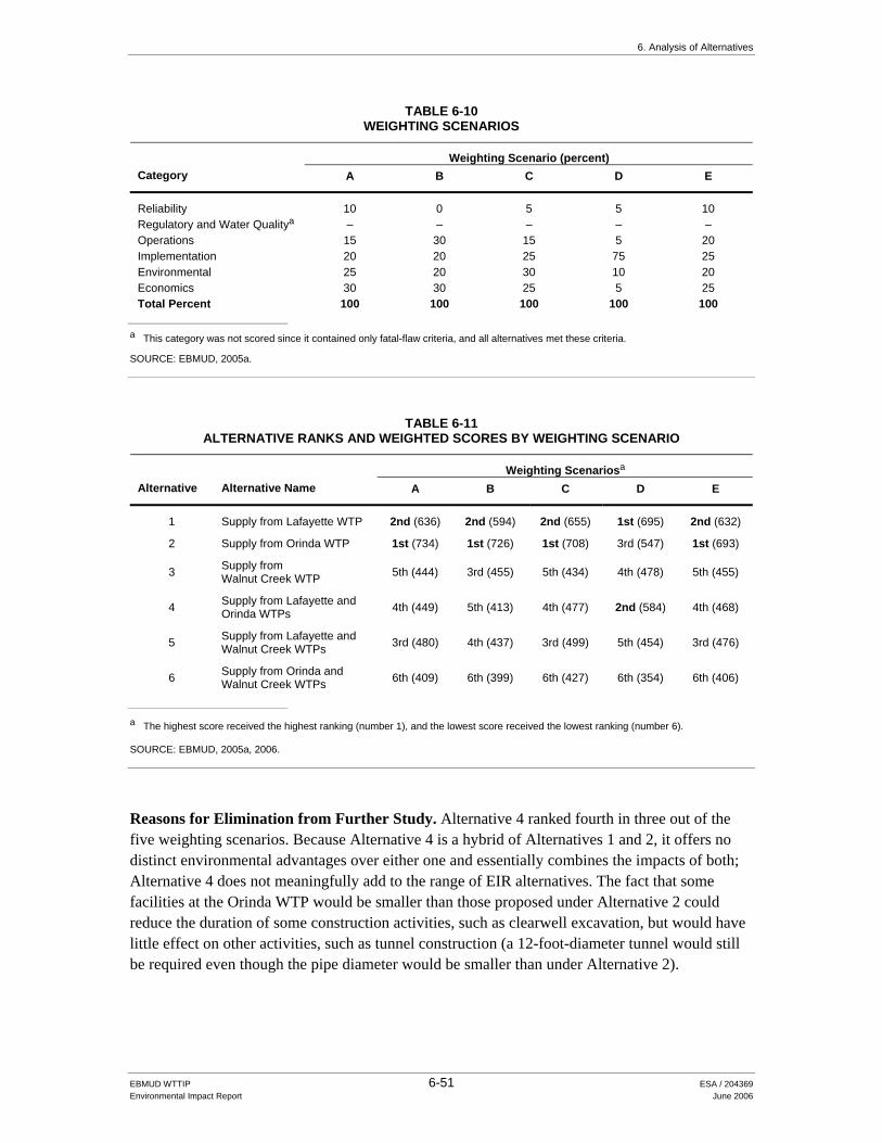
6. Analysis of Alternatives
EBMUD WTTIP 6-51 ESA / 204369 Environmental Impact Report June 2006
TABLE 6-10 WEIGHTING SCENARIOS
Weighting Scenario (percent) Category A B C D E
Reliability 10 0 5 5 10 Regulatory and Water Qualitya – – – – – Operations 15 30 15 5 20 Implementation 20 20 25 75 25 Environmental 25 20 30 10 20 Economics 30 30 25 5 25 Total Percent 100 100 100 100 100
a This category was not scored since it contained only fatal-flaw criteria, and all alternatives met these criteria. SOURCE: EBMUD, 2005a.
TABLE 6-11 ALTERNATIVE RANKS AND WEIGHTED SCORES BY WEIGHTING SCENARIO
Weighting Scenariosa Alternative Alternative Name A B C D E
1 Supply from Lafayette WTP 2nd (636) 2nd (594) 2nd (655) 1st (695) 2nd (632)
2 Supply from Orinda WTP 1st (734) 1st (726) 1st (708) 3rd (547) 1st (693)
3 Supply from Walnut Creek WTP 5th (444) 3rd (455) 5th (434) 4th (478) 5th (455)
4 Supply from Lafayette and Orinda WTPs 4th (449) 5th (413) 4th (477) 2nd (584) 4th (468)
5 Supply from Lafayette and Walnut Creek WTPs 3rd (480) 4th (437) 3rd (499) 5th (454) 3rd (476)
6 Supply from Orinda and Walnut Creek WTPs 6th (409) 6th (399) 6th (427) 6th (354) 6th (406)
a The highest score received the highest ranking (number 1), and the lowest score received the lowest ranking (number 6). SOURCE: EBMUD, 2005a, 2006.
Reasons for Elimination from Further Study. Alternative 4 ranked fourth in three out of the five weighting scenarios. Because Alternative 4 is a hybrid of Alternatives 1 and 2, it offers no distinct environmental advantages over either one and essentially combines the impacts of both; Alternative 4 does not meaningfully add to the range of EIR alternatives. The fact that some facilities at the Orinda WTP would be smaller than those proposed under Alternative 2 could reduce the duration of some construction activities, such as clearwell excavation, but would have little effect on other activities, such as tunnel construction (a 12-foot-diameter tunnel would still be required even though the pipe diameter would be smaller than under Alternative 2).

6. Analysis of Alternatives
EBMUD WTTIP 6-52 ESA / 204369 Environmental Impact Report June 2006
Alternative 5 – Supply from Lafayette and Walnut Creek WTPs Description. Alternative 5 is a hybrid of Alternatives 1 and 3, described above. The Lafayette WTP would be retained and upgraded, but at a smaller scale than proposed under Alternative 1 (Lafayette WTP demand capacity of 18 mgd); under this alternative, the Walnut Creek WTP would make up the water supply shortfall. The facility upgrades at the Walnut Creek WTP would also be at a smaller scale than under Alternative 3 and would include (among other things) a new 16.8-mg clearwell tank and a 62-mgd Leland Pumping Plant No. 2. Upgrades at the Orinda, Sobrante, and Upper San Leandro WTPs would be similar to Alternative 1 (see Table 6-7).
Reasons for Elimination from Further Study. Alternative 5 ranked third in three of the five weighting scenarios, demonstrating that it did not meet the project objectives as well as Alternative 1 or 2. In the same fashion as Alternative 4, Alternative 5 is a hybrid of Alternatives 1 and 3. It offers no distinct environmental advantages over either one, and essentially combines the impacts of both. Alternative 5 also had a low ranking (fifth) in the implementation category due to the high number of agency permits, easements, and rights-of-ways required, and the highest operations and maintenance costs among the alternatives.
Alternative 6 – Supply from Orinda and Walnut Creek WTPs Description. Alternative 6 involves decommissioning the Lafayette WTP and making up for the shortfall in water supply from both the Orinda and Walnut Creek WTPs. For the Orinda WTP, the proposed facilities are the same as under Alternative 2, but the new Los Altos No. 2 Pumping Plant and clearwell would be smaller. For the Walnut Creek WTP, the facilities would be the same as under Alternative 5. Improvements to the Upper San Leandro and Sobrante WTPs would be similar to those proposed under Alternatives 1 and 2.
Reasons for Elimination from Further Study. Alternative 6 ranked sixth under all the weighting scenarios. Alternative 6 would have required the most permits and had the highest estimated present-value capital cost out of all six projects. The Facilities Plan environmental screening process identified a three-year construction period and a higher number of services located within both 500 and 500–1,000 feet of treatment plant and pipeline construction areas than either Alternative 1 or 2. Alternative 6 offers no distinct environmental advantages over Alternative 1 or 2.
Other Water Treatment Plant Alternatives Considered On the basis of input from agencies and the public, several alternatives concerning the Orinda and Walnut Creek WTP were also considered.
Orinda WTP Several alternatives to upgrading the Orinda WTP were suggested during the NOP scoping period. Commenters suggested alternatives involving relocation or decommissioning of the Orinda WTP. In its response to the NOP, City of Orinda staff requested that the EIR consider alternatives involving improvements to West of Hills facilities, and that the EIR discuss whether “the potential downsizing or elimination of reservoirs west of hills could accommodate

6. Analysis of Alternatives
EBMUD WTTIP 6-53 ESA / 204369 Environmental Impact Report June 2006
additional treatment capacity and better distribute impacts among the communities EBMUD serves” (Worth, 2005).
Any alternative involving a shift in water treatment operations from the Orinda WTP to other WTPs serving the West of Hills area or to a new WTP would diverge from the District’s water quality objectives and would represent a radical departure from current and proposed water treatment and transmission practice. The WTTMP (the predecessor document to the Facilities Plan) considered a broad range of conceptual alternatives for meeting District water quality and quantity needs, including complete restructuring of the water treatment and transmission system (by consolidating all treatment activities at one WTP, either within or outside of EBMUD’s service area), various reconfigurations of the existing system, as well as some nontraditional strategies.4 The evaluation of these conceptual alternatives concluded that reconfigurations of the existing system that maintained between three and six WTPs in service were viable options; the other conceptual alternatives contained fatal flaws related to excessive cost, regulatory acceptance, customer disruption, and reliability. Through the WTTMP and Facilities Plan evaluations the District concluded that the Orinda WTP was essential to existing and future operations based on water quality, cost, reliability and operational flexibility.5
Nonetheless, EBMUD explored the following alternatives in response to the above-noted comments.
Alternative A – Relocate Orinda WTP Alternative B – Eliminate Transmission of Treated Water to West of Hills from Orinda WTP
Alternative C – Expand Lafayette WTP and Decommission Orinda WTP
These alternatives, as well as the potential for downsizing West of Hills reservoirs to accommodate additional treatment capacity, are briefly described below.
Alternative A – Relocate Orinda WTP Alternative A would involve decommissioning the Orinda WTP and building a new water treatment plant at approximately the same capacity as the Orinda WTP. Two alternative locations for the WTP were considered, both on District watershed lands: Scow Canyon and a site near
4 While traditional water utility practice is to construct centralized treatment facilities and distribute drinking water
for all customers through a piped distribution system, various alternatives to this practice exist and have been implemented in certain circumstances. Examples of some nontraditional alternatives considered in the WTTMP include point of entry devices (package water treatment units located at customers’ service connections), point of use devices (water treatment devices for homes and businesses, such as faucet attachments), dual (raw and potable) systems, and distribution of bottled water for potable use.
5 As described in Section 2.2.1 of Chapter 2, Orinda is EBMUD’s largest WTP, and the District relies on it more heavily than other WTPs because the Orinda WTP receives high-quality raw water. The Orinda WTP is also the only WTP that routinely services both the West of Hills and East of Hills areas and, if needed (e.g., due to an outage of the Mokelumne Aqueducts), can draw water from the Briones Reservoir and can serve all but the Walnut Creek WTP service area during portions of the winter months. Consequently, the Orinda WTP provides significant operational flexibility to ensure a reliable level of service to all customers west of Walnut Creek in a variety of planned and unplanned circumstances.

6. Analysis of Alternatives
EBMUD WTTIP 6-54 ESA / 204369 Environmental Impact Report June 2006
Briones Dam. Under either alternative, both the Orinda and Lafayette WTPs would be decommissioned and their service areas supplied by the new water treatment plant.
WTP in Scow Canyon. This alternative would involve decommissioning the Orinda and Lafayette WTPs and building a new water treatment plant in Scow Canyon on the east shore of San Pablo Reservoir and north of the Orinda WTP. The source water for the new treatment plant would come from San Pablo Reservoir. An intake pipeline for the raw water would be constructed in San Pablo Reservoir near Scow Canyon. The new WTP would be a conventional treatment plant as opposed to a filtration plant (like the existing Orinda and Lafayette WTPs) because water from the San Pablo Reservoir requires more treatment.6 EBMUD would construct two parallel 90-inch-diameter treated water pipelines to convey water from the treatment plant in Scow Canyon to the Orinda WTP. The existing tunnel to the San Pablo WTP would be reconstructed to carry a treated water pipeline, as would also occur as part of the program-level San Pablo Pipeline project proposed in the WTTIP. The alignment for the two treated water pipelines would follow Old San Pablo Dam Road. Like Alternative 2, a water treatment plant in Scow Canyon would require construction of the Orinda-Lafayette Aqueduct to convey water east to the Lafayette WTP service area. The estimated cost associated with this alternative would be 2.3 billion dollars.
WTP near Briones Dam. This alternative would involve decommissioning the Orinda and Lafayette WTPs and building a new water treatment plant on Bear Creek Road near Briones Dam. The source water for the new treatment plant would come from the Briones Center, on the alignment of the Lafayette Aqueducts. A new intake pipeline would be constructed in Briones Reservoir adjacent to the treatment plant, and a new raw water pumping plant would be constructed near Briones Center. This plant would also use conventional treatment processes as discussed for the Scow Canyon plant. EBMUD would construct two parallel 84-inch-diameter treated water pipelines from the treatment plant on Bear Creek Road to the Orinda WTP. A tunnel would be constructed to house the pipelines. Additionally, a 42-inch-diameter pipeline would be open-trenched from the treatment plant to the eastern portal of the San Pablo Raw Water Tunnel. The existing tunnel to the San Pablo WTP would be reconstructed to carry a treated water pipeline. This alternative would require construction of the Orinda-Lafayette Aqueduct to convey water east to the Lafayette WTP service area. The estimated cost associated with this alternative would be 1.9 billion dollars.
Reasons for Elimination from Further Study. These two relocation alternatives were eliminated based on feasibility, ability to meet the WTTIP’s objectives regarding source water quality and reliability, and environmental impacts. Refer to discussion on page 6-53.
Alternative B – Eliminate Transmission of Treated Water to West of Hills from Orinda WTP This alternative explores the concept of providing separate treatment facilities to serve East of Hills customers and West of Hills customers, respectively. This alternative would include expansion of the San Pablo WTP to 30 mgd, construction of a new 130-mgd-WTP in the West of
6 Refer to the discussion in Section 2.2 of Chapter 2 for a description of conventional versus direct filtration WTPs.

6. Analysis of Alternatives
EBMUD WTTIP 6-55 ESA / 204369 Environmental Impact Report June 2006
Hills area, decommissioning of the Orinda WTP, reconstruction of the Lafayette WTP to treat 50 mgd, conversion of the Claremont Tunnel to raw water, and additional transmission facility improvements. The result would be that treatment plants west of the Oakland-Berkeley Hills would provide water to West of Hills customers, while treatment plants east of the Oakland-Berkeley Hills would provide water to East of Hills customers. Given the configuration of the West of Hills treated water transmission system, a new WTP serving the West of Hills area would need to be located at or very near the existing Claremont Center (the western terminus of the Claremont Tunnel). However, the Claremont Center is too small to accommodate a 130-mgd water treatment plant and the area around the site is surrounded by residences and a school. The estimated cost associated with this alternative would be 2.1 billion dollars.
Reasons for Elimination from Further Study. These transmission alternatives were eliminated based on feasibility, ability to meet the WTTIP’s objectives regarding source water quality and reliability, and environmental impacts. Refer to discussion on page 6-53.
Alternative C – Expand Lafayette WTP and Decommission Orinda WTP EBMUD also investigated the possibility of converting the Lafayette WTP to a 174-mgd membrane filtration plant. This alternative is similar but larger than the Membrane Filtration Alternative described in Section 6.4. It also converts both of the Lafayette Aqueducts to convey treated water. Under this alternative, the Orinda-Lafayette Aqueduct would be constructed as it is described in Chapter 2 (Alternative 2), but the pipeline would be approximately 86 inches in diameter. This would convey raw water from Briones back to the Lafayette WTP. The Orinda-Lafayette Aqueduct would also serve to gravity-flow raw water to San Pablo Reservoir. This conveyance would serve both the Sobrante WTP and the Briones Pumping Plant.
The Orinda and San Pablo WTPs would be decommissioned under this alternative. Construction of the San Pablo Pipeline (program-level element) would facilitate the decommissioning of the San Pablo WTP. This pipeline would be constructed using open-trench construction. The San Pablo Pipeline and Claremont Tunnel would convey the treated water to the West of Hills area. In addition, a raw water pipeline would be constructed between Briones Center and the eastern portal of the Orinda-Lafayette Aqueduct and a new treated water pipeline/microtunnel would be constructed from Briones Center to connect Lafayette Aqueduct No. 2 to the eastern portal of the Claremont Tunnel. The cost associated with this alternative would be 1.4 billion dollars.
Reasons for Elimination from Further Study. This alternative was also eliminated based on feasibility, ability to meet the WTTIP’s objectives regarding source water quality and reliability, and environmental impacts. Refer to discussion on page 6-53.
Downsizing West of Hills Reservoirs/Continued Use of West of Hills Reservoirs as Remote Clearwell Storage The comment requesting that the EIR discuss the potential downsizing or elimination of reservoirs as an alternative is likely referring to the North, Central, and South Reservoirs located in Richmond, Oakland, and Castro Valley. These large, open-cut reservoirs serve the Central Pressure Zone, the largest pressure zone in the West of Hills area. These three reservoirs, in

6. Analysis of Alternatives
EBMUD WTTIP 6-56 ESA / 204369 Environmental Impact Report June 2006
conjunction with the Dunsmuir Reservoir and Claremont Tunnel, currently serve as distribution storage and remote clearwell storage for the Orinda WTP. As described in Chapter 2, there is presently no clearwell at the Orinda WTP. Most water treated at the Orinda WTP flows by gravity through the Claremont Tunnel to the West of Hills portion of the EBMUD service area.
The District plans to explore options for replacing or rehabilitating the North, Central, and South Reservoirs with tanks, as described in the draft PZPP studies for the Central Pressure Zone (EBMUD, 2005g, 2005h, and 2005i). Similar to the existing Fay Hill and Moraga Reservoirs, the North, South, and Central Reservoirs experience maintenance issues associated with open-cut reservoirs. In addition, the reservoirs are substantially oversized (partly because they function as remote clearwell storage), which contributes to water quality problems associated with water aging. The replacement tanks would have much smaller volumes.
This EIR evaluates, at a program level of detail under either Alternative 1 or Alternative 2, the addition of clearwell capacity to the Orinda WTP. The purpose of constructing that clearwell capacity at the Orinda WTP is two-fold:
Manage the Quality of Treated Water Delivered to the Distribution System. The District needs to keep water that does not meet (due to source water quality problems or a problem in the treatment process) water quality regulations out of the distribution system. Once water enters the Claremont Tunnel it cannot be retrieved and enters the distribution system. The clearwells would allow the District to more effectively manage the quality of treated water delivered to the distribution system by preventing such water from entering the Claremont Tunnel.
Manage the Quality of Treated Water in Distribution Storage Reservoirs. The clearwell
would be designed to turn over all of its water in a single day, an added water quality benefit, which is not possible with the existing system configuration of the West of Hills reservoirs and would not be possible if they were reconstructed to provide remote clearwell storage. Because the West of Hills reservoirs are oversized to provide remote clearwell storage, they experience water quality problems due to water aging (e.g., low chlorine residuals and potential for additional formation of disinfection byproducts as the reservoirs are field-chlorinated). Refer also to the discussion under Section 2.4 regarding reservoir operations.
Although providing clearwell capacity at the Orinda WTP would allow the District to further reduce the size of the North, South and Central Reservoirs, doing so would not meet the fundamental objectives (managing water quality) of building the program-level clearwell at the Orinda WTP and therefore cannot be considered an alternative.
The potential downsizing of the South, Central, and North Reservoirs would not create opportunities to accommodate additional treatment capacity. The reservoirs are part of the treated water distribution system and are not located anywhere near the District’s raw water reservoirs or raw water transmission mains.
EBMUD Board approval of the WTTIP would not constitute approval to construct clearwell capacity for the West of Hills area at the Orinda WTP; as stated elsewhere in this EIR, additional project-level environmental evaluation would be required prior to such approval.

6. Analysis of Alternatives
EBMUD WTTIP 6-57 ESA / 204369 Environmental Impact Report June 2006
Walnut Creek WTP Public and agency comments regarding the Walnut Creek WTP asked whether alternative haul routes could be used and whether alternative sites had been considered for the Leland Pumping Plant No.2.
Alternative Haul Routes to and/or from the Walnut Creek WTP At a public meeting held in Walnut Creek, several residents from the neighborhood surrounding the existing Walnut Creek WTP requested consideration of an alternative haul route. The commenters’ concerns stemmed from their experience with traffic impacts during construction of the Walnut Creek WTP expansion. The WTP expansion was completed in 2005.
Under the WTTIP, the District is proposing that truck traffic follow the same haul route to and from the Walnut Creek WTP that was used for the previous project. The haul route includes Pinneman Lane, North Main Street, San Luis Road, Larkey Lane, and Alfred Avenue. The vehicle trip estimates for trucks hauling soil or clean fill (to and from the site), trucks hauling other materials (such as construction equipment), and worker vehicle trips are detailed in Appendix B, Table B-WCWTP-1. The proposed construction schedule and estimated trip generation associated with WTTIP activities at the Walnut Creek WTP are summarized below:
The proposed schedule for construction activities at the site is from 7:00 a.m. to 6:00 p.m.; the proposed haul schedule is from 9:00 a.m. to 4:00 p.m.
The construction phase with the greatest number of vehicle trips is projected to occur when the concrete foundations are poured. This construction phase is expected to last less than a month and would generate up to 24 one-way truck trips (12 trucks hauling concrete and other materials to the site and then leaving the site) and 60 one-way worker vehicle trips per day.
Excavation (for the new filters) is expected to last almost three months. Of the approximately 5,500 cubic yards of excavated material, project designers are assuming that most of the soil (about 4,100 cubic yards) would be hauled offsite for disposal. The excavation phase would generate an estimated 10 one-way truck trips and 30 one-way worker vehicle trips per day.
In comparison, during July 2004, construction activities at the Walnut Creek WTP generated over 300 one-way truck trips per day on numerous occasions.
Developing an alternative haul route would require additional construction, given the limited points of access to the WTP. One option would be to use the right-of-way for the Mokelumne Aqueducts to access the WTP site. However, the existing gravel road on top of the Mokelumne Aqueducts is not suitable for heavy truck use. Substantial roadbed improvements would be needed to protect the aqueducts from damage. A second alternative haul route would be to access the site from the north, via Camino Verde from Pleasant Hill Road. In this case, a route would have to be found from Camino Verde through the Acalanes Ridge Open Space to the WTP. A third alternative would be to route construction through the Acalanes Ridge Open Space from Pleasant Hill Road. The second and third haul routes would also cross the Mokelumne Aqueducts.

6. Analysis of Alternatives
EBMUD WTTIP 6-58 ESA / 204369 Environmental Impact Report June 2006
Reasons for Elimination from Further Study. The improvements needed to develop these alternative access routes would generate additional environmental impacts for road construction and might not be feasible. In addition, the first alternative would only avoid truck trips on Larkey Lane and Alfred Avenue, since trucks would still access the site via San Luis Road. The second option would not avoid truck trips through neighborhoods, but would affect other residents. In addition to residential considerations, two of the alternative routes would cross through the Acalanes Ridge Open Space area. This open space area is owned by the City of Walnut Creek. In the City’s response to the Notice of Preparation published for the WTTIP EIR (Parness, 2005), city staff indicated that “no permission will be granted to allow materials deliveries, dirt off-haul, or lay down areas through open space.” Lastly, the access road improvements would increase the cost of the project. For these reasons, development of an alternative haul route is not considered a feasible option.
Alternative Sites for Leland Pumping Plant No. 2 The proposed Leland Pumping Plant is needed to address problems associated with meeting summer demand in the Leland Pressure Zone, which covers parts of Pleasant Hill, Walnut Creek, and Alamo. The hydraulic connectivity between the Danville Pumping Plant suction pipeline and the Leland Pressure Zone is adversely affecting summertime water supply in that zone, which, among other problems, is causing: (1) the Lafayette WTP to produce water that flows into the Leland Pressure Zone; (2) drawdown of the Leland Reservoir; and (3) low water pressure for customers in the upper parts of the zone. (The capacity of the Lafayette WTP is not sufficient to meet current maximum-day demands; the Leland Pressure Zone is supposed to be supplied by the Walnut Creek WTP.) The Leland Pumping Plant No.2, the new filter, and the Leland Pressure Zone Isolation Pipeline and Bypass Valves would correct these problems.
Two alternatives to the proposed Leland Pumping Plant No.2 site were considered. In order to meet the project need, the District determined that the pumping plant would need to be sited at either the Walnut Creek WTP or along the transmission pipeline between the Walnut Creek WTP and Lacassie Avenue, where one of the isolation pipelines would be installed. The preferred site (discussed in Chapter 2 – Project Description) is located at the Walnut Creek WTP. The first alternative site is located between Cole Avenue and Trinity Avenue, near the intersection of North California Boulevard in Walnut Creek. The other alternative site is located at the southeast corner of South Broadway and Newell Avenue in downtown Walnut Creek. These alternatives were eliminated from further study for the following reasons:
North California Boulevard Alternative Site. This site was an undeveloped parcel at the time the alternative sites were identified. However, since then, construction has begun on The Mercer, a mixed-use residential and multi-family housing project. Due to this change in parcel status, the site is no longer under consideration for Leland Pumping Plant No. 2.
Kaiser Parking Lot Alternative Site. The second alternative site evaluated for the Leland Pumping Plant No. 2 is a parking lot owned by Kaiser Permanente. It is currently used for auxiliary employee parking for employees at Kaiser Hospital further west on Newell Avenue. This site was comparable to the preferred site with respect to many of the potential impacts. However, because a pumping plant on this site would permanently affect parking for Kaiser employees, this location was less desirable than the preferred site.
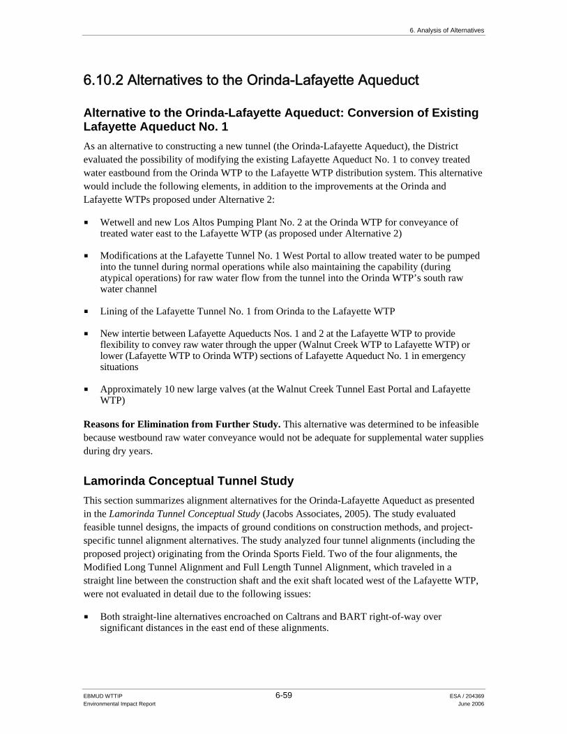
6. Analysis of Alternatives
EBMUD WTTIP 6-59 ESA / 204369 Environmental Impact Report June 2006
6.10.2 Alternatives to the Orinda-Lafayette Aqueduct
Alternative to the Orinda-Lafayette Aqueduct: Conversion of Existing Lafayette Aqueduct No. 1 As an alternative to constructing a new tunnel (the Orinda-Lafayette Aqueduct), the District evaluated the possibility of modifying the existing Lafayette Aqueduct No. 1 to convey treated water eastbound from the Orinda WTP to the Lafayette WTP distribution system. This alternative would include the following elements, in addition to the improvements at the Orinda and Lafayette WTPs proposed under Alternative 2:
Wetwell and new Los Altos Pumping Plant No. 2 at the Orinda WTP for conveyance of treated water east to the Lafayette WTP (as proposed under Alternative 2)
Modifications at the Lafayette Tunnel No. 1 West Portal to allow treated water to be pumped into the tunnel during normal operations while also maintaining the capability (during atypical operations) for raw water flow from the tunnel into the Orinda WTP’s south raw water channel
Lining of the Lafayette Tunnel No. 1 from Orinda to the Lafayette WTP
New intertie between Lafayette Aqueducts Nos. 1 and 2 at the Lafayette WTP to provide flexibility to convey raw water through the upper (Walnut Creek WTP to Lafayette WTP) or lower (Lafayette WTP to Orinda WTP) sections of Lafayette Aqueduct No. 1 in emergency situations
Approximately 10 new large valves (at the Walnut Creek Tunnel East Portal and Lafayette WTP)
Reasons for Elimination from Further Study. This alternative was determined to be infeasible because westbound raw water conveyance would not be adequate for supplemental water supplies during dry years.
Lamorinda Conceptual Tunnel Study This section summarizes alignment alternatives for the Orinda-Lafayette Aqueduct as presented in the Lamorinda Tunnel Conceptual Study (Jacobs Associates, 2005). The study evaluated feasible tunnel designs, the impacts of ground conditions on construction methods, and project-specific tunnel alignment alternatives. The study analyzed four tunnel alignments (including the proposed project) originating from the Orinda Sports Field. Two of the four alignments, the Modified Long Tunnel Alignment and Full Length Tunnel Alignment, which traveled in a straight line between the construction shaft and the exit shaft located west of the Lafayette WTP, were not evaluated in detail due to the following issues:
Both straight-line alternatives encroached on Caltrans and BART right-of-way over significant distances in the east end of these alignments.

6. Analysis of Alternatives
EBMUD WTTIP 6-60 ESA / 204369 Environmental Impact Report June 2006
The east end of these alignment alternatives present potentially significant geologic/ geotechnical issues related to rock conditions. This issue is of particular importance with respect to constructing a tunnel under BART and Caltrans right-of-way. No existing geotechnical information about rock conditions in this area was found.
In particular, the significant overburden depth (depth from surface to tunnel depth) in the east end of the alignment and in the vicinity of the Lafayette WTP, absence of information from borings into rock in this area, and the termination of the existing tunnels about 1,000 feet to the north and west of the Lafayette WTP and Highway 24/BART right-of-way justify caution about the feasibility of tunneling without further exploration and evaluation. The tunnel study recommended early characterization of the geotechnical conditions in this area prior to completing preliminary design of the new facilities.
The fourth alternative, the Long Tunnel Alignment Alternative, was evaluated in the study. The Long Tunnel Alignment Alternative involved construction of a 16,950-foot-long tunnel with entry and exit shafts at the ballfields in Orinda and at a property owned by EBMUD about 1,000 feet west of the Lafayette WTP, north of Highway 24 and adjacent to the entrance to the Bentley School parking lot. From that location, this alternative is the same as the preferred project (the pipeline would be installed using bore and jack construction under Highway 24 from the Bentley School park lot and open-trench construction along Mt. Diablo Boulevard to the Lafayette WTP). The alignment for this alternative was between the rights-of-way for Lafayette Tunnel No. 1 and No.2, and included two short arcs. This alternative was eliminated from further consideration based on cost and attenuation of environmental impacts to receptors near the entry shaft site.
6.10.3 Alternatives to Other WTTIP Projects This section identifies alternatives considered for projects other than the WTPs and the Orinda-Lafayette Aqueduct.
Fay Hill Pumping Plant and Pipeline Improvements Alternative The proposed Fay Hill Pumping Plant and Pipeline project is needed to increase pumping capacity to meet future maximum-day demands and to correct existing water pressure problems in the Fay Hill Pressure Zone. The PZPP study for the Fay Hill and Carter Pressure Zones (EBMUD, 2003a) analyzed one alternative to the preferred project to meet these needs: constructing a new pumping plant (referred to as the Bollinger Pumping Plant) near the St. Mary’s Road/Rheem Boulevard intersection. Although the construction of a new pumping plant was considered feasible, upgrading the existing Fay Hill Pumping Plant and associated discharge pipeline as proposed in this EIR would be more cost-effective. Constructing a new pumping plant would require more construction than the proposed project because it involves installing new equipment. Therefore, the Bollinger Pumping Plant was eliminated from further evaluation.

6. Analysis of Alternatives
EBMUD WTTIP 6-61 ESA / 204369 Environmental Impact Report June 2006
Fay Hill Reservoir Alternatives The District considered three alternatives for addressing maintenance problems associated with the existing open-cut Fay Hill Reservoir: the preferred project described in Chapter 2 (constructing two tanks within the basin of the existing reservoir); construction of a single tank in the existing reservoir’s basin; and rehabilitation of the existing reservoir’s liner (EBMUD, 2003a). Reservoir rehabilitation was rejected because of long-term maintenance and water quality concerns. The preferred project was selected over the single-tank option based on operations and maintenance considerations.
Glen Pipeline Improvements and Reservoir Decommission Alternatives The Glen Pipeline Improvements and Glen Reservoir Decommission project would correct unacceptably low water levels in the Glen Reservoir during high-demand periods. For the Bryant Pressure Zone PZPP study (EBMUD, 2004), the District conducted hydraulic modeling of three alternatives (in addition to the preferred project) to meet these needs. The first alternative (Remove Reservoir from Service with No Improvements) had fatal flaws, including pressure decreases in the area around Glen Reservoir and the lack of water supply to one area. Due to these fatal flaws, the alternative was eliminated from further evaluation.
Under the second alternative (Remove and Replace Reservoir Only), Glen Reservoir would still drop to below 50 percent of capacity. The alternative would not appreciably improve existing conditions and was therefore eliminated from further evaluation.
The third alternative (Upgrade Pipeline and Replace Glen Reservoir with 0.6-mg Reservoir) was similar to the preferred project but also included replacement of Glen Reservoir. However, hydraulic modeling confirmed that, while Glen Reservoir could not be refilled to acceptable levels without pipeline improvements, the pipeline improvements eliminate the need for the reservoir. While replacing the Glen Reservoir would add system redundancy, it was not needed for acceptable water service (to address water pressure and fire flow). Reservoir replacement, together with pipeline improvements, would also cost more than the preferred alternative. Therefore, this alternative was eliminated from further evaluation.
Happy Valley Pumping Plant and Pipeline Alternatives An alternative pumping configuration was considered in the PZPP study for the Las Aromas Pressure Zone (2005c) to address existing maximum-demand and future (2030) deficits in pumping capacity. This alternative involved expanding the pumping plants currently serving the Las Aromas Pressure Zone. Existing pumping plants serving this pressure zone include Sleepy Hollow (located 600 feet north of 53 Los Altos Drive in Orinda), Valory (located on the corner of Happy Valley Road and Palo Alto Drive in Lafayette), and Las Aromas (located at 32 Las Aromas in Orinda, 100 feet east of Las Cascadas Road). Each of these pumping plants fill a reservoir of the same name, and all three pumping plants fill a fourth reservoir serving the Las Aromas Pressure Zone (the Happy Valley Reservoir).

6. Analysis of Alternatives
EBMUD WTTIP 6-62 ESA / 204369 Environmental Impact Report June 2006
This alternative was determined to be infeasible based on siting constraints, hydraulic constrictions, and the extent of construction involved. Because no single existing pumping plant could accommodate the 3.2-mgd expansion needed to address the aforementioned demands and deficits, a combination of pumping plants would require expansion, meaning that construction-related impacts would occur at multiple pumping plant sites. In addition, relative to the proposed project, more pipeline construction would be needed between the expanded pumping plants and the reservoirs currently serving the Las Aromas Pressure Zone in order to meet project objectives. Specifically, this alternative would require approximately 1.9 miles of 16-inch pipe to expand another pumping plant in the pressure zone, while the proposed project would require only 1.0 mile of 16-inch pipeline. For these reasons, this alternative pumping configuration was eliminated from further evaluation.
The District also considered a variant of the proposed Happy Valley Pumping Plant and Pipeline project that would increase pumping plant capacity to 4.2 mgd (instead of the proposed capacity of 3.2 mgd), thereby allowing the Sleepy Hollow Pumping Plant to be decommissioned. Hydraulic analysis indicated that removal of the Sleepy Hollow Pumping Plant would trigger the need for other distribution system improvements (e.g., more piping); consequently, EBMUD decided to retain the Sleepy Hollow Pumping Plant.
EBMUD also identified two alternative locations in addition to the preferred site for the Happy Valley Pumping Plant (see the Happy Valley Pumping Plant Alternative Sites map in Appendix J). Site selection and evaluation criteria included land use compatibility (e.g., whether the parcel was vacant), site size, the number of adjacent landowners, environmental factors (impact indicators such as the length of haul routes through residential neighborhoods and the number of nearby residences), construction requirements (including pipeline length), and cost. One of these alternative sites (referred to as #2) is described in Section 6.8; the other site (#1) was eliminated from further evaluation, based on the extent of construction and environmental impact, as described below:
Site #1 is a 1.2-acre vacant parcel at 1 Miner Road (on the west side of the road) between Camino Don Miguel and Oak Arbor Road. The site has one residential neighbor. The usable land on the parcel is on the opposite side of a creek/bridge. This site would require hillside excavation, a retaining wall, and a bridge for the inlet/outlet pipe. There is a mapped landslide on the northeast part of the site. This site was less desirable than both the preferred site and the alternative #2 site as it would have greater impacts to protected trees, greater impacts on neighbors during construction, and would require considerably more site work. Furthermore, the bridge to the pumping plant would require additional maintenance.
Highland Reservoir and Pipelines Alternatives As described in Section 2.6, the Highland Reservoir is needed because the southwestern portion of the Colorados Pressure Zone does not have sufficient storage and because water levels in this subzone drop below acceptable levels during periods of high demand. The southwestern portion of the Colorados Pressure Zone includes portions of the city of Lafayette north and south of Highway 24, west of Pleasant Hill Road, and between 250 feet to 450 feet above mean sea level. This subzone is currently served by the Colorados Reservoir. The elevation of the Highland

6. Analysis of Alternatives
EBMUD WTTIP 6-63 ESA / 204369 Environmental Impact Report June 2006
Reservoir must match that of the Colorados Reservoir, so any areas below 530 feet were excluded from consideration. The Highland Reservoir Alternative Sites map in Appendix J depicts the 530-foot elevation contour and the nine sites (including the preferred project) that were initially considered for the Highland Reservoir. Only vacant properties were considered; sites at a suitable elevation that were already developed were excluded.
The reservoir also needs to be sited such that customers at the highest elevations in this subzone of the Colorados Pressure Zone would not experience large swings in water pressure. Reservoirs tend to stabilize the water pressure in the surrounding area. In general, the farther water service is from the distribution reservoir, the larger the swing will be (between the static pressure when no water is flowing and the residual pressure available during a period of maximum demand). The subzone for the proposed Highland Reservoir includes customers north of Highway 24 that are located at a high elevation and consequently have low static water pressure.
The nine candidate sites were screened against five criteria (operational, implementation, environmental, construction, and cost). Site 9 was determined to best meet these criteria; Sites 1 through 8 were eliminated for the reasons discussed below.
Site 1 is located within EBMUD’s Lafayette Reservoir Recreation Area east of the dam and north of the Lower Trail. The site was less desirable than the preferred alternative because of its impacts on the recreational use of the facility (the Lower Trail receives much more use than the Rim Trail). This site would have visual impacts comparable to those of the preferred alternative and would require removal of protected trees.
Sites 2 through 6 were eliminated from further consideration because none would sufficiently meet the hydraulic requirements of the project. The sites were not close enough hydraulically to the low-pressure water services north of Highway 24 to stabilize residual water pressures during periods of high demand.
Site 7 is a vacant parcel owned by Caltrans north of Highway 24 and east of Via Roble. Initially, this site was considered less than desirable than the preferred alternative because of uncertainties regarding EBMUD’s ability to acquire the site and visual impacts. Site 7 would require removal of few, if any, protected trees. However, subsequent investigation revealed that Caltrans has changed the topography and the site is now below the 530-foot contour, making the site infeasible for development of the reservoir.
Site 8 is a privately owned vacant parcel at the end of Crestmont Drive. The site is surrounded by 20 residential neighbors that are in close proximity to the potential construction. The site was less desirable than the preferred alternative because of potential construction impacts to neighboring residences, including construction of the inlet/outlet pipeline. Construction of the reservoir at Site 8 would substantially alter the site’s appearance and significantly affect views, an impact that could be reduced with landscaping but could not be avoided. The reservoir would be highly visible to the surrounding neighborhood. The site would require removal of fewer trees than the proposed project.
Environmental analysis conducted for the EIR concluded that development of the preferred site would result in significant, unavoidable impacts related to the removal of protected trees and effects on views and scenic vistas. Subsequent consideration of alternatives to the proposed reservoir site focused on avoidance of these significant impacts. No sites were identified that

6. Analysis of Alternatives
EBMUD WTTIP 6-64 ESA / 204369 Environmental Impact Report June 2006
could avoid significant visual impacts due primarily to the elevation requirements of the reservoir. Site 7 was reconsidered but review of recent topography indicated that the site is not high enough for the reservoir due to modifications made by Caltrans. Two sites near the preferred site, one north of the Rim Trail from the preferred site and a second site to the southwest, were also reconsidered. The site to the southwest was eliminated due to greater impacts on recreation resources and slope stability issues. The site north of the Rim Trail is evaluated in Section 6.6.
Sunnyside Pumping Plant and Pipeline Alternatives Three of the locations identified on the Sunnyside Pumping Plant Alternative Sites map in Appendix J were considered and rejected as potential alternatives. Site 2 on that map is the proposed Sunnyside Pumping Plant site. All of the sites were located near Sundown Terrace in Orinda and Lafayette. Residential development along Sundown Terrace is characterized by custom-built homes and estates in a rural setting. Land use compatibility impacts associated with construction of the new pumping plant and related inlet/outlet pipeline were therefore the primary consideration in site selection. Sites 1, 3, and 4 were eliminated from further evaluation for the reasons discussed below:
Site 1 is a vacant 0.62-acre parcel located at 283 Sundown Terrace, Orinda, adjacent to three residential properties, and is the least suitable from a land use compatibility perspective as it has relatively close residential neighbors on three sides. It would also require a comparatively long inlet/outlet line and thus would have additional construction-related impacts (noise, dust, and traffic) on neighborhood residents. It is likely that the District would need to purchase the entire parcel so as not to leave an undevelopable remnant parcel. If the entire parcel were purchased, the site would be the most expensive to develop. Site 1 is the least desirable of the four site alternatives.
Site 3 is located in an undeveloped area on a 133-acre parcel at the intersection of Sundown Terrace and Happy Valley Road in Orinda. This site would have similar but slightly greater impacts than the preferred site as it is closer to more residential neighbors. Although this site would require minimal inlet/outlet pipeline construction, it would be more difficult to develop than the preferred site because it is situated in a local drainage area on a steep slope.
Site 4 is located at the northeast end of Honeywood Road, Orinda, on an EBMUD-owned parcel containing the existing 1.5-mg Happy Valley Reservoir. This site is the farthest from adjacent residential neighbors. However, it would have greater construction-related impacts as it would require a long inlet/outlet line, either along Honeywood Road and Sundown Terrace or through residential parcels and then along Sundown Terrace. It would also need to be constructed on the steep slopes to the south of the pumping plant, potentially altering the hillside views for residents on Sundown Terrace.
Tice Pumping Plant and Pipeline Alternatives Three alternatives to the proposed Tice Pumping Plant site were considered (see the Tice Pumping Plant Alternative Sites map in Appendix J). Site 2 is the proposed project site, and Site 3 is the alternative site evaluated in Section 6.9. Of the other two, one site was located on Boulevard Way and one site was located near the intersection of Olympic Boulevard and Tice Valley Boulevard in unincorporated Contra Costa County. Land use compatibility was the

6. Analysis of Alternatives
EBMUD WTTIP 6-65 ESA / 204369 Environmental Impact Report June 2006
primary consideration in site selection. Inlet/outlet pipeline construction impacts were similar for both sites.
Site 1 is a vacant 0.30-acre parcel located at 1600 Tice Valley Boulevard that is currently being used as a parking lot for adjacent businesses. Because a pumping plant on this site would permanently affect parking for the adjacent businesses, this location was less desirable than the other sites at the Olympic/Tice Valley Boulevard intersection.
Site 4 is a vacant 0.73-acre parcel located on the west side of Boulevard Way, south of Boulevard Court adjacent to three residential properties. Unlike Sites 1, 2, and 3, Site 4 is surrounded on all sides by residences. This site was eliminated based on potential to generate greater impacts to residential uses than the preferred project.
Withers Pumping Plant Two alternatives to the proposed Withers Pumping Plant site were considered. One alternative site is located on Grayson Road, and the other is located on Withers Avenue. Both are in unincorporated Contra Costa County. Both of these sites are on privately owned parcels zoned for residential development. Land use compatibility and operational requirements were the primary considerations in site selection. These sites were eliminated from further evaluation based on the details below.
For Site 2, EBMUD would purchase a portion of the one-acre parcel on which an existing residence is located (at 1024 Grayson Road). The site was less desirable than the proposed project site as the land would have to be purchased and because of the existing residence on the site. The inlet/outlet pipeline would be longer (approximately 1,400 feet) than that for the proposed project site.
Site 3 is one of four parcels resulting from a recent subdivision at 3182 Withers Avenue. The site was less desirable than the other alternative site for several reasons. The site would fail to meet EBMUD operational requirements. Water quality in Grayson Reservoir would not be improved as much as with the other two options due to the proximity of the site to the Walnut Creek WTP. Tree removal and slope stability issues also contributed to rejection of this site. The inlet/outlet pipeline for this site would be significantly longer than the other alternatives and would require substantial improvements. In addition, this site would have to be purchased by EBMUD (whereas EBMUD owns the proposed site for the Withers Pumping Plant).
New Leland Pressure Zone Reservoir and Pipeline Alternatives Sites considered for the New Leland Pressure Zone Reservoir are shown on the New Leland Pressure Zone Reservoir Alternative Sites map in the Appendix J. Site 3 is the proposed New Leland Pressure Zone Reservoir site described in Chapter 2. The remaining six sites were rejected for the following reasons:
Site 1 is made up of one privately owned vacant parcel and one vacant parcel owned by the City of Walnut Creek, located between Craddock Court and Summit Road in Walnut Creek. The City-owned parcel is designated open space, which can only be sold following a vote in favor of this action by the citizens of Walnut Creek; therefore, this site is no longer under consideration.

6. Analysis of Alternatives
EBMUD WTTIP 6-66 ESA / 204369 Environmental Impact Report June 2006
Site 2 is a portion of a parcel owned by the City of Walnut Creek in the Shell Ridge Open Space. Since open space land in Walnut Creek can only be sold following a vote in favor of the sale by citizens, this site is no longer under consideration.
Site 4 is a privately owned parcel located south of Cielo Via and east of Arbol Via. Due to the extent of traffic impacts associated with construction of the inlet/outlet pipeline (the pipeline alignment followed Ygnacio Valley Road) this site is no longer under consideration.
Site 5 is a vacant parcel owned by the East Bay Regional Park District. This site is fatally flawed because it is located on the Reliez Fault. The new reservoir could not be safely operated if it were constructed over an active fault trace.
Site 6, composed of portions of seven different parcels, is located northwest of the interchange between Highway 24 and Interstate 680. One parcel, owned by the City of Walnut Creek, is part of the Acalanes Ridge Open Space. As discussed above, since open space land in Walnut Creek can only be sold a vote by citizens, this site is no longer under consideration.
Site 7 is a privately owned vacant parcel. The site is less than desirable than the preferred site because there are five mapped landslides on the property.
6.11 Comparison of Alternatives This section presents a comparison of the alternatives and identifies the environmentally superior alternative. Consistent with the CEQA Guidelines, Section 15126.6a, the comparison of alternatives and determination of the environmentally superior alternative is based on the ability of the alternative to meet the basic objectives of the project while avoiding or substantially lessening any significant impacts. Consequently, this section presumes implementation of mitigation measures identified in the EIR.
6.11.1 Comparison of the No Project Alternative, Alternative 1, and Alternative 2
Many of the same significant impacts would occur under Alternative 1 or Alternative 2 because those impacts are associated with projects common to both alternatives. All of the impacts determined to be unavoidable would occur under either alternative because those impacts are associated with the Highland Reservoir project (impacts to visual and biological resources), and Tice, Happy Valley, and Glen pipelines (temporary, construction-phase impacts related to available width of traffic lanes, vehicular access, and transit service).
However, there are several important differences between the potential impacts and extent of required mitigation measures associated with the two alternatives; these differences are discussed below. Table 6-12 provides a summary comparison of impacts for Alternatives 1 and 2 by impact classification (e.g. significant mitigable, less than significant).
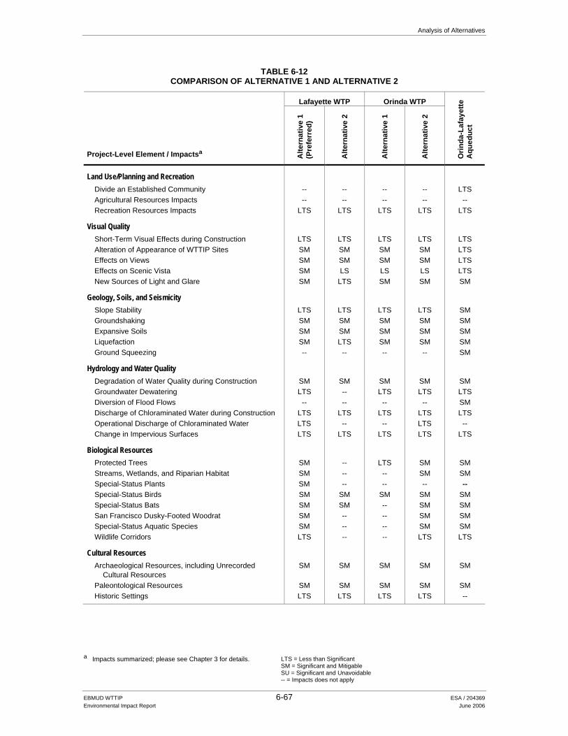
Analysis of Alternatives
a Impacts summarized; please see Chapter 3 for details.
LTS = Less than Significant SM = Significant and Mitigable SU = Significant and Unavoidable -- = Impacts does not apply
EBMUD WTTIP 6-67 ESA / 204369 Environmental Impact Report June 2006
TABLE 6-12 COMPARISON OF ALTERNATIVE 1 AND ALTERNATIVE 2
Lafayette WTP Orinda WTP
Project-Level Element / Impactsa Alte
rnat
ive
1 (P
refe
rred
)
Alte
rnat
ive
2
Alte
rnat
ive
1
Alte
rnat
ive
2
Orin
da-L
afay
ette
A
qued
uct
Land Use/Planning and Recreation
Divide an Established Community -- -- -- -- LTS Agricultural Resources Impacts -- -- -- -- -- Recreation Resources Impacts LTS LTS LTS LTS LTS
Visual Quality
Short-Term Visual Effects during Construction LTS LTS LTS LTS LTS Alteration of Appearance of WTTIP Sites SM SM SM SM LTS Effects on Views SM SM SM SM LTS Effects on Scenic Vista SM LS LS LS LTS New Sources of Light and Glare SM LTS SM SM SM
Geology, Soils, and Seismicity
Slope Stability LTS LTS LTS LTS SM Groundshaking SM SM SM SM SM Expansive Soils SM SM SM SM SM Liquefaction SM LTS SM SM SM Ground Squeezing -- -- -- -- SM
Hydrology and Water Quality
Degradation of Water Quality during Construction SM SM SM SM SM Groundwater Dewatering LTS -- LTS LTS LTS Diversion of Flood Flows -- -- -- -- SM Discharge of Chloraminated Water during Construction LTS LTS LTS LTS LTS Operational Discharge of Chloraminated Water LTS -- -- LTS -- Change in Impervious Surfaces LTS LTS LTS LTS LTS
Biological Resources
Protected Trees SM -- LTS SM SM Streams, Wetlands, and Riparian Habitat SM -- -- SM SM Special-Status Plants SM -- -- -- -- Special-Status Birds SM SM SM SM SM Special-Status Bats SM SM -- SM SM San Francisco Dusky-Footed Woodrat SM -- -- SM SM Special-Status Aquatic Species SM -- -- SM SM Wildlife Corridors LTS -- -- LTS LTS
Cultural Resources
Archaeological Resources, including Unrecorded Cultural Resources
SM SM SM SM SM
Paleontological Resources SM SM SM SM SM Historic Settings LTS LTS LTS LTS --

Analysis of Alternatives
a Impacts summarized; please see Chapter 3 for details.
LTS = Less than Significant SM = Significant and Mitigable SU = Significant and Unavoidable -- = Impacts does not apply
EBMUD WTTIP 6-68 ESA / 204369 Environmental Impact Report June 2006
TABLE 6-12 (Continued) COMPARISON OF ALTERNATIVE 1 AND ALTERNATIVE 2
Lafayette WTP Orinda WTP
Project-Level Element / Impactsa Alte
rnat
ive
1 (P
refe
rred
)
Alte
rnat
ive
2
Alte
rnat
ive
1
Alte
rnat
ive
2
Orin
da-L
afay
ette
A
qued
uct
Traffic and Circulation
Increased Traffic SM SM SM SM SM Reduced Road Width SM SM -- -- SM Parking SM SM SM SM SM Traffic Safety SM SM SM SM SM Access -- -- -- -- SM Transit -- -- -- -- SM Pavement Wear/Tear LTS LTS LTS LTS LTS
Air Quality
Construction Emission SM SM SM SM SM DPM Emissions Along Haul Routes LTS LTS LTS LTS LTS Tunnel-Related Emissions -- -- -- -- SM Operational Pollutant Emissions at Treatment Facilities LTS LTS LTS LTS -- Operational Odor Emissions LTS LTS LTS LTS LTS Secondary Emissions from Electricity Generation LTS LTS LTS LTS LTS
Noise and Vibration
Construction Noise Increases SM SM SM SM SM Noise Increases Along Haul Routes LTS LTS LTS LTS LTS Construction-Related Vibration Effects SM SM SM SM SM Operational Noise Increases SM LTS LTS SM LTS
Hazards and Hazardous Materials
Hazardous Materials in Soil and Groundwater SM SM SM SM SM Hazardous Building Materials SM SM -- SM -- Gassy Conditions in Tunnels -- -- -- -- LTS High Pressure Gas Line Rupture -- -- -- -- SM Wildland Fires -- -- LTS LTS LTS Release from Construction Equipment LTS LTS LTS LTS LTS Accidental Release during Operation LTS LTS -- -- --
Public Services and Utilities
Disruption of Utility Lines SM SM SM SM SM Increase in Electricity Demand LTS LTS LTS LTS LTS Increase in Public Services Demand LTS LTS LTS LTS LTS Adverse Effect On Landfill Capacity SM -- SM SM SM Failure to Achieve State Diversion Mandates SM SM SM SM SM

6. Analysis of Alternatives
EBMUD WTTIP 6-69 ESA / 204369 Environmental Impact Report June 2006
The differences primarily reflect the fact that the Orinda-Lafayette Aqueduct project would only be associated with Alternative 2 and thus that project’s impacts over a one- to two-year period would be avoided under Alternative 1. Although the tunneling proposed as part of the Orinda-Lafayette Aqueduct project would avoid surface-disturbance impacts associated with open-trench construction, it would concentrate impacts at the tunnel entry shaft (and, to a lesser extent, the exit shaft), and there are some impacts unique to tunneling, including noise associated with 24-hour construction and groundborne vibration. The total areal extent of construction also would be greater under Alternative 2 than under Alternative 1 because of the Orinda-Lafayette Aqueduct.
Other differences between the alternatives relate to the impacts to, and sensitivities of, the areas immediately surrounding the Orinda WTP and Lafayette WTP sites. There are a greater number of residences closer to the Orinda WTP than is the case at the Lafayette WTP. There are about twice as many residences within 1,000 feet of the Orinda WTP as there are within 1,000 feet of the Lafayette WTP. The Lafayette WTP backs up to Highway 24, and the open space of the Lafayette Reservoir Recreation Area lies to the south, across Mt. Diablo Boulevard. Mt. Diablo Boulevard itself, because of its breadth near the Lafayette WTP, provides something of a buffer from other nearby residential areas, although this is also partially the case along the west side of the Orinda WTP, adjacent to Camino Pablo.
The more extensive construction footprints and greater excavation and grading requirements associated with Alternative 2 -- about 680,000 cubic yards of excavation, compared to about 445,000 cubic yards of excavation for Alternative 1 -- would result in incrementally greater construction-phase air emissions (e.g. approximately 139 lbs/day of PM10 emissions under Alternative 2 versus about 105 lbs/day under Alternative 1). In both cases, those emissions can be mitigated to a less-than-significant level.
Potential cumulative construction traffic added to Camino Pablo (two-lane section north of Miner Road) would be incrementally greater under Alternative 2 than Alternative 1 (about three percent above existing traffic volumes under Alternative 2 and one percent above existing traffic volumes under Alternative 1). In both cases the increases would fall within the typical daily traffic volume fluctuations. Conversely, potential cumulative construction traffic added to Acalanes Road (El Nido Ranch Road to Mt. Diablo Boulevard) would represent about a five percent increase above existing traffic volumes and would only occur under Alternative 1. Cumulative truck traffic resulting from potentially overlapping WTTIP projects, and associated diesel particulate emissions, would also be incrementally greater under Alternative 2 than under Alternative 1, although the analytic threshold (600 truck-trips per day) would not likely be exceeded along any particular haul route under either alternative.
There would be fewer (15-20) protected trees lost under Alternative 1 than under Alternative 2, primarily because more protected trees would be removed to upgrade and expand the Lafayette WTP than would be required to upgrade and expand the Orinda WTP. There would be somewhat more (20-30) protected trees potentially damaged under Alternative 2, owing primarily to the Orinda-Lafayette Aqueduct project, although the degree of damage is unknown and may be quite limited in many cases (e.g. tree limb loss).

6. Analysis of Alternatives
EBMUD WTTIP 6-70 ESA / 204369 Environmental Impact Report June 2006
For these reasons, Alternative 1 is considered environmentally superior to Alternative 2. For reasons summarized below in Section 6.11.2, implementation of Alternative 1 coupled with the Membrane Filtration Alternative, Lafayette Reclaimed Water Pipeline Alternative, alternative alignment segments for the Moraga Road Pipeline through the Lafayette Reservoir Recreation Area, and Tice Pumping Plant Alternative Site, is considered environmentally superior to Alternative 1 as proposed.
The No Project Alternative would neither meet the needs addressed by the WTTIP nor satisfy the project objectives. In the short term, the No Project Alternative would be environmentally superior to either “action” alternative because none of the impacts associated with those alternatives would occur. However, as described in Section 6.2, a continuation of existing conditions would become untenable, and the District would eventually have to implement projects to address the purpose and need identified for the WTTIP. This situation could, in turn, result in environmental effects that could be worse than those of either Alternative 1 or 2 in the long term.
6.11.2 Comparison of WTTIP Projects as Proposed with Alternatives Described in Chapter 6
As described in the preceding sections, the following alternatives described in this section are considered environmentally superior to the projects as proposed under the WTTIP:
Membrane Filtration Alternative. Overall, the Membrane Filtration Alternative is considered environmentally superior to the upgrades proposed at the Lafayette WTP under Alternative 1. This would be due primarily to the fact that less excavation and dewatering would be necessary at the Lafayette WTP and the construction for the Membrane Filtration Alternative would not be as close to residences. In addition, demolition of existing structures that may contain hazardous materials in the soil and groundwater would not be required under this alternative. However, there are few large water treatment plants using this water treatment technology in the US today. EBMUD will defer consideration of the Membrane Filtration Alternative until this emerging technology is more fully investigated.
Lafayette Reclaimed Water Pipeline Alternative. This alternative is considered
environmentally superior to the proposed Lafayette Reclaimed Water Pipeline if impacts at the Lafayette Creek crossing cannot be avoided through trenchless construction techniques pursuant to Mitigation Measure 3.6-2a. The alternative would avoid construction impacts to trees and other riparian vegetation along the Creek as well as any impacts associated with constructing the pipeline across the Reservoir shoreline and would also avoid the backwash water discharge to Lafayette Reservoir, although those impacts and that associated with the discharge itself is expected to result in a less than significant water quality impact to the Reservoir under the proposed project.
Moraga Road Pipeline. Implementing the proposed project with the realignments through the
Lafayette Reservoir Recreation Area identified under the Moraga Road Pipeline Alternative is considered environmentally preferable to either the project as proposed or the tunneling option. The tunnel option is considered environmentally superior to trenching the pipeline in Moraga Road between Nemea Court and Sky-Hy Drive because it would reduce the number of protected trees requiring removal by up to 25 and total number of trees by up to 40. Removing

6. Analysis of Alternatives
EBMUD WTTIP 6-71 ESA / 204369 Environmental Impact Report June 2006
fewer trees, particularly those of large-diameter, would in turn reduce impacts to the habitat of upland special status species.
Tice Pumping Plant. The alternative pumping plant site is considered environmentally
preferable to the proposed site. This is primarily because the alternative site would be less visible and well screened from most directions by trees that would be preserved, and would reduce the magnitude of more significant impacts. However, if the site owner proceeds to develop the parcel with residences, the site would no longer be a suitable location for a pumping plant.
_________________________
References – Analysis of Alternatives Anderson, John, President and CEO, Bay Area Rescue Missions, telephone conversation, July 22,
2005. East Bay Municipal Utility District (EBMUD), Pressure Zone Planning Program Study for Fay
Hill and Carter Pressure Zones, Water Distribution Planning Division, August 19, 2003a. ______, Pressure Zone Planning Program Study for Holly, Hill Mutual, Ridgewood, and Crest
Pressure Zones, Water Distribution Planning Division, April 3, 2003b. ______, Water Treatment and Transmission Master Plan, 2003c. ______, Pressure Zone Planning Program Study for Bryant Pressure Zone, Water Distribution
Planning Division, June 9, 2004. ______, Lamorinda Water System Improvements Program Facilities Plan, June 2005a. ______, Pressure Zone Planning Program Study for Colorados Pressure Zone, Water
Distribution Planning Division, April 2005b. ______, Pressure Zone Planning Program Study for Las Aromas and Valley View Pressure
Zones, Water Distribution Planning Division, May 31, 2005c. ______, Pressure Zone Planning Program Study for Leland Pressure Zone, Water Distribution
Planning Division, May 2005d. ______, Pressure Zone Planning Program Study for Baseline, White Oak, Orchard, Valencia,
and Laguna Pressure Zones, Water Distribution Planning Division, April 2005e. ______, Pressure Zone Planning Program Study for Encinal, Westside, and Dos Osos Pressure
Zones, Water Distribution Planning Division, April 11, 2005f ______, Pressure Zone Planning Program Study for Central Pressure Zone, South Reservoir
Area, Water Distribution Planning Division, May 2005g. ______, Pressure Zone Planning Program Study for Central Pressure Zone, North Reservoir
Area, Water Distribution Planning Division, May 2005h.

6. Analysis of Alternatives
EBMUD WTTIP 6-72 ESA / 204369 Environmental Impact Report June 2006
______, Pressure Zone Planning Program Study for Central Pressure Zone, Central Reservoir Area, Water Distribution Planning Division, May 2005i.
______, Amendment to the Lamorinda Water System Improvements Program Facilities Plan,
June 2006. Jacobs Associates, Draft Lamorinda Water System Improvements Program, Tunnel
Constructability, Cost and Schedule Report, September 30, 2005. O’Connell-Nye, Ann, Orinda Historic Landmarks Committee, response to the EBMUD Notice of
Preparation for the Water Treatment and Transmission Improvements Program, December 16, 2005.
Parness, Mike, City Manager, City of Walnut Creek, response to the EBMUD Notice of
Preparation for the Water Treatment and Transmission Improvements Program, September 22, 2005.
Worth, Amy, City of Orinda, response to the EBMUD Notice of Preparation for the Water
Treatment and Transmission Improvements Program, October 21, 2005.