526674
DESCRIPTION
526674TRANSCRIPT

A Survey of the Roman Fort and Settlement at Birdoswald, CumbriaAuthor(s): J. Alan Biggins, David J. A. Taylor, B. Coxon, B. Esselmont, A. Frank, C. Hudson,P. McCloy, E. Montgomery, J. RobinsonSource: Britannia, Vol. 30 (1999), pp. 91-110Published by: Society for the Promotion of Roman StudiesStable URL: http://www.jstor.org/stable/526674 .Accessed: 08/10/2011 12:18
Your use of the JSTOR archive indicates your acceptance of the Terms & Conditions of Use, available at .http://www.jstor.org/page/info/about/policies/terms.jsp
JSTOR is a not-for-profit service that helps scholars, researchers, and students discover, use, and build upon a wide range ofcontent in a trusted digital archive. We use information technology and tools to increase productivity and facilitate new formsof scholarship. For more information about JSTOR, please contact [email protected].
Society for the Promotion of Roman Studies is collaborating with JSTOR to digitize, preserve and extendaccess to Britannia.
http://www.jstor.org

A Survey of the Roman Fort and
Settlement at Birdoswald, Cumbria
By J. ALAN BIGGINS and DAVID J.A. TAYLOR' with contributions by B. Coxon, B. Esselmont, A. Frank, C. Hudson, P. McCloy,
E. Montgomery, and J. Robinson
INTRODUCTION
he fort at Birdoswald is situated on the line of Hadrian's Wall, some 25 km (15/? miles) east of Carlisle (FIG. 1). The site lies between the forts of Great Chesters 10 km (61/3 miles) to the east, and Castlesteads 12 km (71/3 miles) to the west.
The strategic importance of the site, which shows evidence of possible Neolithic activity2 on the promontory to the east, was recognised by the Roman army. A signal-tower to the south-east of the
Birrens Bei.a * CO
"l e' Netherby
.SS
s~ ~e5chester Lanhe
C26 IQ"
FIG. 1. Map showing the location of the site.
I The survey was undertaken by the authors as a joint academic research project. J.A.B. was reading for an MA in Archaeological Survey at the University of Durham, and D.J.A.T. was investigating the stone buildings in the forts on Hadrian's Wall for a PhD, also at the University of Durham.
2 Wilmott forthcoming (a).
92 J. ALAN BIGGINS and DAVID J.A. TAYLOR
present fort probably formed part of the Trajanic Stanegate communication system,3 and there is evidence of at least one earlier fort beneath the extant stone fort.4 Milecastle 49 is situated one third of a mile (530 m) to the east on the edge of the escarpment, and overlooks the important bridging point over the river Irthing at Willowford.5 The Maiden Way ran north from the fort to the outpost fort at Bewcastle.
The site is centred upon NY 616 664, at OD 165 m, and comprises the fort itself with evidence of settlement to the south, east, and west. The remains of the curtain-wall surrounding the fort are upstanding, with the exception of the greater part of the north wall which is overlain by later farm buildings and the modern road. The north-west corner of the site is occupied by a farmhouse and ancillary buildings, some of which are now used as a visitor centre. The consolidated remains of the portae principales, porta decumana, horrea, fabrica, and part of a basilica6 can be seen. The surrounding fields do not contain any visible excavated buildings, although field boundaries define the fort to the east and west, and there is a small wood to the north-west. Several mounds can be seen in the field to the east, some of which may in part comprise the spoil from earlier excavations. Those running east-west, however, are probably the result of later field clearance along the line of Roman features. The southern boundary of the site is defined by the top of a steep escarpment and there is evidence of considerable landslip in the past, as a result of which some of the former settlement has been lost.7 More recent landslip has occurred because of the instability of the ground due to the waterlogged ditches of archaeological features. To the north of the fort and Wall lies Midgeholme Moss, and a Roman cemetery is sited some 350 m to the south-west, south of the Military Way.8
The Wall, in its original form, comprised a stone barrier to the east of the river Irthing and a turf barrier to the west with milecastles; the intervening miles each contained two turrets. Turret 49a was sited in the centre of the fort, and was constructed of stone, as were all the turrets to the Turf Wall. When the decision was taken to position forts on its line, a fort with turf ramparts was built astride the Wall. It was positioned so that the Turf Wall abutted the south guard-chambers to the portae principales, and built over the Wall ditch. At about this time the vallum was constructed, almost certainly by cohors I Aelia Dacorum (RIB 1365), and re-filled within a very short period.9 Some time after this the further decision was taken to enlarge the fort and rebuild it in stone. It would seem that, once this work had started, it was resolved to realign the Stone Wall on the north side of the promontory, which would have greatly increased the area available for the military annexe and vicus. The timetable for these events as suggested by Wilmott1o (taking into account Breeze and Dobson, and Stevens) indicates that the Turf Wall was completed by 123, by which time the primary forts and vallum were under construction, with the latter being completed by 125. Occupation of the fort occurred around this time, and is thought to have been by a cohors milliaria.
The construction date of the stone fort is not known, but it concludes with the blocking of the portae quintanae, made redundant when the Stone Wall joined up with both northern corners of the fort. Shortly after construction commenced there was a period of abandonment11 during the second century with no evidence of destruction. The consolidated horrea were built early in the
3 Woolliscroft 1989; Daniels 1978, 206; Shotter 1996, 41-54; although Breeze and Dobson 1991, 19-26, do not consider the evidence satisfactory.
4 Wilmott 1997, 41-5. 5 Bidwell and Holbrook 1989, 50-98. 6 Wilmott 1997, 97-8; the basilica at Birdoswald is as yet unique in an auxiliary fort. 7 Simpson and Richmond 1932, 144; Wilmott forthcoming (b). 8 Wilmott 1993. 9 Wilmott 1997, 44-5. 10 Wilmott 1997, 40-4. 11 Wilmott 1997, 73-9.
A SURVEY OF THE ROMAN FORT AND SETTLEMENT AT BIRDOSWALD 93
third century (RIB 1909). Considerable rebuilding occurred in the late third or early fourth century (RIB 1912), probably undertaken by cohors I Aelia Dacorum.12 By the mid-fourth century the pattern of activity in the fort had changed, which is illustrated by the collapse of one of the horrea, whilst the other was put to a different use. Evidence of sub-Roman activity on the site can be seen in the reuse of an horreum as a hall and this period of activity could have a seventh-century terminal date. At no other site in northern Britain has such tangible evidence for continuity of settlement been identified.13 Documentary evidence for the post-Conquest period is summarised by Wilmott,14 and shows that a tower house and a bastle were erected on the site in respectively the medieval and post-medieval periods. The present farmhouse dating from the seventeenth century was extended and modified in the eighteenth century.
The archaeological history of the site has been comprehensively summarised by Birley,15 Daniels,16 and lately by Wilmott.17 The first important excavation took place on the site between 1850 and 1852 when H. Norman, the owner of the site, and H.G. and W.S. Potter18 excavated the portae quintanae. During four seasons of excavation F. Haverfield19 identified the Turf Wall and the vallum, and, importantly, that the fort was built across the line of the Turf Wall. Seven consecutive seasons of work by F.G. Simpson and I.A. Richmond20 took place between 1927 and 1933, during which extensive excavations to the south of the fort identified both prehistoric and Roman ditches, and defined the line of the vallum. Work inside the ramparts took place in the retentura and in the east of the praetentura where a possible barracks was identified. During consolidation of the gates and ramparts between 1949 and 1952, including the porta principalis dextra, some limited excavation was conducted by J. Gillam.21 Major excavations took place between 1987 and 1992 by T. Wilmott22 for English Heritage in the south-western sector of the praetentura. The porta principalis sinistra and a section of curtain wall to the north were excavated, together with the two horrea, part of the basilica, and adjoining buildings to the south. Work in the final year exposed the porta quintana dextra and a section of the adjacent curtain wall. Excavations to the south of the fort by T. Wilmott in 199623 revealed a putative Neolithic burial, and re-examined the results of Simpson and Richmond's campaign. This work also established the extent of the erosion threat on the spur end.
THE SURVEY
The survey was carried out between May and October 1997. The original intention was to carry out a topographical and geophysical survey limited to the fort and its immediate defences, but, in view of the significance of the results, the scope of the survey was extended. Limited resources only permitted magnetometry survey outside the fort.
12 Daniels 1978, 205. 13 Wilmott 1997, 408-9. 14 Wilmott 1997, 410. 15 Birley 1961, 196-203. 16 Daniels 1978, 198-206. 17 Wilmott 1997, 1-14. 18 Potter 1855, 63-75. 19 Haverfield 1897a, 185-97; Haverfield 1897b, 413-33. 20 Richmond 1929; Richmond and Birley 1930; Richmond 193 1; Simpson and Richmond 1932; Simpson and Richmond
1933; Simpson and Richmond 1934. 21 Gillam 1950. 22 Wilmott 1997. 23 Wilmott forthcoming (a) and (b).

94 J. ALAN BIGGINS and DAVID J.A. TAYLOR
155
Outbuildings
f
155 \ 156
156
Farmhouse 156
5157 156
Granaries
156
157
158 156 157
157 15915
160
158
161
162
159
16.161 161 160 50m0
50m
FIG. 2. Topographic survey.

A SURVEY OF THE ROMAN FORT AND SETTLEMENT AT BIRDOSWALD 95
A close contour topographical survey was carried out within the area of the fort (FIG. 2).24 Whilst the general contour configuration is likely to apply from Roman times, the present-day surface may differ substantially in detail. Significant till wash has occurred from the formerly terraced centre of the site, as is apparent by the present exposure of the primary gate sills to the porta decumana and the south wall of the principia, which is recorded as standing thirteen courses high,25 and now stands just above present ground level. The advantage of close-contour survey is that certain elements of micro-topography, not readily visible from the earthwork survey (FIG. 3) and often concealed by vegetation, become apparent. It became evident that the ridge and furrow was largely confined to the southern face of the fort, i.e. the retentura, but perhaps the most striking remains were elements of the principia. This is situated in a slight saddle formed by the ruined masonry in the low-lying centre of the fort from which later terracing ran to the north and south. The lowest part of the fort was in the north-east corner where the latrines were probably situated.
A resistivity survey was carried out only within the area of the fort (FIG. 4).26 Because of the slower application speed it was restricted to the interior of the fort. In many respects the resistivity survey was disappointing and did not produce the response expected in the presence of so much masonry; this is probably due to the depth of the overlying rubble especially in the retentura. Significantly the more prominent earthwork features gave the better response, no doubt due to their improved drainage. The survey did, however, provide valuable additional evidence and was particularly useful in determining the extent of a probable Roman drainage system and the location of a number of kilns.
The magnetometry survey (FIG. 5) included the fort, together with an area 80 m to the west and 120 m to the east.27 The survey of the fort, subjected to so many building phases, was never expected to prove a simple prospect. The net effect was a palimpsest of features, particularly in the southern part of the fort, which seems to have undergone the most intensive reconstruction. The superimposition of later ridge and furrow complicated the analysis.
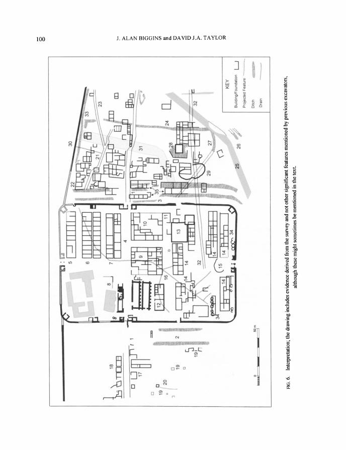
INTERPRETATION (FIG. 6)
THE TURF WALL
The Turf Wall (1) was built from a point west of the river Irthing to Bowness-on-Solway. It has been demonstrated that the Wall was c. 6.10 m wide at its base, and, close to the fort, was protected
24 The survey used a Wild TC1010 total station from a single station point by the porta decumana. The walls and consolidated masonry were also surveyed but not included as contourable points. Data was downloaded onto a CAD programme (Liscad) and after data manipulation was transferred to EasyCad as an industry standard dxf file, which was then smoothed using Cubic B Spline transformation. The high density survey (c. 3000 readings per ha) was designed to emphasise micro-topographical anomalies. The north-western part of the survey area, including the farm buildings and conjectural structures, was appended from other sources, including the RCHME 1987 survey and the most recent site excavations.
25 Richmond 1931, 127. 26 The survey was conducted at 0.5 m sample and 1 m zigzag traverse intervals using a Geoscan RM 15 resistivity meter
which had a twin electrode configuration and a probe separation of 0.5 m. Data was treated as magnetometry, except that desloping was performed.
27 This survey was conducted using a Geoscan FM36 fluxgate gradiometer using 0.5 m sample and I m parallel east-west traverses, with the application of drift correction. Data was downloaded and analysed using both Geoplot 2 and Insite software. Inherent programme limitations with Geoplot indicated the use of Insite for larger survey areas. Data processing used the stages; edge matching, despiking at a tolerance of + or - 2 S.D.'s, after which it was smoothed by interpolation using a factor of 0.125. It was found necessary to utilise a number of different compression and contrast values in order to visualise features of different relative intensities.

96 J. ALAN BIGGINS and DAVID J.A. TAYLOR
Ram
.- ---- --
? " "'
" ... . i
- --F
Th
-q !1 i i .... .. . ...
-" .--
rr
rr-
"•-• '•
., ," .•:
-
-( : " . .. . ..I'-Jo -
50m
' r- ""0m
:!- - ? •
"----_ .. . . .. . . . .. . . . • -
-- - Ei• lllil
-,,• ' .... I" ,I--:
50mr
FIG. 3. Earthwork survey.

A SURVEY OF THE ROMAN FORT AND SETTLEMENT AT BIRDOSWALD 97
Outbuildings
Farmhouse
Granaries
M 0
50m -ww
FIG. 4. Resistivity survey.

98 J. ALAN BIGGINS and DAVID J.A. TAYLOR
N
br
4 2
o-5 A. 1
7IO r
FIG. 5. Magnetometer survey.

A SURVEY OF THE ROMAN FORT AND SETTLEMENT AT BIRDOSWALD 99
to the north by a ditch 8.23 m wide at the top and 2.74 m deep.28 The ditch at Birdoswald was found to be 7.70 m wide and a projected 3.80 m deep.29 The original, likely intention of the fort builders was that the Stone Wall would follow the same line, and abut the Hadrianic fort at the enlarged southern guard-chambers to the portae principales. These two guard-chambers are both 5.48 m long, while both northern guard-chambers have contracted lengths (4.69 m and 4.64 m). At Chesters there is a slight increase in the width of the guard-chambers to the gates of the portae principales when compared to the other two main gates. The probable explanation for the increase in size at Birdoswald is that the Turf Wall was in situ at the time the construction of the stone fort commenced.30
Gillam31 found that the north portal and north guard-chamber of the porta principalis dextra were built precisely over the infilled ditch of the Turf Wall. Consequently, the line of the via principalis and the eastern exit road appears to have been close to the inner edge of the Wall Ditch. This is supported by the discovery of the southern edge of the Turf Wall 6.70 m south of the south portal of the porta principalis sinistra,32 additionally conforming with a typical berm width of c. 1.80 m. Evidence of the ditch can be seen as an anomaly in the east of the fort north of the via principalis. The route of the roads leaving the fort to both the east and west does not quite follow a straight line. The road leaving the fort to the east is at three degrees less than a right angle to the curtain wall, whilst the road leaving to the west is two degrees less than a right angle. It is probable, therefore, that there was a realignment of the Turf Wall at the west gate as indicated by Wilmott,33 but not to the extent shown.
THE DEFENCES
Two clearly defined ditches (2) can be seen to the west, c. 13 m apart and with the centre of the inner one c. 9 m from the face of the stone fort wall. There is some evidence of later recutting as a further section of ditch can be seen to the south-west of the outer ditch. Three ditches were found on the west of the south-west comer during the 1996 excavation;34 all were primary and the outer two cut the vallum backfill. The ditches to the east (3) are much more complex. Simpson and Richmond35 found two ditches to the north of the Turf Wall ditch, the outer one of which, c. 3.30 m wide with its inner edge c. 15.20 m from the face of the curtain-wall, ran into the Turf Wall ditch as if contemporary with it. A further ditch was found to the south of the Turf Wall only c. 1 m wide, with its inner edge c. 13.70 m from the curtain-wall. This stopped c. 15 m short of the centre of the porta principalis dextra, and it was considered by Simpson and Richmond to have been cut in association with the Turf Wall ditch, so as to leave a gap for the construction of the Turf Wall. The ditches immediately to the south of the gate and the line of the Turf Wall are confused, and seem to be made up of a single ditch close to the curtain-wall, with a group of three ditches further to the east, one of which must be that described by Simpson and Richmond above; none of these appear to run parallel to each other. To the south of these, two ditches are clearly defined. The ditches on the east are seen to run up close to the south of the Stone Wall.
28 Daniels 1978, 20. 29 Wilmott 1997, 47. 30 Wilmott 1997, 89-90. 31 Gillam 1950, 65. 32 Wilmott 1997, 90. 33 Wilmott 1997, 90 fig. 59. 34 Wilmott forthcoming (b). 35 Simpson and Richmond 1934, 127-9.
. U... 3 1 ..16
14 K
18 7I1 _ _i
r 1 : L :
7 rr
Drain i*-
1 7 9......... L i . .
2 50 m Ditch
24•.
FIG. 6. Interpretation; the drawing includes evidence derived from the survey and not other significant features mentioned by previous excavators,
although these might sometimes be mentioned in the text.
z
0
(I
0
II
0
H 0:
>3;
t" ? 7•

A SURVEY OF THE ROMAN FORT AND SETTLEMENT AT BIRDOSWALD 101
Comparison with other forts per lineam valli is limited. Petch36 cut a section through the eastern defences at Benwell and found two ditches 6 m wide separated by a 1.50 m space, with a berm of 3 m. Simpson and Richmond37 found a similar arrangement to the western defences of the same fort, with the exception that the inner ditch was 7.60 m and the outer ditch 3 m. At Halton Chesters it was found that the double ditches to the north and north-west comprised an outer ditch c. 3 m wide with an inner ditch c. 7.50 m separated by a c. 6 m space.38 There was a c. 6 m berm between the inner ditch and the fort rampart. It has been shown that the sequence of ditches as fort defences is extremely complex.39 At both Birdoswald and South Shields it was found that cutting and recutting had taken place on many occasions, for a ditch section cut through clay has only a limited life.
Causeways can clearly be seen at the porta principalis dextra where the road crosses the ditches, although no causeways can be seen outside the portae quintanae. These gates would have become redundant when the Stone Wall was moved up to the line of the north fort curtain-wall. It has been shown that the gates were blocked, and it is assumed that ditches had been cut across the causeway shortly after the completion of the building of the stone fort.40
The porta quintana dextra does not show up on the survey, although this was excavated recently by Wilmott.4' Evidence of considerable later activity can be seen in the rampart to the fort wall by the great many magnetic anomalies, probably reflecting the greater number of people occupying the fort in its later periods. Simpson and Richmond42 found that the rampart to the southern fort wall was made up partly with rubbish from an earlier fort. An Hadrianic oven was also seen close to the south-west comer, whilst a successive series of ovens (34) were found to the east of the porta decumana,43 and the south-west sector of the retentura.
INTERIOR OF THE FORT
The street pattern
The four sides of the fort are not set out parallel to each other, although the south and west curtain-walls are set out close to a right angle. The portae principales are not quite directly opposite one another, which probably accounts for the alignment of the via principalis and the east and west roads.
The original street pattern within the fort followed the normal pattern for forts astride the Wall.44 Later activity within the fort obscured this street pattern, and this reflects the final periods of occupation. The via principalis (4) is clearly defined, and the line of the Turf Wall ditch can be made out to the north along its length. Some intrusion into the northern part of this road can be seen adjacent to the porta principalis dextra. This probably reflects the blocking of the north portal which Potter noted was at a higher level than the original level of the floor to the gate.45
36 Petch 1927. 37 Simpson and Richmond 1941. 38 Berry and Taylor 1997. 39 Bidwell and Speak 1994, 127-44; Wilmott 1997, 86. 40 Wilmott 1997, 100. 41 Wilmott 1997, 65-9. 42 Simpson and Richmond 1932, 142-3. 43 Simpson and Richmond 1933, 252-4 and fig. 10. 44 Johnson 1983, 70. 45 Potter 1855, 142.
102 J. ALAN BIGGINS and DAVID J.A. TAYLOR
Replacement pivot blocks had been provided to both portals. The interpretative and other plans show the portals with the later blocking.
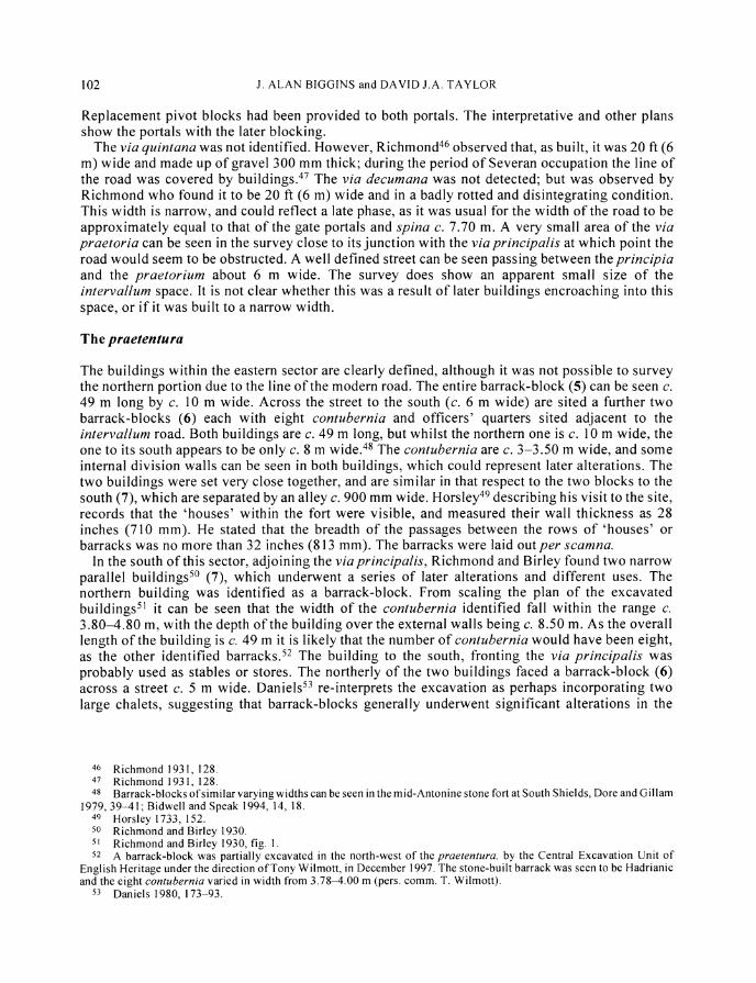
The via quintana was not identified. However, Richmond46 observed that, as built, it was 20 ft (6 m) wide and made up of gravel 300 mm thick; during the period of Severan occupation the line of the road was covered by buildings.47 The via decumana was not detected; but was observed by Richmond who found it to be 20 ft (6 m) wide and in a badly rotted and disintegrating condition. This width is narrow, and could reflect a late phase, as it was usual for the width of the road to be approximately equal to that of the gate portals and spina c. 7.70 m. A very small area of the via praetoria can be seen in the survey close to its junction with the via principalis at which point the road would seem to be obstructed. A well defined street can be seen passing between the principia and the praetorium about 6 m wide. The survey does show an apparent small size of the intervallum space. It is not clear whether this was a result of later buildings encroaching into this space, or if it was built to a narrow width.
The praetentura
The buildings within the eastern sector are clearly defined, although it was not possible to survey the northern portion due to the line of the modem road. The entire barrack-block (5) can be seen c. 49 m long by c. 10 m wide. Across the street to the south (c. 6 m wide) are sited a further two barrack-blocks (6) each with eight contubernia and officers' quarters sited adjacent to the intervallum road. Both buildings are c. 49 m long, but whilst the northern one is c. 10 m wide, the one to its south appears to be only c. 8 m wide.48 The contubernia are c. 3-3.50 m wide, and some internal division walls can be seen in both buildings, which could represent later alterations. The two buildings were set very close together, and are similar in that respect to the two blocks to the south (7), which are separated by an alley c. 900 mm wide. Horsley49 describing his visit to the site, records that the 'houses' within the fort were visible, and measured their wall thickness as 28 inches (710 mm). He stated that the breadth of the passages between the rows of 'houses' or barracks was no more than 32 inches (813 mm). The barracks were laid out per scamna.
In the south of this sector, adjoining the via principalis, Richmond and Birley found two narrow parallel buildings50 (7), which underwent a series of later alterations and different uses. The northern building was identified as a barrack-block. From scaling the plan of the excavated buildings5" it can be seen that the width of the contubernia identified fall within the range c. 3.80-4.80 m, with the depth of the building over the external walls being c. 8.50 m. As the overall length of the building is c. 49 m it is likely that the number of contubernia would have been eight, as the other identified barracks.52 The building to the south, fronting the via principalis was probably used as stables or stores. The northerly of the two buildings faced a barrack-block (6) across a street c. 5 m wide. Daniels53 re-interprets the excavation as perhaps incorporating two large chalets, suggesting that barrack-blocks generally underwent significant alterations in the
46 Richmond 1931, 128. 47 Richmond 1931, 128. 48 Barrack-blocks of similar varying widths can be seen in the mid-Antonine stone fort at South Shields, Dore and Gillam
1979, 39-41; Bidwell and Speak 1994, 14, 18. 49 Horsley 1733, 152. 50 Richmond and Birley 1930. 51 Richmond and Birley 1930, fig. 1. 52 A barrack-block was partially excavated in the north-west of the praetentura, by the Central Excavation Unit of
English Heritage under the direction of Tony Wilmott, in December 1997. The stone-built barrack was seen to be Hadrianic and the eight contubernia varied in width from 3.78-4.00 m (pers. comm. T. Wilmott).
53 Daniels 1980, 173-93.

A SURVEY OF THE ROMAN FORT AND SETTLEMENT AT BIRDOSWALD 103
fourth century, when these chalet-type blocks were commonly constructed. It is suggested that much of the alterations to this building and other barracks, represents the construction of chalets, where each building is a separate structure. Evidence of chalets was found in a barrack-block in the north-west of the praetentura excavated in December 1997.54 Examples of these have been seen on many sites in the northern military zone including Housesteads, Wallsend, South Shields, Ebchester, High Rochester, and Newstead. Restating the excavated evidence (with suggested reconstructions),55 Daniels posited considerable alterations to barracks during the fourth century. Supportive evidence comes from Newstead which showed that chalet-type blocks were being used as early as c. 160.56 The number of contubernia in each of the barrack-blocks at eight is unusual per lineam valli, and is only matched at Halton Chesters where sixteen contubernia are provided in each double block.
To the south-west, the corner of a building (8) could represent part of the eastern section of the basilica. This building was excavated by Wilmott57 and part of the south aisle was found to overlie the Wall ditch. The basilica was seen to consist of a nave and two aisles, it was estimated that its length was 42.78 m,58 equal to the distance between the via praetoria and the intervallum road. The building was found, in this survey, to be set back from the via praetoria, possibly indicating that the length of the building could be less than 40 m. The setting back of this building from the road could reflect its importance.
The latera praetorii
South of the junction between the via principalis and the via praetoria lies the principia (9), although the centre of the building does not lie on the central axis of the via praetoria. The cross-hall and rear range of five rooms can clearly be distinguished, together with the central courtyard surrounded by a series of rooms which are almost certainly later additions. Some later subdivision appears to have taken place in the cross-hall to form three main units. The overall size of the building is c. 28 m by c. 32 m, with the cross-hall being c. 9 m wide overall, with no aisle visible to the south of the courtyard. An ambulatory was formed to the north, east and west sides of the courtyard c. 4 m wide. The projection of the rear range is c. 6 m. The northerly section of the building would seem to have undergone later alteration with an extension being built onto the north wall, together with a reconstruction of the northern ambulatory, partially extending into the via principalis. No certain identification could be made of a strong-room, although it could be represented by a strong positive anomaly in the room at the south-west corner of the rear range.
Richmond excavated part of the principia59 and estimated the back wall to be fifteen courses high adding that, 'the back rooms of the principia must be amongst the most remarkable in Britain; in one room alone we found the voussoirs of the arched entrance lying as they had fallen'. The nearest comparative size of a principia, per lineam valli, is that at Carrawburgh which measures 26.20 m by 28 m, although that at Halton Chesters is c. 30 m by 39 m and Chesters 27.54 m by 39.19 m.
The praetorium (10) was situated to the east of the principia, separated from it by a street c. 6 m wide and set back from the assumed line of the via principalis, calculated at 7.70 m wide, by some
54 T. Wilmott pers. comm. 55 Daniels 1980, 173-93. 56 Clarke 1996, 5. 57 Wilmott 1997, 79-82. 58 Wilmott 1997, 81. 59 Richmond 1931, 127.

104 J. ALAN BIGGINS and DAVID J.A. TAYLOR
3 m. The building measured c. 33 m by 26 m, and comprised a series of rooms set around a central courtyard, which may have had a width of c. 10 m. The building shows evidence of considerable later alterations and additions, and it is probable that the range of rooms to the west was c. 6 m wide. Richmond60 noted material from a hypocaust which he thought had come from the building. Whilst excavating 'not far' from the east gate, Potter61 found a room with a hypocaust together with a similar room leading from it. These rooms measured 10 ft (3.05 m) by 8 ft 9 inches (2.70 m) and 10 ft (3.05 m ) by 9 ft 6 inches (2.90 m). A further room was seen adjacent, measuring 9 ft 8 inches (2.95 m) by 9 ft 6 inches (2.90 m). The walls to the hypocaust room were described as being covered in 'red coloured stucco', presumably opus signinum. From their portrayal it is almost certain that the description refers to a suite of baths attached to the praetorium, and situated adjacent to the intervallum road. High negative anomalies in this area could indicate the position of the furnaces.
A substantial building is sited to the west of the principia (12) some 6 m south of the two third-century granaries. The building, c. 27 m by 9 m, is divided internally into three by two walls, and could be the one described by Richmond62 as having a north wall at least eight feet (2.40 m) high. Unfortunately this is the only description given of this building, but it is shown on Richmond's site plan being c. 93 ft (28.30 m) by 25 ft (7.60 m). The walls to this building are somewhat thicker than those of the buildings previously described, being in the region of 1 m thick. Taking this into account with the width it is possible that the structure might be a granary. The absence of any buttresses seen by Richmond could reflect the superficial nature of the excavation, which was almost certainly by narrow trenches, with a trench possibly being sited between the buttresses. The overall width of both of the third-century granaries at Birdoswald is 8.26 m. A pathway can be seen leading from the north-east corner of the building to the south-east corner of the principia, and from thence, passing by a group of buildings to the south, to the north-west corner of the possible farmstead (13). A significant later structure (11) was constructed adjacent to the south east corner of the praetorium.
The retentura
A positive, linear feature, with a rounded corner, running north and west adjacent to the south-east corner may suggest that this represented a defensive feature of an earlier fort. A similar linear feature can be seen to the west just inside the intervallum road.
The dominant building in this sector of the fort is a clearly defined farmstead and enclosure (13), which can be seen to overlie earlier buildings, possibly barracks. The enclosure measures c. 22 m by 18 m, and the farmhouse c. 11 m by 11 m seems to cut into the south-east corner of the enclosure, and in this respect it is almost identical to a similar complex at Sundayburn in the Tynedale Liberty, adjoining the river Irthing.63 This is a type of farmstead which is common to north-east Cumbria, and is typified by a house and one or more enclosures, though rarely more than one building. It could date from the eighteenth century, although there is no documentary evidence to support this assumption. The absence of documentary evidence could suggest that the building is much earlier, perhaps representative of a phase of occupation on the site between the sub-Roman period and the farmhouse in the north-west corner. The large cleared area to the west of the complex could reflect the desire to have a cleared area free from upstanding masonry around it. The linear feature (32) to the south running to the south-east is a probable prehistoric defensive
60 Richmond 1931, 128. 61 Potter 1855, 67-9. 62 Richmond 1931, 127. 63 Ramm, McDowall and Mercer 1970, 49, 52.

A SURVEY OF THE ROMAN FORT AND SETTLEMENT AT BIRDOSWALD 105
feature which can also be seen outside the fort to the east. This can be identified as a bank on the topographical survey.
It is likely that there were two pairs of barrack-blocks each side of the via decumana adjacent to the south intervallum road (14), each with eight contubernia, as the lengths of the buildings are similar to those in the praetentura. Further barrack-blocks could have been built to the north of these. Simpson and Richmond64 show the south wall of a possible barrack-block some 1 1.90 m north of the east guard-chamber to the south gate and 7 m to the east of its eastern wall. This narrow trench apparently found no evidence of walling to the south. It is probable that the buildings in the south-east sector (14) represent a pair of barrack-blocks separated by a narrow alley, with some considerable later alteration to form chalet-type dwellings, the separate units of which can be clearly distinguished. The overall size of each block is c. 47 m by 8 m. There is a suggestion that there may be one or more large buildings, probably barrack-blocks, in the south-western sector. The buildings, possibly barracks, sited on the line of the via quintana, could be those mentioned by Richmond,65 and thought by him to relate to early third-century occupation.
Part of a semi-circular feature (15) can be seen to the north of the south gate, possibly forming part of a post-Roman enclosure wall. The position of the south-west angle tower is clearly seen as an intense feature, and could reflect occupation over a prolonged period.
DRAINS AND WATER SUPPLY
A main drain can be identified (16) cutting diagonally across the south-western part of the retentura before passing under the principia in an approximately north-south direction, and then proceeding diagonally across the praetentura to a point at the ramparts just north of the interval tower. Several subsidiary branches join the main drain. This was probably the lowest point of the original ground level, and it is possible that the latrines were sited to the inside of the curtain-wall at this point. This feature is shown very precisely on the resistivity survey, as is the modem drain running north-east in the south-east corner of the fort. As the response intensity of both drains is similar, it cannot be discounted that feature (16) forms part of a later drainage system. The strong linear feature in the south-west of the retentura running north-west/south-east, shown in FIG. 5, is a modern drain; a similar feature can be seen in the vicus to the west.
Bruce66 states that there was a spring to the west side of the station, and that he saw water flowing in a water course about three hundred yards from it. The water course, made up of flat stones, fed a cistern near the centre of the station, presumably close to the principia.
THE VICUS
Bruce67 observed that, 'The field on the east side of the station contains the foundations of several suburban buildings'. More recently Shotter68 contended that, 'the continuing strength of the vicus at Nether Denton (which survived the abandonment of the fort) has been adduced to explain the apparent absence of a vicus at the neighbouring Wall Fort of Birdoswald'.
64 Simpson and Richmond 1933, fig. 10 opp. 254. 65 Richmond 1931, 128-30. 66 Bruce 1867, 260-1. 67 Bruce 1867, 261. 68 Shotter 1996, 50.

106 J. ALAN BIGGINS and DAVID J.A. TAYLOR
At Birdoswald there is a marked difference between the buildings to the west of the fort and those to the east. The former are much slighter in their appearance and are probably more lightly constructed, with the use of timber-framed construction. These buildings are generally much more linear in their layout, with concentrations on each side of the road leading out of the fort. The majority of the buildings to the east, however, appear to be of more substantial construction, more closely aligned, and are almost certainly stone-built. Some of the buildings to the east may represent a form of military annexe and it is possible that the blurred linear feature (31) could define its original extent. The military annexe usually contained the bath-house, and other military buildings which could not fit comfortably within the ramparts. At Housesteads the exceptional masonry of Buildings V and VII is thought to represent military use,69 and it is even suggested that troops might have been billeted there.
West of the fort
The survey was continued to the west of the fort for a distance of 80 m. Buildings fronted the road, c. 9 m wide, leading west out of the fort. These were not only of the traditional rectangular form with a narrow gable fronting the street (17),70 but also of squarish proportion on plan (18). Some of the former, possibly tabernae, can be seen fronting the street to the south, whilst the latter are more generally spaced. Some slighter structures indicated by a thin dark line (19) could represent buildings using timber construction, and could relate to those seen by Simpson and Richmond to the south of the fort.71 The excavators suggested that these buildings, possibly used for storage, were of a temporary nature dating from the construction of the stone fort. One timber building (20) has a drain running to the south on its west side. Circular positive features behind the buildings fronting the road could represent rubbish pits.
The cemetery is sited some 350 m to the south-west of the fort, and several isolated buildings have been identified in the field to the west of the fort72 which could be associated with it. Birley and Keeney73 point out that the position of temples and cemeteries has an important bearing on the plan of a settlement, and state that at several forts the temples are set some distance from the main roads. This proximal relationship of cemeteries can be seen at both Housesteads and Saalburg, where in general the cemetery lies on a road leading away from the settlement.
East of the fort
The survey extended 120 m to the east from the curtain-wall. Simpson and Richmond74 found that the large mounds outside the east gate covered the vicus (or fort annexe), which was seen to have at least three, well defined occupation levels. The heap aligned north-south, north of the porta principalis dextra, is predominately excavation spoil, presumably that produced by Glasford Potter in 1850. The presence of these mounds interfered with the magnetic readings of the anomalies below them.
The road leading out of the fort past the outer ditches was fronted by much larger stone buildings than those to the west. Buildings on each side of the road seem to have impinged on its width and reduced it to c. 5 m. Similar stone buildings are closely grouped within the linear feature (31).
69 Birley and Keeney 1935; Crow 1995, 73. 70 Salway 1958, 236. 71 Simpson and Richmond 1934, 125-9. 72 Walker 1986, unpublished resistivity survey, pers. comm. 73 Birley and Keeney 1935, 237. 74 Simpson and Richmond 1934, 130.

A SURVEY OF THE ROMAN FORT AND SETTLEMENT AT BIRDOSWALD 107
Another road (21) runs south-east at an angle of c. 60 degrees from the north-east interval-tower, incorporating a kink close to some substantial buildings (22) sited close to the south of the Wall. It is possible that one of these might have been a bath-house. A further road (23) runs from the latter road towards the north-east.
A ditch (24) runs from the south of the Wall to cut the vallum (25). This ditch does not cut any of the roads, and, as it does not follow a straight line, it is implied that it was excavated in sections thereby respecting the existing roads; as it cuts the vallum it would have a terminus post quem of c. 125. The ditch clearly cuts through Building 28 together with several buildings to either side of the east-west road. It is probable that it is a late defensive feature, and is evidence of the abandonment of these buildings outside the fort. A similar set of circumstances has been seen to have occurred in the vicus at Malton,75 where a large ditch (3.60 m wide) with a rampart was cut through buildings close to the south-east gate, and a fifth-century date has been adduced.
The truncated ends of two parallel ditches (26) can be identified where landslip has occurred to the south-east of the survey, and these could relate to the north-south ditch (24). The curving end of a further ditch (27) can be seen to the north of the vallum. This could be the end of the ditch seen by Richmond,76 which ran from a point north of the porta quintana dextra stopping short of the vallum in a curving end, implying that the vallum was there when it was dug. He considered this ditch cut off an area defined on the south by the vallum, and on the east by the ditch.
A well defined square feature (28) can be seen on the edge of the survey on a continuation of the line of the via quintana. The building measures c. 9 m on each axis, and a ditch was seen on three sides. There can be little doubt that this is the building seen by Richmond77 to the east of the fort and described as, 'A good building, twenty feet square, with three-foot walls standing thirteen courses high....'. A drain was also seen to run away from the feature towards the escarpment. If the dimensions stated by Richmond were the internal ones, then the size almost exactly matches that shown on the survey. It is probable that this building is a signal-tower connected with the Stanegate limes,78 local examples of which are known at Pike Hill, Walltown, and Mains Rigg. This latter tower is 6.40 m (21 ft) square, and surrounded on four sides by a ditch. During the course of the recent excavations on the site, a photographic tower was placed approximately on the site of this building. It was found that it was possible to see over the fort and observe the west and north horizons.79 The building has been extended in its full width to the east, as can be seen by broken joints in the masonry, for a distance of c. 20 m. In addition some nine cellular type units have been built onto the tower and its extension, to the south, forming one block of three and one block of six. The widths of the blocks are c. 7 m and 14 m respectively, and the length of each c. 18 m. A wider unit was provided in the westernmost block adjacent to the tower. A gap of some 3 m was formed between each block. The extension to the signal-tower has been cut by the north-south ditch (24).
An ear-shaped sub-circular enclosure (29) can be seen just outside the defensive ditches measuring c. 27 m by 15 m. This is constructed in stone and overlies earlier buildings. It may relate to a much later farmstead similar in form to that at Mount Hulie,80 but this is only a provisional interpretation.
A drain (30) can be seen running north-south from the point on the Wall where a drainage outlet can be seen discharging to the north. This was constructed as an integral part of the Wall implying a connection to an existing drain for an existing settlement.
75 Wenham and Heywood 1997, 29-30, 38. 76 Richmond 1931, 122-4. 77 Richmond 1931, 130. 78 See note 1. 79 T. Wilmott pers. comm. 80 Ramm et al. 1970, 47, 49 fig. 13, 187.

108 J. ALAN BIGGINS and DAVID J.A. TAYLOR
A short distance to the south of feature (28), a possible linear prehistoric earthwork (32) can be seen running east-west. It is evident in the southern part of the retentura and runs to the east of the curtain-wall, where it subsequently cuts the vallum, to the edge of the survey. Evidence of a ditch (33) can be seen to the south of the Wall which probably formed part of the defences to the promontory fort on its north side. The position of this defensive feature may have influenced the siting of the realigned Stone Wall. To the east of the late ditch (24) there is little evidence of any stone buildings; there are however many slighter features which probably represent timber buildings.
Several anomalies can be seen associated with the defensive ditches to the east of the fort (35). These features can be seen to cut across the ditches in many instances and could possibly be interpreted as buildings. This could be considered doubtful as it is unlikely that buildings would be erected in this position during the occupation of the vicus. It is, however, conceivable that they may have been erected at a much later date. It is possible that the anomalies were caused by the material making up the fill of the ditches.
CONCLUSION
The survey has quickly and economically revealed the extent of the archaeology of most of the fort, together with significant areas of a possible military annexe and vicus to the east and west. The interpretation is complex, for it is probable that some form of continuous occupation took place within the fort and its settlement from prehistoric times until the present. The geophysical method of survey cannot distinguish between different phases of construction, and only provides a composite plan of all the features within the instrument's depth range. It is only possible to produce an interpretation of limited accuracy, and hence only a tentative reconstruction is offered; excavation is the only sure method of verification. It is not considered that this paper is an appropriate place to enter into the wider discussion on the implications of the number of contubernia, the potential number of barrack-blocks, and the size of the garrison in the fort.
The size of the vicus is unknown, and no significant work has yet been carried out on vici in the northern military zone. A geophysical survey has been carried out on part of the vicus at Chesters which has been seen to extend for over 150 m beyond the fort to the south. Extensive settlements are known at Benwell, Housesteads, and Chesterholm. At Newstead the mid-second-century civilian settlement in the southern annexe is thought to have comprised 80-100 buildings, although this interpretation is not wholly accepted, whilst the eastern annexe had buildings on either side of the road for a distance of c. 80 m.81 It is probable that the civilian population has been greatly underestimated per lineam valli. The Roman army has been shown to have provided a major input of wealth into the native population,82 and acted as a honey-pot for camp-followers and traders.
The scale of the prehistoric features seen was unexpected, and it is now known that more lie to all sides of the fort. This is supported by the recent finding of part of a lost resistivity survey carried out to the north, east, and west of the fort.83 This survey shows evidence of ditches and earthworks to the east as far as Milecastle 49, and to the west for a distance in excess of 250 m. A great many features were also seen to the north. It is hoped that the survey will be resumed to determine the full extent of the occupation of the site in both its Roman and prehistoric phases. This paper should therefore be considered as an interim report.
81 Clarke 1996, 4. 82 Millett 1994, 57-60. 83 See note 69.

A SURVEY OF THE ROMAN FORT AND SETTLEMENT AT BIRDOSWALD 109
ACKNOWLEDGEMENTS
The assistance of all the staff on the site at Birdoswald is greatly appreciated together with that of Bruce Bennison of Cumbria County Council Heritage Services. Thanks are also given to Professor Martin Millett of the Department of Archaeology, University of Durham for his helpful comments on a draft of this paper, and to Tony Wilmott, of the Central Archaeology Service, English Heritage for his help and advice during the survey and the preparation of this paper.
Department ofArchaeology, University of Durham
This paper is published with the aid of a grant from Cumbria County Council
BIBLIOGRAPHY
Berry, J., and Taylor, D.J.A. 1997: 'The Roman fort at Halton Chesters: a geophysical survey', Archaeologia Aeliana5 25, 51-60
Bidwell, P.T., and Holbrook, N. 1989: Hadrian's Wall Bridges, English Heritage Archaeological Report 9, London
Bidwell, P.T., and Speak, S. 1994: Excavations at South Shields Roman Fort. 1, Soc Antiqs Newcastle upon Tyne Monograph 4, Newcastle upon Tyne
Birley, E. 1961: Research On Hadrian's Wall, Kendal Birley, E., and Keeney, G.S. 1935: 'Fourth report on excavations at Housesteads', Archaeologia
Aeliana4 12, 204-58 RCHME 1987: Birdoswald (Banna) Roman Fort and its Environs, unpub. survey Breeze, D.J., and Dobson, B. 1991: Hadrian's Wall, Harmondsworth Bruce, J.C. 1867: The Roman Wall, Newcastle upon Tyne Clarke, S. 1996: Trimontium: A Roman Frontier Post and its Phases, University of Bradford Crow, J. 1995: Housesteads, London Daniels, C.M. 1978: The Roman Wall, Newcastle upon Tyne Daniels, C.M. 1980: 'Excavation at Wallsend and the fourth century barracks on Hadrian's Wall',
in W.S. Hanson and L.J.F. Keppie (eds), Roman Frontier Studies 1979, pt 1, BAR int. ser. 71 (i), 173-200
Dore, J.N., and Gillam, J.P. 1979: The Roman Fort at South Shields, Soc Antiqs Newcastle upon Tyne Monograph 1, Newcastle upon Tyne
Gillam, J.P. 1950: 'Recent excavations at Birdoswald', Trans Cumberland & Westmorland Antiq & Archaeol Soc2 50, 63-8
Haverfield, F. 1897a: 'Report of the Cumberland Excavation Committee 1895', Trans Cumberland & Westmorland Antiq & Archaeol Soc1 14, 185-97
Haverfield, F. 1897b: 'Report of the Cumberland Excavation Committee 1896', Trans Cumberland & Westmorland Antiq & Archaeol Soc1 14, 413-33
Horsley, J. 1733: Britannia Romana (Graham edn reprinted 1974), Newcastle upon Tyne Johnson, A. 1983: Roman Forts, London Millett, M. 1994: The Romanization of Britain, Cambridge Petch, J.A. 1927: 'Excavations at Benwell (Condercum), first interim report (1926)', Archaeologia
Aeliana4 4, 135-92 Potter, H.G. 1855: 'Amboglana', Archaeologia Aelianal 4, 63-75, 141-9 Ramm, H.G., McDowall, R.W., and Mercer, E. 1970: Shielings and Bastles, RCHME London

110 J. ALAN BIGGINS and DAVID J.A. TAYLOR
Richmond, I.A. 1929: 'Excavations on Hadrian's Wall in the Gilsland-Birdoswald-Pike Hill Sector, 1928', Trans Cumberland & Westmorland Antiq & Archaeol Soc2 29, 303-15
Richmond, I.A. 1931: 'Excavations on Hadrian's Wall in the Birdoswald-Pike Hill Sector, 1930', Trans Cumberland & Westmorland Antiq & Archaeol Soc2 31, 122-34
Richmond, I.A., and Birley, E.B. 1930: 'Excavations on Hadrian's Wall in the Birdoswald-Pike Hill Sector, 1929', Trans Cumberland & Westmorland Antiq & Archaeol Soc2 30, 169-205
Salway, P. 1958: 'Civilians in the Roman frontier region', Archaeologia Aeliana4 36, 227-44 Shotter, D. 1996: The Roman Frontier in Britain, Preston Simpson, F.G., and Richmond, I.A. 1932: 'Report of the Cumberland Excavation Committee for
193 1. Excavations on Hadrian's Wall', Trans Cumberland & Westmorland Antiq & Archaeol Soc2 32, 141-5
Simpson, F.G., and Richmond, I.A. 1933: 'Report of the Cumberland Excavation Committee for 1932. Excavations on Hadrian's Wall', Trans Cumberland & Westmorland Antiq & Archaeol Soc2 33, 246-62
Simpson, F.G., and Richmond, I.A. 1934: 'Report of the Cumberland Excavation Committee for 1933. Excavations on Hadrian's Wall', Trans Cumberland & Westmorland Antiq & Archaeol Soc2 34, 120-30
Simpson, F.G., and Richmond, I.A. 1941: 'The Roman fort on Hadrian's Wall at Benwell', Archaeologia Aeliana4 19, 1-43
Walker, R. 1986: Resistivity Survey, unpub. Kendal Wenham, L.P., and Heywood, B. 1997: The 1968 to 1970 Excavations in the Vicus at Malton,
North Yorkshire, Yorkshire Archaeological Report 3, Leeds Wilmott, T. 1993: 'The Roman cremation cemetery in New Field, Birdoswald', Trans
Cumberland & Westmorland Antiq & Archaeol Soc2 93, 79-85 Wilmott, T. 1997: Birdoswald, English Heritage Archaeological Report 14, London Wilmott, T. forthcoming (a): 'A possible Neolithic burial from Birdoswald, Cumbria', Proc
Prehist Soc Wilmott, T. forthcoming (b): 'Excavations on the Birdoswald Spur 1997', Trans Cumberland &
Westmorland Antiq & Archaeol Soc Woolliscroft, D.J. 1989: 'Signalling and the design of Hadrian's Wall', Archaeologia Aeliana5,
17, 5-20