520437 qttc ton - fsi-
TRANSCRIPT
MEMORANDUM
TO:
FROM:
DATE:
5 2 0 4 3 7 Qttc JMOUT ton - fsi- WSl
Jim Oliver
RE:
1992
True Blue Property: Slocan Mining Division, N.T.S. 82F/15W, Lt. 49 53' Long 116 58'
SUMMARY: Copper rich massive sulphides develop at the transition between late Paleozoic Milford and Kaslo group rocks at or near a volcanic-sediment transition. All rocks have been strongly penetratively deformed by two deformational events. A series of exhalitive horizons cross the flank of True Blue Mountain at approximately the 1500 m elevation datum. The horizons may be zoned from base metal poor, Mn rich to the north, to base and precious metals enhanced near the True Blue showing. Two massive sulphide lenses combine to form thicknesses of up to 1.2 m's and have produced 90 tons of ore grading 8.9% Cu, 58.6 g/T Ag, and 1.3 g/T Au.
RECOMMENDATION: The property owner should be approached and the conditions and terms of a potential option agreement investigated. The property should be aquired with the intention of immediately testing the D1 down plunge extension of the True Blue massive sulphide lense with 3 to 4 boreholes.
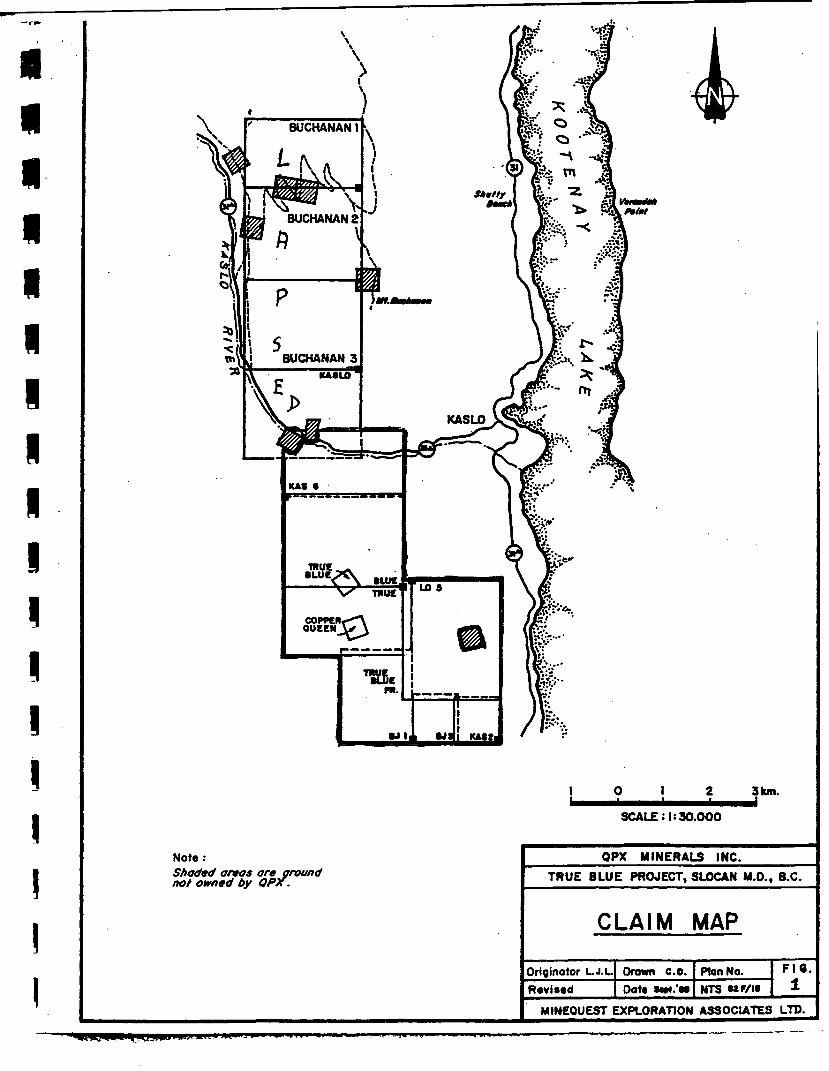
seven QOuv-rc LAND POSITION: The True Blue property consists of eleven mineral claims, one
m'o" fractional mineral claim, and two reverted Crown Grants, Figure 1.
MR OTTO JANOUT 30-33123-NELSONAVE OWNERSHIP: The claims are held by Otto and Otakar Janout of' =S= V2S°2
TLT0RD B A CANADA
LOCATION AND ACCESS: The True Blue property is located on the east slope of True Blue mountain, five kilometres soutwest of Kaslo, B.C. Elevation ranges from 625 metres in the True Blue valley to 2135 metres on the peak of True Blue Mountain. The property is road accessissble to within one kilometre of the main showning.
TARGET TYPE: The property is an example of a volcanogenic massive sulphide potentially of a Besshi type affinity.
GEOLOGICAL feYtlNG: The property is underlain by the Mississppian age Milford and older Kaslo groups. The Milford may be correlative with Fennel and Slide Mountain rocks. A gradational contact exists between the dominantly sedimentary Milford rocks and the more volcanic Kaslo group. This contact occurs at approximately the 1600 metre elevation datum on True Blue Mountain. Within the Milford group are a series of agillites and interbedded pyritic to manganiferous cherts and exhalites which increase in frequency toward the upper volcanic (Kaslo) contact. Volcanic rocks include massive foliated mafic flows, chlorite schists and potentially subvolcanic intrusions. Felsic tuffaceous sequences are also identified. Geological relations in the area of the True Blue adits are shown on Figure 2.
Beds are west to southwest dipping at moderate angles, 30 to 40 degrees. Beds are isoclinally folded by two major fold events. The earliest of these (D1) generates tight fold structures which are south-southwest plunging at moderate angles, 20 — > 200. D1 minor folds are shown on Plate 1. Smaller scale D2 structures rotate the earlier linear fabrics into moderate east or west directed plunges. D2 folds are shown on Plate 2. Sterographic data, Figure 3 clearly shows that earlier south plunging rock fabics are rotated by later smaller scale folds. It is critical to note that the overall plunge direction remains to the south-southwest at moderate angles.
MINERALIZATION AND ALTERATION: Two massive sulphide lenses are identified at the True Blue occurrence. Where they are exposed they range in thickness from 25 to 35 em's. Mining records suggests thicknesses of up to 1.2 m's were encountered. These lenses are very copper rich and sometimes demonstrate well defined zinc rich layers. Material which was mined had an average grade of 8.9% Cu, 1 - 2% Zn, < 0.5% Pb, 58.6 g/T Ag and 1.3 g/T Au. A distinctive zonation exists across all mineralized horizons on this property with Mn and Ba contents in exhalitive horizons increasing distally to away from main showning.
Massive sulphides exposed in the west rib of the upper adit are shown in Plate 3 and a more distal manganiferous chert horizon in Plate 4.
The main massive sulphide lens is overlain by 1.0 to 2.0 m's of strongly sericitized and weakly pyritic volcanic tuffs possibly of felsic origin. Although the sulphide lenses decrease in the more distant portions of the True Blue underground workings the hangingwall alteration does not diminish. Alteration levels are similar at the collar of the adit, Plate 5, and 40 m's into the mine workings, Plate 6.

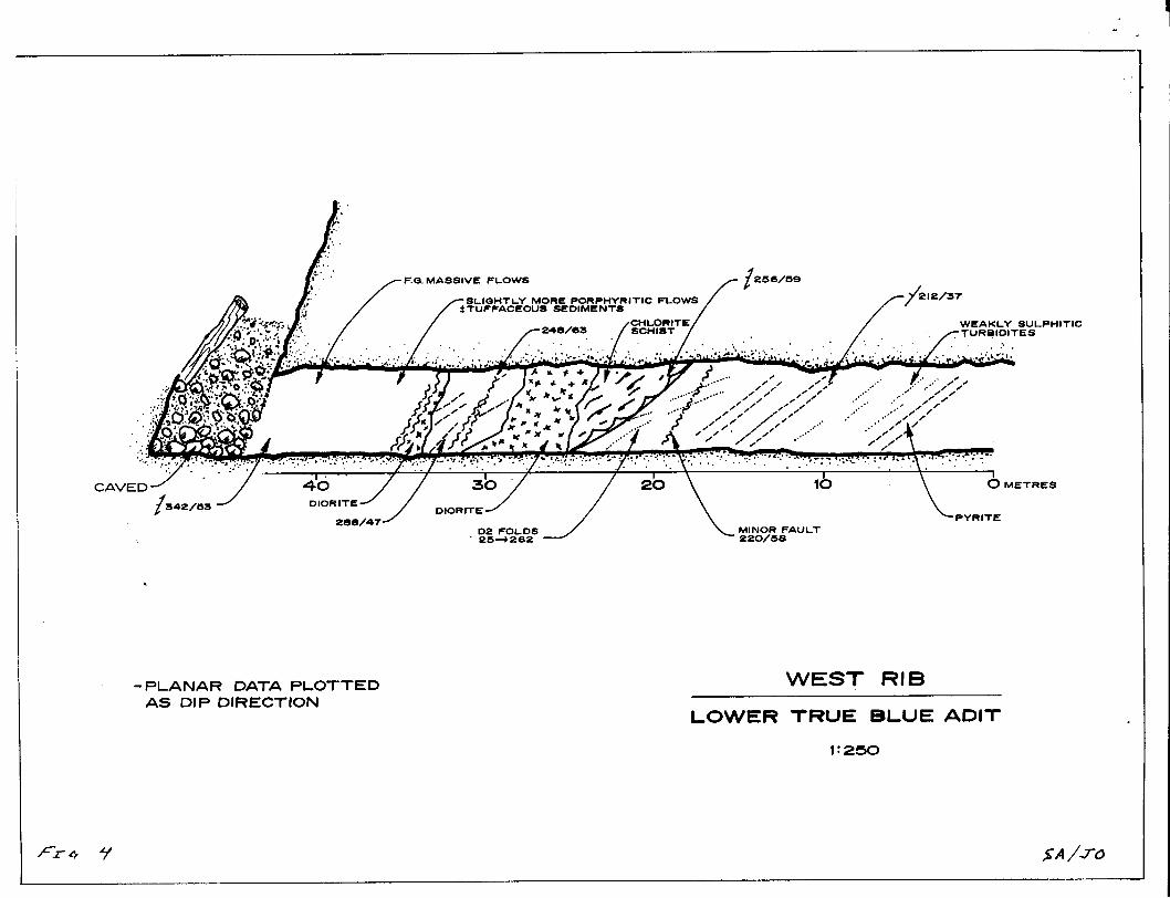
The underground workings at True Blue are cut by a large number of faults. Well defined thrust and extensional faults mapped in the lower adit (Figure 4) were also noted in the upper adit. Some of these structures may be partially responsible for the termination of ore at the True Blue.
PREVIOUS WORK: The True Blue has been the recipient of detailed geochemical, ground and airbourne geophysical, and geological mapping. The occurrence has produced 90 tons of high grade ore. One 135 m drill hole has been drilled on this property.
RECOMMENDATION RATIONALE:
There are several points to consider in the evaluation of this property:
A. Negative Parameters
1. The known massive sulphide lenses are small and have modest alteration development.
2. Geophysical and geochemical data are not definitive in defining a discrete geophysical or geochemical target.
3. The occurrence is hosted by a belt of rocks not typically associated with other VMS occurrences.
4. The single borehole drilled on this property, and tested with a down hole geophysical system has met with negative results.
B. Postive Parameters
1. Although the known lenses are small, significant rock alteration persists throughout the known workings of the mine and exists in the absensce of known sulphide development Manganiferous horizons, sometimes with anomalous barite, are laterally persistant.
2. The sulphide lenses develope very close to a volcanic sediment contact. This conductive contact may tend to mask an EM signature related to massive sulphides.
3. Although the Kaslo - Milford Groups do not have past production from known VMS deposits two other copper rich massive sulphides are known in the Kaslo area and are hosted by a similar rock package.
4. The single borehole drilled on this property has been drilled at an azimuth of 060 degrees in an attempt to intersect the down plunge extension of the True Blue mineralized zone. This azimuth is directed toward D2 fold plunges. The primary control on the distibution of sulphides at True Blue is from D1 plunges. These structures plunge 20 degrees towards 200 degrees. In essense, every foot that this borehole penetrates takes it farther away from its presumed target.
5. The True Blue zone is outlined by a large cylindical Mise a la Masse anomaly of approximately 300 m's in strike length. I do not believe that the thin sedimentary beds intersected in the borehole drilled are the cause of this conductor. Virtually none of the core in this borehole has been split. No trace element indicators have been intersected in this borehole to suggest that the main True Blue zone has been penetrated.
The True Blue is an untested massive sulphide occurrence. It warrants drill testing. A single drill collar positioned at approximately L 99+25 E and L104+25 N could be used to initiate 3 drill holes drilled at azimuths of 015,045, and 075 degrees. Approximately 450 metres of thin wall BQ drilling would be required.
I would estimate that this program would stand about a 10% percent chance of intersecting massive sulphides as good as, or better than, those currently known at the True Blue.
- 4 -
P L A N A R D A T A P L O T T E D A S D IP D I R E C T I O N
W E S T R I B
L O W E R T R U E B L U E A D I T 1 : 2 5 0
TRUE • L U C .
COPPER, QUEEN
3 km.
SCALE :|t30.000
Note : Shaded anas are ground not owned by QPx.
QPX MINERALS INC. TRUE BLUE PROJECT, SLOCAN M.O., B.C.
CLAIM MAP
Originator L.J.L.
R«vis«d Drawn c.o. Oat« —#.'m
Plan No. NTS
F I O .
MINEQUEST EXPLORATION ASSOCIATES LTD.

Fx. o. 3.


p L,
r
A T

P L A N A R D A T A P L O T T E D A S D IP D I R E C T I O N
W E S T R I B
L O W E R T R U E B L U E A D I T 1 : 2 0 0
%A/J~0