5.0 architectural appraisal
TRANSCRIPT

Austin-Smith:Lord LLP
24 October 2007 Page 55 of 135 206068
East Ayrshire Council
Kilmarnock John Finnie Street and Bank Street Conservation Area Conservation Area Appraisal and Management Plan
CONSULTATIVE DRAFT
5.0 ARCHITECTURAL APPRAISAL
5.1 East Ayrshire Council’s Conservation Area Appraisal, approved in early May 2006 and prepared in accordance with PAN 71 Conservation Area Management, sets out the characteristics of the designated area. This section of the report summarises the Appraisal, where appropriate enhancing important issues necessary to guide the development of an appropriate strategy and ensure that available funds are properly targeted.
5.2 The fabric of any historic site is of value for two reasons; it embodies tangible, physical evidence of its development (for example separate phases of work or differing constructional techniques), and for aesthetic reasons (essentially the architectural, or stylistic value).
5.3 The next step in the development of this conservation plan was therefore an assessment of buildings within the outstanding conservation area in order to:
Identify key design features including principal elevations and apartments.
Assess the extent and location of historic features.
Based upon these features, to determine the general phasing and development of the house.
Assess the relative importance of the house and its constituent parts
From this, develop guidelines which will ensure the building’s significance is maintained.
5.4 A key aspect of this was a building-by-building survey of all properties within the Outstanding Conservation Area. This took the form of a gazetteer comprising a record and description of each building, together with notes on materials, condition and use at the time of survey. These were recorded on a series of pro-forma recording sheets, cross-refer Appendix [ENTER NUMBER]. This was augmented by further detailed recording and analysis of key features including materials used, construction methods,
Key Characteristics – Architectural Appraisal and Principal Buildings
5.5 The analysis confirmed that, as a result of the historical pattern of development focussed on quite distinct areas, the Outstanding Conservation Area can be divided into four main zones:
John Finnie Street, a largely intact and superb example of a Victorian planned street
Bank Street and Strand, which although composed of largely 19th century buildings nevertheless follows the original post-medieval street plan.
St. Marnock Street, predominantly civic in emphasis with the Court, Church, Procurator Fiscal, and Police Station.
Portland Street north of the railway viaduct and West George Street, comprising the remaining 19th century buildings which typified the town centre together with the much older Old High Kirk
5.6 This section of the report provides an overview of each area, reviewing the architecture and the key buildings in order that target objectives can be set for the proposed Townscape Heritage Initiative. It has been based on a comprehensive desk assessment of published material including historical sources, listing data, RCAHMS/National Monuments Record archives, and other material such as SCRAN. The desk assessment was augmented by site inspections carried out during October 2005, augmented by further visits during early 2006.
Austin-Smith:Lord LLP
24 October 2007 Page 56 of 135 206068
East Ayrshire Council
Kilmarnock John Finnie Street and Bank Street Conservation Area Conservation Area Appraisal and Management Plan
CONSULTATIVE DRAFT
John Finnie Street
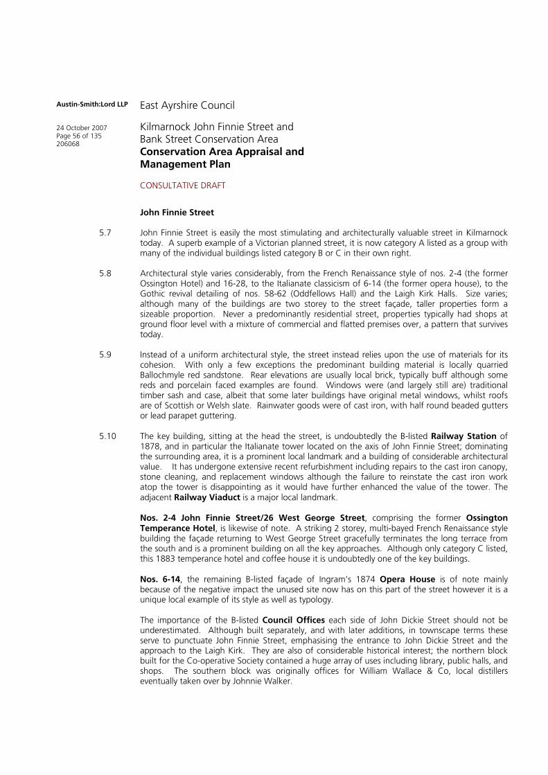
5.7 John Finnie Street is easily the most stimulating and architecturally valuable street in Kilmarnock today. A superb example of a Victorian planned street, it is now category A listed as a group with many of the individual buildings listed category B or C in their own right.
5.8 Architectural style varies considerably, from the French Renaissance style of nos. 2-4 (the former Ossington Hotel) and 16-28, to the Italianate classicism of 6-14 (the former opera house), to the Gothic revival detailing of nos. 58-62 (Oddfellows Hall) and the Laigh Kirk Halls. Size varies; although many of the buildings are two storey to the street façade, taller properties form a sizeable proportion. Never a predominantly residential street, properties typically had shops at ground floor level with a mixture of commercial and flatted premises over, a pattern that survives today.
5.9 Instead of a uniform architectural style, the street instead relies upon the use of materials for its cohesion. With only a few exceptions the predominant building material is locally quarried Ballochmyle red sandstone. Rear elevations are usually local brick, typically buff although some reds and porcelain faced examples are found. Windows were (and largely still are) traditional timber sash and case, albeit that some later buildings have original metal windows, whilst roofs are of Scottish or Welsh slate. Rainwater goods were of cast iron, with half round beaded gutters or lead parapet guttering.
5.10 The key building, sitting at the head the street, is undoubtedly the B-listed Railway Station of 1878, and in particular the Italianate tower located on the axis of John Finnie Street; dominating the surrounding area, it is a prominent local landmark and a building of considerable architectural value. It has undergone extensive recent refurbishment including repairs to the cast iron canopy, stone cleaning, and replacement windows although the failure to reinstate the cast iron work atop the tower is disappointing as it would have further enhanced the value of the tower. The adjacent Railway Viaduct is a major local landmark.
Nos. 2-4 John Finnie Street/26 West George Street, comprising the former Ossington Temperance Hotel, is likewise of note. A striking 2 storey, multi-bayed French Renaissance style building the façade returning to West George Street gracefully terminates the long terrace from the south and is a prominent building on all the key approaches. Although only category C listed, this 1883 temperance hotel and coffee house it is undoubtedly one of the key buildings.
Nos. 6-14, the remaining B-listed façade of Ingram’s 1874 Opera House is of note mainly because of the negative impact the unused site now has on this part of the street however it is a unique local example of its style as well as typology.
The importance of the B-listed Council Offices each side of John Dickie Street should not be underestimated. Although built separately, and with later additions, in townscape terms these serve to punctuate John Finnie Street, emphasising the entrance to John Dickie Street and the approach to the Laigh Kirk. They are also of considerable historical interest; the northern block built for the Co-operative Society contained a huge array of uses including library, public halls, and shops. The southern block was originally offices for William Wallace & Co, local distillers eventually taken over by Johnnie Walker.

Austin-Smith:Lord LLP
24 October 2007 Page 57 of 135 206068
East Ayrshire Council
Kilmarnock John Finnie Street and Bank Street Conservation Area Conservation Area Appraisal and Management Plan
CONSULTATIVE DRAFT
Whilst architecturally rather understated, the comparatively modern 2 storey Co-operative Funeral Service at 116-118 John Finnie Street is a good, solid example of a near unaltered building with original glazing and timberwork. The lack of cills and mouldings is a characteristic element, giving the building a pared down, modern appearance and it sits on a focal position at the junction with Bank Street.
To the immediate west of John Finnie Street, the former Kilmarnock Standard Printing Officeoccupies a focal position at the junctions of Grange Place, Nelson Street, and Grange Street. The V-shaped 19th century, B listed building has carved friezes of Caxton, Guthenberg, and Shakespeare whilst the design in many ways mirrors the design of the former Wylie’s Grain Store on the opposite side of Grange Place, in turn framing views towards Bank Place.
Figure 43: John Finnie Street From the South (A-S:L)
Figure 44: John Finnie Street - Typical Buildings (A-S:L)

Austin-Smith:Lord LLP
24 October 2007 Page 58 of 135 206068
East Ayrshire Council
Kilmarnock John Finnie Street and Bank Street Conservation Area Conservation Area Appraisal and Management Plan
CONSULTATIVE DRAFT
5.11 The northwest part of John Finnie Street, now occupied by the modern telephone exchange, lay within the policies of Langlands House, and was never developed to match the adjacent tenemental properties and public buildings; the corner plot was instead the site of a series of large detached and semi detached villas, the style of which suggests that some or all might predate the street’s formation and are apparently shown on the 1857 map of the town.
5.12 The majority of the properties within John Finnie Street have been executed in the locally quarried Ballochmyle red sandstone. Applied masonry finishes vary from a smooth ashlar, rusticated, stugged (2 John Finnie Street, Allen and Harris Estate Agents) and bullfaced (30-38 John Finnie Street, Blue Triangle Café), all of which have been brought to course. Also evident in a limited number of properties is the use of marble cladding to the lower half of the elevation (11 John Finnie Street, Church Hall and 73 John Finnie Street, the Post Office Building).
With the exception of a few buildings towards the bottom end of John Finnie Street e.g. 116-118 John Finnie Street (Co-op Funeral Directors), the majority of the buildings have fine decorative stone masonry detailing including Corinthian columns, balustraded pediments and carved panel detailing.
Rear elevations have been constructed from a blonde or red local brick. In some occasion, such as in the Blue Triangle Café, the rear elevation has been finished in a porcelain faced brick.
5.13 Later modern builds / infills have resulted in the introduction of concrete to limited number of sites within the Conservation Area. This has taken place in the form of concrete render and concrete panelling/cladding. This includes 96 John Finnie Street (the Royal Bank of Scotland), 97 John Finnie Street (Pharaoh’s Locksmith) and 81 -87 John Finnie Street (George Tannahill & Sons).
Figure 45: The Former Ossington Hotel, John Finnie Street. Mid-20th century postcard (author’s collection)

Austin-Smith:Lord LLP
24 October 2007 Page 59 of 135 206068
East Ayrshire Council
Kilmarnock John Finnie Street and Bank Street Conservation Area Conservation Area Appraisal and Management Plan
CONSULTATIVE DRAFT
5.14 Slated in traditional Scottish / welsh slate the majority of the properties retain their original roof coverings. Generally pitched with diminishing courses and terracotta / lead ridge detail. Where original slating has been lost due to deterioration or damage, (100-106 John Finnie Street The Paper Roses building), modern concrete tiles have been introduced. Reslating of 39-41 John Finnie Street has seen the introduction of a grey/green slate, possibly West Highland which is also uncommon within the OCA.
5.15 A number of buildings, in particular those dominating prominent corner site position, feature decorative corner towers, as seen in 56-62 John Finnie Street.
5.16 Chimney stack construction and positioning varies from property to property, with gable and centrally stacks also vary in size. The materials used however remain consistent. This includes the use of smooth squared ashlar or red / blonde brick with sandstone cope. It should be noted that a number of stacks have modern cement render applied. The majority of the properties also retain their original decorative pots. Only a limited number of modern additions are visible from street level.
5.17 Rainwater goods within John Finnie Street are predominantly cast iron with half round beaded guttering. Buildings such as 75-79 John Finnie Street (George Tannahill & Sons) has retained its traditional cast iron rainwater goods with hopper collection. A number of properties have parapet guttering systems such as that found in 100-106 John Finnie Street (the Paper Roses building). Inappropriate repair methods has resulted in the introduction of PVC downpipes and gutters to a number of rear elevations.
5.18 John Finnie Street retains the majority of its original windows. These are predominantly traditional timber sash and case windows, with the exception of a limited number of later buildings such as 11 John Finnie Street that retains it original steel framed windows. The general configuration varies throughout the length of the street which in turn adds to the unique style and quality of the area. Horn details are a common feature within many of the sash and case windows along John Finnie Street.
In general the windows are glazed with clear float glass Exceptions include the Blue Triangle Building that houses a mix collection of coloured glass to the upper panes, whilst a limited number of stained glass panels (although in need of restoration) remain in-situ such as those found in 56-62 John Finnie Street (The Clansman).
5.19 Where traditional windows have been removed modern look-a-like sash and case alternatives have been introduced (78-84 John Finnie Street Douglas Wright Solicitors). This has had a negative impact on the appearance and quality of the area. The introduction of large double height glazing as seen at 96 John Finnie Street (the Royal Bank of Scotland) is ???
5.20 Nearly all of the original shopfronts and doors have been replaced with modern materials such as aluminium and plastic. Number 81 -87 John Finnie Street George Tannahill & Sons is now the last remaining original shopfront in the street.
5.21 Traditional hardwood doors such as that found at the Evangelical Church at 23 John Finnie Street have now been replaced with a combination of lower quality timber alternatives and modern security roller shutter doors.

Austin-Smith:Lord LLP
24 October 2007 Page 60 of 135 206068
East Ayrshire Council
Kilmarnock John Finnie Street and Bank Street Conservation Area Conservation Area Appraisal and Management Plan
CONSULTATIVE DRAFT
Figures 46 and 47: Typical Sash and Case Windows – Note Banding and Carved Work A-S:L)
Figure 48: Typical Sash and Case Window - Note Bullfaced Masonry and Ashlar Dressings A-S:L)

Austin-Smith:Lord LLP
24 October 2007 Page 61 of 135 206068
East Ayrshire Council
Kilmarnock John Finnie Street and Bank Street Conservation Area Conservation Area Appraisal and Management Plan
CONSULTATIVE DRAFT
Figure 51: Ornate Corner Tower (A-S:L)
Figure 49: Carved Decoration (A-S:L) Figure 50: Typical Chimney Stack and Pots (A-S:L)
Figure 52: Ornate Corner Tower (A-S:L)

Austin-Smith:Lord LLP
24 October 2007 Page 62 of 135 206068
East Ayrshire Council
Kilmarnock John Finnie Street and Bank Street Conservation Area Conservation Area Appraisal and Management Plan
CONSULTATIVE DRAFT
Bank Street and Strand Street
5.22 Bank Street and surrounding streets such as Strand, Croft Street, Cheapside, College Wynd, and Low Church Lane offer a stark contrast to the planned geometry of John Finnie Street, Grange Place, and John Dickie Street. Although the buildings are largely 19th and 20th century, the irregular street plan dates from Kilmarnock’s earliest days and – with comprehensive redevelopment east of the Cross – is perhaps the sole surviving evidence for this important period in its development. This is the defining character of this part of the conservation area.
5.23 Buildings encompass a period of some 200-250 years and styles therefore vary significantly. Construction is overwhelmingly traditional with stonemasonry walls, timber sash and case windows, and Scottish or Welsh slate roofs. Many of the buildings are rendered, albeit in modern cement mixes, however typically 19th century sandstone buildings also exist. Strand Street in particular was comprehensively redeveloped by Johnnie Walker and contains a locally unique set of French Renaissance brickwork warehouses (others were demolished as recently as the 1970’s).
The focus for this part of the conservation area is the Laigh Kirk (now formally Laigh West High). Although the tower is 17th century, the main part of the building dates from 1802 and was enlarged in 1831. The A listed two storey classical church, sitting in an elevated position within its own (separately listed) kirkyard, dominates this part of the town centre. It is one of the most important historical and architectural buildings surviving. It was extensively restored in the 1990s.
Although not a building, Sandbed Bridge (also the Old Bridge or Town Bridge) dates from 1762 and is the oldest surviving bridge in Kilmarnock. Linking Cheapside and Bank Street with the main road south along Sandbed Street, it was one of the principle approaches to the town and until the late 18th century the venue for the town’s market.
Gabriel Andrew’s Johnnie Walker Whisky Bonds of 1895-97 are another key focus for the Bank Street/Strand area. These stunning 3 storey, multi-bayed French Renaissance style, brick and slate bonded warehouses are without architectural precedent locally and are the only reminder of the former Walker complex which dominated Croft Street and Strand Street. They define not only the area around the Laigh Kirk, but also Strand and Croft Street.
Northeast of the Bonds are two much more modest buildings, the importance of which should not be underestimated. The single storey, gabled red brick former Bond Stable is surprisingly intact externally, and although unlisted is an irreplaceable part of the town’s history. 1-3 Dunlop Street/12 Strand Street is the sole survivor of the traditional early 19th century houses and shops which were found on Strand Street prior to the Walker redevelopment around the turn of the 20th
century. Its retention should be an absolute priority.
The former Bank of Scotland at 44-48 Bank Street, originally a pair of semi-detached houses, is a unique classical essay set back from the narrow canyon of Bank Street and terminating the axial view from Grange Place.
58-62 Bank Street, another Andrew building dating from 1903, occupies a visually important site at the corner of Bank Street and Nelson Street, whilst the close retains a fine example of largely intact art nouveau tiling.
1-3 St. Marnock Place (the Treehouse, formerly Borland’s Seed Warehouse) and adjacent 5-7(Graham & Sibbald) of 1850 and 1895 respectively are excellent examples of the industrial/commercial properties found in this part of the town during the latter part of the 19th
century. Framing the approach from the Timmer Brig, and dominating the west bank of the Kilmarnock Water, their historical and townscape value should not be undervalued.

Austin-Smith:Lord LLP
24 October 2007 Page 63 of 135 206068
East Ayrshire Council
Kilmarnock John Finnie Street and Bank Street Conservation Area Conservation Area Appraisal and Management Plan
CONSULTATIVE DRAFT
Figure 53: Bank Street and the Laigh Kirk (A-S:L)
Figures 54 and 55: Strand Street and the Walker Buildings (A-S:L)
Austin-Smith:Lord LLP
24 October 2007 Page 64 of 135 206068
East Ayrshire Council
Kilmarnock John Finnie Street and Bank Street Conservation Area Conservation Area Appraisal and Management Plan
CONSULTATIVE DRAFT
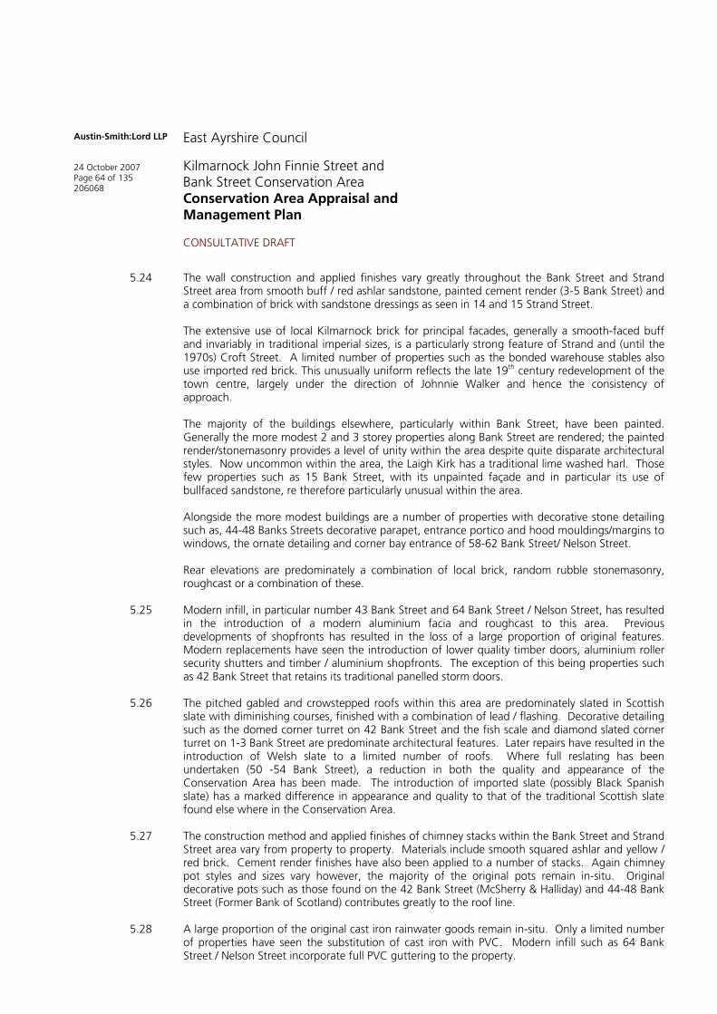
5.24 The wall construction and applied finishes vary greatly throughout the Bank Street and Strand Street area from smooth buff / red ashlar sandstone, painted cement render (3-5 Bank Street) and a combination of brick with sandstone dressings as seen in 14 and 15 Strand Street.
The extensive use of local Kilmarnock brick for principal facades, generally a smooth-faced buff and invariably in traditional imperial sizes, is a particularly strong feature of Strand and (until the 1970s) Croft Street. A limited number of properties such as the bonded warehouse stables also use imported red brick. This unusually uniform reflects the late 19th century redevelopment of the town centre, largely under the direction of Johnnie Walker and hence the consistency of approach.
The majority of the buildings elsewhere, particularly within Bank Street, have been painted. Generally the more modest 2 and 3 storey properties along Bank Street are rendered; the painted render/stonemasonry provides a level of unity within the area despite quite disparate architectural styles. Now uncommon within the area, the Laigh Kirk has a traditional lime washed harl. Those few properties such as 15 Bank Street, with its unpainted façade and in particular its use of bullfaced sandstone, re therefore particularly unusual within the area.
Alongside the more modest buildings are a number of properties with decorative stone detailing such as, 44-48 Banks Streets decorative parapet, entrance portico and hood mouldings/margins to windows, the ornate detailing and corner bay entrance of 58-62 Bank Street/ Nelson Street.
Rear elevations are predominately a combination of local brick, random rubble stonemasonry, roughcast or a combination of these.
5.25 Modern infill, in particular number 43 Bank Street and 64 Bank Street / Nelson Street, has resulted in the introduction of a modern aluminium facia and roughcast to this area. Previous developments of shopfronts has resulted in the loss of a large proportion of original features. Modern replacements have seen the introduction of lower quality timber doors, aluminium roller security shutters and timber / aluminium shopfronts. The exception of this being properties such as 42 Bank Street that retains its traditional panelled storm doors.
5.26 The pitched gabled and crowstepped roofs within this area are predominately slated in Scottish slate with diminishing courses, finished with a combination of lead / flashing. Decorative detailing such as the domed corner turret on 42 Bank Street and the fish scale and diamond slated corner turret on 1-3 Bank Street are predominate architectural features. Later repairs have resulted in the introduction of Welsh slate to a limited number of roofs. Where full reslating has been undertaken (50 -54 Bank Street), a reduction in both the quality and appearance of the Conservation Area has been made. The introduction of imported slate (possibly Black Spanish slate) has a marked difference in appearance and quality to that of the traditional Scottish slate found else where in the Conservation Area.
5.27 The construction method and applied finishes of chimney stacks within the Bank Street and Strand Street area vary from property to property. Materials include smooth squared ashlar and yellow / red brick. Cement render finishes have also been applied to a number of stacks. Again chimney pot styles and sizes vary however, the majority of the original pots remain in-situ. Original decorative pots such as those found on the 42 Bank Street (McSherry & Halliday) and 44-48 Bank Street (Former Bank of Scotland) contributes greatly to the roof line.
5.28 A large proportion of the original cast iron rainwater goods remain in-situ. Only a limited number of properties have seen the substitution of cast iron with PVC. Modern infill such as 64 Bank Street / Nelson Street incorporate full PVC guttering to the property.
Austin-Smith:Lord LLP
24 October 2007 Page 65 of 135 206068
East Ayrshire Council
Kilmarnock John Finnie Street and Bank Street Conservation Area Conservation Area Appraisal and Management Plan
CONSULTATIVE DRAFT
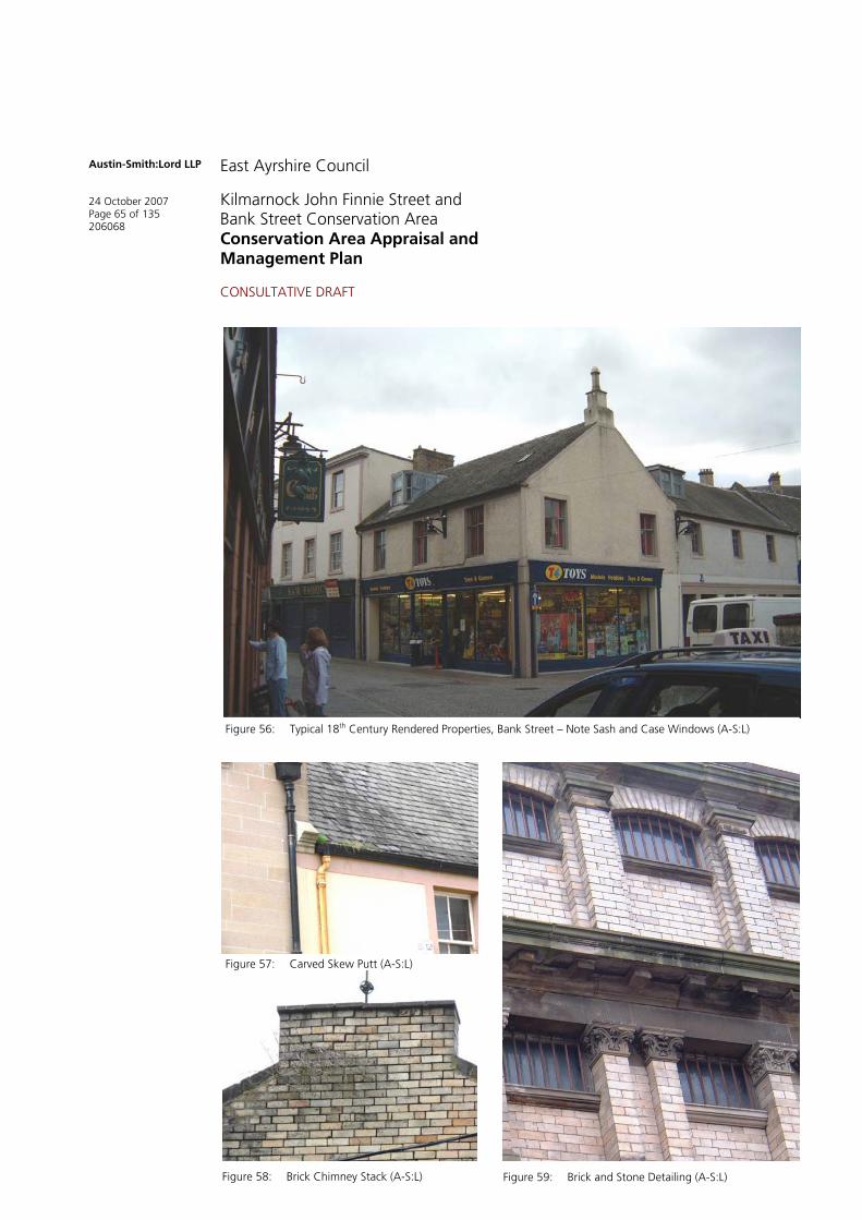
Figure 56: Typical 18th Century Rendered Properties, Bank Street – Note Sash and Case Windows (A-S:L)
Figure 57: Carved Skew Putt (A-S:L)
Figure 58: Brick Chimney Stack (A-S:L) Figure 59: Brick and Stone Detailing (A-S:L)

Austin-Smith:Lord LLP
24 October 2007 Page 66 of 135 206068
East Ayrshire Council
Kilmarnock John Finnie Street and Bank Street Conservation Area Conservation Area Appraisal and Management Plan
CONSULTATIVE DRAFT
Figures 60 and 61: Decorative Corner Details, Bank Street (A-S:L)
Figures 62 and 63: Decorative Door and Corner Details, Bank Street (A-S:L)

Austin-Smith:Lord LLP
24 October 2007 Page 67 of 135 206068
East Ayrshire Council
Kilmarnock John Finnie Street and Bank Street Conservation Area Conservation Area Appraisal and Management Plan
CONSULTATIVE DRAFT
5.29 Again, within upper floors the glazing finish varies from 1 pane over 1 pane traditional timber sash and case to 2-pane over 1 pane and even 6 pane over 6 pane. In addition to the more standard glazing styles 42 Bank Street and 36-40 Bank Street retain, although more unusual within the area, a small 3 pane vertical panel over 1 pane. The introduction of replacement windows within 36-40 Bank Street highlights the impact uPVC windows have on period buildings.
St. Marnock Street
5.30 Arguably the closest which Kilmarnock has ever had to a civic street, St. Marnock contains three of the town’s main public buildings, arranged as an imposing group which dominate the immediate area. St. Marnock Church, the Procurator Fiscal’s Office, and modern SheriffCourt are one of the most important groups in the area; three markedly contrasting styles drawn together by materials - red sandstone with slated roofs - and acting as a fitting entrance to Dundonald Road, Portland Road, and John Finnie Street.
5.31 The gap site on the northern side of the street marks the site of Kilmarnock House, the townhouse of the Boyds of Kilmarnock, latterly converted to a school and demolished during the early 20th century. It has since been vacant and used for car parking. Immediately opposite and just outside of the conservation area (but identified here because of its focal position) is a further gap site and car park, previously occupied by a tenement structure (the walls of which were discernable until comparatively recently).
5.32 Also of interest is Borland’s Seed Warehouse at the corner of St. Marnock Street and St. Marnock Place, the eastern façade of which occupies a focal position on adjacent main access routes.
Figure 64: St. Marnock Street (A-S:L)

Austin-Smith:Lord LLP
24 October 2007 Page 68 of 135 206068
East Ayrshire Council
Kilmarnock John Finnie Street and Bank Street Conservation Area Conservation Area Appraisal and Management Plan
CONSULTATIVE DRAFT
5.33 The general wall construction within the St, Marnock Street area consists predominantly of sandstone to the principal elevation with brick to the side and rear elevations. A typical example of this is 5-7 St Marnock Street where the principal elevation is construction with smooth squared ashlar to the ground floor, bullfaced red sandstone with raised smooth ashlar margins to the first floor and yellow brick construction to the remaining elevations. In contrast, 3 St. Marnock Place is constructed with red sandstone to the principal elevation and blonde sandstone to the side elevations. The rear elevation has had its masonry painted.
5.34 Highly decorative masonry details within this area of the town have been kept to the minimum with the exception of the Procurator Fiscal Building that has a large stone portico and pediment features. In contrast, the modern Sheriff Court building is plain with smooth squared ashlar brought to course with no additional detailing such as raised quoins or margins.
5.35 Roof finishes within the St. Marnock Street area are predominately natural slate on pitched roofs. Slating finishes vary from diminishing to non-diminishing courses (the Sherrif Court Dundonald Road) with lead / zinc ridges. Later alterations have resulted in a limited number of flat roofs within the Conservation Area.
5.36 Chimney stack constructed is limited to the key materials used throughout the Conservation Area, from squared ashlar to brick with sandstone copes. Remaining terracotta pot tend to be plainer in style than those recorded else where in the Conservation Area.
5.37 As with the majority of the properties within the Kilmarnock Conservation Area, the gutter system is a combination of parapet gutters and cast iron rainwater systems. A large proportion of the original cast iron rainwater goods within the area remain in-situ, with only a limited number of properties seeing the substitution of cast iron with PVC.
5.38 The window styles vary considerably throughout the St. Marnock Street area. From the narrow, vertical and horizontal astragals of the Procurator Fiscal Office building to the more traditional sash and case style found on the elevation of 5-7 St Marnock Place. The lack of original detailing and inappropriate reduction of astragals widths in modern uPVC replacement windows (as visible in 1 St. Marnock Place) has had a detrimental impact on the appearance of the buildings.
5.39 Original shopfronts and doors have been replaced with a series of aluminium and modern timber replacements.
Figures 65 and 66: Typical Masonry Styles and Windows (A-S:L)

Austin-Smith:Lord LLP
24 October 2007 Page 69 of 135 206068
East Ayrshire Council
Kilmarnock John Finnie Street and Bank Street Conservation Area Conservation Area Appraisal and Management Plan
CONSULTATIVE DRAFT
Portland Street and West George Street
5.40 The importance of 78-80 Portland Street (Mason Murphy) cannot be overestimated. This classical mid 19th century former hotel with giant Ionic pilasters supporting a pedimented parapet is the termination of the view north from the Cross. It is one of the few remaining historic buildings in Portland Street, it was the town’s best hotel and hosted most of Kilmarnock’s important civic functions.
5.41 The former West High Church is perhaps the last of the key landmarks on Portland Street with the High Kirk, one of the most important historic buildings in the town, unfortunately lost amidst a sea of tarmac and roads. Nevertheless the remainder of the adjacent terrace is of note, albeit in much dilapidated condition. To the rear in Garden Street, one of the oldest roads in the town, what appear to be the blocked-up remnants of the original cottages now form part of the boundary walls. These are irreplaceable evidence of the area’s historical development.
5.42 Within West George Street, no. 22-24 (Fanny by Gaslight) turns the corner into Strand with a gracefully subdued curved corner and turret. 13-15, directly opposite, is a striking (if largely overlooked) Beaux-Arts gusset office building with octagonal tower roof. It frames the entrance to West George Street from John Finnie Street and Langlands Brae, a vista rather diluted by the loss of East George Street in the 1970s, but is nevertheless a landmark building on one of the main routes around the town.
Figure 67: 78-80 Portland Street From the South (A-S:L)

Austin-Smith:Lord LLP
24 October 2007 Page 70 of 135 206068
East Ayrshire Council
Kilmarnock John Finnie Street and Bank Street Conservation Area Conservation Area Appraisal and Management Plan
CONSULTATIVE DRAFT
Figure 69: West George Street from the West – Late 19th Century View (Author’s Collection)
Figure 68: 78-80 Portland Street from the Cross – Early 20th Century View (Author’s Collection)
Austin-Smith:Lord LLP
24 October 2007 Page 71 of 135 206068
East Ayrshire Council
Kilmarnock John Finnie Street and Bank Street Conservation Area Conservation Area Appraisal and Management Plan
CONSULTATIVE DRAFT
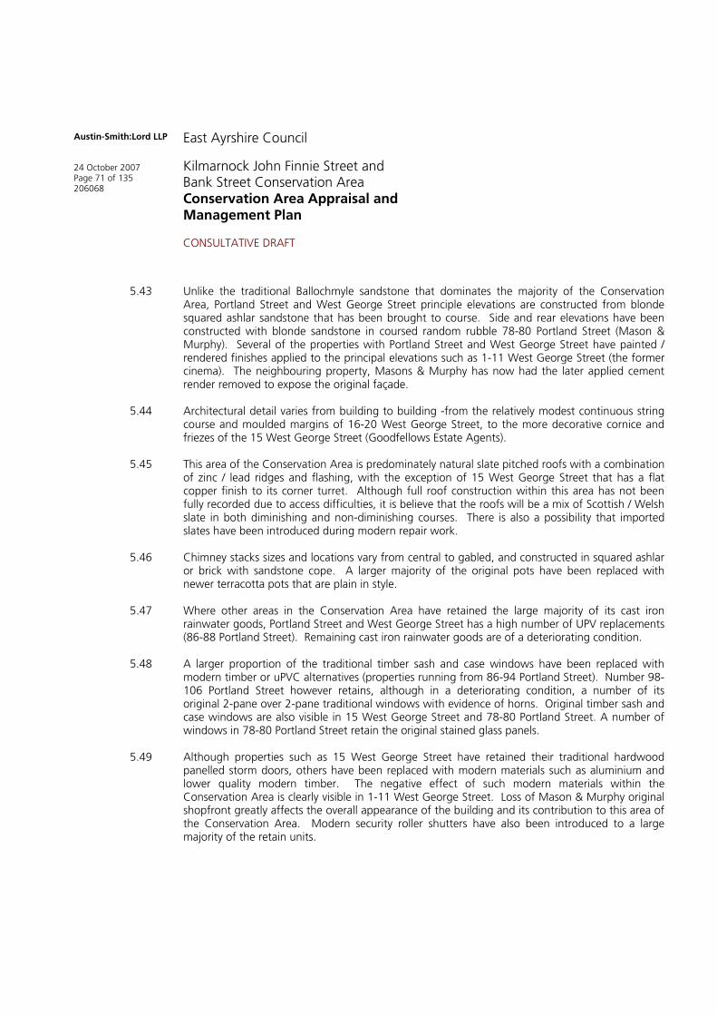
5.43 Unlike the traditional Ballochmyle sandstone that dominates the majority of the Conservation Area, Portland Street and West George Street principle elevations are constructed from blonde squared ashlar sandstone that has been brought to course. Side and rear elevations have been constructed with blonde sandstone in coursed random rubble 78-80 Portland Street (Mason & Murphy). Several of the properties with Portland Street and West George Street have painted / rendered finishes applied to the principal elevations such as 1-11 West George Street (the former cinema). The neighbouring property, Masons & Murphy has now had the later applied cement render removed to expose the original façade.
5.44 Architectural detail varies from building to building -from the relatively modest continuous string course and moulded margins of 16-20 West George Street, to the more decorative cornice and friezes of the 15 West George Street (Goodfellows Estate Agents).
5.45 This area of the Conservation Area is predominately natural slate pitched roofs with a combination of zinc / lead ridges and flashing, with the exception of 15 West George Street that has a flat copper finish to its corner turret. Although full roof construction within this area has not been fully recorded due to access difficulties, it is believe that the roofs will be a mix of Scottish / Welsh slate in both diminishing and non-diminishing courses. There is also a possibility that imported slates have been introduced during modern repair work.
5.46 Chimney stacks sizes and locations vary from central to gabled, and constructed in squared ashlar or brick with sandstone cope. A larger majority of the original pots have been replaced with newer terracotta pots that are plain in style.
5.47 Where other areas in the Conservation Area have retained the large majority of its cast iron rainwater goods, Portland Street and West George Street has a high number of UPV replacements (86-88 Portland Street). Remaining cast iron rainwater goods are of a deteriorating condition.
5.48 A larger proportion of the traditional timber sash and case windows have been replaced with modern timber or uPVC alternatives (properties running from 86-94 Portland Street). Number 98-106 Portland Street however retains, although in a deteriorating condition, a number of its original 2-pane over 2-pane traditional windows with evidence of horns. Original timber sash and case windows are also visible in 15 West George Street and 78-80 Portland Street. A number of windows in 78-80 Portland Street retain the original stained glass panels.
5.49 Although properties such as 15 West George Street have retained their traditional hardwood panelled storm doors, others have been replaced with modern materials such as aluminium and lower quality modern timber. The negative effect of such modern materials within the Conservation Area is clearly visible in 1-11 West George Street. Loss of Mason & Murphy original shopfront greatly affects the overall appearance of the building and its contribution to this area of the Conservation Area. Modern security roller shutters have also been introduced to a large majority of the retain units.

Austin-Smith:Lord LLP
24 October 2007 Page 72 of 135 206068
East Ayrshire Council
Kilmarnock John Finnie Street and Bank Street Conservation Area Conservation Area Appraisal and Management Plan
CONSULTATIVE DRAFT
6.0 TOWNSCAPE AND URBAN REALM APPRAISAL
6.1 The conservation area is not just defined by the quality and style of its buildings, but also by its wider townscape. Townscape differs from historic or architectural value, in that it encapsulates all aspects of the urban form Undistinguished modern buildings, for example, with arguably little in the way of current architectural or historic character and value, may still be important in contributing to the distinctive nature of an urban area. For example, the high rise office blocks and modern apartments in London's Docklands give that area a distinctive character and value. However the underlying archaeological and historic framework may partly define and be reflected in the grain of a townscape.
6.2 The methodology for appraising the impact of plans on townscape was based on a sequential analysing of the characteristic features of the townscape including:
Layout; the way that buildings, routes and open spaces are placed in relation to each other. What is the pattern of buildings and their plots, and the degree to which an area's pattern of streets and junctions are small and frequent (fine grain) or large and infrequent (coarse grain)?
Density, scale, and mix; the amount of floorspace of buildings relative to an area and the range of uses. Density determines the intensity of development and with mix contributes to the vitality and viability of a townscape. Height determines the relationship between buildings, structures and spaces and the visual impact on views, vistas and skylines.
Spatial definition and enclosure; how much clarity is there between the key streets and public places?
Landmarks and focal points; buildings, structures, and parks can all serve as landmarks which help define the quality of the adjacent public spaces and which can form a focus.
Desire lines and nodes of activities; how well do the routes within the study area reflect natural pathways and desire lines, where are the key areas of activities, and how does this impact on the townscape (or its perception)?
6.3 This analysis takes the form of initial findings but a key requirement is the need for further, detailed analysis of the town centre’s spatial characteristics through more comprehensive observation, survey, space syntax analysis and the development of an Urban Design Framework.
Density, and Scale
6.4 Massing of properties is one of the most visible ways in which any townscape is defined, setting the scale not just of the facades but just as importantly the surrounding streets and open spaces. Within the John Finnie Street and Bank Street conservation area we find a broad mix of property sizes and heights (figure 70), and a number of patterns can be identified.
John Finnie Street is generally more intensively developed that other areas; the eastern side of the street is predominantly three or more storey, creating a series of imposing buildings which (together with the rise towards the north) are one of the areas strongest characteristics. The western side is more subdued, with taller buildings limited to the cluster around the Post Office/Nelson Street Junction.

Austin-Smith:Lord LLP
24 October 2007 Page 73 of 135 206068
East Ayrshire Council
Kilmarnock John Finnie Street and Bank Street Conservation Area Conservation Area Appraisal and Management Plan
CONSULTATIVE DRAFT
Figure 70: Density and Scale: Yellow – Single Storey, Orange – Two, Red – Three or More excluding basements (Ordnance Survey/A-S:L)

Austin-Smith:Lord LLP
24 October 2007 Page 74 of 135 206068
East Ayrshire Council
Kilmarnock John Finnie Street and Bank Street Conservation Area Conservation Area Appraisal and Management Plan
CONSULTATIVE DRAFT
Figure 71: Strongly Defined Urban Edges (Ordnance Survey/A-S:L)

Austin-Smith:Lord LLP
24 October 2007 Page 75 of 135 206068
East Ayrshire Council
Kilmarnock John Finnie Street and Bank Street Conservation Area Conservation Area Appraisal and Management Plan
CONSULTATIVE DRAFT
6.5 Around Bank Street properties are of a much more domestic and less imposing scale; towards the Cross properties are predominantly single storey (plus extensive basements towards the Kilmarnock Water), however they rise to two and three storey around Bank Place. It is only when we reach the later development at St. Marnock Place that we find larger scale buildings and these reflect more deliberate commercial and light industrial uses which were found during the first part of the 20th century.
Although Strand was originally another street of polite two storey properties, the extensive distillery-led redevelopment of the late 19th and early 20th century has completely altered the character of the thoroughfare. The warehouses, of which only the Goldbergs building (the largest) survives, were predominantly tall three and four storey, massive structures with larger floorplates than their predecessors.
6.6 Although the large, imposing public buildings of St. Marnock Street are of a scale similar to that found in John Finnie Street (notwithstanding storey heights), the actual and perceived density is significantly less; the modern court building, the Procurator Fiscal’s office, St. Marnock’s Church, and the Police Station are all set back from the pavement in landscaped grounds. The car park on the site of Kilmarnock House, on the north of the street, and the gap site at the junction with Waterside Street reinforce this low density and it is only at the very eastern end – at the junction with Titchfield Street – that we find a more traditional town centre pattern.
6.7 West George Street is rather dwarfed by the bulk of the former cinema on the northern side of the road, which towers some two storeys higher than most of the adjoining properties and extends back to the rear of the plot – at the same height – in stark contrast to the more traditional two storey properties and the modern Portland Gate development (Gala Bingo) on the south. However this disparity in fact serves to partially mitigate the towering, massive presence of the listed railway viaduct.
6.8 The surviving northern part of Portland Street also reflects the traditional Kilmarnock two storey pattern; the eastern side of the street was of similar scale, but now replaced by an open expanse of car park which subdues and overwhelms the surviving properties – including the Old High Kirk. It is only to the rear of Portland Street, along Garden Street, that we get any feel for the pre-20th
century scale and character of the area.
Definition and Edges
6.9 There is a complex mix of well defined edges within the conservation area generally, in particular along the main historic streets (John Finnie Street, Bank Street, and West George Street). All are well defined but active frontages by virtue of their shopping, food and drink and professional services uses on the ground floor. Open gap sites such as the former Opera House at NUMBER John Finnie Street are therefore particularly emphasised and have a disproportionately adverse impact. Beyond the main streets, most notably in Portland Street and the northern part of Strand Street, the frontages have suffered from extensive demolition leaving an open and fragmented pattern. This has a detrimental impact on the legibility of the townscape generally, and discourages redevelopment of adjacent premises.
St. Marnock Street is of markedly different character, with a series of large public buildings set back from the street creating a much more open environment; the scale of these buildings is sufficient to maintain a strong urban edge. The exceptions are two previously mentioned car parking areas on St. Marnock Street, which have a detrimental impact on the definition of the streetscape. St. Marnock Street is likewise fragmented by the poorly defined street frontage to the rear of the “Kilmarnock House” site.

Austin-Smith:Lord LLP
24 October 2007 Page 76 of 135 206068
East Ayrshire Council
Kilmarnock John Finnie Street and Bank Street Conservation Area Conservation Area Appraisal and Management Plan
CONSULTATIVE DRAFT
Figure 72: Key Routes: Vehicle – Orange, Pedestrian - Blue (Ordnance Survey/A-S:L)

Austin-Smith:Lord LLP
24 October 2007 Page 77 of 135 206068
East Ayrshire Council
Kilmarnock John Finnie Street and Bank Street Conservation Area Conservation Area Appraisal and Management Plan
CONSULTATIVE DRAFT
Figure 73: Principal Nodes (Ordnance Survey/A-S:L)

Austin-Smith:Lord LLP
24 October 2007 Page 78 of 135 206068
East Ayrshire Council
Kilmarnock John Finnie Street and Bank Street Conservation Area Conservation Area Appraisal and Management Plan
CONSULTATIVE DRAFT
6.10 A number of spaces have a strong sense of enclosure within the town centre and these vary considerably in character; the twisting, irregular character of Bank Street and the area around the Laigh Kirk creates a series of intimate streetscapes and closed views. Immediately outwith the Conservation Area is the Cross, which continues to reflect its historic role as the main crossroads or junction in the town.
There are also a number of areas where there are problems with a lack of enclosure; the area at the north end of John Finnie Street and bounding the railway station is particularly poor due to the undeveloped frontage at the telephone exchange. The redeveloped northern end of Strand Street also suffers from the open parking and service areas to the rear of the Wheatsheaf Inn and Portland Gate shopping centre. Moving south, St. Marnock Place is very poorly defined along its southern perimeter. Immediately adjacent to the conservation area, the distinctiveness of the edges around western end of West George Street is fragmented by the car park, a problem which continues around the northern perimeter of the town centre and has a particularly adverse impact on this part of town.
Landmarks, Nodes, and Focal Points
6.11 The complex combination of landmarks, gateways and views and vistas in Kilmarnock town centre’s townscape contributes to its legibility, distinctiveness and sense of place. These elements serve to reinforce the legibility inherent in the strong historical form. These need not necessarily be the larger, key properties. Often smaller scale, local landmarks have an architectural quality or function that cause them to stand out from the rest of the urban fabric. Figure 74 focuses on the landmarks, gateways and views and vistas within the conservation area. Neighbourhood and local landmarks provide a strong degree of legibility.
6.12 There are many views within the conservation area but these tend to be restricted to the vistas along John Finnie Street (most notably northwards to the railway station) and around Laigh Kirk/Bank Street. Views to the Old High Kirk are truncated by the Viaduct. Views from St. Marnock Street Bridge northwards along Kilmarnock Water suffer from insensitive rear of few redevelopment along King Street, in particular the bridged extension to the former Lauders Department Store.
6.13 For the most part, the desire lines within the town centre follow the line of existing streets and footpaths. This creates a network of linkages and a relatively permeable townscape which are well used by vehicles and pedestrians. However, there are a number of routes through the existing urban fabric which despite following desire lines are in fact under used. These occur at three locations; the northern part of Strand Street (linking the Cross and the railway station), Dunlop Street-Croft Street (linking the Cross and John Finnie Street), and Sandbed Street following the river.
6.14 The nodes of activity within the town centre are predominantly focused at the intersection of streets and around the primary shopping streets with other streets. Where nodes are identified away. The most significant nodal point is around the Post Office where a combination of busy premises, access to residential areas, and on-street parking, and range of premises have created a very busy focus.
6.15 Typically, from 5.00pm onwards the daytime activity areas start to change as some shops and businesses close and others open. Evening activity is focused around two distinct nodes; the licensed premises along Bank Street and the range of fast food premises generally along John Finnie Street. Outwith normal working hours Strand Street, Croft Street, and Dunlop Street can be almost devoid of pedestrian or vehicular traffic.

Austin-Smith:Lord LLP
24 October 2007 Page 79 of 135 206068
East Ayrshire Council
Kilmarnock John Finnie Street and Bank Street Conservation Area Conservation Area Appraisal and Management Plan
CONSULTATIVE DRAFT
Figure 74: Prominent/Landmark Buildings (Ordnance Survey/A-S:L)
Austin-Smith:Lord LLP
24 October 2007 Page 80 of 135 206068
East Ayrshire Council
Kilmarnock John Finnie Street and Bank Street Conservation Area Conservation Area Appraisal and Management Plan
CONSULTATIVE DRAFT
Urban Realm and Streetscape
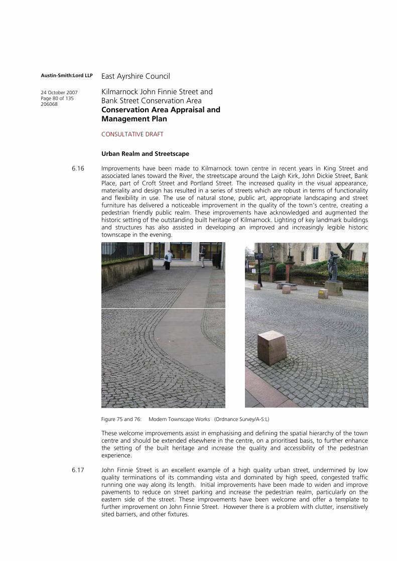
6.16 Improvements have been made to Kilmarnock town centre in recent years in King Street and associated lanes toward the River, the streetscape around the Laigh Kirk, John Dickie Street, Bank Place, part of Croft Street and Portland Street. The increased quality in the visual appearance, materiality and design has resulted in a series of streets which are robust in terms of functionality and flexibility in use. The use of natural stone, public art, appropriate landscaping and street furniture has delivered a noticeable improvement in the quality of the town’s centre, creating a pedestrian friendly public realm. These improvements have acknowledged and augmented the historic setting of the outstanding built heritage of Kilmarnock. Lighting of key landmark buildings and structures has also assisted in developing an improved and increasingly legible historic townscape in the evening.
These welcome improvements assist in emphasising and defining the spatial hierarchy of the town centre and should be extended elsewhere in the centre, on a prioritised basis, to further enhance the setting of the built heritage and increase the quality and accessibility of the pedestrian experience.
6.17 John Finnie Street is an excellent example of a high quality urban street, undermined by low quality terminations of its commanding vista and dominated by high speed, congested traffic running one way along its length. Initial improvements have been made to widen and improve pavements to reduce on street parking and increase the pedestrian realm, particularly on the eastern side of the street. These improvements have been welcome and offer a template to further improvement on John Finnie Street. However there is a problem with clutter, insensitively sited barriers, and other fixtures.
Figure 75 and 76: Modern Townscape Works (Ordnance Survey/A-S:L)

Austin-Smith:Lord LLP
24 October 2007 Page 81 of 135 206068
East Ayrshire Council
Kilmarnock John Finnie Street and Bank Street Conservation Area Conservation Area Appraisal and Management Plan
CONSULTATIVE DRAFT
6.18 As a key gateway to the town, offering visitors a first impression of Kilmarnock, the streetscape around the station requires significant improvement in terms of its visual appearance, its configuration and functionality as experienced by the pedestrian. The Station is a moderate, but attractive, example of station architecture however the quality of the passenger and pedestrian experience is significantly diminished upon arrival at street level.
The main interface with the town centre is at the southern side of the station underpass, facing John Finnie Street. However what should be a striking introduction to Kilmarnock, with a view along the grand street frontage, is undermined by the ungenerous proportions of the pavement which forces the arriving passenger into immediate conflict with vehicles, with attention drawn to a plethora of street signs, traffic signals and other clutter which greatly, adversely affects the quality of this introductory experience to the town.
The lack of enclosure to the north-western edge of John Finnie Street north of Dunlop Street further undermines the quality and setting of the street and the view from the Station.
6.19 St. Marnock Street enjoys a profile and quality of built heritage similar in standard to John Finnie Street, though quite different in terms of building type, setting and function. It also shares similar problems in terms of being dominated by the congestion and traffic circuiting the town centre on the one way system.
As with the northern end the southern end of John Finnie Street, at the junction with St. Marnock Street, is dominated by visual clutter created by a plethora of street signs, traffic signals and traffic islands which detract and undermine the quality of the architectural setting. As a key hub of civic Kilmarnock this junction should act as a gateway into the town centre, offering views up John Finnie Street and across the junction to the Procurator Fiscals office and the Courts which are not obscured by inconsiderately located signs and the like.
Figure 77: Existing Poor Quality/Fragmented Urban Realm, John Finnie Street (Austin-Smith: Lord)

Austin-Smith:Lord LLP
24 October 2007 Page 82 of 135 206068
East Ayrshire Council
Kilmarnock John Finnie Street and Bank Street Conservation Area Conservation Area Appraisal and Management Plan
CONSULTATIVE DRAFT
Figure 78: Streetscape Clutter, St. Marnock Street (Austin-Smith: Lord)