5. definition of the study area - world...
TRANSCRIPT

Ministry of Energy of Georgia
Khudoni - Environmental and Social Impact Assessment | Final Report
65
5. Definition of the Study Area
5.1 STUDY AREA
The area to be studied for the Environmental and Social Impact Assessment of the Khudoni HPP
Project includes all areas that might be potentially affected by the Project, or which study is necessary
to understand the impacts of the Project.
The study area includes:
� the whole watershed upstream the future reservoir, insomuch as it determines the water
supply, water quality, sediments and floating material supply to the future reservoir;
� the area of the future reservoir and its surroundings: Enguri valley and tributary valleys, Khaishi
village;
� the HPP Project site and immediate surroundings, i.e. the implantation site of the dam and
ancillary infrastructure: construction site, workers' settlements, access roads, areas required for
construction material borrow…;
� the river systems downstream the Khudoni Project site, i.e.: (i) the Enguri River between the
Khudoni Dam site and the Enguri Reservoir; (ii) the Enguri Reservoir; (iii) the lower Enguri River
from the Enguri Dam to the Black Sea; (iv) the Abkhazian River system downstream the Enguri
HPP (= Eristakli watershed). The three last elements will be taken into account as the Khudoni
HPP implementation might change the hydraulic management of the Enguri Dam.
Environmental and social baseline analysis of the study area is made on the two following scales:
� An expanded study area, (i.e. the whole study area) some parts of which might be affected by
indirect impacts of the HPP Project,
� A core study area, where direct and major impacts of the Project might occur, i.e. implantation
of the reservoir and flooding of the Khaishi village, slope erosion due to the construction of
roads and other facilities, other impacts related to the Project during development, construction
and operation stages.


Ministry of Energy of Georgia
Khudoni - Environmental and Social Impact Assessment | Final Report
67
Figure 5-1: Study area

Ministry of Energy of Georgia
Khudoni - Environmental and Social Impact Assessment | Final Report
68
Figure 5-2: Core Study Area and Khaishi Settlements

Ministry of Energy of Georgia
Khudoni - Environmental and Social Impact Assessment | Final Report
69
The table below presents the different settlements of Khaishi community, with GPS coordinates and
elevation.
Table 5-1: Khaishi settlements
Coordinates no Settlement
Altitude N E
Cat. I : Settlements flooded
1 Gagma Khaishi 650 42° 56’ 536” 42° 09’ 869”
2 Khaishi 621 42° 56’ 730” 42° 11’ 250”
3 Kvemo Khaishi 778 42° 56’ 657” 42° 10’ 972”
4 Lukhi 669 42° 58’ 258” 42° 11’ 272”
5 Tsvirmindi 740 42° 56’ 286” 42° 12’ 087”
6 Zemo Khaishi 627 42° 56’ 659” 42° 11’ 281”
Cat.II: Settlements located very close to the maximum water level of the reservoir
7 Dakari 850 42° 56’ 836” 42° 09’ 486”
8 Lakhami 760 42° 59’ 543” 42° 10’ 874”
9 Tobari 760 42° 57’ 859” 42° 11’ 696”
Cat.III: Isolated settlements
10 Kvemo Vedi 882 42° 54’ 420” 42° 12’ 129”
11 Nankbuli 980 42° 55’ 712” 42° 12’ 062”
12 Vedi 831 42° 55’ 091” 42° 11’ 694”
13 Zeda Vedi 1423 42° 53’ 635” 42° 15’ 554”
Cat.IV: Non-directly affected settlements
14 Gentsvishi 818 43° 00’ 471” 42° 18’ 045”
15 Ifari 831 43° 00’ 291” 42° 17’ 267”
16 Jorkvali 758 42° 59’ 610” 42° 16’ 054”
17 Khelra 1204 42° 59’ 275” 42° 18’ 875”
18 Lakhani 728 42° 59’ 119” 42° 14’ 603”
19 Lekalmakhe 775 43° 01’ 003” 42° 11’ 493”
20 Barjani 578 42° 52’ 290” 42° 01’ 866”
21 Idliani 778 42° 55’ 776” 42° 05’ 074”
22 Kvakva 570 42° 54’ 8569” 42° 03’ 669”
23 Lebertskhila 743 42° 55’ 116” 42° 04’ 266”
24 Natsiskvilari 550 42° 55’ 270” 42° 04’ 982”
25 Shgedi 700 42° 55’ 467” 42° 05’ 998”
26 Skormeti 850 42° 56’ 306” 42° 07’ 603”
27 Totana 900 42° 55’ 539” 42° 06’ 756”
28 Tsitskhvari 510 42° 55’ 873” 42° 06’ 521”
The settlements of the Khaishi community are localized on the figure 5-1 presenting the core study
area.


Ministry of Energy of Georgia
Khudoni - Environmental and Social Impact Assessment | Final Report
71
6. Baseline information on Natural Environment
This chapter describes the important environmental components of the natural environment within the
study area: (i) physical environment (i.e. climate, relief, geology, soils, hydrography, hydrology, water
quality, solid flow); (ii) biological environment (vegetation, terrestrial and aquatic fauna, biodiversity
status, protected areas); (iii) landscape; (iv) natural resources (hydropower, forest resources, mining,
fishing and hunting); and (v) natural risks and pollution.
6.1 PHYSICAL ENVIRONMENT
6.1.1 Local Climate
General features. The Western Georgian lowlands around the Black Sea (= Kolkhida lowlands) are
characterized by a humid subtropical climate. The Greater Caucasus forms a barrier for cold air
masses from the North, and forces moist air masses from the Black Sea to move upward, causing
intense precipitations. In contrast, Eastern Georgia is far more dry.
The climate varies significantly with elevation, forming a gradient of climateic belts from the sea to the
summits within a distance of one hundred kilometres only. The upper Enguri watershed experiences
cool and wet summers, and long winters with high snow fall. Permafrost conditions occurs in the
highest mountains.
Temperature. Kolkhida lowlands is one of the warmest parts of Georgia, with mean annual
temperatures ranging from 12 to 15°C. Mean temperature is maximum in July (22-24°C) and
minimum in January (5-7°C). The absolute minimum is about -16°C.
Mean annual temperature (figure 6.1) falls with elevation and ranges 6-10°C in the mountainous part
of the valley, and 2-4°C in the high mountain zone, with absolute minimum down -30°C and -35°C,
respectively. The southern slope of the upper Svaneti valley is the coldest spot of the study area, with
mean annual temperature below 2°C.
Rainfall. On the coast, near Anaklia, and in the central part of the Enguri Valley, up to Lakhani,
annual precipitations range from 1,400 to 1,800 mm (figure 6.2).
In Zugdidi, precipitation is about 1,788 mm/year (1929-1988 period) and tends to be uniformly
distributed throughout the year, with particularly heavy rains during summer and autumn months
(figure 6.3). Mean precipitation is maximum in June (182 mm) and decreases gradually to become
minimum in May (111 mm). Occasionally sub-tropical anti-cyclones induce drought conditions.
Rainfall rises with elevation, reaching 2,800 mm on the summits of Mount Kodzal and Mount Lajla-
Lekheli – on both sides of the future reservoir area -, and more than 3,200 mm in the highest range
of the Greater Caucasus.
In contrast, the upper Enguri valley appears to be the driest part of the study area with precipitations
down to 1,000-1,200 mm.

Ministry of Energy of Georgia
Khudoni - Environmental and Social Impact Assessment | Final Report
72
Figure 6-1: Distribution of mean annual air temperatures
in the study area (from UNDP/GEF, 1999)
Figure 6-2: Distribution of mean annual sums of atmospheric precipitations
in the study area (from UNDP/GEF, 1999)
Figure 6-3: Monthly mean precipitation at Zugdidi between 1929 and 1988 (from GHCN)
0
50
100
150
200
jan. feb. mar. apr. may jun. jul. agu. sept. oct. nov. dec.
Pre
cip
itat
ion
(m
m)

Ministry of Energy of Georgia
Khudoni - Environmental and Social Impact Assessment | Final Report
73
Snow cover. Duration of a stable snow cover increases from 10-20 days on plains to 100-150 days in
mountainous regions. Stable snow cover forms from the altitude of 500-600 m. Alpine conditions
begin at about 2,100 meters. Above 3,000 meters, mountains are covered by snow and ice year-
round (USAID, 2006). At some mountain stations, the height of snow cover reaches 4 to 6 m.
Wind. Wind regime in Western Georgia is under the influence of orography. Breeze circulation, from
Black Sea to valleys is considerably revealed. Average wind speed does not exceed 2 to 3 m/s in the
valleys covered by forests. The most frequent and high winds are characteristic for the mountain and
high mountain passes with mean annual wind speed reaching 5.5 to 9.0 m/s (UNDP/GEF, 1999)
Solar radiation. In the most part of Georgian territory, mean annual duration of solar radiation
varies within the range of 1900-2200 hours. In the high mountain zones, where cloudiness is frequent
at some places, this value decreases down to 1,500-1,300 hours (UNDP/GEF, 1999).
6.1.2 Climate Change and Green House Gas (GHG) emission
Two aspect of the climate change have specifically to be addressed in the ESIA:
� the Climate evolution in the study area is analysed in relation with: (i) global changes over the
XXth century, and (ii) the implementation of the Enguri reservoir in the '80s.
� the tentative anticipation of Climate change due to the new project of Khudoni dam and
reservoir and specially its contribution to Global Greenhouse Effect.
6.1.2.1 Climate change over the 20th century
Analysis of climate data from 1905 to the early '90s shows small changes for temperatures and
precipitations in the study area (UNDP/GEF, 1999 ; N. Begalishvili, pers.com.):
� A decrease of the mean temperature in the upper Enguri watershed (- 0.3°C) and surrounding
ranges but fairly stable in the central and lower valley;
� A general reduction of annual precipitation in the whole country, except in a few places like high
Caucasian mounts near Mestia (up to 5%) and the coastal plain between Zugdidi and Anaklia
(up to 10%).
6.1.2.2 Climate change due to Enguri dam reservoir
In the late '90s, the Institute of Hydrometeorology (IHM, a department of the Georgian Academy of
Sciences) has developed a research program on the influence of Enguri reservoir implementation on
local climate. The research was based on data from the former meteorological stations at
Mestia/Betho, Khaishi, Djvari and Zugdidi and measurement investigations in the lake area.
The results show (Begalishvili, pers. com.):
� no significant statistical difference on time series of climateic parameters (temperature,
humidity, rain fall …) before and after the dam implementation. If any influence of the dam on
humidity, it is insignificant compared to the influence of the Black Sea.
� a good correlation between the 4 stations (Djvari and Zugdidi downstream the dam;
Mestia/Betho and Khaishi upstream). There is no reservoir effect at a large scale either in
summer or in winter. However, in summer, the climateic difference between Djvari and Khaishi
has decreased since the reservoir implementation, which induces homogeneous conditions on
this section of the valley.
� a significant elevation of average temperature above the reservoir (measured 2 m above water
level) and in the immediate surroundings, but no significant difference in the valley, either
upstream or downstream of the lake.
According to these scientific results, significant changes in local climate due to the Enguri reservoir
only appeared above the reservoir and up to a distance of 1-2 km from the shore. No climate change
was observed higher up in the valley.

Ministry of Energy of Georgia
Khudoni - Environmental and Social Impact Assessment | Final Report
74
6.1.2.3 Climate change anticipation due to Khudoni dam and reservoir.
The approach concerning Climate change anticipation due to the Project is made through two items:
� evaluation of GHG emissions from the reservoir
� calculation of the CO2 emissions from the dam project
EMISSION OF GHG FROM RESERVOIR
Emissions of GHG from dams and reservoirs vary widely according to their geographical location and
other factors.
Reservoir depth and shape, the local climate, and the way in which the dam is operated, could all
impact emission levels.
Research indicates that most of the emissions at dams in boreal and temperate regions comes from
the diffusion of carbon dioxide into the atmosphere from the surfaces of their reservoirs.
In the tropics, emissions vary depending on how deep a reservoir is. Shallow tropical reservoirs
appear to produce much more methane than carbon dioxide. The methane is produced when bacteria
break down organic matter in the water.
GHG emission from the Khudoni Reservoir (CO2 and CH4) will have no signicative direct effect on
regional climate, but it will still contribute to global climate change.
The construction of dams may contribute some emissions of GHG. According to the litterature, for
Khudoni dam those emissions can be estimated as 1-2 g CO2/KWh (Svensson, 2005).
Once implemented, the reservoir will produce two types of greenhouse gas (GHG): methane (CH4)
due to anaerobic decomposition of organic matter, and CO2 (carbon dioxide).
Hydrogen sulphide (H2S) is also likely to be produced due to anaerobic decomposition, with a possible
toxic effect on aquatic life.
These emissions are still to be quantified, from data on reservoirs in similar geographic context, in
Georgia or elsewhere (L.P. Rosa & M.A. dos Santos, 2000).
The data on reservoirs in similar geographical context shows that three main factors should be studied
to estimate the GHG emissions from Khudoni reservoir (Svensson, 2005):
� amount of organic matter in the water (carbon content of flooded ecosystems and quantity of
biomass); can be approached through wood volume remaining in the area after flooding;
� depth (quotient between reservoir volume and reservoir surface area);
� climate conditions (latitude).
The total emissions of GHG from the reservoir will be approached using the method of adding add CH4
emissions and CO2 emissions:
CH4 emissions = [M-factor (%)]*[Carbon content (g/m2)]*[Flooded area (m2)]*[16/12 (C – CH4)]*[21
(GWP)]
CO2 emissions = [100 – M-factor (%)]*[Carbon content (g/m2)]*[Flooded area (m2)]*[44/12 (C –
CO2)]
M-factor (%) is a relative amount of methane of total GHG emissions. According to the assumptions
made for similar conditions M-factor may be equal to 0 or 1 respectively for 50% and 100% degree of
decomposition of biomass after 100 years flooding.
Nevertheless according to case reviews available in the litterature, the volume of gas emission might
be quite significant, especially in summer when subtropical temperatures are likely to occur.

Ministry of Energy of Georgia
Khudoni - Environmental and Social Impact Assessment | Final Report
75
The greenhouse effect of a reservoir like Khudoni, and the approximate estimated amount of flooded
organic matter will be evaluated and compared with those of an equivalent thermal powerplant.
CO2 EMISSIONS
The calculation of CO2 emissions during the implementation of the project is simply made to give an
indication on how much carbon dioxide implementation of the dam is likely to generate.
The CO2 emissions of the dam project should be calculated using the following data to be produced by
the technical team:
� Energy for dam and infrastructure construction
� Type and quantity of material used pour la construction of the dam (e.g. quantity of cement or
raw material)
� Energy used for raw material processing
� Internal transportation (workers on the site);
� External transportation for materials providing (cement, rocks, aggregates) by trucks or railway
Type of waste and waste management (waste processing?)
6.1.3 Relief
6.1.3.1 Expanded Study Area
The Enguri watershed, oriented NE-SW, spreads over a distance of about 200 km and a surface of
4,062 sq km, from the Greater Caucasus range to the Black Sea coast.
The watershed belongs to the Samegrelo – Zemo Svaneti Region, with the exception of a small area in
the lower valley being situated in Abkasia. The area is at the same latitude as Northern Greece and
Northern Spain.
According to morphological features, the Enguri watershed can be divided into three sections of
approximately 70 km each: upper valley, central valley and lower valley.
Upper Valley: Upstream of the village of Lakhani, the valley is oriented to the west and bordered with
two crest mounts higher than 3,500 m: the Greater Caucasus range in the north, culminating at 5,068
m (Mount Shkhara) and the Svaneti mountain range in the south, culminating at 4,008 m (Mount
Lajla Lekheli).(see figure 6-5)
Most of the area is within a range of altitude from 1,000 to 3,500 m. Slopes are steep with important
erosion figures. The bottom of the main valley is fairly wide, and densely occupied with Svan
settlements and agricultural lands.
Tributary valleys, generally oriented north-south, are much smaller and narrower, with the exception
of the Mestiacha valley, where Mestia is located.
Ministry of Energy of Georgia
Khudoni - Environmental and Social Impact Assessment | Final Report
76
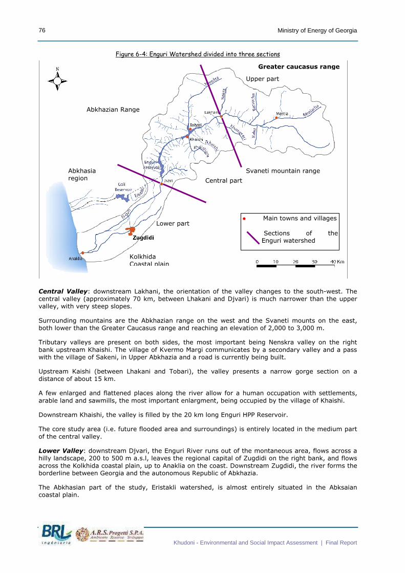
Figure 6-4: Enguri Watershed divided into three sections
Central Valley: downstream Lakhani, the orientation of the valley changes to the south-west. The
central valley (approximately 70 km, between Lhakani and Djvari) is much narrower than the upper
valley, with very steep slopes.
Surrounding mountains are the Abkhazian range on the west and the Svaneti mounts on the east,
both lower than the Greater Caucasus range and reaching an elevation of 2,000 to 3,000 m.
Tributary valleys are present on both sides, the most important being Nenskra valley on the right
bank upstream Khaishi. The village of Kvermo Margi communicates by a secondary valley and a pass
with the village of Sakeni, in Upper Abkhazia and a road is currently being built.
Upstream Kaishi (between Lhakani and Tobari), the valley presents a narrow gorge section on a
distance of about 15 km.
A few enlarged and flattened places along the river allow for a human occupation with settlements,
arable land and sawmills, the most important enlargment, being occupied by the village of Khaishi.
Downstream Khaishi, the valley is filled by the 20 km long Enguri HPP Reservoir.
The core study area (i.e. future flooded area and surroundings) is entirely located in the medium part
of the central valley.
Lower Valley: downstream Djvari, the Enguri River runs out of the montaneous area, flows across a
hilly landscape, 200 to 500 m a.s.l, leaves the regional capital of Zugdidi on the right bank, and flows
across the Kolkhida coastal plain, up to Anaklia on the coast. Downstream Zugdidi, the river forms the
borderline between Georgia and the autonomous Republic of Abkhazia.
The Abkhasian part of the study, Eristakli watershed, is almost entirely situated in the Abksaian
coastal plain.
Abkhasia region Central part
Upper part
Lower part
Kolkhida
Coastal plain
Svaneti mountain range
Greater caucasus range
Abkhazian Range
● Main towns and villages
Sections of the Enguri watershed

Ministry of Energy of Georgia
Khudoni - Environmental and Social Impact Assessment | Final Report
77
6.1.3.2 Core study area
The slopes surrounding the future reservoir extend on both sides. Slopes are fairly regular and reach
secondary summits culminating at 1,800 m on the right bank and more than 2,000 m on the left bank
(see map on figure 6.6).
The future reservoir will flood two straight sections of the Enguri Valley, the village of Khaishi being at
their junction.
� The upper section, 4 km long, is oriented to the south-west. Slopes are very steep on both sides
especially in the long gorge section between Lakhani and Tobari. Near the village of Tobari, the
Nenskra valley embranches on the right bank. The future reservoir will flood the lower part of
this tributary valley.
� The lower section, 3 km long, oriented to the west, is a bit larger but still very steep. The first
stage of Khudoni dam construction was started on a rocky constriction of the valley. Slopes on
the dam site have been deforested and present important erosion figures (photos 6.E and 6.F)
Figure 6-5 presents elevations in the core study area while figure 6-6 presents slopes occurring in the
core study area ranged in 6 categories corresponding to 0° to 10° - no significant erosion process,
several ranges from 10° to 40 ° allowing easy to more difficult cultural activities and higher to 40°
representing slopes more difficult to exploit for agricultural production.
These figures show that the village of Khaishi and the surrounding arable lands, occupy an
enlargement of the Enguri valley at the bend between these two sections, and the lower part of a
valley formed by two tributaries from Svaneti mountains (Khaishura and Tkheishi rivers). Flatter lands
are located upstream of the confluence between the Khaishura and Tkheishi rivers, along the right
bank of the Enguri river (Gagma Khaishi and upstream Lakhani), and the Nenskra river (Lakhami).
In some areas around Khaishi, the slopes form shelves of limited extension occupied with a few
houses and arable land.


Ministry of Energy of Georgia
Khudoni - Environmental and Social Impact Assessment | Final Report
79
Figure 6-5: Relief of the core study area


Ministry of Energy of Georgia
Khudoni - Environmental and Social Impact Assessment | Final Report
81
Figure 6-6: Slopes of the Core study Area


Ministry of Energy of Georgia
Khudoni - Environmental and Social Impact Assessment | Final Report
83
Figure 6-7: General 3D view from downstream of the core study area (from Google Earth, 2007)
6.1.4 Geomorphology and topography
The topography resulted from tectonic factors-built up of basement itself, which was dveloped as a
result of sedimentation, periodic volcanism and numerous phases of folding.
There are 2 different types of relief in the region :
� Moutainous, sculptured-tectonic steep erosional topography developed on the rocks built of the
upper paleozoic Dizi series, lower and Middle jurassic argilo-arenaceous and porphyritic series.
� Denudation-accumulation relief with terraced and alluvial gorges, found along the Enguri,
Nenskra, Tkheishi and Khaishura rivers.
Khudoni Project site
Khaishi
Enguri river
Nenskra river
Khaishura river
Tkheisi river

Ministry of Energy of Georgia
Khudoni - Environmental and Social Impact Assessment | Final Report
84
6.1.5 Geology
REGIONAL GEOLOGY
The study area belongs to the Caucasian collision zone between the Eurasian plate and the Arabian
plate, moving nothward. The active tectonique features are: (i) wrench faults oriented to the NW, the
major one lying from the Abkhasian coast (Sokhumi and Ochiri) to the Great Caucasus crest line and
(ii) overthrust lines parallel to the Great Caucasian axis (NE-SW). The earth crust in the whole area is
divided in many tectonic blocks.
STRATIGRAPHY IN THE STUDY AREA
The expanded study area belongs to the fold system of the central Greater Caucasus. Around the
project area variously metamorphosed Upper Paleozoic-Triassic and Mezozoic formations of different
age, composition and thickness are encountered. They are exposed in the Enguri river gorge as well
as the adjacent areas to the west and east. It presents a complex sequence of sedimentary,
metamorphic and igneous rocks from different ages that have been folded and faulted:
� Upper paleozoic- triassic age – Deposits of the Upper paleozoic- triassic age represented by the
Dizi series are locatde in the southern part of the region. They are the oldest formations on the
southern slope of the greater caucasus. They are mainly represented by black shales, cherts,
sandstones, lenses of marble, and calc-alkaline andesite-dacitic volcanoclastics. Upper paleozoic
rocks are also presents. In the Main Range zone, crystalline intrusions are ovelain by
metamorphic rocks.
� Mesozoic deposits, consisting of the Jurassic deposits and cretaceous formations form the main
part of the Enguri upper and central watershed.
� Lower jurassic rocks (Aalenian – J2a), up to 5,000 m thick, are represented by dark-grey
clayey shales, aleuronites and fine and medium grained micaceous-quartz sandstones. They
build up the generally flatter areas of the valley between the dam and Khaishi village.
� Middle jurassic volcanogenic series (Bajocian-J2b) is known as a Porphyritic suite is well
developped in the region and particularly at the Khudoni project. The porphyritic suite of the
Enguri river gorge is exposed mainly between the villages of Jorkvali and Khaishi. Rocks consist
of lava breccias, porphyry tuff breccias and tuffs, interbedded with porphyry rocks of similar age
and tuffogenic-sedimentary deposits (sandstones). Upper Jurassic, Cretaceous and Cenozoic
depo sits (up to 300 m thick) consists mainly of clastic limestone flysch and greywacke
siltstone.
� Upper and Recent Quaternary deposits are present in the coastal plain and make up the beds
and valleys of the Enguri, Nenskra, Nakra and Tkheishi rivers. The project area is characterized
as a highly fragmented young montainous region. Intense denudation pocesses promoted
accumulation of quaternary formations at the foot of the mountains and in the river gorges.
Among them are deposits of various genesis and age, glacial and fluvioglacial, diluvial, proluvial,
colluvial and of mixed type. These formations, weakly developped in the project region, are
represented only by the upper quaternary and recent quaternary deposits. They are composed
of sand, gravel, cobbles and boulders;
GEOLOGY AROUND THE DAM SITE
The rocks exposed in the core study area (clay shales ,sandstones, volcanic and tuffaceous rocks) are
mostly from middle jurassic (Bajocian) and to a lesser extend, from lower Jurassic (Aalenian). Older
layers, like Lias schists, are visible at the fundation of the dam.
Bars of hard rocks, diabase and porphyry are present accross Enguri river, upstream Tobari and
across Tkheishi river, upstream Khaishi.
The Enguri and Neskra valley and the confluence area are filled with alluviums (boulders, gravels and
sand) of quaternary age
In the left abutment a major 10-20 m wide fault zone is developed and crosses the dam foundations.
This fault builds the tectonic boundary between porphyric volcanic rocks (higher part) and tuffaceous
rocks (lower part). A river paleochannel is visible in the upper part of the left abutment.

Ministry of Energy of Georgia
Khudoni - Environmental and Social Impact Assessment | Final Report
85
Figure 6-8: Map of geology of the study area

Ministry of Energy of Georgia
Khudoni - Environmental and Social Impact Assessment | Final Report
86
6.1.6 Hydrogeology
(from Colenco Stucky JV phase II report – Annexes April 2008)
Hydrogeological conditions of the area are based on the following factors, lithology of the constituent
rocks in the area, tectonics and very humid mountain climate.
Three types of groundwater are identified:
� Glacial and crevice waters found in the prorphyritic suite of Bajocian age (small permeability
due to fine grained characteristics): water of the complex are connected to the recent glaciers
by the network of open joints and existing fractures of the rocks. The aquifers are mainly
recharged by thawing glaciers and athmospheric precipitation. Many springs associated with this
porphyritic suiteare found in the Enguri valley. Water from the springs is potable as the salinity
content is low.
� Ground waters, predominantly crevic waters found in the Middle Jurassic argilo-arenaceous
suite: the joints developed in the sandstones are very good water collectors. Impervious blocks
of clay shales divide the aquifers. Several springs sprout out along the contact between the
prophyritic series and clay shales. The main source of the water-bearing beds in the rocks is
atmospheric precipitation.
� Interstitial and ground waters in the alluvial and diluvial deposits of the quaternary age: along
the river valleys of Nenskra and Tkheishi rivers, the terraces consist of sediments (shingles,
ands and clays, sometimes loan) which are good collector (high permeability) of subsurface and
ground water. Springs are numerous and notable for the temperature and flow. Water
dscharge depends on the amount of athmospheric precipitations. Mineralization level is low,
thus water from the springs are potable and can be used as water supply to the settlements.
Thanks to this hydrogeology, population of the area are widely using the numerous springs for potable
water supply, independantly of the river water.
6.1.7 Soils
Soils in the expanded study area (see figures 6.9 hereafter) consists of:
(i) primitive soil fragments in the Great Caucasus crest (glaciers), (ii) mountain brown forest
soils on most parts of the upper and central valley ; (iii) raw humus calcareous in some places,
related to calcareous geological background ; (iv) alluvial soils along the river bed, with
enlargment deposits in the coastal plain ; (v) red soils and in the Kolkheti plain, with some
places of bog soils.
Soils in the core study area, i.e. on the slopes of the future flooded area and surroundings, are mainly
mountain brown forest soils, willow, skeletal and clayey, here and there weakly developed and
strongly eroded, developed on weathering products of splashed out and sedimentary rocks. Alluvial
soils are present along the river.

Ministry of Energy of Georgia
Khudoni - Environmental and Social Impact Assessment | Final Report
87
Figure 6-9: Map of soils of the study area (from CENN)

Ministry of Energy of Georgia
Khudoni - Environmental and Social Impact Assessment | Final Report
88
Figure 6-10: Soils of the core study area

Ministry of Energy of Georgia
Khudoni - Environmental and Social Impact Assessment | Final Report
89
6.1.8 Hydrography
ENGURI RIVER SYSTEM
The Enguri River, approximately 220 km long, originates near Mount Shkhara (alt. 5,068 m) in the
Greater Caucasus chain and flows into the Black Sea at Anaklia.
The Enguri River system, the second largest in West Georgia, after Rioni, is fairly dense due to heavy
rain and geological features. The hydrological features are given for the three previously desribed
sections (see figure 6.4):
� Upper valley (upstream Lakhani): the Enguri River flows to the west in a fairly large valley
(photo 1.E) and receives two main tributaries on the left side, draining the Svaneti moutain
range (Naku and Khumpreri rivers) and three on the left side, draining the Greater Caucasus
range (Mulkhuza-Mestiacha, Betsocha and Nakra rivers).
� Central valley (from Lakhani to Djvari): the Enguri River flows to the south west, in a narrow
and deep canyon, with rapids. About 2,5 km downstream Khaishi, the river flow into the Enguri
Reservoir (length: 20 km, superficy: 13.5 km²).
The Nenskra River, inflowing on the right bank near Tobari Bridge is the main tributary of the
whole Enguri river. The Nenskra, 42 km long, originates at 2,650 m a.s.l. and inflows into
Enguri at 565.7 m a.s.l. The lower part (2,5 km) is to be flooded by the future Khudoni
reservoir. The river presents a steeper slope than the Enguri branch with rapids and rocky gorge
sections (photos 4.A to 4.D).
The other tributaries in the central valley are, from upstream to downstream: (1) Khaishura
river (photo 5.C)and its tributary, Tkheishi river, inflowing at Khaishi on the right bank ; the
lower course of Khaishura is to be flooded by the future reservoir ; (2) a tributary on the right
bank draining Mount Khotzal area and inflowing into the Enguri reservoir, with important
sediment deposits (photo 8.D) ; (4) another tributary on the left bank, inflowing downstream
Djvari bridge and providing large amounts of alluvium to the river bed (photo 10.B).
� Lower valley (downstream Djvari). The Enguri River flows across the Kolkheti plain within a
braided river bed, full of alluvial material. At Datcheli, the Enguri receives an important tributary
which drains the eastern part of the lower watershed (area of Zugdidi). Enguri River discharges
into the Black Sea at Anaklia (photo 10.E to 10.H), in an area of wetlands and bogs.
ERISTAKLI RIVER SYSTEM
The Eristakli river, 30 km long, originates in the foothill of the Greater Caucasus, flows accross the
coastal plain and discharges into the Black Sea near Meore-Gudava. The upper river has been
impounded with a dam forming the Gali Reservoir and a cascade of 4 HPPs (“Vardnilhesi Cascade”, see
§ 6.4.1). this cascade is fed by tailwater from the Enguri HPP (see § 6.4.1 & figure 6-12).
6.1.9 Hydrology
WATER FLOW OF THE ENGURI RIVER
Hydrological data on the Enguri River system were measured during the Soviet period since the early
'40s untill the early '90s, with nine hydrological stations (Ipari, Dizi, Khaishi, Khubezi and Darcheli on
the Enguri, Mestia on the Mestiacha, Mulhuza, Naku on the Nakra and Lakhani on the Nenskra). Data
are kept in the archives of the Hydrometeorological Department, Centre for Monitoring and
Prognostication (Hydromet). Currently, there is no daily monitoring of the flow by Hydromet.
Engurhesi Ltd measures once a month: (i) the flow near Djvari bridge, downstream of the inflow of
the tributary on the left bank, and (ii) the inflow into the reservoir. All these data could not be made
available for the study.
The main characteristics of Enguri water flow are given from existing reports.

Ministry of Energy of Georgia
Khudoni - Environmental and Social Impact Assessment | Final Report
90
Monthly discharge averages 130 m3/s at Khudoni dam site and 155 m3/s upstream Enguri reservoir
(Personal comm. Enghuresi Ltd). Average long-term estimated run-off at Khudoni is estimated to 5.35
km3/year.
The respective water distribution is 69% for the Enguri river, 25% for the Nenskra river and 7% for
the Tkheishi river.
Seasonal variations are important, with a maximum flow peak in late spring and early summer
(300 m3/s) due to snow smelt and heavy precipitations and a minimum flow in winter (about 20
m3/s).
Table 6-1: Monthly average water discharge (m3/s)
Station J F M A M J J A S O N D Mean
Khudoni 30 29 39 110 230 286 302 232 132 80 56 39 130
The ratio between the inflow during the two high flow months and the two driests (Qmax/Qmin also
shows a very consistent regularity:
Khudoni Qmax/Qmin = 9.1
Maximum flow measured at the Khudoni site is 2,500 m3/s.
Water flow downstream Enguri dam is weak most of the year, as the outflow from Enguri HPP is
discharged into the Eriskali River system. The regulatory minimal value is 10 m3/s, measured near the
Djvari Bridge, downstream of the confluence with the tributary, on the left bank (interview with the
Engurhesi ltd.)
CHARACTERISTICS AND WATER LEVEL IN THE ENGURI RESERVOIR
Enguri reservoir, at full supply level, has a storage volume of 1,110 million m3 and a surface of
13.5 km2, a length of about 25 km and a maximal depth of 268.5 m.
The main characteristics of the reservoir are resumed in the following table.
Table 6-2: Main Characteristics of the Enguri Dam Reservoir
Mean inflow 155 m3/s
Full supply level 510.0 m a.s.l.
Max flood level 511.5 m a.s.l.
Min. Operating level 430.0 m a.s.l.
Storage volume 1,110 million m3
Live storage 676 million m3
Area at full supply level 13.5 km²
Maximal depth at f.s.l. About 250 m
Length at f.s.l. 29 km

Ministry of Energy of Georgia
Khudoni - Environmental and Social Impact Assessment | Final Report
91
The water level is monitored automatically. The monitoring system (gauge) was modernized in 1996.
The usual pattern of the reservoir level over the year (see following figure) is as follows (interview
with the EngurhesiLtd):
� from early August to early October (late summer - early autumn), the reservoir is at full supply
level (510 m a.s.l.);
� from October, the level decreases during late autumn and early winter;
� minimum level is reached in February. The reservoir usually drops to 440 m a.s.l. (minimum
operating level: 430 m a.s.l.) and more exceptionally to 400 m a.s.l, (under the level of water
intakes to HPP) when water is to be released to the river downstream;
� the level remains low at the beginning of spring, usually until May;
� the reservoir fills rapidly in late spring and early summer, with snow melt and heavy
precipitations
Figure 6-11: Enguri Reservoir Level Evolution during the Year - Data between April 2004 and January 2006
(USAID, 2005)
The water level range is very important, about 100 m. The lowering of the reservoir discovers steep
bare banks in the lower part and the whole valley in the upper part, the river flowing in its former bed
among sediment accumulations.
The central part of low level outlets is situated 339 m a.s.l., i.e. 101 m below usual minimum level.
The natural bottom is about 256 m. a.s.l. Emptying the whole reservoir would mean to pump down
between 339 m and 256 m a.s.l.
May
June
July
Aug.
Sept.
Oct.
Nov.
Dec.
Jan.
Feb.
Mar.
Apr.
520
500
480
460
440
420
400
Reserv
oir
Level (m
a.s
.l.)
2005-2006 2004-2005

Ministry of Energy of Georgia
Khudoni - Environmental and Social Impact Assessment | Final Report
92
6.1.10 Water Quality
WATER QUALITY IN THE ENGURI RIVER
There is currently no monitoring of water quality on the Enguri River1. Therefore, the rehabilitation of
a minimum water quality monitoring will be proposed in the monitoring Plan of Khudoni EIA.
The following description of water quality is mainly based on the seven water-quality samples
collected in April 2007, during the field mission (see following table).
Samples n°1 to 4 allow for a characterisation of the quality of inflow waters to the future reservoir.
Low pollution level. All together, the water at the Khudoni site presents a good quality with high
dissolved oxygen level (Interview T. Mergiani, Mestia Museum). The concentrations of nitrogenous and
phosphorous elements are low (nitrates at 1.2 mg/l; ammonium, nitrites and phosphates under the
detection limit) indicating a poor biological productivity. Organic matters are moderate (1.3 to 8.9
mg/l O2). This situation is characteristic of a mountain watershed with few sources of degradation
(few human settlements, non-intensive agriculture, no industry).
Fairly high mineralization. Conductivity and alcalinity (HC03) measured near Khaishi are fairly
important (respectively 198 µS/cm and 109.8 mg/l), characterising geological background with
calcareous rocks. Upstream of Tobari, an important difference in mineralization between the two rivers
can be observed, probably reflecting a different geological background: water conductivity in Enguri
river is three times more important than in Neskra river.
Suspended solids, approached on the two rivers through turbidity, appear much higher in the Enguri
River (41 FTU) than in the Nenskra River (9.4 FTU). This difference might be related to vegetation
cover and land use: Nenskra comes directly from the Greater Caucasus range with few villages and
agriculture, whereas Enguri flows across a valley with fairly high density of population, livestock and
ploughed fields.
A comparison of samples n°3 and 4 shows no significative difference in water quality upstream and
downstream Khaishi, especially for pollution indicators (NH4, COD).
In the coastal plain (sample n°7), nitrates concentration is maximum, but still very moderate
(2.6 mg/l).
1 From 1981 to 1991, 5 water quality stations were monitored on the Enguri River: (1) Khaishi; (2) Enguri Reservoir (800 m
upstream the Dam); (3) 5.6 km upper Abastumani (near Zugdidi); (4) Abastumani; (5) Darchali (between Zugdidi and Anaklia).
Measures were done presumably every month for the following parameters: total suspended solids, dissolved oxygen, COD and BOD, ammonium nitrogen, nitrite nitrogen, nitrate nitrogen, iron, copper, zinc, phenols, oil products, and superficially active substances.
A request to get these data was made at the Department of Monitoring of Environmental Pollution, the Centre for Monitoring and Pronostication. But data were not made available for the study.
Water quality of Enguri river system was controlled twice a year at the foot of the Enguri Dam. Data are available at Hydroproject.

Ministry of Energy of Georgia
Khudoni - Environmental and Social Impact Assessment | Final Report
93
WATER QUALITY IN THE ENGURI RESERVOIR
There is no data on water quality and stratification in the water column of the reservoir. According to
Engurhesi Ltd, sulphured smells at the foot of the dam have not been observed. But the lower part of
the reservoir is certainly deoxygenized.
During the field mission, the surface water of the reservoir (sample n°5) presented a higher turbidity -
possibly due to the presence of plankton – and a lower mineralization than in the river. As for the
other parameters, the results from samples n° 4 , 5 and 6 do not show any great changes in water
quality between the inflow, the surface layer of the reservoir and the outflow.
Table 6-3:Water Quality - Enguri River System - from samples collected during inception mission (April, 2007)
and analysed by Gamma ltd., Tbilissi
1 2 3 4 5 6 7
River Enguri riv.
Nenskra riv.
Enguri Riv.
Enguri riv.
Enguri reservoir
Enguri riv.
Enguri riv.
Localisation of the sampled stations
Upstr. future
Khudoni reservoir
at the bridge
upstr. Khaishi
downstr. Khaishi Reservoir Djvari
bridge Orsantia bridge
pH 6.7 6.5 7.8 6.7 6.6 6.7 7.9
Cond. µS/cm 250 88 179 198 146 198 202
Tot.Hard. (Ca-Mg) mg-Eq 3.2 1.0 2.0 2.5 1.8 2.5 2.5
Major ions
Cl mg/L 5.7 5.7 5.7 5.7 5.7 5.7 5.7
HCO3 mg/L 135.5 53.7 104.9 109.8 87.8 129.3 135.4
CO3 mg/L <0.5 <0.5 <0.5 <0.5 <0.5 <0.5 <0.5
SO4 mg/L 35.2 9.5 24.4 31.6 20 13.2 8
Ca mg/L 37 12.6 25.8 30 31 39 36
Mg mg/L 15.6 4.1 9 12 3 6.6 8.4
Na mg/L 10.5 5.7 7.8 7.8 6.6 9.9 5.7
K mg/L 0.9 0.9 0.8 0.8 1.3 0.9 1.3
Al mg/L <0.02 <0.02 <0.02 <0.02 <0.02 <0.02 <0.02
Nitrogenous and phosphorus parameters
NO3 mg/L 1.3 1.1 1.1 1.3 1.1 1.8 2.6
NO2 mg/L <0.02 <0.02 <0.02 <0.02 <0.02 <0.02 <0.02
NH4 mg/L <0.02 <0.02 <0.02 <0.02 <0.02 <0.02 <0.02
PO4 mg/L <0.02 <0.02 <0.02 <0.02 <0.02 <0.02 <0.02
Organic matter
COD mg/L O2 24.3 14.1 8.9 1.3 1.3 5.1 5.1
Suspended matter
Turbidity FTU 41.0 9.4 19.6 21.8 32.5 20.9 28.4

Ministry of Energy of Georgia
Khudoni - Environmental and Social Impact Assessment | Final Report
94
6.1.11 Solid and suspended matter
Solid and suspended matter data. There is no data on solid flow in the study area, with the
exception of suspended matter monitoring during the Soviet period (see note on the previous page).
These data were not made available for the Study.
Solid flow should be important considering the important erosion on the slopes and the amount of
sediments in the Enguri reservoir.
Silting of reservoirs. The quantity of sediments accumulated since the '80s is considered to be very
important (interview with the EngurhesiLtd). A recent study, using subaquatic and ultrasonic pictures,
has estimated the silt layer 50 m upstream the Dam.
The channel to the Enguri HPP is very silted too (average layer: 0.5 m). A tender is on the way for
cleaning of this channel by removing the silt from upstream. Cleaning the channel by expulsing the silt
downstream does not seem to be the best solution, because of the ecological risk on the Abkhasian
hydrosystem (Interview with the Engurhesi Ltd).
Floating Material: The river brings an important flow of floating material (logs and branches, sawmill
scraps).
Part of this material accumulates in huge quantity behind the Enguri Dam, with a risk of damaging the
spillway. About 1,000 m3 of wood is removed every year with cranes. The private company in charge
of this operation works for free, and the material is sold as firewood (interview with the EngurhesiLtd).
Accumulation of wood can also be observed on the banks of the water level range area, especially in
the upper reservoir (photos 8A and 8B).
The construction of the Khudoni Dam shloud decrease both solid and floating material inflow to the
Khudoni Dam.

Ministry of Energy of Georgia
Khudoni - Environmental and Social Impact Assessment | Final Report
95
6.2 BIOLOGICAL ENVIRONMENT
Bibliographic information completed by preliminary field observations, enable us to: (i) present the
global significance of the Georgian biodiversity, (ii) describe the vegetation cover in the study area,
(iii) establish a first listing of fauna species potentially existing in the study area and (iv) identify the
position of the Project regarding (existing and projected) protected areas.
6.2.1 Global Significance of the Georgian Biodiversity
(The following description is based on: Elanidze et al. 1970, Elanidze 1983, Beruchashvili 2000,
Bukhnikashvili 2004, GCCW database).
The Caucasus region encompasses fully Georgia, Armenia and Azerbaijan and intersects some parts of
the Russian Federation, Turkey and Iran.
Apart from being a historic and bio-geographic unit, the Caucasus region is one of WWF’s Global 200
Ecoregions identified as globally outstanding for biodiversity. One of the most biologically rich
Ecoregions on earth, the Caucasus is ranked among the planet’s 25 most diverse and endangered
hotspots2 as well.
In comparison to other temperate countries, Georgia is notably rich in various species with a high
level of endemism and relict species, for both flora and fauna. Georgia supports:
� 6,000 vascular plant species (of which 600 species are native to the Caucasus and 300 species
are native to Georgia);
� 659 vertebrates with a high number of endemic species for fishes, amphibians (among
12 species), reptiles (among 54 species), mammal species (among 100 species) and birds
(350 species). Over half of the bird species bred in the country, while the rest use it for
wintering, roosting, or stop-over sites. If most of Georgia’s bird species are also found in the
Mediterranean region of Europe, many species common in Georgia are extremely rare
elsewhere;
� 13,514 invertebrates.
According to Biodiversity Index (BDI) calculated for all countries, Georgia comes in 36th on the global
scale with a BDI value of 1.01, and 1st on the European scale (Beruchashvili, 2000).
Besides wild flora and fauna diversity, Georgia is very rich in agro-diversity. It is one of the centres
of plant and animal domestication. The country’s agro-diversity includes original breeds as well as
many varieties of grapes, fruits and cereals.
6.2.2 Vegetation
The first description of the vegetation of the study area is established based on available literature.
We present hereafter: (i) the principle features of the vegetation cover in the expanded study area,
(ii) a preliminary spatial distribution of vegetation types in the core area and (iii) a list of endemic
genus/ and species and threatened species potentially occurring in the core study area.
Further investigations were carried out in the EIA phase, both in field and through consultation of
experts, to define a more accurate spatial distribution of vegetation types, identification and
localisation of threatened and endemic genus or species in the core study area.
2 Biodiversity hotspots: Countries or Regions that altogether comprise only 1.4% of the land surface of the Earth but contain, as endemics, 44% of the Earth’s plant species and 35% of its vertebrate species while facing a high risk of degradation at the hands of humans (Myers et al., 2000)

Ministry of Energy of Georgia
Khudoni - Environmental and Social Impact Assessment | Final Report
96
6.2.2.1 Vegetation Cover in the Enguri Valley
The following description is based on: Gagnidze 2000; Gigauri 2000; Shetekauri & Gagnidze 2000;
Gagnidze et al. 2006, Nakhutsrishvili, 2000.
EXPANDED STUDY AREA
In western Georgia there are no semiarid or arid landscapes, and the lower limits of the forest zone
run at sea level.
Upper valley. In the upper valley of the Enguri, and especially upstream of Djvari, the general
vegetation zones are the following, highly depending on the elevation:
� Forest zone from 400 to 2,500 m a.s.l. comprising broad-leaved forests (oak and other broad-
leaved species) and dark coniferous forests;
� Subalpine zone, from 1,800 to 2,600 m a.s.l.,mainly occupied by birch forests;
� Alpine zone, from 2,350 to 3,150 m a.s.l., where meadows are the dominant type of vegetation;
� Subnival zone from 2,900 to 3,300 m a.s.l.
� Nival zone above 3 150 m a.s.l.
The upper and lower limits of the vegetation zones vary depending on the slope exposition. On the
east-facing slopes (right bank of the Enguri river) the limits are 100-200 m higher than the west-
facing slopes (left bank of the Enguri river).
The upper limits of the closed plant cover reaches subnival zone at 3,250 on the main
watershed of the Greater Caucasus.
Figure 6-12: Vertical Distribution of Vegetation of Western Georgia

Ministry of Energy of Georgia
Khudoni - Environmental and Social Impact Assessment | Final Report
97
Figure 6-13: Vegetation Cover of the Enguri Watershed
Lower valley. In the lower part of the Enguri valley, and especially downstream of Djvari, the
vegetation is mainly composed of broad-leaved forests (beech and sylver fir forests on the slopes and
oak and other broad-leaved forests in the valley).
Coastal plain. In the kolkhida coastal plain the cover is mainly represented by foothill forests.
Wetlands (swampy forests and marshes) are localised at the mouth of the Enguri River and along the
coast (Kolkheti National Park).

Ministry of Energy of Georgia
Khudoni - Environmental and Social Impact Assessment | Final Report
98
Box 6.1: Description of the different types of vegetation in the Forest zone
� Broad-leaved forests.
At elevation of 600-1,600 m broad-leaved forests are dominant.
Relatively dry slopes are occupied by oak forests (Quercus iberica), mixed with hornbeam
(Carpinus caucasicus) or oriental hornbeam (Carpinus orientalis) on acidic soils.
On aciditic soils and north slopes, there are fewer chestnut forests (Castanea sativa) mixed with
hornbeam (Carpinus caucasicus) and beech (Fagus orientalis) with hazel tree (Coryllus avellana)
very frequent understorey.
Moist areas are dominated by beech forests (Fagus orientalis) mixed with chestnut (Castanea
sativa) on aciditic soils and boxtree (Boxus colchicus) on calcareous soils with undergrowth
dominated by rhododendron (Rhododendron ponticum, R. caucasicum), and bilberry (Vaccinum
myrtillus, V. arctostaphylos).
� Dark coniferous forests.
Above 1,600 m, beech forests (Fagus orientalis) give way to dark coniferous forests (Picea
orientalis, Abies nordmanniana) with some areas of beech and pine forests (Pinus sosnowskyi).
Abies forests (Abies nordmanniana) are mainly in the areas of high rainfall like in Nenskra
gorges, associated with Laurocerasus officinalis, Vaccinum arctostaphylos, and in some places
associated with Rhododendron luteum and Viburnum lantana.
Pine forests (Pinus sosnowskyi) mostly grow on dry south-facing slopes with thin soil cover.
Primary pine forests are associated with Junipers and gramineous species like Poa and
Brachypodium, when secondary pine forests are usually associated with hazel (Coryllus
avellana), bilberry (Vaccinum myrtillus) and Azalea pontica, and grow in less dry areas.
Distribution of spruce (Picea orientalis) is irregular: spruce mixed with abies or pine occur in the
areas with relatively low rainfall. In moistly areas they are associated with Rhododendron
ponticum, Vaccinum arctostaphylos and tall herbaceous vegetation and on moderately dry
south-facing slopes they are associated with Rhododendron luteum and Calamagrostis.
High mountain oak (Quercus macranthera) is also found at these elevations on south and
southeast-facing slopes. Svaneti is the western edge of Q. macranthera distribution on the
Greater Caucasus.
High mountain maple forests (Acer trautvetteri) occur on alluvial cones at 1,700-2,300 m asl
and near treeline at 2,100-2,200 m asl.
� Shrubs. Various species of shrubs grow in Enguri Watershed related to the moisture, elevation
and level of forest degradation. Relatively moist areas attract Sambucus nigra, Ligustrum
vulgare, Rubus caucasicum, Lonicera caucasica, Ribes biebersteinii, Viburnum opulus and
Viburnum lantana, Sorbus subfusca…, when dry areas are colonized by Junipers (Juniperus
depressa and Juniperus oblonga), Rhododendron luteum, Cotinus coggygria, Crataeus
pentagyna, Spiraea hypericifolia, Leptopus colchica….
� Herbaceous vegetation. Communities of herbaceous vegetation are associated with mountain
swamps, rocks and scree. High mountain meadows (from 1,800 m asl) include 440 species of
vascular plants of which 160 are native to the Caucasus. Tall herbaceous vegetation occurs in or
near open forests. In deforested areas, tall herbaceous communities include Senecio pojarkovae
native to the Greater Caucasus;
� Riparian forest. There is no real wetlands in the core study area but only narrow riparian
forest because of the steep banks of the river.
Riparian forests are composed with alder (Alnus spp.), aspen (Populus tremula), willow (Salix
spp.) and other hygrophilous species associated with tall herbaceous vegetation like Senecio
rhombifolius, Petasites albus, Pachyphragma macrophyllum, Matteuchia struthiopteris…

Ministry of Energy of Georgia
Khudoni - Environmental and Social Impact Assessment | Final Report
99
6.2.2.2 Vegetation Cover in the Core Study area
The core study area is globally comprised in the Forest zone. Inside this zone there is a declination of
different forest types (see box 6-1) depending on factors like local humidity or dry conditions, nature
of the geological substratum and soils, degree of slope and orientation, with undergrowth vegetation
associated.
The vegetation cover of the core area and particularly the area that could be flooded by the Project, is
mainly represented by broad-leaved forests with patches of coniferous forests of various extent (see
after: forest classes).
The riparian forest is narrow due to steep slopes and narrow valley. This type of forest is more
developed around the Nenskra River.
At the Khudoni site, traces of previous activities are still visible and have resulted with numerous
deserted spots due to lack of activities on restaruration of the site to its original state. On the slopes,
for instance, forest clearing and extraction tracks done without precautions have left a serious
degradation or a total inexistance of the vegetation cover, leaving the place for erosion marks to
appear.
This state of degradation of the vegetation cover is clearly visible on the satelite images.
Upstream of the village and at the confluence with the River Nenskra, slopes are more preserved and
the forest more dense containing trees of a larger diameter. There are several localised landslides.
The table below presents the major landcover classes within the future flooded area and immediate
surroundings.
Table 6-4: Major landcover classes in the future flooded area
Option 1 Class
Area (ha) Coverage (%)
bare 119.13 21.60
bush and grass 69.86 12.66
short trees < 5m 17.88 3.24
tall trees > 5m 157.50 28.55
Shaded areas 187.29 33.95
551.66 100
Forest (i.e. tall trees > 5m) covered around 157 ha (28.55%) of the strict future flooded area and
immediate surroundings.
Figure 6-13 presents a land-cover map of the core study area while figure 6-14 presents distribution
of the vegetation classes in the core study area.
FLORA BIODIVERSITYA
Inventory of flora species occurring in the core study area and specifically on the future flooded area
gave the following results (see table in annex 6-1):
� 131 plant species identified within the study area of which 20 species forming the upperstorey;
The list of flora species occurring in the core study area and specifically on the future flooded area is
presented in annex 6-1.
Ministry of Energy of Georgia
Khudoni - Environmental and Social Impact Assessment | Final Report
100
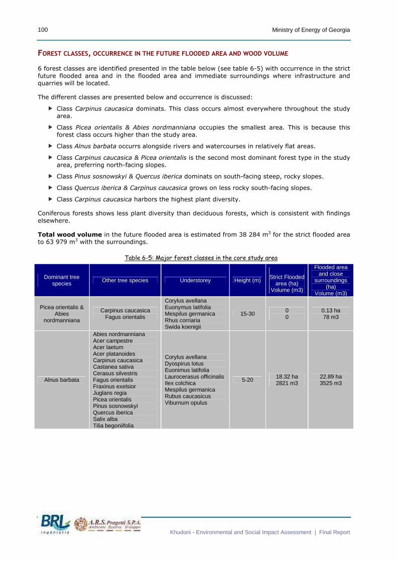
FOREST CLASSES, OCCURRENCE IN THE FUTURE FLOODED AREA AND WOOD VOLUME
6 forest classes are identified presented in the table below (see table 6-5) with occurrence in the strict
future flooded area and in the flooded area and immediate surroundings where infrastructure and
quarries will be located.
The different classes are presented below and occurrence is discussed:
� Class Carpinus caucasica dominats. This class occurs almost everywhere throughout the study
area.
� Class Picea orientalis & Abies nordmanniana occupies the smallest area. This is because this
forest class occurs higher than the study area.
� Class Alnus barbata occurrs alongside rivers and watercourses in relatively flat areas.
� Class Carpinus caucasica & Picea orientalis is the second most dominant forest type in the study
area, preferring north-facing slopes.
� Class Pinus sosnowskyi & Quercus iberica dominats on south-facing steep, rocky slopes.
� Class Quercus iberica & Carpinus caucasica grows on less rocky south-facing slopes.
� Class Carpinus caucasica harbors the highest plant diversity.
Coniferous forests shows less plant diversity than deciduous forests, which is consistent with findings
elsewhere.
Total wood volume in the future flooded area is estimated from 38 284 m3 for the strict flooded area
to 63 979 m3 with the surroundings.
Table 6-5: Major forest classes in the core study area
Dominant tree species Other tree species Understorey Height (m)
Strict Flooded
area (ha) Volume (m3)
Flooded area and close
surroundings (ha)
Volume (m3)
Picea orientalis & Abies
nordmanniana
Carpinus caucasica Fagus orientalis
Corylus avellana Euonymus latifolia Mespilus germanica Rhus corriaria Swida koenigii
15-30 0 0
0.13 ha 78 m3
Alnus barbata
Abies nordmanniana Acer campestre Acer laetum Acer platanoides Carpinus caucasica Castanea sativa Cerasus silvestris Fagus orientalis Fraxinus exelsior Juglans regia Picea orientalis Pinus sosnowskyi Quercus iberica Salix alba Tilia begoniifolia
Corylus avellana Dyospirus lotus Euonimus latifolia Laurocerasus officinalis Ilex colchica Mespilus germanica Rubus caucasicus Viburnum opulus
5-20 18.32 ha 2821 m3
22.89 ha 3525 m3