4.8 protection of hydrologic balance 4.9 preventative and
TRANSCRIPT
4 | P a g e C o v e r S h e e tC r e a t e d : 9 / 1 5 / 1 7R e v i s e d : 5 / 3 1 / 1 8
4.8 Protection of Hydrologic Balance 4.9 Preventative and Remedial Measures Plan
4.10 Liners 4.11 Coal Combustion Materials
5.0 Drainage Control 5.1 Pre-Mining Drainage Patterns Mapping X 5.2 General Drainage Control Description X 5.3 Conveyance Ditch Design X 5.4 Impoundments
6.0 Streams 6.1 Disturbance Information X 6.2 Stream Information 6.3 Stream Buffer Variance 6.4 Streams Outside Permit Boundary 6.5 Existing Stream Locations 6.6 Temporary Stream Diversions 6.7 Permanent Stream Diversions
6.8 Culverts and Crossing of Non-Diverted, Temporary, and/or Permanent Stream Channels
6.9 Stream Buffer Zone X 7.0 Fish and Wildlife
7.1 Pre-Mining Fish and Wildlife Resources X 7.2 Threatened and Endangered Species X 7.3 General Fish and Wildlife Protection and Enhancement Measures X
8.0 Cropland Capability Soils 8.1 High Capability Post-Mining Land Use X 8.2 Pre-Mining Prime Farmland Soils X 8.3 Prime Farmland Soil Handling X 8.4 Prime Farmland Reclamation Plan and Map X
9.0 Reclamation Plan 9.1 Post-mining Land Uses X 9.2 Backfilling and Grading X 9.3 Shaft, Slope, and Borehole Sealing X 9.4 Abandonment and Closure of Refuse Disposal Areas 9.5 Bond Estimation X
10.0 Revegetation and Reclamation 10.1 Revegetation of Drainage Control Ditches 10.2 Revegetation of Faces of Embankments 10.3 Revegetation of Soil Stockpiles X 10.4 Revegetation of Refuse Disposal Facilities 10.5 Pasture Reclamation Plan 10.6 Fish and Wildlife Herbaceous Reclamation Plan 10.7 Fish and Wildlife Woody Reclamation Plan 10.8 Fish and Wildlife Wetland Reclamation Plan
10.9 Fish and Wildlife Water and/or Developed Water Resources Reclamation Plan
10.10 Forest Reclamation Plan 10.11 Industrial/Commercial Reclamation Plan 10.12 Recreation Reclamation Plan 10.13 Habitat Diversification in Cropland
11.0 Blasting 11.1 Proposed Blasting 11.2 Surface Mine Blasting

Received Electronically Department of Natural Resources
June 9, 2021 Office of Mines and Minerals
Land Reclamation Division

Cover Sheet: Application for Coal Mining and Reclamation Operations
Applicant: Hillsboro Energy, LLC Name of Company, Corporation, Partnership or Individual. [1777.11]
AVS ID: (Optional) Applicant is a: x Corporation Partnership Sole Proprietor Association or other Business Entity [1778.13(a)]
Mine Name: Deer Run Mine Address/PO P.O. Box 457 City: Hillsboro State: Illinois Zip Code: 62049 Email Address: [email protected] Phone Number: 217-556-0692 Fax Number: Tax ID/FEIN: 20-5231639
Application Type: New MUF
x Existing Permit No(s). 399
Sig. Rev No. Renewal Transfer No. x IBR SIBR IPR Type of Operation:
Surface
Underground
Carbon Recovery x
Mine Safety Health Administration Information:
MSHA ID Number 11-03182 [1778.13(d)(1)] Date of Issuance March 2, 2009
List the Mine Safety and Health Administration (MSHA) number(s) for all mine associated structures that require MSHA approval. [1778.13(g)]
Structure Type Structure Name MSHA No. N/A
Received Electronically Department of Natural Resources
June 9, 2021 Office of Mines and Minerals
Land Reclamation Division
Received Electronically Department of Natural Resources
June 9, 2021 Office of Mines and Minerals
Land Reclamation Division

Description of Proposed Permitting Action: Describe in sufficient detail the proposed activities. The information should summarize the requested permitting action to assist the Department in determining the scope and magnitude of the proposal. The purpose of this IBR is to add an additional 2.74 acres to Permit 399. The additional permit area will be used to support underground mining operations with the installation of five (5) 6-inch utility boreholes, and a total of 0.15 acres graveled area. Topsoil removed as part of the additional area to be disturbed will be stored on site. The site will be used for sampling, injecting inert products, and/or concrete delivery to the underground mine. Application Part Inventory:
Application
Part Application Part Title
Indicate with an “X” all Parts modified with this
submittal 1.0 Administrative Information 1.1 General Information X 1.2 Acreage and Timetable X 1.3 Ownership and Control Information 1.4 Violation History 1.5 Property Ownership X 2.0 Pre-Mining information 2.1 Pre-Mining Land Use Information X 2.2 Pre-Mining Soils Information X 2.3 Areas Where Mining is Limited or Prohibited X 2.4 Public Parks, Historic Properties 2.5 Valid Existing Rights (VER) - Good Faith/All Permits Standard 2.6 Valid Existing Rights (VER) - Needed for and Adjacent Standard 2.7 Valid Existing Rights (VER) - Standards for Mine Roads 3.0 Mining Operations Plan 3.1 General Description of Operations X 3.2 Description of Mine Facilities X 3.3 Signs and Markers X 3.4 Soil and Overburden Handling and Protection X 3.5 Lateral Support X 3.6 Surface Mining Near Underground Mining X 3.7 Existing Structures X 3.8 Transportation Facilities X 3.9 Non-Coal Mine Waste Material X 3.10 Coal Preparation X 3.11 Coal Processing Waste and Underground Development Waste X 3.12 Coal Refuse Disposal Area X 3.13 Air Pollution Control Plan X 3.14 Fire Control Plan X 4.0 Hydrologic and Geologic Information 4.1 Regional Characteristics 4.2 Hydrogeologic Information 4.3 Area Specific Characteristics 4.4 Ground Water Information 4.5 Ground Water Monitoring Program 4.6 Surface Water Information 4.7 NPDES Monitoring Program
Received Electronically Department of Natural Resources
June 9, 2021 Office of Mines and Minerals
Land Reclamation Division
4.8 Protection of Hydrologic Balance 4.9 Preventative and Remedial Measures Plan 4.10 Liners 4.11 Coal Combustion Materials 5.0 Drainage Control 5.1 Pre-Mining Drainage Patterns Mapping X 5.2 General Drainage Control Description X 5.3 Conveyance Ditch Design X 5.4 Impoundments 6.0 Streams 6.1 Disturbance Information X 6.2 Stream Information 6.3 Stream Buffer Variance 6.4 Streams Outside Permit Boundary 6.5 Existing Stream Locations 6.6 Temporary Stream Diversions 6.7 Permanent Stream Diversions
6.8 Culverts and Crossing of Non-Diverted, Temporary, and/or Permanent Stream Channels
6.9 Stream Buffer Zone X 7.0 Fish and Wildlife 7.1 Pre-Mining Fish and Wildlife Resources X 7.2 Threatened and Endangered Species X 7.3 General Fish and Wildlife Protection and Enhancement Measures X 8.0 Cropland Capability Soils 8.1 High Capability Post-Mining Land Use X 8.2 Pre-Mining Prime Farmland Soils X 8.3 Prime Farmland Soil Handling X 8.4 Prime Farmland Reclamation Plan and Map X 9.0 Reclamation Plan 9.1 Post-mining Land Uses X 9.2 Backfilling and Grading X 9.3 Shaft, Slope, and Borehole Sealing X 9.4 Abandonment and Closure of Refuse Disposal Areas 9.5 Bond Estimation X 10.0 Revegetation and Reclamation 10.1 Revegetation of Drainage Control Ditches 10.2 Revegetation of Faces of Embankments 10.3 Revegetation of Soil Stockpiles X 10.4 Revegetation of Refuse Disposal Facilities 10.5 Pasture Reclamation Plan 10.6 Fish and Wildlife Herbaceous Reclamation Plan X 10.7 Fish and Wildlife Woody Reclamation Plan 10.8 Fish and Wildlife Wetland Reclamation Plan
10.9 Fish and Wildlife Water and/or Developed Water Resources Reclamation Plan
10.10 Forest Reclamation Plan 10.11 Industrial/Commercial Reclamation Plan 10.12 Recreation Reclamation Plan 10.13 Habitat Diversification in Cropland 11.0 Blasting 11.1 Proposed Blasting 11.2 Surface Mine Blasting
Received Electronically Department of Natural Resources
June 9, 2021 Office of Mines and Minerals
Land Reclamation Division

11.3 Underground Mine Blasting 12.0 Shaft, Slope, and Miscellaneous Borehole Construction 12.1 Shafts and/or Slopes 12.2 Miscellaneous Boreholes X 13.0 Underground Extraction 13.1 General Shadow Area Information 13.2 Unplanned Subsidence Control Plan 13.3 Planned Subsidence Control Plan 13.4 Subsidence Damage Mitigation 13.5 Water Supplies 13.6 Auger Mining 14.0 Disposal of Coal Waste in Underground Workings 14.1 MSHA Approval 14.2 Waste Material Description 14.3 Pneumatic Injection 14.4 Surface Disturbance Operations 14.5 Underground Workings Disposal Area 14.6 Circuitry of the Disposal Operation 14.7 Subsidence Control 14.8 Hydrologic Balance Protection 15.0 Coal Combustion Materials 15.1 Coal Combustion By-Products (CCB) 15.2 Coal Combustions Waste (CCW)
Received Electronically Department of Natural Resources
June 9, 2021 Office of Mines and Minerals
Land Reclamation Division

PART 1: Administrative Information
1.1 General Information.
1.1.1 Applicant: Hillsboro Energy, LLC Applicant is a: x Corporation Partnership Sole Proprietor Association or other Business Entity [1778.13(a)]
Individual Contact: [1778.13(b)]
Clayton Cross, Authorized Person (Name and Title)
Address/PO Box: P.O. Box 457 City: Hillsboro State: Illinois Zip Code: 62049 Email Address: [email protected] Phone Number: 217-556-0692 Fax Number: Tax ID/FEIN No. 20-5231639
1.1.2 Resident Agent who will accept service of process for the applicant: [1778.13(b)]
Company: Hillsboro Energy, LLC Individual Contact: Clayton Cross, Authorized Person (Name and Title) Address/PO Box: P.O. Box 457 City: Hillsboro State: Illinois Zip Code: 62049 Email Address: [email protected] Phone Number: 217-556-0692 Fax Number: Tax ID/FEIN No. 20-5231639
1.1.3 Who will be the operator at the permit site? [1778.13(b)]
x Applicant Other/Contract operator If the operator is not the applicant, then complete Table 1.3.1 for the company/entity.
1.1.4 Who will pay Abandoned Mine Land Reclamation fees? [1778.13(b)]
x Applicant Other/Contract operator
Received Electronically Department of Natural Resources
June 9, 2021 Office of Mines and Minerals
Land Reclamation Division

1.2 Acreage and Timetable.
Pit or Portal No./Name County Sec(s) Twp Range Total Acres Emergency Boreholes Montgomery 20 8N 3W 2.74
TOTAL: 2.74
Shadow Area County Sec(s) Twp Range Total Acres
TOTAL:
1.2.1 Indicate type of disturbance from mining and acreage associated with each type. [1780.11/1784.11]
Type of Disturbance: Acres Surface Mined Area Processing Areas & Support Facilities 2.74 Undisturbed Areas (optional)
TOTAL (must equal total acres being permitted) 2.74 Shadow Area
1.2.2 Indicate on the Pre-Mining Land Use Map where future permits for coal refuse piles, coal waste impoundments, or other surface facilities would be located. Provide a general statement that future facilities will be located X number of miles from the current permit. [1778.17(a); 1779.24(c)]
N/A
1.3 Ownership and Control Information.
1.3.1 Complete Table 1.3.1 to identify all owners/controllers of the applicant. Separate sheet/table shall be provided for each entity or individual deemed to be an owner/controller of the applicant.
Ownership or control is evidenced by:
• Being a permittee of a surface coal mining operation; or • Based on instruments of ownership or voting securities, owning of record in excess of fifty (50)
percent of an entity; or • Having any other relationship which gives one person authority directly or indirectly to determine
the manner in which an applicant, an operator, or other entity conducts surface coal mining operations
The following relationships are presumed to constitute ownership or control unless a person can demonstrate that the person subject to the presumption does not in fact have the authority directly or indirectly to determine the manner in which the relevant surface coal mining operation is conducted.
Received Electronically Department of Natural Resources
June 9, 2021 Office of Mines and Minerals
Land Reclamation Division

• Being an officer or director of an entity; or • Being the operator of a surface coal mining operation; or • Having the ability to commit the financial or real property assets or working resources of an entity; • Being a general partner in a partnership; or • Based on the instruments of ownership or the voting securities of a corporate entity, owning of
record ten (10) through fifty (50) percent of the entity; or • Owning or controlling coal to be mined by another person under a lease, sublease or other contract
and having the right to receive such coal after mining or having authority to determine the manner in which that person or another person conducts a surface coal mining operation. [1773.5, 1778.13(c)(1) to (c)(3)]
1.3.2 Complete Table 1.3.2 for surface coal mining and reclamation operations, within the five (5) years preceding the date of the application for associated with: [1778.13(c)(4)/1778.13(c)(5)]
• Each Owner/Controller identified in Table 1.3.1 • The applicant.
1.4 Violation History.
1.4.1 Has the applicant, any subsidiary, affiliate, or persons controlled by or under common control with the applicant, had Federal, State, or Tribal coal mining permit suspended or revoked in the last five (5) years preceding the date of submission of the application? [1778.14(a)(1)]
Yes No
1.4.2 Has the applicant, any subsidiary, affiliate, or persons controlled by or under common control with the applicant, had forfeited a performance bond or similar security deposited in lieu of bond? [1778.14(a)(2)]
Yes No
If YES to either Questions 1.4.1 or 1.4.2, the applicant shall complete Table 1.4 for any permit/company associated with permit suspension, revocation or bond forfeiture. [1778.14(a) and (b)]
1.4.3 The applicant shall complete Table 1.4.3 for all violations received by the applicant or any one owning/controlling the applicant as provided in Table 1.3.1 during the three (3) year period preceding the application date. [1778.14(c)]
For any outstanding violation or violation under appeal listed in Table 1.4.3, the applicant shall provide supporting documentation showing good faith efforts for the violation from the issuing agency, or in the case of appeals provide documentation of current proceedings. [1773.15(b), 1778.14(c)]
NOTE: Provide as an Attachment to Part 1.4.3.
1.5 Property Ownership.
1.5.1 Complete Table 1.5.1 for (1) each legal or equitable owner of record, (2) each holder of leasehold interest, and (3) any purchaser of record under a real estate contract for the surface and mineral property within the proposed permit boundary. [1778.13(e), 1778.15(a)]
Received Electronically Department of Natural Resources
June 9, 2021 Office of Mines and Minerals
Land Reclamation Division

If the proposed permit is for a surface mine where the private mineral estate has been severed from the private surface estate, applicant must also provide the Department with:
• A copy of the written consent of the surface owner to the extraction of coal by surface mining methods; or
• A copy of the conveyance that expressly grants or reserves the right to extract the coal by surface mining methods; or
• If the conveyance does not expressly grant the right to extract the coal by surface mining methods, provide the Department with documentation that, under the applicable State law, the applicant has the legal authority to extract the coal by surface mining methods. [1778.15(b)]
• See Part 1.5.3, below, for additional requirements to uncontrolled properties.
NOTE: Provide as an Attachment to Part 1.5.1.
1.5.2 Complete Table 1.5.2 for any owner of record for property (surface and subsurface) contiguous to any part of the proposed permit boundary. [1778.13(f)]
Does the applicant have an interest in any lands, options or pending bids on interest for lands which are contiguous to the proposed permit area?
Yes No
If YES, the applicant shall indicate in Table 1.5.2 all lands, interest in lands, options, or pending bids on interests held or made by the applicant for lands contiguous to the area described in the permit application. [1778.13(h)]
Upon request by the applicant, this information may be held in confidence by the Department, if not on public file. Does the applicant wish any of the above information to be held confidential?
Yes No
If YES, the applicant shall identify which information is to be held confidential in its statement. [1778.13(h)]
1.5.3 Complete Table 1.5.3 for any owner of record for property (surface and subsurface) identified in Table 1.5.1 and shown on the Pre-Mining Land Use Map identified in 1.5.4, not owned by the applicant, identifying the documents and legal rights claimed to enter and mine.
All properties identified in Table 1.5.1 that the applicant does not have a legal right to enter and begin mining operations shall require submission of a Property Ownership Waiver form for each property identified for the application to be considered administratively complete [see Operator Memorandum No. 2011-01]
NOTE: Provide as an Attachment to Part 1.5.3.
1.5.4 Delineate all boundaries of lands and names of present owners of record of those lands, both surface and subsurface, included in or contiguous to the permit area on the Pre-Mining Land Use Map. The map shall also show lands within the permit area that are controlled properties (i.e. applicant is claiming legal right to enter and begin surface coal mining and reclamation operations) versus uncontrolled properties (i.e. applicant does not yet have the legal right of entry). [1779.24(a) and (b)]
Received Electronically Department of Natural Resources
June 9, 2021 Office of Mines and Minerals
Land Reclamation Division

Name Address Type of Holder: Legal/Equitable/Leaseholder/Purchaser Surface or Mineral Property Surface Acreage Parcel ID Map ID Reference
Kasten, Arlen & Patricia Joint Revoc Living Trust 13162 Illinois Route 185, Hillsboro, IL 62049 Legal - Agreement dated May 6, 2021 Surface 76.50 17-20-300-001 17-20-300-001
1.5.1 Property OwnershipWithin Permit Area
Received Electronically Department of Natural Resources
June 9, 2021 Office of Mines and Minerals
Land Reclamation Division

Name Address Options/Interests on Property Surface or Mineral Property Parcel ID Map ID ReferenceSchraut, Larry G & Phyllis I 7199 Buckeye Tr., Hillsboro, IL 62049 Legal Surface 17-20-300-005 17-20-300-005Schraut, Larry G & Phyllis I 7199 Buckeye Tr., Hillsboro, IL 62049 Legal Surface 17-20-400-006 17-20-400-006Kasten, Arlen & Patricia Joint Revoc Living Trust 13162 Illinois Route 185, Hillsboro, IL 62049 Legal Surface 17-20-300-004 17-20-300-004Kasten, Arlen & Patricia Joint Revoc Living Trust 13162 Illinois Route 185, Hillsboro, IL 62049 Legal Surface 17-19-400-005 17-19-400-005New River Royalty, LLC P.O. Box 147, Pinckneyville, IL 62274 Legal Surface 17-19-200-011 17-19-200-011New River Royalty, LLC P.O. Box 147, Pinckneyville, IL 62274 Legal Surface 17-20-100-002 17-20-100-002Spinner, George and Martha 15342 N 9th Avenue, Hillsboro, IL 62049 Legal Surface 17-20-100-005 17-20-100-005
1.5.2 Property OwnershipContiguous to the Permit Area
Received Electronically Department of Natural Resources
June 9, 2021 Office of Mines and Minerals
Land Reclamation Division

Property Owner (Name) Parcel ID Map ID Reference Type of Document Date of Execution Identification of the Specific Lands to which the Document Pertains
Explanation of the Legal Rights Claimed (including whether any rights are the
subject of pending litigation)
Pending Litigation?
Y/N
Check if no legal rights
claimed.
Table 1.5.3Uncontrolled Interests Within Proposed Boundary
Received Electronically Department of Natural Resources
June 9, 2021 Office of Mines and Minerals
Land Reclamation Division

Attachment 1.6.2
Received Electronically Department of Natural Resources
June 9, 2021 Office of Mines and Minerals
Land Reclamation Division

PUBLIC NOTICE Pursuant to the Surface Coal Mining Land Conservation and Reclamation Act (PA-81-1015, as amended) and the Rules and Regulations of the Act, Hillsboro Energy, LLC, (PO Box 457, Hillsboro, Illinois 62049) hereby gives notice that a request for an approximate 2.74 acre non-contiguous surface permit was submitted to the Illinois Department of Natural Resources, Office of Mines and Minerals, Land Reclamation Division, One Natural Resources Way, Springfield, IL 62702-1271 on __________ to install and maintain five boreholes under the provisions of 62 IAC Section 1774.13(d)(2) (Incidental Boundary Revision to Permit No. 399). Activities associated with the permit application include installation of five 6-inch utility boreholes. These activities are to occur within an approximate 2.74 acre area located within Section 20, Township 8 North, Range 3 West, Montgomery County, Illinois and some activities are located within 100-feet of the right-of-way of the public road. Access to the site will be provided via a constructed access road off State Route 185. Any person who may be adversely affected by the proposed mining operation within 100-feet north of the public road may submit comments or request a public hearing, in writing, to the Land Reclamation Division of the Illinois Department of Natural Resources, Office of Mines and Minerals at the above address within 14 days following this Public Notice. Copies of the application are on file at the Illinois Department of Natural Resources office, as noted above. The closing date of the comment period for this IBR is fourteen (14) days from the date of this Public Notice. Note: The above is to be published in “The Journal-News”, 431 South Main Street, Hillsboro, Illinois
62049
Received Electronically Department of Natural Resources
June 9, 2021 Office of Mines and Minerals
Land Reclamation Division
Received Electronically Department of Natural Resources
June 9, 2021 Office of Mines and Minerals
Land Reclamation Division

PART 2: Pre-Mining Information
2.1 Pre-Mining Land Use Information.
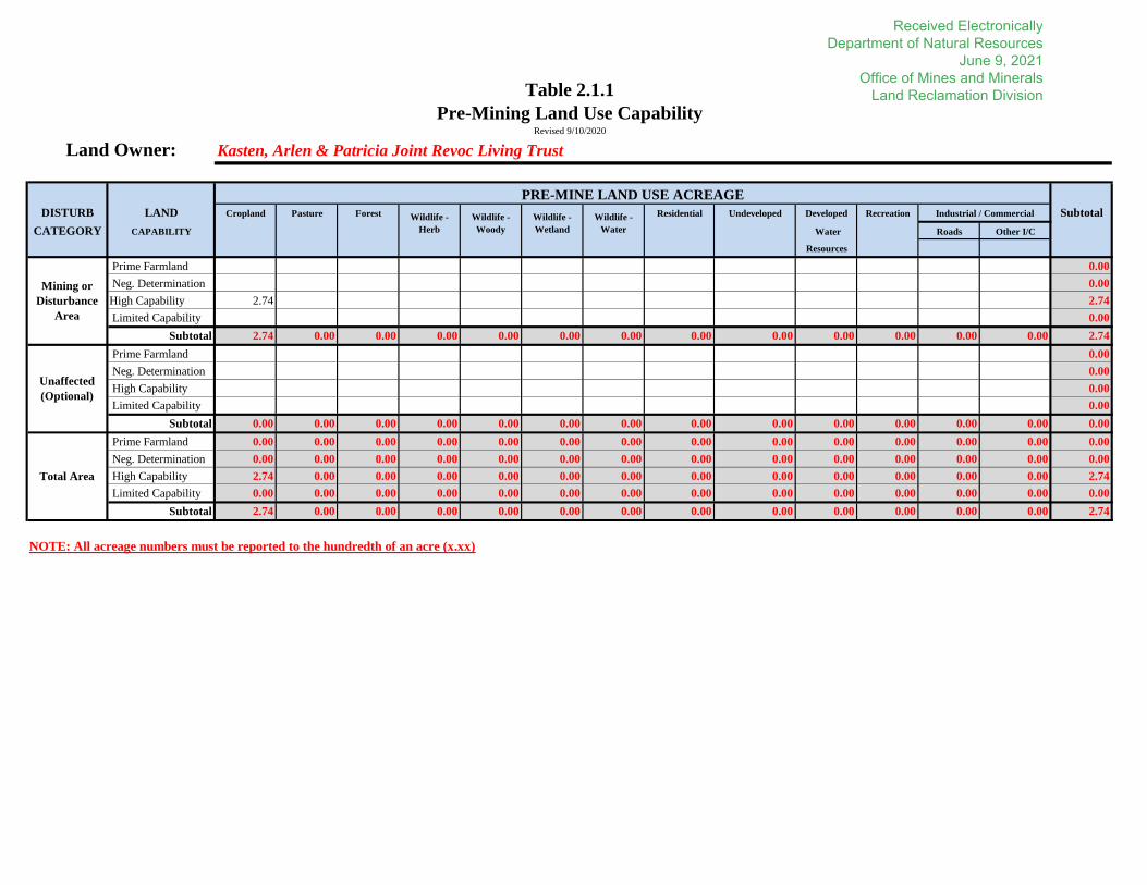
2.1.1 Pre-Mining Land Use and Capability Acreages. Complete Table 2.1.1: Pre-Mining Land Use Capability giving the acreage and capability of each land use within the proposed permit area, employing only land use categories of 62 Ill. Adm. Code 1701.5, the “fish and wildlife” land use category must be subdivided as required by Operator Memorandum 2015-01. Use only these land uses for completing the land use maps.
The information shall be broken down with a separate table for each landowner. In addition, the applicant shall complete Table 2.1.1 - Grand Total: Pre-Mining Land Use Capability Summary. This table is a compilation of all Pre-Mining Land Use Capability tables filled out for each individual land owner.
For IBR applications, complete Table 2.1.1: Pre-Mining Land Use Capability for each landowner and update Table 2.1.1 - Grand Total: Pre-Mining Land Use Capability Summary. [1780.23/1784.15]
Note: other agencies, such as USACE, may define land uses differently.
Pre-mining land use and capability information is presented in Attachment 2.1.1. The custom soil survey defines the scale at which the soils were mapped and provides a warning of accuracy when that scale has been exceeded. Where soil survey results are too small to calculate, agency policy is to interpolate soil and land use acreages to meet regulatory requirements.
2.1.2 Provide slope measurements to represent existing land surface configuration of proposed permit area. A soils map of medium intensity prepared to NRCS specifications or a contoured aerial photo may be submitted to meet this requirement. [1779.24/1783.24(l)]
Check here if using one of the above maps or photos.
Does the Soils Map submitted with the application meet the requirements to provide slope measurements?
YES NO
If NO, provide a contoured aerial photo for the proposed boundary.
2.1.3 For any proposed surface coal mining and reclamation operation, has previous mining activity including active, inactive or abandoned underground mine workings along with any mine opening to the surface occurred within the permit and/or adjacent area? [1816.133/1817.133]
YES NO
If YES, complete Table 2.1.3: Previous Mining Activity - Surface Permit Areas and delineate the areas disturbed by previous mining activities, including active, inactive or abandoned underground mine work along with any mine opening to the surface on the Pre-Mining Land Use Map. In addition, the map shall identify areas where surface coal mining operations were conducted prior to August 3, 1977; after August
Received Electronically Department of Natural Resources
June 9, 2021 Office of Mines and Minerals
Land Reclamation Division

3, 1977 and prior to May 3, 1978; after May 3, 1978 and prior to February 1, 1983; and any permanent regulatory program permit issued after February 1, 1983. [1777.14(b); 1779.25(a)(8)/1783.25(a)(8)]
2.1.3.1 Identify the land uses preceding any type of mining, if known. [1780.23(a)(1)/1784.15(a)(1)]
Cropland
2.1.4 Is any of the permit area subject to local or county zoning?
YES NO
If YES, provide a description of the existing land uses and land classifications under local law, if any, for the proposed permit and adjacent areas.
2.1.5 Provide the location of surface and subsurface man-made features within, passing through, or passing over the proposed permit area on the Pre-Mining Land Use Map. Such features should include, but are not limited to, major electric transmission lines, pipelines, agricultural drainage tile fields, gas and oil wells, and water wells. For gas, oil, and water wells provide the depth, if available, of the well in Table 2.1.5: Oil and Gas Well Information. [1779.24(e)/1783.24(e)]
Existing surface and subsurface items are presented on the Surface Operations Map.
2.1.6 If any of the land uses changed within the last five (5) years, indicate the acreage and changes of land uses. [1780.23(a)(1)/1784.15(a)(1)]
Land uses within the proposed permit area have not changed within the last five years.
2.2 Pre-Mining Soils Information. The applicant is strongly recommended to use the USDA Web Soil Survey. The web soil survey has the ability to create a Custom Soil Survey report for the application area which will generate many of the information requirements for pre-mining soils and prime farmland restoration plans which may reference this report. Please note there are extra soil data tables, including Land Classification, Non-irrigated Capability Class, and Vegetation Productivity, and the data from the Soil Property and Qualities tab which must specifically be extracted when creating a custom report.
NOTE: The acreage of the Area of Interest must agree with the permit acreage. This report may be referenced in responding to portions of the required soil information.
2.2.1 The narrative of land capability and productivity shall employ the USDA National Resources Conservation Service's Land-Capability Classification (Agriculture Handbook No. 210) in conjunction with the soil information provided under the published soil survey when completing Part 2.2.9. Optimum levels management productivity information may be found in Bulletin 811. [1779.21/1783.21].
NOTE: This Bulletin has periodic updates in a supplemental table.
Received Electronically Department of Natural Resources
June 9, 2021 Office of Mines and Minerals
Land Reclamation Division

2.2.2 A Soils Map shall be provided as required by Part 2.2. The scale of the Soil Map scale must be the same scale as the Pre-Mining Land Use Map and Post-Mining Land Use/Capability Reclamation Map, unless otherwise approved by the Department. Does the submitted Soils Map represent a map developed by the National Resources Conservation Service (NRCS)? [1779.21/1783.21]
YES NO
If YES, complete the following:
2.2.2.1 Has the NRCS soil map been modified in any way except by a change in scale?
YES NO
If YES, explain the nature of the changes.
2.2.3 For surface mines, delineate on the Soils Map, the area which will incur actual mining (removal of overburden and/or deposition of overburden for the extraction of coal). Identify any areas proposed to remain undisturbed. [1780.14]
For underground mines, identify any areas proposed to remain undisturbed. [1784.23]
N/A. All area is underground mine support.
2.2.4 Are any of the identified map units correlated as prime farmland by NRCS criteria?
YES NO
If YES, explain and provide documentation to meet the requirements of 62 Ill. Adm. Code 1785.17 or 1823.11, if a request for grandfathering, negative determination or underground mine exemption is sought. If prime farmlands exist which will not meet the exemption criteria described above, a prime farmlands restoration plan must be provided in Parts 8.2 through 8.4. [1785.17(b)/1823.11]
See Attached Soil Map 5 and Soil Report (Attachment 2.2.2).
2.2.5 Indicate the average topsoil thickness of each of the Soil Map units to be affected. Locate on Soils Map the test holes for soil horizon thickness sampling. Provide the average and methodology for determining the average pre-mining topsoil thickness in inches for: [1779.21/1783.21]
- Non-cropland capability inches - High capability 8-14 inches - Prime Farmland inches
2.2.6 List the soil types and acreages of areas that will require the B and/or portions of the C horizon to be removed and replaced in order to establish the root medium necessary to achieve soil productivity consistent with the proposed post-mining land use. Alternatively, a narrative description explaining why specific soil type acres information for reclamation plan achievement is not necessary may be provided. [1780.18(b)(4)/1784.13(b)(4)]
N/A
Received Electronically Department of Natural Resources
June 9, 2021 Office of Mines and Minerals
Land Reclamation Division

2.2.7 Are selected overburden materials proposed to be used in lieu of or as a supplement to the A-horizon?
YES NO
If YES, provide the appropriate information required by 62 Ill. Adm. Code 1779.21(b) or 1783.21(b).
Also, identify the source of the substitute materials and the topsoil to be substituted away from (not removed) on a separate soils map, labeled Topsoil Substitution Map and/or describe the area in narrative form. [1780.14/1784.23]
2.2.8 Explain why the proposed plan will provide the best available material of equal or better quality than present topsoil or surface existing material. [1816.22(b)/1817.22(b)]. This section must be addressed when affecting previously disturbed areas if the surface soil is not to be salvaged. If topsoil substitutes or supplements are proposed, a demonstration of their suitability shall be required based on analysis of thickness of soil horizons, total depth, texture, percent coarse fragments, pH, and aerial extent of the different kinds of soils. The Department shall require other chemical and physical analyses, field-site trials, or greenhouse tests if determined to be necessary or desirable to demonstrate the stability of the topsoil substitutes or supplements. [1780.18(b)(4)/1784.13(b)(4); 1779.21/1783.21]
N/A. Topsoil will be replaced.
2.2.9 Complete Table 2.2.9: Soils Information Chart acreage for each of the map units (soil type and slope classification) of prime farmland, high capability (include grandfathered and negatively determined prime farmland) and non-cropland capability land with respect to areas within the permit area. All soils previously disturbed by home sites, farmsteads, roads, etc., shall be tabulated as non-cropland capability and need not undergo a negative determination. The Soil Information Chart must be broken out by land owner, if there is more than one. [1779.21(a)/1783.21(a); 1785.17]
Optional-addition: If applicable, quantify map units acreage values on Table 2.2.9: Soils Information Chart for areas which will not be disturbed. [1779.21(a)/1783.21(a)]
2.3 Areas Where Mining is Limited or Prohibited.
Complete Table 2.3: Areas Prohibiting or Limiting Mining Operations for each structure (occupied dwelling, public building, school, church, community/institutional building, public park, cemeteries, public road) identified in question 2.3.2 through 2.3.9 with respect to areas where mining is prohibited. Indicate if the buffer zone will be in effect or if a waiver is obtained. [1761.11(c)(d)(e)(f)(g)]
2.3.1 Does the proposed permit area include areas designated unsuitable for surface coal mining and reclamation operations, or under study for designation in an administrative proceedings as unsuitable for surface coal mining and reclamation operations? [1773.15(c)(3)]
Received Electronically Department of Natural Resources
June 9, 2021 Office of Mines and Minerals
Land Reclamation Division

YES NO
If YES, identify these areas on the Pre-Mining Land Use and Operations Map.
2.3.2 Does the proposed permit area include lands within boundaries of the National Park System, National Wildlife Refuge System, the National System of Trails, the National Wilderness Preservation System, the Wild and Scenic Rivers System, and National Recreation Areas, etc.? [1761.11(a)]
YES NO
If YES, identify these areas on the Pre-Mining Land Use and Operations Map.
2.3.3 Does the proposed permit area include lands within the boundaries of any national forest? [1761.11(b)]
YES NO
If YES, identify these areas on the Pre-Mining Land Use and Operations Map.
2.3.4 Are there any publicly owned parks or any places included in the National Register of Historic Places on or within 1,000 feet of the proposed permit area? [1761.11(c)]
YES NO
If YES, identify these areas on the Pre-Mining Land Use and Operations Map.
2.3.5 Does the operations plan propose any surface coal mining operations within 100 feet measured horizontally of the outside right-of-way line of any public road? [1761.11(d)]
YES NO
If YES, complete the following:
2.3.5.1 Describe the measures to be used to insure that the interest of the affected public and landowners will be protected. [1761.11(d)(2)(B)]
The access road off State Route 185 is within the existing road construction zone, therefore, speeds are already reduced through this area. The boreholes within 100-feet measured horizontally of the outside right-of-way line of the public road are considered temporary and should not affect the interest of the public. 2.3.5.2 In the public notice of the application required in the Cover Sheet, identify the public road(s), describe the activities to be conducted within 100 feet of the road(s), and indicate the opportunity for a public hearing on this matter. [1761.11(d)(2)(A)]
See attachment 1.6.2 Public Notice
2.3.6 Does the proposed permit area include any public roads which are to be removed, relocated or closed? [1761.14]
YES NO
Received Electronically Department of Natural Resources
June 9, 2021 Office of Mines and Minerals
Land Reclamation Division

If YES, complete the following:
2.3.6.1 Submit the necessary approvals of the authority with jurisdiction over the public road. [1761.14(b)(2)]
2.3.6.2 If a public road is to be replaced or re-located within the permit area, provide evidence that a bond has or will be posted with the authority with jurisdiction over the public road. If such bond has not been nor will be posted, address road replacement costs in Table 9.5.1.14: Public Road Replacement.
2.3.6.3 Describe the measures to be used to insure that the interest of the affected public and landowners will be protected. [1761.14(b)(5)]
2.3.6.4 As required in the Cover Sheet, the public notice shall identify the public road(s) to be removed, relocated or closed, and indicate the opportunity for a public hearing on this matter. [1761.14(b)(3) and (4)]
2.3.7 Does the operations plan propose any surface coal mining operations within 300 feet measured horizontally from any occupied dwelling other than a haul road or access road which connects with an existing public road on the side of the public road opposite the dwelling? [1761.11(e)]
YES NO
If YES, include a waiver from the owner of the dwelling meeting the following requirements: [1761.15]
- The waiver shall be by lease, deed, or other conveyance from the owner of the dwelling. The waiver must clarify that the owner and signator had the legal right to deny mining and knowingly waived that right.
- Provide proof that the waiver has been properly filed in public property records pursuant to State laws.
If NO, and occupied dwellings are located either within the permit boundary or within 300 feet of the permit boundary but no disturbance is proposed within 300 feet, then indicate 300 foot buffer markers around all applicable occupied dwellings on the Operations Map
NOTE: If a valid waiver was obtained before August 3, 1977 from the owner of an occupied dwelling to conduct operations within 300 feet of the dwelling, a new waiver need not be obtained. [1761.15(c)]
2.3.8 Does the operations plan propose any surface coal mining operations within 300 feet measured horizontally of any public building, school, church, community or institutional building or public park? [1761.11(f)]
YES NO
Received Electronically Department of Natural Resources
June 9, 2021 Office of Mines and Minerals
Land Reclamation Division
2.3.9 Are there any public or private cemeteries or Indian burial grounds or other areas where human bodies are interred located in or within one hundred (100) feet of the proposed permit area? [1761.11(g)]
YES NO
If YES, locate on the Pre-Mining Land Use, Operations and Post-Mining Land Use/Capability Reclamation Plan Maps the boundaries of the above-referenced areas and indicate a 100 foot buffer zone around the cemetery or burial ground. [1779.24(j)/1783.24(j)]
2.3.10 Are valid existing rights claimed for any part of the permit area? [1761.5; 1761.16]
YES NO
If YES, complete Part 2.6 or 2.7 to substantiate the claim.
2.4 Public Parks, Historic Properties.
2.4.1 Provide a description of the historic properties (archeological sites and/or historic standing structures) listed or potentially eligible for listing on the National Register of Historic Places and any known archeological features within the proposed permit and adjacent areas. The description of the historic properties occurring within the permit area and adjacent areas shall be based upon available data. If studies have been completed and submitted for review prior to this application, attach a copy of the results of that review. For significant revisions other than shadow area revisions, attach a copy of the IHPA review. Also, with regard to historic properties, provide the anticipated start date when the area is to be affected. [1779.12/1783.12]
2.4.2 If investigations are underway or under review, reference the current status. [1779.12(b)/1783.12(b)]
NOTE: Studies which are submitted to the Department shall be submitted as a separate document (3 hard copies, plus one on disk in pdf format or other format as directed by the Department)
2.4.3 If historic properties are to be avoided, provide a map showing their location in lieu of either a Phase I evaluation or a Phase II evaluation. A qualified archaeologist shall create the map and identifying field markings to be employed to ensure the site(s) will not be disturbed by surface coal mining and reclamation operations. The map is to be submitted in duplicate in separate cover from the rest of the application and labeled Historic Properties Protection Map. The Department will hold the map as a confidential document. If a revision proposes a disturbance not previously identified, identify its location to any avoidance area. [1773.13(d)(3)].
2.4.4 Provide a plan for publicly owned park(s), or place(s) listed on the National Register of Historic Places, that may be adversely affected by the proposed operation describing the measures to be employed: [1780.31/1784.17]
Received Electronically Department of Natural Resources
June 9, 2021 Office of Mines and Minerals
Land Reclamation Division

- To prevent adverse impacts caused by surface mining related activities including, but not limited to, loss or destruction of historic properties; or
- If valid existing rights exist or joint agency approval is to be obtained under 62 Ill. Adm. Code 1761.17(d), to minimize adverse impacts. If valid existing rights are to be claimed, complete Sections 2.5 or 2.6 of this application, whichever is applicable.
2.5 Valid Existing Rights (VER) Good Faith/All Permits Standard. [1761.16(b)(2)]
The applicant must provide a property rights demonstration under 62 Ill. Adm. Code 1761.5(a) if the applicant’s request for VER is based upon the good faith/all permits standard in Section 1761.5(b)(1). This demonstration must include the following items: [1761.16(b)]
2.5.1 A legal description of the land to which the request pertains.
2.5.2 Complete documentation of the character and extent of the current interests in the surface and mineral estates of the land to which the request pertains.
2.5.3 A complete chain of title for the surface and mineral estates of the land to which the request pertains.
2.5.4 A description of the nature and effect of each title instrument that forms the basis for the request, including any provision pertaining to the type of method of mining or mining-related surface disturbances and facilities.
2.5.5 A description of the type and extent of surface coal mining operations that the applicant or permittee claims the right to conduct, including the method of mining and mining-related surface activities and facilities, and an explanation of how those operations would be consistent with State property law.
2.5.6 Complete documentation of the nature and ownership, as of the date that the land came under the protection of 62 Ill. Adm. Code 1761.11, of all property rights for the surface and mineral estates of the land to which the request pertains.
2.5.7 Names and addresses of the current owners of the surface and mineral estates of the land to which the request pertains.
Received Electronically Department of Natural Resources
June 9, 2021 Office of Mines and Minerals
Land Reclamation Division

2.5.8 If the coal interests have been severed from other property interests, documentation that the owners of other property interests in the land to which the request pertains have been notified and provided a minimum of 14 days to comment on the validity of the applicant or permittee’s property rights claims.
2.5.9 Provide any comments received in response to the notification provided under Part 2.5.8. above.
2.5.10 Approval and issuance dates and identification numbers for any permits, licenses, and authorizations that the applicant, permittee or a predecessor in interest obtained before the land came under the protection of 62 Ill. Adm. Code 1761.11.
2.5.11 Application dates and identification numbers for any permits, licenses, and authorizations for which the applicant, permittee or a predecessor in interest submitted an application before the land came under the protection of 62 Ill. Adm. Code 1761.11.
2.5.12 An explanation of any other good faith effort that the applicant, permittee or a predecessor in interest made to obtain the necessary permits, licenses, and authorizations as of the date that the land came under the protection of 62 Ill. Adm. Code 1761.11.
2.6 Valid Existing Rights (VER) Needed for and Adjacent Standard. [1761.16(b)(3)]
The applicant must provide a property rights demonstration under 62 Ill. Adm. Code 1761.5(a) if the applicant’s request for VER is based upon the needs for and adjacent standard in Section 1761.5(b)(1). This demonstration must include the following items: [1761.16(b)]
2.6.1 A legal description of the land to which the request pertains.
2.6.2 Complete documentation of the character and extent of the current interests in the surface and mineral estates of the land to which the request pertains.
2.6.3 A complete chain of title for the surface and mineral estates of the land to which the request pertains.
2.6.4 A description of the nature and effect of each title instrument that forms the basis for the request, including any provision pertaining to the type of method of mining or mining-related surface disturbances and facilities.
Received Electronically Department of Natural Resources
June 9, 2021 Office of Mines and Minerals
Land Reclamation Division

2.6.5 A description of the type and extent of surface coal mining operations that the applicant or permittee claims the right to conduct, including the method of mining and mining-related surface activities and facilities, and an explanation of how those operations would be consistent with State property law.
2.6.6 Complete documentation of the nature and ownership, as of the date that the land came under the protection of 62 Ill. Adm. Code 1761.11, of all property rights for the surface and mineral estates of the land to which the request pertains.
2.6.7 Names and addresses of the current owners of the surface and mineral estates of the land to which the request pertains.
2.6.8 If the coal interests have been severed from other property interests, documentation that the owners of other property interests in the land to which the request pertains have been notified and provided a minimum of 14 days to comment on the validity of the applicant or permittee’s property rights claims.
2.6.9 Provide any comments received in response to the notification provided under Part 2.6.8 above.
2.6.10 Explain how and why the land is needed for and immediately adjacent to the operation upon which the request is based. This explanation shall include a demonstration that prohibiting expansion of the operation onto that land would unfairly impact the viability of the operation as originally planned before the land came under the protection of 62 Ill. Adm. Code 1761.11.
2.7 Valid Existing Rights (VER) Standards for Mine Roads. [1761.16(b)(4)]
If the request relies upon one of the standards for roads in 62 Ill. Adm. Code 1761.5(c)(1) through (c)(4), satisfactory documentation of one or more of the following must be submitted showing that: [1761.5(c)]
2.7.1 The road existed when the land upon which it is located came under the protection of 62 Ill. Adm. Code 1761.11, and the applicant has a legal right to use the road for surface coal mining operations.
2.7.2 A properly recorded right of way or easement for a road in that location existed when the land came under the protection of 62 Ill. Adm. Code 1761.11, and, under the document creating the right-of-way or easement, and under any subsequent conveyances, the applicant has a legal right to use or construct a road across that right of way or easement to conduct surface coal mining operations.
Received Electronically Department of Natural Resources
June 9, 2021 Office of Mines and Minerals
Land Reclamation Division

2.7.3 A valid permit for use or construction of a road in that location for surface coal mining operations existed when the land came under the protection of 62 Ill. Adm. Code 1761.11.
2.7.4 Valid existing rights exist under 62 Ill. Adm. Code 1761.5(a) and (b).
Received Electronically Department of Natural Resources
June 9, 2021 Office of Mines and Minerals
Land Reclamation Division
DISTURB LAND Cropland Pasture Forest Residential Undeveloped Developed Recreation Subtotal
CATEGORY CAPABILITY Water Roads Other I/C
Resources
Prime Farmland 0.00
Neg. Determination 0.00
High Capability 2.74 2.74
Limited Capability 0.00
Subtotal 2.74 0.00 0.00 0.00 0.00 0.00 0.00 0.00 0.00 0.00 0.00 0.00 0.00 2.74
Prime Farmland 0.00
Neg. Determination 0.00
High Capability 0.00
Limited Capability 0.00
Subtotal 0.00 0.00 0.00 0.00 0.00 0.00 0.00 0.00 0.00 0.00 0.00 0.00 0.00 0.00
Prime Farmland 0.00 0.00 0.00 0.00 0.00 0.00 0.00 0.00 0.00 0.00 0.00 0.00 0.00 0.00
Neg. Determination 0.00 0.00 0.00 0.00 0.00 0.00 0.00 0.00 0.00 0.00 0.00 0.00 0.00 0.00
High Capability 2.74 0.00 0.00 0.00 0.00 0.00 0.00 0.00 0.00 0.00 0.00 0.00 0.00 2.74
Limited Capability 0.00 0.00 0.00 0.00 0.00 0.00 0.00 0.00 0.00 0.00 0.00 0.00 0.00 0.00
Subtotal 2.74 0.00 0.00 0.00 0.00 0.00 0.00 0.00 0.00 0.00 0.00 0.00 0.00 2.74
NOTE: All acreage numbers must be reported to the hundredth of an acre (x.xx)
Table 2.1.1
Pre-Mining Land Use Capability
Wildlife -
Wetland
Wildlife -
Woody
Wildlife -
Herb
Wildlife -
Water
PRE-MINE LAND USE ACREAGE
Revised 9/10/2020
Industrial / Commercial
Mining or
Disturbance
Area
Unaffected
(Optional)
Total Area
Land Owner: Kasten, Arlen & Patricia Joint Revoc Living Trust
Received Electronically Department of Natural Resources
June 9, 2021 Office of Mines and Minerals
Land Reclamation Division

DISTURB LAND Cropland Pasture Forest Residential Undeveloped Developed Recreation Subtotal
CATEGORY CAPABILITY Water Roads Other I/C
Resources
Prime Farmland 0.00
Neg. Determination 0.00
High Capability 2.74 2.74
Limited Capability 0.00
Subtotal 2.74 0.00 0.00 0.00 0.00 0.00 0.00 0.00 0.00 0.00 0.00 0.00 0.00 2.74
Prime Farmland 0.00
Neg. Determination 0.00
High Capability 0.00
Limited Capability 0.00
Subtotal 0.00 0.00 0.00 0.00 0.00 0.00 0.00 0.00 0.00 0.00 0.00 0.00 0.00 0.00
Prime Farmland 0.00 0.00 0.00 0.00 0.00 0.00 0.00 0.00 0.00 0.00 0.00 0.00 0.00 0.00
Neg. Determination 0.00 0.00 0.00 0.00 0.00 0.00 0.00 0.00 0.00 0.00 0.00 0.00 0.00 0.00
High Capability 2.74 0.00 0.00 0.00 0.00 0.00 0.00 0.00 0.00 0.00 0.00 0.00 0.00 2.74
Limited Capability 0.00 0.00 0.00 0.00 0.00 0.00 0.00 0.00 0.00 0.00 0.00 0.00 0.00 0.00
Subtotal 2.74 0.00 0.00 0.00 0.00 0.00 0.00 0.00 0.00 0.00 0.00 0.00 0.00 2.74
NOTE: All acreage numbers must be reported to the hundredth of an acre (x.xx)
NOTE: This table must reflect the summary of all individual Pre-mining Land Use Capability tablesRevised 9/10/2020
Industrial / Commercial
Mining or
Disturbance
Area
Unaffected
(Optional)
Total Area
Table 2.1.1 - Grand Total
Pre-Mining Land Use Capability Summary
PRE-MINE LAND USE ACREAGE
Wildlife -
Herb
Wildlife -
Woody
Wildlife -
Wetland
Wildlife -
Water
Received Electronically Department of Natural Resources
June 9, 2021 Office of Mines and Minerals
Land Reclamation Division
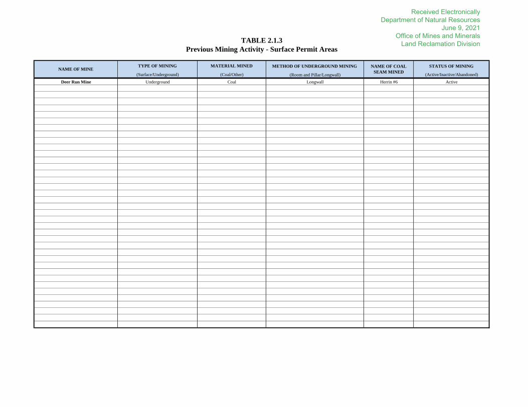
METHOD OF UNDERGROUND MINING STATUS OF MINING
(Room and Pillar/Longwall) (Active/Inactive/Abandoned)
Longwall Herrin #6 Active
TABLE 2.1.3
Previous Mining Activity - Surface Permit Areas
NAME OF MINETYPE OF MINING MATERIAL MINED NAME OF COAL
SEAM MINED(Surface/Underground) (Coal/Other)
Deer Run Mine Underground Coal
Received Electronically Department of Natural Resources
June 9, 2021 Office of Mines and Minerals
Land Reclamation Division

Soil Map Soil Slope Capability Productivity Prime Neg Det High Limited Prime Neg Det High Limited TOTALS
Symbol Name [%] Class Index Farmland PFL Capability Capability Farmland PFL Capability Capability
(optimum)* [acres] [acres] [acres] [acres] [acres] [acres] [acres] [acres] [acres]
Kasten, Arlen & Patricia Joint Revoc Living Trust 894A Herrick-Biddle-Piasa 0 to 2 2w 122 2.74 2.74
0.00
0.00
0.00
0.00
0.00
0.00
0.00
0.00
0.00
0.00
0.00
0.00
0.00
0.00
0.00
0.00
0.00
0.00
0.00
0.00
0.00
0.00
0.00
0.00
0.00
0.00 0.00 2.74 0.00 0.00 0.00 0.00 0.00 2.74
* Bulletin 811 (adjusted for slope and erosion)
Information required under 1785.17, 1823,1779.21 and/or 1783.21
NOTE: All acreage numbers must be reported to the hundredth of an acre (x.xx)
Revised 1/9/2019
SURFACE OWNER
Table 2.2.9
Soils Information Chart
TOTALS:
Prime Soils NonPrime Soils Prime Soils NonPrime Soils
MINING OR DISTURBANCE AREA UNAFFECTED (OPTIONAL)SOIL IDENTIFICATION
Received Electronically Department of Natural Resources
June 9, 2021 Office of Mines and Minerals
Land Reclamation Division

Map ID Reason for Mining (dwelling owner
waiver/ cemetery relocation)Buffer Distance
State Route 185 Emergency utility drillholes Approx. 50-feet
Areas/Features Prohibiting or Limiting Mining Operations [62 Ill Adm. Code 1761.11]
Lands within boundaries of the National Park System, National Wildlife Refuge System, the National System of Trails, the National Wilderness Preservation System, the
Wild and Scenic Rivers System, and National Recreation Areas, etc
Lands within the boundaries of any national forest.
Areas on or within 1,000 feet of Publicly Owned Parks or any places included in the National Register of Historic Places.
Areas within 100' horizontally of right of way line of Public Road.
Areas within 300 feet measured horizontally from an Occupied Dwelling
Areas within 300 feet measured horizontally from Public Building (e.g School, church, community/institutional building e.t.c)
Areas within 100 feet horizontally of a Cemetery.
TABLE 2.3
Areas Prohibiting or Limiting Mining OperationsRefer to the index below for a list of areas/features to be identified
Owner/Structure ID/ Area/Feature Address/Location Type of Structures
IL State Route 185 Road Adjacent to proposed area Public Road
Received Electronically Department of Natural Resources
June 9, 2021 Office of Mines and Minerals
Land Reclamation Division

United StatesDepartment ofAgriculture
A product of the NationalCooperative Soil Survey,a joint effort of the UnitedStates Department ofAgriculture and otherFederal agencies, Stateagencies including theAgricultural ExperimentStations, and localparticipants
Custom Soil Resource Report for
Montgomery County, IllinoisIBR Boundary ONLY
NaturalResourcesConservationService
June 3, 2021
Received Electronically Department of Natural Resources
June 9, 2021 Office of Mines and Minerals
Land Reclamation Division

PrefaceSoil surveys contain information that affects land use planning in survey areas. They highlight soil limitations that affect various land uses and provide information about the properties of the soils in the survey areas. Soil surveys are designed for many different users, including farmers, ranchers, foresters, agronomists, urban planners, community officials, engineers, developers, builders, and home buyers. Also, conservationists, teachers, students, and specialists in recreation, waste disposal, and pollution control can use the surveys to help them understand, protect, or enhance the environment.
Various land use regulations of Federal, State, and local governments may impose special restrictions on land use or land treatment. Soil surveys identify soil properties that are used in making various land use or land treatment decisions. The information is intended to help the land users identify and reduce the effects of soil limitations on various land uses. The landowner or user is responsible for identifying and complying with existing laws and regulations.
Although soil survey information can be used for general farm, local, and wider area planning, onsite investigation is needed to supplement this information in some cases. Examples include soil quality assessments (http://www.nrcs.usda.gov/wps/portal/nrcs/main/soils/health/) and certain conservation and engineering applications. For more detailed information, contact your local USDA Service Center (https://offices.sc.egov.usda.gov/locator/app?agency=nrcs) or your NRCS State Soil Scientist (http://www.nrcs.usda.gov/wps/portal/nrcs/detail/soils/contactus/?cid=nrcs142p2_053951).
Great differences in soil properties can occur within short distances. Some soils are seasonally wet or subject to flooding. Some are too unstable to be used as a foundation for buildings or roads. Clayey or wet soils are poorly suited to use as septic tank absorption fields. A high water table makes a soil poorly suited to basements or underground installations.
The National Cooperative Soil Survey is a joint effort of the United States Department of Agriculture and other Federal agencies, State agencies including the Agricultural Experiment Stations, and local agencies. The Natural Resources Conservation Service (NRCS) has leadership for the Federal part of the National Cooperative Soil Survey.
Information about soils is updated periodically. Updated information is available through the NRCS Web Soil Survey, the site for official soil survey information.
The U.S. Department of Agriculture (USDA) prohibits discrimination in all its programs and activities on the basis of race, color, national origin, age, disability, and where applicable, sex, marital status, familial status, parental status, religion, sexual orientation, genetic information, political beliefs, reprisal, or because all or a part of an individual's income is derived from any public assistance program. (Not all prohibited bases apply to all programs.) Persons with disabilities who require
2
Received Electronically Department of Natural Resources
June 9, 2021 Office of Mines and Minerals
Land Reclamation Division

alternative means for communication of program information (Braille, large print, audiotape, etc.) should contact USDA's TARGET Center at (202) 720-2600 (voice and TDD). To file a complaint of discrimination, write to USDA, Director, Office of Civil Rights, 1400 Independence Avenue, S.W., Washington, D.C. 20250-9410 or call (800) 795-3272 (voice) or (202) 720-6382 (TDD). USDA is an equal opportunity provider and employer.
3
Received Electronically Department of Natural Resources
June 9, 2021 Office of Mines and Minerals
Land Reclamation Division

ContentsPreface.................................................................................................................... 2How Soil Surveys Are Made..................................................................................5Soil Map.................................................................................................................. 8
Soil Map................................................................................................................9Legend................................................................................................................10Map Unit Legend................................................................................................ 11Map Unit Descriptions.........................................................................................11
Montgomery County, Illinois............................................................................13894A—Herrick-Biddle-Piasa silt loams, 0 to 2 percent slopes.................... 13
Soil Information for All Uses...............................................................................16Suitabilities and Limitations for Use....................................................................16
Land Classifications........................................................................................ 16Farmland Classification............................................................................... 16
4
Received Electronically Department of Natural Resources
June 9, 2021 Office of Mines and Minerals
Land Reclamation Division

How Soil Surveys Are MadeSoil surveys are made to provide information about the soils and miscellaneous areas in a specific area. They include a description of the soils and miscellaneous areas and their location on the landscape and tables that show soil properties and limitations affecting various uses. Soil scientists observed the steepness, length, and shape of the slopes; the general pattern of drainage; the kinds of crops and native plants; and the kinds of bedrock. They observed and described many soil profiles. A soil profile is the sequence of natural layers, or horizons, in a soil. The profile extends from the surface down into the unconsolidated material in which the soil formed or from the surface down to bedrock. The unconsolidated material is devoid of roots and other living organisms and has not been changed by other biological activity.
Currently, soils are mapped according to the boundaries of major land resource areas (MLRAs). MLRAs are geographically associated land resource units that share common characteristics related to physiography, geology, climate, water resources, soils, biological resources, and land uses (USDA, 2006). Soil survey areas typically consist of parts of one or more MLRA.
The soils and miscellaneous areas in a survey area occur in an orderly pattern that is related to the geology, landforms, relief, climate, and natural vegetation of the area. Each kind of soil and miscellaneous area is associated with a particular kind of landform or with a segment of the landform. By observing the soils and miscellaneous areas in the survey area and relating their position to specific segments of the landform, a soil scientist develops a concept, or model, of how they were formed. Thus, during mapping, this model enables the soil scientist to predict with a considerable degree of accuracy the kind of soil or miscellaneous area at a specific location on the landscape.
Commonly, individual soils on the landscape merge into one another as their characteristics gradually change. To construct an accurate soil map, however, soil scientists must determine the boundaries between the soils. They can observe only a limited number of soil profiles. Nevertheless, these observations, supplemented by an understanding of the soil-vegetation-landscape relationship, are sufficient to verify predictions of the kinds of soil in an area and to determine the boundaries.
Soil scientists recorded the characteristics of the soil profiles that they studied. They noted soil color, texture, size and shape of soil aggregates, kind and amount of rock fragments, distribution of plant roots, reaction, and other features that enable them to identify soils. After describing the soils in the survey area and determining their properties, the soil scientists assigned the soils to taxonomic classes (units). Taxonomic classes are concepts. Each taxonomic class has a set of soil characteristics with precisely defined limits. The classes are used as a basis for comparison to classify soils systematically. Soil taxonomy, the system of taxonomic classification used in the United States, is based mainly on the kind and character of soil properties and the arrangement of horizons within the profile. After the soil
5
Received Electronically Department of Natural Resources
June 9, 2021 Office of Mines and Minerals
Land Reclamation Division

scientists classified and named the soils in the survey area, they compared the individual soils with similar soils in the same taxonomic class in other areas so that they could confirm data and assemble additional data based on experience and research.
The objective of soil mapping is not to delineate pure map unit components; the objective is to separate the landscape into landforms or landform segments that have similar use and management requirements. Each map unit is defined by a unique combination of soil components and/or miscellaneous areas in predictable proportions. Some components may be highly contrasting to the other components of the map unit. The presence of minor components in a map unit in no way diminishes the usefulness or accuracy of the data. The delineation of such landforms and landform segments on the map provides sufficient information for the development of resource plans. If intensive use of small areas is planned, onsite investigation is needed to define and locate the soils and miscellaneous areas.
Soil scientists make many field observations in the process of producing a soil map. The frequency of observation is dependent upon several factors, including scale of mapping, intensity of mapping, design of map units, complexity of the landscape, and experience of the soil scientist. Observations are made to test and refine the soil-landscape model and predictions and to verify the classification of the soils at specific locations. Once the soil-landscape model is refined, a significantly smaller number of measurements of individual soil properties are made and recorded. These measurements may include field measurements, such as those for color, depth to bedrock, and texture, and laboratory measurements, such as those for content of sand, silt, clay, salt, and other components. Properties of each soil typically vary from one point to another across the landscape.
Observations for map unit components are aggregated to develop ranges of characteristics for the components. The aggregated values are presented. Direct measurements do not exist for every property presented for every map unit component. Values for some properties are estimated from combinations of other properties.
While a soil survey is in progress, samples of some of the soils in the area generally are collected for laboratory analyses and for engineering tests. Soil scientists interpret the data from these analyses and tests as well as the field-observed characteristics and the soil properties to determine the expected behavior of the soils under different uses. Interpretations for all of the soils are field tested through observation of the soils in different uses and under different levels of management. Some interpretations are modified to fit local conditions, and some new interpretations are developed to meet local needs. Data are assembled from other sources, such as research information, production records, and field experience of specialists. For example, data on crop yields under defined levels of management are assembled from farm records and from field or plot experiments on the same kinds of soil.
Predictions about soil behavior are based not only on soil properties but also on such variables as climate and biological activity. Soil conditions are predictable over long periods of time, but they are not predictable from year to year. For example, soil scientists can predict with a fairly high degree of accuracy that a given soil will have a high water table within certain depths in most years, but they cannot predict that a high water table will always be at a specific level in the soil on a specific date.
After soil scientists located and identified the significant natural bodies of soil in the survey area, they drew the boundaries of these bodies on aerial photographs and
Custom Soil Resource Report
6
Received Electronically Department of Natural Resources
June 9, 2021 Office of Mines and Minerals
Land Reclamation Division

identified each as a specific map unit. Aerial photographs show trees, buildings, fields, roads, and rivers, all of which help in locating boundaries accurately.
Custom Soil Resource Report
7
Received Electronically Department of Natural Resources
June 9, 2021 Office of Mines and Minerals
Land Reclamation Division

Soil MapThe soil map section includes the soil map for the defined area of interest, a list of soil map units on the map and extent of each map unit, and cartographic symbols displayed on the map. Also presented are various metadata about data used to produce the map, and a description of each soil map unit.
8
Received Electronically Department of Natural Resources
June 9, 2021 Office of Mines and Minerals
Land Reclamation Division

9
Custom Soil Resource ReportSoil Map
4332
800
4332
820
4332
840
4332
860
4332
880
4332
900
4332
920
4332
940
4332
960
4332
980
4332
800
4332
820
4332
840
4332
860
4332
880
4332
900
4332
920
4332
940
4332
960
4332
980
288150 288170 288190 288210 288230 288250 288270 288290
288150 288170 288190 288210 288230 288250 288270
39° 7' 13'' N89
° 2
7' 2
'' W39° 7' 13'' N
89° 2
6' 5
5'' W
39° 7' 6'' N
89° 2
7' 2
'' W
39° 7' 6'' N
89° 2
6' 5
5'' W
N
Map projection: Web Mercator Corner coordinates: WGS84 Edge tics: UTM Zone 16N WGS840 45 90 180 270
Feet0 10 20 40 60
MetersMap Scale: 1:936 if printed on A portrait (8.5" x 11") sheet.
Soil Map may not be valid at this scale.
Received Electronically Department of Natural Resources
June 9, 2021 Office of Mines and Minerals
Land Reclamation Division

MAP LEGEND MAP INFORMATION
Area of Interest (AOI)Area of Interest (AOI)
SoilsSoil Map Unit Polygons
Soil Map Unit Lines
Soil Map Unit Points
Special Point FeaturesBlowout
Borrow Pit
Clay Spot
Closed Depression
Gravel Pit
Gravelly Spot
Landfill
Lava Flow
Marsh or swamp
Mine or Quarry
Miscellaneous Water
Perennial Water
Rock Outcrop
Saline Spot
Sandy Spot
Severely Eroded Spot
Sinkhole
Slide or Slip
Sodic Spot
Spoil Area
Stony Spot
Very Stony Spot
Wet Spot
Other
Special Line Features
Water FeaturesStreams and Canals
TransportationRails
Interstate Highways
US Routes
Major Roads
Local Roads
BackgroundAerial Photography
The soil surveys that comprise your AOI were mapped at 1:12,000.
Warning: Soil Map may not be valid at this scale.
Enlargement of maps beyond the scale of mapping can cause misunderstanding of the detail of mapping and accuracy of soil line placement. The maps do not show the small areas of contrasting soils that could have been shown at a more detailed scale.
Please rely on the bar scale on each map sheet for map measurements.
Source of Map: Natural Resources Conservation ServiceWeb Soil Survey URL: Coordinate System: Web Mercator (EPSG:3857)
Maps from the Web Soil Survey are based on the Web Mercator projection, which preserves direction and shape but distorts distance and area. A projection that preserves area, such as the Albers equal-area conic projection, should be used if more accurate calculations of distance or area are required.
This product is generated from the USDA-NRCS certified data as of the version date(s) listed below.
Soil Survey Area: Montgomery County, IllinoisSurvey Area Data: Version 17, May 29, 2020
Soil map units are labeled (as space allows) for map scales 1:50,000 or larger.
Date(s) aerial images were photographed: Sep 6, 2013—Sep 20, 2016
The orthophoto or other base map on which the soil lines were compiled and digitized probably differs from the background imagery displayed on these maps. As a result, some minor shifting of map unit boundaries may be evident.
Custom Soil Resource Report
10
Received Electronically Department of Natural Resources
June 9, 2021 Office of Mines and Minerals
Land Reclamation Division

Map Unit Legend
Map Unit Symbol Map Unit Name Acres in AOI Percent of AOI
894A Herrick-Biddle-Piasa silt loams, 0 to 2 percent slopes
2.7 100.0%
Totals for Area of Interest 2.7 100.0%
Map Unit DescriptionsThe map units delineated on the detailed soil maps in a soil survey represent the soils or miscellaneous areas in the survey area. The map unit descriptions, along with the maps, can be used to determine the composition and properties of a unit.
A map unit delineation on a soil map represents an area dominated by one or more major kinds of soil or miscellaneous areas. A map unit is identified and named according to the taxonomic classification of the dominant soils. Within a taxonomic class there are precisely defined limits for the properties of the soils. On the landscape, however, the soils are natural phenomena, and they have the characteristic variability of all natural phenomena. Thus, the range of some observed properties may extend beyond the limits defined for a taxonomic class. Areas of soils of a single taxonomic class rarely, if ever, can be mapped without including areas of other taxonomic classes. Consequently, every map unit is made up of the soils or miscellaneous areas for which it is named and some minor components that belong to taxonomic classes other than those of the major soils.
Most minor soils have properties similar to those of the dominant soil or soils in the map unit, and thus they do not affect use and management. These are called noncontrasting, or similar, components. They may or may not be mentioned in a particular map unit description. Other minor components, however, have properties and behavioral characteristics divergent enough to affect use or to require different management. These are called contrasting, or dissimilar, components. They generally are in small areas and could not be mapped separately because of the scale used. Some small areas of strongly contrasting soils or miscellaneous areas are identified by a special symbol on the maps. If included in the database for a given area, the contrasting minor components are identified in the map unit descriptions along with some characteristics of each. A few areas of minor components may not have been observed, and consequently they are not mentioned in the descriptions, especially where the pattern was so complex that it was impractical to make enough observations to identify all the soils and miscellaneous areas on the landscape.
The presence of minor components in a map unit in no way diminishes the usefulness or accuracy of the data. The objective of mapping is not to delineate pure taxonomic classes but rather to separate the landscape into landforms or landform segments that have similar use and management requirements. The delineation of such segments on the map provides sufficient information for the development of resource plans. If intensive use of small areas is planned, however, onsite investigation is needed to define and locate the soils and miscellaneous areas.
Custom Soil Resource Report
11
Received Electronically Department of Natural Resources
June 9, 2021 Office of Mines and Minerals
Land Reclamation Division

An identifying symbol precedes the map unit name in the map unit descriptions. Each description includes general facts about the unit and gives important soil properties and qualities.
Soils that have profiles that are almost alike make up a soil series. Except for differences in texture of the surface layer, all the soils of a series have major horizons that are similar in composition, thickness, and arrangement.
Soils of one series can differ in texture of the surface layer, slope, stoniness, salinity, degree of erosion, and other characteristics that affect their use. On the basis of such differences, a soil series is divided into soil phases. Most of the areas shown on the detailed soil maps are phases of soil series. The name of a soil phase commonly indicates a feature that affects use or management. For example, Alpha silt loam, 0 to 2 percent slopes, is a phase of the Alpha series.
Some map units are made up of two or more major soils or miscellaneous areas. These map units are complexes, associations, or undifferentiated groups.
A complex consists of two or more soils or miscellaneous areas in such an intricate pattern or in such small areas that they cannot be shown separately on the maps. The pattern and proportion of the soils or miscellaneous areas are somewhat similar in all areas. Alpha-Beta complex, 0 to 6 percent slopes, is an example.
An association is made up of two or more geographically associated soils or miscellaneous areas that are shown as one unit on the maps. Because of present or anticipated uses of the map units in the survey area, it was not considered practical or necessary to map the soils or miscellaneous areas separately. The pattern and relative proportion of the soils or miscellaneous areas are somewhat similar. Alpha-Beta association, 0 to 2 percent slopes, is an example.
An undifferentiated group is made up of two or more soils or miscellaneous areas that could be mapped individually but are mapped as one unit because similar interpretations can be made for use and management. The pattern and proportion of the soils or miscellaneous areas in a mapped area are not uniform. An area can be made up of only one of the major soils or miscellaneous areas, or it can be made up of all of them. Alpha and Beta soils, 0 to 2 percent slopes, is an example.
Some surveys include miscellaneous areas. Such areas have little or no soil material and support little or no vegetation. Rock outcrop is an example.
Custom Soil Resource Report
12
Received Electronically Department of Natural Resources
June 9, 2021 Office of Mines and Minerals
Land Reclamation Division

Montgomery County, Illinois
894A—Herrick-Biddle-Piasa silt loams, 0 to 2 percent slopes
Map Unit SettingNational map unit symbol: 2tbs1Elevation: 330 to 820 feetMean annual precipitation: 38 to 46 inchesMean annual air temperature: 54 to 58 degrees FFrost-free period: 180 to 195 daysFarmland classification: Farmland of statewide importance
Map Unit CompositionHerrick and similar soils: 45 percentBiddle and similar soils: 30 percentPiasa and similar soils: 25 percentEstimates are based on observations, descriptions, and transects of the mapunit.
Description of Herrick
SettingLandform: Ground morainesLandform position (two-dimensional): SummitLandform position (three-dimensional): Interfluve, talfDown-slope shape: LinearAcross-slope shape: LinearParent material: Loess over silty pedisediment
Typical profileAp - 0 to 13 inches: silt loamBtg - 13 to 39 inches: silty clay loamBt - 39 to 60 inches: silty clay loam2C - 60 to 79 inches: silt loam
Properties and qualitiesSlope: 0 to 2 percentDepth to restrictive feature: More than 80 inchesDrainage class: Somewhat poorly drainedCapacity of the most limiting layer to transmit water (Ksat): Moderately high (0.20
to 0.60 in/hr)Depth to water table: About 12 to 24 inchesFrequency of flooding: NoneFrequency of ponding: NoneCalcium carbonate, maximum content: 10 percentMaximum salinity: Nonsaline to very slightly saline (0.0 to 2.0 mmhos/cm)Sodium adsorption ratio, maximum: 10.0Available water capacity: High (about 10.6 inches)
Interpretive groupsLand capability classification (irrigated): None specifiedLand capability classification (nonirrigated): 2wHydrologic Soil Group: C/DHydric soil rating: No
Custom Soil Resource Report
13
Received Electronically Department of Natural Resources
June 9, 2021 Office of Mines and Minerals
Land Reclamation Division

Description of Biddle
SettingLandform: Ground morainesLandform position (two-dimensional): SummitLandform position (three-dimensional): InterfluveDown-slope shape: LinearAcross-slope shape: LinearParent material: Loess over drift
Typical profileAp - 0 to 14 inches: silt loamBt - 14 to 28 inches: silty clay loamBtng - 28 to 73 inches: silty clay loam2Cg - 73 to 79 inches: silt loam
Properties and qualitiesSlope: 0 to 2 percentDepth to restrictive feature: More than 80 inchesDrainage class: Somewhat poorly drainedCapacity of the most limiting layer to transmit water (Ksat): Moderately low to
moderately high (0.06 to 0.20 in/hr)Depth to water table: About 12 to 24 inchesFrequency of flooding: NoneFrequency of ponding: NoneCalcium carbonate, maximum content: 10 percentMaximum salinity: Nonsaline to slightly saline (0.0 to 4.0 mmhos/cm)Sodium adsorption ratio, maximum: 10.0Available water capacity: High (about 9.6 inches)
Interpretive groupsLand capability classification (irrigated): None specifiedLand capability classification (nonirrigated): 2wHydrologic Soil Group: C/DHydric soil rating: No
Description of Piasa
SettingLandform: Ground moraines, depressionsLandform position (two-dimensional): Summit, toeslopeLandform position (three-dimensional): Interfluve, talf, dipDown-slope shape: LinearAcross-slope shape: LinearParent material: Loess over silty pedisediment
Typical profileAp - 0 to 8 inches: silt loamEng - 8 to 12 inches: silt loamBtng - 12 to 48 inches: silty clay loam2BCng - 48 to 79 inches: silt loam
Properties and qualitiesSlope: 0 to 2 percentDepth to restrictive feature: 11 to 14 inches to natricDrainage class: Poorly drained
Custom Soil Resource Report
14
Received Electronically Department of Natural Resources
June 9, 2021 Office of Mines and Minerals
Land Reclamation Division

Capacity of the most limiting layer to transmit water (Ksat): Low to moderately low (0.01 to 0.06 in/hr)
Depth to water table: About 0 to 12 inchesFrequency of flooding: NoneFrequency of ponding: FrequentCalcium carbonate, maximum content: 30 percentMaximum salinity: Very slightly saline to slightly saline (2.0 to 4.0 mmhos/cm)Sodium adsorption ratio, maximum: 20.0Available water capacity: Very low (about 2.6 inches)
Interpretive groupsLand capability classification (irrigated): None specifiedLand capability classification (nonirrigated): 3wHydrologic Soil Group: DHydric soil rating: Yes
Custom Soil Resource Report
15
Received Electronically Department of Natural Resources
June 9, 2021 Office of Mines and Minerals
Land Reclamation Division

Soil Information for All Uses
Suitabilities and Limitations for UseThe Suitabilities and Limitations for Use section includes various soil interpretations displayed as thematic maps with a summary table for the soil map units in the selected area of interest. A single value or rating for each map unit is generated by aggregating the interpretive ratings of individual map unit components. This aggregation process is defined for each interpretation.
Land Classifications
Land Classifications are specified land use and management groupings that are assigned to soil areas because combinations of soil have similar behavior for specified practices. Most are based on soil properties and other factors that directly influence the specific use of the soil. Example classifications include ecological site classification, farmland classification, irrigated and nonirrigated land capability classification, and hydric rating.
Farmland Classification
Farmland classification identifies map units as prime farmland, farmland of statewide importance, farmland of local importance, or unique farmland. It identifies the location and extent of the soils that are best suited to food, feed, fiber, forage, and oilseed crops. NRCS policy and procedures on prime and unique farmlands are published in the "Federal Register," Vol. 43, No. 21, January 31, 1978.
16
Received Electronically Department of Natural Resources
June 9, 2021 Office of Mines and Minerals
Land Reclamation Division

17
Custom Soil Resource ReportMap—Farmland Classification
4332
800
4332
820
4332
840
4332
860
4332
880
4332
900
4332
920
4332
940
4332
960
4332
980
4332
800
4332
820
4332
840
4332
860
4332
880
4332
900
4332
920
4332
940
4332
960
4332
980
288150 288170 288190 288210 288230 288250 288270 288290
288150 288170 288190 288210 288230 288250 288270
39° 7' 13'' N89
° 2
7' 2
'' W39° 7' 13'' N
89° 2
6' 5
5'' W
39° 7' 6'' N
89° 2
7' 2
'' W
39° 7' 6'' N
89° 2
6' 5
5'' W
N
Map projection: Web Mercator Corner coordinates: WGS84 Edge tics: UTM Zone 16N WGS840 45 90 180 270
Feet0 10 20 40 60
MetersMap Scale: 1:936 if printed on A portrait (8.5" x 11") sheet.
Soil Map may not be valid at this scale.
Received Electronically Department of Natural Resources
June 9, 2021 Office of Mines and Minerals
Land Reclamation Division
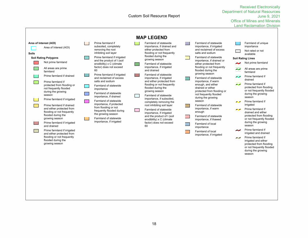
MAP LEGENDArea of Interest (AOI)
Area of Interest (AOI)
SoilsSoil Rating Polygons
Not prime farmland
All areas are prime farmlandPrime farmland if drained
Prime farmland if protected from flooding or not frequently flooded during the growing seasonPrime farmland if irrigated
Prime farmland if drained and either protected from flooding or not frequently flooded during the growing seasonPrime farmland if irrigated and drainedPrime farmland if irrigated and either protected from flooding or not frequently flooded during the growing season
Prime farmland if subsoiled, completely removing the root inhibiting soil layerPrime farmland if irrigated and the product of I (soil erodibility) x C (climate factor) does not exceed 60Prime farmland if irrigated and reclaimed of excess salts and sodiumFarmland of statewide importanceFarmland of statewide importance, if drainedFarmland of statewide importance, if protected from flooding or not frequently flooded during the growing seasonFarmland of statewide importance, if irrigated
Farmland of statewide importance, if drained and either protected from flooding or not frequently flooded during the growing seasonFarmland of statewide importance, if irrigated and drainedFarmland of statewide importance, if irrigated and either protected from flooding or not frequently flooded during the growing seasonFarmland of statewide importance, if subsoiled, completely removing the root inhibiting soil layerFarmland of statewide importance, if irrigated and the product of I (soil erodibility) x C (climate factor) does not exceed 60
Farmland of statewide importance, if irrigated and reclaimed of excess salts and sodiumFarmland of statewide importance, if drained or either protected from flooding or not frequently flooded during the growing seasonFarmland of statewide importance, if warm enough, and either drained or either protected from flooding or not frequently flooded during the growing seasonFarmland of statewide importance, if warm enoughFarmland of statewide importance, if thawedFarmland of local importanceFarmland of local importance, if irrigated
Farmland of unique importanceNot rated or not available
Soil Rating LinesNot prime farmland
All areas are prime farmlandPrime farmland if drainedPrime farmland if protected from flooding or not frequently flooded during the growing seasonPrime farmland if irrigatedPrime farmland if drained and either protected from flooding or not frequently flooded during the growing seasonPrime farmland if irrigated and drainedPrime farmland if irrigated and either protected from flooding or not frequently flooded during the growing season
Custom Soil Resource Report
18
Received Electronically Department of Natural Resources
June 9, 2021 Office of Mines and Minerals
Land Reclamation Division

Prime farmland if subsoiled, completely removing the root inhibiting soil layerPrime farmland if irrigated and the product of I (soil erodibility) x C (climate factor) does not exceed 60Prime farmland if irrigated and reclaimed of excess salts and sodiumFarmland of statewide importanceFarmland of statewide importance, if drainedFarmland of statewide importance, if protected from flooding or not frequently flooded during the growing seasonFarmland of statewide importance, if irrigated
Farmland of statewide importance, if drained and either protected from flooding or not frequently flooded during the growing seasonFarmland of statewide importance, if irrigated and drainedFarmland of statewide importance, if irrigated and either protected from flooding or not frequently flooded during the growing seasonFarmland of statewide importance, if subsoiled, completely removing the root inhibiting soil layerFarmland of statewide importance, if irrigated and the product of I (soil erodibility) x C (climate factor) does not exceed 60
Farmland of statewide importance, if irrigated and reclaimed of excess salts and sodiumFarmland of statewide importance, if drained or either protected from flooding or not frequently flooded during the growing seasonFarmland of statewide importance, if warm enough, and either drained or either protected from flooding or not frequently flooded during the growing seasonFarmland of statewide importance, if warm enoughFarmland of statewide importance, if thawedFarmland of local importanceFarmland of local importance, if irrigated
Farmland of unique importanceNot rated or not available
Soil Rating PointsNot prime farmland
All areas are prime farmlandPrime farmland if drained
Prime farmland if protected from flooding or not frequently flooded during the growing seasonPrime farmland if irrigated
Prime farmland if drained and either protected from flooding or not frequently flooded during the growing seasonPrime farmland if irrigated and drainedPrime farmland if irrigated and either protected from flooding or not frequently flooded during the growing season
Prime farmland if subsoiled, completely removing the root inhibiting soil layerPrime farmland if irrigated and the product of I (soil erodibility) x C (climate factor) does not exceed 60Prime farmland if irrigated and reclaimed of excess salts and sodiumFarmland of statewide importanceFarmland of statewide importance, if drainedFarmland of statewide importance, if protected from flooding or not frequently flooded during the growing seasonFarmland of statewide importance, if irrigated
Custom Soil Resource Report
19
Received Electronically Department of Natural Resources
June 9, 2021 Office of Mines and Minerals
Land Reclamation Division

Farmland of statewide importance, if drained and either protected from flooding or not frequently flooded during the growing seasonFarmland of statewide importance, if irrigated and drainedFarmland of statewide importance, if irrigated and either protected from flooding or not frequently flooded during the growing seasonFarmland of statewide importance, if subsoiled, completely removing the root inhibiting soil layerFarmland of statewide importance, if irrigated and the product of I (soil erodibility) x C (climate factor) does not exceed 60
Farmland of statewide importance, if irrigated and reclaimed of excess salts and sodiumFarmland of statewide importance, if drained or either protected from flooding or not frequently flooded during the growing seasonFarmland of statewide importance, if warm enough, and either drained or either protected from flooding or not frequently flooded during the growing seasonFarmland of statewide importance, if warm enoughFarmland of statewide importance, if thawedFarmland of local importanceFarmland of local importance, if irrigated
Farmland of unique importanceNot rated or not available
Water FeaturesStreams and Canals
TransportationRails
Interstate Highways
US Routes
Major Roads
Local Roads
BackgroundAerial Photography
The soil surveys that comprise your AOI were mapped at 1:12,000.
Warning: Soil Map may not be valid at this scale.
Enlargement of maps beyond the scale of mapping can cause misunderstanding of the detail of mapping and accuracy of soil line placement. The maps do not show the small areas of contrasting soils that could have been shown at a more detailed scale.
Please rely on the bar scale on each map sheet for map measurements.
Source of Map: Natural Resources Conservation ServiceWeb Soil Survey URL: Coordinate System: Web Mercator (EPSG:3857)
Maps from the Web Soil Survey are based on the Web Mercator projection, which preserves direction and shape but distorts distance and area. A projection that preserves area, such as the Albers equal-area conic projection, should be used if more accurate calculations of distance or area are required.
This product is generated from the USDA-NRCS certified data as of the version date(s) listed below.
Soil Survey Area: Montgomery County, IllinoisSurvey Area Data: Version 17, May 29, 2020
Soil map units are labeled (as space allows) for map scales 1:50,000 or larger.
Date(s) aerial images were photographed: Sep 6, 2013—Sep 20, 2016
The orthophoto or other base map on which the soil lines were compiled and digitized probably differs from the background imagery displayed on these maps. As a result, some minor shifting of map unit boundaries may be evident.
Custom Soil Resource Report
20
Received Electronically Department of Natural Resources
June 9, 2021 Office of Mines and Minerals
Land Reclamation Division

Table—Farmland Classification
Map unit symbol Map unit name Rating Acres in AOI Percent of AOI
894A Herrick-Biddle-Piasa silt loams, 0 to 2 percent slopes
Farmland of statewide importance
2.7 100.0%
Totals for Area of Interest 2.7 100.0%
Rating Options—Farmland Classification
Aggregation Method: No Aggregation Necessary
Aggregation is the process by which a set of component attribute values is reduced to a single value that represents the map unit as a whole.
A map unit is typically composed of one or more "components". A component is either some type of soil or some nonsoil entity, e.g., rock outcrop. For the attribute being aggregated, the first step of the aggregation process is to derive one attribute value for each of a map unit's components. From this set of component attributes, the next step of the aggregation process derives a single value that represents the map unit as a whole. Once a single value for each map unit is derived, a thematic map for soil map units can be rendered. Aggregation must be done because, on any soil map, map units are delineated but components are not.
For each of a map unit's components, a corresponding percent composition is recorded. A percent composition of 60 indicates that the corresponding component typically makes up approximately 60% of the map unit. Percent composition is a critical factor in some, but not all, aggregation methods.
The majority of soil attributes are associated with a component of a map unit, and such an attribute has to be aggregated to the map unit level before a thematic map can be rendered. Map units, however, also have their own attributes. An attribute of a map unit does not have to be aggregated in order to render a corresponding thematic map. Therefore, the "aggregation method" for any attribute of a map unit is referred to as "No Aggregation Necessary".
Tie-break Rule: Lower
The tie-break rule indicates which value should be selected from a set of multiple candidate values, or which value should be selected in the event of a percent composition tie.
Custom Soil Resource Report
21
Received Electronically Department of Natural Resources
June 9, 2021 Office of Mines and Minerals
Land Reclamation Division

PART 3: Mining Operations Plan
3.1 General Description of Operations.
3.1.1 Describe the type of operation (surface, underground or carbon recovery) and method of mining procedures (surface, room and pillar or longwall). [1780.11(a)/1784.11(a)]
The purpose of this IBR is to add an additional 2.74 acres to Permit 399 to install five 6” utility boreholes, and 0.15 acres of graveled area. This IBR site will be used for sampling, injecting inert products, and/or concrete delivery to the underground mine. The five (5) boreholes will be 6-inch diameter, fully grouted, steel lined, and approximately 440-feet total depth each. The boreholes will be down drilled from the surface using conventional drilling techniques. Prior to initiating any construction activities, silt fencing will be installed along all down-sloping sides of the proposed IBR to control potential erosion from the disturbed area, and will be maintained during the completed construction process.
3.1.2 Describe the major equipment to be employed and how such equipment will be used in the different aspects of the mining operation. [1780.11(a)/1784.11(a)]
The major equipment for activities proposed in the added permit area will be typical construction equipment such as bulldozers, excavators, road graders, compactors, haul trucks, scrapers, etc. along with conventional drilling equipment.
3.1.3 Provide an estimation of the anticipated annual coal production and anticipated total coal production by tonnage once the mine is at full operational capacity. Define the annual progression of mining on the Operations Map. For underground mines, show annual progression of surface disturbance for support facilities. [1780.11(a)/1784.11(a)]
N/A
3.2 Description of Mine Facilities. Provide a narrative that explains the construction, modification, use maintenance and removal of the following structures and facilities as applicable to the proposed operations. If not applicable to this permitting action, indicate such. [1780.11(b)/1784.11(b)].
3.2.1 Dams, Embankments, and other impoundments. List all such structures, their use, maintenance practices and whether they will be retained permanently or removed as applicable. Please note that an impoundment includes incised structures. [1780.11(b)/1784.11(b)]
N/A
3.2.2 Coal storage, coal preparation and cleaning facilities, loading and transportation areas. [1780.11(b)/1784.11(b)]
N/A
3.2.3 Water treatment facilities including but not limited to, sediment ponds, chemical treatment of discharge, and any special water treatment facilities beyond sediment ponds. [1780.11(b)/1784.11(b)]
Received Electronically Department of Natural Resources
June 9, 2021 Office of Mines and Minerals
Land Reclamation Division

N/A, Sediment Pond Exemption Requested.
3.2.4 Air pollution control facilities [1780.11(b)/1784.11(b)]
3.2.5 Buried Pipelines. Are pipelines proposed to be buried within the permit boundary? [1816.133/1817.133]
YES NO
If YES, locate pipeline corridors on the operations map. Provide a description of the pipeline operation including but not limited to: the material to be transported, the type, diameter and wall thickness of the pipe and the depth of burial to the top of pipe. Indicate whether the pipe is to be removed when no longer needed. It is recommended that pipeline burials follow the Illinois Department of Agriculture guidelines if they are intended to be left in place permanently. IDOA guidelines for different types of pipelines may be found at: https://www2.illinois.gov/sites/agr/Resources/LandWater/Documents/pipelinestandardspolicies.pdf#search=pipeline https://www2.illinois.gov/sites/agr/Resources/LandWater/Documents/waterandsewerlines.pdf
N/A
3.3 Signs and Markers. All signs and markers required to be posted shall be easily seen and read, uniform in design and made of durable material. Signs and markers shall also be maintained and retained in place throughout the life of specific mining activity. Boundary or buffer markers shall be spaced to be visible from one to another. Describe the signs and markers in terms of material type, color, and wording to be used for the following boundary(s) and/or protected feature(s). If not applicable to this permitting action, indicate as such. [1816.11(a)/1817.11(a)].
3.3.1 Permit Perimeter markers (Include incremental bond areas, unaffected areas, uncontrolled properties, pending archeological areas, and areas of lateral support) [1816.11(d)/1817.11(d)]
The added perimeter markers will be established with posts located within eyesight of each other. Same as specified in Permit 399.
3.3.2 Stockpile Markers [1816.11(f)/1817.11(f)]
Topsoil stockpiles will be marked with an identifying sign (Topsoil, Subsoil if needed).
3.3.3 Stream buffer zones [1816.57(b)/1817.57(b)]
N/A
3.3.4 Prohibited or limited areas identified on Table 2.3: Areas Prohibiting or Limiting Mining Operations [1816/1817.11(d)]
N/A
3.4 Soil and Overburden Handling and Protection.
Received Electronically Department of Natural Resources
June 9, 2021 Office of Mines and Minerals
Land Reclamation Division

3.4.1 Describe how each type of overburden (soil horizons, glacial drift and consolidated material) will be handled with regards to different types of mining equipment. [1780.18(b)(7)/1784.13(b)(7)]
Excavator, backhoe, truck, and/or dozer will be used to handle subsoils/topsoil. Subsoils will be handled the minimum required in order to minimize compaction and loss of capability.
3.4.2 If toxic materials have been identified as occurring in the overburden, describe how these materials will be segregated and handled to insure proper disposal. This includes, shaft and slope cuttings, excavation of incised portions of ponds, ditches, stream diversions or refuse disposal areas. [1780.11(b)/1784.11(b); 1780.18(b)(7)/1784.13(b)(7)]
No toxic material has been identified within the subsoil being removed.
3.4.3 Locate all soil horizon storage areas and/or root medium stock piles on the Operations Map and describe measures to be employed to prevent or minimize exposure of soil stockpiles to excessive water and wind erosion, unnecessary compaction and contamination by undesirable materials. [1780.11(b)(2)/1784.11(b)(2); 1780.14(b)(5)/1784.23(b)(5)]
See Permit 399, topsoil stockpile locations have been located on the Surface Operations Map 3. These stockpiles are positioned separately from areas of undesirable materials. Should excessive water or wind erosion be identified, the stockpiles may be temporarily seeded and mulched or erosion barriers such as silt fencing may be installed around the soil stockpile.
3.4.4 Describe methods and treatment measures to be used on exposed areas where topsoil has been removed to prevent excess air and water pollution. [1816.95/1817.95]
See Permit 399 for details.
3.5 Lateral Support. For excavations locate all areas on the Operations Map where lateral support removal will approach the minimum distance allowed. State the minimum width of lateral support to be left in appropriate areas, including adjacent landowners, road right-of-way’s, pipelines and power line easements. Account for highwall sloping when such slopes are to be incorporated into the proposed reclamation plan. [1816.99]
N/A
3.6 Surface Mining Near Underground Mining. If surface mining activities are to be conducted within 500 feet of an underground mine describe the measures to be employed to comply with the requirements of 62 Ill. Adm. Code 1780.27 and 1816.79
N/A
3.7 Existing Structures. The definition of an “existing structure” is a structure used in connection with surface coal mining and reclamation operations for which construction began prior to June 1, 1982. Are existing structures proposed to be used in connection with or to facilitate the surface coal mining and reclamation operations? [1701.APP.A]
YES NO
If YES, complete the following:
3.7.1 Use of Existing Structures. Provide a list of all of the existing structures to be used [1780.12/1784.12]
Received Electronically Department of Natural Resources
June 9, 2021 Office of Mines and Minerals
Land Reclamation Division

3.7.2 Provide the location of all existing structures on the Operations Map and provide the following information for each existing structure to be used: [1780.12(a)/1784.12(a)]
- Plans of the structure detailing its current, pre-mining condition. - Approximate dates, beginning and completion for construction of the structure. - A showing that the structure meets the performance standards of 62 Ill. Adm. Code 1810 through
1828. The showing shall include monitoring data or other substantiating evidence.
3.7.3 Modification or Reconstruction of Existing Structures. Provide a plan for each existing structure to be modified or reconstructed for use in connection, or to facilitate coal mining and reclamation operations. The plan shall include the following information: [1780.12(b)/1784.12(b)]
- Design specifications for reconstruction or modification of the structure to meet the design and performance standards of 62 Ill. Adm. Code 1810 through 1828,
- A schedule for reconstruction or modification of the structure showing dates for beginning and completing interim steps as well as final reconstruction,
- Provisions for monitoring the structure during and after modification to ensure that the performance standards of 62 Ill. Adm. Code 1810 through 1828 are met, and
- A showing that the risk of harm to the environment or to public health or safety is not significant during the period of modification or reconstruction.
3.8 Transportation Facilities.
3.8.1 Which, if any of the following facilities, are to be constructed, used, modified or maintained within the proposed permit area?
Roads Conveyors Rail Systems
3.8.2 For all roads proposed, indicate the classification of each as either Primary or Ancillary in accordance with 62 Ill. Adm. Code 1816.150/1817.150 below: [1816.150(a)/1817.150(a)]
Road Identification Road Classification (Primary or Ancillary)
3.8.3 For each transportation facility, provide a detailed description of their design, construction and maintenance that includes the following information: [1780.37/1784.24]
Received Electronically Department of Natural Resources
June 9, 2021 Office of Mines and Minerals
Land Reclamation Division

3.8.3.1 A general description of each road, conveyor, or rail system to be constructed, used, or maintained within the proposed permit area. [1780.37(a)(6)/1784.24(a)(6)]
N/A. 3.8.3.2 Specifications for each road width, existing grade line, proposed road gradient, road surface, road cut, fill embankment, culvert, bridge, drainage ditch, and drainage structure. Provide information as Attachment 3.8.3.2. [1780.37(a)(1)/1784.24(a)(1)]
N/A 3.8.3.3 Provide a report of appropriate geotechnical analysis, where the Department’s approval is required for alternative specifications, or for steep cut slopes. This report shall be included as Attachment 3.8.3.3. [1780.37(a)(2)/1784.24(a)(2); 1816.150/1817.150]
N/A
3.8.3.4 A description of measures to be taken to obtain the Department’s approval for alteration or relocation of a natural drainageway. [1780.37(a)(3)/1784.24(a)(3); 1816.150/1817.150]
N/A 3.8.3.5 A description of measures, other than use of a rock headwall, to be taken to protect the inlet end of a ditch relief culvert. [1780.37(a)(4)/1784.24(a)(4); 1816/1817.150]
N/A
3.8.3.6 The drawings and specifications for each proposed ford of a perennial or intermittent stream that is used as a temporary route. [1780.37(a)(5)/1784.24(a)(5); 1816.151(c)(2)/1817.151(c)(2)]
N/A 3.8.3.7 A description of the plans to remove and reclaim each road that will not be retained under an approved post-mining land use, and the schedule for this removal and reclamation. [1780.37(a)(7)/1784.24(a)(7)]
N/A 3.8.3.8 A discussion of the removal/construction/or relocation of powerlines related to transportation facilities and structures associated with roads. [1780.11(b)(3)/1784.11(b)(3)]
N/A
3.8.4 Primary Roads. If any roads identified in Part 3.8.2 are classified as primary, provide the design criteria and construction procedures used for each primary road proposed. Design calculations and/or drawings shall be included as attachments to this part. [1816.151/1817.151]
N/A
3.8.5 Are any roads constructed to facilitate surface coal mining operations proposed to be permanent? [1816.150(b)/1817.150(b)]
YES NO
Received Electronically Department of Natural Resources
June 9, 2021 Office of Mines and Minerals
Land Reclamation Division

If YES, locate on the Post-Mining Land Use/Capability Reclamation Map and include appropriate discussion on how modifications will be accomplished, including the removal and disposition of any excess road material.
N/A
3.9 Non-Coal Mine Waste Material.
3.9.1 Identify all non-coal waste material to be disposed within the permit area, including but not limited to, grease, lubricants, paints, flammable liquids, garbage, tires, abandoned mining machinery, lumber and other hazardous and/or combustible materials generated during coal mining operations. [1780/1784.11(b)(4)]
N/A
3.9.2 Describe how each non-coal waste will be stored on site, disposed on site or removed from the site. Also, describe the measures to be employed to ensure that all debris, acid-forming and toxic-forming materials, and materials constituting a fire hazard are disposed in a safe manner. Indicate on the Operations Map the location of each non-coal waste storage area. [1780.14(b)(5)/1784/23(b)(5); 1816.89/1817.89].
N/A
3.10 Coal Preparation.
3.10.1 Will processing of coal take place within the proposed permit area? [1780.11(b)(3)/1784.11(b)(3)]
YES NO
If YES, locate processing facilities on the Operations Map and give a general description of the coal processing operation at this facility. [1780.14(b)(4)/1784.23(b)(4)].
If NO, and coal preparation plants are not located within the permit area, the applicant shall explain where coal processing would occur. The applicant is required to possess or obtain a separate permit for coal preparation plants that are not located within the proposed permit area. [1785.21; 1827]
3.10.2 Will in-situ processing activities be conducted? [1785.22]
YES NO
If YES, provide information to assure compliance with 62 Ill. Adm. Code 1785.22 and 1828. [1785.22; 1828]
3.10.3 Provide an annual estimation of the volume of both coarse and fine coal waste streams generated. [1780/1784.11(b)(4)]
Received Electronically Department of Natural Resources
June 9, 2021 Office of Mines and Minerals
Land Reclamation Division

3.10.4 Describe the processing water (fresh water/make-up water) and slurry line circuitry. Incorporate flow diagrams as necessary. Provide locations of all processing water transport lines and slurry transport lines on the Operations Map. [1780.11(b)/1784.11(b)]
3.10.5 What safeguards are provided to prevent the discharge of slurry fines and untreated slurry water during emergency situations (e.g. power outages, mechanical equipment breakdown, plant shutdowns, etc.)? Indicate where the slurry would go by gravity flow in the event of an emergency discharge, and the environmental impact this would have [1780.21(h)/1784.14(g)]
3.11 Coal Processing Waste and Underground Development Waste.
3.11.1 Will coal processing waste and/or underground development waste be disposed of within the proposed permit area?
YES NO
If NO, explain how coal processing waste and underground development waste will be handled and disposed?
If YES, complete Table 3.11.1: List of Coal Waste Materials to be Disposed within the Permit Area providing analytical data to describe the nature of all coal processing waste and underground development waste material that will be disposed within the proposed permit area.
Note: If this is a new facility and no processed refuse has been generated, provide an estimated analysis in the table and a discussion of the basis for the assumptions in the space below. Also, please note the Department will require submittal of actual analytical results of the refuse material within 60 days after the preparation facility is operational.
Table 3.11.1: List of Coal Waste Materials to be Disposed within the Permit Area
Type of material includes but is not limited to Coarse Coal Refuse Filter Cake, Fine Coal Refuse (Slurry), immediate floor and roof rock potentially removed and not sent to the preparation plant with coal.
Type of Material
Source Mine Permit and Preparation Plant
Potential Acidities
Net Neutralization Potential
Received Electronically Department of Natural Resources
June 9, 2021 Office of Mines and Minerals
Land Reclamation Division

3.11.2 Is Disposal of Coal Waste in Underground Workings proposed in this application?
YES NO
If YES, complete and include Part 14: Disposal of Coal Waste in Underground Workings
3.12 Coal Refuse Disposal Area. Is the construction or modification of a Coal Refuse Disposal Area proposed in this application?
YES NO
If YES, complete the following
3.12.1 Complete Table 3.12.1: List of Coal Refuse Disposal Areas to be Constructed or Modified for each Coal Refuse Disposal Area to be constructed or modified with this application.
Table 3.12.1 List of Coal Refuse Disposal Areas to be Constructed or Modified.
Name of Facility
*Type of Facility
(Coal Refuse Pile, Coal Slurry Waste Impoundment)
Latitude (DD)
Longitude (DD)
Approx. Start of Construction (month/yr)
Estimated Lifespan Coarse refuse Slurry
Surface Acreage footprint Total Coarse Coal Refuse Storage Volume (cubic yards)
Total Fine Coal Refuse Storage Volume (cubic yards)
*Dam Class (According to TR-60, if applicable)
*Hazard Classification (According to MSHA determination, if applicable)
Associated NPDES Permit
3.12.2 Design and Construction Details of Coal Refuse Disposal Areas. Coal mine waste shall be disposed of in compliance with requirements of 62 Ill. Adm. Code 1816.81/1817.81 through 1816.84/1817.84.
Received Electronically Department of Natural Resources
June 9, 2021 Office of Mines and Minerals
Land Reclamation Division

3.12.2.1 Provide location and describe refuse disposal capacity requirements, facility configuration/staging and scheduling in a detailed construction plan. The plan shall include: acreage of disposal and borrow areas associated with the coal waste disposal area, engineering calculations, cross sections, maps, drawings and design certification for each proposed structure. [1780.14(b)(8)/1784.23(b)(7); 1816/1817.81(c)]
3.12.2.2 Provide measures to be taken to: control surface drainage, provide surface area stabilization and minimize erosion of the coarse refuse disposal facility and of areas that receive runoff from the coarse refuse disposal facility. Include detail engineering design of all proposed surface drainage control structures. [1816/1816.81(a)(1); 1816/1817.83(a); 1816.84/1817.84(d)]
3.12.2.3 Provide measures that will be taken to ensure mass stability and prevent mass movement of the structure during and after construction. [1816/1817.49(a)(4); 1816.81(a)(2)/1817.81(a)(2)]
3.12.2.4 Provide all necessary on-site investigations results, test borings, and laboratory results of foundation material and coal waste that was used to determine the design requirements for the foundation stability of the coarse refuse disposal area and/or structure as Attachment 3.12.2.4. [1816/1817.49(a)(6); 1816/1817.81(d)]
3.12.2.5 For coal processing waste dams and embankments meeting the Mine Safety and Health Administration (MSHA) size criteria, each design and operations plan shall comply with the requirements of MSHA 30 CFR 77.216-1 and 77.216-2.
3.12.2.5.1 Is the applicant proposing to construct or modify a coal waste disposal structure that impounds water and/or slurry to an elevation of five (5) feet or more above the upstream toe of the structure and can have a storage volume of 20 acre-feet or more?
YES NO
3.12.2.5.2 Is the applicant proposing to construct or modify a coal waste disposal structure that impounds water and/or slurry to an elevation of twenty (20) feet or more above the upstream toe of the structure?
YES NO
If the answer to either above is YES, the applicant shall provide in this application the plan submitted to the District Manager of the Mine Safety and Health Administration (MSHA) under 77.216 insofar as the MSHA informational design standard requirements are duplicative of the Department’s requirements. [1816/1817.49(a)(2)].
3.12.3 Operation and Maintenance of Coal Refuse Disposal Areas.
3.12.3.1 Describe measures to be taken to safely operate the coal refuse disposal area including but not limited to: Scope and frequency of inspections, maintenance of embankments and liners,
Received Electronically Department of Natural Resources
June 9, 2021 Office of Mines and Minerals
Land Reclamation Division

controls to ensure compaction standards and maintenance of runoff conveyance and discharge structures [1816/1817.81(a)(4)]
3.12.3.2 For all coal waste disposal areas explain measures to be taken to ensure that final disposal facility is suitable for reclamation. [1816/1817.81(a)(3)]
3.12.3.3 Provide the emergency guidelines that will be followed in the case that a potential hazard develops associated with the coarse refuse disposal area(s) being discussed. [1816/1817.81(e)]
3.13 Air Pollution Control Plan.
3.13.1 Provide a plan detailing fugitive dust control practices to be employed during proposed surface coal mining and reclamation operations. [1780.15/1784.26; 1816.150(b)(1)/1817.150(b)(1)]
N/A
3.13.2 Provide a description of the steps to be taken to comply with the requirements of the Clean Air Act (42 U.S.C. 7401 et seq.), and other applicable air and water quality laws and regulations and health and safety standards. [1780.18(b)(9)/1784.13(b)(9)]
N/A
3.14 Fire Control Plan.
3.14.1 Concerning non-coal mine waste, all debris, acid-forming and toxic-forming materials, and materials constituting a fire hazard, provide a description of contingency plans which have been developed to preclude sustained combustion of such materials. [1780.18(b)(7)/1784.13(b)(7)].
N/A
3.14.2 Provide a plan detailing how coal mine waste fires shall be extinguished. [1816.87/1817.87]
N/A
3.14.3 Provide a plan detailing how coal stockpile fires shall be extinguished. [225 ILCS 720/4.08]
N/A
Received Electronically Department of Natural Resources
June 9, 2021 Office of Mines and Minerals
Land Reclamation Division

PART 5: Drainage Control
5.1 Pre-mining Drainage Patterns Mapping. On the Existing Streams Location and Watershed Map, show the pre-mining drainage patterns of all areas to be affected by the mining and reclamation activities within the permit boundary and properties adjacent to the permit boundary. The map shall include, at minimum, adequate contour mapping, a delineation of the watershed boundaries both within and adjacent to the permit boundary, and shall depict the size of each watershed. [1780.14/1784.23]
5.2 General Drainage Control Description.
5.2.1 Will all surface drainage from the affected mining area be collected and treated prior to leaving the permit area? [1816.46(b)(2)/1817.46(b)(2)]
YES NO
If NO, delineate the areas where an exemption is being requested on the Operations Map. Describe each location concerning the size of the disturbed area and the type of disturbances. Describe alternate sediment control measures to be utilized if proposed. Demonstrate that siltation structures and alternate sediment control measures (if not proposed) are not necessary for drainage from the disturbed areas to meet effluent limitations and water quality standards. [1816.46(e)/1817.46(e)]
A drainage exemption is requested for the IBR area as the disturbed drainage area is small. No significant permanent drainage systems are proposed for the proposed permit area. Existing drainage conditions are expected to remain similar to pre-existing conditions. Silt fence and straw bales will be used as necessary to protect any disturbed area from excessive erosion. Following site development activities, the majority of surfaces will be covered with limestone aggregate, while undeveloped areas that are disturbed will be re-graded, seeded and an appropriate grass/plant mix, and mulched with straw.
5.2.2 Will any surface drainage from unaffected areas be intercepted and diverted around the affected mining area. [1816/1817.43(a)]
YES NO
If NO, explain why this is not necessary.
No major changes to existing flow patterns or existing drainage conditions are anticipated. Again, a small drainage area exemption is being requested for the proposed permit area.
If YES, based on the definitions of “perennial” and “intermittent” streams as outlined in 62 Ill. Adm. Code 1701.Appendix A, does the Applicant propose to divert a perennial or intermittent stream?
YES NO
If YES, also complete the appropriate items of Part 6.0: Streams.
5.2.3 Describe the timing in which all construction of the sediment ponds and surface drainage control structures will be completed. Include a discussion of the vegetation stabilization of these structures. [1816.46(b)(3)/1817.46(b)(3); 1816.49(a)(7)/1817.49(a)(7)]
Received Electronically Department of Natural Resources
June 9, 2021 Office of Mines and Minerals
Land Reclamation Division

N/A
5.3 Conveyance Ditch Design.
5.3.1 Does the Applicant propose to construct or modify any conveyance ditch that collects surface water drainage from affected mining areas and direct it to sediment ponds/treatment facilities? [1816/1817.45(b)(3)]
YES NO
Does the Applicant propose to construct or modify any conveyance ditch that intercepts surface drainage from unaffected areas and direct it around the affected mining area? [1816/1817.45(b)(4)]
YES NO
If either answer above is YES, complete Table 5.3.1: Conveyance Ditch Design Summary and complete the remaining questions through Part 5.3.4. Refer to Technical Guidance Document 2 for clarification.
5.3.1.1 Provide detailed design and construction calculations for the ditches listed in Table 5.3.1 as Attachment 5.3.1.1. [1816.43/1817.43]
5.3.1.2 For all ditches listed in Table 5.3.1, indicate the location of each on the Operations Map in relation to the proposed mining operations. Include the drainage area reporting to each segment of conveyance ditch on the Surface Drainage Control Plan Map and/or indicate the drawing(s) that provide the information required and provide a specific reference in the area below. [1780.14(b)(6)/1784.23(b)(6)]
5.3.1.3 Provide typical cross-sections for each ditch listed in Table 5.3.1 depicting the bottom width, side slopes, depth based on the appropriate precipitation event, and freeboard depth. (Indicate the drawing(s) that provide the information required and provide a specific reference in the area below.) [1780.14(b)(6)/1784.23(b)(6)]
5.3.1.4 Provide profiles for each ditch listed in Table 5.3.1 depicting the flow line slope and the depth based on the appropriate precipitation event. (Indicate the drawing(s) that provide the information required and provide a specific reference in the area below.) [1780.14(b)(6)/1784.23(b)(6)]
5.3.1.5 Based on calculated flows, define areas that require supplemental erosion control such as rip rap or dry dams on the Surface Drainage Control Plan Map. Provide details and calculations on the design of additional erosion control features to be employed during the operational life of the ditches. [1780.14(b)(6)/1784.23(b)(6)]
Received Electronically Department of Natural Resources
June 9, 2021 Office of Mines and Minerals
Land Reclamation Division

5.3.1.6 Describe measures to ensure proper maintenance of diversion ditches, such as methods and frequency of cleaning of ditches that may receive excessive sediments and special equipment to be used for ditches designed with liners. [1816.43(a)(2)(c)/1817.43(a)(2)(c)]
5.3.1.7 Provide details of the proposed erosion and sediment control measures to be employed during the construction of the proposed conveyance ditches. [1816.43(a)(2)/1817.43(a)(2)]
5.3.2 Are culvert(s) being proposed within the permit area including but not limited to ditches, stream crossings and/or transportation facilities.
YES NO
If YES, complete Table 5.3.2: Culvert Design Summary and the following:
5.3.2.1 Provide design calculations for each culvert as Attachment 5.3.2.1. [1816/1817.43(b)(3); 1816/1817.43(c)(3); 1816/1817.151(d)(1)]
5.3.2.2 Provide a profile for each culvert, depicting appropriate design information including but not limited to length, diameter, slope, inlet and outlet elevations, maximum headwater depth and elevation of roadway or rail crossing. (Indicate the drawing(s) that provide the information required and provide a specific reference in the area below) [1780/1784.29]
5.3.2.3 For culverts being proposed beneath transportation facilities (road/railway), provide measures to be implemented to insure structural capacity under live loads. [1816/1817.151(d)(4)]
5.4 Impoundments. This section refers to modifications or design plans for all impoundments including sediment ponds, freshwater lakes, recirculation lakes (both incised and above grade) other than those covered under Part 3.12 “Coal Refuse Disposal Area”. These structures are considered “impoundments” as defined in 62 Ill. Adm. Code 1701.Appendix A. Refer to Technical Guidance Document 2 for clarification.
5.4.1 Impoundment Design.
5.4.1.1 For all proposed impoundments, complete the Impoundment Design Table 5.4.1: Impoundment Design. [1816.46(c)/1817.46(c)]
5.4.1.2 Discuss the design basis for the impoundment calculations. Submit calculations used in spillway designs and determination of inflow volume and pond volume as Attachment 5.4.1.2.
Received Electronically Department of Natural Resources
June 9, 2021 Office of Mines and Minerals
Land Reclamation Division

5.4.1.3 Provide construction and maintenance details of dams, spillways, seepage control measures, and erosion control measures for inlets and outlets. Employ maps and cross sections where necessary. [1816.45/1817.45; 1816.46/1817.46; 1816.49/1817.49]
5.4.1.4 Submit a typical cross section of the embankment(s), details of the principal and emergency spillways and a plan view of each pond at an appropriate scale showing pond bottom contours and points of inflow. (Indicate the drawing(s) that provide the information required and provide a specific reference in the area below) [1816.45/1817.45; 1816.46/1817.46; 1816.49/1817.49]
5.4.1.5 If underground mining has or will occur beneath or adjacent to the proposed impoundment, the plan shall incorporate a technical discussion, survey and evaluation of the potential effect subsidence of the surface and subsurface strata would have on the structure. [1780.25(a)(1)(D)/1784.16(a)(1)(D)]
5.4.1.6 Explain what criteria will be used to monitor and determine periodic and/or timely removal of sediments from sediment ponds, to maintain storage volume capacity. If sediment removal becomes necessary to maintain necessary pond treatment volume, explain how the sediment will be removed, where it will be disposed of, and what protective measures will be used to ensure the integrity of clay and/or geosynthetic liners, if applicable. [1816.46(c)(1)(C)(vi)/1817.46(c)(1)(C)(vi)]
5.4.1.7 Will pH adjustment be necessary on any of the impoundments in order to meet the applicable State and Federal Standards? [1780.21(h); 1784.14(g)]
YES NO
If YES, discuss in detail, along with detailed basis of design. The basis should include a detailed description of the proposed treatment facilities, process flow diagrams, and design calculations. [1780.21(h)/1784.14(g)]
5.4.2 Impoundments Regulated by MSHA.
Are any of the impoundments proposed to be modified or constructed in Part 5.4.1 capable of impounding water or sediment to an elevation of five feet or more above the upstream toe of the structure and can have a storage volume of 20 acre-feet or more?
YES NO
Are any of the impoundments proposed to be modified or constructed in Part 5.4.1 capable of impounding water or sediment to an elevation of twenty feet or more above the upstream toe of the structure?
Received Electronically Department of Natural Resources
June 9, 2021 Office of Mines and Minerals
Land Reclamation Division

YES NO
If the answer to either above is YES, for each structure meeting or exceeding the size or other criteria of MSHA, 30 CFR 77.216(a), include the following additional information [1780.25(a)(2)/1784.16(a)(2)]:
5.4.2.1 The plan required to be submitted to the District Manager of the Mine Safety and Health Administration (MSHA) under 30 CFR 77.216 shall also be submitted to the Department as part of the permit application insofar as the MSHA informational design standard requirements are duplicative of the requirements of 62 Ill. Adm. Code 1780.25/1784.22. This plan shall be included as Attachment 5.4.2.1. [1816/1817.49(a)(2)]
5.4.2.2 Any certification issued by MSHA with respect to the design plan shall be included as Attachment 5.4.2.2. [1816/1817.49(a)(2)]
5.4.2.3 Provide a geotechnical analysis for stability design and construction specification requirements for the structure as Attachment 5.4.2.3. Include a description of each engineering design assumption and calculation with discussion of each alternative considered in selection design parameters and construction methods. [1780.25(f); 1784.16(f)]
5.4.2.4 Describe the operation and maintenance procedures that will be used to ensure the stability of each structure. Include all monitoring instrumentation to be used. [1780.25(a)(2)(C); 1784.16(a)(2)(C)]
5.4.3 Impoundment Reclamation. For permanent impoundments, including sedimentation ponds, provide the following information:
5.4.3.1 Describe the proposed reclamation plans for each structure, including a time table and plans for removal and disposal of material. [1780.25(a)(2)(D); 1784.16(a)(2)(D)]
For permanent impoundments, including sedimentation ponds, provide the following information:
5.4.3.2 Provide sufficient design data and calculations to substantiate that the design is in accordance with NRCS Engineering Standard 378 “Ponds” or NRCS Technical Release #60 “Earth Dams and Reservoirs”. This information shall be included as Attachment 5.4.3.2. [1816/1817.49(b)(2)]
5.4.3.3 Based on the location of the pond relative to existing or proposed surface mining disturbances, and the projected post mining reclamation and post mining land uses, provide an evaluation of the anticipated water quality to assure it will be suitable for the intended use. [1816.49(b)(2)/1817.49(b)(2)]
Received Electronically Department of Natural Resources
June 9, 2021 Office of Mines and Minerals
Land Reclamation Division

5.4.3.4 Describe the relationship of the impoundment to the post-mining land use. [1816.49(b)(6)/1817.49(b)(6)]
5.4.3.5 Describe methods of dropping surface runoff over excavated impoundment side slopes. Discuss design criteria to be employed for downdrain structures and perimeter diversions. [1816.49(b)(7)/1817.49(b)(7)]
5.4.3.6 Plans of access roads and other use related facilities. [1816.49(b)(4)/1817.49(b)(4)]
Received Electronically Department of Natural Resources
June 9, 2021 Office of Mines and Minerals
Land Reclamation Division

PART 6: Streams
The design and construction of all stream channel diversions of perennial and intermittent streams shall be sealed by a qualified registered professional engineer as meeting the performance standards of this Section. [1780.16(a)(2)(B)/1784.21(a)(2)(B); 1816.97(f)/1817.97(f); 1816.43(a)(3)/1817.43(a)(3)]
6.1 Disturbance Information. Are surface coal mining operations and/or reclamation activities (including road crossings) or permit boundaries proposed within 100 feet of any stream (ephemeral, intermittent, or perennial)? [1816.57/1817.57]
YES NO
If YES,
- For any stream(s) located outside the proposed permit boundary where disturbance within 100 feet. is proposed go to Part 6.3; and
- For any stream(s) located outside the proposed permit boundary where NO disturbance within 100 feet. will occur go to Part 6.9; and
- For any stream(s) located within the proposed permit boundary where disturbance within 100 feet. is proposed go to Part 6.2.
If NO, go to Part 6.9.
6.2 Stream Information. Provide a Stream Delineation Report and/or Wetland Delineation Report as Attachment 6.2. Information contained in the report(s) shall meet the requirements found at 1780.14/1784.23; 1780.29/1784.29; 1816.43/1817.43 and 1816.97/1817.97.
6.2.1 Stream Classification. Provide the total number of each type of stream or stream segment or channel reach located within the proposed permit area and continue to Part 6.3.
Ephemeral Intermittent Perennial
6.3 Stream Buffer Variance. Is a stream buffer variance requested? [1816.57/1817.57]
YES NO
Note, in certain scenarios both YES and NO may be applicable.
If YES,
- For stream(s) located outside the proposed permit boundary go to Part 6.4 - For stream(s) located inside the proposed permit boundary go to Part 6.5.
If NO, provide a justification that each disturbed stream is ephemeral based on both parts of the definition of ephemeral stream found at Section 1701.5 Appendix A. Refer to Operator Memorandum No. 2017-06 for guidance regarding ephemeral stream justification. Briefly describe the disposition of the ephemeral stream(s) during operations and post-mining. Nomenclature of ephemeral streams must be consistent with maps and reports. No further information is required in Part 6 of the application if all streams are ephemeral. [1816.57/1817.57; 1701.5 Appendix A; 1777.13]
N/A
Received Electronically Department of Natural Resources
June 9, 2021 Office of Mines and Minerals
Land Reclamation Division

6.4 Streams Outside Permit Boundary. For each intermittent and/or perennial stream located outside the permit boundary where a stream buffer variance is requested, provide the name of the stream and describe how the stream channel and its associated riparian vegetation will be restored and how the proposed operations will not adversely affect water quality and quantity. No further information is required in Part 6 of the application for streams outside the proposed permit boundary where buffer zone exemptions are requested. [1816.57/1817.57]
N/A
6.5 Existing Streams Locations. Provide the Existing Streams Location and Watershed Map meeting the specifications found in the General Mapping Requirements of the Instructions. Additionally, for each intermittent and/or perennial stream located inside the permit boundary where a stream buffer variance is requested, provide the name of the stream and describe how the stream channel and its associated riparian vegetation will be restored and how the proposed operations will not adversely affect water quality and quantity. [1780.14/1784.23; 1780.29/1784.29; 1816.43/1817.43; 1816.57/1817.57; 1816.97/1817.97]
- For Temporary Stream Diversions complete Part 6.6. - For Permanent Stream Diversions, Restorations and Relocations complete Part 6.7. - For culverts and crossings of non-diverted, temporary, or permanent stream channels complete Part 6.8.
N/A
6.6 Temporary Stream Diversions. Temporary diversions shall be removed promptly when no longer needed to achieve the purpose for which they were authorized. [1816.43/1817.43]
6.6.1 Temporary Stream Diversion Construction Narrative. For each temporary diversion proposed, discuss the proposed construction practices including the following information: [1780.29/1784.29]; [1816.43/1817.43; Memorandum No. 2005-04]
6.6.1.1 Estimated diversion construction beginning and ending dates.
6.6.1.2 Erosion control practices during construction to reduce addition of suspended solids to streamflow outside the permit area.
6.6.1.3 Estimated date when erosion control and vegetation will be sufficiently established to allow diversion of water through the temporary channel.
6.6.1.4 Indicate the timing and method of contacting the Department for approval upon stabilization of the stream channel. Department approval is required before water may be diverted through the temporary stream channel.
6.6.1.5 If a sediment pond exemption was requested for diversion channel spoil in Part 5.2.1, then describe methods to prevent channel spoil from impacting the surrounding area and include a discussion of the disposition of channel spoil. If a sediment pond exemption was not requested for diversion channel spoil in Part 5.2.1, then indicate N/A. [1816.46(e)/1817.46(e)]
Received Electronically Department of Natural Resources
June 9, 2021 Office of Mines and Minerals
Land Reclamation Division

6.6.1.6 Outline a reporting schedule to be submitted to the Department during construction and submit a report to the Department within 30 days after completion of the temporary diversion that has been sealed by a qualified registered professional engineer.
6.6.1.7 Discuss how the activity will comply with the Section 404 of the Federal Water Pollution Control Act of 1972, as amended, and all local ordinances. [Ill. Rev. Stat. 1991, ch. 19, pars. 52-79; 615 ILCS 5; 30 U.S.C. 1344]
6.6.2 Temporary Stream Diversion Locations. Provide a Stream Diversion Map meeting the specifications found in the General Mapping Requirements of the Instructions or reference the Surface Drainage Control Plan Map. [1780.14/1784.23; 1780.29/1784.29; 1816.43/1817.43]
6.6.3 Temporary Stream Diversion Plan-Profile and Cross-Section. For each temporary stream diversion proposed, provide drawings depicting the following information: [1780.14/1784.23; 1780.29/1784.29; 1816.43/1817.43]
6.6.3.1 Cross-sections showing the limits and configuration of the proposed activities, dimensions, channel linings, normal water surfaces, side slopes and inflection points (cut and fill, curves, and straight sections).
6.6.3.2 A profile of the temporary stream diversion depicting the flow line slope and the water level for the 10-year 6-hour storm event.
6.6.3.3 Detailed channel sizing calculations demonstrating the temporary diversion channel is adequate to convey the 10-year 6-hour storm event. The calculations shall include run-off volumes from the drainage area.
6.6.4 Post-Diversion Reclamation. Describe the reclamation of temporary stream diversions after flow has been diverted to the restored or relocated stream channel, provide the following information: [1816.43(a)(3)/1817.43(a)(3)]
6.6.4.1 Describe the timing of removal of each temporary stream diversion when the diversion is no longer needed to achieve the purpose for which they were authorized.
6.6.4.2 Discuss any necessary modification or removal of downstream water treatment facilities that were protected by the temporary diversion to prevent overtopping or failure of such facilities.
Received Electronically Department of Natural Resources
June 9, 2021 Office of Mines and Minerals
Land Reclamation Division

6.7 Permanent Stream Diversion. The following requirements for a permanent stream diversion must be met: [1816.43/1817.43]
6.7.1 Classification. The following information in Part 6.8 contains construction and restoration plan information for (indicate the number of each type):
Permanent Restored Stream(s) Permanent Relocated Stream(s)
6.7.2 Permanent Stream Channel Construction Narrative. For each permanent diversion or permanent restored stream proposed, discuss the proposed construction practices including the following information: [1780.29/1784.29; 1816.43/1817.43; Operator Memorandum No. 2005-04]
6.7.2.1 Estimated permanent channel construction beginning and end dates.
6.7.2.2 Erosion control practices during construction to reduce addition of suspended solids to streamflow outside the permit area.
6.7.2.3 Estimated date when erosion control and vegetation will be sufficiently established to allow diversion of water through the permanent channel.
6.7.2.4 Indicate the timing and method of contacting the Department for approval upon stabilization of the stream channel. Department approval is required before water may be diverted through the permanent stream channel.
6.7.2.5 Is a Sediment Pond Exemption requested for diversion channel spoil. [1816.46(e)/1817.46(e)]
YES NO
If NO, explain why an exemption is not required.
If YES, describe methods to prevent diversion channel spoil from impacting surrounding area, including disposition of channel spoil.
6.7.2.6 Discuss how the activity will comply with the Rivers, Lakes, and Streams Act, Section 404 of the Federal Water Pollution Control Act of 1972, as amended, and all local ordinances. [Ill. Rev. Stat. 1991, ch. 19, pars. 52-79; 615 ILCS 5; 30 U.S.C. 1344]
6.7.2.7 Outline a reporting schedule to be submitted to the department during construction and submit a report to the Department within 30 days after completion of the permanent stream channel that has been sealed by a qualified registered professional engineer.
Received Electronically Department of Natural Resources
June 9, 2021 Office of Mines and Minerals
Land Reclamation Division

6.7.3 Permanent Stream Diversion Locations. Provide a Stream Diversion Map meeting the specifications found in the General Mapping Requirements of the Instructions or reference the Surface Drainage Control Plan Map. [1780.14/1784.23; 1780.29/1784.29; 1816.43/1817.43]
6.7.4 Permanent Stream Channel Plan-Profile and Cross-Section. Permanent stream channels shall approximate the original pre-mining stream characteristics. For each permanent stream channel proposed, provide drawings depicting the following information: [1780.14/1784.23; 1780.29/1784.29; 1816.43/1817.43]
6.7.4.1 A profile depicting bed slopes, pool-riffle ratios, and normal water surfaces.
6.7.4.2 Plans and drawings for boulder deflectors, check dams, and other instream habitat structures.
6.7.4.3 Cross-sections showing the limits and configuration of the proposed activities, dimensions, channel linings, normal water surfaces, side slopes and inflection points (cut and fill, curves, and straight sections).
6.7.4.4 Include a calculated flow rate (cfs) and velocity (ft/sec) at representative locations for low flow and normal flow and the 100-year flood condition that will allow a freeboard of no less than 0.3 feet.
6.7.4.5 Channel sizing calculations to demonstrate that the proposed stream channel and surrounding flood plain are adequate to convey the 100-year, 6-hour storm event. The calculations shall include run-off volumes from the drainage area.
6.7.5 Permanent Stream Channel Reclamation. Describe the reclamation of permanent stream channels, provide the following: [1780.18(b)(5)/1784.13(b)(5); 1816.14/1817.43; 1816.116/1817.116; 1816.97/1817.97]
If all responses to this part are the same as Forest or Fish and Wildlife - Woody post-mining land use information provided in Part 10, indicate such in the space below.
6.7.5.1 Describe proposed soil preparation and a soil testing plan related to reclamation and revegetation procedures. [1780.18(b)(5)(G)/1784.13(b)(5)(G)]
Received Electronically Department of Natural Resources
June 9, 2021 Office of Mines and Minerals
Land Reclamation Division

6.7.5.2 Describe the methods for the use of temporary seeding/mulching to control erosion, discuss the species, seeding rate by species per acre, and mulching methods and type of mulch. [1816.111(c)/1817.111(c); 1816.114/0817.114]
6.7.5.3 Describe the timing and methods proposed to transition from the temporary vegetation to the permanent vegetative cover. [1816.111(c)/1817.111(c)]
6.7.5.4 Provide a permanent species list that will achieve the designated post-mining land use that is diverse, permanent, composed of species native to the area, capable of controlling erosion, compatible with the approved post-mining land use, and capable of self-regeneration.. If non-native species are proposed to achieve the post-mining land use, provide adequate justification that the species are desirable and necessary to achieve the approved post-mining land use. Describe seeding rate by species per acre, methods of planting and seeding, mulching and fertilizer plan and rates. [1780.18(b)(5)/1784.13(b)(5); 1816.111 (a) and (b)/1817.111 (a) and (b); 1816.97(g)/1817.97(g)]
6.7.5.5 If a bat Protection and Enhancement Plan (PEP) is part of the application, the applicant shall ensure consistency between this part and the bat PEP. Describe measures taken to ensure consistency.
6.7.5.6 Describe a periodic measurement plan of the vegetation that will be used to identify if remedial actions are necessary to achieve the approved species and / or post-mining land use vegetation success standards during the applicable period of liability. Refer to Operator Memorandum No. 2017-02 for additional information regarding tree and shrub planting maintenance. Information provided shall also describe a remedial action plan to achieve the approved vegetative species, invasive species management, or post-mining land use success. Remedial actions required may include but are not limited to mowing, burning, undesirable invasive species control, irrigation and pest and disease control. [1816.116(b)(1)/1817.116(b)(1); 1816.111(a) and (b)/1817.111(a) and (b)]
6.8 Culverts and Crossing of Non-Diverted, Temporary, and/or Permanent Stream Channels. Where a bridge, road, culvert or other crossing is proposed for any streams, provide the following information: [1780.37/1784.24; 1816.181(b)/1817.181(b)]
NOTE: For design specification requirements, see Part 5.3.2.
6.8.1 Name of stream(s) with nomenclature consistent with names used in maps and reports.
6.8.2 Description of construction methods and sequence including water handling during construction and erosion/sediment control measures for each crossing.
Received Electronically Department of Natural Resources
June 9, 2021 Office of Mines and Minerals
Land Reclamation Division

6.8.3 Describe how the original stream channel(s) and associated riparian vegetation will be restored.
6.9 Stream Buffer Zone. Discuss how the designated 100 ft. stream buffer zone will be marked for any intermittent and/or perennial stream that will not be disturbed by surface mining activities. Cleary indicate the 100-ft. stream buffer zone on all appropriate maps in the General Mapping Requirements of the Instructions and Part 3.3. If no streams are located within the proposed permit boundary or within 100 ft. of the proposed permit boundary indicate N/A. [1816.57(b)/1817.57(b) and 1816.11/1817.11]
N/A
Received Electronically Department of Natural Resources
June 9, 2021 Office of Mines and Minerals
Land Reclamation Division

PART 7: Fish and Wildlife
7.1 Pre-Mining Fish and Wildlife Resources. Each application shall include fish and wildlife resource information for the permit and adjacent area. Prior to initiating fish and wildlife resource information studies, the applicant shall contact the Department to determine what fish and wildlife resources information will be required. If the applicant has not contacted the Department as described above, an explanation shall be supplied in the space below. [1780.16(a)/1784.21(a); 1780.16(a)(1)(A)/1784.21(a)(1)(A)]
The USFWS Information for Planning and Consultation (IPaC) website was utilized.
7.1.1 Vegetation Map. Provide a Vegetation Map meeting the requirements found in General Mapping Requirements of the Instructions. [1779.19/1783.19; 1779.24(l)/1783.24(l); 1780.16(a)(2)(B) & (C)/1784.21(a)(2)(B)&(C)]
See Map 4 for Aerial Photo.
7.1.2 Habitat Descriptions. Provide a description of the habitat types for each listed pre-mining land use category, excluding cropland, within the proposed permit area. Include information for areas categorized as Residential, Industrial/Commercial, Recreational, and Undeveloped that contain trees or other potential habitats of high value for fish and wildlife. Include specific information on pre-mining woody and herbaceous vegetation species. In addition, provide a general description of the habitat found in the adjacent half mile area, specifically addressing any potential habitats of high value. [1784.15(a)(1)/1780.23(a)(1); 1779.19(a)/1783.19(a); Operator Memorandum 2015-01]
The area is cropland. No trees are located within the proposed permit area.
7.1.2.1 For wetland resources located within the proposed permit area, discuss how these areas will be avoided or replaced, and enhanced where applicable and provide general information on the steps taken to comply with the Section 404 of the Clean Water Act. If no wetland resources exits within the proposed permit area pre-mining, indicate N/A. [1780.18(b)(9)/1784.13(b)(9); 1816.97(f)/1817.97(f)]
N/A
7.1.3 Other Site Specific Habitats of High Value. Address any habitats of unusually high value for fish and wildlife located within the proposed permit and adjacent half mile area. The following information is required: [1780.16(a)(2)(B)/1784.21(a)(2)(B); 1816.97(f)/1817.97(f)]
7.1.3.1 Stream Habitat Characterization. For each intermittent and perennial stream discussed in Part 6, provide a description of the riparian vegetation (if this information is found in Attachment 6.2, referencing that material is acceptable) and a narrative discussing any critical habitat for threatened and endangered aquatic species. Provide a general discussion on how stream habitat will be avoided or replaced, and enhanced where practicable. Provide general information on the steps taken to comply with Section 404 of the Clean Water Act regarding streams and associated riparian areas. If no intermittent or perennial streams were identified in Part 6 indicate N/A. [1780.16(a)(2)(B)/1784.21(A)(2)(B); 1816.97(f)/1817.97(f); (1780.18(b)(9)/1784.13(b)(9)]
N/A
Received Electronically Department of Natural Resources
June 9, 2021 Office of Mines and Minerals
Land Reclamation Division

7.1.3.2 Shelter, Protection, and Reproductive Areas. Discuss areas within the proposed permit and adjacent half mile area such as cliffs supporting raptors, caves, migration routes and wintering areas and measures to protect these areas and enhance where practicable. If none of these areas exist indicate N/A. [1780.16(a)(2)(B)/1784.21(a)(2)(B); 1816.97(f)/1817.97(f)]
N/A
7.1.3.3 Agency Consultation. Discuss any additional habitats of high value identified through other agency consultations as requiring protection by applicable state and federal laws, this may include a larger adjacent area as defined by consultation. If no other habitats of high value were identified through consultation indicate N/A. [1780.16(a)(2)(C)/1784.21(a)(2)(C); 1780.16(a)(1)(B)(iii)/1784.21(a)(1)(B)(iii)]
N/A
7.2 Threatened and Endangered Species. Information required in this section will ensure that the proposed operations adhere to the Endangered Species Act of 1973, as amended, the Migratory Bird Treaty Act, as amended, the Bald and Golden Eagle Protection Act, as amended and other applicable state and federal laws. [1773.12; 1780.16/1784.21; 1816.97/1817.97]
7.2.1 T&E Species List. Provide a complete threatened and endangered species list for both state and federally listed species that are known to occur within the county(ies) of the proposed permit area and half a mile adjacent to the proposed boundary. Applicants should be aware that the adjacent area may be expanded based on the nature of the listed species in the area and/or as defined by consultation. This information may be provided in Attachment 7.2.1. [1780.16(a)(1)(B)/1784.21(a)(1)(B); 1780.16(a)(2)(A)/1784.21(a)(2)(A); 1816.97(b)/1817.97(b)]
N/A
7.2.1.1 Likely to Occur Determination. For each threatened and endangered species listed in part 7.2.1 provide a determination based on species habitat requirements regarding the likelihood that the species may occur within the proposed permit and, if applicable, the adjacent half mile area. In addition, provide the rationale justifying the determination. If an attachment is provided, it should be titled Attachment 7.2.1.1. If multiple attachments are necessary they should be titled Attachment 7.2.1.1 - 1 of 2 etc. [1780.16(a)(1)(B)/1784.21(a)(1)(B), 1780.16(a)(2)(A)/1784.21(a)(2)(A); 1816.97(b)/1817.97(b)]
N/A
7.2.1.2 Format and Contents. The information presented shall be current, clear and concise, filed in the format required by the Department, and contain explicit citations. Where required by the Department, relevant portions of the referenced materials shall be presented by photocopying or abstracting. If references to previously approved permits are made, the relevant portions of the permits must be supplied in accordance with Operator Memorandum No. 90-08 or an explanation shall be provided below why this information is not provided. This information may be supplied as Attachment 7.2.1.3 if necessary. [1777.11(a) and (b)]
Received Electronically Department of Natural Resources
June 9, 2021 Office of Mines and Minerals
Land Reclamation Division

N/A
7.2.1.3 Agency Consultation. Discuss any additional species identified through other agency consultations as requiring protection by applicable state and federal laws. If no other species information is required indicate N/A. [1780.16(a)(2)(C)/1784.21(a)(2)(C); 1780.16(a)(1)(b)(iii)/1784.21(a)(1)(b)(iii)]
N/A
7.2.2 T&E Species Protection and Enhancement Plans.
7.2.2.1 Do any trees exist within the proposed permit area? [1780.16(b)/1784.21(b)]
YES NO
If YES, the applicant shall:
- Provide a Protection and Enhancement Plan and an Incidental Take Authorization request as Attachment 7.2.2 for the Indiana bat meeting the specifications of the “Range-wide Indiana Bat Protection and Enhancement Plan Guidelines” (revised 2013) developed by the U.S. Fish and Wildlife Service and the Office of Surface Mining, or justify why a Protection and Enhancement Plan and Incidental Take authorization request are not required under those guidelines, and;
- Discuss whether or not the project is consistent with the northern long-eared bat Final 4(d) Rule for Federal Actions (January 2016), and if not then provide a Protection and Enhancement Plan and Incidental Take Authorization request consistent with the 2013 Indiana bat guidelines referenced above. This information may be provided in Attachment 7.2.2.
If NO, provide a statement regarding the absence of trees below. If the proposed permit area contains trees but these trees will remain unaffected throughout the life of the permit, this information may be relayed in the space below.
No trees exist within the proposed permit area.
7.2.2.2 Provide Protection and Enhancement Plans for any additional state or federally listed species that are likely to occur within the proposed permit and adjacent half mile area in Attachment 7.2.2.2. For any additional federally listed threatened or endangered species that are likely to occur in the permit area, provide an Incidental Take Authorization request with the Protection and Enhancement Plan. Indicate N/A if this information is not applicable.
N/A
7.2.2.3 If an applicant is in possession of any current Incidental Take Authorizations for state listed threatened or endangered species obtained through the Illinois Department of Natural Resources Office of Resource Conservation, list those species in the space below, otherwise indicate N/A.
N/A
Received Electronically Department of Natural Resources
June 9, 2021 Office of Mines and Minerals
Land Reclamation Division

7.2.3 Eagles. The applicant shall ensure that mining activity will be conducted in a manner that will not result in the taking of a Bald or Golden Eagle, or any other raptor protected under the Bald Eagle Protection Act, and their nests or eggs. “Take” includes the disturbance of protected eagles to the degree that it substantially interferes with breeding, feeding, or sheltering behavior or results in injury. [1816.97(c) and (d)/1817.97(c) and (d)]
7.2.3.1 Provide current and accurate information on distances to known Bald Eagle nests within the proposed permit boundary and within a one mile radius. If none exist, then this should be specifically stated. If nests exist within a one mile radius, a Protection and Enhancement Plan must be supplied. Information should also include any species protected under the Bald Eagle Protection Act as amended and may be provided in Attachment 7.2.3.
The following resource is suggested:
National Bald Eagle Management Guidelines USFWS
The USFWS Information for Planning and Consultation (IPaC), the probability of presence score for the proposed permit area is zero for the Bald Eagle. No Bald Eagle nests are known to be present within a one-mile radius.
7.2.4 Reporting of Threatened and Endangered and Other Identified Protected Species. Describe the steps and timeframe for reporting to the Department any state or federally listed species or other protected species as identified through agency consultation, should the operator become aware of the species existence within the proposed permit area. This may include, but not be limited to bald eagle nest reporting in the permit area or applicable adjacent area. [1780.16(a)(2)(C)/1784.21(a)(2)(C); 1816.97(b)/1817.97(b)]
After consulting with the USFWS Information for Planning and Consultation (IPaC), no known threatened, endangered, or other identified protected species exist within the proposed permit area.
7.3 General Fish and Wildlife Protection and Enhancement Measures. The applicant shall, to the extent possible and with the best technology currently available, minimize disturbances and adverse impacts on fish and wildlife and related environmental values and achieve enhancement of these resources where practicable. [1780.16(b)/1784.21(b)]; [1816.97(a)/1817.97(a)]
7.3.1 Protection Measures. Provide information on measures using the best technology currently available how the applicant will protect fish and wildlife and related environmental values. The following information is required: [1780.16(b)(3)/1784.21(b)(3); 1816.97(e)/1817.97(e)]
7.3.1.1 Electric Powerlines. If powerlines are proposed to be relocated or constructed at any point during operations, then discuss the measures to ensure electric powerlines are designed and constructed to minimize electrocution hazards and other hazards as identified by agency consultation (potentially including collisions with powerlines) to ensure that the Endangered Species Act, the Bald Eagle Protection Act, and the Migratory Bird Treaty Act have been considered and addressed where applicable. This information may be provided in Attachment 7.3.1.1 if necessary. [1773.12; 1780.16(b)/1784.21(b); 1816.97(e)(1)/1817.97(e)(1)]
The following are suggested resources: “Suggested Practices for Avian Protection from Powerlines: The State of the Art in 2006”
Received Electronically Department of Natural Resources
June 9, 2021 Office of Mines and Minerals
Land Reclamation Division

“Reducing Avian Collisions with Power Lines: The State of the Art in 2012”
N/A 7.3.1.2 Haul and Access Roads. Describe how access and haul roads will be located and operated to avoid or minimize impacts on species protected under the Endangered Species Act, Migratory Bird Treaty Act, and the Bald Eagle Protection Act, or discuss why these protection measures are not applicable. [1780.16(b)(3)(A)/1784.21(b)(3)(A); 1816.97(e)(2)/1817.97(e)(2)]
N/A 7.3.1.3 Fences and Overland Conveyers. Describe how fences and overland conveyers and other potential barriers will be designed and constructed to allow passage of large mammals, or discuss why these protection measures are not applicable. [1780.16(b)(3)(A)/1784.21(b)(3)(A); 1816.97(e)(3)/1817.97(e)(3)]
N/A
7.3.1.4 Exclusion from Ponds. Provide information on whether or not ponds on site will contain hazardous concentrations of toxic-forming materials and if so, then describe how control measures, management techniques, and monitoring methods will be used to ensure how wildlife protected under the Endangered Species Act, Migratory Bird Treaty Act, and the Bald Eagle Protection Act are excluded from these areas. [1780.16(b)(3)(A)/1784.21(b)(3)(A); 1816.97(e)(4)/1817.97(e)(4)]
No ponds are proposed to be constructed within or in conjunction with the proposed permit area.
7.3.2 Enhancement Measures. Provide a detailed description of enhancement measures that will be used during the reclamation and post-mining phases of operations to develop aquatic and terrestrial habitats. Measures may include but are not limited to: restoration of streams and wetlands, retention of ponds, establishment of wildlife food and cover, addition of perches or nest boxes, habitat diversification of croplands, and any other management strategies designed to enhance wildlife habitat. [1780.16(b)(3)(b)/1784.21(b)(3)(b)]
N/A – The proposed permit area will be returned to its pre-mining land use of cropland after operations are complete.
Received Electronically Department of Natural Resources
June 9, 2021 Office of Mines and Minerals
Land Reclamation Division

PART 8: Cropland Capability Soils
8.1 High Capability Post-Mining Land Use.
8.1.1 Discuss planned final graded slopes of the replaced high capability areas. Include a discussion of slope lengths and slope steepness. [1825.14(c)]
See Soil Report Attachment 2.2.2
8.1.2 Discuss planned replacement of soil horizons with respect to horizon thickness and total root zone (mention thickness of each horizon).
Topsoil is 8-14 inches thick.
a) The topsoil replacement thickness will be ___ inches. [1823.14]
b) The root medium replacement thickness will be ___ inches [1825.14
8.1.3 Discuss how excessive compaction will be avoided. If excessive compaction cannot be avoided, provided a compaction alleviation plan. [1825.14(e)]
Minimal passes will be required to distribute topsoil. Therefore, compaction will be minimized
8.1.4 Discuss how wind and water erosion will be minimized. Include discussions of construction, timing, seeding, seeding equipment to be used and erosion control structures to be used. [1825.14(f)]
Immediately after topsoil replacement, the topsoil will be seeded with a quick-growing nurse crop such as wheat or oats. The area will then be planted during the next growing season.
8.1.5 Discuss the management of these areas including crop rotations, green manuring, and levels of fertility. [1780.18(b)/1784.13(b)]
The soil will be sampled if needed at the time of planting and appropriate fertilizer will be added.
8.1.6 Discuss planned timing of the construction and removal, if applicable, of the erosion control structures. If erosion control design and construction is to be coordinated with the Natural Resources Conservation Service, please discuss. [1825.14(f)]
N/A
8.1.7 Discuss the management of positive surface drainage with respect to differential settling. [1825.14]
N/A as the area is small.
8.1.8 Discuss the methods of mulching to be used with respect to seasonal variation. [1780.18(b)/1784.13(b)]
Mulch will be broadcast by hand during weather conditions that do not allow a mulch blower to broadcast mulch.
Received Electronically Department of Natural Resources
June 9, 2021 Office of Mines and Minerals
Land Reclamation Division
8.1.9 If the post-mining acreage of high capability land is proposed to be reduced for any individual landowner in the permit area other than the applicant, provide a letter of consultation and response, if received, from those landowners.[1780.23 (b) and (c)/1784.15(b) and (c)]
N/A
8.2 Pre-Mining Prime Farmland Soils. The following information must be given, in order for the regulatory authority to evaluate whether the applicant has the technological capability to restore mined prime farmland to equivalent or greater productivity within a reasonable time. The applicant shall use the Soils Map and Soil Information Chart provided in Part 2.3.9 of the application. The applicant may also choose to include references to the Custom Soil Survey referenced in Part 2.3.
8.2.1 Pre-Mining Soil Profile. The applicant must include a description of the original undisturbed soil profile. The description must discuss the following parameters for each soil horizon that collectively constitutes the root zone unless specific depths or horizons are requested. [1785.17(c)]
N/A
8.2.1.1 Depth and thickness of each horizon (range and average).
8.2.1.2 Moist bulk density of each major horizon (use USDA approved method or reference).
8.2.1.3 Present pH and state of fertility (P&K) (A horizon only).
8.2.1.4 Texture analysis of each horizon (use USDA texture classification).
8.2.1.5 If B&C horizons are proposed to be mixed, submit evidence to support proposal.
8.2.2 Pre-Mining Soil Samples. Soil samples must be taken on the permit site to obtain the material necessary for the above-required information. Sample site locations must be indicated on the soils map. NRCS established values on bulk density may be used in lieu of field investigation. Use of soil information from related permits may be considered if they are representative of the proposed application area. Underground mine surface disturbances which are not exempt from prime farmland restoration requirements and which propose to leave the subsoil in place, may submit the information provided in a Custom Soil Survey except that onsite samples must be taken to provide the information required for A horizon thickness.
8.2.2.1 The applicant shall discuss the history of previous productivity and cropping practices on the prime farmland, if known, or may reference the productivity information from Bulletin 811, provided in response to Part 2.3.1. [1785.17(c)(4)]
Received Electronically Department of Natural Resources
June 9, 2021 Office of Mines and Minerals
Land Reclamation Division

8.2.2.2 The applicant shall provide references or copies of available agricultural school studies, company data or other scientific data for comparable areas to demonstrate that the applicant, using their proposed method of reclamation will achieve, within a reasonable time, equivalent or higher levels of yield after mining as existed before mining. [1785.17(c)(3)]
8.3 Prime Farmland Soil Handling.
8.3.1 Describe the equipment to be used in the removal and replacement of each soil horizon. [1785.17(c)(2)]
8.3.2 Discuss how excessive compaction will be avoided. [1823.14(c)]. If excessive compaction cannot be avoided, provide a compaction alleviation plan. [1823.14(d)]
8.3.3 Discuss the timing of the removal and replacement of the horizons with regards to seasons, weather, and regulatory authority testing approval. [1823.12, 1823.14(b) and (e)]
8.3.4 Discuss how mining operation will impact prime farmlands where the B and/or C horizons are to be left in place and how these soils layers will be protected or restored to their original capability [1823.12]
8.3.5 Discuss how the prime farmland will be identified in the field in order to avoid contamination with non-prime farmland soils. [1823.12]
8.3.6 Are prime farmland topsoil or subsoils to be mixed with non-prime soils?
YES NO
If YES, provide evidence showing how combining will not affect the permittee’s ability to restore the pre-mining prime farmland productivity. [1823.14(e)]
8.3.7 Discuss whether stockpiles will be used or direct placement will be used. If stockpiling will be used, discuss. Locate on Operations Map. [1823.13]
8.3.8 Discuss length of time stockpiles are to be in place. [1823.13]
Received Electronically Department of Natural Resources
June 9, 2021 Office of Mines and Minerals
Land Reclamation Division

8.3.9 Discuss how prime land stockpiles are to be identified in the field in terms of different horizons and prime versus non-prime farmland piles. [1823.13]
8.3.10 Discuss any intermittent stockpile relocations as to how, when and why. [1823.13]
8.3.11 Discuss temporary and/or permanent seeding and revegetation to prevent wind and water erosion. [1823.13]
8.3.12 Discuss how contamination by other soil horizons or by fly rock will be prevented. [1823.13]
8.4 Prime Farmland Reclamation Plan and Map.
8.4.1 Locate on the Post-Mining Land Use/Capability Reclamation Map the location of the replaced prime farmland. Give acreage totals in Table 9.1. If the post mining acreage of prime farmland is proposed to be reduced for any individual landowner in the permit area other than the applicant, provide a letter of consent from those landowners. [1785.17 (e)(5)]
8.4.2 Discuss how wind and water erosion will be minimized. Include discussions of construction, timing, seeding, seeding equipment to be involved and erosion control structures to be used. [1823.14(e)]
8.4.3 Discuss the management of these areas including crop rotations, green manuring, levels of fertility and personnel responsible for management. Discuss the fertility management. Also, discuss the management in relation to any land leveling needed. [1823.14(f)]
8.4.4 Discuss the timing of the construction of the erosion control structures and the criteria used to determine the need for and construction design of erosion control systems. If erosion control design and construction is to be coordinated with the Natural Resources Conservation Service, please discuss. [1823.14(g)]
8.4.5 Discuss the final graded slopes of the replaced prime farmland areas. Include a discussion of slope lengths. [1816.102(a)/1817.102(a); 1823.14]
Received Electronically Department of Natural Resources
June 9, 2021 Office of Mines and Minerals
Land Reclamation Division

8.4.6 Discuss the management of positive surface drainage with respect to differential settling. [1823.14]
8.4.7 Discuss the replacement of soil horizons with respect to horizon thickness and the total root zone.
a) The topsoil replacement thickness will be ___ inches. [1823.14(e)]
b) The root medium replacement thickness will be ___ inches [1823.14(a)(1)]
8.4.8 Include any other relevant information in support of a possible finding by the regulatory authority that the operator has the technological capability to restore prime farmland areas, within a reasonable time, to equivalent or higher levels of yield, as determined by the regulatory authority. [1785.17(e)]
Received Electronically Department of Natural Resources
June 9, 2021 Office of Mines and Minerals
Land Reclamation Division

PART 9: Reclamation Plan
9.1 Post-Mining Land Use.
9.1.1 Provide a Post-Mining Land Use/Capability Reclamation Map as required by the General Mapping Requirements.
Provide a detailed description of proposed post-mining land uses and capabilities employing land use and capability categories listed in Table 9.1: Post-Mining Land Use Capability. Complete acreage figures for each post-mining land use proposed and designate its capability classification. This information shall be broken down by landowner in addition to the composite land uses and capabilities. In addition, the applicant shall complete Table 9.1 – GRAND TOTAL: Post-Mining Land Use Capability Summary. This table is a compilation of all Post-Mining Land Use Capability tables filled out for each individual land owner.
For IBR applications complete Table 9.1: Post-Mining Land Use Capability for each landowner and update Table 9.1 – GRAND TOTAL Post-Mining Land Use Capability Summary.
NOTE: For Post-Mining Land Use change IPRs and Significant Revisions see Guidance Document TGD#4 and complete ONLY Tables 9.1.1 and 9.1.2. In addition, applicant shall complete Table 9.1 - Post-Mining Land Use Capability for currently approved and proposed acreage changes for each individual landowner(s).
For surface mines, acreage figures for post-mining land use must differentiate between mined and surface disturbance areas based on the mining line used in Part 2.2.3 of the application. [1777.11(a)(3)]
Post-mining land use will return to pre-mining land use. All of the area will be returned to cropland. Stockpile areas will be revegetated after the initial disturbance with a cover crop to minimize erosion. The entire disturbed area will be graded for positive drainage. During the reclamation work, topsoil removed and stored during initial site construction, will be redistributed and graded over the exposed subsoil. The topsoil will be limed, fertilized, as needed, and prepared and seeded in accordance with the following schedule: If the site is reclaimed in the spring season, but before normal planting season, the disturbed area will be straw mulched at 1-1/2 tons per acre and seeded with a cover crop of spring oats to protect the soil until the primary planting season is underway. If the site is reclaimed in the late fall season, the site will be seeded to a temporary cover crop of winter wheat (+/-) Bu. per acre, and the site fertilized, as needed, and then mulched at 2 tons per acre, to protect the soil over the winter season. Thereafter, the planting of cropland activities will fall into the regulator rotation and planting according to the management plan of the landowner.
9.1.2 Where a post-mining land use different from a pre-mining land use is proposed, provide:
a) A discussion explaining the consideration which has been given to making all the proposed surface mining activities consistent with surface owner plans and applicable state and local land use plans and programs. [1780.23/1784.15]
N/A
Received Electronically Department of Natural Resources
June 9, 2021 Office of Mines and Minerals
Land Reclamation Division

b) A copy of the comments from the owner of the surface concerning the proposed land use of the proposed permit area and from the state or local government agencies which would have to initiate, implement, approve or authorize the proposed uses of the land following reclamation. In the event the surface land owner does not provide comments; the applicant shall provide proof of mailing to the surface owner soliciting comments to show that a good faith effort was made to provide the surface owner with the opportunity to comment. [1780.23/1784.15]
9.1.3 Provide a detailed timetable for completion for each major step in the proposed reclamation plan. The time table shall include for: [1780.18(b)(1)/1784.13(b)(1)]
9.1.3.1 Surface mine mining areas:
9.1.3.1.1 The timing of the rough grading, root medium, and topsoil during active mining to meet the standards of Section 1816.101(b)(1).
Note: If the plan proposes to reduce the time frames or distance to less than that allowed, it must be stated here and in the reclamation cost estimate section.
9.1.3.1.2 The timing of the planting of initial and permanent vegetation after final grading as it relates to the proposed land use.
9.1.3.2 Surface and underground mines, support areas, including refuse disposal areas:
9.1.3.2.1 The timing of the rough grading, root medium, and topsoil during active mining to meet the standards of Section 1816.101/1817.101
Following active operation in the mine workings and/or in conjunction with overall mine closure, reclamation of site soils by grading and backfilling will be completed within a reasonable time, such that the time frame allows the most beneficial conditions to place soils. No later than the time period allowed by IDNR as indicated in 62 IAC 1871.100 and 100. If variances or extensions are necessary, timely requests will be made to the Department for approval.
9.1.3.2.2 The timing of the planting of initial and permanent vegetation after final grading as it relates to the proposed land use.
The planting of vegetation will be completed as soon as practical after backfilling and grading, and will be completed when weather conditions will enable the most productive initial vegetative growth (e.g., outside of dry/hot summer months or winter). Temporary seeding may be utilized should the time period between grading and optimum planting conditions be extensive.
9.1.3.2.3 Any other reclamation proposed activities during the mining to minimize reclamation liability and its associated costs.
N/A
9.2 Backfilling and Grading.
Received Electronically Department of Natural Resources
June 9, 2021 Office of Mines and Minerals
Land Reclamation Division

9.2.1 Describe the methods to be used for backfilling and grading the proposed permit area, including soil stabilization and compaction practices in accordance with 62 Ill. Adm. Codes 1816.102/1817.102 through 1816.107/1817.107. To ensure the proposed final cut size and configuration as shown in Map 7 and Map 10 will be achieved, discuss how the active mining operations (overburden handling) sequence will be modified before the proposed limits of mining are reached. If no mining operation modification is proposed, describe any proposed backfill operation that will reduce the width of the final cut, as necessary, to ensure adequate space to reclaim required acreage of prime farmland and high capability land.
Reclamation of the worksite will include removal of the aggregate surface and the geotextile in areas where pre-mining conditions were vegetated. After aggregate and geotextile removal, disturbed areas will be covered evenly with the previously stockpiled topsoils and graded to conform to pre-mining grades and slopes to support post-mining land use. The reclamation of site soils is to be completed in accordance with 62 IAC 1823 and 1825. Soil placement will be dictated by seasonal weather conditions. Soil placement will generally be completed during the drier months of the year to avoid undesirable compaction.
9.2.1.1 Provide appropriate cross-sections to illustrate and define both the active mining pit and the proposed post-mining configuration of the permit area including the final cut, if proposed. The cross section must include the elevation of permanent pool of any proposed finals cut(s). These cross-sections shall be referenced on the Post-Mining Land Use/Capability Reclamation Map [1780.18(b)(3)/1784.13(b)(3)]
The area will be restored to pre-mining conditions.
9.2.2 To achieve the proposed post-mining configuration including cover requirements for refuse disposal areas, the Applicant shall provide soil balancing calculations to ensure an adequate quantity of material is available. These calculations shall include soil shrinkage and swell factors consistent with sound engineering practices as approved by the Department. [1780.23(b)(1)/1784.15(b)(1)]
NOTE: This information may be supplied as Attachment 9.2.2.
N/A
9.2.2.1 Are borrow areas being proposed to provide a sufficient amount of material to achieve the post-mining configuration?
YES NO
If YES, delineate the locations of the borrow areas on the Post-Mining Land Use/Capability Reclamation Map and complete the appropriate items included in Part 5.0: Drainage Control.
9.2.3 For surface mines, does the proposed surface coal mining and reclamation operation require disposal of excess spoil?
YES NO N/A
If YES, provide the following:
9.2.3.1 Each application shall contain descriptions, including appropriate maps and cross-section drawings, of the proposed disposal site and design of the spoil disposal structures according to 62 Ill. Adm. Code 1816.71 through 1816.74. These plans shall describe the geotechnical
Received Electronically Department of Natural Resources
June 9, 2021 Office of Mines and Minerals
Land Reclamation Division

investigation, design, construction, operation, maintenance, and removal, if appropriate, of the site and structures. [1780.35(a)]
9.2.3.2 Each application shall contain the results of a geotechnical investigation of the proposed disposal site that include the information outlined in 62 Ill. Adm. Code 1780.35(b).
9.2.3.3 If, under 62 Ill. Adm. Code 1816.71(l), rocktoe buttresses or key-way cuts are required, the application shall include information as outlined in 62 Ill. Adm. 1780.35(c).
If NO, will the spoil and other waste materials available from the entire permit area be insufficient to restore the disturbed area to its approximate original contour as addressed in 62 Ill. Adm. Code 1816.104?
9.2.4 Describe the timing in which all grading and the construction and removal or renovation of water and erosion control structures will be complete and the sequence for accomplishing the work in relation to seasonal weather conditions. [1780.25(a)/1784.16(a)]
9.3 Shaft, Slope and Borehole Sealing. Each shaft, drift, adit, tunnel, exploratory hole, entryway, or other opening to the surface from underground shall be capped, sealed, backfilled, or otherwise properly managed, as required by the Department, in accordance with 62 Ill. Adm. Code Section 1816.13/1817.13, Operator Memorandum No. 00-01, Operator Memorandum No. 2015-02, Operator Memorandum No. 17-09, consistent with 30 CFR 75.1711, and provide the following: [1816.15/1817.15]
9.3.1 Temporary Seals. In the event the mine is temporarily closed or abandoned, provide information on temporary seals to be constructed for prevention of entry to all mine openings. Include an appropriate timetable for construction of these seals. [1816.14/1817.14]
All openings will be covered with a substantial cap to prevent easy access to the mine workings by people, livestock, fish and wildlife, and machinery. The surface casing will be high enough above the ground to prevent drainage from entering the hole, keep acid or other toxic drainages from entering groundwater or surface water.
9.3.2 Permanent Sealing Plans.
9.3.2.1 Provide a description, including appropriate cross-sections and plan views, of the measures to be used to seal or manage mine openings, and to plug, case, or manage exploration holes, other boreholes, wells, and other openings within the proposed permit area, in accordance with 62 Ill. Adm. Code 1816.13/1817.13 through 1816.15/1817.15 and shall reflect the following concerns:
- Completion using a combination of backfilling and sealing. - The type and grade of materials to be used for backfilling and the intervals in which they
will be used.
Received Electronically Department of Natural Resources
June 9, 2021 Office of Mines and Minerals
Land Reclamation Division

- Sections of casing, entry linings, or collar to be demolished. - Design of hydraulic seals, including construction material, reinforcing, method of
placement, design thickness, and method of anchoring. - Design of gas ventilation piping that will be incorporated in seal design. - Finished grading at land surface. - A description of a permanent monument marker identifying the seal as a mine opening. - A description of the location of all sealed shafts, slopes, or other entrance tunnels to be
recorded with the appropriate recorder of deeds. This is in Operator Memorandum 00-01 as a RECOMMENDATION.
9.3.2.2 For any deviation from the established guidelines for sealing, backfilling, and capping, provide an engineering and hydrologic justification. [1780.18(b)(8)/1784.13(b)(8); Operator Memorandum 00-01; Operator Memorandum 17-09]
The boreholes will be plugged from top to bottom according to all MSHA and IDNR regulatory standards after they are no longer needed. Any steel casings will be cut off a minimum of five feet below natural soil level and the void filled with subsoil, and then covered with topsoil, mulched and seeded. All boreholes will be plugged and filled with neat cement.
9.4 Abandonment and Closure of Refuse Disposal Areas.
9.4.1 Describe proposed reclamation for all coal refuse disposal areas in accordance with 62 Ill Adm. Code 1780.18(b)/1784.13(b), and 1816.83(c)(4)/1817.83(c)(4). The proposed reclamation plan shall include the following information:
- Timing of final coverage - Cross sections of final cover and configuration. - Type and amount of material proposed to be used for cover, including any coarse refuse used
to provide a base over slurry prior to soil cover. - Construction details of cover and caps, including the proposed soil depths and long-term
groundwater protection measures. - Design details of all proposed downdrain, terraces, benches or any other permanent surface
drainage structure. - Relationship of the refuse disposal area to the post-mining land use. - Any plans of access roads and other use related facilities. - Provide sampling plan of refuse material for neutralization material rates that will be used
prior to soil covering. For guidance regarding neutralization material rate requests and required information, see Operator Memorandum No. 2020-02.
- If any variance from the required 4 feet of cover material is requested as a part of a Significant Revision or Insignificant Permit Revision, then the applicant shall utilize Technical Guidance Document TGD#5 and provide documentation of approval from the Department’s Refuse Cover Variance Committee of the SCML-9 “Cover Variance Request Form”.
NOTE: This information shall be provided as Attachment 9.4.1.
9.5 Bond Estimation.
9.5.1 Provide the information necessary for the Department to estimate the cost of reclamation for the proposed operation required to be covered by a performance bond. Complete the applicable Table 9.5 sections and provide all required dimensions, haul distances, soil depths, grading information, building and
Received Electronically Department of Natural Resources
June 9, 2021 Office of Mines and Minerals
Land Reclamation Division

structure material information, etc. Provide calculations and/or drawings, and cross sections where necessary to support reclamation information. Information regarding the estimated dollar amount of the cost of reclamation is optional. [1780.18(b)(2)/1784.13(b)(2); 1800.14] The Department will estimate the cost of reclamation on the following information:
- Bond Calculation Acreage (Table 9.5.1.1) - Soil Replacement (Table 9.5.1.2) - Interior Grading ((Table 9.5.1.3) - Boxcut Outslope Grading (Table 9.5.1.4) - Incline/Highwall Reclamation (Table 9.5.1.5) - Refuse Disposal Areas (Table 9.5.1.6) - Incised Slurry Pond or Refuse Reclamation (Table 9.5.1.7) - Support Area Reclamation (Table 9.5.1.8) - Building Reclamation (Table 9.5.1.9) - Reinforced Concrete Structure Reclamation (Table 9.5.1.10) - Pavement/Gravel Area Reclamation (Table 9.5.1.11) - Borehole/Monitoring Well Backfilling (Table 9.5.1.12) - Shaft/Slope Backfilling (Table 9.5.1.13) - Public Road Reclamation (Table 9.5.1.14)
9.5.2 Bond Calculation Map [1800.14]
Provide a Bond Calculation Map that includes the following:
- Location and ID of all buildings to be reclaimed - Location and ID of all reinforced concrete structures to be reclaimed, including shafts, slopes,
coal stacking towers, silos, and thickeners - Location and ID of all pavement and gravel areas to be reclaimed - Location and ID of all temporary ponds to be reclaimed - Location and ID of all haul roads to be reclaimed and/or narrowed - Location and ID of all conveyors and rail roads to be reclaimed - Provide the location of buried volatile material storage facilities including size of each facility
9.5.3 Bond Increment Map [1800.14] If incremental bonding is requested, provide a Bond Increment Map as required by the General Mapping Requirements of the Instructions and complete all appropriate 9.5 Tables.
Received Electronically Department of Natural Resources
June 9, 2021 Office of Mines and Minerals
Land Reclamation Division

DISTURB LAND Cropland Pasture Forest Residential Undeveloped Developed Recreation SubtotalCATEGORY CAPABILITY Water Roads Other I/C
Resources
Prime Farmland 0.00Mining or High Capability 0.00
Disturbance Limited Capability 0.00Area Subtotal 0.00 0.00 0.00 0.00 0.00 0.00 0.00 0.00 0.00 0.00 0.00 0.00 0.00 0.00
Prime Farmland 0.00Unaffected Neg. Determination 0.00(Optional) High Capability 0.00
Limited Capability 0.00 Subtotal 0.00 0.00 0.00 0.00 0.00 0.00 0.00 0.00 0.00 0.00 0.00 0.00 0.00 0.00
Prime Farmland 0.00Support High Capability 2.74 2.74
Limited Capability 0.00 . Subtotal 2.74 0.00 0.00 0.00 0.00 0.00 0.00 0.00 0.00 0.00 0.00 0.00 0.00 2.74
Prime Farmland 0.00 0.00 0.00 0.00 0.00 0.00 0.00 0.00 0.00 0.00 0.00 0.00 0.00 0.00Total Neg. Determination 0.00 0.00 0.00 0.00 0.00 0.00 0.00 0.00 0.00 0.00 0.00 0.00 0.00 0.00Area High Capability 2.74 0.00 0.00 0.00 0.00 0.00 0.00 0.00 0.00 0.00 0.00 0.00 0.00 2.74
Limited Capability 0.00 0.00 0.00 0.00 0.00 0.00 0.00 0.00 0.00 0.00 0.00 0.00 0.00 0.00 Subtotal 2.74 0.00 0.00 0.00 0.00 0.00 0.00 0.00 0.00 0.00 0.00 0.00 0.00 2.74
NOTE: All acreage numbers must be reported to the hundreth of an acre (x.xx)
Wildlife -Herb
Industrial/Commercial
Table 9.1Post-Mining Land Use Capability
Kasten, Arlen & Patricia Joint Revoc Living Trust
Wildlife - Water
POST-MINE LAND USE ACREAGE
Land Owner:Revised 9/10/2020
Wildlife - Wetland
Wildlife -Woody
Received Electronically Department of Natural Resources
June 9, 2021 Office of Mines and Minerals
Land Reclamation Division

DISTURB LAND Cropland Pasture Forest Residential Undeveloped Developed Recreation SubtotalCATEGORY CAPABILITY Water Roads Other I/C
Resources
Prime Farmland 0.00Mining or High Capability 0.00
Disturbance Limited Capability 0.00Area Subtotal 0.00 0.00 0.00 0.00 0.00 0.00 0.00 0.00 0.00 0.00 0.00 0.00 0.00 0.00
Prime 0.00Unaffected Neg. Determination 0.00(Optional) High Cap. 0.00
Limited Capability 0.00 Subtotal 0.00 0.00 0.00 0.00 0.00 0.00 0.00 0.00 0.00 0.00 0.00 0.00 0.00 0.00
Prime Farmland 0.00Support High Capability 2.74 2.74
Limited Capability 0.00 Subtotal 2.74 0.00 0.00 0.00 0.00 0.00 0.00 0.00 0.00 0.00 0.00 0.00 0.00 2.74
Prime 0.00 0.00 0.00 0.00 0.00 0.00 0.00 0.00 0.00 0.00 0.00 0.00 0.00 0.00Total Neg. Determination 0.00 0.00 0.00 0.00 0.00 0.00 0.00 0.00 0.00 0.00 0.00 0.00 0.00 0.00Area High Capability 2.74 0.00 0.00 0.00 0.00 0.00 0.00 0.00 0.00 0.00 0.00 0.00 0.00 2.74
Limited Capability 0.00 0.00 0.00 0.00 0.00 0.00 0.00 0.00 0.00 0.00 0.00 0.00 0.00 0.00 Subtotal 2.74 0.00 0.00 0.00 0.00 0.00 0.00 0.00 0.00 0.00 0.00 0.00 0.00 2.74
NOTE: All acreage numbers must be reported to the hundreth of an acre (x.xx)
Table 9.1 - Grand TotalPost-mining Land Use Capability Summary
NOTE: This table must reflect the summary of all individual Pre-Mining Land Use Capability tables
POST-MINE LAND USE ACREAGEWildlife -
HerbWildlife -Woody
Wildlife - Wetland
Wildlife - Water
Revised 9/10/2020
Industrial / Commercial
Received Electronically Department of Natural Resources
June 9, 2021 Office of Mines and Minerals
Land Reclamation Division
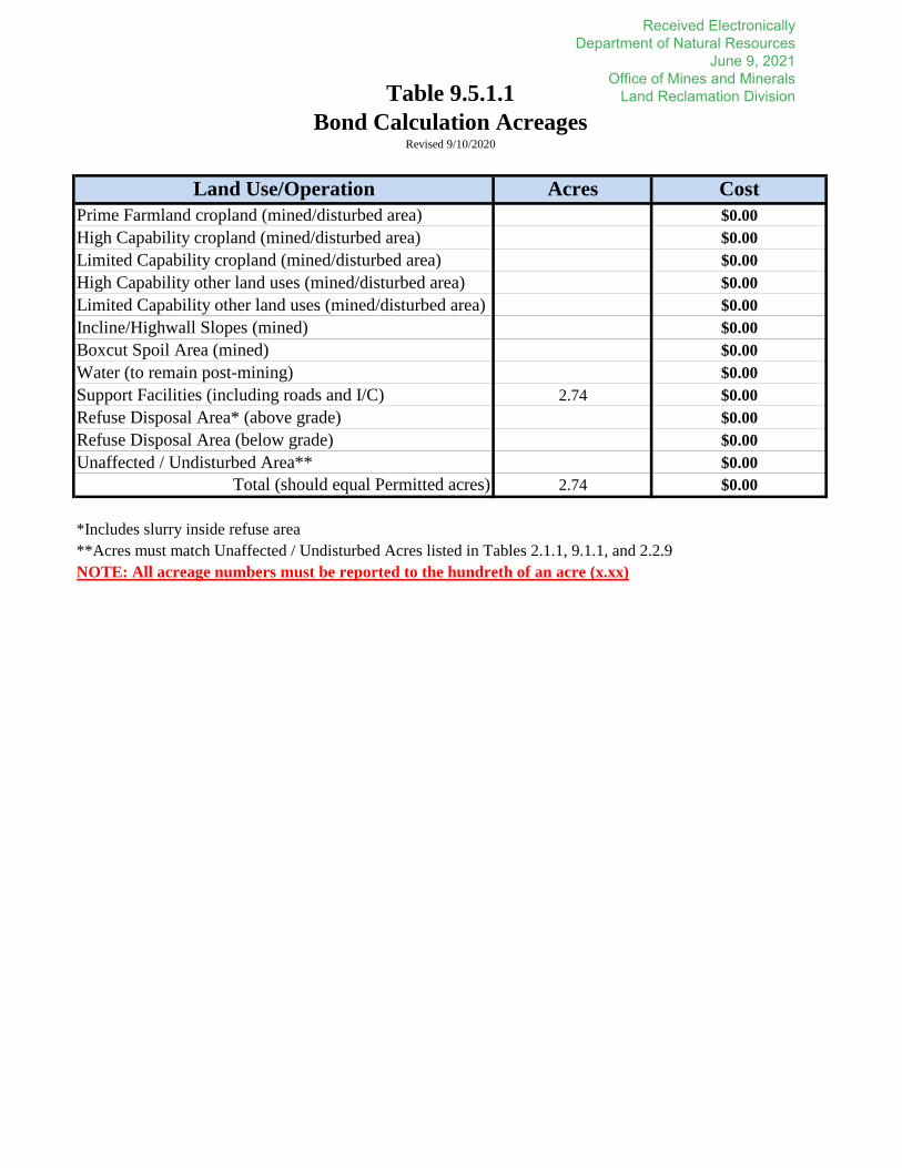
Land Use/Operation Acres CostPrime Farmland cropland (mined/disturbed area) $0.00High Capability cropland (mined/disturbed area) $0.00Limited Capability cropland (mined/disturbed area) $0.00High Capability other land uses (mined/disturbed area) $0.00Limited Capability other land uses (mined/disturbed area) $0.00Incline/Highwall Slopes (mined) $0.00Boxcut Spoil Area (mined) $0.00Water (to remain post-mining) $0.00Support Facilities (including roads and I/C) 2.74 $0.00Refuse Disposal Area* (above grade) $0.00Refuse Disposal Area (below grade) $0.00Unaffected / Undisturbed Area** $0.00
Total (should equal Permitted acres) 2.74 $0.00
*Includes slurry inside refuse area**Acres must match Unaffected / Undisturbed Acres listed in Tables 2.1.1, 9.1.1, and 2.2.9NOTE: All acreage numbers must be reported to the hundreth of an acre (x.xx)
Table 9.5.1.1Bond Calculation Acreages
Revised 9/10/2020
Received Electronically Department of Natural Resources
June 9, 2021 Office of Mines and Minerals
Land Reclamation Division

Revised 9/10/2020
Subsoil (inches):Length of haul (feet):Method of Replacement:
Scraper: Truck:Cost/Yard:
Topsoil (inches):Length of haul (feet):Method of Replacement:
Scraper: Truck:Cost/Yard:
Subsoil (inches):Length of haul (feet):Method of Replacement:
Scraper: Truck:Cost/Yard:
Topsoil (inches):Length of haul (feet):Method of Replacement:
Scraper: Truck:Cost/Yard:
Subsoil (inches):Length of haul (feet):Method of Replacement:
Scraper: Truck:Cost/Yard:
Topsoil (inches):Length of haul (feet):Method of Replacement:
Scraper: Truck:Cost/Yard:
Yes No x
If YES, the root medium well be current to within ft. of the toe of the spoil.
*The cross section provided under the Interior grading bond calculation section must depict this.
*For surface mining, is there a committal to have the root medium replaced in an accelerated manner?
$0.00
$0.00
$0.00
$0.00
Limited Capability
$0.00
Table 9.5.1.2Surface Affected Areas Soil Replacement
Prime Farmland
$0.008-14
High Capability
Received Electronically Department of Natural Resources
June 9, 2021 Office of Mines and Minerals
Land Reclamation Division

Name/ID:
Type: (Concrete/Asphalt/Gravel) Thickness (in) Length (ft) Width (ft) Cost
Gravel 8 81 81 $0.00
Name/ID:
Type: (Concrete/Asphalt/Gravel) Thickness (in) Length (ft) Width (ft) Cost
$0.00
Name/ID:
Type: (Concrete/Asphalt/Gravel) Thickness (in) Length (ft) Width (ft) Cost
$0.00
Name/ID:
Type: (Concrete/Asphalt/Gravel) Thickness (in) Length (ft) Width (ft) Cost
$0.00
Name/ID:
Type: (Concrete/Asphalt/Gravel) Thickness (in) Length (ft) Width (ft) Cost
$0.00
Name/ID:
Type: (Concrete/Asphalt/Gravel) Thickness (in) Length (ft) Width (ft) Cost
$0.00
Name/ID:
Type: (Concrete/Asphalt/Gravel) Thickness (in) Length (ft) Width (ft) Cost
$0.00
Name/ID:
$0.00
Note: All pavement/gravel areas must be located on the Bond Calculation Map
TOTAL COST:
Table 9.5.1.11Pavement / Gravel Area Reclamation
Graveled Area
Received Electronically Department of Natural Resources
June 9, 2021 Office of Mines and Minerals
Land Reclamation Division

Quantity Name / ID Type Diameter (inches) Depth (feet)1 Drillhole K2 Borehole 6 4401 Drillhole K3 Borehole 6 4401 Drillhole L1 Borehole 6 4401 Drillhole L2 Borehole 6 4401 Drillhole L3 Borehole 6 440
TOTAL COST: $0.00
Borehole/Monitoring Well BackfillingTable 9.5.1.12
Revised: 5/8/19
Received Electronically Department of Natural Resources
June 9, 2021 Office of Mines and Minerals
Land Reclamation Division

PART 10: Revegetation (Excluding Cropland and Streams)
10.1 Revegetation of Drainage Control Ditches. Describe plans for revegetation of ditches associated with construction of roads, conveyer systems, rail systems, and associated with controlling overland flow drainage. For responses that are identical to other parts, “see response to question number X” is acceptable. The following information is required: [1780.18(b)(5)/1784.13(b)(5; 1816.43/1817.43; 1816.45/1817.45; 1816.111/1817.111; 1816.114/1817.114]
10.1.1 Describe the methods for the use of temporary seeding/mulching to control erosion, discuss the species, seeding rate by species per acre, and mulching methods and type of mulch. [1816.111(c)/1817.111(c); 1816.114/0817.114; 1780.18(b)(5)/1784.13(b)(5)]
10.1.2 Describe the timing and methods proposed to transition from the temporary vegetation to the semi-permanent or permanent vegetative cover. [1816.111(c)/1817.111(c)]
10.1.3 Provide a semi-permanent or permanent grass and forbs species list that is diverse, native, capable of controlling erosion, and capable of self-regeneration. If non-native species are proposed, provide adequate justification that the species are desirable, necessary to achieve the approved post-mining land use, and are required to control erosion. [1816.111 (a) and (b)/1817.111 (a) and (b); 1816.111(c)/1817.111(c)]
10.1.4 Describe seeding rate by species per acre, methods of planting and seeding, mulching and fertilizer plan and rates for the semi-permanent or permanent grass and forbs list. [1780.18(b)(5)/1784.13(b)(5)]
10.2 Revegetation of Faces of Embankments. Describe plans for revegetation of faces of embankments of sediment ponds and other water structures. For responses that are identical to other parts, “see response to question number X” is acceptable. The following information is required: [1780.18(b)(5)/1784.13(b)(5); 1816.46(b)(1) and (4)/1817.46(b)(1) and (4); 1816.49(a)(8)/1817.49(a)(8); 1816.111/1817.111]
10.2.1 Describe the methods for the use of temporary seeding/mulching to control erosion, discuss the species, seeding rate by species per acre, and mulching methods and type of mulch. [1816.111(c)/1817.111(c); 1816.114/0817.114; 1780.18(b)(5)/1784.13(b)(5)]
10.2.2 Describe the timing and methods proposed to transition from the temporary vegetation to the semi-permanent or permanent vegetative cover. [1816.111(c)/1817.111(c)]
10.2.3 Provide a semi-permanent or permanent grass and forbs species list that is diverse, native, capable of controlling erosion, and capable of self-regeneration. If non-native species are proposed, provide adequate justification that the species are desirable, necessary to achieve the approved post-mining land
Received Electronically Department of Natural Resources
June 9, 2021 Office of Mines and Minerals
Land Reclamation Division

use, and are required to control erosion. [1816.111 (a) and (b)/1817.111 (a) and (b); 1816.111(c)/1817.111(c)]
10.2.4 Describe seeding rate by species per acre, methods of planting and seeding, mulching and fertilizer plan and rates for the semi-permanent or permanent grass and forbs list. [1780.18(b)(5)/1784.13(b)(5)]
10.3 Revegetation of Soil Stockpiles. Describe plans for revegetation of subsoil and topsoil stockpiles. For responses that are identical to other parts, “see response to question number X” is acceptable. The following information is required: [1780.18(b)(5)/1784.13(b)(5; 1816.22(c)(2)(C)/1817.22(c)(2)(C); 1816.111/1817.111]
10.3.1 Describe the methods for the use of temporary seeding/mulching to control erosion, discuss the species, seeding rate by species per acre, and mulching methods and type of mulch. [1816.111(c)/1817.111(c); 1816.114/1817.114; 1780.18(b)(5)/1784.13(b)(5)]
Spring Oats (Spring seeding) 50 lbs./acre and Winter Wheat (Fall seeding) 40 lbs./acre are proposed as a temporary cover crop, Ryegrass (annual) 20.0 lbs./acre, German Millet 20.0 lbs./acre (Fall planting), Ryegrass (perennial) 20.0 lbs./acre, 1.5 tons mulch/acre straw broadcast.
10.3.2 Describe the timing and methods proposed to transition from the temporary vegetation to the semi-permanent vegetative cover. [1816.111(c)/1817.111(c)]
Permanent vegetation will be planted during the final reclamation. 10.3.3 Provide a semi-permanent grass and forbs species list that is capable of controlling erosion and capable of self-regeneration. If non-native species are proposed, provide adequate justification that the species are desirable and necessary to control erosion. [1816.111 (a) and (b)/1817.111 (a) and (b); 1816.111(c)/1817.111(c)]
See 10.3.1 10.3.4 Describe seeding rate by species per acre, methods of planting and seeding, mulching and fertilizer plan and rates for the semi-permanent grass and forbs list. [1780.18(b)(5)/1784.13(b)(5)]
See 10.3.1
10.4 Revegetation of Refuse Disposal Facilities. Describe plans for revegetation of refuse disposal facilities. The revegetation plan must conform to the standards of success outlined in the regulations and adhere to the Illinois Noxious Weed Law. For responses that are identical to other parts, “see response to question number X” is acceptable. The following information is required: [1780.18(b)(5)/1784.13(b)(5); 1816.22(c)(2)(C)/1817.22(c)(2)(C); 1816.111/1817.111]
10.4.1 Provide the proposed post-mining land use designation for refuse disposal facilities and a justification for the necessity of that land use. [1780.23(b)/1784.15(b)]
10.4.2 Describe proposed soil preparation and a soil testing plan related to reclamation and re-vegetation procedures. [1780.18(b)(5)(G)/1784.13(b)(5)(G)]
Received Electronically Department of Natural Resources
June 9, 2021 Office of Mines and Minerals
Land Reclamation Division

10.4.3 Describe the methods for the use of temporary seeding/mulching to control erosion, discuss the species, seeding rate by species per acre, and mulching methods and type of mulch. [1816.111(c)/1817.111(c); 1816.114/0817.114]
10.4.4 Describe the timing and methods proposed to transition from the temporary vegetation to the permanent vegetative cover. [1816.111(c)/1817.111(c)]
10.4.5 Provide a permanent grass and forbs species list that is diverse, native, capable of controlling erosion, and capable of self-regeneration. If non-native species are proposed to achieve the post-mining land use, provide adequate justification that the species are desirable, necessary to achieve the approved post-mining land use, and are required to control erosion. Specify if the proposed seed mix contains different species for the slopes and the top of the structure. Describe seeding rate by species per acre, methods of planting and seeding, mulching and fertilizer plan and rates. [1780.18(b)(5)/1784.13(b)(5); 1816.111(a) and (b)/1817.111(a) and (b); 1816.111(a)(2)/1817.111(a)(2); 1816.97(g)/1817.97(g)]
10.4.6 Describe a periodic measurement plan of the vegetation that will be used to identify if remedial actions are necessary to achieve the approved species and / or post-mining land use vegetation success standards during the applicable period of liability. Information provided shall also describe a remedial action plan to achieve the approved vegetative species, invasive species management, or post-Mining Land Use success. Remedial actions may include but are not limited to mowing, burning, undesirable invasive species control, irrigation and pest and disease control. [1816.116(b)(1)/1817.116(b)(1); 1816.111(a) and (b)/1817.111(a) and (b)]
10.5 Pasture Reclamation Plan. Describe plans for reclamation and revegetation of Pasture. The revegetation plan must conform to the standards of success outlined in the regulations and adhere to the Illinois Noxious Weed Law. For responses that are identical to other parts, “see response to question number X” is acceptable. The following information is required: [1780.18(b)(5)/1784.13(b)(5); 1816.111/1817.111; 1816.116/1817.116]
10.5.1 Describe proposed soil preparation and a soil testing plan related to reclamation and re-vegetation procedures. [1780.18(b)(5)(G)/1784.13(b)(5)(G)]
10.5.2 Describe the methods for the use of temporary seeding/mulching to control erosion, discuss the species, seeding rate by species per acre, and mulching methods and type of mulch. [1816.111(c)/1817.111(c); 1816.114/0817.114]
10.5.3 Describe the timing and methods proposed to transition from the temporary vegetation to the permanent vegetative cover. [1816.111(c)/1817.111(c)]
Received Electronically Department of Natural Resources
June 9, 2021 Office of Mines and Minerals
Land Reclamation Division

10.5.4 Provide a permanent pasture grass species list, describe seeding rate by species per acre, methods of planting and seeding, mulching and fertilizer plan and rates. [1780.13(b)(5)/1784.18(b)(5)]
10.5.5 Describe a periodic measurement plan of the vegetation that will be used to identify if remedial actions are necessary to achieve the approved species and / or post-mining land use vegetation success standards during the applicable period of liability. Information provided shall also describe a remedial action plan to achieve the approved vegetative species, invasive species management, or post-Mining Land Use success. Remedial actions may include but are not limited to mowing, burning, undesirable invasive species control, irrigation and pest and disease control. [1816.116(b)(1)/1817.116(b)(1); 1816.111(a) and (b)/1817.111(a) and (b)]
10.6 Fish and Wildlife-Herbaceous Reclamation Plan. Describe plans for reclamation and revegetation of Wildlife Herbaceous areas. The revegetation plan must conform to the standards of success outlined in the regulations and adhere to the Illinois Noxious Weed Law. For responses that are identical to other parts, “see response to question number X” is acceptable. The following information is required: [1780.18(b)(5)/1784.13(b)(5); 1816.111/1817.111; 1816.97/1817.97; 1816.116/1817.116; 1816.117/1817.117]
10.6.1 Describe proposed soil preparation and a soil testing plan related to reclamation and revegetation procedures. [1780.18(b)(5)(G)/1784.13(b)(5)(G)]
10.6.2 Describe the methods for the use of temporary seeding/mulching to control erosion, discuss the species, seeding rate by species per acre, and mulching methods and type of mulch. [1816.111(c)/1817.111(c); 1816.114/0817.114]
10.6.3 Describe the timing and methods proposed to transition from the temporary vegetation to the permanent vegetative cover. [1816.111(c)/1817.111(c)]
10.6.4 Provide a permanent grass and forbs species list that is diverse, native, capable of controlling erosion, and capable of self-regeneration. If non-native species are proposed to achieve the post-mining land use, provide adequate justification that the species are desirable, necessary to achieve the approved post-mining land use, and are required to control erosion. Describe seeding rate by species per acre, methods of planting and seeding, mulching and fertilizer plan and rates. [1780.18(b)(5)/1784.13(b)(5); 1816.111(a) and (b)/1817.111(a) and (b); 1816.111(a)(2)/1817.111(a)(2); 1816.97(g)/1817.97(g)]
10.6.5 Describe a periodic measurement plan of the vegetation that will be used to identify if remedial actions are necessary to achieve the approved species and / or post-mining land use vegetation success standards during the applicable period of liability. Information provided shall also describe a remedial action plan to achieve the approved vegetative species, invasive species management, or post-mining land use success. Remedial actions may include but are not limited to mowing, burning, undesirable invasive
Received Electronically Department of Natural Resources
June 9, 2021 Office of Mines and Minerals
Land Reclamation Division

species control, irrigation and pest and disease control. [1816.116(b)(1)/1817.116(b)(1); 1816.111(a) and (b)/1817.111(a) and (b)]
10.7 Fish and Wildlife-Woody Reclamation Plan. Describe plans for reclamation and revegetation of Wildlife Woody areas. The revegetation plan must conform to the standards of success outlined in the regulations and adhere to the Illinois Noxious Weed Law. If a bat Protection and Enhancement Plan (PEP) is part of the application, the applicant shall ensure consistency between this part and the bat PEP. For responses that are identical to other parts, “see response to question number X” is acceptable. The following information is required: [1780.18(b)(5)/1784.13(b)(5; 1816.111/1817.111; 1816.97/1817.97; 1816.116/1817.116; 1816.117/1817.117; OSM Directives TSR-16 Directive 931]
10.7.1 Describe proposed soil preparation and a soil testing plan related to reclamation and revegetation procedures. [1780.18(b)(5)(G)/1784.13(b)(5)(G)]
10.7.2 Describe the methods for the use of temporary seeding/mulching to control erosion, discuss the species, seeding rate by species per acre, and mulching methods and type of mulch. [1816.111(c)/1817.111(c); 1816.114/0817.114]
10.7.3 Describe the timing and methods proposed to transition from the temporary vegetation to the permanent vegetative cover. [1816.111(c)/1817.111(c)]
10.7.4 Provide a permanent herbaceous ground cover species list and a woody species list that is diverse, native, capable of controlling erosion, capable of self-regeneration, and that has growth habits compatible with woody species success. If non-native species are proposed to achieve the post-mining land use, provide adequate justification that the species are desirable, necessary to achieve the approved post-mining land use, and are required to control erosion. Describe seeding rate by species per acre, methods of planting and seeding, mulching and fertilizer plan and rates. [1780.18(b)(5)/1784.13(b)(5); 1816.111(a) and (b)/1817.111(a) and (b); 1816.111(a)(2)/1817.111(a)(2); 1816.97(g)/1817.97(g); Operator Memorandum No. 2017-02]
10.7.5 Describe a periodic measurement plan of the vegetation that will be used to identify if remedial actions are necessary to achieve the approved species and / or post-mining land use vegetation success standards during the applicable period of liability. Refer to Operator Memorandum No. 2017-02 for additional information regarding tree and shrub planting maintenance. Information provided shall also describe a remedial action plan to achieve the approved vegetative species, invasive species management, or post-mining land use success. Remedial actions may include but are not limited to mowing, burning, undesirable invasive species control, irrigation and pest and disease control. [1816.116(b)(1)/1817.116(b)(1); 1816.111(a) and (b)/1817.111(a) and (b)]
Received Electronically Department of Natural Resources
June 9, 2021 Office of Mines and Minerals
Land Reclamation Division

10.8 Fish and Wildlife-Wetland Reclamation Plan. Describe plans for reclamation and revegetation of Wildlife Wetland areas. The revegetation plan must conform to the standards of success outlined in the regulations and adhere to the Illinois Noxious Weed Law. The following information is required: [1701.5; 1816.111/1817.111; 1816.97/1817.97; 1816.116/1817.116; 1816.117/1817.117; 1816.102(h)/1817.102(h); OSM Directives System TSR-14 Directive 828]
10.8.1 Is the wetland a managed engineered area, a borrow area or a structure that functions as part of the surface drainage/sediment control plan?
YES NO
If NO, complete Part 10.8.2, If YES, the following information is required:
10.8.1.1 Describe how the soil type(s) in the proposed wetland area will support hydrophytic vegetation. If hydric soils are not present, describe how the area will function as a wetland without this wetland parameter. [1701.5 Appendix A]
10.8.1.2 Discuss the potential for the area to be inundated or saturated by surface or groundwater at a frequency to support hydrophytic vegetation on at least 30% of the surface acres of the wetland. [1701.5 Appendix A]
10.8.1.3 Provide a permanent wetland vegetation species list that is compatible with the Corp of Engineers Wetland Delineation Manual as described in the regulations. The species list must also be diverse, capable of controlling erosion, and capable of self-regeneration. If non-native species are proposed to achieve the post-mining land use, provide adequate justification that the species are desirable, necessary to achieve the approved post-mining land use, and are required to control erosion. [1816.116(a)(5)(A)/1817.116(a)(5)(A); 1816.111 (a) and (b)/1817.111 (a) and (b); 1816.97(g)/1817.97(g)]
10.8.1.4 Provide a description of how the requirements for permanent impoundments will be met. [1816.49(b)/1817.49(b)]
10.8.2 Wildlife Wetland Enhancement
10.8.2.1 Describe how the soil type(s) in the proposed will support hydrophytic vegetation. If hydric soils are not present, describe how the area will function as a wetland without this wetland parameter. [1701.5 Appendix A]
10.8.2.2 Discuss the potential for the area to be inundated or saturated by surface or groundwater at a frequency to support hydrophytic vegetation on at least 30% of the surface acres of the wetland. [1701.5 Appendix A]
Received Electronically Department of Natural Resources
June 9, 2021 Office of Mines and Minerals
Land Reclamation Division

10.8.2.3 Provide a permanent wetland vegetation species list that is compatible with the Corp of Engineers Wetland Delineation Manual as described in the regulations. The species list must also be diverse, capable of controlling erosion, and capable of self-regeneration. Adequate justification that the species are desirable, necessary to achieve the approved post-mining land use, and are required to control erosion. [1816.116(a)(5)(A)/1817.116(a)(5)(A); 1816.111 (a) and (b)/1817.111 (a) and (b); 1816.97(g)/1817.97(g)]
10.9 Fish and Wildlife-Water and/or Developed Water Resources Reclamation Plan. Describe plans for reclamation and revegetation of Wildlife Water and/or Developed Water Resources areas. The revegetation plan must conform to the standards of success outlined in the regulations and adhere to the Illinois Noxious Weed Law. The following information is required: [1816.49(b)/1817.49(b); 1816.56/1817.56; 1816.97/1817.97]
10.9.1 For Developed Water Resources, provide a description of the future quality of the impounded water including the following: assurance that it will meet water quality standards, it will not degrade the quality of the receiving water, and it will not diminish the quality/quantity of water utilized by adjacent land owners. [1816.49(b)/1817.49(b)]
10.9.2 For Fish and Wildlife - Water, discuss how the area will support and enhance fish and wildlife habitat, describe the future water quality, and describe how the water level will be capable of supporting the intended use. [1816.49(b)/1817.49(b); 1816.97/1817.97]
10.10 Forest Reclamation Plan. Describe plans for reclamation and revegetation of Forest areas. The revegetation plan must conform to the standards of success outlined in the regulations and adhere to the Illinois Noxious Weed Law. If a bat Protection and Enhancement Plan (PEP) is part of the application, the applicant shall ensure consistency between this part and the bat PEP. For responses that are identical to other parts, “see response to question number X” is acceptable. The following information is required: [1816.111/1817.111; 1816.97/1817.97; 1816.116/1817.116; 1816.117/1817.117; OSM Directives TSR-16 Directive 931]
10.10.1 Describe proposed soil preparation and a soil testing plan related to reclamation and revegetation procedures. [1780.18(b)(5)(G)/1784.13(b)(5)(G)]
10.10.2 Describe the methods for the use of temporary seeding/mulching to control erosion, discuss the species, seeding rate by species per acre, and mulching methods and type of mulch. [1816.111(c)/1817.111(c); 1816.114/1817.114]
10.10.3 Describe the timing and methods proposed to transition from the temporary herbaceous cover vegetation to the permanent vegetative cover. [1816.111(c)/1817.111(c)]
Received Electronically Department of Natural Resources
June 9, 2021 Office of Mines and Minerals
Land Reclamation Division

10.10.4 Provide a permanent herbaceous ground cover species list and a woody species list that is diverse, native, capable of controlling erosion, capable of self-regeneration, and that has growth habits compatible with woody species success. If non-native species are proposed to achieve the post-mining land use, provide adequate justification that the species are desirable, necessary to achieve the approved post-mining land use, and are required to control erosion. Describe seeding rate by species per acre, methods of planting and seeding, mulching and fertilizer plan and rates. [1780.18(b)(5)/1784.13(b)(5); 1816.111(a) and (b)/1817.111(a) and (b); 1816.111(a)(2)/1817.111(a)(2); 1816.97(g)/1817.97(g); Operator Memorandum No. 2017-02]
10.10.5 Describe a periodic measurement plan of the vegetation that will be used to identify if remedial actions are necessary to achieve the approved species and / or post-mining land use vegetation success standards during the applicable period of liability. Refer to Operator Memorandum No. 2017-02 for additional information regarding tree and shrub planting maintenance. Information provided shall also describe a remedial action plan to achieve the approved vegetative species, invasive species management, or post-mining land use success. Remedial actions may include but are not limited to mowing, burning, undesirable invasive species control, irrigation and pest and disease control. [1816.116(b)(1)/1817.116(b)(1); 1816.111(a) and (b)/1817.111(a) and (b)]
10.11 Industrial/Commercial Reclamation Plan. Describe plans for reclamation and revegetation of Industrial/Commercial areas. The revegetation plan must conform to the standards of success outlined in the regulations and adhere to the Illinois Noxious Weed Law. For responses that are identical to other parts, “see response to question number X” is acceptable. The following information is required: [1816.111/1817.111; 1816.97/1817.97; 1816.116/1817.116; 1816.117/1817.117]
10.11.1 Describe plans for utilization of the area for Industrial or Commercial purposes at the time of bond release.
10.11.2 Provide a ground cover species list and a woody species list, if applicable that is diverse, native, capable of controlling erosion, and capable of self-regeneration. If non-native species are proposed to achieve the post-mining land use, provide adequate justification that the species are desirable, necessary to achieve the approved post-mining land use, and are required to control erosion. [1816.111 (a) and (b)/1817.111 (a) and (b); 1816.97(i)/1817.97(i)]
10.12 Recreation Reclamation Plan. Describe plans for reclamation and revegetation of Recreation areas. The revegetation plan must conform to the standards of success outlined in the regulations and adhere to the Illinois Noxious Weed Law. For responses that are identical to other parts, “see response to question number X” is acceptable. The following information is required: [1816.111/1817.111; 1816.97/1817.97; 1816.116/1817.116; 1816.117/1817.117]
10.12.1 Describe plans for utilization of the area for recreational purposes at the time of bond release.
Received Electronically Department of Natural Resources
June 9, 2021 Office of Mines and Minerals
Land Reclamation Division

10.12.2 Provide a ground cover species list and a woody species list, if applicable that is diverse, native, capable of controlling erosion, and capable of self-regeneration. If non-native species are proposed to achieve the post-mining land use, provide adequate justification that the species are desirable, necessary to achieve the approved post-mining land use, and are required to control erosion [1816.111 (a) and (b)/1817.111 (a) and (b); 1816.97(i)/1817.97(i)]
10.13 Habitat Diversification in Cropland. Describe plans to intersperse crop fields with trees, hedges, conservation drainage ways, or fence rows that will break up crop monocultures and diversify habitat, where appropriate and compatible with crop management and wildlife management practices. [1816.97(h)/1817.97(h); 1816.111/1817.111]
Received Electronically Department of Natural Resources
June 9, 2021 Office of Mines and Minerals
Land Reclamation Division

PART 12: Shaft, Slope and Miscellaneous Borehole Construction
12.1 Shafts and/or Slopes.
12.1.1 For the shafts and/or slopes being proposed, describe the measures to be implemented to minimize disturbance to the prevailing hydrologic balance and to ensure the safety of people, livestock, fish and wildlife, and machinery in the permit area and adjacent area. [1816.13/1817.13]
12.1.2 For each shaft and/or slope, provide a drawing showing those features which are relevant to protecting the hydrologic balance. The drawing shall include:
- The physical dimensions of excavations and entry lining material; - The type of entry lining material; - The measures which will be used to seal the annulus between the entry lining and adjacent rock; - Water rings and conductor pipes; - Elevation of land surface, coal seam, and any other mine workings penetrated by the structure; and - Provide the latitude and longitude (in decimal degrees) for each shaft and/or slope.
Provide reference to each drawing below.
12.1.3 Will the Applicant be conducting any surface blasting activities incidental to underground mining, including, but not limited to, initial rounds of slopes and/or shafts that are within 50 vertical feet of the original ground surface? [1817.61(a)]
YES NO
If YES, complete the appropriate items in Part 11: Blasting.
12.2 Miscellaneous Boreholes.
12.2.1 For each borehole or group of boreholes being proposed, describe the measures to be implemented to minimize disturbance to the prevailing hydrologic balance and ensure the safety of people, livestock, fish and wildlife, and machinery in the permit area and adjacent area. [1816.13/1817.13]
Each borehole will be fully cased with steel pipe and fully grouted in place. All openings will be covered with a substantial cap to prevent easy access to the mine workings by people, livestock, fish and wildlife, and machinery. The surface casing will be high enough above the ground to prevent drainage from entering the hole and to keep acid or other toxic drainages from entering groundwater or surface water. The boreholes will be permanently sealed within 60 days of when the borehole becomes inactive. Each hole drilled will be plugged during reclamation by filling with neat cement to the top and the casing will be cut off at least five feet below grade.
Received Electronically Department of Natural Resources
June 9, 2021 Office of Mines and Minerals
Land Reclamation Division

12.2.2 For each borehole or group of boreholes which will be constructed in a similar manner, provide a borehole log with the following: [Operator Memorandum 2017-01]
- The depth (or depth range) and diameter of each drill hole; - The depth (or depth range) and diameter of each casing string, type and thickness of casing
material in each string, and spacing of collars and any centralizers; - Intervals to be cemented, grouted, or otherwise sealed and the method of placement; - Any geophysical logging which is proposed; - The names and numbers of boreholes to which the sketch applies; and - Provide the latitude and longitude (in decimal degrees) for each borehole.
Provide reference to each borehole log below.
1 – 6” diameter steel lined fully grouted borehole approximately ~440 feet deep. No geophysical logging proposed at LAT: ~39.1194° LON: ~-89.4498° ( Drillhole K2)
1 – 6” diameter steel lined fully grouted borehole approximately ~440 feet deep. No geophysical logging proposed at LAT: ~39.1194° LON: ~-89.4497° (Drillhole K3)
1 – 6” diameter steel lined fully grouted borehole approximately ~440 feet deep. No geophysical logging proposed at LAT: ~39.1194° LON: ~-89.4500° (Drillhole L1)
1 – 6” diameter steel lined fully grouted borehole approximately ~440 feet deep. No geophysical logging proposed at LAT: ~39.1197° LON: ~-89.4498° (Drillhole L2)
1 – 6” diameter steel lined fully grouted borehole approximately ~440 feet deep. No geophysical logging proposed at LAT: ~39.1197° LON: ~-89.4493° (Drillhole L3)
Received Electronically Department of Natural Resources
June 9, 2021 Office of Mines and Minerals
Land Reclamation Division

a
r
c
a
t
C
r
k
.
M
il
l
e
r
C
r
k
.
B
e
a
r
c
a
tC
r
k
.
S
t
a
t
e
R
t
e
1
8
5
S
t
a
t
e
R
t
e
1
8
5
E 14th R
d
Schoolhouse R
d
N 9th Ave
Schoolhouse R
d
N 7th Ave
N 9th Ave
T
N
R
W
18
8
3
T
N
R
W
17
8
3
T
N
R
W
19
8
3
T
N
R
W
30
8
3
T
N
R
W
29
8
3
T
N
R
W
20
8
3
EXISTING
PERMITTED
AREA
NEW PERMIT AREA
REFERENCE POINT
N : 8 9 4 1 4 5 . 4 7 7 5 1
E : 2 4 9 9 7 9 1 . 4 2 5 6 9
LAT:33°06'51.308954"
LON:90°52'04.794194"
General Location Map
IBR XX Drill Site
Drawn By:
Date:
Approved By:
Checked By:
No.Date
ByDate
No.By
Revisions
1
2
3
4
5
6
7
8
10
9
Scale:
File Location:
BM
CAC
1"=1000'
MAP_1_GENERAL LOCATION_MAP_TG4_DRILL SITE
CAC
06/08/2021
Legend
EXISTING DEER RUN PERMITTED AREAS
MAP 1
PROPOSED IBR PERMIT LINE
EXISTING ROADS
STREAMS
PONDS
SECTION LINES
12051 9TH AVENUE, HILLSBORO IL 62049
DEER RUN MINE
HILLSBOROENERGY LLC
Received ElectronicallyDepartment of Natural ResourcesJune 9, 2021Office of Mines and MineralsLand Reclamation Division

NEW PERMIT
AREA
NRR
17-19-200-011
37.79
KASTEN ARLEN
17-20-300-001
76.5
KA
ST
EN
A
RL
. L
IV
IN
G T
RU
ST
17
-1
9-4
00
-0
05
38
.4
3
SPINNER GEORGE
17-20-100-005
80.
NRR
17-20-100-002
40.
SCHRAUT L.
17-20-400-006
64.5
KASTEN ARLEN
17-20-300-001
76.5
SCHRAUT LARRY
17-20-300-005
76.6
KASTEN A.
17-20-300-004
3.4
Land Tract Map
IBR XX Drill Site
Drawn By:
Date:
Approved By:
Checked By:
No.Date
ByDate
No.By
Revisions
1
2
3
4
5
6
7
8
10
9
Scale:
File Location:
BM
CAC
1"=700'
MAP_2_LAND_TRACT_ID_MAP_TG4_DRILL SITE
CAC
06/08/2021
Legend
EXISTING DEER RUN PERMITTED AREAS
MAP 2
PROPOSED IBR PERMIT LINE
EXISTING ROADS
SECTION LINES
PROPERTY OWNERSHIP WITHIN IBR PERMIT AREA
PROPERTY OWNERSHIP CONTIGUOUS TO IBR AREA
12051 9TH AVENUE, HILLSBORO IL 62049
DEER RUN MINE
HILLSBOROENERGY LLC
Received ElectronicallyDepartment of Natural ResourcesJune 9, 2021Office of Mines and MineralsLand Reclamation Division
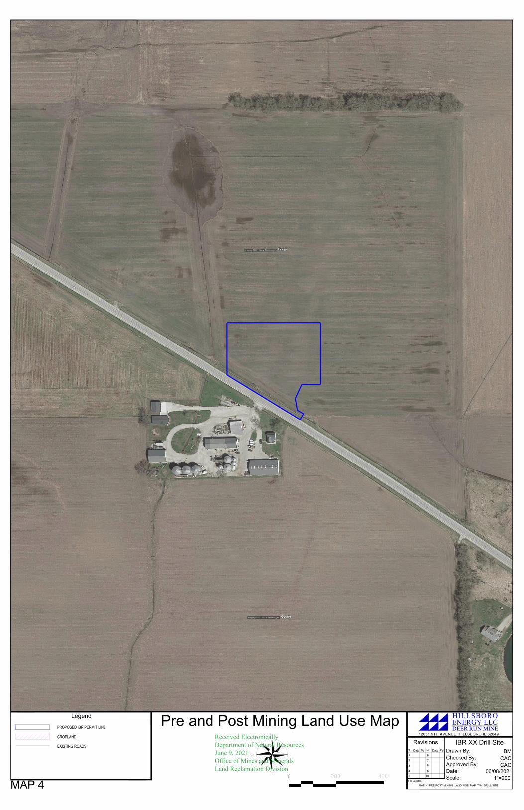
Pre and Post Mining Land Use Map
IBR XX Drill Site
Drawn By:
Date:
Approved By:
Checked By:
No.Date
ByDate
No. By
Revisions
1
2
3
4
5
6
7
8
10
9
Scale:
File Location:
BM
CAC
1"=200'
MAP_4_PRE-POST-MINING_LAND_USE_MAP_TG4_DRILL SITE
CAC
06/08/2021
Legend
MAP 4
PROPOSED IBR PERMIT LINE
EXISTING ROADS
CROPLAND
12051 9TH AVENUE, HILLSBORO IL 62049
DEER RUN MINE
HILLSBOROENERGY LLC
Received ElectronicallyDepartment of Natural ResourcesJune 9, 2021Office of Mines and MineralsLand Reclamation Division

DRILLHOLE (L2)
DRILLHOLE (L1)
DRILLHOLE (L3)
DRILLHOLE (K2)
DRILLHOLE (K3)
6
3
2
630
STATE ROUTE 185
GRAVELED AREA
0.15 AC
N:894145.47751
E:2499791.42569
LAT:33°06'51.308954"
LON:90°52'04.794194"
TOPSOIL
STOCKPILE
TOPSOIL
STOCKPILE
Operation Map
IBR XX Drill Site
Drawn By:
Date:
Approved By:
Checked By:
No.Date
ByDate
No.By
Revisions
1
2
3
4
5
6
7
8
10
9
Scale:
File Location:
BM
CAC
1"=100'
MAP_3_SURFACE_OPERATIONS_MAP_TG4_DRILL SITE
CAC
06/08/2021
Legend
EXISTING DEER RUN PERMITTED AREAS
MAP 3
PROPOSED IBR PERMIT LINE
PROPOSED IBR ROAD
FLOW ARROW
6
2
6
SURFACE CONTOURS
POWERPOLES
12051 9TH AVENUE, HILLSBORO IL 62049
DEER RUN MINE
HILLSBOROENERGY LLC
Received ElectronicallyDepartment of Natural ResourcesJune 9, 2021Office of Mines and MineralsLand Reclamation Division

894A
894A
885A
W
885A
993A
894A
885A
885A
Soils Map
IBR XX Drill Site
Drawn By:
Date:
Approved By:
Checked By:
No.Date
ByDate
No.By
Revisions
1
2
3
4
5
6
7
8
10
9
Scale:
File Location:
BM
CAC
1"=300''
MAP_5_SOILS_MAP_TG4_DRILL SITE
CAC
06/08/2021
Legend
MAP 5
PROPOSED IBR PERMIT LINE
EXISTING ROADS
HIGH CAPABILITY
12051 9TH AVENUE, HILLSBORO IL 62049
DEER RUN MINE
HILLSBOROENERGY LLC
Received ElectronicallyDepartment of Natural ResourcesJune 9, 2021Office of Mines and Minerals
Land Reclamation Division