4.6 cultural, historical, and paleontological resources … · ca-sba-1733 would be cut by the...
TRANSCRIPT
4.6 Cultural, Historical, and Paleontological Resources
March 2011 4.6-1 Ellwood Pipeline CompanyLine 96 Modification Project EIR
4.6 CULTURAL, HISTORICAL, AND PALEONTOLOGICAL RESOURCES 1
This section addresses potential impacts to cultural, historical, and paleontological 2
resources that would potentially result from development of the proposed Project; its 3
principal alternatives, and cumulative impacts from this and other projects in the region; 4
and recommends mitigation measures to reduce those impacts. 5
4.6.1 ENVIRONMENTAL SETTING 6
4.6.1.1 Onshore Archaeological Resources 7
The Ellwood Onshore Facility (EOF), the new onshore pipeline, and the Ellwood Marine 8
Terminal (EMT) are all located within the Barbareño Chumash cultural area, which 9
includes evidence of human occupation dating to over 9,500 years ago. The Project 10
area’s various sources of fresh water were ideal locations for permanent and semi-11
permanent village settlements that provided abundant fish, birds, and plants for hunting 12
and gathering. Due to the rich food resources found on land and in the sea, Native 13
American populations in the region grew in both size and organizational complexity over 14
time. 15
Current models of cultural evolution along the Santa Barbara Channel recognize that, 16
over time, prehistoric peoples in the region became increasingly dependent upon marine 17
resources, even though these resources required greater energy to procure. Populations 18
also became less dependent upon terrestrial resources such as large game animals due 19
to growing pressures on the resource base. The need for more sophisticated subsistence 20
technologies and group cooperation resulted in increasingly complex cultural interactions, 21
culminating in the Chumash culture and complex social organization encountered by the 22
Spanish explorers in the 1500s (Arnold et. al. 1997; Glassow et al. 1990; Wilcoxon et al. 23
1982). Climatic change during the transition from the Middle to Late Period, around A.D. 24
1150 to 1300, and pressures from increased population may have also played important 25
roles in this process (Raab and Larson 1997; Arnold et al. 1997). 26
A cultural resources record search of relevant archaeological and historic documents was 27
undertaken to identify and evaluate existing archaeological resources that would be 28
potentially affected by the proposed Project. The potential significance of an 29
archaeological site is related to its ability to yield information important in prehistory or 30
history. Archaeologists consider that this ability is dependent upon the integrity (i.e., 31
intactness, or degree to which the deposit has been disturbed) of the archaeological site 32
4.6 Cultural, Historical, and Paleontological Resources
Ellwood Pipeline Company Line 96 Modification Project EIR
4.6-2 March 2011
soils. When a site deposit has been displaced horizontally and vertically through grading, 1
the relationship of artifacts is lost. This precludes the ability to interpret their chronological 2
relationship (i.e., is there evidence of how the lifestyles of site occupants changed over 3
time in response to climate, availability of food resources, or population increases), and 4
their spatial relationships (i.e., is the location of the artifacts within the site related to a 5
specific activity, indicating that several different activities were undertaken at the site). 6
Although no historic buildings or structures are present within the EOF, the proposed 7
pipeline corridor, or the EMT, the following discussion provides a summary of the of the 8
cultural resources record search findings and information on known or suspected 9
archaeological resources in the general Project area. 10
Onshore Pipeline 11
A record search of the statewide Historical Resources Inventory (HRI) database at the 12
Central Coast Information Center (CCIC) housed at the University of California at Santa 13
Barbara (UCSB) was performed on 28 July 2005, to identify recorded archaeological sites 14
within one-quarter mile of the new onshore pipeline (site-specific information is contained 15
in a confidential appendix that is not available to the public). Over 60 archaeological 16
studies have been performed within one-quarter mile of the new pipeline corridor that 17
extends within existing road rights-of-way and adjacent to existing water, gas, and electric 18
utility services running parallel to, and north of, Highway 101. There is an existing Gas 19
Company pipeline corridor along much of the proposed pipeline corridor; and where 20
appropriate, it is proposed to locate the new pipeline as close to this existing pipeline as 21
allowed. It appears that most, if not all, of the new onshore pipeline route has been 22
previously surveyed during various investigations. 23
Forty-five recorded prehistoric and historic archaeological sites are located within one-24
quarter mile of the new onshore pipeline. At least four of the recorded archaeological 25
sites, CA-SBA-139, CA-SBA-83, CA-SBA-1676, and CA-SBA-1733, are located within 26
the new pipeline corridor. They are described below based on definitions provided in 27
Department of Parks and Recreation Archaeological Site Records. 28
CA-SBA-139 was described in 1929 as a large temporary camp where seed processing 29
and stone tool manufacturing occurred. Investigations in 1960 documented a site 350 30
feet (107 m) in diameter where large quantities of ground stone tools for seed processing 31
and chipped stone tools for food processing were recovered. Subsequent site 32
evaluations in 1961, and again in 1986, noted far fewer artifacts. The southern portion of 33
the site was described as being destroyed by highway construction, while the western 34

4.6 Cultural, Historical, and Paleontological Resources
March 2011 4.6-3 Ellwood Pipeline CompanyLine 96 Modification Project EIR
portion of the site was described as being destroyed by residential construction. 1
However, in 1991 shovel test pit excavations for the Southern California Edison (SCE) 2
Hybrid Alternative Project identified relatively intact subsurface deposits in the northern 3
portion of the site, along the south shoulder of the frontage road. Therefore, portions of 4
this site may still exist within the proposed pipeline corridor. 5
CA-SBA-83 was described in 1929 as a long-term residential camp. In 1991, the site, 6
described as a sparse lithic scatter, covered an area of 490 feet x 131 feet (150 m x 40 7
m). The site included several discrete activity areas where stone tool manufacturing 8
occurred. Shovel test pit excavations conducted in 1991 for the SCE Hybrid Alternative 9
Project identified subsurface artifacts in the northern portion of the site, along the south 10
shoulder of the frontage road located north of Highway 101 (within the proposed pipeline 11
corridor). It was unclear, however, if the subsurface artifacts identified were intact, and 12
the site was not relocated during excavations conducted in 2000. Test unit excavations 13
for the Level (3) Long Haul Fiber Optic Line Project in 2001 did not identify intact 14
subsurface artifacts in the southern portion of the site, along the north side of the Union 15
Pacific Railroad, south of Highway 101. 16
CA-SBA-1676, located immediately west of CA-SBA-83, was described in 1981 as a low 17
density scatter of chipped stone artifacts representing a temporary stone tool 18
manufacturing camp. In 1986, as part of the ARCO Pipeline Project, shovel test pits were 19
excavated to determine the northern site boundary (Chambers Group 1986). No artifacts 20
were recovered, suggesting that CA-SBA-1676 did not extend north of Highway 101. 21
However, in 1991, as part of the SCE Hybrid Alternative Project, shovel test pits 22
excavated north of Highway 101 and east of Canada de la Destiladera (within the 23
proposed pipeline corridor) encountered artifactual material. Although the soil appeared 24
to be relatively intact, it was unclear whether the material retained its integrity. At that 25
time, the size of the site was documented at 6,562 feet x 574 feet (2,000 m x 175 m). In 26
2001, as part of the Level (3) Long Haul Fiber Optic Line Project, test units were 27
excavated in the southern portion of the site, along the north side of the Union Pacific Rail 28
Road, south of Highway 101. No cultural material was recovered in the area tested. 29
Originally recorded in 1982, CA-SBA-1733 appears to be a long-term residential camp 30
where more permanent and extensive occupation would take place. This assessment 31
was based on the diverse accumulation of prehistoric cultural material including tools and 32
food remains, including chipped stone artifacts, mammal and fish bone, and shellfish 33
remains. The site measured 984 feet x 410 feet (300 m x 125 m) and possibly extended 34
from north of the frontage road, beneath Highway 101 and the Union Pacific Railroad, to 35

4.6 Cultural, Historical, and Paleontological Resources
Ellwood Pipeline Company Line 96 Modification Project EIR
4.6-4 March 2011
the beach. CA-SBA-1733 would be cut by the proposed pipeline corridor along the 1
frontage road. 2
An intensive Phase 1 archaeological field survey was performed by SAIC archaeologists 3
on 24 April 2007 to identify all existing resources that would be potentially affected by the 4
proposed Project. The pipeline route was surveyed in the mapped locations of CA-SBA-5
139, CA-SBA-83, CA-SBA-1676, and CA-SBA-1733. Vegetation including annual 6
grasses and forbs limited the ground surface visibility to poor (0 to 10 percent). However, 7
rodent burrow tailings allowed examination of sub-surface soils. No prehistoric or historic 8
cultural materials were observed in the mapped locations of CA-SBA-139, CA-SBA-83, 9
CA-SBA-1676, or CA-SBA-1733. 10
EOF 11
A field survey of the EOF was conducted by an SAIC archaeologist on 29 November 12
2006. The survey identified substantial evidence of previous ground disturbance. 13
Grading (i.e., cut and fill) was necessary to create a level area for the facility. It is 14
reasonable to assume that installation of storage tanks and pipelines at the EOF would 15
have resulted in substantial ground disturbances to depths of 4 to 10 feet since ground 16
disturbances associated with the installation of infrastructure at Venoco’s Carpinteria 17
Processing Facility extended that deep (personal communication, Steve Grieg, 2006). 18
However, it is possible that 10,000-year-old landforms, formed before sea level rise and 19
inundation, may still exist below the EOF. Therefore, it is not possible to completely 20
dismiss the potential for Paleoindian period archaeological sites that are buried 21
approximately 10 feet or more below the ground surface in the area of the EOF. 22
The seaward portion of the EOF consists of relatively loose beach sand that is prone to 23
erosion and scour (i.e., the removal of sand due to wave action along the oceanfront). 24
Due to the open exposure, the oceanfront is generally not considered suitable for 25
occupation by prehistoric peoples. Additionally, due to the movement of sand on a 26
seasonal basis (i.e. sand is generally scoured off the beach during the winter months as a 27
result of high surf activity, but is generally deposited during the summer months of gentle 28
surf), intact prehistoric cultural material is generally not found along the oceanfront. 29
Therefore, there is no archaeological sensitivity in the seaward portion of the EOF, and no 30
potential for impacts. 31
4.6 Cultural, Historical, and Paleontological Resources
March 2011 4.6-5 Ellwood Pipeline CompanyLine 96 Modification Project EIR
EMT 1
A record search of the statewide HRI database at the CCIC housed at UCSB performed 2
on 28 July 2005, identified nine recorded investigations and five archaeological sites 3
within one-quarter mile of the EMT (site-specific information is contained in a confidential 4
appendix that is not available to the public). Three of the studies covered the EMT, and 5
two of the five recorded prehistoric sites, CA-SBA-1327 and CA-SBA-2341, are located 6
within the EMT. 7
CA-SBA-1327 is described as a scatter of chipped stone artifacts used for food 8
processing and tool manufacture (i.e., retouched flakes and cores), ground stone milling 9
artifacts for seed processing (i.e., a pestle fragment, oval manos), shellfish, and animal 10
bone covering a 656 feet x 656 feet (200 m x 200 m) area. The cultural material was 11
observed in man-made embankments and graded areas around oil storage tanks and 12
associated facilities. Two pieces of human bone were noted in the man-made 13
embankments. Based on the diverse accumulation of prehistoric cultural material 14
including tools and food remains, CA-SBA-1327 appears to have served as a long-term 15
residential camp where more permanent and extensive occupation would take place. 16
CA-SBA-2341 is described as a midden (soil created by decomposition of prehistoric food 17
remains over time) containing chipped stone artifacts (a projectile point, biface knives, 18
and chert and obsidian waste flakes resulting from tool manufacture), ground stone 19
artifacts (bifacial manos), a bone awl for punching holes in leather or use in basketry, 20
shellfish, bone, and fire-affected rock from campfires. Limited significance testing 21
indicated the midden covered a 180 feet x 164 feet (55 m x 50 m) area and was 22
27 inches (0.7 m) deep. The midden appeared to be fairly intact (undisturbed) despite 23
previous grading activities. CA-SBA-2341 appears to have served as a long-term 24
residential camp where more permanent and extensive occupation would take place, 25
based on the diverse accumulation of prehistoric cultural material including tools and food 26
remains. 27
Archaeological investigations have demonstrated that the integrity of both CA-SBA-1327 28
and CA-SBA-2341 has been compromised in large part by modern ground disturbances 29
(SAIC 2000); however, it is possible that intact portions of both sites exist. 30
If present, intact portions of CA-SBA-139 have the potential to provide a better 31
understanding of prehistoric populations. Although it is unclear whether subsurface 32
artifacts at CA-SBA-83, CA-SBA-1676, and CA-SBA-1733 retain their integrity, if intact 33
portions of these three sites are present, they would likewise have the potential to help 34
4.6 Cultural, Historical, and Paleontological Resources
Ellwood Pipeline Company Line 96 Modification Project EIR
4.6-6 March 2011
provide a better understanding of prehistoric populations. Similarly, if present, intact 1
portions of CA-SBA-1327 and CA-SBA-2341 have the potential to help provide a better 2
understanding of how prehistoric populations in the Project vicinity exploited nearby 3
foods, together with marine resources. 4
4.6.1.2 Onshore Paleontological Resources 5
Paleontological resources are generally found in sedimentary rock units in which the 6
boundaries of a sedimentary rock unit define the limits of paleontological sensitivity in a 7
given region. Paleontological sites are normally discovered in cliffs, ledges, steep gullies, 8
or along wave-cut terraces where vertical rock sections are exposed. Fossil material may 9
be exposed by a trench, ditch, or channel caused by construction. 10
Paleontologists examine invertebrate fossil sites differently than vertebrate fossil sites. 11
Invertebrate fossils in microscopic form such as diatoms, foraminifera, and radiolarians 12
can be so prolific as to constitute major rock material in some areas. Invertebrate fossils 13
normally are marine in origin, widespread, abundant, fairly well preserved, and 14
predictable as to fossil sites. Therefore, the same or similar fossils can be located at any 15
number of sites throughout central California. 16
Vertebrate fossil sites are usually found in non-marine or continental deposits. Vertebrate 17
fossils of continental material are usually rare, sporadic, and localized. Scattered 18
vertebrate remains (mammoth, mastodon, horse, ground sloth, camel, and rodents) have 19
been identified from the Pleistocene non-marine continental terrace deposits on 20
Vandenberg Air Force Base (Gray 2003), but these resources would not be expected 21
within the EOF, along the new onshore pipeline, in the EMT, or in the surrounding areas. 22
Onshore Pipeline 23
In general, the new onshore pipeline would be situated on Pleistocene older alluvium 24
deposits, consisting primarily of relatively unconsolidated silt, sand, and gravel, and 25
underlying Miocene Rincon Shale. However, Holocene floodplain deposits, consisting of 26
unconsolidated silt, sand, and gravel, are found in canyon bottoms, and shale of the 27
Miocene Monterey Formation is exposed along the margins of Bell Canyon and Canada 28
del Corral (Dibblee 1987 and 1988). Therefore, the sensitivity for encountering important 29
paleontological resources along the new onshore pipeline is considered very low. 30

4.6 Cultural, Historical, and Paleontological Resources
March 2011 4.6-7 Ellwood Pipeline CompanyLine 96 Modification Project EIR
EOF 1
The majority of the infrastructure at the EOF is situated on Holocene floodplain deposits 2
consisting of unconsolidated silt, sand, and gravel; however, the seaward portion of the 3
EOF consists of beach sand deposits (Dibblee 1987). Therefore, the sensitivity for 4
encountering important paleontological resources within the EOF is considered very low. 5
EMT 6
The EMT is situated on Pleistocene older alluvium deposits, consisting primarily of 7
relatively unconsolidated silt, sand, and gravel. These alluvial deposits overlie the 8
Miocene Sisquoc Shale, which is exposed in the coastal bluff northwest of the Project 9
area and consists of silty, diatomaceous, clay shale. The majority of the onshore portion 10
of the marine loading line similarly traverses older alluvium, underlain by Sisquoc Shale; 11
however, the seaward 200 feet (60 m) of the pipeline is underlain by beach sand deposits 12
(Dibblee 1987). 13
The invertebrate fossils that would be expected to exist along the new onshore pipeline 14
and within the EMT as geologic rock units are widespread and abundant in many areas 15
throughout Santa Barbara County. The overwhelming bulk of invertebrate fossil material 16
in these rocks is due to the deposition of sediment in marine basins. Very seldom are 17
vertebrate marine fossils such as whale, porpoise, seal, or sea lion found in marine rock 18
units such as the Miocene Sisquoc Shale, Monterey Formation, and Rincon Shale found 19
along the new onshore pipeline route, within the EMT area of the Project site, and in the 20
surrounding area. Therefore, the probability of encountering important paleontological 21
resources within the EOF, along the new onshore pipeline and in the surrounding area is 22
considered very low. 23
4.6.1.3 Offshore Cultural Resources 24
The two general categories of offshore cultural resources, prehistoric and historic, are 25
distinguished by their character as well as their date of origin. Prehistoric resources are 26
further delineated based on their relationship to the worldwide rise in sea level known as 27
the Holocene Transgression. In-situ remains predating the Holocene Transgression are 28
usually situated on submerged landforms and are associated with ancient settlement 29
sites. Confirmed pre-Holocene seafloor sites are rare because of the disturbance caused 30
by the advancing Holocene shoreline. Consequently, most are located in sheltered wave 31
environments and are preserved by a sediment cap. Prehistoric remains deposited 32
subsequent to the Holocene Transgression are largely isolated artifacts which are 33
4.6 Cultural, Historical, and Paleontological Resources
Ellwood Pipeline Company Line 96 Modification Project EIR
4.6-8 March 2011
deposited on the seafloor by cliff erosion, loss from fishing and trading canoes, ritual 1
deposition, or random loss. 2
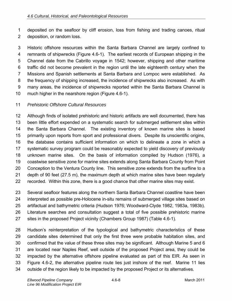
Historic offshore resources within the Santa Barbara Channel are largely confined to 3
remnants of shipwrecks (Figure 4.6-1). The earliest records of European shipping in the 4
Channel date from the Cabrillo voyage in 1542; however, shipping and other maritime 5
traffic did not become prevalent in the region until the late eighteenth century when the 6
Missions and Spanish settlements at Santa Barbara and Lompoc were established. As 7
the frequency of shipping increased, the incidence of shipwrecks also increased. As with 8
many areas, the incidence of shipwrecks reported within the Santa Barbara Channel is 9
much higher in the nearshore region (Figure 4.6-1). 10
Prehistoric Offshore Cultural Resources 11
Although finds of isolated prehistoric and historic artifacts are well documented, there has 12
been little effort expended on a systematic search for submerged settlement sites within 13
the Santa Barbara Channel. The existing inventory of known marine sites is based 14
primarily upon reports from sport and professional divers. Despite its unscientific origins, 15
the database contains sufficient information on which to delineate a zone in which a 16
systematic survey program could be reasonably expected to yield discovery of previously 17
unknown marine sites. On the basis of information compiled by Hudson (1976), a 18
coastwise sensitive zone for marine sites extends along Santa Barbara County from Point 19
Conception to the Ventura County line. This sensitive zone extends from the surfline to a 20
depth of 90 feet (27.5 m), the maximum depth at which marine sites have been regularly 21
recorded. Within this zone, there is a good chance that other marine sites may exist. 22
Several seafloor features along the northern Santa Barbara Channel coastline have been 23
interpreted as possible pre-Holocene in-situ remains of submerged village sites based on 24
artifactual and bathymetric criteria (Hudson 1976; Woodward-Clyde 1982, 1983a, 1983b). 25
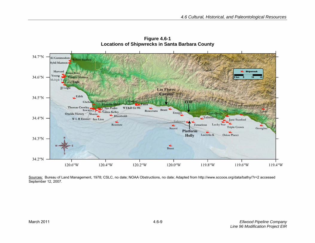
Literature searches and consultation suggest a total of five possible prehistoric marine 26
sites in the proposed Project vicinity (Chambers Group 1987) (Table 4.6-1). 27
Hudson’s reinterpretation of the typological and bathymetric characteristics of these 28
candidate sites determined that only the first three were probable habitation sites, and 29
confirmed that the value of these three sites may be significant. Although Marine 5 and 6 30
are located near Naples Reef, well outside of the proposed Project area, they could be 31
impacted by the alternative offshore pipeline evaluated as part of this EIR. As seen in 32
Figure 4.6-2, the alternative pipeline route lies just inshore of the reef. Marine 11 lies 33
outside of the region likely to be impacted by the proposed Project or its alternatives. 34
4.6 Cultural, Historical, and Paleontological Resources
March 2011 4.6-9 Ellwood Pipeline CompanyLine 96 Modification Project EIR
Figure 4.6-1 Locations of Shipwrecks in Santa Barbara County
Sources: Bureau of Land Management, 1978; CSLC, no date; NOAA Obstructions, no date; Adapted from http://www.sccoos.org/data/bathy/?r=2 accessed September 12, 2007.
4.6 Cultural, Historical and Paleontological Resources
Ellwood Pipeline Company Line 96 Modification Project EIR
4.6-10 March 2011
Table 4.6-1 Prehistoric Marine Cultural Resources in the Project Vicinity
Site Size Distance from Shore Location
Marine 5 104 acres 98 feet (30 m) south of Naples
Marine 6 33 acres one mile (1.6 km) near Naples Reef
Marine 11 8.6 acres 492 feet (150 m) near Ellwood Pier
Marine 45 unknown one-half mile (900 m) near Naples
Marine 54 unknown just offshore Coal Oil Point
Source: Adapted from Chambers Group 1987.
Figure 4.6-2 Location of Shipwrecks in the Project Vicinity
Historic Offshore Cultural Resources 1
As the population of Santa Barbara, and California in general, increased throughout the 2
twentieth century, the Santa Barbara Channel became a prominent shipping route for 3
ships traveling between northern and southern California. The construction of Stearn’s 4
Wharf in 1872, and the Santa Barbara breakwater in 1928, provided the groundwork for 5
the completion of the eventual present day Santa Barbara harbor, further increasing the 6
shipping industry in Santa Barbara. Commerce from shipping, especially in the fishing 7

4.6 Cultural, Historical, and Paleontological Resources
March 2011 4.6-11 Ellwood Pipeline CompanyLine 96 Modification Project EIR
and oil industries, began to flourish through the 1960s when two new harbors were built in 1
Ventura County, vastly increasing the access of recreational and industrial vessels to the 2
Santa Barbara Channel. 3
The widespread availability of a valuable commodity such as oil in the Channel led the oil 4
companies to actively increase exploration offshore of Santa Barbara. Concurrently with 5
the larger fleets of boats came an increase in shipping accidents. Shipwreck data 6
obtained from the Bureau of Land Management (BLM) (BLM, 1978), National Oceanic 7
and Atmospheric Administration (NOAA) obstructions database, and the California State 8
Lands Commission (CSLC) shipwreck database indicate the possibility of up to five 9
shipwrecks in the vicinity of the proposed Project (Table 4.6-2). The probable or known 10
locations of these wrecks in relation to Project facilities and alternatives are shown in 11
Figure 4.6-2. 12
Table 4.6-2 Shipwrecks in the Project Vicinity
Vessel Name
Type Year Built
Date Lost
Tonnage Length Latitude Longitude
Brant¹ Oil Screw 1926 May 1960
149 96 ft N34°26'48.43" W120°01'10.43"
Ensign² Four-Masted
Schooner 1904
Jan 1909
618 >150 ft N34°24'59.99" W119°57'03.40"
Suomi² Racing Yacht
--- April 1955
--- 49 ft N34°21’59.99” W120°00’03.40”
Tenacious¹²׳ --- --- --- --- --- N34°23’00.00” W119°53’03.39”
Unknown² --- --- --- --- --- N34°22'59.99" W119°55'03.40"
Sources: ¹NOAA Dogs Obstruction Database; ²Bureau of Land Management, 1978
A literature review conducted as part of this EIR provided site-specific details and 13
histories for each of the shipwrecks. In particular, narratives by Ruhge (2000) and 14
Wheeler (1984), lend insight into the great degree of uncertainty in the final locations of 15
the shipwrecks. As with most shipwreck data, offshore locations were poorly measured 16
and documented due to the lack of points of reference and the emergency nature of most 17
accidents. In addition, post-abandonment drift, burial, and salvage operations can also 18
affect the location of shipwreck remains. Details of each of the relevant five shipwrecks 19
are as follows: 20
Brant. On May 8, 1960, the 96-foot long, 149-ton oil exploration Vessel Brant caught fire 21
while offshore of El Capitan. Fearing explosion, the crew of eight abandoned the ship 22

4.6 Cultural, Historical and Paleontological Resources
Ellwood Pipeline Company Line 96 Modification Project EIR
4.6-12 March 2011
while still under power. The Brant apparently continued to run under power, in circles, for 1
several miles until it finally sank. 2
A 12-mile discrepancy exists between the location of the Brant in the NOAA obstructions 3
database and its plotted location in the CSLC shipwrecks database (Figure 4.6-1). This 4
inconsistency was resolved by bathymetric data collected in 2007 that show the remains 5
of the Brant on the seafloor approximately one mile offshore of El Capitan State Beach 6
(Figure 4.6-2). An ROV dive conducted on 4 February 2007 confirmed the Brant’s 7
location at a depth of 136 feet (41.5 m). The wreckage had been extensively dismantled 8
and spread over the ocean floor in a manner that is consistent with the report of its 9
sinking (Wheeler 1984). 10
The location of the Brant is adjacent to where the alternative offshore pipeline route would 11
land at the LFC facility. However, as the Brant lies approximately 0.7 mile (1,130 m) to 12
the east, its cultural significance is not likely to be impacted by this alternative. 13
Ensign. The sailing vessel Ensign was a 150-foot long, four-masted schooner that 14
displaced 618 tons. It grounded in dense fog on the reef of Naples Point on 20 January 15
1909. Waves forced the Ensign further along the saw-toothed reef, severely damaging 16
the hull and preventing Captain Melberg from navigating off of the reef. Eventually, 17
waves forced the ship onto shore where it was abandoned. Years of heavy winter surf 18
and artifact collectors took their toll on the wreckage, with the result that nothing remains 19
of the Ensign today (Ruhge 2000). 20
As with the Brant, Figure 4.6-1 shows two separate locations for the Ensign that are the 21
result of differences between the CSLC and BLM shipwreck databases. The 15.76 mi 22
(25.36 km) discrepancy between the two databases seen in Figure 4.6-1 places the 23
coordinates from the BLM database closest to the actual location of the shipwreck, but 24
still sites it approximately 1.25 mi (2 km) offshore of Naples Point. However, the 25
shipwreck was extensively photographed when it was grounded on the shoreline. 26
Therefore, although the BLM location is shown in Figure 4.6-1, it should be noted that the 27
actual location of the shipwreck is along the shoreline, where it is even farther removed 28
from potential impacts from the proposed Project, but closer to the alternative offshore 29
pipeline route. 30
Suomi. On the morning of 22 April 1955, the 49-foot racing vessel Suomi collided with 31
the Swedish freighter, Parramatta. Of the five man crew of the Suomi, only one body was 32
ever recovered. The body that was recovered was missing one leg that was presumed to 33
have been cut off by the vessel’s propeller during the accident (Wheeler 1968). The crew 34

4.6 Cultural, Historical, and Paleontological Resources
March 2011 4.6-13 Ellwood Pipeline CompanyLine 96 Modification Project EIR
of Parramatta struck the smaller Suomi without hearing or seeing the collision. After 1
sensing that they had hit something when they saw a light in their wake, the crew of the 2
Parramatta notified the Coast Guard. The exact location of the remains of the Suomi is 3
not known but it is presumed to lie about nine miles southwest of Platform Holly. The 4
location is well offshore of the alternative pipeline route and no vessel matching the size 5
of the Suomi appeared on the high-resolution bathymetric data collected in 2007. 6
Tenacious. Little information is available for the Tenacious, other than that it was 7
reported to have sunk 1.3 mi (2.1 km) southeast of Platform Holly, in both the BLM and 8
NOAA databases. However, the reported position lies within one of the largest oil seeps 9
in the region and close to the seep tent (Figure 4.6-2). If the location is accurate, it can be 10
presumed that the wreck of the Tenacious would not be impacted by the proposed 11
Project activities or alternatives. No evidence of this wreck was encountered in the 12
bathymetric data collected in 2007. 13
Unknown. The fifth ship is an unknown vessel from the BLM database that has no 14
literature to confirm its history or wreck location. The database locates the shipwreck 0.8 15
mi (1.28 km) southwest of Platform Holly. This location is well offshore of the Project 16
area, and if accurate, the shipwreck would not be impacted by the proposed Project 17
activities. Additionally, no evidence of this wreck was encountered in the bathymetric 18
data collected in 2007. 19
In addition to literary records searches, two detailed archeological analyses have been 20
conducted on seafloor data collected in the Project area. The first was a reinterpretation 21
by Hunter (1984abcd) of sidescan sonar and magnetometer data collected for the 22
proposed ARCO Coal Oil Point Project (Chambers Group 1986). He identified 67 23
anomalies that could not be otherwise attributed to geologic features, physical 24
oceanographic conditions, or system operation. Following a conservative interpretation 25
approach, these 67 anomalies were designated "potential cultural properties”. 26
The second evaluation of seafloor features for cultural significance was conducted in 27
2007 as part of the Venoco Full Field Development Project (Appendix F). This analysis 28
was based on a high-resolution multibeam bathymetric survey and photo documentation 29
by remotely operated vehicle (ROV) and covered areas applicable to the currently 30
proposed Project. The main survey area extended 2600 feet (800 m) on either side of the 31
existing pipeline route from Platform Holly to the EOF (Figure 4.6-2). Additional areas of 32
investigation during the 2007 survey included nearshore areas by the EMT, and a swath 33
4.6 Cultural, Historical and Paleontological Resources
Ellwood Pipeline Company Line 96 Modification Project EIR
4.6-14 March 2011
near the suspected wreckage of the Brant near LFC. Bathymetry over the surveyed 1
areas surveyed extended from a water depth of 16 feet (5 m) to 250 feet (76 m). 2
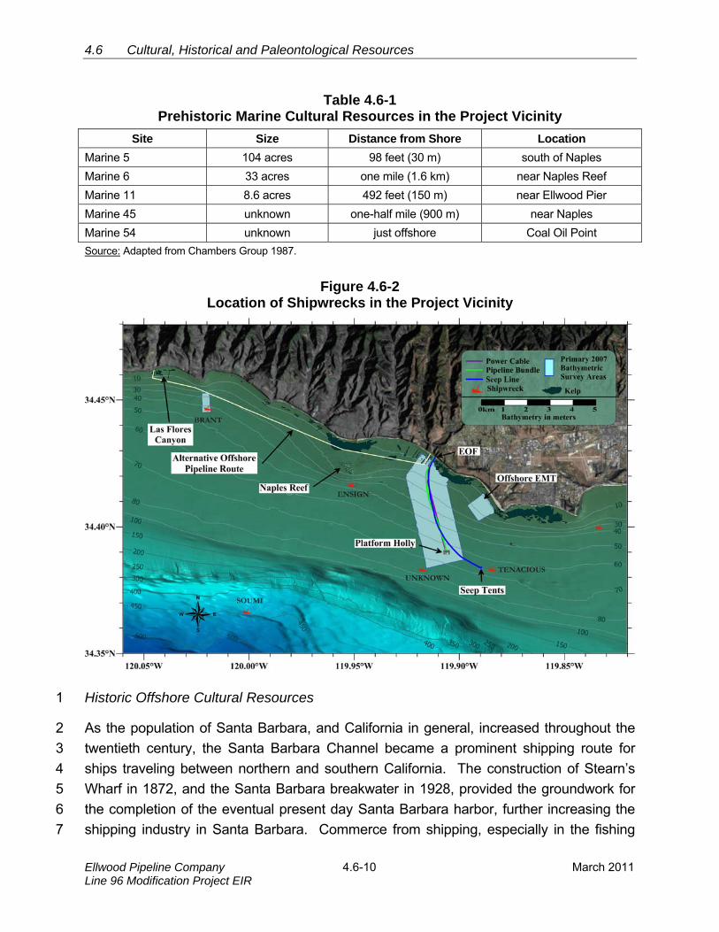
The extensive history of offshore oil and gas development in the Project area affects the 3
ability to search for offshore cultural resources by occasionally interfering with recording 4
and interpreting of electronic evidence of shipwrecks. Offshore oil and gas exploration 5
and development dating from as far back as the 1890s have left the seafloor riddled with 6
anchor drag marks, production and transport facilities, abandoned well sites, abandoned 7
equipment, and debris (see Figure 4.6-3). 8
Figure 4.6-3 Locations of Original Oil Production Piers and Remaining Seafloor Debris
Although large scale offshore exploration of the Project area did not truly begin until the 9
1950s with development of the Naples area by Phillips Petroleum, a large number of 10
wells were drilled near the surf zone at various locations during the 1930s and 1940s (see 11
inset photo in Figure 4.6-3). These and other features are often detectable on swath 12
bathymetric, side-scan sonar, and magnetometer records, and in some cases, may mask 13
evidence of shipwrecks and other submerged cultural resources. In particular, substantial 14
alteration of local magnetic fields by well casings, pipelines, ferromagnetic debris, and 15
production platforms can render magnetometry data almost useless in affected areas. 16
4.6 Cultural, Historical, and Paleontological Resources
March 2011 4.6-15 Ellwood Pipeline CompanyLine 96 Modification Project EIR
Of a total of 592 seafloor features identified from the bathymetric data collected in 2007, 1
almost half were ascribed to active and abandoned fishing gear, particularly crab and 2
lobster traps. The locations of the 67 Hunter anomalies did not coincide with features 3
identified during analysis of the high-resolution bathymetry of the area acquired in 4
2007(Appendix F), nor did they coincide with seafloor obstructions listed in NOAA’s 5
Automated Wreck and Obstruction Information System (NOAA 2007). 6
Based on the analysis of seafloor features in the Project area conducted in 2007, it is 7
unlikely that any of the original Hunter anomalies represent actual cultural features. 8
Although discrepancies between the location of the Hunter anomalies and seafloor 9
features identified in more recent datasets may be due to improvements in navigational 10
accuracy, it is more likely that the majority of Hunter anomalies were actually derelict crab 11
or lobster traps. 12
An initial screening of seafloor features for potential cultural interest was conducted by 13
interpreting high-resolution acoustic images within the swath bathymetric database. 14
Often, the acoustic signature of a target seafloor feature is an indirect representation of 15
the actual shape of the object, which may be partially buried. Consequently, interpretation 16
of acoustic signatures is not always conclusive as to the origin of the seafloor feature, or 17
its cultural significance. For example, of the 592 features observed during the 2007 18
seafloor survey, 23 percent were categorized as unidentified bottom features (UBFs). 19
Some of the larger UBSs were further investigated with magnetometer surveys and ROV 20
dives. 21
Screening of seafloor features for their potential archaeological significance depends on a 22
range of acoustic-image characteristics that are often indicative of cultural origin. The 23
screening analysis used on the 2007 survey data examined the following characteristics 24
of the acoustic images: 25
Size and shape; 26
Aspect ratios; 27
Sharp angular edges and 90-degree elements; 28
Definitive shadows; 29
High acoustic reflectivity of the target; and 30
Consideration of the surrounding geology and uniformity of the surrounding 31
seafloor. 32
Even when some of the characteristics are indicative of anthropogenic (human) origin, 33
acoustic images seldom have the resolution necessary to definitively distinguish cultural 34
4.6 Cultural, Historical and Paleontological Resources
Ellwood Pipeline Company Line 96 Modification Project EIR
4.6-16 March 2011
features from other seafloor features and debris. For example, of the 592 acoustic 1
seafloor features that were screened in the analysis, over 42 percent of the features were 2
determined to be seafloor crab or lobster pots. These weighted pots are generally made 3
out of a wood or wire-mesh frame in which bait is placed inside to attract the lobsters or 4
crabs. A rope with a small buoy extends from the pot to the surface so that the fishermen 5
can identify and retrieve their pots. 6
Pots that are lost or abandoned by fishermen can persist for long periods of time as 7
seafloor debris. Pots frequently become abandoned or lost when boats unknowingly pass 8
over surface marker buoys, thereby cutting the pot line. Also, the winter months of the 9
open-lobster fishing season often coincide with high surf and wind associated with 10
seasonal storms. These oceanographic forces can also cause the surface marker buoys 11
to become detached, leaving the rope suspended in the water column and the pot 12
unrecoverable. Although the acoustic signature of the pots on the seafloor is small, the 13
air-filled lines that project upward result in a strong acoustic signature, often extending 14
well above the seafloor. 15
Over 18 percent of the features in the initial screening database were identified as 16
seafloor debris, consisting of naturally-occurring or manmade objects that are not of 17
cultural significance. Some readily identifiable seafloor features in the screening dataset 18
were clearly associated with existing equipment and pipelines. They included the 19
nearshore outfalls near the EOF and LFC facilities, and the six EMT moorings, each 20
consisting of an anchor, attached chain, and surface buoy. This mooring spread is 21
currently used by the Barges Jovalan and Olympic Spirit during oil-loading operations. 22
Other prominent seafloor features were artificial and naturally occurring reefs that 23
accounted for over six percent of the features in the screening database. A series of 24
artificial reefs were produced by demolition of the oil piers shown in Figure 4.6-3. Natural 25
reefs, although few in number, cover larger areas of the seafloor, as described in Section 26
4.5 Biological Resources. Other seafloor features determined to be debris of non-cultural 27
interest were also generally large, up to 50 feet (15 m) in length, and occurred randomly 28
throughout the survey area. 29
In particular, natural hydrocarbon seeps provide a strong acoustic signature. Three 30
known seeps and one seepage area were identified in the screening database. The 31
largest seep is the Shane Seep, which is found within the EMT offshore loading area. The 32
two remaining identifiable seeps, the Holoil and Sea Dog Seeps, as well as a dispersed 33
seepage area were all found within the survey swath along the existing pipeline route to 34
the EOF. 35
4.6 Cultural, Historical, and Paleontological Resources
March 2011 4.6-17 Ellwood Pipeline CompanyLine 96 Modification Project EIR
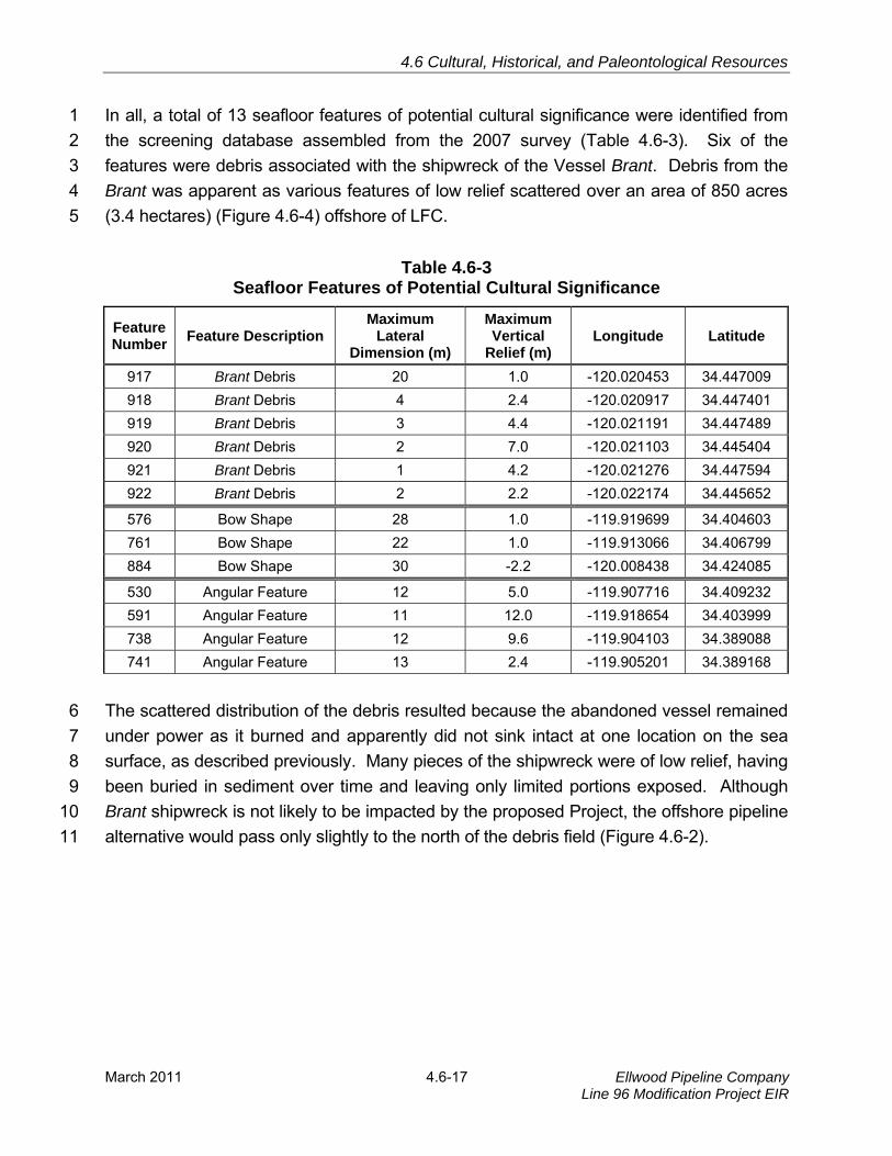
In all, a total of 13 seafloor features of potential cultural significance were identified from 1
the screening database assembled from the 2007 survey (Table 4.6-3). Six of the 2
features were debris associated with the shipwreck of the Vessel Brant. Debris from the 3
Brant was apparent as various features of low relief scattered over an area of 850 acres 4
(3.4 hectares) (Figure 4.6-4) offshore of LFC. 5
Table 4.6-3 Seafloor Features of Potential Cultural Significance
Feature Number
Feature Description Maximum
Lateral Dimension (m)
Maximum Vertical
Relief (m) Longitude Latitude
917 Brant Debris 20 1.0 -120.020453 34.447009
918 Brant Debris 4 2.4 -120.020917 34.447401
919 Brant Debris 3 4.4 -120.021191 34.447489
920 Brant Debris 2 7.0 -120.021103 34.445404
921 Brant Debris 1 4.2 -120.021276 34.447594
922 Brant Debris 2 2.2 -120.022174 34.445652
576 Bow Shape 28 1.0 -119.919699 34.404603
761 Bow Shape 22 1.0 -119.913066 34.406799
884 Bow Shape 30 -2.2 -120.008438 34.424085
530 Angular Feature 12 5.0 -119.907716 34.409232
591 Angular Feature 11 12.0 -119.918654 34.403999
738 Angular Feature 12 9.6 -119.904103 34.389088
741 Angular Feature 13 2.4 -119.905201 34.389168
The scattered distribution of the debris resulted because the abandoned vessel remained 6
under power as it burned and apparently did not sink intact at one location on the sea 7
surface, as described previously. Many pieces of the shipwreck were of low relief, having 8
been buried in sediment over time and leaving only limited portions exposed. Although 9
Brant shipwreck is not likely to be impacted by the proposed Project, the offshore pipeline 10
alternative would pass only slightly to the north of the debris field (Figure 4.6-2). 11

4.6 Cultural, Historical and Paleontological Resources
Ellwood Pipeline Company Line 96 Modification Project EIR
4.6-18 March 2011
Figure 4.6-4 Debris from the Vessel Brant
Other features determined to be of potential cultural significance were identified based on 1
the criteria listed above focusing mostly on aspect ratios, angular features, and the 2
surrounding geology. For example, a ballast pile may lay transverse to the strike of an 3
area's rock exposures, or exhibit something in the reflection that does not appear natural, 4
such as a right angle within the acoustic signature. Nevertheless, distinguishing an 5
underwater shipwreck ballast pile from a natural seafloor rock outcropping is challenging. 6
Three features, in addition to the Brant, were identified in Table 4.6-3 as potential 7
shipwrecks based on a combination of their length to width ratios as well as their shapes. 8
Watercraft lengths are generally three to six times their beam width, so isolated outcrops 9
can resemble the remains of a historic or prehistoric vessel regardless of size. All three 10

4.6 Cultural, Historical, and Paleontological Resources
March 2011 4.6-19 Ellwood Pipeline CompanyLine 96 Modification Project EIR
features, however, had profiles resembling that of a ship with a narrow nose, resembling 1
the bow, and the widest area at the center of the body. Figure 4.6-5 shows one of the 2
potential shipwrecks and the distinct vessel-like shape of the feature. 3
Figure 4.6-5 Seafloor Feature Number 576
However, given that the outline of the feature is a depression, it is likely that this feature is 4
actually a scar that resulted from bottom trawling. Bottom trawling is a form of fishing 5
common in the Project area in which a net is towed along the seafloor. In contrast, a 6
sunken vessel would likely be partially exposed above the seafloor, as is the case with 7
the Brant debris, which has slight vertical relief despite extensive burial. Nevertheless, 8
without independent confirmation, the possibility that Features 576, 761, and 884 9
represent shipwrecks cannot be ruled out. On the other hand, Feature 576 was located 10
700 m from the existing Platform Holly-EOF pipeline corridor and is unlikely to be 11
impacted by the proposed Project activities. Similarly, Feature 884 was highly localized 12
and located well west of the Project area. Although Feature 761 was located along the 13
existing pipeline route, no visual evidence of artifacts or other anthropogenic material 14
related to this feature was observed during the ROV surveys conducted in 2007. 15
4.6 Cultural, Historical and Paleontological Resources
Ellwood Pipeline Company Line 96 Modification Project EIR
4.6-20 March 2011
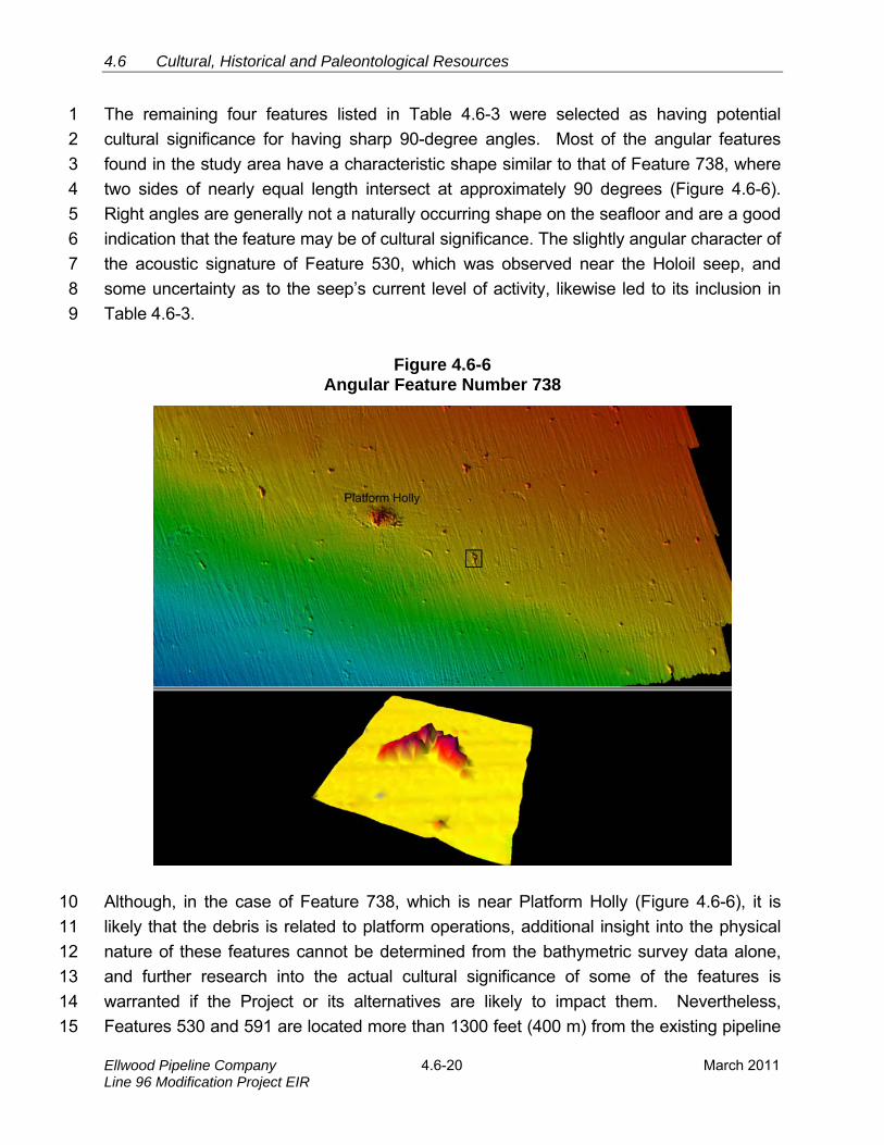
The remaining four features listed in Table 4.6-3 were selected as having potential 1
cultural significance for having sharp 90-degree angles. Most of the angular features 2
found in the study area have a characteristic shape similar to that of Feature 738, where 3
two sides of nearly equal length intersect at approximately 90 degrees (Figure 4.6-6). 4
Right angles are generally not a naturally occurring shape on the seafloor and are a good 5
indication that the feature may be of cultural significance. The slightly angular character of 6
the acoustic signature of Feature 530, which was observed near the Holoil seep, and 7
some uncertainty as to the seep’s current level of activity, likewise led to its inclusion in 8
Table 4.6-3. 9
Figure 4.6-6 Angular Feature Number 738
Although, in the case of Feature 738, which is near Platform Holly (Figure 4.6-6), it is 10
likely that the debris is related to platform operations, additional insight into the physical 11
nature of these features cannot be determined from the bathymetric survey data alone, 12
and further research into the actual cultural significance of some of the features is 13
warranted if the Project or its alternatives are likely to impact them. Nevertheless, 14
Features 530 and 591 are located more than 1300 feet (400 m) from the existing pipeline 15
4.6 Cultural, Historical, and Paleontological Resources
March 2011 4.6-21 Ellwood Pipeline CompanyLine 96 Modification Project EIR
corridor where Project activities are likely to occur; while the two others, Features 738 and 1
741, lie well offshore of Platform Holly. 2
Offshore Paleontological Resources 3
Since the height of the last glaciation about 18,000 years ago, warming climates have 4
melted much of the polar ice caps and resulted in rapidly rising sea levels that have 5
covered much of the continental shelf. It has been recognized that the now submerged 6
portions were likely occupied by humans during the late Pleistocene and early Holocene 7
eras, leading to the assumption that early cultural sites may now lay offshore. However, 8
offshore paleontological resources are generally found on rocky substrates rather than 9
the sandy bottom conditions prevalent in the Project area. Paleontological sites are 10
normally discovered in cliffs, ledges, steep gullies, or along wave-cut terraces where 11
vertical rock sections are exposed. Additionally, any fossils found in the Project area 12
would likely be widely occurring, abundant, fairly well preserved, and predictable as to 13
their association with a larger fossil site. Therefore, the same or similar fossils can be 14
located at any number of sites throughout Central California, and are not endemic to the 15
Project area. 16
4.6.2 REGULATORY SETTING 17
4.6.2.1 Federal 18
Cultural Resources 19
Any shipwrecks discovered in Federal waters would be covered under the Federal 20
Abandoned Shipwreck Act in accordance with Section 43 U.S.C. 2105(d) that states that 21
any shipwreck that is on Federal land is the property of the United States Government. 22
4.6.2.2 State 23
Cultural Resources 24
The California Coastal Act of 1976 (Public Resources Code [PRC] Sections 30000 et 25
seq.), as amended, addresses impacts on archaeological resources. Section 30244 26
requires reasonable mitigation measures where development would adversely impact 27
archaeological resources as identified by the State Historic Preservation Officer. 28

4.6 Cultural, Historical and Paleontological Resources
Ellwood Pipeline Company Line 96 Modification Project EIR
4.6-22 March 2011
The State CEQA Guidelines Sections 15064.5 and 15126.4 provide the basis for 1
determining the significance of archaeological and historical resources. Their application 2
to the proposed Project is discussed below in Section 4.6.3, Significance Criteria. 3
Paleontological Resources 4
There is no Federal legislation designed specifically for the management and protection 5
of paleontological resources, and most states do not have laws or guidelines for the 6
preservation of fossil material. Professional societies such as the Society of Vertebrate 7
Paleontologists (SVP) and the Board of Earth Science of the National Research Council 8
have attempted, thus far unsuccessfully, to get Congress to approve legislation for 9
paleontological resources. Under strong pressure from the SVP and other organizations, 10
the U.S. House of Representatives and the Senate are considering bills that strengthen 11
the protection of vertebrate fossils through stronger penalties and provide clear 12
management guidelines to Federal land managers. 13
The California Coastal Act provisions are ambiguous and generalized as related to 14
paleontological resources. Where development would adversely impact paleontological 15
resources, as identified by the State Historic Preservation Officer, reasonable mitigation 16
measures are required. However, the statute does not indicate a specific procedure for 17
mitigating the loss of paleontological resources. 18
Section 5097.5 of the PRC prohibits excavation or removal of any “vertebrate 19
paleontological site or historical feature, situated on public lands, except with the express 20
permission of the public agency having jurisdiction over such lands.” Section 30244 21
requires reasonable mitigation of adverse impacts to paleontological resources from 22
development on public land. Penal Code Section 623 contains regulations for the 23
protection of caves, including their natural, cultural, and paleontological contents. It 24
specifies that no “material” (including all or any part of any paleontological item) will be 25
removed from any natural geologically formed cavity or cave. 26
4.6.2.3 Local 27
Cultural Resources 28
The Santa Barbara County Coastal Plan and the Goleta General Plan have several 29
polices that address the preservation of significant cultural resources. Policy 10-1 in the 30
County Plan states that all available measures must be explored to avoid development on 31
significant historic, prehistoric, archaeological and other classes of cultural sites. Policy 32

4.6 Cultural, Historical, and Paleontological Resources
March 2011 4.6-23 Ellwood Pipeline CompanyLine 96 Modification Project EIR
10-2 states that project design shall be required to avoid impacts on archaeological or 1
other cultural sites if possible. Policy 10-3 states that where avoidance of construction 2
impacts is not possible, adequate mitigation shall be required designed in accord with 3
State Office of Historic Preservation and Native American Heritage Commission 4
guidance. Policy 10-4 states that indirect activities including off-road vehicle use, 5
unauthorized artifact collection or similar actions capable of destroying or damaging 6
archaeological or cultural sites is prohibited. Policy 10-5 states that a Native American 7
representative shall be consulted when development is proposed that would potentially 8
impact significant archaeological or cultural sites. 9
Policies OS.8.3, 8.4, 8.5, 8.6 and 8.7 of the Goleta General Plan address protection of 10
Native American and paleontological resources. Policy OS 8.3 requires preservation of 11
cultural resources from destruction by avoidance. OS 8.4 requires preparation of a 12
Phase 1 cultural resources inventory by a qualified archaeologist for development in 13
areas of known archeological sensitivity. OS 8.5 requires mitigation to disturbances that 14
may occur in areas where avoidance is infeasible. Mitigation would be imposed in 15
accordance with cultural beliefs of the affected populations. OS 8.6 requires onsite 16
monitoring by a qualified archaeologist and appropriate Native American observer for all 17
grading, excavation and earth moving in areas identified as archaeologically sensitive. 18
Finally, OS 8.7 requires that work be stopped and the site studied in the event that 19
substantial paleontological resources are encountered. 20
Santa Barbara County Cultural Resource Guidelines provide direction to archaeologists 21
on what types of research topics and research questions are appropriate to determine the 22
significance of an archaeological site. The City of Goleta adopted the County Cultural 23
Resource Guidelines upon incorporation. 24
Paleontological Resources 25
There are no local guidelines, within the Santa Barbara County Coastal Plan, that 26
address the preservation of, or consideration for, paleontological resources during the 27
planning process. 28
4.6.3 SIGNIFICANCE CRITERIA 29
Cultural Resources 30
The State CEQA Guideline Section 15064.5 provides significance threshold criteria for 31
determining a substantial adverse change to the significance of a cultural resource: 32
4.6 Cultural, Historical and Paleontological Resources
Ellwood Pipeline Company Line 96 Modification Project EIR
4.6-24 March 2011
Substantial adverse change in the significance of an historical resource means 1
physical demolition, destruction, relocation, or alteration of the resource or its 2
immediate surroundings such that the significance of a historical resource would be 3
materially impaired. 4
The significance of a historical resource is materially impaired when a project demolishes 5
or materially alters in an adverse manner those physical characteristics of a historical 6
resource that: 7
(A) Justify its inclusion in, or eligibility for, inclusion in the California Register of 8
Historical Resources; 9
(B) Account for its inclusion in a local register of historical resources pursuant to 10
PRC Section 5020.1(k) of the or its identification in a historical resources 11
survey meeting the requirements of PRC Section 5024.1(g); or 12
(C) Convey its historical significance and that justify its eligibility for inclusion in 13
the California Register of Historical Resources as determined by a lead 14
agency for purposes of the CEQA. 15
Sections 15064.5 and 15126.4 of the State CEQA Guidelines define a significant cultural 16
resource, either prehistoric or historic, as a “historical resource.” A historical resource is 17
defined as: 18
A resource listed in, or determined to be eligible by the State Historical Resources 19
Commission, for listing in the California Register of Historical Resources (Pub. Res. 20
Code SS5024.1, Title 14 CCR, Section 4850 et seq.). 21
A resource included in a local register of historical resources, as defined in PRC Section 22
5020.1(k) or identified as significant in a historical resource survey as meeting the 23
requirements of PRC Section 5024.1(g), shall be presumed to be historically or culturally 24
significant. Public agencies must treat any such resource as significant unless the 25
preponderance of evidence demonstrates that it is not historically or culturally significant. 26
Any object, building, structure, site, area, place, record, or manuscript, which a lead 27
agency determines to be historically significant or significant in the architectural, 28
engineering, scientific, economic, agricultural, educational, social, political, military, or 29
cultural annals of California, may be considered to be a historical resource, provided the 30
lead agency’s determination is supported by substantial evidence in light of the whole 31
record. Generally, a resource shall be considered by the lead agency to be “historically 32

4.6 Cultural, Historical, and Paleontological Resources
March 2011 4.6-25 Ellwood Pipeline CompanyLine 96 Modification Project EIR
significant” if the resource meets the criteria for listing on the California Register of 1
Historical Resources (Pub. Res. Code SS5024.1, Title 14 CCR, Section 4852). These 2
resources of historic significance possess the following attributes: 3
Associated with events that have made a significant contribution to the broad 4
patterns of California’s history and cultural heritage; 5
Associated with the lives of persons important in our past; 6
Embodies the distinctive characteristics of a type, period, region, or method of 7
construction, or represents the work of an important creative individual, or 8
possesses high artistic values; or 9
Has yielded, or may be likely to yield, information important in prehistory or 10
history. 11
The fact that a resource is not listed in, or determined to be eligible for listing in the 12
California Register of Historical Resources, not included in a local register of historical 13
resources (pursuant to PRC 5020.1[k]), or identified in an historical resources survey 14
(pursuant to PRC 5024.1[g]) does not preclude a lead agency from determining that the 15
resource may be a historical resource as defined in PRC Sections 5020.1(j) or 5024.1. 16
Paleontological Resources 17
The State CEQA Guidelines Appendix G, Environmental Checklist Form, provides a 18
suggested significance threshold for paleontological resources as a threshold that would: 19
Directly or indirectly destroy a unique paleontological resource or site or unique 20
geologic feature. 21
Onshore Pipeline 22
If present, intact portions of CA-SBA-139, CA-SBA-83, CA-SBA-1676, and CA-SBA-1733 23
would be likely to yield information important in prehistory (Criterion d.). CA-SBA-139, 24
CA-SBA-83, CA-SBA-1676, and CA-SBA-1733 are, therefore, potentially significant 25
resources under the CEQA. 26
EOF 27
If present, unknown archaeological sites that would be buried approximately 10 feet 28
below the EOF and would date to approximately 10,000 years ago would have the 29
potential to increase understanding of the Paleoindian Period, and be likely to yield 30
4.6 Cultural, Historical and Paleontological Resources
Ellwood Pipeline Company Line 96 Modification Project EIR
4.6-26 March 2011
information important in prehistory (Criterion d.). These unknown sites are, therefore, 1
potentially significant resources under the CEQA. 2
EMT 3
If present, intact portions of CA-SBA-1327 and CA-SBA-2341 would have the potential to 4
increase understanding of how prehistoric populations exploited nearby foods, together 5
with marine resources in the vicinity, and be likely to yield information important in 6
prehistory (Criterion d.). CA-SBA-1327 and CA-SBA-2341, therefore, are potentially 7
significant resources under the CEQA. These resources would not be disturbed as part of 8
the proposed Project, but future environmental studies to evaluate abandonment of the 9
EMT and site restoration would need to consider impacts to these resources. 10
4.6.4 IMPACT ANALYSIS AND MITIGATION 11
Onshore Cultural Resources 12
Direct impacts on cultural resources result from ground disturbances directly and 13
immediately caused by pipeline construction, operation or maintenance, and the 14
abandonment and partial removal of the existing Line 96 between the EOF and EMT. 15
Indirect impacts resulting from increased access to archaeological sites (i.e., construction 16
or facility employees) include unauthorized artifact collecting. 17
The Line 96 Pipeline would be abandoned in place with the exception of two locations on 18
the Ellwood Mesa: 19
An approximately 2,400-foot section located on the south side of Phelps Road, 20
and extending west from Pacific Oaks Road to the western terminus of Phelps 21
Road (except a short segment that crosses Phelps Ditch, a designated ESHA). 22
This area is in undeveloped open space with nearby residential development. 23
An approximately 400-foot section located on the Ellwood Mesa property, in 24
undeveloped open space. This area is characterized by mixed coastal scrub and 25
non-native annual grassland, generally south of the east-west trending Devereux 26
Creek riparian corridor (a designated ESHA), and north of the eucalyptus windrow 27
(also a designated ESHA) that trends north-south along the Ellwood Mesa eastern 28
property boundary. 29
Pipeline within these areas would be physically removed. The remainder of the pipeline 30
would be left intact. 31

4.6 Cultural, Historical, and Paleontological Resources
March 2011 4.6-27 Ellwood Pipeline CompanyLine 96 Modification Project EIR
Impact CR-1: Disturbance and Damage to Cultural Resources During Grading 1
Grading and excavation associated with construction of the proposed Project 2
pipeline facilities at the EOF would involve ground disturbing activities that could 3
potentially result in disturbance to unknown archaeological sites buried below 4
the EOF (Potentially Significant Class II). 5
Impact Discussion 6
If intact cultural remains were encountered during grading and excavation at the EOF, the 7
potential for destruction of these remains would be a significant impact. 8
Mitigation Measures 9
MM CR-1a. Archeological Monitoring: All ground disturbances associated with 10
construction of the proposed Project at the EOF that extend into soils shall 11
be monitored by a qualified archaeologist and a local Native American 12
representative as per the Goleta General Plan OS 8.6 and OS 8.7. If 13
cultural resources of potential importance are uncovered during 14
construction, the grading shall cease and the City shall be notified within 15
24 hours. A qualified archaeologist shall prepare a report assessing the 16
significance of the find and provide recommendations regarding 17
appropriate disposition. Disposition will be determined by the City in 18
conjunction with the affected Native American nation. 19
MM CR-1b. Pre-construction Workshop: A pre-construction workshop shall be 20
conducted by a qualified archaeologist and a Native American 21
representative from the affected Native American Nation. All construction 22
personnel who would work, during any phase of ground disturbance, shall 23
be required to attend the workshop. To ensure participation in the 24
workshop, attendance records will be monitored for all personnel who 25
attend the workshop. Additionally, upon completion of the workshop, 26
hardhat stickers will be issued to denote the completion of workshop 27
training. The workshop shall: 28
1. Review the types of archaeological artifacts that may be 29
uncovered; 30
2. Provide examples of common archaeological artifacts to 31
examine; 32

4.6 Cultural, Historical and Paleontological Resources
Ellwood Pipeline Company Line 96 Modification Project EIR
4.6-28 March 2011
3. Review what makes an archaeological resource significant to 1
archaeologists and local Native Americans; 2
4. Review procedures that shall be used to record, evaluate, and 3
mitigate new discoveries; and 4
5. Describe reporting requirements and responsibilities of 5
construction personnel. 6
Rationale for Mitigation 7
Mitigation Measures MM CR-1a and MM CR-1b would help reduce the potential for 8
impacts on unknown, potentially significant cultural resources buried below the EOF. 9
Impact CR-2: Construction Grading and Excavation at CA-SBA-139 10
Grading and excavation associated with construction of the proposed Project 11
would potentially result in disturbance to unknown CA-SBA-139 deposits 12
(Potentially Significant, Class II). 13
Impact Discussion 14
If intact cultural remains were encountered during grading and excavation at CA-SBA-15
139, the potential for destruction of these remains would be a significant impact. 16
Mitigation Measures 17
MM CR-2a. Avoid Disturbances to CA-SBA-139: The new onshore pipeline shall be 18
redesigned or relocated, to the extent feasible, in order to avoid 19
disturbances to CA-SBA-139. Directional drilling shall be considered as a 20
method to avoid the site. 21
MM CR-2b. Phase 2 Study: A Phase 2 significance assessment investigation shall 22
be conducted if avoidance of CA-SBA-139 is not feasible. If found to be 23
significant, a Phase 3 data recovery mitigation program shall be 24
conducted. 25
MM CR-2c. Archeological Monitoring: All ground disturbances associated with 26
construction of the new onshore pipeline within the documented CA-SBA-27
139 site boundary shall be monitored by a qualified archaeologist and a 28
Native American representative from the affected Native American Nation. 29
4.6 Cultural, Historical, and Paleontological Resources
March 2011 4.6-29 Ellwood Pipeline CompanyLine 96 Modification Project EIR
MM CR-2d. Avoidance and Unanticipated Discoveries Plan: Prepare an 1
Avoidance and Unanticipated Discoveries Plan, as per CCC requirements, 2
including provisions for an archeological monitor, data recovery program, 3
Native American monitor, and guidelines addressing immediate actions to 4
be taken should a discovery be made. 5
Rationale for Mitigation 6
Mitigation Measures MM CR-1b through MM CR-2c would help reduce the potential for 7
impacts on potentially significant cultural resources at CA-SBA-139. Mitigation measure 8
MM-CR-2d would address considerations should a discovery be made during excavation. 9
Impact CR-3: Grading and Excavation Access to CA-SBA-139 10
Grading and excavation associated with construction of the proposed Project 11
would result in a short-term increase in access to archaeological artifacts 12
associated with CA-SBA-139 and the potential for unauthorized collection 13
(Potentially Significant, Class II). 14
Impact Discussion 15
CA-SBA-139 would potentially be exposed during grading and excavation, and personnel 16
would have increased access to artifacts during the short-term construction period. 17
Potential unauthorized collection of artifacts during grading and excavation would 18
contribute to the destruction of site integrity and would be a significant adverse impact 19
that could be reduced below significance (Class II) with implementation of Mitigation 20
Measures MM CR-1b and MM CR-2c. 21
Mitigation Measures 22
Mitigation Measures MM CR-1b and MM CR-2c would reduce potential impacts on 23
cultural resources resulting from unauthorized artifact collection. 24
Rationale for Mitigation 25
Mitigation Measures MM CR-1b and MM CR-2c would help minimize the potential for 26
increased illicit artifact collection during grading and excavation activities by educating 27
construction workers regarding the importance of preserving the location and integrity of 28
individual archaeological artifacts. 29
4.6 Cultural, Historical and Paleontological Resources
Ellwood Pipeline Company Line 96 Modification Project EIR
4.6-30 March 2011
Impact CR-4: Grading and excavation access to CA-SBA-83, CA-SBA-1676, and 1
CA-SBA-1733 2
Grading and excavation associated with construction of the proposed Project 3
would potentially result in a short-term increase in access to archaeological 4
artifacts associated with CA-SBA-83, CA-SBA-1676, and CA-SBA-1733, and the 5
potential for unauthorized collection (Potentially Significant, Class II). 6
Impact Discussion 7
Even though subsurface deposits at CA-SBA-83, CA-SBA-1676, and CA-SBA-1733 are of 8
questionable integrity, artifacts associated with the sites would potentially be exposed 9
during grading and excavation, and construction personnel would have increased access to 10
artifacts during this time. Potential unauthorized collection of artifacts during grading and 11
excavation would be a significant adverse impact that can be reduced below significance 12
(Class II) with implementation of Mitigation Measures MM CR-1b and MM CR-4a. 13
Mitigation Measures 14
MM CR-4 Archeologist Monitoring All ground disturbances associated with 15
construction of the new onshore pipeline within the documented CA-SBA-16
83, CA-SBA-1676, and CA-SBA-1733 site boundaries shall be monitored 17
by a qualified archaeologist and a local Native American representative. 18
Mitigation Measures MM CR-1b and MM CR-4a would reduce potential impacts on 19
cultural resources resulting from unauthorized artifact collection. 20
Rationale for Mitigation 21
Mitigation Measures MM CR-1b and MM CR-4a would help minimize the potential for 22
increased illicit artifact collection during grading and excavation activities by educating 23
construction workers regarding the importance of preserving the location and integrity of 24
individual archaeological artifacts. 25
Impact CR-5: Oil Spill Impacts 26
Potential oil spills from the operational pipeline have the potential to affect 27
cultural resources resulting from subsequent cleanup and remediation activities 28
(Potentially Significant, Class II). 29
4.6 Cultural, Historical, and Paleontological Resources
March 2011 4.6-31 Ellwood Pipeline CompanyLine 96 Modification Project EIR
Impact Discussion 1
The primary concern would be spills in areas adjacent to coastal drainages that have a 2
high sensitivity for prehistoric archaeological resources. (Potentially Significant, Class II). 3
Mitigation Measures 4
Mitigation Measure MM CR-1b would reduce potential impacts on cultural resources 5
resulting from cleanup and remediation activities of potential pipeline oil spills. 6
Rationale for Mitigation 7
Mitigation Measure MM CR-1b would help reduce the potential for impacts on potentially 8
significant cultural resources. 9
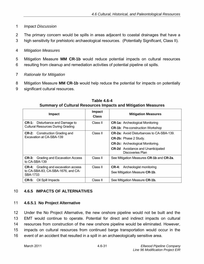
Table 4.6-4 Summary of Cultural Resources Impacts and Mitigation Measures
Impact Impact
Class Mitigation Measures
CR-1: Disturbance and Damage to Cultural Resources During Grading
Class II CR-1a: Archeological Monitoring
CR-1b: Pre-construction Workshop
CR-2: Construction Grading and Excavation at CA-SBA-139
Class II CR-2a: Avoid Disturbances to CA-SBA-139.
CR-2b: Phase 2 Study.
CR-2c: Archeological Monitoring.
CR-2d Avoidance and Unanticipated Discoveries Plan
CR-3: Grading and Excavation Access to CA-SBA-139
Class II See Mitigation Measures CR-1b and CR-2a.
CR-4: Grading and excavation access to CA-SBA-83, CA-SBA-1676, and CA-SBA-1733
Class II CR-4: Archeologist monitoring
See Mitigation Measure CR-1b.
CR-5: Oil Spill Impacts Class II See Mitigation Measure CR-1b.
4.6.5 IMPACTS OF ALTERNATIVES 10
4.6.5.1 No Project Alternative 11
Under the No Project Alternative, the new onshore pipeline would not be built and the 12
EMT would continue to operate. Potential for direct and indirect impacts on cultural 13
resources from construction of the new onshore pipeline would be eliminated. However, 14
impacts on cultural resources from continued barge transportation would occur in the 15
event of an accident that resulted in a spill in an archaeologically sensitive area. 16
4.6 Cultural, Historical and Paleontological Resources
Ellwood Pipeline Company Line 96 Modification Project EIR
4.6-32 March 2011
Currently, lease agreements for the operations of the EMT will expire in 2013 and/or 2016 1
(see Section 2.0, Project Description). It is assumed that, under the No Project 2
Alternative, after the lease expirations, the Applicant would pursue alternative means of 3
crude oil transport such as pipeline or truck transportation. The impacts of these 4
transportation modes are described in the Venoco Ellwood EMT Lease Renewal Project 5
Final EIR (CSLC 2009). Any future crude oil transportation options would be subject to 6
appropriate agency reviews and approval. 7
4.6.5.2 Oil Processing on Platform Holly with a New Pipeline to Shore and 8
Onshore Pipeline Route to the PPLP Coastal Pipeline tie-in near LFC 9
Under this alternative, processing would be moved to Platform Holly and a large portion of 10
the EOF equipment would be removed. The onshore pipeline would still be installed and 11
used for transportation of the crude oil to the PLPP Coastal Pipeline. Impacts would be 12
similar to the proposed Project except that there would be an increased opportunity for 13
discovery of archeological remains at the EOF due to the increased decommissioning 14
activities at the EOF. Therefore, impact CR-1 would be somewhat greater, but impacts 15
could still be mitigated to Class II with implementation of MM CR-1a and MM CR-1b. All 16
other impacts would be the same as the proposed Project. Replacement of the existing 17
offshore oil pipeline between Platform Holly and the EOF would also have a less than 18
significant impact to offshore archaeological resources. 19
Impact CR-6: Effects on Offshore Archaeological Resources 20
Activities could damage, disrupt, or adversely diminish the quality of an 21
important prehistoric or historic archaeological resource or a historical resource 22
such that its integrity would be diminished (Less than Significant, Class III). 23
Two of the five shipwrecks that have been identified in the general vicinity of the Project 24
have been physically located. The remains of the Brant are close to the alternative 25
offshore pipeline route. The second ship known to exist in the Project area, the Ensign, 26
was widely documented and photographed when it grounded on the shoreline adjacent to 27
Naples reef, although no remains of the ship are present today. The remaining three 28
ships documented to have wrecked in the Project area do not have exact known 29
locations; however, analysis of the high-resolution bathymetric data collected during the 30
2007 survey of the Project area did not reveal definitive evidence of any shipwrecks other 31
than the Brant. Based on this data, it is presumed that all other shipwrecks are located 32
outside of the Project area. As the pipeline route from Platform Holly to the EOF has been 33
4.6 Cultural, Historical, and Paleontological Resources
March 2011 4.6-33 Ellwood Pipeline CompanyLine 96 Modification Project EIR
well surveyed, and the route would follow much the same path as the existing pipeline 1
bundles, impacts from the proposed new pipeline from Platform Holly to the EOF to 2
archaeological resources would be less than significant (Class III), and no mitigation 3
would be required. 4
Impact CR-7: Potential Disturbance to Offshore Paleontological Resources 5
Activities could damage or disturb paleontological resources including Chumash 6
midden sites due to offshore modifications to existing facilities (Less than 7
Significant, Class III). 8
Due to the mud and sand depositional environment of the Project area, as well as the age 9
of any artifacts, it is presumable that any paleontological resources have been long-since 10
buried. Previous research of the Project area completed for the ARCO 1986 EIR 11
identified 67 potential paleontological resources (Chambers Group 1986). Modern data-12
collection techniques performed for this EIR used more accurate high-resolution 13
bathymetric data and found that very few of the potential sites matched between the two 14
datasets. It is possible that, over time, deposition and seafloor disturbance has either 15
buried or moved the sources of the anomalies. However, it is more likely that the original 16
anomalies were misidentified crab and lobster pots. The large high-relief angular acoustic 17
signatures of these anomalies arise from long lines that are attached to the pots and float 18
upward in the water column. 19
Prehistoric Chumash midden sites in the Project area have been described in very 20
general terms that do not give great detail of their precise whereabouts. Furthermore, the 21
sites are confined to shallow waters and are not known to exist past depths of the 90 foot 22
(27.5 m) isobath. If Project activities were to come into contact with an ancient midden 23
site, the impact would be significant and non-mitigable (Class I). However, offshore 24
Project activities would not have an impact on the archaeological sites as many of the 25
proposed activities are further offshore and exceed the 90 foot isobath. Additionally, the 26
potential sites identified in the ARCO 1986 Coal Oil Point EIR were addressed because 27
the project included installation of the offshore oil platforms. Any prehistoric cultural 28
remains in the affected area would, therefore, have been impacted by the installation of 29
the platforms and pipelines that followed. Therefore, the proposed disposition is 30
considered a less than significant impact (Class III) and no mitigation is required. 31

4.6 Cultural, Historical and Paleontological Resources
Ellwood Pipeline Company Line 96 Modification Project EIR
4.6-34 March 2011
4.6.5.3 Offshore Pipeline Route from the EOF to the PPLP Coastal Pipeline tie-in 1
near LFC 2
This alternative would require a new, 12-mile (19-km) long offshore crude oil pipeline that 3
would be constructed from the EOF to LFC. The new, 6-inch (0.15 m) pipeline would 4
leave the EOF heading westerly through State waters to a point offshore of LFC. Landfall 5
would be achieved by directional drilling 3,500 feet (1,067m) from the LFC parking area 6
north of Highway 101 to an ocean outfall located approximately 2,500 feet (762 m) from 7
shore in water depths ranging between 35 feet to 50 feet (11 m to 15 m) below mean sea 8
level. Potential impacts to offshore paleontological resources (Impact CR-7) from this 9
alternative would be adverse as the alternative proposed pipeline would run adjacent to 10
known Chumash midden sites. 11
Impact CR-8: Effects on Offshore Archaeological Resources 12
Activities could damage, disrupt, or adversely diminish the quality of an 13
important prehistoric or historic archaeological resource or a historical resource 14
such that its integrity would be diminished (Potentially Significant, Class II). 15
There is potential for a significant impact if the new alternative offshore pipeline route 16
from Platform Holly to the LFC comes into contact with a prehistoric cultural site or a 17
shipwreck, such as the remains of the Brant. The remains of the Brant shipwreck lie one 18
mile south of El Capitan, very near the proposed alternative offshore pipeline route 19
(Figure 4.6-2). Preliminary review of bathymetric data identified the potential for the 20
presence of shipwrecks of potential cultural resource value in the proposed Project area. 21
Additionally, previous research (Chambers Group 1986) of the Project area identified 22
potential sites of paleontological concern. Since the proposed alternative pipeline route 23
lies outside of most of the previously surveyed areas, and is near to shore, it is possible 24
that a previously unknown cultural or archaeological resource could be damaged or 25
destroyed during installation of this offshore pipeline. Thus, a new impact, similar to 26
Impact CR-6, would be potentially significant and adverse (Class II), but reduced with 27
implementation of a measure that would require additional surveys of the area, and re-28
routing of the pipeline around any cultural or paleontological resources identified along 29
the proposed pipeline route. 30
Execution of this alternative would require mitigation necessitating a more thorough 31
survey of the pipeline route. With a comprehensive survey of the route, the pipeline 32
would be routed around features of cultural significance, including the Brant and other 33

4.6 Cultural, Historical, and Paleontological Resources
March 2011 4.6-35 Ellwood Pipeline CompanyLine 96 Modification Project EIR
shipwrecks. Nevertheless, impacts on cultural resources from this alternative would be 1
potentially significant (Class II). 2
Mitigation Measures 3
CR-8a. Prior to pipeline installation, the Applicant shall provide a detailed analysis 4
of side scan sonar and magnetometer data for the proposed pipeline route 5
between the shoreline and the 200 foot depth contour. The analysis shall 6
identify and analyze all magnetic and side scan anomalies that occur 7
within the pipeline corridor, which is defined as the lateral distance of one 8
kilometer (500 m on each side of the pipeline). The analysis shall also 9
include the potential significance of each anomaly identified within the 10
pipeline corridor. The Applicant must submit the side-scan sonar and 11
magnetometer data, and an accompanying report which analyzes the 12
data. Final approval from the State Lands Commission must be received 13
prior to pipeline installation. 14
CR-8b. The Applicant shall hire a qualified archaeologist and Native American 15
representative to analyze the pipeline route for the possibility of the 16
occurrence of Chumash midden sites within the pipeline corridor. If a site 17
of concern were to be identified by the archaeologist, the Applicant shall 18
propose a new pipeline route that does not come into contact or disturb 19
any prehistoric or ancient cultural sites. 20
Rationale for Mitigation 21
MM CR-3 would reduce potential impacts to cultural resources by discouraging the 22
construction of the alternative pipeline in areas that could contain relics of historical, 23
paleontological, or cultural importance. 24
Implementation of the above mitigation measures would identify and avoid disturbing 25
known and previously unknown shipwrecks of potential cultural resource value and is 26
sufficient to reduce potential impacts to a level of less than significant (Class III). 27
4.6.6 CUMULATIVE PROJECTS IMPACT ANALYSIS 28
Prehistoric archaeological sites are non-renewable resources that have been destroyed 29
at an alarming rate state-wide and locally. It has been estimated that more than 30
80 percent of all sites in coastal Santa Barbara have been destroyed by coastal 31
development. Therefore, the assessment of potential cumulative impact on cultural 32
4.6 Cultural, Historical and Paleontological Resources
Ellwood Pipeline Company Line 96 Modification Project EIR
4.6-36 March 2011
resources within the proposed Project area considers these past activities resulting in loss 1
of archaeological sites, along with other probable future project in the vicinity. 2
Cumulative projects (see Tables 4-1 through 4-3) would involve ground disturbances that 3
would potentially impact cultural resources in an archaeologically sensitive areas adjacent 4
to freshwater sources. 5
In many cases, site redesign or use of fill could minimize potentially significant, adverse 6
impacts. Total avoidance of cultural resources would not be reasonably expected, 7
however, and increased human activity in the vicinity of cultural resources would lead to 8
greater exposure, potential for unauthorized artifact collection and inadvertent disturbance 9
during construction. Therefore, cumulative impacts to archaeological resources caused 10
by past, present and future probable projects in the undeveloped coastal areas in the 11
vicinity of the EOF, the new onshore pipeline, and the EMT are considered significant. 12
The City of Goleta and Santa Barbara County both have policy considerations and 13
standard mitigations for addressing the potential for ground disturbances that impact 14
cultural resources, including requirements for surveys in archaeologically sensitive areas, 15
field investigations to precisely delineate site boundaries, significance assessments and, 16
when required to mitigate significant resources, data recovery programs. Construction 17
monitoring by qualified archaeologists and local Native American representatives is also 18
required for disturbances within archaeological site boundaries. These measures would 19
ensure that cumulative impacts on cultural resources would be reduced to less than 20
significant (Class III). 21