45:211: environmental geography soil and land module 5
TRANSCRIPT

45:211: Environmental Geography
Soil and Land
Module 5

45:211: Environmental Geography
Learning Objectives: Soil
• Know what is meant by soil texture and soil structure– Explain the importance of texture and structure
to human uses of soil
• Know what soil humus is and how it is important to fertility

45:211: Environmental Geography
Learning Objectives: Soil Degradation
• List four main causes of soil degradation worldwide
• Describe the processes of soil erosion by water and wind– Describe two examples of soil conservation
practices

45:211: Environmental Geography
Learning Objectives: Land Capability
• Understand the concept of land capability as used in Canada– List the categories of land use included in land
capability assessment in Canada– Explain the land capability rating scale for
agriculture

45:211: Environmental Geography
What is Soil?
• Soil is a mixture of minerals, organic material, living organisms, air, and water.– The soil, as the major medium for plant growth,
is the basic resource for all land use and development.
– Ecologically sustainable development must include the conservation and sustainable use of soils.

45:211: Environmental Geography
Soils and Land Use
• Soils have intrinsic properties related to their texture and structure.– Certain soils are better suited to cultivation,
others for construction, others for good drainage, others for moisture containment, etc.
• Soils occur in geographic locations, and competing pressures and priorities may bring about conflicts in land use.

45:211: Environmental Geography
World Soils
• Most of the Earth’s terrestrial surface (75%) is covered with soil.
• Each soil grades, with depth, into parent material. – There is a great diversity of soils on Earth,
because of parent material, weathering and soil forming processes (which depend on climate and moisture conditions).

45:211: Environmental Geography
Soil Sustainability
• Soil-making processes are slow, requiring from 200 to 1,000 years to form 2.5 centimeters of topsoil under normal environmental conditions.– One analysis of global soil erosion estimates
that, depending on the region, topsoil is currently being lost 16 to 300 times faster than it can be replaced by natural processes.

45:211: Environmental Geography
World Soil Suitability
Prime land11%
Too Dry28%
Too Wet10%
Too shallow22%
Permanently Frozen
6%
Chemically Imbalanced
23%

45:211: Environmental Geography
Soil resources• Soil composition
• Soil formation– Soil profile– Soil humus and fertility
• Soil Conditions– Texture and structure
• Soil erosion– Soil degradation and soil conservation

45:211: Environmental Geography
Soil Composition• The fundamental components of soils are
mineral particles, organic matter, water and air.– Mineral particles are inorganic materials derived
from rocks, by weathering. They are variable in size.
• The pore space, which is not occupied by minerals, organic matter and living organisms is filled with water and air.– Soil water and air typically make up about 50% of
the soil volume.

45:211: Environmental Geography
Soil Ecosystem
• Soil organic matter consists of living organisms (soil biomass), remains of organisms and organic compounds.
Soil organisms form a food web, and play a critical role in decomposition of organic residues, nutrient cycling and in the formation of soil structure.

45:211: Environmental Geography
The Functions of Soil• Soil’s essential functions are:
– Sustaining plant and animal life: The diversity and productivity of living things depends on soil
– Regulating water: Soil helps control where rain, snowmelt, and irrigation water goes. Water and dissolved solutes flow over the land or into and through the soil.
– Cycling nutrients: Carbon, nitrogen, phosphorus, and many other nutrients are stored, transformed, and cycled through soil.

45:211: Environmental Geography
The Functions of Soil (2)
– Filtering potential pollutants: The minerals and microbes in soil are responsible for filtering, buffering, degrading, immobilizing, and detoxifying organic and inorganic materials, including industrial and municipal by-products and atmospheric deposits.
– Supporting structures: Buildings and roads need stable soil for support, and archeological treasures associated with human habitation are protected in soils.

45:211: Environmental Geography
Soil Formation
• Parent Material - consists of rock layers with recent deposits from lava or glacial flows.
• Weathering - factors which bring about fragmentation or chemical change of parent material.

45:211: Environmental Geography
Weathering
• Mechanical Weathering - Temperature changes, moisture changes and abrasions are primary agents.
• Chemical Weathering - Small rock fragments exposed to atmosphere may oxidize, or otherwise chemically change when exposed to other elements.– Water is important

45:211: Environmental Geography
Soil Profile• A series of horizontal layers
of different chemical composition, particle size, and amount of organic matter.– Horizon - each recognizable
layer of the profile.
– There are significant differences in texture, structure and colour of the soil horizons in a profile.

45:211: Environmental Geography
Soil Humus
• Humus - is decaying organic material.
• It is an important factor in soil fertility and soil structure.– Humus becomes mixed with the top layers of
rock particles, and supplies some of the needed nutrients to plants.
– Humus also creates crumbly soil which allows adequate water absorption and drainage and permits good root penetration.

45:211: Environmental Geography
The Soil Profile• A Horizon - (Topsoil) the uppermost layer,
containing most of the organic matter and soil nutrients.
• B Horizon - (Subsoil) underneath topsoil.– Contains less organic matter and fewer
organisms, but accumulates nutrients leached from topsoil. Poorly developed in dry areas.
• C Horizon - Weathered parent material, with very little organic material.

45:211: Environmental Geography

45:211: Environmental Geography
• Grassland Soils – Usually have a deep A-Horizon.
• Low rainfall limits topsoil leaching.
– A-horizon supports most root growth.
• Forest Soils– Topsoil layer is relatively thin, but topsoil leachate
forms a subsoil that supports substantial root growth.
• Characteristic of high rainfall areas

45:211: Environmental Geography
Soil Texture
• Soil texture refers to the content of sand, silt and clay particles in soil.– Soil textural classes are determined by limits
set for the amount of sand, silt and clay in a particular soil.
• The textural triangle.
• Soil texture cannot be changed by land/soil management.

45:211: Environmental Geography
Soil Particles
• Gravel: rock fragments between 2mm and 75 mm in diameter
• Sand: Soil mineral particles between 0.05 and 2 mm in diameter
• Silt: Soil mineral particles between 0.002 and 0.05 mm in diameter
• Clay: Size fraction less than 0.002mm

45:211: Environmental Geography
Textural Triangle

45:211: Environmental Geography
Soil Properties• Soil texture affects soil
drainage, soil water holding capacity. Large pores between sand particles promote drainage and aeration in soil. – However, too many large
particles leads to extreme leaching.
– Too many small particles leads to poor drainage.
45:211: Environmental Geography
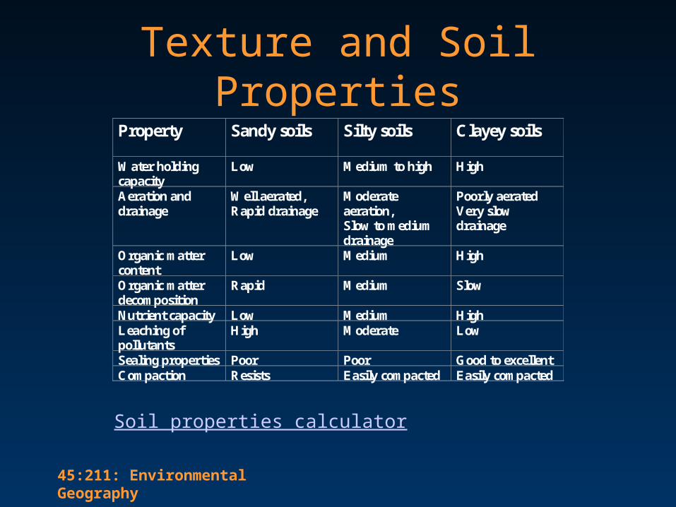
Texture and Soil PropertiesProperty Sandy soils Silty soils Clayey soils
Water holdingcapacity
Low Medium to high High
Aeration anddrainage
Well aerated,Rapid drainage
Moderateaeration,Slow to mediumdrainage
Poorly aeratedVery slowdrainage
Organic mattercontent
Low Medium High
Organic matterdecomposition
Rapid Medium Slow
Nutrient capacity Low Medium HighLeaching ofpollutants
High Moderate Low
Sealing properties Poor Poor Good to excellentCompaction Resists Easily compacted Easily compacted
Soil properties calculator

45:211: Environmental Geography
Soil Structure
• Refers to the way various soil particles clump together.– In good soils 2/3 of the intra-soil spaces contain
air after the excess water has drained.
• Soil structure is important for soil permeability, aeration, fertility and cultivation.
45:211: Environmental Geography
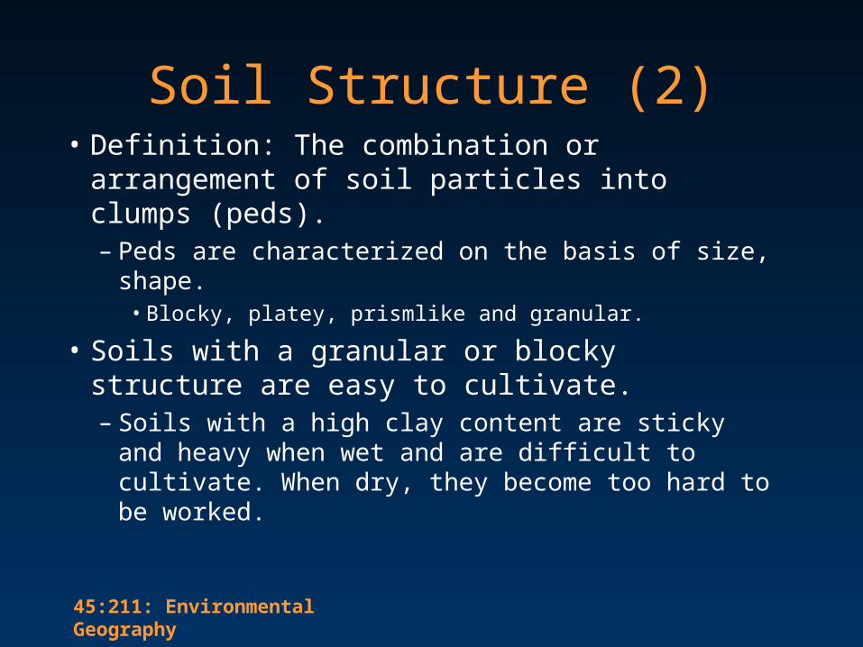
Soil Structure (2)• Definition: The combination or arrangement
of soil particles into clumps (peds). – Peds are characterized on the basis of size, shape.
• Blocky, platey, prismlike and granular.
• Soils with a granular or blocky structure are easy to cultivate. – Soils with a high clay content are sticky and
heavy when wet and are difficult to cultivate. When dry, they become too hard to be worked.

45:211: Environmental Geography
Soil Structure: summary• The particles in sandy soil do not attach to one
another; therefore, sandy soils have a granular structure.
• Clay particles tend to stick together to form large clods.
• Soils with a mixture of particle sizes (loams) tend to form smaller clods;– A good soil forms small clods that crumble easily.
– Friability is the soil’s ability to crumble

45:211: Environmental Geography
Improving Structure• The incorporation of humus into the soil
reduces the stickiness of wet soil and the hardness of dry soil.– This results in the improvement of soil structure,
making it more friable, • providing pathways for air and moisture
• providing ventilation of CO2 and promoting biological processes.
• Tilling can also be successful in breaking up soil clods and improving structure.

45:211: Environmental Geography
Soil Degradation• About 85 percent of the world's agricultural
land contains areas degraded by – erosion, – salinization,– waterlogging – compaction, – nutrient depletion, – biological degradation, – pollution.
45:211: Environmental Geography
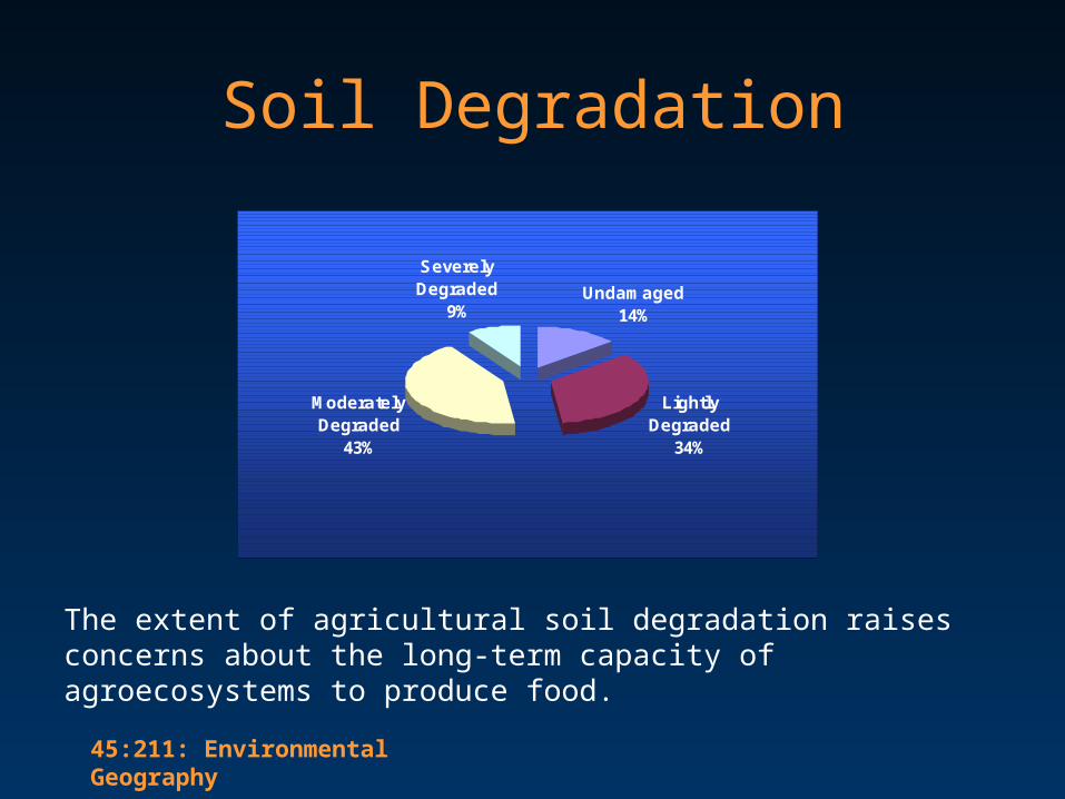
Undamaged14%
Lightly Degraded
34%
Moderately Degraded
43%
Severely Degraded
9%
Soil Degradation
The extent of agricultural soil degradation raises concerns about the long-term capacity of agroecosystems to produce food.

45:211: Environmental Geography
Soil Degradation

45:211: Environmental Geography
Soil Erosion• Erosion - the detachment and transportation of
soil particles by wind and water.– Worldwide, erosion removes 25.4 Billion tons/yr– Made worse by deforestation and desertification.– Poor agricultural practices increase erosion and lead
to the transport of associated fertilizers and pesticides.
• What normally protects soil from erosion?– Vegetation, organic content, water content

45:211: Environmental Geography
Soil Loss and Conservation
• When topsoil is lost, fertility is reduced or destroyed, thus fertilizers must be used to restore fertility.– Reduces productivity, and increases sediment
loads in waterways.– Over 50% of US land is suitable for agriculture,
but only 2% does not require some form of soil conservation practice.

45:211: Environmental Geography
Soil Conservation Practices
– Contour Farming: Tilling at right angles to the slope of the land. Each ridge acts as a small dam.
– Strip Farming: Alternating strips of closely sown crops to slow water flow.
– Terracing: Level areas constructed at right angles to the slope to retain water - good for very steep land.
– Windbreaks: Planting of trees or other plants that protect bare soil from the full force of the wind.

45:211: Environmental Geography
Managing for Soil Quality– Add organic matter: Regular additions of organic
matter are linked to many aspects of soil quality.
– Avoid excessive tillage: Tillage has positive effects, but it also triggers excessive organic matter degradation, disrupts soil structure, and can cause compaction.
– Increase ground cover: Bare soil is susceptible to wind and water erosion, and to drying and crusting. Ground cover protects soil.
45:211: Environmental Geography
Managing for Soil Quality (2)
– Carefully manage fertilizer and pesticide use: Pesticides and chemical fertilizers have revolutionized agriculture but they can harm non-target organisms and pollute soil water and air if mismanaged.
– Increase plant diversity: A diversity of soil organisms can help control pest populations, and a diversity of cultural practices can reduce weed and disease pressures.

45:211: Environmental Geography
Land resources
• Factors affecting land capability– Canada Land Inventory– Land suitability for agriculture
• Land use planning and zoning

45:211: Environmental Geography
Land Capability
• A measure of how well land and soil do what we want them to do. – Land capability is the capacity of a specific
kind of soil to function, within natural or managed ecosystem boundaries, to sustain plant and animal productivity, maintain or enhance water and air quality, and support human health and habitation.

45:211: Environmental Geography
Canada Land Inventory• The CLI was designed to provide information
for land development planning.– The broad objective of the CLI is to classify lands
as to their capabilities; to obtain a firm estimate of the extent and location of each land class and to encourage use of CLI data in planning.
– Lands are classified according to their physical capability for use in agriculture, forestry, recreation, and wildlife; and their present use.

45:211: Environmental Geography
CLI Classes
• For each of the four sectors - agriculture, forestry, recreation, and wildlife - there are seven classes used to rate land capability. – Class 1 lands have the highest and Class 7 lands
the lowest capability to support land use activities of each sector.
– Subclasses are used to identify specific limiting factors for each class.
• Land Capability Map

45:211: Environmental Geography
Land Use Planning
• Zoning - designating land for specific uses.– Often regulations made based on short-term
goals, ignoring long-terms needs. – Often planners represent business or
development interests.

45:211: Environmental Geography

45:211: Environmental Geography
Land Planning Conflicts• Loss of Farmland
– Flat, well-drained land is ideal for both farmland and urban development.
– Partial transformation often leads to whole transformation
• Floodplain Problems– Many cities located on floodplains
• Flat, nutrient rich
– Development increases potential economic losses

45:211: Environmental Geography
Land Planning Conflicts• Wetlands Misuse
– Many have been drained, filled, or used as landfills.– Wetlands play a crucial role in the reproductive
phase of many organisms.– Provide sediment filtration
• Other– Building on fault lines?– Building in dry areas ?– Floodplains

45:211: Environmental Geography
Summary• Soil is a mixture of minerals, organic
matter, living organisms and air.
• Soil texture and soil structure are important properties.
• Soil Profiles - Horizons A-C

45:211: Environmental Geography
Summary
• Erosion is the removal of soil via air or water.
• Soil conservation techniques can reduce erosion and soil degradation.
• Land capability assessment and land use zoning are intended to identify the optimal human uses of soil and land resources.