42chne008) matthews81la1 hambleton … · 42chne008) matthews81la1 hambleton 010 received ... t _^...
TRANSCRIPT

*V '
#?
42CHNE008) MATTHEWS81lA1 HAMBLETON 010
RECEIVEDAPR 18 1984
MINING LANDS SECTION
REPORT ON
ELECTROMAGNETIC AND MAGNETIC SURVEYS
FOR
HONCHO GOLD MINES INC. (Ill)
MATTHEWS LAKE PROPERTY
SAULT STE. MARIE MINING DIVISION, ONTARIO
April 3, 1984 Deborah A. McCombe
TENOQA CONSULTANTS INC.
42C14NE8ee) MATTHEWSeilA) HAMBLETON 010C
TABLE OF CONTENTS
tyf'.-' .^- : -' ' ' :- - - - ' Page'f ' '.,- ' - r '' : .'' -- \ ' . -'. '-'
;|| : 1.0 INTRODUCTION ———————-———————————————————————— l
;^ 2.0 LOCATION AND ACCESS ———————————————————————————— l
3.0 PROPERTY ———————————————————————————————————— l
A.O PREVIOUS WORK ————————————————————————————————— 2
V 5.0 GEOLOGY ————————————————————————————————————— 3
6.0 SURVEY PROCEDURE AND INSTRUMENTATION ———————————————— 3
;f 7.0 INTERPRETATION ———————————————————————————————— 3
8.0 CONCLUSIONS AND RECOMMENDATIONS ——————————————————— A
MAPS (in back pocket)
- VLF Survey (Part l and Part 2)- Magnetometer Survey (Part l and Part 2}
TENOGA CONSULTANTS INC.
SK -1-
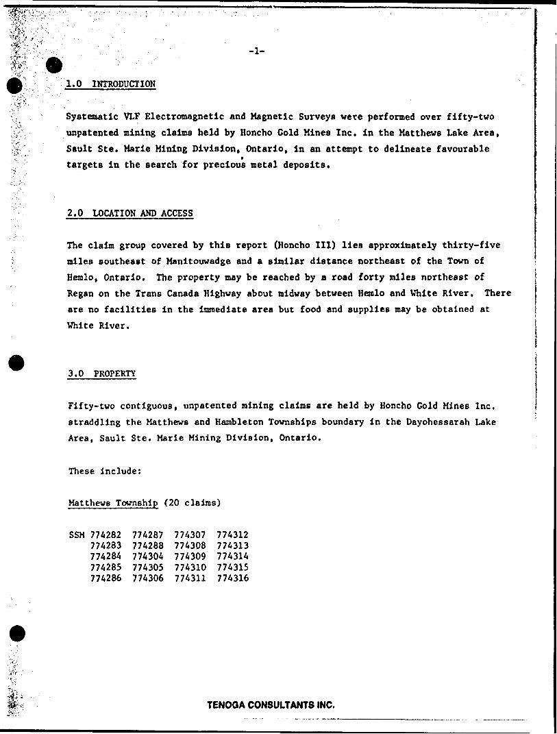
1.0 INTRODUCTION
Systematic VLF Electromagnetic and Magnetic Surveys were performed over fifty-two unpatented mining claims held by Honcho Gold Mines Inc. in the Matthews Lake Area, Sault Ste. Marie Mining Division, Ontario, in an attempt to delineate favourable targets in the search for precious metal deposits.
2.0 LOCATION AND ACCESS
The claim group covered by this report (Honcho III) lies approximately thirty-five miles southeast of Manitouwadge and a similar distance northeast of the Town of
Hemlo, Ontario. The property may be reached by a road forty miles northeast of Regan on the Trans Canada Highway about midway between Hemlo and White River. There are no facilities in the Immediate area but food and supplies may be obtained at White River.
3.0 PROPERTY
Fifty-two contiguous, unpatented mining claims are held by Honcho Gold Mines Inc. straddling the Matthews and Hambleton Townships boundary in the Dayohessarah Lake Area, Sault Ste. Marie Mining Division, Ontario.
These include:
Matthews Township (20 claims)
SSM 774282 774287 774307 774312774283 774288 774308 774313774284 774304 774309 774314774285 774305 774310 774315774286 774306 774311 774316
TENOOA CONSULTANTS INC.

'.'O'.
-2- 1Hambleton Township (32 claims)
SSM 774289 774290 774291 774292 774293 774294 774295 774296
774297 774298 774299 774300 774301 774302 774303 774317
774318 774319 774320 774321 774322 774323 774324 774325
774326 774327 774328 774329 774330 774331 774332 774333
4.0 PREVIOUS WORK
Little attention was given to ;his portion of northwestern Ontario in the past as it was felt that small greenstone belts did not lend themselves to the
occurrence of large mineral deposits.
During the period 1936-1940, underground development and some mining was per formed on two gold properties, the Hiawathe Mine on the west shore of
Kabinakagami Lake about thirty miles west of the Matthews Lake property and the Shenago Mine in Hawkings Township, a further twenty miles to the east-northeast.
Drom 1947-1951, diamond drilling by Lake Superior Mining Corporation Limited
outlined 89,000 tons of 0.27 oz/ton gold on the present west zone of International Corona Resources Limited in the Hemlo area.
In 1953, a copper-zinc-silver showing in the Manitouwadge area was staked thirty- five miles northwest of the Matthews property. Subsequent exploration led to the discovery of the Geco and Wilroy Mines.
In 1980, the original Lake Superior Mining Corporation was res*c'-d by the McKinnon-Larch partnership and optioned to Corona Resources. The combined
reserves of the three deposits outlined to date are in excess of 13.0 million tons grading 0.236 ounces of gold per ton.
TENOGA CONSULTANTS INC.

5.0 GEOLOGY
Most of the Matthews Lake property is covered by Precambrian age rocks. The claim group was staked to cover two bands of anphibolitic material striking in a northeasterly direction across the boundary between Matthews and Hambleton Townships (OGS Map 2129, K. G. Fenwick, 1967, l"-2 miles). Much of Matthews Township north and west of Matthews Lake is covered by heavy overburden and the geology is unknown. -
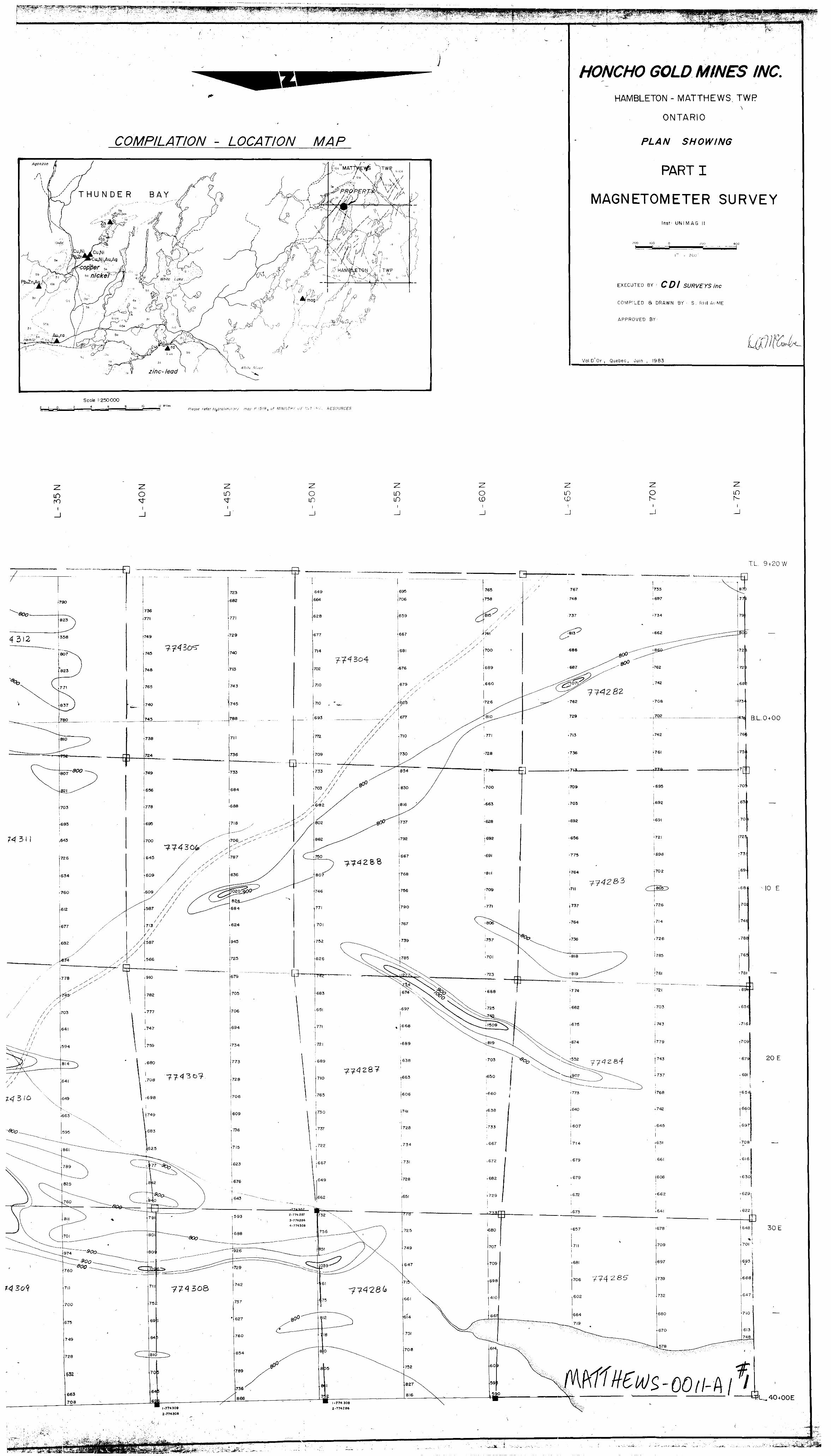
6.0 SURVEY PROCEDURE AND INSTRUMENTATION
The VLF Electromagnetic Survey was performed using an EM-16 unit manufactured by Geonics. Lines were cut at 500 foot spacings and the data was collected at 100 foot intervals. The frequency observed was 17.8 kHz and the survey was performed by CDI Surveys of Val d 'Or.
The Magnetic Survey was completed using a UNIMAG II unit manufactured by
Geometrics. Readings were observed at 100 foot stations in June 1983.
7.0 INTERPRETATION
Electromagnetic Survey
Three VLF conductors were outlined on Part I of the survey. The longest conductor trends northwesterly between L60N, 1W and L30N, 16E. There is a slight magnetic association and this conductor may be due to the presence of metavolcanics. The secondary conductors lie between L25N, 1W trending northwesterly from L15N, HE
and L5S, 9W trending northwesterly from L10S, 3W. There is no magnetic association with these conductors and further exploration is required to explain their
presence.
Four long VLF anomalies were outlined on Part 2. These include:
(1) L35S between l and 2W trending southeasterly to L50S, HE. Slight
flanking magnetic association.
TENOQA CONSULTANTS INC.

•vjjrV-:',-- - - ' . ' ' : - -" ' . . -4-m* ' : :Jfc (2) L55S, 1W trending easterly to 58S, HE. No magnetic association.
: i (3) L60S, 9W trending southeasterly to L75S, 111. No magnetic association.
(4) L70S, TL 42*45W trending slightly southeasterly to L90S, 32W. Magnetic " association.
Magnetic Survey
A long, narrow magnetic conductor trending north-south in the central portion of
the claim group le the major magnetic feature. This conductor appears at L54N between L30E and L33E and brpadens slightly at irregular intervals as it trends southwesterly off the southern edge of the claim group between L"*N and L22N. This conductor appears to correspond to the lineament mapped by K.G. Fenwick,
Ontario Geological Survey, 1967.
8.0 CONCLUSIONS AND RECOMMENDATIONS
The Honcho Gold Mines Inc. Ill property consists of fifty-two continguous mining
claims straddling the Hambleton-Matthews Township boundary, thirty-five miles
northeast of the Village of Hemlo, Ontario. As several geophysical conductors were outlined, a geological mapping program is recommended to expose and sample any areas of outcrop and any zone of fracturing, alteration and mineralization
which may assist in the explanation of the geophysical conductors.
TENOOA CONSULTANTS INC.

HAMBLETON
i.
Mining Lands SectionV' 'V'' •''"*v""..V ; v ' -' ,. "-
ControliSheet
900
Pile No
TYPE OP SURVEY
MINING LANDS COMMENTS:
GEOPHYSICAL
GEOLOGICAL
GEOCHEMICAL
EXPENDITURE
1 ./.-y.
i
H*
Signature of Assessor

l SSM j SSM; l ;x*s*Vl •' - •'•-••-- •~^'- !---'-:-f -.-'"^.~j'i-it -;':-'f'.-:^-.'i^'':'-^^f'^\^^^.-^T̂ ^^sfS-••y^^-^^^^i^^'^^^^^y^&^&A^^^^^!^^j 727395 j 72n941 727393 j 727392* '
-. V v ...^ l ̂ - ,y™-^, - -r^
. .
^ 727397 1727398 1727399L.——J^-f^-1-i^-^
773891 ) 773892 \]
_^ T - s*l |773880|77J^B8II 7T50B3jffaww l. *~*
rV^M /l c-ex ' ceM jf SSM l SS— i
SSM j SSM l SSM l
774282 774283 774284 J T-——————i.-————j-
SSM j SS* I^SM
743O4I 774288\j 77*587 j
HAMBLETON TWP. G-2768

Matthews Twp. (M. 1308)
774SZOI U 177431* 1774317 ____HI**'*! _____I..'
rr*2*Z I 77*293 77*Z9* I 77*293 - — — -1 — — __I___ — i - — —
l l77*3OO |77*SOl |77*3O2 J7743O3
l l l l l
^916*5988 j**5*y-
665894 66599O S
Ontario
Ministry of Natural Resources
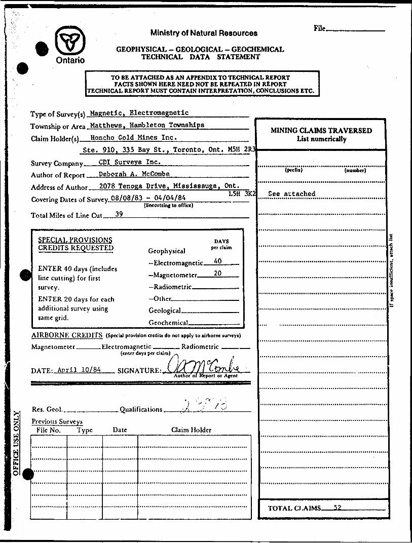
GEOPHYSICAL - GEOLOGICAL - GEOCHEMICAL TECHNICAL DATA STATEMENT
FUc.
TO BE ATTACHED AS AN APPENDIX TO TECHNICAL REPORTFACTS SHOWN HERE NEED NOT BE REPEATED IN REPORT
TECHNICAL REPORT MUST CONTAIN INTERPRETATION, CONCLUSIONS ETC.
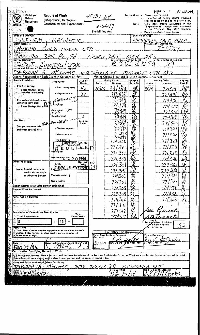
Type of Survey(s) Magnetic. ElectromagneticTownship or Area Matthews. Hambleton Townships Claim Holder(s) Honcho Gold Mines Inc.-———
Ste. 910, 335 Bay St., Toronto, Ont. M5H 2R3Survey Company GDI Surveys Inc.Author of Report Deborah A. McCombeAddress of Author 2078 Tenoga Drive. Mississauga. Ont.Covering Dates of Survey 08/08/83 - 04/04/84
(linecutting to office)
Total Miles of Line Hut 39____________
L5H SK!
SPECIAL PROVISIONS CREDITS REQUESTED
ENTER 40 days (includes line cutting) for first survey.ENTER 20 days for each additional survey using same grid.
Geophysical -Electromagnetic——^J)
20
DAYS per claim
-Radiometric.
Geological.firnrhrmiral.
AIRBORNE CREDITS (Special provision crediti do not apply to airborne turveyi)
__Electromagnetic _____ Radiometric ___.(enter dayi per claim)
Magnetometer.
HATR- April 10/84 SIGNATURE: yAuthbr'of Rtport or Agent
Res. Geol.., .Qualifications.Previous Surveys
File No. Type Date Claim Holder
MINING CLAIMS TRAVERSED List numerically
(number)
See attached
TOTAL CLAIMS 52

GEOPHYSICAL TECHNICAL DATA
GROuND SURVEYS - If more than one survey, specify data for each type of survey
Number of Stations J7Q4—— Station interval 100 ft.
Profile scale——————————Contour interval.
.Number of Readings EM-1704, Mag 1756
JLine tparing 500 ft._____________
100 gammas
os
Instrument. UNIMAG II. Geometries
Accuracy — Spale constant Diurnal correction method
l gainiualooping along adjacent lines, correcting to base station
Base Station check-in interval (hmirt) l hour—————————————————————,-—-—————- Base Station location and value, BL 1S400S. 59.815 gammas
u
o <s o s*
w
EM-16. ReonlcHInstrument .Coil configuration horiieontal loopCoil separation
Accuracy ———Method:
400 ft.4- .251 -l- IX
Frequency-CD Fixed transmitter
17.8 kHz. Cutter MaineD Shoot back G9 In line O Parallel line
Parameters measured.(ipcdfy V.L.F. tution)
In phase and quardature_______
b<e*o
Instrument.Scale constantCorrections made.
Base station value and location.
Elevation accuracy.
Instrument .———.—.—.—. 2 Method D Time Domain
Parameters — On time ——— - Off time —--
fe
— Delay time ———— Integration time.
D Frequency Domain _ Frequency_____ — Range————————
Power.Electrode array— Electrode spacing , Type of electrode
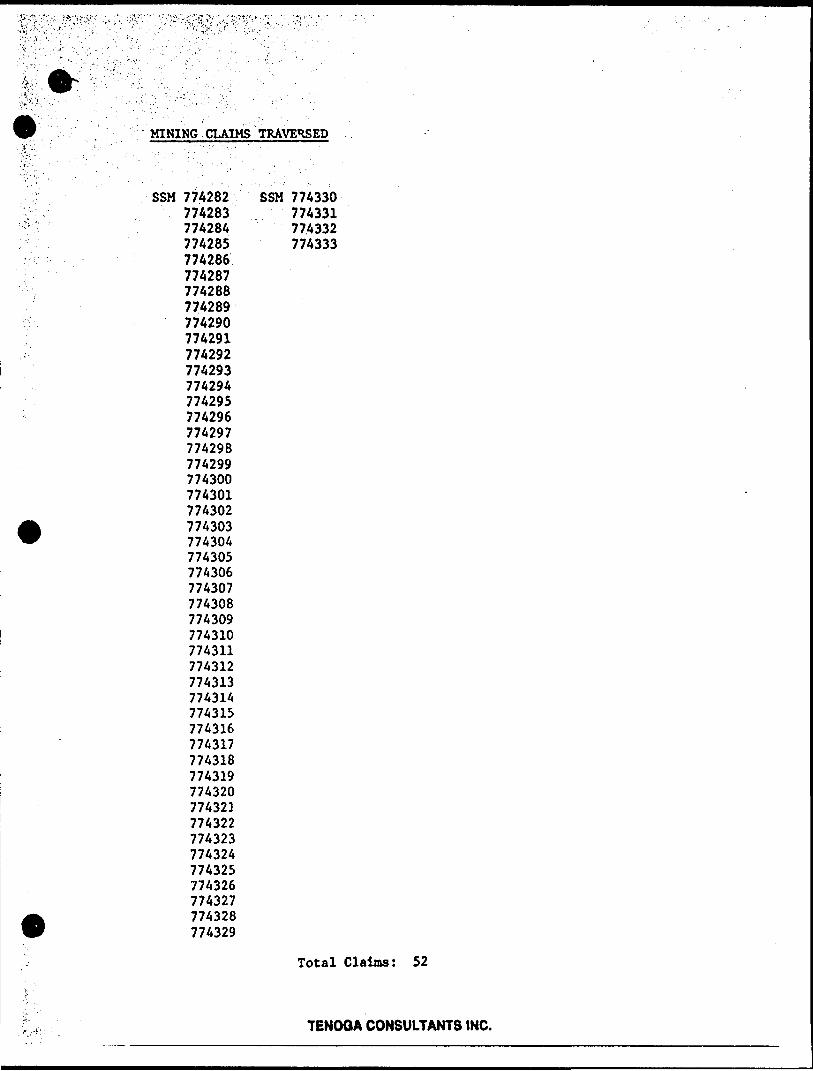
MINING CLAIMS TRAVERSED
SSM 774282774283774284 77A285774286774287774288774289774290774291774292774293774294774295774296774297774298774299774300774301774302774303774304774305774306774307774308774309774310774311774312774313774314774315774316774317774318774319774320774321774322774323774324774325774326774327774328774329
SSM 774330774331774332774333
Total Claims: 52
TENOQA CONSULTANTS INC.
wj-'' .Resource!Ontario
Report of Work (Geophysical, Geological, Geochemical and Expenditures)
The Mining Act
Imtructioni: - Plfjsc t y pt or print.- It number of mining claims travcrtpd
exceeds tpace on thit form, amch t lin,Not*: - Only riayi credits tnlculated in thp
"Expcnditurei" lection may bc enlcredin the "Expend. Dayl Cr." columnj.
- Do not use iharicd oreot below.
ir.
Type of SurveyU) ITownihlp or Area
J..'.I.. J.: '/t/Aj -? ..C-yj/^V /- ViiProipectbTi Licence No.
Addrei
Survey Company-ffi'ib.'r-.
7
Name tnd Addreii of Author (of Qto-Ttchnlcil riport)
——A)C.from ft lo) -. ITotal Mile* of lin* Cut
KCtA h/Cvi&j^-i-.-^a.. i ^.^~ . ^^. .^ . - 4 , --M- .. T .^ ILIP^.J-^ y . y
S7/ 3k3 ,-- -- -. - -..-. ̂.
Creoiti Requested per Each Claim in Columns at r^Special Provltloni
For firtt survey:
^ * Em*r 40 dayt. (Thh K,.-.fneludw lin* cutting)
For Men additional turvey: wing the lamr grid: r^
Enter 20 days (for eaVn)
Man Dayt
tComplete revert* tide nd enter totaUt) her*
Airborne Credit*
Not*: Special provljK.it credit! do not app'v to Airborne Survey*.
Oeophyilcal
- Electromagnetic
- Magnetometer
Oaochemlcal
- Electromagnetic
- Magnetometer
- Radiometric
El
Dayl perClaim
Dayl perClaim
.OtJ^HtW
K E C Elogical
. .1 l Dav* p" A.M. Claim
iiPii.iii.2m1l?C
Magnetometer k
Rid lo metric
Expenditures (excludes power stripping)
Mining Claims Traveised (List in nunierical sequence)
^Type of Work Performed- -'t , '
Perfof med on OaimU)
Calculation of Expenditure Dayt Credit!
: Total Expenditure!
iS -h 15
Total Day! Credit!
s
Inttructlont v. Total Dayi Credit! may be apportioned at the claim holder'! t! eKolc*. Entet number of day* cradltt per claim selected 'k; In columm at right.
_____Mining Claim Prefix Number
Expend. Dayt Cr Prefix
Mining ClaimNumber
—27d**
Expend. Da y i Cr,
Oat* t
M.^-Certification Verifying Report of
For Offirp Use O nixlotai Da vi C'. Recorded
fy**
Dite Rtco'dad
/'./X. J?^*JtT*rpprc
Minmp
ff*0
. ,^1 htrtby Ctnlfy thtt l/tvc l ptrtonsl end intimate knowledge of the fact) let forth in the Report of Wo'k annexed hereto, having performed the work j'1 tt w'ltrYetttd wme du/ing and/'or after its completion and the annexed report it true.''Nema and Poital Addreti'-cJ^p/rton Certifying
i

Ministry ot Natural * Resources
Technical Assessment Work Credlti
OntarioIStti
1984 07 26
Fit* j
2.6647Minino RtcotOn'i FUpori'of j Work No.. -.1-84
Recorded Holder
Township or AreaHONCHO GOLD MINES LIMITED
MATTHEWS LAKE
Type ol survey md number ol A*te*tm*nl days credit per claim Mining Cliimi An*u*d
Geophysical
20
Radiometric.
Induced polarization.
.deyt
. deyi
.deyt
. d*yi
SSM 774282-83-84 774286 to 314 incl 774316 to 324 incl 774327 774329 to 333 incl
Section 77 (19) S*e "Mining CUImi Aiittitd" column
Geological ———————————— ————— d*yi
Man days O
Special provision 0
Airborne Q
Ground E]
Q Credits have been reduced because ol partial coverage of claim*.
Q Credits have been reduced because of corrections to work dates and figures of applicant
Special credits under section 77 (16) for the following mining claims
30 days Electromagnetic 15 days Magnetometer
SSM 774285774315-25-28
20 days Electromagnetic 10 days Magnetometer
SSM 774326
l; No credits have been allowed for the following mining ci si mi
O not iuffici*rnly covtrtd by tht jurvry Lj Inefficient technical dm filed
*)Trie Mining Recorder may reduce the above credits If necessary In order that the total number of approved assessment days recorded on veach claim does not exceed the maximum allowed as follows: Geophysical — 60; Geological~ 40; Geochemical — 40; Section 77M9I—GO:

.Ministry of Natural Resources
1984 07 26
Mrs. M.V. St. JulesMining RecorderMinistry of Natural Resources875 Queen Street EastP.O. Box 669Sault Ste. Marie, OntarioP6A 5N2
Dear Madam:
Your File: Our File:
51-84 2.6647
m
ml ki ss.;^P:-.-3..:'4L'V.-." '**te
Enclosed are two copies of a Notice of Intent with statements listing a reduced rate of assessment work credits to be allowed for a technical survey. Please forward one copy to the recorded holder of the claims and retain the other. In approximately fifteen days from the above date, a final letter of approval of these credits will be sent to you. On receipt of the approval letter, you may then change the work entries on tne claim record sheets.For further information, if required, please contact Mr. R.J. Pichette at 416/965-488P.
Yours sincerely,
S.EyYundt Erector Land Management Branch
Whitney Block, Room 6643 Queen's Park Toronto, Ontario M7A 1W3
. Hurst:se
Ends.cc: Honcho Gold Mines Limited
Suite 910 335 Bay Street Toronto, Ontario M5H 2R3
cc: Mr. G.K. FergusonMining S Lands CommissionerToronto, Ontario
J45
cc: Resident GeologistSault Ste. Marie, Ontarioflue
fyt};./.'-.. -. ' '
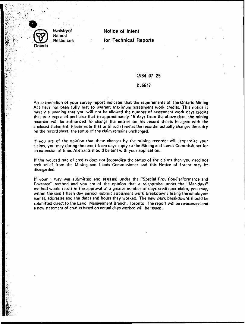
v — Ministryof Notice of Intent^- i -IT i NaturalfffT;; yVv Resources for Technical Reports
Ontario
1984 07 25
2.6647
An examination of your survey report indicates that the requirements of The Ontario Mining Act have not been fully met to warrant maximum assessment work credits. This notice is merely a warning that you will not be allowed the number of assessment work days credits that you expected and also that in approximately 15 days from the above date, the mining recorder will be authorized to change the entries on his record sheets to agree with the enclosed statement. Please note that until such timex as the recorder actually changes the entry on the record sheet, the status of the claim remains unchanged.
If you are of the opinion that these changes by the mining recorder will jeopardize your claims, you may during the next fifteen days apply to the Mining and Lands Commissioner for an extension of time. Abstracts should be sent with your application.
If the reduced rate of credits does not jeopardize the status of the claims then you need not seek relief from the Mining ano Lands Commissioner and this Notice of Intent may bo disregarded.
If your -Tvey was submitted and assessed under the "Special Provision-Performance and Coverage" method and you are of the opinion that a re-appraisal under the "Man-days" method would result in the approval of a greater number of days credit per claim, you may, within the said fifteen day period, submit assessment work breakdowns listing the employees names, addresses and the dates and hours they worked. The new work breakdowns should be submitted direct to the Land Management Branch, Toronto. The report will be re-assessed and a new statement of credits based on actual days worked will be issued.
t
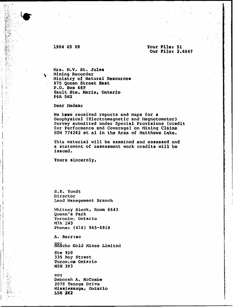
1984 03 09 Your Filei 51Our Pilot 2.6647
Mrs. M.V. St. JuleoMining RecorderMinistry of Natural Resources875 Queen Street BastP.O. Box 669Sault Ste. Marie, OntarioP6A 5N2
Dear Madami
We hvve received reports and maps for a Geophysical; (Electromagnetic and Magnetometer) Survey submitted under Special Provisions (credit for Performance and Coverage) on Mining Claims SSM 774282 et al in the Area of Matthews Lake.
Thifc material will be examined and assessed and a statement of assessment work credits will be issued.
Yours sincerely,
S.E. YundtDirectorLand Management Branch
Whitney Block, Room 6643Queon's ParkToronto r OntarioM7A 1W3Phonet (416) 965-6918
A. Barrtao
fiSAcho Gold Mines LimitedSte 910335 Bay Street Torontom Ontario M5H 2R3
cctDeborah A. KcCombe 2078 Tenoga Drive Mississauga, Ontario L5H 3K2

July 6. 1984 Filet 2.6647
Honcho told Mines Ltd Suite 9fg 335 BayfStreet Toronto; OntarioM5H 2R3 ,
Dear Sir:REt Geophysical (Magnetometer ft Electromagnetic) Survey
submitted on Mining Claims SSM 774283 et al 1n Matthews and Hambleton Townships
Returned herein art the plans (In duplicate) for the above-mentioned survey. Please show claim lines and claim numbers on all plans and return them to this office quoting flit 2.6647.
For further Information, please conttct Mr. Ray Pkhette at (116)965-4888.
Yours sincerely,
S.E. YundtDirectorLand Management Branch
Whitney Block, Room 6643 Queen's Park Toronto, Ontario M7A 1H3 Phone:(416)965-4888S. Hurst:mecc: Mining Recorder
Sault Ste. Marie, OntarioEncl.
-."f. f:.- .
#r*'.-.
l''
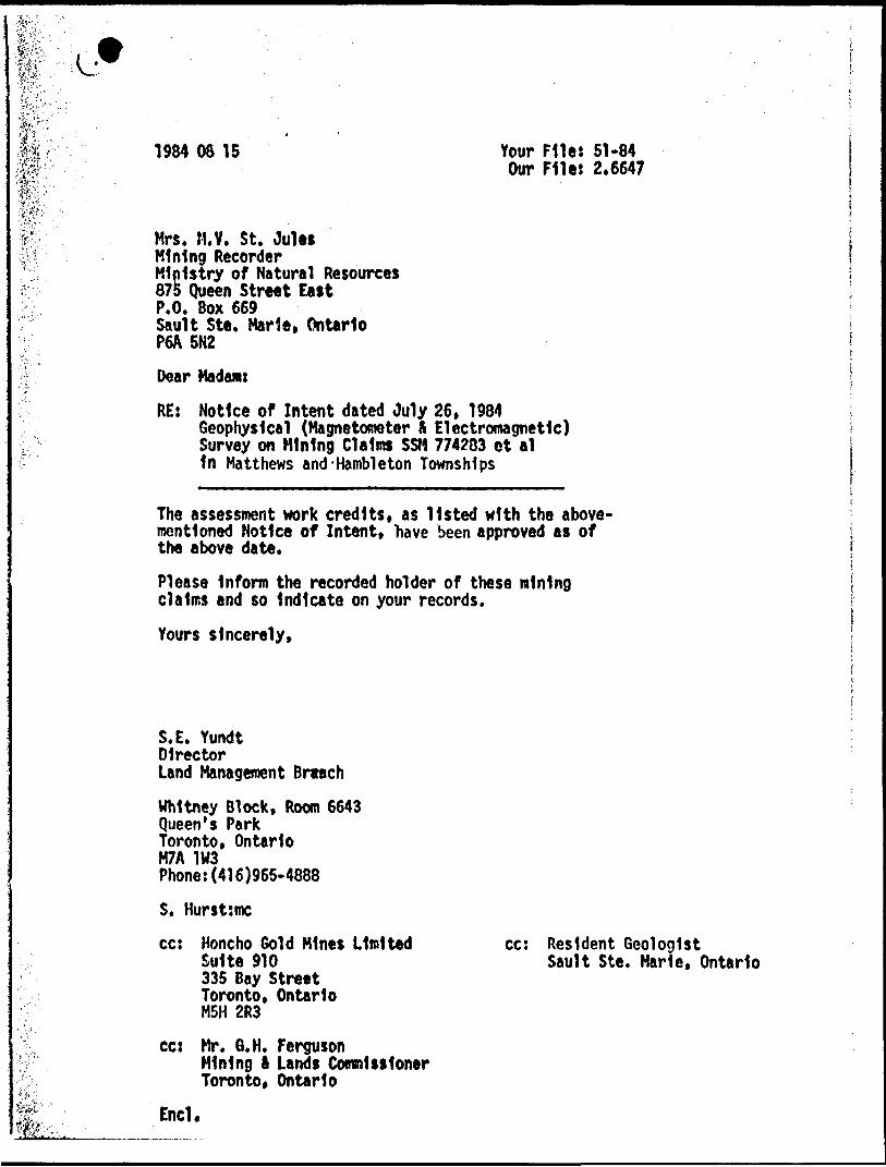
1984 08 15 Your File: 51-84Our File: 2.6647
Mrs. M.Y. St. JuleiMining RecorderMinistry of Natural Resources875 Queen Street EastP.O. Box 669Sault Ste. Marie, OntarioP6A 5N2
Dear Madam:
RE: Notice of Intent dated July 26, 1984Geophysical (Magnetometer S Electromagnetic) Survey on Mining Claims SSM 774283 ct al1n Matthews and-Hambleton Townships
The assessment work credits, as listed with the above- mentioned Notice of Intent, "have been approved as of the above date.
Please Inform the recorded holder of these mining claims end so Indicate on your records.
Yours sincerely,
,i'j; feT.'-'-'
S.E. YundtDirectorLand Management BreachWhitney Block, Room 6643 Queen's Park Toronto, Ontario M7A 1W3 Phone:(416)965-4888
S. Hurst:mccc: Honcho Gold Mines Limited
Suite 910 335 Bay Street Toronto, Ontario M5H 2R3
cc: Mr. 6.H. FergusonMining ft Lands Commissioner Toronto, Ontario
End.
cc: Resident GeologistSault Ste. Marie, Ontario
SH y
UP v/v/ y
v/n y
y
I S* y s y sy y y
90 y yv/
yy y v/
y y 'Hy yN/ s -v/
9 f 7 Myy y
606 y v/
50, y yy y x
y yy
y
7 y ~7
vX
y'~7
jL y
IPS" ^•r.1 -'
FOR MOTION
LEGEND
MAG CALCULATION . OVER 59,000 GAMMAS
LESS
800
900
1000
1500
2000
LAKE
CREEK
800
900
1000
1500
2000
MORE
COMPILATION - LOCATIONAgonzon
THUNDER
Scale 1 = 2500002 l O
refer mop P/5/9,
00
ol
-J
enLO o
lLO
l
o
-J
LO oCM
IT) CM
i-J
O ro
i -J
roi
.J
O
42CHNEa00l MATTHE*Sei1A1 HAMBLETON

- -3WiMirnn.ii *" '
LEGEND
MAG CALCULATION . OVER 59,000 GAMMAS
LESS
800
900
1000
1500
2000
800
900
1000
1500
2000
MORE
i69l
763
734
.680
.758
.705
724
676
.700
673
766
.592
654 774303
748
730
667
•695
• 694
'663
• 649
4682
.651
.733
~—~--- - ROAD
3 LAKE
CREEK
v\
-O'
/P
LEGEND
LOCATION OF CONDUCTORS ALONG THE LINES.
APPROXIMATE LOCATION OF CONDUCTORS BETWEEN THE LINES.
ROAD
LAKE
OU..+ a l
Agonzon
COMPILATION - LOCATION MA
THUNDER BAY
Zn m*:
Au, ra
"copper . nickel ''f
A ra
zinc- lead
y
mag
CO
oCO
LO ol
LO!
-J
o LO
l
oCM
mCM
l.J
oro no i
Oz:o
July 15,1983.
42C14NE0001 MATTHEWS0I1AI HAMBLETON

TL.42t45 W
774300
•714301
774213
77433
LEGEND 774^3-2.l 77^333 — V- — ~~"
LOCATION OF CONDUCTORS ALONG THE LINES
APPROXIMATE LOCATION OF CONDUCTORS BETWEEN- THE LINES.
42C14NE0801 MATTHEWSailAl HAMBLETON 230
Note : Transmitting station NSS,ctosed until july 15, 1983. Transmitting station NAA, used for survey.
COMPILATION - LOCATION MAPAgon z on
THUNDER
Scale h250000
JHONCHO GOLD MINES INC.
HAMBLETON - MATTHEWS. TWP
ONTARIO
PLAN SHOWING
PARTI
MAGNETOMETER SURVEYInst' UNIMAG
?00 100 O
EXECUTED BY -- C DI SURVEYS me
COMPILED a DRAWN BY : S. RHF AUME
APPROVED BY
Val D Or , Quebec, Juin , 1983
2 l O 12 MilesPlease refer tOfpreltminor/ map F' .'5/9 , of MtNWf iff :-V; 7 ,'•'.;, RESOURCES
inro
i-J
O LO oin
LO LO
OCD
l-I
inCD
t.J
oNt
-J
LO
TL. 9 + 20W

HONCHO GOLD MINES INC.
HAMBLETON - MATTHEWS TWP
ONTARIO
PLAN SHOWING
PART IE
MAGNETOMETER SURVEYInsT' UNIMAG
200 100 O 200 400
- 200
EXECUTED BY ' C DI SURVEYS me.
COMPILED S DRAWN BY ' S . RHEAUME
Val D Or , Quebec , Juin 1983
lOOO938 "^7433937
~9OO~

Agonzon
Au,ru
LO
COMPILATION - LOCATION MAP
BAY
('copper , nickel
mag
O in O LO LO
OCDl
.J
PONCHO GOLD MINES INC.HAMBLETON - MATTHEWS TWP
LOCD
Inst : EM-16
ONTARIO
PLAN SHOWING
PARTIi4
\I\JF. SURVEYStation : Cutler (NAA) Freer 17.8 KHz
EXECUTED BY C DI SURVEYS inc.
COMPILED S DRAWN BY S RHEAUME
APPRO/ED B
Juebec,
Or-LO
TL 9 + 20W
B.L'0-tOO
10 E
30 E
-R L. 404QOE

5 W
CO
oLO
l-J
LO^ i-j
o sj-coLOro
c/)Oro
CO
LO00
l-J
HONCHO GOLD MINES INC.
HAMBLETON - MATTHEWS TWP
ONTARIO
PLAN SHOWING
PART 31
VLF SURVEYlnst : EM-16 Statfon : Cutler (NAA) Freq : l7.8 KHz
200 100 O 400
EXECUTED BY -- C D l SURVEYS
COMPILED 6 DRAWN BY : S . RHEAUME
APPROVED BY :
Val D Or , Quebec , Jum 1983
^UWHL