4.1 aesthetics - department of city planningplanning.lacity.org/eir/westadams/deir/4.1...
TRANSCRIPT

West Adams New Community Plan 4.1 Aesthetics Draft EIR
taha 2010-074 4.1-1
4.1 AESTHETICS This section provides an overview of visual changes that would occur and evaluates impacts associated with the proposed West Adams New Community Plan. Topics addressed include visual character, views and vistas, scenic resources, light and glare, and shade and shadows.
Methodology
As required under CEQA, the aesthetic analysis of a project must disclose the potential impacts the project would have on the existing visual character of the project area and surroundings. The concept of visual character, however, is not explicitly defined in the CEQA Guidelines or the City of Los Angeles CEQA Thresholds Guide.1
Visual character can be defined in terms of the overall impression formed by the relationship between perceived visual elements of the built, urban environment existing in the potentially impacted area. Elements contributing to this impression include the following:
Therefore, in this aesthetics discussion, potential visual character impacts will be determined based on industry-accepted definitions of visual character.
• The nature and quality of buildings • The compatibility between uses and activities with the built environment • The quality of streetscape, including roadways, sidewalks, plazas, parks, and street furniture • The nature and quality of landscaping that is visible to the general public
Visual character functions as a point of reference in assessing whether a project’s features would appear to be compatible with the established built environment. In general, evaluation of visual character is determined by the degree of contrast that could potentially result between a proposed project and the existing built environment. Contrast is assessed by considering the consistency of the following features of a proposed project with those of the existing built environment:
• Scale: Refers to the general intensity of development comprised of the height and set back of buildings • Massing: Refers to the volume and arrangement of buildings • Open Space: Refers to set back of buildings and amount of pedestrian spaces
REGULATORY FRAMEWORK
Federal
There are no federal aesthetic regulations applicable to the proposed project.
State
Caltrans State Scenic Highways. California's Scenic Highway Program was created by the Legislature in 1963. Its purpose is to protect and enhance the natural scenic beauty of California highways and adjacent corridors, through special conservation treatment. The State laws governing the Scenic Highway Program are found in the Streets and Highways Code, Sections 260 through 263. A highway may be designated scenic depending upon how much of the natural landscape can be seen by travelers, the scenic quality of the landscape, and the extent to which development intrudes upon the traveler's enjoyment of the view. The California Department of Transportation (Caltrans) defines a State Scenic Highway as any freeway, highway, road, or other public right-of-way that traverses an area of exceptional scenic quality. Eligibility for designation as a State Scenic Highway is based on vividness, intactness, and unity of the roadway.
1City of Los Angeles, CEQA Thresholds Guide, 2006, available at http://www.ci.la.ca.us/ead/programs/ table_of_contents.htm, accessed September 7, 2011.

West Adams New Community Plan 4.1 Aesthetics Draft EIR
taha 2010-074 4.1-2
The status of a proposed State Scenic Highway changes from eligible to officially-designated when the local governing body applies to Caltrans for scenic highway approval, adopts a Corridor Protection Program, and receives notification that the highway has been officially designated a State Scenic Highway.2
Local
City of Los Angeles General Plan, Framework, Conservation, and Transportation Elements. The City of Los Angeles General Plan provides growth and development policies by providing a comprehensive long-range view of the City as a whole. The General Plan provides a comprehensive strategy for accommodating long-term growth should it occur as projected. Applicable goals and policies that apply to all development within the City of Los Angeles include a balanced distribution of land uses, adequate housing for all income levels, and economic stability.
The Citywide General Plan Framework (Framework), an element of the City of Los Angeles General Plan adopted in December 1996, is intended to guide the City’s long-range growth and development through the year 2010. The Framework establishes Citywide planning policies regarding urban form and neighborhood design and the conservation of open space. The Framework’s urban form and neighborhood design policies seek to improve community and neighborhood liveability in the City of Los Angeles. The Framework’s open space and conservation policies seek to conserve significant resources and use open space to enhance community and neighborhood character in the City of Los Angeles. The policies and objectives that are applicable are shown in Table 4.1-1.
TABLE 4.1-1: RELEVANT GENERAL PLAN AESTHETICS GOALS, OBJECTIVES, AND POLICIES Goal/Objective/Policy Goal/Objective/Policy Description GENERAL PLAN FRAMEWORK
Goal 5A A livable City for existing and future residents and one that is attractive to future investment. A City of interconnected, diverse neighborhoods that builds on the strengths of those neighborhoods and functions at both the neighborhood and Citywide scales.
Objective 5.1 Translate the Framework Element's intent with respect to Citywide urban form and neighborhood design to the community and neighborhood levels through locally prepared plans that build on each neighborhood's attributes, emphasize quality of development, and provide or advocate "proactive" implementation programs.
Policy 5.1.1 Use the Community Plan Update process and related efforts to define the character of communities and neighborhoods at a finer grain than the Framework Element permits.
Objective 5.2 Encourage future development in centers and in nodes along corridors that are served by transit and are already functioning as centers for the surrounding neighborhoods, the community or the region.
Policy 5.2.1 Designate centers and districts in locations where activity is already concentrated and/or where good transit service is, or will be provided.
Policy 5.2.2 Encourage the development of centers, districts, and selected corridor/boulevard nodes such that the land uses, scale, and built form allowed and/or encouraged within these areas allow them to function as centers and support transit use, both in daytime and nighttime (see Chapter 3: Land Use). Additionally, develop these areas so that they are compatible with surrounding neighborhoods, as defined generally by the following building characteristics. Note: Centers and districts will vary from the following general standards in scale and built form, depending on local conditions. Those serving higher-density neighborhoods may be at higher intensities, while those constrained by local conditions, such as compatibility with historical resources, will be at lower intensities. Buildings in neighborhood districts generally should be low rise (one- to two-stories), compatible with adjacent housing, and incorporate the pedestrian-oriented design elements defined in Policies 5.8.1 and 3.16.1 - 3.16.3. They should also be located along sidewalks with appropriate continuous storefronts.
2Caltrans, Landscape Architecture Program website, http://www.dot.ca.gov/hq/LandArch/scenic/faq.htm, accessed
September 7, 2011.

West Adams New Community Plan 4.1 Aesthetics Draft EIR
taha 2010-074 4.1-3
TABLE 4.1-1: RELEVANT GENERAL PLAN AESTHETICS GOALS, OBJECTIVES, AND POLICIES Goal/Objective/Policy Goal/Objective/Policy Description
Objective 5.5 Enhance the livability of all neighborhoods by upgrading the quality of development and improving the quality of the public realm.
Policy 5.5.3 Formulate and adopt building and site design standards and guidelines to raise the quality of design Citywide.
Policy 5.5.4 Determine the appropriate urban design elements at the neighborhood level, such as sidewalk width and materials, street lights and trees, bus shelters and benches, and other street furniture.
Policy 5.5.6 Identify building and site design elements for commercial or mixed-use streets in centers that may include: the height above which buildings must step back; the location of the building base horizontal articulation; and other design elements.
Policy 5.5.7 Promote the undergrounding of utilities throughout the City's neighborhoods, districts, and centers.
Objective 5.6 Conserve and reinforce the community character of neighborhoods and commercial districts not designated as growth areas.
Policy 5.6.1 Revise community plan designations as necessary to conserve the existing urban form and community character of areas not designated as centers, districts, or mixed-use boulevards.
Objective 5.7 Provide a transition between conservation neighborhoods and their centers.
Policy 5.7.1 Establish standards for transitions in building height and for on-site landscape buffers.
Objective 5.8 Reinforce or encourage the establishment of a strong pedestrian orientation in designated neighborhood districts, community centers, and pedestrian-oriented subareas within regional centers, so that these districts and centers can serve as a focus of activity for the surrounding community and a focus for investment in the community.
Policy 5.8.1 Buildings in pedestrian-oriented districts and centers should have the following general characteristics:
a. An exterior building wall high enough to define the street, create a sense of enclosure, and typically located along the sidewalk;
b. A building wall more-or-less continuous along the street frontage; c. Ground floor building frontage designed to accommodate commercial uses, community
facilities, or display cases; d. Shops with entrances directly accessible from the sidewalk and located at frequent
intervals; e. Well lit exteriors fronting on the sidewalk that provide safety and comfort commensurate
with the intended nighttime use, when appropriate; f. Ground floor building walls devoted to display windows or display cases; g. Parking located behind the commercial frontage and screened from view and driveways
located on side streets where feasible; h. Inclusion of bicycle parking areas and facilities to reduce the need for vehicular use; and i. The area within 15 feet of the sidewalk may be an arcade that is substantially open to the
sidewalk to accommodate outdoor dining or other activities.
Policy 5.8.2 The primary commercial streets within pedestrian-oriented districts and centers should have the following characteristics:
a. Sidewalks: 15-17 feet wide (see illustrative street cross-sections). b. Mid-block medians (between intersections): landscaped where feasible. c. Shade trees, pruned above business signs, to provide a continuous canopy along the
sidewalk and/or palm trees to provide visibility from a distance. d. Pedestrian amenities (e.g., benches, pedestrian-scale lighting, special paving, window
boxes, and planters).
Policy 5.8.4 Encourage that signage be designed to be integrated with the architectural character of the buildings and convey a visually attractive character.

West Adams New Community Plan 4.1 Aesthetics Draft EIR
taha 2010-074 4.1-4
TABLE 4.1-1: RELEVANT GENERAL PLAN AESTHETICS GOALS, OBJECTIVES, AND POLICIES Goal/Objective/Policy Goal/Objective/Policy Description CONSERVATION ELEMENT
Objective Protect and reinforce natural and scenic vistas as irreplaceable resources and for the aesthetic enjoyment of present and future generations.
Policy Continue to encourage and/or require property owners to develop their properties in a manner that will, to the greatest extent practical, retain significant existing land forms (e.g., ridge lines, bluffs, unique geologic features) and unique scenic features (historic, ocean, mountains, unique natural features) and/or make possible public view or other access to unique features or scenic views.
TRANSPORTATION ELEMENT
Objective 11 Preserve and enhance access to scenic resources and regional open space.
Policy 11.1 Designate scenic highways and scenic byways which merit special consideration for protection and enhancement of scenic resources.
Policy 11.2 Provide for protection and enhancement of views of scenic resources along or visible from designated scenic highways through implementation of guidelines set forth in this Transportation Element (Chapter VI.D).
Policy 11.3 Consider aesthetics and scenic preservation in the design and maintenance of designated scenic highways and of those scenic byways designated in Community Plans.
Policy 11.4 Establish Scenic Corridor Plans, where appropriate, which set forth corridor boundaries and development controls in harmony with each corridor's specific scenic character.
SOURCE: City of Los Angeles, The Citywide General Plan Framework, An Element of the City of Los Angeles General Plan, re-adopted 2001; City of Los Angeles General Plan, Conservation Element, adopted 2001; City of Los Angeles General Plan, Transportation Element, adopted 1999.
The City of Los Angeles General Plan Conservation and Transportation Elements, adopted in 2001 and 1997, respectively, include a discussion of the existing land forms and scenic vistas in the City of Los Angeles. Objectives, policies, and programs are included in these Elements to ensure the protection of natural terrain and landforms, unique site features, scenic highways, and panoramic public views. The goals, objectives, and policies that are applicable are shown in Table 4.1-1.
City of Los Angeles Scenic Highways Plan. The City of Los Angeles Scenic Highways Plan is a component of the Transportation Element of the City of Los Angeles General Plan. It designates scenic highways which merit special controls for protection and enhancement of scenic resources and is designed to serve as the official guide to be used by the City in all public decisions affecting the City’s scenic resources, highways, and corridors. Within the Scenic Highways Plan, several roadways and corridors as designated as scenic resources and have the potential to have either partial or full views of the project site.
City of Los Angeles Planning and Zoning Code. The Planning and Zoning Code is the first chapter of the Los Angeles Municipal Code (LAMC) which designates, regulates, and restricts the location and use of buildings, structures and land, for agriculture, residence, commerce, trade, industry, or other purpose. The LAMC includes design standards that seek to regulate the physical alteration of streets, intersections, alleys, pedestrian walkways, and landscaping.
Historic Preservation Overlay Zones (HPOZs). The City of Los Angeles has developed an expansive program of HPOZs that provide for review of proposed exterior alterations and additions to historic properties within designated districts. The West Adams CPA contains three HPOZs, including Lafayette Square, Jefferson Park, and West Adams Terrace.
Crenshaw Corridor Specific Plan. The Crenshaw Corridor Specific Plan (Specific Plan) was adopted in 2004 and includes Crenshaw Boulevard from the I-10 Freeway in the north, to Florence Avenue in the south. The Specific Plan aims to preserve and enhance community aesthetics by establishing coordinated and comprehensive standards for sign, buffering, setbacks, building and wall height, open space, lot coverage, parking, landscaping, and façade treatment.

West Adams New Community Plan 4.1 Aesthetics Draft EIR
taha 2010-074 4.1-5
Community Redevelopment Agency of the City of Los Angeles (CRA/LA) – Redevelopment Project Areas. CRA/LA has developed redevelopment plans to present a process and framework within which specific projects would be undertaken. The plans provide the CRA/LA with the ability to take certain actions, such as to buy and sell land within the area covered by the plan, improving dilapidated facilities, and to use tax increment financing. The West Adams CPA includes three redevelopment project areas, including: 1) Crenshaw/Slauson; 2) Mid-City Recovery; and 3) Crenshaw Original and Crenshaw 1st Amendment. Each of the redevelopment plans for these areas provides strategies and policies for removing physical blight.
Although dissolution of the CRA/LA took effect on February 1, 2012 under AB1x-26, the California Supreme Court’s decision did not abolish the City's 31 existing Redevelopment Project Areas, nor eliminate the Redevelopment Plans.
City of Los Angeles Baseline Hillside Ordinance. The Baseline Hillside Ordinance (Ordinance No. 181624) was adopted by the City of Los Angeles in May 2011. It establishes development standards aimed at reducing the “mansionization” of the City’s hillside and canyon areas. It applies only to single-family designated zones in hillside areas. Development standards include setback requirements, maximum residential floor area, height limits, maximum lot coverage, and grading limits. The ordinance prevents large residential developments from blocking scenic views by preserving the character of residential neighborhoods.
EXISTING SETTING
Visual Character
Topographic Features. The West Adams CPA is located in the central portion of the Los Angeles coastal plain. The topography of this area is predominately level with areas of rolling hills. The southern boundary of the area is punctuated by the Baldwin Hills, the northern face of which incorporate slopes in excess of 30 percent. The topography is further distinguished by an extensive natural mesa extending through much of the historic West Adams neighborhoods located in the northeast portion of the West Adams CPA.
Adams and Washington Boulevards roughly follow along the top of an old east-west trending river terrace (the alluvial plain of the Ballona Creek watershed). An abrupt topographic step down from the old terrace south of Adams and Washington Boulevards leads to the more level remaining portion of the West Adams CPA. A small portion of the Baldwin Hills is also located within the West Adams CPA. Located in the west-central portion of the West Adams CPA, this area mostly consists of steep northeast facing slopes. The concrete channel of the Ballona Creek borders the northwestern portion of the West Adams CPA (Figures 4.1-1 and 4.1-2).
Urban Visual Character. The West Adams CPA is one of the older communities of the City of Los Angeles. The most common land use in the West Adams CPA is residential. Single-family residential neighborhoods are generally located in the southern and eastern portion of the West Adams CPA, and multi-family residential uses are interspersed, with the majority located in the northern section of the West Adams CPA. Housing stock in the area was developed over time and reflects the popular architectural styles of the late 19th through mid-20th centuries including: Victorian, Queen Anne, Stick/Eastlake, Shingle, Mission, Transitional Arts and Crafts, Beaux Arts, Craftsman, and Moderne Periods. Many of these historic homes still stand today. Neighborhoods, such as Lafayette Square, Jefferson Park, and West Adams Terrace, have been designated as HPOZs. Banker George L. Crenshaw developed Lafayette Square in 1912 as a stylish residential park. It attracted celebrities such as actors W.C. Fields and Fatty Arbuckle, boxer Joe Louis, art collector Norton Simon, and George Pepperdine, founder of Pepperdine University. Most of the homes in this neighborhood were built in the 1910s and 1920s.

TOPOGRAPHIC FEATURESBALLONA CREEK AND BALDWIN HILLS
FIGURE 4.1-1
SOURCE: TAHA, 2012.
Ballona Creek. Looking west where Ballona Creek crosses under Hauser Street.
Baldwin Hills. Looking south on Crenshaw Boulevard at the Santa MonicaFreeway (I-10) overpass.
taha 2010-074 CITY OF LOS ANGELES
West Adams New Community PlanEnvironmental Impact Report

TOPOGRAPHIC FEATURESWEST ADAMS MESA AND BASIN
FIGURE 4.1-2
SOURCE: TAHA, 2012.
West Adams Mesa. Looking west on Washington Boulevard toward Century City.This view is from the natural mesa, located in the northeast portion of WestAdams CPA.
Basin. Looking south on Crenshaw Boulevard at Hyde Park Boulevard. Thisview includes the flat portion of the basin and the rising hill at Florence Avenue.
taha 2010-074 CITY OF LOS ANGELES
West Adams New Community PlanEnvironmental Impact Report

West Adams New Community Plan 4.1 Aesthetics Draft EIR
taha 2010-074 4.1-8
The West Adams Terrace neighborhood contains four original subdivisions developed between 1887 and 1910. The neighborhood is laid out in a grid, except for Gramercy Park designed by the Olmsted Brothers.3
The West Adams CPA has many commercial corridors, located on major streets running both north/south and east/west. Specifically, commercial land uses are located along the north/south streets including (from east to west) Crenshaw Boulevard, La Brea Avenue, Fairfax Avenue, La Cienega Boulevard, and Robertson Boulevard. East/west streets where commercial land uses are concentrated include (from north to south) Pico, Venice, Washington, Adams, and Jefferson Boulevards; and Vernon, Slauson, and Florence Avenues. Commercial land uses in the West Adams CPA include a variety of low-rise retail, office, government agency, and institutional buildings. Neighborhood Commercial corridors comprise a smaller portion of the commercial land uses and are generally located in the portion of the West Adams CPA south of Martin Luther King Jr. Boulevard (Figure 4.1-4 and Table 4.1-2).
The west-central portion of the West Adams CPA includes the eastern slopes of the Baldwin Hills. This area is the location of the Baldwin Hills Estates, which includes the “Dons,” winding streets with "modernistic" homes, panoramic views of the city, and names such as "Don Luis," "Don Felipe," etc. The area is characterized by hillside houses with swimming pools, and by condominiums. West of La Brea Avenue is Baldwin Vista, with slightly smaller, but more secluded homes (Figure 4.1-3).
Crenshaw Boulevard is the principal north-south commercial corridor. Palm trees planted along Crenshaw Boulevard’s sidewalks during preparations for the 1932 Summer Olympics still dominate the area's otherwise low-rise skyline. Today, Crenshaw Boulevard is anchored by the Baldwin Hills Crenshaw Plaza, located at the Crenshaw/Martin Luther King Jr. Boulevards intersection. The Baldwin Hills Crenshaw Plaza shopping mall includes several major anchor stores, as well as many smaller stores. An additional shopping area, Santa Barbara Plaza (also known as Marlton Square), to the west of the Baldwin Hills Crenshaw Plaza shopping mall, is partially vacant. Industrial and manufacturing uses are located along portions of Washington, Venice, Jefferson, and Exposition Boulevards, and along the Harbor Subdivision. An industrial corridor is concentrated along Jefferson Boulevard to the south of the original West Adams residential area. This industrial corridor extends between Crenshaw Boulevard on the east to La Cienega Boulevard on the west. Low and Low-Medium density residential communities are situated immediately adjacent to this industrial area.
Open Space. Approximately 120 acres of Neighborhood and Community Parks are dispersed throughout the West Adams CPA. Residents of the West Adams CPA benefit from direct access to the Baldwin Hills which includes the Kenneth Hahn State Recreation Area (of which approximately 80 acres are located within the West Adams CPA). The 319-acre Kenneth Hahn State Recreation Area includes large areas of native coastal sage scrub habitat, lawns and landscaped areas, picnic sites, tot lots, fishing lake, lotus pond, community center, and more than seven miles of trails. One of the most actively used features is the park’s variety of footpaths and trails which provide views of the Baldwin Hills and much of the Los Angeles Basin.
Other than the Kenneth Hahn State Recreation Area, open space within the West Adams CPA typically consists of developed urban parks and recreation centers, the most notable of which is the 28-acre Rancho Cienega Recreation Center, which includes a public park, a sports center, and a recreational facility. Parks in the West Adams CPA are listed in Table 4.1-3.
3City of Los Angeles, West Adams Terrace HPOZ Preservation Plan, December 2010, available at
http://preservation.lacity.org/files/West%20Adams%20Terrace%20PP.pdf, accessed September 7, 2011.

VIEWS OF RESIDENTIAL AREAS
FIGURE 4.1-3
SOURCE: TAHA 2012.
Looking east towards Leimert Park and Crenshaw Boulevard from Baldwin Hills.This area is characterized by a mixture of single- and multi-family residences.
Looking north with Venice Boulevard in the foreground and Pico Boulevard inthe background. This area is characterized by single-family historic homes.
VENICE BLVD
VENICE BLVD
PICO BLVDPICO BLVDPICO BLVD
VICTORIA
PARK PL
VICTORIA
PARK PL
VICTORIA
PARK PL
AN
GE
LE
SV
IS
TA
AN
GE
LE
SV
IS
TA
AN
GE
LE
SV
IS
TA
LEIMERT PARKLEIMERT PARKLEIMERT PARK
CRENSHAW BLVD
CRENSHAW BLVD
PICO BLVDPICO BLVDPICO BLVD
taha 2010-074 CITY OF LOS ANGELES
West Adams New Community PlanEnvironmental Impact Report

VIEWS OF COMMERCIAL AREAS
FIGURE 4.1-4
SOURCE: TAHA 2012.
Looking north on La Brea Avenue and Coliseum Street near the Baldwin Village neighborhood.This area is characterized by strip malls and shopping centers.
Looking southeast at the Crenshaw Boulevard/Stocker Street intersection. This intersection ofan otherwise pedestrian oriented area is characterized by stand-alone businesses.
taha 2010-074 CITY OF LOS ANGELES
West Adams New Community PlanEnvironmental Impact Report

West Adams New Community Plan 4.1 Aesthetics Draft EIR
taha 2010-074 4.1-11
TABLE 4.1-2: EXISTING VISUAL CHARACTER OF MAJOR WEST ADAMS CPA CORRIDORS Corridor Visual Character Components NORTH-SOUTH CORRIDORS Crenshaw Boulevard • One- to two-story commercial buildings
• Large- and small-scale commercial strip malls/centers • Auto-related buildings, fast food restaurants, churches, schools, and vacant properties • One- to three-story single- and multi-family residences • Few buildings over three stories in height • Many palms, other mature trees, and landscaped parkways
La Brea Avenue • One- to two-story commercial buildings • Medium- and small-scale commercial strip malls/centers • Auto-related buildings, fast food restaurants, churches, schools, and vacant properties • One- to two-story single- and multi-family residences • Residential buildings cover large portion of parcel • Several buildings over two stories in height • Some mature trees; some landscaped parkways
Fairfax Avenue • One-story commercial buildings from Venice to La Cienega Boulevards • 1-2 story single/multi-family residences between Pico and Venice Boulevards • Landscaping and mature trees between Pico and Venice Boulevards
La Cienega Boulevard • One- to two-story commercial buildings • Medium- and small-scale commercial strip malls/centers • Auto-related buildings, fast food restaurants, industrial buildings, churches, and schools • One- to four-story single- and multi-family residences • Few buildings over four stories in height • Some landscaping, parkways, and mature trees • Access to Kenneth Hahn Recreation Area
Robertson Boulevard • One- to two-story commercial buildings • Small-scale commercial strip malls/centers • Auto-related buildings, churches, hotels, fast food restaurants, and schools • Landscaping
EAST-WEST CORRIDORS Pico Boulevard • One- to two-story commercial buildings
• Small-scale commercial strip malls • Auto-related buildings, churches, and schools • One- to three-story multi-family residences • Few buildings over three stories in height • Some mature trees
Venice Boulevard • One- to two-story commercial buildings • Small-scale commercial strip malls/centers • Auto-related buildings, fast food restaurants, churches, and schools • One- to three-story single- and multi-family residences • Few buildings over three stories in height • Some mature trees
Washington Boulevard • One- to three-story commercial buildings • Small- to medium-scale commercial strip malls/centers • Auto-related buildings, fast food restaurants, industrial buildings, and schools • One- to two-story single- and multi-family residences • Few buildings over two stories in height • Some mature trees; palm trees
Adams Boulevard • One- to two-story commercial buildings • Small- to medium-scale commercial strip malls/centers • Auto-related buildings, fast food restaurants, churches, schools, and vacant properties • One- to three-story single- and multi-family residences • Historic Victorian- and Spanish-style residences and institutions • Few buildings over three stories in height • Mature trees • Many residential front yards front Adams Boulevard

West Adams New Community Plan 4.1 Aesthetics Draft EIR
taha 2010-074 4.1-12
TABLE 4.1-2: EXISTING VISUAL CHARACTER OF MAJOR WEST ADAMS CPA CORRIDORS Corridor Visual Character Components Jefferson Boulevard • One- to two-story commercial buildings
• Small- to medium-scale commercial/manufacturing strip malls/centers • Auto-related buildings, fast food restaurants, churches, and schools • One- to four-story single- and multi-family residences • Few buildings over three stories in height • Some mature trees; palm trees
Exposition Boulevard • One- to two-story commercial buildings • Small- to medium-scale commercial strip malls/centers • Auto-related buildings, churches, and schools • Railroad right-of-way in street median • One- to two-story single- and multi-family residences • Few buildings over four stories in height • Some mature trees; palm trees
Rodeo Road • One- to two-story commercial buildings • Small- to medium-scale commercial strip malls/centers • One- to two-story single- and multi-family residences • Few buildings over three stories in height • Some mature trees • Many residential front yards front Rodeo Road
Martin Luther King Jr. Boulevard
• One- to two-story commercial buildings • Medium- to large-scale commercial strip malls/centers • Auto-related buildings, fast food restaurants, and churches • One- to two-story single- and multi-family residences • Baldwin Hill Crenshaw Plaza Mall • Some mature trees • Many residential front yards front Martin Luther King Jr. Boulevard
Vernon Avenue • One- to two-story commercial buildings • Small- to medium-scale commercial strip malls/centers • Auto-related buildings, schools, and churches • One- to two-story single- and multi-family residences • Few buildings over two stories in height • Some mature trees • Many residential front yards front Vernon Avenue
Slauson Avenue • One- to two-story commercial buildings • Small- to large-scale commercial strip malls/centers • Auto-related buildings, fast food restaurants, schools, churches, and vacant properties • One- to two-story single- and multi-family residences • Few buildings over two stories in height • Few mature trees
Florence Avenue • One- to two-story commercial buildings • Small- to medium-scale commercial strip malls/centers • Auto-related buildings, churches, and vacant properties • One- to three-story single- and multi-family residences • Few buildings over three stories in height • Some mature trees
SOURCE: TAHA, 2012.

West Adams New Community Plan 4.1 Aesthetics Draft EIR
taha 2010-074 4.1-13
TABLE 4.1-3: WEST ADAMS CPA OPEN SPACE Park Name Address Description of Amenities Baldwin Hills Recreation Center 5401 Highlight Place Basketball courts; baseball and football fields;
indoor gym; picnic tables; BBQ; children’s play area
Benny H. Potter West Adams Avenues Memorial Park
2413 2nd Avenue Basketball courts; BBQ; picnic tables; children’s play area
Genessee Avenue Park 2330 S. Genessee Avenue Pocket Park, no developed facilities Jim Gilliam Recreation Center 4000 S. La Brea Avenue Senior Citizens Center, Recreation Center, and
Child Care Center; auditorium; BBQ pits; baseball, basketball, football, and soccer fields; indoor gym; tennis courts; children’s play area; community room; jogging path; putting greens
Kenneth Hahn State Recreation Area
4100 S. La Cienega Boulevard Footpaths and trails; playgrounds; fishing lake; basketball courts; baseball and multi-purpose fields; volleyball court; one administrative building with meeting room; picnic tables; BBQ
Leimert Park 4395 Leimert Boulevard Picnic tables Leslie N. Shaw Park 2250 W. Jefferson Boulevard Pocket Park with basketball courts; children’s
play area; picnic tables Norman O. Houston Park 4800 S. La Brea Avenue Pocket Park with basketball courts; children’s
play area; picnic tables Rancho Cienega Park 5001 Rodeo Road Jackie Robinson baseball stadium and three
other baseball fields with lights; basketball court, football field, 12 tennis courts, indoor pool, playground; hardball courts; picnic tables
Reynier Park 2803 Reynier Avenue Basketball courts; BBQ; picnic tables; children’s play area
Rubin Ingold Parkway 4400 Mount Vernon Drive Jogging/walking path Van Ness Recreation Center 5720 2nd Avenue Basketball courts; baseball, soccer, and football
fields; tennis courts, picnic tables; children’s play area
Vineyard Recreation Center 2942 Vineyard Avenue Basketball courts; indoor gym; children’s play area; community room; picnic tables
Westside Park 3085 Clyde Avenue Pocket Park with basketball courts; children’s play area
SOURCE: City of Los Angeles Department of City Planning, GIS, 2009.
Views and Vistas
The majority of the West Adams CPA is flat and the only views that are available are of distant features, including hills and cityscapes. Topographic features visible from the West Adams CPA include the Baldwin Hills (partially visible from portions of the West Adams CPA), views toward the southern higher plateau, and more distant Citywide views. Cityscape views include Century City, Hollywood, and downtown Los Angeles. Scenic views of the Century City high-rise towers are available from several areas of the West Adams CPA including from Washington Boulevard in the northern part of the West Adams CPA and Martin Luther King Jr. Boulevard in the southern part of the West Adams CPA. Scenic views from Kenneth Hahn State Recreation Area in the Baldwin Hills include views of downtown high-rises, the Santa Monica Mountains (Griffith Park and the Hollywood Hills portions), and the San Gabriel Mountains. The Santa Monica Mountains, which stretch from Elysian and Griffith Parks to Point Mugu in Ventura County, are noted in the Conservation Element as the most visible feature from many areas of the City.

West Adams New Community Plan 4.1 Aesthetics Draft EIR
taha 2010-074 4.1-14
Scenic Resources
Scenic Highways. The Transportation Element of the City’s General Plan includes a Citywide list and map of roadways designated as “Scenic Highways.” These designations are included in the existing West Adams New Community Plan. The Transportation Element Scenic Highways Map identifies the following roadways within the West Adams CPA as scenic roadways (Figure 4.1-5):
• Crenshaw Boulevard. Portions of Crenshaw Boulevard from south of the I-10 Freeway to Slauson Avenue are designated as a Scenic Principal Major Highway.
• Adams Boulevard. Portions of Adams Boulevard from west of Arlington Ave. to Crenshaw Boulevard are designated as a Scenic Highway.
• Leimert Boulevard. A small segment of Leimert Boulevard between Martin Luther King Jr. Boulevard and Vernon Avenue is designated as a Scenic Highway.
• Venice Boulevard. A segment of Venice Boulevard from La Brea Avenue continuing past the western boundary of the CPA to slightly east of Pacific Avenue in the Venice CPA is designated as a Scenic Highway.
The nearest State Designated Scenic Highway to the West Adams CPA is State Route 2, north of State Route 210 in La Canada Flintridge, located approximately 12 miles northwest of the project area.
Other Scenic Resources. The scenic resources in the West Adams CPA range from the previously discussed Baldwin Hills and views around the Los Angeles Basin to West Adams CPA neighborhoods and individual buildings. The West Adams CPA is home to one of the largest collections of historic homes west of the Mississippi River. The West Adams CPA was developed between 1880 and 1925, and contains many diverse architectural styles of the era. In recognition of these historic homes, Ordinance 175,698 (effective January 19, 2004) established the West Adams Terrace HPOZ. The portion of the Overlay Zone located within the West Adams CPA is bounded by the I-10 Freeway on the north, Adams Boulevard on the south, Arlington Avenue on the east and 13th Avenue on the west. For further discussion of historic homes in the West Adams CPA, please see Section 4.5 Cultural Resources. One of the most architecturally significant features within the West Adams CPA is the Baldwin Hills Village, now known as The Village Green. This 64-acre park-like residential community, located at 5300 Rodeo Road, was designed by Reginald Johnson, a prominent Los Angeles architect; Clarence Stein was a consulting architect. Built as a housing experiment in the 1940s, the site plan is considered the best and most fully developed example of Clarence Stein's “Radburn Idea” of neighborhood community planning, which featured complete separation of automobile and pedestrian traffic, while providing a calm oasis of greenery in an urban area. Today, The Village Green is a condominium community and national historic landmark.
Individual buildings can also be considered as scenic resources. These buildings are located throughout the West Adams CPA and include churches (such as the First Presbyterian, McCarthy Memorial Christian Church, and West Angeles Church of God), the Vision Theater and the Nate Holden Performing Arts Center, older shopping areas along Crenshaw Boulevard, and the Helms Bakery. The West Adams CPA also includes older streets with wide medians that add visual interest to the West Adams CPA.
Light and Glare
The West Adams CPA is a highly urbanized community and, therefore, has a high level of nighttime illumination. Street lighting is present along major thoroughfares, as well as window illumination, exterior security lighting, illuminated signage and advertising, and vehicle headlights. Residential streets tend to have lower levels of nighttime lighting, but still maintain higher levels of lighting than do newer suburban communities.

CITY DESIGNATED SCENIC ROADS
FIGURE 4.1-5
West Adams CPA
SOURCE: ESRI and TAHA, 2012.
City Designated Scenic Roads
LEGEND:N
AR
LIN
GT
ON
AV
E
PICO BLVD
WASHINGTON BLVD
ADAMS BLVD
JEFFERSON BLVD
EXPOSITION BLVD
MARTIN LUTHER KING JR. BLVD
VERNON AVE
SLAUSON AVE
CR
EN
SH
AW
BLV
D
LATIJ
ERA
BLV
D
RODEO RD
VEN
ICE
BLV
D
RO
BE
RT
SO
NB
LV
D
FA
IRFA
XA
VE
LA
BR
EA
AV
E
FLORENCE AVE
LA
CIE
NE
GA
BLV
D
LEIM
ERT
BLVD
10
405
0 4,0002,000
FEET
taha 2010-074 CITY OF LOS ANGELES
West Adams New Community PlanEnvironmental Impact Report
Approx.
Scale

West Adams New Community Plan 4.1 Aesthetics Draft EIR
taha 2010-074 4.1-16
There is substantial “night glow” or "light pollution" above the West Adams CPA. The sky glow is seen in all directions and though sky glow is more dominant on overcast nights, it is observable even on the clearest of nights with a new moon. As a result, there is little night sky visible above the West Adams CPA.
Glare is a common phenomenon in the Southern California area primarily due to the occurrence of a high number of days per year with direct sunlight and the highly urbanized nature of the region, resulting in a large concentration of potentially reflective surfaces. The majority of existing structures within the West Adams CPA are comprised of non-reflective materials, such as concrete, wood, and plaster. Glare can result from sunlight reflecting off the plastic awnings or other structural fixtures of buildings located on adjacent streets in the project area. During the daytime, parked vehicles can produce a large source of glare from sunlight being reflected off windshields and other surfaces.
Shade and Shadow
Shadows are cast in a clockwise direction from west/northwest to east/northeast from approximately 7:00 a.m. to 4:00 p.m. or later depending on the time of the year: Summer Solstice (June 21st), Spring/Fall Equinoxes (March 20th and September 22nd), and Winter Solstice (December 21st). Generally, the shortest shadows are cast during the Summer Solstice and grow increasingly longer until the Winter Solstice. During the Winter Solstice, the sun appears to be lower in the sky and shadows are at their maximum coverage lengths. Due to the relatively dense arrangement of the existing commercial, industrial, and residential buildings within the West Adams CPA, shadow effects on shadow-sensitive uses already exist in the project area. Shadow- sensitive uses generally include routinely useable outdoor spaces associated with residential, recreational, or institutional land uses; commercial uses, such as pedestrian-oriented outdoor spaces or restaurants with outdoor eating areas; nurseries; and existing solar collectors/panels.
THRESHOLDS OF SIGNIFICANCE
In accordance with Appendix G of the State CEQA Guidelines, the proposed project would have a significant impact related to aesthetics if it would:
• Substantially degrade the existing visual character or quality of the site and its surroundings; • Result in a substantial adverse effect on a scenic vista; • Substantially damage scenic resources, including but not limited to trees, rock outcroppings, and historic
buildings within a state scenic highway; and/or • Create a new source of substantial light or glare, which would adversely affect day or nighttime views in
the area.
City of Los Angeles CEQA Thresholds Guidelines
In addition, based on the criteria set forth in the City of Los Angeles CEQA Thresholds Guide (2006), the determination of significance shall be made on a case-by-case basis, considering the following factors:
• Shadow-sensitive uses would be shaded by project-related structures for more than three hours between the hours of 9:00 a.m. and 3:00 p.m. Pacific Standard Time (between late October and early April), or for more than four hours between the hours of 9:00 a.m. and 5:00 p.m. Pacific Daylight Time (between early April and late October).

West Adams New Community Plan 4.1 Aesthetics Draft EIR
taha 2010-074 4.1-17
IMPACTS
The proposed project is the adoption of the West Adams New Community Plan and its implementing ordinances. These ordinances, which include standards and guidelines for projects within the West Adams CPA, include a CPIO containing several subdistricts throughout the plan area, as well as amendments to the existing Crenshaw Corridor Specific Plan. The proposed project further involves General Plan Amendments and zone changes to create consistency with the City’s Framework Element, as well as create consistency between both planned and existing uses of parcels and their relationship to surrounding areas. The proposed project further restricts detrimental uses, incentivizes development in targeted areas, and provides development standards to ensure that new construction is consistent with neighborhood character, as well as corrects minor errors within the existing West Adams New Community Plan. In relation to aesthetics, the proposed West Adams New Community Plan and implementing ordinances contain design guidelines that would influence visual character, views and vistas, scenic resources, light and glare, and shade and shadows. Table 4.1-4 summarizes the characteristics of the CPIO subdistricts and Crenshaw Corridor Specific Plan amendments in relation to aesthetics. A detailed list of proposed land use and zone changes can be found in Appendix B.
Construction The West Adams New Community Plan describes the capacity for future development for a portion of the City and does not constitute a commitment to any project-specific construction. Therefore, no further discussion of construction impacts is necessary.
Operations Visual Character
Because the majority of the West Adams CPA is built out, the proposed Community Plan would encourage infill development in vacant lots and redevelopment as opportunities occur. Therefore, it is anticipated that for most of the West Adams CPA, the proposed project would not structurally change land use patterns nor result in a drastic change in the existing visual character.
However, the proposed project encourages TOD in specific areas of the West Adams CPA. The TODs will feature refined, and in certain subareas, increased heights that are encouraged to take advantage of their proximity to transit stations and stops. In light of this, some subdistricts of the West Adams CPIO, as well as subareas of the Specific Plan, will include standards and guidelines for development in TOD areas.
The TOD CPIO subdistricts proposed along the Expo LRT Line (Phase I) within the proposed West Adams New Community Plan are:
• Venice/National TOD CPIO subdistrict • Jefferson/La Cienega TOD CPIO subdistrict • La Brea/Farmdale TOD CPIO subdistrict The TOD areas along the Crenshaw/LAX Transit Corridor LRT Project (proposed as amendments to the existing Crenshaw Corridor Specific Plan) are: • Crenshaw/Expo TOD • Crenshaw/MLK TOD • Crenshaw Vernon TOD (currently unfunded station) • Crenshaw/Slauson TOD • West Boulevard TOD (City of Inglewood station)

West Adams New Community Plan 4.1 Aesthetics Draft EIR
taha 2010-074 4.1-18
TABLE 4.1-4: CPIO SUBDISTRICT AND SPECIFIC PLAN AMENDMENT STANDARDS AND GUIDELINES REGARDING AESTHETICS
CPIO Subdistrict Visual Character Views and Vistas Scenic
Resources Light and Glare Shade and Shadows COMMERCIAL CORRIDORS AND MAJOR INTERSECTION NODES CPIO SUBDISTRICT
Corridors
1.5:1 Maximum FAR 30 Percent Minimum Lot Coverage Pedestrian Oriented Ground Floor /a/
45 foot Maximum Height Setback transition to Residential Neighborhoods
Façade Preservation /b/ Highway Dedication Wavier
No Relevant CPIO Guidelines, guided by the LAMC as well as adopted Citywide and Community Plan guidelines.
Setback transition to Residential Neighborhoods
Nodes
2:1 Baseline FAR 3:1 Maximum FAR 1:1 Minimum FAR 50 Percent Minimum Lot Coverage Pedestrian Oriented Ground Floor
55 foot Maximum Height Setback transition to Residential Neighborhoods
Façade Preservation Highway Dedication Wavier
No Relevant CPIO Guidelines, guided by the LAMC as well as adopted Citywide and Community Plan guidelines.
Setback transition to Residential Neighborhoods
Significant Impact
No, with required Mitigation Measures No No No, with required Mitigation Measures
Yes, during December and January, otherwise, No, with required Mitigation Measures
CRENSHAW CORRIDOR SPECIFIC PLAN AMENDMENTS 1.5:1 Maximum FAR (portions of all subareas)
2:1 Maximum FAR (portions of all subareas, except E) 3:1 Maximum FAR (Mixed Use Projects in portions of Subarea A, B, C and F) Increased street frontage setbacks for projects with outdoor amenities (Subareas D and E) Maximum FAR may be increased by up to 1.0 when allowed by height district, through introducing one square foot of floor area for each square foot of podium or surface parking area relocated to subterranean levels
48 foot Maximum Height (portions of subareas B, D, and F) 60 foot Maximum Height (portions of subareas A, B, C, and F) 75 foot Maximum Height (Mixed Use Projects in portions of Subarea A, B, C and F) Setback transition to Residential Neighborhoods
Discretionary projects involving an Eligible Historic Resource may require compliance with the Secretary of the Interior’s Standards for Rehabilitation and Guidelines for Rehabilitating Historic Buildings as mitigation pursuant to CEQA.
Refer to Crenshaw Corridor Specific Plan Guidelines, the LAMC, as well as adopted Citywide and Community Plan guidelines.
Setback transition to Residential Neighborhoods
Significant Impact
No, with required Mitigation Measures No No No, with required Mitigation Measures
Yes, during December and January, otherwise, No, with required Mitigation Measures

West Adams New Community Plan 4.1 Aesthetics Draft EIR
taha 2010-074 4.1-19
TABLE 4.1-4: CPIO SUBDISTRICT AND SPECIFIC PLAN AMENDMENT STANDARDS AND GUIDELINES REGARDING AESTHETICS
CPIO Subdistrict Visual Character Views and Vistas Scenic
Resources Light and Glare Shade and Shadows HYDE PARK INDUSTRIAL CORRIDOR CPIO SUBDISTRICT 1.5:1 Maximum FAR
(Subareas A, C, D, F) 2:1 Maximum FAR (Subareas B, E) Pedestrian Oriented Ground Floor /c/ Bicycle, Vehicular, and Pedestrian Network Improvements Accessible Open Space and Greenway Linkage Improvements /d/
30 foot Maximum Height (Subarea D) 45 foot Maximum Height (Subarea F) 45 foot to 60 foot Maximum Height (Subareas A, C) 45 foot to 75 foot Maximum Height (Subareas B, E) Industrial setback transition to Residential Neighborhoods, Public Open Space, or School /e/
Façade Preservation /b/ Highway Dedication Wavier
No Relevant CPIO Guidelines, guided by the LAMC as well as adopted Citywide and Community Plan guidelines.
Industrial setback transition to Residential Neighborhoods, Public Open Space, or School /e/
Significant Impact
No, with required Mitigation Measures No No No, with required Mitigation Measures
Yes, during December and January, otherwise, No, with required Mitigation Measures
JEFFERSON/LA CIENEGA TOD CPIO SUBDISTRICT 1.5:1 Maximum FAR (Subarea A)
2:1 Maximum FAR (Subarea F) 3:1 Maximum FAR (Subareas B, C, D, E, G) 30 Percent Minimum Lot Coverage (Subareas A, B, D, E, F) 50 Percent Minimum Lot Coverage (Subarea C, G) Pedestrian Oriented Ground Floor Building Frontage Façade at Sidewalk Bicycle Parking On-street Carshare and Bicycleshare Parking Bicycle, Vehicular, and Pedestrian Network Improvements Open Space Improvements
45 foot Maximum Height (Subareas A, D) 55 foot Maximum Height (Subareas C, G) 75 foot Maximum Height (Subareas B, E, F) Setback transition to Residential Neighborhoods /f/
No Relevant Guidelines
No Relevant CPIO Guidelines, guided by the LAMC as well as adopted Citywide and Community Plan guidelines.
Setback to Residential Neighborhoods
Significant Impact
No, with required Mitigation Measures No No No, with required Mitigation Measures
Yes, for December and January, otherwise, No, with required Mitigation Measures

West Adams New Community Plan 4.1 Aesthetics Draft EIR
taha 2010-074 4.1-20
TABLE 4.1-4: CPIO SUBDISTRICT AND SPECIFIC PLAN AMENDMENT STANDARDS AND GUIDELINES REGARDING AESTHETICS
CPIO Subdistrict Visual Character Views and Vistas Scenic
Resources Light and Glare Shade and Shadows LA BREA/FARMDALE TOD CPIO SUBDISTRICT 1.5:1 Maximum FAR (Subarea B)
2:1 Maximum FAR (Subarea C) 3:1 Maximum FAR (Subareas A, C, D, F) 30 Percent Minimum Lot Coverage (Subareas B, C, D, E) 50 Percent Minimum Lot Coverage (Subarea A) Pedestrian Oriented Ground Floor Building Frontage Façade at Sidewalk Bicycle, Vehicular, and Pedestrian Network Improvements Accessible Open Space and Greenway Linkage Improvements /g/
45 foot Maximum Height (Subareas B, C, E, F) 55 foot Maximum Height (Subareas A, D) 65 foot Maximum Height (Subarea A) Setback transition to Residential Neighborhoods
Façade Preservation Highway Dedication Wavier
No Relevant CPIO Guidelines, guided by the LAMC as well as adopted Citywide and Community Plan guidelines.
Setback to Residential Neighborhoods
Significant Impact
No, with required Mitigation Measures No No No, with required Mitigation Measures
Yes, during December and January, otherwise, No, with required Mitigation Measures
VENICE/NATIONAL TOD CPIO SUBDISTRICT 2:1 Maximum FAR (Subarea B)
3:1 Maximum FAR (Subareas A, C, D, E) Tower Footprint (Subarea A) Tower Separation (Subarea A) 30 Percent Minimum Lot Coverage (Subareas C, E) 50 Percent Minimum Lot Coverage (Subareas A, B) Pedestrian Oriented Ground Floor Building Frontage Façade at Sidewalk On-street Carshare and Bicycleshare Parking Bicycle, Vehicular, and Pedestrian Network Improvements Accessible Open Space and Greenway Linkage Improvements /g/
45 foot Maximum Height (Subarea D) 55 foot Maximum Height (Subareas B, C, E) 65 foot to 150 foot Maximum Height (Subarea A) Setback transition to Residential Neighborhoods /h/
Façade Preservation Highway Dedication Wavier
No Relevant CPIO Guidelines, guided by the LAMC as well as adopted Citywide and Community Plan guidelines.
Transition to Residential Neighborhoods
Significant Impact
No, with required Mitigation Measures No No No, with required Mitigation Measures
Yes, during December and January, otherwise, No, with required Mitigation Measures
/a/ Recommended in all corridors, required on Washington and Robertson Boulevards for Administrative Clearance. /b/ Recommended for Administrative Clearance. /c/ Required in subareas C, D, and F for Administrative Clearance. /d/ Required in subareas A, B, C, and E for Administrative Clearance. /e/ Required in subareas A, B, and E for Administrative Clearance. /f/ Required in subareas A, C, and D for Administrative Clearance. /g/ Required in subarea A for Administrative Clearance. /h/ Required in subareas C and E for Administrative Clearance. SOURCE: City of Los Angeles Department of City Planning, West Adams-Baldwin Hills-Leimert Community Plan Implementation Overlay Districts and Crenshaw Corridor Specific Plan Amendments, 2012. TAHA, 2012.

West Adams New Community Plan 4.1 Aesthetics Draft EIR
taha 2010-074 4.1-21
In addition to these TOD areas, there is a CPIO subdistrict known as the Commercial Corridors and Major Intersection Nodes CPIO Subdistrict. This CPIO subdistrict identifies specific commercial corridors and nodes, and includes land use limitations and development standards for new construction along most corridors and at several transportation nodes. The east-west corridors within the CPIO subdistrict include Pico, Venice, Washington, Adams, Jefferson, and Martin Luther King Jr. Boulevards; Vernon, Slauson, and Florence Avenues; and 48th and 54th Streets. The north-south corridors consist mainly of Robertson Boulevard and a portion of Crenshaw Boulevard which falls outside of the Specific Plan. The nodes occur at the intersection of several major arterial streets within the West Adams CPA. The CPIOs and Specific Plan provide subareas that directly implement the goals, policies, and programs of the West Adams New Community Plan. These CPIOs and Specific Plan would be used in combination with proposed underlying zone and height district regulations to further tailor land use and development standards. In general, the overall intent of the proposed CPIO subdistricts, as well as the Specific Plan amendments, is to foster commercial revitalization, provide land use incentives, ensure that new development complements the existing character and scale of neighborhoods through contextual infill development, conserve neighborhood character, and improve pedestrian orientation in the West Adams CPA. In addition, as stated in the TOD CPIO subdistricts, part of the purpose is to ensure that new infill development responds to desirable prevailing neighborhood character and is not dominated by excessive automobile orientation. This would be done by requiring minimum lot coverage and specific building orientation criteria so as to mitigate the potential negative impact of new height located directly adjacent to residential properties.
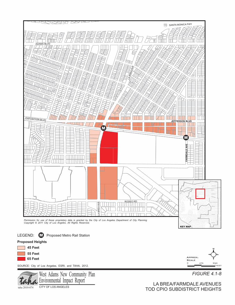
A required transitional height limit at the rear of new construction abutting residential properties would be incorporated into the CPIO subdistricts and Specific Plan amendments. Therefore, the CPIO subdistricts and Specific Plan amendments would utilize building orientation criteria, and transitional heights to reduce the appearance of change in visual character. However, these development standards would vary from the existing character and scale of neighborhoods in the West Adams CPA. Table 4.1-5 compares existing to proposed height and floor area ratios (FAR) with respect to visual character for TOD areas. Figures 4.1-6 through 4.1-8 show where these changes would be located. TABLE 4.1-5: EXISTING VERSUS PROPOSED HEIGHT/FLOOR AREA RATIOS (FAR) COMPARISON
TOD CPIO Maximum Existing Allowance
Maximum Community Plan TOD Allowance
Potential Impacts Height FAR Height FAR
Venice/National 45 feet to Unlimited 3:1 45 feet to 150 feet 3:1 Shadow, Light and Glare, Scale
Jefferson/La Cienega 33 feet to Unlimited 3:1 45 feet to 75 feet 3:1 Shadow, Light and Glare, Scale
La Brea/Farmdale 45 feet to Unlimited 3:1 36 feet to 65 feet 3:1 Shadow, Light and Glare, Scale
Crenshaw Corridor Specific Plan Amendment
45 feet to Unlimited 1.5:1 45 feet to 75 feet 4:1 Shadow, Light and Glare, Scale
SOURCE: City of Los Angeles, ZIMAS website, http://zimas.lacity.org/, accessed October 11, 2011 and City of Los Angeles West Adams CPIOs, 2012.
As discussed earlier, the proposed West Adams New Community Plan will make amendments to the Specific Plan. The amendments will address the planned light rail transit system that will run within the Crenshaw Corridor by developing TOD standards and guidelines at four potential light rail station areas: Crenshaw/Exposition, Crenshaw/Martin Luther King Jr., Crenshaw/Vernon, and Crenshaw/Slauson, (Table 4.1-5 above, and Figure 4.1-9), as well as at the City of Inglewood West Boulevard station as part of the Hyde Park Industrial Corridor CPIO subdistrict.

VENICE/NATIONAL BOULEVARDSTOD CPIO SUBDISTRICT HEIGHTS
FIGURE 4.1-6
SOURCE: City of Los Angeles, ESRI, and TAHA, 2012.
Permission for use of these propriet y data is granted by the City of Los Angeles Department of City Planning
Copyright 20 City of Los Angeles. All Rights Reserved.
ar
© 11
VENICE
BLVD
EXPOSITION BLVD
NATIONAL
BLVD
CATTARAGUS AVE
SANTAMONIC
AFW
Y
WASHIN
GTONBLV
D
LEGEND: West Adams CPA Boundary
65-150 Feet
45 Feet
Proposed Heights
55 Feet
10
RO
BE
RT
SO
NB
LV
D
N
0 620310
FEET
taha 2010-074 CITY OF LOS ANGELES
West Adams New Community PlanEnvironmental Impact Report
Approx.
Scale
PICO BLVD
VENICE
BLVD
RO
BE
RT
SO
NB
LV
D
FA
IRFA
XA
VE
LATIJ
ERA
BLVD
LA
CIE
NE
GA
BLV
D
405
10
WASHINGTON BLVD
ADAMS BLVD
JEFFERSON BLVD
EXPOSITION BLVD
MARTIN LUTHER KING JR. BLVD
VERNON AVE
SLAUSON AVE
CR
EN
SH
AW
BLV
D
FLORENCE AVE
RODEO RD
LA
BR
EA
AV
E
AR
LIN
GT
ON
AV
E
KEY MAP

LEGEND:
JEFFERSON/LA CIENEGA BOULEVARDSTOD CPIO SUBDISTRICT HEIGHTS
FIGURE 4.1-7
West Adams CPA Boundary
SOURCE: City of Los Angeles, ESRI, and TAHA, 2012.
75 Feet
45 Feet
Proposed Heights
Permission for use of these propriet y data is granted by the City of Los Angeles Department of City Planning
Copyright 20 City of Los Angeles. All Rights Reserved.
ar
© 11
55 Feet
RODEO RD
FA
IRFA
XAV
E
LA
CIE
NE
GA
BLV
D
JEFFERSON BLVD
NATIONAL BLVD
N
M
M Proposed Metro Rail Station
0 620310
FEET
taha 2010-074 CITY OF LOS ANGELES
West Adams New Community PlanEnvironmental Impact Report
Approx.
Scale
PICO BLVD
VENICE
BLVD
RO
BE
RT
SO
NB
LV
D
FA
IRFA
XA
VE
LATIJ
ERA
BLVD
LA
CIE
NE
GA
BLV
D
405
10
WASHINGTON BLVD
ADAMS BLVD
JEFFERSON BLVD
EXPOSITION BLVD
MARTIN LUTHER KING JR. BLVD
VERNON AVE
SLAUSON AVE
CR
EN
SH
AW
BLV
D
FLORENCE AVE
RODEO RD
LA
BR
EA
AV
E
AR
LIN
GT
ON
AV
E
KEY MAP
LA BREA/FARMDALE AVENUESTOD CPIO SUBDISTRICT HEIGHTS
FIGURE 4.1-8
SOURCE: City of Los Angeles, ESRI, and TAHA, 2012.
Permission for use of these propriet y data is granted by the City of Los Angeles Department of City Planning
Copyright 20 City of Los Angeles. All Rights Reserved.
ar
© 11
JEFFERSON BLVD
ADAMS BLVD
RODEO RD
LA
BR
EA
AV
E
LA
BR
EA
AV
E
EXPOSITION BLVD
LEGEND:
65 Feet
45 Feet
Proposed Heights
55 Feet
10 SANTA MONICA FWY
N
FA
RM
DA
LE
AV
E
M
M
M Proposed Metro Rail Station
0 950475
FEET
taha 2010-074 CITY OF LOS ANGELES
West Adams New Community PlanEnvironmental Impact Report
Approx.
Scale
PICO BLVD
VENICE
BLVD
RO
BE
RT
SO
NB
LV
D
FA
IRFA
XA
VE
LATIJ
ERA
BLVD
LA
CIE
NE
GA
BLV
D
405
10
WASHINGTON BLVD
ADAMS BLVD
JEFFERSON BLVD
EXPOSITION BLVD
MARTIN LUTHER KING JR. BLVD
VERNON AVE
SLAUSON AVE
CR
EN
SH
AW
BLV
D
FLORENCE AVE
RODEO RD
LA
BR
EA
AV
E
AR
LIN
GT
ON
AV
E
KEY MAP

Permission for use of these propriet y data is granted by the City of Los Angeles
Department of City Planning Copyright 20 City of Los Angeles. All Rights Reserved.
ar
© 11
CRENSHAW CORRIDOR SPECIFIC PLANTOD HEIGHTS
FIGURE 4.1-9
SOURCE: City of Los Angeles, ESRI, and TAHA, 2012.
LEGEND:
West Adams CPA Boundary
45 Feet
75 Feet
48 Feet
60 Feet
Crenshaw Corridor Specific Plan Area
Heights
EXPOSITION BLVD
CR
EN
SH
AW
BLV
D
JEFFERSON BLVD
COLISEUM ST
ADAMS BLVD
SANTA MONICA FWY 10
1
MLK JR BLVD
STOCKER ST
CR
EN
SH
AW
BLV
D
CR
EN
SH
AW
BLV
D
W 48TH ST
LEIM
ERT
BLV
D
VERNON AVE
2
SLAUSON AVE
57TH ST
60TH ST
HYDE PARK BLVD
FLORENCE AVE
CR
EN
SH
AW
BLV
D
3
Not to
Scale
N
taha 2010-074 CITY OF LOS ANGELES
West Adams New Community PlanEnvironmental Impact Report
PICO BLVD
VENICE
BLVD
RO
BE
RT
SO
NB
LV
D
FA
IRFA
XA
VE
LATIJ
ERA
BLVD
LA
CIE
NE
GA
BLV
D
405
10
WASHINGTON BLVD
ADAMS BLVD
JEFFERSON BLVD
EXPOSITION BLVD
MARTIN LUTHER KING JR. BLVD
VERNON AVE
SLAUSON AVE
CR
EN
SH
AW
BLV
D
FLORENCE AVE
RODEO RD
LA
BR
EA
AV
E
AR
LIN
GT
ON
AV
E
KEY MAP
2
1
3

West Adams New Community Plan 4.1 Aesthetics Draft EIR
taha 2010-074 4.1-26
The changes in heights and FARs discussed above would not cause a significant impact to any existing HPOZs. In particular, the Crenshaw/Exposition TOD, located within subarea “A” of the existing Crenshaw Corridor Specific Plan, is the nearest TOD to an HPOZ (Jefferson Park). Adjacent to the western boundary of the Jefferson Park HPOZ, the Crenshaw/Exposition TOD would limit heights to 45 feet and an FAR of 1.5:1 immediately adjacent to the HPOZ, which are the same height and FAR limits that currently exists. Since the proposed TOD policies would not increase the heights or FARs, the project could not alter the existing character of the Jefferson Park HPOZ more than is currently allowed under the existing zoning. Additionally, the Specific Plan amendments propose height and FAR increases at the Crenshaw/Adams Boulevards intersection. Height would be increased to 60 feet and FAR would increase to 2:1, or 3:1 if mixed use is proposed. This intersection is adjacent to the West Adams Terrace HPOZ, but not within it, therefore, the increases would not alter the character of the HPOZ.
There are also several proposed HPOZs within the West Adams CPA. These include Leimert Park, Jefferson Park, Victoria Park, Arlington Heights, and Wellington Square. While height and FAR changes are proposed adjacent to some of these proposed HPOZs, no changes would take place within them, therefore, they would not alter the character of the proposed HPOZs.
In addition, HPOZs, and any future HPOZs, are protected by the City’s Historic Preservation Overlay Zone Ordinance and require a historic preservation board to review projects within HPOZs. Since none of the proposed changes of the project are located within an HPOZ, there will be no impact to the historic character of any HPOZ.
Overall, the change from the CPIO subdistricts will impact relatively little land area within the West Adams CPA. Framework Policies 5.1.1, 5.2.2, 5.5.3, 5.5.6, 5.5.7, 5.7.1, and 5.8.4 would continue to protect visual character by encouraging development that defines the character of the West Adams CPA, promoting the development of low-rise buildings and the use of step backs in heights for higher floors of buildings, encouraging the formulation and adoption of building design and site design standards, promoting the undergrounding of utilities, establishing standards for transitions in heights of buildings, and encouraging visually attractive signage.
Existing Framework and Conservation Element policies would help minimize potential impacts from land form alteration of any development in hilly areas. Hillside areas would also be protected by the LAMC Hillside Ordinance, which contains standards to ensure development conforms to the land by establishing, among other guidelines, setback requirements, maximum FAR, lot coverage, and height limits. The Conservation Element includes an objective, policy, and program related to Land Form and Scenic Vistas to encourage development that would retain significant existing land forms or unique scenic features or vistas through permit processing, enforcement, and environmental review of project designs to ensure that natural features and views are retained. Therefore, the City’s policies would protect the existing visual character and implementation of the existing policies described above.
As discussed above, the adoption and implementation of the proposed West Adams New Community Plan would not substantially damage existing visual character, value, or quality of the community; however, in order to ensure that these aspects of neighborhood character are maintained, mitigation measures such as the transitional building height policies of the CPIO subdistricts should be met in those areas. Therefore, without mitigation, the proposed project would result in a significant impact related to visual character.
Views and Vistas
In general, the land use changes under the proposed West Adams New Community Plan would not disrupt views of the Baldwin Hills and the Santa Monica Mountains. In this regard, the land use changes would not substantially modify the character of the West Adams CPA, particularly in the residential areas, which are predominately conservation areas with no proposed changes. Scenic views of landmarks will remain available, such as views of the Hollywood Sign from Crenshaw Boulevard in the southern portion of the CPA. In addition, the Century City high-rise towers as viewed from Washington Boulevard west of West

West Adams New Community Plan 4.1 Aesthetics Draft EIR
taha 2010-074 4.1-27
Boulevard and Martin Luther King Jr. Boulevard west of Crenshaw Boulevard will also remain available. Existing land use designations along Washington Boulevard are primarily a mix of Commercial Manufacturing, General Commercial, Community Commercial, and Medium Residential. Land use changes are proposed along Washington Boulevard to foster continued commercial revitalization. Some of these changes include increases in FAR from 1.5:1 to 2:1(at major intersection nodes)and 3:1 (at nodes where subterranean parking is constructed), as well as changes to the height district from unlimited to 45 feet along commercial corridors and 55 feet at major intersection nodes, as seen in Table 4.1-4 above. While these changes will be made primarily to create consistency and predictability in height, views of Century City, the Santa Monica Mountains, and the Baldwin Hills from Washington Boulevard are primarily available to motorist from the street itself. As Washington Boulevard is a major Class II highway approximately 100 feet in width, these views would still be available to motorists on Washington Boulevard and this impact would be less than significant.
Land use designations along Martin Luther King Jr. Boulevard are primarily General Commercial, and the land use changes proposed would foster continued commercial revitalization. Similar to Washington Boulevard, some of these changes include increases in FAR from 1.5:1 to 2:1 and 3:1, and changes to the height district to create consistency in height to 45 feet along the corridor segment and a range from 48 feet to 60 feet at the major intersection nodes (including the Baldwin Hills-Crenshaw Plaza). Similarly, views of the Baldwin Hills and Century City from Martin Luther King Jr. Boulevard remain available to motorist from the street itself due to the wide right-of-way afforded by the frontage roads flanking the corridor west of Crenshaw Boulevard. These views would still be available to motorists on Martin Luther King Jr. Boulevard and this impact would be less than significant.
The proposed zoning designations of the West Adams New Community Plan would serve to regulate development standards such as: heights of structures, setbacks, lot coverage, density, intensity, open space, use of land, parking, and design. The CPIO and Specific Plan amendments would additionally be established to regulate development that is consistent with the General Plan, enhances the unique character of neighborhoods, and addresses growth within the West Adams CPA.
The specific proposed land use and zoning changes are listed in detail in Appendix B - Proposed West Adams New Community Plan Change Areas. Other than zoning changes to height districts, land use and zoning changes under the proposed West Adams New Community Plan would not structurally change land use patterns within the West Adams CPA. The proposed West Adams New Community Plan includes changes in height districts in several areas of the West Adams CPA, including, major east/west commercial and industrial corridors such as Washington, Adams and Jefferson Boulevards; TOD areas located directly adjacent to the Exposition Light Rail Transit line stations at Crenshaw Boulevard, La Brea Avenue, Jefferson/La Cienega Boulevards, and National/Washington/Robertson Boulevards, as well as the Crenshaw Corridor. The height district changes would create consistency and predictability in height by limiting height to 45 feet along commercial corridors and up to 55 feet at major intersection nodes including along all major north/south and east/west streets such as Crenshaw, La Brea, and Robertson Boulevards; Fairfax and La Cienega Avenues; Pico, Washington, Adams, Jefferson, and Martin Luther King Jr. Boulevards; and Vernon, Slauson, and Florence Avenues.
As described above, the proposed West Adams New Community Plan would include the adoption of the Commercial Corridors and Major Intersection Nodes CPIO subdistrict, which would include design standards and guidelines for sites located primarily along east/west commercial corridors and at the intersection of major arterial streets. These standards would ensure that new development complements the existing character and scale of neighborhoods through encouraging contextual infill development and improving pedestrian orientation in the West Adams CPA. These changes would not be substantial and would not lead to substantial adverse effects on scenic vistas, recognized/valued views, and/or result in view obstruction.

West Adams New Community Plan 4.1 Aesthetics Draft EIR
taha 2010-074 4.1-28
The maximum heights of some of the buildings associated with the station adjacent subareas of the Venice/National, Jefferson/La Cienega, and the La Brea/Farmdale TOD CPIO subdistricts would have the potential to block views of the Baldwin Hills. Due to the existing low-height character of homes and buildings in the West Adams CPA, views of the Baldwin Hills and Century City high-rise towers are restricted to pedestrians and vehicles travelling on streets. The largest maximum increase in height allowed would be within the Venice/National TOD CPIO subdistrict. The Venice/National TOD CPIO subdistrict would allow development south of Venice Boulevard within subarea “A” of the CPIO subdistrict to have maximum heights ranging from 65 to 150 feet (if very specific design criteria are met), while the northern portion of Venice Boulevard would be allowed to have maximum heights ranging from 45 to 55 feet. Therefore, views of the Baldwin Hills from the northern portion of Venice Boulevard in the Venice/National TOD CPIO subdistrict could likely be blocked from development on the southern side of Venice Boulevard, if the maximum development capacity is attained. Views of the Baldwin Hills from residential uses surrounding the Jefferson/La Cienega TOD CPIO subdistrict generally would not be disrupted since the increased heights would be located to the west of the residential uses and the Baldwin Hills are located to the south of the residential uses. In addition, the La Brea/Farmdale TOD CPIO subdistrict could partially block views of the Baldwin Hills from residential uses located immediately to the north of the TOD and east of La Brea Avenue if developed to maximum capacity. However, existing Framework and Conservation Element policies would help minimize potential impacts to scenic vistas. The Conservation Element includes an objective, policy, and program related to Land Form and Scenic Vistas to protect and reinforce natural and scenic vistas through permit processing, enforcement, and environmental review of project designs to ensure that natural features and views are retained. Framework Policies 5.2.2, 5.5.6, 5.5.7, and 5.7.1, as well as standards and guidelines in the CPIO subdistricts, would protect scenic vistas by encouraging the use of step backs in heights for higher floors of buildings, promoting the undergrounding of utilities, and establishing standards for transitions in heights of buildings.
The proposed West Adams New Community Plan would not impact any identified scenic vistas or recognized views and is geared toward maintaining consistent neighborhood character, encouraging adaptive reuse and rehabilitation, improving business and employment opportunities, and preserving existing retail and neighborhood services. Therefore, the adoption and implementation of the proposed West Adams New Community Plan would not have a substantial adverse effect on scenic vistas, recognized/valued views and/or result in view obstruction available from a length of a public roadway, bike path, or trail. In addition, the City’s policies would protect scenic vistas. Therefore, the proposed project would result in less-than-significant impacts related to views and vistas.
Scenic Resources
The Baldwin Hills are the most visible scenic resources in the West Adams CPA. Also, the historic residences and HPOZs are scenic resources in the West Adams CPA. The proposed West Adams New Community Plan would slightly increase the land use density around TOD areas and commercial corridors and nodes within the West Adams CPA, but no substantial changes are proposed for residential areas, particularly those that include historic properties.
The TOD and commercial corridor and node areas, which include several CPIO subdistricts and subareas of the Amended Crenshaw Corridor Specific Plan, are included as part of the proposed West Adams New Community Plan and would intensify development at several intersections. As discussed above, while some of these changes are adjacent to HPOZs, none are located within HPOZs, or in the Baldwin Hills. Therefore, intensified commercial and residential development due to the implementation of the CPIO and Specific Plan amendments would not affect scenic resources in the West Adams CPA.
The overall intent of the land use changes in the West Adams New Community Plan would be to foster commercial revitalization by providing land use incentives that promote regeneration of the area’s traditional urban form, ensure that new development complements the existing character and scale of neighborhoods through contextual infill development, conserve neighborhood character, and improve pedestrian orientation

West Adams New Community Plan 4.1 Aesthetics Draft EIR
taha 2010-074 4.1-29
in the West Adams CPA. Consequently, these development standards would protect scenic resources in the West Adams CPA (Table 4.1-4, above) and the proposed West Adams New Community Plan would not impact any scenic resources or scenic highways within the West Adams CPA.
Although the West Adams CPA is primarily flat, new development could occur in hilly areas of the CPA. Existing Framework and Conservation Element policies would also help minimize potential impacts from land form alteration. The Conservation Element includes an objective, policy, and program related to Land Form and Scenic Vistas to encourage development that would retain significant existing land forms or unique scenic features through permit processing, enforcement, and environmental review of project designs to ensure that natural features and views are retained.
Additionally, Framework Policies 5.1.1, 5.2.2, 5.5.3, 5.5.6, 5.5.7, 5.7.1, and 5.8.4, and guidelines in the CPIO subdistricts and the amended Specific Plan would protect scenic resources and vistas by encouraging development that defines the character of the West Adams CPA, promoting the development of low-rise buildings and the use of step backs in heights for higher floors of buildings, encouraging the formulation and adoption of building design and site design standards, promoting the undergrounding of utilities, establishing standards for transitions in heights of buildings, and encouraging visually attractive signage. Therefore, the adoption and implementation of the proposed West Adams New Community Plan would not substantially damage scenic resources, including, but not limited to, trees, rock outcroppings, historic buildings, or other locally recognized desirable aesthetic natural features. In addition, the City’s policies would protect scenic resources. Therefore, the proposed project would result in less-than-significant impacts related to scenic resources.
Light and Glare
The proposed West Adams New Community Plan does not include large scale land use changes or developments that would substantially increase lighting in any part of the West Adams CPA. However, implementation of the proposed West Adams New Community Plan would result in an increase in population and buildings in the West Adams CPA. As a result, the creation of new lighting sources associated with additional dwelling units, businesses, street lighting, and vehicle headlights would be anticipated. While the CPIO subdistricts and Crenshaw Corridor Specific Plan do not contain ordinance standards regarding light and glare, the proposed West Adams New Community Plan includes policies that are geared toward streetscape improvements, urban design standards, and guidelines that would regulate the amount of nighttime illumination, such as:
• Policy LU7-4: Crime Prevention through Environmental Design (CPTED). Pursue urban design strategies that reduce street crime and violence such as CPTED (e.g., "defensible space," "eyes on the street," and pedestrian-friendly lighting) without creating barriers that disconnect neighborhoods.
• Policy LU17-3: Mitigate commercial residential mixed-use conflicts. Require that mixed-use projects be designed to mitigate potential conflicts between the commercial and residential uses (e.g., noise, lighting, security, truck and automobile access, etc.) and provide adequate amenities for residential occupants.
• Policy LU21-1: High quality street lighting. Support neighborhood and stakeholder initiatives to enhance the unique character of an area through the introduction of high quality street lighting.
• Policy M3-3: Pedestrian Amenities. Maintain sidewalks, streets and rights-of- way in good condition, free of obstructions, and with adequate lighting, trees and parkways. Streets must accommodate pedestrians comfortably through adequate sidewalks and parkway landscaping that provides shade from the hot sun, and street lighting that provides for safety during the night.

West Adams New Community Plan 4.1 Aesthetics Draft EIR
taha 2010-074 4.1-30
• Design Guidelines regarding light and glare for commercial uses: o Install new street lights in commercial districts which are pedestrian-oriented, attractively designed,
compatible in design with facades and other street furniture, to provide adequate visibility, security, and a festive night time environment.
• Design Guidelines regarding light and glare in historic districts:
o Establish a consistent street lighting type in areas designated historic, utilizing a light standard that is compatible with the historic commercial theme and coordinated with an overall street furniture and graphics/signage program.
• Design guidelines for parking structures: o Solid spandrel panels a minimum of 3-feet-6-inches in height should be installed at the ramps of the
structure which are adjacent to residential uses or zones so as to minimize headlight glare.
In addition, the LAMC contains specific regulations with respect to light and glare. LAMC Section 12.21 A.5 (k) (Amended by Ordinance No. 171,858) states that all lights used to illuminate a parking area shall be designed, located and arranged so as to reflect the light away from any street and any adjacent premises. Additionally, any new lighting would be designed to conform to applicable standards including LAMC Sections 93.0117 and 12.21 A.5 (k), which pertains to outdoor lighting affecting residential property. All new development would be required to be consistent with the LAMC, which would ensure that such amenities as the community’s low ambient lighting would be protected and that light sensitive areas adjacent to new developments would be protected from spillover lighting. Therefore, the adoption and implementation of the proposed West Adams New Community Plan would not significantly change ambient illumination levels.
The West Adams CPA is an area predominately developed with single- and multi-family residential uses and low- and medium-rise commercial areas and industrial uses. The commercial buildings in the West Adams CPA are generally one- to three-stories tall and are primarily constructed of non-reflective materials. Although there are some commercial buildings that may contain reflective materials, such as glass, there is no concentration of glass buildings (e.g., Downtown Los Angeles). However, the West Adams CPIO subdistricts and Amended Crenshaw Corridor Specific Plan could potentially increase the amount of glare in the CPA due to the intensification of residential and commercial development. Therefore, without mitigation, the proposed project would result in a significant impact related to light and glare.
Shade and Shadow
Shade and shadow impacts may be considered significant when they cover shadow-sensitive uses for a substantial amount of time (three to four hours depending on the time of the year). Shadow-sensitive uses generally include routinely useable outdoor spaces associated with residential, recreational, or institutional land uses; commercial uses, such as pedestrian-oriented outdoor spaces or restaurants with outdoor eating areas; nurseries; and existing solar collectors/panels.
In general, the West Adams New Community Plan does not structurally change land use patterns within the West Adams CPA, and only proposes changes that could result in shade and shadow impacts at particular locations. These locations consist of the CPIO subdistricts, the Specific Plan area, and areas immediately to the north of these locations. It is important to note that while changes are being made to the West Adams Community Plan, existing as-built conditions, as well as development standards from the 1998 West Adams Community Plan, already create, or could lead to, shade and shadow impacts.
Due to the relatively dense arrangement of the existing commercial, industrial, and residential buildings within the West Adams CPA, as well as the often shallow depth of parcels along many of the commercial corridors, shadow effects on shadow-sensitive uses already exist throughout the project area. The proposed zoning designations of the CPIO subdistricts and Specific Plan amendments would serve to regulate
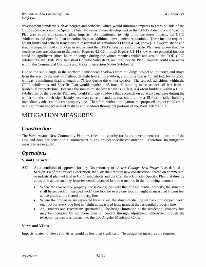
West Adams New Community Plan 4.1 Aesthetics Draft EIR
taha 2010-074 4.1-31
development standards such as heights and setbacks, which would minimize impacts to areas outside of the CPIO subdistricts and the Specific Plan. However, future development in the CPIO subdistricts and Specific Plan area could still cause shadow impacts. As mentioned, to help minimize these impacts, the CPIO subdistricts and Specific Plan amendments pose additional development regulations. These include required height limits and setback transitions to residential neighborhoods (Table 4.1-4, above). However, shade and shadow impacts could still occur in and around the CPIO subdistricts and Specific Plan area where shadow-sensitive uses are adjacent to the north. Figures 4.1-10 through Figure 4.1-14 show where potential impacts could be significant (three hours or longer during the winter months) within and around the TOD CPIO subdistricts, the Hyde Park Industrial Corridor Subdistrict, and the Specific Plan. Impacts could also occur within the Commercial Corridors and Major Intersection Nodes Subdistrict.
Due to the sun’s angle in the northern hemisphere, shadows from buildings project to the north and move from the west to the east throughout daylight hours. In addition, a building that is 45 feet tall, for instance, will cast a minimum shadow length of 71 feet during the winter solstice. The setback transitions within the CPIO subdistricts and Specific Plan would require a 45-foot tall building to be setback 45 feet from a residential property line. Because the minimum shadow length is 71 feet, a 45-foot building within a CPIO subdistricts or the Specific Plan area would still cast shadows that encroach on adjacent land uses during the winter months, albeit significantly less than current standards that could allow a 45-foot or taller building immediately adjacent to a rear property line. Therefore, without mitigation, the proposed project could result in a significant impact related to shade and shadows throughout portions of the West Adams CPA.
MITIGATION MEASURES
Construction The West Adams New Community Plan describes the capacity for future development for a portion of the City and does not constitute a commitment to any project-specific construction. Therefore, no mitigation measures are required.
Operations Visual Character
AE1 As a condition of approval for any Discretionary or “Active Change Area Project”, as defined in Section 3.4 of the Project Description, the City shall require new construction located on commercial or industrial planned land in CPIO subdistricts and the Crenshaw Corridor Specific Plan that directly abuts or is across an alley from residential planned land to transition in the following manner:
• Where the rear or side property line is contiguous with that of a residential property, the structure shall be set back or “stepped back” one foot for every one foot in height as measured fifteen feet above grade at the shared property line.
• Where the properties are separated by an alley, the structure shall be set back or “stepped back” one foot for every one foot in height as measured from grade at the residential property line.
• Adjustments and Exceptions (permitted): The height limitation at the residential property line may be increased by not more than 20 percent through adjustment, otherwise, through the exception procedures pursuant to the Los Angeles Municipal Code.
Views and Vistas
Impacts related to views and vistas would be less than significant. No mitigation measures are required.

VENICE/NATIONAL BOULEVARDS TOD CPIOSUBDISTRICT SIGNIFICANT SHADOW ZONES
FIGURE 4.1-10
SOURCE: City of Los Angeles, ESRI, and TAHA, 2012.
Permission for use of these propriet y data is granted by the City of Los Angeles Department of City Planning
Copyright 20 City of Los Angeles. All Rights Reserved.
ar
© 11
VENICE
BLVD
EXPOSITION BLVD
NATIONAL
BLVD
CATTARAGUS AVE
SANTAMONIC
AFW
Y
WASHIN
GTONBLV
D
10
RO
BE
RT
SO
NB
LV
D
N
0 620310
FEET
taha 2010-074 CITY OF LOS ANGELES
West Adams New Community PlanEnvironmental Impact Report
Approx.
Scale
PICO BLVD
VENICE
BLVD
RO
BE
RT
SO
NB
LV
D
FA
IRFA
XA
VE
LATIJ
ERA
BLVD
LA
CIE
NE
GA
BLV
D
405
10
WASHINGTON BLVD
ADAMS BLVD
JEFFERSON BLVD
EXPOSITION BLVD
MARTIN LUTHER KING JR. BLVD
VERNON AVE
SLAUSON AVE
CR
EN
SH
AW
BLV
D
FLORENCE AVE
RODEO RD
LA
BR
EA
AV
E
AR
LIN
GT
ON
AV
E
KEY MAP
LEGEND: West Adams CPA Boundary
75 Feet
45 Feet
Proposed Heights
55 Feet
45 Feet & Significant 3-hour Shadow Zones
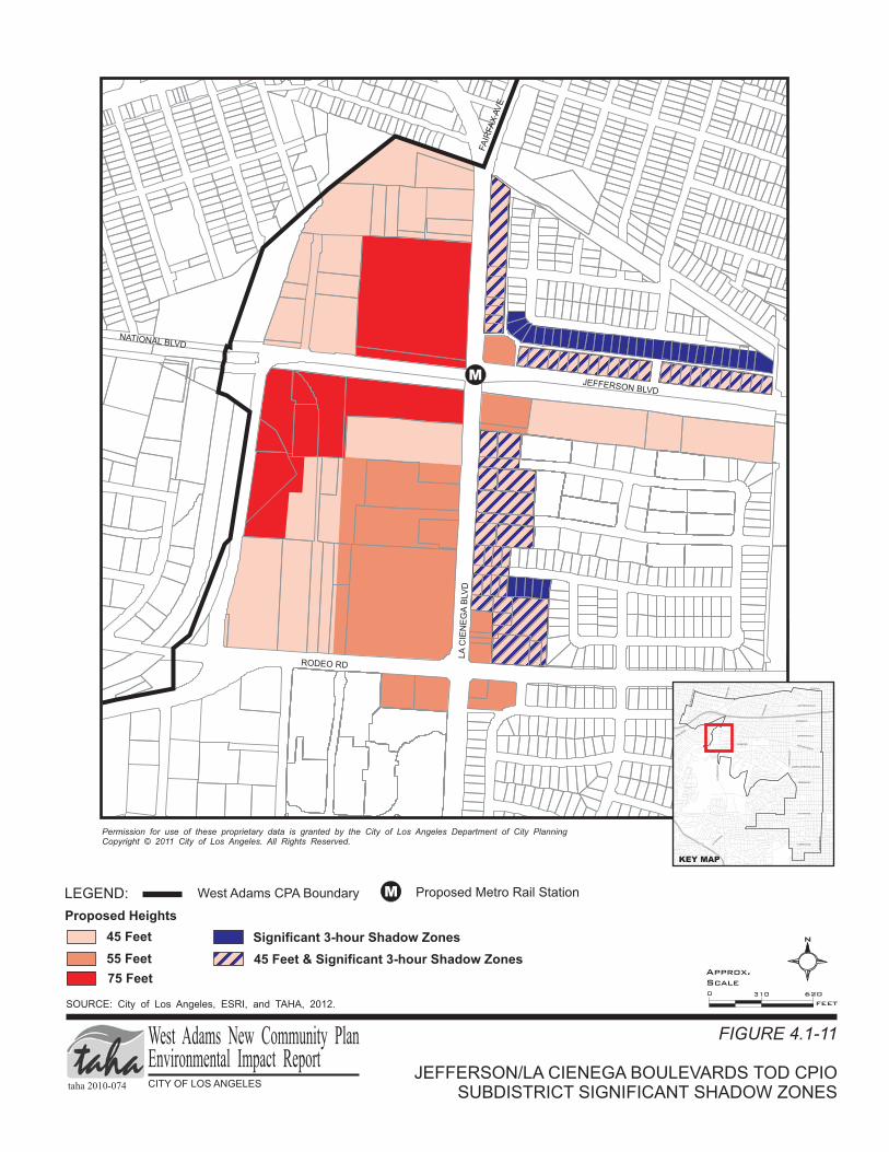
LEGEND:
JEFFERSON/LA CIENEGA BOULEVARDS TOD CPIOSUBDISTRICT SIGNIFICANT SHADOW ZONES
FIGURE 4.1-11
West Adams CPA Boundary
SOURCE: City of Los Angeles, ESRI, and TAHA, 2012.
75 Feet
45 Feet
Proposed Heights
Permission for use of these propriet y data is granted by the City of Los Angeles Department of City Planning
Copyright 20 City of Los Angeles. All Rights Reserved.
ar
© 11
55 Feet
RODEO RD
FA
IRFA
XAV
E
LA
CIE
NE
GA
BLV
D
JEFFERSON BLVD
NATIONAL BLVD
N
M
M Proposed Metro Rail Station
0 620310
FEET
Significant 3-hour Shadow Zones
taha 2010-074 CITY OF LOS ANGELES
West Adams New Community PlanEnvironmental Impact Report
Approx.
Scale
PICO BLVD
VENICE
BLVD
RO
BE
RT
SO
NB
LV
D
FA
IRFA
XA
VE
LATIJ
ERA
BLVD
LA
CIE
NE
GA
BLV
D
405
10
WASHINGTON BLVD
ADAMS BLVD
JEFFERSON BLVD
EXPOSITION BLVD
MARTIN LUTHER KING JR. BLVD
VERNON AVE
SLAUSON AVE
CR
EN
SH
AW
BLV
D
FLORENCE AVE
RODEO RD
LA
BR
EA
AV
E
AR
LIN
GT
ON
AV
E
KEY MAP
45 Feet & Significant 3-hour Shadow Zones

LA BREA/FARMDALE AVENUES TOD CPIOSUBDISTRICT SIGNIFICANT SHADOW ZONES
FIGURE 4.1-12
SOURCE: City of Los Angeles, ESRI, and TAHA, 2012.
Permission for use of these propriet y data is granted by the City of Los Angeles Department of City Planning
Copyright 20 City of Los Angeles. All Rights Reserved.
ar
© 11
JEFFERSON BLVD
ADAMS BLVD
RODEO RD
LA
BR
EA
AV
E
LA
BR
EA
AV
E
EXPOSITION BLVD
LEGEND:
65 Feet
45 Feet
Proposed Heights
Proposed Metro Rail Station
55 Feet
10 SANTA MONICA FWY
N
FA
RM
DA
LE
AV
E
M
M
M
0 950475
FEET
taha 2010-074 CITY OF LOS ANGELES
West Adams New Community PlanEnvironmental Impact Report
Approx.
Scale
PICO BLVD
VENICE
BLVD
RO
BE
RT
SO
NB
LV
D
FA
IRFA
XA
VE
LATIJ
ERA
BLVD
LA
CIE
NE
GA
BLV
D
405
10
WASHINGTON BLVD
ADAMS BLVD
JEFFERSON BLVD
EXPOSITION BLVD
MARTIN LUTHER KING JR. BLVD
VERNON AVE
SLAUSON AVE
CR
EN
SH
AW
BLV
D
FLORENCE AVE
RODEO RD
LA
BR
EA
AV
E
AR
LIN
GT
ON
AV
E
KEY MAP
45 Feet & Significant 3-hour Shadow Zones
55 Feet & Significant 3-hour Shadow Zones
Significant 3-hour Shadow Zones

Permission for use of these propriet y data is granted by the City of Los Angeles
Department of City Planning Copyright 20 City of Los Angeles. All Rights Reserved.
ar
© 11
CRENSHAW CORRIDOR SPECIFIC PLANSIGNIFICANT SHADOW ZONES
FIGURE 4.1-13
SOURCE: City of Los Angeles, ESRI, and TAHA, 2012.
LEGEND:
West Adams CPA Boundary
45 Feet
75 Feet
48 Feet
60 Feet
Crenshaw Corridor Specific Plan Area
Proposed Heights
EXPOSITION BLVD
CR
EN
SH
AW
BLV
D
JEFFERSON BLVD
COLISEUM ST
ADAMS BLVD
SANTA MONICA FWY 10
1
MLK JR BLVD
STOCKER ST
CR
EN
SH
AW
BLV
D
CR
EN
SH
AW
BLV
D
W 48TH ST
LEIM
ERT
BLV
D
VERNON AVE
2
SLAUSON AVE
57TH ST
60TH ST
HYDE PARK BLVD
FLORENCE AVE
CR
EN
SH
AW
BLV
D
3
Not to
Scale
N
Significant 3-hour Shadow Zones
taha 2010-074 CITY OF LOS ANGELES
West Adams New Community PlanEnvironmental Impact Report
PICO BLVD
VENICE
BLVD
RO
BE
RT
SO
NB
LV
D
FA
IRFA
XA
VE
LATIJ
ERA
BLVD
LA
CIE
NE
GA
BLV
D
405
10
WASHINGTON BLVD
ADAMS BLVD
JEFFERSON BLVD
EXPOSITION BLVD
MARTIN LUTHER KING JR. BLVD
VERNON AVE
SLAUSON AVE
CR
EN
SH
AW
BLV
D
FLORENCE AVE
RODEO RD
LA
BR
EA
AV
E
AR
LIN
GT
ON
AV
E
KEY MAP
2
1
3

LEGEND:
HYDE PARK INDUSTRIAL CPIOSUBDISTRICT SIGNIFICANT SHADOW ZONES
FIGURE 4.1-14
West Adams CPA Boundary
SOURCE: City of Los Angeles, ESRI, and TAHA, 2012.
Proposed Heights
Permission for use of these propriet y data is granted by the City of Los Angeles Department of City Planning
Copyright 20 City of Los Angeles. All Rights Reserved.
ar
© 11
HYDE PARK BLVD
CR
EN
SH
AW
BLV
D
FLORENCE AVE
60TH ST
67TH ST
77TH ST
AR
LIN
GT
ON
AV
E
8T
HA
VE
HYDE PARK BLVD
N
M
M Proposed Metro Rail Station
0 1,200600
FEET
30 Feet
45 - 75 Feet
45 Feet
45 - 60 Feet
Significant 3-hour Shadow Zones
taha 2010-074 CITY OF LOS ANGELES
West Adams New Community PlanEnvironmental Impact Report
Approx.
Scale
PICO BLVD
VENICE
BLVD
RO
BE
RT
SO
NB
LV
D
FA
IRFA
XA
VE
LATIJ
ERA
BLVD
LA
CIE
NE
GA
BLV
D
405
10
WASHINGTON BLVD
ADAMS BLVD
JEFFERSON BLVD
EXPOSITION BLVD
MARTIN LUTHER KING JR. BLVD
VERNON AVE
SLAUSON AVE
CR
EN
SH
AW
BLV
D
FLORENCE AVE
RODEO RD
LA
BR
EA
AV
E
AR
LIN
GT
ON
AV
E
KEY MAP

West Adams New Community Plan 4.1 Aesthetics Draft EIR
taha 2010-074 4.1-37
Scenic Resources
Impacts related to scenic resources would be less than significant. No mitigation measures are required.
Light and Glare
AE2 As a condition of approval for any Discretionary or “Active Change Area Project”, as defined in Section 3.4 of the Project Description, the City shall require that all lighting be directed and/or shielded to minimize lighting spillover effects onto adjacent and nearby properties.
AE3 As a condition of approval for any Discretionary or “Active Change Area Project”, as defined in
Section 3.4 of the Project Description, the City shall require that glare effects be limited by using non-reflective building and construction materials, such as concrete, wood, and stucco. This shall include, but not be limited to, art installations, fencing material, and recreational equipment.
Shade and Shadow See Mitigation Measure AE1 above.
SIGNIFICANCE OF IMPACTS AFTER MITIGATION
Construction The West Adams New Community Plan describes the capacity for future development for a portion of the City and does not constitute a commitment to any project-specific construction. Therefore, no impacts related to construction would occur.
Operations Visual Character
Impacts related to visual character were determined to be significant without mitigation. Mitigation Measure AE1 would reduce the impacts to less than significant.
Views and Vistas
Impacts related to views and vistas were determined to be less than significant without mitigation.
Scenic Resources
Impacts related to scenic resources were determined to be less than significant without mitigation.
Light and Glare
Impacts related to light and glare were determined to be significant without mitigation. Mitigation Measures AE2 and AE3 would reduce the impacts to less than significant.
Shade and Shadow
Impacts related to shade and shadow were determined to be significant without mitigation. Mitigation Measure AE1 would reduce shade and shadow impacts from the CPIO subdistricts and Crenshaw Corridor Specific Plan amendments. However, shade and shadow effects during the months of December and January could still result in a significant impact. Therefore, the proposed project would result in a significant and unavoidable impact related to shade and shadow.