4.1 aesthetics - cpuc.ca.gov€¦ · aesthetics/natural beauty. ... earth mounds, or sound walls....
TRANSCRIPT

4.1 AESTHETICS
Riverside Transmission Reliability Project Draft Subsequent EIR ● April 2018 4.1-1
4.1 AESTHETICS This section presents the environmental setting and impact analysis for aesthetic resources in the vicinity of the Revised Project and the alternatives. Appendix F presents a technical evaluation of key observation points (KOPs) considered in the analysis of visual impacts.
Consideration of Scoping Comments The public expressed concerns regarding aesthetics impacts during public scoping for this Subsequent EIR. Table 4.1-1 summarizes the scoping comments received regarding aesthetics impacts and identifies how and/or where these comments are addressed.
Table 4.1-1 Scoping Comments Related to Aesthetics Impacts Summary of Comment Location Comment is Addressed
The Subsequent EIR needs to evaluate the impact on scenic vistas and visual characteristics.
The analysis for the Initial Study Checklist showed that Revised Project impacts on scenic vistas were consistent with, or less than, impacts described in the 2013 RTRP EIR. Impacts on visual characteristics are described below in Section 4.1.8 of this Subsequent EIR.
The project will block/impact/degrade regional views.
Impacts of the Revised Project are described Section 4.1.8 of this Subsequent EIR.
Power lines are unsightly. Visual simulations showing the Revised Project elements are provided in Section 4.1.9 of this Subsequent EIR.
Commenter requests realistic simulations of view/shadowing impacts.
Simulations of the Revised Project are provided in Section 4.1.9 of this Subsequent EIR.
The project will impact/degrade aesthetics/natural beauty.
Impacts of the Revised Project are described in Section 4.1.9 of this Subsequent EIR.
The project will impact I-15 as a scenic highway. The I-15 freeway is not a designated scenic highway in proximity to the Revised Project. Impacts of the RTRP on scenic highways is described in the 2013 RTRP EIR.
Definitions
Aesthetic Resources Aesthetic resources include the visual character and quality of an area, consisting of both the landscape features and the social environment from which it is viewed. The landscape features may be natural (e.g., mountain views) or manmade (e.g., a city’s skyline). Aesthetic resources include, but are not limited to:
• Federal, state, and local designated scenic resources • Designated federal, state, and local historic properties • Areas of high visual quality (i.e., scenic vistas, scenic hiking trails, scenic rivers,
and scenic highways)

4.1 AESTHETICS
Riverside Transmission Reliability Project Draft Subsequent EIR ● April 2018 4.1-2
• Recreation areas characterized by high numbers of users with sensitivity to visual quality (i.e., parks and preserves)
• Landscape features, including canyons and gorges, valleys, and mountains Terms used to describe aesthetic resources are defined in Table 4.1-2.
Table 4.1-2 Definition of Aesthetic Resources Terms Term Definition
Intactness The integrity of visual order in the natural and built landscape, and the extent to which the landscape is free from visual encroachment.
Key Observation Point
A location from which a viewer can see either iconic or representative landscapes of the project. Used for visual simulations.
Landscape Character Unit
Defined areas that have similar visual features, homogeneous visual character, and frequently, a single viewshed. The spatial unit typically used to assess visual impacts.
Unity The degree to which the visual resources of the landscape join to form a coherent, harmonious visual pattern; the compositional harmony or inter-compatibility between landscape elements.
Viewer A person located within the project viewshed who can observe the project.
Viewer Awareness
Viewer awareness is a measure of attention (level of observation based on routine and familiarity), focus (level of concentration), and protection (legal and social constraints on the use of visual resources). The greater the attention, the more viewers will be concerned about visual impacts.
Viewer Exposure A measure of proximity (distance between viewer and the visual resource being viewed), extent (number of viewers viewing), and duration (how long the visual resource is being viewed). The greater the exposure, the more viewers will be concerned about visual impacts.
Viewer Response Public viewer response is a reaction to a scene or object within view and is based on viewer sensitivity and viewer exposure. Viewer response is predicted by assigning numerical ratings for viewer sensitivity and viewer exposure. The numerical ratings are then added to obtain a predicted level of viewer response.
Viewer Sensitivity The degree to which viewers are sensitive to changes in the visual character of visual resources. Sensitivity is determined by considering the types and numbers of potential viewers of a specified area, the level of public interest, adjacent land uses, and the presence of special natural or cultural resource areas.
Viewshed The surface area visible from a location (e.g., an overlook) or sequence of locations (e.g., a roadway or trail).
Visual Character The description of the visible attributes of a scene or object typically using artistic terms such as form, line, color, and texture.
Visual Quality What viewers like and dislike about visual resources that compose the visual character of a scene. Viewers may evaluate visual resources differently based on their interests in natural harmony, cultural order, and project coherence.
Visual Simulation Two- or three-dimensional depictions of the visual character of a future state. Simulations range from artistic renderings to computer animations.
Vividness The visual power or memorability of the visual impression received from contrasting landscape elements as they combine in distinctive visual patterns.
Source: (FHWA, 1988)

4.1 AESTHETICS
Riverside Transmission Reliability Project Draft Subsequent EIR ● April 2018 4.1-3
Approach to Data Collection Aesthetic resources in the Revised Project area were identified through aerial photography, site visits, scoping comments, review of data provided by SCE, and land use cover maps. Designated scenic highways and vistas in the vicinity of the Revised Project were identified through a review of applicable federal, state, and local regulations, plans, and standards, described in Section 4.1.5 below. The City of Jurupa Valley was consulted in the selection of KOPs (described in Section 4.1.8, below).
Environmental Setting
Regional Setting The Revised Project area is located in the central Santa Ana River Basin, generally centered in Jurupa Valley. Several distant mountains serve as the backdrop to the Revised Project area. The San Gabriel Mountains and Mount Baldy are located to the north, the San Bernardino Mountains, a component of the Transverse Ranges, are located to the northeast, and the Santa Ana Mountains are located to the south. The Jurupa Mountains, Pedley Hills, Mount Rubidoux, and undeveloped hills between the City of Riverside and the City of Norco bordering the Santa Ana River serve as middleground backdrops to views from the Revised Project area. The most significant natural visual feature within the immediate regional setting is the Santa Ana River, its riparian corridor, and surrounding bluffs and undeveloped hills.
Most of the Revised Project area is disturbed or developed. The cities of Eastvale, Jurupa Valley, Corona, Norco, and Riverside generally present a continuous pattern of mixed urban development with commercial, high-density residential, and low-density residential use in and surrounding the project area. These areas vividly contrast with the generally undeveloped character of the Santa Ana River and surrounding hills. Native vegetation characteristic of the region is dominated by flat-topped buckwheat, bush penstemon, brittle-brush, white and black sage, and California sagebrush in the form of low, widely-spaced shrubs and forbs.
Revised Project Setting
Landscape Character Units The Revised Project area is divided into seven representative Landscape Character Units (LCUs) to effectively describe the visual features of the area (Figure 4.1-1 and Figure 4.1-2). Each LCU has landscape conditions that are generally similar and have common basic visual characteristics of line, form, color, and texture. The existing visual conditions and representative photographs of each LCU are presented in Table 4.1-3. The representative photograph of each LCU shows characteristic features of that LCU along the Revised Project alignment.

4.1 AESTHETICS
Riverside Transmission Reliability Project Draft Subsequent EIR ● April 2018 4.1-4
Figure 4.1-1 Landscape Character Units (Map 1 of 2)
Sources: (Esri, 2017; SCE, 2017)

4.1 AESTHETICS
Riverside Transmission Reliability Project Draft Subsequent EIR ● April 2018 4.1-5
Figure 4.1-2 Landscape Character Units (Map 2 of 2)
Sources: (Esri, 2017; SCE, 2017)

4.1 AESTHETICS
Riverside Transmission Reliability Project Draft Subsequent EIR ● April 2018 4.1-6
Table 4.1-3 Landscape Character Units Description Representative Image
LCU 1. Interstate 15
Location. LCU 1 extends the length of I-15 through the cities of Eastvale, Norco, and Jurupa Valley Characteristic features. I-15 is a major transportation corridor. Northbound views are backdropped by views of the San Gabriel Mountains approximately 15 to 20 miles away. Southbound views are backdropped by the Santa Ana Mountains and Santiago Peak approximately 12 to 17 miles away. Surrounding residential development is generally screened from views by freeway vegetation, earth mounds, or sound walls. Open views exist to industrial buildings, outdoor freight delivery and storage areas, commercial shopping centers, agricultural lands, and undeveloped lands. Visually dominant features. I-15; interchanges and related traffic signals; surrounding industrial and commercial development Intactness. Moderate Unity. Moderate Vividness. Moderate Visual Quality. Moderate

4.1 AESTHETICS
Riverside Transmission Reliability Project Draft Subsequent EIR ● April 2018 4.1-7
Description Representative Image
LCU 2. Industrial
Location. East and west of I-15 near the overhead portion of the alignment along Wineville Avenue Characteristic features. The level topography is visually dominated by large, recti-linear, one- to three-story buildings. Development is mostly related to transportation infrastructure and includes expansive areas for outside storage. The overall character is of a planned, vivid industrial park. Street landscaping, including walls, screens much of the area from public view. While the character of each building varies widely in terms of architecture, their massive scale unifies them. Buildings contrast with surrounding agriculture, undeveloped land, and residential development. Visually dominant features. Landscaped road network, large box buildings, transmission lines, railroad tracks Intactness. Moderate Unity. Moderate Vividness. Moderate Visual Quality. Moderate

4.1 AESTHETICS
Riverside Transmission Reliability Project Draft Subsequent EIR ● April 2018 4.1-8
Description Representative Image
LCU 3. Commercial
Location. East and west of I-15 near the interchange at Limonite Avenue. Includes Vernola Marketplace Characteristic features. This LCU is generally flat and characterized by highly vivid commercial retail shopping centers and individual buildings with entrances oriented to the local street network and parking areas. Buildings are moderate to large, and architectural styles and colors vary. Utilities are underground. Landscaping is present but does not block views to commercial facades. Visually dominant features. Street landscaping, outdoor advertising, retail buildings, parking areas and area light standards Intactness. Moderate Unity. Moderate Vividness. Moderate to High Visual Quality. Moderate

4.1 AESTHETICS
Riverside Transmission Reliability Project Draft Subsequent EIR ● April 2018 4.1-9
Description Representative Image
LCU 4. High-Density Residential
Location. Includes neighborhoods east and west of I-15 in the Cities of Eastvale and Jurupa Valley Characteristic features. This unit is relatively flat and presents a relatively complete level of development composed of one- to two-level single-family homes, some apartment complexes, schools, and neighborhood parks. Houses or apartment units are uniformly set back from the landscaped streets with sidewalks. In any given location, architectural styles, colors, and building materials are generally unified. Utility distribution systems are underground. Visually dominant features. Landscaped streets, schools, neighborhood parks Intactness. Moderate Unity. Moderate to High Vividness. Moderate Visual Quality. Moderate

4.1 AESTHETICS
Riverside Transmission Reliability Project Draft Subsequent EIR ● April 2018 4.1-10
Description Representative Image
LCU 5. Agriculture and Open Space LCU
Location. Extends along the east side of I-15 between Landon Drive and Limonite Avenue Characteristic features. A generally level, treeless, featureless area that has yet to be developed, and is currently used for agriculture or stands fallow. Surrounding development (freeway, industrial, commercial, and residential) contrasts with this LCU’s distinct open space qualities, so it is seen as an undeveloped island in an urban setting. Visually dominant features. Open land, surrounding land uses Intactness. High Unity. High Vividness. Low to Moderate Visual Quality. Moderate to High

4.1 AESTHETICS
Riverside Transmission Reliability Project Draft Subsequent EIR ● April 2018 4.1-11
Description Representative Image
LCU 6. Developed Park and Recreation Areas
Location. Vernola Family Park, Limonite Meadows Park, Silver Creek Sports Complex, Goose Creek Golf Club, and Paradise Knolls Golf Course Characteristic features. This LCU consists of public and private recreation facilities. While developed as a manicured landscape, these areas provide a visual sense of open space and contrast from surrounding developed areas. The LCU has a parkland character; some areas include naturalistic elements while others include visually regimented sports fields. Views beyond the LCU boundaries to surrounding areas or mountain backdrops are common. Visually dominant features. Open turf, playground, fields, ornamental vegetation, club house Intactness. Moderate to High Unity. Moderate to High Vividness. Moderate to High Visual Quality. Moderate to High
4.1 AESTHETICS
Riverside Transmission Reliability Project Draft Subsequent EIR ● April 2018 4.1-12
Description Representative Image
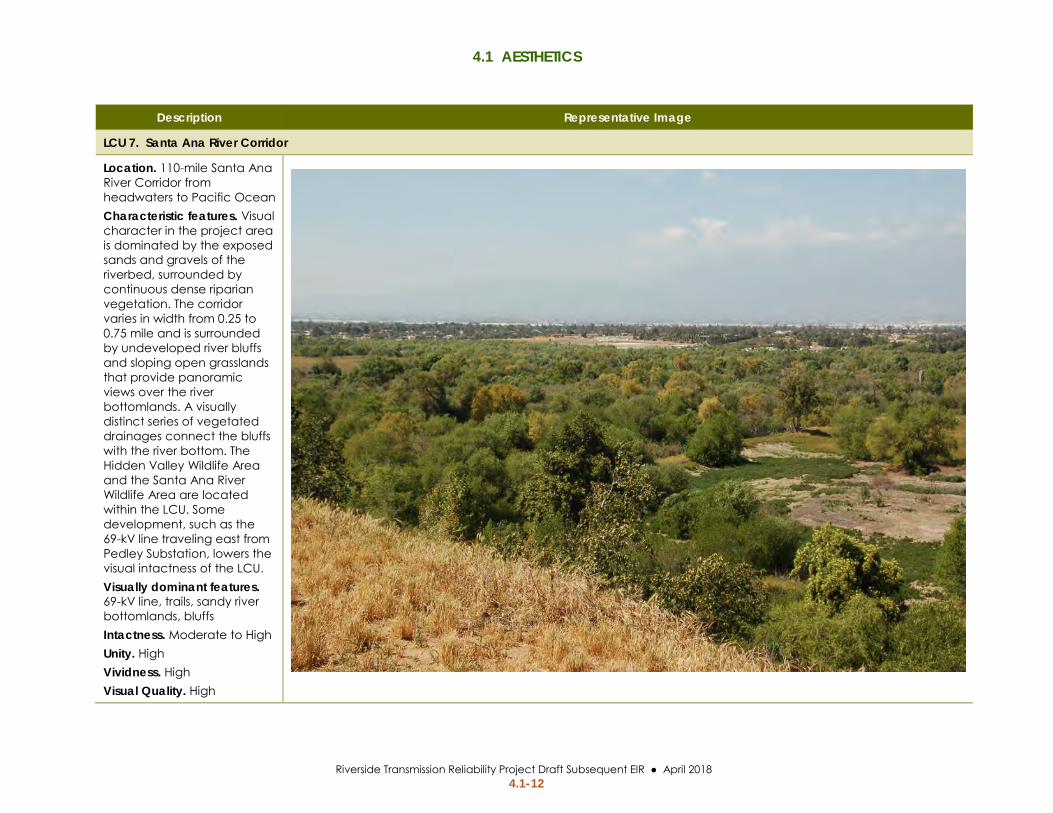
LCU 7. Santa Ana River Corridor
Location. 110-mile Santa Ana River Corridor from headwaters to Pacific Ocean Characteristic features. Visual character in the project area is dominated by the exposed sands and gravels of the riverbed, surrounded by continuous dense riparian vegetation. The corridor varies in width from 0.25 to 0.75 mile and is surrounded by undeveloped river bluffs and sloping open grasslands that provide panoramic views over the river bottomlands. A visually distinct series of vegetated drainages connect the bluffs with the river bottom. The Hidden Valley Wildlife Area and the Santa Ana River Wildlife Area are located within the LCU. Some development, such as the 69-kV line traveling east from Pedley Substation, lowers the visual intactness of the LCU. Visually dominant features. 69-kV line, trails, sandy river bottomlands, bluffs Intactness. Moderate to High Unity. High Vividness. High Visual Quality. High

4.1 AESTHETICS
Riverside Transmission Reliability Project Draft Subsequent EIR ● April 2018 4.1-13
Gateways to Jurupa Valley The City of Jurupa Valley Draft 2017 General Plan (City of Jurupa Valley, 2017) defines gateways as:
…locations of visual or geographic importance, typically on or near major street entry points. They are intended to be aesthetically pleasing, memorable, and understandable places signifying arrival or change. Gateways are typically located in high visibility areas, close to major transportation facilities that, due to their visual prominence, shape the aesthetic character of their surroundings.
Several gateways to Jurupa Valley are located in the Revised Project area, including those along I-15 and SR-60. Gateways near Revised Project components may include the I-15 exits at Cantu-Galleano Ranch Road and Limonite Avenue.
Regulatory Setting
Federal No federal laws or regulations pertaining to aesthetics are applicable to the Revised Project.
State
California Public Utilities Commission California Public Utilities Code § 320 requires that all new or relocated electric and communication distribution facilities within 1,000 feet of an officially designated scenic highway and visible from that highway be buried underground where feasible and not inconsistent with sound environmental planning. CPUC GO 131-D defines distribution as “…a line designed to operate under 50kV”.1
Local
County of Riverside County of Riverside General Plan The County of Riverside prepared the General Plan in 2008 and adopted amendments to several elements in 2015. The County General Plan defines scenic resources in the County as areas that are visible to the general public and are considered visually attractive (County of Riverside, 2015). Scenic vistas are defined as publicly-accessible points that provide views of the countryside. The General Plan identifies the following policy regarding scenic vistas:
Policy OS 21.1 Identify and conserve the skylines, view corridors, and outstanding scenic vistas within Riverside County.
1 The CPUC has implemented PUC § 320 via Tariff Rule 20. While Tariff Rule 20 does not disallow the funding of undergrounding power lines, the specific mandate of PUC § 320 is limited to distribution lines (CPUC, D.85497.)

4.1 AESTHETICS
Riverside Transmission Reliability Project Draft Subsequent EIR ● April 2018 4.1-14
The Jurupa Area Plan is an extension of the County’s General Plan and provides additional measures to protect the visual quality of the Santa Ana River Corridor. The measure below is applicable to the Revised Project.
JURAP 7.13 Discourage utility lines within the river corridor. If approved, lines shall be placed underground where feasible and shall be located in a manner to harmonize with the natural environment and amenity of the river.
City of Jurupa Valley 2017 Draft General Plan The City of Jurupa Valley adopted the 2017 Draft General Plan on August 17, 2017. The Land Use and the Economic Sustainability Elements of the General Plan identify goals and policies pertaining to aesthetics and visual resources. The following policies and goals are relevant to the Revised Project (City of Jurupa Valley, 2017):
Policy LUE 4.8 Impact Mitigation of New Public Facilities. Planning and development of new public facilities, such as public buildings, utility transmission lines (water, sewer, communications and power), roads, bridges, storage and equipment yards, and flood control channels, shall avoid adverse impacts on prime residential or commercial properties, or areas with residential and commercial development potential, and shall not adversely affect the character and quality of life in the City’s residential neighborhoods.
Policy ES 3.11 Gateway Improvements. Enhance major gateways along I-15, SR 60, Van Buren Boulevard, Mission Boulevard, and other important corridors to create attractive entrances into the City, as resources allow, through the City’s land use and capital improvement program.
City of Riverside General Plan 2025 The City of Riverside has prepared the 2025 General Plan, which was adopted in November 2007. The following policies outlined in the Open Space and Conservation Element are applicable to the Revised Project (City of Riverside, 2012):
Policy OS-2.2 Limit the extent and intensity of uses and development in areas of unstable terrain, steep terrain, scenic vistas, arroyos and other critical environmental areas.
Policy OS-2.4 Recognize the value of ridgelines, hillsides and arroyos as significant natural and visual resources and strengthen their role as features which define the character of the City and its individual neighborhoods.

4.1 AESTHETICS
Riverside Transmission Reliability Project Draft Subsequent EIR ● April 2018 4.1-15
Applicant’s Environmental Protection Elements SCE has proposed EPEs to reduce environmental impacts. The EPEs that avoid or reduce potentially significant impacts of the Revised Project will be incorporated as part of any CPUC project approval, and SCE will be required to adhere to the EPEs as well as any identified mitigation measures. The EPEs are included in the MMRP for the Revised Project (refer to Chapter 10: Mitigation Monitoring and Reporting Plan of this Subsequent EIR), and the implementation of the measures will be monitored and documented in the same manner as mitigation measures. The EPEs that are applicable to this aesthetics analysis are provided in Table 4.1-4.
Table 4.1-4 Environmental Protection Elements for Aesthetics Environmental
Protection Element Requirements
EPE AES-06: Placement of Transmission Structures
Transmission structures will be located adjacent to or in proximity of existing electrical infrastructure.
EPE AES-07: Storage Area Vegetation
Rehabilitate pulling, tensioning, and construction storage areas to original contour and vegetative state.
EPE AES-09: Staging Areas
Staging areas will be kept organized, and litter and debris will be regularly removed on at least a weekly basis.
Note: SCE recommended nine aesthetics EPEs in the 2013 EIR. EPEs are included in this table when the EPE is applicable to the Revised Project.
CEQA Significance Criteria Appendix G of CEQA Guidelines (14 CCR 15000 et seq.) provides guidance on assessing whether a project would have significant impacts on the environment. Changes to the Proposed Project or changes in baseline conditions that were not analyzed in the 2013 RTRP EIR require additional analysis to fully disclose potential impacts of the Revised Project. The CPUC prepared an Initial Study Checklist (Appendix B of this Subsequent EIR) to identify the new or increased potentially significant impacts that may occur as a result of the Revised Project elements, or changes in baseline conditions. The Initial Study Checklist indicated that the project has the potential for new or increased impacts under the significance criterion included below. CEQA significance criterion is lettered below to match the criterion lettering in the 2013 RTRP EIR. Consistent with Appendix G, the Revised Project would have significant impacts on aesthetics if it would:
c. Substantially degrade the existing visual character or quality of the site and its surroundings

4.1 AESTHETICS
Riverside Transmission Reliability Project Draft Subsequent EIR ● April 2018 4.1-16
Revised Project Impact Analysis
Approach to Impact Analysis This impact analysis considers whether implementation of the Revised Project would result in significant aesthetics impacts and focuses on reasonably foreseeable effects of the Revised Project as compared with baseline conditions. The analysis uses significance criteria based on the CEQA Appendix G Guidelines. The potential direct and indirect effects of the Revised Project are addressed below, and the cumulative effects are addressed in Chapter 6: Cumulative Impacts. Refer to the 2013 RTRP EIR for analysis of other elements of the Proposed Project.
Applicable EPEs are identified and mitigation is defined to avoid or reduce significant aesthetics impacts. The significance of the impact is first considered prior to application of EPEs and a significance determination is made. The implementation of EPEs is then considered when determining whether impacts would be significant and thus require mitigation. Mitigation measures are identified to reduce significant impacts of the Revised Project.
Visual Impact Assessment Methodology The CPUC evaluates impacts on visual quality using the Federal Highway Administration’s (FHWA) Visual Impact Assessment for Highway Projects (FHWA, 1988). This method was selected because, like highways, the Revised Project includes a linear feature, and the Revised Project would be visible from local streets and roads. The FHWA has published updated guidance for the visual impact assessment of highway projects (FHWA, 2015); however, the 1988 guidance utilizes a quantitative approach to evaluate visual impacts while the 2015 guidance does not. The CPUC selected the 1988 quantitative approach for this project because it is replicable and provides a consistent approach for analysis across KOPs. Additional information about the numeric methodology for determining visual impact is provided in Appendix F.
The change in visual quality because of the Revised Project was determined by comparing the existing visual quality of the landscape with the visual quality after construction of the Revised Project. A total of 20 KOPs were considered (refer to Appendix F), eight of which were selected to depict representative public views of the Revised Project area and used to analyze visual impacts from the Revised Project. The rejected KOPs did not appropriately capture viewer concerns as well as the eight chosen KOPs. The City of Jurupa Valley was consulted to ensure the KOPs addressed views of concern to the community. A description of each KOP is provided in Table 4.1-5, and the locations of KOPs are shown in Figure 4.1-3. Photographs of existing conditions were taken at each of the KOPs to represent the baseline conditions, and visual simulations were developed to represent views of the Revised Project.

4.1 AESTHETICS
Riverside Transmission Reliability Project Draft Subsequent EIR ● April 2018 4.1-17
Table 4.1-5 Description of Key Observation Points and Viewer Sensitivity
KOP Location of Viewpoint
Revised Project Elements
Direction of View Description of Views
Viewer Sensitivity
1 Cantu-Galleano Ranch Road
Overhead transmission line tie-in
West Foreground: Transmission infrastructure, street lights, industrial buildings Middleground: Transmission infrastructure, buildings
Low to Moderate
2 Wineville Avenue Overhead transmission line
North Foreground: Wineville Avenue, industrial buildings, residences Background: San Gabriel Mountains
High
3 Rosebud Lane Overhead transmission line
West Foreground: Residences, residential vegetation Middleground: Commercial buildings
High
4 Vernola Park Northern riser poles
Southwest Foreground: Agricultural field Middleground: Residences, Beacon Hill Background: Peninsular Mountain Range
High
5 Limonite Avenue park-and-ride
Northern riser poles
North Foreground: Agricultural field Background: San Gabriel Mountains
Moderate
6 Limonite Avenue and Pats Ranch Road intersection
Northern riser poles
Northwest Foreground: Agricultural field, radio towers, commercial signage
Moderate
7 Goose Creek Golf Club cart path west of driving range
Southern riser poles
Southeast Foreground: Golf course driving range, vegetation within Santa Ana River corridor, existing transmission lines and towers Middleground: La Sierra Hills
High
8 Horse trail in Norco along south side of Santa Ana River
Southern riser poles
Northwest Foreground: Vegetation along the Santa Ana River Middleground: Residences Background: San Gabriel Mountains
High

4.1 AESTHETICS
Riverside Transmission Reliability Project Draft Subsequent EIR ● April 2018 4.1-18
Figure 4.1-3 Key Observation Point Locations
Sources: (Esri, 2017; SCE, 2017)

4.1 AESTHETICS
Riverside Transmission Reliability Project Draft Subsequent EIR ● April 2018 4.1-19
The photograph of existing conditions and the visual simulation for each KOP were then quantitatively evaluated using a numeric rating system to analyze the Revised Project’s impact on visual quality in the area. The quantitative evaluation considered (1) the change in visual quality, and (2) viewer response to the change in visual quality to determine the overall visual impact. Visual changes resulting from the Revised Project are determined based on how the project blends with and complements the natural setting or the man-made development (unity and intactness), or the degree to which the project contrasts with them (vividness). Viewer response is determined based on the visual experience of different viewers, and their sensitivity and exposure to visual changes. Table 4.1-6 shows how the significance of the change is determined, based on viewer response.
Table 4.1-6 Guidelines for Determining the Significance of Adverse Visual Impact
Overall Viewer Response
Overall Visual Change
Low Low to
Moderate Moderate Moderate to
High High
Low Not Significant Not Significant Adverse, but Not Significant
Adverse, but Not Significant
Adverse, but Not Significant
Low to Moderate Not Significant Adverse, but
Not Significant Adverse, but
Not Significant Adverse, but
Not Significant Adverse, but
Not Significant
Moderate Adverse, but Not Significant
Adverse, but Not Significant
Adverse, but Not Significant
Adverse and Potentially Significant
Adverse and Potentially Significant
Moderate to High
Adverse, but Not Significant
Adverse, but Not Significant
Adverse and Potentially Significant
Adverse and Potentially Significant
Significant
High Adverse, but Not Significant
Adverse and Potentially Significant
Adverse and Potentially Significant
Significant Significant
Not Significant impacts may or may not be perceptible but are considered minor in the context of existing landscape characteristics and view opportunity. Adverse but Not Significant impacts are perceived as negative but do not exceed environmental thresholds. Adverse and Potentially Significant impacts are perceived as negative and may exceed environmental thresholds depending on project and site-specific circumstances. Significant impacts with feasible mitigation may be reduced to less-than-significant levels or avoided all together. Without mitigation or avoidance measures, significant impacts would exceed environmental thresholds.

4.1 AESTHETICS
Riverside Transmission Reliability Project Draft Subsequent EIR ● April 2018 4.1-20
Summary of Impacts Table 4.1-7 presents a summary of the CEQA significance criteria and impacts on aesthetics that would occur during construction, operation, and maintenance of the Revised Project.
Table 4.1-7 Summary of Revised Project Impacts on Aesthetics
Significance Criterion Project Phase Significance before EPEs
Significance after EPEs and before
Mitigation Significance
after Mitigation
Impact Aesthetics-c: Would the Revised Project substantially degrade the existing visual character or quality of the site and its surroundings?
Construction Significant Significant EPE AES-07
Less than Significant MM AES-01
Operation and Maintenance
Significant Significant EPE AES-06
Significant and Unavoidable
Impact Discussion
Impact Aesthetics-c: Would the Revised Project substantially degrade the existing visual character or quality of the site and its surroundings?
Significance Determination
Construction: Less than Significant with Mitigation
Operation & Maintenance: Significant and Unavoidable
Construction
Overview Construction of the Revised Project would introduce construction equipment to the visual landscape and result in landscape alterations through vegetation removal, grading, trenching, and the erection of transmission structures. Overhead transmission line construction activities including site clearing and grading, installation of poles and foundations, and conductor stringing would be visible from surrounding areas. Construction of the Revised Project overhead transmission line would be visible to motorists, recreationalists, and residents near Wineville Avenue and the intersection with Cantu-Galleano Ranch Road.
Underground transmission line construction activities including trenching, conductor duct bank and vault installation, and riser pole installation would be visible from roadways, residences, and equestrian riding paths along the underground alignment. Construction of the riser poles would be visible to motorists and residents near the northern riser poles at Limonite Avenue. Southern riser pole construction in the Goose Creek Golf Club would be visible to golfers.
Construction of the Revised Project would result in short-term views of construction vehicles and equipment, and long-term changes to the visual quality of the site through land modifications and erection of permanent structures. The long-term impacts of the new transmission structures, conductor, and permanent work pads are analyzed under operation and maintenance, below.

4.1 AESTHETICS
Riverside Transmission Reliability Project Draft Subsequent EIR ● April 2018 4.1-21
230-kV Transmission Line Overhead Transmission Line Clearing and Grading. Temporary work areas including pulling sites, tensioning sites, and pole work areas would be cleared of vegetation and possibly graded. Erection of new TSPs, including riser poles, would require a work area of approximately 200 feet by 100 feet at each new pole. LST construction would require a 200-foot by 200-foot work pad. Pulling and tensioning sites would be approximately 100 feet by 400 feet. Views of the graded work areas would persist after construction because it would take time for vegetation to reestablish in areas that are temporarily disturbed by construction. The visual change from graded work areas would be moderate to high because the denuded land surface would contrast with the surrounding landscaped vegetation along Wineville Avenue and in riparian vegetation or manicured lawns within the golf course. The viewer response would be moderate to high. The resulting impact on visual quality from vegetation removal and grading would be significant.
SCE would implement EPE AES-07, which includes the rehabilitation of pulling, tensioning, and construction storage areas to pre-construction conditions. The impact would remain significant after implementation of EPE AES-07 because the EPE does not include revegetation of tower and pole work areas. MM AES-01 requires restoration of all temporarily disturbed areas and specifies methods to achieve successful revegetation. The visual impact from clearing and grading for the overhead alignment would be less than significant with mitigation.
Towers, Poles, and Foundations. Three LSTs, two TSPs, and four riser poles would be installed during construction of the Revised Project. Large construction equipment, such as concrete trucks, flatbed trucks, cranes, and drilling rigs, would be used to install poles, towers, and foundations. Construction activities would typically last approximately 6 to 10 weekdays at each work area for LSTs and TSPs, respectively. Riser pole construction would typically last 15 weekdays (the long-term impact on visual quality from the presence of new poles, towers, and foundations is addressed under operation and maintenance below). The form, line, and color of the construction equipment would contrast substantially with the visual setting of the surrounding suburban community near Wineville Avenue and the open space near the riser poles. The level of visual change during construction would be high, but the viewer response to the temporary visual impact from construction equipment and activity would be low due to the short duration of construction in each area. The resulting visual impact would be less than significant.
Underground 230-kV Alignment Trenching and Vault Installation. Two open trenches (4.5 feet wide) would be constructed north of Limonite Avenue and within Pats Ranch Road, 68th Street, and the Goose Creek Golf Club. The trenches would be constructed within the paved roadways, open agricultural field north of Limonite Avenue, and in the Goose Creek Golf Club. Trench construction would require 30-foot-wide work spaces along their entire length. The double-circuit 230-kV transmission line would be installed in the trenches.
4.1 AESTHETICS
Riverside Transmission Reliability Project Draft Subsequent EIR ● April 2018 4.1-22
Thirty-two vaults would be installed at 16 locations within the underground alignment. Each vault would require a 15,000-square-foot work area to set the vaults. The vault work area may extend beyond the roadway in some locations and could result in impacts on or removal of vegetation along the landscaped road shoulder. Construction equipment, including backhoes, bulldozers, concrete trucks, and dump trucks, would be visible adjacent to the trench and vault locations. Views of the equipment would be transient as equipment moves along the underground alignment. Views of construction would be visible for several months along the underground alignment. Vaults and duct bank placed in the trench would be backfilled, and trenched areas that were paved prior to excavations would be repaved.
Views of construction equipment would contrast with the existing views from residential areas and recreational trails abutting the underground alignment. The presence of construction equipment, an underground trench, and traffic control devices would have a moderately high level of visual change. However, housing development construction has been ongoing for several years in the area, making views of construction part of the baseline environment. The viewer response to this change may be low to moderate. Views of the construction and equipment would last several months, but viewers are aware that construction is temporary. The resulting impact from views of construction activity would be less than significant.
Temporary impacts from vegetation removal for underground construction would be similar to vegetation removal required for overhead construction. Removal of vegetation during underground construction would contrast with the vegetated agricultural fields north of Limonite Avenue and manicured lawns and riparian vegetation in the golf course, presenting a high level of visual change. Viewer response would be moderate to high. If vegetation is not restored on road shoulders and over underground vaults and duct banks following construction, the impact would be significant.
SCE would implement EPE AES-07, which includes the rehabilitation of pulling, tensioning, and construction storage areas to pre-construction conditions; however, the impact would remain significant because the EPE does not include revegetation of underground work areas. MM AES-01 requires restoration of all temporarily disturbed areas and specifies methods to achieve successful revegetation. The impact from vegetation removal for the underground alignment would be less than significant with mitigation.
Distribution Line Relocations #7 and #8 Construction as part of distribution line relocations would require similar construction equipment as required for the underground 230-kV transmission line. Construction equipment would be visible to trail users on the Santa Ana River Trail and residential areas nearby. Construction equipment would contrast with the open space views at Distribution Line Relocation #7 but would not be uncommon in the area due to ongoing remediation activities at the Agricultural Park site (a former sewage treatment plant) south of Distribution Line Relocation #7. Distribution Line Relocation #8 would be located in an industrial area where large equipment also is common. Construction equipment would not significantly contrast with existing views in the area. Additionally, viewer response to the presence of large construction

4.1 AESTHETICS
Riverside Transmission Reliability Project Draft Subsequent EIR ● April 2018 4.1-23
equipment and materials would be low due to the short duration of the exposure that transient trail users would experience as they pass by construction activities. The impact from the presence of construction equipment at Distribution Line Relocations #7 and #8 would be less than significant.
Vegetation removal required for underground construction would significantly contrast with views at Distribution Line Relocations #7 and #8. The impact would be significant if removed vegetation is not restored following construction.
SCE would implement EPE AES-07, which includes the rehabilitation of pulling, tensioning, and construction storage areas to pre-construction conditions; however, the impact would remain significant because the EPE does not include revegetation of underground work areas. MM AES-01 requires restoration of all temporarily disturbed areas and specifies methods to achieve successful revegetation. The impact from vegetation removal at Distribution Line Relocations #7 and #8 would be less than significant with mitigation.
Etiwanda Marshalling Yard The Etiwanda Marshalling Yard would be used for material storage, refueling vehicles, maintenance of construction vehicles, clerical and administrative offices, and as a reporting location for workers. Construction materials, personnel, and heavy equipment, including backhoes, bulldozers, concrete trucks, and dump trucks would be visible at the Etiwanda Marshalling Yard during construction. Views of construction equipment, materials and personnel would be visible at the Etiwanda Marshalling Yard throughout the construction phase, lasting approximately 26 months. The yard is located in an industrial area on an unpaved vacant lot. Views of construction equipment at the Etiwanda Marshalling Yard would not significantly contrast with the industrial setting because the character of the yard would be consistent with the character of the industrial LCU. Additionally, viewer response to the presence of large construction equipment and materials would be low because viewers understand that construction is temporary. The impact from the use of the Etiwanda Marshalling Yard would be less than significant.
Operation and Maintenance
Overview of Revised Project Effects Permanent structures would be installed along the Revised Project alignment and other structures would be removed. The installed and removed structures are identified in Table 4.1-8. The installation and removal of the structures would result in long-term visual changes that are discussed by segment below.
Baseline photographs and views from KOPs showing the simulated project features are provided in Figure 4.1-4 through Figure 4.1-19. Table 4.1-9 provides the rating and level of visual impact resulting from the long-term presence of the Revised Project’s facilities. Rating sheets that provide the numeric evaluation for all KOP baseline photographs and photosimulations are provided in Appendix F. The impacts shown in the simulations are further discussed below.

4.1 AESTHETICS
Riverside Transmission Reliability Project Draft Subsequent EIR ● April 2018 4.1-24
Table 4.1-8 Summary of Visible Revised Project Features Transmission Line Segment KOPs in Segment Revised Project Features
Overhead on Wineville Avenue
KOPs 1, 2, and 3 • Two new LSTs • Two new TSPs
Overhead – Underground Transition North of Limonite Avenue
KOPs 4, 5, and 6 • One new LST • Two new riser poles
Underground Transmission Line on Pats Ranch Road and 68th Street
N/A • Thirty-two underground vaults • Two underground duct banks
Underground – Overhead Transition in Goose Creek Golf Club
KOPs 7 and 8 • Two new riser poles
Distribution Line Relocation #7 N/A • Two new distribution riser poles • Removal of four existing
distribution poles • One underground duct bank • One underground vault
Distribution Line Relocation #8 N/A • Two new distribution riser poles • Removal of seven existing
distribution poles • One underground duct bank • Two underground vaults
Table 4.1-9 Summary of Visual Impacts for Key Observation Points KOP Revised Project Element Visual Impact
1 Overhead Transmission Tie-In Low
2 Overhead Transmission Line (Wineville Avenue) Moderate
3 Overhead Transmission Line (Rosebud Lane) High
4 Northern Riser Poles (from Vernola Park) Moderate
5 Northern Riser Poles (from park-and-ride) Moderately High
6 Northern Riser Poles (from Limonite Avenue) Moderately High
7 Southern Riser Poles (Goose Creek Golf Course) High
8 Southern Riser Poles (Norco recreational trail) High

4.1 AESTHETICS
Riverside Transmission Reliability Project Draft Subsequent EIR ● April 2018 4.1-25
This page is intentionally left blank.

4.1 AESTHETICS
Riverside Transmission Reliability Project Draft Subsequent EIR ● April 2018 4.1-26
Figure 4.1-4 KOP 1 – Baseline Photograph – Cantu-Galleano Ranch Road Looking West

4.1 AESTHETICS
Riverside Transmission Reliability Project Draft Subsequent EIR ● April 2018 4.1-27
Figure 4.1-5 KOP 1 – Photosimulation (After Revised Project) – Cantu-Galleano Ranch Road Looking West

4.1 AESTHETICS
Riverside Transmission Reliability Project Draft Subsequent EIR ● April 2018 4.1-28
Figure 4.1-6 KOP 2 – Baseline Photograph – Wineville Avenue Looking North

4.1 AESTHETICS
Riverside Transmission Reliability Project Draft Subsequent EIR ● April 2018 4.1-29
Figure 4.1-7 KOP 2 – Photosimulation (After Revised Project) – Wineville Avenue Looking North

4.1 AESTHETICS
Riverside Transmission Reliability Project Draft Subsequent EIR ● April 2018 4.1-30
Figure 4.1-8 KOP 3 – Baseline Photograph – Rosebud Lane Looking West

4.1 AESTHETICS
Riverside Transmission Reliability Project Draft Subsequent EIR ● April 2018 4.1-31
Figure 4.1-9 KOP 3 – Photosimulation (After Revised Project) – Rosebud Lane Looking West

4.1 AESTHETICS
Riverside Transmission Reliability Project Draft Subsequent EIR ● April 2018 4.1-32
Figure 4.1-10 KOP 4 – Baseline Photograph – Vernola Park Looking Southwest

4.1 AESTHETICS
Riverside Transmission Reliability Project Draft Subsequent EIR ● April 2018 4.1-33
Figure 4.1-11 KOP 4 – Photosimulation (After Revised Project) – Vernola Park Looking Southwest

4.1 AESTHETICS
Riverside Transmission Reliability Project Draft Subsequent EIR ● April 2018 4.1-34
Figure 4.1-12 KOP 5 – Baseline Photograph – Limonite Avenue Park-and-Ride Looking North

4.1 AESTHETICS
Riverside Transmission Reliability Project Draft Subsequent EIR ● April 2018 4.1-35
Figure 4.1-13 KOP 5 – Photosimulation (After Revised Project) – Limonite Avenue Park-and-Ride Looking North

4.1 AESTHETICS
Riverside Transmission Reliability Project Draft Subsequent EIR ● April 2018 4.1-36
Figure 4.1-14 KOP 6 – Baseline Photograph – Limonite Avenue at Pats Ranch Road Looking Northwest

4.1 AESTHETICS
Riverside Transmission Reliability Project Draft Subsequent EIR ● April 2018 4.1-37
Figure 4.1-15 KOP 6 – Photosimulation (After Revised Project) – Limonite Avenue at Pats Ranch Road Looking Northwest

4.1 AESTHETICS
Riverside Transmission Reliability Project Draft Subsequent EIR ● April 2018 4.1-38
Figure 4.1-16 KOP 7 – Baseline Photograph – Goose Creek Golf Club Driving Range Looking Southeast1
1 Note: KOP 7 baseline photograph and simulation were provided by Southern California Edison and represent baseline and project conditions in panoramic views. Panoramic simulations allow the viewer to see more of the proposed 230-kV transmission line; however, project facilities appear smaller in a panoramic simulation due to the nature of baseline photography.

4.1 AESTHETICS
Riverside Transmission Reliability Project Draft Subsequent EIR ● April 2018 4.1-39
Figure 4.1-17 KOP 7 – Photosimulation (After Revised Project) – Goose Creek Golf Club Driving Range Looking Southeast2
2 Note: KOP 7 baseline photograph and simulation were provided by Southern California Edison and represent baseline and project conditions in panoramic views. Panoramic simulations allow the viewer to see more of the proposed 230-kV transmission line; however, project facilities appear smaller in a panoramic simulation due to the nature of baseline photography.
4.1 AESTHETICS
Riverside Transmission Reliability Project Draft Subsequent EIR ● April 2018 4.1-40
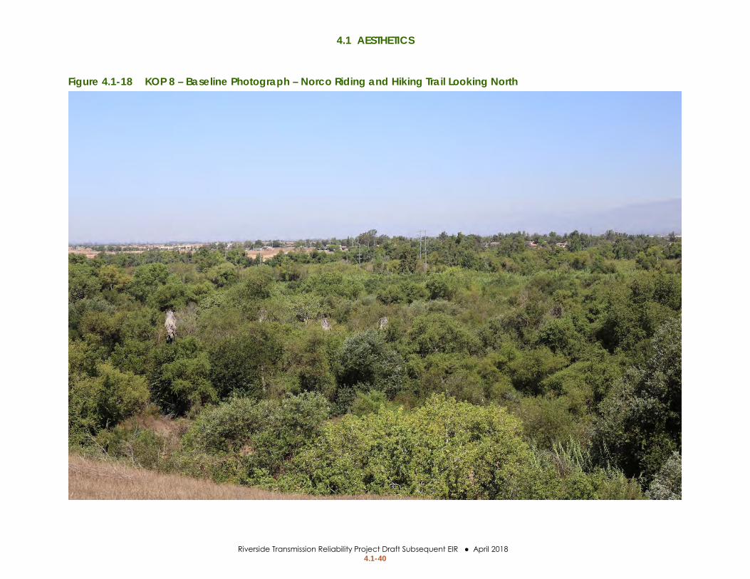
Figure 4.1-18 KOP 8 – Baseline Photograph – Norco Riding and Hiking Trail Looking North

4.1 AESTHETICS
Riverside Transmission Reliability Project Draft Subsequent EIR ● April 2018 4.1-41
Figure 4.1-19 KOP 8 – Photosimulation (After Revised Project) – Norco Riding and Hiking Trail Looking North

4.1 AESTHETICS
Riverside Transmission Reliability Project Draft Subsequent EIR ● April 2018 4.1-42
This page is intentionally left blank.

4.1 AESTHETICS
Riverside Transmission Reliability Project Draft Subsequent EIR ● April 2018 4.1-43
Overhead Transmission Line Overview Visual impacts along Wineville avenue are represented by KOPs 1, 2, and 3 (Figure 4.1-4 through Figure 4.1-9). Existing electrical infrastructure is present in the area, including LSTs from the Mira Loma – Vista #1 230-kV Transmission Line and distribution poles and wires along Cantu-Galleano Ranch Road and Wineville Avenue. The Revised Project would cause long-term visual change from installation of TSPs and LSTs and would be visible from local roadways, recreational paths along Wineville Avenue, and residences east of Wineville Avenue. The visual change from construction of the overhead 230-kV transmission line along Wineville Avenue would be low to moderate. The visual sensitivity in the area ranges from moderate along Wineville Avenue to high on Rosebud Lane due to the new residential development east of Wineville Avenue. The impacts are described in more detail below.
Views from Local Roadways and Recreational Paths (KOPs 1 and 2) The overhead transmission line would be visible from roadways in the Revised Project area, including Wineville Avenue, Landon Drive, and Cantu-Galleano Ranch Road (Figure 4.1-4 through Figure 4.1-7). Vegetation within 10 feet of transmission lines would be trimmed to reduce fire danger, and a 25-foot radius around would be maintained around LSTs and TSPs for fire protection. This area would be cleared of large shrubs and trees for fire purposes.
Overhead electrical infrastructure is present in the area. The LSTs that make up the Mira Loma – Vista #1 230-kV Transmission Line north of Cantu-Galleano Ranch Road are visible from local roadways and recreational paths in the area. Existing power lines parallel the north side of Cantu-Galleano Ranch Road and the east side of Wineville Avenue (refer to Figure 4.1-4). As described in the 2013 RTRP EIR, the existing overhead distribution line on Wineville Avenue would be moved underground, reducing the overall amount of overhead electrical infrastructure. Viewer sensitivity on Wineville Avenue and Cantu-Galleano Ranch Road would generally be low to moderate along roadways because motorists’ attention would be focused on the road. Views from recreational paths would be moderate because the visual quality along the Revised Project overhead alignment is moderate. The Revised Project transmission structures would be taller and larger than existing distribution structures along Wineville Avenue but would be visually comparable to the Mira Loma – Vista #1 230-kV Transmission Line north of Cantu-Galleano Ranch Road. The new transmission poles would not substantially affect visual quality in the area around the Revised Project overhead transmission line. The visual impact from local roadways and recreational paths would be less than significant.
Views from Residential Streets (KOP 3) Towers and poles of the Revised Project would be visible from residential streets near the overhead transmission line. Conductor wires and the tops of TSPs and LSTs would be visible over residences from residential streets such as Horse Chestnut Drive. The LST at the corner of Wineville Avenue and Landon Drive would be fully visible to residents as they exit the community on Rosebud Lane. Electrical infrastructure is not visible from residential streets under current conditions. The new overhead transmission line would contrast with the form and color of the open landscape that is currently observed from the residential community
4.1 AESTHETICS
Riverside Transmission Reliability Project Draft Subsequent EIR ● April 2018 4.1-44
entrance on Rosebud Lane. Viewer response to the change on residential streets would be high due to the high sensitivity of residential viewers to landscape changes and the high level of viewer exposure to the Revised Project elements. The resulting impact on visual quality would be significant.
SCE has not proposed EPEs to reduce the impact of overhead transmission structures. Mitigation for impacts on aesthetic resources typically include vegetative screening or color treatment of facilities. Vegetative screening is not possible due to the height of the structures. Color treating the Revised Project facilities is possible, but color treatment mitigation would only apply to the Revised Project facilities and would not reduce the contrasting impact resulting from the size and form of the overhead transmission facilities. Color treatment could cause an even greater contrast with nearby untreated, existing galvanized steel electrical facilities, as well as the Proposed Project facilities that are not included in the scope of the Revised Project. The impact of the overhead transmission structures on views from residential streets would be significant and unavoidable.
Riser Pole Locations Visual impacts on locations with views of the northern riser poles (north of Limonite Avenue) are represented by KOPs 4, 5, and 6 (Figure 4.1-10 through Figure 4.1-15). Visual impacts within the Goose Creek Golf Club from the southern riser poles and views from recreational paths south of the Santa Ana River are represented by KOPs 7 and 8, respectively (Figure 4.1-16 through Figure 4.1-19). Riser poles would have long-term visual impacts. Two riser poles would be constructed in the agricultural field north of the Limonite Avenue park-and-ride. Two riser poles would also be constructed in the Goose Creek Golf Club. Each riser pole would be 165 feet tall. A 30-foot-tall metal shroud would be constructed around the base of each riser pole to cover the conductor as it transitions underground. Additionally, three bollards would be installed in front of each riser pole to protect the conductor from accidental impact from vehicles, agricultural equipment, and golf carts. A 25-foot radius would be maintained free of shrubs and trees around each riser pole for fire protection. The visual change from the new riser poles would be moderate to high, both north of Limonite Avenue and in the golf course. The viewer sensitivity in the area ranges from moderate on roadways to high in recreational areas.
Views from Parks and Recreational Areas (KOPs 4, 7, and 8) The long-term impact on aesthetic resources from recreational facilities such as Vernola Park, the Goose Creek Golf Club, and recreational paths on the south side of the Santa Ana River would range from moderate to high. The overhead transmission line and riser poles would be visible to park, trail, and golf course users and would contrast with the surrounding agricultural or manicured landscape.
KOP 4 represents the visual change from the southwestern end of Vernola Park. The visual contrast would be muted at Vernola Park due to the distance between the park and the transmission structures, as well as the presence of other industrial, residential, and commercial visual elements. The change in visual quality would be moderate. The viewer sensitivity at Vernola Park would be high because viewer exposure is high. The overall impact on visual

4.1 AESTHETICS
Riverside Transmission Reliability Project Draft Subsequent EIR ● April 2018 4.1-45
quality at KOP 4 is moderate. A moderate impact on visual change in areas with high viewer sensitivity would result in a significant impact on visual quality.
SCE has proposed implementation of EPE AES-06, which requires transmission infrastructure to be constructed in proximity to existing infrastructure. This EPE applies to the riser pole in the Goose Creek Golf Club. An overhead 115-kV transmission line exists within the golf course, but the riser poles of the Revised Project are substantially larger than the TSPs that support the existing 115-kV transmission line. The impact would remain significant after implementing the EPE.
The EPEs proposed by SCE would not reduce the impact of overhead facilities on visual quality. Mitigation options, such as vegetative screening or color treatment of facilities, are either infeasible or have the potential to cause greater contrast with existing transmission infrastructure. The impact on visual quality at KOP 4 would be significant and unavoidable.
KOPs 7 and 8 represent views of the southern riser poles in the Goose Creek Golf Club. Visual quality from these KOPs is high despite existing transmission infrastructure visible from both locations. The riser poles would contrast substantially with the surrounding vegetated landscape, and the form of the riser poles would contrast with adjacent TSPs and LSTs. The level of viewer change would be high and viewer sensitivity would be high. The visual impact would be high and the impact on visual quality would be significant. The EPEs proposed by SCE would not reduce the impact of overhead facilities on visual quality. Mitigation options, such as vegetative screening or color treatment of facilities, are infeasible and could create greater visual contrast, as stated previously. The visual impact from the overhead transmission line and riser poles on parks and recreational areas would be significant and unavoidable.
Views from Local Roadways (KOPs 5 and 6) The Limonite Avenue riser poles would contrast substantially with agricultural landscapes as shown in KOPs 5 and 6 (Figure 4.1-12 through Figure 4.1-15). The Limonite Avenue riser poles would be substantially taller than existing structures in the vicinity including buildings, radio towers, street lights, and commercial signage. The large size of the riser poles and the lack of surrounding vertical infrastructure would increase their visibility and industrial appearance. The change in visual quality at KOPs 5 and 6 would be moderate. The viewer response would be moderate where the riser poles would be installed near the Limonite Avenue overpass, which is considered a gateway to Jurupa Valley. The visual impact from the riser poles would be moderately high, and the impact on visual quality would be significant.
SCE has not proposed any EPEs to reduce the impact of overhead facilities on visual quality. Mitigation options do not exist to reduce the impact, as stated previously. The impact from the Limonite Avenue riser poles would be significant and unavoidable.
Underground 230-kV Transmission Line The underground transmission line would be buried and would not be visible except for grade-level manholes at vaults located in roadways. There would be no impact on visual quality after construction is complete.

4.1 AESTHETICS
Riverside Transmission Reliability Project Draft Subsequent EIR ● April 2018 4.1-46
Distribution Line Relocations #7 and #8 Two riser poles would be installed in the place of two existing distribution poles at Distribution Line Relocations #7 and #8. Distribution riser poles would be approximately 54 feet tall. Construction would remove four existing poles from the overhead alignment at Distribution Line Relocation #7. Seven existing poles would be removed from the overhead alignment at Distribution Line Relocation #8. Visual quality would be improved due to the reduced number of poles and overhead infrastructure that impacts existing views. The impact on visual quality near Distribution Line Relocations #7 and #8 would be less than significant.
Etiwanda Marshalling Yard The Etiwanda Marshalling Yard would be returned to pre-construction conditions following construction and all project-related activities would cease at the yard. There would be no long-term impact on visual quality at the Etiwanda Marshalling Yard.
Mitigation Measures: MM AES-01 Significance after Mitigation: Significant and Unavoidable
Revised Project Mitigation Measures
MM AES-01: Restore Construction Impacts to Vegetation SCE shall conduct a pre-construction site assessment of all locations where Revised Project construction activities have the potential to disturb existing vegetation, including native and landscaped vegetation. The pre-construction site assessment and proposed revegetation activities shall be documented in a Pre-Activity Study Report and shall include the following: • Description of work location, size, equipment, and methods required for project activities that may
disturb vegetation • Map of work area location • Documentation of surrounding land uses • Photographs of the area to be disturbed • Documentation of vegetation types, species, and quantity to be removed • Proposed landscape revegetation plans • Records of communication with landowners indicating approval of revegetation plans
The Pre-Activity Study Report shall be submitted to CPUC for review and approval no fewer than 30 days prior to the start of construction. When Revised Project construction has been completed, all temporarily disturbed terrain will be restored, to the extent practical, to pre-construction conditions documented in the Pre-Activity Study Report while maintaining adequately safe work areas for operation and maintenance activities, as needed. Revegetation will be used, where appropriate (re-vegetation in certain areas is not possible due to vegetation management requirements related to fire safety) to re-establish a natural-appearing landscape and reduce potential visual contrast between disturbed areas and the surrounding landscape. Documentation of completed revegetation shall be submitted to the CPUC for final approval within 30 days of project completion.
Applicable Locations: All Revised Project locations where natural vegetation or landscaping has been disturbed by construction purposes

4.1 AESTHETICS
Riverside Transmission Reliability Project Draft Subsequent EIR ● April 2018 4.1-47
Performance Standards and Timing: • Prior to Construction: SCE completes pre-construction site assessment and submits a Pre-Activity
Study Report to CPUC for review and approval no fewer than 30 days prior to the start of construction
• During Construction: N/A • Following Construction: Restore impacts on vegetation and provide documentation of completed
revegetation to CPUC for final approval within 30 days of project completion
Alternatives Setting
Environmental Setting The aesthetic environmental setting would include the same viewsheds described for the revised project because the alternative above ground project components would be visible from the same KOPs as the Revised Project.
Regulatory Setting The regulatory settings for Alternatives 1 through 4 would include the federal, State, and Jurupa Valley policies and regulations identified for the revised project. Regulations that pertain to the City or County of Riverside are not applicable because none of the alternatives considered in this analysis occur in the City or unincorporated County of Riverside.
Alternatives Impact Analysis
Alternatives Analysis Scope The following analysis considers only the environmental impacts resulting from construction and operation of each alternative alignment segment. Any specific alternative replaces only a portion of the Revised Project and would require combination with the remaining unaffected segments of the Revised Project to form a complete alternative route through Jurupa Valley. Impacts resulting from construction and operation of the additional Revised Project elements necessary to form a complete alternative route are not considered in this section. A discussion of the environmental impacts resulting from construction and operation of the complete alternative route, comprised of each alternative alignment plus the unaffected Revised Project elements, is provided in Chapter 6: Comparison of Alternatives.
Impacts Avoided by the Alternatives Alternatives 1 through 4 would be constructed in the same general project area as the revised project and would have no impact on three CEQA Appendix G significance criteria:
a. Have a substantial adverse effect on a scenic vista b. Substantially damage scenic resources, including, but not limited to, trees, rock
outcroppings, and historic buildings within a state scenic highway d. Create a new source of substantial light or glare which would adversely affect day or
nighttime views in the area None of the alternatives are located near a scenic vista and there are no designated scenic highways in the project vicinity. None of the alternatives would create a new source of daytime glare or nighttime lighting because the transmission line would be placed underground and

4.1 AESTHETICS
Riverside Transmission Reliability Project Draft Subsequent EIR ● April 2018 4.1-48
construction would occur during the day. The riser poles would be the only aboveground component of the retained alternatives. Riser poles would be constructed using galvanized steel treated to reduce glare. Aesthetics impacts associated with these significance criteria are not discussed further.
Alternative 1 and Alternative 2 Environmental Impacts and Mitigation Measures Alternative 1 and Alternative 2 involve construction of two riser poles at the northwest corner of Wineville Avenue and Cantu-Galleano Ranch Road. The Alternative 1 underground transmission line would be located within Wineville Avenue, Bellegrave Avenue, and Pats Ranch Road. The Alternative 2 underground transmission line would be located within Wineville Avenue and Limonite Avenue. Both Alternative 1 and Alternative 2 would meet the Revised Project underground alignment at the intersection of Limonite Avenue and Pats Ranch Road.
Impact Aesthetics-c: Would Alternative 1 or 2 substantially degrade the existing visual character or quality of the site and its surroundings?
Significance Determination
Construction: Less than Significant with Mitigation
Operation & Maintenance: Less than Significant
Construction Construction of Alternatives 1 and 2 would each involve the installation of two riser poles (165 feet tall) near Cantu-Galleano Ranch Road and construction of two underground transmission lines that would extend the entire length of each alignment. Vaults would be installed along the alternative underground transmission alignment to allow for maintenance of the new 230-kV transmission line. The same heavy equipment required for the Revised Project would be used to construct Alternatives 1 and 2, including motograders, cranes, backhoes, concrete saws and concrete trucks (refer to Chapter 2, Table 2.4-2). Construction equipment and traffic control devices would be visible to residents, recreationalists on trails and within parks, and motorists near the underground alignments.
Views of construction would last 13 months at active work areas along the Alternative 1 and Alternative 2 alignments and would temporarily impact visual quality and character. Construction would not be visible along the entire alignment for the duration of construction; rather, equipment would be observed at the active work area along the alignment, which would migrate from week to week as construction progresses along the alignment. The presence of construction equipment, underground trenches, and traffic control devices would have a moderate to moderately high level of visual change. Affected viewers would be aware of the temporary nature of project construction, and would have low sensitivity to the impact. The impact from views of construction equipment and materials would be less than significant.
Construction of Alternatives 1 and 2 may require the removal of landscaped vegetation along road shoulders. Vegetation along roadways screens views of roads and commercial development. Removal of vegetation would change the view in the immediate vicinity of the removed landscaping and would contrast with the landscaped shoulders unaffected by the project. The visual change would be moderate and viewer response would be moderate to high

4.1 AESTHETICS
Riverside Transmission Reliability Project Draft Subsequent EIR ● April 2018 4.1-49
due to the long-term affect from the removal of the vegetative screening. The overall impact from the removed landscape materials would be potentially significant. MM AES-01 requires SCE to restore all temporarily disturbed areas, including landscaping, and specifies methods to achieve successful revegetation. The impact would be less than significant with mitigation.
Operation and Maintenance The Alternative 1 and Alternative 2 transmission line would be buried under roadways. There would be no lasting aesthetic impacts from the underground transmission line.
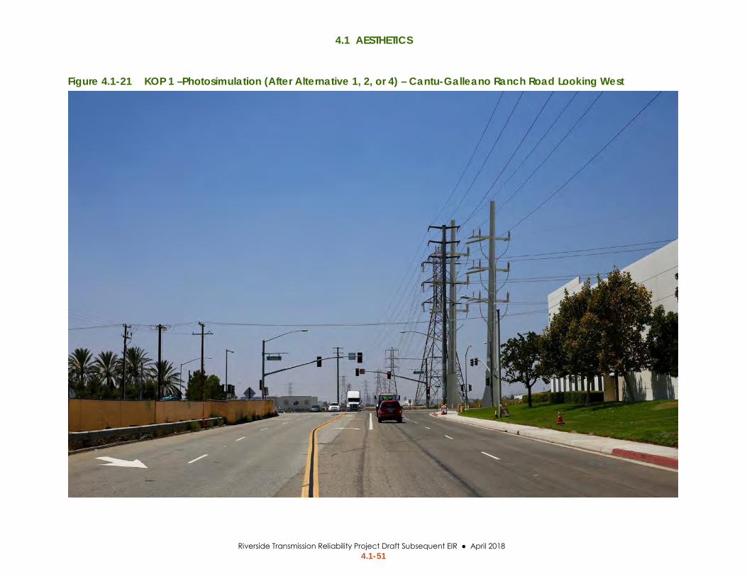
Alternative 1 and Alternative 2 riser poles at the northwest corner of the intersection of Wineville Avenue and Cantu-Galleano Ranch Road would be 165 feet tall and would be similar in height to the existing LSTs that support the Mira Loma – Vista #1 230-kV Transmission Line. Figure 4.1-20 and Figure 4.1-21 show the existing view and visual simulation of the Alternative 1 and Alternative 2 riser poles at KOP 1. The riser poles would be constructed adjacent to existing overhead transmission infrastructure. Motorists on Wineville Avenue and Cantu-Galleano Ranch Road would have unobstructed views of the riser poles. The riser poles would also be visible to future residences at the southeast corner of Wineville Avenue and Cantu-Galleano Ranch Road. The shape and form of the riser poles would contrast with the sparse landscape and adjacent buildings; however, the size and color of the riser poles are similar to the adjacent existing transmission structures and surrounding character of the landscape unit. The impact on visual quality would be low, resulting in a less than significant impact.
Mitigation Measures: MM AES-01 (refer to Section 4.1.9: Revised Project Mitigation Measures) Significance after Mitigation: Less than Significant
Impact Aesthetics-d: Would Alternative 1 or 2 create a new source of substantial light or glare which would adversely affect day or nighttime views in the area?
Significance Determination
Construction: Less than Significant
Operation & Maintenance: Less than Significant
Construction Light Lighting would be used during construction to the extent required for safety and equipment operation. Construction would generally occur within the daylight working hours of 6:00 am to 6:00 pm (June to September) and 7:00 am to 6:00 pm (October to May), Monday through Friday. Supplemental temporary lighting may be required outside of daylight hours to allow for the completion of work tasks and daily cleanup as well as for safety. Temporary lighting units would be in operation to provide workers with a minimum level of illumination to allow the safe completion of their work. If required, lighting during nighttime construction activities would be very short term and intermittent (i.e., a few hours on a single evening). Alternatives 1

4.1 AESTHETICS
Riverside Transmission Reliability Project Draft Subsequent EIR ● April 2018 4.1-50
Figure 4.1-20 KOP 1 – Baseline Photograph – Cantu-Galleano Ranch Road Looking West
4.1 AESTHETICS
Riverside Transmission Reliability Project Draft Subsequent EIR ● April 2018 4.1-51
Figure 4.1-21 KOP 1 –Photosimulation (After Alternative 1, 2, or 4) – Cantu-Galleano Ranch Road Looking West

4.1 AESTHETICS
Riverside Transmission Reliability Project Draft Subsequent EIR ● April 2018 4.1-52
and 2 would also be located in roadways and near residences where there are existing sources of lighting. Due to the short duration of potential lighting during construction and the presence of existing lighting in the surrounding area, Alternatives 1 and 2 would not create a substantial source of lighting. The impact would be less than significant.
Glare Construction of the riser poles for Alternatives 1 and 2 would include two potential sources of glare: the riser poles and insulators. Untreated galvanized steel poles can produce substantial glare and cause a significant impact on motorists traveling on Wineville Avenue and Cantu-Galleano Ranch Road. Insulators, which can glow from the sun being refracted from their convex form when the tower structure holding the insulator is directly in line with the rising or setting sun, could be another source of glare. Impacts from glare would be potentially significant. SCE would implement EPEs AES-01 and AES-02, which require the use of non-reflective/non-refractive transmission structures, insulators, and conductors. The riser poles, conductor, and insulators would not produce substantial glare with non-reflective treatment. The impact would be less than significant.
Operation and Maintenance Light No permanent lighting would be required on the riser poles for Alternatives 1 and 2. Routine operation and maintenance work would occur during daylight hours. No impact would occur.
Glare As described under construction above, Alternatives 1 and 2 would introduce three potentially significant sources of glare to the area: transmission structures, conductors, and insulators. Implementation of EPEs AES-01 and AES-02 would treat the sources of glare. The impact would be less than significant.
Mitigation Measures: None Required
Alternative 3 Environmental Impacts and Mitigation Measures Alternative 3 involves extending the underground segment of the Revised Project by 0.25 mile along I-15 in the Revised Project alignment. The riser poles would be constructed at the north end of the extended underground segment.
Impact Aesthetics-c: Would Alternative 3 substantially degrade the existing visual character or quality of the site and its surroundings?
Significance Determination
Construction: Less than Significant
Operation & Maintenance: Significant and Unavoidable
Construction Alternative 3 involves constructing approximately 0.25 mile of underground transmission line and two riser poles near I-15, north of Limonite Avenue. The underground segment would consist of two 4.5-foot trenches and 2 vaults. Riser poles would be 165 feet tall and would connect to the proposed overhead alignment that parallels I-15. Construction would require
4.1 AESTHETICS
Riverside Transmission Reliability Project Draft Subsequent EIR ● April 2018 4.1-53
equipment similar to the Revised Project, including cranes, backhoes, and concrete trucks (refer to Chapter 2, Table 2.4-2). Traffic control devices would not be necessary for construction of Alternative 3 because work would not occur within any roadways. Construction would be visible from nearby streets, including Limonite Avenue, Pats Ranch Road, and I-15. Construction would also be visible from parks and residential communities that border Pats Ranch Road. Construction of the riser poles and underground segment would last approximately 2 months.
The presence of construction equipment, underground trenches, and traffic control devices would have a low to moderate level of visual change due to proximity to the freeway and existing vehicles and equipment. Viewers would be aware of the temporary nature of project construction impacts, which would decrease their sensitivity to the impact. The resulting impact from construction activity would be less than significant.
Operation and Maintenance Overview The underground transmission line and vaults would be buried within the agricultural field. There would be no lasting aesthetic impacts from the underground transmission line.
The riser poles and protective bollards at the base of the riser poles would be the only elements of Alternative 3 that would be visible following construction. Figure 4.1-22 through Figure 4.1-27 show existing views and visual simulations of the riser poles from KOP 4 at Vernola Park, KOP 5 at the Limonite Avenue park-and-ride, and KOP 6 from Limonite Avenue.
Views from Vernola Park (KOP 4) The post-construction impact of the riser poles would be similar to the Revised Project impact at KOP 4 described in Section 4.1: Aesthetics, Impact Aesthetics-c. The change in visual quality would be moderate due to the presence of other industrial, residential, and commercial visual elements that extend vertically above the flat landscape. Viewer sensitivity at Vernola Park would be high because viewer exposure is high. The impact on visual quality from Alternative 3 at KOP 4 would be moderate and a significant impact would occur.
As discussed, the EPEs proposed by SCE would not reduce the impact of overhead facilities on visual quality. Mitigation measures such as vegetative screening and color treatment are infeasible or have the potential to cause greater contrast with other infrastructure in the area. The impact on visual quality at KOP 4 would be significant and unavoidable.
Views from Local Roadways (KOPs 5 and 6) View of the Alternative 3 riser poles from KOP 5 and KOP 6 are shown in Figure 4.1-24 through Figure 4.1-27. The Alternative 3 riser poles would be north and away from the Limonite Avenue gateway. The riser poles would be substantially taller than other vertical infrastructure in the area, including radio towers, street lights, and commercial signage. The visual change would be moderate due to other similar infrastructure in the viewshed. Viewer response would be

4.1 AESTHETICS
Riverside Transmission Reliability Project Draft Subsequent EIR ● April 2018 4.1-54
Figure 4.1-22 KOP 4 – Baseline Photograph – Vernola Park Looking Southwest

4.1 AESTHETICS
Riverside Transmission Reliability Project Draft Subsequent EIR ● April 2018 4.1-55
Figure 4.1-23 KOP 4 – Photosimulation (After Alternative 3) – Vernola Park Looking Southwest

4.1 AESTHETICS
Riverside Transmission Reliability Project Draft Subsequent EIR ● April 2018 4.1-56
Figure 4.1-24 KOP 5 – Baseline Photograph – Limonite Avenue Park-and-Ride Looking North

4.1 AESTHETICS
Riverside Transmission Reliability Project Draft Subsequent EIR ● April 2018 4.1-57
Figure 4.1-25 KOP 5 – Photosimulation (After Alternative 3) – Limonite Avenue Park-and-Ride Looking North

4.1 AESTHETICS
Riverside Transmission Reliability Project Draft Subsequent EIR ● April 2018 4.1-58
Figure 4.1-26 KOP 6 – Baseline Photograph – Limonite Avenue at Pats Ranch Road Looking Northwest

4.1 AESTHETICS
Riverside Transmission Reliability Project Draft Subsequent EIR ● April 2018 4.1-59
Figure 4.1-27 KOP 6 – Photosimulation (After Alternative 3) – Limonite Avenue at Pats Ranch Road Looking Northwest

4.1 AESTHETICS
Riverside Transmission Reliability Project Draft Subsequent EIR ● April 2018 4.1-60
moderate due to the brief exposure while entering or exiting the freeway. The resulting impact on visual quality at KOPs 5 and 6 would be less than significant.
Mitigation Measures: None required
Impact Aesthetics-d: Would Alternative 3 create a new source of substantial light or glare which would adversely affect day or nighttime views in the area?
Significance Determination
Construction: Less than Significant
Operation & Maintenance: Less than Significant
Construction Alternative 3 would relocate the Revised Project riser poles north of Limonite Avenue. The alternative would be constructed during the same hours as the Revised Project and would involve relocation of the riser poles. The relocated riser poles would have the same potential to produce glare as the Proposed Project steel poles analyzed in the 2013 RTRP EIR. SCE proposed implementation of EPE AES-01 and EPE AES-02 to reduce impacts from glare off transmission infrastructure. The potential impact from light and glare would be less than significant.
Operation and Maintenance The Alternative 3 relocated riser poles north of Limonite Avenue would have a potential to produce glare that could affect drivers on I-15. The relocated riser poles would potentially produce glare. EPE AES-01 and EPE AES-02 requires the use of non-reflective non-refractive transmission structures and insulators, which would treat the potential source of glare. The impact would be less than significant.
Mitigation Measures: None Required
Alternative 4 Environmental Impacts and Mitigation Measures Alternative 4 involves construction of a segment of underground transmission line that follows Wineville Avenue and Landon Drive. Two riser poles would be constructed at either end of the underground segment.
Impact Aesthetics-c: Would Alternative 4 substantially degrade the existing visual character or quality of the site and its surroundings?
Significance Determination
Construction: Less than Significant
Operation & Maintenance: Less than Significant
Construction Construction of Alternative 4 would utilize the same construction methods and equipment as the Revised Project (refer to Chapter 2, Table 2.4-2). Construction would occur for approximately 6 months and would be visible to motorists, trail users, and residential communities near Wineville Avenue, Cantu-Galleano Ranch Road, and Landon Drive. The presence of construction equipment, underground trenches, and traffic control devices would have a moderate to moderately-high level of visual change; however, affected viewers would be aware of the temporary nature of project construction impacts, which would decrease viewer sensitivity to the impact. The resulting impact from construction activity would be less than significant.

4.1 AESTHETICS
Riverside Transmission Reliability Project Draft Subsequent EIR ● April 2018 4.1-61
Operation and Maintenance The Alternative 4 underground transmission lines would be buried under roadways. There would be no lasting aesthetic impacts from the underground transmission line.
The riser poles near Cantu-Galleano Ranch Road and Landon Drive would have long-term impacts on visual quality. KOP 1 and KOP 3 represent the views of Alternative 4 riser poles. Figure 4.1-20 and Figure 4.1-21 show the existing view and visual simulation of the riser poles at KOP 1. Figure 4.1-28 and Figure 4.1-29 show the existing view and visual simulation of the riser poles at KOP 3. The shape and form of the riser poles at KOP 1 would contrast with the sparse landscape and adjacent buildings; however, the size and color of the riser poles are similar to the adjacent existing transmission structures and surrounding character of the industrial landscape unit. The riser poles and a single LST would be visible in the middleground from KOP 3. The overhead structures would extend above the horizon line in a similar manner and color as existing street lights. The visual change would be low. Viewer response would be high at KOP 3 due to high sensitivity and high exposure. The impact on visual quality would be low, resulting in a less than significant impact.
Mitigation Measures: None required
Impact Aesthetics-d: Would Alternative 4 create a new source of substantial light or glare which would adversely affect day or nighttime views in the area?
Significance Determination Construction: Less than Significant Operation & Maintenance: Less than Significant
Construction, Operation, and Maintenance Alternative 4 construction would primarily occur during daylight hours in accordance with the County construction hours. Any lighting for construction would be very brief (a few hours) and temporary. Alternative 4 would not create any permanent source of light. The impact from light would be less than significant.
The glare impacts of the Alternative 4 riser poles and insulators at Wineville Avenue and Cantu Galleano Ranch Road are described above for Alternatives 1 and 2. Refer to Impact Aesthetics-d of Alternatives 1 and 2 for a discussion of glare impacts at Wineville Avenue and Cantu-Galleano Ranch Road, as well as EPEs that would be applied. The riser poles and insulators at Landon Drive would be located within an undeveloped agricultural field and would not produce glare on any sensitive land uses. The impact from glare would be less than significant.
Mitigation Measures: None Required

4.1 AESTHETICS
Riverside Transmission Reliability Project Draft Subsequent EIR ● April 2018 4.1-62
Figure 4.1-28 KOP 3 – Baseline Photograph – Vernola Park Looking Southwest

4.1 AESTHETICS
Riverside Transmission Reliability Project Draft Subsequent EIR ● April 2018 4.1-63
Figure 4.1-29 KOP 3 – Photosimulation (After Alternative 4) – Vernola Park Looking Southwest

4.1 AESTHETICS
Riverside Transmission Reliability Project Draft Subsequent EIR ● April 2018 4.1-64
No Project Alternative Impact Analysis New battery storage and additional gas-fired power generators would likely occur within or adjacent to existing SCE or RPU facilities and would be visually congruous with existing facilities; however, significant visual change may occur if battery storage is constructed in a location where infrastructure does not currently exist. Facilities may contrast with natural or suburban site conditions. Mitigation such as screening, color treatment, or other visual treatment could be required to reduce impacts to less than significant.
References City of Jurupa Valley. (2017). Draft 2017 General Plan.
City of Riverside. (2012, November). Riverside General Plan 2025 Open Space and Conservation Element.
County of Riverside. (2015, February). General Plan Amendment No. 290.
Esri. (2017). Raster, vector, and on-line GIS Data resources.
FHWA. (1988). Visual Impact Assessment for Highway Projects. Office of Environmental Policy. Retrieved from http://www.dot.ca.gov/ser/downloads/visual/FHWAVisualImpactAssmt.pdf
FHWA. (2015). Guidelines for the Visual Impact Assessment of Highway Projects. Retrieved July 19, 2016, from US Department of Transportation: http://www.environment.fhwa.dot.gov/guidebook/documents/VIA_Guidelines_for_Highway_Projects.pdf
SCE. (2017, January). Proposed Project Elements GIS dataset.