4.0 introduction · section 20(c) of the lgc (ra 7160) mandates lgus to prepare a comprehensive...
TRANSCRIPT

Section 20(c) of the LGC (RA 7160) mandates LGUs to prepare a comprehensive land use plan enacted through a zoning ordinance. Sections 106 and 109 of the LBC likewise mandate the LGUs to prepare comprehensive multisectoral development plans and public investment programs. These plans in turn influence public and private sector investments which have the cumulative effect of making available improved-quality goods and services and making these more accessible to the people thereby raising the level of their wellbeing. Any change in the level of welfare of the population is expected to create corresponding changes in the character and configuration of the land and other
1 A local government unit in the Philippine context may be a province, a city, a municipality, or a barangay in the descending order of geographical scale and scope of political power. In geographical terms, each LGU has its own territorial jurisdiction but the smaller unit is embedded in the next higher unit forming a nested pattern. Thus, a barangay forms part of a municipality or city, a municipality is an integral part of the province, and a province is a component of the country as a whole. Politically, however, most cities are independent of the province although they are geographically located within the province.


4.0 INTRODUCTION definition of the planning process (Robert Young): the process of determining goals and designing the means by which these goals may be achieved. Planning chart? 4.1 GOAL FORMULATION

Goal formulation, or the process of determining what the people want their city/municipality to become, is often considered the most important step in the planning process. 4.1.1 Importance of Goals in Planning 1) as an end toward which all future actions specified in the plan are directed; 2) as a set of criteria for evaluating alternative strategies and approaches; and 3) as a standard against which the success or failure of each action is measured. if you know where you are going, you would know how best to get there as well as how far or near you are to that destination at any point in time.
4 GOAL FORMULATION PROCESS Where do goals emanate?
from within : values from outside. Stimuli
1) Value is something prized as of great worth and desirability, which motivates action. It is held and respected whether or not the completed action is successful. Values held by a person or group are seldom articulated but they nonetheless motivate behavior in a more general way than do goals. There are two types of values:
a. Welfare values – those the possession of which is a necessary condition for continued activity and striving of a person, e.g. well-being, wealth, skill, knowledge.
b. Deference values – those that are taken into consideration in the relationship of a person to others and to one’s self, e.g. respect, affection, justice, righteousness. 2) Stimuli? 4.1.2 Hierarchy of Goals
1. Values – are the foundation 2. Goals : values plus stimuli 3. Objectives – more specific than goals. An objective is definite about the point to be
reached or target to be achieved given the constraints of resources and time. The S-M-A-R-T test is applied to objectives rather than to goals.
S = Specific M = Measurable

A = Achievable R = Realistic T = Time-bounded
4. Norms and standards – are rules of action which are not necessarily explicitly stated or consciously reflected upon but which are very noticeable when violated. These are the day-to-day measures of performance in pursuit of objectives. Their most visible forms are indicators which are assessed during monitoring and evaluation.
4.1.3 Sources of Development Goals- STIMULI
1) The Universal Concept of Public Interest Public interest is a broad concept that can be broken down into smaller components such as health and safety, convenience and economy, and environmental amenity. a. Public health and safety can be promoted in at least two ways in the plan:
1) prevention of conditions injurious or hazardous to the physical wellbeing of the community (regulatory measures); and 2) provision of services and facilities for the promotion of improved health and safety by planning for and building them into the physical environment (developmental measures).
b. Convenience is a function of the circulation system, that is, the proper positional arrangements and relationships between and among different land uses, and varying intensities of land development, so that the movement of goods and people that they generate and attract is on the whole efficient. (least cost and effort) c. Economy is related to convenience: convenience pertains to physical ease of movement whereas economy translates physical ease into efficiency or the least costly ways of carrying out one’s activities. d. Amenity pertains to the pleasantness of the environment as a place in which to live, to work and to spend one’s leisure time. It refers to the perceptual aspects of the surroundings, their aesthetic appeal to the eye and the other senses. 2) The General Welfare Goals The 1991 Local Government Code (RA 7160, Sec. 16) mandates LGUs to promote the general welfare, which it defines in a manner that represents an expanded version of the public interest:

a. preservation and enrichment of culture; b. promotion of health and safety; c. enhancement of the right of the people to a balanced ecology; d. encouraging and supporting the development of appropriate and self-reliant scientific and technological capabilities; e. improvement of public morals; f. enhancement of economic prosperity and social justice; g. promotion of full employment; h. maintenance of peace and order; and i. preservation of comfort and convenience. (See Sec. 4.3 below.) 3) Regional Physical Framework Plans The general goal of each RPFP is to “achieve such a spatial arrangement and location of land-use activities as would a) effect rational distribution of the population, b) guarantee access by the population to basic services, c) ensure optimum sustainable utilization of resources, and d) protect the integrity of the environment.” 4) National Policies
a) National Framework for Physical Planning.
NFPP (2001 – 2030) Vision: National development anchored on sustainable development and growth with social equity. NFPP Principles: a. Food security. Provision of sufficient and affordable food products to all Filipinos through local production and/or importation. b. Environmental stability or ecological integrity. Observance of appropriate standards in natural resource management and balancing the demands of production with the need for preservation of ecosystems. c. Rational urban development. Encouraging the sustainable growth of cities and large towns and complementing the growth of rural areas by adopting alternative urban development approaches. d. Spatial integration. Linking consumption and production areas to achieve physical and economic integration through appropriate infrastructure

systems. e. Equitable access to physical and natural resources. Providing just distribution of, and equal access to opportunities by all Filipinos in the use and acquisition of land and other resources. f. Public-private sector partnership. Encouraging shared responsibility between government and the private sector in the development and management of the country’s physical resources. g. People empowerment. Establishing pragmatic, appropriate, flexible and dynamic structures or mechanisms that involve the participation of key stakeholders. h. Recognition of the rights of indigenous people. Ensuring the indigenous people’s rights to develop, control and use lands within their ancestral domain. i. Market orientation. Adopting the interplay of market forces within the framework of ecological and intergenerational factors as a basic parameter in the allocation or use of land and physical resources. 5) Local Communities Of course, the ultimate source of development goals for local communities should be the local residents themselves. These goals are derived by means of participatory processes among the local residents themselves. 4.1.4 Approaches to Goal Formulation 1) Goals Technically Derived The planner’s or the technocrat’s goal technically derived proceeds from a thorough analysis of the problems and issues using the formula: PROBLEM = GOAL + IMPEDIMENTS TO ACHIEVING THE GOAL Therefore GOAL = PROBLEM – IMPEDIMENTS This approach to goal formulation is often branded as “table planning”. In application, it is akin to the practice of deciding to produce a certain product on the basis solely of market trends and forecasts, without considering consumer tastes and preferences. Another form of technocrats’ goal follows the dictum that a “Goal is the inverse of a problem”.

GOAL = 1 _________
PROBLEM “problem tree” and its inverse, the “goal or policy tree”. (See sample in Figure 4.1 below.) Figure 4.1 SAMPLE PROBLEM TREE TRANSFORMED INTO POLICY TREE 2) Participatory Goal Formulation There are many ways of eliciting people participation in goal formulation, a few of which are household surveys, barangay consultations, and seminarworkshops. Household surveys have the advantage of reaching the people directly. But they require more manpower and logistics to undertake. Barangay consultations are more efficient in that they only involve representatives of people and sectoral groups. Sometimes a few contiguous barangays can be batched together and representatives of the people there can be consulted. Another advantage of barangay consultations is that they allow participants to join in discussions of issues. This is not possible in household surveys. Both methods, household surveys and barangay Squatting continues to exist Adhoc approach to housing concerns Absence of permanent housing body Some settlements still exposed to environmental hazards Indigent families not adequately served Existence of many private hospitals Incidence of drug abuse Loss of cultural artifacts Weak moral values Corruption prevalent Low-level appreciation for local culture and arts Weak promotion

of culture and the arts High dependence on paid indoor recreation Some social issues not adequately addressed Limited space for public recreation Children/ youth play in the streets No scholarships for ordinary indigent students Most preschools and all colleges are privately owned Squatting stopped Housing concerns addressed regularly Permanent housing body created Settlements located in hazard-free areas Indigent families adequately served Existence of public and private hospitals Drug abuse eliminated Cultural artifacts preserved Strong moral values Corruption stopped or minimized Heightened appreciation for local culture and arts Sustained promotion of culture and the arts Reduced dependence on paid indoor recreation Social issues adequately addressed Ample space for public recreation Playgrounds provided for children/youth Scholarships offered for ordinary indigent students Public and private preschools and colleges established

87 consultations however, have the disadvantage of eliciting narrow and parochial concerns from respondents. Seminar-workshops are more systematic and purposive and more selective in terms of participation than the other two methods. What seminar-workshops lack in direct participation, they compensate in the quality of outputs. 4.1.5 The Format of Goal Statements 1) Vision or Goal? Up until the late 1980s the term “vision” was never used in public sector planning in the Philippines. Instead the term “goal” was adopted, differentiated into long-, medium-, or short-term time frames. It was during the 1990s that “vision” gained currency in public sector planning as a offshoot of the advocacy by non-government sectors to adopt private corporate planning practices in government planning. The terms “vision” and “goal” carry no substantial difference as both pertain to the future. They differ only in form. A vision describes an end-state scenario as though it were already attained. Hence, it is often stated in the present tense or past participle. A goal, on the other hand, also specifies a desired future state but does not assume that it is already attained. Hence, a goal is normally stated in the form of an infinitive. Goal statements can be transformed into a vision statement as in the example below. General goals of the RPFP: a. To achieve a rational distribution of the region’s population. b. To ensure access to economic opportunities and social services. c. To attain optimum utilization of natural resources. d. To preserve and maintain the integrity of the environment. Transformed into a vision statement, a place where the population are distributed rationally and have access to economic opportunities and social services, where the resources are optimally utilized, and where the integrity of the environment is preserved and maintained. So which to adopt, vision or goal? It does not really matter whether to use one or the other. But for the sake of consistency, let goal or vision pertain to a long-term horizon. For time frames of 3 years or less, objectives and targets should be used instead.

4.2 CRAFTING A VISION STATEMENT In as much as the use of the term vision has become common practice among local governments it is time to introduce some system and rationality into the practice. A vision must cover a fairly long time horizon. Hence, the proper occasion for drafting one is in connection with the CLUP preparation. The CDP and other short term plans must not have another vision statement but will simply adopt the vision in the CLUP and must contribute towards its eventual realization. The goals in the CDP therefore shall consist of sectoral objectives and targets because the time and resource constraints are considered. The expression practical vision, currently in use especially in barangay planning and budgeting is an oxymoron. One does not formulate a vision for a one-year plan. Just setting a target will suffice. Moreover, one does not formulate a vision that can be easily achieved, fitting it to current resources and constraints. What is being “practical” about making visions is presumably being aware of constraints and limitations and therefore one should not set so high a target as to be unattainable. Rather, one should make a vision irrespective of constraints and uncertainties. A vision is an image of a desired state in the future. It may or may not be completely attained but it serves as an inspiration for design and a guide to action. A vision is a dream and small dreams don’t inspire. Heed Daniel H. Burnham, the well-known architect-planner’s advice: “Make no small plans. They have no magic to stir men’s blood … Make big plans; aim high in hope and work, remember that a noble [plan] will never die, but will be a living thing … long after we are gone.” What is the proper vision for a local government unit? However it may be phrased, a vision statement of an LGU must reflect its dual character as a political unit and as a corporate body. An LGU vision statement should have two major components: 1) a desired role the LGU can play or the best contribution it can make to the development of the nation, the region and the province of which the LGU is an integral part, and 2) a desired state of the LGU as an environment for its inhabitants to live in and where they can make a living. In short, the LGU vision should not deviate from, but rather should be a local variation on the very aspiration of the national government that its territorial and political subdivisions (LGUs) attain their fullest development as self-reliant communities and become more effective partners in the attainment of national goals (Sec. 2, a, RA 7160). 4.2.1 Role in the Wider Region Defining the role of the LGU in its regional and national contexts is normally done in a brainstorming session among a broad cross-section of the local inhabitants.

The technical component of the local planning structure may prepare the groundwork for consensus taking by culling from existing higher-level plans, laws, administrative issuances and related documents what role or function these “outsiders” have envisioned for this particular LGU to play in the wider region. The broad-based consensus led by the local planning structure, after inquiring into the bases for assigning such role or function, may decide to adopt, modify or totally reject the assigned role. Whatever decision the local planning body takes other than to adopt the assigned role, the LGU must be prepared to argue and defend before the higher-level review body (PLUC). If no such assigned role for the LGU exists in higher-level plans, the planning body can still decide on this through brainstorming and arrive at a consensus on the following points: a. Identifying the wider region to which the LGU relates or makes a unique or substantial contribution. b. Defining the LGU’s role in that region both at present and in the future. 4.2.2 As a Desired Human Habitat The other component of the vision is inward looking. It presents a picture of the LGU as a desirable environment for living and for making a living under a local leadership that promotes the general welfare of its inhabitants. Accordingly, this second component of the vision can be further analyzed into elements which correspond to the development sectors described in Chapter 1, namely, the desired character or condition of: a. the local population (social) b. the local economy (economic) c. the natural environment (environment) d. the built form (infrastructure) e. the local leadership/governance (institutional). Each of these elements shall be assigned to the sectoral committees asdescribed in Chapter 1. Each sectoral committee in its most expanded form possible shall select at least three (3) descriptors (adjectives) that articulate the most desired end-state scenario for its sector. Then, for each descriptor, the sectoral committee shall generate as many success indicators as possible. (See sample outputs in Annex 4.1) 4.2.3 Final Vision Statement

The outputs of the different workshop or brainstorming groups are then collated and endorsed to a style committee which will put the vision statement into its final draft form. From the sectoral committee outputs, only the descriptors are collated to be incorporated into the vision statement. To make the final vision statement easier to read the style committee may reduce the number of descriptors further to one or two or else select a word that encompasses the meaning of all the descriptors generated by a particular sector. The success indicators are saved for use in the vision-reality gap analysis which leads towards the preparation of the CDP (Module 4). Box 6 summarizes the components and elements of a vision statement for an LGU and Box 7 is a sample vision statement, that of Dagupan City. Box 6. Vision Elements ◙ The town/city/province as an effective partner in national development o Identification of the wider region to which it relates o Definition of its role or roles in the region ◙ The town/city/province as an environment for living and as a place for making a living o Qualities of the people as society o Nature of the local economy o State of the natural environment o Condition of the built environment o Capability of the local leadership Box 7. The Vision Statement of Dagupan City We envision Dagupan City as the premiere center of the north for education, information technology, health, commerce and trade, and aquaculture, with Godloving, well-informed, healthy, self-reliant, empowered and vigilant citizenry who live in a balanced, planned, attractive and safe environment and a globally-competitive, diversified and environment-friendly economy under a firm, decent and progressive leadership. 4.3 AN ALTERNATIVE VISION STATEMENT: THE GENERAL WELFARE GOALS In the absence of a vision statement or pending the formulation of one, the LGU may consider adopting the general welfare goals as embodied in Section 16 of the Local Government Code. To be able to use the general welfare goals to the greatest

advantage each of the nine goals should be further translated into desired end-states or success indicators. In a workshop or focus group discussion, the participants, considering one goal at a time, are asked: “What do you want to see occurring or happening in your city/town if this particular general welfare goal is already achieved or operational?” 4.3.1 Success Indicators for the General Welfare Goals The following list of success indicators is a summary of the outputs of workshops conducted in many LGUs throughout the country. The list can serve as take off point for any LGU. They can add to or subtract from the list as appropriate. 1. Preservation and enrichment of culture 1.1. Public library/museum and archives well maintained 1.2. Historical/heritage sites preserved 1.3. Adequate school facilities for pre-school, elementary and high school levels per municipality 1.4. Public parks well patronized by the community 1.5. Local language and literature promoted 1.6. Local festivals observed 1.7. Citizens literate in at least one language other than their native tongue 1.8. Local and foreign tourism vigorously promoted 2. Promotion of health and safety 2.1. Health center in every barangay 2.2. RHU/puericulture center/general hospital in every municipality 2.3. Pedestrian sidewalks/crossings or traffic signals provided in busy streets 2.4. Well-lighted streets 2.5. Drugstores or pharmacies in every barangay 2.6. Fire station and fire-fighting equipment in every municipality 2.7. Flood control and drainage structures functional 2.8. Widest possible coverage of level III water supply 2.9. Facilities to rehabilitate the mentally ill and drug users available 2.10.Health insurance coverage for all 2.11.Institutional ability to respond to disasters 2.12.No users/pushers of dangerous drugs 2.13.Physical fitness exercises well attended 2.14.Low incidence of mental illness 3. Enhancement of people’s right to a balanced ecology 3.1. Acceptable ratio of built form to open space 3.2. Clean air monitoring and enforcement effective 3.3. Plenty of greeneries in public and private places

3.4. Acceptable waste management systems (liquid and solid) in place 3.5. Wildlife preservation areas well protected 3.6. Tree parks and green belts in abundance 3.7. Built up surfaces not completely impervious 4. Encouragement and support for appropriate self-reliant technology 4.1. Technical/vocational schools established 4.2. Complete coverage/adequate supply of electric power 4.3. Technology research and dissemination program for the use of indigenous resources and the reuse of recovered waste materials consistently pursued 4.4. Research and development programs for new products and processes 4.5. Indigenous property rights protected 4.6. Native ingenuity recognized 4.7. Regulated use of biotechnology 4.8. Linkages between academe and industry established 5. Improvement of public morals 5.1. Churches and other religious organizations actively involved in community affairs 5.2. Community reading centers well equipped and widely used 5.3. Freedom parks established 5.4. Bulletin/billboards in public places 5.5. Properly located and regulated gaming and amusement activities 5.6. Transparency in government transactions an established practice 5.7. Venues for airing complaints and grievances available 5.8. Public awareness of safe sex at a high level 6. Enhancement of economic prosperity and social justice 6.1. Adequate infrastructure support for production activities - Irrigation systems - Farm to market roads - Commercial/industrial zones - Agricultural supply stores 6.2. Adequate infrastructure support for distribution/consumption - Grain drying - Agricultural product processing plants - Public markets 6.3. Modern communication systems in place 6.4. Banks and other financial institutions available 6.5. Well distributed farm lands
6.6. Cooperativism widely accepted 6.7. Rural industries proliferate 6.8. Reduced insurgency and labor militancy 6.9. Increased number of small entrepreneurs 6.10.Increased local government revenues and receipts 6.11.Full participation of the poor, the underprivileged, homeless, and landless citizens in opportunities to better their lives and livelihood. 7. Promotion of full employment 7.1. Optimally utilized farm lands 7.2. Fisherfolk given territorial use rights in municipal waters 7.3. Availability of non-farm jobs 7.4. Support facilities for informal businesses and small enterprises provided 7.5. Opportunities for self-employment assured 7.6. Investment information and job placement services available 8. Maintenance of peace and order 8.1. Adequate facilities for police services (police headquarters and police outposts) 8.2. Well-appointed courts 8.3. Well-maintained jails and detention cells 8.4. Facilities to prevent drug abuse available 8.5. Rehabilitation centers for vagrants, beggars, street children, juvenile delinquents, and victims of drug abuse in place 8.6. Legal assistance to paupers offered 8.7. Sports promotion and development consistently pursued 9. Preservation of comfort and convenience 9.1. Well provided access facilities for the handicapped and elderly in public places and buildings 9.2. Clean functional public latrines 9.3. Public toilets well maintained 9.4. One-stop shops provided 9.5. Modern telecommunications systems available and accessible 4.3.2 The General Welfare Goals and the Development Sectors There is no direct fit between the nine general welfare goals and the five

development sectors. As can be seen in the list above, the success indicators for each general welfare goal can be the concern of more than one development sector. Consider goal number 4: Encouragement and support for appropriate selfreliant technology. The eight sample success indicators can be distributed among the development sectors as follows: 1) economic support infrastructure 2) infrastructure – urban utilities 3) economic and social sectors 4) economic development 5) social development 6) social development 7) environmental sector 8) economic sector The example above suggests that, after exhaustively listing the success indicators for the general welfare goals the success indicators may now be classified individually under any of the five development sectors to form part of sectoral goals, objectives and targets. (See Chapter 6, Section 6.4 below.) 5.0 INTRODUCTION After the vision statement has been firmed up or validated, the plan formulation process can proceed with either the CLUP or the CDP or with both simultaneously. However, it is highly desirable to prepare the CLUP first because it serves as the framework or long-term guide for all other plans of the LGU. However the vision statement for the locality is formulated the CLUP must be anchored on generic goals of physical planning in the country as embodied in higher level plans, namely, to effect rational population distribution; to ensure access by the population to basic social services and economic opportunities; to promote sustainable utilization of resources, and to protect the integrity of the environment. These goals correspond to the four general land use policy areas of settlements, infrastructures, production areas, and protected areas, respectively. The CLUP formulation process involves five sets of activities, namely, 1) balancing the future demand for, and supply of land for urban development; 2) generation and characterization of alternative spatial strategies or urban forms; 3) evaluating the alternatives and selecting the preferred strategy; 4) detailing the preferred urban form; and 5) formulating the land and water use policy framework. 5.1 DEMAND-SUPPLY BALANCING: OR demand management Land as a resource is finite while the population continues to grow. Because every individual added to the population requires additional space for living, space for

making a living, and space for infrastructure support, the built environment increases in size while the unbuilt environment is correspondingly reduced. The purpose of demand-supply balancing is to determine whether there is adequate supply of land to meet the projected demand for urban development or the built environment. This activity consists of three steps: 1) projection of future demand for urban land, 2) assessment of land supply, and 3) matching the demand with available supply.
THE COMPREHENSIVE LAND USE 5 PLANNING PROCESS 98 These activities cannot be a subject of participatory consultation. They are more effectively performed by the smaller technical working group, specially coming from the land use (environment) and physical (infrastructure) development sector. 5.1.1 Projection of Future Demand The calculation of how much land will be needed for future urban development or urban expansion is usually based on the projected size of the population using certain assumptions of person-land ratio or population density. These per capita space requirements are often supplied by planning guidelines but blind adherence to standards fails to address the peculiarities of specific areas. At any rate, a few selected methods may be helpful as described below.
a. FAO Urban Land Distribution Formula
For less urbanized areas it is quite convenient to use the formula developed by the Food and Agriculture Organization. By regressing the size of the urban area against the urban population of selected LGUs, the FAO came up with a range of distribution of the various urban land uses for every 1,000 urban population. The ranges for each urban land use type are shown in Box 8. Box 8

Urban Land Use The FAO formula is used for determining total demand for urban land. It may not be used as the standard allocation requirement for any specific urban land use. b. Urban Density Method In the case of highly urbanized LGUs the calculation of future urban land requirement is a little more complicated. Simple per capita allocation standards are not very useful because of the difference between the daytime and nighttime populations. Cities as central places do not serve their native residents (nighttime population) alone but also those of other areas who patronize the city’s services during the day time and well into the early evening such as shopping centers, universities, factories, offices, hospitals, indoor recreation facilities, and the like. This means that the per capita share of these land-using activities is much too disproportionate to the requirements of the city’s resident population. The urban density method is a more realistic basis of projection in this case. The urban density method requires the use of time-series aerial photographs or urban land use maps covering at least two time periods. From the photo/map get the ratio of the urban built up area to the total area of the LGU for each year or period. Then compute for the annual rate of change by dividing the difference of the two ratios by the number of years interval between the two photo/map sources. Assuming the same rate of change continues, the future area of the urban built up area is projected from the later photo/map as the base using the geometric or the exponential growth formula. A more refined variation of the urban density method is one in which the urban land density is expressed in terms of population density or person-land ratio. Using the same set of time-series photos/maps, derive the person-land ratio by dividing the population of the LGU by the size of the built up area for each year the photo was taken or map prepared. Then compute for the annual rate of change by the geometric or the exponential growth formula.
Using the same formula, the estimated future person-land ratio at the end of the planning period (usually 30 years for the CLUP) is derived. The estimated total future demand for urban land is finally derived by dividing the projected population of the LGU by the projected person-land ratio. c. Special Studies A third and probably the most accurate method of determining the demand for urban land as suggested by Chapin (1965) is to conduct special studies to derive the projection figures from field surveys of firms, institutions and households. Chapin’s suggested parameters are shown in Box 9. Box 9. Bases for Projecting Demand for Urban Land Uses For industrial use (manufacturing) a. ratio of industrial space to projected total population b. forecast increase in industrial establishments, by type c. forecast levels of industrial employment, by type d. forecast changes in industrial floor space ratio For commercial use (wholesale, retail, services) a. forecast number of establishments b. forecast of employment c. employment to shop floor ratio d. ratio of commercial area to built-up areas For residential neighborhoods (including areas for dwelling and related uses) a. additional housing requirements consistent with affordability levels b. areas for public low-income housing For institutional areas (public and semi-public) a. based on prescribed standards for each sector b. based on special studies For parks and open space a. based on service area b. locally determined policies 5.1.2 Assessment of Supply of Urban Land a. Simple Land Accounting The assessment of supply of buildable land can be performed by working out a simple accounting table that nets out from the total land area of the LGU those lands that ought not to be built over, as shown in Box 10.

b. Sieve Mapping or Overlay Sieve mapping to determine the location of suitable areas for urban expansion is the graphical equivalent of the land supply accounting in the previous section. While the land supply accounting considers the quantity of lands available for urban development by netting out areas that are not available, sieve mapping also screens out of consideration those areas that ought not to be built over due to various types of constraints such as physical or environmental (e.g. flood prone areas) and political or legal (e.g. protected areas).

Sieve mapping is a necessary support to the land accounting procedure because some of the areas that are not suitable may overlap and are counted twice or many times over. With the aid of maps a particular area with several overlapping constraints is counted only once under one constraint. This way, multiple counting is avoided. The procedure involves preparation of as many criteria maps of uniform map scale as there are constraints to urban development that can be identified from various thematic maps, for example, land classification (timberlands), existing land use (built-up areas), slope (above 18%), elevation (more than 300m), hazard (erosion, landslide, tsunami, etc.). The unsuitable areas are blocked off with a uniform density of dots or uniform tonal value of light gray. When these criteria maps are overlaid one on top of the other, the composite map will show areas of varying shades of darkness, from pitch black to completely white areas, indicating areas that are the least suitable to the most suitable areas for urban expansion. The white areas are measured first and matched with the total areas required. If the total hectarage of white areas do not match the projected demand other areas with light tones are added then the less light ones, and so on, until a match is obtained. Under extremely deficit situations, some criteria may be relaxed one by one. Care must be taken however that the choice of what critique to index should not be arbitrary. When enough criteria maps are removed from the overlay a surplus situation of white spaces can be seen to emerge. The size, shape and location of the white or nearly white spaces are examined closely. An ocular inspection should be made by the planning team of the white areas to determine whether there are any more constraints that are not reflected in the maps. After the ground validation, the resulting composite map will be used in the design of alternative urban forms. 5.1.3 Matching Demand with Supply The estimated available supply of buildable land is matched with the projected demand following the logical flow as shown in Figure 5.1 below.
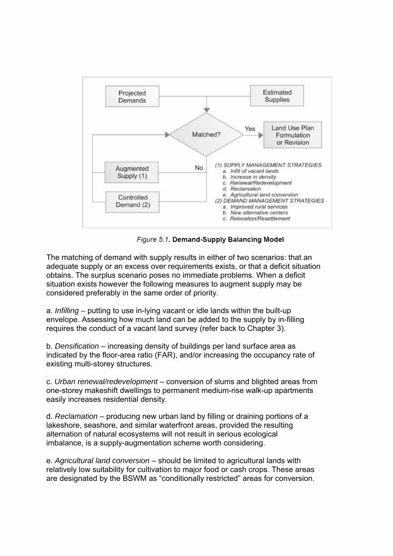
The matching of demand with supply results in either of two scenarios: that an adequate supply or an excess over requirements exists, or that a deficit situation obtains. The surplus scenario poses no immediate problems. When a deficit situation exists however the following measures to augment supply may be considered preferably in the same order of priority. a. Infilling – putting to use in-lying vacant or idle lands within the built-up envelope. Assessing how much land can be added to the supply by in-filling requires the conduct of a vacant land survey (refer back to Chapter 3). b. Densification – increasing density of buildings per land surface area as indicated by the floor-area ratio (FAR), and/or increasing the occupancy rate of existing multi-storey structures. c. Urban renewal/redevelopment – conversion of slums and blighted areas from one-storey makeshift dwellings to permanent medium-rise walk-up apartments easily increases residential density. d. Reclamation – producing new urban land by filling or draining portions of a lakeshore, seashore, and similar waterfront areas, provided the resulting alternation of natural ecosystems will not result in serious ecological imbalance, is a supply-augmentation scheme worth considering. e. Agricultural land conversion – should be limited to agricultural lands with relatively low suitability for cultivation to major food or cash crops. These areas are designated by the BSWM as “conditionally restricted” areas for conversion.

Extreme necessity could justify conversion of moderately suitable agricultural lands designated as “moderately restricted” areas. Agricultural lands designated as “highly restricted” however should be considered “no touch” or non-negotiable areas. The augmentation process is an iterative one. After the effect of each option is added to the estimated supply, the new total is matched with the demand. When a deficit still exists, then the next supply augmentation measure is considered incrementally until a match is reached. In the event that a deficit situation still exists after all the augmentation measures are considered, then a number of demand management strategies can be considered as well such as: a. Improved rural services – intended to dampen the need or urge of rural dwellers to move to urban areas. Vigorous agrarian reform, rural resettlement, rural electrification, efficient telecommunications are some examples of rural development interventions that effectively reduce ruralto- urban migration. b. Opening alternative growth centers – fast-growing barangays could be assisted to serve as service centers for other barangays within their areas of influence, thus reducing the pressure on the poblacion or traditional urban center to expand. c. Relocation or resettlement – an effective way of decentralizing urban populations. The social, economic and psychological costs to the affected population of this option however, are so high that resettlement is often regarded as an unattractive alternative. 5.2 SPATIAL STRATEGIES GENERATION This step in the process explores various alternative spatial patterns or urban forms that will serve as framework or guide for detailed allocation of space and location of various activities and facilities. From these alternatives, one pattern or a combination of several patterns will be chosen and put in final form to become the organizing concept for the long-term physical development of the locality. It is expected that the selected alternative will best provide the conditions necessary to attain the long-term development goals. 5.2.1 Designing Alternative Urban Forms This activity demands the ability to see reality in the abstract, to recognize trends and patterns and to discern their implications, positive or negative, for the future. In short, the planner, to be able to undertake this activity should have a formal education in planning or at least a familiarity with planning literature. Often, an outsider’s perspective is sought at this stage of the process. In general, two

scenarios are considered: the base plan or “do nothing” and the development scenarios. Either scenario can have any number of variations. a. The Base Plan or “Do Nothing” Scenario The base plan is the logical extension of past and current trends if no major intervention by the government is introduced to the area other than those already on-going, programmed or committed. The principal question that this exercise seeks to answer is “What is the likely shape of the town/city in the future, given the present pattern and trends of growth?” Is this growth pattern generally constraint-free, at least in physical/ environmental terms? Some activities that will aid in this exercise are suggested below. 1) Analyze the existing spatial pattern from the General Land Use Map. Pay special attention to the following points: a) Identify major settlements and examine closely their distribution in space. By the size of the built-up areas, is there a distinct hierarchy? Can the urban center (poblacion) be distinguished from the rural settlements (barangay/barrios)? Are there other built up areas that are as large as or larger than the poblacion? What factors contributed to the growth of these barangays. b) Examine the road network from the Base Map, Topographic Map, or Infrastructure and Utilities Map, whichever is available. How does this network relate to the settlement pattern? c) Determine the direction of spontaneous growth. This can be done visually by comparing an older map with a more recent one. What is the general growth trend? Is there greater concentration or dispersion? Did the growth entail mere enlargement of the built up areas, or are there new built up areas forming? Indicate growth direction schematically by the use of arrows or other appropriate symbols. In the absence of time-series maps, the time series population figures can be used. The information on tempo of urbanization can indicate whether there is a general trend towards concentration or dispersion. Clue: A positive trend towards urbanization leads to more concentration of development. The opposite tendency leads to greater dispersion. 2) Check the direction of spontaneous growth against the identified physical and policy constraints to urban expansion as determined in Sec. 5.2.1 above. If the direction of growth is toward constrained or protected areas, then consider alternatives (See Sec. b below).

3) Check also whether the urban expansion areas are within the existing urban services envelope, i.e. the areas being served by piped water distribution systems; areas covered by electric power services; areas within solid waste and waste water collection systems; areas with telephone lines available; and so on. If the urban expansion areas were not covered by these utilities, would extension of the services be physically feasible? If not, consider alternatives (See Sec. b below). b. Alternatives to the Base Plan 1) Examine the size and shape of the existing built up area and the potential urbanizable area. Calculate the gross area of the lands available for urban use. If existing density levels are maintained over the plan period, will there be enough land to accommodate the projected population? If the answer is NO, make various assumptions of person-land ratio until an acceptable balance of demand and supply is reached. (Refer back to Sec. 5.1 above.) 2) Make generalized schemes of the possible urban forms suggested by the various density assumptions by taking into consideration the outcome of the sieve analysis. These generalized urban forms will take either a concentrated form, a dispersed form, or a combination of the two. Creativity is needed here. Some stereotype urban forms are described and illustrated below (from Kevin Lynch). Give brief descriptions of the schemes you make, similar to the illustrations below. This characterization is useful in the next step: Evaluation. Another strong generator of urban form is the growth strategy adopted by the LGU in pursuit of maximizing its role assigned to it by, or it has volunteered to play in the province or region. Such a role is usually based on, or defined by the natural or acquired advantage of the local area vis-à-vis the wider regions. The growth strategy then involves developing to its full potential the particular economic sector in which the area is specialized as well as concentrating investments and policy in the built environments to enable the local economy to grow and flourish in the desired direction and realize the desired spatial outcome. As a guide to preparing the schematic diagram to illustrate the spatial outcome of each economic growth strategy the following questions may be considered: a. Where will be your production areas and what infrastructure support will be needed to fully realize this particular strategy? b. Where will the future urban population be concentrated and what services and utilities will be needed to serve the existing and proposed urban areas?

b. How will you enable rural residents to benefit from the urban services?
d. What areas and resources ought to be protected to maintain environmental integrity and sustainable development?

4. The Urban Star

5. The Ring
What are the theories of urban spatial organization?
1. Concentric theory (Ernest Burgess, 1925): invasion/succession of CBD, independent worker housing, better housing, commuters/suburban housing)
2. Sector theory (Homer Hoyt, 1939): high density residential, commercial and industrial radiate out from the CBD in sectors that follow major transportation routes; more expensive housing also radiates from CBD towards large open spaces and higher ground; less expensive housing takes whatever land is left over.
3. Multiple nuclei zone theory (Harris and Ullman, 1945): certain land uses together to take advantage of unique facilities (e.g., universities), specializations, codependencies or externalities.
5.2.2 Characterizing the Urban Form Give names that are more reflective of the local situation, more ingenious and easy to remember. In characterizing the urban forms generated, answer at least two questions: a) What does it take to realize this urban form? and b) What are the implications to the town/city if this urban form is realized?
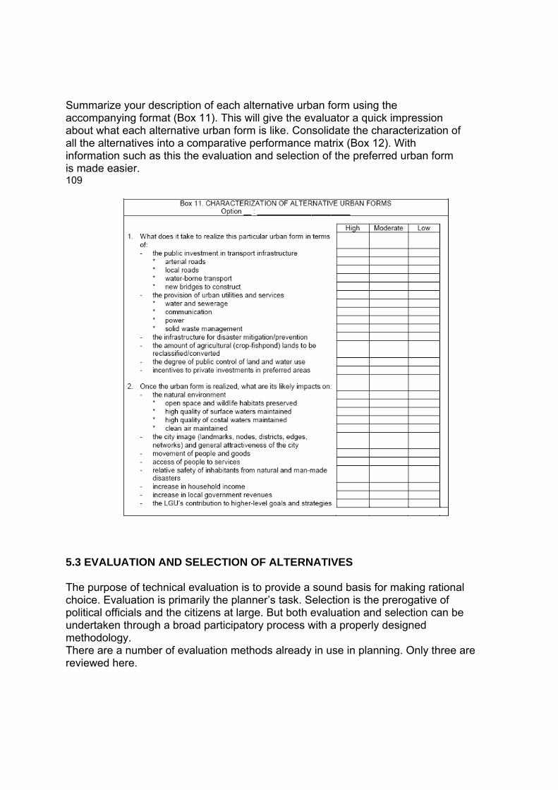
Summarize your description of each alternative urban form using the accompanying format (Box 11). This will give the evaluator a quick impression about what each alternative urban form is like. Consolidate the characterization of all the alternatives into a comparative performance matrix (Box 12). With information such as this the evaluation and selection of the preferred urban form is made easier. 109
5.3 EVALUATION AND SELECTION OF ALTERNATIVES The purpose of technical evaluation is to provide a sound basis for making rational choice. Evaluation is primarily the planner’s task. Selection is the prerogative of political officials and the citizens at large. But both evaluation and selection can be undertaken through a broad participatory process with a properly designed methodology. There are a number of evaluation methods already in use in planning. Only three are reviewed here.

5.3.1 The Cost-Benefit Analysis (CBA) The most common method is cost-benefit analysis (CBA). This method requires quantification, that is, everything must be expressed in money terms. The CBA involves the following tasks, as adapted from N. Lichfield: 1) Define the alternative spatial strategies which are under consideration. 2) Estimate the cost of the programs and projects, that is, the value of the capital investments and operating resources required to realize each alternative strategy. 3) Define the benefits from the investment, and put a value to these benefits by methods appropriate to their nature. To avoid inflating the benefits, exclude those which would emerge even without the investment. 4) Distinguish between real benefits and costs from those that are transfers. Real benefits and costs are those resulting in gain or loss to the community as a whole. Transfers are those gains or losses to some sections of the community but which will be cancelled out by corresponding gains and losses to other sections. 5) Relate real benefits to costs by an appropriate criterion (e.g. rate of return) which needs to be carefully selected according to the circumstances, to indicate the course which shows the best value for money. The CBA format is simple as shown below:
Some criticisms of this method are: 1) The calculation of costs and benefits in monetary terms may be too long, complicated, and expensive. 2) It does not accommodate intangible benefits nor indirect costs of related projects. 3) It does not give room for uncertainties in implementation.

4) It is suitable for the evaluation of single projects with simple objectives. 5) It does not lend itself to participatory processes and is confined to technical evaluations only. 5.3.2 Planning Balance Sheet (PBS) An improvement on the CBA is the Planning Balance Sheet developed by Nathaniel Lichfied. The PBS attempts to present not only the tangible costs and benefits but also the intangible and unmeasured costs and benefits for different affected groups. PBS divides the affected groups into producers/operators and consumers/users. It is not necessary to express all costs and benefits in money terms. However, it is necessary to reduce benefits and costs into some common units to permit aggregation for producers and consumers separately and comparison of alternatives. The format of PBS is as follows:
The criticisms of the CBA could also be leveled on the PBS in that these two methods are most suitable for evaluating projects or plans against a single objective. Planning objectives however, are seldom singular but are often multiple in character and affect different sectors of the community simultaneously. The Goal-Achievement Matrix (GAM), designed by Morris Hill, is another alternative method to the first two. 5.3.3 Goal-Achievement Matrix (GAM) Designed to avoid the disadvantages of the other two methods, the GAM involves the following activities: 1) The explicit formulation of a set of objectives. If objectives are already given, say, a vision statement, these should be broken down into measurable indicators which will serve as evaluation criteria. 2) The ranking or rating of alternative strategies against each individual objective. 3) The weighting of objectives for their relative importance to particular sections

of the community. 4) The combining of scores to obtain relative measures of goals achievement for each alternative. This method is highly participatory. It allows various sectors of the community to express their bias through the weighting of each objective according to their perception of its relative importance to their sector. The rating of each alternative according to its perceived contribution to the achievement of each objective is quite simple: choosing an ordinal number within a given range, the evaluator determines whether the alternative in question has any contribution, positive or negative, to the attainment of a particular goal. If no apparent relationship exists, then a rating of “0” is given. If a relationship exists (+ or -) then the degree of relationship is indicated by the ordinal numbers 1, 2 or 3 representing slight, moderate, or high degree respectively. The score of a particular urban form with respect to a given goal/objective is the rating determined by the particular sector multiplied by the sector’s weight assigned to that objective. Finally, the aggregate (algebraic sum) of sectoral total scores is taken, and though the sectoral scores reflect their biases, the grand total of scores amounts to the social consensus. The format of a GAM looks like this:
This form will be filled up by each sector represented. The completed forms are aggregated in the summary form below: The highest scoring alternative is obviously the preferred one. The summary is then presented for adoption by whoever has the mandate to officially select or adopt the preferred alternative such as the Local Development Council or the Local Legislative Council. 5.4 DETAILING OF SELECTED ALTERNATIVE After the desired spatial strategy has been chosen, the CLUP will now be put in final

form. The output will be a revised map showing the various existing and proposed land/water uses and their preferred locations. The completed output is a written report of which the map forms a part. In detailing the chosen strategy, the location of the following land/water uses will be shown in the CLUP map. Policy recommendations are made for each use type, consistent with the four general land use policy areas of settlements, production, protected areas, and infrastructure support areas as described in Chapter 2 above.
5.4.1 Settlement Areas The settlement areas embrace the traditional town center or poblacion, other

urban barangays, rural settlements, and where applicable, the settlement of ethnic groups or indigenous people. Conceptually, settlement areas constitute the space for living. a. The Town Center The town center is the most important element of the city/municipality’s spatial structure. It is the nerve center of the social and political life of the town. It is the place where the most important functions are located and from where city/municipal-level services are provided. The town center also performs a symbolic function. It embodies the distinctive image of the town with which residents identify themselves. This unique image also enables non-residents and visitors to recognize the town and not mistake it for any other town. The CLUP should ensure that the appropriate functional and symbolic artifacts are in place. In case the town also serves as provincial capital and/or regional administrative center, the urban design is a bit more complicated. In any case, a well conceived urban design ensures that the hierarchy of functions and the relative prominence of each center are visually distinct and easily recognizable. There are at least four focal points of the town center: 1) the city/municipal hall and related buildings for government administration; 2) the parish church or churches or mosque; 3) the central business district (CBD); and 4) the central park or town plaza. Of these four focal points, the religious center is the only one that cannot be influenced by the local government. But efforts should be exerted to ensure that it continues to be an integral part of the town center. In most cases, the CBD is formed by the accretion of private sector investments over many years. But in small towns, the formation of the CBD usually follows the location of the public market. The main problem for the local decision-makers to decide is where should the town center be located consistent with the preferred spatial strategy? Is the present location the ideal one? Should there be only one center or several? If more than one, where are they best located? Are those centers equal in importance or is there some kind of hierarchical order?

The secondary problem is whether to locate the four focal points in the same general area (the traditional “plaza complex”) or to locate each one of them separately. b. The Residential Pattern In practice, the residential pattern is the outcome of the aggregate of decisions of estate developers. This sometimes gives rise to undesirable consequences. Residential subdivisions are generally better planned and designed but they have a selective clientele and hence, they tend to create enclaves and exacerbate social segregation. On the other hand, individual households’ self-built housing results in spontaneous settlements whose location and quality are largely unregulated especially in the matter of providing the mandatory open space or direct road access to individual lots and houses. The fact, however, is that the public interest is better served and general welfare is better promoted if the government exerts a stronger influence in regard to the location of residential areas. Through the locational clearance system and subdivision regulations, the local government can reorganize the town’s physical structure through properly conceived residential patterns. Residential developments outside of formal subdivisions can be restructured through such schemes as land consolidation or readjustment and proper location of infrastructure, especially that of roads and streets. The primary concern in structuring residential patterns is the promotion of health and safety of the residents. This suggests that location of residential areas must be free from natural and man-made hazards to life and limb and must have a pleasant and healthful environment. The other concern relates to access by local residents to places of employment, shopping and community level services as well as to city/municipal-level services. One simple way to ensure access by ordinary residents is to declare by ordinance that all customary footpaths be recognized as public easements which must be kept open at all times. The ideal physical form that can address the above concerns effectively is the concept of “neighborhood unit”. An ideal neighborhood unit is simply a physical environment in which a mother knows that her child will have no traffic streets to cross on his way to school. It is moreover, an environment where the housewife may easily walk to the shopping center to obtain the daily household goods, and where employed persons may find convenient transportation to and from work. Above all, an ideal neighborhood provides a safe environment and adequate facilities for children to play.

A cluster of a few neighborhoods may form a community to support higher level facilities and services like a secondary school, a district park or a feeder public market. These clusters are then conveniently linked to the town center. The challenge for every LGU is how to fit and/or reorganize the existing sitios and barangays to conform to the concept of neighborhood unit and the hierarchical pattern of residential areas. Also, how to integrate ethnic communities, rural settlements, resettlement sites, and other forms of human communities into the general residential pattern. Depending on available lands for urban expansion and consistent with the chosen urban form, the CLUP should also indicate the desired residential densities in various areas or districts. It must be borne in mind that although the single-family, single-detached housing is preferred by almost all households, in the long term this housing type cannot be sustained. Sooner of later, multi-family attached housing and in highly urbanized areas, medium rise walk up apartments will become necessary. 4.4.2 Production Areas Production areas, or the space for making a living, are those taken up by commercial, office, industrial, agricultural, tourism and similar activities. Some production areas are located within the built environment, e.g. commercial, office, and certain types of industrial activities. Other production activities take place in the unbuilt environment such as agriculture, mining and quarrying, and some forms of tourism. Commercial and industrial land uses must be properly located not only to afford convenience and economy to local residents in the procurement of the goods they need. These areas also provide employment to a substantial portion of the labor force. Their location moreover, has tremendous impact on the volume and direction of daily traffic flow. Commercial and industrial activities and some extractive activities like mining, furthermore, have the potential to pollute and degrade the environment in varying degrees. a. Commercial Areas Commercial establishments range in scale from the sari-sari store to the huge shopping centers. Each type of commercial establishments has its own service population and offers a variety of goods and services appropriate to its clientele. For small provincial towns, the types of shopping facilities generally include the public market and the strips of commercial street frontages that develop around it, and along the arterial road traversing the town center.
The importance of the public market lies in the enormous variety of goods that it offers. It serves principally the local residents and to a lesser extent the nonresidents. Therefore, decision must be made whether there should be only one public market or several which are located in various places close to the concentration of population, also consistent with the chosen spatial strategy. The shopping centers offering convenience goods and shopping goods serve both the local and regional population. These establishments usually locate along the arterial roads thereby causing enormous traffic congestions during certain days or parts of the day. The local government should direct these commercial strips to other municipal streets to unclog the arterial road and speed up through traffic. At the same time, measures may be taken to convert motorists into shoppers by providing ample and safe parking and pedestrianizing certain side streets. If there is any intention to attract investors in large free-standing shopping centers, appropriate areas for this purpose should be identified in the CLUP. Offices traditionally co-locate with commercial activities because they often share a common clientele. In recent years, however, offices have increasingly shared residential space as an offshoot of widespread use of electronic communication media. The rise of the home-office phenomenon is changing the character of what are traditionally exclusive residential areas. b. Industrial Areas Industrial activities are also a major provider of non-agricultural employment, attract daily traffic, and, depending on the type of manufacturing process and product or by-product, a polluter of the environment. Therefore, their location must be carefully chosen, especially in relation to residential areas, schools and other sensitive activity areas. The main location decision is whether to have a separate industrial zone or allow industries to intersperse with other activities. If the choice is the latter, individual firms certainly have their own perception of what makes for profitable locations. But the local government must evaluate location of industries on the basis of their impact on the environment, on traffic, and on public provision of services and utilities like water and sewerage systems, telecommunications facilities, electric power and service roads. Proximity and access to transport nodes like ports, airports, bus terminals and train stations must also be considered. Traditionally, industries found locations along the banks of navigable rivers advantageous due to cheap bulk transport. The use of river water for industrial cooling and as receiver of effluents is an added advantage. Such considerations may still be valid today. Small-scale and cottage industries may be located in conjunction with commercial and residential areas.

If the LGU intends to develop an industrial estate, the indicative location should be identified in the CLUP but the site plan should be commissioned to experienced site planners. Another important decision that the LGU should take is whether to place the industrial estate under the status of a special economic zone or under some other management arrangement. Careful evaluation of the options should lead to what is most advantageous to the local residents. c. Agricultural and Other Resource Extraction Areas Easily the most extensive production area in many localities is the area devoted to agriculture, mainly crop cultivation. Some localities also have extensive fishery areas. The peculiar characteristics of agricultural areas are their relatively flat topography and their close proximity to built up areas. Due to these geographical features, agricultural areas are often seen as potential urban expansion areas. In fact, the rapid conversion of agricultural lands to urban uses especially in regions where large-scale industrial development is being promoted has sparked the most heated arguments and mass actions in recent years. Just how should local governments regard their agricultural lands? As eventual “catch basins” for future urban expansion? As the ultimate basis of the nation’s food security? These are the two extreme views that divide the conservationists and the “conversionists”. Actually, there are national policies that have conflicting effects. One is Sec. 20 of the Local Government Code, which allows cities and municipalities to reclassify between 5% and 15% of their agricultural areas for urban purposes. On the other hand, the Agriculture and Fisheries Modernization Act (RA 8435) prohibits conversion of irrigated and potentially irrigable lands to urban uses. The specific impacts of these national policies on local areas vary from one municipality to the next and appropriate local policies should be formulated to reconcile and balance local and national interests. For the proper guidance of LGUs the maps of protected agricultural areas prepared by the BSWM called Sustainable Agriculture and Fisheries Development Zones (SAFDZ) pursuant to the provisions of RA 8435 should be incorporated in their CLUP and Zoning Ordinance. Regarding other resource extraction like forestry, commercial fisheries, mining and quarrying, the municipality has limited control over their exploitation except those that had been devolved under DENR Administrative Order No. 30, series of 1992.

Nonetheless, these activities have a direct impact on the physical and socioeconomic environment of the LGU. Therefore, the affected LGU must fully exercise its co-management function with the national government as mandated in RA 7160, Sec. 3(i) to protect its residents from adverse impacts of resource extraction activities within its borders. d. Tourism Areas Tourism is an important source of income for the local community. Care should be taken however, that the development of tourist resources does not result in environmental degradation as well as in moral corruption of the local population. The paradox of tourism that people tend to destroy what they come for to enjoy must not be lost on local officials and investors. Moreover, the benefits of tourism promotion and development of local tourist resources must be equitably distributed among all sectors of society. Also, tourism development should not deprive the local residents of access to common resources such as beaches, lakes, rivers, natural forests, caves, mountains and the like. 5.4.3 Infrastructure Areas Infrastructure areas provide a vital link between and among the different land use areas as well as support the activities for living and those for making a living. Conceptually, infrastructures that support the former are classified as social infrastructure while those that support the latter are known as economic infrastructures. In reality, however, their functions overlap. Nevertheless, infrastructures may serve any or a combination of the following functions: 1) To support the realization of the desired urban form. 2) To fill backlogs in existing public services and utilities. 3) To upgrade the quality of urban services to national or international standards. 4) To ensure access and equalize social and economic opportunities in all areas of the town. 5) To reduce vulnerability of people to natural and man-made disasters. 6) To support increased economic production or productivity in accordance with growth targets. 7) To rehabilitate degraded ecosystems and to maintain environmental integrity.
The main infrastructure components and their locational peculiarities are discussed below. a. Circulation System The circulation system is a major factor contributing to the formation of the physical structure of the town. It plays both reactive and proactive roles. It is reactive when it merely services development, that is, the circulation system is laid out to service activity areas that are already in existence. On the other hand, the circulation system can be used to induce future development in identified growth areas, in accordance with the preferred spatial strategy. There are at least three types of circulation sub-systems that must be planned: thru traffic, linkages between the town center and the barrios, and internal circulation in the town center. 1) Thru Traffic To most towns thru traffic is a major component of local circulation. This is due to the fact that the inter-town (provincial or national) arterial road that crosses the town center is usually adopted as the main urban thoroughfare. All other municipal roads connect to, or branch out from it. In such a case, there is a high degree of merging of local and regional traffic, causing traffic congestion problems in the town’s main street. How can thru traffic be separated from local traffic? The usual solution is construction of an overpass or a by-pass road. But a by-pass has the adverse effect of diverting development to another part of town or causing premature conversion of agricultural lands. Is this socially desirable? Perhaps an alternative is to use certain existing municipal streets to handle diverted traffic. An overpass eases traffic flow at intersections but it does not increase the capacity of existing streets. 2) Poblacion-Barrio Traffic In many cases, too, traffic between the poblacion and the barrios is handled by the arterial national or provincial road. This also leads to the use of the arterial by slow-moving barrio-bound vehicles like tricycles and calesas, often retarding thru traffic flow and sometimes causing vehicular accidents. It makes more sense therefore to provide alternate routes to handle strictly local traffic. Customary footpaths should also be identified, listed and declared as perpetual easements of public use. 3) Internal Circulation in the Poblacion

Traditional town centers have streets that were not built to handle big and heavy vehicles. Widening these old streets however, is often not feasible due to intensive permanent roadside developments. A bypass road is often the solution but the adverse effects of this solution on the local commercial establishments must be carefully evaluated. Other alternatives should be explored such as the prohibition on buses and trucks to cross the town center. This requires the provision of bus terminals at the edges of the town center and traffic inside the center can be conveyed by pedicabs, tricycles, calesas, bicycles, or on foot. This solution is also environment friendly. Recovering sidewalks for the pedestrian and totally pedestrianizing certain streets can also improve internal circulation in the town center. Facilities for safe pedestrian crossing like signal lights, painted cross-walks, elevated foot bridges and others will ease vehicular flow considerably. A growing trend among cities and towns that experience congestion in the traditional town center is to open new areas for eventual development into the new center. This is often done by relocating the city/town hall and in time investments follow toward the new site. Among the design features of the new site is a much improved street network to better handle the anticipated volumes of vehicular and pedestrian traffic. Another thing to look into is the linkage between subdivision streets and the municipal circulation system. Make sure that no subdivision has a dead-end effect. It is better to layout the municipal or barangay street pattern in advance before subdivision developers start their projects so that they can design their internal circulation system in conjunction with the wider circulation network of the town. b. Other Major Infrastructures and Urban Services In addition to transport networks, other infrastructures and urban services that have to be properly located are waterworks (especially water source), treatment and disposal of sewage and garbage, power plant or power distribution substation, oil or gas depot, and flood control. Each of these must be carefully located because of their potential to pollute the environment or their susceptibility to pollution themselves. Some of these facilities also pose great risks to the life and limb of affected residents. 1) Domestic Water Sources If the town must rely on surface water as a source of domestic water supply, this body of surface water and its immediate catchment area should be delineated as protected area to ensure the continuous supply of water at the right quantity and quality. If the source of water supply is the groundwater, aquifer recharge areas should likewise be identified and

protected. 2) Sewage Disposal Beyond a certain population density, alternative sewage treatments to the septic tank system should be considered. In predominantly residential areas, especially in low-income informal settlements community sewerage systems may replace individual septic tanks. In industrialized areas, the municipal government may install a centralized sewage treatment facility and collect user charges from connected establishments. Refer to specific provisions of the Clean Water Act (RA 9275). 3) Garbage Dump or Sanitary Landfill Low-lying areas such as ravines, swamps and abandoned barrow pits are good dumping grounds provided that air and water contamination is abated. Landfilling is recommended to minimize spread of diseases. The practice of dumping along shoulders or side ditches of major roads could no longer be allowed in the light of the enactment recently of the Ecological Solid Waste Management Act (RA 9003). 4) Power Sources Power plants, sub-stations and gas or oil depots must be situated away from residential areas. Buffers surrounding these installations must be provided. Consult the Clean Air Act (RA 8749) for specific provisions applicable to LGUs. 5) Flood Control and Drainage Areas requiring major civil works to stabilize riverbanks, seashores, lakeshores and to straighten the course of meandering rivers should be identified. Such structures may be so designed as to accommodate other users, e.g. dike roads or walkways. The regulation easements and salvage zones, properly landscaped or vegetated can enhance the quality of the urban environment. 6) Social Service Facilities The location of social services like schools, hospitals, and government administrative buildings on the other hand, must take into account proximity to and access by their service population. The hierarchy of services should also be followed. Hence, the most central municipal services like a secondary or tertiary school, a general hospital, etc. have to be located in the poblacion; lower level services should be sited in conjunction with the neighborhood unit and community clusters.

5.4.4 Open Space and Preservation Areas A system of functional open spaces is an important element of the CLUP. Functional open spaces are areas that are deliberately kept in their open character for their contribution toward maintaining the amenity value of the environment. If sufficiently vegetated open spaces perform ecological services as carbon sink and contribute to rainwater infiltration and aquifer recharge. They also offer opportunities for cheap recreation for the local residents. At the same time they can serve as protection buffers around hazardous areas and installations. Open spaces like other social services follow a hierarchy of functions. At the city/ municipal level, the town square or plaza is at the top of the hierarchy. The town plaza should be a factor in establishing the image of the town. Central urban functions may be located around the town plaza. Lower order parks should be planned in conjunction with neighborhood and community centers. Lower-end open spaces include barangay parks, neighborhood parks, vest-pocket parks, and tot lots (children’s play areas). Buffers and the city/municipal communal forest required by the Local Government Code may also be incorporated into the open space system. So are the public easements along riverbanks, around escarpments, or along lakeshores and seacoasts. Prime agricultural lands, too, due to their status as protected areas should now form part of the municipal open space system. Historical and heritage sites of national or local significance should form part of the open space and preservation areas of the locality. Finally, the environmentally critical and hazardous areas could be ingeniously planned and designed to form part of the town’s open space and preservation areas. 5.5 FORMULATING THE LAND AND WATER USE POLICY FRAMEWORK The final step in the CLUP preparation process is to formulate the specific land use policies for each of the areas covered by the detailed land use plan/map. This will aid in the translation of the CLUP into the zoning ordinance. For consistency, the four general land use categories of settlements, production, infrastructure and protected areas should be maintained. The boundaries of each land use class and subclass should be delimited as precisely as possible because this will be directly translated into the zoning ordinance. As a general rule all pertinent national laws should be reviewed and their local implications carefully analyzed to ensure compliance and to avoid conflicts. To ensure integration of policies across administrative levels all national agencies that have functional responsibilities over land and other natural resources found within the LGU territory must be invited to any consultative function convened for the
purpose. Examples of local policies may include the following: 1. Policies to resolve issues derived from the result of map overlay analysis (decision zones). 2. Relevant policies extracted from the problem-solution matrix and the vision-reality gap analysis. 3. Policies to reconcile inter-jurisdictional conflicts, e.g. boundary disputes. 4. Where applicable include policies on use of municipal waters. 5. Policies pertaining to each of the four general land use policy areas of settlements, production, infrastructure and protection as mapped out in detail in the proposed general and urban land use maps. 6.0 INTRODUCTION Whereas the term “comprehensive” in the CLUP is to be understood in its territorial sense that in the CDP means “multi-sectoral”. As earlier described in the previous chapters, to be comprehensive the CDP must cover the five development sectors: social, economic, physical, environmental and institutional (refer back to Box 1, chapter 1). 6.1 UNDERSTANDING THE DEVELOPMENT SECTORS Development is both a product and a process. As the product or outcome of a process, development is a seamless, integrated, holistic reality. A composite concept, development is hard to comprehend or appreciate, much less measure, in its entirety. But when taken in small bits and pieces, as it were, development can be perceived if not actually measured in terms of its various manifestations. Some of the more apparent of these manifestations include changes in the way people live, in the quantity and quality of goods and services they produce and consume, in the size or proportion of the built up area relative to the unbuilt environment, and even in the manner in which the members of the community conduct their collective affairs. The bits and pieces that make up the holistic reality may be seen as the different sectors and subsectors of development. When it is seen as a process, development is the transformation mediated by, or occurring within and among the sectors and subsectors.
