3d terrestrial laser scanner with online waveform ... · 3d terrestrial laser scanner with online...
TRANSCRIPT
®RIEGLRIEGL VZ-400 VZ-4003D Terrestrial Laser Scanner with Online Waveform Processing
Terrestrial Laser Scanning
visit our website www.riegl.com
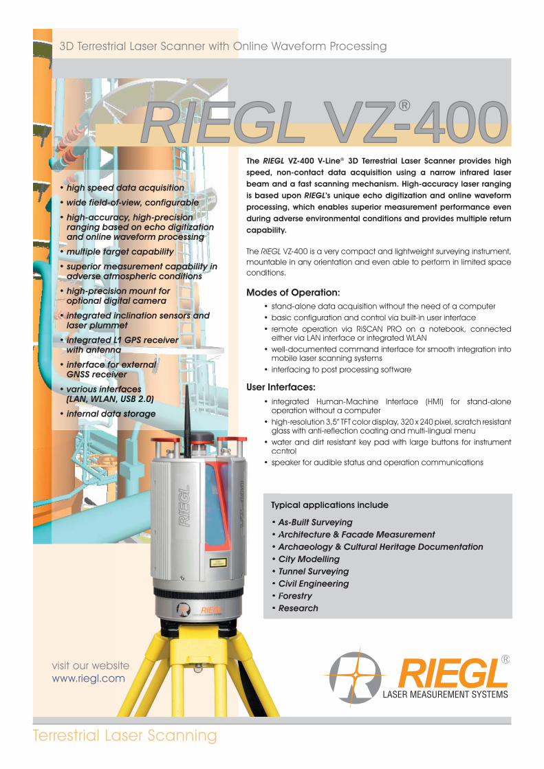
The RIEGL VZ-400 V-Line® 3D Terrestrial Laser Scanner provides high speed, non-contact data acquisition using a narrow infrared laser beam and a fast scanning mechanism. High-accuracy laser ranging is based upon RIEGL’s unique echo digitization and online waveform processing, which enables superior measurement performance even during adverse environmental conditions and provides multiple return capability.
The RIEGL VZ-400 is a very compact and lightweight surveying instrument, mountable in any orientation and even able to perform in limited space conditions.
Modes of Operation:• stand-alone data acquisition without the need of a computer• basic configuration and control via built-in user interface• remote operation via RiSCAN PRO on a notebook, connected
either via LAN interface or integrated WLAN• well-documented command interface for smooth integration into
mobile laser scanning systems• interfacing to post processing software
User Interfaces:• integrated Human-Machine Interface (HMI) for stand-alone
operation without a computer• high-resolution 3,5” TFT color display, 320 x 240 pixel, scratch resistant
glass with anti-reflection coating and multi-lingual menu• water and dirt resistant key pad with large buttons for instrument
control• speaker for audible status and operation communications
Typical applications include
• As-Built Surveying • Architecture & Facade Measurement • Archaeology & Cultural Heritage Documentation • City Modelling • Tunnel Surveying • Civil Engineering • Forestry • Research
• high speed data acquisition
• wide field-of-view, configurable
• high-accuracy, high-precision ranging based on echo digitization and online waveform processing
• multiple target capability
• superior measurement capability in adverse atmospheric conditions
• high-precision mount foroptional digital camera
• integrated inclination sensors andlaser plummet
• integrated L1 GPS receiverwith antenna
• interface for external GNSS receiver
• various interfaces (LAN, WLAN, USB 2.0)
• internal data storage
sitem
User Inte• inte
op• hig
gla• wa
co• spe
Typ
• A• A• A• C• T• C• F• R
rrfrfrrrrrrffrffffaaca essssssssssssss , USUSB BBBB 222222.2222222 0)0)0)00)0)0)0)00))
aaaaaaa a sttststssssssss ororororagagagagagee
Copyright RIEGL Laser Measurement Systems GmbH © 2017– All rights reserved.
System ConfigurationSystem ConfigurationVZ-400 Key Features and Components
2
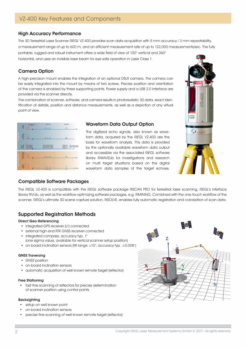
High Accuracy PerformanceThe 3D Terrestrial Laser Scanner RIEGL VZ-400 provides scan data acquisition with 5 mm accuracy / 3 mm repeatability,
a measurement range of up to 600 m, and an efficient measurement rate of up to 122,000 measurements/sec. The fully
portable, rugged and robust instrument offers a wide field of view of 100° vertical and 360°
horizontal, and uses an invisible laser beam for eye safe operation in Laser Class 1.
Camera Option
Waveform Data Output Option
A high-precision mount enables the integration of an optional DSLR camera. The camera can be easily integrated into the mount by means of two screws. Precise position and orientation of the camera is enabled by three supporting points. Power supply and a USB 2.0 interface are provided via the scanner directly.
The combination of scanner, software, and camera results in photorealistic 3D data, exact iden-tification of details, position and distance measurements, as well as a depiction of any virtual point of view.
The digitized echo signals, also known as wave-form data, acquired by the RIEGL VZ-400 are the basis for waveform analysis. This data is provided by the optionally available waveform data output and accessible via the associated RIEGL software library RiWAVELib for investigations and research on multi target situations based on the digital waveform data samples of the target echoes.
Compatible Software Packages
The RIEGL VZ-400 is compatible with the RIEGL software package RiSCAN PRO for terrestrial laser scanning, RIEGL‘s interface library RiVLib, as well as the workflow-optimizing software packages, e.g. RiMINING. Combined with the one-touch workflow of the scanner, RIEGL‘s ultimate 3D scene capture solution, RiSOLVE, enables fully automatic registration and colorization of scan data.
Supported Registration MethodsDirect Geo-Referencing
• integrated GPS receiver (L1) connected• external high-end RTK GNSS receiver connected• integrated compass, accuracy typ. 1°
(one sigma value, available for vertical scanner setup position)• on-board inclination sensors (tilt range ±10°, accuracy typ. ±0.008°)
GNSS Traversing• GNSS position• on-board inclination sensors• automatic acquisition of well known remote target (reflector)
Free Stationing• fast fine scanning of reflectors for precise determination
of scanner position using control points
Backsighting• setup on well known point• on-board inclination sensors• precise fine scanning of well known remote target (reflector)
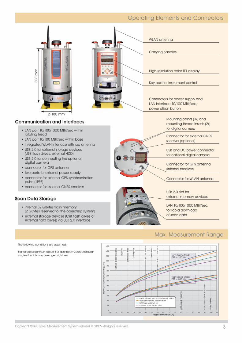
WLAN antenna30
8 m
m
Ø 180 mm
Copyright RIEGL Laser Measurement Systems GmbH © 2017– All rights reserved. 3
Operating Elements and Connectors
Max. Measurement Range
308
mm
Ø 180 mm
Carrying handles
High-resolution color TFT display
Key pad for instrument control
Connectors for power supply andLAN interface 10/100 MBit/sec,power off/on button
USB and DC power connectorfor optional digital camera
Connector for external GNSSreceiver (optional)
Mounting points (3x) andmounting thread inserts (2x)for digital camera
Connector for GPS antenna(internal receiver)
Connector for WLAN antenna
USB 2.0 slot for external memory devices
LAN 10/100/1000 MBit/sec,for rapid downloadof scan data
0
50
100
200
150
350
400
450
500
550
600
Target Reflectance [%]
Ma
ximum
Mea
sure
men
t Ra
nge
[m]
we
t ic
e, b
lac
k ta
r pa
pe
r
dry
sno
w
co
nife
rous
tre
es
dry
asp
halt
de
cid
uous
tre
es
terra
co
tta
clif
fs, s
and
, ma
sonr
y
whi
te p
last
er w
ork
, lim
est
one250
300
0 5 10 15 20 25 30 35 40 45 50 55 60 65 70 75 80
High Speed ModePRR = 300 kHz
650
Long Range ModePRR = 100 kHz
whi
te m
arb
le
9085
standard clear atmosphere: visibility 23 kmclear atmosphere: visibility 15 kmlight haze: visibility 8 kmmedium haze: visibility 5 km
co
nstru
ctio
n c
onc
rete
The following conditions are assumed:
Flat target larger than footprint of laser beam, perpendicularangle of incidence, average brightness
Communication and Interfaces
• LAN port 10/100/1000 MBit/sec within rotating head
• LAN port 10/100 MBit/sec within base • integrated WLAN interface with rod antenna • USB 2.0 for external storage devices(USB flash drives, external HDD)
• USB 2.0 for connecting the optionaldigital camera
• connector for GPS antenna • two ports for external power supply • connector for external GPS synchronizationpulse (1PPS)
• connector for external GNSS receiver
Scan Data Storage
• internal 32 GBytes flash memory (2 GBytes reserved for the operating system)
• external storage devices (USB flash drives or external hard drives) via USB 2.0 interface
www.riegl.comData Sheet, RIEGL VZ-400, 2017-06-14
RIEGL Laser Measurement Systems GmbHRiedenburgstraße 483580 Horn, AustriaPhone: +43 2982 4211 | Fax: +43 2982 [email protected]
RIEGL USA Inc.Orlando, Florida | [email protected] | www.rieglusa.com
RIEGL Japan Ltd.Tokyo, Japan | [email protected] | www.riegl-japan.co.jp
RIEGL China Ltd.Beijing, China | [email protected] | www.riegl.cn
Copyright RIEGL Laser Measurement Systems GmbH © 2017– All rights reserved.Use of this data sheet other than for personal purposes requires RIEGL’s written consent.This data sheet is compiled with care. However, errors cannot be fully excluded and alternations might be necessary.
Technical Data RIEGL VZ®-400Laser Product Classification Class 1 Laser Product according to IEC 60825-1:2014
Range Performance 1)
Minimum Range 1.5 mLaser Wavelength near infraredLaser Beam Divergence 8) 0.3 mrad
Scanner Performance Vertical (Line) Scan Horizontal (Frame) ScanScan Angle Range total 100° (+60° / -40°) max. 360°Scanning Mechanism rotating multi-facet mirror rotating headScan Speed 3 lines/sec to 120 lines/sec 0°/sec to 60°/sec 10)
Angular Step Width (vertical), (horizontal) 0.0024° ≤ ≤ 0.288° 9) 0.0024° ≤ ≤ 0.5° 9)
between consecutive laser shots between consecutive scan lines
Angle Measurement Resolution better 0.0005° (1.8 arcsec) better 0.0005° (1.8 arcsec)
Inclination Sensors integrated, for vertical scanner setup position, details see page 2GPS Receiver integrated, L1, with antennaCompass optional, for vertical scanner setup position, details see page 2Internal Sync Timer integrated, for real-time synchronized time stamping of scan dataScan Sync (optional) scanner rotation synchronization
General Technical Data
Power Supply Input Voltage 11 - 32 V DCPower Consumption typ. 65 W (max. 80 W)External Power Supply up to three independent external power sources can be connected for uninterrupted operationMain Dimensions Ø 180 x 308 mm (diameter x length)Weight approx. 9.6 kgHumidity max. 80 % non condensing @ +31°CProtection Class IP64, dust-proof and splash-proofTemperature Range Storage -10°C up to +50°C Operation 0°C up to +40°C: standard operation Low Temperature Operation 11) -20°C: continuous scanning operation if the instrument is powered on while internal temperature is at or above 0°C and still air -40°C: scanning operation for about 20 minutes if the instrument is powered on while internal temperature is at or above 15°C and still air
1) With online waveform processing.2) Rounded values.3) Typical values for average conditions. Maximum range is
specified for flat targets with size in excess of the laser beam diameter, perpendicular angle of incidence, and for atmos-pheric visibility of 23 km. In bright sunlight, the max. range is shorter than under overcast sky.
9) Selectable. 10) Frame scan can be disabled, providing 2D scanner operation.
Long Range Mode High Speed Mode
Laser Pulse Repetition Rate PRR (peak) 2) 100 kHz 300 kHz
Effective Measurement Rate (meas./sec) 2) 42 000 122 000
Max. Measurement Range 3)
natural targets ≥ 90 % 600 m 350 m natural targets ≥ 20 % 280 m 160 m
Max. Number of Targets per Pulse practically unlimited 4)
Accuracy 5) 7) 5 mmPrecision 6) 7) 3 mm
4) If the laser beam hits, in part, more than one target, the laser’s pulse power is split accordingly. Thus, the achievable range is reduced. Details on request.
5) Accuracy is the degree of conformity of a measured quantity to its actual (true) value.6) Precision, also called reproducibility or repeatability, is the degree to which further measurements show
the same result.7) One sigma @ 100 m range under RIEGL test conditions.8) Measured at the 1/e2 points. 0.3 mrad corresponds to an increase of 30 mm of beam diameter
per 100 m distance.
11) Insulating the scanner with appropriate material will enable operation at even lower temperatures.