35 willits environmental center - california · 35 willits environmental center ... responses here...
TRANSCRIPT

35 Willits Environmental Center
35-1 See General Response 1.10 for a discussion of a two-lane bypass and why it does not meet the purpose and need for the project.
35-2 See response to Comment 34-60 (Willits Citizens for Good Planning) and General Response 1.11.
35-3 The comment is not clear regarding which thresholds are unrealistic or excessive. The impact thresholds listed in the DEIS/EIR were used to determine if the project would have an impact on a particular resource. These thresholds, which are based on agency criteria, regulatory standards, and professional judgment, are applied on a project-by-project basis. See also response to Comment 34-60 (Willits Citizens for Good Planning). 35-4 See Section 6.2 Cumulative Impacts Analysis (DEIS/EIR) for a discussion of the Willits wastewater treatment plant expansion project. See also response to Comment 35-27(h). Section 3.19 (FEIS/EIR) is an updated Cumulative Impacts discussion specific to Modified Alternative J1T. See response to Comment 34-7 (Willits Citizens for Good Planning) for a discussion of why construction of the northern portions of the truncated alternatives is not reasonably foreseeable.
35-5 The DEIS/EIR identified Alternatives J1T and LT as meeting Clean Water Act Section 404(b)(1) criteria for LEDPA (see Summary Sections S.5 and S.8 and Appendix H, NEPA/404 Alternatives Analysis). The document disclosed to the public that the LEDPA would be the preferred alternative. Caltrans and FHWA deferred identification of a preferred alternative until after public circulation of the DEIS/EIR so that the public would have the opportunity to provide further input, which eventually led to development of Modified Alternative J1T and its identification as the LEDPA/preferred alternative.
35-1
35-2
35-5
35-4
35-3
The DEIS/EIR presented a reasonable range of alternatives, which meet the purpose and need of the project. See Chapters 2 and 3 (DEIS/EIR), which describe the project’s purpose and need and the range of alternatives. The responses here to the WEC comments provide sufficient explanation and no change to the DEIS/EIR is necessary.
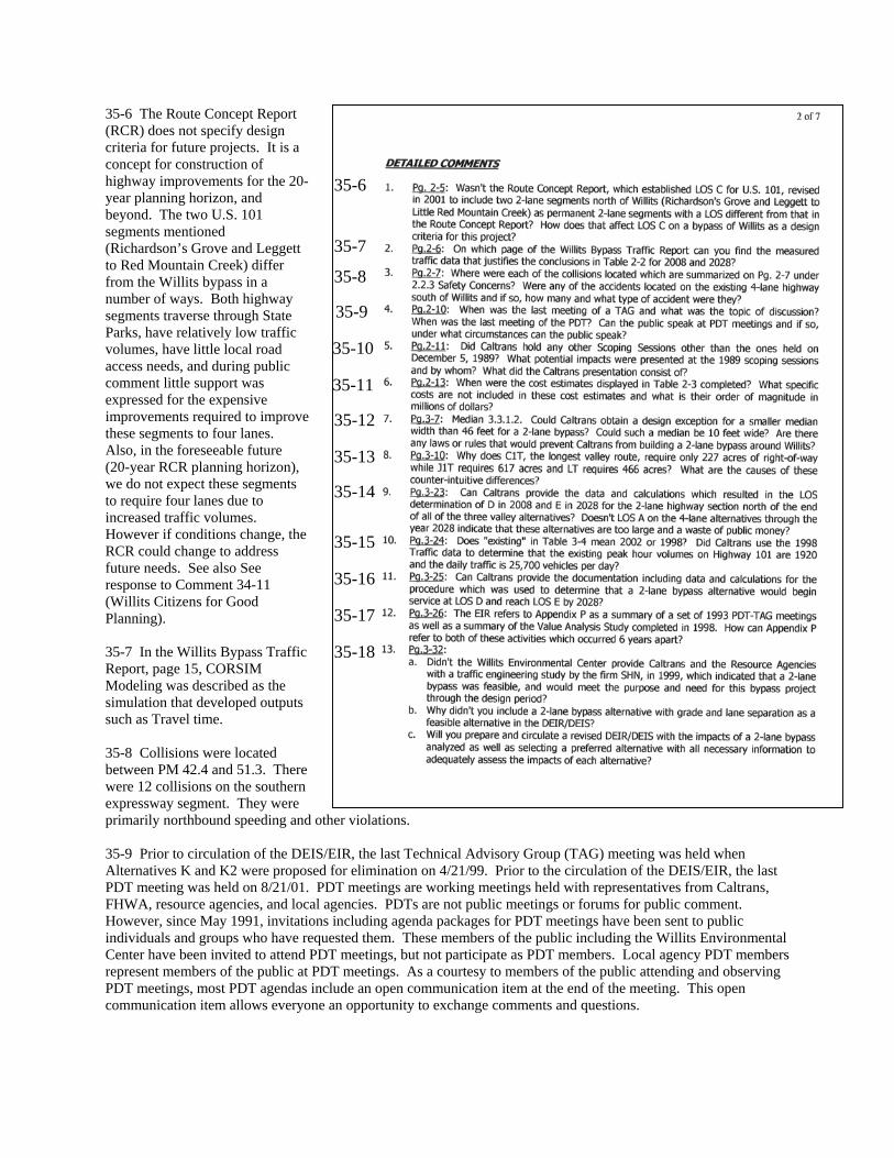
35-6 The Route Concept Report (RCR) does not specify design criteria for future projects. It is a concept for construction of highway improvements for the 20-year planning horizon, and beyond. The two U.S. 101 segments mentioned (Richardson’s Grove and Leggett to Red Mountain Creek) differ from the Willits bypass in a number of ways. Both highway segments traverse through State Parks, have relatively low traffic volumes, have little local road access needs, and during public comment little support was expressed for the expensive improvements required to ithese segments to four lanes. Also, in the foreseeable future (20-year RCR planning horizon), we do not expect these segments to require four lanes due to increased traffic volumes. However if conditions change, the RCR could change to address future needs. See also See response to Comment 34-11 (Willits Citizens for Good Planning).
mprove
35-7 In the Willits Bypass Traffic Report, page 15, CORSIM Modeling was described as the simulation that developed outputs such as Travel time. 35-8 Collisions were located between PM 42.4 and 51.3. There were 12 collisions on the southern expressway segment. They were primarily northbound speeding and other violations.
35-6
35-7
35-8
35-9
35-10
35-11
35-12
35-13
35-14
35-15
35-16
35-17
35-18
35-9 Prior to circulation of the DEIS/EIR, the last Technical Advisory Group (TAG) meeting was held when Alternatives K and K2 were proposed for elimination on 4/21/99. Prior to the circulation of the DEIS/EIR, the last PDT meeting was held on 8/21/01. PDT meetings are working meetings held with representatives from Caltrans, FHWA, resource agencies, and local agencies. PDTs are not public meetings or forums for public comment. However, since May 1991, invitations including agenda packages for PDT meetings have been sent to public individuals and groups who have requested them. These members of the public including the Willits Environmental Center have been invited to attend PDT meetings, but not participate as PDT members. Local agency PDT members represent members of the public at PDT meetings. As a courtesy to members of the public attending and observing PDT meetings, most PDT agendas include an open communication item at the end of the meeting. This open communication item allows everyone an opportunity to exchange comments and questions.

35-10 There were two separate scoping meetings held on December 5, 1989. One was with resource agencies and the other was with the public. The purpose of the scoping meetings was to discuss the proposed alternatives that had been developed at that point in time and to get input on environmental issues, reasonable alternatives and mitigation measures. Caltrans representatives presented the alternatives and open discussion ensued. 35-11 Cost estimates on Table 2-3 (DEIS/EIR) for Alternatives C1T, J1T, and LT were completed in the Fall of 2001. Cost estimates include capital costs such as structures, earthwork, base and paving, drainage; traffic-related items such as signing and striping; and various specialty items such as erosion control, landscaping, guardrailing, and fencing. The estimates also include allowances for environmental mitigation and relinquishment work and percentages for contingencies. Right of way estimates are included in the sums and allow for acquisitions, utility relocations, relocation assistance, and other incidental costs. See Section 1.2 (FEIS/EIR) for current estimated project schedule and cost. 35-12 See General Response 1.13 regarding median width. See General Response 1.10 regarding a two-lane alternative. See response to Comment 3-5 (USEPA).
35-13 The amount of actual "Highway Right-of-Way" needed for the footprint of the bypass is relatively similar for each alternative (see table below). The substantial differences in the "Total Acquisition" identified for each alternative are due to differences in the amount of "Excess Lands" generated by the project during the Right-of-Way acquisition process. Excess Lands emerge when the acquisition of Right-of-Way for the project results in the generation of "Remnant" parcels of land, which are not needed for the project footprint, but are too small, fragmentary, and/or unusable for a landowner to economically retain. The Department, therefore, purchases unusable remnants of land from landowners whose parcels are affected by the project. The Department seeks to purchase no more land than is needed for the project. All excess lands (remnant parcels) would not be permanently retained as State property and are generally sold back to interested members of the public and/or adjacent landowners. The amount of excess lands generated by each alternative depends on the manner in which the project footprint traverses a given parcel or group of parcels, and therefore, some alternatives would have a greater potential for the creation of more remnant parcels than others. For instance, alternatives that traverse land with larger numbers of small parcels may have a greater potential for creating more small remnants of land than alternatives that traverse land with fewer numbers of large parcels. Thus, the differences in the total amount of Right-of-Way acquired for each alternative are largely based on the amount of excess land rather than the amount of actual Right-of-Way needed for the footprint of the project. At this stage of the project, the amount of excess land identified for each alternative is merely an estimate that is calculated for cost projection purposes. Please note that, although the estimated Right-of-Way numbers have changed slightly from those presented in the Draft EIS/EIR, such changes are typical as project information becomes more refined. The most current estimates are as follows:
Table of Estimated Right of Way Acquisition Required for Project (acres)*
ALTERNATIVE C1T J1T LT Modified J1T
Highway Right of Way 243 204 214 197
Excess Lands 34 413 252 102
Total Acquisition 277 617 466 300 *All values are estimated
35-14 See General Response 1.10 regarding a two-lane alternative. 35-15 In Table 3-4, “Existing”(as shown in the legend as yellow) is 1998.

Figure 4 of the Willits Bypass Traffic Study shows Peak Hour volumes and Average Annual Daily Traffic (AADT). Existing (1998) bi-directional Peak Hour volumes south of Willits on U.S. 101 are 1390 and AADT is 18,530. North of Willits existing (1998) bi-directional Peak Hour volumes are 960 and AADT 12,800. AADT were not determined from the July 1998 traffic study. Caltrans Traffic Census provided 24-hour traffic counts, which provide the AADTs. See Response to Comment 33-5 (Sierra Club, Mendo Lake Group). 35-16 See General Response 1.10 regarding a two-lane alternative. See also response to Comment 34-29 (Willits Citizens for Good Planning). 35-17 Comment noted. The information in Appendix P was related to the 1993 TAG and PDT meetings, not the 1998 Value Analysis Study. Volume 3 (FEIS/EIR) Text Changes to the DEIS/EIR deletes the statement that was made on page 3-26. 35-18 Caltrans received a copy of a report prepared by SHN Consulting Engineers & Geologists, Inc. entitled, “Willits Bypass Alterative Analysis – Final Report”. The SHN report was not a traffic engineering study, as indicated in the comment, but rather it was a proposal for a two-lane bypass alternative. This proposal was prepared at the request of the Willits Environmental Center and was forwarded to Caltrans by the US Army Corps of Engineers. Caltrans staff reviewed the SHN proposal and concluded that the report did not have sufficient merit to justify a two-lane facility. Part of the Willits Bypass project purpose includes achieving a minimum Level of Service “C” for interregional traffic on U.S. 101 within the project area through the 20-year design period. Our traffic analysis demonstrates that a two-lane facility would not meet the purpose and need established for the project. For this reason, an analysis of a two-lane bypass was not included in the DEIS/EIR and is also not included in the FEIS/EIR. For additional discussion, see General Response 1.10 regarding a two-lane alternative. See also, response to 34-11.

35-19 Please refer to response to Comment 34-38 (Willits Citizens for Good Planning). 35-20 Surveys for Northern red-legged frog (Rana aurora aurora) were conducted and none were found in the project area. Table 4-16 (DEIS/EIR) summarizes the listing status of Northern red-legged frog, the subspecies that occurs in the project area. The California red-legged frog (R. aurara draytnii), the subspecies that is listed federally as a threatened species, does not occur in Mendocino County (Source: Recovery Plan for the California Red-legged Frog [Rana aurora draytonii]: Region 1, U.S. Fish and Wildlife Service, Portland, Oregon, May 2002). See response to Comment 26-5 (California Oak Foundation). 35-21 The mitigation measures proposed in the DEIS/EIR are based on acceptable professional engineering and geologic construction practices appropriate for geologic conditions in the Little Lake Valley area. 35-22 See General Response 1.12. 35-23(a) In the event that large numbers of residents need to be relocated in this area, Caltrans will need to employ a variety of techniques to ensure that decent, safe, and sanitary housing is found for all residents. As defined in the CEQA guidelines, mitigation is an action that compensates for an impact by replacing or providing substitute resources. Caltrans is obliged to provide substitute resources for displaced residents in the form of a comparable replacement dwelling. Furthermore, Caltrans cannot require anyone to move until at least one, but preferably three comparable replacement dwellings have been identified (Caltrans Right of Way Manual 10.06.01.00).
35-19 35-20 35-21
35-22
35-23
35-24
35-25
35-26
Technically, no further mitigation is required to offset the impact of displacements. Mitigation Measures COM-1 through COM-6 are provided in order to reinforce the requirements of the law (in the case of COM-1), and to publicly discuss the perceived obstacles to relocating residents locally and approaches for overcoming these obstacles. 35-23(b) The approach selected to determine the economic impact of the bypass was a quantitative model. This model used traffic projections, construction expenditures, and the City’s plans for economic development to derive an overall growth rate resulting from each of the build alternatives and the No Build Alternative. Based on the results of this study, no significant economic impacts were anticipated.

35-23(c) A quantitative economic analysis indicated that, over a period of 20 years, construction of the proposed bypass coupled with local economic development strategies, would result in economic growth greater than under the No Build Alternative. 35-24(a) Because Mendocino County has not been mapped by the Department of Conservation Farmland Mapping and Monitoring Program, Caltrans uses Natural Resources Conservation Services (NRCS) Farmland Conversion ratings to help identify the level of impacts to farmlands. 35-24(b&c) Regarding feasibility of mitigation measures FRM-1 and FRM-3, see responses to Comments 34-60 and 34-63 (Willits Citizens for Good Planning). 35-25(a) The Natural Resource Conservation Service (NRCS) calculates the farmland impacts using 7.5 minute topographic maps. The questions used and associated point spread are usually not attached to the CPA-106 form, but are available upon request. 35-25(b) While the Coleman ranch does contain prime farmland soils, it is not enrolled in the Williamson Act Program; therefore, it is not listed in Appendix L, which lists only those properties enrolled in the Williamson Act Program. 35-25(c) See General Response 1.14 regarding the project mitigation. 35-25(d) Due to its large footprint, Alternative E3 has the highest impact on prime soils of any of the build alternatives. 35-25(e) The 1984 Farmland Protection Policy Act Part 658 Sec. 658.4 reads: (1) Sites receiving scores totaling 160 or more be given increasingly higher levels of consideration for protection. (2) When considering these alternatives with higher scores (160 or higher) the project proponent should consider: (i) Using land that is not farmland or use of existing structures. (ii) Alternative sites, locations and designs that would serve the proposed purpose but converts either fewer acres of farmland or other farmland that has a lower relative value; (iii) Special siting requirements of the proposed project and the extent to which an alternative site fails to satisfy the special siting requirement as the original selected site. Caltrans has modified Alternative J1T to avoid and minimize resource and community impacts and during final design will continue to seek ways to further minimize environmental impacts. 35-25(f) NRCS scores Parts II and IV of Form CPA 106. Alternative E3 has the highest impact score, which is due to the high number of acres to be converted. Recent changes due to the resubmittal of the Farmland Conversion Impact Rating Form (CPA 106) indicate that all of the build alternatives are relatively close in their impact rating. Alternative E3, however, has the highest impact score, which is due to the high number of acres to be converted. See Volume 3 (FEIS/EIR) Text Changes to the DEIS/EIR, which includes revisions to Section 5.4.6 of the DEIS/EIR that show this new information. Farmland Conversion Impact Rating Forms are included in Appendix E (FEIS/EIR). 35-25(g) See response to Comment 35-24(a). 35-25(h) The proposed mitigation measures which focus on preservation, and the design of the valley alternatives, which do not include a center valley interchange, limit impacts to prime farmland (soils). See Section 3.4 FEIS/EIR for discussion of Farmland impacts resulting from Modified Alternative J1T. See also response to Comment 34-64 (Willits Citizens for Good Planning). 35-26(a) There are no new NPDES storm water requirements for testing of toxic chemicals which could leach out of asphalt. It should be noted, however, that Caltrans has completed an extensive characterization of storm water runoff quality throughout California. A comprehensive report summarizing the efforts and results of that study can be found at http://dot.ca.gov/hq/env/stormwater/special/newsetup/index.htm. The comment reflects misinformation regarding recent modifications to the General Construction Storm Water Permit. On April 26, 2001, SWRCB modified the General Permit for Storm Water Discharges associated with

Construction Activity (Water Quality Order 99-08-DWQ). The Superior Court, County of Sacramento, issued a judgment and writ of mandate on September 15, 2000. The Court directed the SWRCB to modify the provisions of the General Permit to require permittees to implement specific sampling and analytical procedures to determine whether Best Management Practices (BMPs) implemented on a construction site are: (1) preventing further impairment by sediment in storm waters discharged directly into waters listed as impaired for sediment or silt, and (2) preventing other pollutants, that are known or should be known by permittees to occur on construction sites and that are not visually detectable in storm water discharges, from causing or contributing to exceedence of water quality objectives. Generally, all construction projects, which disturb greater than 5 acres of area (reduced to 1 acre, March 2003) are subject to this permit, therefore the proposed Willits Bypass Project will be subject to the requirements of this permit. The General Permit can be accessed at the following web-site: http://www.swrcb.ca.gov/stormwtr/docs/constpermit.pdf The adopted modifications can be accessed at the following web-site: http://www.swrcb.ca.gov/stormwtr/docs/adopted_modifications.pdf 35-26(b) Overall, Caltrans has made great efforts to address storm water quality issues in the last several years and has incorporated mechanisms to ensure these issues are addressed through all phases of project delivery. For example, the Project Planning and Design Guide (PPDG),1 revised April 2003, provides for a thorough evaluation of water quality issues and provides specific guidance for incorporating BMPs into the project planning and design phases of project development. These include Treatment BMPs, Design Pollution Prevention BMPs, and critical Construction BMPs. The PPDG also contains checklists, decision trees, and a format for a Storm Water Data Report. As per a September 25, 2002 Memorandum from the Chief of the Division of Design: "The preparation of a Storm Water Data Report shall be mandatory for all projects advertised after January 1, 2003." These mechanisms were not in place during the construction of the Redwood Bypass to which the comment letter refers. An additional measure implemented by Caltrans is outlined in a December 18, 2002 Memorandum from the Deputy Director of Project Delivery. In part, the Memorandum states, "Districts shall begin incorporating critical Construction Site Best Management Practices (BMPs) into project plans and specifications for all projects ready to list (RTL) on or after October 1, 2003, and shall begin preparing quantities tables within PS&E documents for anticipated Construction Site BMPs. Additionally, Conceptual SWPPPs [Storm Water Pollution Prevent Plan] should be considered for Environmentally Sensitive Projects RTL on or after October 1, 2003". 35-26(c) Caltrans has developed an extensive library of construction site Best Management Practices (BMPs). These can be accessed at:
http://www.dot.ca.gov/hq/construc/Construction_Site_BMPs.pdfCaltrans construction contract documents require temporary erosion control BMPs to be implemented during project construction. Caltrans staff will design water pollution control project elements for the preferred alternative. Additional requirements with regard to wetlands protections may be required by the resource agencies.
1 Mitigation Measure WQ-6 refers to the Storm Water Quality Handbook Planning and Design Staff Guide (June 2000). The correct title is the Project Planning and Design Guide (PPDG), revised April 2003.
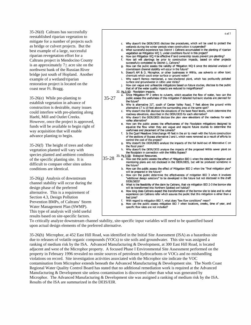
35-26(d) Caltrans has successfully reestablished riparian vegetation to mitigate for a number of projects such as bridge or culvert projects. But the best example of a large, successful riparian revegetation effort for a Caltrans project in Mendocino County is an approximately 7+ acre site on the northwest bank of the Russian River bridge just south of Hopland. Another example of a wetland/riparian restoration project is located on the coast near Ft. Bragg. 35-26(e) While pre-planting to establish vegetation in advance of construction is desirable, many issues could interfere with pre-planting along Haehl, Mill and Outlet Creeks. However, once the project is approved, funds will be available to begin right of way acquisition that will enable advance planting to begin. 35-26(f) The height of trees and other vegetation planted will vary with species planted and ambient conditions of the specific planting site. It is difficult to compare other sites unless conditions are identical. 35-26(g) Analysis of downstream channel stability will occur during the design phase of the preferred alternative. This is a requirement of Section 4.3, Design Pollution Prevention BMPs, of Caltrans’ Storm Water Management Plan (SWMP). This type of analysis will yield useful results based on site-specific factors. To critically analyze downstream channel stability, site-specific input variables will need to be quantified based upon actual design elements of the preferred alternative.
35-27
35-28
35-26(h) Microphor, at 452 East Hill Road, was identified in the Initial Site Assessment (ISA) as a hazardous site due to releases of volatile organic compounds (VOCs) to site soils and groundwater. This site was assigned a ranking of medium risk by the ISA. Advanced Manufacturing & Development, at 300 East Hill Road, is located adjacent and west of the Microphor property. A focused Phase I Environmental Site Assessment performed on the property in February 1996 revealed no onsite sources of petroleum hydrocarbons or VOCs and no mishandling violations on record. Site investigation activities associated with the Microphor site indicate the VOC contamination from Microphor extends beneath the Advanced Manufacturing & Development site. The North Coast Regional Water Quality Control Board has stated that no additional remediation work is required at the Advanced Manufacturing & Development site unless contamination is discovered other than what was generated by Microphor. The Advanced Manufacturing & Development site was assigned a ranking of medium risk by the ISA. Results of the ISA are summarized in the DEIS/EIR.
35-26(i) ABEX Corporation (REMCO) was identified in the Initial Site Assessment (ISA) as a hazardous site due to releases of chromium and chlorinated solvents to site soils, surface water and groundwater. Remediation activities have included a groundwater pump and treat system, and a pilot test system including injecting calcium polysulfide into the groundwater. Based on the distance from this facility to the alternatives, the ABEX facility was assigned a ranking of low risk. 35-26(j) See response to Comment 34-61 (Willits Citizens for Good Planning). 35-27(a) Caltrans utilized the best information available to evaluate floodplain impact(s) for the DEIS/EIR. The Federal Emergency Management Agency’s (FEMA) Flood Insurance Study (FIS) for the City of Willits (1988) and Mendocino County (1992), and the Willits Bypass Floodplain Study prepared by the University of California, at Davis (1995) were used to evaluate this impact. The majority of freeway embankment traversing the base floodplain passes through the Zone A designation where the equalizing culverts would be considered. The FIS describes Zone A as an area of 100-year flood with base flood elevations and flood hazard factors not determined. It was not economically prudent to perform a complete floodplain analysis for each alternative traversing Little Lake Valley. A hydraulic analysis has been performed for the LEDPA, to refine the impact analysis. Deferring the hydraulic analysis has no bearing on the identification of the preferred alternative, because other environmental issues govern this process. 35-27(b) Caltrans is unsure of the specific location alluded to in the comment. Caltrans has reviewed the profiles for Alternatives J1T and LT, and finds that they are similar south of Center Valley Road; generally, the fill for Alternative J1T between East Hill Road and Center Valley Road is slightly lower than that for Alternative LT, but by less than one meter. During final design of the preferred alternative, more detailed survey information will be used to set the final profile. 35-27(c) FEMA’s FIS and the Flood Insurance Rate Map (FIRM) provide base flood elevations in the area(s) of the detailed study. Detailed studies for the City of Willits and Mendocino County FIS include Haehl, Baechtel, Broaddus, Mill, Outlet and Davis Creeks. Caltrans did not include the base flood elevations (BFE) in the DEIS/EIR because the FEMA publications are available to interested parties and were cited as references. In addition, the FEMA publications do not provide BFEs outside the detailed study limits. BFEs were only available in the vicinity of Alternative J1T where it crossed Haehl, Baechtel, Broaddus and Mill Creek. Alternative J1T spans these floodplains and floodways with a bridge or viaduct structure. BFEs outside the detailed study limits were estimated for other preliminary design purposes. Please note the freeway profile is not only governed by the BFEs in Little Lake Valley. The freeway profile must also provide adequate vertical clearance at the proposed undercrossings 35-27(d) Profiles have been prepared for Modified Alternative J1T (LEDPA/preferred alternative). See Appendix H (FEIS/EIR). 35-27(e) See response to Comment 35-27(a). 35-27(f) None of the truncated valley alternatives would prohibit future construction to the north of the project. However, continuation of a valley alternative further to the north is not foreseeable nor would it be a priority project for Caltrans, Willits, or Mendocino County. The elevation of the mainline near Quail Meadows interchange is controlled by the railroad. The roadway must clear the railroad by at least 7 m (23 ft). The railroad is approximately 4.6-6.0 m (15-20 ft) above the surrounding ground. The structure depth is 1.8-2.4 m (6-8 ft). Falsework requirements add another 1.5-1.8 m (5-6 ft). The total height above the surrounding ground is roughly 15 m (50 ft). 35-27(g) The reference to “full build-out” is unclear. All the build alternatives were analyzed at an equal level of detail in the DEIS/EIR. 35-27(h) Detailed information on the Willits Wastewater Treatment/Water Reclamation Project was not available when the DEIS/EIR was prepared. Since public circulation of the Willits Bypass DEIS/EIR and the Willits Wastewater Treatment Plant (WWTP) project EIR, Design staff have evaluated floodplain impacts due to both projects. The City’s WWTP project EIR includes mitigation measures associated with the project’s impacts.
Mitigation measures for impacts associated with the WWTP project are the lead agency’s (City of Willits) responsibility. 35-28(a)-(c)(g)(l)-(n) Since identification of Modified Alternative J1T as the preferred alternative, Caltrans began preparing alignment-specific avoidance, minimization, and mitigation measures. The measures are located in Appendix A (FEIS/EIR). A Conceptual Mitigation Plan (Appendix L, FEIS/EIR) has been prepared in coordination with resources agencies, which have jurisdiction over and technical expertise of the biological resources impacted by the project. Modified Alternative J1T was developed to avoid and minimize impacts to various resources. During final design of Modified Alternative J1T, minor changes may be incorporated for additional avoidance of sensitive habitats. 35-28(d)(e) See response to Comment 27-4 (California Native Plant Society). 35-28(f)(g) Low-flow conditions refer to the time of year, usually late summer and fall, when water levels are at their lowest or the stream channel is dry. Flow levels in streams vary from year to year depending on the amount of rainfall occurring during the previous wet season. Any work in the creeks, if required, will occur during the summer and fall months when water levels are typically low. 35-28(h)(i) See response to Comment 26-3 (California Oak Foundation). There are several factors that need to be considered for successful oak mitigation. Caltrans’ experience is that successful oak establishment seems to be a function of the site conditions more than the size of material or amount of watering. On sites that have good soil (soil that water can infiltrate into and roots can penetrate; not constructed fill or cut), good results have been achieved. 35-28(j) See response to Comment 35-26(d). 35-28(k) Since identification of Modified Alternative J1T as the preferred alternative, Caltrans began preparing alignment-specific avoidance, minimization, and mitigation measures. The measures are located in Appendix A (FEIS/EIR). A Conceptual Mitigation Plan (Appendix L, FEIS/EIR) has been prepared in coordination with resources agencies, which have jurisdiction over and technical expertise of the biological resources impacted by the project. Modified Alternative J1T was developed to avoid and minimize impacts to various resources. 35-28(l) Functions and values were considered in determining project impact on a habitat. For example, its function as habitat for protected species. Thus, Alternative E3, which has fewer direct impacts to wetlands and other waters, has indirect impacts to endangered fish species due to erosion and sedimentation issues. The conceptual mitigation plan for Modified Alternative J1T (the Preferred Alternative) is included in Appendix L (FEIS/EIR). The functions and values analysis accompanied the Final Alternatives Analysis that was submitted to the NEPA/404 resources agencies. The functions and values analysis, along with other technical studies, is available for review (see “Purpose of this Document” at the beginning of Volume 1, FEIS/EIR). 35-28(n) See response to Comment 48-4 (Andrea Beene).

35-29 Alternatives J1T and LT do not meet Clean Water Act 404(b)(1) Criteria for their overall environmental harm, and therefore, will no longer be considered for construction. See General Response 1.11. Modified Alternative J1T was developed to avoid and minimize projects impacts. 35-30 In Figure 5-3, the impact to sensitive plant communities for all of the alternatives, including Alternative LT are shown in acres. In the text immediately above the figure, the impacts for all of the alternatives are shown in both hectares and acres. 35-31 See response to Comment 139-6 (Karina McAbee). 35-32 Impact to oak woodlands was included in the DEIS/EIR (Table 5-16). Alternative LT would have resulted in a direct impact to the large oak riparian woodland in the project area, as well as indirect impacts on wildlife due to habitat segmentation. Modified Alternative J1T was developed, in part, to minimize impacts to this oak woodland. See also responses to Comments 26-1 and 26-4 (California Oak Foundation). Currently, there have been no confirmed occurrences of Sudden Oak Death (SOD) in Mendocino County (Source: Oak Woodlands of Mendocino County: An Assessment of Their Distribution, Ownership Patterns and Policies affecting their Conservation. Giusti, G.A., 2001). Caltrans will include special provisions in contract document for reducing the potential spread of SOD for projects in Mendocino County. When CT biologists conduct surveys for project impacts to oak trees, they will also determine if SOD exists in the project corridor. If an infected tree is identified on the project site, biologists familiar with procedures to safely remove infected trees will be consulted and the tree(s) or shrub(s) will not be chipped and reapplied to revegetation sites.
35-29
35-30
35-31
35-32
35-33
35-34
35-33 The DEIS/EIR provides considerable detail on habitat types being impacted by each project alternative (Tables 5-16 and 5-18). ACOE has stated that functions and values are useful when comparing alternatives that have a similar magnitude of impacts to waters of the U.S. Habitat types occurring on each of the proposed alignments are similar in functions and quality. Hence, even with the difference in the acreage of each habitat affected within all the alternatives, a separate comparison for these habitats for each alternative is not warranted, because of the similarities in function and quality of each habitat type. Obviously, areas that serve as habitat for federally listed fish species or state listed species (Baker’s meadowfoam) were considered in the impact analysis. See also response to Comment 35-28(l).

35-34 See General Response 1.4 and responses to Comments 5-1 and 5-2 (CDFG).

35-35
35-36
35-37
35-38
35-39
35-41
35-42
35-43
35-44
35-40
35-35 As stated in Willits Bypass Draft EIR/EIS (Volume 3, page 3-23), "Levels of service on the two-lane highway section north of Willits would be LOS D in 2008 and LOS E in 2028 for alternatives C1T, J1T and LT”. Speeds on a two-lane rural highway at LOS E are approximately 45 mph according to the Highway Capacity Manual 2000 (see also General Response 1.10). The distance between the Upper Haehl Creek interchange and the Quail Meadows interchange is approximately 4 miles for the Modified Alternative J1T. The travel time difference for vehicles traveling at 50mph versus 64 mph over this distance (4 miles) is approximately 65 seconds (one minute, 5 seconds). 35-36 The cumulative impacts discussion in the DEIS/EIR (Section 6.2) included the wastewater treatment plant project. However, when the bypass DEIS/EIR was published, ACOE had not yet determined the extent of wetland impacts from the wastewater treatment plant project, so it was not possible to accurately determine the cumulative impact of the bypass and the wastewater treatment plant project. Section 3.19 (FEIS/EIR) provides an updated cumulative impacts discussion specific to Modified Alternative J1T.
35-37 See response to Comment 34-7 (Willits Citizens for Good Planning) for a discussion of why construction of the northern portions of the truncated alternatives are not reasonably foreseeable, and therefore no cumulative impact analysis is required for these previous project elements. 35-38 On page 17 of the Willits Bypass Traffic report, it states: An abundance of traffic data has been reviewed and is on file for this study area. The Office of Travel Forecasting and Modeling staff specifically gathered data in both April and July 1998, including turn movement counts, Origin/Destination studies and GPS TAC Runs. The analysis included in this report is primarily based on the July 1998 data collected (see Design Hour Volumes Considerations). 35-39 See response to Comment 33-5 (Sierra Club, Mendo-Lake Group). 35-40 Comparing hypothetical scenarios involving speculative changes in bypass alternatives was not part of the traffic study conducted for the DEIS/EIR.

35-41 It is common for drivers to reduce their speed in foggy conditions. If fog becomes a problem on the chosen alternative, there are methods such as fog detection and warning systems that increase driver awareness. 35-42 The energy analysis examined all of the alternatives based on vehicle miles traveled and future fuel usage based on projected fleet make-up. 35-43 As referenced on Page 3-34 of the DEIS/EIR, a 2-lane bypass, as proposed by the Willits Environmental Center, was not studied and evaluated as an alternative bypass facility. See General Response 1.10 for further discussion of a two-lane bypass and why it does not meet the purpose and need for this project. 35-44 Any member of the public may undertake their own studies or check the validity of Caltrans studies for the bypass project. Because of software licensing agreements, Caltrans is unable to provide copies of the software programs used to conduct our studies, but we can provide the names of the computer programs that were used to generate various studies. Subsequent to the public comment period for the DEIS/EIR, Caltrans received a request from the WEC for information that would allow them to check the validity of our studies. In response, Caltrans provided the WEC with electronic data, mapping, and an explanation of the specific computer software we used in our wetlands impact analyses. Regarding “defects” in the DEIS/EIR, the foregoing responses are sufficient and no revisions to the DEIS/EIR are required. See General Response 1.10 regarding a two-lane bypass.

36 Willits Environmental Center
36-1
36-2
36-1 See General Response 1.10 for the discussion of a two-lane bypass and why it does not meet the purpose and need of the project. 36-2 See response to Comment 30-6 (Mendocino Forest Watch). See also General Response 1.10, which supplements the DEIS/EIR discussion on why a two-lane alternative does not meet the purpose and need for the project, and therefore is not a feasible or reasonable alternative. See response to Comment 35-10 (Willits Environmental Center) regarding scoping.
36-3 See response to Comment 34-5 (Willits Citizens for Good Planning).
36-3

36-4 See response to Comment 33-1 (Sierra Club, Mendo-Lake Group). “The range of potential alternatives to the proposed project shall include those that could feasibly accomplish most of the basic objectives of the project and could avoid or substantially lessen one or more of the significant effects” [emphasis ours] (CEQA 15126.6). At a minimum, the alternatives considered must reduce delays, improve safety, and achieve a “C” Level of Service for interregional traffic.
36-4

36-5 See response to Comment 33-1 (Sierra Club, Mendo-Lake Group). Also, under CEQA, the EIR need examine in detail only the alternatives that the lead agency determines could feasibly attain most of the basic objectives of the project (CEQA Guidelines, 15126.6(f) “Rule of Reason”).
36-5

36-6
36-7
36-6 Caltrans Traffic staff reviewed the SHN report (10/28/99) and concluded that the report did not justify a two-lane facility. 36-7 The statement that a two-lane bypass would have “significantly” less impacts than a four-lane bypass is unsubstantiated. Reducing the four-lane bypass to two lanes would not reduce the footprint by half because of necessary design components such as the median, inside/outside shoulders, side slopes, and drainage facilities, all of which would remain the same size regardless the number of lanes.

36-8 See General Response 1.10 regarding a two-lane bypass. The responses presented here, as well as the responses to Willits Environmental Center and Willits Citizens for Good Planning, provide sufficient explanation and no change to the DEIS/EIR is necessary. 36-9 See response to Comment 34-5 (Willits Citizens for Good Planning) and response to Comment 36-8.
36-8
36-9