3.1.1 the challenge of natural hazards - home - … 9-1 gcse.pdf3.1.1 the challenge of natural...
TRANSCRIPT
Maghull High School Geography Department
New AQA 9-1 GCSE course outline
3.1.1 The challenge of natural hazards
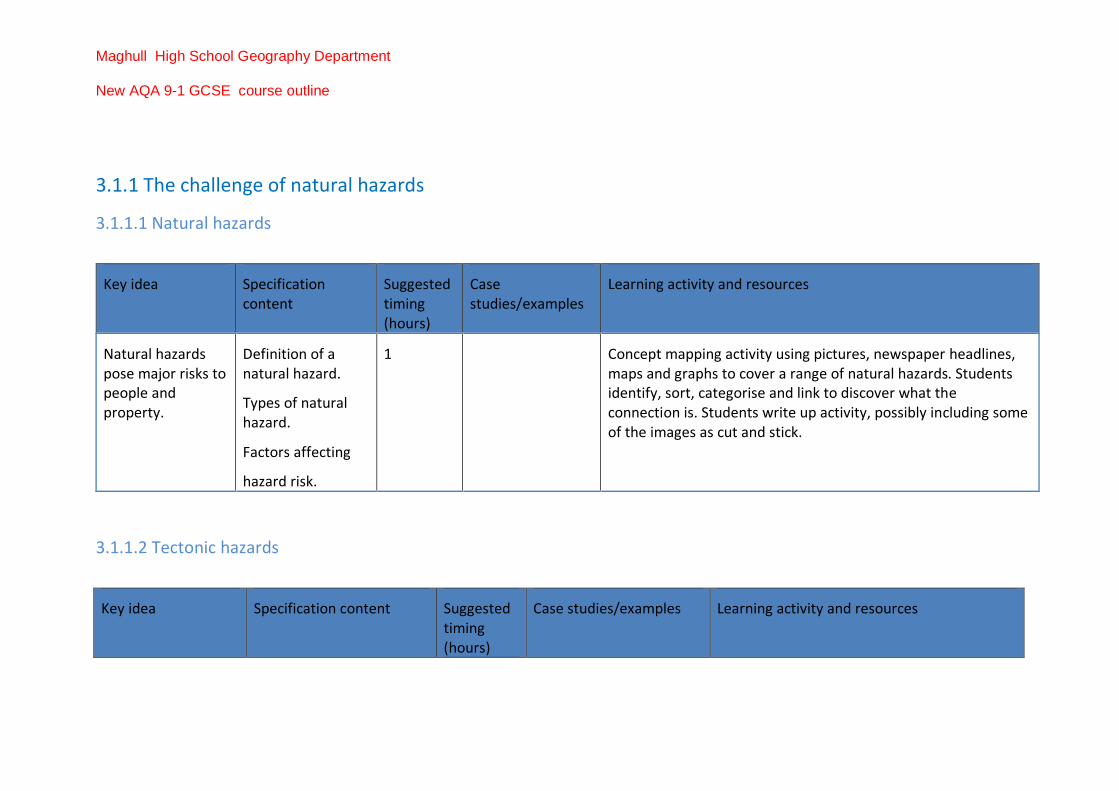
3.1.1.1 Natural hazards
Key idea Specification content
Suggested timing (hours)
Case studies/examples
Learning activity and resources
Natural hazards pose major risks to people and property.
Definition of a natural hazard.
Types of natural hazard.
Factors affecting
hazard risk.
1 Concept mapping activity using pictures, newspaper headlines, maps and graphs to cover a range of natural hazards. Students identify, sort, categorise and link to discover what the connection is. Students write up activity, possibly including some of the images as cut and stick.
3.1.1.2 Tectonic hazards
Key idea Specification content Suggested timing (hours)
Case studies/examples Learning activity and resources

Maghull High School Geography Department
New AQA 9-1 GCSE course outline
Earthquakes and volcanic eruptions are the result of physical processes.
Plate tectonics theory.
Global distribution of earthquakes and volcanic eruptions and their relationship to plate margins.
1 Introduce the movement of continental plates with the film of 'Scrat's Continental Crack Up' on YouTube
GIS-mapping activity using USGS website to plot active volcanoes and earthquakes on a world map (plate margins marked on optional). Describe and explain the distribution.
Draw out theory and the reasons for this, linking to the YouTube clip.
The physical processes taking place at different types of plate margins (constructive, destructive and conservative) that lead to earthquakes and volcanic activity.
2 1st hour
Teacher taught using animations, such as "Kung Fu Panda Plate Tectonics" on YouTube
Students to make well-annotated diagrams.
2nd hour
Create models to represent the different plate boundaries, using cardboard, PlayDoh or bread and jam to show the movement of plates. Return to map to mark on the directional movement of the plates and name examples of each margin across the world.
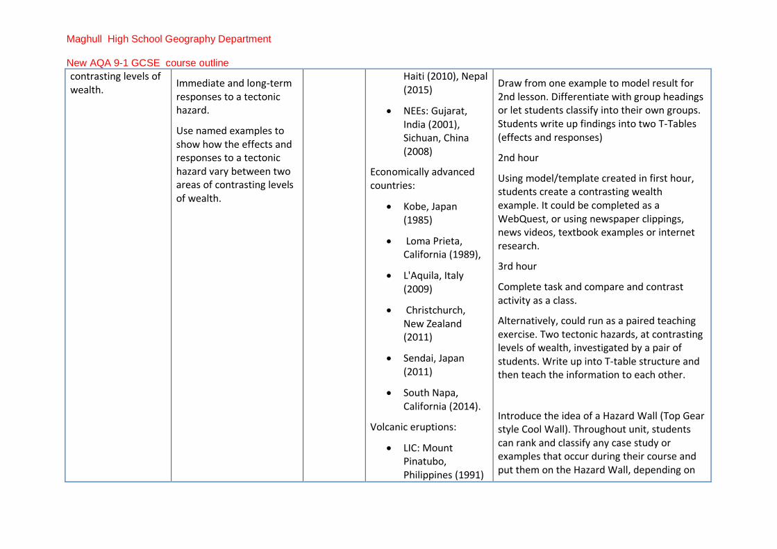
The effects of and responses to a tectonic hazard vary between areas of
Primary and secondary effects of a tectonic hazard.
3 Earthquakes:
• LICs: Kashmir, Pakistan (2005),
1st hour
Card sort of effects of tectonic hazards into four groups (primary, secondary, immediate and long term responses).
Maghull High School Geography Department
New AQA 9-1 GCSE course outline
contrasting levels of wealth.
Immediate and long-term responses to a tectonic hazard.
Use named examples to show how the effects and responses to a tectonic hazard vary between two areas of contrasting levels of wealth.
Haiti (2010), Nepal (2015)
• NEEs: Gujarat, India (2001), Sichuan, China (2008)
Economically advanced countries:
• Kobe, Japan (1985)
• Loma Prieta, California (1989),
• L'Aquila, Italy (2009)
• Christchurch, New Zealand (2011)
• Sendai, Japan (2011)
• South Napa, California (2014).
Volcanic eruptions:
• LIC: Mount Pinatubo, Philippines (1991)
Draw from one example to model result for 2nd lesson. Differentiate with group headings or let students classify into their own groups. Students write up findings into two T-Tables (effects and responses)
2nd hour
Using model/template created in first hour, students create a contrasting wealth example. It could be completed as a WebQuest, or using newspaper clippings, news videos, textbook examples or internet research.
3rd hour
Complete task and compare and contrast activity as a class.
Alternatively, could run as a paired teaching exercise. Two tectonic hazards, at contrasting levels of wealth, investigated by a pair of students. Write up into T-table structure and then teach the information to each other.
Introduce the idea of a Hazard Wall (Top Gear style Cool Wall). Throughout unit, students can rank and classify any case study or examples that occur during their course and put them on the Hazard Wall, depending on

Maghull High School Geography Department
New AQA 9-1 GCSE course outline
• Soufrier Hills, Montserrat (1995)
• Sinabung, Indonesia (2014).
Economically advanced countries:
• Mount St Helens, USA (2005)
• Etna, Sicily (2007)
• Eyjafjallajökull, Iceland (2010)
• Mount Ontake, Japan (2014).
severity of effect. Brings forward the idea of comparing across the natural hazard types.
Management can reduce the effects of a tectonic hazard.
Reasons why people continue to live in areas at risk from a tectonic hazard.
How monitoring, prediction, protection and planning can reduce the risks from a tectonic hazard.
1 Enquiry Lesson: "Why do we still live in areas at risk?"
Introduce the Three P's (Planning, Prediction and Protection). Students draw out examples of each P from their two case studies.
Hypothesise/discuss why the contrasting examples were different.

Maghull High School Geography Department
New AQA 9-1 GCSE course outline
3.1.1.3 Weather hazards
Key idea Specification content Suggested timing (hours)
Case studies/examples Learning activity and resources
Global atmospheric circulation helps determine patterns of weather and climate.
General atmospheric circulation model: pressure belts and surface winds.
1 Largely needs to be taught, with the opportunity for some active modelling depending on space available. Activities could use:
• chalk on an outdoor court
• balloons to show sinking air in high pressure/rising air in falling pressure
• coloured water at different temperatures, mixing to show circulation of air at different temperatures
• whiteboard pens to annotate earth balloons/beach ball globes.
Tropical storms (hurricanes, cyclones, typhoons) develop as a result of particular physical conditions.
Global distribution of tropical storms (hurricanes, cyclones, typhoons).
An understanding of the relationship between
2 1st hour
National Geographic video- Hurricanes 101
Maghull High School Geography Department
New AQA 9-1 GCSE course outline
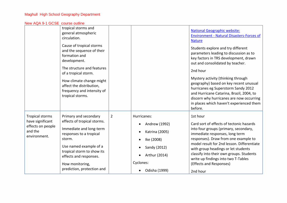
tropical storms and general atmospheric circulation.
Cause of tropical storms and the sequence of their formation and development.
The structure and features of a tropical storm.
How climate change might affect the distribution, frequency and intensity of tropical storms.
National Geographic website: Environment - Natural Disasters-Forces of Nature
Students explore and try different parameters leading to discussion as to key factors in TRS development, drawn out and consolidated by teacher.
2nd hour
Mystery activity (thinking through geography) based on key recent unusual hurricanes eg Superstorm Sandy 2012 and Hurricane Catarina, Brazil, 2004, to discern why hurricanes are now occurring in places which haven't experienced them before.
Tropical storms have significant effects on people and the environment.
Primary and secondary effects of tropical storms.
Immediate and long-term responses to a tropical storm.
Use named example of a tropical storm to show its effects and responses.
How monitoring, prediction, protection and
2 Hurricanes:
• Andrew (1992)
• Katrina (2005)
• Ike (2008)
• Sandy (2012)
• Arthur (2014)
Cyclones:
• Odisha (1999)
1st hour
Card sort of effects of tectonic hazards into four groups (primary, secondary, immediate responses, long term responses). Draw from one example to model result for 2nd lesson. Differentiate with group headings or let students classify into their own groups. Students write up findings into two T-Tables (Effects and Responses)
2nd hour

Maghull High School Geography Department
New AQA 9-1 GCSE course outline
planning can reduce the effects of tropical storms.
• Giri (2010)
• Phailin (2013)
• Hudhud (2014)
Typhoons:
• Angela (1995)
• Bopha (2012)
• Haiya (2013)
Formalise exemplar (could be student choice from earlier exercise) into clear notes.
Alternative sequence:
1st hour
Flipped Learning: students research exemplar from list provided and use template to ensure consistency of coverage. Follow homework to prepare for second lesson:
2nd hour
Dragons' Den Pitch "My TRS is the best because..." or Balloon debate "My TRS is worse than yours…".
Follow up with 3Ps already introduced to show how they ameliorate hazard effects.
The UK is affected by a number of weather hazards.
Overview of types of weather hazard experienced in the UK.
0.5 Discussion and Concept mapping of types of hazards experienced in UK. Link it back to global circulation and position of UK on Polar Front Jet Stream/Polar and Ferrell cell convergence.
Extreme weather events in the UK have impacts on human activity.
One example of a recent extreme weather event in the UK to illustrate:
• causes
3.5
Drought:
• Central, Eastern and Southern England and
Diamond shaped learning
1st hour

Maghull High School Geography Department
New AQA 9-1 GCSE course outline
• social, economic and environmental impacts
• how management strategies can reduce risk
• evidence that weather is becoming more extreme in the UK.
Wales (2004-2006, 2010-2012).
Heavy Rain – Flooding:
• Tewkesbury, River Severn (Summer 2007)
• Lake District (November 2009)
• Carlisle, River Eden (June 2012)
• York, River Ouse (September 2012)
• Somerset Levels (December 2013-March 2014)
• Cumbria (December 2015).
Flash floods:
• Boscastle (August 2004)
• Inverness (September 2002)
• Lostwithiel (November 2010)
Extreme weather event of teacher choice (suggest this should be local/memorable event) either taught or by providing a template with info to be extracted from sources.
2nd hour (and may need an extra 30 minutes here).
Small groups: 'secret groups' in which each group researches one of the categories (heavy rain, flash floods etc) using web, or other resources if preferred, to find as much evidence as possible. Students write this up (possibly in a template to ensure all aspects covered) to provide their example.
3rd hour
Collate evidence, and use this to produce a concept map showing that UK weather is becoming more extreme.

Maghull High School Geography Department
New AQA 9-1 GCSE course outline
• Bognor Regis (May 2015).
Strong winds/storms:
• November 2011
• January 2012
• October 2013
• December 2013
• February 2014
• December 2015 (Storm Desmond)
Periods of exceptionally cold weather:
• Winter 2010/2011
Periods of heavy snowfall:
• January 2010
• December 2010
• November/December 2010
• March/April 2013.
Periods of exceptionally high temperatures (heat wave):

Maghull High School Geography Department
New AQA 9-1 GCSE course outline
• Summer (2003)
• September/October (2011)
• March (2012).
3.1.1.4 Climate change
Key idea Specification content Suggested timing (hours)
Case studies/examples
Learning activity and resources

Maghull High School Geography Department
New AQA 9-1 GCSE course outline
Climate change is the result of natural and human factors and has a range of effects.
Evidence for climate change from the beginning of the Quaternary period to the present day.
Possible causes of climate change.
Natural factors: orbital changes, volcanic activity and solar output.
Human factors: use of fossil fuels, agriculture and deforestation.
Overview of the effects of climate change on people and the environment.
2 1st hour
Either:
Students collect evidence on a large A3 sheet (eg graphs of glacial retreat, CO2 concentrations over time, maps of arctic ice reduction, weather records, historical evidence such as Frost Fair, Mauna Loa records, Vostok ice cores etc). Students identify the evidence for climate change.
OR
CSI Lesson: classroom is the crime scene with evidence for climate change around the room on cards. Students find and identify. Teacher assists to collate a range of different types of evidence.
2nd hour
Teach causes using videos and textbook. Students create a map/table of effects at the UK scale and global scale. Students given the effects and then they colour code/classify based on SPEE and natural/human impacts.
Managing climate change involves both mitigation (reducing causes) and
Managing climate change:
• mitigation – alternative energy
2 1st hour
Students create living concept map. Tables covered with paper to allow student to write

Maghull High School Geography Department
New AQA 9-1 GCSE course outline
adaptation (responding to change).
production, carbon capture, planting trees, international agreements
• adaptation – change in agricultural systems, managing water supply, reducing risk from rising sea levels.
with marker pens. Small box of props/pictures given to each table, with objects that relate to management of climate change ie child's paper windmill to represent wind power, or Lego house on stilts to represent adaptation to rising sea levels.
2nd hour
Class makes a set of notes together based on ideas and discussion arising from the living concept map.
Alternatively, spilt class into two groups to cover mitigation and adaptation separately. Discuss the difference in approaches.
Group discussion:
Discuss differences to draw out the ideas of mitigation of climate change and adaptation to climate change.

Maghull High School Geography Department
New AQA 9-1 GCSE course outline
3.1.2 The living world
3.1.2.1 Ecosystems
Key idea Specification content Suggested timing (hours)
Case studies/examples
Learning activity and resources
Ecosystems exist at a range of scales and involve the interaction between biotic and abiotic components.
One example of a small-scale UK ecosystem, to illustrate the concept of inter-relationships within a natural system, an understanding of producers, consumers, decomposers, food chain, food web and nutrient cycle.
The balance between components. The impact on the ecosystem of changing one component.
Overview of the distribution and characteristics of large scale, natural, global ecosystems.
3 Any small-scale ecosystem – hedgerow, woodland, sand dune, pond etc.
1st and 2nd hours
Teacher led initially, with information or clear short task re components. Change then modelled with scenarios/cards to prompt. Could be done as a living concept map. Tables covered with paper to allow student to write with marker pens. Small box of props/pictures given to each table with objects that relate to a small-scale ecosystem eg for hedgerow, a small container of soil, bag of bird food, Lego trees, Playmobil people, cards to prompt/model changes.
Clear fieldwork opportunity in local ecosystem if possible.
Maghull High School Geography Department
New AQA 9-1 GCSE course outline
3rd hour
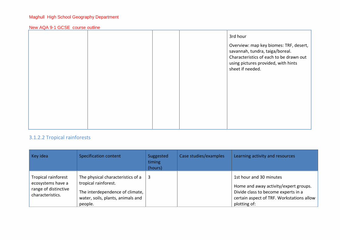
Overview: map key biomes: TRF, desert, savannah, tundra, taiga/boreal. Characteristics of each to be drawn out using pictures provided, with hints sheet if needed.
3.1.2.2 Tropical rainforests
Key idea Specification content Suggested timing (hours)
Case studies/examples Learning activity and resources
Tropical rainforest ecosystems have a range of distinctive characteristics.
The physical characteristics of a tropical rainforest.
The interdependence of climate, water, soils, plants, animals and people.
3 1st hour and 30 minutes
Home and away activity/expert groups. Divide class to become experts in a certain aspect of TRF. Workstations allow plotting of:

Maghull High School Geography Department
New AQA 9-1 GCSE course outline
How plants and animals adapt to the physical environment.
Issues related to biodiversity.
• climate graph (skill),
• map of location, reasoning behind it
• soil description and horizon
• plant adaptations
• animals adaptations.
Students teach one another their findings.
Leads to the importance of nutrient recycling in the TRF.
2nd hour and 30 minutes
Homework/Flipped Learning. Students design a plant to exist in TRF - not the content that is important but the thinking skill.
Apply to real world examples from TRF - to annotation, diagrams, photos (skills).

Maghull High School Geography Department
New AQA 9-1 GCSE course outline
Deforestation has economic and environmental impacts.
Changing rates of deforestation.
A case study of a tropical rainforest to illustrate:
• causes of deforestation – subsistence and commercial farming, logging, road building, mineral extraction, energy development, settlement, population growth
• impacts of deforestation - economic development, soil erosion, loss of biodiversity, contribution to climate change.
4 Amazonia
Congo Basin
SE Asia
Indonesia/Borneo
Potential time saving opportunity - simultaneous work on case study of a TRF and either hot desert or cold environment.
Half of class works on TRF.
Half of class works on either hot deserts or cold environment.
Brief is to create a presentation of a case study to cover the areas in specification. Give students resources, textbooks, journals, web references. Provide low ability students with a template. Clear instructions and good resources will guide students.
Students have 4 hours to prepare: 1 hour to present TRF findings (students make notes during presentations), 1 hour to present hot desert/cold environment (students make notes during presentation).
Total saving of two hours - work shared between class.

Maghull High School Geography Department
New AQA 9-1 GCSE course outline
3.1.2.3 Hot deserts
Key idea Specification content Suggested timing (hours)
Case studies/examples Learning activity and resources
Hot desert ecosystems have a range of distinctive characteristics.
The physical characteristics of a hot desert.
3 Teach this after the TRF section has been completed. Then having looked at the characteristics of a TRF, use climate detectives activity. Students are given hot
Tropical rainforests need to be managed to be sustainable.
Value of tropical rainforests to people and the environment.
Strategies used to manage the rainforest sustainably:
• selective logging and replanting
• conservation and education
• ecotourism and international agreements about the use of tropical hardwoods
• debt reduction.
3 Malaysia/Sarawak Taught case study. Show students a good video/documentary base. Students make notes from textbook. Teacher to draw out relevant content.
Teacher to draw out relevant content with use of ketch map and/or annotated images with keywords deployed and highlighted.

Maghull High School Geography Department
New AQA 9-1 GCSE course outline
The interdependence of climate, water, soils, plants, animals and people.
How plants and animals adapt to the physical conditions.
Issues related to biodiversity.
desert plants and animals and have to reverse engineer/deduce what the ecosystems’ characteristics must be like. Give students categories of climate, soil, water etc. and blank climate graph, map etc., What would the ecosystem be like based on the adaptations of the animals and plants?
Alternative activity. Aliens land on planet Earth in a hot desert. They find this plant and this animal. What do they think Planet Earth is like?
Development of hot desert environments creates opportunities and challenges.
A case study of a hot desert to illustrate:
• development opportunities in hot desert environments: mineral extraction, energy, farming, tourism
• challenges of developing hot desert environments: extreme temperatures, water supply, inaccessibility.
4
(use 2 of these 4 hours to present TRF and hot desert findings).
Sahara
Dubai
Nevada/Arizona
Sudan/Egypt
Australian outback
Already completed if following the example given in TRF section of simultaneous work of case study of a TRF and either hot desert or cold environment.
Half of class works on TRF
Half of class works on either hot deserts or cold environment.
Maghull High School Geography Department
New AQA 9-1 GCSE course outline
Areas on the fringe of hot deserts are at risk of desertification.
Causes of desertification: • climate change
• population growth
• removal of fuel wood
• overgrazing
• over-cultivation and soil erosion.
Strategies used to reduce the risk of desertification:
• water and soil management,
• tree planting and use of appropriate technology.
2 1st hour
Give students a range of examples, causes and strategies as cards/images/small pieces of text.
Sort/classify into causes and strategies.
2nd hour
Write up into a flow diagram
Problem Cause Solution
Illustrated with examples.
3.1.2.4 Cold environments
Key idea Specification content Suggested timing (hours)
Case studies/examples Learning activity and resources
Cold environments (polar and tundra) have a range of distinctive characteristics.
The physical characteristics of a cold environment.
The interdependence of climate, permafrost, soils, plants, animals and people.
How animals adapt to the physical conditions.
3 Teach this after the TRF section has been completed. Then having looked at the characteristics of a TRF, use climate detectives activity. Give students cold environment plants and animals and ask them to reverse engineer/deduce what the ecosystems’ characteristics must be like. Give categories of climate, soil, water etc

Maghull High School Geography Department
New AQA 9-1 GCSE course outline
Issues related to biodiversity. and blank climate graph, map etc. What would the ecosystems be like based on the adaptations of the animals and plants?
Alternative activity: Aliens land on Planet Earth in a cold environment. They find this plant and this animal. What do they think Planet Earth is like?
Development of cold environments creates opportunities and challenges.
A case study of a cold environment to illustrate:
• development opportunities in cold environments: mineral extraction, energy, fishing and tourism
• challenges of developing cold environments: extreme temperature, inaccessibility, provision of buildings and infrastructure.
4
(use two of these hours to present TRF and cold environments findings)
Antarctica
Tundra, Northern Alaska
Already completed if following the example given in TRF section of simultaneous work of case study of a TRF and either hot desert or cold environment.
Half of the class works on TRF
Half of the class works on hot deserts or cold environments.

Maghull High School Geography Department
New AQA 9-1 GCSE course outline
Cold environments are at risk from economic development.
The value of cold environments as wilderness areas and why these fragile environments should be protected.
Strategies used to balance the needs of economic development and conservation in cold environments:
• use of technology
• role of governments
• international agreements
• conservation groups.
2 Antarctica
Alaska
Arctic Oil Drilling
Siberia/Russia
1st hour
Teacher taught - definitions, examples of strategies and the concept of fragility and wilderness.
2nd hour
Apprentice/Dragon's Den activity. Students look at the costs, benefits and sustainability of the strategies and "pitch" their plan for using the cold environment. Teacher to play the role of Alan Sugar/Dragons.
Alternatively, students rank possibilities on their sustainable credentials and then as a class come to a consensus of which is most likely/viable.
Maghull High School Geography Department
New AQA 9-1 GCSE course outline
3.1.3 Physical landscapes in the UK
3.1.3.1 UK physical landscapes
Key idea Specification content Suggested timing (hours)
Case studies/examples
Learning activity and resources
The UK has a range of diverse landscapes.
Overview of the location of major upland/lowland areas and river systems.
1 Maps from memory thinking skills activity. Create class definitive version.
3.1.3.2 Coastal landscapes in the UK
Key idea Specification content Suggested timing (hours)
Case studies/examples
Learning activity and resources
The coast is shaped by a number of physical processes.
Wave types and characteristics.
Coastal processes:
• weathering processes – mechanical, chemical
• mass movement – sliding, slumping and rock falls
2 Teacher led/taught using videos and animations widely available. Leads to good clear diagrams/notes so that students have solid technical knowledge of key processes.

Maghull High School Geography Department
New AQA 9-1 GCSE course outline
• erosion – hydraulic power, abrasion and attrition
• transportation – longshore drift
• deposition – why sediment is deposited in coastal areas.
Distinctive coastal landforms are the result of rock type, structure and physical processes.
How geological structure and rock type influence coastal forms.
Characteristics and formation of landforms resulting from erosion: headlands and bays, cliffs and wave cut platforms, caves, arches and stacks.
Characteristics and formation of landforms resulting from deposition: beaches, sand dunes, spits and bars.
An example of a section of coastline in the UK to identify its major landforms of erosion and deposition.
6
Flamborough Head to Spurn Head
Activity lasting up to 4 hours for characteristics and formation. A number of approaches possible depending on teacher preferences, such as:
• CSI Lesson - classroom is the crime scene with evidence for, eg stack (Who killed Old Harry?) around the room on cards. Students find and identify. Teacher helps to coordinate process and sequence.
• Teach sequence and process with landform outcomes.
• Model with PlayDoh, sand trays.
• Stop-motion animation (students draw line diagrams on mini whiteboards and photograph individually then flick through or put into slideshow)

Maghull High School Geography Department
New AQA 9-1 GCSE course outline
Purbeck Coast (Swanage Bay to Lulworth Cove)
Activity for up to 2 hours, using UK example to illustrate. Use photos, linked to base maps with annotation/explanation. Should be possible to fit onto A3, 'case study on a page' format. Tracing paper overlays of different maps eg geology, or GIS packages to achieve same.
Fieldwork opportunity if location permits.
Different management strategies can be used to protect coastlines from the effects of physical processes.
The costs and benefits of the following management strategies:
• hard engineering – sea walls, rock armour, gabions and groynes
• soft engineering – beach nourishment and re-profiling, dune regeneration
• managed retreat – coastal realignment.
One example of a coastal management scheme in the UK to show:
• the reasons for management
4
Holderness coast
Studland Bay
Barton on Sea
Walton on the Naze
1st hour
Costs/benefits table for each strategy, either taught or card sort/info search from provided resources.
2nd , 3rd and 4th hours
Either
Taught study, using base map to annotate and build up picture from google earth, photos etc. as a virtual field trip (clearly actual fieldwork could be used)
Or
'Home and away'/'expert groups' technique: small groups (4) start, then individuals tasked with finding info on: reasons for/strategy/effects/conflicts from resources provided. Report findings to rest of group to build example.
Maghull High School Geography Department
New AQA 9-1 GCSE course outline
• the management strategy
• the resulting effects and conflicts.
Lyme Regis
Medmerry – West Sussex
Suggest 2 hours teaching/group work, then fix layout:
Either
1 hour group discussion and checking understanding/details and key terms.
Or
1 hour issue evaluation exercise for alternative/proposed schemes to develop paper 3 skills. Could be prepared for homework using pre-release style material.

Maghull High School Geography Department
New AQA 9-1 GCSE course outline
3.1.3.3 River landscapes in the UK
Key idea Specification content Suggested timing (hours)
Case studies/examples
Learning activity and resources
The shape of river valleys changes as rivers flow downstream.
The long profile and changing cross profile of a river and its valley.
Fluvial processes:
• erosion – hydraulic action, abrasion, attrition, solution, vertical and lateral erosion
• transportation – traction, saltation, suspension and solution
• deposition – why rivers deposit sediment.
2 Teacher taught, using:
• good diagrams and notes
• animations/diagrams available online
• active modelling eg students as particles of different sizes in outdoor space, responding to changes in velocity
• OS maps to develop cross-section skills.

Maghull High School Geography Department
New AQA 9-1 GCSE course outline
Distinctive fluvial landforms result from different physical processes.
Characteristics and formation of landforms resulting from erosion: interlocking spurs, waterfalls and gorges.
Characteristics and formation of landforms resulting from erosion and deposition: meanders and ox-bow lakes.
Characteristics and formation of landforms resulting from deposition: levées, flood plains and estuaries.
An example of a river valley in the UK to identify its major landforms of erosion and deposition.
5
River Tees
River Severn
River Wye
River Exe
Fieldwork opportunity
As with other landforms in this section, the important focus should be on understanding sequence and process(es). Possible resources include:
• teacher led notes on process, with clear diagrams
• modelling eg using PlayDoh or set a 'Bake-Off' challenge to recreate individual landforms/wider landscapes
• stop-motion animation using mini whiteboards (students draw line diagrams on mini whiteboards and photograph individually then flick through or put into slideshow)
• use of photos of landforms at points in time, which could be: sequenced, annotated to explain, students to predict the next change and justify why.
• virtual field trip - google earth/geograph (class contributes series of photographs to Geograph website to illustrate key features, activity can link well with fieldwork)
• OS map use/cross profiling skills eg locate the photo/feature on the map and justify why. Then link features with other maps

Maghull High School Geography Department
New AQA 9-1 GCSE course outline
such as GIS sources eg landforms of deposition and Environment Agency flood maps
Different management strategies can be used to protect river landscapes from the effects of flooding.
How physical and human factors affect the flood risk – precipitation, geology, relief and land use.
The use of hydrographs to show the relationship between precipitation and discharge.
The costs and benefits of the following management strategies:
• hard engineering – dams and reservoirs, straightening, embankments, flood relief channels
• soft engineering – flood warnings and preparation, flood plain zoning, planting
5
Activity lasting 1-2 hours. Start with hydrographs. Teach basics through use of living graph(s), then set 4 contrasting hydrographs (chosen to illustrate physical and human factors) around room. Students have table with 4 headings: 1 hydrograph no., 2 Description, 3 Factors and 4 Explanation, with possible supporting information such as photographs, fact cards to aid understanding.
Group discussion to draw out class answers of the factors that affect the flood risk.
Activity lasting 1 hour. Teacher taught/led on costs and benefits with simple T-table to record.
3 to 3.5 hour activity working on example:
Fieldwork opportunity incl. virtual fieldtrip
Enquiry/Mystery activity with structured write up eg "Why has a dam just been finished at Mitford, Northumberland?"
Morpeth Herald website

Maghull High School Geography Department
New AQA 9-1 GCSE course outline
trees and river restoration.
One example of a flood management scheme in the UK to show:
• why the scheme was required
• the management strategy
• the social, economic and environmental issues.
River Ouse – York
River Thames
River Parrett and River Tone – Somerset levels
River Severn – Shrewsbury
"Why has Somerset launched a 20 year flood plan?"
Somerset Newsroom
NB the more current the better and can be linked with UK extreme weather.

Maghull High School Geography Department
New AQA 9-1 GCSE course outline
3.2 Challenges in the human environment
3.2.1 Urban issues and challenges
Key idea Specification content Suggested timing (hours)
Case studies/examples Learning activity and resources
A growing percentage of the world’s population lives in urban areas.
The global pattern of urban change.
Urban trends in different parts of the world including HICs and LICs.
Factors affecting the rate of urbanisation - migration (push - pull theory), natural increase.
The emergence of mega-cities.
3 1st hour
Use of GIS/web to show change over time eg
Unicef urban population map
Worldmapper website
Interactive 3D maps can be found at McKinsey & Company website
Students could annotate base world map for notes.
2nd and 3rd hours
Teach processes and terminology, producing a table

Maghull High School Geography Department
New AQA 9-1 GCSE course outline
with terms relevant to each continent and why.

Maghull High School Geography Department
New AQA 9-1 GCSE course outline
Urban growth creates opportunities and challenges for cities in LICs and NEEs.
A case study of a major city in an LIC or NEE to illustrate:
• the location and importance of the city, regionally, nationally and internationally
• causes of growth: natural increase and migration
• how urban growth has created opportunities:
o social: access to services – health, education; access to resources -water supply, energy
o economic: how urban industrial areas can be a stimulus for economic development.
• how urban growth has created challenges:
o managing urban growth - slums, squatter settlements
6 LIC:
• Bangladesh – Dhaka
• Pakistan – Karachi
• India - Dehli/Kolkata/Mumbai
• Kenya – Nairobi
• Nigeria - Lagos
NEE:
BRIC countries:
• Brazil – Sao Paulo/Rio de Janeiro
• Russia – Moscow
• India – Delhi/Kolkata/ Mumbai
• China – Shanghai/ Beijing/Guangzhou/Shenzen
MINT countries:
• Mexico – Mexico City
• Indonesia – Jakarta
• Nigeria – Lagos
• Turkey – Istanbul
Begin with reference back to maps at start and continent view leading to a reducing scale and focus.
4 to 5 hours on main section. Use documentary/film footage to convey 'sense of place' which provides important link to new A-level content eg
• BBC ' Welcome to Lagos'
• C4 'Slumming it'
• BBC 'Welcome to Rio'
• Al Jazeera 'The Slum' - series of 6 episodes on different topics, all based in Manila.
Make clear and organised/classified notes eg using Cornell note system to focus use of video.
Provide printed and textual resources from which info has to be extracted (paper 3 skill)
GIS/Google Earth

Maghull High School Geography Department
New AQA 9-1 GCSE course outline
o providing clean water, sanitation systems and energy
o providing access to services - health and education,
o reducing unemployment, crime
o managing environmental issues - waste disposal, air and water pollution, traffic congestion.
An example of how urban planning is improving the quality of life for the urban poor.
Mumbai – Dharavi- Dharavi Redevelopment Project/Slum Rehabilitation Authority
Nairobi – Kibera – Kenya Slum Upgrade Programme (KENSUP)
Kolkata – Kolkata Environment Improvement Project (KEIP)
Rio de Janiero – Rochina – Self-help Schemes/Favela Bairro Project Slum Dwellers International (SDI)
Use A3 case study sheet to condense key info.
Up to 2 hours on mini study, within or after the main one above.

Maghull High School Geography Department
New AQA 9-1 GCSE course outline
Urban change in cities in the UK leads to a variety of social, economic and environmental opportunities and challenges.
Overview of the distribution of population and the major cities in the UK.
A case study of a major city in the UK to illustrate:
• the location and importance of the city in the UK and the wider world
• impacts of national and international migration on the growth and character of the city
• how urban change has created opportunities:
o social and economic: cultural mix, recreation and entertainment, employment, integrated transport systems
o environmental: urban greening
• how urban change has created challenges:
7
London, Manchester, Birmingham, Leeds, Glasgow, Bradford, Liverpool, Southampton, Newcastle, Nottingham, Sheffield, Bristol, Belfast, Cardiff, Wakefield, Coventry, Leicester, Edinburgh.
1 hour activity: topological mapping to give an overview of the UK. Looking at distribution of cities in the UK. Proportional circles added to map population (skills).
1 to 2 hours: fieldwork opportunity. Case study of a major city.
Geographical Association website- Walking guides of cities
Alternatively, use of documentary footage of cities - BFI Britain on Film series to look at the changing character of British cities overtime. Use Cornell note structure to interrogate video or students write diary extracts to look at city and its importance.
Or living graph exercise of notable moments in history of the chosen city case study. Pictures, text, event located on a timeline

Maghull High School Geography Department
New AQA 9-1 GCSE course outline
o social and economic: urban deprivation, inequalities in housing, education, health and employment
o environmental: dereliction, building on brownfield sites, waste disposal
o the impact of urban sprawl on the rural-urban fringe and the growth of commuter settlements.
An example of an urban regeneration project to show:
• reasons why the area needed regeneration
• the main features of the project.
• Aston Pride – Birmingham
• Park Hill – Sheffield
• Salford Quays - Manchester
• Olympic Park - London.
1 hour: teacher taught - opportunities created by urban areas. Annotated photos located around a map (GIS). Use of Guardian data blog for resources or to create a mystery activity "Why are the cities the place to be?"
Guardian website – Cities and news datablog
1 to 2 hours: fieldwork opportunity - example of urban regeneration project.
Alternatively, clear structured case study - location map, key facts and information - pictures before and after - problems identified and solutions offered by the project.
1 hour. Using the previous case study as source material, students draw out the challenges that were tackled by the regeneration project. Group them, classify and

Maghull High School Geography Department
New AQA 9-1 GCSE course outline
colour code within the case study.
Alternatively, split class into three groups. Give them either social and economic, environmental or the impact on the rural fringe. Give clear instructions, expectations, weblinks and textbook sources as a task sheet. Students create a presentation and one A4 of summary notes for the class.

Maghull High School Geography Department
New AQA 9-1 GCSE course outline
Urban sustainability requires management of resources and transport.
Features of sustainable urban living:
• water and energy conservation
• waste recycling
• creating green space.
How urban transport strategies are used to reduce traffic congestion.
2
London, Manchester, Cambridge, Curitiba, Cairo, Freiberg, Paris (R-urban).
Hexagon Card Sort (Metacognition): information about the sustainable area given on Hexagon cards. Students classify and group information based on their choice of groups. Differentiate to give help for lower ability students.
Information then written up on a Honeycomb/Blockbuster style hexagon sheet. Pictures of the sustainable areas added and annotated to draw out features.
Homework: build a sustainable city from scrap/Lego/paper, label it and bring in for show and tell.
Maghull High School Geography Department
New AQA 9-1 GCSE course outline
3.2.2 The changing economic world
Key idea Specification content Suggested timing (hours)
Case studies/examples
Learning activity and resources
There are global variations in economic development and quality of life.
Different ways of classifying parts of the world according to their level of economic development and quality of life.
Different economic and social measures of development: gross national income (GNI) per head, birth and death rates, infant mortality, life expectancy, people per doctor, literacy rates, access to safe water, Human Development Index (HDI).
Limitations of economic and social measures.
Links between stages of the Demographic Transition Model and the level of development
Causes of uneven development: physical, economic and historical
3-4 1 hour: use of topological maps, Gapminder, Global Health Atlas, to create packs, workstations covering the different measures of economic development/quality of life.
Each table looks through their pack and feeds back to the class about patterns, discoveries and method of measuring development.
Homework: follow up Mix and Match activity of measurement and its definition.
1 hour: Teach Demographic Transition Model. Create good notes or alternatively, do living graph exercise.
Diamond 9 ranking activity based on the measures of development and quality of life. Which of the measures should a country solve/improve to

Maghull High School Geography Department
New AQA 9-1 GCSE course outline
Consequences of uneven development: disparities in wealth and health, international migration.
further its development? Class discussion, justification and notes.
1 hour: living concept map - tables covered with large paper to write on. Each table provided with box/bag of props to stimulate discussion, link to development eg bottle of dirty water, a condom etc. Students write ideas on large table covering, then formalise into clear links and notes.
1 hour - After living concept map, tackle links to the DTM and its limitations. DTM is based on births and deaths as a means of reflecting wider processes. Students write critique of the DTM, potentially using examples of countries and their birth and death rates to place them on the DTM, but then challenge the suggested level of development.
Alternatively, use the DTM as a Top Gear Style Cool Wall. Students position countries according to their corresponding stage of DTM, based on births and deaths and critique inconsistencies.

Maghull High School Geography Department
New AQA 9-1 GCSE course outline
Various strategies exist for reducing the global development gap.
Overview of the strategies used to reduce the development gap:
• Investment
• industrial development
• tourism
• aid
• using intermediate technology
• fair trade
• debt relief
• microfinance loans.
One example of how the growth of tourism in an LIC or NEE helps to reduce the development gap.
2
Democratic Republic of Congo
Kenya, Tunisia, Vietnam
Turkey, Jamaica, Mauritius
China
1st hour: enquiry "How do you solve a problem like Chad?" Expert groups/home and away activity. Students visit workstation and look at mini case studies of strategies to improve development. Notes set out in flow diagram:
Strategy detail and description problem solved/addressed students comment on it.
Students report back and teach each other their discovered strategy.
2nd hour, Teacher taught, use images, textbook information, GeoActive sources, videos and notes.
Some LICs or NEEs are experiencing rapid economic development which leads to significant social, environmental and cultural change.
A case study of one LIC or NEE to illustrate:
• the location and importance of the country regionally and globally
• the wider political, social, cultural and environmental context within which the country is placed
6 LIC: • Bangladesh
• Pakistan
• India
• Kenya
• Nigeria
NEE
BRIC countries: • Brazil
For variety this could be well done as a guided self-study (to avoid a series of potentially dry and 'by the numbers' factual lessons). Teacher provides intriguing title and maps/diagrams/data.
- Students use these to answer structured questions.
Or

Maghull High School Geography Department
New AQA 9-1 GCSE course outline
• the changing industrial structure. The balance between different sectors of the economy. How manufacturing industry can stimulate economic development
• the role of transnational corporations (TNCs) in relation to industrial development. Advantages and disadvantages of TNC(s) to the host country
• the changing political and trading relationships with the wider world
• international aid: types of aid, impacts of aid on the receiving country
• the environmental impacts of economic development
• the effects of economic development on the quality of life for the population.
• Russia
• India
• China
MINT countries: • Mexico
• Indonesia
• Nigeria
• Turkey
Flip the idea - give text/writing and students to find evidence to back it up.
Each section can be collected for a quick mark/check.
So, using China as example:
'Just how far east is China?' (location and context).
'The Rise of the Dragon' (changing industrial structure).
'An apple a day keeps the World Bank away'/'The Huawei to growth' (role of TNCs).
'The Chinese are coming' (changing political and trading relationships).
'China's Dirty Little Secret' (environmental impacts/quality of life).

Maghull High School Geography Department
New AQA 9-1 GCSE course outline
Major changes in the economy of the UK have affected and will continue to affect employment patterns and regional growth.
Economic futures in the UK:
• causes of economic change: de-industrialisation and decline of traditional industrial base, globalisation and government policies
• moving towards a post-industrial economy: development of information technology, service industries, finance, research, science and business parks
• impacts of industry on the physical environment. An example of how modern industrial development can be more environmentally sustainable
• social and economic changes in the rural landscape in one area of population growth and one area of population decline
• improvements and new developments in road and rail infrastructure, port and airport capacity
6
London Sustainable Industries Park (London SIP)
Adnac Park Southampton (including OS building)
Cambridge – various buildings
1 hour, Teacher taught. Five levels of industry in the UK - Primary to Quinary. Leading to looking at graphs of industrial output over time, annotation and comment on changes.
Alternative activity: living graph of industrial output in various sectors, statements positioned to reflect change over time.
Spend 1 hour on the remaining six bullet points (could co-teach 1 and 2)
1 hour - mystery or enquiry question to look at the growth of science parks and the post-industrial economy.
Alternatively, fieldwork opportunity.
1 hour activity: social and economic changes in area of population growth and decline. Split the class in half to cover areas of decline and growth. Students interview older members of family/community and write up findings as diary extracts about the change nature of the area.
Alternatively, students write imagined diary extracts of an old person living in a rural area that has seen decline and

Maghull High School Geography Department
New AQA 9-1 GCSE course outline
• the north–south divide. Strategies used in an attempt to resolve regional differences
• the place of the UK in the wider world. Links through trade, culture, transport, and electronic communication. Economic and political links: the European Union (EU) and Commonwealth.
Northern Powerhouse
HS2
one that has seen growth. Paired activity and swap results.
1 hour: newspaper headlines and images based around third runway at Heathrow, HS2 etc to create discussion/debate with notes to follow.
1 hour: Flipped Learning - give students the headings of Trade, Culture, Transport, Electronic Communication, Political Links. Students find for homework things that they have, do, eat, etc that fall into those categories. Where they see it, hear it, experienced it.
Bring to class to draw up the Global Citizen that they are - music, products, food, fashion etc.
Concept map results/map results with string to show the UK's global reach.

Maghull High School Geography Department
New AQA 9-1 GCSE course outline
3.2.3 The challenge of resource management
3.2.3.1 Resource management
Key idea Specification content Suggested timing (hours)
Case studies/examples
Learning activity and resources
Food, water and energy are fundamental to human development
The significance of food, water and energy to economic and social well-being.
An overview of global inequalities in the supply and consumption of resources.
2 1 hour game based lesson (cf. trading game) with 3 different sweets to represent each of food/water/energy. Teacher to run game with event cards and associated responses from students.
1 hour: predict patterns on world map then follow up with real data.
The changing demand and provision of resources in the UK creates opportunities and challenges.
An overview of resources in relation to the UK.
Food:
• the growing demand for high value food exports from low income countries and all year demand for seasonal food and organic produce
• larger carbon footprints due to the increasing number of
6 2 hours: Food activity:
'Supermarket Sweep' - analyse the weekly shop, map origins, food mile calculations, maths opportunity with CO2 calculations.
Food Carbon Emissions Calculator website
Link findings to adverts for farmers markets/local food campaigns

Maghull High School Geography Department
New AQA 9-1 GCSE course outline
‘food miles’ travelled and moves towards local sourcing of food.
• the trend towards agribusiness
Water:
• the changing demand for water
• water quality and pollution management
• matching supply and demand – areas of deficit and surplus
• the need for transfer to maintain supplies.
Energy:
• the changing energy mix - reliance on fossil fuels, growing significance of renewables
• reduced domestic supplies of coal, gas and oil
• economic and environmental issues associated with exploitation of energy sources.
OR activity using two shopping bags (virtual or real) containing same items but one sourced from supermarket, the other ethically/locally. Calculate costs for each and compare and contrast.
2 hours: Water activity:
Teacher led: rainfall vs population distribution maps. Add overlay for transfer schemes.
Teach water quality and pollution management.
2 hours: Energy activity:
Debate – give info, ensure well-structured and all aspects covered, including a crib sheet for post-debate issue if needed, to form notes/record
Possible areas to cover: dependence on Russian natural gas, decline of the North Sea, closed coal mines.

Maghull High School Geography Department
New AQA 9-1 GCSE course outline
Debate could be multi-faceted and quite open with groups of students 'lobbying' their interest as issued
Or
Traditional title eg 'Should the Chinese be allowed to subcontract a French company to build a nuclear reactor in Somerset?'
3.2.3.2 Food
Key idea Specification content Suggested timing (hours)
Case studies/examples
Learning activity and resources
Demand for food resources is rising globally
Areas of surplus (security) and deficit (insecurity):
3 1 hour: Flipped Learning. Homework: preparation to create 4 Top Trump cards for 4 countries covering food

Maghull High School Geography Department
New AQA 9-1 GCSE course outline
but supply can be insecure, which may lead to conflict.
• global patterns of calorie intake and food supply
• reasons for increasing food consumption: economic development, rising population
• factors affecting food supply: climate, technology, pests and disease, water stress, conflict, poverty.
Impacts of food insecurity – famine, under nutrition, soil erosion, rising prices, social unrest.
consumption, calorie intake etc. Template provided.
Sketch map of the world. Map and locate Top Trumps individually and collaboratively to draw out patterns.
Alternative - GIS-mapping over time to look at patterns of surplus and deficit.
1 to 2 hours. Topological maps, Worldmapper website GIS used to complete a series of group work tasks. Jigsaw activity: each member of the group is responsible for one of the reasons relating to increasing food consumption or one of the factors affecting supply. Make notes in template, report back and share with rest of group.
1 hour activity. Concept mapping on impacts as a class. Each table provided with a box or pile of props (newspaper headlines, images, facts, and cards of data). As concept map is drawn up as a class, try to use a prop and stop the lesson to explain the link and use this to add to the detail.

Maghull High School Geography Department
New AQA 9-1 GCSE course outline
Different strategies can be used to increase food supply.
Overview of strategies to increase food supply:
• irrigation, aeroponics and hydroponics, the new Green Revolution and use of biotechnology, appropriate technology
• one example of a large-scale agricultural development to show how it has both advantages and disadvantages.
Moving towards a sustainable resource future:
• the potential for sustainable food supplies: organic farming, permaculture, urban farming initiatives, fish and meat from sustainable sources, seasonal food consumption, reduced waste and losses
• an example of a local scheme in an LIC or NEE to increase sustainable supplies of food.
5
River Volga/Caspian Sea - Russia
River Nile – Egypt
River Colorado – USA
River Volta – Burkina Faso
River White Volta – Ghana
Farm Africa – various projects in Africa
1 hour: Teach strategies, using videos, clips, images, GeoActive to create good notes for each area.
1 hour: Study of a large scale agricultural development as a T-Table of advantages and disadvantages. Based on textbook material, GeoActive material etc.
2 hours - 1 hour to research/1 hour to deliver a short presentation (3 to 5 mins for each pair/small group) and one A4 handout of notes on the ways of moving to more sustainable food resources. Students provided with a target card with details, weblinks, reading and guidance of structure.
During presentation hour students "gather their thoughts" using a grid structure to note down the strategy, costs and benefits. Students then rank the usefulness of each strategy. Could use SurveyMonkey to complete online vote/tally of ideas.

Maghull High School Geography Department
New AQA 9-1 GCSE course outline
International Fund for Agricultural Development – various projects in India
ActionAid
1 hour activity. Classic case study prepared on A3. Notes made from video, textbook, GeoActive. Include sketch map, key facts, images, details of scheme and examples.
3.2.3.3 Water
Key idea Specification content Suggested timing (hours)
Case studies/examples
Learning activity and resources
Demand for water resources is rising globally but supply can be insecure, which may lead to conflict.
Areas of surplus (security) and deficit (insecurity):
• global patterns of water surplus and deficit
• reasons for increasing water consumption: economic development, rising population
• factors affecting water availability: climate,
3 1 hour - Flipped Learning. Homework Preparation to create 4 Top Trump cards for 4 countries covering water usage, wasted water etc. Template provided.
Sketch map of the world. Map and locate Top Trumps individually and collaboratively to draw out patterns.
Alternative activity: GIS-mapping over time to look at patterns of surplus and deficit.

Maghull High School Geography Department
New AQA 9-1 GCSE course outline
geology, pollution of supply, over-abstraction, limited infrastructure, poverty.
Impacts of water insecurity: waterborne disease and water pollution, food production, industrial output, potential for conflict where demand exceeds supply.
1 to 2 hours - Topological Maps, Worldmapper, GIS used to complete a series of group work tasks. Jigsaw activity: each member of the group is responsible for one of the reasons relating to increasing water consumption or one of the factors affecting availability. Make notes in template, report back and share with rest of group.
1 hour - Concept mapping on Impacts, working as a class. Each table provided with a box or pile of props (newspaper headlines, images, facts, and cards of data) As concept map is drawn up as a class, try to use a prop and stop the lesson to explain the link and use this to add to the detail.
Different strategies can be used to increase water supply.
Overview of strategies to increase water supply:
• diverting supplies and increasing storage, dams and reservoirs, water transfers and desalination
• an example of a large-scale water transfer scheme to show how its development has both advantages and disadvantages.
5
South-North Water Transfer Scheme – China
1 hour - Teach strategies using videos, clips, images. Use GeoActive to create good notes for each area.
1 hour - Study of a large scale water transfer scheme as a T-Table of advantages and disadvantages. Based on textbook material, GeoActive material etc.

Maghull High School Geography Department
New AQA 9-1 GCSE course outline
Moving towards a sustainable resource future:
• water conservation, groundwater management, recycling, ‘grey’ water
• an example of a local scheme in an LIC or NEE to increase sustainable supplies of water.
California State Water Project – USA
Tigris-Euphrates – Western Asia
Rainwater harvesting – India
Turkana aquifer access – Kenya
Water Aid schemes – various projects in Africa
2 hours - 1 hour to research/1 hour to deliver a short presentation (3 to 5 mins for each pair/small group) and 1 A4 handout of notes on the ways of moving to more sustainable water resources. Students provided with a target card with details, weblinks, reading and guidance of structure.
During presentation hour students "gather their thoughts" using a grid structure to note down the strategy, costs and benefits. Students then rank the usefulness of each stategy. Could use SurveyMonkey to complete online vote/tally of ideas.
1 hour - Classic Case study prepared on A3. Notes made from video, textbook, GeoActive. Include sketch map, key facts, images, details of scheme and examples.
3.2.3.4 Energy

Maghull High School Geography Department
New AQA 9-1 GCSE course outline
Key idea Specification content Suggested timing (hours)
Case studies/examples
Learning activity and resoruces
Demand for energy resources is rising globally but supply can be insecure, which may lead to conflict.
Areas of surplus (security) and deficit (insecurity):
• global distribution of energy consumption and supply
• reasons for increasing energy consumption: economic development, rising population, technology
• factors affecting energy supply: physical factors, cost of exploitation and production, technology and political factors.
Impacts of energy insecurity – exploration of difficult and environmentally sensitive areas, economic and environmental costs, food production, industrial output, potential for conflict where demand exceeds supply.
3 1 hour - Flipped Learning - Homework Preparation to create 4 Top Trump cards for 4 countries covering energy consumption, CO2 emissions etc. Template provided.
Sketch Map of the World - Map and locate Top Trumps individually and collaboratively to draw out patterns.
Alternative – GIS-mapping over time to look at patterns of surplus and deficit.
1 - 2 hours - Topological Maps, Worldmapper, GIS used to complete a series of group work tasks. Jigsaw activity - Each member of the group is responsible for one of the reasons relating to increasing energy consumption or one of the factors affecting supply. Notes made in template - report back and share with rest of group.
1 hour - Concept mapping - Impacts as a class. Each table provided with a box or pile of props - newspaper headlines, images, facts, and cards of data. As concept map is drawn up as a class, try to

Maghull High School Geography Department
New AQA 9-1 GCSE course outline
use a prop and stop the lesson to explain the link and use this to add to the detail.

Maghull High School Geography Department
New AQA 9-1 GCSE course outline
Different strategies can be used to increase energy supply.
Overview of strategies to increase energy supply:
• renewable (biomass, wind, hydro, tidal, geothermal, wave and solar) and nonrenewable (fossil fuels and nuclear power) sources of energy
• an example to show how the extraction of a fossil fuel has both advantages and disadvantages.
Moving towards a sustainable resource future:
• individual energy use and carbon footprints. Energy conservation: designing homes, workplaces and transport for sustainability, demand reduction, use of technology to increase efficiency in the use of fossil fuels
• an example of a local renewable energy scheme in an LIC or NEE to provide sustainable supplies of energy.
5
Taichung coal-fired power station (Taiwan)
Banqiao coal-fired power station (China)
Surgut-2 gas-fired power station (Russia)
Shoaiba oil-fired power station (Saudi Arabia)
Nepal – solar energy/fuelwood schemes
Tunisia – TuNur project –solar energy
1 hour - Teacher taught strategies - using videos, clips, images, GeoActive to create good notes for each area.
1 hour - Study of a fossil fuel extraction as a T-Table of advantages and disadvantages. Based on textbook material, GeoActive material etc.
2 hours: 1 hour to research, 1 hour to deliver a short presentation (3-5 mins for each pair/group) and one A4 handout of notes on the ways of moving to more sustainable energy use. Give students a target card with details, web links, reading and guidance of structure.
During presentation hour students "gather their thoughts" using a grid structure to note down the "strategy", "costs", "benefits". Students then rank the usefulness of each strategy. Could use SurveyMonkey to complete online vote/tally of ideas.
1 hour - Classic case study prepared on A3. Notes made from video, textbook,

Maghull High School Geography Department
New AQA 9-1 GCSE course outline
China – Ganzu wind farm
Various local HEP schemes located in Brazil.
GeoActive. Include sketch map, key facts, images, details of scheme and examples.

Maghull High School Geography Department
New AQA 9-1 GCSE course outline
3.3 Geographical applications
3.3.1 Issue evaluation
Issue evaluation requirements Suggested timing (hours)
Case studies/examples Learning activity and resources
This section contributes a critical thinking and problem-solving element to the assessment structure. The assessment will provide students with the opportunity to demonstrate geographical skills and applied knowledge and understanding by looking at a particular issue(s) derived from the specification using secondary sources. The issue(s) will arise from any aspect of the compulsory subject content, but may extend beyond it through the use of resources in relation to specific unseen contexts. This section is synoptic and the assessment will require students to use their learning of more than one of the themes in units 3.1 and 3.2 so that they can analyse a geographical issue at a range of scales, consider and select a possible option in relation to the issue(s) and justify their decision.
A resource booklet will be available twelve weeks before the date of the exam so that students have the opportunity to work through the resources, enabling them to become familiar with the material. Students will not be allowed to take the original resource booklet into the exam room but will be issued with a clean copy in the exam. Sources could include maps at different scales, diagrams, graphs, statistics, photographs, satellite images, sketches, extracts from published materials, and quotes from different interest groups.
6 Examples already published in sample papers:
• Urban issues and challenges
Past AQA Specification B and IGCSE papers may also prove useful.

Maghull High School Geography Department
New AQA 9-1 GCSE course outline
3.3.2 Fieldwork
Fieldwork requirements Suggested timing (hours)
Case studies/examples
Learning activity and resources
Students need to undertake two geographical enquiries, each of which must include the use of primary data, collected as part of a fieldwork exercise. There should be a clear link between the geographical enquiries and the subject content.
The two enquiries must be carried out in contrasting environments and show an understanding of both physical and human geography. In at least one of the enquiries, students are expected to show an understanding of the interaction between physical and human geography.
Students will be expected to have an understanding of the following aspects of the process of geographical enquiry:
• Suitable question for geographical enquiry
• Selecting, measuring and recording data appropriate to the chosen enquiries
• Selecting appropriate ways of processing and presenting fieldwork data
• Describing, analysing and explaining fieldwork data
• Reaching conclusions
• Evaluation of geographical enquiry.
8 Please refer to tables below.

Maghull High School Geography Department
New AQA 9-1 GCSE course outline
Case studies: Fieldwork options
Physical
Topic Posed as a question Posed as a simple hypothesis
River landscapes – cross profiles
How does the cross profile of the river X change? That the cross profile of the river X changes over distance.
River landscapes – bedload How does the bedload of the river X change? That the bedload of the river X will change over distance.
Coastal landscapes – longshore drift
In which direction is longshore drift operating along the coast at X?
That longshore drift is from West-East at X.
Coastal landscapes – mass movement
How is mass movement affecting the coast at X? That mass movement is a major process affecting the coast at X.
Human
Topic Posed as a question Posed as a simple hypothesis
Tourism (in a glaciated area) What are the environmental impacts of tourism at X?
That tourism creates environmental impacts at X.
Urban change – opportunities
What are the recreation opportunities in X? That X provides a range of recreational opportunities for local people.
Urban change – challenges What impact is urban sprawl having on the rural-urban fringe?
That urban sprawl is having a negative impact on the rural-urban fringe.
Economic futures in the UK What benefits have the science/business park at X brought to the local area?
That the science/business park at X has brought a wide range of benefits to the local area.
Maghull High School Geography Department
New AQA 9-1 GCSE course outline
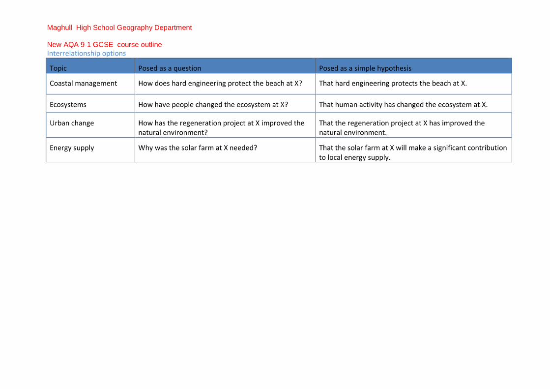
Interrelationship options
Topic Posed as a question Posed as a simple hypothesis
Coastal management How does hard engineering protect the beach at X? That hard engineering protects the beach at X.
Ecosystems How have people changed the ecosystem at X? That human activity has changed the ecosystem at X.
Urban change How has the regeneration project at X improved the natural environment?
That the regeneration project at X has improved the natural environment.
Energy supply Why was the solar farm at X needed? That the solar farm at X will make a significant contribution to local energy supply.