3 national report on implementation of united nations - prais
TRANSCRIPT

lR;eso t;rs
Government of IndiaMinistry of Environment and ForestsNew Delhi
RD3 National Report on Implementation
of United Nations Convention toCombat Desertification
Submitted toUnited Nations Convention to Combat
Desertification (UNCCD)Secretariat, Bonn, Germany
02
NATIONAL REPORT ON IMPLEMENTATION OF THE UNITED NATIONS CONVENTION TO COMBAT DESERTIFICATION
2. Summary
India has an area of about 228.3 m ha (29.6% of total land area of 328 m ha) comprising arid (50.8 m ha), semi-arid (123.4 m ha) and dry sub-humid (54.1 m ha). India in rich in biodiversity; Eastern Himalayas and Western Ghats are recognized internationally as two biodiversity hotspots. India's forests are classified into tropical, sub-tropical, temperate and alpine categories. Climate of the country is tropical monsoon and varies from 100 mm in arid areas to more than 3,600 mm in wet areas of North-Eastern States. Temperature varies from less than 10ºC during winter to 45ºC in summer. In arid and semi-arid regions, the temperature goes upto 45º to 48ºC.
Large areas are susceptible to water and wind erosion, salinisation, water-logging, drought and desertification etc. Land degradation is aggranted by high biotic pressure - human population (1,027 m) and livestock population (470 m). Biotic pressure, and erratic and uncertain amount of rainfall are the major causes behind desertification. The dryland regions ae moe susceptible to ferquent droughts which accelerate the process of desertification.
In India various steps have been taken to tackle the problem of land dragradation. many centres/stations were established to check wind erosion and aggravation of desert conditions. Systematic efforts were initiated way back in Second Five year Plan (1956-61)to contain the problem. In 1959, central Arid Zone Research Institute was established at Jodhpur which was strengthened in subsequent years to deal and provide solutions of major problems related to desetification. The projects and sechemes started during Second Five Year Plan were further exponded during Fourth Five ear Plan (1969-74) India has been making constant efforts to develop short-term and long-term strategies in its Five Year Plans for tackling the problems of drought, desertification, land degradation and deforestation.
under drylands
2.1. Focal Point Institution : Ministry of Enviroment and Forests
2.2. Status of NAP : prepared and submitted to UNCCD Seuetainat
2.3. Member of SRAP/AP :
Name of Sub Regional and/or Regional Cooperation Framework : Joined South Africa Sub-Regional Action plan in August. 2004.
Six thematic programme components from Asian Regional Action Programme have been included and implemented.
I TPN-1
Desertification Monitoring and Assessment. Space Application Centre is the National Task Manager.
NATIONAL REPORT ON IMPLEMENTATION OF THE UNITED NATIONS CONVENTION TO COMBAT DESERTIFICATION
03
II TPN-2
Agroforestry and Soil Conservation in Arid, Semi-arid and Dry Sub-humid Areas. CAZRI is the National Task Manager and the Host Institute.
III TPN-3
Range and Pasture Management.
IV TPN-4
Water Resources Management for Agriculture in Arid, Semi-arid, Dry sub-humid areas. Ministry of Water Resources is the National Task Manager
V TPN-5
Drought preparedness and Mitigation in the context of climate change.
VI TPN-6
Strengthening Planning Capacities for Drought management and controlling Desertification.
2.4. Composition of the National Coordinating Bodies (NCB) :
Various Ministries under Government of India have been identified and included in the composition of the National Coordinating Bodies (NCB) as given below :
1. Ministry of Environment and Forests, New Delhi (MoEF).
2. Ministry of Agriculture (MoA).
3. Ministry of Rural Development (MoRD).
4. Planning Commission.
5. Ministry of Water Resources (MoWR).
6. Ministry of Panchayat Raj.
7. Ministry of Non-conventional Energy Sources (MNES).
8. Ministry of Law and Jutice.
2.5 Total number of NGOs accredited to the process : 47
An NGO National Coordinating Committee on desertification has been established.
A large number of NGOs support (47 No) and participate in the programme. About 10 million ha of wastelands in the common property regimes have been regenerated through the efforts of NGOs and people. National RIOD-INDIA set up in 1995, is a wide network of NGOs from all States divided into 5 regions-Northern, Eastern, Western, North-Eastern and Southern. It has large number of NGOs from these regions as its members. RIOD-INDIA is actively involved in issues such as empowerment of women, assisting in providing micro-credits for alternate employment, generating/assisting with seed money for taking up eco-regeneration programmes, promoting awareness on issues concerning desertification etc. Names of major NGOs involved in the programme are given below :
4
1. Adarsha Seva Sangathana (ASS), Bhubaneswar, Orissa.
2. Agha Khan Rural Support Programme, Gujrat.
3. BAIF Development Research Foundation.
4. Bhoruka Charitable Trust (BCT), Churu, Rajasthan.
5. Development Group, Pune.
6. Disasster Mitigation Institute, Ahmedbad.
7. Good Social Work Centre, Maduari.
8. Jana Vikas Samiti, Andhra Pradesh.
9. Kalensar Vikas Samiti Jodhpur.
10. MYRDADA, Bangalore.
11. National Tree Growers Coopertative Federation.
12. Rajasthan Pradesh Bharat Sewak Samaj, Jaipur.
13. Shanti Maitri Mission Sansthan, Rajasthan.
14. Society for Promotion of Wastelands Development, New Delhi.
15. Tamilnadu Environment Council, Ceda Trust,
16. Tata Energy and Resource Institute (TERI), New Delhi.
17. Watershed Support Services and Activities Newtwork (WASSAN).
Besides RIOD-NGOs, Capacity Building Organization (CBO) and Civil Societies are actively engaged in programmes aiming at empowering of the community in general and women in particular for ensuring sustainable livelihood and consumption.
2.6 Total number of acts and laws passed relating to the UNCCD :
A number of policies, acts and laws have been passed and adopted in India. In line with principles 16 and 17 of Agenda 21, the Government of India, Ministry of Environment and Forests adopted the national conservation strategy and policy statement on environment and development in June 1992. The strategy and policy statement lays down, inter-alia, comprehensive action points in respect of sectors such as agriculture, irrigation, animal husbandry, forestry, energy generation, industrial development, mining and quarrying, tourism, transportation and human settlements to ensure that conservation and enhancement of the environment is taken due care of, while achieving sustainable development.
Various acts and laws relating to UNCCD activities are given below :-
1. Biodiversity Act, 2002.rd2. Constitutional Amendments (73 Amendment) of 1992 and State Pachayat Raj
Acts.
3. Disaster Management Act.
4. Environment Protection Act, 1986.
5
5. Forest Conservation Act, 1980.
6. Land Acquisition Act.
7. River Boards Act, 1956.
8. Water (Prevention and Control of Pollution) Act, 1974 as amended in 1988.
9. Wildlife Protection Act.
2.7 The Consultative Process
1. Number of partnership agreements that have been concluded and/or are being initiated within the framework of the UNCCD - Nil
2. List of consultative meetings on UNCCD implementation - Nil
3. Name of country which has taken over the role of Chef de file- Nil
2.8 Name upto 10 projects currently under implementation which are directly or indirectly related to the UNCCD :
The Ministry of Environment and Forests, Government of India is the nodal agency and National Coordinating Body for participation in UNCCD as representative of Government of India. For major land use, the responsible Ministries and Departments are as under :
• Ministry ofA griculture and Cooperation - 142 mha.
• Ministry of Environment and Forests - 67 mha.
Ministry of Rural Development.
• Ministry of Water Resources.
Departments
• Indian Meteorolical Department (IMD).
• National Remote Sensing Agency (NRSA).
Research Support :-
• Ministry of Science and Technology.
• Indian Council of Agriculture Research (ICAR).
• Indian Council of Forestry Research and Education (ICFRE).
• Indian Council of Social Science Research (ICSSR).
• State Agriculture Universities.
Above mentioned Ministries, Departments and institutions have been utilized for effective implementation of programmes and objectives of UNCCD in India.
National Policy and Coordination Committee (NPCC) under the chairmanship of Secretary, Ministry of Environment and Forests comprises representatives from related Ministries, departments, State Governments, institutions and NGOs etc.
!
NATIONAL REPORT ON IMPLEMENTATION OF THE UNITED NATIONS CONVENTION TO COMBAT DESERTIFICATIONNATIONAL REPORT ON IMPLEMENTATION OF THE UNITED NATIONS CONVENTION TO COMBAT DESERTIFICATION
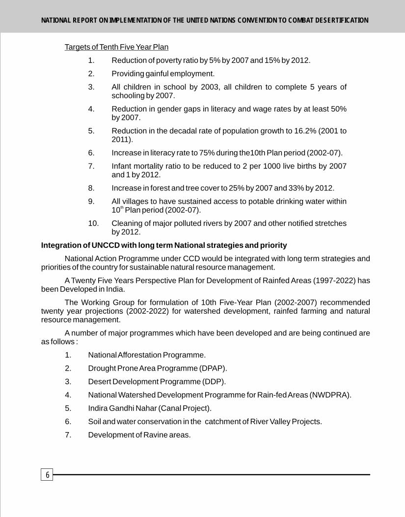
Targets of Tenth Five Year Plan
1. Reduction of poverty ratio by 5% by 2007 and 15% by 2012.
2. Providing gainful employment.
3. All children in school by 2003, all children to complete 5 years of schooling by 2007.
4. Reduction in gender gaps in literacy and wage rates by at least 50% by 2007.
5. Reduction in the decadal rate of population growth to 16.2% (2001 to 2011).
6. Increase in literacy rate to 75% during the10th Plan period (2002-07).
7. Infant mortality ratio to be reduced to 2 per 1000 live births by 2007 and 1 by 2012.
8. Increase in forest and tree cover to 25% by 2007 and 33% by 2012.
9. All villages to have sustained access to potable drinking water within th10 Plan period (2002-07).
10. Cleaning of major polluted rivers by 2007 and other notified stretches by 2012.
Integration of UNCCD with long term National strategies and priority
National Action Programme under CCD would be integrated with long term strategies and priorities of the country for sustainable natural resource management.
A Twenty Five Years Perspective Plan for Development of Rainfed Areas (1997-2022) has been Developed in India.
The Working Group for formulation of 10th Five-Year Plan (2002-2007) recommended twenty year projections (2002-2022) for watershed development, rainfed farming and natural resource management.
A number of major programmes which have been developed and are being continued are as follows :
1. National Afforestation Programme.
2. Drought Prone Area Programme (DPAP).
3. Desert Development Programme (DDP).
4. National Watershed Development Programme for Rain-fed Areas (NWDPRA).
5. Indira Gandhi Nahar (Canal Project).
6. Soil and water conservation in the catchment of River Valley Projects.
7. Development of Ravine areas.
6
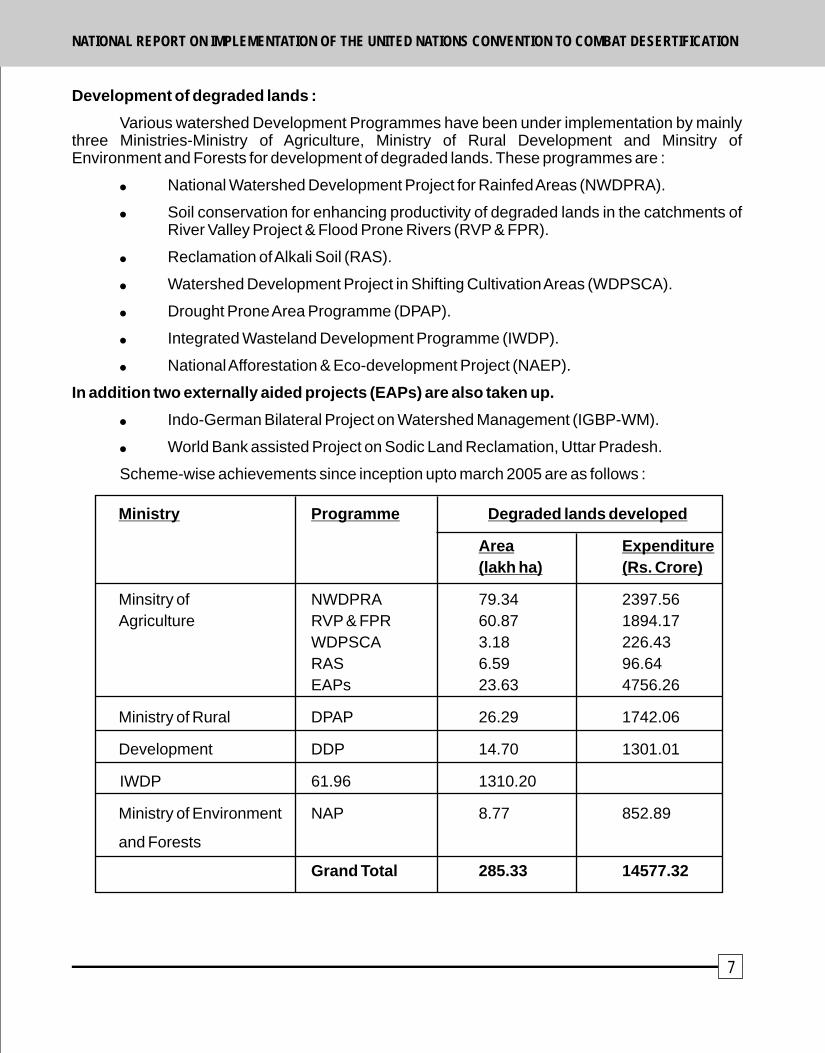
Development of degraded lands :
Various watershed Development Programmes have been under implementation by mainly three Ministries-Ministry of Agriculture, Ministry of Rural Development and Minsitry of Environment and Forests for development of degraded lands. These programmes are :
! National Watershed Development Project for Rainfed Areas (NWDPRA).
! Soil conservation for enhancing productivity of degraded lands in the catchments of River Valley Project & Flood Prone Rivers (RVP & FPR).
! Reclamation of Alkali Soil (RAS).
! Watershed Development Project in Shifting Cultivation Areas (WDPSCA).
! Drought Prone Area Programme (DPAP).
! Integrated Wasteland Development Programme (IWDP).
! National Afforestation & Eco-development Project (NAEP).
In addition two externally aided projects (EAPs) are also taken up.
! Indo-German Bilateral Project on Watershed Management (IGBP-WM).
! World Bank assisted Project on Sodic Land Reclamation, Uttar Pradesh.
Scheme-wise achievements since inception upto march 2005 are as follows :
Ministry Programme Degraded lands developed
Area Expenditure
(lakh ha) (Rs. Crore)
Minsitry of NWDPRA 79.34 2397.56
Agriculture RVP & FPR 60.87 1894.17
WDPSCA 3.18 226.43
RAS 6.59 96.64
EAPs 23.63 4756.26
Ministry of Rural DPAP 26.29 1742.06
Development DDP 14.70 1301.01
IWDP 61.96 1310.20
Ministry of Environment NAP 8.77 852.89
and Forests
Grand Total 285.33 14577.32
7
NATIONAL REPORT ON IMPLEMENTATION OF THE UNITED NATIONS CONVENTION TO COMBAT DESERTIFICATIONNATIONAL REPORT ON IMPLEMENTATION OF THE UNITED NATIONS CONVENTION TO COMBAT DESERTIFICATION
Targets of Tenth Five Year Plan
1. Reduction of poverty ratio by 5% by 2007 and 15% by 2012.
2. Providing gainful employment.
3. All children in school by 2003, all children to complete 5 years of schooling by 2007.
4. Reduction in gender gaps in literacy and wage rates by at least 50% by 2007.
5. Reduction in the decadal rate of population growth to 16.2% (2001 to 2011).
6. Increase in literacy rate to 75% during the10th Plan period (2002-07).
7. Infant mortality ratio to be reduced to 2 per 1000 live births by 2007 and 1 by 2012.
8. Increase in forest and tree cover to 25% by 2007 and 33% by 2012.
9. All villages to have sustained access to potable drinking water within th10 Plan period (2002-07).
10. Cleaning of major polluted rivers by 2007 and other notified stretches by 2012.
Integration of UNCCD with long term National strategies and priority
National Action Programme under CCD would be integrated with long term strategies and priorities of the country for sustainable natural resource management.
A Twenty Five Years Perspective Plan for Development of Rainfed Areas (1997-2022) has been Developed in India.
The Working Group for formulation of 10th Five-Year Plan (2002-2007) recommended twenty year projections (2002-2022) for watershed development, rainfed farming and natural resource management.
A number of major programmes which have been developed and are being continued are as follows :
1. National Afforestation Programme.
2. Drought Prone Area Programme (DPAP).
3. Desert Development Programme (DDP).
4. National Watershed Development Programme for Rain-fed Areas (NWDPRA).
5. Indira Gandhi Nahar (Canal Project).
6. Soil and water conservation in the catchment of River Valley Projects.
7. Development of Ravine areas.
6
Development of degraded lands :
Various watershed Development Programmes have been under implementation by mainly three Ministries-Ministry of Agriculture, Ministry of Rural Development and Minsitry of Environment and Forests for development of degraded lands. These programmes are :
! National Watershed Development Project for Rainfed Areas (NWDPRA).
! Soil conservation for enhancing productivity of degraded lands in the catchments of River Valley Project & Flood Prone Rivers (RVP & FPR).
! Reclamation of Alkali Soil (RAS).
! Watershed Development Project in Shifting Cultivation Areas (WDPSCA).
! Drought Prone Area Programme (DPAP).
! Integrated Wasteland Development Programme (IWDP).
! National Afforestation & Eco-development Project (NAEP).
In addition two externally aided projects (EAPs) are also taken up.
! Indo-German Bilateral Project on Watershed Management (IGBP-WM).
! World Bank assisted Project on Sodic Land Reclamation, Uttar Pradesh.
Scheme-wise achievements since inception upto march 2005 are as follows :
Ministry Programme Degraded lands developed
Area Expenditure
(lakh ha) (Rs. Crore)
Minsitry of NWDPRA 79.34 2397.56
Agriculture RVP & FPR 60.87 1894.17
WDPSCA 3.18 226.43
RAS 6.59 96.64
EAPs 23.63 4756.26
Ministry of Rural DPAP 26.29 1742.06
Development DDP 14.70 1301.01
IWDP 61.96 1310.20
Ministry of Environment NAP 8.77 852.89
and Forests
Grand Total 285.33 14577.32
7
NATIONAL REPORT ON IMPLEMENTATION OF THE UNITED NATIONS CONVENTION TO COMBAT DESERTIFICATIONNATIONAL REPORT ON IMPLEMENTATION OF THE UNITED NATIONS CONVENTION TO COMBAT DESERTIFICATION
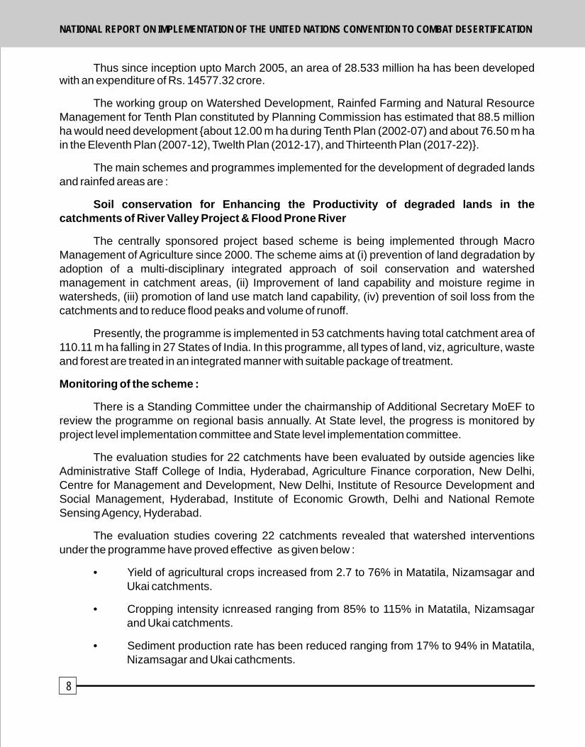
Thus since inception upto March 2005, an area of 28.533 million ha has been developed with an expenditure of Rs. 14577.32 crore.
The working group on Watershed Development, Rainfed Farming and Natural Resource Management for Tenth Plan constituted by Planning Commission has estimated that 88.5 million ha would need development {about 12.00 m ha during Tenth Plan (2002-07) and about 76.50 m ha in the Eleventh Plan (2007-12), Twelth Plan (2012-17), and Thirteenth Plan (2017-22)}.
The main schemes and programmes implemented for the development of degraded lands and rainfed areas are :
Soil conservation for Enhancing the Productivity of degraded lands in the catchments of River Valley Project & Flood Prone River
The centrally sponsored project based scheme is being implemented through Macro Management of Agriculture since 2000. The scheme aims at (i) prevention of land degradation by adoption of a multi-disciplinary integrated approach of soil conservation and watershed management in catchment areas, (ii) Improvement of land capability and moisture regime in watersheds, (iii) promotion of land use match land capability, (iv) prevention of soil loss from the catchments and to reduce flood peaks and volume of runoff.
Presently, the programme is implemented in 53 catchments having total catchment area of 110.11 m ha falling in 27 States of India. In this programme, all types of land, viz, agriculture, waste and forest are treated in an integrated manner with suitable package of treatment.
Monitoring of the scheme :
There is a Standing Committee under the chairmanship of Additional Secretary MoEF to review the programme on regional basis annually. At State level, the progress is monitored by project level implementation committee and State level implementation committee.
The evaluation studies for 22 catchments have been evaluated by outside agencies like Administrative Staff College of India, Hyderabad, Agriculture Finance corporation, New Delhi, Centre for Management and Development, New Delhi, Institute of Resource Development and Social Management, Hyderabad, Institute of Economic Growth, Delhi and National Remote Sensing Agency, Hyderabad.
The evaluation studies covering 22 catchments revealed that watershed interventions under the programme have proved effective as given below :
• Yield of agricultural crops increased from 2.7 to 76% in Matatila, Nizamsagar and Ukai catchments.
• Cropping intensity icnreased ranging from 85% to 115% in Matatila, Nizamsagar and Ukai catchments.
• Sediment production rate has been reduced ranging from 17% to 94% in Matatila, Nizamsagar and Ukai cathcments.
8
• Runoff peak reduced from 46.6 to 1.6% in Sahibi cathment.
• Due to ground water recharge, the water table in wells increased from 1 to 2.5 meter in Matatila, Nizamgarh and Ukai catchments.
• Employment generation was increased from 2.0 to 7.9 lakh man-days in Matatila, Nizamsagar and ukai catchments.
Since inception of programme and upto 2004-05, and area of 6.097 million ha has been treated with an expenditure of Rs. 1894.16 crores.
Reclamation of Alkali Soils :
The programme was launched in Seventh Five Year Plan. This programme is now implemented through Macro management of Agriculture. The programme objectives are; (i) reclamation of the lands affected by alkalinity and improvement in land productivity by growing salt tolerant crops and horticulture plantations, (ii) increasing the production of fuelwood and fodder, (iii) improving capacity of extension workers and beneficiaries and (iv) generating employment opportunities.
About 70.00 lakh ha (7.00 million ha) area is affected by salt problem and out of this about 35.81 lakh ha area suffers from alkalinity in the country. Such alkali affected areas are mainly located in 11 States :
The main components of the programme covered under the project are :
(a) Isolated approach : (i) survey, planning and awareness campaign and training of beneficiaries and staff (ii) formulation of water user group, site implementation committee, (iii) providing soil amenders.
(b) Projectized approach : (i) providing soil amenders, (ii) boring and installation of pump sets, (iii) providing inputs like seed, fertilizer, insecticides, pesticides, green manure seeds, (iv) plantation of fruit trees/fuelwood/fooder species and (v) maintenance of plantation area for three years.
The programme progress is reviewed in the meeting of Standing Committee (Government of India) besides periodic visit of regional, State and national level functionaries to project items.
Positive impact of the scheme was observed in areas of Haryana and Uttar Pradesh; ph decreased from 9.4-10.5 to 8.9-9.2, organic carbon increased from 0.15 to 0.38%, paddy yield increased from 19 to 41 quintals per ha, 76% farmers' income increased and additional employment was created for them.
Since inception and upto 2004-2005, an area of 6.59 lakh hectare has been reclaimed with expenditure of Rs. 96.64 crores.
All India Soil & Land use Survey :
The organization has been conducting Rapid Reconnaissance Survey (RRS) for catchments to be treated in the project area of River Valley Projects & Flood Prone Rivers. Detailed soil survey, Land Degradation Mapping and Evaluation of various Watershed Development Programmes of the country have also been conducted. Major achievements are as follows :
9
NATIONAL REPORT ON IMPLEMENTATION OF THE UNITED NATIONS CONVENTION TO COMBAT DESERTIFICATIONNATIONAL REPORT ON IMPLEMENTATION OF THE UNITED NATIONS CONVENTION TO COMBAT DESERTIFICATION

Programmes Area Surveyed Area to be(March 2005) surveyed
1. Rapid Recomaissance Survey 195.50 m.ha 104.00 m.ha
2. Detailed Soil Survey 13.50 m.ha 25.20 m.ha
3. Land Degradation Mapping 64 districts 522 districtsDevelopment of Digital
4. Watershed Atlas of India Completed To be published
5. Short training courses on soil 11 courses Two coursessurvey for user departments every year
Soil Conservation Training Centre, Damodar Valley Corporation, Hazaribag, Jharkhand :
The major mandate of Soil conservation Training Centre, Damodar Valley Corporation, Hazaribagh is to organize training courses in different areas of soil and water conservation.
Since inception and upto March 2005, 1,685 farmers, Sarpanches, Gram Pradhans of village level institutions have been trained in the field of integrated watershed management. During the same period, 2,968 officials working in different States in soil conservation programmes have been trained covering various aspects of the subject.
Watershed Development Project for Shifting Cultivation Area :
The project is continuing in seven North Eastern States, viz, Arunachal Pradesh, Assam, Manipur, Meghalaya, Mizoram, Nagaland, and Tripura. The objectives of the project are : (i) to protect the hill slopes of Jhum areas through soil and water conservation measures on watershed basis and to reduce further land degradation, (ii) encourage relocation of Jhumia families by providing developed productive land and improved cultivation packages, (iii) to improve the socio-economic status of Jhumia families through household/land based activities, and (iv) to mitigate the ill effects of shifting cultivation by introducing appropriate land use as per land capability and improved technoligies.
The project is being implemented through government and non-government organizations, scientific and technical institutions in the watersheds where a minimum of 25% area is under shifting cultivation.
The programme implemented and evaluated in two States, viz, Nagaland and Tripura, revealed the following :
• 30% decrease in shifting cultivation area due to adoption of permanent/settled cultivation.
• About 27% Jhumias have abandoned jhum practice.
• Sustainable increase in productivity of agriculture crops, horticulture crops, livestock, inland fisheries etc was observed.
• Overall income of Jhum families increase by 25%.
• Cropping intensity increase by 40%.
• Active participation and contribution of the watershed community for development of watershed was found effective.
10
• Watershed Associations/Panchayats helped in promoting participatory approach.
Since inception and upto the end of 2004-05, an area of 3.18 lakh ha has been developed with an expenditure of Rs. 226.43 crores.
Indo-German Bilateral Project on watershed Management :
The Indo-German Bilateral Project was launched in 1989 as technical cooperation between federal Republic Ministry, German Technical Cooperation, and Ministry of Agriculture in
ththe GOI. The project continued for 16 years and closed on 30 June 2005.
Since inception, a total of 37 sediment monitoring stations (SMS) and 5 hi-tech weather stations have been established in 12 different States, i.e., Andhra Pradesh, Bihar, Gujarat, Himanchal Pradesh, Jharkhand, Madhya Pradesh, Maharashtra, Orissa, Rajasthan, Tamilnadu, Uttaranchal and Uttar Pradesh. 345 staff members and 62 senior/junior staff working for soil and water conservation programmes have been trained.
Sodic Land Reclamation Project :
The World Bank assisted project was launched in April 1999 in Uttar Pradesh (State has about 11.00 lakh ha area with problem of alkalinity). The objectives of the project are : (i) to reverse the process of sodicity, (ii) development of sodic land through sustainable reclamation package, and (iii) prevention of further sodicity and contributing significantly towards poverty alleviation in selected aeas.
The project is implemented in ten districts of Uttar Pradesh. The major components include : identification, survey and delineation of sodic soils, on farm development, provision of assured irrigation, application of soil amenders for reclamation of sodic lands, crop production and plantation, adaptive research, training and technology dissemination and people's participation for sustainability.
At national level, the progress is reviewed by holding quarterly and annual desk review.
Since inception and upto 2005, about 1.57 lakh ha area has been reclaimed under the scheme.
DPAP, DDP & IWDP : Watershed Development Programmes :
Sizable proportion of the total land area of the country falls under arid, semi-arid and dry sub-humid categories and is either subject to desertification, or identified as drought prone watersheds. Ministry of Rural Development is implementing special area development programmes as instruments of poverty alleviation in drought prone areas, and desert and rainfed areas in a participatory mode. Following programmes of the Ministry of Rural Development are being implemented in partnership with State Governments.
1. Drought Prone Areas Programme (DPAP).
2. Desert Development Programme (DDP).
3. Integrated Watershed Development Programme (IWDP).
Department of Land Resources (DOLR), Minsitry of Rural Development has the mandate to develop degraded area of about 153 million hectares under these three programmes. These programmes aim to tackle : (i) continuous degradation of land, (ii) decreasing vegetative cover, (iii) soil erosion, (iv) depleting water resources, (v) decreasing productivity of crop (vi) livestock and
11
NATIONAL REPORT ON IMPLEMENTATION OF THE UNITED NATIONS CONVENTION TO COMBAT DESERTIFICATIONNATIONAL REPORT ON IMPLEMENTATION OF THE UNITED NATIONS CONVENTION TO COMBAT DESERTIFICATION

human resources, (vii) and outmigration of both human and cattle populations in times of stress.
Guiding approach for DPAP, DDP and IWDP
! Development of lands, water and vegetative resources on watershed basis.
! Treatment of watershed to include all categories of lands including private, village commons, revenue and degraded forest lands.
! A micro-watershed with about 500 ha taken up as a basic unit for management and development with total watershed treatment approach.
! Planning and implementation of watershed development programme with the total participation of the beneficaries through community based organizations for community empowerment.
! Women empowerment especially by creating alternative livelihood options.
! Developing sustainable production system, community based management of assets and equitable sharing thereof.
! Creating awareness including dissemination of information.
! State and district level committee to monitor the programmes with special emphasis on social audit.
! Capacity building and training at various levels of stakeholders.
! Independent evaluation studies on regular basis.
Role of Non-Government organizations (NGOs) : Watershed Development Programmes underline an active role for NGOs in order to ensure implementation of programmes in a participatory mode.
The role of Panchayati Raj Institutions in watershed programmes has become pivotal in the implementation of developmental programmes at the grass root level.
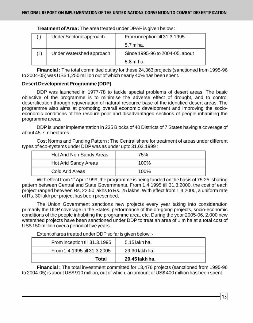
Drought Prone Areas Programme (DPAP) :
The Rural Works Programme (RWP) initiated in 1970-71 was redesignated as Drought Prone Areas Programme (DPAP) in 1973-74 to focus solely on problems of drought prone areas.
Since the adoption of watershed approach in the year 1995-96 and till 2005-2006, 24,363 projects have been sanctioned to treat 12.2 million hectares of drought prone area.
The Union Government sanctions new projects every year taking into consideration primarily the DPAP coverage in the States, performance of the on-going projects, socio-economic condition of the persons inhabiting the programme area, etc. During the Year 2005-06, 3,000 new watershed projects have been sanctioned under DPAP to treat an area of 1.5 m hectares at a total cost of about US$ 200 million over a period of fiver years.
12
Treatment of Area : The area treated under DPAP is given below :
(i) Under Sectoral approach From inception till 31.3.1995
5.7 m ha.
(ii) Under Watershed approach Since 1995-96 to 2004-05, about
5.8 m.ha
Financial : The total committed outlay for these 24,363 projects (sanctioned from 1995-96 to 2004-05) was US$ 1,250 million out of which nearly 40% has been spent.
Desert Development Programme (DDP)
DDP was launched in 1977-78 to tackle special problems of desert areas. The basic objective of the programme is to minimise the adverse effect of drought, and to control desertification through rejuvenation of natural resource base of the identified desert areas. The programme also aims at promoting overall economic development and improving the socio-economic conditions of the resoure poor and disadvantaged sections of people inhabiting the programme areas.
DDP is under implementation in 235 Blocks of 40 Districts of 7 States having a coverage of about 45.7 m hectares.
Cost Norms and Funding Pattern : The Central share for treatment of areas under different types of eco-systems under DDP was as under upto 31.03.1999 :
Hot Arid Non Sandy Areas 75%
Hot Arid Sandy Areas 100%
Cold Arid Areas 100%st
With effect from 1 April 1999, the programme is being funded on the basis of 75:25. sharing pattern between Central and State Governments. From 1.4.1995 till 31.3.2000, the cost of each project ranged between Rs. 22.50 lakhs to Rs. 25 lakhs. With effect from 1.4.2000, a uniform rate of Rs. 30 lakh per project has been prescribed.
The Union Government sanctions new projects every year taking into consideration primarily the DDP coverage in the States, performance of the on-going projects, socio-economic conditions of the people inhabiting the programme area, etc. During the year 2005-06, 2,000 new watershed projects have been sanctioned under DDP to treat an area of 1 m ha at a total cost of US$ 150 million over a period of five years.
Extent of area treated under DDP so far is given below :-
From inception till 31.3.1995 5.15 lakh ha.
From 1.4.1995 till 31.3.2005 29.30 lakh ha.
Total 29.45 lakh ha.
Financial : The total investment committed for 13,476 projects (sanctioned from 1995-96 to 2004-05) is about US$ 910 million, out of which, an amount of US$ 400 million has been spent.
13
NATIONAL REPORT ON IMPLEMENTATION OF THE UNITED NATIONS CONVENTION TO COMBAT DESERTIFICATIONNATIONAL REPORT ON IMPLEMENTATION OF THE UNITED NATIONS CONVENTION TO COMBAT DESERTIFICATION
human resources, (vii) and outmigration of both human and cattle populations in times of stress.
Guiding approach for DPAP, DDP and IWDP
! Development of lands, water and vegetative resources on watershed basis.
! Treatment of watershed to include all categories of lands including private, village commons, revenue and degraded forest lands.
! A micro-watershed with about 500 ha taken up as a basic unit for management and development with total watershed treatment approach.
! Planning and implementation of watershed development programme with the total participation of the beneficaries through community based organizations for community empowerment.
! Women empowerment especially by creating alternative livelihood options.
! Developing sustainable production system, community based management of assets and equitable sharing thereof.
! Creating awareness including dissemination of information.
! State and district level committee to monitor the programmes with special emphasis on social audit.
! Capacity building and training at various levels of stakeholders.
! Independent evaluation studies on regular basis.
Role of Non-Government organizations (NGOs) : Watershed Development Programmes underline an active role for NGOs in order to ensure implementation of programmes in a participatory mode.
The role of Panchayati Raj Institutions in watershed programmes has become pivotal in the implementation of developmental programmes at the grass root level.
Drought Prone Areas Programme (DPAP) :
The Rural Works Programme (RWP) initiated in 1970-71 was redesignated as Drought Prone Areas Programme (DPAP) in 1973-74 to focus solely on problems of drought prone areas.
Since the adoption of watershed approach in the year 1995-96 and till 2005-2006, 24,363 projects have been sanctioned to treat 12.2 million hectares of drought prone area.
The Union Government sanctions new projects every year taking into consideration primarily the DPAP coverage in the States, performance of the on-going projects, socio-economic condition of the persons inhabiting the programme area, etc. During the Year 2005-06, 3,000 new watershed projects have been sanctioned under DPAP to treat an area of 1.5 m hectares at a total cost of about US$ 200 million over a period of fiver years.
12
Treatment of Area : The area treated under DPAP is given below :
(i) Under Sectoral approach From inception till 31.3.1995
5.7 m ha.
(ii) Under Watershed approach Since 1995-96 to 2004-05, about
5.8 m.ha
Financial : The total committed outlay for these 24,363 projects (sanctioned from 1995-96 to 2004-05) was US$ 1,250 million out of which nearly 40% has been spent.
Desert Development Programme (DDP)
DDP was launched in 1977-78 to tackle special problems of desert areas. The basic objective of the programme is to minimise the adverse effect of drought, and to control desertification through rejuvenation of natural resource base of the identified desert areas. The programme also aims at promoting overall economic development and improving the socio-economic conditions of the resoure poor and disadvantaged sections of people inhabiting the programme areas.
DDP is under implementation in 235 Blocks of 40 Districts of 7 States having a coverage of about 45.7 m hectares.
Cost Norms and Funding Pattern : The Central share for treatment of areas under different types of eco-systems under DDP was as under upto 31.03.1999 :
Hot Arid Non Sandy Areas 75%
Hot Arid Sandy Areas 100%
Cold Arid Areas 100%st
With effect from 1 April 1999, the programme is being funded on the basis of 75:25. sharing pattern between Central and State Governments. From 1.4.1995 till 31.3.2000, the cost of each project ranged between Rs. 22.50 lakhs to Rs. 25 lakhs. With effect from 1.4.2000, a uniform rate of Rs. 30 lakh per project has been prescribed.
The Union Government sanctions new projects every year taking into consideration primarily the DDP coverage in the States, performance of the on-going projects, socio-economic conditions of the people inhabiting the programme area, etc. During the year 2005-06, 2,000 new watershed projects have been sanctioned under DDP to treat an area of 1 m ha at a total cost of US$ 150 million over a period of five years.
Extent of area treated under DDP so far is given below :-
From inception till 31.3.1995 5.15 lakh ha.
From 1.4.1995 till 31.3.2005 29.30 lakh ha.
Total 29.45 lakh ha.
Financial : The total investment committed for 13,476 projects (sanctioned from 1995-96 to 2004-05) is about US$ 910 million, out of which, an amount of US$ 400 million has been spent.
13
NATIONAL REPORT ON IMPLEMENTATION OF THE UNITED NATIONS CONVENTION TO COMBAT DESERTIFICATIONNATIONAL REPORT ON IMPLEMENTATION OF THE UNITED NATIONS CONVENTION TO COMBAT DESERTIFICATION

Integrated Wasteland Development Programme (IWDP) :
IWDP was launched in the year 1989-90 to develop the wastelands on watershed basis to strengthen the natural resource base, and to promote overall economic development of the resource poor and disadvantaged sections of people inhabiting the programme areas.
The programme has a treatable coverage of about 33 million hectares of wasteland. The IWDP is implemented in those degraded lands which are not identified under DPAP. The programme is being implemented in 403 districts of 28 States.
Since the adoption of watershed approach in the year 1995-96 and upto 2004-05, 885 projects have been sanctioned to treat 6.2 m ha of wasteland area.
Financial : The total investment committed for these 885 projects (sanctioned from 1995-96 to 2004-05) is about US$ 935 million. Out of this an amount of US$ 370 million has been spent.
Poverty Alleviation :
Rural Poverty alleviation : Policies and programmes have a direct bearing on improvement of employment and livelihood opportunities in rural areas. The Integrated Rural Development Programme (IRDP) started in 1978-79 for providing assistance to rural poor in the form of subsidised bank credit. In 1999, the IRDP and other allied programmes were merged, and a single programme, the Swarnajayanti Gram Swarozgar Jojana (Golden Jubilee Village Self-employment Scheme) was launched. This programme aims at :
! Microenterprise development in rural areas, with emphasis on organizing the rural poor into self-held groups,
! Capacity building;
! Planning of activity clusters;
! Infrastructure development, technology,
! Credit and marketing linkages
Jawahar Rozgar Yojna (Jawahar Employment Scheme) has been one of the important wage employment schemes for rural areas. Over 47 percent of the employment generated benefitted the marginalized sections. The share of landless labourers among the beneficiaries was 36%. The Jawahar Rojgar Yojna (JRY) was renamed as Jawahar Gram Samridhi Yojna (JGSY) during 1999. In 2001, it was merged with other similar schemes like Employment Assurance Scheme (EAS) and Food for Work Programme and came to be known as Sampoorna Gramin Rozgar Yojna (Total Village Employment Scheme). The basic aim of the scheme remains the generation of wage employment, creation of durable economic infrastructure, and provision of food and nutrition security to the poor.
Urban Poverty alleviation : Several schemes to generate employment opportunites in urban areas were launched, such as Nehru Rojgar Yojna (1985), Urban Basic Services for Poor (1990) and Prime Minsiter's Integrated Urban Poverty Eradication Programme (1995). In 1997, Swarna Jayanti Shahri Rozgar Yojna (SJSRY) (Golden Jubilee Urban Employment Scheme) was launched. This shceme aims to provide gainful employment to the urban unemployed or under-employed poor, by encouraging them to set up self-employment ventures or by providing wage employment by utilizing their labour for construction of socially and economically useful assets. Urban Self-Employment Programme (USEP) and the Urban Wage Employment Programme
14
(UWEP) form the two major components of SJSRY with focus on women participation.
More than 5,11,000 persons have been provided employment (by March 2004) through setting up of micro enterprises and about 6,00,000 persons provided skill upgradation in varous commercial activities. More than 30,000 women self-helf groups have been formed and close to 1,00,000 women have benefited from the scheme.
The absolute numbers below the poverty line declined by 60 million heads between 1991-92 and 1999-2000.
Various programmes that deal directly with the poverty alleviation have to simultaneously cover a number of social sector issues such as heath care, literacy, empowerment of women, and improved governance. Accordingly, the Government of India has launched a number of initiatives covering a range of sector subjects. Some of these are :-
(i) Rural water supply : The major thrust under the Rural Drinking Water Programme is on water conservation, water harvesting, water recharge and sustainability of the drinking water sources. A comprehensive action plan for covering all rural habitations in the country with provision of potable drinking water has been prepared.
(ii) Sanitation and Hygiene : The Restructured Central Rural Sanitation Programme (RCRSP), which is community led and people oriented, aims to provide adequate sanitation facilities to the rural poor, and generate awareness about health education. A Rural School Sanitation Programme has also been introduced. Total sanitation campaign with active NGO participation is being implemented.
(iii) Rural Infrastructure : Jawahar Gram Samridhi Yojna (JGSY) provides demand driven rural infrastructure at the village level. It is implemented by Gram Panchayats to enable village community to create assets.
(iv) Education : The Tenth Five-Year Plan envisages ;-
! Provision of one teacher for every group of 40 children for primary and upper primary schools.
! Opening of primary school/alternate schooling facility within 1 km of every habitation.
! Provision of free text books to all SC/ST (Scheduled Caste and Scheduled Tribe) children and girls at primary and upper primary levels.
(v) Health : In social development programmes, it is one of the improtant aspects. The Tenth Five Year Plan focuses on the reorganisation and re-structuring of existing health care infrastructure to facilitate adoption and delivery of indigenous system of medicine and healthcare services at primary, secondary and tertiary levels.
All the above mentioned programmes are implemented in collaboration with State Governments, local self-governments and the civil society.
thBeing acutely aware of the challenges in addressing the task of combating poverty, the 10
Five Year Plan fixes enhanced targets for poverty alleviation, i.e., a reduction in the poverty ratio by 5% points by 2007, and 15% points by 2012.
15
NATIONAL REPORT ON IMPLEMENTATION OF THE UNITED NATIONS CONVENTION TO COMBAT DESERTIFICATIONNATIONAL REPORT ON IMPLEMENTATION OF THE UNITED NATIONS CONVENTION TO COMBAT DESERTIFICATION

Afforestation Programme :
National Forestry Action Programme (NFAP) emphasizes to take immediate steps for sustainable development of forests. It aims to rehabilitate and increase the productivity of degraded forest, and also to increase the area under forest and tree cover to make it 33% of the total area of the country. The degraded/open forests are to be rehabilitated to take crown density above 40%, and the status of scrub forests is to be improved. According to NFAP, forest area of about 60 mha will be brought under afforestation/plantation/regeneration in the next 20 years. This is intended to be achieve by :
(a) Improvement in forest cover density : about 31 mha.
(b) Plantation on non-forest and farm lands : about 29 mha.
About 64 mha area of the country is not available for plantation activity due to reasons of either being under habitation, industries, water bodies, snow etc. The landuse categories of the remaining 264 mha are as follows :
Cultivated land 142 mha
Forest land 67 mha
Fallows 24 mha
Pastures 12 mha
Tree groves 3 mha
Cultivated wasteland 16 mha
The cultivable lands comprising fallows, pastures, groves and wastelands constitute 55 mha, of which about 44 mha is estimated to be in the degraded condition. About 60% of 44 million (25.4 mha or say 25 mha) may be available for tree plantation.
The area for plantations would also be available from the area under agriculture lands.
Agriculture land
Irrigated 40 mha
Un-irrigated 102 mha
Total 142 mha
About 4 million ha agriculture land (notionally) may also be assumed to be available for tree planting activities. Thus following area will be available for planting activities outside forest areas.
Non forest land 25.00 m.ha.
Agriculture land 4.00 m.ha.
16
Of the total degraded forest land (31 mha) and non-forest land (29 mha), NFAP has given the following estimates :
Degraded Forest Land
Target for Annual target
20 year of plantation
(mha) (mha)
(a) with natural rootstock 15.5 0.775
(b) with depleted rootstock 15.5 0.775
(c) totally degraded and treeless 25.0 1.250
(d) Tree planting under agroforestry/farm forestry 4.0 0.200
Agroforestry
Agroforestry system has been recognised as an important land use system in India where land whether for sustained essential production of goods, e.g., food, firewood, timber, fodder, oil seeds, industrial materials etc. on a sustained basis or for rural urban dwelligs has been a big constraint. In India, various tree-based agroforestry models have been developed, for introduction into different agro-ecological situations. These models have been incorporated in the UNCCD publication entitled “Agroforestry Manual For Asia Pacific Region” by Jagdish Kishwan, K.K. Sharma and S.K. Ratho (Editors) 2005. Tree based agroforestry models for various climatic regions are as follows :
Arid Region : Acacia nilotica, Azadirachta indica, Ailanthus excelsa, Acacia tortilis Faidherbia albida, Zizyphus mauritiana and Populus euphratica (for cold desert).
Semi-Arid Region : Dalbergia sissoo, Eucalyptus spp, Albizia lebbeck, Leucaena leucocephala, Mangifera indica, Psidium guajava.
Dry Sub-humid Region : Tectona grandis, Bamboo, Sesbania spp, Populus deltoides, Gmelina arborea.
17
NATIONAL REPORT ON IMPLEMENTATION OF THE UNITED NATIONS CONVENTION TO COMBAT DESERTIFICATIONNATIONAL REPORT ON IMPLEMENTATION OF THE UNITED NATIONS CONVENTION TO COMBAT DESERTIFICATION
18
3. Strategies and priorties within the framework and sustainable development plans and/or policies
3.1 National plans and stratigies available in other social and economic areas.
Various programmes implemented in India have been discussed and presented under Section-8. Over the last few decades, India has made significant progress in the areas of poverty eradication, improvement of literacy rates and health standards etc. Following indicators show that the challenges before the nation in terms of improving the basic services that are essential for a decent quality of life for its populace are difficult.
Infant mortality 72/1000 live births.
Literacy rate 65.2%.
Households with access to safe drinking water 62.3%.
Households with access to proper sanitation facilities 49.32%.
Households with electricity connection 42.37%.
Households with electricity, safe drinking
Water and proper sanitation facilities 16.1%.
Households with permanent houses 41.61%.
Households with semi-permanent houses 30.95%.
Household with temporary shelters 27.44%.
Thus, programmes implemented in other areas like adult literacy, social welfare, poverty alleviation, human resource development, health and social welfare etc. are relevent in community development/upliftment and rehabitition in the dry areas of the country.
3.1.1. Plannning for Development
Planning in India is based on an interactive process involving interaction between the Centre, the State and the local bodies. Multiple stokeholders participate in the planning process. At the national level, India's priorities are highlighted in the Five Year Plans. In Eighth Five Year Plan (1992-1997), Planning Commission emphasized indicative planning to outline the priorities and encourage a higher growth rate from a centralized planning system. The Ninth Plan document also highlighted the same. Tenth Five Year Plan (2002-2007) which is currently in operation includes the major thrust areas :-
! Reduction of poverty ratio by 5% by 2007 and 15% by 2012.
! Providing gainful employment.
19
! All children in school by 2003, all children to complete 5 years of schooling by 2007.
! Reduction in gender gaps in literacy and wase rates by at least 50% by 2007.
! Reduction in the decadal rate of population growth to 16.2% (2001 to 2011).
! Increase in literacy rate to 75% during the plan period.
! Infrant mortality rate to be reduced to 45 per 1000 live births by 2007 and 28 by 2012.
To prepare plans for various sectors, working groups and task forces are constituted involving participation, inter-alia, of civil society. These reports are taken into consideration by the Planning Commission in consultation with Central Ministries and State Governments while formulating the Five Year Plans. Areas identified and targets given in the Five Year Plans become the basis for formulation of Annual Plans which set priorities for short term development goals. These plans are implemented through decentralised and broad based government mechanism. A uniform pattern exists for devolution of responsibility between the Centre and the States on one hand, and the States and local bodies on the other.
3.1.2. National conservation strategy
The Earth Summit 1992 is widely regarded as being one of the most important global events to address issues relating to environmental degradation, inequities between nations, and possible strategies to protect the future of life on earth at international level. Principles 16 and 17 of Agenda 21, conform to the framework of Government of India in its endeavour to seek a balance between conservation and development. Ministry of Environment and Forests, Govt. of India adopted the National Conservation Strategy and policy statement on Environment and Development in June 1992. The tradition of care, conservation and preservation of environmental resources is also reflected in the spirit of the Constitution of India, which has acted as the guiding inspiration of the nation for over half a century.
Ministry of Environment and Forests lays down the guidelines that help to weave environmental consideration into the fabric of the national planning and development processes. The conservation strategy is to serve as a management guide for integrating environmental concerns with development imperatives.
Thus the congruity of Agenda 21's objectives of sustainable development with India's own traditional values provided renewed thrust to several initiatives in the country. It also provided new direction in sectors, such as agriculture, irrigation, animal husbandry, forestry, energy (generation, use and conservation), industrial development, mining and quarrying, tourism, transportation and human settlements to ensure that conservation and enhancement of the environment are taken due care of while achieving sustainable development.
STRATEGIES AND PRIORTIES WITHIN THE FRAMEWORK AND SUSTAINABLE DEVELOPMENT PLANS AND/OR POLICIES
20
3.1.3. Agenda 21 implementation Plan
Sustainable development was accepted at the 1992 United Nations Conference on Environment and Development (UNCED) as a critical element in preserving the environment and promoting development and human welfare. In pursuance of this, country0specific programmes of action for channeling investing resources (both internal and external) into ecologically compatible projects and programmes are now incorporated into the Indian planning development process.
In the Government of India, the Ministry of Environment and Forest (MoEF) is the nodal agency for conducting the Environment Action Programme (EAP) exercise. MoEF constituted an EAP Implementation Committee comprising Ministries, Departments of the Government of India, Research Institute of excellence and NGOs concerned with different sectoral issues addressed in the EAP. After incorporating inter-ministerial suggestions, the draft EAP document was finalized in 1993. The goals of EAP are to improved the environmental services and to facilities intergration of environmental considerations into development programmes. People's participation at the grass-root, local and regional levels are also accepted as key issues of the action plans. The Environmental Action Programm (EAP) process adopted a decentralized system of generating information and perspectives.
A great deal of progress has been achieved in the strengthening of organizations in the governmental, research and non-governmental sectors to pursue the programme under Agenda 21. The stress, among other, on soil and water conservation and drought proofing and management of natural disasters in the Environmental Action Programme (EAP) is significant. Consequent to EAP, the priority areas are being monitored in terms of comprehensive Environmental impact assessment (EIA) framework and a scientific system of Natural Resource Accounting (NRA). Twenty-nine projects have been proposed to Global Environmental Facility (GEF) and Capacity 21 of UNDP to Promote capacity building and generating environmental awareness (Government of India 1993).
The Environmental Action Programme (EAP) is presently under comprehensive review both in the Governmental and Non-Governmental sectors. The results of these reviews would be significant for incorporating EAP in the future five year plans.
3.2 National Plans or Strategies Available in the field of combating desertification developed prior to the Convention.
(i) Evolution of the programme :
Desertification and drought are common features of arid, and semi-arid regions. It is a continuous process of land degradtion leading to desert like conditions. Sizable proportion of the total land area of the country falls under arid, semi-arid and dry sub-humid categories and is either subject to desertification, identified as drought prone or wastelands.
During 1951-52, Government of India appointed a committee to advise on development of Rajasthan desert. To study various problems of the desert, a Desert Afforestation Station was
21
established in Jodhpur. Later on, the studies at the station also included soil conservation programmes and as such its name was changed to Desert Afforestation and Soil Conservation Station (DA & SCS). Its mandate included conduct of basic and applied research in forestry, crop husbandry, and grassland development aiming to check wind erosion and aggravation of desert conditions. Subsequently in 1959, under UNESCO's Arid Zone project, the DA & SCS was reorganized and named, as Central Arid Zone Research Institute.
In 1960, Govt. of Rajasthan set up a State Land Utilization Committee which made recommendations on development of desert and semi-desert areas of the State.
The Desert Development Board was constituted in 1966 under the chairmanship of Secretary, Ministry of Agriculture (MoA) comprising representatives of other central Ministires and nominees of States like Rajasthan, Haryana and Gujarat. The Board was reconstituted with Minister of State (MoA) as its chairman and Secretary (MoA) as Vice Chairman. The Board recommended an integrated programme of pilot projects for desert development for inclusion in the Fourth Five Year Plan (1969-1974). National Commission on Agriculture (NCA) made recommendations and the Desert Development Project (DDP) was started during 1977-78 in 20 districts.
Dryland farming projects initiated during Second Five Year Plan (1956-61) were expanded in the Fourth Five Year Plan (1969-1974). Suggestions were made during Fourth Five Year Plan emphasizing that the amount spent by Government of India on relief in famine-affected areas be so deployed as to generate more employment in rural sector in accordance with a pre-planned programme of rural works. Thus in 1970-71, rural works programme was formulated. In all, 54 districts including parts of 18 contiguous districts were identified as drought prone for the purpose of Rural Works Programme. The Fourth Five Year Plans mid-term appraisal redesigned the programme and named it as Drought Prone Area Programme (DPAP). The Task Force headed by Dr. Minhas, Member, Planning Commission recommended integrated development of drought affected areas. Later, during Fifth Five Year Plan (1974-79), restoration of ecological balance through integrated development on watershed basis became the goal. Subsequently, following changes were made :-
! Dr. M. S. Swaminathan (1982) headed Task Force emphasized the importance of ecologically sustainance programmes of DPAP and DDP.
! Mid-term appraisal of the Seventh Five Year Plan in 1988 considered the decisions taken by Central Sanctioning Committee during 1987 and spelt out drought proofing and control of desertification as the main objectives of DPAP and DDP.
! Technical Committee charied by Professor Hanumantha Rao, former Member, Planning Commission recommended full involvement of beneficiaries in the watershed development planning as well as implementation of the works and sanctioning of works on the basis of the action plans prepared on watershed basis.
! In 2000, a common approach for watershed development was jointly formulated and
STRATEGIES AND PRIORTIES WITHIN THE FRAMEWORK AND SUSTAINABLE DEVELOPMENT PLANS AND/OR POLICIESSTRATEGIES AND PRIORTIES WITHIN THE FRAMEWORK AND SUSTAINABLE DEVELOPMENT PLANS AND/OR POLICIES

22
adopted by Ministry of Agriculture (MoA) and Ministry of Rural Development (MoRD), and restructered NWDPRA providing for decentralization of procedures, flexibility in choice of technology and provision for active involvement of the watershed community in planning, was launched.
The various projects and programmes related to desertification control launched earlier were continued during Ninth Five Year Plan.
The Mid Term review of 10th Five Year Plan undertaken by the Planning Commission, recommended a number of measures to promote sustainable land management in the country. Some of these are :
Involvement of NGOs and corporate Sector in complementing the government efforts for the welfare of the disadvantaged groups.
Suitable policy change in the area of management of common property resources to address the problem shortage of green fodder and grazing lands.
Improvement in water use efficiency to bridge the gap between demand and supply.
Development of a framwork for conjunctive use of surface and ground water in watershed development project.
Special Programme for dryland farming in arid and semi-arid areas of the country.
Setting up of National Mission on Bamboo Technology and Trade cultivation, and National Mission on Bio-Diesel to promote bamboo plantation and Jatropha in the country.
Proposal to setup a National Rainfed Area Authority to address the problem of farmers in dryland areas.
(II) Programmes : Important major programmes have been discussed in section-8.
3.2.1. Ministry of Environment and Forests (MoEF) Programmes
Afforestation Prgrammes :
(a) The Ministry of Environment and Forests (MoEF) in consultation with State Governments fixes targets for afforestation/tree planting activities annually. These afforestation activities are taken up under various schemes/projects of different Central Ministries/Departments and State Governments. Important programmes of MoEF are given below :
! 20 point programme, NAEB/MoEF.
! National Afforatation Programme.
! Grant-in-Aid for Greening India.
! Externally Assisted Forestry Projects.
!
!
!
!
!
!
!
23
(b) Programmes of other Ministries
! Integrated Wasteland Development Scheme.
! Desert Development Programme (DDP).
! Drought Prone Areas Programme (DPAP)
! Grants-in-Aid scheme of Ministry of Rural Areas and Employment.
! Programmes of the Department of Poverty Alleviation and Rural Employment.
! Soil Conservation, Watershed Management and other integrated programmes of the Department of Agriculture and Cooperation.
! CAPART Aided watershed projects.
(A separate Department for Drinking Water has been created to make available potable drinking water to all villages during 2000-2005).
3.2.2. Ministry of Agriculture (MoA) programmes
(a) Indian Projects :
! Soil conservation for enhancing the productivity of degraded lands in the catchments of River Valley Project & Flood Prone River.
! Reclamation of Alkali Soils (RAS).
! Strengthening of State Land Use Board (SLUB).
! All India Soil and Land Use Survey (AIS & LUS) organisation.
! Soil Conservation Training Centre, Damodar Valley Corporation, Hazaribagh, Jharkhand.
! National Land Use and Conservation Board (NLCB).
! Watershed Development Project for Shifting Cultivation Area (WDPSCA).
(c) Externally aided projects :-
! Indo-German Bilateral Project on Watershed Management.
! Sodic Land Reclamation Project (World Bank Assisted).
! Indira Gandhi Nahar (Canal) Project (IGNP) (Japan Bank For International Cooperation assisted).
STRATEGIES AND PRIORTIES WITHIN THE FRAMEWORK AND SUSTAINABLE DEVELOPMENT PLANS AND/OR POLICIESSTRATEGIES AND PRIORTIES WITHIN THE FRAMEWORK AND SUSTAINABLE DEVELOPMENT PLANS AND/OR POLICIES
24
3.2.3. Other Schemes which are relevant in this context :-
! Jawahar Rozgar Yojana (JRY) for poverty alleviation and rural employment with focus on horticulture and watershed development.
! Integrated Watershed Management in the catchments of Flood Prone Rivers.
! Reclamation of special problem areas and improvement of productivity.
! Development and stabilization of ravines.
! Reclamation of mined areas, saline and alkaline areas, and waterlogged areas.
! Jawahar Gram Samridhi Yojana (JGSY). The programme is implemented by Gram Panchayat to enable village community to create community assets.
! Desertification Status Mapping using satellite data has been taken up by Space Application Centre (ISRO), Ahmedabad. ISRO intends to
(a) establish Network for Desertification Monitoring and Assessment in India.
(b) evolve and standardize procedure for desertification status mapping for both hot and cold deserts of the country.
(c) indentify various sub-programme areas where research and development effort is needed.
! The National Remote Sensing Agency (NRSA) with the cooperation of other agencies of the Department of Space (DoS) has taken up the following national programmes for long term drought mitigation :-
(a) Drinking Water Technology Mission prepared ground water potential maps at district level, using multi-spectral satellite data
(b) The integrated Mission for Sustainable Development of NRSA for combating drought has evolved action plans by integrating satellite data on watersheds with socio-economic data to provide action plans for development of food, fodder and water resources.
(c) Under irrigation management projects in selected basins, satellite data has been used for purposes such as proposed irrigation development, identification of causes for poor performance of distributaries and assessment of sediment in reservoirs.
(d) NRSA is also developing land and water resource management maps and plans for 174 chronically drought affected districts in the country.
! The Swarnjayanti Gram Swarozgar Yojana (SGSY) for the rural areas, launched in 1999 is the single largest self employment programme for the rural poor. Under
25
the programme, it is proposed that 30% of the rural poor in each Block would be covered in the next five years.
! Swarn Jayanti Rojgar Yojna (SJRY) for the urban areas. Under the programme, there are two special schemes.
(a) The Urban Self Employment Programme (USEP).
(b) The Urban Wage Employment Programme (UWEP).
Approximately, 6 million people benefitted from various schemes run under the programme.
3.2.4. Social Sector Programmes :
! National Social Assistance Programme (NSAP)-started on August 15, 1995, represents a significant step towards creation of social security net for vulnerable population. NSAP consists of three schemes :
(a) National Old Age Pension Scheme (NOAPS).
(b) National Family Benefit Scheme (NFBS).
(c) National Maternity Benefit Scheme (NMBS).
These schemes provide benefits in the form of old age pension to aged destitutes, aid to the bereaved (poor) of its primary breadwinner and maternity aid to poor women, upto the first two live births.
! Education Programmes : The Tenth Five Year Plan aims at providing one teacher for every group of 40 children for primary school/alternate schooling facility within 1 Km. of every habitation, provision of free text books to all SC/ST (vulnerable groups of society) children and girls at the primary and upper primary levels.
! Health Programme : The Tenth Five Year Plan focusses on the re-organization and restructuring of existing health care infrastructure so that it serves populations residing in a well defined geographical area.
! Poverty alleviation : The Tenth Five Year Plan fixes targets to reduce the poverty ratio by 5 percent points by 2007 and 15 percent points by 2012.
rd! The passage of the Constitution (73 Amendment) Act, 1992 provides constitutional
status to the Panchayati Raj Institutions (PRIs). Thus, PRIs at the district level (Zila Parishad), at intermediary (Mandal Panchayats) and village levels (Gram sabha/Panchayats) have been set up to accelerate the socio-economic development of the rural areas. The following representative base now exits in India.
(a) Gram panchayats (Village councils) 2,27,698
STRATEGIES AND PRIORTIES WITHIN THE FRAMEWORK AND SUSTAINABLE DEVELOPMENT PLANS AND/OR POLICIESSTRATEGIES AND PRIORTIES WITHIN THE FRAMEWORK AND SUSTAINABLE DEVELOPMENT PLANS AND/OR POLICIES
(b) Mandal Panchayats (Block councils) 5,906
(c) Zila Parishad (District councils) 474
(d) No. of elected representatives. 3.4 million
(e) No. of women representatives 1.13 million
The Panchayati Raj System further strengthened with participatory approach in managing the livelihood resources by initiating following programmes.
(a) Joint Forest Management (JFM) : JFM became a system of managing forests as partnerships between forest department and local community. Under JFM, communities are assured of certain share of forest produce and income in return for taking the responsibility of protecting and managing the forests. Following is the status of JFM in India :
(a) Implemented in 28 States of India
(b) 99,868 JFM committees established
(c) Covering 21.44 million hectares
(d) Equivalent to 28.17of the total forest area
Participatory watershed Development : The watershed development is now planned, implemented, monitored and sustained by the watershed communities. Following are the salient features of this programme :-
(a) Implemented through Watershed Community.
(b) Participatory approach.
(c) Demand driven watershed development plan prepared through PRA.
(d) Convergence of on going development programmes.
(e) Cost sharing by community.
(f) Linkages with credit institutions.
(g) Flexibility in technology.
(h) Sustainable arrangements for post project maintenance.
From 1997 to 2002, under National Watershed Development Programme for Rainfed Areas (NWDPRA), an area of 2.216 million hectares was treated through participatory approach.
3.3 Domestic Energy needs, Development and conservation
The fuel policy committee in its report (1974), indicated that nearly one-half of the total energy consumed in the country was met by non-commercial sources, such as firewood, cowdung and agricultural waste. The Ministry of Non-conventional Energy Sources (MNES) has developed one of the largest renewable energy programmes covering the whole spectrum of renewable energy technologies. India has the largest decentralized solar energy programmes, the second largest biogas and improved cooking stoves programme, and the fifth largest wind energy programme in the world. A substantial manufacturing base has been created in a variety of new
26
and renewable sources of energy placing India not only in a position to export technology, but also to offer technical expertise to other countries . Thus promotion of renewable energy sources is an integral component of the country's strategy for sustainable development.
Fuel wood occupies a pre-dominant place as an energy source in rural areas. Annual demand for fuel wood is estimated to be 270 to 300 million cum. Major consumption of non commercial fuel (80 percent) in the country is in villages. Continued use of fuel wood contributes to the degradation of land resources.
A number of programmes have been initialed to augment energy, sources like tapping solar energy, harnessing of wind power, undertaking plantation programmes with people's participation, and encouraging farmers to plant trees on agricultural fields. Some of the programmes launched by MNES are given below :
(a) Development of small hydro and wind farms with World Bank assistance.
(b) Development of photovoltaic market with assistance from global environment facility (GEF).
(c) National Project on biogas development to promote family type biogas plants.
(d) National Programme of improved chulhas (stoves).
3.4
Overall potential and extent of utilization of r sources of energy is given below (GOI, 2002).
Technology Potential Cumulative Installation
(upto March (upto December
1973) 2001)
Family size bio-gas plants (million) 12 1.76 3.27
Improved cook-stoves (million) 120 14.50 33.80
Solar hot water systems (million m²) 140 0.25 0.60
Solar cookers (million) - 0.29 0.48
Solar photovolltaic power 20 mw/km² - 82.0 mwp
Bio-mass gasifier - - 42.00
Bio-mass power/co-generation (MW) 19500 - 358.00
Wind farms (MW) 45000 53.00 1507.00
Small Hydro (MW) 15000 93.00 1423.00
Waste to energy (MW) 1700 - 17.10
enewable
27
STRATEGIES AND PRIORTIES WITHIN THE FRAMEWORK AND SUSTAINABLE DEVELOPMENT PLANS AND/OR POLICIESSTRATEGIES AND PRIORTIES WITHIN THE FRAMEWORK AND SUSTAINABLE DEVELOPMENT PLANS AND/OR POLICIES
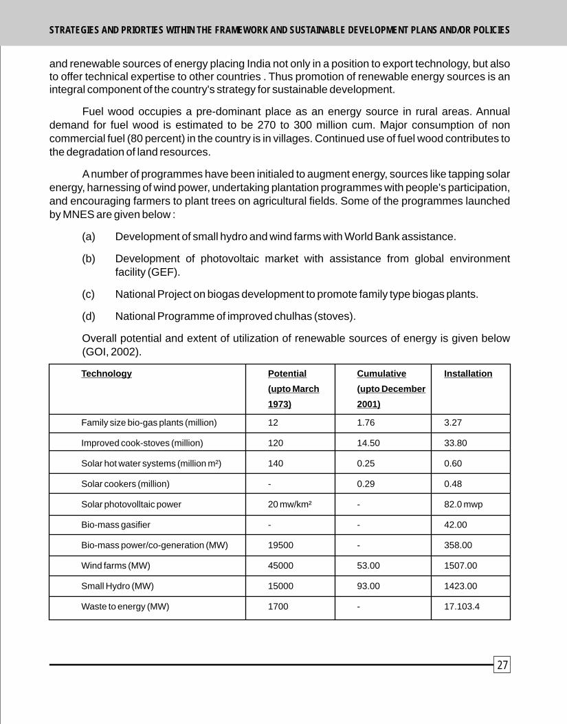
Research Efforts
Scientific and technological activities in India are carried out by Central Government, State Governments, education sector, public and private sector, industry and non-profit organizations. The application of research efforts is made possible through the development of a large infrastructure of institutions and laboratories. Notable among these are :-
! Indian council of Agricultural Research (ICAR).
! Indian Council of Forestry Research and Education (ICFRE).
Indian Council of Agricultural Research (ICAR)
Research institutes, of ICAR dealing with problems related to desertification and drought are listed below :
! Central Arid Zone Research Institute (CAZRI), Jodhpur.
! Central Research Institute for Dryland Agriculture (CRIDA), Hyderabad.
! Central Soil and Water Conservation Research & Training Institute, Dehradun.
! National Research Centre on Agroforestry (NRCAF), Jhansi.
! National Soil Salinity Research Institute (CSSRI), Karnal.
! Indian Grassland and Fodder Research Institute (IGFRI), Jhansi.
! Central Sheep and Wool Research Institute (CSWRI), Awikanagar.
! The National Bureau of soild Survey and Land use Planning (NBSS & LUP), Nagpur.
! In addition, All India coordinated research projects have been initiated on (i) forage crops at Jhansi, (ii) dryland farming at Hyderabad, and (iii) agroforestry at Jhansi. These projects, with a network of sub-centres in the arid and semi-arid regions of the country, have also been established for conducting location-specific research on problems related to desertification and drought.
Indian Council of Forestry Research and Education (ICFRE)
CFRE is dealing with research problems related to the watershed management, technologies for afforestation, agroforestry and improving forest productivity. Its institutes engaged in conducting research related to desertification and drought are : -
! Arid Froest Research Institute (AFRI), Jodhpur.
! Tropical Froest Research Institute (TFRI), Jabalpur.
! Institute of Forest Genetics and Tree Breeding (IFGTB), Coimbatore.
! Forest Research Institute (FRI), Dehradun.
28
! Centre for Social Forestry & Eco-Rehabilitation, Allahabad.
! Foresty Research & Human Resource Development Centre, Chhindwara.
! Institute of Forest Productivity, Ranchi.
Other Organisations
! Centre for Environment Management of Degraded Ecosystems (CEMDE).
! National Afforestation & Eco-development Board (NAEB).
! National Land-use and Conservation Board (NLCB).
! Krishi Vigyan Kendras (KVKs).
! Central Ground Water Board (CGWB).
! National Disaster Management Authority (NDMA)
! Indian Institute of Public Administration (IIPA), New Delhi.
! National Wastelands Development Board (NWDB), Delhi.
! Indian Renewable Energy Development Agency (IREDA).
! Space Application Centre (SAC), Ahmedabad.
! International Crop Research Institute for the Semi-Arid Tropics (ICRISAT), Hyderabad.
! National Institute for Rural Development (NIRD), Hyderabad.
! Indian Institute of Forest Management (IIFM), Bhopal.
! India Meteorological Department.
! National Remote Sensing Agency (NRSA), Hyderabad.
! Agriculture Universities.
! Social Science Research Institutes.
! Department of Science and Technology.
! Pollution Control Boards.
! Soil Conservation Training Centre, Hazaribagh.
Research studies were conducted to rehabilitate lands and to combat desertification by various research organization departments. The finding /packages developed for different site conditions are presented below :
29
STRATEGIES AND PRIORTIES WITHIN THE FRAMEWORK AND SUSTAINABLE DEVELOPMENT PLANS AND/OR POLICIESSTRATEGIES AND PRIORTIES WITHIN THE FRAMEWORK AND SUSTAINABLE DEVELOPMENT PLANS AND/OR POLICIES

3.4.1 Technology packages
Water erosion : Loss of Top soil in 130.5 m ha and terrain deformation in 16.4 m ha.
! Ravine Lands : Successful trees and shrubs for salt affected Ravines are
(i) Acacia tortilis, Albizia amara and Diclrostachys cinerarea.
(ii) Aacia nilotica and grasses are Dichanthium annulatum and Cenchrus ciliaris.
Sand dune stabilization in Arid regions :
The activities include
! Protection of area
! Establishment of micro-windbreaks on dune slopes
! Plantation or direct sowing of grass seeds on leeward side of micro-windbreaks.
Plant Species suitable for sand dune stabilization
Rainfall (mm)
150-300 Trees : Acacia tortilis, A. Senegal, Prosopes julifpora; Shrubs : Calligonum polygonoides, Ziziphus nummularia, Citrullus sp., Grasses : Lasiurus Sindices.
300-400 Trees : A. Tortillis, P. cineraria, Parkinsonia aculeata, Cordia rothii Shrubs : Z. mauritiana, Z. nummularia, C. polygonoides, C. colosynthis Grasses : Cenchrus citiaris, C. setigerus, L. sindicus, Saccharum munja
400-550 Trees : A. tortilis, P. cineraria, A. nilotica, A. senegal, Dalbergia sissoo, Ailamthus excelsa, Albizia procera, T. undulata; Shrubs : Z. mauritiana, Cassia auriculata; Grasses : C. ciliaris, C. setigerus, S. munja, Panicum antidotale.
Management of industrial effluents
Suitable technology developed includes : (i) adding of gypsum and farmyard manure @ 5 kg per pit (ii) adoption of double ring method for irrigation (iii) Tree species planted : E. camaldulensis, A. nilotica, A. tortilis, Azadirachta indica, Hardwiekia binata, P. cineraria, P. juliflora, Tecomela undulala.
Improvement of Salt affected soils
! Salt affected areas lying in low rainfall areas are recommended to be managed by adopting silvi-pasture system, and those in semi-arid and dry sub-humid areas can be managed for agriculture crop cultivation.
! Reclamation of salt affected areas need to be amended by application of gypsum,
30
FYM @ 7 to 8 kg, 6.5 ton per ha (for trees 5 kg per pit).
! Heavy irrigation is recommended before sowing to facilitate leaching down of the accumulated salts to improve germination and initial growth.
Suitable Tree Species for sodic soils
Average pH
More than 10 Trees : Prosopis juliflora, Acacia nilotica, Casuarina equisetifolia.
9-10 Trees : Temarix artienlata, Terminalia arjuna, Albizia lebbeck, Pongania pinnata, Sesbania sp., Eucalyptus tereticornis, Fruit Trees : Ziziphus mauritiana, Emblica officinalis, carissa carandas, phoenis, dactilifera, psidium guajava, syzygium cumini, Aegle marmelos Japota sapota.
8.5-9.0 Trees : D. sissoo, A. nilotica, E. tereticoonis, Morus alba, A. indica, Ailanthus excelsa; Furit Trees : Punica granatum, S. cumini, Sapindus laurifolius, Mangifera indica.
Grasses for salt affected soils : Chloris gayana, Brachiaria mutica, C. dactylon, Paspelam notatum, Diplochane fusea.
3.4.2 Tree Based Agroforestry Models for Arid, Semi-arid and Dry sub-humid areas
(A) ICFRE Institutes
Semi-arid and Dry sub-humid
! Dalbergia sissoo Scattered : 20 trees/ha Rainfed : 50 trees/ha, Boundary 60 trees/ha Agriculture crops : sugarcane, wheat, sorghum, maize, mustard, paddy.
! Eucalyptus tereticornis : Bounary : 80 to 120 trees/ha; Agriculture crops : sugarcane, wheat, paddy, millets, gram, sorghum.
! Populus detoides Block : 500 tree/ha; Row : 450 trees/ha, Boundary : 40 to 60 trees/ha Agriculture crops : sugarcane, wheat, pearl millet, turmeric, ginger, Fruit trees : mango, peach, Best rotation : Sugarcane (first two years) + turmeric in rest of years.
! Acacia nilotica : Rainfed: Boudnary 40 to 80 trees/ha- generally single row on N-S and E-W direction; scattered trees 40 to 80 per ha; Agriculture crops : Pearlmillet, moongbean, cluster bean, sorghum, mustard, wheat.
! Syzygium cumini Windbreak 50 to 60 trees/ha, Agriculture crops : sugarcane, maize, wheat, sorghum; fruit trees : mango, guava.
! Authocephalus chilensis : Block 400 trees/ha, Agriculture crops : sugarcane (for first two years), wheat, sorghum, vegetables.
31
STRATEGIES AND PRIORTIES WITHIN THE FRAMEWORK AND SUSTAINABLE DEVELOPMENT PLANS AND/OR POLICIESSTRATEGIES AND PRIORTIES WITHIN THE FRAMEWORK AND SUSTAINABLE DEVELOPMENT PLANS AND/OR POLICIES

(B) ICAR Institutes
Arid region
! Azadirachta indica Boundary : 60 trees/ha, Agriculture crops : gram, wheat, mustard, pearlmillet, sesame, clusterbean, mungbean.
! Prosopis cineraria : Rainfed : Scattered 10 to 40 trees/ha; Agriculture crops : pearlmillet, cluster bean, Mung bean, moth bean, sesame.
! Z. nummularia : 30 to 90 trees/ha - 30 to 90 trees/ha depending on rainfall intensity Agriculture crops : pearlmillet, moth bean, cluster bean, sesame, gram, masoor.
! Z. Mauritiana : Block 400 trees/ha; Agriculture crops : pearlmillet, cluster bean, moth bean, mung bean, sesame.
! A. nilotica : Scattered : 10 to 15 trees/ha; Agriculture crops : pearlmillet, cluster bean, seasame.
! Hardwickia binaa : Silvipasture system in arid and Agrisilviculture system in semi-arid conditions) Arid : Boundary 40 to 80 trees/ha; Agriculture crops pearlmillet, gram, mungbean; Semi-arid region : (Block : 400 trees/ha) Agriculture crops : wheat, sorghum, pearlmillet, gram.
! Ailanthus excelsa : Semi-arid region Boundary 60 to 80 trees/ha; Block 400 tress/ha; Agriculture crops : wheat, paddy, sorghum, gram, mustard.
! Albizia procera : semi-arid - Boundary 10 to 15 trees/ha; Block 250/ha; Agriculture crops : wheat, mungbean, sorghum, mustard, gram.
! Emblica officinalis : semi-arid block 10 m x 6 m; about 170 trees/ha suitable for saline sodic soils; Agriculture crops: green gram, horse gram, mustard, wheat, vegetables etc.
3.5 National Policies, Strategy and Acts/Legislations
The Environment (Protection) Act is an umbrella legislation that empowers the Central Government to take measures necessary to protect and improve the quality of environment. The Constitution of India also enables the Centre and States to enact laws to carry out the duties of preservation, afforestation and conservation of natural resources. The specific projects, schemess and research efforts of Central and State Governments are supported by institutional, policy and legislative measures. National Action Programme to Combat Desertification reviewed and discussed action points and objectives contained in various policies that related to its central theme. Major polices are as follows :-
National Water Policy
Ministry of Water Resources, Government of India formulated first policy in 1987 covering
32 33
the following priority areas :
! Drinking water
! Irrigation
! Hydro-power
! Navigation
! Industrial and other uses
Drinking water has been given prime consideration. An integrated and multidisciplinary approach is followed for planning, formulation, approval, and implementation of water related projects. The projects invariably include catchment treatment and management, environmental and ecological aspects, rehabilitation of affected people, and command area development measures for minimising land erosion. Projects for drought prone areas are recommended to incorporate special water conservation measures. Water resource development projects give priority to drought-prone areas. Drought proofing methods are given special attention in such projects.
1987 Policy has been replaced by a new Policy in 2002. The National Water Policy 2002 has emphasized following important aspects which are important from the point of view of sustainability.
! Water resources planning
! Ground water development
! Drinking water
! Irrigation
! Participatory approaches to water resources management
! Private sector participation
! Water quality
! Flood control and management
! Drought-prone area programme
! Water sharing/distribution amongst States
! Application of Science and Technology
Legislation :- Water (Prevention and Contol of Pollution) Act was promulgated as early as 1974. It prohibits discharge of pollutants into the water bodies beyond a given standard and also lays down penalties for non compliance. Water (Prevention and Control of Pollution)
STRATEGIES AND PRIORTIES WITHIN THE FRAMEWORK AND SUSTAINABLE DEVELOPMENT PLANS AND/OR POLICIESSTRATEGIES AND PRIORTIES WITHIN THE FRAMEWORK AND SUSTAINABLE DEVELOPMENT PLANS AND/OR POLICIES

Cess Act, 1977 provides for a levy for collection of cess on water consumed by industries and local bodies to augment the financial resources for regulatory authorities.
The Central Ground Water Board has constituted the Central Ground Water Authority (CGWA) for regulating the development and management of ground water resources.
National Land Use Policy outlines, 1988
The policy outlines take into account environmental, social, demographic, economic and legal issues. A Land Resource Management Policy and Approach has also been finalized in consultation with the FAO, the Lal Bahadur Shastri National Academy of Administration, and the National Institute of Rural Development.
Several steps have now been taken for institutional restructuring and better management of land resources. A national policy on the management of land resources is being formulated. The proposed policy is intended to make a paradigm shift from 'use of land' to 'management of land'. The initiatives taken by other Ministries also have a bearing on the prevention of the degradation of the land. Some of these are :-
! Improved policy framework for natural resource management.
! Inproved data on land resource degradation and its Management.
! (Draft) grazing and livestock management policy.
! (Draft) national policy for common property resource lands (under formulation).
The major strategy for sustainability of land resources focuses on tenurial reforms, decentralized land resource management through local bodies adopting the watershed approach, people's participation, and technological innovations.
National Froest Policy (NFP) 1988 :-
The National forest Policy of 1988 has given importance to the conservation of forest resources and subsistence needs of forest dependent communities. The policy became a major instrument in bringing about a change in the forest management from policing of the forest area to co-managig forest in partnership with the people. Main objectives of the NFP are : -
! Increasing the forest/tree cover through massive afforestation.
! Increasing productivity of forests.
! Meeting the requirement of fuelwood, fodder, minor forest produce, small timber and bamboo of the rural and tribal population.
! Creating massive people's movement for afforestation.
! Effiecient utilization of forest resources.
34
! Conservation of natural resources.
! Checking soil erosion.
! Checking extension of sand dunes.
The NFP further prioritizes increasing forest cover on semi-arid, arid and desert tracts. It also stipulates that as far as possible, forest based industries should raise their raw material for meeting their requirements preferably by establishing a direct relationship between the factory and the individuals who can grow the raw material on their lands.
The Ministry of Environment and Forests has prepared and circulated the National Forestry Action Programme (NFAP) which provides a comprehensive work plan for the next 20 years. The NFAP indentified five areas for overall forestry development in India. These are :
! Protect existing resources :-Comprises three programmes, i.e., front forest protection, soil and water conservation in protected areas, and biodiversity conservation.
! Improve forest productivity :- Includes four sub-programmes, i.e., rehabilitation of degraded forests, research and technology development, development of NWFPs and assisting private initiatives with community participation.
! Reduce total demand :- Consists of sub-programmes covering, fuelwood, fodder, timber and NWFPs. This can be achieved by developing technology for preservation, seasoning and substitution of wood.
! Strengthen policy and institutional framework : It comprises sub-prgorammes aimed at strengthening of Central forestry administration, Central forestry institutions, and State forestry administration and institutions.
! Expand forest area :- It comprises two sub-programmes (i) tree plantation on forest and non-forest lands, and (ii) people's participation in plantation activity and its protection.
National Environment Policy 2006
It seeks to
Encourage adoption of science-based, and tradtional sustainable land use practices.
Promote reclamation of wasterland and degraded forest land.
Encourage watershed management strategies, for arresting and reversingdesertification, and expanding green cover.
Promote sustainable alternatives to shifting cultivation where it is no longer ecologically viable
!
!
!
!
35
STRATEGIES AND PRIORTIES WITHIN THE FRAMEWORK AND SUSTAINABLE DEVELOPMENT PLANS AND/OR POLICIESSTRATEGIES AND PRIORTIES WITHIN THE FRAMEWORK AND SUSTAINABLE DEVELOPMENT PLANS AND/OR POLICIES
! Encourage agro-forestry, organic farming, environmentally sustainable cropping patterns, and adoption of efficient irrigation techniques.
National Agriculture Policy 2000
Policy intends to promote technically sound, economically viable, environmentally non-degrading, and socially acceptable use of country's natural resources- land, water and genetic endowment to promote sustainable development of agriculture. The policy mainly emphasizes integrated and holistic development of rainfed areas by conservation of rain water by vegetative measures on watershed basis, and augmentation of biomass production, for maintenance of ecological balance, and also for higher income generation through agro and farm forestry with the involvement of the watershed community, and by evolving appropriate technology, extension and credit support packages. Broad policy framework outlines :-
! Management of grazing land for increasing availability of animal feed and fodder,
! Promoting use of underutilized wasteland for agriculture and afforestation.
! Reclamation of degraded and fallow lands as well as problem soils for optimisation of their productive use.
! Generation and transfer of technology,
! Improving input use efficiency.
! Pooling and evaluating traditional practices, and wisdom.
! Promoting investments in agriculture, strengthening institutional infrastructure, ensuring better risk management and introducing management reforms.
The policy highlights the importance of social forestry and agroforestry in the maintenance of ecological balance and augmentation of biomass production in agricultural systems. There is now shift in the agriculture sector strategy from subsidies to creation of capital of rural infrastructure and management of environmental concerns by greater public investment and application of frontier technology.
! The Tenth Five Year Plan aims at a major revival of public investments in irrigation capacity and water management. The Accelerated Irrigation Benefit Programme (AIBP) provides resources to State Governments to support ongoing irrigation schemes.
! Emphasis is given on diversification of agriculture. Science and technology, especially biotechnology is intended to play an important role in diversification of agriculture and in increasing productivity of various crops.
! A programme titled “The Prime Minister's Rural Road Programme" has been launched. It aims at connecting every habitation with a population of over 1,000
36
persons through all weather roads by 2003 and those with population of 500 persons by 2007. Development of rural roads will help in opening up of markets, introduction of new technologies, and diversification of agriculture.
! An Integrated Pests Management (IPM) programme has been implemented laying stress on pest management through a combination of agronomic, chemical and biological methods.
National Land Reforms Policy
Government of India plays an advisory, and coordinating role in the field of land reforms with the aim to allow access to land by the landless rural poor. It also provides guidelines for introduction of land refroms legislation or amendments to be initiated by States and Union Territories.
Policy on Drought :-
As such, there is no separate policy on drought. However, respective Ministries/Sectors/Departments like agriculture, water, forestry, livestock management etc. have addressed issues of drought management independently.
Strategy of Environmental Conservation :-
Environmental conservation has been given special priority in national development. The strategy includes not only use of latest science and technologies, but also considers traditional knowledge and technologies with active participation of people as an essential element of environmental conservation. Following important acts/legislation have been adopted by Government of India in this regard :-
! In line with principles 16 and 17 of Agenda 21, Ministry of Environment and Forests, Government of India adopted the National Conservation Strategy and Policy Statement on Environment and Development in June 1992.
! National Policy and Macro-level Strategy and Action Plan on Biodiversity 2000 focuses on biological diversity, secure participation of stakeholders and local people, realization of consumptive and non-consumption values of biodiversity.
Forest (conservation) Act, 1980 : It was enacted with a view to checking indiscriminate diversion of forest land for non-forestry purposes.
!
! Environment (Protection) Act, 1986 : It is a comprehensive Act for the conservation and protection of environment of the country.
! Water (Prevention & Control of Pollution) Act, 1974 amended in 1988 : It contains the provisions for the prevention, control and abatement of water pollution in the country.
! Wildlife (Protection) Act, 1972 as amended in 1988 : It deals with the
37
STRATEGIES AND PRIORTIES WITHIN THE FRAMEWORK AND SUSTAINABLE DEVELOPMENT PLANS AND/OR POLICIESSTRATEGIES AND PRIORTIES WITHIN THE FRAMEWORK AND SUSTAINABLE DEVELOPMENT PLANS AND/OR POLICIES
conservation of wildlife in the country.
! Panchayat Raj Act, 1992 (Seventy Third Amendment Act) : Under this Act, land related subjects are given to the Panchyat Raj Institution (local self governments) at the village, block and district levels.
Planning Commission has identified promotion of farming system approach as a thrust area in the 'Tenth Plan Mid Term Appraisal'. The National Common Minimum Programme (NCMP) has envisaged that the government will introduce a special programme for dryland farming in the arid and semi-arid regions of the country. Planning Commission has recommended a provision of subsidies on water conservation techniques in the regions affected by acute water stress.
38 39
4. Institutional measures taken to implement the convention
Since the adoption of the UN Convention to Combat Desertification (UNCCD) in 1994, affected countries across the world have undertaken various actions to break the nexus between land degradation and poverty. UNCCD is recognized by the international community as an important tool, which could contribute substantially in achieving the Millenimum Development Goals (MDGs) particulary the efforts to alleviate poverty.
The first regional conference on the implementation of the Convention in Asia was held in New Delhi in August 1996. Subsequently, the ministerial level conference, held at Beijing in May 1997, conceptualized a framework of six Thematic Programme Networks (TPNs) for greater cooperation on the subject among affected countries in Asia-Pacific Region. India being an active member of the Inter-governmental Negotiating Country ratified the Convention to Combart Desertification which came into force in this country in March 1997. Government of India, while endorsing the six TPNs, offered to host TPN-2 on “Agroforestry and Soil Conservation in Arid, Semi-arid and Dry Sub-humid Areas”. Ministry of Environment and Forests, Government of India as the National Coordinating Body for The UNCCD has been making concerted efforts to develop the TPN-2 Network with a view to building knowledge database on agroforestry and allied subjects to facilitate exchange of information among the member countries.
4.1 Institutional Framework
An intersectoral and multi-disciplinary National Steering Committee (NSC) was established in July 1999 under chairmanship of Special Secretary to the Government of India, Ministry of Environment and Forests. Secretaries of the Ministries of Rural Development, Health, Water Resources, Social Justice, officers of the Department of Agricultural Research and Education, Women and Child Development, Directors of premier national research institutes, Director General of Indian Meteorological Department and representatives of UNDP are members of NSC. A National Policy and Coordination Committee (NPCC) under the Chairmanship of Secretary, Ministry of Environment and Forests has been set up comprising representatives from respective Ministries, Departments, State Governments, academic institutions, NGOs etc to formulate policies, and promote coordinated involvement of all concerned institutions/organizations.
The National Land Use and Wasteland Development Council (NLWC) is highest policy planning and coordination body. Prime Minister of India is the Chairman of the Council. Department of Land Resources (DOLR), Ministry of Rural Development is the front runner in implementing special area development programmes as instruments of poverty alleviation in drought prone, desert and related areas. The programmes are implemented in a participatory mode that seeks to secure close involvement of user communities. Accordingly, the Drought Prone Areas Programme (DPAP), the Desert Development Programme (DDP) and the Integrated Wasteland Development Programme (IWDP) have been under implementation in partnership with State Government and local communities. Soil degradation has been estimated by National Bureau of Soil Survey and Land Use Planning (NBSS & LUP) Nagpur of ICAR. The data has been published during 2005 which indicates that 146.82 million ha area is suffering from various kinds of
STRATEGIES AND PRIORTIES WITHIN THE FRAMEWORK AND SUSTAINABLE DEVELOPMENT PLANS AND/OR POLICIES

40 41
soil degradation. Various watershed programmes are being implemented mainly by three ministries, viz., MoA, MoRD and MoEF.
The “Housing for all” is planned to be met by the Tenth Plan Period (2007). Space Application Centre (ISRO), Ahmedabad, as national focal institution is coordinating TPN-1 activities in India and desertification monitoring and assessment.
A Desertification Cell in the Ministry of Environment and Forests has been established under the National Afforestation and Eco-development Board (NAEB). This is being strengthened to constitute a multi-discriplinary team involving experts on agriculture, agroforestry, forestry, environmental science, geo-hydrology, rural development and social sciences.
4.2 National Action Programme as part of the National Economic and Social Development and Environment Protection Plans.
The MoEF has prepared a National Action Programme to Combat Desertification. Several steps have been taken towards institutional restructuring and better management of land resources. Two major programmes to combat desertification are the Desert Development Programme (DDP) and Drought Prone Areas Programme (DPAP). In addition, an Integrated Wasteland Development Project (IWDP) has been under implementation on watershed basis. NGOs and people are involved in regenerating wastelands falling in the common property domain. A centrally sponsored scheme for computerization of land records is being implemented. Ministry of Environment and Forests has prepared the National Forestry Action Programme (NFAP) that provides a comprehensive work plan for sustainable development of forests in India for the next 20 years. NAP has been implemented in a phased manner synchronous with the national perspective plan, Five Year Plans, long term priorities and strategies. The first phase of the short term strategy is being implemented alongwith the Tenth Five Year Plan (2002 - 2007) and the long term strategy would be taken up in the next 15 years (2007-2022), and second phase in 2022 to 2037.
Some developments having a bearing on control of desertification in the intermediate period are listed below :-
1. Finalisation of National Environment Policy by MoEF (2006)
2. Proposal for constitution of National Rainfed Authority (2006)
3. Conceptualisation of Panchayat Van Yojana {Local self Government plantation Scheme (2006)}
4. National Rural Employment Guarantee Scheme (2006)
5. Bharat Nirman Yojana (2005)
6. Village Energy Security Programme (2005)
7. National Bio-fuel Mission (2005)
The National Steering Committee would take into account the issues of desertification and drought and ensure that these are integrated within the overall policies and strategies.
4.3 Coherent and functional legal and regulatory framework
No separate legislation/Act has been enacted to implement the provisions of the Convention. Various policies/legislitions/Acts of Government of India are in place (see section-3.5) aimed at conservation and management of natural resources and preservation and protection of the environment. Important Acts dealing with the subject are as follows :-
lForest Conservation Act, 1980.
lEnvironment Protection Act, 1986.
lWater (Prevention and Control of Pollution) Act,1988.
lWildlife Protection Act, 1972.
lPanchayat Raj Act, 1992.
lNational Policy and Macro-level Strategy and Action Plan on Biodiversity.
lNational Conservation Strategy and Policy Statement on Environnment and Development, June 1992.
INSTITUTIONAL MEASURES TAKEN TO IMPLEMENT THE CONVENTION INSTITUTIONAL MEASURES TAKEN TO IMPLEMENT THE CONVENTION
5. Participatory process in support of preparation and implementation of the National Action Programme
Ministry of Environment and Forests the national focal point for the CCD has formulated a 20 member National Steering Committee (NSC) under the chairmanship of Special Secretary, MoEF. The wasteland development programmes being implemented by MoRD ensure that local level user groups/self help groups are involved at each stage of project right from formulation to implementation to monitoring. Panchayat Raj Institutions have a pivotal role in this arrangement. MoA has revised WARSA-JAN SAHBHAGITA guidelines for National Watershed Development Project for Rainfed to Areas to incorporate peoples participation. National Afforestation and Eco-development Board (NAEB) in the MoEF has made participation of local communities through Joint Forest Management (JFM) mandatory in its afforestation schemes. Similar arrangements for people's participation in the form of “Watershed Associations” have also been incorporated for implemention of DPAP and DDP of the MoRD.
6. Consulatative process in support of the preparation and implementation of National Action Programme and partnership agreements developed by country parties and other interested entities
Effective Support from International partners for cooperation :-
Various externally funded projects are already under implementation (see Section 3.2.2). Forestry/Community Forestry Projects in various States have been funded by World Bank, Europeon Union, and UNDP. Consultations with multi-lateral/bi-lateral agencies and international donors have been proposed to secure financial assistance. Appropriate programmes have been identified and prioritised as per NAP document.
42 43

7.3 Action Programmes implemented in compliance with priority fields set out in the
Convention :
The National Action Programme (NAP) to Combat Desertification was prepared by Ministry
of Environment and Forests, Government of India, in collaboration with UNCCD. A
Regional Workshop on Agroforestry was organised at Banglore in December 2003. The
workshop was attended by representatives and experts from affected country parties in
Asia-Pacific Region. The focus of the workshop was on following points :-
! To share information on best practices of agroforestry among participating
countries.
! To discuss agroforestry project concepts under the new operational programme of
GEF that would address livelihood concerns of dryland communities in their
countries.
The important recommendation of this workshop was for bringing out an Agroforestry
Manual based on the best practices of agroforestry in the region. As a follow-up of the
decision taken at the Bangalore Workshop, Government of India constituted an Editorial
Board for preparation of the Manual. Experts and participants from Asia-Pacific Region
reviewed the first draft of Agroforestry Manual in extensive deliberations on 6-7 January
2005. The draft was upgraded and was further discussed in the regional consultations of th rdthe Asia-Pacific Region" on 6 May 2005 during 3 Session of CRIC meeting held at Bonn,
Germany. The “Agroforestry Manual for Asia-Pacific Region by Jagdish Kishwan,
K.K.Sharma, and S.K.Ratho (Editors) was published in June, 2005 and was circulated to all
concerned.
A publication “Study of Best Practices and Techniques of Agroforestry in Asia and the
Pacific” under TPN-2 of UNCCD was prepared in joint collaboration of UNCCD and Ministry
of Environment and Forests, Government of India in 2005.
7.4 Effectiveness of Measures in Local capacity Building.
Under the new central scheme for combating desertification, capacity building and training will be given a sharp focus along with entry point activities to elicit active participation of the local people.
7. Measures taken or planned within the framework of National Action Programmes,
including measures to improve the economic environment, to conserve natural
resources and promote their sustainable use, to rehabitate degraded land, to
enhance knowledge on desertification and its control, and to monitor and assess
desertificatin and drought
7.1. Adequate diagnosis of past experience :-
A mechanism for monitoring and evaluation of ongoing programmes to improve their
contents and quality of implementation already exists. The evaluation is done both
internally and through independent agencies. The working groups have initiated the
process of reviewing such evaluation reports and studies. Planning Commission also
monitors the regular progress of projects, and gives substantial finding at the time of Mid-
term Appraisal. Outside agencies like Administrative Staff College of India, Hyderabad,
Agriculture Finance Corporation, Mumbai, Centre for Management and Development,
Thiruvananathapuram, Institute of Resource Develoment & Social Management,
Hyderabad, Institute of Economic Growth, Delhi and National Remote Sensing Agency,
Hyderabad, are invovled in the evaluation of projects related to degraded lands. A national
level standing committee also reviewed the progress of the projects on degraded lands.
A National Standing Committee for watershed development under the chairmanship of
Deputy Chairman, Planning Commission with Ministers incharge of Rural Development,
Agriculture, Environment and Forests as members, was constituted on August 9, 1999.
7.2 Established Technical Programmes and functional integrated projects to combat
desertification
The integrated area development programmes like Drought Prone Areas Programme
(DPAP), the Desert Development Programme (DDP), the National Watershed
Development Projects for Rainfed Areas (NWDPRA), Integrated Wasteland Development
Programme (IWDP) and programmes of Natural Resource Management Division in
Ministry of Agriculture like soil conservation for enhancing the productivity of degraded
lands in the catchments of River Valley Project and Flood Prone River (RVP & FPR),
Reclamation of Alkoli Soils (RAS), All India Soil and Land Use Survey (AIS & LUS), Soil
Conservation Training Centre, Damodar Valley Corporation, Hazaribagh, etc. are
important in the context of addressing land degradation and desertification. NAEB in MoEF
is also funding “Grants in Aid for Greening India” scheme which aims at creating awareness
about tree planting and use of quality planting material by local people. Increase in green
cover is inteded to increase productivity of lands and, at the same time reduce land
degradation.
44 45
9 Review of bench marks and indicators intilized to measure progress and an
assessment thereof.
9.1 Operational Mechanisms for Monitoring and Evaluation
All programmes for land development have an elaborate mechanism for monitoring and
evaluation. In the National Programme for Combating Desertification also, monitoring and
evaluation would continue to be an integral part of the scheme. The process of monitoring
and evaluation is two pronged - one inbuilt in the scheme, and another concurrent M & E
through independent agencies/consultants.
8. Financial allocations from national budgets in support of implementation as well as financial assistance and technical coperation including their informs. Proves to identify their requirements, areas of funding and setting priorities
8.1 Adopted Financial Mechanisms
The Ministries of Agriculture and Cooperation, Environment and Forests, Rural Development and Non-conventional Energy sources would continue to be the major actors in the sphere of sustainable renewable natural resource management and desertification control in the Centre and their counterpart technical line departments in the States. The sources of funding available to these agencies for implementing their sustainable development programmes including desertification control are the national and state budgets, dedicated sectoral funds and external assistance.
8.2 NAP Financial
The ongoing programmes of individual Ministries would continue to be funded from their respective Plan Budget Funds. Ministry of Environment and Forests will continue to discharge the model role for scouting the funds under the NAP CD, and also act as a clearing house for posing projects relating to desertification control, for internal and external finding.
8.3 Technical Cooperation Developed
For mapping the status of desertification in India, institutions such as India Meteorological Department and National Bureau of Soil Survey and Land Use Planning have already furnished the following maps and reports :-
India Aridity Anomaly Chart
Severity of Degradation : Water Erosion
Severity of Degradation : Wind Erosion
Agro-ecological Regions : India
Agro-ecological Sub-regions : India (2 no)
Bio-climatic Regions : India
Bio-climatic Types : India
Census of India 2001
46 47
at Bonn, Germany (Dec. 11-22, 2000, MOEF, Govt. of India, New Delhi.
MOEF 2001 INDIA National Action Programme to combat desertification in the context of UNCCD
(Vol. I, II), Ministry of Environment & Forests, Govt. of India, New Delhi.
MOEF 2002. Empowering People for Sustainable Development, Ministry of Environment and
Forests, Govt. of India, New Delhi.
MOEF 2002. Second National Report on Implementation of the UNCCD, submitted to UNCCD
Secretariat Bonn, Germany. Ministry of Environment and Forests, Govt. of
India, New Delhi.
MOEF 2004. Creation of New Employment in Afforestation and Forestry Sector, Report of support
group on investment, credit and technical support for creation of new
employment in Afforestation and Forestry Sector, Ministry of Environment
and Forests, Govt. of India, New Delhi.
MOEF 2004. Mitigating Poverty, water, sanitation and Human Settlements, India's Report to the th12 Review Session of the united Nations commission on sustainable
Development (April 2004), Ministry of Environment and Forestry, Govt. of
India, New Delhi.
MOEF 2006. Combating desertification, NAEB, Desertification cell, Ministry of Environment and
Forests, New Delhi.
MOF 2001. Economic Survey 2000-2001. Economic Division, Ministry of Finance (MOF), Govt. of
India, New Delhi.
MOHFW 2000. Annual Report 2001-2002. Ministry of Health and Family Welfare, Govt. of India,
New Delhi.
MOHRD 1988. Draft National Perspective Plan for Women (1988-2000), Dept. of Women and
child development, Ministry of Human Resource Development, Govt. of
India, New Delhi.
MORD 1982. Report on the Task Force on the Drought Prone Area Programme and the Desert
Development Programme, Ministry of Rural Development, Govt. of India,
New Delhi.
MORD 1994. Report of the Technical Committee on Drought Prone Area Programme and Desert
Development Programme, Ministry of Rural Development, Govt. of India,
New Delhi.
MORD 2001. Annual Report 2000-2001. Ministry of Rural Development, Govt. of India, New Delhi.
NCA 1974. Interim Report on Desert Development, National Commission on Agriculture, Govt. of
India, New Delhi.
Pant J.C. 2000. High Power committee for Preparation of Disaster Management Plans : Interim
REFERENCES
Anon Inception Report on the linkages study of the land degradation component of the NCSA
(Preliminary Report), Submitted to Ministry of Environment and Forests,
Institute of Economic Growth, univesity of Delhi Enclave, North campus,
Delhi.
Dadhwal K.S. and K.R. Solanki, 2000. Agroforestry Innovations For Degraded Lands, National
Research Centre for Agroforesry, Jhansi (UP), Indian Council of Agriculture
Research.
ICAR India Agro-Ecological Regions, Indian Council of Agriculture Research, New Delhi.
GOI 1991 Census of India 1991, Series 1; provisional population totals; Workers and their
distribution, Registrar General and Census Commissioner, Govt. of India,
New Delhi.
Kishwan J., K.K. Sharma and S.K. Ratho 2005 (editors). Agroforestry Manual For Asis-Pacific
Region, Secretariat of the united Nations Convention to combat
Desertification, Bonn, Germany.
MOA 2000. Common Approach for Watershed Development, Department of Ariculture and
cooperation, Ministry of Agriculture, New Delhi.
MOA 2000. National Agricultre Policy, Department of Agriculture and cooperation, Ministry of
Agriculture, New Delhi.
MOA 2000. WARASA-JAN SAHBHAGITA : Guidelines for National Watershed Development
Project for Rainfed Areas, Department of Agriculture and Coopration,
Ministry of Agriculture, New Delhi.
MOA 2005. Programme and Achievements of Natural Resources Management Division
(November 2005), Ministry of Agriculture, Govt. of India, New Delhi.
MNES 2001. Annual Report 2000-2001. Ministry of Non-conventional Energy Sources, Govt. of
India, New Delhi.
MOEF 1992. National Conservation Strategy and Policy Statement on Environment and
development. Ministry of Environment and Forests, Govt. of India, New
Delhi.
MOEF 1993. Environment Action Programme India, Ministry of Environment and Forests, Govt.
of India, New Delhi.
MOEF 1999. National Forestry Action Plan. Ministry of Environment and Forests, Govt. of India,
New Delhi.
MOEF 2000 National Report on implementation of the United Nations Convention to Combat
Desertification, The Fourth conference of the parties (COP-4) to the UNCCD
48 49
REFERENCES
ANNEXURE-1
Country Profile
Biophysical indicators relating to desertification and drought
The Earth Summit 1992 recognised to address issues of global environmental
degradation, and its Agenda 21, reflects a global consensus and political commitment at the
highest level on development and environmental cooperation. The main policies and programmes
of the Agenda 21 are in conformity to a number of traditional values inherent in the Indian Culture
and also with all those values that are enshrined in the Indian Constitution. In India, innumerable
initiatives were undertaken by the people in the past which not only demonstrate concern for the
environment, but also the awareness about the need to balance this concern with livelihood
resources. These tenets such as care, conservation and preservation of environmental resources
are also reflected in the spirit of the Constitution of India. Over hundreds of years, the people of
India have evolved time-tested mechanisms of conservation and prudent utilization of the
livelihood resources.
1. Topography of India
The country can be classified into four broad geographical areas which include Northern
Mountains comprising great Himalayas (East-West); Indo-Gangetic Plains; the Thar desert and
the Southern (Deccan) Penninsula bounded by the Western and Eastern Ghats; and the coastal
plains and Island Systems of Lakshadweep and Minicoy Islands in the Arabian Sea, and the
Andaman and Nicobar Islands in the Bay of Bengal. 14 major river systems, besides a number of
smaller water bodies, drain through the land mass of the country.
Main Physio-Geographic zones in India
Physio-Geographic Area Population No. of Density of Urban Villages
Zone Km² % Million % districts population centres
No. Population No. Population(mill.) (milliion)
Northern 322158 10.5 28.04 3.34 - - - - - -
Mountains
(Himalayas)
Indo-Gangetic 730955 22.2 333.43 39.4 150 456 1516 74.03 235641 259.4
Plains
Southern 1525279 49.76 307.49 36.67 158 202 1785 78.13 266892 29.36
Peninsula
Coastal Plains 486635 15.38 169.38 20.23 76 349 1031 58.76 67972 110.84
And Islands
Source : Census of India, 1991.
Report, Ministry of Agriculture, Govt. of India, New Delhi.
Planning Commission 2001. Approach Paper to the Tenth Five Year Plan (2002-2007). Planning
Commission, Govt. of India, New Delhi.
Planning Commission 2002. National Human Development Report, Planning Commission, Govt.
of India, New Delhi.
SAC 2003. Desertification Status Mapping, Technical guidelines, Forest, Landuse and
photogrammetry Group, RESIPA, Space Applications centre, Govt. of India,
Ahmedabad.
Sharma, K.K. 1995. Agroforestry for sustainable rural development, Van Vigyan 22(I).
Sharma K.K. 1996. Agroforestry in farming Systems development, Indian For. 122 (7)
Sharma K.K. 1996. Demonstration of Foresry Programme for alleviation of Poverty in District
Hardwar States Report (UNDP Project), Indian Council of Forestry
Research and Education, Dehradun (India).
Sharma K.K. and R.C. Dhiman, 1997. Agroforestry Research & Extension Linkages. National
Workshop on Linkages between Forestry Research and Forestry Practices
(May 13-14), ICFRE, Dehradun (India).
Singh I.S. and R.K. Singh, 1987. Agroforestry Present States and scope for Future Development
in Farming Systems, Narendra Deva University of Ariculture and Technology,
Kumarganj, Faizabad (U.P.).
UNCED. Agenda 21. United Nations Conference on Environment and Development, Rio de
Janerio, Brazil, June 3-4, 1992.
World Bank, 1992. Gender and Poverty in India. World Bank Country Study. The World Bank,
Washington DC.
50 51
REFERENCES
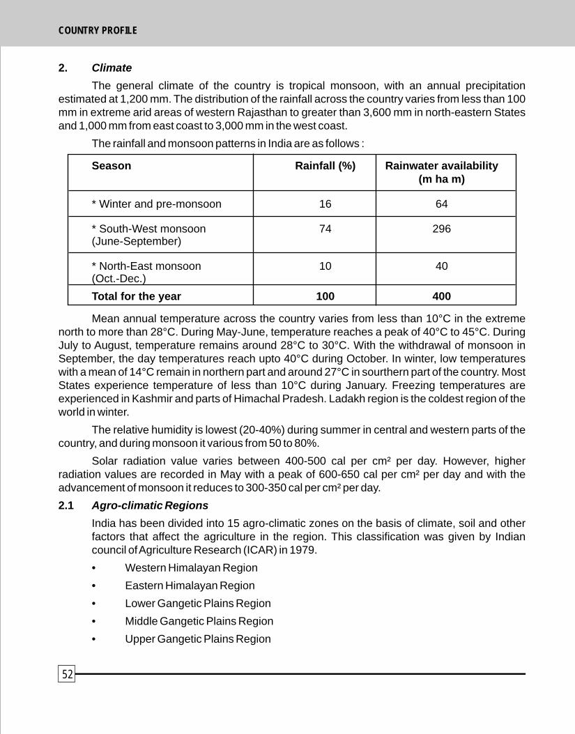
• Trans Gangetic Plains Region
• Eastern Plateau and Hill Region
• Central Plateau and Hill Region
• Western Plateau and Hill Region
• Southern Plateau and Hill Region
• East Coast Plains and Hill Region
• West Coast Plains and Ghat Region
• Gujarat Plain and Ghat Region
• Western Dry Region
• Island Region
India has also been divided into 20 Agro-Ecological Regions and 60 sub-regions on the basis of physiography, soils, climate, growing period and also taking into account available water capacity of the soil. The agro-ecological regions fall into 6 major climatic regions which are (i) Arid (ii) Semi-arid (iii) Dry sub-humid (iv) Moist sub-humid (v) Humid (vi) Per-humid.
According to National Bureau of Soil Science and Land Use Planning (NBSSLUP) the arid, semi-arid and dry sub-humid regions constitute the drylands cover of about 228.3 m ha (69.6%) of the total land area (328 m ha) of the country. Area under different categories of drylands is as follows :
(i) Arid 50.8 m ha
(ii) Semi-arid 123.4 m ha
(iii) Dry sub-humid 54.1 m ha
TOTAL 228.3 m ha
3. Land use pattern in India
Major categories of land use are presented in table 1 below :
Table 1 : Land use pattern in India.
Land use Area (m ha)
Total Land area 328.73
Forests 67.08
Area under non-agricultural use 21.8
Barren and unculturable Land 19.4
Permanent pastures and grazing lands 12.0
Fallow lands 24.0
2. Climate
The general climate of the country is tropical monsoon, with an annual precipitation estimated at 1,200 mm. The distribution of the rainfall across the country varies from less than 100 mm in extreme arid areas of western Rajasthan to greater than 3,600 mm in north-eastern States and 1,000 mm from east coast to 3,000 mm in the west coast.
The rainfall and monsoon patterns in India are as follows :
Season Rainfall (%) Rainwater availability(m ha m)
* Winter and pre-monsoon 16 64
* South-West monsoon 74 296(June-September)
* North-East monsoon 10 40(Oct.-Dec.)
Total for the year 100 400
Mean annual temperature across the country varies from less than 10°C in the extreme north to more than 28°C. During May-June, temperature reaches a peak of 40°C to 45°C. During July to August, temperature remains around 28°C to 30°C. With the withdrawal of monsoon in September, the day temperatures reach upto 40°C during October. In winter, low temperatures with a mean of 14°C remain in northern part and around 27°C in sourthern part of the country. Most States experience temperature of less than 10°C during January. Freezing temperatures are experienced in Kashmir and parts of Himachal Pradesh. Ladakh region is the coldest region of the world in winter.
The relative humidity is lowest (20-40%) during summer in central and western parts of the country, and during monsoon it various from 50 to 80%.
Solar radiation value varies between 400-500 cal per cm² per day. However, higher radiation values are recorded in May with a peak of 600-650 cal per cm² per day and with the advancement of monsoon it reduces to 300-350 cal per cm² per day.
2.1 Agro-climatic Regions
India has been divided into 15 agro-climatic zones on the basis of climate, soil and other factors that affect the agriculture in the region. This classification was given by Indian council of Agriculture Research (ICAR) in 1979.
• Western Himalayan Region
• Eastern Himalayan Region
• Lower Gangetic Plains Region
• Middle Gangetic Plains Region
• Upper Gangetic Plains Region
52 53
COUNTRY PROFILE COUNTRY PROFILE
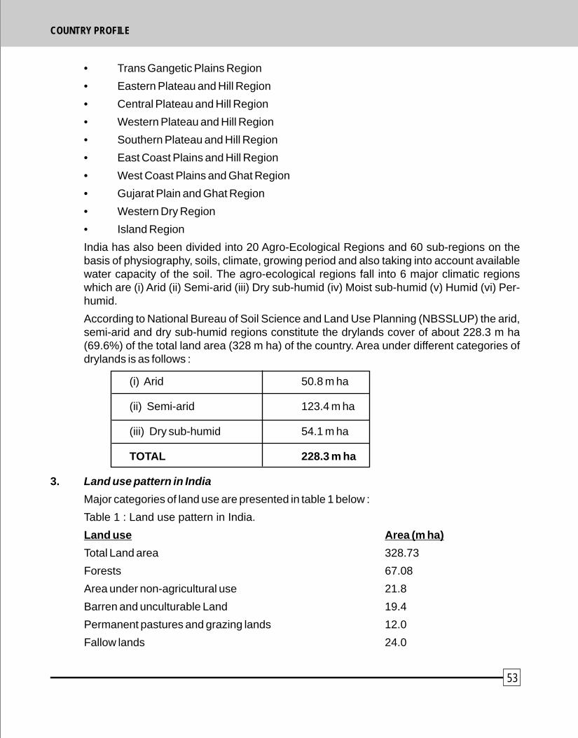
! 204 identified amphibians (62% endemic)
! 91 eco-cultural zones
! 4,635 communities
Cultivated diversity
! 167 species of crops
! 320 species of wild crop relatives
! 50,000 varieties of rice
! 1,000 varieties of mangoes
! 5,000 varieties of sorghum
! 500 pepper varieties
! 27 breeds of cattle
! 22 breeds of goats
! 40 breeds of sheep
! 18 breeds of poultry
! 8 breeds of buffaloes
In order to protect and conserve the biodiversity, a network of 586 protected areas which includes 89 national parks and 497 sanctuaries has been set up. It also includes 13 Biosphere Reserves, and 27 Project Tiger Reserves. A national Bio-Diversity Authority has heen established under Bio-Diversity Act, 2004.
5. Agriculture
Agriculture contributes 29.93% of India's GDP. Major part of agriculture is rainfed, extending to 89 m ha (61% of the net cultivated area of 123.5 m ha). A large percentage of cultivated areas growing coarse cereals (90%), pulses (81%), oil seeds (76%), cotton (65%) and rice (50%) is rainfed.
Expansion of irrigation has played an important role in the development of agriculture. Full irrigation potential of India has been estimated to be 139.5 m ha, comprising 58.5 m ha from major and medium schemes, 15 m ha from minor irrigation schemes and 40 m ha (revised to 66 m ha) from ground water exploitation. It is estimated that even after achieving the full irrigation potential,
Cropped area 142.5
• Area under food grain cultivation 123.5
• of this area under rainfed farming systems 89.0
4. Natural Resources
4.1 Forests
Forestry is an important part of land use. Forests occupy a recorded area of about 77.47 million ha constituting 23.6% of the total geographical area of the country. However, the actual forest cover is only 67.84 million ha (20.64% of the country area) out of which 28.78 million ha are open forests. 4.03 million ha of of land areas is under scrub vegetation. Thus about 32.81 million ha forest in the country are degraded or open. The forests range from tropical rainforest to dry thorn forests and to mountain temperate and alpine forests. There are four major forest types and 16 detailed forest types in the country.
4.2 Deforestation
In India, the per capital availability of forest land is one of the lowest in the world, a meagre 0.08 ha, against an average of 0.5 ha for developing countries and 0.64 ha for the world. The rate of deforestation in the country has been considerably reduced in the past. The average annual deforestation rate fell from about 1.3 million hectares during 1970's to 27,000 ha in 1980's, and to about 22,000 ha during the period from 1990-1995. In quantitative terms, however, extent of dense forest in almost all the major States has been reduced. On the other hand, during 1980-1990 period and also in subsequent years, there were afforestation efforts which added about one million ha annually to the plantation area. Thus, while the total area of natural forests of 55.12 million ha in 1980 reduced to 50.38 million ha by 1995, the total area of natural and plantation forests increased from 58.26 million ha in 1980 to 65.00 million ha in 1995.
4.3 Biodiversity
India is rich in biodiversity because of its diverse physiograpic and climatic conditions. Two of the 18 internationally recognised biodiversity hotspots are the Eastern Himalayas and Western Ghats. India's biodiversity details are as follows :
! 10 bio-geographic zones
! 45,000 identified plant species including 6% of the worlds flowering plants (about 3,000 Non-Timber Forest Products species)
! 81,000 identified animal species.
! 1,228 identified birds (14% endemic) which is 14% of the world's total birds.
! 446 identified reptiles (32% endemic)
54 55
COUNTRY PROFILE COUNTRY PROFILE
The human population as estimated in 2001 is 1,027 million with an average growth rate of 1.95% (between 1991 to 2001). Much of this population resides in rural areas with the average population density of the country at 284 persons per sq. km. Gangetic Plains of India has an overage of 456 persons per sq. km. The rate of growth of population during 1981-1991 in dryland region has been 29% as against 23% for the country. Seven districts in Rajasthan showed very high growth rate of 30-35%.
The urban population is 285 million and about one fifth of this population lives in slums. The rural population at 741 million constitutes about 72 percent of the total population. In terms of growth, the decadal growth rate has come down by about 3.5% over the last three decades. In 1991, the growth rate was more than 2% per year whereas in 2001-02 this has come down to 1.76% per year.
7.2 Livestock
The livestock population in 1992 was 470 million heads. Over the four decades 1951-1992, the number of bovine increased by 45%. Sheep and goat populations were 51 and 115 million respectively in 1992. Livestock population and its density in arid regions are very high as indicated below :
Livestock Population
Camels 1,001,000
Sheep and goats 155,910,000
Cattle 199,695,000
Horse, Donkeys and Mules 1,922,000
Buffaloes 75,677,000
Others 175,000
A nationwide survey of National Council of Applied Economic Research (NCAER) indicated that income from livestock averages 22.5% of total household income. In 1991, 65% of the total Indian working force of 185 million people was dependent on agriculture with 80% of these involved in livestock production, either as producers or workers. Family women carry out about 60% of the work related to care and management of livestock in households. The GDP from livestock sector is estimated around 5.5% (1999-2000) at current prices. Livestock in India is characterised by very large numbers and very low productivity.
7.3 Fodder
The cattle health in the country, in general, is poor due to constraints of fodder availability.
substantial part of the total cultivated area will remain rainfed.
6. Water resources
Of the total estimated 432 cubic km of replenishable ground water resources, nearly 92% are estimated to be utilizable. By now, only 32% of the same have been exploited. The river water resources are estimated at around 1,953 cubic km. About 93 percent of the available water resources are used for agriculture, and only 4 percent for industrial purposes. The total water requirement by 2050 is expected to grow to 1,180 billion cubic meters. The national average of annual per capita availability of water is about 1,829 cubic meters which may decline to 1,557 cubic meters by 2015 due to increase in population.
India has been divided into 20 river basins comprising 12 major river basins, each having a catchment area exceeding 20,000 sq. km, and eight composite river basins. The other water resources include reservoirs, tanks, ponds and lakes which cover about 7 m ha of the surface area of the country. In addition, the ground water potential varies in different regions of the country. However, due to heavy extraction of ground water and its limited recharge, the ground water is getting depleted at a fast rate. This depletion is mainly caused in most of the dryland comprising States of Punjab, Haryana, Uttar Pradesh, Rajasthan, Andhra Pradesh, Karnataka, Madhya Pradesh, Orissa and Maharashtra.
It is predicted that India's total water resources during 2050 will not be able to meet the country's total water requirements. This situation points to the urgent attention to plan and develop an integrated approach to the development and management of water resources in the country. In addition, maintaining a balance between the availability and requirements of water across basins, regions, watersheds and between sections of the population adds another dimension to the challenge.
The other important issues are the deteriorating quality of water resources. Continuous monitoring of the water quality standards of the country's aquatic resources is the mandate of Central Pollution Control Board (CPCB) in collaboration with State Pollution Control Boards. The monitoring results indicate that organic and bacterial contaminations are the predominant sources of pollution in the water resources of the country. Following points need to be given priority :-
! Release of untreated municipal sewage into the rivers is reducing the level of dissolved oxygen required to support aquatic life. Thus increasing pollution levels in terms of unmet biological oxygen demand are leading to the destruction of aquatic life.
! Chemical effluents released into the water are also having a detrimental effect on the quality of the aquatic resources of the country.
7. Population
7.1 Human
56 57
COUNTRY PROFILE COUNTRY PROFILE

below poverty line.
9. Types of land degradation
Per capita land availability in India has declined from 0.89 ha (1951) to 0.3 ha in 2001. Per capita availability of agriculture land has declined from 0.48 ha (1951) to 0.14 ha in 2001. Per capita land resources is further exacerbated by degradation and desertification of land. About 107.43 m ha or 32.75% of the total geographical area of the country is affected by various forms and degree of land degradation.
Type of degradation 1990-99 2000-2003
m ha % of total area m ha % of total area
Water erosion 107.12 61.7 57.15 17.42
Wind erosion 17.79 10.24 10.46 3.18
Ravines 3.97 2.28 2.67 0.81
Salt affected 7.61 4.38 6.32 1.92
Water logging 8.52 4.90 3.19 0.97
Mines and industrial waste - - 0.25 0.08
Shifting cultivation 4.91 2.82 2.37 0.72
Degraded forests 19.49 11.22 24.89 7.58
Special problems 2.73 1.57 0.11 0.30
Coastal sandy areas 1.46 0.84 - -
Source : Govt. of India, 1994, MoA 1985
10. Rehabilitation of degraded lands
Various watershed development programmes have been initiated by Government of India for rehabitation of degraded lands. Upto March 2005, an area of 28.533 million ha has been developed with an expenditure of Rs.14,577.32 Crore. The details are as follows :
Area treated upto 1999 - 21.07 Mha
Area treated during 2002-2005 - 7.47 Mha
It is estimated that about 12.00 mha of degraded lands is likely to be treated during Tenth Plan period and about 76.50 mha of degraded lands will remain to be treated in the beginning of Eleventh Five Year Plan.
Cattle are grossly underfed and the available fodder resources on the average can only provide for one third of the maintenance ration prescribed, i.e., 4.53 kg of roughage per day plus 2.72 kg of green fodder for a body weight of 227 kg. Committee on Fodder and Grasses (1987) estimated the green and dry fodder requirement for the year 2000 as 1,136 and 949 million tonnes as against the fodder production of 250 and 441 million tones respectively. The total supply of feed and fodder in 1993 (MoEF) was straw : 398 million tonnes, green fodder : 573.50 million tonnes, and concentrates : 41.98 million tonnes. Thus current as well as future estimates indicate that production of fodder in the country falls short of the requirement, and the shortage of green fodder is more acute than that of dry fodder. Forest Policy (1988) aims at creating self reliant village communities in respect of fodder resources. Simultaneouly, the policy restricts the grazing inside forest according to its carrying capacity. Another important feature of the policy is emphasis on encouragement of stall feeding of cattle. Most of the ruminants in India, large and small, survive by grazing on common property resources (CPRs). Overgrazing by herds far larger than what the land can sustain, year after year, has progressively rendered the CPRs to marginal or waste lands, grossly eroded. Some estimates put annual erosion of top soil at 6,000 million tonnes, and reduction in water points from 55 to 92% changing plant associations on CPRs, making them unsuitable for bovine grazing.
7.4 Area under grazing
The other uncultivated land, excluding current fallows, covers areas classified under permanent pastures and grazing lands. About 12.0 million ha (Table 1) of land in the country is recorded as permanent pastures and grazing land which are mostly located in States of Himachal Pradesh, Karnataka, Madhya Pradesh, Gujarat, Rajasthan, Tripura and the Union Territory of Dadra and Nagar Haveli.
8. Poverty
Poverty in both rural and urban areas continues to be one of the major developmental concerns for the country. Planning Commission defines the poverty line as the cost of an all India average consumption basket at which calorie norms of 2,400 calories per capita per day in rural areas, and 2,100 calories per capita per day for urban areas, are met. India has 22% of the world's poor, with more than 260 million people living below the poverty line. Of this, about 75 percent are in rural areas.
Combating poverty and its eventual eradication has been the central theme of all major policies and programmes of the Government of India and UNCCD. While in 1993-94, 37% or 244 million people in rural areas were poor, in 1999-2000, this figure got reduced to 193 million, i.e., 27%. In urban areas, the percentage of poor people has declined from 32% in 1993-94 to 23% in 1999-2002. However, by the end of the decade, India succeeded in bringing down the number of people living below the poverty line by 18.75% to 260 million. In terms of absolute numbers, about 60 million people were brought above the poverty line in 10 years' time. The Mid-Term evaluation
thof 10 Five Year Plan (2005) estimates that urgent figure US Behera million people are living
58 59
COUNTRY PROFILE COUNTRY PROFILE
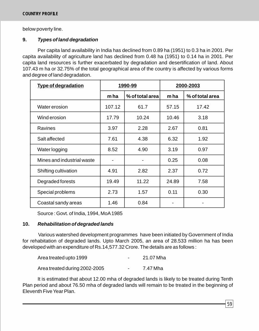
below poverty line.
9. Types of land degradation
Per capita land availability in India has declined from 0.89 ha (1951) to 0.3 ha in 2001. Per capita availability of agriculture land has declined from 0.48 ha (1951) to 0.14 ha in 2001. Per capita land resources is further exacerbated by degradation and desertification of land. About 107.43 m ha or 32.75% of the total geographical area of the country is affected by various forms and degree of land degradation.
Type of degradation 1990-99 2000-2003
m ha % of total area m ha % of total area
Water erosion 107.12 61.7 57.15 17.42
Wind erosion 17.79 10.24 10.46 3.18
Ravines 3.97 2.28 2.67 0.81
Salt affected 7.61 4.38 6.32 1.92
Water logging 8.52 4.90 3.19 0.97
Mines and industrial waste - - 0.25 0.08
Shifting cultivation 4.91 2.82 2.37 0.72
Degraded forests 19.49 11.22 24.89 7.58
Special problems 2.73 1.57 0.11 0.30
Coastal sandy areas 1.46 0.84 - -
Source : Govt. of India, 1994, MoA 1985
10. Rehabilitation of degraded lands
Various watershed development programmes have been initiated by Government of India for rehabitation of degraded lands. Upto March 2005, an area of 28.533 million ha has been developed with an expenditure of Rs.14,577.32 Crore. The details are as follows :
Area treated upto 1999 - 21.07 Mha
Area treated during 2002-2005 - 7.47 Mha
It is estimated that about 12.00 mha of degraded lands is likely to be treated during Tenth Plan period and about 76.50 mha of degraded lands will remain to be treated in the beginning of Eleventh Five Year Plan.
Cattle are grossly underfed and the available fodder resources on the average can only provide for one third of the maintenance ration prescribed, i.e., 4.53 kg of roughage per day plus 2.72 kg of green fodder for a body weight of 227 kg. Committee on Fodder and Grasses (1987) estimated the green and dry fodder requirement for the year 2000 as 1,136 and 949 million tonnes as against the fodder production of 250 and 441 million tones respectively. The total supply of feed and fodder in 1993 (MoEF) was straw : 398 million tonnes, green fodder : 573.50 million tonnes, and concentrates : 41.98 million tonnes. Thus current as well as future estimates indicate that production of fodder in the country falls short of the requirement, and the shortage of green fodder is more acute than that of dry fodder. Forest Policy (1988) aims at creating self reliant village communities in respect of fodder resources. Simultaneouly, the policy restricts the grazing inside forest according to its carrying capacity. Another important feature of the policy is emphasis on encouragement of stall feeding of cattle. Most of the ruminants in India, large and small, survive by grazing on common property resources (CPRs). Overgrazing by herds far larger than what the land can sustain, year after year, has progressively rendered the CPRs to marginal or waste lands, grossly eroded. Some estimates put annual erosion of top soil at 6,000 million tonnes, and reduction in water points from 55 to 92% changing plant associations on CPRs, making them unsuitable for bovine grazing.
7.4 Area under grazing
The other uncultivated land, excluding current fallows, covers areas classified under permanent pastures and grazing lands. About 12.0 million ha (Table 1) of land in the country is recorded as permanent pastures and grazing land which are mostly located in States of Himachal Pradesh, Karnataka, Madhya Pradesh, Gujarat, Rajasthan, Tripura and the Union Territory of Dadra and Nagar Haveli.
8. Poverty
Poverty in both rural and urban areas continues to be one of the major developmental concerns for the country. Planning Commission defines the poverty line as the cost of an all India average consumption basket at which calorie norms of 2,400 calories per capita per day in rural areas, and 2,100 calories per capita per day for urban areas, are met. India has 22% of the world's poor, with more than 260 million people living below the poverty line. Of this, about 75 percent are in rural areas.
Combating poverty and its eventual eradication has been the central theme of all major policies and programmes of the Government of India and UNCCD. While in 1993-94, 37% or 244 million people in rural areas were poor, in 1999-2000, this figure got reduced to 193 million, i.e., 27%. In urban areas, the percentage of poor people has declined from 32% in 1993-94 to 23% in 1999-2002. However, by the end of the decade, India succeeded in bringing down the number of people living below the poverty line by 18.75% to 260 million. In terms of absolute numbers, about 60 million people were brought above the poverty line in 10 years' time. The Mid-Term evaluation
thof 10 Five Year Plan (2005) estimates that urgent figure US Behera million people are living
58 59
COUNTRY PROFILE COUNTRY PROFILE