2nd international workshop on vdes -...
TRANSCRIPT

Page 1
2nd International Workshop on VDES
Focus on Satellite VDES
Tokyo, 20/01/2014
Gaetan FabritiusCLS, Head of Maritime Surveillance Team
www.sat-ais.org

Page 2
Presentation Overview
Introducing CLS
No need to remind the definition and (very favorable) context for VDES
but...
... reminding what satellite VDE can offer
On-going activities in Europe around satellite VDE
Expected next steps for satellite VDE
Discussion

Page 3
Created: 21 April 1986 – subsidiary of the French Space Agency (CNES) Operating the Argos constellation (Advanced Doppler location)
Core activities: • Commercial operation of satellite systems for positioning, data collection, ocean observation and surveillance
• Developing added-value applications and services based on satellite remote-sensing data;
Applications to:• environmental surveillance• sustainable management of marine resources• maritime surveillance• oil and gas
Supported by: Cubic-I (i3) – CLS office in Japan
Introducing CLS

Page 4
CLS day to day mission

Page 5
About the interest of satellite VDE (1/2)
No doubt that VDES is a must have (current VDL load jeopardizing existing use of AIS, natural evolution for the current very successful AIS system)
Main justifications for a satellite component as complement for VDES (COMSAR 17/INF.7):
Communicate beyond terrestrial coverage & address polar communication issues or other remote areas (ex: French territories)
Address typical multicast/broadcast information exchange requirements (e-Nav and modernization of GMDSS), for instance complementing the maritime safety information service and WWNWS (World-Wide Navigational Warning Service) broadcasts, for instance via SafetyNET
Ex: Typhoon, oil spill, ice maps, hazard at sea, even speed limit in given areas (ship emissions) etc.
Serve a large population of ships (VHF-only equipped, incl. non-SOLAS)
Page 6
About the interest of satellite VDE (2/2)
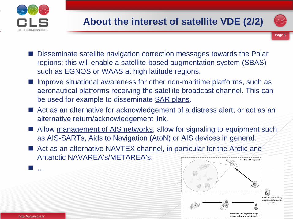
Disseminate satellite navigation correction messages towards the Polar regions: this will enable a satellite-based augmentation system (SBAS) such as EGNOS or WAAS at high latitude regions.
Improve situational awareness for other non-maritime platforms, such as aeronautical platforms receiving the satellite broadcast channel. This can be used for example to disseminate SAR plans.
Act as an alternative for acknowledgement of a distress alert, or act as an alternative return/acknowledgement link.
Allow management of AIS networks, allow for signaling to equipment such as AIS-SARTs, Aids to Navigation (AtoN) or AIS devices in general.
Act as an alternative NAVTEX channel, in particular for the Arctic and Antarctic NAVAREA’s/METAREA’s.
…

Page 7
CLS and Satellite VDE
CLS already deeply involved in VDES definition and design at IALA, ITU and IMO.
Currently under contract with the European Space Agency (ESA) to complete a preliminary study:
- Services definition & requirements- System design & requirements (space segment)- Operational concepts (+ orchestration with SafetyNET, NAVTEX
broadcasting services + interaction with terrestrial VDE operations)- ROM price

Page 8
VDES & corresponding channels
Page 9
Where we are now - preliminary outcomes
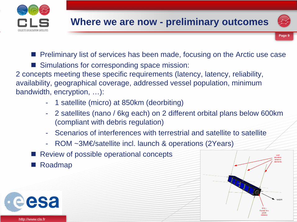
Preliminary list of services has been made, focusing on the Arctic use case
Simulations for corresponding space mission:
2 concepts meeting these specific requirements (latency, latency, reliability,availability, geographical coverage, addressed vessel population, minimum bandwidth, encryption, …):
- 1 satellite (micro) at 850km (deorbiting)- 2 satellites (nano / 6kg each) on 2 different orbital plans below 600km
(compliant with debris regulation) - Scenarios of interferences with terrestrial and satellite to satellite- ROM ~3M€/satellite incl. launch & operations (2Years)
Review of possible operational concepts
Roadmap
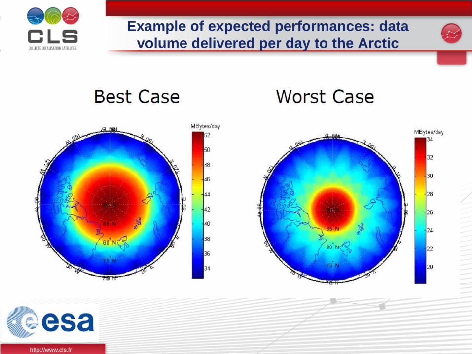
Example of expected performances: data volume delivered per day to the Arctic

Page 11
Next steps (1/2)
Agree on final frequency plan allocation and consolidate sharing studies especially with land mobile systems
Consolidate services and associated requirements
Review possible operational concepts, in coordination with terrestrial VDE developments
Financial viability (business case) and user feedbacks
Phase II to start Q1 2014 ESA & CLS are inviting main stakeholders to join the on-going study
in preparation of following-up testbed Letter of interest have been circulated, as per recommandations of Annex 1
of e-NAV14-17.1.7.1 (guideline on testbeds) to involve users and stakeholders at every stage.
Page 12
Next steps (2/2)
ESA is also preparing a demo mission for satellite VDE (procurement Q4 2014 / launch 2016-2017). Other national initiatives are also expected (in Europe and worldwide)
Planning is fully in line with:
- e-NAV SIP (3 phases implementation 2014-2020)- IMO and ITU milestones- European Horizon 2020 R&D framework program
Towards a dedicated VDES (incl. satellite VDE) testbed in Europe (and more ?)
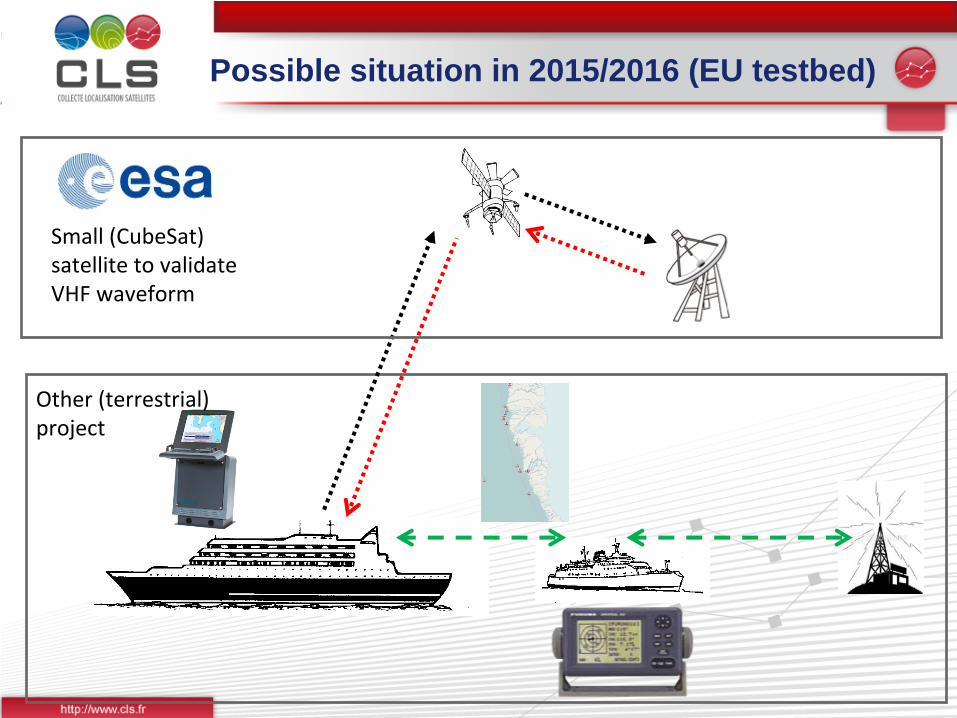
ESA projectSmall (CubeSat)
satellite to validate
VHF waveform
Other (terrestrial)
project
Possible situation in 2015/2016 (EU testbed)
Page 14
Why would satellite VDE happen ?
Increasing needs and VDL loading growing issue
e-Navigation and modernization of GMDSS open the door to new systems
On-going research activities to demonstrate the technical viability
Affordable satellite technology serving global needs. This is stimulating national space industries in several countries, towards a possible international cooperation (in kind contributions to a global system).
This may drive the overall viability of satellite VDE, for instance towards a non-profit (public services) scheme, similar to the Argos system (US, FR, EU, India cooperation).
We look forward exchanging with all interested parties to share views and take onboard all valuable inputs for the next steps !
