2.5 billion tonne inferred coal resource at · pdf file2.5 billion tonne inferred coal...
TRANSCRIPT
13th May 2014
2.5 BILLION TONNE INFERRED COAL RESOURCE AT SESE WEST
Highlights
Initial Inferred Coal Resource estimate of 2,501Mt at the Sese West Project.
Average calorific value of 14.6MJ/kg (3,500 kcal.kg) on an air‐dried basis.
Geological interpretation indicates that the Sese West Inferred Resource is the down dip extension of the nearby Sese coal deposit.
Inferred Resource remains open to the south where further drilling is required
The addition of the Sese West Inferred Resource takes African Energy’s total inventory coal resources to 8.7 billion tonnes.
Scoping study to determine development options at Sese West to commence in June.
1. BACKGROUND
African Energy Resources Limited (‘African Energy’ or ‘the Company’) owns four prospecting licences for
coal in Botswana (Diagram 1). The Company has completed an initial resource estimate for the Sese West
Coal Project in Botswana, where a 2.5 billion tonnes Inferred Resource has been defined at an average
calorific value of 14.6 MJ/kg. This Inferred Resource occurs approximately 2km to the south of the
Company’s Sese coal deposit (also 2.5 billion tonnes), and is considered to represent the down‐dip
extension of Sese (Diagrams 2 and 3).
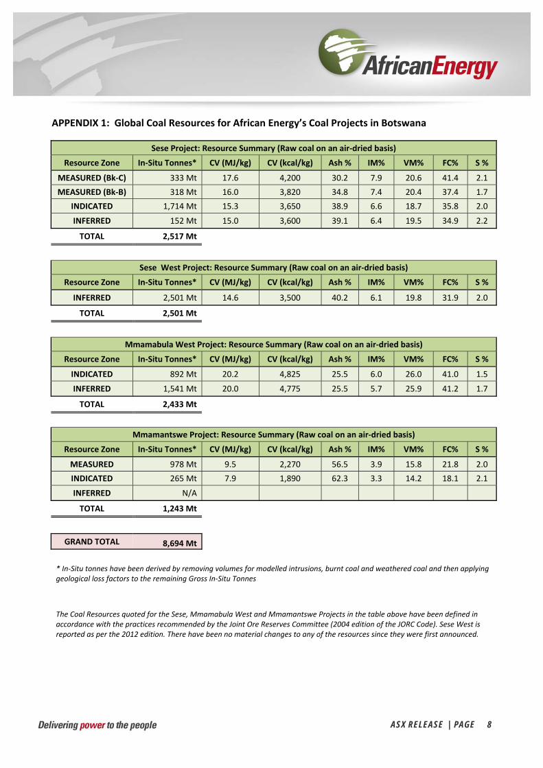
The addition of the Inferred Resource at Sese West takes African Energy’s total inventory of in‐situ coal to
8.7 billion tonnes (Appendix 1).
2. RESOURCE ESTIMATE AND COAL QUALITY
The Inferred Resource estimate at Sese West is based on data collected from fifteen vertical diamond drill
holes (Appendix 2). A summary of the Sese West Inferred Resource is given in the table below:

ASX RELEASE | PAGE 2
Sese West Project: Inferred Coal Resource Summary
Raw coal reported on an air‐dried basis
Resource Zone In‐Situ Tonnes*
CV (MJ/kg)
CV (kcal/kg)
Ash %
IM% VM% FC% S %
INFERRED 2,501 Mt 14.6 3,500 40.2 6.1 19.8 31.9 2.0
* In‐Situ tonnes have been derived by:
Applying a resource boundary limited to the 4 km by 4km average drillhole spacing within the bounds of the Sese West licence;
Removing volumes for modelled dolerite dykes and intrusions, burnt coal and weathered coal;
Applying cut‐offs to: o Seam thickness (>= 1m); o Calorific Value(>= 8 MJ/kg); and o Ash content <= 50%).
Applying a further geological loss factor of 15% to the remaining Gross In‐Situ Tonnes
3. SUMMARY OF RESOURCE ESTIMATION AND REPORTING CRITERIA
As per ASX Listing Rule 5.8 and the 2012 JORC reporting guidelines, a summary of the material information
used to estimate the Sese West Coal Resource is included below (for more detail please refer to Table 1,
Sections 1 to 3 included in Appendix 3).
Geology and geological interpretation
The Sese West coal deposit occurs in the northern belt of the Central Kalahari sub‐basin, one of several
Permo‐Carboniferous Gondwana depositional sub‐basins in the region. The coal resource occurs within
Lower Karoo aged sediments and is typified by a relatively thick coal zone occurring in close proximity to
the basal unconformity between the Karoo Supergroup and the Precambrian Basement. Sediments are
relatively flat‐lying with very gentle dips (<3°, average 0.5‐1°) towards the south (Diagram 3 – note vertical
exaggeration).
The coal zone is the principal interval of economic interest and comprises a number of sub‐zones or
“seams” and a series of “plies” that can be recognised across the deposit. The principal seams which can be
recognised are the Sese Main (SS), Sese Top (SST) and Sese Upper (SSU). The SSU and SST units are
separated by a carbonaceous unit containing minimal coal development which is regarded as an inter‐seam
“parting” which will likely be regarded as “waste” in any mining recovery operation. In general the coal
rank ranges from medium‐ to low‐volatile bituminous coal.
Key stratigraphic contacts were interpreted and correlated (“wireframed”) in 3D software modelling
packages. The seams and plies were correlated across the entire deposit area. Partings were selected
using a minimum interval of 0.5m between coal plies.
The licence area includes some dolerite intrusions and faulting with, on a macro‐scale, inferred
development of blocks representing half‐grabens and grabens. Several major dolerite dykes are present
based on geomagnetic evidence.

ASX RELEASE | PAGE 3
Drilling techniques and hole spacing
The Sese West deposit has been drilled using Polycrystalline Diamond open‐hole rotary mud drilling (PCD)
and diamond core drilling (DD). All but one of the 15 holes in the licence area (Diagram 2) were drilled by
African Energy in 2011 and 2012 and used PCD for pre‐collars with HQ sized diamond core collected
through the coal zones. One AFR hole was cored from surface. Shell Coal Botswana Pty Ltd (Shell) drilled
one cored hole (N11) in the licence area in 1976 as part of a regional exploration program.
Within the licence area, and including the Shell hole, there are 15 drill holes (points of observation) for
2,479m. Drill hole spacing within the reported resource area averages 4km by 4km (Diagram 2).
Logging and Sampling
Core holes were geologically logged for lithology, stratigraphy, oxidation, grain size and colour. In addition
intervals were logged for sorting, roundness, clast size, clast sorting, clast roundness, cement and mica
where appropriate. PCD chips were collected at 1 metre intervals at the rig and logged for lithology,
stratigraphy, oxidation, grain size and colour. All accessible boreholes were geophysically logged using a
combined density/gamma sonde with the objective of describing coal seam depth, thickness and quality.
Lithological logging was verified against downhole geophysical logs. The Shell hole was logged for lithology
only.
African Energy submitted whole core was submitted for coal quality analyses at ALS Global’s Witbank Coal
Laboratory located near Johannesburg, South Africa. No information is available for the sampling
methodology used for the Shell hole.
Sample analysis method
All African Energy core samples were analysed by ALS Global at their Witbank SANAS ISO 17025 accredited
laboratory. Coal analyses were conducted on air‐dried core samples to determine the Apparent Relative
Density, Proximate Analysis, Calorific Value and Total Sulphur. The Shell hole samples were also analysed
on an air‐dried basis for Apparent Relative Density, Proximate Analysis, Calorific Value and Total Sulphur
although no information is available regarding the laboratory at which they were analysed.
Estimation Methodology
The estimate was resolved into a 2‐D block model with 50m (E) x 50m (N) blocks and where the elevation
was set to 1m.
Coal structure (seam roof, floor and thickness) was modelled on seam composites using ARANZ Leapfrog
Geo software. The 50m x 50m block model grid was draped over each of the surfaces to determine an
elevation or thickness at each grid point. This information was then imported into the Surpac “structure”
block model.
Coal qualities were estimated by Inverse Distance Squared (“ID2”) on seam composites using GEOVIA
Surpac™ software.

ASX RELEASE | PAGE 4
Classification criteria
The Sese West Coal Resource has been classified as Inferred according to the 2012 Australasian Code for
Reporting of Exploration Results, Mineral Resources and Ore Reserves guidelines (JORC 2012). This is
primarily due to the current average spacing of 4km by 4km between observation points (drillholes). The
confidence in the understanding of geological and coal seam model (for the purposes of reporting an
Inferred Resource) is high when considering the available drillhole data from within the Sese West licence
itself and the extensively drilled and modelled adjacent (up‐dip) Sese Coal Deposit (also owned by African
Energy ‐ refer to the geological cross‐section depicted in Diagram 3).
Cut‐off grades
All seams were reported using the following cut‐off parameters:
1. Minimum composited seam thickness of 1m.
2. Minimum Calorific Value of 8 MJ/kg.
3. Maximum Ash of 50%.
A resource boundary limit was created within the bounds of the Sese West licence using the 4 km by 4km
average drillhole spacing as a guide and is shown in Diagram 2.
As per understanding generated from the adjacent Sese Coal Deposit area, buffer zones around the dolerite
dykes (interpreted from available magnetics data) have been created to allow for potential burnt areas of
the in situ coal. Two generations of dolerite dykes are interpreted and classed as major or minor. The
major dykes have a 250m buffer zone applied either side of the dyke and the minor dykes a 100m buffer
zone. Coal modelled within these buffer zones is excluded from the reported Gross Tonnes In‐Situ (GTIS)
resource.
In addition, a further 15% reduction in the reported resource has been applied for potential geological
losses. The reported resource is thus stated as Total Tonnes In‐Situ (TTIS).
Mining and metallurgical methods and parameters
Based on the depth to seam roof and the seam thickness modelled, the potential mining methods
considered to date are either open pit mining in the northern (shallowest) parts of the resource
transitioning to underground mining in the deeper southern areas. Further technical studies are required
to determine the optimal mining methods.
For any further information, please contact the Company directly on +61 8 6465 5500.
For and on behalf of the board.

COMPETEN
The Australasistandards, recReserves. The references to “
The informatiocompiled by MAustralian Insthas sufficient ewhich he is unExploration Rebased on his in
Diag
NT PERSON
ian Code for Recommendationsinformation co“Measured, Ind
on in this reporMr Lauritz Barnetitute of Geosciexperience whindertaking, to qesults, Mineral nformation in th
gram 1 – Loc
NS STATEME
eporting of Explos and guidelinesontained in this dicated and Infe
t relating to thees who is a consientists and theich is relevant toqualify as CompResources and he form and co
cation Map s
ENT
oration Results,s for Public Repannouncementerred Resources
e Sese West Prosultant to Africae Australasian Ino the style of metent Person asOre Reserves”. ontext in which
showing the other coal
s, Mineral Resouporting in Austrt has been press” are to those
oject exploratioan Energy Resonstitute of Minimineralisation as defined in the Mr Barnes conit appears.
location of tl deposits in
urces and Ore Rralasia of Explorsented in accordterms as define
on results and cources Limited.ing and Metallund type of depoe 2012 Edition onsents to the inc
the Sese WesBotswana.
A
Reserves (the ‘JOration Results, Mdance with the Jed in the JORC C
oal resources isMr Barnes is aurgy. Mr Barneosit under consiof the “Australaclusion in the AS
st Project and
ASX RELEASE
ORC Code’) setsMineral ResourJORC Code (201Code (2012 edit
s based on infora member of boes is a qualified ideration and tasian Code for RSX release of th
d the Compa
E | PAGE 5
s out minimumrces and Ore 12 edition) andtion).
rmation th the geologist and
to the activity Reporting of he matters
any’s
5
d

Diagr
am 2 – Plan showing Ses
se West drill
hole collar loocations and
A
d proximity to
ASX RELEASE
o Sese coal d
E | PAGE 6
deposit
6
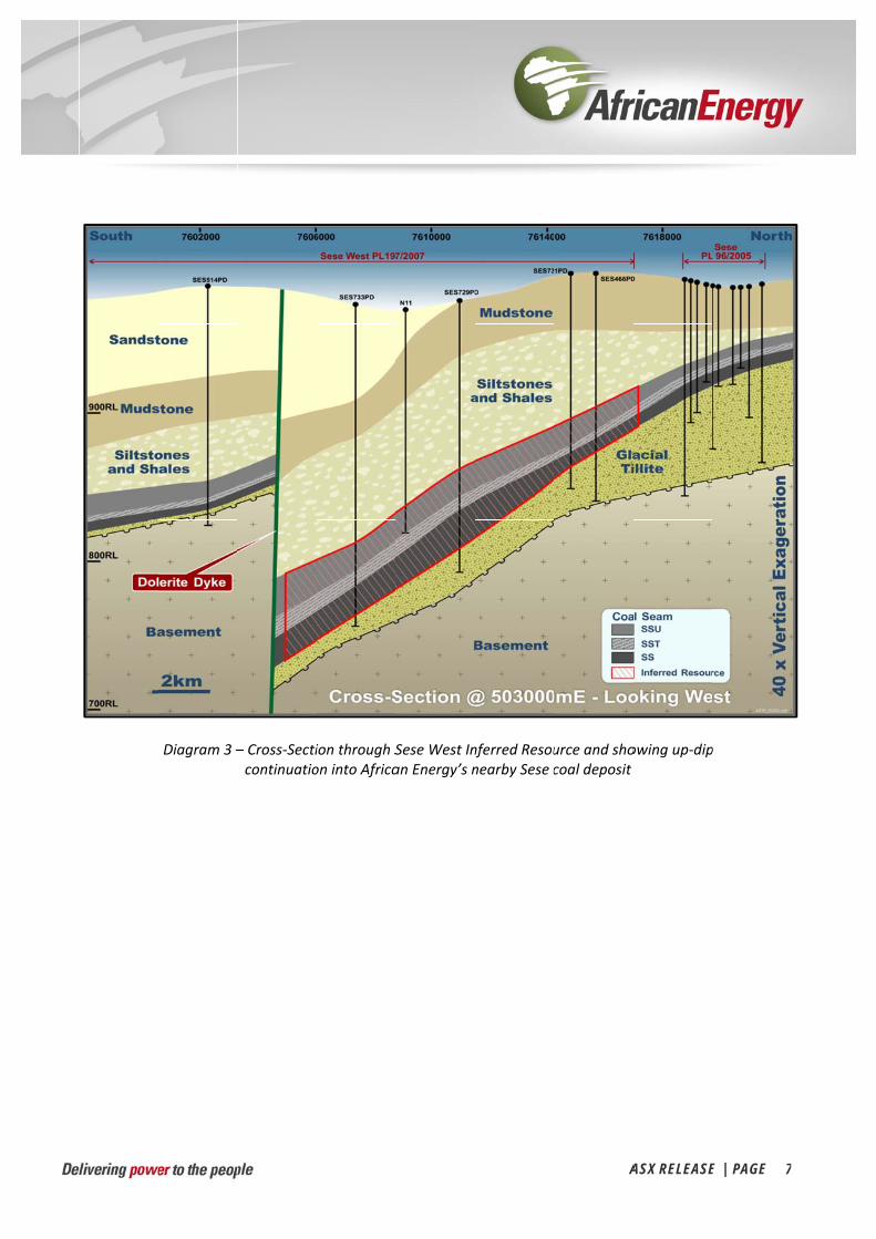
Diagram 3 –– Cross‐Secticontinuatio
ion through Son into Africa
Sese West Inan Energy’s n
nferred Resounearby Sese c
A
urce and shocoal deposit
ASX RELEASE
owing up‐dip
E | PAGE 7
p
7
ASX RELEASE | PAGE 8
APPENDIX 1: Global Coal Resources for African Energy’s Coal Projects in Botswana
Sese Project: Resource Summary (Raw coal on an air‐dried basis)
Resource Zone In‐Situ Tonnes* CV (MJ/kg) CV (kcal/kg) Ash % IM% VM% FC% S %
MEASURED (Bk‐C) 333 Mt 17.6 4,200 30.2 7.9 20.6 41.4 2.1
MEASURED (Bk‐B) 318 Mt 16.0 3,820 34.8 7.4 20.4 37.4 1.7
INDICATED 1,714 Mt 15.3 3,650 38.9 6.6 18.7 35.8 2.0
INFERRED 152 Mt 15.0 3,600 39.1 6.4 19.5 34.9 2.2
TOTAL 2,517 Mt
Sese West Project: Resource Summary (Raw coal on an air‐dried basis)
Resource Zone In‐Situ Tonnes* CV (MJ/kg) CV (kcal/kg) Ash % IM% VM% FC% S %
INFERRED 2,501 Mt 14.6 3,500 40.2 6.1 19.8 31.9 2.0
TOTAL 2,501 Mt
Mmamabula West Project: Resource Summary (Raw coal on an air‐dried basis)
Resource Zone In‐Situ Tonnes* CV (MJ/kg) CV (kcal/kg) Ash % IM% VM% FC% S %
INDICATED 892 Mt 20.2 4,825 25.5 6.0 26.0 41.0 1.5
INFERRED 1,541 Mt 20.0 4,775 25.5 5.7 25.9 41.2 1.7
TOTAL 2,433 Mt
Mmamantswe Project: Resource Summary (Raw coal on an air‐dried basis)
Resource Zone In‐Situ Tonnes* CV (MJ/kg) CV (kcal/kg) Ash % IM% VM% FC% S %
MEASURED 978 Mt 9.5 2,270 56.5 3.9 15.8 21.8 2.0
INDICATED 265 Mt 7.9 1,890 62.3 3.3 14.2 18.1 2.1
INFERRED N/A
TOTAL 1,243 Mt
GRAND TOTAL 8,694 Mt
* In‐Situ tonnes have been derived by removing volumes for modelled intrusions, burnt coal and weathered coal and then applying geological loss factors to the remaining Gross In‐Situ Tonnes
The Coal Resources quoted for the Sese, Mmamabula West and Mmamantswe Projects in the table above have been defined in accordance with the practices recommended by the Joint Ore Reserves Committee (2004 edition of the JORC Code). Sese West is reported as per the 2012 edition. There have been no material changes to any of the resources since they were first announced.

ASX RELEASE | PAGE 9
APPENDIX 2: List of drillholes and associated coal seam intercepts
Hole ID1 Easting2 Northing2 Elevation3 Max. Depth
(m) Seam
Depth to Seam Roof
(m)
Seam Thickness
(m)
Average CV
(MJ/kg)
Average Ash (%)
N11 503895 7609132 963 142.00 SSU 126.8 2.7 18.1 30.1
SES466PD 505831 7615754 984 141.48 SSU 94.0 0.7 12.8 43.9
SST 104.3 3.2 18.1 27.9
SS 118.1 15.1 18.9 26.5
SES509PD 497024 7617981 997 131.75 SSU 67.9 2.2 8.0 58.3
SST 80.1 2.2 14.3 39.5
SS 83.4 3.7 15.0 37.4
SES511PD 506719 7607672 957 271.72 SSU 136.3 1.7 11.4 48.3
SST 153.9 10.9 12.4 46.8
SS 169.2 14.3 15.6 38.1
SES512PD 499600 7609504 970 200.67 SSU 116.3 1.1 11.6 47.6
SST 131.1 7.4 12.8 45.0
SS 139.6 9.5 16.2 37.3
SES513PD 504070 7596999 985 184.86 SSU 142.0 0.3 6.7 62.3
SST 157.0 4.2 13.0 44.9
SS 163.7 2.3 10.2 54.8
SES514PD 502504 7602265 979 155.14 SSU 125.3 0.5 10.0 52.4
SST 137.7 2.0 12.4 46.0
SS 139.7 1.7 15.4 37.3
SES726PD 496550 7615900 996 134.94 SSU 89.9 3.2 12.0 49.9
SST 103.8 0.4 11.4 48.2
SS 111.5 9.1 14.9 41.3
SES727PD 496866 7612702 1002 148.53 SSU 96.0 1.0 12.1 46.1
SST 111.0 4.1 12.7 44.0
SS 118.2 6.2 12.0 49.7
SES728PD 499968 7616838 1002 185.62 SSU 133.4 1.8 13.1 45.2
SST 151.4 6.7 12.3 46.6
SS 162.2 14.0 19.2 26.7
SES729PD 504050 7611000 976 178.53 SSU 113.8 1.9 11.3 48.4
SST 132.1 5.9 12.9 46.5
SS 151.4 3.7 17.7 32.9
SES730PD 500760 7612768 981 146.24 SSU 87.8 1.8 12.7 44.1
SST 96.6 6.0 9.5 54.0
SS 108.2 3.1 15.0 37.1
SES731PD 504200 7614850 994 145.49 SSU 100.0 0.8 12.2 45.6
SST 117.0 3.7 7.7 62.6
SS 120.7 3.8 12.8 45.6
SES732PD 507692 7612966 977 103.55 SSU 93.2 3.9 18.9 30.5
SES733PD 503400 7607425 966 208.54 SSU 154.2 2.3 11.6 47.9
SST 171.9 10.7 13.8 42.0
SS 185.3 12.4 17.0 33.4
Notes: 1. African Energy drillholes with prefix SES, Shell drillhole with prefix N. All holes were drilled vertical. 2. Coordinates provided in WGS84 UTM Zone 35S 3. Elevation in metres above mean sea level

APPENDIX 3: JORC Code, 2012 Edition – Table 1 report
ASX RELEASE | PAGE 10
Section 1 – Sampling Techniques and Data
Criteria JORC Code explanation Commentary
Sampling techniques
Nature and quality of sampling (eg cut Faces, random chips, or specific specialised industry standard measurement tools appropriate to the minerals under investigation, such as down hole gamma sondes, or handheld XRF instruments, etc). These examples should not be taken as limiting the broad meaning of sampling.
Include reference to measures taken to ensure sample representivity and the appropriate calibration of any measurement tools or systems used.
Aspects of the determination of mineralisation that are Material to the Public Report.
In cases where ‘industry standard’ work has been done this would be relatively simple (eg ‘reverse circulation drilling was used to obtain 1 m samples from which 3 kg was pulverised to produce a 30 g charge for fire assay’). In other cases more explanation may be required, such as where there is coarse gold that has inherent sampling problems. Unusual commodities or mineralisation types (eg submarine nodules) may warrant disclosure of detailed information.
Two methods of drilling were used in the African Energy Resources Limited (AFR) Sese West drilling programmes, namely polycrystalline diamond open‐hole rotary mud drilling (PCD) and diamond core drilling (DD).
PCD was used as pre‐collars for diamond drilling. One AFR hole was cored from surface.
AFR submitted only core samples for laboratory analysis. Sampling of core holes commenced only after receipt of the borehole’s “down the hole” geophysical wire‐line log. Density contrasts as indicated by the geophysical logs in combination with lithological variations as indicated from visual inspection of the core and from the geology lithological log were used as the major parameters in determining sample intervals in the coal zones. In instances where no density logs were available (i.e. due to a blocked hole), then samples were selected on lithological variations as indicated from visual inspection of the core and from the geological log.
Coal analyses were conducted on air dried core samples at ALS Global Witbank Coal Laboratory using industry standard methods to determine the Apparent Relative Density (ARD), Proximate Analysis, Calorific Value (CV) & Total Sulphur.
Downhole geophysical wire‐line logs of RC and PCD were used to assist with the correlation of coal seams and calculation of CV and Ash values where PCD pre‐collars had drilled beyond initial coal intersections.
Historical holes drilled by Shell Coal Botswana Pty Ltd (Shell) were cored from surface. Lithological logs, as well as proximate and washing data have been obtained for the Shell holes.
Drilling techniques Drill type (eg core, reverse circulation, open‐hole hammer, rotary air blast, auger, Bangka, sonic, etc) and details (eg core diameter, triple or standard tube, depth of diamond tails, face‐sampling bit or other type, whether core is oriented and if so, by what method, etc).
PCD – 123mm diameter, drilled to the first indication of coal (15 holes)
DD consisted of wire‐line triple tube core drilling to produce HQ3 (15 holes).
All DD and PCD/DD holes were drilled vertically and as a result core holes were not routinely orientated.
The Shell holes were core holes. No further information is available.
To assist with continuity AFR incorporated the results of a further 4 core holes located in the Sese tenement and 3 historic Shell holes outside the licence areas in the structure and quality determinations.
Drill sample recovery
Method of recording and assessing core and chip sample recoveries and results assessed.
Measures taken to maximise sample recovery and ensure representative nature of the samples.
Whether a relationship exists between sample recovery and grade and whether sample bias may have occurred due to preferential loss/gain of fine/coarse
PCD chips were not submitted for analysis and as a result assessment of recovery is not material in assessing coal quality.
The drill site geologist monitored the drilling of each core run with the driller. On completion of each drilling run, the driller would supply a depth of hole which would be recorded on a core block inserted into the core tray at the relevant position.

APPENDIX 3: JORC Code, 2012 Edition – Table 1 report
ASX RELEASE | PAGE 11
Criteria JORC Code explanation Commentary
material. Core recovery and RQD measurements were completed by the geologist while the core was laid out on the drilling rack. The delivered core would be measured and a core recovery would be calculated. Where <95% recovery was achieved in a coal horizon then a re‐drill of the hole would, in general, be called for. In situations where poor ground conditions prevailed then a re‐drill may have been waived.
Triple tube rods were used for core drilling to maximise recovery.
No sample bias has been established.
No information is available for Shell holes.
Logging Whether core and chip samples have been geologically and geotechnically logged to a level of detail to support appropriate Mineral Resource estimation, mining studies and metallurgical studies.
Whether logging is qualitative or quantitative in nature. Core (or costean, Face, etc) photography.
The total length and percentage of the relevant intersections logged.
PCD chips were collected at 1 metre intervals at the rig and subsequently logged for lithology, stratigraphy, oxidation, grain size and colour. In addition intervals were logged for sorting, roundness, clast size, clast sorting, clast roundness, cement and mica where appropriate. Lithological logging was verified against downhole geophysical logs.
Core holes were geologically logged for lithology, stratigraphy, oxidation, grain size and colour. In addition intervals were logged for sorting, roundness, clast size, clast sorting, clast roundness, cement and mica where appropriate. Lithological logging was verified against downhole geophysical logs.
Core recoveries and RQD’s were logged for 9 of the 19 core holes. No material core recovery issues were identified.
Core photos are available for all the AFR drill core.
All accessible boreholes were geophysically logged using a density/gamma combination sonde with the objective of describing coal seam depth, thickness and quality. Geophysical logging was completed by Wellfield Consulting Services (Wellfield) of Gaborone, Botswana and by Gondwana Ventures (Pty) Ltd (GV) of Francistown, Botswana. For the initial Sese West holes, Wellfield originally deployed Robertson Geologging Sidewall Density sonde before September 2011. After September 2011 Wellfield used a Century Geophysical Corporation dual spaced density sonde. Holes SES726PD to SES733PD were logged by GV using a Robertson Geologging tool.
Shell core holes were logged for lithology only.
Drill holes have been logged to a level to support coal resource estimation.
Sub‐sampling techniques and sample preparation
If core, whether cut or sawn and whether quarter, half or all core taken.
If non‐core, whether riffled, tube sampled, rotary split, etc and whether sampled wet or dry.
For all sample types, the nature, quality and appropriateness of the sample preparation technique.
Quality control procedures adopted for all sub‐sampling stages to maximise representivity of samples.
Measures taken to ensure that the sampling is representative of the in situ
AFR submitted whole core for coal quality analyses. All samples were prepared and analysed at the ALS Global Witbank Coal Laboratory located near Johannesburg, South Africa. ALS Witbank is a SANAS ISO 17025 accredited laboratory.
Coal analyses were conducted on air dried core samples using industry standard methods to determine the Apparent Relative Density (ARD), Proximate Analysis, Calorific Value (CV) & Total Sulphur.
No information is available for Shell holes.
APPENDIX 3: JORC Code, 2012 Edition – Table 1 report
ASX RELEASE | PAGE 12
Criteria JORC Code explanation Commentary
material collected, including for instance results for field duplicate/second‐half sampling.
Whether sample sizes are appropriate to the grain size of the material being sampled.
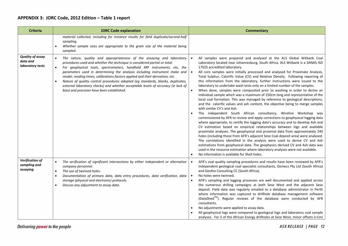
Quality of assay data and laboratory tests
The nature, quality and appropriateness of the assaying and laboratory procedures used and whether the technique is considered partial or total.
For geophysical tools, spectrometers, handheld XRF instruments, etc, the parameters used in determining the analysis including instrument make and model, reading times, calibrations factors applied and their derivation, etc.
Nature of quality control procedures adopted (eg standards, blanks, duplicates, external laboratory checks) and whether acceptable levels of accuracy (ie lack of bias) and precision have been established.
All samples were prepared and analysed at the ALS Global Witbank Coal Laboratory located near Johannesburg, South Africa. ALS Witbank is a SANAS ISO 17025 accredited laboratory.
All core samples were initially processed and analysed for Proximate Analysis, Total Sulphur, Calorific Value (CV) and Relative Density. Following reporting of this information from the laboratory, further instructions were issued to the laboratory to undertake wash tests only on a limited number of the samples.
When done, samples were composited prior to washing in order to derive an individual sample which was a maximum of 250cm long and representative of the local coal formation. This was managed by reference to geological descriptions, and the calorific values and ash content, the objective being to merge samples with similar CV’s and Ash.
The independent South African consultancy, Wireline Workshop was commissioned by AFR to review and apply corrections to geophysical logging data where appropriate, to certify the logging data’s accuracy and to develop Ash and CV estimation based on empirical relationships between logs and available proximate analyses. The geophysical and proximal data from approximately 240 holes (including those from AFR’s adjacent Sese Coal deposit area) were analysed. The correlations identified in the analysis were used to derive CV and Ash estimations from geophysical data. The geophysics derived CV and Ash data was used in the resource estimation where laboratory analyses were not available.
No information is available for Shell holes.
Verification of sampling and assaying
The verification of significant intersections by either independent or alternative company personnel.
The use of twinned holes.
Documentation of primary data, data entry procedures, data verification, data storage (physical and electronic) protocols.
Discuss any adjustment to assay data.
AFR’s coal quality sampling procedures and results have been reviewed by AFR’s independent geological coal specialist consultants, Gemecs Pty Ltd (South Africa) and Geofox Consulting CC (South Africa).
No holes were twinned.
AFR’s sampling and logging processes are well documented and applied across the numerous drilling campaigns at both Sese West and the adjacent Sese deposit. Field data was regularly emailed to a database administrator in Perth where information was captured to drillhole database management software (DataShed
TM). Regular reviews of the database were conducted by AFR consultants.
No adjustments were applied to assay data.
All geophysical logs were compared to geological logs and laboratory coal sample analyses. For 5 of the African Energy drillholes at Sese West, minor offsets (<1m)

APPENDIX 3: JORC Code, 2012 Edition – Table 1 report
ASX RELEASE | PAGE 13
Criteria JORC Code explanation Commentary
were identified between the geophysical log depths and the geological logs / laboratory coal sample analyses – this was readily identifiable by comparing the downhole density logs with the logged coal intervals and analysed samples. The drill core samples were selected as the correct depth and depth corrections were applied to geophysical logs.
Location of data points
Accuracy and quality of surveys used to locate drill holes (collar and down‐hole surveys), trenches, mine workings and other locations used in Mineral Resource estimation.
Specification of the grid system used.
Quality and adequacy of topographic control.
The standard coordinate system for the Sese Coal Project is Universal Transverse Mercator projection (Zone 35S) using datum WGS84.
Hole positions were surveyed using a combination of GPS and DGPS.
Topographic information was sourced from the Shuttle Radar Topography Mission (SRTM) website from the US Geological Survey’s EROS Data Centre (http://srtm.usgs.gov/index.php).
All holes were draped to the SRTM Digital Elevation Model. The difference between the draped and DGPS RL was relatively consistent and averaged around 3m. Draped collars were used in the resource estimation.
The quality and adequacy of topographical control has been deemed adequate for use for Inferred Resources.
Data spacing and distribution
Data spacing for reporting of Exploration Results.
Whether the data spacing and distribution is sufficient to establish the degree of geological and grade continuity appropriate for the Mineral Resource and Ore Reserve estimation procedure(s) and classifications applied.
Whether sample compositing has been applied.
Drillhole spacing at Sese West is approximately 4km x 4km. The spacing of points of observation is sufficient for the establishment of grade and geological continuity considering the style and classification of the coal resource.
Multiple samples were often taken per drill hole for individual seams. Length and density weighted sample compositing was applied to obtain overall seam quality information for the points of observation.
Orientation of data in relation to geological structure
Whether the orientation of sampling achieves unbiased sampling of possible structures and the extent to which this is known, considering the deposit type.
If the relationship between the drilling orientation and the orientation of key mineralised structures is considered to have introduced a sampling bias, this should be assessed and reported if material.
The coal seams at Sese West are parallel stratigraphic layers with shallow dip (less than 1
o). Drill holes are all orientated vertically resulting in near true width intersections. Considering the geological and structural setting of the coal seams, the orientation of drill holes relative to the seams is likely to have achieved unbiased sampling.
Sample security The measures taken to ensure sample security. After collection at the field camp all core samples were dispatched by vehicle to the town office in Francistown, where the required export and permit documentation were processed prior to the samples being dispatched by courier to South Africa (to ALS Global’s Witbank Laboratory). A Francistown based courier collected samples at the office in Francistown and delivered them to ALS in South Africa.
Audits or reviews The results of any audits or reviews of sampling techniques and data. Site visits were completed by senior personnel from AFR’s independent geological coal specialist consultants, Gemecs Pty Ltd (South Africa) and Geofox Consulting CC (South Africa). Geophysical data was audited by specialist independent wireline logging consultancy, Wireline Workshop (South Africa).
APPENDIX 3: JORC Code, 2012 Edition – Table 1 report
ASX RELEASE | PAGE 14
Section 2 ‐ Reporting of Exploration Results
(Criteria listed in the preceding section also apply to this section.)
Criteria JORC Code explanation Commentary
Mineral tenement and land tenure status
Type, reference name/number, location and ownership including agreements or material issues with third parties such as joint ventures, partnerships, overriding royalties, native title interests, historical sites
The security of the tenure held at the time of reporting along with any known impediments to obtaining a licence to operate in the area.
Sese West is located on Prospecting Licence PL197/2007 (100% owned by AFR) which covers approximately 230 km2.
To the best of the Company’s knowledge, the project is not subject to encumbrances (other than standard government royalties).
Exploration done by other parties
Acknowledgment and appraisal of exploration by other parties. During the mid‐1970’s, Shell conducted a regional traverse of drilling in the Sese area and completed 24 bore holes between Foley and Orapa. Samples from the holes were analysed and reported but Shell considered the coal quality to not be of interest at the time.
No further exploration has been completed in the licence area until African Energy’s recent exploration and drilling programs.
Geology Deposit type, geological setting and style of mineralisation. The Sese coal deposits occur in the northern belt of the Central Kalahari sub‐basin, one of several Permo‐Carboniferous Gondwana depositional sub‐basins in the region. The coal resource occurs within Lower Karoo aged sediments and is typified by a relatively thick coal zone occurring in close proximity to the basal unconformity between the Karoo Supergroup and the Precambrian Basement. Sediments are relatively flat‐lying with mostly gentle dips (<3°, average 0.5‐1°) towards the south.
The Sese deposits are interpreted to have formed under inferred temperate climatic conditions in a fluvio‐deltaic to lacustrine palæo‐environment possibly partially concurrent with rift‐basin development. Available evidence suggests that the Sese coals represent a predominantly flood‐plain or meander‐belt type deposit with the extensive development of peat swamps towards the base of the “coal measures” sequence.
The coal zone is the principal interval of economic interest and comprises a number of sub‐zones or “seams” and a series of “plies” can be recognised across the deposit. The principal sub‐zones or ”seams” which can be recognised are the Sese Main (SS), Sese Top or “Ryder” (SST) and Sese Upper (SSU). The SSU and SST units are separated by a carbonaceous unit containing minimal coal development which is regarded as an inter‐seam “Parting” which will likely be regarded as “waste” in any mining recovery operation. In general the coal rank ranges from medium‐ to low‐volatile bituminous perhaps verging onto sub‐bituminous.
Drill hole Information
A summary of all information material to the understanding of the exploration results including a tabulation of the following information for all Material drill
Refer to Appendix 2.

APPENDIX 3: JORC Code, 2012 Edition – Table 1 report
ASX RELEASE | PAGE 15
Criteria JORC Code explanation Commentary
holes, including easting and northing of the drill hole collar, elevation or RL (Reduced Level – elevation above sea level in metres) of the drill hole collar, dip and azimuth of the hole, down hole length and interception depth plus hole length.
If the exclusion of this information is justified on the basis that the information is not Material and this exclusion does not detract from the understanding of the report, the Competent Person should clearly explain why this is the case.
Data aggregation methods
In reporting Exploration Results, weighting averaging techniques, maximum and/or minimum grade truncations (eg cutting of high grades) and cut‐off grades are usually Material and should be stated.
Where aggregate intercepts incorporate short lengths of high grade results and longer lengths of low grade results, the procedure used for such aggregation should be stated and some typical examples of such aggregations should be shown in detail.
The assumptions used for any reporting of metal equivalent values should be clearly stated.
Length weighted averages were used to report exploration results.
No minimum seam thickness was applied when interpreting the geological model and correlating the seams across the Sese West deposit area.
Partings were selected using a minimum interval of 0.5m between coal plies.
Cut‐off were applied to seam thickness and coal qualities in the resource reporting – see below.
Relationship between mineralisation widths and intercept lengths
These relationships are particularly important in the reporting of Exploration Results.
If the geometry of the mineralisation with respect to the drill hole angle is known, its nature should be reported.
If it is not known and only the down hole lengths are reported, there should be a clear statement to this effect (eg ‘down hole length, true width not known’).
Vertical drill holes have intersected coal seams nearly perpendicularly due to the shallow dip of seams (<1
o). All vertical drillhole intervals reported can therefore be regarded as true width.
Diagrams Appropriate maps and sections (with scales) and tabulations of intercepts should be included for any significant discovery being reported These should include, but not be limited to a plan view of drill hole collar locations and appropriate sectional views.
Refer to Diagrams 2 and 3 ‐ and Appendix 2.
Balanced reporting Where comprehensive reporting of all Exploration Results is not practicable, representative reporting of both low and high grades and/or widths should be practiced to avoid misleading reporting of Exploration Results.
Comprehensive reporting of drill details has been provided in the drill results reported in Appendix 2.
Other substantive exploration data
Other exploration data, if meaningful and material, should be reported including (but not limited to): geological observations; geophysical survey results; geochemical survey results; bulk samples – size and method of treatment; metallurgical test results; bulk density, groundwater, geotechnical and rock characteristics; potential deleterious or contaminating substances.
All meaningful and material exploration data have been reported.
Further work The nature and scale of planned further work (eg tests for lateral extensions or depth extensions or large‐scale step‐out drilling).
Diagrams clearly highlighting the areas of possible extensions, including the main
Diagrams 2 and 3 show drillholes SES513PD and SES514PD within the Sese West Prospecting Licence but to the south of the reported coal resource area. Both of these drillholes intersected the same stratigraphy and all three coal seams

APPENDIX 3: JORC Code, 2012 Edition – Table 1 report
ASX RELEASE | PAGE 16
Criteria JORC Code explanation Commentary
geological interpretations and future drilling areas, provided this information is not commercially sensitive.
modelled in the Sese West coal resource but the area will require additional drillholes to allow for definition of further coal resources.
No further exploration work is currently planned.
Section 3 ‐ Estimation and Reporting of Mineral Resources
(Criteria listed in section 1, and where relevant in section 2, also apply to this section.)
Criteria JORC Code explanation Commentary
Database integrity Measures taken to ensure that data has not been corrupted by, for example, transcription or keying errors, between its initial collection and its use for Mineral Resource estimation purposes.
Data validation procedures used.
Field data was regularly emailed to a database administrator in Perth where information was captured to drillhole database management software (DataShedTM). Extensive reviews of the database were conducted by AFR consultants.
Lithological and sampling intervals were compared against downhole geophysical logs. Suspected data entry errors were identified, investigated and where appropriate corrected.
Laboratory generated CV and Ash data was plotted against CV and Ash generated from geophysical probe data as an additional quality control check.
Site visits Comment on any site visits undertaken by the Competent Person and the outcome of those visits.
The Competent Person for this resource, Lauritz Barnes, visited the site twice in 2011 (August and October) plus in February 2012. Site visits typically lasted for 1 to 2 weeks.
During site visits, all aspects of field activities including drilling practices, geological logging and sampling procedures and downhole logging were inspected.
Geological interpretation
Confidence in (or conversely, the uncertainty of) the geological interpretation of the mineral deposit.
Nature of the data used and of any assumptions made.
The effect, if any, of alternative interpretations on Mineral Resource estimation.
The use of geology in guiding and controlling Mineral Resource estimation.
The factors affecting continuity both of grade and geology.
The general procedure for geological evaluation of coal resources were as follows:
o Capture, verification and tabulation of borehole data. o Determination of indicated geological trends and anticipated coal resource
limits. o Review of geological structures affecting the coal deposits and
interpretation of geological structure (dolerite sills and dykes). o Interpretation and review of borehole data (physical and chemical
properties of the coal). o Re‐correlation of coal “zones” and seams/”plies” to conform to a
“standard” nomenclature. o Processing of borehole data in terms of Coal Seams and Coal “Plies”.
Geological modelling was performed using GEOVIA Surpac™.
The coal seams modelled Sese Upper (SSU), Sese Top (SST), the Sese Seam (SS)

APPENDIX 3: JORC Code, 2012 Edition – Table 1 report
ASX RELEASE | PAGE 17
Criteria JORC Code explanation Commentary
and also the Sese Lower Seam (SSL). Due to its limited seam thickness, the SSL is excluded from the Sese West coal resource reporting.
Sufficient confidence in the geological interpretation and continuity exist to support the classification of the Inferred Coal Resource.
Dimensions The extent and variability of the Mineral Resource expressed as length (along strike or otherwise), plan width, and depth below surface to the upper and lower limits of the Mineral Resource.
The Sese West Coal Resource strikes for approximately 15 x 10km and dips very gently to the south. The average depth to the SSU seam in the resource area is approximately 112m (minimum of 68m and maximum of 154m), while the average depth to the SST seam is 127m (minimum of 80m and maximum of 172m) and the SS seam is 136m (minimum of 83m and maximum of 185m). The package containing coal seems (including partings) extend vertically for approximately 50m.
Estimation and modelling techniques
The nature and appropriateness of the estimation technique(s) applied and key assumptions, including treatment of extreme grade values, domaining, interpolation parameters and maximum distance of extrapolation from data points. If a computer assisted estimation method was chosen include a description of computer software and parameters used.
The availability of check estimates, previous estimates and/or mine production records and whether the Mineral Resource estimate takes appropriate account of such data.
The assumptions made regarding recovery of by‐products.
Estimation of deleterious elements or other non‐grade variables of economic significance (eg sulphur for acid mine drainage characterisation).
In the case of block model interpolation, the block size in relation to the average sample spacing and the search employed.
Any assumptions behind modelling of selective mining units.
Any assumptions about correlation between variables.
Description of how the geological interpretation was used to control the resource estimates.
Discussion of basis for using or not using grade cutting or capping.
The process of validation, the checking process used, the comparison of model data to drill hole data, and use of reconciliation data if available.
A two‐dimensional block model (consisting of a single 1m block in the Z direction) was created for the purpose of estimating and reporting quality and structure using GEOVIA Surpac™. Laterally blocks sizes were set to 50m (X) by 50m (Y).
For each coal seam a roof, floor and composite ply thickness surface was created in ARANZ Leapfrog Geo software using the points of observation obtained from drilling data. The 50m x 50m block model grid was draped over each of the surfaces to determine an elevation or thickness at each grid point. This information was then imported into the Surpac “structure” block model as an attribute.
Raw coal qualities were estimated in the “quality” block model for each seam using the Inverse Distance Squared (ID2) interpolation method in GEOVIA Surpac™. Qualities modelled and reported are: RD (Relative density), CV (Calorific Value), AS (Ash), IM (Inherit Moisture), VM (Volatile matter) and TS (Total Sulphur. All qualities reported are on an air‐dried basis. FC (Fixed carbon) is reported as difference.
Known basement areas were used to exclude coal resources on the adjacent Sese coal deposit but this was not necessary for the Sese West Coal Resource as the coal seams overlaid the basement rocks over the entire deposit area.
Physical coal parameter limits or cut‐offs were applied to the In Situ tonnage estimation as follows:
o Minimum seam thickness of 1m un‐weathered coal to define seam limits. o Buffer areas around dolerites dykes. Major dykes are buffered 250m
either side of the dyke and minor dykes are buffered 100m either side of the dyke. These distances are based on detailed airborne magnetics surveys and dolerite dyke and sill targeted drilling and sampling from the adjacent Sese Coal deposit. Any coal modelled within these buffer zones were excluded from the coal resource reporting.
o Prospecting Permit boundaries.

APPENDIX 3: JORC Code, 2012 Edition – Table 1 report
ASX RELEASE | PAGE 18
Criteria JORC Code explanation Commentary
o A resource area defined by the maximum allowed 4km by 4km average drillhole spacing (see Diagram XX).
Moisture Whether the tonnages are estimated on a dry basis or with natural moisture, and the method of determination of the moisture content.
Tonnages are estimated on an air dried basis.
Cut‐off parameters The basis of the adopted cut‐off grade(s) or quality parameters applied. Coal quality cut‐offs were applied to the In Situ tonnage estimation as follows: o Composited seam thickness of greater than or equal to 1m. o Ash (%) less than or equal to 50%. o Calorific Value greater than or equal to 8 MJ/kg.
In addition, a further 15% reduction in the reported resource has been applied for potential geological losses. The reported resource is thus stated as TTIS (total tonnes in‐situ).
Mining factors or assumptions
Assumptions made regarding possible mining methods, minimum mining dimensions and internal (or, if applicable, external) mining dilution. It is always necessary as part of the process of determining reasonable prospects for eventual economic extraction to consider potential mining methods, but the assumptions made regarding mining methods and parameters when estimating Mineral Resources may not always be rigorous. Where this is the case, this should be reported with an explanation of the basis of the mining assumptions made.
Based on the depth to seam roof and the seam thickness modelled, the potential mining methods considered to date are either open pit mining in the northern (shallowest) parts of the resource transitioning to underground mining in the deeper southern areas. Further technical studies are required to determine the optimal mining methods.
A minimum seam thickness of 1m was applied to the resource in order to reflect the reduced selectivity associated with underground mining of coal seams.
Metallurgical factors or assumptions
The basis for assumptions or predictions regarding metallurgical amenability. It is always necessary as part of the process of determining reasonable prospects for eventual economic extraction to consider potential metallurgical methods, but the assumptions regarding metallurgical treatment processes and parameters made when reporting Mineral Resources may not always be rigorous. Where this is the case, this should be reported with an explanation of the basis of the metallurgical assumptions made.
Detailed processing test work has been completed using coal from the Sese deposit located to the North and East of Sese West Coal Resource. Sese deposit coal has been demonstrated to be suitable feedstock for power generation and the potential also exists to create an export quality product through washing.
Raw quality characteristics of the Sese West coal is similar to that of the Sese coal seams.
Environmental factors or assumptions
Assumptions made regarding possible waste and process residue disposal options. It is always necessary as part of the process of determining reasonable prospects for eventual economic extraction to consider the potential environmental impacts of the mining and processing operation. While at this stage the determination of potential environmental impacts, particularly for a greenfields project, may not always be well advanced, the status of early consideration of these potential environmental impacts should be reported. Where these aspects have not been considered this should be reported with an explanation of the environmental assumptions made.
At the current stage of the project there are no limiting environmental factors.
Bulk density Whether assumed or determined. If assumed, the basis for the assumptions. If determined, the method used, whether wet or dry, the frequency of the measurements, the nature, size and representativeness of the samples.
The bulk density for bulk material must have been measured by methods that
Air dried Apparent Relative Densities (ARD’s) were determined at ALS Witbank using the standard Archimedes method.
Where coal intersections were drilled with PCD and as a result not sampled, intersection densities were calculated using Long Spaced Density (LSD) obtained
APPENDIX 3: JORC Code, 2012 Edition – Table 1 report
ASX RELEASE | PAGE 19
Criteria JORC Code explanation Commentary
adequately account for void spaces (vugs, porosity, etc), moisture and differences between rock and alteration zones within the deposit.
Discuss assumptions for bulk density estimates used in the evaluation process of the different materials.
from the geophysical probe.
Weighted average densities were calculated for each seam at the points of observation. Densities for each seam were subsequently estimated to the Block Model using the ID2 Method.
Classification The basis for the classification of the Mineral Resources into varying confidence categories.
Whether appropriate account has been taken of all relevant factors (ie relative confidence in tonnage/grade estimations, reliability of input data, confidence in continuity of geology and metal values, quality, quantity and distribution of the data).
Whether the result appropriately reflects the Competent Person’s view of the deposit.
An Inferred Coal Resource has been estimated for the Sese West deposit. The resource adequately reflects the confidence as determined by the drill spacing and the geological model.
The Coal Resource estimate appropriately reflects the Competent Person’s view of the deposit.
Audits or reviews The results of any audits or reviews of Mineral Resource estimates. No 3rd party reviews or audits of the resource have been completed. External
audits and reviews for Sese West is limited to geophysical probe data, drilling and sampling practices and database integrity.
Discussion of relative accuracy/ confidence
Where appropriate a statement of the relative accuracy and confidence level in the Mineral Resource estimate using an approach or procedure deemed appropriate by the Competent Person. For example, the application of statistical or geostatistical procedures to quantify the relative accuracy of the resource within stated confidence limits, or, if such an approach is not deemed appropriate, a qualitative discussion of the factors that could affect the relative accuracy and confidence of the estimate.
The statement should specify whether it relates to global or local estimates, and, if local, state the relevant tonnages, which should be relevant to technical and economic evaluation. Documentation should include assumptions made and the procedures used.
These statements of relative accuracy and confidence of the estimate should be compared with production data, where available.
The relative accuracy of the Coal Resource estimate is reflected in the reporting of the Coal Resource as per the guidelines of the 2012 JORC Code.
The statement relates to global estimates of tonnes and grade.
No production data is available.