2.4-2 methodology 2.4-2.1 analysis overview · shaft and bypass tunnel ... potential nighttime...
TRANSCRIPT
2.4-1
Chapter 2: Probable Impacts of Project 1, Shaft and Bypass Tunnel Construction
Section 2.4: Visual Character
2.4-1 INTRODUCTION
This section of Chapter 2 discusses the potential impacts on visual character during construction of Project 1, Shaft and Bypass Tunnel Construction. The visual character of an area is defined by its urban design and visual resources.
Construction activity would be visible at both the west connection site and east connection site, and, therefore, this section considers Project 1’s effects on the visual character of both sites and their surrounding communities.
In addition, this section considers the potential for visual changes resulting from the tree removal being undertaken as part of Project 1. Potential nighttime lighting impacts from Project 1 are also considered.
This chapter is organized as follows:
Section 2.4-2, “Methodology,” provides a discussion of the New York City Environmental Quality Review (CEQR) Technical Manual and New York State Department of Environmental Conservation (NYSDEC) guidelines used in the analysis.
Sections 2.4-3, “West of Hudson,” and 2.4-4, “East of Hudson” provide the analyses of the potential for Project 1 to affect visual resources.
Section 2.4-4, “Conclusions,” summarizes the conclusions of the analysis.
2.4-2 METHODOLOGY
2.4-2.1 ANALYSIS OVERVIEW
Typically, in both New York City Environmental Quality Review (CEQR) and the New York State Environmental Quality Review Act (SEQRA), an analysis of a project’s construction-period effects on visual character is not undertaken. However, because Project 1, Shaft and Bypass Tunnel Construction would occur over a period of seven and a half years and would include periods of extended work hours such that night lighting would be required, an assessment of Project 1’s effects on visual character in the areas surrounding the west and east connection sites has been undertaken. In addition, views of the east connection site from the Hudson River have been assessed. Since there are no publicly accessible views of the east

Water for the Future Program: Delaware Aqueduct Rondout-West Branch Tunnel Repair FEIS
2.4-2
connection site from the west side of the river, no visual assessment of the east connection site from the west side of the river has been undertaken.
Neither the CEQR Technical Manual (January 2012) nor the NYSDEC Visual Impact Assessment Methodology, Assessing and Mitigating Visual Impacts, accounts for impacts associated with construction. Both guidance documents focus on assessing the potential permanent effects from new facilities. More specifically, the CEQR Technical Manual approach focuses on whether the pedestrian experience would be negatively affected, and the NYSDEC approach assesses whether there would be adverse impact to aesthetic resources of statewide significance. However, this analysis will apply these guidelines to Project 1 construction.
This analysis describes the CEQR and NYSDEC guidance (see sections 2.4-2.2 and 2.4-2.3). The visual character analysis then focuses on a description of existing conditions within defined study areas (see section 2.4-2.4 for a description of how the study areas were selected) and includes photographs of existing conditions from several viewpoints in the west of Hudson and east of Hudson study areas, projects conditions in the future without Project 1, and then describes the effects of Project 1on the visual character within the study areas. Graphics of the proposed construction effort are included.
The potential for lighting impacts is also considered as part of this analysis. The analysis considers any local applicable codes, the most recent edition of the Illuminating Engineering Society Handbook, and the most recent edition of the American National Practice for Roadway Lighting (RP-8) approved by the American National Standards Institute (ANSI). Lighting plans for the west and east connection sites showing the locations of lighting fixtures and illumination levels on the site will also be presented.
2.4-2.2 CEQR TECHNICAL MANUAL GUIDELINES
As defined in the CEQR Technical Manual, urban design is the totality of components that may affect a pedestrian’s experience of public space. These components include the following:
Streets—the arrangement and orientation of streets define location, flow of activity, street views, and create blocks on which buildings and open spaces are arranged. Other elements, including sidewalks, plantings, street lights, curb cuts, and street furniture, also contribute to an area’s streetscape.
Buildings—A building’s size, shape, setbacks, pedestrian and vehicular entrances, lot coverage, and orientation to the street are important urban design components that define the appearance of the built environment.
Visual Resources—visual resources include significant natural or built features, including important views corridors, public parks, landmarks structures or districts, or otherwise distinct buildings.
Open Space—open space includes public and private areas that do not include structures, including parks and other landscaped areas, cemeteries, and parking lots.

Chapter2: Probable Impacts of Project 1, Shaft and Bypass Tunnel Construction
Section 2.4: Visual Character
2.4-3
Natural Features—natural features include vegetation, and geologic and aquatic features that are natural to the area.
Sunlight and wind conditions also affect the pedestrian experience of a given area.
The CEQR Technical Manual suggests that a preliminary assessment of urban design is needed when a project may have an effect on one or more of the elements that contribute to the pedestrian experience described above.
Within Project 1’s study areas, pedestrian activity is limited due to the rural/suburban character of the land uses. Further, the study areas do not contain sidewalks or uses that would promote or encourage pedestrian activity, although there is occasional pedestrian activity on the streets. Due to the limited pedestrian presence on study area roadways, the visual assessment focuses largely on the potential for Project 1 to affect aesthetic and visual resources within the study areas.
2.4-2.3 NYSDEC GUIDELINES
NYSDEC has developed a methodology for assessing and mitigating visual impacts (DEP-00-2).1 This policy was developed for NYSDEC review of actions and defines what visual and aesthetic impacts are, describes when a visual assessment is necessary and how to review a visual impact assessment, differentiates State and local concerns, and defines avoidance, mitigation and offset measures that eliminate, reduce or compensate for negative visual effects. The methodology and impact assessment criteria established by the policy are comprehensive and can be used by other state and local agencies to assess potential impacts.
According to DEP-00-2, certain variables can affect a viewer’s perception of an object or project and the visibility of that object or project in the overall viewshed; these variables include the character of the landscape (existing vegetation, buildings, and topography), size perspective (reduction of apparent size of objects as distance increases), and atmospheric perspective2. Consequently, according to the NYSDEC guidance, an “impact” would occur when there is a detrimental effect on an aesthetic resource that interferes with or reduces the public’s enjoyment of a resource and when the mitigating1 effects of perspective, such as vegetation, distance, and atmospheric perspective or other designed mitigation, do not reduce the visibility of a project to
1 DEP-00-2, “Assessing and Mitigating Visual Impacts,” July 31, 2000. Accessible at
www.dec.ny.gov/docs/permits_ej_operations_pdf/visual2000.pdf.
2 DEP-00-2 describes atmospheric perspective as the “reduction in intensity of colors and the contrast between light and dark as the distance of the objects from the observer increases.” This phenomenon is a product of the natural particles within the atmosphere that scatter light and minimize the significance of the project in the overall viewshed as one moves further away from the project.
3 DEP-00-2 uses the term “mitigating” or “mitigation” to refer to design parameters that avoid or reduce potential visibility of a project. This should not be confused with the use of the term “mitigation” with respect to mitigation of significant adverse environmental impacts as required by SEQRA.

Water for the Future Program: Delaware Aqueduct Rondout-West Branch Tunnel Repair FEIS
2.4-4
insignificant levels. However, it is also noted that visibility of a project, even startling visibility, would not necessarily result in a visual impact.
Therefore, while the construction of Project 1 may be visible, that alone is not a threshold of significance. A determination of significance depends on several factors: presence of designated historic or scenic resources within the viewshed of the project, distance, general characteristics of the surrounding landscape, and the extent to which the visibility of the project interferes with the public’s enjoyment or appreciation of the resource. A significant adverse visual impact would only occur when the effects of design, distance, and intervening topography and vegetation do not minimize the visibility of an object and the visibility significantly detracts from the public’s enjoyment of a resource (e.g., a cooling tower plume blocks a view from a State Park overlook, resulting in a diminishment of the public enjoyment and appreciation of the State Park or an impairment of the character or quality of such a place).4 Typically, these guidelines are applied to the permanent change to a site, but are being used here as a tool to evaluate impacts during construction.
AESTHETIC AND VISUAL RESOURCE INVENTORY
The NYSDEC guidance provides a list of 15 categories of state aesthetic and visual resources that should be evaluated. In addition, the guidance discusses evaluation of local resources and notes that the Hudson River has been designated as an American Heritage River. While NYSDEC provides no specific guidance for evaluating American Heritage Rivers, views from the Hudson River are considered as part of this analysis of visual character. An inventory of sensitive aesthetic and visual resources was prepared following the guidance in NYSDEC Program Policy.5 The following aesthetic and visual resources have been identified and analyzed to determine the potential impacts of Project 1:
State/National Register of Historic Places
Three designated and one potentially-eligible resources on the State and/or National Register of Historic Places6 were identified in the study areas. Section 2.5, “Historic and Archeological Resources,” provides a description of these resources. Project 1 would have the potential to affect the viewshed of the following identified resources:
Our Lady of Mercy Church (west side of the Hudson River)
Carnwath Farms (east side of the Hudson River)
Wheeler Hill Historic District (east side of the Hudson River)
4 DEP-00-2, “Assessing and Mitigating Visual Impacts,” July 31, 2000, page 9. Accessible at
http://www.dec.ny.gov/docs/permits_ej_operations_pdf/visual2000.pdf
5 “Assessing and Mitigating Visual Impacts” (DEP-00-2, July 31, 2000)
6 (S/NR) (16 USC § 470a et seq., Parks, Recreation and Historic Preservation Law § 14.07)

Chapter2: Probable Impacts of Project 1, Shaft and Bypass Tunnel Construction
Section 2.4: Visual Character
2.4-5
225 River Road (east side of the Hudson River)
New York State Parks
There are no State Parks as defined by New York State Parks, Recreation and Historic Preservation Law § 3.09 identified within the study areas for the west and east connection sites.
Heritage Areas
No Heritage Areas, as defined by Article 35, New York State Parks, Recreation and Historic Preservation Law, are located within the study areas.
New York State Forest Preserve
All lands within the State Forest Preserve (New York State Constitution Article XIV) are located within the boundaries of the Adirondack and Catskill Parks. Thus, there are no State Forest Preserve lands within the study areas.
National Wildlife Refuges
No National Wildlife Refuges (NWR) are defined by the National Wildlife Refuge System Administration Act 16 USC 668dd-668ee and amended by P.L. 105-57. There are no NWRs located within the study areas.
State Game Refuges and State Wildlife Management Areas
State Game Refuges and State Wildlife Management Areas (WMA) are defined by Environmental Conservation Law (ECL) § 11-2105. There are no State Game Refuges or WMAs within the study areas.
National Natural Landmarks
There are no National Natural Landmarks (defined by 36 CFR Part 62) located within the study areas.
National Park System Recreation Areas, Seashores, Forests
No National Parks (as defined by 16 USC § 1c) are located within the study areas.
Rivers Designated as National or State Wild, Scenic, or Recreational
There are no National Wild, Scenic, or Recreational (16 USC Chapter 28) rivers within the study areas.7 Rivers designated by New York State as Wild, Scenic, or Recreational are listed in ECL §§ 15-2713 through 15-2715. There are no State-designated Wild, Scenic, or Recreational rivers within the study areas.
7 Sources: http://www.rivers.gov/wildriverslist.html#ny_pa and http://www.ncrc.nps.gov/rtca/nri/states/ny.html;
posted as of 06/30/2008.
Water for the Future Program: Delaware Aqueduct Rondout-West Branch Tunnel Repair FEIS
2.4-6
Sites, Areas, Lakes, Reservoirs, or Highways Designated or Eligible for Designation as Scenic
Resources identified in Article 49 of the ECL include Scenic Byways (under the purview of New York State Department of Transportation [NYSDOT]), parkways (designated by the Office of Parks, Recreation, and Historic Preservation [OPRHP]), and other areas designated by NYSDEC. No designated scenic roads are location within the study areas.
Scenic Areas of Statewide Significance
In July 1993, the New York State Department of State (NYSDOS) designated six Scenic Areas of Statewide Significance (SASS) in the Hudson River Valley as part of its implementation of the State’s Coastal Management Program. There are no Scenic Areas of Statewide Significance in the study areas.
State or Federally Designated Trails
There are no state or federally designated trails (as defined by 16 USC Chapter 27) located within the study areas.
State Nature and Historic Preservation Areas
There are no State Nature or Historic Preservation Areas (as designated by Section 4 of Article XIV of the New York State Constitution) located within the study areas.
Palisades Park
Palisades Park is not located within the study area.
Bond Act Properties Purchased Under Exceptional Scenic Beauty or Open Space Category
No Bond Act properties purchased under the exceptional scenic beauty or open space category were identified in the study areas.
Locally Significant Resources
The following resources within the west and east study areas have been identified as locally significant:
Historic Resources
Our Lady of Mercy Church (west side of the Hudson River)
Carnwath Farms (east side of the Hudson River)
Wheeler Hill Historic District (east side of the Hudson River)
225 River Road (east side of the Hudson River)
Public Parks Carnwath Farms (east side of the Hudson River)
Local Roadways This analysis also considers some roadways within the study areas. The roadways listed below are considered because of their proximity to the east and west connection sites or because they are major roadways.

Chapter2: Probable Impacts of Project 1, Shaft and Bypass Tunnel Construction
Section 2.4: Visual Character
2.4-7
Route 9W (Orange County)
River Road (west side of the Hudson River)
River Road (east side of the Hudson River)
2.4-2.4 LIGHTING ANALYSIS
A photometric analysis was prepared for the west and east connection sites to determine the potential impacts of lighting on properties adjacent to the connection sites. Future conditions were assessed through the use of a computer model to predict the amount and direction of light based on the location and illumination levels of the proposed lighting fixtures as well as existing lighting levels.
The proposed site lighting would be subject to the local Town codes and standards as well as operational performance requirements. Where local regulations or specific limits for site lighting are undefined, professional best-practice recommendations as established by the Illuminating Engineering Society of North America (IESNA), the Occupational Health and Safety Administration (OSHA), and the American National Practice for Roadway Lighting (RP-8) approved by the American National Standards Institute (ANSI) was followed.
2.4-2.5 STUDY AREA
Study areas for visual resources and aesthetic resources were delineated to include areas within visual range of the connection sites that could be affected by the construction activity. Information was collected through field visits, and visually sensitive locations within the study areas were identified.
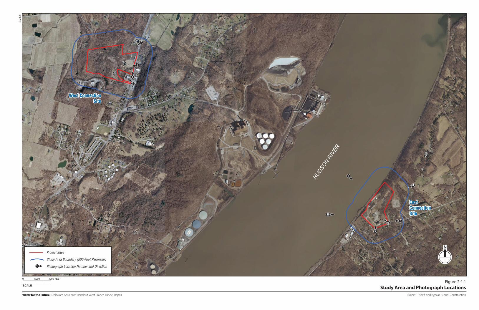
The study areas for this analysis are defined by a 500-foot radius surrounding the west and the east connection sites (see Figure 2.4-1). These study areas were determined to be appropriate based on existing visual conditions and the fact that Project 1 is a construction effort and so would not include any permanent, tall structures. Any potential visual impacts would likely be confined to the immediate environs of the connection sites where clearing, grading, and construction activities would be visible. The east connection site is visible from the Hudson River. Therefore views of the east connection site from the river were considered in this analysis. The west connection site is not visible from the Hudson River due to intervening topography and vegetation.
2.4-3 WEST OF HUDSON
2.4-3.1 EXISTING CONDITIONS—WEST OF HUDSON
WEST CONNECTION SITE
The west connection site comprises approximately 32.9 acres on a hill that steeply slopes upward (westward) from Route 9W. The majority of the site is wooded and undeveloped, but portions close to Route 9W are cleared and contain vacant structures, including two single-family houses
9.23
.11
SCALE
0 5000 1000 FEET
Water for the Future: Delaware Aqueduct Rondout-West Branch Tunnel Repair Project 1: Shaft and Bypass Tunnel Construction
Figure 2.4-1Study Area and Photograph Locations
West ConnectionSite
West ConnectionSite
HUDSON R
IVER
EastConnectionSite
EastConnectionSite
Project Sites
Study Area Boundary (500-Foot Perimeter)
Photograph Location Number and Direction1
1
2
4
2
10
9
6
5
8
7

Water for the Future Program: Delaware Aqueduct Rondout-West Branch Tunnel Repair FEIS
2.4-8
with outbuildings, a former restaurant and bar, and several trailers. Figures 2.4-2 and 2.4-3 provide photographs of the west connection site from Route 9W. No aesthetic or visual resources are located on the west connection site.
STUDY AREA
The visual character of the study area immediately surrounding the west connection site is primarily defined by the commercial uses that line Route 9W. These uses include a gas station, a diner, an ATV dealership, an auto repair shop, two motels, and a truck rental facility. In general, these uses include large open parking areas and one-story buildings that are characteristic of a suburban/rural commercial corridor. Interspersed among these commercial uses are residential buildings and homes that have been converted to offices. However, the visual character is dominated by the larger commercial uses. Pedestrian activity is limited to customers of the commercial uses located along 9W.
In general, there are no notable visually sensitive locations in the study area and no noteworthy scenic vistas or resources that allow for exceptional or scenic views. While an apple orchard with scenic views is located west of the west connection site beyond the Route 9W corridor, this area is visually separated from the west connection site by dense vegetation, steep changes in grade, and is not visually connected to the west connection site.
The most expansive views of the west connection site occur from nearby areas along Route 9W (as shown in Figure 2.4-2), and the site would be visible from cars and truck traveling along Route 9W. At the edges of the study area (as shown in Figure 2.4-3), views of the west connection site are somewhat screened by vegetation and buildings located on adjoining properties.
Along the Route 9W corridor, commercial uses line the roadway to the east and west with a few residential uses interspersed. On the east side of Route 9W, beyond the commercial corridor, portions of the study area are densely forested. Beyond the commercial corridor that lines the west side of Route 9W, the study area is largely forested and slopes steeply upward. A small number of residential properties are located on the hillside beyond the commercial strip, but most are not visible or only partially visible from Route 9W due to the dense vegetation and steep change in elevation. Immediately north of the west connection site along the west side of Route 9W the study area is densely forested.
There is minimal lighting currently used within the study area. Some businesses in the study area use lighting to illuminate parking areas and signage, but any such light does not typically travel beyond its immediate environs. There are also certain buildings that have interior lighting that are visible from Route 9W. Chapter 125 of the Newburgh Town Code pertains to Noise and Illumination Control. The illumination standards require that illumination be the minimal amount necessary for security and safety. The standards also require shielding light and/or directing it away from residential areas. There are no specifics regarding permitted light levels.

Water for the Future: Delaware Aqueduct Rondout-West Branch Tunnel Repair
View of West Connection Site (looking southwest) 1
View of West Connection Site (looking northwest) 2
5.7.12
Project 1: Shaft and Bypass Tunnel Construction
Figure 2.4-2Visual Photographs

Water for the Future: Delaware Aqueduct Rondout-West Branch Tunnel Repair
View looking southwest toward West Connection Site from Route 9W 3
View looking northwest toward West Connection Site from Route 9W 4
5.7.12
Project 1: Shaft and Bypass Tunnel Construction
Figure 2.4-3Visual Photographs

Chapter2: Probable Impacts of Project 1, Shaft and Bypass Tunnel Construction
Section 2.4: Visual Character
2.4-9
2.4-3.2 FUTURE WITHOUT PROJECT 1, SHAFT AND BYPASS TUNNEL CONSTRUCTION—WEST OF HUDSON
WEST CONNECTION SITE
In the future without Project 1, it is assumed that the west connection site would remain in its current state.
STUDY AREA
Several parcels within the study area have the potential to be redeveloped, but any such development is not expected to result in any significant changes to the overall visual character of the study area. There is one known area near the study area where development activity is planned, but it is located approximately ½-mile from the west connection site. This project, which would result in development of condominium units adjacent to an existing condominium complex, is not likely to significantly alter the visual character of the area.
2.4-3.3 PROBABLE IMPACTS OF PROJECT 1, SHAFT AND BYPASS TUNNEL CONSTRUCTION—WEST OF HUDSON
WEST CONNECTION SITE
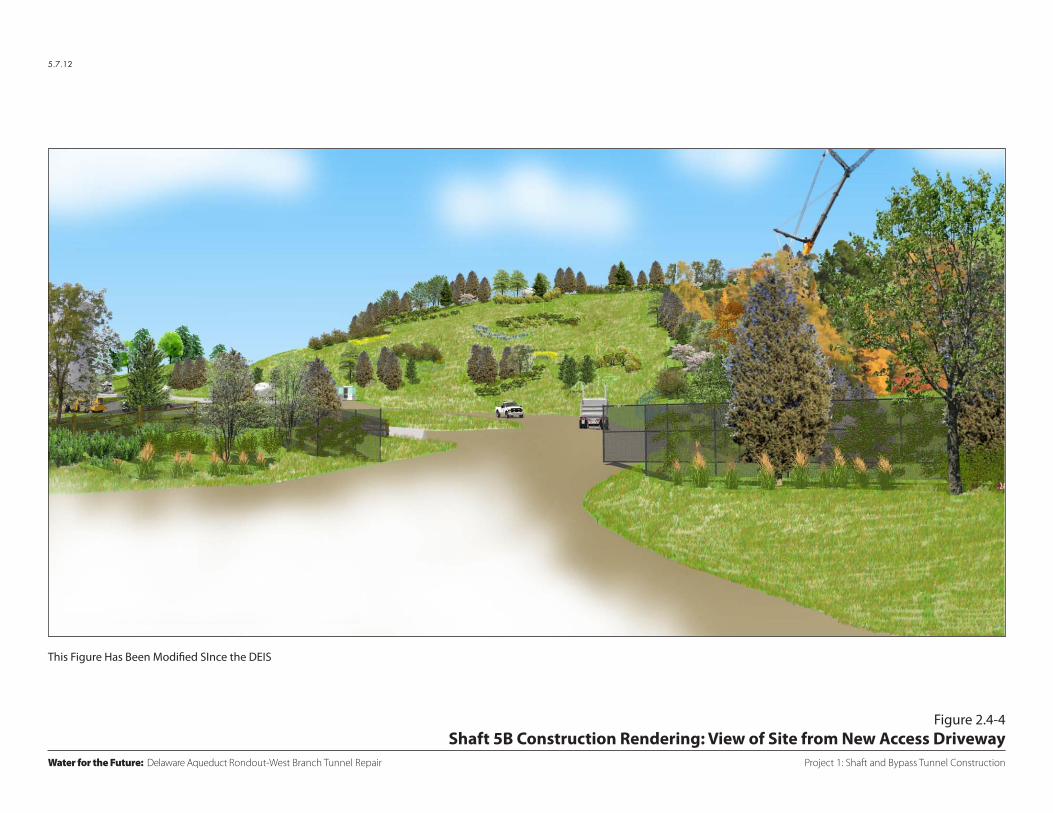
During the construction of Project 1, the west connection site would be transformed from a largely wooded and undeveloped site into an active construction site. The existing buildings on the site, with the exception of the vacant single-family house on the south central portion of the site (tax parcel 8-1-15.3), would be demolished, and a large portion of the site would be cleared and graded. The clearing and grading effort would result in open cleared areas with steep slopes visible on parts of the site (see Figure 2.4-4).
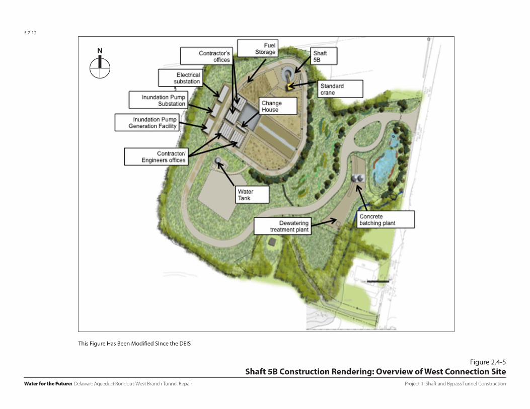
Within the area to be cleared and graded, a new site access road with access from Route 9W would be developed to provide access to and egress from the site and to provide internal circulation. The new driveway would be constructed at the northern end of the site and would wind up the hill to the center of the site. During the early stages of Phase 1: Site Preparation, the existing southern driveway would provide access to the west connection site. Early in Phase 1: Site Preparation, the driveway would be improved as needed to support construction activities until the new site entrance is in place. Once the new site entrance is in place, the existing southern driveway would no longer be used except for emergency access. The new driveway site entrance would serve as the primary location for access to and egress from the west connection site. In connection with this new site driveway entrance, Route 9W would be reconfigured to provide a dedicated left-turn lane for northbound traffic to access the site and a dedicated right-turn lane for southbound traffic to access the site (see Figure 1-10). In addition, work areas, office areas, and maintenance areas would be provided, and support facilities (e.g., power supply, dewatering treatment, and stormwater management) would be developed (see Figure 2.4-5).
5.7.12
Project 1: Shaft and Bypass Tunnel Construction
Figure 2.4-4Shaft 5B Construction Rendering: View of Site from New Access Driveway
Water for the Future: Delaware Aqueduct Rondout-West Branch Tunnel Repair
This Figure Has Been Modified SInce the DEIS
5.7.12
Project 1: Shaft and Bypass Tunnel Construction
Figure 2.4-5Shaft 5B Construction Rendering: Overview of West Connection Site
Water for the Future: Delaware Aqueduct Rondout-West Branch Tunnel Repair
N
This Figure Has Been Modified SInce the DEIS
Water for the Future Program: Delaware Aqueduct Rondout-West Branch Tunnel Repair FEIS
2.4-10
Various pieces of construction equipment, including construction trailers, would be visible on the site at different times during the construction period. Construction efforts would occur throughout the site, with concentrations of activity around the areas of the shaft and inundation plug.
During construction, landscaping would be installed at the site entrance and along the northern half of the site’s Route 9W frontage to soften the appearance of the security fence and buffer views into the site. Landscaping would also be installed along the top of the hill and within the cleared areas to reduce the visibility of the proposed roadway, exposed slopes, and construction activity. In addition, a split rail fence with mesh fabric would be installed around the stormwater detention basin located on the eastern portion of the site (see Figures 2.4-4 and 2.4-5).
During the approximately 7½-year construction period between 2013 and 2021, lighting would be installed to maintain the safety and security of the site. An analysis of the expected lighting conditions during construction was developed as part of the site plan application. Construction at the west connection site for Project 1 would occur Monday through Friday with the exception of Phase 1: Site Preparation, which would require Saturday work. During all phases of construction it is expected that at least some nighttime work would be required (see Chapter 2.1, “Description of the Project 1 Construction Program,” for details on the anticipated hours and durations of each construction phase). A 24-hour/day, five days/week cycle of three 8-hour shifts would begin during Phase 2: Shaft Construction and would continue through Phase 3: Bypass Tunnel Excavation and Phase 4: Bypass Tunnel Lining.
The lighting likely required for the site includes site lighting for security and circulation (e.g., driveways and parking areas) and portable lighting units, which would be used to illuminate the work areas during construction activity. These portable units would comply with local codes and would be removed once construction is complete. Construction lighting would be oriented away from neighboring properties and would not result in any significant light spillover at the west connection site property line. All lighting would be installed to be consistent with local codes as well as the most recent editions of the Illuminating Engineering Society Handbook, and the American National Practice for Roadway Lighting (RP-8) approved by the American National Standards Institute (ANSI).While there would at times be a glow visible from the site when lighting is used, the photometric models show that light levels at the property lines would be below 0.5 footcandles. Efforts would be made to reduce spillover of light onto adjacent properties to the extent practicable (see Figure 2.4-6).
WATER MAIN EXTENSION AND DEWATERING PIPELINE
In the area around the water main extension and dewatering pipeline route, construction would result in some additional activity. Because construction of the water main extension and dewatering pipeline would be of a short duration and would advance approximately 100 feet per day, after which the water main and pipeline would be located entirely underground, it is not

9W
9W
NYSDEC Classi�ed Stream
Shaft 5b
36’ Access Road36’ Access Road
24’ Access Road24’ Access Road
11.23.11
Water for the Future: Delaware Aqueduct Rondout-West Branch Tunnel Repair Project 1: Shaft and Bypass Tunnel Construction
Figure 2.4-6West Connection Site: Proposed Lighting Plan
SCALE
0 200 400 FEETWest Connection Site
Light Pole with Light
Portable Lighting Unit
Indicate Major ConstructionElements During Project 1 Construction
Chapter2: Probable Impacts of Project 1, Shaft and Bypass Tunnel Construction
Section 2.4: Visual Character
2.4-11
expected to result in significant adverse impacts on visual character of the area surrounding the pipeline route.
STUDY AREA
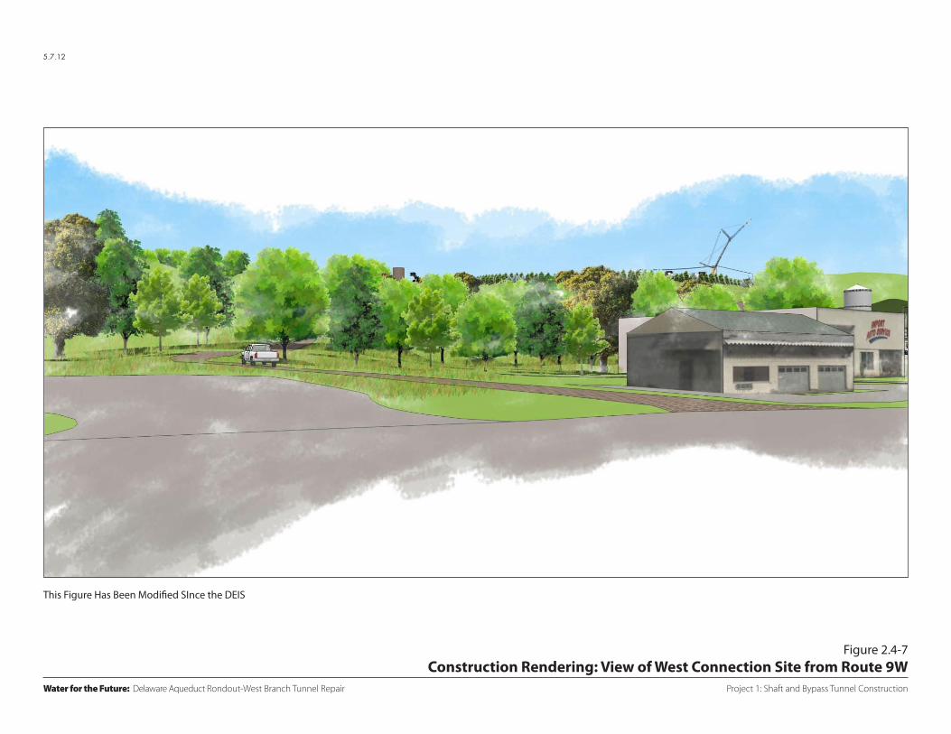
During construction, the visual character of the study area surrounding the west connection site is not expected to change significantly (see Figure 2.4-7). Views of the construction activity at the west connection site would be possible in the immediate vicinity of the site and partially visible from a small number of residences located to the south and directly across Route 9W from the site as well as from the two motels. Pedestrian traffic is limited to customers of the commercial uses on Route 9W immediately surrounding the site and from cars and trucks travelling along Route 9W in front of the west connection site. Project 1 would not result in the construction of any tall structures on the site. Rather, any changes to views from nearby areas would result from clearing, grading, and demolition of existing buildings as well as the temporary use of construction equipment on the site. Since the properties surrounding the west connection site are primarily commercial in nature with a few residential uses interspersed and do not contain any aesthetic or visually sensitive resources, the visual character of the study area is not expected to be significantly altered by the construction activities associated with Project 1. Therefore, Project 1 would not be expected to result in any significant adverse impacts to pedestrians or aesthetic or visual resources within the study area.
2.4-4 EAST OF HUDSON
2.4-4.1 EXISTING CONDITIONS—EAST OF HUDSON
EAST CONNECTION SITE
The east connection site, located on the Hudson River along River Road in the Town of Wappinger, comprises approximately 20.1 acres. The site has varying topography that generally slopes down toward the Hudson River and railroad tracks that run along the River. The site is currently occupied by DEP and facilities associated with Shaft 6 of the Delaware Aqueduct system. Several existing buildings and structures are visible on the site, as seen in Figure 2.4-8, most notably the Shaft 6 superstructure.
The site is currently an active construction site and is surrounded by chain link security fencing.8 Noise blankets cover the fence line separating the site from the residential property to the south. Noise blankets are also installed over the interior fences along the southern edge of the parking area behind the Shaft 6 building and along portions of the eastern fence line. These noise blankets partially block views into the site from the neighboring properties. In addition to these noise blankets, several structures and some equipment currently on the east connection site are related to the ongoing construction. 8 Construction is currently underway at the east connection site as part of the tunnel and shaft rehabilitation of Shaft
6. Completion of this work is expected in 2013.
5.7.12
Project 1: Shaft and Bypass Tunnel Construction
Figure 2.4-7Construction Rendering: View of West Connection Site from Route 9W
Water for the Future: Delaware Aqueduct Rondout-West Branch Tunnel Repair
This Figure Has Been Modified SInce the DEIS

Water for the Future: Delaware Aqueduct Rondout-West Branch Tunnel Repair
View of East Connection Site (looking northwest) 5
View of East Connection Site (looking southwest) 6
5.7.12
Project 1: Shaft and Bypass Tunnel Construction
Figure 2.4-8Visual Photographs
Water for the Future Program: Delaware Aqueduct Rondout-West Branch Tunnel Repair FEIS
2.4-12
STUDY AREA
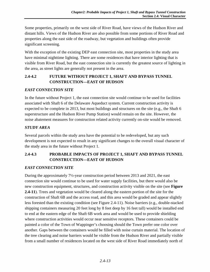
The visual character of the study area immediately surrounding the east connection site is primarily defined by the residential neighborhoods along River Road and its side streets. River Road is a narrow, curvy road with a rural residential character and no sidewalks or shoulder. Pedestrian activity and vehicular traffic is relatively light since the road primarily serves as a route for local traffic. Cars and trucks traveling along River Road have limited passing, partial views of the east connection site. There is some limited commercial activity associated with a lumberyard located south of the east connection site, but one- and two-family residences define the overall visual character. Many properties in close proximity to the east connection site have partial views of the existing Shaft 6 facilities.
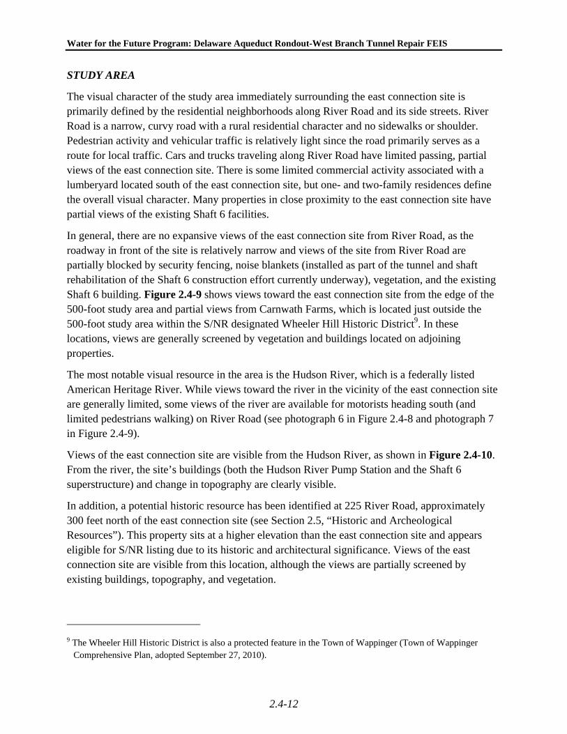
In general, there are no expansive views of the east connection site from River Road, as the roadway in front of the site is relatively narrow and views of the site from River Road are partially blocked by security fencing, noise blankets (installed as part of the tunnel and shaft rehabilitation of the Shaft 6 construction effort currently underway), vegetation, and the existing Shaft 6 building. Figure 2.4-9 shows views toward the east connection site from the edge of the 500-foot study area and partial views from Carnwath Farms, which is located just outside the 500-foot study area within the S/NR designated Wheeler Hill Historic District9. In these locations, views are generally screened by vegetation and buildings located on adjoining properties.
The most notable visual resource in the area is the Hudson River, which is a federally listed American Heritage River. While views toward the river in the vicinity of the east connection site are generally limited, some views of the river are available for motorists heading south (and limited pedestrians walking) on River Road (see photograph 6 in Figure 2.4-8 and photograph 7 in Figure 2.4-9).
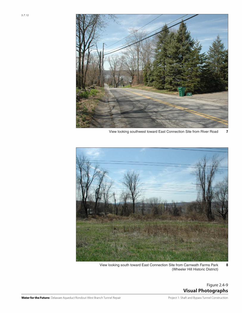
Views of the east connection site are visible from the Hudson River, as shown in Figure 2.4-10. From the river, the site’s buildings (both the Hudson River Pump Station and the Shaft 6 superstructure) and change in topography are clearly visible.
In addition, a potential historic resource has been identified at 225 River Road, approximately 300 feet north of the east connection site (see Section 2.5, “Historic and Archeological Resources”). This property sits at a higher elevation than the east connection site and appears eligible for S/NR listing due to its historic and architectural significance. Views of the east connection site are visible from this location, although the views are partially screened by existing buildings, topography, and vegetation.
9 The Wheeler Hill Historic District is also a protected feature in the Town of Wappinger (Town of Wappinger
Comprehensive Plan, adopted September 27, 2010).
Water for the Future: Delaware Aqueduct Rondout-West Branch Tunnel Repair
View looking southwest toward East Connection Site from River Road 7
View looking south toward East Connection Site from Carnwath Farms Park(Wheeler Hill Historic District)
8
5.7.12
Project 1: Shaft and Bypass Tunnel Construction
Figure 2.4-9Visual Photographs
View looking southeast toward East Connection Site from Hudson River 9
View looking northeast toward East Connection Site from Hudson River 10
5.7.12
Program Description
Figure 2.4-10Visual Photographs
Chapter2: Probable Impacts of Project 1, Shaft and Bypass Tunnel Construction
Section 2.4: Visual Character
2.4-13
Some properties, primarily on the west side of River Road, have views of the Hudson River and distant hills. Views of the Hudson River are also possible from some portions of River Road and properties along the east side of the roadway, but vegetation and buildings often provide significant screening.
With the exception of the existing DEP east connection site, most properties in the study area have minimal nighttime lighting. There are some residences that have interior lighting that is visible from River Road, but the east connection site is currently the greatest source of lighting in the area, as street lights are generally not present in the area.
2.4-4.2 FUTURE WITHOUT PROJECT 1, SHAFT AND BYPASS TUNNEL CONSTRUCTION—EAST OF HUDSON
EAST CONNECTION SITE
In the future without Project 1, the east connection site would continue to be used for facilities associated with Shaft 6 of the Delaware Aqueduct system. Current construction activity is expected to be complete in 2013, but most buildings and structures on the site (e.g., the Shaft 6 superstructure and the Hudson River Pump Station) would remain on the site. However, the noise abatement measures for construction related activity currently on-site would be removed.
STUDY AREA
Several parcels within the study area have the potential to be redeveloped, but any such development is not expected to result in any significant changes to the overall visual character of the study area in the future without Project 1.
2.4-4.3 PROBABLE IMPACTS OF PROJECT 1, SHAFT AND BYPASS TUNNEL CONSTRUCTION—EAST OF HUDSON
EAST CONNECTION SITE
During the approximately 7½-year construction period between 2013 and 2021, the east connection site would continue to be used for water supply facilities, but there would also be new construction equipment, structures, and construction activity visible on the site (see Figure 2.4-11). Trees and vegetation would be cleared along the eastern portion of the site for the construction of Shaft 6B and the access road, and this area would be graded and appear slightly less forested than the existing condition (see Figure 2.4-11). Noise barriers (e.g., double-stacked shipping containers measuring 20 feet long by 8 feet deep by 16 feet tall) would be installed end to end at the eastern edge of the Shaft 6B work area and would be used to provide shielding where construction activities would occur near sensitive receptors. These containers could be painted a color of the Town of Wappinger’s choosing should the Town prefer one color over another. Gaps between the containers would be filled with noise curtain material. The location of the tree clearing and noise barriers would be visible from the Hudson River and partially visible from a small number of residences located on the west side of River Road immediately north of

5.16
.12
Proj
ect 1
: Sha
ft a
nd B
ypas
s Tun
nel C
onst
ruct
ion
Figu
re 2
.4-1
1Co
nstr
ucti
on R
ende
ring
: Ove
rvie
w o
f Eas
t Con
nect
ion
Site
Wat
er fo
r the
Fut
ure:
Del
awar
e Aq
uedu
ct R
ondo
ut-W
est B
ranc
h Tu
nnel
Rep
air
N
This
Fig
ure
Has
Bee
n M
odifi
ed S
Ince
the
DEI
S
Water for the Future Program: Delaware Aqueduct Rondout-West Branch Tunnel Repair FEIS
2.4-14
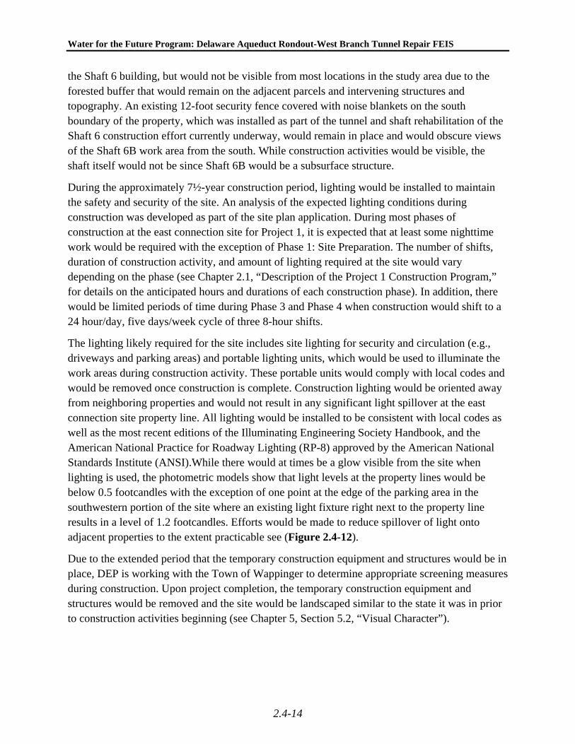
the Shaft 6 building, but would not be visible from most locations in the study area due to the forested buffer that would remain on the adjacent parcels and intervening structures and topography. An existing 12-foot security fence covered with noise blankets on the south boundary of the property, which was installed as part of the tunnel and shaft rehabilitation of the Shaft 6 construction effort currently underway, would remain in place and would obscure views of the Shaft 6B work area from the south. While construction activities would be visible, the shaft itself would not be since Shaft 6B would be a subsurface structure.
During the approximately 7½-year construction period, lighting would be installed to maintain the safety and security of the site. An analysis of the expected lighting conditions during construction was developed as part of the site plan application. During most phases of construction at the east connection site for Project 1, it is expected that at least some nighttime work would be required with the exception of Phase 1: Site Preparation. The number of shifts, duration of construction activity, and amount of lighting required at the site would vary depending on the phase (see Chapter 2.1, “Description of the Project 1 Construction Program,” for details on the anticipated hours and durations of each construction phase). In addition, there would be limited periods of time during Phase 3 and Phase 4 when construction would shift to a 24 hour/day, five days/week cycle of three 8-hour shifts.
The lighting likely required for the site includes site lighting for security and circulation (e.g., driveways and parking areas) and portable lighting units, which would be used to illuminate the work areas during construction activity. These portable units would comply with local codes and would be removed once construction is complete. Construction lighting would be oriented away from neighboring properties and would not result in any significant light spillover at the east connection site property line. All lighting would be installed to be consistent with local codes as well as the most recent editions of the Illuminating Engineering Society Handbook, and the American National Practice for Roadway Lighting (RP-8) approved by the American National Standards Institute (ANSI).While there would at times be a glow visible from the site when lighting is used, the photometric models show that light levels at the property lines would be below 0.5 footcandles with the exception of one point at the edge of the parking area in the southwestern portion of the site where an existing light fixture right next to the property line results in a level of 1.2 footcandles. Efforts would be made to reduce spillover of light onto adjacent properties to the extent practicable see (Figure 2.4-12).
Due to the extended period that the temporary construction equipment and structures would be in place, DEP is working with the Town of Wappinger to determine appropriate screening measures during construction. Upon project completion, the temporary construction equipment and structures would be removed and the site would be landscaped similar to the state it was in prior to construction activities beginning (see Chapter 5, Section 5.2, “Visual Character”).
ExistingSubstation
ExistingHudson RiverPump Station
ExistingHudson RiverPump Station
ExistingShaft 6 Building
ExistingShaft 6 Building
ELECTRICAL OVERHEAD
EXISTIN
G SCREEN W
ALL
HUDSON RIVER
Shaft 6b
9W
11.23.11
Water for the Future: Delaware Aqueduct Rondout-West Branch Tunnel Repair Project 1: Shaft and Bypass Tunnel Construction
Figure 2.4-12East Connection Site: Proposed Lighting Plan
SCALE
0 50 100 FEET
East Connection Site
Light Pole with Light
Indicate Major ConstructionElements During Project 1 Construction

Chapter2: Probable Impacts of Project 1, Shaft and Bypass Tunnel Construction
Section 2.4: Visual Character
2.4-15
STUDY AREA
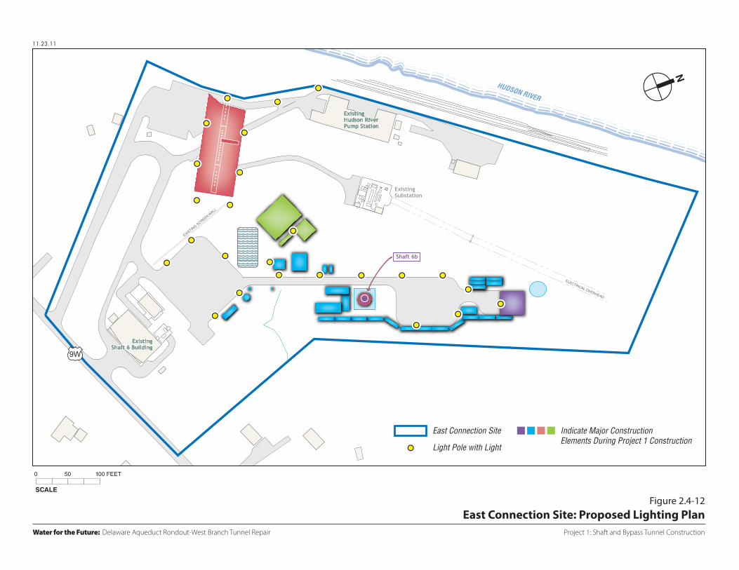
During construction of Project 1, the visual character of the study area surrounding the east connection site is not expected to change significantly since project-related construction activity would be confined to the east connection site. However, while the study area as a whole would not be significantly affected since vegetation, fencing, and intervening buildings and topography would screen the site, construction activity would be at least partially visible from a small number of residences on River Road located in close proximity to the site (see Figure 2.4-13). The existing noise blankets and fencing, which would be retained during Project 1 construction, would continue to be visible to the residences and motorists on River Road. Additional noise blankets erected during construction would change the character of the site along River Road in comparison to the Future without Project 1.
As described above, some locations along River Road have partial views of the Hudson River when looking west beyond the east connection site. Currently, many of these views are partially screened by the vegetation and structures on the Shaft 6 site and further screened by the existing fencing and noise blankets associated with the current construction effort. As also described above, some views of the Hudson River are available for motorists (and limited pedestrians) on River Road. During Project 1 construction, new structures and equipment may be introduced to the site that would further limit views toward the Hudson River from River Road, including additional noise barriers on the east connection site along River Road. Views of the site and the Hudson River along River Road near the east connection site would be adversely affected by the construction of Project 1. However, these effects would be temporary, limited in location, and are not expected to result in significant adverse impacts on the visual character of the study area.
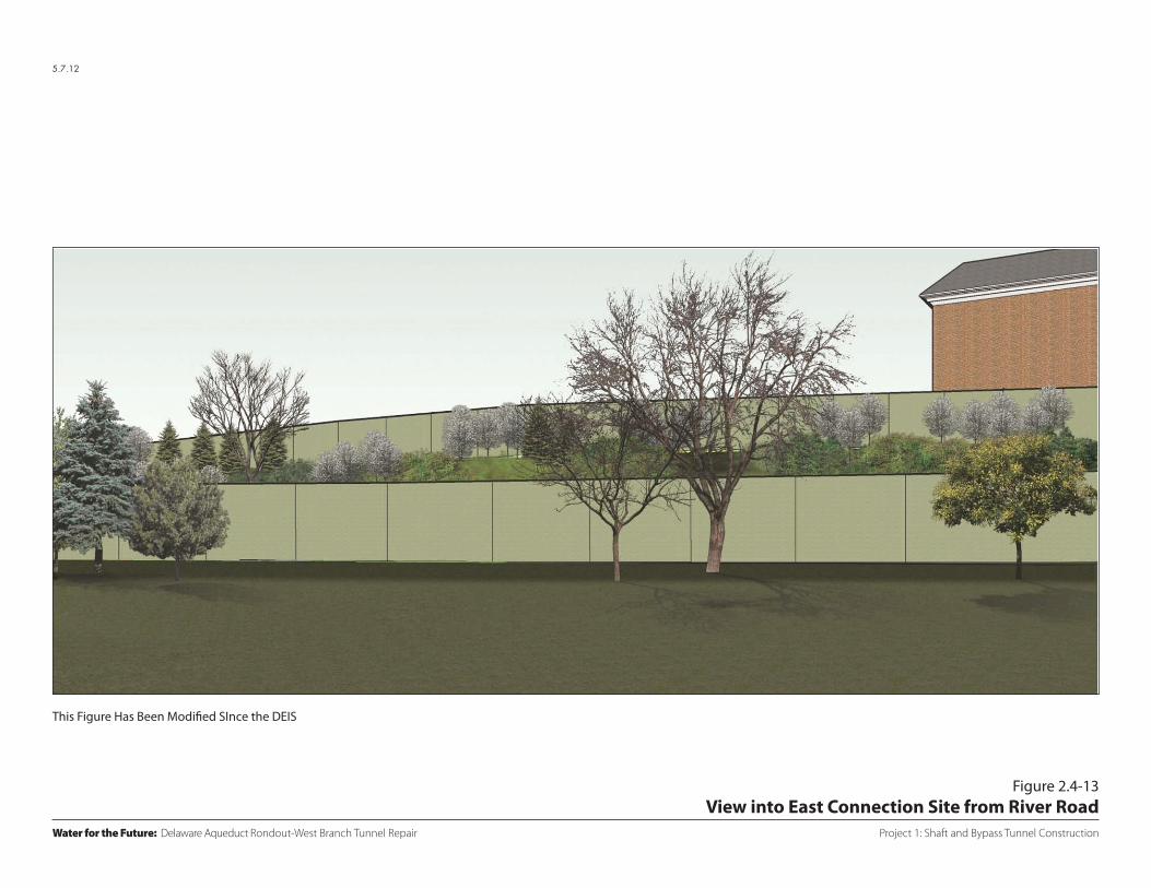
The east connection site is visible for boaters on the Hudson River but the site’s visibility varies based on the location of the boat and is largely limited to the area of the river directly fronting the east connection site due to vegetation, existing structures, and the curvilinear path of the river itself. During the construction period, boaters on the Hudson River would be able to see the construction site and would recognize a change to the east connection site from its current condition. In addition to the clearing and grading associated with the shaft site preparation, cranes, construction trailers, equipment and materials would be visible from the Hudson River (see Figure 2.4-14). During nighttime construction activity, construction area lighting would be clearly visible from the Hudson River.
Due to the presence of the railroad tracks along the east connection site’s western edge and the change of grade between the river and the construction area, there would be no effective means of screening the site from views of the Hudson River. Thus, there would be temporary impacts associated with views of the site from the Hudson River. However, these views would not detract from the overall enjoyment that boaters would derive from the overall scenic qualities of the Hudson River and shoreline and therefore, these temporary impacts are not considered significant or adverse.
Project 1: Shaft and Bypass Tunnel Construction
Figure 2.4-13
Water for the Future: Delaware Aqueduct Rondout-West Branch Tunnel Repair
5.7.12
View into East Connection Site from River Road
This Figure Has Been Modified SInce the DEIS
Project 1: Shaft and Bypass Tunnel Construction
Figure 2.4-14
Water for the Future: Delaware Aqueduct Rondout-West Branch Tunnel Repair
5.7.12
View into East Connection Site from Hudson River/Railroad Tracks on Western Property Line
This Figure Has Been Modified SInce the DEIS

Water for the Future Program: Delaware Aqueduct Rondout-West Branch Tunnel Repair FEIS
2.4-16
Portions of the east connection site are partially visible from the potential historic resource located at 225 River Road. During the construction period, construction activity would be visible from this location. Visibility would depend on the location of the activity and would be largely screened by the existing buildings on the Shaft 6 site and intervening vegetation. Thus, views would be limited and would not be expected to detract from the visual character of the site. During nighttime construction activity, construction area lighting would be visible from this location.
The east connection site would also be partially visible from Carnwath Farms, which is located within the Wheeler Hill Historic District. From this location, views of the east connection site would be very limited due to intervening distance, vegetation, and buildings.
Distant views of the east connection site are partially visible from Our Lady of Mercy Church located along River Road on the west side of the river. Viewers from this location may recognize changes to the site far in the distance during construction, although due to distance, vegetation, and intervening structures on the Dynegy site, these views would not affect the aesthetic or visual character of the church. In addition, distant views of the east connection site would be visible from some locations along River Road in the vicinity of the Dynegy site. Due to distance and vegetation views of the construction activity on the east connection site would be limited and would not detract from the visual character of River Road.
2.4-5 CONCLUSIONS
2.4-5.1 WEST OF HUDSON
Construction of Project 1 on the west side of the Hudson River would not result in any permanent impacts to visual character. While views of the west connection site would change during construction, the overall commercial/industrial visual character of the study area would not be significantly adversely affected. Therefore, construction of Project 1 is not expected to result in any significant adverse visual impacts.
2.4-5.2 EAST OF HUDSON
Construction activity at the east connection site would not result in any permanent impacts to the visual character of the study area. The site is currently used for water supply purposes and would continue to be used as a water supply use. Construction activity would result in changes to the appearance of the east connection site from certain locations within the study area and from the Hudson River. Views of the site and to the Hudson River along River Road near the east connection site would be adversely affected by the construction of Project 1. However, these effects would be temporary, limited in location, and are not expected to result in significant adverse impacts on the visual character of the study area. Therefore, construction of Project 1 is not expected to result in any significant adverse visual impacts.