2.2.pdfmid wales conjoined wind farm inquiry - grid session 4 evidence supplementary environmental...
TRANSCRIPT

Llanbrynmair Wind Farm Supplementary Environmental Information
Volume 2
APPENDIX 2.2 - MID WALES CONJOINED WIND FARM INQUIRY – GRID SESSION 4 EVIDENCE SUPPLEMENTARY ENVIRONMENTAL INFORMATION ON GRID SCENARIOS

Mid Wales Conjoined Wind Farm Inquiry - Grid
Session 4 Evidence
Supplementary Environmental Information on Grid Connection Scenarios
Final Report
Prepared by LUC on behalf of Vattenfall, Fferm Wynt Llaithddu Cyf (FWL), RES UK & Ireland Limited
(RES') and RWE Npower Renewables Limited (RWE)
December 2013
Planning & EIA Design Landscape Planning Landscape Management Ecology Mapping & Visualisation
LUC BRISTOL 14 Great George Street Bristol BS1 5RH Tel:0117 929 1997 Fax:0117 929 1998 [email protected]
Offices also in: London Glasgow Edinburgh
FS 566056
EMS 566057
Land Use Consultants Ltd Registered in England Registered number: 2549296 Registered Office: 43 Chalton Street London NW1 1JD
LUC uses 100% recycled paper

Project Title: Mid Wales Conjoined Wind Farm Inquiry - Grid Session 4 Evidence, Supplementary
Environmental Information on Grid Scenarios
Client: Vattenfall, FWL, RES and RWE
Version Date Version Details Prepared by Checked by Approved by
Principal
V1 18/12/2013 Draft Report Sarah Young
and Ben Miller
Kate Wigley Marc van
Grieken
V1_1 18/12/2013 Amended Draft Report Sarah Young
and Ben Miller
Kate Wigley
V2 23/12/2013 Final Report Sarah Young
\\Glfp01\56 jobs and above\59\5920 Mid Wales Grid Review\B Project Working\Mid Wales Grid Session
4 Evidence_20121223_V2.docx

Contents
Overview of the Assessment 1
Background 1
Grid Connection Options Scenarios 2
Assessment of Environmental Impacts and Limitations 4
Summary of Environmental Information 5
Figures
Figure 1: Grid Connection Scenario 1
Figure 2: Grid Connection Scenario 2
Figure 3: Grid Connection Scenario 3
Figure 4: Grid Connection Scenario 4
Figure 5: Grid Connection Scenario 5
Figure 6: Grid Connection Scenario 6
Figure 7: Grid Connection Scenario 7
Figure 8: Grid Connection Scenario 8a
Figure 9: Grid Connection Scenario 8b
Appendices
Appendix 1: Summary of Environmental Information on Grid Scenarios

Mid Wales Grid Session 4 Evidence 1 December 2013
Overview of the Assessment
Background
1.1 Vattenfall, Fferm Wynt Llaithddu Cyf (FWL), RES UK & Ireland Limited (RES') and RWE Npower
Renewables Limited (RWE) (herein referred to as ‘the developers’) have submitted Section 36
applications under the Electricity Act 1989 for consent to construct and operate wind farms in the
Mid Wales Strategic Search Areas (SSA) B & C.
1.2 Each of the developers has an agreement with SP Manweb (SPM) for provision of a grid
connection into the existing electricity grid network. SPM’s current proposals are to connect the
wind farms via overhead line connections to a proposed new 400kV grid substation being
proposed by National Grid near Cefn Coch. The SPM proposal is known as the SP Manweb Mid
Wales Grid Connections Project (MWC) and also incorporates grid connection requirements for a
further four Windfarms1. In total SPM has eight ‘contracted schemes’. From Cefn Coch, National
Grid is proposing to construct a new 400kV in part overhead and part underground cable
connection to the existing electricity network near to Lower Frankton, approximately 40km North
East from Cefn Coch.
1.3 In addition to the developers’ applications, an application has also been made under section 36 by
Celtpower Limited ("Celtpower") for consent to construct and operate a wind turbine generating
station at Llandinam in Powys, Mid Wales. This is a repowering of an existing wind farm. It is not
proposed that this generating station will connect to the new 400kV substation at Cefn Coch.
Instead it will export electricity via a new 132 KV overhead line connection to the existing
Welshpool substation. An application has been made by SPM under section 37 of the Electricity
Act 1989 to install this new line.
1.4 A summary of the proposed wind farm schemes to which this review relates are set out in Table
1 below:
Table 1: S36 Wind Farm Proposals in SSA B and SSA C
SSA Wind farm Developer Mega Watt Capacity (Application)
Mega Watt Capacity
(Contracted Capacity to DNO)
SSA B Llanbrynmair RES 90
90
Carnedd Wen RWE 150
150
SSA C Llaithddu Fferm Wynt Llaithddu Cyf 62.1
80
Llanbadarn Fynydd Vattenfall
59.5 61.2
Llandinam repowering
Celt Power Ltd. 102 90
1.5 Table 1 sets out both the capacities (in terms of megawatt) that the ‘developers’ have submitted
S36 applications for, and the contracted capacities with the Distribution Network Operator (DNO),
in this case is SPM. The wind farm options used in this report are based upon the application
capacity. However should different wind farm options be based upon the contracted capacities to
the DNO, these would not alter the basic infrastructure elements required for each grid option
scenario.
1 The four wind farms include: Dyfnant Forest, which is at pre-application stage and is expected to be submitted to the Planning
Inspectorate in 2014; Rhyd Ddu, which will be part of the Mynydd Lluest y Graig application and is at pre-planning stage and is
expected to be submitted in 2014; Carno III was submitted in July 2010 and a decision is pending; and Neuadd Goch Bank was
submitted in January 2012 and is still in the planning process.

Mid Wales Grid Session 4 Evidence 2 December 2013
1.6 All six applications (i.e. the five wind farms and the Llandinam grid connection) are currently the
subject of a conjoined public inquiry. The main parties at the inquiry include: Powys County
Council, Natural Resources for Wales, Fferm Wynt Llaithddu Cyf, Vattenfall, RES, RWE, Celt
Power, SPM and various local action/ interest groups. Questions have been asked in the Inquiry
by the Inspector and the Alliance regarding the need for, and environmental effects of, the
proposed Mid Wales Grid Connection.
1.7 As the MWC Project necessarily identifies grid connection options taking account of all eight
contracted schemes, it is likely that if less than five of the wind farms listed in Table 1 above,
were to be granted approval, the grid connection options would be different to that proposed by
SPM in the MWC Project. On this basis, to inform the Inquiry on the potential environmental
implications of the different grid connection scenarios associated with the developments in SSA B
and SSA C, ‘the developers’ have commissioned LUC and Mott MacDonald to prepare
Supplementary Environmental Information. This comprises:
• A technical assessment of the various options available for connecting the proposed wind
farms to the grid and the (grid) connection infrastructure that this may require. This is set
out in the accompanying Connections Options Review Report (December 2013) prepared by
Mott MacDonald.
• A high level desk based assessment of the environmental effects of the various grid options
(as set out in the accompanying Connections Options Review Report).
1.8 This report sets out the findings of the high level assessment of environmental effects of the
possible alternative grid connection options.
1.9 It should be highlighted that the ‘baseline’ situation for the potential grid connection scenario
within Mid Wales, comprises that being currently proposed by SPM as their SP Mid Wales
Connections Project. This is on the basis that, in accordance with the Electricity Act 1989, SPM
plc, the licence holder for the electricity network at 132kilovolt (kV) and below in Mid Wales, has
agreed terms to provide connections for eight wind farms in Mid Wales to the electricity network.
As licence holder, SPM is required under the Electricity Act 1989 to identify electrical connections
that meet the technical requirements of the electricity network and cause, on balance, the least
disturbance to the environment and the people who live, work and recreate within it.
1.10 As four of the five wind farms which are involved in the conjoined inquiry (Llanbrynmair, Carnedd
Wen, Llaithddu and Llanbadarn Fynydd), are also contracted with SPM, and therefore represented
by the SP Mid Wales Connections Project, the findings of the ongoing routeing work being
undertaken by SPM are therefore considered to represent the baseline situation for the grid
connection scenario.
1.11 The alternative scenarios considered within this study, as requested by the Inspector, are
therefore hypothetical, and are being considered to inform the inquiry as to the possible situation
should the contracted SP Mid Wales Connections Project not proceed in its current form.
Grid Connection Options Scenarios
1.12 The accompanying Connections Options Review Report (December 2013) identifies eight grid
connection option scenarios, as set out in Table 2 below and in Figures 1-9. Please refer to the
Connections Options Review Report for a detailed justification of why the scenarios were selected
for review. The scenarios are based on potential circuit loadings but for added clarity, a summary
of the potential wind farm options that could be accommodated by each scenario has been
included in Table 2. A summary of the proposed grid solution is also provided, along with an
approximation of the potential length of the grid route.
Mid Wales Grid Session 4 Evidence 3 December 2013
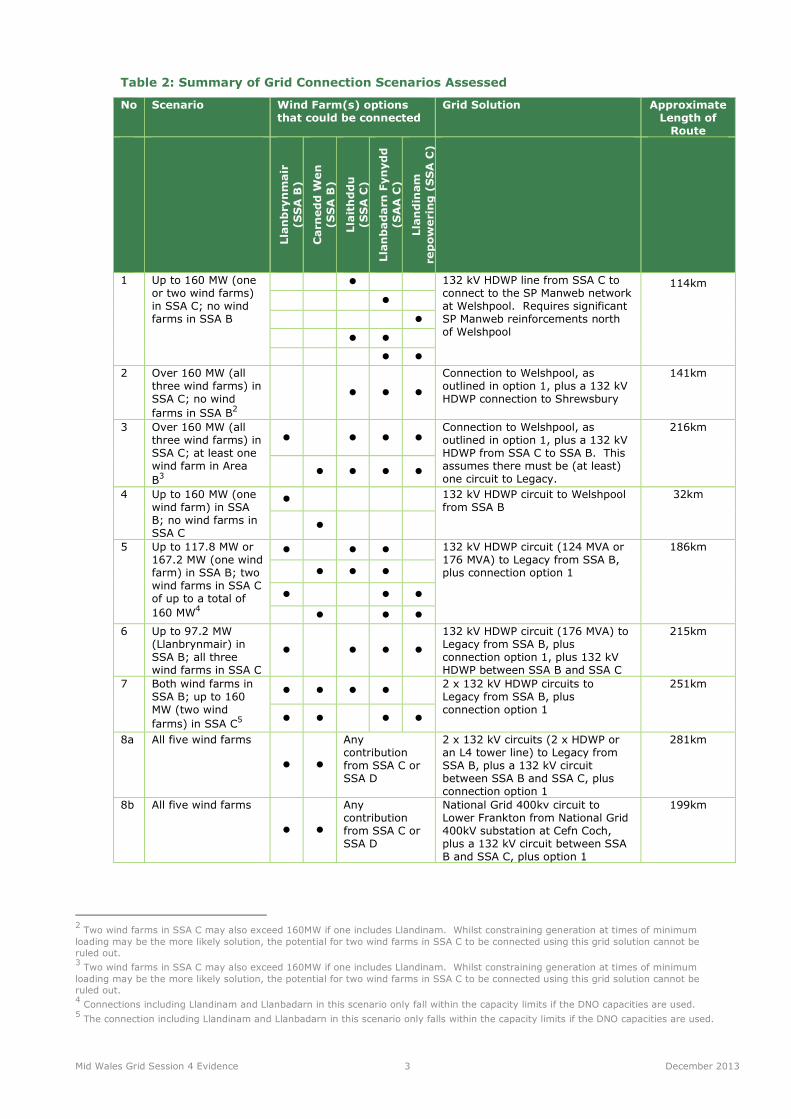
Table 2: Summary of Grid Connection Scenarios Assessed
No Scenario Wind Farm(s) options that could be connected
Grid Solution Approximate Length of Route
Llanbrynmair
(SSA B)
Carnedd Wen
(SSA B)
Llaithddu
(SSA C)
Llanbadarn Fynydd
(SAA C)
Llandinam
repowering (SSA C)
1 Up to 160 MW (one or two wind farms) in SSA C; no wind farms in SSA B
� 132 kV HDWP line from SSA C to connect to the SP Manweb network at Welshpool. Requires significant SP Manweb reinforcements north of Welshpool
114km
�
�
� �
� �
2 Over 160 MW (all three wind farms) in SSA C; no wind
farms in SSA B2
� � �
Connection to Welshpool, as outlined in option 1, plus a 132 kV HDWP connection to Shrewsbury
141km
3 Over 160 MW (all three wind farms) in SSA C; at least one wind farm in Area
B3
� � � � Connection to Welshpool, as outlined in option 1, plus a 132 kV HDWP from SSA C to SSA B. This assumes there must be (at least) one circuit to Legacy.
216km
� � � �
4 Up to 160 MW (one wind farm) in SSA B; no wind farms in SSA C
� 132 kV HDWP circuit to Welshpool from SSA B
32km
�
5 Up to 117.8 MW or 167.2 MW (one wind farm) in SSA B; two wind farms in SSA C of up to a total of
160 MW4
� � � 132 kV HDWP circuit (124 MVA or 176 MVA) to Legacy from SSA B, plus connection option 1
186km
� � �
� � �
� � �
6 Up to 97.2 MW (Llanbrynmair) in SSA B; all three wind farms in SSA C
� � � �
132 kV HDWP circuit (176 MVA) to Legacy from SSA B, plus connection option 1, plus 132 kV HDWP between SSA B and SSA C
215km
7 Both wind farms in SSA B; up to 160 MW (two wind
farms) in SSA C5
� � � � 2 x 132 kV HDWP circuits to Legacy from SSA B, plus connection option 1
251km
� � � �
8a All five wind farms
� �
Any contribution from SSA C or SSA D
2 x 132 kV circuits (2 x HDWP or an L4 tower line) to Legacy from SSA B, plus a 132 kV circuit between SSA B and SSA C, plus connection option 1
281km
8b All five wind farms
� �
Any contribution from SSA C or SSA D
National Grid 400kv circuit to Lower Frankton from National Grid 400kV substation at Cefn Coch, plus a 132 kV circuit between SSA B and SSA C, plus option 1
199km
2 Two wind farms in SSA C may also exceed 160MW if one includes Llandinam. Whilst constraining generation at times of minimum
loading may be the more likely solution, the potential for two wind farms in SSA C to be connected using this grid solution cannot be
ruled out. 3 Two wind farms in SSA C may also exceed 160MW if one includes Llandinam. Whilst constraining generation at times of minimum
loading may be the more likely solution, the potential for two wind farms in SSA C to be connected using this grid solution cannot be
ruled out. 4 Connections including Llandinam and Llanbadarn in this scenario only fall within the capacity limits if the DNO capacities are used.
5 The connection including Llandinam and Llanbadarn in this scenario only falls within the capacity limits if the DNO capacities are used.

Mid Wales Grid Session 4 Evidence 4 December 2013
Assessment of Environmental Effects and Study Limitations
1.13 As requested by the Inspector, a high level review of existing environmental information has been
undertaken. The assessment of effects has necessarily been based on a desk study of existing
published environmental information with regards to known potential grid route options. The
following published environmental information has been used in the preparation of this report:
• SP MANWEB (Sept 2013). SP Mid Wales Connections, Line Routing Methodology & Appraisal -
Phase 3 Report.
• SP MANWEB (Oct 2013). Volume 1: New 132kV Overhead Line Connection from Llandinam
Wind Farm to Welshpool Substation - Updated Environmental Statement.
• National Grid (Sept 2013). Mid Wales Connection Project, Draft Substation Site Report.
• National Grid (Sept 2013). Mid Wales Connection Project, Draft Route Report.
Limitations
1.14 There are no existing studies that have been undertaken looking at a potential grid connection
route from Cefn Coch to Legacy, or from SSA C to Shrewsbury. Scenarios 2 outlined in Table 2
above requires a grid route connection to Shrewsbury and Scenarios 3, 4, 5, 6 and 7 (see Table
2) all require part of their grid connection to link to Legacy. As no information is available on
these sections of routes, this limits the ability to draw conclusions with respect of the likely
environmental effects of grid connections along these sections.
1.15 The four main publications used (see para 1.13) also vary considerably in the level of information
they contain. The SPM and National grid studies provide a high level assessment of the potential
environmental issues associated with these routes, whereas the Llandinam to Welshpool grid
Connection ES comprises the findings of a detailed Environmental Impact Assessment. Care has
been taken to try to provide comparable information in Appendix 1, Tables B to J.
1.16 The required number of connections from the wind farms to the wider grid network will also vary
depending on which wind farms are consented or not. For example under Scenario 1, it will not
be necessary to construct a grid connection from Llaithddu to the Llandinam route if it is not
approved. The summary of environmental information for each scenario therefore presents a
maximum effect scenario – assuming that Llaithddu and Llanbadarn Fynydd are both constructed.
1.17 The proposed routes from the wind farms identified by SPM in the MWC Project were all aimed at
connecting up with the substation at Cefn Coch. If Llanbadarn Fynydd was to use the proposed
Llandinam grid connection route instead of Cefn Coch, it is likely that this would take a more
direct route than that proposed by the MWC Project. No environmental information is however
available on the more direct route and therefore only the MWC project routes have been
considered in this assessment. Individual developers with extensive knowledge of the constraints
and receptors pertaining to their own schemes may be in a better position to attempt
assessments of hypothetical connections not covered by the scope of this study.
1.18 It should also be noted that line route sections CC2, CC3 and CC4 in SSA C, as identified by SPM
in the MWC Project, are relatively short connections, with limited associated environmental
constraints and have therefore been summarised within CC1 line route Section 1’s environmental
information in the MWC Project Phase 3 Report. This approach has been maintained in the
environmental information presented in Tables B – J (Appendix 1) for any Scenario identified in
Table 2 which includes a wind farm in SSA C. However, for clarity, the line routes for the
scenarios are shown as commencing from the relevant wind farm substations on the respective
maps (Figures 1 – 9).

Mid Wales Grid Session 4 Evidence 5 December 2013
Summary of Environmental Effects
1.19 The tables set out in Appendix 1 provide a summary of the environmental information that is
available for identified scenarios. Table A in Appendix 1 sets out the publications that have
been used to assess the environmental effects of each scenario. Tables B- J (Appendix 1) set
out in detail the potential environmental issues for each scenario under the following topic
headings:
• Air Quality and Emissions (incl. dust).
• Ecology/Biodiversity and Geological Conservation.
• Climate Change.
• Electric and Magnetic Fields.
• Forestry and Woodland.
• Geology and Soils.
• Historic Environment.
• Land Use.
• Landscape and Visual Amenity.
• Lighting.
• Noise and Vibration.
• Socio Economics (including Tourism and Recreation).
• Traffic and Transport.
• Waste Management.
• Water Environment.
1.20 The information for each section of the route or substation is presented (where available) along
with an overall summary of the key environmental issues for the topic in question. Please note
that this summary does not constitute an assessment of the cumulative impacts of the scenario,
as that requires a level of information and assessment that is not available for this study.
1.21 Tables 3-6 below set out the key environmental effects that have been identified for each
scenario as drawn from the summary columns in Tables B-J in Appendix 1.
1.22 The same summaries of environmental effects are presented for some scenarios, for the following
reasons:
• Scenarios 1 and 2 both include the Llandinam route to Welshpool. Scenario 2 also requires a
132kV connection to Shrewsbury but there is no environmental information available for this
connection.
• Scenarios 3, 6 and 8a all require the Llandinam connection to Welshpool, a 132 kV HDWP
from SSA C to SSA B and (at least) one circuit to Legacy. 8a requires 2 x 132 kV circuits to
Legacy. No environmental information is available for the route to Legacy.
• Scenario 5 requires the Llandinam connection to Welshpool and one circuit 132kV HDWP
circuit to Legacy from SSA B. Scenario 7 is the same but it requires 2 x 132 kV HDWP
circuits to Legacy. No environmental l information is available for the route to Legacy.
• No assessment of the environmental effects for Scenario 4 has been provided as there is no
identified route or environmental information for a connection from SSA B to Welshpool.
1.23 Where topics (such as air quality) have been scoped out of the assessments contained in the
relevant publications, they are not included in the tables below.

Mid Wales Grid Session 4 Evidence 6 December 2013
Table 3: Summary of Effects for Scenarios 1 and 2 - Llandinam connection to Welshpool
Note: The following table does not include any environmental information for the effects of
constructing a 132kV line to Shrewsbury which would be required for Scenario 2.
Topic Summary of Environmental Effects
Ecology/Biodiversity and Geological Conservation
Birds: There is potential for birds particularly larger species (such as
swans) to collide with the overhead lines. This represents a long-term,
permanent hazard to certain groups of birds but the use of bird deflectors
is likely to help to reduce this risk.
Designated Sites: The proposed routes to Llandinam and the Man Web
Collector Station do not cross any nature conservation designations.
Several sites do however lie within close proximity to the route.
Peatland: The route will pass through areas identified as having potential
peatland habitats.
Habitat Management Plans: Due to the location of the wind farm
substations, the routes will pass through a wind farm HMP area.
Protected Species: Protected species are likely to be located in proximity to
the routes. However full compliance with relevant protected species
legislation is likely to help to minimise any effects.
Forestry and Woodland Some trees and hedgerows will be lost to facilitate construction of the grid
connection routes. The loss of trees may result in potential habitat loss for
bats, although this is expected to be a localised effect.
In some locations, mature trees as well as Ancient and Semi-Natural
woodland may be affected by construction of the proposed routes.
Although this will be avoided where possible at the detailed design stage,
limited felling may be required in some locations.
Historic Environment The Llandinam Route is the only route corridor that has designated historic
assets within it, as two SAMs are located within the route. The Llandinam
Route and other routes included in this scenario pass within 1-2km of other
historic assets, including: SAMs, Conservation Areas, Listed Buildings
(primarily lower grade II but also including higher grade), registered
historic landscapes , registered historic parks and gardens, and
undesignated below-ground sites/features. Assuming that mitigation
measures are successfully implemented, long-term direct impacts on
cultural heritage are not expected to be significant.
There may be significant visual impacts on the setting of some historic
assets such as Crugyn Bank Dyke and Bryn Cwmyrhiwdre Round Barrow.
Only the Llandinam route passes through a Registered Historic Landscape
resulting in significant effects.
Landscape and Visual Amenity
Landscape and visual effects are likely to arise along the routes of this
scenario, however the effects will be localised and will diminish rapidly with
distance from the route. Localised effects have been identified for visual
receptors utilising a proportion of the footpaths, roads and residential
properties sited close the routes/sites of this scenario.
Overall, effects are more likely for landscape and visual receptors located
close to the southern sections of the proposed routes. This is because this
is generally a more elevated area with lower levels of vegetation cover
consequently there would be greater potential visibility for the routes. In
comparison, the central and northern sections of the Llandinam –
Welshpool route is routed through more diverse and enclosed landscape
character types, although the corollary is that these sections tend to be
more populous, therefore a greater number of receptors are likely.
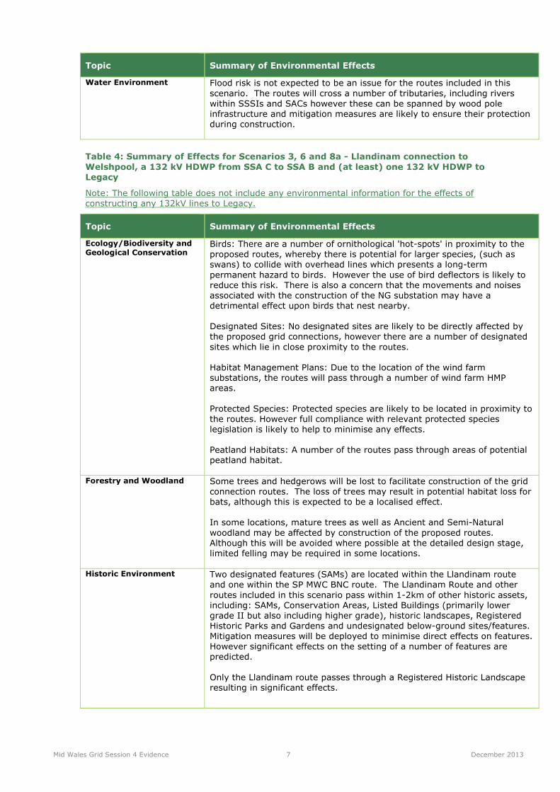
Mid Wales Grid Session 4 Evidence 7 December 2013
Topic Summary of Environmental Effects
Water Environment Flood risk is not expected to be an issue for the routes included in this
scenario. The routes will cross a number of tributaries, including rivers
within SSSIs and SACs however these can be spanned by wood pole
infrastructure and mitigation measures are likely to ensure their protection
during construction.
Table 4: Summary of Effects for Scenarios 3, 6 and 8a - Llandinam connection to
Welshpool, a 132 kV HDWP from SSA C to SSA B and (at least) one 132 kV HDWP to
Legacy
Note: The following table does not include any environmental information for the effects of
constructing any 132kV lines to Legacy.
Topic Summary of Environmental Effects
Ecology/Biodiversity and Geological Conservation
Birds: There are a number of ornithological 'hot-spots' in proximity to the
proposed routes, whereby there is potential for larger species, (such as
swans) to collide with overhead lines which presents a long-term
permanent hazard to birds. However the use of bird deflectors is likely to
reduce this risk. There is also a concern that the movements and noises
associated with the construction of the NG substation may have a
detrimental effect upon birds that nest nearby.
Designated Sites: No designated sites are likely to be directly affected by
the proposed grid connections, however there are a number of designated
sites which lie in close proximity to the routes.
Habitat Management Plans: Due to the location of the wind farm
substations, the routes will pass through a number of wind farm HMP
areas.
Protected Species: Protected species are likely to be located in proximity to
the routes. However full compliance with relevant protected species
legislation is likely to help to minimise any effects.
Peatland Habitats: A number of the routes pass through areas of potential
peatland habitat.
Forestry and Woodland Some trees and hedgerows will be lost to facilitate construction of the grid
connection routes. The loss of trees may result in potential habitat loss for
bats, although this is expected to be a localised effect.
In some locations, mature trees as well as Ancient and Semi-Natural
woodland may be affected by construction of the proposed routes.
Although this will be avoided where possible at the detailed design stage,
limited felling may be required in some locations.
Historic Environment Two designated features (SAMs) are located within the Llandinam route
and one within the SP MWC BNC route. The Llandinam Route and other
routes included in this scenario pass within 1-2km of other historic assets,
including: SAMs, Conservation Areas, Listed Buildings (primarily lower
grade II but also including higher grade), historic landscapes, Registered
Historic Parks and Gardens and undesignated below-ground sites/features.
Mitigation measures will be deployed to minimise direct effects on features.
However significant effects on the setting of a number of features are
predicted.
Only the Llandinam route passes through a Registered Historic Landscape
resulting in significant effects.

Mid Wales Grid Session 4 Evidence 8 December 2013
Topic Summary of Environmental Effects
Landscape and Visual Amenity
Landscape and visual effects are likely to arise along the routes of this
scenario, however the effects will be localised and will diminish rapidly with
distance from the route.
Localised significant effects have been identified for visual receptors
utilising a proportion of the footpaths, roads and residential properties
sited close to the routes of this scenario.
Overall, for the SSAC connection to Welshpool, effects are more likely for
landscape and visual receptors located close to the southern sections of the
proposed route. This is because this is generally a more elevated area with
lower levels of vegetation cover consequently there would be greater
potential visibility for the routes. In comparison, the central and northern
sections of the Llandinam – Welshpool line is routed through more diverse
and enclosed landscape character types, although the corollary is that
these sections tend to be more populous, therefore a greater number of
receptors are likely.
The SSAC connection to Cefn Coch will be visible as it crosses roads and
within valleys and there are likely to be potential visual effects on a
number of residential properties.
Landscape and visual effects are likely along line route section 1 of BNC 3,
BNC 4 and BNC5. However, these elements of this scenario will be
screened from some receptors and directions. The overhead line may
potentially be seen alongside other above ground equipment such the
turbines of the planned wind farms.
Effects are likely for landscape and visual receptors around the substation
at Cefn Coch than the SP Manweb Collector Substation: Option A. It is
anticipated that there would be unrestricted and filtered views of the
substation at Cefn Coch from the surrounding area, and it would potentially
be seen alongside above ground equipment such as overhead electricity
lines and the turbines of the planned wind farms.
Water Environment Flood risk is not expected to be an issue for the routes included in this
scenario. The routes will cross many tributaries, including rivers within
SSSIs and SACs however these can be spanned by wood pole
infrastructure and mitigation measures are likely to ensure their protection
during construction.
Table 5: Summary of Effects for Scenarios 5 and 7 – Llandinam connection to Welshpool
and (at least) one 132 kV HDWP to Legacy
Note: The following table does not include any environmental information for the effects of
constructing any 132kV lines to Legacy.
Topic Summary of Environmental Effects
Ecology/Biodiversity and Geological Conservation
Birds: There are a number of ornithological 'hot-spots' in proximity to the
proposed routes, whereby there is potential for larger species, (such as
swans) to collide with overhead lines which presents a long-term
permanent hazard to birds, however the use of bird deflectors is likely to
reduce this risk.
Designated Sites: No designated sites are likely to be directly affected by
the proposed grid connections, however there are a number of designated
site which lie in proximity to the routes.
Habitat Management Plans: Due to the location of the wind farm
substations the routes will pass through a number of wind farm HMP areas.

Mid Wales Grid Session 4 Evidence 9 December 2013
Topic Summary of Environmental Effects
Protected Species: Protected species are likely to be located in proximity to
the routes. However full compliance with relevant protected species
legislation is likely to help to minimise any effects.
Peatland Habitats: A number of the routes pass through areas of potential
peatland habitat.
Forestry and Woodland Some trees and hedgerows will be lost to facilitate construction of the grid
connection routes. The loss of trees may result in potential habitat loss for
bats, although this is expected to be a localised effect.
In some locations, mature trees as well as Ancient and Semi-Natural
woodland may be affected by construction of the proposed routes.
Although this will be avoided where possible at the detailed design stage,
limited felling may be required in some locations.
Historic Environment Two designated features (SAMs) are located within the Llandinam route
and one within the SP MWC BNC route. The Llandinam Route and other
routes included in this scenario pass within 1-2km of other historic assets,
including: SAMs, Conservation Areas, Listed Buildings (primarily lower
grade II but also including higher grade), historic landscapes, Registered
Historic Parks and Gardens and undesignated below-ground sites/features.
Mitigation measures will be deployed to minimise direct effects on features.
However, significant effects on the setting of a number of features are
predicted.
Only the Llandinam route passes through a Registered Historic Landscape
resulting in significant effects.
Landscape and Visual Amenity
Landscape and visual effects are likely to arise along the routes of this
scenario, however the effects will be localised and will diminish rapidly with
distance from the route.
Localised significant effects have been identified for visual receptors
utilising a proportion of the footpaths, roads and residential properties
sited close to the routes of this scenario.
Overall, for the SSAC connection, effects are more likely for landscape and
visual receptors located close to the southern sections of the proposed
route. This is because this is generally a more elevated area with lower
levels of vegetation cover consequently there would be greater potential
visibility for the routes. In comparison, the central and northern sections of
the Llandinam – Welshpool route is routed through more diverse and
enclosed landscape character types, although the corollary is that these
sections tend to be more populous, therefore a greater number of
receptors are likely.
Landscape and visual effects are likely along line route section 1 of BNC 3,
BNC 4 and BNC5. However, these elements of this scenario will be
screened from some receptors and directions and the overhead line may
potentially be seen alongside other above ground equipment such the
turbines of the planned wind farms.
Water Environment Flood risk is not expected to be an issue for the routes included in this
scenario. The routes will cross many tributaries, including rivers within
SSSIs and SACs however these can be spanned by wood pole
infrastructure and mitigation measures are likely to ensure their protection
during construction.

Mid Wales Grid Session 4 Evidence 10 December 2013
Table 6: Summary of Effects for Scenario 8b - Llandinam connection to Welshpool, a 132
kV circuit between SSA B and SSA C and National Grid 400kv circuit to Lower Frankton
from National Grid 400kV substation at Cefn Coch
Topic Summary of Environmental Effects
Ecology/Biodiversity and Geological Conservation
Birds: There are a number of ornithological 'hot-spots' in proximity to the
proposed routes, whereby there is potential for larger species, (such as
swans) to collide with overhead lines which presents a long-term
permanent hazard to birds, however the use of bird deflectors is likely to
reduce this risk. There is also a concern that the movements and noises
associated with the construction of the NG substation may have a
detrimental effect upon birds that nest nearby.
Designated Sites: The Montgomery / Shropshire Union Canal SAC and
Montgomery Canal SSSI are crossed by the 400kV preferred route corridor.
No other designated sites are likely to be directly affected by the proposed
grid connections, however there are a number of designated sites which lie
in close proximity to the routes.
Habitat Management Plans: Due to the location of the wind farm
substations the routes will pass through a number of wind farm HMP areas.
Protected Species: Protected species are likely to be located in proximity to
the routes. However full compliance with relevant protected species
legislation is likely to help to minimise any effects.
Peatland Habitats: A number of the routes pass through areas of potential
peatland habitat.
Forestry and Woodland Some trees and hedgerows will be lost to facilitate construction of the grid
connection routes. The loss of trees may result in potential habitat loss for
bats, although this is expected to be a localised effect.
In some locations, mature trees as well as Ancient and Semi-Natural
woodland may be affected by construction of the proposed routes.
Although this will be avoided where possible at the detailed design stage,
limited felling may be required in some locations.
Historic Environment Two designated features (SAMs) are located within the Llandinam route
and one within the SP MWC BNC route. There are also multiple SAMs
located within the 400kV preferred route. The Llandinam Route and other
routes included in this scenario pass within 1-2km of other historic assets,
including: SAMs, Conservation Areas, Listed Buildings (primarily lower
grade II but also including higher grade), historic landscapes, Registered
Historic Parks and Gardens and undesignated below-ground sites/features.
Mitigation measures will be deployed to minimise direct effects on features.
However, significant effects on the setting of a number of features are
predicted.
Only the Llandinam route passes through a Registered Historic Landscape
resulting in significant effects.
Landscape and Visual Amenity
Landscape and visual effects are likely to arise along the routes of this
scenario, however the effects will be localised and will diminish rapidly with
distance from the route. Views are also variable depending on localised
topography and tree cover.
Localised significant effects have been identified for visual receptors
utilising a proportion of the footpaths, roads and residential properties
sited close to the routes of this scenario. In some locations along the
400kV line preferred route, settlements, including a number of large
villages are affected. Also, the popular viewpoint of Llanymynech Hill with
its Heritage Trail overlooks this section of the preferred route corridor.

Mid Wales Grid Session 4 Evidence 11 December 2013
Topic Summary of Environmental Effects
While the existing 400 kV line is noticeable in locations along the route, it
is not a dominant landscape feature, particularly towards the eastern end
of the route.
Overall, for the SSAC connection to Welshpool, effects are more likely for
landscape and visual receptors located close to the southern sections of the
proposed route. This is because this is generally a more elevated area with
lower levels of vegetation cover consequently there would be greater
potential visibility for the routes. In comparison, the central and northern
sections of the Llandinam – Welshpool route is routed through more
diverse and enclosed landscape character types, although the corollary is
that these sections tend to be more populous, therefore a greater number
of receptors are likely.
The SSAC connection to Cefn Coch will be visible as it crosses roads and
within valleys and there are likely to be potential visual effects on a
number of residential properties.
Landscape and visual effects are likely along line route section 1 of BNC 3,
BNC 4 and BNC5. However, these elements of this scenario will be
screened from some receptors and directions and the overhead line may
potentially be seen alongside other above ground equipment such the
turbines of the planned wind farms.
Effects are likely for landscape and visual receptors around the substation
at Cefn Coch than the SP Manweb Collector Substation: Option A. It is
anticipated that there would be unrestricted and filtered views of the
substation at Cefn Coch from the surrounding area, and it would potentially
be seen alongside above ground equipment such as overhead electricity
lines and the turbines of the planned wind farms.
Water Environment Flood risk is not expected to be an issue for most routes included in this
scenario. However, the 400kV line preferred route crosses extensive areas
of flood plain, areas of indicative reservoir flood risk and groundwater flows
associated with floodplain areas, which all requires consideration.
The routes will cross many tributaries, including rivers within SSSIs and
SACs however these can be spanned by wood pole infrastructure and
mitigation measures are likely to ensure their protection during
construction.

APPENDIX 1: SUMMARY OF
ENVIRONMENTAL INFORMATION
FOR GRID SCENARIOS

APPENDIX 1
Table A: Publications that have been used to assess the environmental effects of each scenario
Scenario Solution Source of Environmental Information
(Green = Environmental information available; Amber = Some environmental information not available)
1 Up to 150 MW (one or two wind farms) in SSA C; no
wind farms in SSA B)
132 kV HDWP line from SSA C to connect to the
SP Manweb network at Welshpool. Requires SP
Manweb reinforcements north of Welshpool
Environmental information for how the wind farms in SSA C can connect to the Llandinam Route can be found in: SP MANWEB
(Sept 2013). SP Mid Wales Connections, Line Routing Methodology & Appraisal - Phase 3 Report.
Environmental information for the Llandinam Route can be found in: SP MANWEB (Oct 2013). Volume 1: New 132kV
Overhead Line Connection from Llandinam Wind Farm to Welshpool Substation - Updated Environmental Statement.
2 Over 150 MW (all three wind farms) in SSA C; no
wind farms in SSA B
The connection to Welshpool, as outlined in
option 1, plus a 132 kV HDWP connection to
Shrewsbury
Environmental information for how the wind farms in SSA C can connect to the Llandinam Route can be found in: SP MANWEB
(Sept 2013). SP Mid Wales Connections, Line Routing Methodology & Appraisal - Phase 3 Report.
Environmental information for the Llandinam Route can be found in: SP MANWEB (Oct 2013). Volume 1: New 132kV
Overhead Line Connection from Llandinam Wind Farm to Welshpool Substation - Updated Environmental Statement.
No environmental information is available for a complete circuit to Shrewsbury.
3 Over 150 MW (all three wind farms) in SSA C; at
least one wind farm in Area B
The connection to Welshpool, as outlined in
option 1, plus a 132 kV HDWP from SSA C to
SSA B. This assumes there must be (at least)
one circuit to Legacy (see the following options)
Environmental information for how the wind farms in SSA B and SSA C can connect to the Substation at Cefn Coch, and the
Llandinam Route can be found in: SP MANWEB (Sept 2013). SP Mid Wales Connections, Line Routing Methodology & Appraisal
- Phase 3 Report.
Environmental information for the Llandinam Route can be found in: SP MANWEB (Oct 2013). Volume 1: New 132kV
Overhead Line Connection from Llandinam Wind Farm to Welshpool Substation - Updated Environmental Statement.
Environmental information for the Substation at Cefn Coch can be found in: National Grid (Sept 2013). Mid Wales Connection
Project, Draft Substation Site Report.
No environmental information is available for a complete circuit to Legacy.
4 Up to 150 MW (one wind farm) in SSA B; no wind
farms in SSA C
132 kV HDWP circuit to Welshpool from SSA B Environmental information for how the wind farms in SSA B route towards Welshpool (as far as the substation at Cefn Coch)
can be found in: SP MANWEB (Sept 2013). SP Mid Wales Connections, Line Routing Methodology & Appraisal - Phase 3
Report.
No environmental information is available for a complete circuit to Welshpool.
5 Up to 117.8 MW or 167.2 MW (one wind farm) in
SSA B; two wind farms in SSA C of up to a total of
150 MW
132 kV HDWP circuit (124 MVA or 176 MVA) to
Legacy from SSA B, plus connection option 1
Environmental information for how the wind farms in SSA B route towards Legacy (as far as the substation at Cefn Coch) and
SSA C connect to the Llandinam Route can be found in: SP MANWEB (Sept 2013). SP Mid Wales Connections, Line Routing
Methodology & Appraisal - Phase 3 Report.
Environmental information for the Llandinam Route can be found in: SP MANWEB (Oct 2013). Volume 1: New 132kV
Overhead Line Connection from Llandinam Wind Farm to Welshpool Substation - Updated Environmental Statement.
No environmental information is available for a complete circuit to Legacy.

Scenario Solution Source of Environmental Information
(Green = Environmental information available; Amber = Some environmental information not available)
6 Up to 87.2 MW (Llanbrynmair) in SSA B; all three
wind farms in SSA C
132 kV HDWP circuit (176 MVA) to Legacy from
SSA B, plus connection option 1, plus 132 kV
HDWP between SSA B and SSA C
Environmental information for how the wind farms in SSA B and SSA C can connect to the Substation at Cefn Coch, and the
Llandinam Route can be found in: SP MANWEB (Sept 2013). SP Mid Wales Connections, Line Routing Methodology & Appraisal
- Phase 3 Report.
Environmental information for the Llandinam Route can be found in: SP MANWEB (Oct 2013). Volume 1: New 132kV
Overhead Line Connection from Llandinam Wind Farm to Welshpool Substation - Updated Environmental Statement.
Environmental information for the Substation at Cefn Coch can be found in: National Grid (Sept 2013). Mid Wales Connection
Project, Draft Substation Site Report.
No environmental information is available for a complete circuit to Legacy.
7 Both wind farms in SSA B; up to 150 MW (two wind
farms) in SSA C
2 x 132 kV HDWP circuits to Legacy from SSA B,
plus connection option 1
Environmental information for how the wind farms in SSA B route towards Legacy (as far as the substation at Cefn Coch) and
SSA C connect to the Llandinam Route can be found in: SP MANWEB (Sept 2013). SP Mid Wales Connections, Line Routing
Methodology & Appraisal - Phase 3 Report.
Environmental information for the Llandinam Route can be found in: SP MANWEB (Oct 2013). Volume 1: New 132kV
Overhead Line Connection from Llandinam Wind Farm to Welshpool Substation - Updated Environmental Statement.No
environmental information is available for complete routes to Legacy.
8a All five windfarms 2 x 132 kV circuits (2 x HDWP or an L4 tower
line) to Legacy from SSA B, plus a 132 kV circuit
between SSA B and SSA C, plus connection
option 1
Environmental information for how the wind farms in SSA B and SSA C can connect to the Substation at Cefn Coch, and the
Llandinam Route can be found in: SP MANWEB (Sept 2013). SP Mid Wales Connections, Line Routing Methodology & Appraisal
- Phase 3 Report.
Environmental information for the Llandinam Route can be found in: SP MANWEB (Oct 2013). Volume 1: New 132kV
Overhead Line Connection from Llandinam Wind Farm to Welshpool Substation - Updated Environmental Statement.
Environmental information for the Substation at Cefn Coch can be found in: National Grid (Sept 2013). Mid Wales Connection
Project, Draft Substation Site Report.
No environmental information is available for complete routes to Legacy.
8b All five windfarms National Grid 400kv circuit to Lower Frankton
from National Grid 400kV substation at Cefn
Coch, plus a 132 kV circuit between SSA B and
SSA C, plus connection option 1
Environmental information for how the wind farms in SSA B and SSA C can connect to the Substation at Cefn Coch, and the Llandinam Route can be found in: SP MANWEB (Sept 2013). SP Mid Wales Connections, Line Routing Methodology & Appraisal - Phase 3 Report. Environmental information for the Llandinam Route can be found in: SP MANWEB (Oct 2013). Volume 1: New 132kV Overhead Line Connection from Llandinam Wind Farm to Welshpool Substation - Updated Environmental Statement. Environmental information for the Substation at Cefn Coch can be found in: National Grid (Sept 2013). Mid Wales Connection Project, Draft Substation Site Report. Environmental information for the 400kv circuit to Lower Frankton can be found in: National Grid (Sept 2013). Mid Wales Connection Project, Draft Route Report.
Green = Environmental information is available for whole route.
Amber = Environmental information is not available for some sections of the route.

Table B: Scenario 1 - 132 kV HDWP line from SSA C to Welshpool
Environmental
Topics
Proposed Grid Connection
132 kV HDWP line from SSA C to connect to the SP Manweb network at Welshpool
SSA C Windfarms to Llandinam Route (Route Options CC1, CC2, CC3 and CC4: Line Route
Section 1)
SP Manweb Collector Substation: Option A Llandinam Route to Welshpool Summary of Environmental Effects
Air Quality
and Emissions (incl. dust)
As no line route option is considered to have a greater or lesser effect in respect of this topic at this scale, this topic has not been included as it does not assist in identifying a line route with least environmental effect. This topic will be considered at the EIA stage. (page 48 of Ref. 1)
As no line route option is considered to have a greater or lesser effect in respect of this topic at this scale, this topic has not been included as it does not assist in identifying a line route with least environmental effect. This topic will be considered at the EIA stage. (page 48 of Ref. 1)
Not covered in Reference 2. This topic has not been included in the environmental assessments or reports for the routes included in this scenario.
Ecology/Biodi
versity and Geological Conservation
CC4, CC1 and CC3: Line route section 1 (page 91 of
Ref. 1) Wind farm Habitat Management Plan Area (HMP) - The route passes through several HMP areas associated with Hirddywell Wind Farm. Protected Species - The route passes through a small potential protected species hotspot at Custogion. Two further potential protected species hotspots are located within 2km of the route. Peatland Habitats - The route passes through two large areas of potential peat. It also passes through areas identified in Environmental Statements as supporting peat habitats. Ornithological ‘Hot Spots’ - The route is not associated with any ornithological hotspots; however the Tylwch tip hotspot is approx. 400m to the north-west. Sites Designated for Nature Conservation Importance (SPA, SAC, SSSI) - The route does not pass through any statutory designated sites; however several designated areas are within a 2km radius, including the River Wye SAC. The closest site is the Gweunydd Camnant SSSI, approx. 55m to the north.
SP Manweb Collector Substation: Option A (Tables 6.4 and
6.5 of Ref. 1) SAC - The River Wye SAC headwaters lie 0.75km to the south east of the site with associated freshwater sensitivities. SSSI - The site lies less than 1km from Gweunydd Camnant SSSI, designated for habitats, the River Ithon SSSI and the Esgairdraenllwyn Pastures SSSI, designated for habitats.
Llandinam Route to Welshpool (Chapter 7 of Ref. 2)
It is considered that the proposed overhead line is not likely to result in any significant adverse long-term effects. If the mitigation measures discussed in Chapter 7 (Ref. 2) are fully implemented any risk of adverse effects will be further reduced. The potential for collisions with overhead lines is probably the most significant effect likely to arise. This represents a long-term, permanent hazard to certain groups of birds, primarily the larger species such as swans and to a lesser extent the smaller wildfowl. However, the erection of bird deflectors in appropriate locations will reduce the risk of birds colliding with the overhead line, and the erection of devices to discourage or prevent roosting on wood pole supports will reduce the risk of predation on ground nesting birds.
Birds: There is potential for birds particularly larger species (such as swans) to collide with the overhead lines. This represents a long-term, permanent hazard to certain groups of birds but the use of bird deflectors is likely to help to reduce this risk. Designated Sites: The proposed routes to Llandinam and the Man Web Collector Station do not cross any nature conservation designations. Several sites do however lie within close proximity to the route. Peatland: The route will pass through areas identified as having potential peatland habitats.
Habitat Management Plans: Due to the
location of the wind farm substations the
routes will pass through a wind farm
HMP area.
Protected Species: Protected species are
likely to be located in proximity to the
routes. However full compliance with
relevant protected species legislation is
likely to help to minimise any effects.
Climate
Change
As no line route option is considered to have a greater or lesser effect in respect of this topic at this scale, this topic has not been included as it does not assist in identifying a line route with least environmental effect. This topic will be considered at the EIA stage. (page 48 of Ref. 1)
As no line route option is considered to have a greater or lesser effect in respect of this topic at this scale, this topic has not been included as it does not assist in identifying a line route with least environmental effect. This topic will be considered at the EIA stage. (page 48 of Ref. 1)
Not covered in Reference 2. This topic has not been included in the environmental assessments or reports for the routes included in this scenario.
Electric and Magnetic Fields
As no line route option is considered to have a greater or lesser effect in respect of this topic at this scale, this topic has not been included as it does not assist in identifying a line route with least environmental effect. This topic will be considered at the EIA stage. (page 48 of Ref. 1)
As no line route option is considered to have a greater or lesser effect in respect of this topic at this scale, this topic has not been included as it does not assist in identifying a line route with least environmental effect. This topic will be considered at the EIA stage. (page 48 of Ref. 1)
Llandinam Route to Welshpool (Chapter 11 of Ref. 2) No significant environmental effects are anticipated on electric and magnetic fields. On this basis, the decision was made to not make this topic the subject of a detailed environmental impact assessment.
This topic has not been included in the environmental assessments or reports for the routes included in this scenario.
Environmental Topics
Proposed Grid Connection 132 kV HDWP line from SSA C to connect to the SP Manweb network at Welshpool
SSA C Windfarms to Llandinam Route (Route Options CC1, CC2, CC3 and CC4: Line Route
Section 1)
SP Manweb Collector Substation: Option A Llandinam Route to Welshpool Summary of Environmental Effects
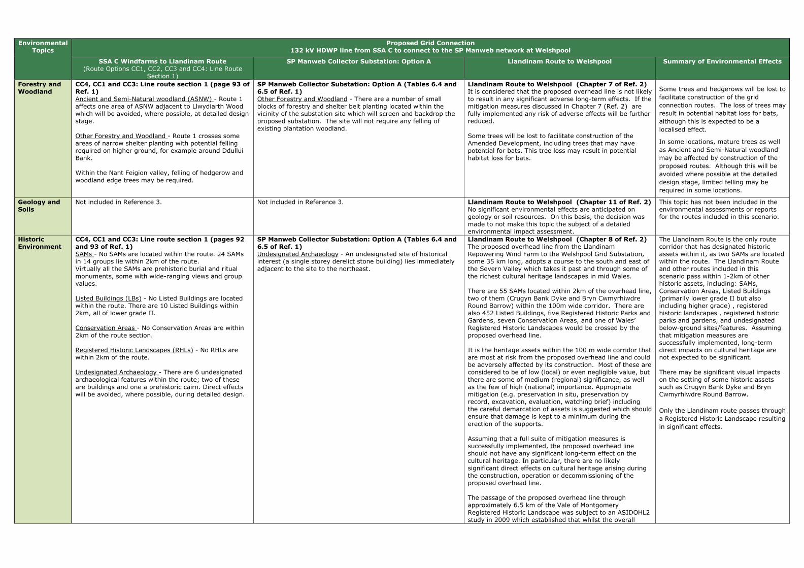
Forestry and Woodland
CC4, CC1 and CC3: Line route section 1 (page 93 of Ref. 1) Ancient and Semi-Natural woodland (ASNW) - Route 1 affects one area of ASNW adjacent to Llwydiarth Wood which will be avoided, where possible, at detailed design stage. Other Forestry and Woodland - Route 1 crosses some areas of narrow shelter planting with potential felling required on higher ground, for example around Ddullui Bank. Within the Nant Feigion valley, felling of hedgerow and woodland edge trees may be required.
SP Manweb Collector Substation: Option A (Tables 6.4 and 6.5 of Ref. 1) Other Forestry and Woodland - There are a number of small blocks of forestry and shelter belt planting located within the vicinity of the substation site which will screen and backdrop the proposed substation. The site will not require any felling of existing plantation woodland.
Llandinam Route to Welshpool (Chapter 7 of Ref. 2) It is considered that the proposed overhead line is not likely to result in any significant adverse long-term effects. If the mitigation measures discussed in Chapter 7 (Ref. 2) are fully implemented any risk of adverse effects will be further reduced. Some trees will be lost to facilitate construction of the Amended Development, including trees that may have potential for bats. This tree loss may result in potential habitat loss for bats.
Some trees and hedgerows will be lost to
facilitate construction of the grid
connection routes. The loss of trees may
result in potential habitat loss for bats,
although this is expected to be a
localised effect.
In some locations, mature trees as well
as Ancient and Semi-Natural woodland
may be affected by construction of the
proposed routes. Although this will be
avoided where possible at the detailed
design stage, limited felling may be
required in some locations.
Geology and Soils
Not included in Reference 3. Not included in Reference 3. Llandinam Route to Welshpool (Chapter 11 of Ref. 2) No significant environmental effects are anticipated on geology or soil resources. On this basis, the decision was made to not make this topic the subject of a detailed environmental impact assessment.
This topic has not been included in the environmental assessments or reports for the routes included in this scenario.
Historic Environment
CC4, CC1 and CC3: Line route section 1 (pages 92 and 93 of Ref. 1) SAMs - No SAMs are located within the route. 24 SAMs in 14 groups lie within 2km of the route. Virtually all the SAMs are prehistoric burial and ritual monuments, some with wide-ranging views and group values. Listed Buildings (LBs) - No Listed Buildings are located within the route. There are 10 Listed Buildings within 2km, all of lower grade II. Conservation Areas - No Conservation Areas are within 2km of the route section. Registered Historic Landscapes (RHLs) - No RHLs are within 2km of the route. Undesignated Archaeology - There are 6 undesignated archaeological features within the route; two of these are buildings and one a prehistoric cairn. Direct effects will be avoided, where possible, during detailed design.
SP Manweb Collector Substation: Option A (Tables 6.4 and 6.5 of Ref. 1) Undesignated Archaeology - An undesignated site of historical interest (a single storey derelict stone building) lies immediately adjacent to the site to the northeast.
Llandinam Route to Welshpool (Chapter 8 of Ref. 2) The proposed overhead line from the Llandinam Repowering Wind Farm to the Welshpool Grid Substation, some 35 km long, adopts a course to the south and east of the Severn Valley which takes it past and through some of the richest cultural heritage landscapes in mid Wales. There are 55 SAMs located within 2km of the overhead line, two of them (Crugyn Bank Dyke and Bryn Cwmyrhiwdre Round Barrow) within the 100m wide corridor. There are also 452 Listed Buildings, five Registered Historic Parks and Gardens, seven Conservation Areas, and one of Wales’ Registered Historic Landscapes would be crossed by the proposed overhead line. It is the heritage assets within the 100 m wide corridor that are most at risk from the proposed overhead line and could be adversely affected by its construction. Most of these are considered to be of low (local) or even negligible value, but there are some of medium (regional) significance, as well as the few of high (national) importance. Appropriate mitigation (e.g. preservation in situ, preservation by record, excavation, evaluation, watching brief) including the careful demarcation of assets is suggested which should ensure that damage is kept to a minimum during the erection of the supports. Assuming that a full suite of mitigation measures is successfully implemented, the proposed overhead line should not have any significant long-term effect on the cultural heritage. In particular, there are no likely significant direct effects on cultural heritage arising during the construction, operation or decommissioning of the proposed overhead line. The passage of the proposed overhead line through approximately 6.5 km of the Vale of Montgomery Registered Historic Landscape was subject to an ASIDOHL2 study in 2009 which established that whilst the overall
The Llandinam Route is the only route corridor that has designated historic assets within it, as two SAMs are located within the route. The Llandinam Route and other routes included in this scenario pass within 1-2km of other historic assets, including: SAMs, Conservation Areas, Listed Buildings (primarily lower grade II but also including higher grade) , registered historic landscapes , registered historic parks and gardens, and undesignated below-ground sites/features. Assuming that mitigation measures are successfully implemented, long-term direct impacts on cultural heritage are not expected to be significant. There may be significant visual impacts on the setting of some historic assets such as Crugyn Bank Dyke and Bryn Cwmyrhiwdre Round Barrow.
Only the Llandinam route passes through
a Registered Historic Landscape resulting
in significant effects.

Environmental Topics
Proposed Grid Connection 132 kV HDWP line from SSA C to connect to the SP Manweb network at Welshpool
SSA C Windfarms to Llandinam Route (Route Options CC1, CC2, CC3 and CC4: Line Route
Section 1)
SP Manweb Collector Substation: Option A Llandinam Route to Welshpool Summary of Environmental Effects
effect would be moderate, locally it would be severe, representing a significant effect. Inevitably during the operational life of the proposed overhead line, it would have an indirect visual effect on a significant number of designated and registered assets. In a few cases, around six in number, that effect is likely to be very large. It is difficult to identify how such visual effects might be reduced for the density of assets in this region is such that any route adopted would be likely to generate visual issues. These are long-term temporary effects which would last for the operational life of the proposed overhead line but which would be completed removed once the proposed overhead line has been decommissioned.
Land Use CC4, CC1 and CC3: Line route section 1 (page 94 of Ref. 1) Open space and Green Infrastructure - Route 1 crosses one area of Open Country access and lies within 1km of one other, and within 1km of two areas of Registered Common Land.
No environmental information was covered for this topic. Not covered in Reference 2. It is not possible to draw conclusions from the environmental information available, as all of the routes have not considered this topic.
Landscape and Visual Amenity
CC4, CC1 and CC3: Line route section 1 (pages 91 and 92 of Ref. 1) Landscape Sensitivity - The route runs north-west from Llanbadarn across open pasture, below higher moorland tops to the east and above the A483. Although visible in longer views from the west, the landscape is of medium sensitivity due to its scale, blocks and belts of coniferous woodland and existing wind farms. The route runs through the Ithon valley but is relatively shallow at this point. The route turns west, crossing the A483 and Ithon valley across undulating higher land, with the 33kV line from Neuadd Goch Wind Farm meeting the line in the vicinity of Camnant, where a collector substation will be required. The route drops down from the higher land at Hirddywel, running cross slope just below the highest land at Pegwyn Bank and dropping down the steep scarp slope to run west through the small Nant Feigion valley, contained by steep slopes and woodland blocks. Route 1 follows the field pattern, using field boundaries and shelter belts to screen and backdrop the route. It will be visible in views in the generally open landscape but these views will be broken by existing planting and will seldom skyline. The route follows local valleys as it descends from the higher ground, contained by topography and woodland planting. It will be visible intermittently in longer views but will be set within the landscape. Visual Sensitivity - Route 1 will be visible as it crosses the A483, including both the 132kV alignment from Llanbadarn and the 33kV from Neuadd Goch. Otherwise the local road network is crossed 3 times. Residential Visual Amenity - Residential properties are
SP Manweb Collector Substation: Option A (Tables 6.4 and 6.5 of Ref. 1) Landscape Sensitivity - The open pasture landscape lies below the higher moorland tops to the north and east above the A483. The Ithon valley runs to the east of the site but is relatively shallow at this point. The moderate sized pastoral fields are often contained by coniferous shelter belts and larger woodland blocks, which both introduce man made elements to the landscape and break up and contain views. The substation is potentially visible within the landscape due to its elevation and the relatively open nature of the upland landscape. However, the sensitivity of this landscape is medium-low, and there is scope for extension of the existing areas of coniferous planting belts which contain views. The site includes a belt of existing coniferous planting on its southern edge which will both screen, and provide a backdrop for the substation infrastructure. Residential Visual Amenity - The area is sparsely populated with only four properties within 1km of the substation. Views from residential properties will be limited to the properties at Camnant Farm, Camnant Bridge and one property to the north-west. These views will be screened in part by intervening vegetation. The distance of the sites from the A483, the local landform, and intervening vegetation, reduces visibility from the road. Recreational Resource - There is a relatively dense network of public rights of way in the vicinity of the site; two local public footpaths cross the site but these can be diverted to an existing track around the site. There would be views to the site from the adjacent public footpaths and others in the vicinity; however use of the footpaths does not appear to be high.
Llandinam Route to Welshpool (Chapter 6 of Ref. 2) Any likely significant landscape or visual effects would arise during the operational stage from the localised loss of trees and the introduction into the landscape of approximately 35 km of new overhead line on wood pole structures. The design and routing of the proposed overhead line has been developed to minimise its effects on the landscape and visual amenity of the area. The location of the Llandinam wind farm on the Waun Ddubarthog Ridge means that the route is more visible at the southern end of the corridor, than further north where it merges into the more diverse and enclosed landscape east of the Severn Valley. However, the use of wood pole supports helps mitigate the effects within the more open and elevated parts of the route. Landscape Effects
Although significant or borderline significant, all the effects were assessed as minor-moderate or moderate and none of the effects was assessed as major. The only landscape along the route identified as experiencing a moderate and therefore significant effect is between the A483 near Old Neuadd Bank and Cae-betin Wood, including the open hillside below the Kerry Ridgeway Regional Trail. Other areas of landscape (e.g. the Canlad Valley and the Severn Valley) would experience minor-moderate effects which would be borderline significant. Visual Effects
Although significant or verging on significant, all the effects were assessed as minor - moderate or moderate and none of these effects was assessed as major. In terms of settlements, some properties on the edge of Fron Bank/Cilcewydd, which lie within 500m of the overhead line will experience a significant change in their view, where there is no screening afforded by landform, buildings or vegetation. Of the many individual properties
Landscape and visual effects are likely to arise along the routes of this scenario, however the effects will be localised and will diminish rapidly with distance from the route. Localised effects have been identified for visual receptors utilising a proportion of the footpaths, roads and residential properties sited close the routes/sites of this scenario. Overall, effects are more likely for landscape and visual receptors located close to the southern sections of the proposed routes. This is because this is generally a more elevated area with lower levels of vegetation cover consequently there would be greater potential visibility for the routes. In comparison, the central and northern sections of the Llandinam – Welshpool route is routed through more diverse and enclosed landscape character types, although the corollary is that these sections tend to be more populous, therefore a greater number of receptors are likely.

Environmental Topics
Proposed Grid Connection 132 kV HDWP line from SSA C to connect to the SP Manweb network at Welshpool
SSA C Windfarms to Llandinam Route (Route Options CC1, CC2, CC3 and CC4: Line Route
Section 1)
SP Manweb Collector Substation: Option A Llandinam Route to Welshpool Summary of Environmental Effects
limited in the upland landscape, although 5 properties are likely to have views to the route, notably 2 properties at Blue Line Farm. As the line drops off the high ground properties increase, including those at Cloesfynnon and Rhiw-felen, which will have views to the line. Visitor Attractions - No visitor attractions have been identified that would be directly or indirectly affected by route 1. Recreational Resource - Route 1 crosses Glwyndwr’s Way once and a moderate density of RoWs also cross or run adjacent to the line.
scattered throughout the study area, only those close to the overhead line will experience a significant change in their view some of which will have views of the proposed overhead line. However, the nature of the proposed overhead line, combined with the screening effects of landform and vegetation, mean that its effect will be limited, and no views would create effects on residential amenity to the extent that they would become an undesirable place to live. Users of local public rights of way and open access areas will be variably affected. Where a pole is seen in close proximity to these areas (e.g. the public forest, footpaths and local access roads near Bryn-picca), the effect on visual amenity will be significant, although this effect will diminish rapidly with distance. Similarly, road users will be variably affected. Significant residual effects are noted for the A483 and B4355, although these effects would be localised and transient.
Lighting Not included in Reference 1. Not included in Reference 1. Llandinam Route to Welshpool (Chapter 11 of Ref. 2) No significant environmental effects are anticipated on lighting. On this basis, the decision was made to not make this topic the subject of a detailed environmental impact assessment.
This topic has not been included in the environmental assessments or reports for the routes included in this scenario.
Noise and Vibration
As no line route option is considered to have a greater or lesser effect in respect of this topic at this scale, this topic has not been included as it does not assist in identifying a line route with least environmental effect. This topic will be considered at the EIA stage. (page 48 of Ref. 1)
As no line route option is considered to have a greater or lesser effect in respect of this topic at this scale, this topic has not been included as it does not assist in identifying a line route with least environmental effect. This topic will be considered at the EIA stage. (page 48 of Ref. 1)
Llandinam Route to Welshpool (Chapter 11 of Ref. 2) No significant environmental effects are anticipated for noise. On this basis, the decision was made to not make this topic the subject of a detailed environmental impact assessment. This is because of the low intensity of construction activities, the very low volume of vehicle movements which construction of the proposed overhead line would generate, the short-term (days rather than weeks) and reversible activities at each wood pole structure, and the proven methods of noise control at construction sites. While the Draft Construction Method Statement will ultimately address noise control issues in detail it is noted that Powys CC has powers to investigate noise complaints and serve abatement notices on activities which it considers are giving rise to unacceptable levels of noise
This topic has not been included in the environmental assessments or reports for the routes included in this scenario.

Environmental Topics
Proposed Grid Connection 132 kV HDWP line from SSA C to connect to the SP Manweb network at Welshpool
SSA C Windfarms to Llandinam Route (Route Options CC1, CC2, CC3 and CC4: Line Route
Section 1)
SP Manweb Collector Substation: Option A Llandinam Route to Welshpool Summary of Environmental Effects
Socio Economics (including Tourism and Recreation)
As no line route option is considered to have a greater or lesser effect in respect of this topic at this scale, this topic has not been included as it does not assist in identifying a line route with least environmental effect. This topic will be considered at the EIA stage. (page 48 of Ref. 1)
As no line route option is considered to have a greater or lesser effect in respect of this topic at this scale, this topic has not been included as it does not assist in identifying a line route with least environmental effect. This topic will be considered at the EIA stage. (page 48 of Ref. 1)
Llandinam Route to Welshpool (Chapter 10 of Ref. 2) The design and routeing of the proposed overhead line has been developed to minimise its effects on visual amenity and consequently upon negative perceptions of tourists and residents alike. The proposed overhead line generally avoids major settlements, tourist attractions, and local amenity assets. No significant socio-economic effects would arise from the construction and decommissioning of the proposed overhead line. In respect of the operational stage, the proposed overhead line would not have any significant effects upon the local population, economy, local community assets, tourist attractions or tourism more broadly. The operational stage would be expected to have a moderately significant effect upon tourism accommodation at two sites namely the Tavern Caravan Park and Edderton Hall B&B/Guest House. If proposed mitigation is accepted the residual effects would become not significant at Tavern Caravan Park but remain moderately significant for Edderton Hall B&B/Guest House.
It is not possible to draw conclusions from the environmental information available, as all of the routes have not considered this topic.
Traffic and Transport
CC4, CC1 and CC3: Line route section 1 (page 95 of Ref. 1) This route could be accessed via existing main public roads although there are two extended sections (the area south of Hirddywell and north-west of Esgaidraenliwyn) where access will be difficult due to steep land and a lack of existing tracks.
SP Manweb Collector Substation: Option A (Tables 6.4 and 6.5 of Ref. 1) The site is accessible from existing farm tracks.
Llandinam Route to Welshpool (Chapter 11 of Ref. 2) No significant environmental effects are anticipated on traffic and transport. On this basis, the decision was made to not make this topic the subject of a detailed environmental impact assessment. The main issue of concern with respect to traffic would be the creation of construction and maintenance accesses and then accessing otherwise inaccessible fields with construction vehicles. This would be set out in the Draft Construction and Method Statement as part of the planning conditions, and would be developed in consultation with Powys Highways Authority.
Most routes/sites in this scenario are accessible by existing farm tracks or main public roads. However, localised instances may occur where the terrain makes access difficult.
Waste Management
As no line route option is considered to have a greater or lesser effect in respect of this topic at this scale, this topic has not been included as it does not assist in identifying a line route with least environmental effect. This topic will be considered at the EIA stage. (page 48 of Ref. 1)
As no line route option is considered to have a greater or lesser effect in respect of this topic at this scale, this topic has not been included as it does not assist in identifying a line route with least environmental effect. This topic will be considered at the EIA stage. (page 48 of Ref. 1)
Llandinam Route to Welshpool (Chapter 11 of Ref. 2) No significant environmental effects are anticipated on waste management. On this basis, the decision was made to not make this topic the subject of a detailed environmental impact assessment.
This topic has not been included in the environmental assessments or reports for the routes included in this scenario.
Water Environment
CC4, CC1 and CC3: Line route section 1 (page 93 of Ref. 1) Water Quality - Route 1 crosses four tributaries of the River Wye SAC and River Ithon SSSI. Flood Risk - Route 1 crosses four narrow tributaries of the River Ithon flood zone, which are 35 to 80m in width and will not form a constraint to routeing.
SP Manweb Collector Substation: Option A (Tables 6.4 and 6.5 of Ref. 1) Flood Zones - A narrow flood zone lies 0.3km to the north and 0.7km to the east of the site. It is less than 50m wide and will not be affected by the substation.
Llandinam Route to Welshpool (Chapter 9 of Ref. 2) It is considered that, if the mitigation measures discussed above and detailed fully in the Draft Construction Method Statement are successfully implemented, the construction, operation and decommissioning effects of the proposed overhead line on hydrology, groundwater, flood risk and water quality would not result in any likely significant adverse long term effects.
Flood risk is not expected to be an issue
for the routes included in this scenario.
The routes will cross a number of
tributaries, including rivers within SSSIs
and SACs however these can be spanned
by wood pole infrastructure and
mitigation measures will ensure their
protection during construction.

Environmental Topics
Proposed Grid Connection 132 kV HDWP line from SSA C to connect to the SP Manweb network at Welshpool
SSA C Windfarms to Llandinam Route (Route Options CC1, CC2, CC3 and CC4: Line Route
Section 1)
SP Manweb Collector Substation: Option A Llandinam Route to Welshpool Summary of Environmental Effects
Technical Review
CC4, CC1 and CC3: Line route section 1 (page 94 of Ref. 1) Existing and Proposed OHL Infrastructure 33kV and 132kV - The Llandinam OHL route would cross this at the eastern end of the route. Existing and Proposed Wind Turbines - The route passes within proximity of turbines; however it will be possible to maintain the required distance. Altitude and Topography - The eastern end of this route would cover altitudes of up to 455m at the substation at Llanbadarn Fynydd. Moving west, the land height is 373m at the Neuadd Goch substation. As the line moves south-west, land heights increase to around 420m at Llaithddu and then higher to around 550m at Hirddywel. Gradients range between 0-15°. As the line passes west of Hirddywel, there is a section of land with a gradient of between 15-22°. The height of land then reduces to around 320m as the route moves west before turning north.
SP Manweb Collector Substation: Option A (Tables 6.4 and 6.5 of Ref. 1) This site could accommodate the required equipment.
Not covered in Reference 2. This information is not applicable to the summary of effects as it has been included for reference only.
References (Ref.): (1) SP MANWEB (Sept 2013). SP Mid Wales Connections, Line Routing Methodology & Appraisal - Phase 3 Report. (2) SP MANWEB (Oct 2013). Volume 1: New 132kV Overhead Line Connection from Llandinam Wind Farm to Welshpool Substation - Updated Environmental Statement. (3) National Grid (Sept 2013). Mid Wales Connection Project, Draft Substation Site Report. (4) National Grid (Sept 2013). Mid Wales Connection Project, Draft Route Report.

Table C: Scenario 2 - Connection to Welshpool, plus a 132 kV HDWP connection to Shrewsbury
Environmental
Topics
Proposed Grid Connection
Connection to Welshpool, as outlined in Scenario 1, plus a 132 kV HDWP connection to Shrewsbury
SSA C Windfarms to Llandinam Route (Route Options CC1, CC2, CC3 and CC4: Line
Route Section 1)
SP Manweb Collector Substation: Option A Llandinam Route to Welshpool 132kV HDWP connection to Shrewsbury
Summary of Environmental Effects
Air Quality
and Emissions (incl. dust)
As no line route option is considered to have a greater or lesser effect in respect of this topic at this scale, this topic has not been included as it does not assist in identifying a line route with least environmental effect. This topic will be considered at the EIA stage. (page 48 of Ref. 1)
As no line route option is considered to have a greater or lesser effect in respect of this topic at this scale, this topic has not been included as it does not assist in identifying a line route with least environmental effect. This topic will be considered at the EIA stage. (page 48 of Ref. 1)
Not covered in Reference 2. No environmental information available.
This topic has not been included in the environmental assessments or reports for the routes included in this scenario.
Ecology/Biodiversity and Geological Conservation
CC4, CC1 and CC3: Line route section 1 (page 91 of Ref. 1) Wind farm Habitat Management Plan Area (HMP) - The route passes through several HMP areas associated with Hirddywell Wind Farm. Protected Species - The route passes through a small potential protected species hotspot at Custogion. Two further potential protected species hotspots are located within 2km of the route. Peatland Habitats - The route passes through two large areas of potential peat. It also passes through areas identified in Environmental Statements as supporting peat habitats. Ornithological ‘Hot Spots’ - The route is not associated with any ornithological hotspots; however the Tylwch tip hotspot is approx. 400m to the north-west. Sites Designated for Nature Conservation Importance (SPA, SAC, SSSI) - The route does not pass through any statutory designated sites; however several designated areas are within a 2km radius, including the River Wye SAC. The closest site is the Gweunydd Camnant SSSI, approx. 55m to the north.
SP Manweb Collector Substation: Option A (Tables 6.4 and 6.5 of Ref. 1) SAC - The River Wye SAC headwaters lie 0.75km to the south east of the site with associated freshwater sensitivities. SSSI - The site lies less than 1km from Gweunydd Camnant SSSI, designated for habitats, the River Ithon SSSI and the Esgairdraenllwyn Pastures SSSI, designated for habitats.
Llandinam Route to Welshpool (Chapter 7 of Ref. 2) It is considered that the proposed overhead line is not likely to result in any significant adverse long-term effects. If the mitigation measures discussed in Chapter 7 (Ref. 2) are fully implemented any risk of adverse effects will be further reduced. The potential for collisions with overhead lines is probably the most significant effect likely to arise. This represents a long-term, permanent hazard to certain groups of birds, primarily the larger species such as swans and to a lesser extent the smaller wildfowl. However, the erection of bird deflectors in appropriate locations will reduce the risk of birds colliding with the overhead line, and the erection of devices to discourage or prevent roosting on wood pole supports will reduce the risk of predation on ground nesting birds.
No environmental information available.
Birds: There is potential for birds particularly larger species (such as swans) to collide with the overhead lines. This represents a long-term, permanent hazard to certain groups of birds but the use of bird deflectors is likely to help to reduce this risk. Designated Sites: The proposed routes to Llandinam and the Man Web Connector Station do not cross any nature conservation designations. Several sites do however lie within close proximity to the route. Peatland: The route will pass through areas identified as having potential peatland habitats.
Habitat Management Plans: Due to the
location of the wind farm substations the
routes will pass through a wind farm
HMP area.
Protected Species: Protected species are likely to be located in proximity to the routes. However full compliance with relevant protected species legislation is likely to help to minimise any effects.
Climate Change
As no line route option is considered to have a greater or lesser effect in respect of this topic at this scale, this topic has not been included as it does not assist in identifying a line route with least environmental effect. This topic will be considered at the EIA stage. (page 48 of Ref. 1)
As no line route option is considered to have a greater or lesser effect in respect of this topic at this scale, this topic has not been included as it does not assist in identifying a line route with least environmental effect. This topic will be considered at the EIA stage. (page 48 of Ref. 1)
Not covered in Reference 2. No environmental information available.
This topic has not been included in the environmental assessments or reports for the routes included in this scenario.
Electric and
Magnetic Fields
As no line route option is considered to have a greater or lesser effect in respect of this topic at this scale, this topic has not been included as it does not assist in identifying a line route with least environmental effect. This topic will be considered at the EIA stage. (page 48 of Ref. 1)
As no line route option is considered to have a greater or lesser effect in respect of this topic at this scale, this topic has not been included as it does not assist in identifying a line route with least environmental effect. This topic will be considered at the EIA stage. (page 48 of Ref. 1)
Llandinam Route to Welshpool (Chapter 11 of Ref.
2) No significant environmental effects are anticipated on electric and magnetic fields. On this basis, the decision was made to not make this topic the subject of a detailed environmental impact assessment.
No environmental information available.
This topic has not been included in the environmental assessments or reports for the routes included in this scenario.

Environmental Topics
Proposed Grid Connection Connection to Welshpool, as outlined in Scenario 1, plus a 132 kV HDWP connection to Shrewsbury
SSA C Windfarms to Llandinam Route (Route Options CC1, CC2, CC3 and CC4: Line
Route Section 1)
SP Manweb Collector Substation: Option A Llandinam Route to Welshpool 132kV HDWP connection to Shrewsbury
Summary of Environmental Effects
Forestry and Woodland
CC4, CC1 and CC3: Line route section 1 (page 93 of Ref. 1) Ancient and Semi-Natural woodland (ASNW) - Route 1 affects one area of ASNW adjacent to Llwydiarth Wood which will be avoided, where possible, at detailed design stage. Other Forestry and Woodland - Route 1 crosses some areas of narrow shelter planting with potential felling required on higher ground, for example around Ddullui Bank. Within the Nant Feigion valley, felling of hedgerow and woodland edge trees may be required.
SP Manweb Collector Substation: Option A (Tables 6.4 and 6.5 of Ref. 1) Other Forestry and Woodland - There are a number of small blocks of forestry and shelter belt planting located within the vicinity of the substation site which will screen and backdrop the proposed substation. The site will not require any felling of existing plantation woodland.
Llandinam Route to Welshpool (Chapter 7 of Ref. 2) It is considered that the proposed overhead line is not likely to result in any significant adverse long-term effects. If the mitigation measures discussed in Chapter 7 (Ref. 2) are fully implemented any risk of adverse effects will be further reduced. Some trees will be lost to facilitate construction of the Amended Development, including trees that may have potential for bats. This tree loss may result in potential habitat loss for bats.
No environmental information available. Some trees and hedgerows will be lost to
facilitate construction of the grid
connection routes. The loss of trees may
result in potential habitat loss for bats,
although this is expected to be a
localised effect.
In some locations, mature trees as well
as Ancient and Semi-Natural woodland
may be affected by construction of the
proposed routes. Although this will be
avoided where possible at the detailed
design stage, limited felling may be
required in some locations.
Geology and Soils
Not included in Reference 3. Not included in Reference 3. Llandinam Route to Welshpool (Chapter 11 of Ref. 2) No significant environmental effects are anticipated on geology or soil resources. On this basis, the decision was made to not make this topic the subject of a detailed environmental impact assessment.
No environmental information available.
This topic has not been included in the environmental assessments or reports for the routes included in this scenario.
Historic Environment
CC4, CC1 and CC3: Line route section 1 (pages 92 and 93 of Ref. 1) SAMs - No SAMs are located within the route. 24 SAMs in 14 groups lie within 2km of the route. Virtually all the SAMs are prehistoric burial and ritual monuments, some with wide-ranging views and group values. Listed Buildings (LBs) - No Listed Buildings are located within the route. There are 10 Listed Buildings within 2km, all of lower grade II. Conservation Areas - No Conservation Areas are within 2km of the route section. Registered Historic Landscapes (RHLs) - No RHLs are within 2km of the route. Undesignated Archaeology - There are 6 undesignated archaeological features within the route; two of these are buildings and one a prehistoric cairn. Direct effects will be avoided, where possible, during detailed design.
SP Manweb Collector Substation: Option A (Tables 6.4 and 6.5 of Ref. 1) Undesignated Archaeology - An undesignated site of historical interest (a single storey derelict stone building) lies immediately adjacent to the site to the northeast.
Llandinam Route to Welshpool (Chapter 8 of Ref. 2) The proposed overhead line from the Llandinam Repowering Wind Farm to the Welshpool Grid Substation, some 35 km long, adopts a course to the south and east of the Severn Valley which takes it past and through some of the richest cultural heritage landscapes in mid Wales. There are 55 SAMs located within 2km of the overhead line, two of them (Crugyn Bank Dyke and Bryn Cwmyrhiwdre Round Barrow) within the 100m wide corridor. There are also 452 Listed Buildings, five Registered Historic Parks and Gardens, seven Conservation Areas, and one of Wales’ Registered Historic Landscapes would be crossed by the proposed overhead line. It is the heritage assets within the 100 m wide corridor that are most at risk from the proposed overhead line and could be adversely affected by its construction. Most of these are considered to be of low (local) or even negligible value, but there are some of medium (regional) significance, as well as the few of high (national) importance. Appropriate mitigation (e.g. preservation in situ, preservation by record, excavation, evaluation, watching brief) including the careful demarcation of assets is suggested which should ensure that damage is kept to a minimum during the erection of the supports. Assuming that a full suite of mitigation measures is successfully implemented, the proposed overhead line should not have any significant long-term effect on the cultural heritage. In particular, there are no likely significant direct effects on cultural heritage arising during the construction, operation or decommissioning of the proposed overhead line.
No environmental information available.
The Llandinam Route is the only route corridor that has designated historic assets within it, as two SAMs are located within the route. The Llandinam Route and other routes included in this scenario pass within 1-2km of other historic assets, including: SAMs, Conservation Areas, Listed Buildings (primarily lower grade II but also including higher grade) , registered historic landscapes, registered park and gardens, and undesignated below-ground sites/features. Assuming that mitigation measures are successfully implemented, long-term direct impacts on cultural heritage are not expected to be significant. There may be significant visual impacts on some historic assets such as Crugyn Bank Dyke and Bryn Cwmyrhiwdre Round Barrow.
Only the Llandinam route passes through a Registered Historic Landscape resulting in significant effects.
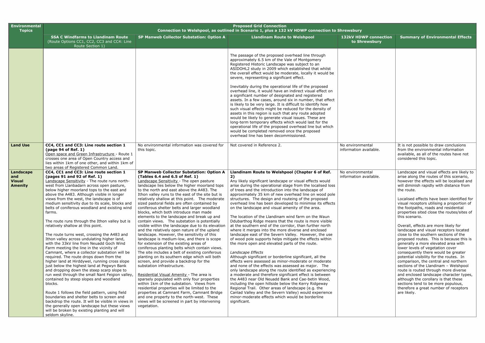
Environmental Topics
Proposed Grid Connection Connection to Welshpool, as outlined in Scenario 1, plus a 132 kV HDWP connection to Shrewsbury
SSA C Windfarms to Llandinam Route (Route Options CC1, CC2, CC3 and CC4: Line
Route Section 1)
SP Manweb Collector Substation: Option A Llandinam Route to Welshpool 132kV HDWP connection to Shrewsbury
Summary of Environmental Effects
The passage of the proposed overhead line through approximately 6.5 km of the Vale of Montgomery Registered Historic Landscape was subject to an ASIDOHL2 study in 2009 which established that whilst the overall effect would be moderate, locally it would be severe, representing a significant effect. Inevitably during the operational life of the proposed overhead line, it would have an indirect visual effect on a significant number of designated and registered assets. In a few cases, around six in number, that effect is likely to be very large. It is difficult to identify how such visual effects might be reduced for the density of assets in this region is such that any route adopted would be likely to generate visual issues. These are long-term temporary effects which would last for the operational life of the proposed overhead line but which would be completed removed once the proposed overhead line has been decommissioned.
Land Use CC4, CC1 and CC3: Line route section 1 (page 94 of Ref. 1) Open space and Green Infrastructure - Route 1 crosses one area of Open Country access and lies within 1km of one other, and within 1km of two areas of Registered Common Land.
No environmental information was covered for this topic.
Not covered in Reference 2. No environmental information available.
It is not possible to draw conclusions from the environmental information available, as all of the routes have not considered this topic.
Landscape and Visual Amenity
CC4, CC1 and CC3: Line route section 1 (pages 91 and 92 of Ref. 1) Landscape Sensitivity - The route runs north-west from Llanbadarn across open pasture, below higher moorland tops to the east and above the A483. Although visible in longer views from the west, the landscape is of medium sensitivity due to its scale, blocks and belts of coniferous woodland and existing wind farms. The route runs through the Ithon valley but is relatively shallow at this point. The route turns west, crossing the A483 and Ithon valley across undulating higher land, with the 33kV line from Neuadd Goch Wind Farm meeting the line in the vicinity of Camnant, where a collector substation will be required. The route drops down from the higher land at Hirddywel, running cross slope just below the highest land at Pegwyn Bank and dropping down the steep scarp slope to run west through the small Nant Feigion valley, contained by steep slopes and woodland blocks. Route 1 follows the field pattern, using field boundaries and shelter belts to screen and backdrop the route. It will be visible in views in the generally open landscape but these views will be broken by existing planting and will seldom skyline.
SP Manweb Collector Substation: Option A (Tables 6.4 and 6.5 of Ref. 1) Landscape Sensitivity - The open pasture landscape lies below the higher moorland tops to the north and east above the A483. The Ithon valley runs to the east of the site but is relatively shallow at this point. The moderate sized pastoral fields are often contained by coniferous shelter belts and larger woodland blocks, which both introduce man made elements to the landscape and break up and contain views. The substation is potentially visible within the landscape due to its elevation and the relatively open nature of the upland landscape. However, the sensitivity of this landscape is medium-low, and there is scope for extension of the existing areas of coniferous planting belts which contain views. The site includes a belt of existing coniferous planting on its southern edge which will both screen, and provide a backdrop for the substation infrastructure. Residential Visual Amenity - The area is sparsely populated with only four properties within 1km of the substation. Views from residential properties will be limited to the properties at Camnant Farm, Camnant Bridge and one property to the north-west. These views will be screened in part by intervening vegetation.
Llandinam Route to Welshpool (Chapter 6 of Ref. 2) Any likely significant landscape or visual effects would arise during the operational stage from the localised loss of trees and the introduction into the landscape of approximately 35 km of new overhead line on wood pole structures. The design and routeing of the proposed overhead line has been developed to minimise its effects on the landscape and visual amenity of the area. The location of the Llandinam wind farm on the Waun Ddubarthog Ridge means that the route is more visible at the southern end of the corridor, than further north where it merges into the more diverse and enclosed landscape east of the Severn Valley. However, the use of wood pole supports helps mitigate the effects within the more open and elevated parts of the route. Landscape Effects
Although significant or borderline significant, all the effects were assessed as minor-moderate or moderate and none of the effects was assessed as major. The only landscape along the route identified as experiencing a moderate and therefore significant effect is between the A483 near Old Neuadd Bank and Cae-betin Wood, including the open hillside below the Kerry Ridgeway Regional Trail. Other areas of landscape (e.g. the Canlad Valley and the Severn Valley) would experience minor-moderate effects which would be borderline significant.
No environmental information available.
Landscape and visual effects are likely to arise along the routes of this scenario, however the effects will be localised and will diminish rapidly with distance from the route. Localised effects have been identified for visual receptors utilising a proportion of the footpaths, roads and residential properties sited close the routes/sites of this scenario. Overall, effects are more likely for landscape and visual receptors located close to the southern sections of the proposed routes. This is because this is generally a more elevated area with lower levels of vegetation cover consequently there would be greater potential visibility for the routes. In comparison, the central and northern sections of the Llandinam – Welshpool route is routed through more diverse and enclosed landscape character types, although the corollary is that these sections tend to be more populous, therefore a great number of receptors are likely.

Environmental Topics
Proposed Grid Connection Connection to Welshpool, as outlined in Scenario 1, plus a 132 kV HDWP connection to Shrewsbury
SSA C Windfarms to Llandinam Route (Route Options CC1, CC2, CC3 and CC4: Line
Route Section 1)
SP Manweb Collector Substation: Option A Llandinam Route to Welshpool 132kV HDWP connection to Shrewsbury
Summary of Environmental Effects
The route follows local valleys as it descends from the higher ground, contained by topography and woodland planting. It will be visible intermittently in longer views but will be set within the landscape. Visual Sensitivity - Route 1 will be visible as it crosses the A483, including both the 132kV alignment from Llanbadarn and the 33kV from Neuadd Goch. Otherwise the local road network is crossed 3 times. Residential Visual Amenity - Residential properties are limited in the upland landscape, although 5 properties are likely to have views to the route, notably 2 properties at Blue Line Farm. As the line drops off the high ground properties increase, including those at Cloesfynnon and Rhiw-felen, which will have views to the line. Visitor Attractions - No visitor attractions have been identified that would be directly or indirectly affected by route 1. Recreational Resource - Route 1 crosses Glwyndwr’s Way once and a moderate density of RoWs also cross or run adjacent to the line.
The distance of the sites from the A483, the local landform, and intervening vegetation, reduces visibility from the road. Recreational Resource - There is a relatively dense network of public rights of way in the vicinity of the site; two local public footpaths cross the site but these can be diverted to an existing track around the site. There would be views to the site from the adjacent public footpaths and others in the vicinity; however use of the footpaths does not appear to be high.
Visual Effects
Although significant or verging on significant, all the effects were assessed as minor - moderate or moderate and none of these effects was assessed as major. In terms of settlements, some properties on the edge of Fron Bank/Cilcewydd, which lie within 500m of the overhead line will experience a significant change in their view, where there is no screening afforded by landform, buildings or vegetation. Of the many individual properties scattered throughout the study area, only those close to the overhead line will experience a significant change in their view some of which will have views of the proposed overhead line. However, the nature of the proposed overhead line, combined with the screening effects of landform and vegetation, mean that its effect will be limited, and no views would create effects on residential amenity to the extent that they would become an undesirable place to live. Users of local public rights of way and open access areas will be variably affected. Where a pole is seen in close proximity to these areas (e.g. the public forest, footpaths and local access roads near Bryn-picca), the effect on visual amenity will be significant, although this effect will diminish rapidly with distance. Similarly, road users will be variably affected. Significant residual effects are noted for the A483 and B4355, although these effects would be localised and transient.
Lighting Not included in Reference 1. Not included in Reference 1. Llandinam Route to Welshpool (Chapter 11 of Ref. 2) No significant environmental effects are anticipated on lighting. On this basis, the decision was made to not make this topic the subject of a detailed environmental impact assessment.
No environmental information available.
This topic has not been included in the environmental assessments or reports for the routes included in this scenario.
Noise and Vibration
As no line route option is considered to have a greater or lesser effect in respect of this topic at this scale, this topic has not been included as it does not assist in identifying a line route with least environmental effect. This topic will be considered at the EIA stage. (page 48 of Ref. 1)
As no line route option is considered to have a greater or lesser effect in respect of this topic at this scale, this topic has not been included as it does not assist in identifying a line route with least environmental effect. This topic will be considered at the EIA stage. (page 48 of Ref. 1)
Llandinam Route to Welshpool (Chapter 11 of Ref. 2) No significant environmental effects are anticipated for noise. On this basis, the decision was made to not make this topic the subject of a detailed environmental impact assessment. This is because of the low intensity of construction activities, the very low volume of vehicle movements which construction of the proposed overhead line would generate, the short-term (days rather than weeks) and reversible activities at each wood pole structure, and the proven methods of noise control at construction sites. While the Draft Construction Method Statement will ultimately address noise control issues in detail it is noted that Powys CC has powers to investigate noise complaints and serve abatement notices on activities which it considers are giving rise to unacceptable levels of noise
No environmental information available.
This topic has not been included in the environmental assessments or reports for the routes included in this scenario.

Environmental Topics
Proposed Grid Connection Connection to Welshpool, as outlined in Scenario 1, plus a 132 kV HDWP connection to Shrewsbury
SSA C Windfarms to Llandinam Route (Route Options CC1, CC2, CC3 and CC4: Line
Route Section 1)
SP Manweb Collector Substation: Option A Llandinam Route to Welshpool 132kV HDWP connection to Shrewsbury
Summary of Environmental Effects
Socio Economics (including Tourism and Recreation)
As no line route option is considered to have a greater or lesser effect in respect of this topic at this scale, this topic has not been included as it does not assist in identifying a line route with least environmental effect. This topic will be considered at the EIA stage. (page 48 of Ref. 1)
As no line route option is considered to have a greater or lesser effect in respect of this topic at this scale, this topic has not been included as it does not assist in identifying a line route with least environmental effect. This topic will be considered at the EIA stage. (page 48 of Ref. 1)
Llandinam Route to Welshpool (Chapter 10 of Ref. 2) The design and routeing of the proposed overhead line has been developed to minimise its effects on visual amenity and consequently upon negative perceptions of tourists and residents alike. The proposed overhead line generally avoids major settlements, tourist attractions, and local amenity assets. No significant socio-economic effects would arise from the construction and decommissioning of the proposed overhead line. In respect of the operational stage, the proposed overhead line would not have any significant effects upon the local population, economy, local community assets, tourist attractions or tourism more broadly. The operational stage would be expected to have a moderately significant effect upon tourism accommodation at two sites namely the Tavern Caravan Park and Edderton Hall B&B/Guest House. If proposed mitigation is accepted the residual effects would become not significant at Tavern Caravan Park but remain moderately significant for Edderton Hall B&B/Guest House.
No environmental information available.
It is not possible to draw conclusions from the environmental informaiton available, as all of the routes have not considered this topic.
Traffic and Transport
CC4, CC1 and CC3: Line route section 1 (page 95 of Ref. 1) This route could be accessed via existing main public roads although there are two extended sections (the area south of Hirddywell and north-west of Esgaidraenliwyn) where access will be difficult due to steep land and a lack of existing tracks.
SP Manweb Collector Substation: Option A (Tables 6.4 and 6.5 of Ref. 1) The site is accessible from existing farm tracks.
Llandinam Route to Welshpool (Chapter 11 of Ref. 2) No significant environmental effects are anticipated on traffic and transport. On this basis, the decision was made to not make this topic the subject of a detailed environmental impact assessment. The main issue of concern with respect to traffic would be the creation of construction and maintenance accesses and then accessing otherwise inaccessible fields with construction vehicles. This would be set out in the Draft Construction and Method Statement as part of the planning conditions, and would be developed in consultation with Powys Highways Authority.
No environmental information available.
Most routes/sites in this scenario are accessible by existing farm tracks or main public roads. However, localised instances may occur where the terrain makes access difficult.
Waste Management
As no line route option is considered to have a greater or lesser effect in respect of this topic at this scale, this topic has not been included as it does not assist in identifying a line route with least environmental effect. This topic will be considered at the EIA stage. (page 48 of Ref. 1)
As no line route option is considered to have a greater or lesser effect in respect of this topic at this scale, this topic has not been included as it does not assist in identifying a line route with least environmental effect. This topic will be considered at the EIA stage. (page 48 of Ref. 1)
Llandinam Route to Welshpool (Chapter 11 of Ref. 2) No significant environmental effects are anticipated on waste management. On this basis, the decision was made to not make this topic the subject of a detailed environmental impact assessment.
No environmental information available.
This topic has not been included in the environmental assessments or reports for the routes included in this scenario.
Water Environment
CC4, CC1 and CC3: Line route section 1 (page 93 of Ref. 1) Water Quality - Route 1 crosses four tributaries of the River Wye SAC and River Ithon SSSI. Flood Risk - Route 1 crosses four narrow tributaries of the River Ithon flood zone, which are 35 to 80m in width and will not form a constraint to routeing.
SP Manweb Collector Substation: Option A (Tables 6.4 and 6.5 of Ref. 1) Flood Zones - A narrow flood zone lies 0.3km to the north and 0.7km to the east of the site. It is less than 50m wide and will not be affected by the substation.
Llandinam Route to Welshpool (Chapter 9 of Ref. 2) It is considered that, if the mitigation measures discussed above and detailed fully in the Draft Construction Method Statement are successfully implemented, the construction, operation and decommissioning effects of the proposed overhead line on hydrology, groundwater, flood risk and water quality would not result in any likely significant adverse long term effects.
No environmental information available.
Flood risk is not expected to be an issue for the routes included in this scenario. The routes will cross a number of tributaries, including rivers within SSSIs and SACs however these can be spanned by wood pole infrastructure and mitigation measures will ensure their protection during construction.

Environmental Topics
Proposed Grid Connection Connection to Welshpool, as outlined in Scenario 1, plus a 132 kV HDWP connection to Shrewsbury
SSA C Windfarms to Llandinam Route (Route Options CC1, CC2, CC3 and CC4: Line
Route Section 1)
SP Manweb Collector Substation: Option A Llandinam Route to Welshpool 132kV HDWP connection to Shrewsbury
Summary of Environmental Effects
Technical Review
CC4, CC1 and CC3: Line route section 1 (page 94 of Ref. 1) Existing and Proposed OHL Infrastructure 33kV and 132kV - The Llandinam OHL route would cross this at the eastern end of the route. Existing and Proposed Wind Turbines - The route passes within proximity of turbines; however it will be possible to maintain the required distance. Altitude and Topography - The eastern end of this route would cover altitudes of up to 455m at the substation at Llanbadarn Fynydd. Moving west, the land height is 373m at the Neuadd Goch substation. As the line moves south-west, land heights increase to around 420m at Llaithddu and then higher to around 550m at Hirddywel. Gradients range between 0-15°. As the line passes west of Hirddywel, there is a section of land with a gradient of between 15-22°. The height of land then reduces to around 320m as the route moves west before turning north.
SP Manweb Collector Substation: Option A (Tables 6.4 and 6.5 of Ref. 1) This site could accommodate the required equipment.
Not covered in Reference 2. No environmental information available.
This information is not applicable to the summary of effects as it has been included for reference only.
References (Ref.): (1) SP MANWEB (Sept 2013). SP Mid Wales Connections, Line Routing Methodology & Appraisal - Phase 3 Report. (2) SP MANWEB (Oct 2013). Volume 1: New 132kV Overhead Line Connection from Llandinam Wind Farm to Welshpool Substation - Updated Environmental Statement. (3) National Grid (Sept 2013). Mid Wales Connection Project, Draft Substation Site Report. (4) National Grid (Sept 2013). Mid Wales Connection Project, Draft Route Report.

Table D: Scenario 3 - Connection to Welshpool, plus a 132 kV HDWP from SSA C to SSA B and (at least) one circuit to Legacy
Environment
al Topics
Proposed Grid Connection
Connection to Welshpool, as outlined in Scenario 1, plus a 132 kV HDWP from SSA C to SSA B and (at least) one circuit to Legacy
SSA C Windfarms to Llandinam Route/Substation at Cefn Coch (Route Options CC1, CC2, CC3 and CC4: Line Route Sections 1-2a-3-
4b-5-6a-7a-8-9a-10)
SP Manweb Collector
Substation: Option A
Llandinam Route to Welshpool
SSA B Windfarms to Substation at Cefn Coch
(Route Options BNC 3, BNC 4, BNC 5: Line Route Sections 1 -
2b)
132kV Substation at Cefn Coch (Located at Preferred National Grid
Substation Location NW at Cefn Coch)
132kV HDWP from Substation at Cefn Coch (SSA B) to
Legacy
Summary of Environmental Effects
Air Quality and Emissions (incl. dust)
As no line route option is considered to have a greater or lesser effect in respect of this topic at this scale, this topic has not been included as it does not assist in identifying a line route with least environmental effect. This topic will be considered at the EIA stage. (page 48 of Ref. 1)
As no line route option is considered to have a greater or lesser effect in respect of this topic at this scale, this topic has not been included as it does not assist in identifying a line route with least environmental effect. This topic will be considered at the EIA stage. (page 48 of Ref. 1)
Not covered in Reference 2.
As no line route option is considered to have a greater or lesser effect in respect of this topic at this scale, this topic has not been included as it does not assist in identifying a line route with least environmental effect. This topic will be considered at the EIA stage. (page 48 of Ref. 1)
Preferred Substation Location NW (Section 10.2 of Ref. 3) The site is more than 1km northwest of Tan-y-Foel Quarry and therefore unlikely to be significantly affected by dust from the quarry.
No environmental information available.
It is not possible to draw conclusions from the environmental information available, as all of the routes have not considered this topic.
Ecology/Bio
diversity and Geological Conservation
CC1, CC2, CC3 and CC4: Line
Route Sections 1-2a-3-4b-5-6a-7a-8-9a-10 (Appendix 6.1 of Ref. 1) Wind farm Habitat Management Plan Area (HMP) - Line route sections 1, and 6a-10 pass through and/or are within 2km of HMP areas for Hirddywell Wind Farm and the Tirgwynt HMP area.
Protected Species - The route passes through and passes within 730m to 2km of many potential protected species hotspots.
Peatland Habitats - Line route sections 1 passes through two large areas of potential peat. It also passes through areas identified in Environmental Statements as supporting peat habitats.
Ornithological ‘Hot Spots’ - The route passes through and within 300m to 1.1km of many hot spots, including the Tylwch tip hotspot (to the south of the route) and Bwlch y Garreg (to the north of the route).
Sites Designated for Nature Conservation Importance (SPA, SAC, SSSI) - The route does not pass through any statutory designated sites; however several designated areas are within a 2km radius, including the River Wye SAC and the Llan Mawr SSSI. The closest site is the Gweunydd Camnant SSSI, approx. 55m to the north of line route section 1.
SP Manweb
Collector Substation: Option A (Tables 6.4 and 6.5 of Ref. 1) SAC - The River Wye SAC headwaters lie 0.75km to the south east of the site with associated freshwater sensitivities. SSSI - The site lies less than 1km from Gweunydd Camnant SSSI, designated for habitats, the River Ithon SSSI and the Esgairdraenllwyn Pastures SSSI, designated for habitats.
Llandinam Route to
Welshpool (Chapter 7 of Ref. 2) It is considered that the proposed overhead line is not likely to result in any significant adverse long-term effects. If the mitigation measures discussed in Chapter 7 (Ref. 2) are fully implemented any risk of adverse effects will be further reduced. The potential for collisions with overhead lines is probably the most significant effect likely to arise. This represents a long-term, permanent hazard to certain groups of birds, primarily the larger species such as swans and to a lesser extent the smaller wildfowl. However, the erection of bird deflectors in appropriate locations will reduce the risk of birds colliding with the overhead line, and the erection of devices to discourage or prevent roosting on wood pole supports will reduce the risk of predation on ground nesting birds.
BNC 3, 4 and 5 - line route
section 1 (page 87 of Ref. 1) Wind farm Habitat Management Plan Area (HMP) - The route passes through the Llanbrynmair Wind Farm HMP At its very eastern extent, the route borders provisional areas set out for the Tirgwynt HMP.
Peatland Habitats - The route passes through potential peat habitat to the south and east of Llanbrynmair Wind Farm, along the northern boundary of the woodland.
Ornithological ‘Hot Spots’ - There are no ornithological hotspots associated with the route; however the Foel Quarry hotspot is approximately 360m to the south.
BNC 3, 4 and 5 - line route section 2b (page 87 of Ref. 1) Wind farm Habitat Management Plan Area (HMP) - Approx. 700m of the route passes through provisional areas set out for the Tirgwynt HMP.
Peatland Habitats - No potential peat areas were identified within the route.
Ornithological ‘Hot Spots’ - Approximately 450m of the route passes through the Foel Quarry ornithological hotspot.
Preferred Substation Location NW
(Section 10.2 of Ref. 3) This site is primarily located within an area of semi-improved grassland with low species diversity. Areas of valuable habitat do occur to the north east of the site and are represented by wetland/peatland habitats along a stream valley, therefore indirect hydrological effects are a consideration in this area. Consideration of ornithological effects is also required given proximity to habitats of bird value noted in Tirgwynt EIA (e.g. nesting curlew). There is a concern that the movements and noises associated with the construction of the substation may have a detrimental effect upon the curlews and other breeding bird that nest nearby. However, the EIA for the consented Tirgwynt windfarm did not identify this as a significant impact. Due to the location of the substation site it is highly likely that the site, and the indicative incoming connections and potentially the outgoing National Grid route associated with the site, will affect valuable ecological features such as peatland and/or ornithology.
No environmental information available.
Birds: There are a number of ornithological 'hot-spots' in proximity to the proposed routes, whereby there is potential for larger species, (such as swans) to collide with overhead lines which presents a long-term permanent hazard to birds, however the use of bird deflectors is likely to reduce this risk. There is also a concern that the movements and noises associated with the construction of the NG substation may have a detrimental effect upon birds that nest nearby. Designated Sites: No designated sites are likely to be directly affected by the proposed grid connections, however there are a number of designated sites which lie in close proximity to the routes. Habitat Management Plans: Due to the location of the wind farm substations the routes will pass through a number of wind farm HMP areas. Protected Species: Protected species are likely to be located in proximity to the routes. However full compliance with relevant protected species legislation is likely to help to minimise any effects. Peatland Habitats: A number of the routes pass through areas of potential peatland habitat.

Environmental Topics
Proposed Grid Connection Connection to Welshpool, as outlined in Scenario 1, plus a 132 kV HDWP from SSA C to SSA B and (at least) one circuit to Legacy
SSA C Windfarms to Llandinam Route/Substation at Cefn Coch (Route Options CC1, CC2, CC3 and CC4: Line Route Sections 1-2a-3-
4b-5-6a-7a-8-9a-10)
SP Manweb Collector
Substation: Option A
Llandinam Route to Welshpool
SSA B Windfarms to Substation at Cefn Coch
(Route Options BNC 3, BNC 4, BNC 5: Line Route Sections 1 -
2b)
132kV Substation at Cefn Coch (Located at Preferred National Grid
Substation Location NW at Cefn Coch)
132kV HDWP from Substation at Cefn Coch (SSA B) to
Legacy
Summary of Environmental Effects
Climate Change
As no line route option is considered to have a greater or lesser effect in respect of this topic at this scale, this topic has not been included as it does not assist in identifying a line route with least environmental effect. This topic will be considered at the EIA stage. (page 48 of Ref. 1)
As no line route option is considered to have a greater or lesser effect in respect of this topic at this scale, this topic has not been included as it does not assist in identifying a line route with least environmental effect. This topic will be considered at the EIA stage. (page 48 of Ref. 1)
Not covered in Reference 2.
As no line route option is considered to have a greater or lesser effect in respect of this topic at this scale, this topic has not been included as it does not assist in identifying a line route with least environmental effect. This topic will be considered at the EIA stage. (page 48 of Ref. 1)
Not included in Reference 3. No environmental information available.
This topic has not been included in the environmental assessments or reports for the routes included in this scenario.
Electric and Magnetic Fields
As no line route option is considered to have a greater or lesser effect in respect of this topic at this scale, this topic has not been included as it does not assist in identifying a line route with least environmental effect. This topic will be considered at the EIA stage. (page 48 of Ref. 1)
As no line route option is considered to have a greater or lesser effect in respect of this topic at this scale, this topic has not been included as it does not assist in identifying a line route with least environmental effect. This topic will be considered at the EIA stage. (page 48 of Ref. 1)
Llandinam Route to Welshpool (Chapter 11 of Ref. 2) No significant environmental effects are anticipated on electric and magnetic fields. On this basis, the decision was made to not make this topic the subject of a detailed environmental impact assessment.
As no line route option is considered to have a greater or lesser effect in respect of this topic at this scale, this topic has not been included as it does not assist in identifying a line route with least environmental effect. This topic will be considered at the EIA stage. (page 48 of Ref. 1)
Not included in Reference 3. No environmental information available.
This topic has not been included in the environmental assessments or reports for the routes included in this scenario.
Forestry and Woodland
CC1, CC2, CC3 and CC4: Line Route Sections 1-2a-3-4b-5-6a-7a-8-9a-10 (Appendix 6.1 of
Ref. 1) Ancient and Semi-Natural woodland (ASNW) - Line route sections 1, 4b, and 6a will affect areas of ASNW, this will be avoided, where possible, at detailed design stage. Line route sections 2a, 3, 4b, 7a and 8 affect areas of ASNW and limited felling may be required. Other Forestry and Woodland - All line route sections cross some fields where limited felling of hedgerow trees, and in some cases (e.g. line route sections 1 and 3) woodland edge trees. Line route section 9a passes through 5.9ha of woodland on the Welsh National Forest Inventory although no mature trees would be felled.
SP Manweb Collector Substation: Option
A (Tables 6.4 and 6.5 of Ref. 1) Other Forestry and Woodland - There are a number of small blocks of forestry and shelter belt planting located within the vicinity of the substation site which will screen and backdrop the proposed substation. The site will not require any felling of existing plantation woodland.
Llandinam Route to Welshpool (Chapter 7 of Ref. 2)
It is considered that the proposed overhead line is not likely to result in any significant adverse long-term effects. If the mitigation measures discussed in Chapter 7 (Ref. 2) are fully implemented any risk of adverse effects will be further reduced. Some trees will be lost to facilitate construction of the Amended Development, including trees that may have potential for bats. This tree loss may result in potential habitat loss for bats.
BNC 3, 4 and 5 - line route section 1 (page 87 of Ref. 1) Other Forestry and Woodland - Route 1 will pass through c.320m of mature coniferous plantation above Nant y Graig Lwyd, and c.730m of mature coniferous plantation at Cors yr Ebolion. Native trees along the Nant y Graig Lwyd may be affected by the lines. BNC 3, 4 and 5 - line route section 2b (page 87 of Ref. 1) Other Forestry and Woodland - 2b may affect small stands of woodland south-west of the NG hub.
Not included in Reference 3. No environmental information available.
Some trees and hedgerows will be lost to
facilitate construction of the grid
connection routes. The loss of trees may
result in potential habitat loss for bats,
although this is expected to be a
localised effect.
In some locations, mature trees as well
as Ancient and Semi-Natural woodland
may be affected by construction of the
proposed routes. Although this will be
avoided where possible at the detailed
design stage, limited felling may be
required in some locations.

Environmental Topics
Proposed Grid Connection Connection to Welshpool, as outlined in Scenario 1, plus a 132 kV HDWP from SSA C to SSA B and (at least) one circuit to Legacy
SSA C Windfarms to Llandinam Route/Substation at Cefn Coch (Route Options CC1, CC2, CC3 and CC4: Line Route Sections 1-2a-3-
4b-5-6a-7a-8-9a-10)
SP Manweb Collector
Substation: Option A
Llandinam Route to Welshpool
SSA B Windfarms to Substation at Cefn Coch
(Route Options BNC 3, BNC 4, BNC 5: Line Route Sections 1 -
2b)
132kV Substation at Cefn Coch (Located at Preferred National Grid
Substation Location NW at Cefn Coch)
132kV HDWP from Substation at Cefn Coch (SSA B) to
Legacy
Summary of Environmental Effects
Geology and Soils
Not included in Reference 3. Not included in Reference 3.
Llandinam Route to Welshpool (Chapter 11 of Ref. 2) No significant environmental effects are anticipated on geology or soil resources. On this basis, the decision was made to not make this topic the subject of a detailed environmental impact assessment.
Not included in Reference 1. Not included in Reference 3. No environmental information available.
This topic has not been included in the environmental assessments or reports for the routes included in this scenario.
Historic Environment
CC1, CC2, CC3 and CC4: Line Route Sections 1-2a-3-4b-5-6a-7a-8-9a-10 (Appendix 6.1 of Ref. 1) SAMs - The northen area of the route contains more SAMs that are within 2km of the route. For example, no SAMs are located within line route section 1 but 24 SAMs lie in 14 groups within 2km of the route and line route sections 2a-5 have no SAMs within 2km of the route. Whereas line route sections 6a-10 all have SAMs located within 2km of the route. Virtually all the SAMs are prehistoric burial and ritual monuments, some with wide-ranging views, others are rare prehistoric house sites. Listed Buildings (LBs) - All line route sections, apart from 9a and 10 are within 2km of LBs, the majority of which are lower grade II. However, some line route sections (e.g. 5) have LBs of higher grade II* designated status. LBs that are within close proximity (i.e. 150m) of the route such as Ystradfaelog which is the higher grade II* building along line route section 5, could be the possibility of visual impact. Conservation Areas - Only line route section 3 is located within 2km of a Conservation Area, which is Llanidloes Conservation Area. Registered Historic Landscapes (RHLs) - Line route sections 2a, 3, 5 and 6a are within 1-2km of Clywedog Valley RHL and/or Caersws Basin RHL.
SP Manweb Collector Substation: Option A (Tables 6.4 and
6.5 of Ref. 1) Undesignated Archaeology - An undesignated site of historical interest (a single storey derelict stone building) lies immediately adjacent to the site to the northeast.
Llandinam Route to Welshpool (Chapter 8 of Ref. 2) The proposed overhead line from the Llandinam Repowering Wind Farm to the Welshpool Grid Substation, some 35 km long, adopts a course to the south and east of the Severn Valley which takes it past and through some of the richest cultural heritage landscapes in mid Wales. There are 55 SAMs located within 2km of the overhead line, two of them (Crugyn Bank Dyke and Bryn Cwmyrhiwdre Round Barrow) within the 100m wide corridor. There are also 452 Listed Buildings, five Registered Historic Parks and Gardens, seven Conservation Areas, and one of Wales’ Registered Historic Landscapes would be crossed by the proposed overhead line. It is the heritage assets within the 100 m wide corridor that are most at risk from the proposed overhead line and could be adversely affected by its construction. Most of these are considered to be of low (local) or even negligible value, but there are some of medium (regional) significance, as well as the few of high (national) importance.
BNC 3, 4 and 5 - line route section 1 (page 87 of Ref. 1) SAMs - There is 1 SAM within the route but none within 2km. The proximity of the scheduled Bon-y-maen root store and on the farm of which it forms a part will form a key consideration for the detailed line design stage and effects on its setting will form a key consideration during the EIA stage. Listed Buildings (LBs) - There are no LBs within the route section. There are 2 LBs within 2km of it, both of lower grade II. Undesignated Archaeology - There are 2 undesignated archaeological features in the route section. Direct effects will be avoided, where possible, during detailed design. BNC 3, 4 and 5 - line route section 2b (page 87 of Ref. 1)
SAMs - There are no SAMs within the route but two within 2km, the Bon-y-maen root store and Y Capel stone circle. Listed Buildings (LBs) - There are no Listed Buildings within 2km of the route section. Undesignated Archaeology - There are no undesignated archaeological features in the route section.
Preferred Substation Location NW (Section 10.2 of Ref. 3) The site is located in an area where there are no key local receptors, but it is located roughly equidistant between a scheduled Kerb Cairn (WSM MG 327), a scheduled stone circle (WSM MG 179), and a root store (WSM MG 218). These sites are situated approximately 2km away from the substation, and outside of any identified areas of theoretical visibility. However, whilst the substation site will not be visible from any of these monuments, the proposed overhead line is potentially visible from the root store and may have a slightly adverse effect upon its landscape context. An undesignated group of pillow mounds (WNMR 9448) of regional importance is located to the south east. Whilst the substation site will not be visible, the proposed overhead lines into and out of the substation, are potentially visible and may have a slightly adverse effects upon their landscape context.
No environmental information available.
Two designated features (SAMs) are located within the Llandinam route and one within the SP MWC BNC route. The Llandinam Route and other routes included in this scenario pass within 1-2km of other historic assets, including: SAMs, Conservation Areas, Listed Buildings (primarily lower grade II but also including higher grade), historic landscapes, Registered Historic Parks and Gardens and undesignated below-ground sites/features. Mitigation measures will be deployed to minimise direct effects on features, however significant effects on the setting of a number of features are predicted. Only the Llandinam route passes through a Registered Historic Landscape resulting in significant effects.

Environmental Topics
Proposed Grid Connection Connection to Welshpool, as outlined in Scenario 1, plus a 132 kV HDWP from SSA C to SSA B and (at least) one circuit to Legacy
SSA C Windfarms to Llandinam Route/Substation at Cefn Coch (Route Options CC1, CC2, CC3 and CC4: Line Route Sections 1-2a-3-
4b-5-6a-7a-8-9a-10)
SP Manweb Collector
Substation: Option A
Llandinam Route to Welshpool
SSA B Windfarms to Substation at Cefn Coch
(Route Options BNC 3, BNC 4, BNC 5: Line Route Sections 1 -
2b)
132kV Substation at Cefn Coch (Located at Preferred National Grid
Substation Location NW at Cefn Coch)
132kV HDWP from Substation at Cefn Coch (SSA B) to
Legacy
Summary of Environmental Effects
Undesignated Archaeology - Undesignated archaeological features are located along most line route sections. Direct effects will be avoided, where possible, during detailed design.
Appropriate mitigation (e.g. preservation in situ, preservation by record, excavation, evaluation, watching brief) including the careful demarcation of assets is suggested which should ensure that damage is kept to a minimum during the erection of the supports. Assuming that a full suite of mitigation measures is successfully implemented, the proposed overhead line should not have any significant long-term effect on the cultural heritage. In particular, there are no likely significant direct effects on cultural heritage arising during the construction, operation or decommissioning of the proposed overhead line. The passage of the proposed overhead line through approximately 6.5 km of the Vale of Montgomery Registered Historic Landscape was subject to an ASIDOHL2 study in 2009 which established that whilst the overall effect would be moderate, locally it would be severe, representing a significant effect. Inevitably during the operational life of the proposed overhead line, it would have an indirect visual effect on a significant number of designated and registered assets. In a few cases, around six in number, that effect is likely to be very large. It is difficult to identify how such visual effects might be reduced for the density of assets in this region is such that any route adopted would be likely to generate visual

Environmental Topics
Proposed Grid Connection Connection to Welshpool, as outlined in Scenario 1, plus a 132 kV HDWP from SSA C to SSA B and (at least) one circuit to Legacy
SSA C Windfarms to Llandinam Route/Substation at Cefn Coch (Route Options CC1, CC2, CC3 and CC4: Line Route Sections 1-2a-3-
4b-5-6a-7a-8-9a-10)
SP Manweb Collector
Substation: Option A
Llandinam Route to Welshpool
SSA B Windfarms to Substation at Cefn Coch
(Route Options BNC 3, BNC 4, BNC 5: Line Route Sections 1 -
2b)
132kV Substation at Cefn Coch (Located at Preferred National Grid
Substation Location NW at Cefn Coch)
132kV HDWP from Substation at Cefn Coch (SSA B) to
Legacy
Summary of Environmental Effects
issues. These are long-term temporary effects which would last for the operational life of the proposed overhead line but which would be completed removed once the proposed overhead line has been decommissioned.
Land Use CC1, CC2, CC3 and CC4: Line Route Sections 1-2a-3-4b-5-6a-7a-8-9a-10 (Appendix 6.1 of Ref. 1) Open space and Green Infrastructure - Line route section 1 crosses one area of Open Country access and lies within 1km of one other, and within 1km of two areas of Registered Common Land.
No environmental information was covered for this topic.
Not covered in Reference 2.
BNC 3, 4 and 5 - line route section 1 (pages 87 and 88 of Ref. 1) Open space and Green Infrastructure - Route 1 routes across approximately 1,766m of open access land. BNC 3, 4 and 5 - line route section 2b (pages 87 and 88 of Ref. 1) Open space and Green Infrastructure - 2b routes across approximately 694m of open access land.
Not included in Reference 4. No environmental information available.
It is not possible to draw conclusions from the environmental information available, as all of the routes have not considered this topic.
Landscape and Visual Amenity
CC1, CC2, CC3 and CC4: Line Route Sections 1-2a-3-4b-5-6a-7a-8-9a-10 (Appendix 6.1 of Ref. 1) Landscape and visual amenity varies along the route. Along certain line route sections short sections of sky lining will occur (e.g. line route section 2a), and the line route sections will be visible as they drop down into valleys, such as Afon Trannon Valley. However, some line route sections are provided with natural screening in areas by existing hedgerow and riparian trees, and line route sections, such as line route section 1, follow the field pattern, using field boundaries and shelter belts to screen and backdrop the route. Line route sections, such as 6a, pass through relatively open landscapes above the valley floor and will be visible in views across valleys, although these views will be back dropped by wooded slopes. Line route section 6a will also be locally prominent as it runs around the Allt y Genlli hillside above Tanyrallt. Also,in certain lcoations, line route sections pass through areas of ancient and semi-natural
SP Manweb Collector Substation: Option A (Tables 6.4 and
6.5 of Ref. 1) Landscape Sensitivity - The open pasture landscape lies below the higher moorland tops to the north and east above the A483. The Ithon valley runs to the east of the site but is relatively shallow at this point. The moderate sized pastoral fields are often contained by coniferous shelter belts and larger woodland blocks, which both introduce man made elements to the landscape and break up and contain views. The substation is potentially visible within the landscape due to its elevation and the relatively open nature of the upland landscape.
Llandinam Route to Welshpool (Chapter 6 of Ref. 2) Any likely significant landscape or visual effects would arise during the operational stage from the localised loss of trees and the introduction into the landscape of approximately 35 km of new overhead line on wood pole structures. The design and routing of the proposed overhead line has been developed to minimise its effects on the landscape and visual amenity of the area. The location of the Llandinam wind farm on the Waun Ddubarthog Ridge means that the route is more visible at the southern end of the corridor, than further north where it merges into the more diverse and enclosed landscape east of the Severn Valley. However, the use of wood pole supports helps mitigate
BNC 3, 4 and 5 - line route section 1 (page 87 of Ref. 1) Landscape Sensitivity - Route 1 descends into the small-medium scale valley of the Nant y Graig Lwyd. It traverses a shoulder of moorland, remaining behind the ridge line where possible. Between Cwmderwen and Cors yr Ebolion it crosses medium to large-scale upland pasture. It then passes across larger-scale moorland plateau, avoiding the highest ground where possible. Visual Sensitivity - The parallel wood pole lines may be seen on the skyline above Nant y Graig Lwyd from locations within Nant-yr-Eira. The lines will be backclothed by forestry on the south side of Nant-yr-Eira. Beyond Cors yr Ebolion the plateau has few inward views and wood poles are unlikely to be seen. From the head of Nant Wythan, 1 will be carried on steel towers. These may be visible in longer views toward the moorland, e.g. from Cwm
Preferred Substation Location NW (Section 10.2 of Ref. 3) Whilst currently a substation in this remote rural location would represent a detracting urban element, which would be inconsistent with the local landscape character, this situation is likely to change with the construction of the Tirgwynt wind farm and Mynydd Waen Fawr wind farm (if constructed) as the proposed substation would potentially be seen alongside above ground equipment such as overhead electricity lines, pylons and the turbines of the Tirgwynt Wind farm and other planned wind farms. The Overall Visual and Sensory Evaluation (VS50) of the site is High. The ZTV suggests that a substation in this location may just be visible from Snowdonia National Park in the high area of Mynydd Clywedog. This would be at a distance of 15km and it is likely that the substation would be imperceptible from this distance. The ZTV indicates that the site is visually well contained due to the surrounding landform which provides natural screening on three sides. Areas of potential visibility are largely restricted to the sparsely populated
No environmental information available.
Landscape and visual effects are likely to arise along the routes of this scenario, however the effects will be localised and will diminish rapidly with distance from the route. Localised significant effects have been identified for visual receptors utilising a proportion of the footpaths, roads and residential properties sited close to the routes of this scenario. Overall, for the SSAC connection to Welshpool, effects are more likely for landscape and visual receptors located close to the southern sections of the proposed route. This is because this is generally a more elevated area with lower levels of vegetation cover consequently there would be greater potential visibility for the routes. In comparison, the central and northern sections of the Llandinam – Welshpool route is routed through more diverse and enclosed landscape character types, although the corollary is that these sections tend to be more populous, therefore a greater number of receptors are likely. The SSAC connection to Cefn Coch will be visible as it crosses roads and within valleys and there are likely to be potential visual effects on a number of

Environmental Topics
Proposed Grid Connection Connection to Welshpool, as outlined in Scenario 1, plus a 132 kV HDWP from SSA C to SSA B and (at least) one circuit to Legacy
SSA C Windfarms to Llandinam Route/Substation at Cefn Coch (Route Options CC1, CC2, CC3 and CC4: Line Route Sections 1-2a-3-
4b-5-6a-7a-8-9a-10)
SP Manweb Collector
Substation: Option A
Llandinam Route to Welshpool
SSA B Windfarms to Substation at Cefn Coch
(Route Options BNC 3, BNC 4, BNC 5: Line Route Sections 1 -
2b)
132kV Substation at Cefn Coch (Located at Preferred National Grid
Substation Location NW at Cefn Coch)
132kV HDWP from Substation at Cefn Coch (SSA B) to
Legacy
Summary of Environmental Effects
woodland and scattered properties. Potential visual effects are possible for residential properties, such as Oakley Park, which will have views of line route section 4b. Line route section 4b will also have further effects on individual properties along the route, notably at Red House and Ty’n-y-celyn. Line route sections, such as line route section 1, will be visible as they cross roads (e.g. A483). Effects on visitor attractions are unlikely to arise from the route beyond localised effects on public footpaths.
However, the sensitivity of this landscape is medium-low, and there is scope for extension of the existing areas of coniferous planting belts which contain views. The site includes a belt of existing coniferous planting on its southern edge which will both screen, and provide a backdrop for the substation infrastructure. Residential Visual Amenity - The area is sparsely populated with only four properties within 1km of the substation. Views from residential properties will be limited to the properties at Camnant Farm, Camnant Bridge and one property to the north-west. These views will be screened in part by intervening vegetation. The distance of the sites from the A483, the local landform, and intervening vegetation, reduces visibility from the road. Recreational Resource - There is a relatively dense network of public rights of way in the vicinity of the site; two local public footpaths cross the site but these can be diverted to an existing track around
the effects within the more open and elevated parts of the route. Landscape Effects
Although significant or borderline significant, all the effects were assessed as minor-moderate or moderate and none of the effects was assessed as major. The only landscape along the route identified as experiencing a moderate and therefore significant effect is between the A483 near Old Neuadd Bank and Cae-betin Wood, including the open hillside below the Kerry Ridgeway Regional Trail. Other areas of landscape (e.g. the Canlad Valley and the Severn Valley) would experience minor-moderate effects which would be borderline significant. Visual Effects
Although significant or verging on significant, all the effects were assessed as minor - moderate or moderate and none of these effects was assessed as major. In terms of settlements, some properties on the edge of Fron Bank/Cilcewydd, which lie within 500m of the overhead line will experience a significant change in their view, where there is no screening afforded by landform, buildings or vegetation. Of the many individual properties scattered throughout the study area, only those close to the overhead line will experience a significant change in their view some of which will have views of the
Llwyd to the south and from the Banwy valley to the north. The towers will be partially screened/backclothed by forestry at Mynydd Carreg-y-big in some views. Residential Visual Amenity - The parallel wood pole lines may be viewed from two properties at Cwmderwen, descending from high ground into Nant-yr-Eira. These properties would also overlook the crossing of the Afon Gam at relatively close range. There may be views of the route from Dolau-ceimion, although the lines will be backclothed. Visitor Attractions - No visitor attractions have been identified that would be affected by BNC1. Recreational Resource - The parallel wood pole lines would be visible within Nant y Graig Lwyd and Nant yr Eira from the Glyndwr Way, which passes between 300-500m to the north. BNC 3, 4 and 5 - line route section 2b (page 87 of Ref. 1) Landscape Sensitivity - Route 2b crosses open moorland plateau, largely comprising unenclosed grass moor. It avoids the ridge to the north-west of the NG hub, keeping to the flatter ground to the south of the high point above Gors-dyfwch (418m). Visual Sensitivity - Steel towers will be visible in wider views of the moorland plateau. Residential Visual Amenity - The southward alignment of 2b takes it further from the properties at Carreg-y-big and Gwaenydd, and the towers would be a lesser presence in views.
valley and surrounding hill slopes to the north-east, including the lower slopes of Mynydd Waun Fawr, the Mynydd y Gribin ridgeline and Foel Fawr. It is anticipated that there would be unrestricted and filtered views of the development from Gwaenydd and potentially from a few other scattered properties further afield. There would also be views from the public right of way network, but no views from the local lanes. In those locations where the proposed substation is likely to be visible, it would potentially be seen alongside above ground equipment such as overhead electricity lines, pylons and the turbines of some of the planned wind farms. The visual effects arising from a substation in this location could be lessened by perimeter mounding supplemented by planting which could include a high proportion of conifers. The proximity of the site to existing mature coniferous plantations and shelter belts provides a structural planting context. However the screening benefits would only be achieved in the long term as the planting reached full maturity. Also the entries and exit for the overhead lines would have to kept free from tall vegetation and views of the infrastructure would potentially be available at these points.
residential properties. Landscape and visual effects are likely along line route section 1 of BNC 3, BNC 4 and BNC5. However, these elements of this scenario will be screened from some receptors and directions and the overhead line may potentially be seen alongside other above ground equipment such the turbines of the planned wind farms. Effects are likely for landscape and visual receptors around the substation at Cefn Coch than the SP Manweb Collector Substation: Option A. It is anticipated that there would be unrestricted and filtered views of the substation at Cefn Coch from the surrounding area, and it would potentially be seen alongside above ground equipment such as overhead electricity lines and the turbines of the planned wind farms.

Environmental Topics
Proposed Grid Connection Connection to Welshpool, as outlined in Scenario 1, plus a 132 kV HDWP from SSA C to SSA B and (at least) one circuit to Legacy
SSA C Windfarms to Llandinam Route/Substation at Cefn Coch (Route Options CC1, CC2, CC3 and CC4: Line Route Sections 1-2a-3-
4b-5-6a-7a-8-9a-10)
SP Manweb Collector
Substation: Option A
Llandinam Route to Welshpool
SSA B Windfarms to Substation at Cefn Coch
(Route Options BNC 3, BNC 4, BNC 5: Line Route Sections 1 -
2b)
132kV Substation at Cefn Coch (Located at Preferred National Grid
Substation Location NW at Cefn Coch)
132kV HDWP from Substation at Cefn Coch (SSA B) to
Legacy
Summary of Environmental Effects
the site. There would be views to the site from the adjacent public footpaths and others in the vicinity; however use of the footpaths does not appear to be high.
proposed overhead line. However, the nature of the proposed overhead line, combined with the screening effects of landform and vegetation, mean that its effect will be limited, and no views would create effects on residential amenity to the extent that they would become an undesirable place to live. Users of local public rights of way and open access areas will be variably affected. Where a pole is seen in close proximity to these areas (e.g. the public forest, footpaths and local access roads near Bryn-picca), the effect on visual amenity will be significant, although this effect will diminish rapidly with distance. Similarly, road users will be variably affected. Significant residual effects are noted for the A483 and B4355, although these effects would be localised and transient.
Visitor Attractions - There may be views of the towers at the head of the upland valley as seen from the outdoor centre at Plas y drain, 1800m to the north-east. Recreational Resource - No recreational resources have been identified that would be affected by 2b.
Lighting Not included in Reference 1. Not included in Reference 1.
Llandinam Route to
Welshpool (Chapter 11 of Ref. 2) No significant environmental effects are anticipated on lighting. On this basis, the decision was made to not make this topic the subject of a detailed environmental impact assessment.
Not included in Reference 1. Not included in Reference 4. No environmental information available.
This topic has not been included in the environmental assessments or reports for the routes included in this scenario.

Environmental Topics
Proposed Grid Connection Connection to Welshpool, as outlined in Scenario 1, plus a 132 kV HDWP from SSA C to SSA B and (at least) one circuit to Legacy
SSA C Windfarms to Llandinam Route/Substation at Cefn Coch (Route Options CC1, CC2, CC3 and CC4: Line Route Sections 1-2a-3-
4b-5-6a-7a-8-9a-10)
SP Manweb Collector
Substation: Option A
Llandinam Route to Welshpool
SSA B Windfarms to Substation at Cefn Coch
(Route Options BNC 3, BNC 4, BNC 5: Line Route Sections 1 -
2b)
132kV Substation at Cefn Coch (Located at Preferred National Grid
Substation Location NW at Cefn Coch)
132kV HDWP from Substation at Cefn Coch (SSA B) to
Legacy
Summary of Environmental Effects
Noise and Vibration
As no line route option is considered to have a greater or lesser effect in respect of this topic at this scale, this topic has not been included as it does not assist in identifying a line route with least environmental effect. This topic will be considered at the EIA stage. (page 48 of Ref. 1)
As no line route option is considered to have a greater or lesser effect in respect of this topic at this scale, this topic has not been included as it does not assist in identifying a line route with least environmental effect. This topic will be considered at the EIA stage. (page 48 of Ref. 1)
Llandinam Route to Welshpool (Chapter 11 of Ref. 2) No significant environmental effects are anticipated for noise. On this basis, the decision was made to not make this topic the subject of a detailed environmental impact assessment. This is because of the low intensity of construction activities, the very low volume of vehicle movements which construction of the proposed overhead line would generate, the short-term (days rather than weeks) and reversible activities at each wood pole structure, and the proven methods of noise control at construction sites. While the Draft Construction Method Statement will ultimately address noise control issues in detail it is noted that Powys CC has powers to investigate noise complaints and serve abatement notices on activities which it considers are giving rise to unacceptable levels of noise
As no line route option is considered to have a greater or lesser effect in respect of this topic at this scale, this topic has not been included as it does not assist in identifying a line route with least environmental effect. This topic will be considered at the EIA stage. (page 48 of Ref. 1)
Preferred Substation Location NW (Section 10.2 of Ref. 3) The nearest dwelling to the site is approx 950m to the northeast. Rating levels below existing background levels are achievable with standard noise mitigation solutions.
No environmental information available.
It is not possible to draw conclusions from the environmental information available, as all of the routes have not considered this topic.
Socio Economics (including
Tourism and Recreation)
As no line route option is considered to have a greater or lesser effect in respect of this topic at this scale, this topic has not been included as it does not assist in identifying a line route with least environmental effect. This topic will be considered at the EIA stage. (page 48 of Ref. 1)
As no line route option is considered to have a greater or lesser effect in respect of this topic at this scale, this topic has not been included as it does not assist in identifying a line route with least environmental effect. This topic will be considered at the EIA stage. (page 48 of Ref. 1)
Llandinam Route to Welshpool (Chapter 10 of Ref. 2) The design and routeing of the proposed overhead line has been developed to minimise its effects on visual amenity and consequently upon negative perceptions of tourists and residents alike. The proposed overhead line generally avoids major settlements, tourist attractions, and local amenity assets.
As no line route option is considered to have a greater or lesser effect in respect of this topic at this scale, this topic has not been included as it does not assist in identifying a line route with least environmental effect. This topic will be considered at the EIA stage. (page 48 of Ref. 1)
Preferred Substation Location NW (Section 10.2 of Ref. 3) Economic Activity As the site adjoins Bryn Gwyn Farmhouse the substation development may have a significant negative effect upon the viability of the farm holding. However, it is understood that the farm is to be acquired by the developers of the Tirgwynt windfarm; whose intentions for the use of this holding after acquisition will determine the effect on farm viability which a substation in this location may have.
No environmental information available.
It is not possible to draw conclusions from the environmental information available, as all of the routes have not considered this topic.

Environmental Topics
Proposed Grid Connection Connection to Welshpool, as outlined in Scenario 1, plus a 132 kV HDWP from SSA C to SSA B and (at least) one circuit to Legacy
SSA C Windfarms to Llandinam Route/Substation at Cefn Coch (Route Options CC1, CC2, CC3 and CC4: Line Route Sections 1-2a-3-
4b-5-6a-7a-8-9a-10)
SP Manweb Collector
Substation: Option A
Llandinam Route to Welshpool
SSA B Windfarms to Substation at Cefn Coch
(Route Options BNC 3, BNC 4, BNC 5: Line Route Sections 1 -
2b)
132kV Substation at Cefn Coch (Located at Preferred National Grid
Substation Location NW at Cefn Coch)
132kV HDWP from Substation at Cefn Coch (SSA B) to
Legacy
Summary of Environmental Effects
No significant socio-economic effects would arise from the construction and decommissioning of the proposed overhead line. In respect of the operational stage, the proposed overhead line would not have any significant effects upon the local population, economy, local community assets, tourist attractions or tourism more broadly. The operational stage would be expected to have a moderately significant effect upon tourism accommodation at two sites namely the Tavern Caravan Park and Edderton Hall B&B/Guest House. If proposed mitigation is accepted the residual effects would become not significant at Tavern Caravan Park but remain moderately significant for Edderton Hall B&B/Guest House.
The site is not visible from the local highway network and given the adjoining land is to be developed for a windfarm the substation by itself is unlikely to have a significant detrimental impact upon the local tourism industry.
Traffic and Transport
CC1, CC2, CC3 and CC4: Line Route Sections 1-2a-3-4b-5-6a-7a-8-9a-10 (Appendix 6.1 of
Ref. 1) The line route sections could be accessed by existing public roads and farm tracks in most cases, however a small number of the line route sections (e.g. 2a, 3, 7a) would have to be accessed via fields involving crossing some existing hedgerows between fields. Also, the steep terrain and lack of existing tracks will need to be taken account of for some line route sections (e.g. 1 and 10).
SP Manweb Collector Substation: Option
A (Tables 6.4 and 6.5 of Ref. 1) The site is accessible from existing farm tracks.
Llandinam Route to Welshpool (Chapter 11 of Ref. 2) No significant environmental effects are anticipated on traffic and transport. On this basis, the decision was made to not make this topic the subject of a detailed environmental impact assessment. The main issue of concern with respect to traffic would be the creation of construction and maintenance accesses and then accessing otherwise inaccessible fields with construction vehicles. This would be set out in the Draft Construction and Method Statement as part of the planning conditions,
BNC 3, 4 and 5 - line route section 1 (page 88 of Ref. 1) Access to the route will be via existing forest tracks across steep ground. BNC 3, 4 and 5 - line route section 2b (page 88 of Ref. 1) Access to the route will be via existing forest tracks across steep ground.
Preferred Substation Location NW (Section 10.2 of Ref. 3) The site will require a significant length of new access road from New Road.
No environmental information available.
Most routes/sites in this scenario are accessible by existing farm tracks or main public roads. However, localised instances may occur where the terrain makes access difficult, or lengths of new access road are required.

Environmental Topics
Proposed Grid Connection Connection to Welshpool, as outlined in Scenario 1, plus a 132 kV HDWP from SSA C to SSA B and (at least) one circuit to Legacy
SSA C Windfarms to Llandinam Route/Substation at Cefn Coch (Route Options CC1, CC2, CC3 and CC4: Line Route Sections 1-2a-3-
4b-5-6a-7a-8-9a-10)
SP Manweb Collector
Substation: Option A
Llandinam Route to Welshpool
SSA B Windfarms to Substation at Cefn Coch
(Route Options BNC 3, BNC 4, BNC 5: Line Route Sections 1 -
2b)
132kV Substation at Cefn Coch (Located at Preferred National Grid
Substation Location NW at Cefn Coch)
132kV HDWP from Substation at Cefn Coch (SSA B) to
Legacy
Summary of Environmental Effects
and would be developed in consultation with Powys Highways Authority.
Waste Management
As no line route option is considered to have a greater or lesser effect in respect of this topic at this scale, this topic has not been included as it does not assist in identifying a line route with least environmental effect. This topic will be considered at the EIA stage. (page 48 of Ref. 1)
As no line route option is considered to have a greater or lesser effect in respect of this topic at this scale, this topic has not been included as it does not assist in identifying a line route with least environmental effect. This topic will be considered at the EIA stage. (page 48 of Ref. 1)
Llandinam Route to Welshpool (Chapter 11 of Ref. 2) No significant environmental effects are anticipated on waste management. On this basis, the decision was made to not make this topic the subject of a detailed environmental impact assessment.
As no line route option is considered to have a greater or lesser effect in respect of this topic at this scale, this topic has not been included as it does not assist in identifying a line route with least environmental effect. This topic will be considered at the EIA stage. (page 48 of Ref. 1)
Not included in Reference 3. No environmental information available.
This topic has not been included in the environmental assessments or reports for the routes included in this scenario.
Water
Environment
CC1, CC2, CC3 and CC4: Line
Route Sections 1-2a-3-4b-5-6a-7a-8-9a-10 (Appendix 6.1 of Ref. 1) Water Quality - Line route section 1 crosses four tributaries of the River Wye SAC and River Ithon SSSI. Flood Risk - Line route sections 1, 3, 4b, 5, and 6a cross flood zones (including: the River Ithon flood zone, Severn Valley flood zone, and the Adon Trannon flood zone) and tributaries within these flood zones, which may form a constraint to routeing in some locations.
SP Manweb
Collector Substation: Option A (Tables 6.4 and 6.5 of Ref. 1) Flood Zones - A narrow flood zone lies 0.3km to the north and 0.7km to the east of the site. It is less than 50m wide and will not be affected by the substation.
Llandinam Route to
Welshpool (Chapter 9 of Ref. 2) It is considered that, if the mitigation measures discussed above and detailed fully in the Draft Construction Method Statement are successfully implemented, the construction, operation and decommissioning effects of the proposed overhead line on hydrology, groundwater, flood risk and water quality would not result in any likely significant adverse long term effects.
BNC 3, 4 and 5 - line route
section 1 (page 87 of Ref. 1) Flood Risk - Route 1 crosses the Afon Gam flood zone north of Cwmderwen. The Afon Gam is approximately 120m wide at this point and will not pose a constraint to the route. BNC 3, 4 and 5 - line route section 2b (page 87 of Ref. 1) Flood Risk - 2b does not cross any flood zone.
Preferred Substation Location NW
(Section 10.2 of Ref. 3) Flood Risk The site is 2km upstream of the limit of EA fluvial flood mapping but given the location of this site at the top of a catchment, there is unlikely to be any flood risk associated with this site. As a small watercourse flows through the site details will need to be developed as to how it is to be managed e.g. culverted, bunded etc. Water Resources and Quality No licensed or unlicensed public or private water supplies or abstractions are located within the area or within 500m of the site. As a series of small streams drain the site area, there is a potentially low risk for minor effect to both the surface water flows and quality, with the proposed substation potentially affecting both ground water recharge and surface run-off characteristics within the site area.
No environmental information available.
Flood risk is not expected to be an issue for the routes included in this scenario. The routes will cross many tributaries, including rivers within SSSIs and SACs however these can be spanned by wood pole infrastructure and mitigation measures will ensure their protection during construction.
Technical Review
CC1, CC2, CC3 and CC4: Line Route Sections 1-2a-3-4b-5-6a-7a-8-9a-10 (Appendix 6.1 of Ref. 1) Existing and Proposed OHL Infrastructure 33kV and 132kV - This route would cross existing 33kV OHL at certain line route sections, however, this could be undergrounded. Existing and Proposed Wind
SP Manweb Collector Substation: Option A (Tables 6.4 and 6.5 of Ref. 1) This site could accommodate the required equipment.
Not covered in Reference 2.
BNC 3, 4 and 5 - line route section 1 (page 88 of Ref. 1) Existing and Proposed OHL Infrastructure 33kV and 132kV - This route would be crossed by the Nant y Moch Wind Farm OHL route. Existing and Proposed Wind Turbines - The route passes within proximity of a number of turbines, however the required
Preferred Substation Location NW (Section 10.2 of Ref. 3) The site sits within a shallow valley with ground levels rising steeply towards the southern part of the site. To create a development plateau, some earthworks will be required. Earthworks should be easier in Glacial soils than, although the thickness of these is unknown. If required, cutting operations through sandstone bedrock will likely necessitate the use of
No environmental information available.
This information is not applicable to the summary of effects as it has been included for reference only.

Environmental Topics
Proposed Grid Connection Connection to Welshpool, as outlined in Scenario 1, plus a 132 kV HDWP from SSA C to SSA B and (at least) one circuit to Legacy
SSA C Windfarms to Llandinam Route/Substation at Cefn Coch (Route Options CC1, CC2, CC3 and CC4: Line Route Sections 1-2a-3-
4b-5-6a-7a-8-9a-10)
SP Manweb Collector
Substation: Option A
Llandinam Route to Welshpool
SSA B Windfarms to Substation at Cefn Coch
(Route Options BNC 3, BNC 4, BNC 5: Line Route Sections 1 -
2b)
132kV Substation at Cefn Coch (Located at Preferred National Grid
Substation Location NW at Cefn Coch)
132kV HDWP from Substation at Cefn Coch (SSA B) to
Legacy
Summary of Environmental Effects
Turbines - Line route section 1 passes within proximity of turbines; however it will be possible to maintain the required distance. Line route sections 9a and 10 also pass within proximity of turbines but it may not be possible to maintain the required distance for line route section 9a. Altitude and Topography - The altitude and topography varies throughout the route, as demonstrated from the examples detailed below: Line route section 1: The eastern end of this route would cover altitudes of up to 455m at the substation at Llanbadarn Fynydd. Moving west, the land height is 373m at the Neuadd Goch substation. As the line moves south-west, land heights increase to around 420m at Llaithddu and then higher to around 550m at Hirddywel. Gradients range between 0-15°. As the line passes west of Hirddywel, there is a section of land with a gradient of between 15-22°. The height of land then reduces to around 320m as the route moves west before turning north. Line route section 5: Route 5 runs north-south over land heights between 170 – 300m. The northern section crosses gradients of between 15 -220. Line route section 9a: The southern section of 9a crosses a section of land with a gradient of 15 to 220. As it moves north, land heights range from 420m to 370m before increasing again to 440m.
distance from turbines can be maintained during the detailed design stage. Altitude and Topography - The route would start at a height of 340m, reducing to 260m at the Afon Gam before increasing in height to 380m. Gradients would be 0-150. BNC 3, 4 and 5 - line route section 2b (page 88 of Ref. 1) Existing and Proposed OHL Infrastructure 33kV and 132kV - This route would be crossed by the Nant y Moch OHL route. Existing and Proposed Wind Turbines - The route passes within proximity of a number of potential turbines, and it may not be possible to maintain the required distance at the eastern end. Altitude and Topography - The land height increases from 360m to 410m before reducing to 370m at the substation. Gradients are between 0-150.
hydraulic breakers or blasting. A watercourse runs through the centre of the site from West to East and will need diverting using surface ditches.

References (Ref.):
(1) SP MANWEB (Sept 2013). SP Mid Wales Connections, Line Routing Methodology & Appraisal - Phase 3 Report. (2) SP MANWEB (Oct 2013). Volume 1: New 132kV Overhead Line Connection from Llandinam Wind Farm to Welshpool Substation - Updated Environmental Statement. (3) National Grid (Sept 2013). Mid Wales Connection Project, Draft Substation Site Report. (4) National Grid (Sept 2013). Mid Wales Connection Project, Draft Route Report.

Table E: Scenario 4 - 132 kV HDWP circuit to Welshpool from SSA B
Environmental
Topics
Proposed Grid Connection
132 kV HDWP circuit to Welshpool from SSA B
SSA B Windfarms to Substation at Cefn Coch (Route Options BNC 3, BNC 4, BNC 5: Line Route Sections 1 - 2b)
132kV HDWP circuit from Substation at Cefn Coch (SSA B) to Welshpool
Summary of Effects
Air Quality and Emissions (incl.
dust)
As no line route option is considered to have a greater or lesser effect in respect of this topic at this scale, this topic has not been included as it does not assist in identifying a line route with least environmental effect. This topic will be considered at the EIA stage. (page 48 of Ref. 1)
No environmental information available. Not applicable for this scenario.
Ecology/Biodiversity and Geological Conservation
BNC 3, 4 and 5 - line route section 1 (page 87 of Ref. 1) Wind farm Habitat Management Plan Area (HMP) - The route passes through the Llanbrynmair Wind Farm HMP At its very eastern extent, the route borders provisional areas set out for the Tirgwynt HMP. Peatland Habitats - The route passes through potential peat habitat to the south and east of Llanbrynmair Wind Farm, along the northern boundary of the woodland. Ornithological ‘Hot Spots’ - There are no ornithological hotspots associated with the route; however the Foel Quarry hotspot is approximately 360m to the south. BNC 3, 4 and 5 - line route section 2b (page 87 of Ref. 1) Wind farm Habitat Management Plan Area (HMP) - Approx. 700m of the route passes through provisional areas set out for the Tirgwynt HMP. Peatland Habitats - No potential peat areas were identified within the route. Ornithological ‘Hot Spots’ - Approximately 450m of the route passes through the Foel Quarry ornithological hotspot.
No environmental information available. Not applicable for this scenario.
Climate Change As no line route option is considered to have a greater or lesser effect in respect of this topic at this scale, this topic has not been included as it does not assist in identifying a line route with least environmental effect. This topic will be considered at the EIA stage. (page 48 of Ref. 1)
No environmental information available. Not applicable for this scenario.
Electric and Magnetic Fields
As no line route option is considered to have a greater or lesser effect in respect of this topic at this scale, this topic has not been included as it does not assist in identifying a line route with least environmental effect. This topic will be considered at the EIA stage. (page 48 of Ref. 1)
No environmental information available. Not applicable for this scenario.
Forestry and Woodland
BNC 3, 4 and 5 - line route section 1 (page 87 of Ref. 1) Other Forestry and Woodland - Route 1 will pass through c.320m of mature coniferous plantation above Nant y Graig Lwyd, and c.730m of mature coniferous plantation at Cors yr Ebolion. Native trees along the Nant y Graig Lwyd may be affected by the lines. BNC 3, 4 and 5 - line route section 2b (page 87 of Ref. 1) Other Forestry and Woodland - 2b may affect small stands of woodland south-west of the NG hub.
No environmental information available. Not applicable for this scenario.
Geology and Soils Not included in Reference 1. No environmental information available. Not applicable for this scenario.
Historic
Environment
BNC 3, 4 and 5 - line route section 1 (page 87 of Ref. 1) SAMs - There is 1 SAM within the route but none within 2km. The proximity of the scheduled Bon-y-maen root store and on the farm of which it forms a part will form a key consideration for the detailed line design stage and effects on its setting will form a key consideration during the EIA stage. Listed Buildings (LBs) - There are no LBs within the route section. There are 2 LBs within 2km of it, both of lower grade II. Undesignated Archaeology - There are 2 undesignated archaeological features in the route section. Direct effects will be avoided, where possible, during detailed design. BNC 3, 4 and 5 - line route section 2b (page 87 of Ref. 1) SAMs - There are no SAMs within the route but two within 2km, the Bon-y-maen root store and Y Capel stone circle. Listed Buildings (LBs) - There are no Listed Buildings within 2km of the route section. Undesignated Archaeology - There are no undesignated archaeological features in the route section.
No environmental information available. Not applicable for this scenario.

Environmental Topics
Proposed Grid Connection 132 kV HDWP circuit to Welshpool from SSA B
SSA B Windfarms to Substation at Cefn Coch (Route Options BNC 3, BNC 4, BNC 5: Line Route Sections 1 - 2b)
132kV HDWP circuit from Substation at Cefn Coch (SSA B) to Welshpool
Summary of Effects
Land Use BNC 3, 4 and 5 - line route section 1 (pages 87 and 88 of Ref. 1) Open space and Green Infrastructure - Route 1 routes across approximately 1,766m of open access land. BNC 3, 4 and 5 - line route section 2b (pages 87 and 88 of Ref. 1) Open space and Green Infrastructure - 2b routes across approximately 694m of open access land.
No environmental information available. Not applicable for this scenario.
Landscape and Visual Amenity
BNC 3, 4 and 5 - line route section 1 (page 87 of Ref. 1) Landscape Sensitivity - Route 1 descends into the small-medium scale valley of the Nant y Graig Lwyd. It traverses a shoulder of moorland, remaining behind the ridge line where possible. Between Cwmderwen and Cors yr Ebolion it crosses medium to large-scale upland pasture. It then passes across larger-scale moorland plateau, avoiding the highest ground where possible. Visual Sensitivity - The parallel wood pole lines may be seen on the skyline above Nant y Graig Lwyd from locations within Nant-yr-Eira. The lines will be backclothed by forestry on the south side of Nant-yr-Eira. Beyond Cors yr Ebolion the plateau has few inward views and wood poles are unlikely to be seen. From the head of Nant Wythan, 1 will be carried on steel towers. These may be visible in longer views toward the moorland, e.g. from Cwm Llwyd to the south and from the Banwy valley to the north. The towers will be partially screened/backclothed by forestry at Mynydd Carreg-y-big in some views. Residential Visual Amenity - The parallel wood pole lines may be viewed from two properties at Cwmderwen, descending from high ground into Nant-yr-Eira. These properties would also overlook the crossing of the Afon Gam at relatively close range. There may be views of the route from Dolau-ceimion, although the lines will be backclothed. Visitor Attractions - No visitor attractions have been identified that would be affected by BNC1. Recreational Resource - The parallel wood pole lines would be visible within Nant y Graig Lwyd and Nant yr Eira from the Glyndwr Way, which passes between 300-500m to the north. BNC 3, 4 and 5 - line route section 2b (page 87 of Ref. 1) Landscape Sensitivity - Route 2b crosses open moorland plateau, largely comprising unenclosed grass moor. It avoids the ridge to the north-west of the NG hub, keeping to the flatter ground to the south of the high point above Gors-dyfwch (418m). Visual Sensitivity - Steel towers will be visible in wider views of the moorland plateau. Residential Visual Amenity - The southward alignment of 2b takes it further from the properties at Carreg-y-big and Gwaenydd, and the towers would be a lesser presence in views. Visitor Attractions - There may be views of the towers at the head of the upland valley as seen from the outdoor centre at Plas y drain, 1800m to the north-east. Recreational Resource - No recreational resources have been identified that would be affected by 2b.
No environmental information available. Not applicable for this scenario.
Lighting Not included in Reference 1. No environmental information available. Not applicable for this scenario.
Noise and Vibration As no line route option is considered to have a greater or lesser effect in respect of this topic at this scale, this topic has not been included as it does not assist in identifying a line route with least environmental effect. This topic will be considered at the EIA stage. (page 48 of Ref. 1)
No environmental information available. Not applicable for this scenario.
Socio Economics (including Tourism
and Recreation)
As no line route option is considered to have a greater or lesser effect in respect of this topic at this scale, this topic has not been included as it does not assist in identifying a line route with least environmental effect. This topic will be considered at the EIA stage. (page 48 of Ref. 1)
No environmental information available. Not applicable for this scenario.
Traffic and Transport
BNC 3, 4 and 5 - line route section 1 (page 88 of Ref. 1) Access to the route will be via existing forest tracks across steep ground. BNC 3, 4 and 5 - line route section 2b (page 88 of Ref. 1) Access to the route will be via existing forest tracks across steep ground.
No environmental information available. Not applicable for this scenario.
Waste Management As no line route option is considered to have a greater or lesser effect in respect of this topic at this scale, this topic has not been included as it does not assist in identifying a line route with least environmental effect. This topic will be considered at the EIA stage. (page 48 of Ref. 1)
No environmental information available. Not applicable for this scenario.

Environmental Topics
Proposed Grid Connection 132 kV HDWP circuit to Welshpool from SSA B
SSA B Windfarms to Substation at Cefn Coch (Route Options BNC 3, BNC 4, BNC 5: Line Route Sections 1 - 2b)
132kV HDWP circuit from Substation at Cefn Coch (SSA B) to Welshpool
Summary of Effects
Water Environment BNC 3, 4 and 5 - line route section 1 (page 87 of Ref. 1) Flood Risk - Route 1 crosses the Afon Gam flood zone north of Cwmderwen. The Afon Gam is approximately 120m wide at this point and will not pose a constraint to the route. BNC 3, 4 and 5 - line route section 2b (page 87 of Ref. 1) Flood Risk - 2b does not cross any flood zone.
No environmental information available. Not applicable for this scenario.
Technical Review BNC 3, 4 and 5 - line route section 1 (page 88 of Ref. 1) Existing and Proposed OHL Infrastructure 33kV and 132kV - This route would be crossed by the Nant y Moch Wind Farm OHL route. Existing and Proposed Wind Turbines - The route passes within proximity of a number of turbines, however the required distance from turbines can be maintained during the detailed design stage. Altitude and Topography - The route would start at a height of 340m, reducing to 260m at the Afon Gam before increasing in height to 380m. Gradients would be 0-150. BNC 3, 4 and 5 - line route section 2b (page 88 of Ref. 1) Existing and Proposed OHL Infrastructure 33kV and 132kV - This route would be crossed by the Nant y Moch OHL route. Existing and Proposed Wind Turbines - The route passes within proximity of a number of potential turbines, and it may not be possible to maintain the required distance at the eastern end. Altitude and Topography - The land height increases from 360m to 410m before reducing to 370m at the substation. Gradients are between 0-150.
No environmental information available. Not applicable for this scenario.
References (Ref.): (1) SP MANWEB (Sept 2013). SP Mid Wales Connections, Line Routing Methodology & Appraisal - Phase 3 Report. (2) SP MANWEB (Oct 2013). Volume 1: New 132kV Overhead Line Connection from Llandinam Wind Farm to Welshpool Substation - Updated Environmental Statement. (3) National Grid (Sept 2013). Mid Wales Connection Project, Draft Substation Site Report. (4) National Grid (Sept 2013). Mid Wales Connection Project, Draft Route Report.

Table F: Scenario 5 - 132 kV HDWP circuit to Legacy from SSA B, plus Llandinam Connection to Welshpool
Environmental
Topics
Proposed Grid Connection
132 kV HDWP circuit (124 MVA or 176 MVA) to Legacy from SSA B, plus Scenario 1
SSA C Windfarms to Llandinam Route
(Route Options CC1, CC2, CC3 and CC4: Line Route Section 1)
SP Manweb Collector Substation: Option A
Llandinam Route to Welshpool SSA B Windfarms to Substation at Cefn Coch
(Route Options BNC 3, BNC 4, BNC 5: Line Route Sections 1 - 2b)
132kV HDWP circuit from Substation at Cefn Coch (SSA B) to
Legacy
Summary of Effects
Air Quality and Emissions (incl. dust)
As no line route option is considered to have a greater or lesser effect in respect of this topic at this scale, this topic has not been included as it does not assist in identifying a line route with least environmental effect. This topic will be considered at the EIA stage. (page 48 of Ref. 1)
As no line route option is considered to have a greater or lesser effect in respect of this topic at this scale, this topic has not been included as it does not assist in identifying a line route with least environmental effect. This topic will be considered at the EIA stage. (page 48 of Ref. 1)
Not covered in Reference 2. As no line route option is considered to have a greater or lesser effect in respect of this topic at this scale, this topic has not been included as it does not assist in identifying a line route with least environmental effect. This topic will be considered at the EIA stage. (page 48 of Ref. 1)
No environmental information available.
It is not possible to draw conclusions from the environmental information available, as all of the routes have not considered this topic.
Ecology/Biodiversity and
Geological Conservation
CC4, CC1 and CC3: Line route section 1 (page 91 of Ref. 1) Wind farm Habitat Management Plan Area (HMP) - The route passes through several HMP areas associated with Hirddywell Wind Farm. Protected Species - The route passes through a small potential protected species hotspot at Custogion. Two further potential protected species hotspots are located within 2km of the route. Peatland Habitats - The route passes through two large areas of potential peat. It also passes through areas identified in Environmental Statements as supporting peat habitats. Ornithological ‘Hot Spots’ - The route is not associated with any ornithological hotspots; however the Tylwch tip hotspot is approx. 400m to the north-west. Sites Designated for Nature Conservation Importance (SPA, SAC, SSSI) - The route does not pass through any statutory designated sites; however several designated areas are within a 2km radius, including the River Wye SAC. The closest site is the Gweunydd Camnant SSSI, approx. 55m to the north.
SP Manweb Collector Substation: Option A
(Tables 6.4 and 6.5 of Ref. 1) SAC - The River Wye SAC headwaters lie 0.75km to the south east of the site with associated freshwater sensitivities. SSSI - The site lies less than 1km from Gweunydd Camnant SSSI, designated for habitats, the River Ithon SSSI and the Esgairdraenllwyn Pastures SSSI, designated for habitats.
Llandinam Route to Welshpool (Chapter 7 of Ref. 2)
It is considered that the proposed overhead line is not likely to result in any significant adverse long-term effects. If the mitigation measures discussed in Chapter 7 (Ref. 2) are fully implemented any risk of adverse effects will be further reduced. The potential for collisions with overhead lines is probably the most significant effect likely to arise. This represents a long-term, permanent hazard to certain groups of birds, primarily the larger species such as swans and to a lesser extent the smaller wildfowl. However, the erection of bird deflectors in appropriate locations will reduce the risk of birds colliding with the overhead line, and the erection of devices to discourage or prevent roosting on wood pole supports will reduce the risk of predation on ground nesting birds.
BNC 3, 4 and 5 - line route section 1 (page 87 of Ref. 1) Wind farm Habitat Management Plan Area (HMP) - The route passes through the Llanbrynmair Wind Farm HMP At its very eastern extent, the route borders provisional areas set out for the Tirgwynt HMP. Peatland Habitats - The route passes through potential peat habitat to the south and east of Llanbrynmair Wind Farm, along the northern boundary of the woodland. Ornithological ‘Hot Spots’ - There are no ornithological hotspots associated with the route; however the Foel Quarry hotspot is approximately 360m to the south. BNC 3, 4 and 5 - line route section 2b (page 87 of Ref. 1) Wind farm Habitat Management Plan Area (HMP) - Approx. 700m of the route passes through provisional areas set out for the Tirgwynt HMP. Peatland Habitats - No potential peat areas were identified within the route. Ornithological ‘Hot Spots’ - Approximately 450m of the route passes through the Foel Quarry ornithological hotspot.
No environmental information available.
Birds: There are a number of ornithological 'hot-spots' in proximity to the proposed routes, whereby there is potential for larger species, (such as swans) to collide with overhead lines which presents a long-term permanent hazard to birds, however the use of bird deflectors is likely to reduce this risk. Designated Sites: No designated sites are likely to be directly affected by the proposed grid connections, however there are a number of designated site which lie in proximity to the routes. Habitat Management Plans: Due to the location of the wind farm substations the routes will pass through a number of wind farm HMP areas. Protected Species: Protected species are likely to be located in proximity to the routes. However full compliance with relevant protected species legislation is likely to help to minimise any effects. Peatland Habitats: A number of the routes pass through areas of potential peatland habitat.
Climate Change
As no line route option is considered to have a greater or lesser effect in respect of this topic at this scale, this topic has not been included as it does not assist in identifying a line route with least environmental effect. This topic will be considered at the EIA stage. (page 48 of Ref. 1)
As no line route option is considered to have a greater or lesser effect in respect of this topic at this scale, this topic has not been included as it does not assist in identifying a line route with least environmental effect. This topic will be considered at the EIA stage. (page 48 of Ref. 1)
Not covered in Reference 2. As no line route option is considered to have a greater or lesser effect in respect of this topic at this scale, this topic has not been included as it does not assist in identifying a line route with least environmental effect. This topic will be considered at the EIA stage. (page 48 of Ref. 1)
No environmental information available.
This topic has not been included in the environmental assessments or reports for the routes included in this scenario.

Environmental Topics
Proposed Grid Connection 132 kV HDWP circuit (124 MVA or 176 MVA) to Legacy from SSA B, plus Scenario 1
SSA C Windfarms to Llandinam Route
(Route Options CC1, CC2, CC3 and CC4: Line Route Section 1)
SP Manweb Collector Substation: Option A
Llandinam Route to Welshpool SSA B Windfarms to Substation at Cefn Coch
(Route Options BNC 3, BNC 4, BNC 5: Line Route Sections 1 - 2b)
132kV HDWP circuit from Substation at Cefn Coch (SSA B) to
Legacy
Summary of Effects
Electric and Magnetic Fields
As no line route option is considered to have a greater or lesser effect in respect of this topic at this scale, this topic has not been included as it does not assist in identifying a line route with least environmental effect. This topic will be considered at the EIA stage. (page 48 of Ref. 1)
As no line route option is considered to have a greater or lesser effect in respect of this topic at this scale, this topic has not been included as it does not assist in identifying a line route with least environmental effect. This topic will be considered at the EIA stage. (page 48 of Ref. 1)
Llandinam Route to Welshpool (Chapter 11 of Ref. 2) No significant environmental effects are anticipated on electric and magnetic fields. On this basis, the decision was made to not make this topic the subject of a detailed environmental impact assessment.
As no line route option is considered to have a greater or lesser effect in respect of this topic at this scale, this topic has not been included as it does not assist in identifying a line route with least environmental effect. This topic will be considered at the EIA stage. (page 48 of Ref. 1)
No environmental information available.
This topic has not been included in the environmental assessments or reports for the routes included in this scenario.
Forestry and Woodland
CC4, CC1 and CC3: Line route section 1 (page 93 of Ref. 1) Ancient and Semi-Natural woodland (ASNW) - Route 1 affects one area of ASNW adjacent to Llwydiarth Wood which will be avoided, where possible, at detailed design stage. Other Forestry and Woodland - Route 1 crosses some areas of narrow shelter planting with potential felling required on higher ground, for example around Ddullui Bank. Within the Nant Feigion valley, felling of hedgerow and woodland edge trees may be required.
SP Manweb Collector Substation: Option A (Tables 6.4 and 6.5 of Ref. 1) Other Forestry and Woodland - There are a number of small blocks of forestry and shelter belt planting located within the vicinity of the substation site which will screen and backdrop the proposed substation. The site will not require any felling of existing plantation woodland.
Llandinam Route to Welshpool (Chapter 7 of Ref. 2) It is considered that the proposed overhead line is not likely to result in any significant adverse long-term effects. If the mitigation measures discussed in Chapter 7 (Ref. 2) are fully implemented any risk of adverse effects will be further reduced. Some trees will be lost to facilitate construction of the Amended Development, including trees that may have potential for bats. This tree loss may result in potential habitat loss for bats.
BNC 3, 4 and 5 - line route section 1 (page 87 of Ref. 1) Other Forestry and Woodland - Route 1 will pass through c.320m of mature coniferous plantation above Nant y Graig Lwyd, and c.730m of mature coniferous plantation at Cors yr Ebolion. Native trees along the Nant y Graig Lwyd may be affected by the lines. BNC 3, 4 and 5 - line route section 2b (page 87 of Ref. 1) Other Forestry and Woodland - 2b may affect small stands of woodland south-west of the NG hub.
No environmental information available.
Some trees and hedgerows will be lost to facilitate construction of the grid connection routes. The loss of trees may result in potential habitat loss for bats, although this is expected to be a localised effect.
In some locations, mature trees as well as Ancient and Semi-Natural woodland may be affected by construction of the proposed routes. Although this will be avoided where possible at the detailed design stage, limited felling may be required in some locations.
Geology and
Soils
Not included in Reference 3. Not included in Reference 3. Llandinam Route to Welshpool
(Chapter 11 of Ref. 2) No significant environmental effects are anticipated on geology or soil resources. On this basis, the decision was made to not make this topic the subject of a detailed environmental impact assessment.
Not included in Reference 1. No environmental information available.
This topic has not been included in the environmental assessments or reports for the routes included in this scenario.
Historic Environment
CC4, CC1 and CC3: Line route section 1 (pages 92 and 93 of Ref. 1) SAMs - No SAMs are located within the route. 24 SAMs in 14 groups lie within 2km of the route. Virtually all the SAMs are prehistoric burial and ritual monuments, some with wide-ranging views and group values. Listed Buildings (LBs) - No Listed Buildings are located within the route. There are 10 Listed Buildings within 2km, all of lower grade II. Conservation Areas - No Conservation Areas are within 2km of the route section. Registered Historic Landscapes (RHLs) - No RHLs are within 2km of the route.
SP Manweb Collector Substation: Option A (Tables 6.4 and 6.5 of Ref. 1) Undesignated Archaeology - An undesignated site of historical interest (a single storey derelict stone building) lies immediately adjacent to the site to the northeast.
Llandinam Route to Welshpool (Chapter 8 of Ref. 2) The proposed overhead line from the Llandinam Repowering Wind Farm to the Welshpool Grid Substation, some 35 km long, adopts a course to the south and east of the Severn Valley which takes it past and through some of the richest cultural heritage landscapes in mid Wales. There are 55 SAMs located within 2km of the overhead line, two of them (Crugyn Bank Dyke and Bryn Cwmyrhiwdre Round Barrow) within the 100m wide corridor. There are also 452 Listed Buildings, five Registered Historic Parks and Gardens, seven Conservation Areas, and one of Wales’ Registered Historic Landscapes would be crossed by the proposed overhead line. It is the heritage assets within the 100
BNC 3, 4 and 5 - line route section 1 (page 87 of Ref. 1) SAMs - There is 1 SAM within the route but none within 2km. The proximity of the scheduled Bon-y-maen root store and on the farm of which it forms a part will form a key consideration for the detailed line design stage and effects on its setting will form a key consideration during the EIA stage. Listed Buildings (LBs) - There are no LBs within the route section. There are 2 LBs within 2km of it, both of lower grade II. Undesignated Archaeology - There are 2 undesignated archaeological features in the route section. Direct effects will be avoided, where possible, during detailed design. BNC 3, 4 and 5 - line route section 2b (page 87 of Ref. 1)
No environmental information available.
Two designated features (SAMs) are located within the Llandinam route and one within the SP MWC BNC route. The Llandinam Route and other routes included in this scenario pass within 1-2km of other historic assets, including: SAMs, Conservation Areas, Listed Buildings (primarily lower grade II but also including higher grade) , historic landscapes, Registered Historic Parks and Gardens and undesignated below-ground sites/features. Mitigation measures will be deployed to minimise direct effects on features, however significant effects on the setting of a number of features are predicted. Only the Llandinam route passes through a Registered Historic Landscape resulting in significant effects.

Environmental Topics
Proposed Grid Connection 132 kV HDWP circuit (124 MVA or 176 MVA) to Legacy from SSA B, plus Scenario 1
SSA C Windfarms to Llandinam Route
(Route Options CC1, CC2, CC3 and CC4: Line Route Section 1)
SP Manweb Collector Substation: Option A
Llandinam Route to Welshpool SSA B Windfarms to Substation at Cefn Coch
(Route Options BNC 3, BNC 4, BNC 5: Line Route Sections 1 - 2b)
132kV HDWP circuit from Substation at Cefn Coch (SSA B) to
Legacy
Summary of Effects
Undesignated Archaeology - There are 6 undesignated archaeological features within the route; two of these are buildings and one a prehistoric cairn. Direct effects will be avoided, where possible, during detailed design.
m wide corridor that are most at risk from the proposed overhead line and could be adversely affected by its construction. Most of these are considered to be of low (local) or even negligible value, but there are some of medium (regional) significance, as well as the few of high (national) importance. Appropriate mitigation (e.g. preservation in situ, preservation by record, excavation, evaluation, watching brief) including the careful demarcation of assets is suggested which should ensure that damage is kept to a minimum during the erection of the supports. Assuming that a full suite of mitigation measures is successfully implemented, the proposed overhead line should not have any significant long-term effect on the cultural heritage. In particular, there are no likely significant direct effects on cultural heritage arising during the construction, operation or decommissioning of the proposed overhead line. The passage of the proposed overhead line through approximately 6.5 km of the Vale of Montgomery Registered Historic Landscape was subject to an ASIDOHL2 study in 2009 which established that whilst the overall effect would be moderate, locally it would be severe, representing a significant effect. Inevitably during the operational life of the proposed overhead line, it would have an indirect visual effect on a significant number of designated and registered assets. In a few cases, around six in number, that effect is likely to be very large. It is difficult to identify how such visual effects might be reduced for the density of assets in this region is such that any route adopted would be likely to generate visual issues. These are long-term temporary effects which would last for the operational life of the proposed overhead line but which would be completed removed once the proposed overhead line has been decommissioned.
SAMs - There are no SAMs within the route but two within 2km, the Bon-y-maen root store and Y Capel stone circle. Listed Buildings (LBs) - There are no Listed Buildings within 2km of the route section. Undesignated Archaeology - There are no undesignated archaeological features in the route section.

Environmental Topics
Proposed Grid Connection 132 kV HDWP circuit (124 MVA or 176 MVA) to Legacy from SSA B, plus Scenario 1
SSA C Windfarms to Llandinam Route
(Route Options CC1, CC2, CC3 and CC4: Line Route Section 1)
SP Manweb Collector Substation: Option A
Llandinam Route to Welshpool SSA B Windfarms to Substation at Cefn Coch
(Route Options BNC 3, BNC 4, BNC 5: Line Route Sections 1 - 2b)
132kV HDWP circuit from Substation at Cefn Coch (SSA B) to
Legacy
Summary of Effects
Land Use CC4, CC1 and CC3: Line route section 1 (page 94 of Ref. 1) Open space and Green Infrastructure - Route 1 crosses one area of Open Country access and lies within 1km of one other, and within 1km of two areas of Registered Common Land.
No environmental information was covered for this topic.
Not covered in Reference 2. BNC 3, 4 and 5 - line route section 1 (pages 87 and 88 of Ref. 1) Open space and Green Infrastructure - Route 1 routes across approximately 1,766m of open access land. BNC 3, 4 and 5 - line route section 2b (pages 87 and 88 of Ref. 1) Open space and Green Infrastructure - 2b routes across approximately 694m of open access land.
No environmental information available.
It is not possible to draw conclusions from the environmental information available, as all of the routes have not considered this topic.
Landscape and Visual Amenity
CC4, CC1 and CC3: Line route section 1 (pages 91 and 92 of Ref. 1) Landscape Sensitivity - The route runs north-west from Llanbadarn across open pasture, below higher moorland tops to the east and above the A483. Although visible in longer views from the west, the landscape is of medium sensitivity due to its scale, blocks and belts of coniferous woodland and existing wind farms. The route runs through the Ithon valley but is relatively shallow at this point. The route turns west, crossing the A483 and Ithon valley across undulating higher land, with the 33kV line from Neuadd Goch Wind Farm meeting the line in the vicinity of Camnant, where a collector substation will be required. The route drops down from the higher land at Hirddywel, running cross slope just below the highest land at Pegwyn Bank and dropping down the steep scarp slope to run west through the small Nant Feigion valley, contained by steep slopes and woodland blocks. Route 1 follows the field pattern, using field boundaries and shelter belts to screen and backdrop the route. It will be visible in views in the generally open landscape but these views will be broken by existing planting and will seldom skyline. The route follows local valleys as it descends from the higher ground, contained by topography and woodland planting. It will be visible intermittently in longer views but will be set within the landscape. Visual Sensitivity - Route 1 will be visible as it crosses the A483, including
SP Manweb Collector Substation: Option A (Tables 6.4 and 6.5 of Ref. 1) Landscape Sensitivity - The open pasture landscape lies below the higher moorland tops to the north and east above the A483. The Ithon valley runs to the east of the site but is relatively shallow at this point. The moderate sized pastoral fields are often contained by coniferous shelter belts and larger woodland blocks, which both introduce man made elements to the landscape and break up and contain views. The substation is potentially visible within the landscape due to its elevation and the relatively open nature of the upland landscape. However, the sensitivity of this landscape is medium-low, and there is scope for extension of the existing areas of coniferous planting belts which contain views. The site includes a belt of existing coniferous planting on its southern edge which will both screen, and provide a backdrop for the substation infrastructure. Residential Visual Amenity - The area is sparsely populated with only four properties within 1km of the substation. Views from residential properties will be limited to the properties at Camnant Farm, Camnant Bridge and one property to the north-west. These
Llandinam Route to Welshpool (Chapter 6 of Ref. 2) Any likely significant landscape or visual effects would arise during the operational stage from the localised loss of trees and the introduction into the landscape of approximately 35 km of new overhead line on wood pole structures. The design and routeing of the proposed overhead line has been developed to minimise its effects on the landscape and visual amenity of the area. The location of the Llandinam wind farm on the Waun Ddubarthog Ridge means that the route is more visible at the southern end of the corridor, than further north where it merges into the more diverse and enclosed landscape east of the Severn Valley. However, the use of wood pole supports helps mitigate the effects within the more open and elevated parts of the route. Landscape Effects
Although significant or borderline significant, all the effects were assessed as minor-moderate or moderate and none of the effects was assessed as major. The only landscape along the route identified as experiencing a moderate and therefore significant effect is between the A483 near Old Neuadd Bank and Cae-betin Wood, including the open hillside below the Kerry Ridgeway Regional Trail. Other areas of landscape (e.g. the Canlad Valley and the Severn Valley) would experience minor-moderate effects which would be borderline significant. Visual Effects
Although significant or verging on significant, all the effects were assessed as minor - moderate or moderate and none of these effects was assessed as major.
BNC 3, 4 and 5 - line route section 1 (page 87 of Ref. 1) Landscape Sensitivity - Route 1 descends into the small-medium scale valley of the Nant y Graig Lwyd. It traverses a shoulder of moorland, remaining behind the ridge line where possible. Between Cwmderwen and Cors yr Ebolion it crosses medium to large-scale upland pasture. It then passes across larger-scale moorland plateau, avoiding the highest ground where possible. Visual Sensitivity - The parallel wood pole lines may be seen on the skyline above Nant y Graig Lwyd from locations within Nant-yr-Eira. The lines will be backclothed by forestry on the south side of Nant-yr-Eira. Beyond Cors yr Ebolion the plateau has few inward views and wood poles are unlikely to be seen. From the head of Nant Wythan, 1 will be carried on steel towers. These may be visible in longer views toward the moorland, e.g. from Cwm Llwyd to the south and from the Banwy valley to the north. The towers will be partially screened/backclothed by forestry at Mynydd Carreg-y-big in some views. Residential Visual Amenity - The parallel wood pole lines may be viewed from two properties at Cwmderwen, descending from high ground into Nant-yr-Eira. These properties would also overlook the crossing of the Afon Gam at relatively close range. There may be views of the route from Dolau-ceimion, although the lines will be backclothed. Visitor Attractions - No visitor attractions have been identified that would be affected by BNC1. Recreational Resource - The parallel wood pole lines would be visible within Nant y Graig Lwyd and Nant yr Eira from the Glyndwr Way, which passes between 300-500m to the north. BNC 3, 4 and 5 - line route section 2b (page 87 of Ref. 1)
No environmental information available.
Landscape and visual effects are likely to arise along the routes of this scenario, however the effects will be localised and will diminish rapidly with distance from the route. Localised significant effects have been identified for visual receptors utilising a proportion of the footpaths, roads and residential properties sited close to the routes of this scenario. Overall, for the SSAC connection, effects are more likely for landscape and visual receptors located close to the southern sections of the proposed route. This is because this is generally a more elevated area with lower levels of vegetation cover consequently there would be greater potential visibility for the routes. In comparison, the central and northern sections of the Llandinam – Welshpool route is routed through more diverse and enclosed landscape character types, although the corollary is that these sections tend to be more populous, therefore a greater number of receptors are likely. Landscape and visual effects are likely along line route section 1 of BNC 3, BNC 4 and BNC5. However, these elements of this scenario will be screened from some receptors and directions and the overhead line may potentially be seen alongside other above ground equipment such the turbines of the planned wind farms.

Environmental Topics
Proposed Grid Connection 132 kV HDWP circuit (124 MVA or 176 MVA) to Legacy from SSA B, plus Scenario 1
SSA C Windfarms to Llandinam Route
(Route Options CC1, CC2, CC3 and CC4: Line Route Section 1)
SP Manweb Collector Substation: Option A
Llandinam Route to Welshpool SSA B Windfarms to Substation at Cefn Coch
(Route Options BNC 3, BNC 4, BNC 5: Line Route Sections 1 - 2b)
132kV HDWP circuit from Substation at Cefn Coch (SSA B) to
Legacy
Summary of Effects
both the 132kV alignment from Llanbadarn and the 33kV from Neuadd Goch. Otherwise the local road network is crossed 3 times. Residential Visual Amenity - Residential properties are limited in the upland landscape, although 5 properties are likely to have views to the route, notably 2 properties at Blue Line Farm. As the line drops off the high ground properties increase, including those at Cloesfynnon and Rhiw-felen, which will have views to the line. Visitor Attractions - No visitor attractions have been identified that would be directly or indirectly affected by route 1. Recreational Resource - Route 1 crosses Glwyndwr’s Way once and a moderate density of RoWs also cross or run adjacent to the line.
views will be screened in part by intervening vegetation. The distance of the sites from the A483, the local landform, and intervening vegetation, reduces visibility from the road. Recreational Resource - There is a relatively dense network of public rights of way in the vicinity of the site; two local public footpaths cross the site but these can be diverted to an existing track around the site. There would be views to the site from the adjacent public footpaths and others in the vicinity; however use of the footpaths does not appear to be high.
In terms of settlements, some properties on the edge of Fron Bank/Cilcewydd, which lie within 500m of the overhead line will experience a significant change in their view, where there is no screening afforded by landform, buildings or vegetation. Of the many individual properties scattered throughout the study area, only those close to the overhead line will experience a significant change in their view some of which will have views of the proposed overhead line. However, the nature of the proposed overhead line, combined with the screening effects of landform and vegetation, mean that its effect will be limited, and no views would create effects on residential amenity to the extent that they would become an undesirable place to live. Users of local public rights of way and open access areas will be variably affected. Where a pole is seen in close proximity to these areas (e.g. the public forest, footpaths and local access roads near Bryn-picca), the effect on visual amenity will be significant, although this effect will diminish rapidly with distance. Similarly, road users will be variably affected. Significant residual effects are noted for the A483 and B4355, although these effects would be localised and transient.
Landscape Sensitivity - Route 2b crosses open moorland plateau, largely comprising unenclosed grass moor. It avoids the ridge to the north-west of the NG hub, keeping to the flatter ground to the south of the high point above Gors-dyfwch (418m). Visual Sensitivity - Steel towers will be visible in wider views of the moorland plateau. Residential Visual Amenity - The southward alignment of 2b takes it further from the properties at Carreg-y-big and Gwaenydd, and the towers would be a lesser presence in views. Visitor Attractions - There may be views of the towers at the head of the upland valley as seen from the outdoor centre at Plas y drain, 1800m to the north-east. Recreational Resource - No recreational resources have been identified that would be affected by 2b.
Lighting Not included in Reference 1. Not included in Reference 1. Llandinam Route to Welshpool (Chapter 11 of Ref. 2) No significant environmental effects are anticipated on lighting. On this basis, the decision was made to not make this topic the subject of a detailed environmental impact assessment.
Not included in Reference 1. No environmental information available.
This topic has not been included in the environmental assessments or reports for the routes included in this scenario.
Noise and Vibration
As no line route option is considered to have a greater or lesser effect in respect of this topic at this scale, this topic has not been included as it does not assist in identifying a line route with least environmental effect. This topic will be considered at the EIA stage. (page 48 of Ref. 1)
As no line route option is considered to have a greater or lesser effect in respect of this topic at this scale, this topic has not been included as it does not assist in identifying a line route with least environmental effect. This topic will be considered at the EIA stage. (page 48 of Ref. 1)
Llandinam Route to Welshpool (Chapter 11 of Ref. 2) No significant environmental effects are anticipated for noise. On this basis, the decision was made to not make this topic the subject of a detailed environmental impact assessment. This is because of the low intensity of construction activities, the very low volume of vehicle movements which construction of the proposed overhead line would generate, the short-term (days rather than weeks) and reversible activities at each wood pole structure,
As no line route option is considered to have a greater or lesser effect in respect of this topic at this scale, this topic has not been included as it does not assist in identifying a line route with least environmental effect. This topic will be considered at the EIA stage. (page 48 of Ref. 1)
No environmental information available.
It is not possible to draw conclusions from the environmental information available, as all of the routes have not considered this topic.

Environmental Topics
Proposed Grid Connection 132 kV HDWP circuit (124 MVA or 176 MVA) to Legacy from SSA B, plus Scenario 1
SSA C Windfarms to Llandinam Route
(Route Options CC1, CC2, CC3 and CC4: Line Route Section 1)
SP Manweb Collector Substation: Option A
Llandinam Route to Welshpool SSA B Windfarms to Substation at Cefn Coch
(Route Options BNC 3, BNC 4, BNC 5: Line Route Sections 1 - 2b)
132kV HDWP circuit from Substation at Cefn Coch (SSA B) to
Legacy
Summary of Effects
and the proven methods of noise control at construction sites. While the Draft Construction Method Statement will ultimately address noise control issues in detail it is noted that Powys CC has powers to investigate noise complaints and serve abatement notices on activities which it considers are giving rise to unacceptable levels of noise
Socio Economics (including Tourism and Recreation)
As no line route option is considered to have a greater or lesser effect in respect of this topic at this scale, this topic has not been included as it does not assist in identifying a line route with least environmental effect. This topic will be considered at the EIA stage. (page 48 of Ref. 1)
As no line route option is considered to have a greater or lesser effect in respect of this topic at this scale, this topic has not been included as it does not assist in identifying a line route with least environmental effect. This topic will be considered at the EIA stage. (page 48 of Ref. 1)
Llandinam Route to Welshpool (Chapter 10 of Ref. 2) The design and routeing of the proposed overhead line has been developed to minimise its effects on visual amenity and consequently upon negative perceptions of tourists and residents alike. The proposed overhead line generally avoids major settlements, tourist attractions, and local amenity assets. No significant socio-economic effects would arise from the construction and decommissioning of the proposed overhead line. In respect of the operational stage, the proposed overhead line would not have any significant effects upon the local population, economy, local community assets, tourist attractions or tourism more broadly. The operational stage would be expected to have a moderately significant effect upon tourism accommodation at two sites namely the Tavern Caravan Park and Edderton Hall B&B/Guest House. If proposed mitigation is accepted the residual effects would become not significant at Tavern Caravan Park but remain moderately significant for Edderton Hall B&B/Guest House.
As no line route option is considered to have a greater or lesser effect in respect of this topic at this scale, this topic has not been included as it does not assist in identifying a line route with least environmental effect. This topic will be considered at the EIA stage. (page 48 of Ref. 1)
No environmental information available.
It is not possible to draw conclusions from the environmental information available, as all of the routes have not considered this topic.

Environmental Topics
Proposed Grid Connection 132 kV HDWP circuit (124 MVA or 176 MVA) to Legacy from SSA B, plus Scenario 1
SSA C Windfarms to Llandinam Route
(Route Options CC1, CC2, CC3 and CC4: Line Route Section 1)
SP Manweb Collector Substation: Option A
Llandinam Route to Welshpool SSA B Windfarms to Substation at Cefn Coch
(Route Options BNC 3, BNC 4, BNC 5: Line Route Sections 1 - 2b)
132kV HDWP circuit from Substation at Cefn Coch (SSA B) to
Legacy
Summary of Effects
Traffic and Transport
CC4, CC1 and CC3: Line route section 1 (page 95 of Ref. 1) This route could be accessed via existing main public roads although there are two extended sections (the area south of Hirddywell and north-west of Esgaidraenliwyn) where access will be difficult due to steep land and a lack of existing tracks.
SP Manweb Collector Substation: Option A (Tables 6.4 and 6.5 of Ref. 1) The site is accessible from existing farm tracks.
Llandinam Route to Welshpool (Chapter 11 of Ref. 2) No significant environmental effects are anticipated on traffic and transport. On this basis, the decision was made to not make this topic the subject of a detailed environmental impact assessment. The main issue of concern with respect to traffic would be the creation of construction and maintenance accesses and then accessing otherwise inaccessible fields with construction vehicles. This would be set out in the Draft Construction and Method Statement as part of the planning conditions, and would be developed in consultation with Powys Highways Authority.
BNC 3, 4 and 5 - line route section 1 (page 88 of Ref. 1) Access to the route will be via existing forest tracks across steep ground. BNC 3, 4 and 5 - line route section 2b (page 88 of Ref. 1) Access to the route will be via existing forest tracks across steep ground.
No environmental information available.
Most routes/sites in this scenario are accessible by existing farm tracks or main public roads. However, localised instances may occur where the terrain makes access difficult, or lengths of new access road are required.
Waste Management
As no line route option is considered to have a greater or lesser effect in respect of this topic at this scale, this topic has not been included as it does not assist in identifying a line route with least environmental effect. This topic will be considered at the EIA stage. (page 48 of Ref. 1)
As no line route option is considered to have a greater or lesser effect in respect of this topic at this scale, this topic has not been included as it does not assist in identifying a line route with least environmental effect. This topic will be considered at the EIA stage. (page 48 of Ref. 1)
Llandinam Route to Welshpool (Chapter 11 of Ref. 2) No significant environmental effects are anticipated on waste management. On this basis, the decision was made to not make this topic the subject of a detailed environmental impact assessment.
As no line route option is considered to have a greater or lesser effect in respect of this topic at this scale, this topic has not been included as it does not assist in identifying a line route with least environmental effect. This topic will be considered at the EIA stage. (page 48 of Ref. 1)
No environmental information available.
This topic has not been included in the environmental assessments or reports for the routes included in this scenario.
Water Environment
CC4, CC1 and CC3: Line route section 1 (page 93 of Ref. 1) Water Quality - Route 1 crosses four tributaries of the River Wye SAC and River Ithon SSSI. Flood Risk - Route 1 crosses four narrow tributaries of the River Ithon flood zone, which are 35 to 80m in width and will not form a constraint to routeing.
SP Manweb Collector Substation: Option A (Tables 6.4 and 6.5 of Ref. 1) Flood Zones - A narrow flood zone lies 0.3km to the north and 0.7km to the east of the site. It is less than 50m wide and will not be affected by the substation.
Llandinam Route to Welshpool (Chapter 9 of Ref. 2) It is considered that, if the mitigation measures discussed above and detailed fully in the Draft Construction Method Statement are successfully implemented, the construction, operation and decommissioning effects of the proposed overhead line on hydrology, groundwater, flood risk and water quality would not result in any likely significant adverse long term effects.
BNC 3, 4 and 5 - line route section 1 (page 87 of Ref. 1) Flood Risk - Route 1 crosses the Afon Gam flood zone north of Cwmderwen. The Afon Gam is approximately 120m wide at this point and will not pose a constraint to the route. BNC 3, 4 and 5 - line route section 2b (page 87 of Ref. 1) Flood Risk - 2b does not cross any flood zone.
No environmental information available.
Flood risk is not expected to be an issue for the routes included in this scenario. The routes will cross many tributaries, including rivers within SSSIs and SACs however these can be spanned by wood pole infrastructure and mitigation measures will ensure their protection during construction.
Technical Review
CC4, CC1 and CC3: Line route section 1 (page 94 of Ref. 1) Existing and Proposed OHL Infrastructure 33kV and 132kV - The Llandinam OHL route would cross this at the eastern end of the route. Existing and Proposed Wind Turbines - The route passes within proximity of turbines; however it will be possible to maintain the required distance. Altitude and Topography - The eastern end of this route would cover altitudes of up to 455m at the substation at Llanbadarn Fynydd. Moving west, the land height is 373m at the Neuadd
SP Manweb Collector Substation: Option A (Tables 6.4 and 6.5 of Ref. 1) This site could accommodate the required equipment.
Not covered in Reference 2. BNC 3, 4 and 5 - line route section 1 (page 88 of Ref. 1) Existing and Proposed OHL Infrastructure 33kV and 132kV - This route would be crossed by the Nant y Moch Wind Farm OHL route. Existing and Proposed Wind Turbines - The route passes within proximity of a number of turbines, however the required distance from turbines can be maintained during the detailed design stage. Altitude and Topography - The route would start at a height of 340m, reducing to 260m at the Afon Gam before increasing in height to 380m. Gradients would be 0-150.
No environmental information available.
This information is not applicable to cumulative impacts as it has been included for reference only.

Environmental Topics
Proposed Grid Connection 132 kV HDWP circuit (124 MVA or 176 MVA) to Legacy from SSA B, plus Scenario 1
SSA C Windfarms to Llandinam Route
(Route Options CC1, CC2, CC3 and CC4: Line Route Section 1)
SP Manweb Collector Substation: Option A
Llandinam Route to Welshpool SSA B Windfarms to Substation at Cefn Coch
(Route Options BNC 3, BNC 4, BNC 5: Line Route Sections 1 - 2b)
132kV HDWP circuit from Substation at Cefn Coch (SSA B) to
Legacy
Summary of Effects
Goch substation. As the line moves south-west, land heights increase to around 420m at Llaithddu and then higher to around 550m at Hirddywel. Gradients range between 0-15°. As the line passes west of Hirddywel, there is a section of land with a gradient of between 15-22°. The height of land then reduces to around 320m as the route moves west before turning north.
BNC 3, 4 and 5 - line route section 2b (page 88 of Ref. 1) Existing and Proposed OHL Infrastructure 33kV and 132kV - This route would be crossed by the Nant y Moch OHL route. Existing and Proposed Wind Turbines - The route passes within proximity of a number of potential turbines, and it may not be possible to maintain the required distance at the eastern end. Altitude and Topography - The land height increases from 360m to 410m before reducing to 370m at the substation. Gradients are between 0-150.
References (Ref.): (1) SP MANWEB (Sept 2013). SP Mid Wales Connections, Line Routing Methodology & Appraisal - Phase 3 Report. (2) SP MANWEB (Oct 2013). Volume 1: New 132kV Overhead Line Connection from Llandinam Wind Farm to Welshpool Substation - Updated Environmental Statement. (3) National Grid (Sept 2013). Mid Wales Connection Project, Draft Substation Site Report. (4) National Grid (Sept 2013). Mid Wales Connection Project, Draft Route Report.

Table G: Scenario 6 - 132 kV HDWP circuit to Legacy from SSA B, plus Llandinam connection to Welshpool, plus 132 kV HDWP between SSA B and SSA C
Environmental
Topics
Proposed Grid Connection
132 kV HDWP circuit to Legacy from SSA B, plus connection option 1, plus 132 kV HDWP between SSA B and SSA C
SSA C Windfarms to Llandinam Route/Substation
at Cefn Coch (Route Options CC1, CC2, CC3 and CC4: Line Route Sections 1-
2a-3-4b-5-6a-7a-8-9a-10)
SP Manweb Collector
Substation: Option A
Llandinam Route to Welshpool
SSA B Windfarms to Substation at Cefn Coch
(Route Options BNC 3, BNC 4, BNC 5: Line Route Sections 1 - 2b)
132kV Substation at Cefn Coch (Located at Preferred National Grid Substation Location NW at Cefn
Coch)
132kV HDWP circuit from Substation at Cefn Coch (SSA B)
to Legacy
Summary of Environmental Effects
Air Quality and Emissions (incl. dust)
As no line route option is considered to have a greater or lesser effect in respect of this topic at this scale, this topic has not been included as it does not assist in identifying a line route with least environmental effect. This topic will be considered at the EIA stage. (page 48 of Ref. 1)
As no line route option is considered to have a greater or lesser effect in respect of this topic at this scale, this topic has not been included as it does not assist in identifying a line route with least environmental effect. This topic will be considered at the EIA stage. (page 48 of Ref. 1)
Not covered in Reference 2. As no line route option is considered to have a greater or lesser effect in respect of this topic at this scale, this topic has not been included as it does not assist in identifying a line route with least environmental effect. This topic will be considered at the EIA stage. (page 48 of Ref. 1)
Preferred Substation Location NW (Section 10.2 of Ref. 3) The site is more than 1km northwest of Tan-y-Foel Quarry and therefore unlikely to be significantly affected by dust from quarry.
No environmental information available.
It is not possible to draw conclusions from the environmental information available, as all of the routes have not considered this topic.
Ecology/Biodiversity and Geological Conservation
CC1, CC2, CC3 and CC4: Line Route Sections 1-2a-3-4b-5-6a-7a-8-9a-10 (Appendix 6.1 of Ref. 1) Wind farm Habitat Management Plan Area (HMP) - Line route sections 1, and 6a-10 pass through and/or are within 2km of HMP areas for Hirddywell Wind Farm and the Tirgwynt HMP area. Protected Species - The route passes through and passes within 730m to 2km of many potential protected species hotspots. Peatland Habitats - Line route sections 1 passes through two large areas of potential peat. It also passes through areas identified in Environmental Statements as supporting peat habitats. Ornithological ‘Hot Spots’ - The route passes through and within 300m to 1.1km of many hot spots, including the Tylwch tip hotspot (to the south of the route) and Bwlch y Garreg (to the north of the route). Sites Designated for Nature Conservation Importance (SPA,
SP Manweb Collector Substation: Option A (Tables 6.4 and 6.5 of
Ref. 1) SAC - The River Wye SAC headwaters lie 0.75km to the south east of the site with associated freshwater sensitivities. SSSI - The site lies less than 1km from Gweunydd Camnant SSSI, designated for habitats, the River Ithon SSSI and the Esgairdraenllwyn Pastures SSSI, designated for habitats.
Llandinam Route to Welshpool (Chapter 7 of Ref. 2) It is considered that the proposed overhead line is not likely to result in any significant adverse long-term effects. If the mitigation measures discussed in Chapter 7 (Ref. 2) are fully implemented any risk of adverse effects will be further reduced. The potential for collisions with overhead lines is probably the most significant effect likely to arise. This represents a long-term, permanent hazard to certain groups of birds, primarily the larger species such as swans and to a lesser extent the smaller wildfowl. However, the erection of bird deflectors in appropriate locations will reduce the risk of birds colliding with the overhead line, and the erection of devices to discourage or prevent roosting on wood pole supports will reduce the risk of predation on ground nesting birds.
BNC 3, 4 and 5 - line route section 1 (page 87 of Ref. 1) Wind farm Habitat Management Plan Area (HMP) - The route passes through the Llanbrynmair Wind Farm HMP At its very eastern extent, the route borders provisional areas set out for the Tirgwynt HMP. Peatland Habitats - The route passes through potential peat habitat to the south and east of Llanbrynmair Wind Farm, along the northern boundary of the woodland. Ornithological ‘Hot Spots’ - There are no ornithological hotspots associated with the route; however the Foel Quarry hotspot is approximately 360m to the south. BNC 3, 4 and 5 - line route section 2b (page 87 of Ref. 1) Wind farm Habitat Management Plan Area (HMP) - Approx. 700m of the route passes through provisional areas set out for the Tirgwynt HMP. Peatland Habitats - No potential peat areas were identified within the route. Ornithological ‘Hot Spots’ - Approximately 450m of the route passes through the Foel Quarry ornithological hotspot.
Preferred Substation Location NW (Section 10.2 of Ref. 3) This site is primarily located within an area of semi-improved grassland with low species diversity. Areas of valuable habitat do occur to the north east of the site and are represented by wetland/peatland habitats along a stream valley, therefore indirect hydrological effects are a consideration in this area. Consideration of ornithological effects is also required given proximity to habitats of bird value noted in Tirgwynt EIA (e.g. nesting curlew). There is a concern that the movements and noises associated with the construction of the substation may have a detrimental effect upon the curlews and other breeding bird that nest nearby. However, the EIA for the consented Tirgwynt windfarm did not identify this as a significant impact. Due to the location of the substation site it is highly likely that the site, and the indicative incoming connections and potentially the outgoing National Grid route associated with the site, will affect valuable ecological features such as peatland and/or ornithology.
No environmental information available.
Birds: There are a number of ornithological 'hot-spots' in proximity to the proposed routes, whereby there is potential for larger species, (such as swans) to collide with overhead lines which presents a long-term permanent hazard to birds, however the use of bird deflectors is likely to reduce this risk. There is also a concern that the movements and noises associated with the construction of the NG substation may have a detrimental effect upon birds that nest nearby. Designated Sites: No designated sites are likely to be directly affected by the proposed grid connections, however there are a number of designated sites which lie in close proximity to the routes. Habitat Management Plans: Due to the location of the wind farm substations the routes will pass through a number of wind farm HMP areas. Protected Species: Protected species are likely to be located in proximity to the routes. However full compliance with relevant protected species legislation is likely to help to minimise any effects.

Environmental Topics
Proposed Grid Connection 132 kV HDWP circuit to Legacy from SSA B, plus connection option 1, plus 132 kV HDWP between SSA B and SSA C
SSA C Windfarms to Llandinam Route/Substation
at Cefn Coch (Route Options CC1, CC2, CC3 and CC4: Line Route Sections 1-
2a-3-4b-5-6a-7a-8-9a-10)
SP Manweb Collector
Substation: Option A
Llandinam Route to Welshpool
SSA B Windfarms to Substation at Cefn Coch
(Route Options BNC 3, BNC 4, BNC 5: Line Route Sections 1 - 2b)
132kV Substation at Cefn Coch (Located at Preferred National Grid Substation Location NW at Cefn
Coch)
132kV HDWP circuit from Substation at Cefn Coch (SSA B)
to Legacy
Summary of Environmental Effects
SAC, SSSI) - The route does not pass through any statutory designated sites; however several designated areas are within a 2km radius, including the River Wye SAC and the Llan Mawr SSSI. The closest site is the Gweunydd Camnant SSSI, approx. 55m to the north of line route section 1.
Peatland Habitats: A number of the routes pass through areas of potential peatland habitat.
Climate Change
As no line route option is considered to have a greater or lesser effect in respect of this topic at this scale, this topic has not been included as it does not assist in identifying a line route with least environmental effect. This topic will be considered at the EIA stage. (page 48 of Ref. 1)
As no line route option is considered to have a greater or lesser effect in respect of this topic at this scale, this topic has not been included as it does not assist in identifying a line route with least environmental effect. This topic will be considered at the EIA stage. (page 48 of Ref. 1)
Not covered in Reference 2. As no line route option is considered to have a greater or lesser effect in respect of this topic at this scale, this topic has not been included as it does not assist in identifying a line route with least environmental effect. This topic will be considered at the EIA stage. (page 48 of Ref. 1)
Not included in Reference 3. No environmental information available.
This topic has not been included in the environmental assessments or reports for the routes included in this scenario.
Electric and Magnetic Fields
As no line route option is considered to have a greater or lesser effect in respect of this topic at this scale, this topic has not been included as it does not assist in identifying a line route with least environmental effect. This topic will be considered at the EIA stage. (page 48 of Ref. 1)
As no line route option is considered to have a greater or lesser effect in respect of this topic at this scale, this topic has not been included as it does not assist in identifying a line route with least environmental effect. This topic will be considered at the EIA stage. (page 48 of Ref. 1)
Llandinam Route to Welshpool (Chapter 11 of Ref. 2) No significant environmental effects are anticipated on electric and magnetic fields. On this basis, the decision was made to not make this topic the subject of a detailed environmental impact assessment.
As no line route option is considered to have a greater or lesser effect in respect of this topic at this scale, this topic has not been included as it does not assist in identifying a line route with least environmental effect. This topic will be considered at the EIA stage. (page 48 of Ref. 1)
Not included in Reference 3. No environmental information available.
This topic has not been included in the environmental assessments or reports for the routes included in this scenario.
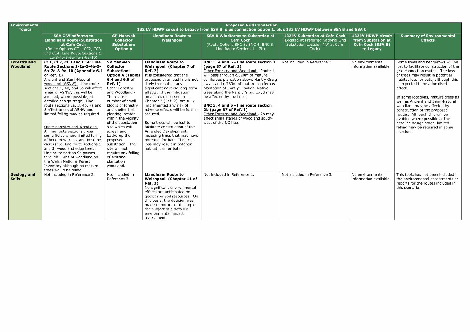
Environmental Topics
Proposed Grid Connection 132 kV HDWP circuit to Legacy from SSA B, plus connection option 1, plus 132 kV HDWP between SSA B and SSA C
SSA C Windfarms to Llandinam Route/Substation
at Cefn Coch (Route Options CC1, CC2, CC3 and CC4: Line Route Sections 1-
2a-3-4b-5-6a-7a-8-9a-10)
SP Manweb Collector
Substation: Option A
Llandinam Route to Welshpool
SSA B Windfarms to Substation at Cefn Coch
(Route Options BNC 3, BNC 4, BNC 5: Line Route Sections 1 - 2b)
132kV Substation at Cefn Coch (Located at Preferred National Grid Substation Location NW at Cefn
Coch)
132kV HDWP circuit from Substation at Cefn Coch (SSA B)
to Legacy
Summary of Environmental Effects
Forestry and Woodland
CC1, CC2, CC3 and CC4: Line Route Sections 1-2a-3-4b-5-6a-7a-8-9a-10 (Appendix 6.1
of Ref. 1) Ancient and Semi-Natural woodland (ASNW) - Line route sections 1, 4b, and 6a will affect areas of ASNW, this will be avoided, where possible, at detailed design stage. Line route sections 2a, 3, 4b, 7a and 8 affect areas of ASNW and limited felling may be required. Other Forestry and Woodland - All line route sections cross some fields where limited felling of hedgerow trees, and in some cases (e.g. line route sections 1 and 3) woodland edge trees. Line route section 9a passes through 5.9ha of woodland on the Welsh National Forest Inventory although no mature trees would be felled.
SP Manweb Collector Substation:
Option A (Tables 6.4 and 6.5 of Ref. 1) Other Forestry and Woodland - There are a number of small blocks of forestry and shelter belt planting located within the vicinity of the substation site which will screen and backdrop the proposed substation. The site will not require any felling of existing plantation woodland.
Llandinam Route to Welshpool (Chapter 7 of Ref. 2)
It is considered that the proposed overhead line is not likely to result in any significant adverse long-term effects. If the mitigation measures discussed in Chapter 7 (Ref. 2) are fully implemented any risk of adverse effects will be further reduced. Some trees will be lost to facilitate construction of the Amended Development, including trees that may have potential for bats. This tree loss may result in potential habitat loss for bats.
BNC 3, 4 and 5 - line route section 1 (page 87 of Ref. 1) Other Forestry and Woodland - Route 1 will pass through c.320m of mature coniferous plantation above Nant y Graig Lwyd, and c.730m of mature coniferous plantation at Cors yr Ebolion. Native trees along the Nant y Graig Lwyd may be affected by the lines. BNC 3, 4 and 5 - line route section 2b (page 87 of Ref. 1) Other Forestry and Woodland - 2b may affect small stands of woodland south-west of the NG hub.
Not included in Reference 3. No environmental information available.
Some trees and hedgerows will be lost to facilitate construction of the grid connection routes. The loss of trees may result in potential habitat loss for bats, although this is expected to be a localised effect.
In some locations, mature trees as well as Ancient and Semi-Natural woodland may be affected by construction of the proposed routes. Although this will be avoided where possible at the detailed design stage, limited felling may be required in some locations.
Geology and Soils
Not included in Reference 3. Not included in Reference 3.
Llandinam Route to Welshpool (Chapter 11 of
Ref. 2) No significant environmental effects are anticipated on geology or soil resources. On this basis, the decision was made to not make this topic the subject of a detailed environmental impact assessment.
Not included in Reference 1. Not included in Reference 3. No environmental information available.
This topic has not been included in the environmental assessments or reports for the routes included in this scenario.

Environmental Topics
Proposed Grid Connection 132 kV HDWP circuit to Legacy from SSA B, plus connection option 1, plus 132 kV HDWP between SSA B and SSA C
SSA C Windfarms to Llandinam Route/Substation
at Cefn Coch (Route Options CC1, CC2, CC3 and CC4: Line Route Sections 1-
2a-3-4b-5-6a-7a-8-9a-10)
SP Manweb Collector
Substation: Option A
Llandinam Route to Welshpool
SSA B Windfarms to Substation at Cefn Coch
(Route Options BNC 3, BNC 4, BNC 5: Line Route Sections 1 - 2b)
132kV Substation at Cefn Coch (Located at Preferred National Grid Substation Location NW at Cefn
Coch)
132kV HDWP circuit from Substation at Cefn Coch (SSA B)
to Legacy
Summary of Environmental Effects
Historic Environment
CC1, CC2, CC3 and CC4: Line Route Sections 1-2a-3-4b-5-6a-7a-8-9a-10 (Appendix 6.1
of Ref. 1) SAMs - The northen area of the route contains more SAMs that are within 2km of the route. For example, no SAMs are located within line route section 1 but 24 SAMs lie in 14 groups within 2km of the route and line route sections 2a-5 have no SAMs within 2km of the route. Whereas line route sections 6a-10 all have SAMs located within 2km of the route. Virtually all the SAMs are prehistoric burial and ritual monuments, some with wide-ranging views, others are rare prehistoric house sites. Listed Buildings (LBs) - All line route sections, apart from 9a and 10 are within 2km of LBs, the majority of which are lower grade II. However, some line route sections (e.g. 5) have LBs of higher grade II* designated status. LBs that are within close proximity (i.e. 150m) of the route such as Ystradfaelog which is the higher grade II* building along line route section 5, could be the possibility of visual impact. Conservation Areas - Only line route section 3 is located within 2km of a Conservation Area, which is Llanidloes Conservation Area. Registered Historic Landscapes (RHLs) - Line route sections 2a, 3, 5 and 6a are within 1-2km of Clywedog Valley RHL and/or Caersws Basin RHL. Undesignated Archaeology - Undesignated archaeological features are located along most line route sections. Direct effects will be avoided, where possible, during detailed design.
SP Manweb Collector Substation:
Option A (Tables 6.4 and 6.5 of Ref. 1) Undesignated Archaeology - An undesignated site of historical interest (a single storey derelict stone building) lies immediately adjacent to the site to the northeast.
Llandinam Route to Welshpool (Chapter 8 of Ref. 2)
The proposed overhead line from the Llandinam Repowering Wind Farm to the Welshpool Grid Substation, some 35 km long, adopts a course to the south and east of the Severn Valley which takes it past and through some of the richest cultural heritage landscapes in mid Wales. There are 55 SAMs located within 2km of the overhead line, two of them (Crugyn Bank Dyke and Bryn Cwmyrhiwdre Round Barrow) within the 100m wide corridor. There are also 452 Listed Buildings, five Registered Historic Parks and Gardens, seven Conservation Areas, and one of Wales’ Registered Historic Landscapes would be crossed by the proposed overhead line. It is the heritage assets within the 100 m wide corridor that are most at risk from the proposed overhead line and could be adversely affected by its construction. Most of these are considered to be of low (local) or even negligible value, but there are some of medium (regional) significance, as well as the few of high (national) importance. Appropriate mitigation (e.g. preservation in situ, preservation by record, excavation, evaluation, watching brief) including the careful demarcation of assets is suggested which should ensure that damage is kept to a minimum during the erection of the supports. Assuming that a full suite of mitigation measures is
BNC 3, 4 and 5 - line route section 1 (page 87 of Ref. 1) SAMs - There is 1 SAM within the route but none within 2km. The proximity of the scheduled Bon-y-maen root store and on the farm of which it forms a part will form a key consideration for the detailed line design stage and effects on its setting will form a key consideration during the EIA stage. Listed Buildings (LBs) - There are no LBs within the route section. There are 2 LBs within 2km of it, both of lower grade II. Undesignated Archaeology - There are 2 undesignated archaeological features in the route section. Direct effects will be avoided, where possible, during detailed design. BNC 3, 4 and 5 - line route section 2b (page 87 of Ref. 1) SAMs - There are no SAMs within the route but two within 2km, the Bon-y-maen root store and Y Capel stone circle. Listed Buildings (LBs) - There are no Listed Buildings within 2km of the route section. Undesignated Archaeology - There are no undesignated archaeological features in the route section.
Preferred Substation Location NW (Section 10.2 of Ref. 3) The site is located in an area where there are no key local receptors, but it is located roughly equidistant between a scheduled Kerb Cairn (WSM MG 327), a scheduled stone circle (WSM MG 179), and a root store (WSM MG 218). These sites are situated approximately 2km away from the substation, and outside of any identified areas of theoretical visibility. However, whilst the substation site will not be visible from any of these monuments, the proposed overhead line is potentially visible from the root store and may have a slightly adverse effect upon its landscape context. An undesignated group of pillow mounds (WNMR 9448) of regional importance is located to the south east. Whilst the substation site will not be visible, the proposed overhead lines into and out of the substation, are potentially visible and may have a slightly adverse effects upon their landscape context.
No environmental information available.
Two designated features (SAMs) are located within the Llandinam route and one within the SP MWC BNC route. The Llandinam Route and other routes included in this scenario pass within 1-2km of other historic assets, including: SAMs, Conservation Areas, Listed Buildings (primarily lower grade II but also including higher grade), historic landscapes, Registered Historic Parks and Gardens and undesignated below-ground sites/features. Mitigation measures will be deployed to minimise direct effects on features, however significant effects on the setting of a number of features are predicted. Only the Llandinam route passes through a Registered Historic Landscape resulting in significant effects.

Environmental Topics
Proposed Grid Connection 132 kV HDWP circuit to Legacy from SSA B, plus connection option 1, plus 132 kV HDWP between SSA B and SSA C
SSA C Windfarms to Llandinam Route/Substation
at Cefn Coch (Route Options CC1, CC2, CC3 and CC4: Line Route Sections 1-
2a-3-4b-5-6a-7a-8-9a-10)
SP Manweb Collector
Substation: Option A
Llandinam Route to Welshpool
SSA B Windfarms to Substation at Cefn Coch
(Route Options BNC 3, BNC 4, BNC 5: Line Route Sections 1 - 2b)
132kV Substation at Cefn Coch (Located at Preferred National Grid Substation Location NW at Cefn
Coch)
132kV HDWP circuit from Substation at Cefn Coch (SSA B)
to Legacy
Summary of Environmental Effects
successfully implemented, the proposed overhead line should not have any significant long-term effect on the cultural heritage. In particular, there are no likely significant direct effects on cultural heritage arising during the construction, operation or decommissioning of the proposed overhead line. The passage of the proposed overhead line through approximately 6.5 km of the Vale of Montgomery Registered Historic Landscape was subject to an ASIDOHL2 study in 2009 which established that whilst the overall effect would be moderate, locally it would be severe, representing a significant effect. Inevitably during the operational life of the proposed overhead line, it would have an indirect visual effect on a significant number of designated and registered assets. In a few cases, around six in number, that effect is likely to be very large. It is difficult to identify how such visual effects might be reduced for the density of assets in this region is such that any route adopted would be likely to generate visual issues. These are long-term temporary effects which would last for the operational life of the proposed overhead line but which would be completed removed once the proposed overhead line has been decommissioned.

Environmental Topics
Proposed Grid Connection 132 kV HDWP circuit to Legacy from SSA B, plus connection option 1, plus 132 kV HDWP between SSA B and SSA C
SSA C Windfarms to Llandinam Route/Substation
at Cefn Coch (Route Options CC1, CC2, CC3 and CC4: Line Route Sections 1-
2a-3-4b-5-6a-7a-8-9a-10)
SP Manweb Collector
Substation: Option A
Llandinam Route to Welshpool
SSA B Windfarms to Substation at Cefn Coch
(Route Options BNC 3, BNC 4, BNC 5: Line Route Sections 1 - 2b)
132kV Substation at Cefn Coch (Located at Preferred National Grid Substation Location NW at Cefn
Coch)
132kV HDWP circuit from Substation at Cefn Coch (SSA B)
to Legacy
Summary of Environmental Effects
Land Use CC1, CC2, CC3 and CC4: Line Route Sections 1-2a-3-4b-5-6a-7a-8-9a-10 (Appendix 6.1
of Ref. 1) Open space and Green Infrastructure - Line route section 1 crosses one area of Open Country access and lies within 1km of one other, and within 1km of two areas of Registered Common Land.
No environmental information was covered for this topic.
Not covered in Reference 2. BNC 3, 4 and 5 - line route section 1 (pages 87 and 88 of Ref. 1) Open space and Green Infrastructure - Route 1 routes across approximately 1,766m of open access land. BNC 3, 4 and 5 - line route section 2b (pages 87 and 88 of Ref. 1) Open space and Green Infrastructure - 2b routes across approximately 694m of open access land.
Not included in Reference 4. No environmental information available.
It is not possible to draw conclusions from the environmental information available, as all of the routes have not considered this topic.
Landscape and Visual Amenity
CC1, CC2, CC3 and CC4: Line Route Sections 1-2a-3-4b-5-6a-7a-8-9a-10 (Appendix 6.1 of Ref. 1) Landscape and visual amenity varies along the route. Along certain line route sections short sections of sky lining will occur (e.g. line route section 2a), and the line route sections will be visible as they drop down into valleys, such as Afon Trannon Valley. However, some line route sections are provided with natural screening in areas by existing hedgerow and riparian trees, and line route sections, such as line route section 1, follow the field pattern, using field boundaries and shelter belts to screen and backdrop the route. Line route sections, such as 6a, pass through relatively open landscapes above the valley floor and will be visible in views across valleys, although these views will be back dropped by wooded slopes. Line route section 6a will also be locally prominent as it runs around the Allt y Genlli hillside above Tanyrallt. Also,in certain lcoations, line route sections pass through areas of ancient and semi-natural woodland and scattered properties. Potential visual effects are possible for residential properties, such as Oakley Park, which will have views of line route section 4b. Line route section 4b will also have further effects on individual properties
SP Manweb Collector Substation: Option A (Tables
6.4 and 6.5 of Ref. 1) Landscape Sensitivity - The open pasture landscape lies below the higher moorland tops to the north and east above the A483. The Ithon valley runs to the east of the site but is relatively shallow at this point. The moderate sized pastoral fields are often contained by coniferous shelter belts and larger woodland blocks, which both introduce man made elements to the landscape and break up and contain views. The substation is potentially visible within the landscape due to its elevation and the relatively open nature of the upland landscape. However, the sensitivity of this landscape is medium-low, and there is scope for extension of the existing areas of
Llandinam Route to Welshpool (Chapter 6 of Ref. 2) Any likely significant landscape or visual effects would arise during the operational stage from the localised loss of trees and the introduction into the landscape of approximately 35 km of new overhead line on wood pole structures. The design and routeing of the proposed overhead line has been developed to minimise its effects on the landscape and visual amenity of the area. The location of the Llandinam wind farm on the Waun Ddubarthog Ridge means that the route is more visible at the southern end of the corridor, than further north where it merges into the more diverse and enclosed landscape east of the Severn Valley. However, the use of wood pole supports helps mitigate the effects within the more open and elevated parts of the route. Landscape Effects
Although significant or borderline significant, all the effects were assessed as minor-moderate or moderate and none of the effects was assessed as major. The only landscape along the route identified as experiencing a moderate and therefore significant effect is between the A483 near Old Neuadd
BNC 3, 4 and 5 - line route section 1 (page 87 of Ref. 1) Landscape Sensitivity - Route 1 descends into the small-medium scale valley of the Nant y Graig Lwyd. It traverses a shoulder of moorland, remaining behind the ridge line where possible. Between Cwmderwen and Cors yr Ebolion it crosses medium to large-scale upland pasture. It then passes across larger-scale moorland plateau, avoiding the highest ground where possible. Visual Sensitivity - The parallel wood pole lines may be seen on the skyline above Nant y Graig Lwyd from locations within Nant-yr-Eira. The lines will be backclothed by forestry on the south side of Nant-yr-Eira. Beyond Cors yr Ebolion the plateau has few inward views and wood poles are unlikely to be seen. From the head of Nant Wythan, 1 will be carried on steel towers. These may be visible in longer views toward the moorland, e.g. from Cwm Llwyd to the south and from the Banwy valley to the north. The towers will be partially screened/backclothed by forestry at Mynydd Carreg-y-big in some views. Residential Visual Amenity - The parallel wood pole lines may be viewed from two properties at Cwmderwen, descending from high ground into Nant-yr-Eira. These properties would also overlook the crossing of the Afon Gam at relatively close range. There may be views of the route from Dolau-ceimion, although the lines will be backclothed. Visitor Attractions - No visitor attractions have been identified that would be affected by BNC1.
Preferred Substation Location NW (Section 10.2 of Ref. 3) Whilst currently a substation in this remote rural location would represent a detracting urban element, which would be inconsistent with the local landscape character, this situation is likely to change with the construction of the Tirgwynt wind farm and Mynydd Waen Fawr wind farm (if constructed) as the proposed substation would potentially be seen alongside above ground equipment such as overhead electricity lines, pylons and the turbines of the Tirgwynt Wind farm and other planned wind farms. The Overall Visual and Sensory Evaluation (VS50) of the site is High. The ZTV suggests that a substation in this location may just be visible from Snowdonia National Park in the high area of Mynydd Clywedog. This would be at a distance of 15km and it is likely that the substation would be imperceptible from this distance. The ZTV indicates that the site is visually well contained due to the surrounding landform which provides natural screening on three sides. Areas of potential visibility are largely restricted to the sparsely populated valley and surrounding hill slopes to the north-east, including the lower slopes of Mynydd Waun Fawr, the Mynydd y Gribin ridgeline and Foel Fawr. It is anticipated that there would be unrestricted and filtered views of the development from Gwaenydd and potentially from a few other scattered properties further afield.
No environmental information available.
Landscape and visual effects are likely to arise along the routes of this scenario, however the effects will be localised and will diminish rapidly with distance from the route. Localised significant effects have been identified for visual receptors utilising a proportion of the footpaths, roads and residential properties sited close to the routes of this scenario. Overall, for the SSAC connection to Welshpool, effects are more likely for landscape and visual receptors located close to the southern sections of the proposed route. This is because this is generally a more elevated area with lower levels of vegetation cover consequently there would be greater potential visibility for the routes. In comparison, the central and northern sections of the Llandinam – Welshpool route is routed through more diverse and enclosed landscape character types, although the corollary is that these sections tend to be more populous, therefore a greater number of receptors are likely. The SSAC connection to Cefn Coch will be visible as it crosses roads and within valleys and there are likely to be potential visual effects on a number of residential properties. Landscape and visual effects are likely along line route section 1 of BNC 3, BNC 4 and BNC5. However, these elements of this scenario will be screened from
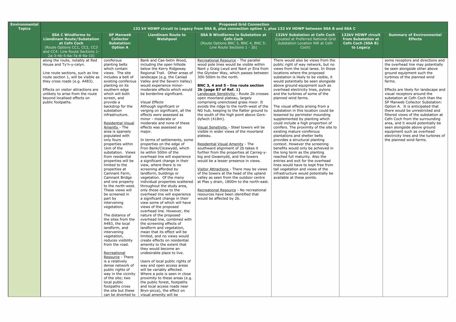
Environmental Topics
Proposed Grid Connection 132 kV HDWP circuit to Legacy from SSA B, plus connection option 1, plus 132 kV HDWP between SSA B and SSA C
SSA C Windfarms to Llandinam Route/Substation
at Cefn Coch (Route Options CC1, CC2, CC3 and CC4: Line Route Sections 1-
2a-3-4b-5-6a-7a-8-9a-10)
SP Manweb Collector
Substation: Option A
Llandinam Route to Welshpool
SSA B Windfarms to Substation at Cefn Coch
(Route Options BNC 3, BNC 4, BNC 5: Line Route Sections 1 - 2b)
132kV Substation at Cefn Coch (Located at Preferred National Grid Substation Location NW at Cefn
Coch)
132kV HDWP circuit from Substation at Cefn Coch (SSA B)
to Legacy
Summary of Environmental Effects
along the route, notably at Red House and Ty’n-y-celyn. Line route sections, such as line route section 1, will be visible as they cross roads (e.g. A483). Effects on visitor attractions are unlikely to arise from the route beyond localised effects on public footpaths.
coniferous planting belts which contain views. The site includes a belt of existing coniferous planting on its southern edge which will both screen, and provide a backdrop for the substation infrastructure. Residential Visual Amenity - The area is sparsely populated with only fours properties within 1km of the substation. Views from residential properties will be limited to the properties at Camnant Farm, Camnant Bridge and one property to the north-west. These views will be screened in part by intervening vegetation. The distance of the sites from the A483, the local landform, and intervening vegetation, reduces visibility from the road. Recreational Resource - There is a relatively dense network of public rights of way in the vicinity of the site; two local public footpaths cross the site but these can be diverted to
Bank and Cae-betin Wood, including the open hillside below the Kerry Ridgeway Regional Trail. Other areas of landscape (e.g. the Canlad Valley and the Severn Valley) would experience minor-moderate effects which would be borderline significant. Visual Effects
Although significant or verging on significant, all the effects were assessed as minor - moderate or moderate and none of these effects was assessed as major. In terms of settlements, some properties on the edge of Fron Bank/Cilcewydd, which lie within 500m of the overhead line will experience a significant change in their view, where there is no screening afforded by landform, buildings or vegetation. Of the many individual properties scattered throughout the study area, only those close to the overhead line will experience a significant change in their view some of which will have views of the proposed overhead line. However, the nature of the proposed overhead line, combined with the screening effects of landform and vegetation, mean that its effect will be limited, and no views would create effects on residential amenity to the extent that they would become an undesirable place to live. Users of local public rights of way and open access areas will be variably affected. Where a pole is seen in close proximity to these areas (e.g. the public forest, footpaths and local access roads near Bryn-picca), the effect on visual amenity will be
Recreational Resource - The parallel wood pole lines would be visible within Nant y Graig Lwyd and Nant yr Eira from the Glyndwr Way, which passes between 300-500m to the north. BNC 3, 4 and 5 - line route section 2b (page 87 of Ref. 1) Landscape Sensitivity - Route 2b crosses open moorland plateau, largely comprising unenclosed grass moor. It avoids the ridge to the north-west of the NG hub, keeping to the flatter ground to the south of the high point above Gors-dyfwch (418m). Visual Sensitivity - Steel towers will be visible in wider views of the moorland plateau. Residential Visual Amenity - The southward alignment of 2b takes it further from the properties at Carreg-y-big and Gwaenydd, and the towers would be a lesser presence in views. Visitor Attractions - There may be views of the towers at the head of the upland valley as seen from the outdoor centre at Plas y drain, 1800m to the north-east. Recreational Resource - No recreational resources have been identified that would be affected by 2b.
There would also be views from the public right of way network, but no views from the local lanes. In those locations where the proposed substation is likely to be visible, it would potentially be seen alongside above ground equipment such as overhead electricity lines, pylons and the turbines of some of the planned wind farms. The visual effects arising from a substation in this location could be lessened by perimeter mounding supplemented by planting which could include a high proportion of conifers. The proximity of the site to existing mature coniferous plantations and shelter belts provides a structural planting context. However the screening benefits would only be achieved in the long term as the planting reached full maturity. Also the entries and exit for the overhead lines would have to kept free from tall vegetation and views of the infrastructure would potentially be available at these points.
some receptors and directions and the overhead line may potentially be seen alongside other above ground equipment such the turbines of the planned wind farms. Effects are likely for landscape and visual receptors around the substation at Cefn Coch than the SP Manweb Collector Substation: Option A. It is anticipated that there would be unrestricted and filtered views of the substation at Cefn Coch from the surrounding area, and it would potentially be seen alongside above ground equipment such as overhead electricity lines and the turbines of the planned wind farms.

Environmental Topics
Proposed Grid Connection 132 kV HDWP circuit to Legacy from SSA B, plus connection option 1, plus 132 kV HDWP between SSA B and SSA C
SSA C Windfarms to Llandinam Route/Substation
at Cefn Coch (Route Options CC1, CC2, CC3 and CC4: Line Route Sections 1-
2a-3-4b-5-6a-7a-8-9a-10)
SP Manweb Collector
Substation: Option A
Llandinam Route to Welshpool
SSA B Windfarms to Substation at Cefn Coch
(Route Options BNC 3, BNC 4, BNC 5: Line Route Sections 1 - 2b)
132kV Substation at Cefn Coch (Located at Preferred National Grid Substation Location NW at Cefn
Coch)
132kV HDWP circuit from Substation at Cefn Coch (SSA B)
to Legacy
Summary of Environmental Effects
an existing track around the site. There would be views to the site from the adjacent public footpaths and others in the vicinity; however use of the footpaths does not appear to be high.
significant, although this effect will diminish rapidly with distance. Similarly, road users will be variably affected. Significant residual effects are noted for the A483 and B4355, although these effects would be localised and transient.
Lighting Not included in Reference 1. Not included in Reference 1.
Llandinam Route to Welshpool (Chapter 11 of Ref. 2) No significant environmental effects are anticipated on lighting. On this basis, the decision was made to not make this topic the subject of a detailed environmental impact assessment.
Not included in Reference 1. Not included in Reference 4. No environmental information available.
This topic has not been included in the environmental assessments or reports for the routes included in this scenario.
Noise and Vibration
As no line route option is considered to have a greater or lesser effect in respect of this topic at this scale, this topic has not been included as it does not assist in identifying a line route with least environmental effect. This topic will be considered at the EIA stage. (page 48 of Ref. 1)
As no line route option is considered to have a greater or lesser effect in respect of this topic at this scale, this topic has not been included as it does not assist in identifying a line route with least environmental effect. This topic will be considered at the EIA stage. (page 48 of Ref. 1)
Llandinam Route to Welshpool (Chapter 11 of Ref. 2) No significant environmental effects are anticipated for noise. On this basis, the decision was made to not make this topic the subject of a detailed environmental impact assessment. This is because of the low intensity of construction activities, the very low volume of vehicle movements which construction of the proposed overhead line would generate, the short-term (days rather than weeks) and reversible activities at each wood pole structure, and the proven methods of noise control at construction sites. While the Draft Construction Method Statement will ultimately address noise control issues in detail it is noted that Powys CC has powers to investigate noise complaints and serve abatement notices on activities which it considers are giving rise to unacceptable levels of noise
As no line route option is considered to have a greater or lesser effect in respect of this topic at this scale, this topic has not been included as it does not assist in identifying a line route with least environmental effect. This topic will be considered at the EIA stage. (page 48 of Ref. 1)
Preferred Substation Location NW (Section 10.2 of Ref. 3) The nearest dwelling to the site is approx 950m to the northeast. Rating levels below existing background levels are achievable with standard noise mitigation solutions.
No environmental information available.
It is not possible to draw conclusions from the environmental information available, as all of the routes have not considered this topic.
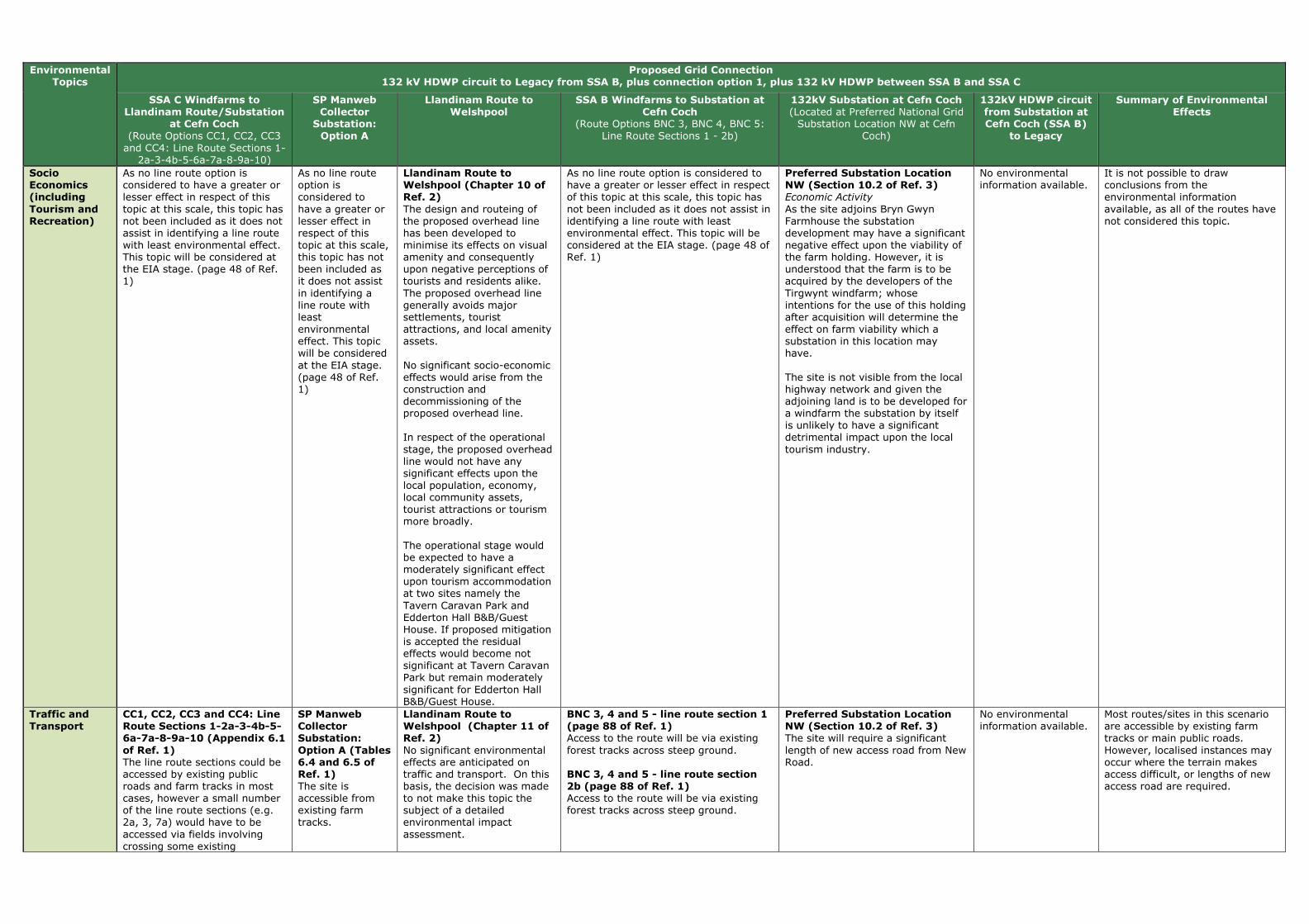
Environmental Topics
Proposed Grid Connection 132 kV HDWP circuit to Legacy from SSA B, plus connection option 1, plus 132 kV HDWP between SSA B and SSA C
SSA C Windfarms to Llandinam Route/Substation
at Cefn Coch (Route Options CC1, CC2, CC3 and CC4: Line Route Sections 1-
2a-3-4b-5-6a-7a-8-9a-10)
SP Manweb Collector
Substation: Option A
Llandinam Route to Welshpool
SSA B Windfarms to Substation at Cefn Coch
(Route Options BNC 3, BNC 4, BNC 5: Line Route Sections 1 - 2b)
132kV Substation at Cefn Coch (Located at Preferred National Grid Substation Location NW at Cefn
Coch)
132kV HDWP circuit from Substation at Cefn Coch (SSA B)
to Legacy
Summary of Environmental Effects
Socio Economics (including
Tourism and Recreation)
As no line route option is considered to have a greater or lesser effect in respect of this topic at this scale, this topic has not been included as it does not assist in identifying a line route with least environmental effect. This topic will be considered at the EIA stage. (page 48 of Ref. 1)
As no line route option is considered to have a greater or lesser effect in respect of this topic at this scale, this topic has not been included as it does not assist in identifying a line route with least environmental effect. This topic will be considered at the EIA stage. (page 48 of Ref. 1)
Llandinam Route to Welshpool (Chapter 10 of Ref. 2) The design and routeing of the proposed overhead line has been developed to minimise its effects on visual amenity and consequently upon negative perceptions of tourists and residents alike. The proposed overhead line generally avoids major settlements, tourist attractions, and local amenity assets. No significant socio-economic effects would arise from the construction and decommissioning of the proposed overhead line. In respect of the operational stage, the proposed overhead line would not have any significant effects upon the local population, economy, local community assets, tourist attractions or tourism more broadly. The operational stage would be expected to have a moderately significant effect upon tourism accommodation at two sites namely the Tavern Caravan Park and Edderton Hall B&B/Guest House. If proposed mitigation is accepted the residual effects would become not significant at Tavern Caravan Park but remain moderately significant for Edderton Hall B&B/Guest House.
As no line route option is considered to have a greater or lesser effect in respect of this topic at this scale, this topic has not been included as it does not assist in identifying a line route with least environmental effect. This topic will be considered at the EIA stage. (page 48 of Ref. 1)
Preferred Substation Location NW (Section 10.2 of Ref. 3) Economic Activity As the site adjoins Bryn Gwyn Farmhouse the substation development may have a significant negative effect upon the viability of the farm holding. However, it is understood that the farm is to be acquired by the developers of the Tirgwynt windfarm; whose intentions for the use of this holding after acquisition will determine the effect on farm viability which a substation in this location may have. The site is not visible from the local highway network and given the adjoining land is to be developed for a windfarm the substation by itself is unlikely to have a significant detrimental impact upon the local tourism industry.
No environmental information available.
It is not possible to draw conclusions from the environmental information available, as all of the routes have not considered this topic.
Traffic and Transport
CC1, CC2, CC3 and CC4: Line Route Sections 1-2a-3-4b-5-6a-7a-8-9a-10 (Appendix 6.1
of Ref. 1) The line route sections could be accessed by existing public roads and farm tracks in most cases, however a small number of the line route sections (e.g. 2a, 3, 7a) would have to be accessed via fields involving crossing some existing
SP Manweb Collector Substation:
Option A (Tables 6.4 and 6.5 of Ref. 1) The site is accessible from existing farm tracks.
Llandinam Route to Welshpool (Chapter 11 of Ref. 2) No significant environmental effects are anticipated on traffic and transport. On this basis, the decision was made to not make this topic the subject of a detailed environmental impact assessment.
BNC 3, 4 and 5 - line route section 1 (page 88 of Ref. 1) Access to the route will be via existing forest tracks across steep ground. BNC 3, 4 and 5 - line route section 2b (page 88 of Ref. 1) Access to the route will be via existing forest tracks across steep ground.
Preferred Substation Location NW (Section 10.2 of Ref. 3) The site will require a significant length of new access road from New Road.
No environmental information available.
Most routes/sites in this scenario are accessible by existing farm tracks or main public roads. However, localised instances may occur where the terrain makes access difficult, or lengths of new access road are required.
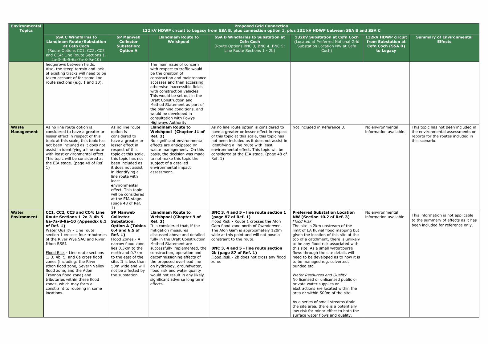
Environmental Topics
Proposed Grid Connection 132 kV HDWP circuit to Legacy from SSA B, plus connection option 1, plus 132 kV HDWP between SSA B and SSA C
SSA C Windfarms to Llandinam Route/Substation
at Cefn Coch (Route Options CC1, CC2, CC3 and CC4: Line Route Sections 1-
2a-3-4b-5-6a-7a-8-9a-10)
SP Manweb Collector
Substation: Option A
Llandinam Route to Welshpool
SSA B Windfarms to Substation at Cefn Coch
(Route Options BNC 3, BNC 4, BNC 5: Line Route Sections 1 - 2b)
132kV Substation at Cefn Coch (Located at Preferred National Grid Substation Location NW at Cefn
Coch)
132kV HDWP circuit from Substation at Cefn Coch (SSA B)
to Legacy
Summary of Environmental Effects
hedgerows between fields. Also, the steep terrain and lack of existing tracks will need to be taken account of for some line route sections (e.g. 1 and 10).
The main issue of concern with respect to traffic would be the creation of construction and maintenance accesses and then accessing otherwise inaccessible fields with construction vehicles. This would be set out in the Draft Construction and Method Statement as part of the planning conditions, and would be developed in consultation with Powys Highways Authority.
Waste
Management
As no line route option is considered to have a greater or lesser effect in respect of this topic at this scale, this topic has not been included as it does not assist in identifying a line route with least environmental effect. This topic will be considered at the EIA stage. (page 48 of Ref. 1)
As no line route option is considered to have a greater or lesser effect in respect of this topic at this scale, this topic has not been included as it does not assist in identifying a line route with least environmental effect. This topic will be considered at the EIA stage. (page 48 of Ref. 1)
Llandinam Route to
Welshpool (Chapter 11 of Ref. 2) No significant environmental effects are anticipated on waste management. On this basis, the decision was made to not make this topic the subject of a detailed environmental impact assessment.
As no line route option is considered to have a greater or lesser effect in respect of this topic at this scale, this topic has not been included as it does not assist in identifying a line route with least environmental effect. This topic will be considered at the EIA stage. (page 48 of Ref. 1)
Not included in Reference 3. No environmental information available.
This topic has not been included in the environmental assessments or reports for the routes included in this scenario.
Water
Environment
CC1, CC2, CC3 and CC4: Line
Route Sections 1-2a-3-4b-5-6a-7a-8-9a-10 (Appendix 6.1 of Ref. 1) Water Quality - Line route section 1 crosses four tributaries of the River Wye SAC and River Ithon SSSI. Flood Risk - Line route sections 1, 3, 4b, 5, and 6a cross flood zones (including: the River Ithon flood zone, Severn Valley flood zone, and the Adon Trannon flood zone) and tributaries within these flood zones, which may form a constraint to routeing in some locations.
SP Manweb
Collector Substation: Option A (Tables 6.4 and 6.5 of Ref. 1) Flood Zones - A narrow flood zone lies 0.3km to the north and 0.7km to the east of the site. It is less than 50m wide and will not be affected by the substation.
Llandinam Route to
Welshpool (Chapter 9 of Ref. 2) It is considered that, if the mitigation measures discussed above and detailed fully in the Draft Construction Method Statement are successfully implemented, the construction, operation and decommissioning effects of the proposed overhead line on hydrology, groundwater, flood risk and water quality would not result in any likely significant adverse long term effects.
BNC 3, 4 and 5 - line route section 1
(page 87 of Ref. 1) Flood Risk - Route 1 crosses the Afon Gam flood zone north of Cwmderwen. The Afon Gam is approximately 120m wide at this point and will not pose a constraint to the route. BNC 3, 4 and 5 - line route section 2b (page 87 of Ref. 1) Flood Risk - 2b does not cross any flood zone.
Preferred Substation Location
NW (Section 10.2 of Ref. 3) Flood Risk The site is 2km upstream of the limit of EA fluvial flood mapping but given the location of this site at the top of a catchment, there is unlikely to be any flood risk associated with this site. As a small watercourse flows through the site details will need to be developed as to how it is to be managed e.g. culverted, bunded etc. Water Resources and Quality No licensed or unlicensed public or private water supplies or abstractions are located within the area or within 500m of the site. As a series of small streams drain the site area, there is a potentially low risk for minor effect to both the surface water flows and quality,
No environmental information available. This information is not applicable
to the summary of effects as it has
been included for reference only.

Environmental Topics
Proposed Grid Connection 132 kV HDWP circuit to Legacy from SSA B, plus connection option 1, plus 132 kV HDWP between SSA B and SSA C
SSA C Windfarms to Llandinam Route/Substation
at Cefn Coch (Route Options CC1, CC2, CC3 and CC4: Line Route Sections 1-
2a-3-4b-5-6a-7a-8-9a-10)
SP Manweb Collector
Substation: Option A
Llandinam Route to Welshpool
SSA B Windfarms to Substation at Cefn Coch
(Route Options BNC 3, BNC 4, BNC 5: Line Route Sections 1 - 2b)
132kV Substation at Cefn Coch (Located at Preferred National Grid Substation Location NW at Cefn
Coch)
132kV HDWP circuit from Substation at Cefn Coch (SSA B)
to Legacy
Summary of Environmental Effects
with the proposed substation potentially affecting both ground water recharge and surface run-off characteristics within the site area.
Technical Review
CC1, CC2, CC3 and CC4: Line Route Sections 1-2a-3-4b-5-6a-7a-8-9a-10 (Appendix 6.1 of Ref. 1) Existing and Proposed OHL Infrastructure 33kV and 132kV - This route would cross existing 33kV OHL at certain line route sections, however, this could be undergrounded. Existing and Proposed Wind Turbines - Line route section 1 passes within proximity of turbines; however it will be possible to maintain the required distance. Line route sections 9a and 10 also pass within proximity of turbines but it may not be possible to maintain the required distance for line route section 9a. Altitude and Topography - The altitude and topography varies throughout the route, as demonstrated from the examples detailed below: Line route section 1: The eastern end of this route would cover altitudes of up to 455m at the substation at Llanbadarn Fynydd. Moving west, the land height is 373m at the Neuadd Goch substation. As the line moves south-west, land heights increase to around 420m at Llaithddu and then higher to around 550m at Hirddywel. Gradients range between 0-15°. As the line passes west of Hirddywel, there is a section of land with a gradient of between 15-22°. The height of land then reduces to around 320m as the route moves west before turning north. Line route section 5: Route 5 runs north-south over land heights between 170 – 300m. The northern section crosses
SP Manweb Collector Substation: Option A (Tables 6.4 and 6.5 of Ref. 1) This site could accommodate the required equipment.
Not covered in Reference 2. BNC 3, 4 and 5 - line route section 1 (page 88 of Ref. 1) Existing and Proposed OHL Infrastructure 33kV and 132kV - This route would be crossed by the Nant y Moch Wind Farm OHL route. Existing and Proposed Wind Turbines - The route passes within proximity of a number of turbines, however the required distance from turbines can be maintained during the detailed design stage. Altitude and Topography - The route would start at a height of 340m, reducing to 260m at the Afon Gam before increasing in height to 380m. Gradients would be 0-150. BNC 3, 4 and 5 - line route section 2b (page 88 of Ref. 1) Existing and Proposed OHL Infrastructure 33kV and 132kV - This route would be crossed by the Nant y Moch OHL route. Existing and Proposed Wind Turbines - The route passes within proximity of a number of potential turbines, and it may not be possible to maintain the required distance at the eastern end. Altitude and Topography - The land height increases from 360m to 410m before reducing to 370m at the substation. Gradients are between 0-150.
Preferred Substation Location NW (Section 10.2 of Ref. 3) The site sits within a shallow valley with ground levels rising steeply towards the southern part of the site. To create a development plateau, some earthworks will be required. Earthworks should be easier in Glacial soils than, although the thickness of these is unknown. If required, cutting operations through sandstone bedrock will likely necessitate the use of hydraulic breakers or blasting. A watercourse runs through the centre of the site from West to East and will need diverting using surface ditches.
No environmental information available. This information is not applicable
to the summary of effects as it has
been included for reference only.

Environmental Topics
Proposed Grid Connection 132 kV HDWP circuit to Legacy from SSA B, plus connection option 1, plus 132 kV HDWP between SSA B and SSA C
SSA C Windfarms to Llandinam Route/Substation
at Cefn Coch (Route Options CC1, CC2, CC3 and CC4: Line Route Sections 1-
2a-3-4b-5-6a-7a-8-9a-10)
SP Manweb Collector
Substation: Option A
Llandinam Route to Welshpool
SSA B Windfarms to Substation at Cefn Coch
(Route Options BNC 3, BNC 4, BNC 5: Line Route Sections 1 - 2b)
132kV Substation at Cefn Coch (Located at Preferred National Grid Substation Location NW at Cefn
Coch)
132kV HDWP circuit from Substation at Cefn Coch (SSA B)
to Legacy
Summary of Environmental Effects
gradients of between 15 -220. Line route section 9a: The southern section of 9a crosses a section of land with a gradient of 15 to 220. As it moves north, land heights range from 420m to 370m before increasing again to 440m.
References (Ref.): (1) SP MANWEB (Sept 2013). SP Mid Wales Connections, Line Routing Methodology & Appraisal - Phase 3 Report. (2) SP MANWEB (Oct 2013). Volume 1: New 132kV Overhead Line Connection from Llandinam Wind Farm to Welshpool Substation - Updated Environmental Statement. (3) National Grid (Sept 2013). Mid Wales Connection Project, Draft Substation Site Report. (4) National Grid (Sept 2013). Mid Wales Connection Project, Draft Route Report.
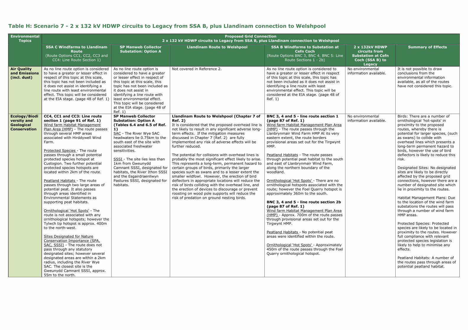
Table H: Scenario 7 - 2 x 132 kV HDWP circuits to Legacy from SSA B, plus Llandinam connection to Welshpool
Environmental
Topics
Proposed Grid Connection
2 x 132 kV HDWP circuits to Legacy from SSA B, plus Llandinam connection to Welshpool
SSA C Windfarms to Llandinam Route
(Route Options CC1, CC2, CC3 and CC4: Line Route Section 1)
SP Manweb Collector Substation: Option A
Llandinam Route to Welshpool SSA B Windfarms to Substation at Cefn Coch
(Route Options BNC 3, BNC 4, BNC 5: Line Route Sections 1 - 2b)
2 x 132kV HDWP circuits from
Substation at Cefn Coch (SSA B) to
Legacy
Summary of Effects
Air Quality and Emissions (incl. dust)
As no line route option is considered to have a greater or lesser effect in respect of this topic at this scale, this topic has not been included as it does not assist in identifying a line route with least environmental effect. This topic will be considered at the EIA stage. (page 48 of Ref. 1)
As no line route option is considered to have a greater or lesser effect in respect of this topic at this scale, this topic has not been included as it does not assist in identifying a line route with least environmental effect. This topic will be considered at the EIA stage. (page 48 of Ref. 1)
Not covered in Reference 2. As no line route option is considered to have a greater or lesser effect in respect of this topic at this scale, this topic has not been included as it does not assist in identifying a line route with least environmental effect. This topic will be considered at the EIA stage. (page 48 of Ref. 1)
No environmental information available.
It is not possible to draw conclusions from the environmental information available, as all of the routes have not considered this topic.
Ecology/Biodi
versity and Geological Conservation
CC4, CC1 and CC3: Line route
section 1 (page 91 of Ref. 1) Wind farm Habitat Management Plan Area (HMP) - The route passes through several HMP areas associated with Hirddywell Wind Farm. Protected Species - The route passes through a small potential protected species hotspot at Custogion. Two further potential protected species hotspots are located within 2km of the route. Peatland Habitats - The route passes through two large areas of potential peat. It also passes through areas identified in Environmental Statements as supporting peat habitats. Ornithological ‘Hot Spots’ - The route is not associated with any ornithological hotspots; however the Tylwch tip hotspot is approx. 400m to the north-west. Sites Designated for Nature Conservation Importance (SPA, SAC, SSSI) - The route does not pass through any statutory designated sites; however several designated areas are within a 2km radius, including the River Wye SAC. The closest site is the Gweunydd Camnant SSSI, approx. 55m to the north.
SP Manweb Collector
Substation: Option A (Tables 6.4 and 6.5 of Ref. 1) SAC - The River Wye SAC headwaters lie 0.75km to the south east of the site with associated freshwater sensitivities. SSSI - The site lies less than 1km from Gweunydd Camnant SSSI, designated for habitats, the River Ithon SSSI and the Esgairdraenllwyn Pastures SSSI, designated for habitats.
Llandinam Route to Welshpool (Chapter 7 of
Ref. 2) It is considered that the proposed overhead line is not likely to result in any significant adverse long-term effects. If the mitigation measures discussed in Chapter 7 (Ref. 2) are fully implemented any risk of adverse effects will be further reduced. The potential for collisions with overhead lines is probably the most significant effect likely to arise. This represents a long-term, permanent hazard to certain groups of birds, primarily the larger species such as swans and to a lesser extent the smaller wildfowl. However, the erection of bird deflectors in appropriate locations will reduce the risk of birds colliding with the overhead line, and the erection of devices to discourage or prevent roosting on wood pole supports will reduce the risk of predation on ground nesting birds.
BNC 3, 4 and 5 - line route section 1
(page 87 of Ref. 1) Wind farm Habitat Management Plan Area (HMP) - The route passes through the Llanbrynmair Wind Farm HMP At its very eastern extent, the route borders provisional areas set out for the Tirgwynt HMP. Peatland Habitats - The route passes through potential peat habitat to the south and east of Llanbrynmair Wind Farm, along the northern boundary of the woodland. Ornithological ‘Hot Spots’ - There are no ornithological hotspots associated with the route; however the Foel Quarry hotspot is approximately 360m to the south. BNC 3, 4 and 5 - line route section 2b
(page 87 of Ref. 1) Wind farm Habitat Management Plan Area (HMP) - Approx. 700m of the route passes through provisional areas set out for the Tirgwynt HMP. Peatland Habitats - No potential peat areas were identified within the route. Ornithological ‘Hot Spots’ - Approximately 450m of the route passes through the Foel Quarry ornithological hotspot.
No environmental information available.
Birds: There are a number of ornithological 'hot-spots' in proximity to the proposed routes, whereby there is potential for larger species, (such as swans) to collide with overhead lines which presents a long-term permanent hazard to birds, however the use of bird deflectors is likely to reduce this risk. Designated Sites: No designated sites are likely to be directly affected by the proposed grid connections, however there are a number of designated site which lie in proximity to the routes. Habitat Management Plans: Due to the location of the wind farm substations the routes will pass through a number of wind farm HMP areas. Protected Species: Protected species are likely to be located in proximity to the routes. However full compliance with relevant protected species legislation is likely to help to minimise any effects. Peatland Habitats: A number of the routes pass through areas of potential peatland habitat.

Environmental Topics
Proposed Grid Connection 2 x 132 kV HDWP circuits to Legacy from SSA B, plus Llandinam connection to Welshpool
SSA C Windfarms to Llandinam Route
(Route Options CC1, CC2, CC3 and CC4: Line Route Section 1)
SP Manweb Collector Substation: Option A
Llandinam Route to Welshpool SSA B Windfarms to Substation at Cefn Coch
(Route Options BNC 3, BNC 4, BNC 5: Line Route Sections 1 - 2b)
2 x 132kV HDWP circuits from
Substation at Cefn Coch (SSA B) to
Legacy
Summary of Effects
Climate Change
As no line route option is considered to have a greater or lesser effect in respect of this topic at this scale, this topic has not been included as it does not assist in identifying a line route with least environmental effect. This topic will be considered at the EIA stage. (page 48 of Ref. 1)
As no line route option is considered to have a greater or lesser effect in respect of this topic at this scale, this topic has not been included as it does not assist in identifying a line route with least environmental effect. This topic will be considered at the EIA stage. (page 48 of Ref. 1)
Not covered in Reference 2. As no line route option is considered to have a greater or lesser effect in respect of this topic at this scale, this topic has not been included as it does not assist in identifying a line route with least environmental effect. This topic will be considered at the EIA stage. (page 48 of Ref. 1)
No environmental information available.
This topic has not been included in the environmental assessments or reports for the routes included in this scenario.
Electric and Magnetic Fields
As no line route option is considered to have a greater or lesser effect in respect of this topic at this scale, this topic has not been included as it does not assist in identifying a line route with least environmental effect. This topic will be considered at the EIA stage. (page 48 of Ref. 1)
As no line route option is considered to have a greater or lesser effect in respect of this topic at this scale, this topic has not been included as it does not assist in identifying a line route with least environmental effect. This topic will be considered at the EIA stage. (page 48 of Ref. 1)
Llandinam Route to Welshpool (Chapter 11 of Ref. 2) No significant environmental effects are anticipated on electric and magnetic fields. On this basis, the decision was made to not make this topic the subject of a detailed environmental impact assessment.
As no line route option is considered to have a greater or lesser effect in respect of this topic at this scale, this topic has not been included as it does not assist in identifying a line route with least environmental effect. This topic will be considered at the EIA stage. (page 48 of Ref. 1)
No environmental information available.
This topic has not been included in the environmental assessments or reports for the routes included in this scenario.
Forestry and Woodland
CC4, CC1 and CC3: Line route section 1 (page 93 of Ref. 1) Ancient and Semi-Natural woodland (ASNW) - Route 1 affects one area of ASNW adjacent to Llwydiarth Wood which will be avoided, where possible, at detailed design stage. Other Forestry and Woodland - Route 1 crosses some areas of narrow shelter planting with potential felling required on higher ground, for example around Ddullui Bank. Within the Nant Feigion valley, felling of hedgerow and woodland edge trees may be required.
SP Manweb Collector Substation: Option A (Tables 6.4 and 6.5 of Ref. 1) Other Forestry and Woodland - There are a number of small blocks of forestry and shelter belt planting located within the vicinity of the substation site which will screen and backdrop the proposed substation. The site will not require any felling of existing plantation woodland.
Llandinam Route to Welshpool (Chapter 7 of Ref. 2) It is considered that the proposed overhead line is not likely to result in any significant adverse long-term effects. If the mitigation measures discussed in Chapter 7 (Ref. 2) are fully implemented any risk of adverse effects will be further reduced. Some trees will be lost to facilitate construction of the Amended Development, including trees that may have potential for bats. This tree loss may result in potential habitat loss for bats.
BNC 3, 4 and 5 - line route section 1 (page 87 of Ref. 1) Other Forestry and Woodland - Route 1 will pass through c.320m of mature coniferous plantation above Nant y Graig Lwyd, and c.730m of mature coniferous plantation at Cors yr Ebolion. Native trees along the Nant y Graig Lwyd may be affected by the lines. BNC 3, 4 and 5 - line route section 2b (page 87 of Ref. 1) Other Forestry and Woodland - 2b may affect small stands of woodland south-west of the NG hub.
No environmental information available.
Some trees and hedgerows will be lost to facilitate construction of the grid connection routes. The loss of trees may result in potential habitat loss for bats, although this is expected to be a localised effect.
In some locations, mature trees as well as Ancient and Semi-Natural woodland may be affected by construction of the proposed routes. Although this will be avoided where possible at the detailed design stage, limited felling may be required in some locations.
Geology and Soils
Not included in Reference 3. Not included in Reference 3. Llandinam Route to Welshpool (Chapter 11 of Ref. 2) No significant environmental effects are anticipated on geology or soil resources. On this basis, the decision was made to not make this topic the subject of a detailed environmental impact assessment.
Not included in Reference 1. No environmental information available.
This topic has not been included in the environmental assessments or reports for the routes included in this scenario.
Historic
Environment
CC4, CC1 and CC3: Line route
section 1 (pages 92 and 93 of Ref. 1) SAMs - No SAMs are located within the route. 24 SAMs in 14 groups lie within 2km of the route. Virtually all the SAMs are prehistoric burial and ritual monuments, some with wide-ranging views and group values.
SP Manweb Collector
Substation: Option A (Tables 6.4 and 6.5 of Ref. 1) Undesignated Archaeology - An undesignated site of historical interest (a single storey derelict stone building) lies immediately adjacent to the site to the northeast.
Llandinam Route to Welshpool (Chapter 8 of
Ref. 2) The proposed overhead line from the Llandinam Repowering Wind Farm to the Welshpool Grid Substation, some 35 km long, adopts a course to the south and east of the Severn Valley which takes it past and through some of the richest cultural heritage landscapes in mid Wales. There are 55 SAMs located within 2km of the overhead line, two of them (Crugyn Bank Dyke
BNC 3, 4 and 5 - line route section 1
(page 87 of Ref. 1) SAMs - There is 1 SAM within the route but none within 2km. The proximity of the scheduled Bon-y-maen root store and on the farm of which it forms a part will form a key consideration for the detailed line design stage and effects on its setting will form a key consideration during the EIA stage.
No environmental information available.
Two designated features (SAMs) are located within the Llandinam route and one within the SP MWC BNC route. The Llandinam Route and other routes included in this scenario pass within 1-2km of other historic assets, including: SAMs, Conservation Areas, Listed Buildings (primarily lower grade II but also including higher grade) , historic
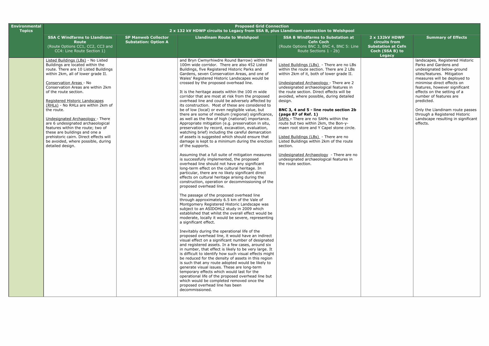
Environmental Topics
Proposed Grid Connection 2 x 132 kV HDWP circuits to Legacy from SSA B, plus Llandinam connection to Welshpool
SSA C Windfarms to Llandinam Route
(Route Options CC1, CC2, CC3 and CC4: Line Route Section 1)
SP Manweb Collector Substation: Option A
Llandinam Route to Welshpool SSA B Windfarms to Substation at Cefn Coch
(Route Options BNC 3, BNC 4, BNC 5: Line Route Sections 1 - 2b)
2 x 132kV HDWP circuits from
Substation at Cefn Coch (SSA B) to
Legacy
Summary of Effects
Listed Buildings (LBs) - No Listed Buildings are located within the route. There are 10 Listed Buildings within 2km, all of lower grade II. Conservation Areas - No Conservation Areas are within 2km of the route section. Registered Historic Landscapes (RHLs) - No RHLs are within 2km of the route. Undesignated Archaeology - There are 6 undesignated archaeological features within the route; two of these are buildings and one a prehistoric cairn. Direct effects will be avoided, where possible, during detailed design.
and Bryn Cwmyrhiwdre Round Barrow) within the 100m wide corridor. There are also 452 Listed Buildings, five Registered Historic Parks and Gardens, seven Conservation Areas, and one of Wales’ Registered Historic Landscapes would be crossed by the proposed overhead line. It is the heritage assets within the 100 m wide corridor that are most at risk from the proposed overhead line and could be adversely affected by its construction. Most of these are considered to be of low (local) or even negligible value, but there are some of medium (regional) significance, as well as the few of high (national) importance. Appropriate mitigation (e.g. preservation in situ, preservation by record, excavation, evaluation, watching brief) including the careful demarcation of assets is suggested which should ensure that damage is kept to a minimum during the erection of the supports. Assuming that a full suite of mitigation measures is successfully implemented, the proposed overhead line should not have any significant long-term effect on the cultural heritage. In particular, there are no likely significant direct effects on cultural heritage arising during the construction, operation or decommissioning of the proposed overhead line. The passage of the proposed overhead line through approximately 6.5 km of the Vale of Montgomery Registered Historic Landscape was subject to an ASIDOHL2 study in 2009 which established that whilst the overall effect would be moderate, locally it would be severe, representing a significant effect. Inevitably during the operational life of the proposed overhead line, it would have an indirect visual effect on a significant number of designated and registered assets. In a few cases, around six in number, that effect is likely to be very large. It is difficult to identify how such visual effects might be reduced for the density of assets in this region is such that any route adopted would be likely to generate visual issues. These are long-term temporary effects which would last for the operational life of the proposed overhead line but which would be completed removed once the proposed overhead line has been decommissioned.
Listed Buildings (LBs) - There are no LBs within the route section. There are 2 LBs within 2km of it, both of lower grade II. Undesignated Archaeology - There are 2 undesignated archaeological features in the route section. Direct effects will be avoided, where possible, during detailed design. BNC 3, 4 and 5 - line route section 2b (page 87 of Ref. 1) SAMs - There are no SAMs within the route but two within 2km, the Bon-y-maen root store and Y Capel stone circle. Listed Buildings (LBs) - There are no Listed Buildings within 2km of the route section. Undesignated Archaeology - There are no undesignated archaeological features in the route section.
landscapes, Registered Historic Parks and Gardens and undesignated below-ground sites/features. Mitigation measures will be deployed to minimise direct effects on features, however significant effects on the setting of a number of features are predicted. Only the Llandinam route passes through a Registered Historic Landscape resulting in significant effects.

Environmental Topics
Proposed Grid Connection 2 x 132 kV HDWP circuits to Legacy from SSA B, plus Llandinam connection to Welshpool
SSA C Windfarms to Llandinam Route
(Route Options CC1, CC2, CC3 and CC4: Line Route Section 1)
SP Manweb Collector Substation: Option A
Llandinam Route to Welshpool SSA B Windfarms to Substation at Cefn Coch
(Route Options BNC 3, BNC 4, BNC 5: Line Route Sections 1 - 2b)
2 x 132kV HDWP circuits from
Substation at Cefn Coch (SSA B) to
Legacy
Summary of Effects
Land Use CC4, CC1 and CC3: Line route section 1 (page 94 of Ref. 1) Open space and Green Infrastructure - Route 1 crosses one area of Open Country access and lies within 1km of one other, and within 1km of two areas of Registered Common Land.
No environmental information was covered for this topic.
Not covered in Reference 2. BNC 3, 4 and 5 - line route section 1 (pages 87 and 88 of Ref. 1) Open space and Green Infrastructure - Route 1 routes across approximately 1,766m of open access land. BNC 3, 4 and 5 - line route section 2b (pages 87 and 88 of Ref. 1) Open space and Green Infrastructure - 2b routes across approximately 694m of open access land.
No environmental information available.
It is not possible to draw conclusions from the environmental information available, as all of the routes have not considered this topic.
Landscape and Visual Amenity
CC4, CC1 and CC3: Line route section 1 (pages 91 and 92 of Ref. 1) Landscape Sensitivity - The route runs north-west from Llanbadarn across open pasture, below higher moorland tops to the east and above the A483. Although visible in longer views from the west, the landscape is of medium sensitivity due to its scale, blocks and belts of coniferous woodland and existing wind farms. The route runs through the Ithon valley but is relatively shallow at this point. The route turns west, crossing the A483 and Ithon valley across undulating higher land, with the 33kV line from Neuadd Goch Wind Farm meeting the line in the vicinity of Camnant, where a collector substation will be required. The route drops down from the higher land at Hirddywel, running cross slope just below the highest land at Pegwyn Bank and dropping down the steep scarp slope to run west through the small Nant Feigion valley, contained by steep slopes and woodland blocks. Route 1 follows the field pattern, using field boundaries and shelter belts to screen and backdrop the route. It will be visible in views in the generally open landscape but these views will be broken by existing planting and will seldom skyline. The route follows local valleys as it descends from the higher ground, contained by topography and woodland planting. It will be visible
SP Manweb Collector Substation: Option A (Tables 6.4 and 6.5 of Ref. 1) Landscape Sensitivity - The open pasture landscape lies below the higher moorland tops to the north and east above the A483. The Ithon valley runs to the east of the site but is relatively shallow at this point. The moderate sized pastoral fields are often contained by coniferous shelter belts and larger woodland blocks, which both introduce man made elements to the landscape and break up and contain views. The substation is potentially visible within the landscape due to its elevation and the relatively open nature of the upland landscape. However, the sensitivity of this landscape is medium-low, and there is scope for extension of the existing areas of coniferous planting belts which contain views. The site includes a belt of existing coniferous planting on its southern edge which will both screen, and provide a backdrop for the substation infrastructure. Residential Visual Amenity - The area is sparsely populated with only four properties within 1km of the substation. Views from residential properties will be limited to the properties at Camnant Farm, Camnant Bridge and one property to the north-west. These views
Llandinam Route to Welshpool (Chapter 6 of Ref. 2) Any likely significant landscape or visual effects would arise during the operational stage from the localised loss of trees and the introduction into the landscape of approximately 35 km of new overhead line on wood pole structures. The design and routeing of the proposed overhead line has been developed to minimise its effects on the landscape and visual amenity of the area. The location of the Llandinam wind farm on the Waun Ddubarthog Ridge means that the route is more visible at the southern end of the corridor, than further north where it merges into the more diverse and enclosed landscape east of the Severn Valley. However, the use of wood pole supports helps mitigate the effects within the more open and elevated parts of the route. Landscape Effects
Although significant or borderline significant, all the effects were assessed as minor-moderate or moderate and none of the effects was assessed as major. The only landscape along the route identified as experiencing a moderate and therefore significant effect is between the A483 near Old Neuadd Bank and Cae-betin Wood, including the open hillside below the Kerry Ridgeway Regional Trail. Other areas of landscape (e.g. the Canlad Valley and the Severn Valley) would experience minor-moderate effects which would be borderline significant. Visual Effects
Although significant or verging on significant, all the effects were assessed as minor - moderate or moderate and none of these effects was assessed as major. In terms of settlements, some properties on the edge of Fron Bank/Cilcewydd, which lie within 500m of the overhead line will experience a significant change in their view, where there is no screening afforded by landform, buildings or vegetation. Of the many individual properties scattered throughout the study area, only those
BNC 3, 4 and 5 - line route section 1 (page 87 of Ref. 1) Landscape Sensitivity - Route 1 descends into the small-medium scale valley of the Nant y Graig Lwyd. It traverses a shoulder of moorland, remaining behind the ridge line where possible. Between Cwmderwen and Cors yr Ebolion it crosses medium to large-scale upland pasture. It then passes across larger-scale moorland plateau, avoiding the highest ground where possible. Visual Sensitivity - The parallel wood pole lines may be seen on the skyline above Nant y Graig Lwyd from locations within Nant-yr-Eira. The lines will be backclothed by forestry on the south side of Nant-yr-Eira. Beyond Cors yr Ebolion the plateau has few inward views and wood poles are unlikely to be seen. From the head of Nant Wythan, 1 will be carried on steel towers. These may be visible in longer views toward the moorland, e.g. from Cwm Llwyd to the south and from the Banwy valley to the north. The towers will be partially screened/backclothed by forestry at Mynydd Carreg-y-big in some views. Residential Visual Amenity - The parallel wood pole lines may be viewed from two properties at Cwmderwen, descending from high ground into Nant-yr-Eira. These properties would also overlook the crossing of the Afon Gam at relatively close range. There may be views of the route from Dolau-ceimion, although the lines will be backclothed. Visitor Attractions - No visitor attractions have been identified that would be affected by BNC1. Recreational Resource - The parallel wood pole lines would be visible within Nant y
No environmental information available.
Landscape and visual effects are likely to arise along the routes of this scenario, however the effects will be localised and will diminish rapidly with distance from the route. Localised significant effects have been identified for visual receptors utilising a proportion of the footpaths, roads and residential properties sited close to the routes of this scenario. Overall, for the SSAC connection, effects are more likely for landscape and visual receptors located close to the southern sections of the proposed route. This is because this is generally a more elevated area with lower levels of vegetation cover consequently there would be greater potential visibility for the routes. In comparison, the central and northern sections of the Llandinam – Welshpool route is routed through more diverse and enclosed landscape character types, although the corollary is that these sections tend to be more populous, therefore a greater number of receptors are likely. Landscape and visual effects are likely along line route section 1 of BNC 3, BNC 4 and BNC5. However, these elements of this scenario will be screened from some receptors and directions and the overhead line may potentially be seen alongside other above ground equipment such the turbines of the planned wind farms.
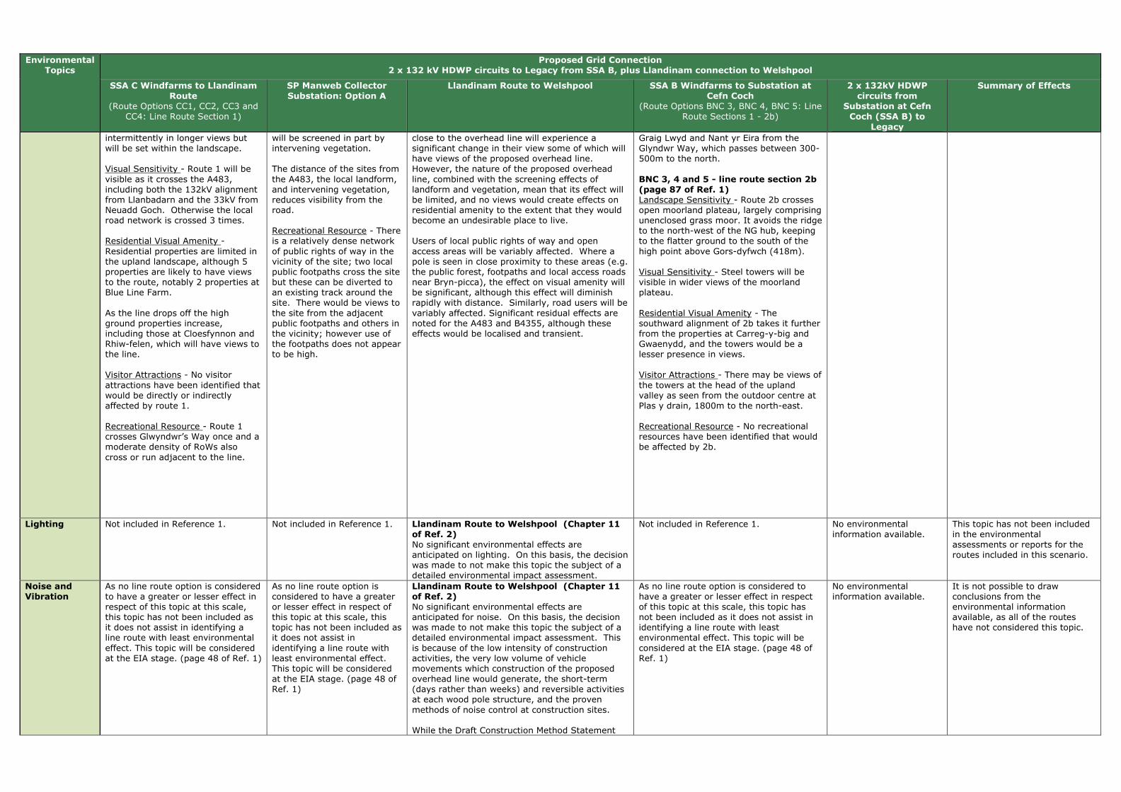
Environmental Topics
Proposed Grid Connection 2 x 132 kV HDWP circuits to Legacy from SSA B, plus Llandinam connection to Welshpool
SSA C Windfarms to Llandinam Route
(Route Options CC1, CC2, CC3 and CC4: Line Route Section 1)
SP Manweb Collector Substation: Option A
Llandinam Route to Welshpool SSA B Windfarms to Substation at Cefn Coch
(Route Options BNC 3, BNC 4, BNC 5: Line Route Sections 1 - 2b)
2 x 132kV HDWP circuits from
Substation at Cefn Coch (SSA B) to
Legacy
Summary of Effects
intermittently in longer views but will be set within the landscape. Visual Sensitivity - Route 1 will be visible as it crosses the A483, including both the 132kV alignment from Llanbadarn and the 33kV from Neuadd Goch. Otherwise the local road network is crossed 3 times. Residential Visual Amenity - Residential properties are limited in the upland landscape, although 5 properties are likely to have views to the route, notably 2 properties at Blue Line Farm. As the line drops off the high ground properties increase, including those at Cloesfynnon and Rhiw-felen, which will have views to the line. Visitor Attractions - No visitor attractions have been identified that would be directly or indirectly affected by route 1. Recreational Resource - Route 1 crosses Glwyndwr’s Way once and a moderate density of RoWs also cross or run adjacent to the line.
will be screened in part by intervening vegetation. The distance of the sites from the A483, the local landform, and intervening vegetation, reduces visibility from the road. Recreational Resource - There is a relatively dense network of public rights of way in the vicinity of the site; two local public footpaths cross the site but these can be diverted to an existing track around the site. There would be views to the site from the adjacent public footpaths and others in the vicinity; however use of the footpaths does not appear to be high.
close to the overhead line will experience a significant change in their view some of which will have views of the proposed overhead line. However, the nature of the proposed overhead line, combined with the screening effects of landform and vegetation, mean that its effect will be limited, and no views would create effects on residential amenity to the extent that they would become an undesirable place to live. Users of local public rights of way and open access areas will be variably affected. Where a pole is seen in close proximity to these areas (e.g. the public forest, footpaths and local access roads near Bryn-picca), the effect on visual amenity will be significant, although this effect will diminish rapidly with distance. Similarly, road users will be variably affected. Significant residual effects are noted for the A483 and B4355, although these effects would be localised and transient.
Graig Lwyd and Nant yr Eira from the Glyndwr Way, which passes between 300-500m to the north. BNC 3, 4 and 5 - line route section 2b (page 87 of Ref. 1) Landscape Sensitivity - Route 2b crosses open moorland plateau, largely comprising unenclosed grass moor. It avoids the ridge to the north-west of the NG hub, keeping to the flatter ground to the south of the high point above Gors-dyfwch (418m). Visual Sensitivity - Steel towers will be visible in wider views of the moorland plateau. Residential Visual Amenity - The southward alignment of 2b takes it further from the properties at Carreg-y-big and Gwaenydd, and the towers would be a lesser presence in views. Visitor Attractions - There may be views of the towers at the head of the upland valley as seen from the outdoor centre at Plas y drain, 1800m to the north-east. Recreational Resource - No recreational resources have been identified that would be affected by 2b.
Lighting Not included in Reference 1. Not included in Reference 1. Llandinam Route to Welshpool (Chapter 11 of Ref. 2) No significant environmental effects are anticipated on lighting. On this basis, the decision was made to not make this topic the subject of a detailed environmental impact assessment.
Not included in Reference 1. No environmental information available.
This topic has not been included in the environmental assessments or reports for the routes included in this scenario.
Noise and Vibration
As no line route option is considered to have a greater or lesser effect in respect of this topic at this scale, this topic has not been included as it does not assist in identifying a line route with least environmental effect. This topic will be considered at the EIA stage. (page 48 of Ref. 1)
As no line route option is considered to have a greater or lesser effect in respect of this topic at this scale, this topic has not been included as it does not assist in identifying a line route with least environmental effect. This topic will be considered at the EIA stage. (page 48 of Ref. 1)
Llandinam Route to Welshpool (Chapter 11 of Ref. 2) No significant environmental effects are anticipated for noise. On this basis, the decision was made to not make this topic the subject of a detailed environmental impact assessment. This is because of the low intensity of construction activities, the very low volume of vehicle movements which construction of the proposed overhead line would generate, the short-term (days rather than weeks) and reversible activities at each wood pole structure, and the proven methods of noise control at construction sites. While the Draft Construction Method Statement
As no line route option is considered to have a greater or lesser effect in respect of this topic at this scale, this topic has not been included as it does not assist in identifying a line route with least environmental effect. This topic will be considered at the EIA stage. (page 48 of Ref. 1)
No environmental information available.
It is not possible to draw conclusions from the environmental information available, as all of the routes have not considered this topic.

Environmental Topics
Proposed Grid Connection 2 x 132 kV HDWP circuits to Legacy from SSA B, plus Llandinam connection to Welshpool
SSA C Windfarms to Llandinam Route
(Route Options CC1, CC2, CC3 and CC4: Line Route Section 1)
SP Manweb Collector Substation: Option A
Llandinam Route to Welshpool SSA B Windfarms to Substation at Cefn Coch
(Route Options BNC 3, BNC 4, BNC 5: Line Route Sections 1 - 2b)
2 x 132kV HDWP circuits from
Substation at Cefn Coch (SSA B) to
Legacy
Summary of Effects
will ultimately address noise control issues in detail it is noted that Powys CC has powers to investigate noise complaints and serve abatement notices on activities which it considers are giving rise to unacceptable levels of noise
Socio Economics (including Tourism and Recreation)
As no line route option is considered to have a greater or lesser effect in respect of this topic at this scale, this topic has not been included as it does not assist in identifying a line route with least environmental effect. This topic will be considered at the EIA stage. (page 48 of Ref. 1)
As no line route option is considered to have a greater or lesser effect in respect of this topic at this scale, this topic has not been included as it does not assist in identifying a line route with least environmental effect. This topic will be considered at the EIA stage. (page 48 of Ref. 1)
Llandinam Route to Welshpool (Chapter 10 of Ref. 2) The design and routeing of the proposed overhead line has been developed to minimise its effects on visual amenity and consequently upon negative perceptions of tourists and residents alike. The proposed overhead line generally avoids major settlements, tourist attractions, and local amenity assets. No significant socio-economic effects would arise from the construction and decommissioning of the proposed overhead line. In respect of the operational stage, the proposed overhead line would not have any significant effects upon the local population, economy, local community assets, tourist attractions or tourism more broadly. The operational stage would be expected to have a moderately significant effect upon tourism accommodation at two sites namely the Tavern Caravan Park and Edderton Hall B&B/Guest House. If proposed mitigation is accepted the residual effects would become not significant at Tavern Caravan Park but remain moderately significant for Edderton Hall B&B/Guest House.
As no line route option is considered to have a greater or lesser effect in respect of this topic at this scale, this topic has not been included as it does not assist in identifying a line route with least environmental effect. This topic will be considered at the EIA stage. (page 48 of Ref. 1)
No environmental information available.
It is not possible to draw conclusions from the environmental information available, as all of the routes have not considered this topic.
Traffic and Transport
CC4, CC1 and CC3: Line route section 1 (page 95 of Ref. 1) This route could be accessed via existing main public roads although there are two extended sections (the area south of Hirddywell and north-west of Esgaidraenliwyn) where access will be difficult due to steep land and a lack of existing tracks.
SP Manweb Collector Substation: Option A (Tables 6.4 and 6.5 of Ref. 1) The site is accessible from existing farm tracks.
Llandinam Route to Welshpool (Chapter 11 of Ref. 2) No significant environmental effects are anticipated on traffic and transport. On this basis, the decision was made to not make this topic the subject of a detailed environmental impact assessment. The main issue of concern with respect to traffic would be the creation of construction and maintenance accesses and then accessing otherwise inaccessible fields with construction vehicles. This would be set out in the Draft Construction and Method Statement as part of the planning conditions, and would be developed in consultation with Powys Highways Authority.
BNC 3, 4 and 5 - line route section 1 (page 88 of Ref. 1) Access to the route will be via existing forest tracks across steep ground. BNC 3, 4 and 5 - line route section 2b (page 88 of Ref. 1) Access to the route will be via existing forest tracks across steep ground.
No environmental information available.
Most routes/sites in this scenario are accessible by existing farm tracks or main public roads. However, localised instances may occur where the terrain makes access difficult, or large lengths of new access road are required.
Waste Management
As no line route option is considered to have a greater or lesser effect in respect of this topic at this scale, this topic has not been included as
As no line route option is considered to have a greater or lesser effect in respect of this topic at this scale, this
Llandinam Route to Welshpool (Chapter 11 of Ref. 2) No significant environmental effects are anticipated on waste management. On this basis,
As no line route option is considered to have a greater or lesser effect in respect of this topic at this scale, this topic has not been included as it does not assist in
No environmental information available.
This topic has not been included in the environmental assessments or reports for the routes included in this scenario.

Environmental Topics
Proposed Grid Connection 2 x 132 kV HDWP circuits to Legacy from SSA B, plus Llandinam connection to Welshpool
SSA C Windfarms to Llandinam Route
(Route Options CC1, CC2, CC3 and CC4: Line Route Section 1)
SP Manweb Collector Substation: Option A
Llandinam Route to Welshpool SSA B Windfarms to Substation at Cefn Coch
(Route Options BNC 3, BNC 4, BNC 5: Line Route Sections 1 - 2b)
2 x 132kV HDWP circuits from
Substation at Cefn Coch (SSA B) to
Legacy
Summary of Effects
it does not assist in identifying a line route with least environmental effect. This topic will be considered at the EIA stage. (page 48 of Ref. 1)
topic has not been included as it does not assist in identifying a line route with least environmental effect. This topic will be considered at the EIA stage. (page 48 of Ref. 1)
the decision was made to not make this topic the subject of a detailed environmental impact assessment.
identifying a line route with least environmental effect. This topic will be considered at the EIA stage. (page 48 of Ref. 1)
Water Environment
CC4, CC1 and CC3: Line route section 1 (page 93 of Ref. 1) Water Quality - Route 1 crosses four tributaries of the River Wye SAC and River Ithon SSSI. Flood Risk - Route 1 crosses four narrow tributaries of the River Ithon flood zone, which are 35 to 80m in width and will not form a constraint to routeing.
SP Manweb Collector Substation: Option A
(Tables 6.4 and 6.5 of Ref. 1) Flood Zones - A narrow flood zone lies 0.3km to the north and 0.7km to the east of the site. It is less than 50m wide and will not be affected by the substation.
Llandinam Route to Welshpool (Chapter 9 of Ref. 2) It is considered that, if the mitigation measures discussed above and detailed fully in the Draft Construction Method Statement are successfully implemented, the construction, operation and decommissioning effects of the proposed overhead line on hydrology, groundwater, flood risk and water quality would not result in any likely significant adverse long term effects.
BNC 3, 4 and 5 - line route section 1 (page 87 of Ref. 1) Flood Risk - Route 1 crosses the Afon Gam flood zone north of Cwmderwen. The Afon Gam is approximately 120m wide at this point and will not pose a constraint to the route. BNC 3, 4 and 5 - line route section 2b
(page 87 of Ref. 1) Flood Risk - 2b does not cross any flood zone.
No environmental information available.
Flood risk is not expected to be an issue for the routes included in this scenario. The routes will cross many tributaries, including rivers within SSSIs and SACs however these can be spanned by wood pole infrastructure and mitigation measures will ensure their protection during construction.
Technical Review
CC4, CC1 and CC3: Line route section 1 (page 94 of Ref. 1) Existing and Proposed OHL Infrastructure 33kV and 132kV - The Llandinam OHL route would cross this at the eastern end of the route. Existing and Proposed Wind Turbines - The route passes within proximity of turbines; however it will be possible to maintain the required distance. Altitude and Topography - The eastern end of this route would cover altitudes of up to 455m at the substation at Llanbadarn Fynydd. Moving west, the land height is 373m at the Neuadd Goch substation. As the line moves south-west, land heights increase to around 420m at Llaithddu and then higher to around 550m at Hirddywel. Gradients range between 0-15°. As the line passes west of Hirddywel, there is a section of land with a gradient of between 15-22°. The height of land then reduces to around 320m as the route moves west before turning north.
SP Manweb Collector Substation: Option A (Tables 6.4 and 6.5 of Ref.
1) This site could accommodate the required equipment.
Not covered in Reference 2. BNC 3, 4 and 5 - line route section 1 (page 88 of Ref. 1) Existing and Proposed OHL Infrastructure 33kV and 132kV - This route would be crossed by the Nant y Moch Wind Farm OHL route. Existing and Proposed Wind Turbines - The route passes within proximity of a number of turbines, however the required distance from turbines can be maintained during the detailed design stage. Altitude and Topography - The route would start at a height of 340m, reducing to 260m at the Afon Gam before increasing in height to 380m. Gradients would be 0-150. BNC 3, 4 and 5 - line route section 2b (page 88 of Ref. 1) Existing and Proposed OHL Infrastructure 33kV and 132kV - This route would be crossed by the Nant y Moch OHL route. Existing and Proposed Wind Turbines - The route passes within proximity of a number of potential turbines, and it may not be possible to maintain the required distance at the eastern end. Altitude and Topography - The land height increases from 360m to 410m before reducing to 370m at the substation. Gradients are between 0-150.
No environmental information available.
This information is not applicable to cumulative impacts as it has been included for reference only.

References (Ref.):
(1) SP MANWEB (Sept 2013). SP Mid Wales Connections, Line Routing Methodology & Appraisal - Phase 3 Report. (2) SP MANWEB (Oct 2013). Volume 1: New 132kV Overhead Line Connection from Llandinam Wind Farm to Welshpool Substation - Updated Environmental Statement. (3) National Grid (Sept 2013). Mid Wales Connection Project, Draft Substation Site Report. (4) National Grid (Sept 2013). Mid Wales Connection Project, Draft Route Report.

Table I: Scenario 8a - 2 x 132 kV circuits to Legacy, plus a 132 kV circuit between SSA B and SSA C, plus Llandinam connection to Welshpool
Environmental
Topics
Proposed Grid Connection
2 x 132 kV circuits (2 x HDWP or an L4 tower line) to Legacy from SSA B, plus a 132 kV circuit between SSA B and SSA C, plus Llandinam connection to Welshpool
SSA C Windfarms to Llandinam Route and
Substation at Cefn Coch (Route Options CC1, CC2, CC3 and CC4: Line Route Sections 1-
2a-3-4b-5-6a-7a-8-9a-10)
SP Manweb Collector
Substation: Option A
Llandinam Route to Welshpool
SSA B Windfarms to Substation at Cefn Coch
(Route Options BNC 3, BNC 4, BNC 5: Line Route Sections 1 - 2b)
Proposed National Grid 400kV Substation - Cefn Coch
(Preferred Substation Location NW at Cefn Coch)
2 x 132kV HDWP circuits from
Substation at Cefn Coch (SSA B) to
Legacy
Summary of Effects
Air Quality and Emissions (incl. dust)
As no line route option is considered to have a greater or lesser effect in respect of this topic at this scale, this topic has not been included as it does not assist in identifying a line route with least environmental effect. This topic will be considered at the EIA stage. (page 48 of Ref. 1)
As no line route option is considered to have a greater or lesser effect in respect of this topic at this scale, this topic has not been included as it does not assist in identifying a line route with least environmental effect. This topic will be considered at the EIA stage. (page 48 of Ref. 1)
Not covered in Reference 2. As no line route option is considered to have a greater or lesser effect in respect of this topic at this scale, this topic has not been included as it does not assist in identifying a line route with least environmental effect. This topic will be considered at the EIA stage. (page 48 of Ref. 1)
Preferred Substation Location NW (Section 10.2 of Ref. 3) The site is more than 1km northwest of Tan-y-Foel Quarry and therefore unlikely to be significantly affected by dust from quarry.
No environmental information available.
It is not possible to draw conclusions from the environmental information available, as all of the routes have not considered this topic.
Ecology/Biodi
versity and Geological Conservation
CC1, CC2, CC3 and CC4: Line
Route Sections 1-2a-3-4b-5-6a-7a-8-9a-10 (Appendix 6.1 of Ref. 1) Wind farm Habitat Management Plan Area (HMP) - Line route sections 1, and 6a-10 pass through and/or are within 2km of HMP areas for Hirddywell Wind Farm and the Tirgwynt HMP area. Protected Species - The route passes through and passes within 730m to 2km of many potential protected species hotspots. Peatland Habitats - Line route sections 1 passes through two large areas of potential peat. It also passes through areas identified in Environmental Statements as supporting peat habitats. Ornithological ‘Hot Spots’ - The route passes through and within 300m to 1.1km of many hot spots, including the Tylwch tip hotspot (to the south of the route) and Bwlch y Garreg (to the north of the route).
SP Manweb
Collector Substation: Option A (Tables 6.4 and 6.5 of Ref. 1) SAC - The River Wye SAC headwaters lie 0.75km to the south east of the site with associated freshwater sensitivities. SSSI - The site lies less than 1km from Gweunydd Camnant SSSI, designated for habitats, the River Ithon SSSI and the Esgairdraenllwyn Pastures SSSI, designated for habitats.
Llandinam Route to
Welshpool (Chapter 7 of Ref. 2) It is considered that the proposed overhead line is not likely to result in any significant adverse long-term effects. If the mitigation measures discussed in Chapter 7 (Ref. 2) are fully implemented any risk of adverse effects will be further reduced. The potential for collisions with overhead lines is probably the most significant effect likely to arise. This represents a long-term, permanent hazard to certain groups of birds, primarily the larger species such as swans and to a lesser extent the smaller wildfowl. However, the erection of bird deflectors in appropriate locations will reduce the risk of birds colliding with the overhead line, and the erection of devices to discourage or prevent roosting on wood pole supports will reduce the risk of predation on ground nesting birds.
BNC 3, 4 and 5 - line route section
1 (page 87 of Ref. 1) Wind farm Habitat Management Plan Area (HMP) - The route passes through the Llanbrynmair Wind Farm HMP At its very eastern extent, the route borders provisional areas set out for the Tirgwynt HMP. Peatland Habitats - The route passes through potential peat habitat to the south and east of Llanbrynmair Wind Farm, along the northern boundary of the woodland. Ornithological ‘Hot Spots’ - There are no ornithological hotspots associated with the route; however the Foel Quarry hotspot is approximately 360m to the south. BNC 3, 4 and 5 - line route section 2b (page 87 of Ref. 1) Wind farm Habitat Management Plan Area (HMP) - Approx. 700m of the route passes through provisional areas set out for the Tirgwynt HMP. Peatland Habitats - No potential peat areas were identified within the route. Ornithological ‘Hot Spots’ - Approximately 450m of the route passes through the Foel Quarry ornithological hotspot.
Preferred Substation Location
NW (Section 10.2 of Ref. 3) This site is primarily located within an area of semi-improved grassland with low species diversity. Areas of valuable habitat do occur to the north east of the site and are represented by wetland/peatland habitats along a stream valley, therefore indirect hydrological effects are a consideration in this area. Consideration of ornithological effects is also required given proximity to habitats of bird value noted in Tirgwynt EIA (e.g. nesting curlew). There is a concern that the movements and noises associated with the construction of the substation may have a detrimental effect upon the curlews and other breeding bird that nest nearby. However, the EIA for the consented Tirgwynt windfarm did not identify this as a significant impact. Due to the location of the substation site it is highly likely that the site, and the indicative incoming connections and potentially the outgoing National Grid route associated with the site, will affect valuable ecological features such as peatland and/or ornithology.
No environmental information available.
Birds: There are a number of ornithological 'hot-spots' in proximity to the proposed routes, whereby there is potential for larger species, (such as swans) to collide with overhead lines which presents a long-term permanent hazard to birds, however the use of bird deflectors is likely to reduce this risk. There is also a concern that the movements and noises associated with the construction of the NG substation may have a detrimental effect upon birds that nest nearby. Designated Sites: No designated sites are likely to be directly affected by the proposed grid connections, however there are a number of designated sites which lie in close proximity to the routes. Habitat Management Plans: Due to the location of the wind farm substations the routes will pass through a number of wind farm HMP areas. Protected Species: Protected species are likely to be located in proximity to the routes. However full compliance with relevant protected species legislation is likely to help to minimise any effects.

Environmental Topics
Proposed Grid Connection 2 x 132 kV circuits (2 x HDWP or an L4 tower line) to Legacy from SSA B, plus a 132 kV circuit between SSA B and SSA C, plus Llandinam connection to Welshpool
SSA C Windfarms to Llandinam Route and
Substation at Cefn Coch (Route Options CC1, CC2, CC3 and CC4: Line Route Sections 1-
2a-3-4b-5-6a-7a-8-9a-10)
SP Manweb Collector
Substation: Option A
Llandinam Route to Welshpool
SSA B Windfarms to Substation at Cefn Coch
(Route Options BNC 3, BNC 4, BNC 5: Line Route Sections 1 - 2b)
Proposed National Grid 400kV Substation - Cefn Coch
(Preferred Substation Location NW at Cefn Coch)
2 x 132kV HDWP circuits from
Substation at Cefn Coch (SSA B) to
Legacy
Summary of Effects
Sites Designated for Nature Conservation Importance (SPA, SAC, SSSI) - The route does not pass through any statutory designated sites; however several designated areas are within a 2km radius, including the River Wye SAC and the Llan Mawr SSSI. The closest site is the Gweunydd Camnant SSSI, approx. 55m to the north of line route section 1.
Peatland Habitats: A number of the routes pass through areas of potential peatland habitat.
Climate Change
As no line route option is considered to have a greater or lesser effect in respect of this topic at this scale, this topic has not been included as it does not assist in identifying a line route with least environmental effect. This topic will be considered at the EIA stage. (page 48 of Ref. 1)
As no line route option is considered to have a greater or lesser effect in respect of this topic at this scale, this topic has not been included as it does not assist in identifying a line route with least environmental effect. This topic will be considered at the EIA stage. (page 48 of Ref. 1)
Not covered in Reference 2. As no line route option is considered to have a greater or lesser effect in respect of this topic at this scale, this topic has not been included as it does not assist in identifying a line route with least environmental effect. This topic will be considered at the EIA stage. (page 48 of Ref. 1)
Not included in Reference 3. No environmental information available.
This topic has not been included in the environmental assessments or reports for the routes included in this scenario.
Electric and Magnetic Fields
As no line route option is considered to have a greater or lesser effect in respect of this topic at this scale, this topic has not been included as it does not assist in identifying a line route with least environmental effect. This topic will be considered at the EIA stage. (page 48 of Ref. 1)
As no line route option is considered to have a greater or lesser effect in respect of this topic at this scale, this topic has not been included as it does not assist in identifying a line route with least environmental effect. This topic will be considered at the EIA stage. (page 48 of Ref. 1)
Llandinam Route to Welshpool (Chapter 11 of Ref. 2) No significant environmental effects are anticipated on electric and magnetic fields. On this basis, the decision was made to not make this topic the subject of a detailed environmental impact assessment.
As no line route option is considered to have a greater or lesser effect in respect of this topic at this scale, this topic has not been included as it does not assist in identifying a line route with least environmental effect. This topic will be considered at the EIA stage. (page 48 of Ref. 1)
Not included in Reference 3. No environmental information available.
This topic has not been included in the environmental assessments or reports for the routes included in this scenario.

Environmental Topics
Proposed Grid Connection 2 x 132 kV circuits (2 x HDWP or an L4 tower line) to Legacy from SSA B, plus a 132 kV circuit between SSA B and SSA C, plus Llandinam connection to Welshpool
SSA C Windfarms to Llandinam Route and
Substation at Cefn Coch (Route Options CC1, CC2, CC3 and CC4: Line Route Sections 1-
2a-3-4b-5-6a-7a-8-9a-10)
SP Manweb Collector
Substation: Option A
Llandinam Route to Welshpool
SSA B Windfarms to Substation at Cefn Coch
(Route Options BNC 3, BNC 4, BNC 5: Line Route Sections 1 - 2b)
Proposed National Grid 400kV Substation - Cefn Coch
(Preferred Substation Location NW at Cefn Coch)
2 x 132kV HDWP circuits from
Substation at Cefn Coch (SSA B) to
Legacy
Summary of Effects
Forestry and Woodland
CC1, CC2, CC3 and CC4: Line Route Sections 1-2a-3-4b-5-6a-7a-8-9a-10 (Appendix 6.1
of Ref. 1) Ancient and Semi-Natural woodland (ASNW) - Line route sections 1, 4b, and 6a will affect areas of ASNW, this will be avoided, where possible, at detailed design stage. Line route sections 2a, 3, 4b, 7a and 8 affect areas of ASNW and limited felling may be required. Other Forestry and Woodland - All line route sections cross some fields where limited felling of hedgerow trees, and in some cases (e.g. line route sections 1 and 3) woodland edge trees. Line route section 9a passes through 5.9ha of woodland on the Welsh National Forest Inventory although no mature trees would be felled.
SP Manweb Collector Substation:
Option A (Tables 6.4 and 6.5 of Ref. 1) Other Forestry and Woodland - There are a number of small blocks of forestry and shelter belt planting located within the vicinity of the substation site which will screen and backdrop the proposed substation. The site will not require any felling of existing plantation woodland.
Llandinam Route to Welshpool (Chapter 7 of Ref. 2)
It is considered that the proposed overhead line is not likely to result in any significant adverse long-term effects. If the mitigation measures discussed in Chapter 7 (Ref. 2) are fully implemented any risk of adverse effects will be further reduced. Some trees will be lost to facilitate construction of the Amended Development, including trees that may have potential for bats. This tree loss may result in potential habitat loss for bats.
BNC 3, 4 and 5 - line route section 1 (page 87 of Ref. 1) Other Forestry and Woodland - Route 1 will pass through c.320m of mature coniferous plantation above Nant y Graig Lwyd, and c.730m of mature coniferous plantation at Cors yr Ebolion. Native trees along the Nant y Graig Lwyd may be affected by the lines. BNC 3, 4 and 5 - line route section 2b (page 87 of Ref. 1) Other Forestry and Woodland - 2b may affect small stands of woodland south-west of the NG hub.
Not included in Reference 3. No environmental information available.
Some trees and hedgerows will be lost to facilitate construction of the grid connection routes. The loss of trees may result in potential habitat loss for bats, although this is expected to be a localised effect.
In some locations, mature trees as well as Ancient and Semi-Natural woodland may be affected by construction of the proposed routes. Although this will be avoided where possible at the detailed design stage, limited felling may be required in some locations.
Geology and Soils
Not included in Reference 3. Not included in Reference 3.
Llandinam Route to Welshpool (Chapter 11 of Ref. 2) No significant environmental effects are anticipated on geology or soil resources. On this basis, the decision was made to not make this topic the subject of a detailed environmental impact assessment.
Not included in Reference 1. Not included in Reference 3. No environmental information available.
This topic has not been included in the environmental assessments or reports for the routes included in this scenario.
Historic Environment
CC1, CC2, CC3 and CC4: Line Route Sections 1-2a-3-4b-5-6a-7a-8-9a-10 (Appendix 6.1 of Ref. 1) SAMs - The northen area of the route contains more SAMs that are within 2km of the route. For example, no SAMs are located within line route section 1 but 24 SAMs lie in 14 groups within 2km of the route and line route sections 2a-5 have no SAMs within 2km of the route. Whereas line route sections 6a-10 all have SAMs located within 2km of the route. Virtually all the SAMs are prehistoric burial and ritual monuments, some with wide-ranging views, others are rare
SP Manweb Collector Substation: Option A (Tables 6.4 and 6.5 of
Ref. 1) Undesignated Archaeology - An undesignated site of historical interest (a single storey derelict stone building) lies immediately adjacent to the site to the northeast.
Llandinam Route to Welshpool (Chapter 8 of Ref. 2) The proposed overhead line from the Llandinam Repowering Wind Farm to the Welshpool Grid Substation, some 35 km long, adopts a course to the south and east of the Severn Valley which takes it past and through some of the richest cultural heritage landscapes in mid Wales. There are 55 SAMs located within 2km of the overhead line, two of them (Crugyn Bank Dyke and Bryn Cwmyrhiwdre Round Barrow) within the 100m wide corridor. There are also 452 Listed Buildings, five
BNC 3, 4 and 5 - line route section 1 (page 87 of Ref. 1) SAMs - There is 1 SAM within the route but none within 2km. The proximity of the scheduled Bon-y-maen root store and on the farm of which it forms a part will form a key consideration for the detailed line design stage and effects on its setting will form a key consideration during the EIA stage. Listed Buildings (LBs) - There are no LBs within the route section. There are 2 LBs within 2km of it, both of lower grade II. Undesignated Archaeology - There are 2 undesignated archaeological features in the route section. Direct effects will
Preferred Substation Location NW (Section 10.2 of Ref. 3) The site is located in an area where there are no key local receptors, but it is located roughly equidistant between a scheduled Kerb Cairn (WSM MG 327), a scheduled stone circle (WSM MG 179), and a root store (WSM MG 218). These sites are situated approximately 2km away from the substation, and outside of any identified areas of theoretical visibility. However, whilst the substation site will not be visible from any of these monuments, the proposed overhead line is potentially visible from the root store and may have a slightly adverse effect upon its landscape context.
No environmental information available.
Two designated features (SAMs) are located within the Llandinam route and one within the SP MWC BNC route. The Llandinam Route and other routes included in this scenario pass within 1-2km of other historic assets, including: SAMs, Conservation Areas, Listed Buildings (primarily lower grade II but also including higher grade), historic landscapes, Registered Historic Parks and Gardens and undesignated below-ground sites/features. Mitigation measures will be deployed to minimise direct effects on features, however significant effects on the setting of a number of features are predicted.

Environmental Topics
Proposed Grid Connection 2 x 132 kV circuits (2 x HDWP or an L4 tower line) to Legacy from SSA B, plus a 132 kV circuit between SSA B and SSA C, plus Llandinam connection to Welshpool
SSA C Windfarms to Llandinam Route and
Substation at Cefn Coch (Route Options CC1, CC2, CC3 and CC4: Line Route Sections 1-
2a-3-4b-5-6a-7a-8-9a-10)
SP Manweb Collector
Substation: Option A
Llandinam Route to Welshpool
SSA B Windfarms to Substation at Cefn Coch
(Route Options BNC 3, BNC 4, BNC 5: Line Route Sections 1 - 2b)
Proposed National Grid 400kV Substation - Cefn Coch
(Preferred Substation Location NW at Cefn Coch)
2 x 132kV HDWP circuits from
Substation at Cefn Coch (SSA B) to
Legacy
Summary of Effects
prehistoric house sites. Listed Buildings (LBs) - All line route sections, apart from 9a and 10 are within 2km of LBs, the majority of which are lower grade II. However, some line route sections (e.g. 5) have LBs of higher grade II* desginated status. LBs that are within close proximity (i.e. 150m) of the route such as Ystradfaelog which is the higher grade II* building along line route section 5, could be the possibility of visual impact. Conservation Areas - Only line route section 3 is located within 2km of a Conservation Area, which is Llanidloes Conservation Area. Registered Historic Landscapes (RHLs) - Line route sections 2a, 3, 5 and 6a are within 1-2km of Clywedog Valley RHL and/or Caersws Basin RHL. Undesignated Archaeology - Undesignated archaeological features are located along most line route sections. Direct effects will be avoided, where possible, during detailed design.
Registered Historic Parks and Gardens, seven Conservation Areas, and one of Wales’ Registered Historic Landscapes would be crossed by the proposed overhead line. It is the heritage assets within the 100 m wide corridor that are most at risk from the proposed overhead line and could be adversely affected by its construction. Most of these are considered to be of low (local) or even negligible value, but there are some of medium (regional) significance, as well as the few of high (national) importance. Appropriate mitigation (e.g. preservation in situ, preservation by record, excavation, evaluation, watching brief) including the careful demarcation of assets is suggested which should ensure that damage is kept to a minimum during the erection of the supports. Assuming that a full suite of mitigation measures is successfully implemented, the proposed overhead line should not have any significant long-term effect on the cultural heritage. In particular, there are no likely significant direct effects on cultural heritage arising during the construction, operation or decommissioning of the proposed overhead line. The passage of the proposed overhead line through approximately 6.5 km of the Vale of Montgomery Registered Historic Landscape was subject to an ASIDOHL2 study in 2009 which established that whilst the overall effect would be moderate, locally it would be severe, representing a significant effect. Inevitably during the operational life of the proposed overhead line, it would have an
be avoided, where possible, during detailed design. BNC 3, 4 and 5 - line route section 2b (page 87 of Ref. 1) SAMs - There are no SAMs within the route but two within 2km, the Bon-y-maen root store and Y Capel stone circle. Listed Buildings (LBs) - There are no Listed Buildings within 2km of the route section. Undesignated Archaeology - There are no undesignated archaeological features in the route section.
An undesignated group of pillow mounds (WNMR 9448) of regional importance is located to the south east. Whilst the substation site will not be visible, the proposed overhead lines into and out of the substation, are potentially visible and may have a slightly adverse effects upon their landscape context.
Only the Llandinam route passes through a Registered Historic Landscape resulting in significant effects.
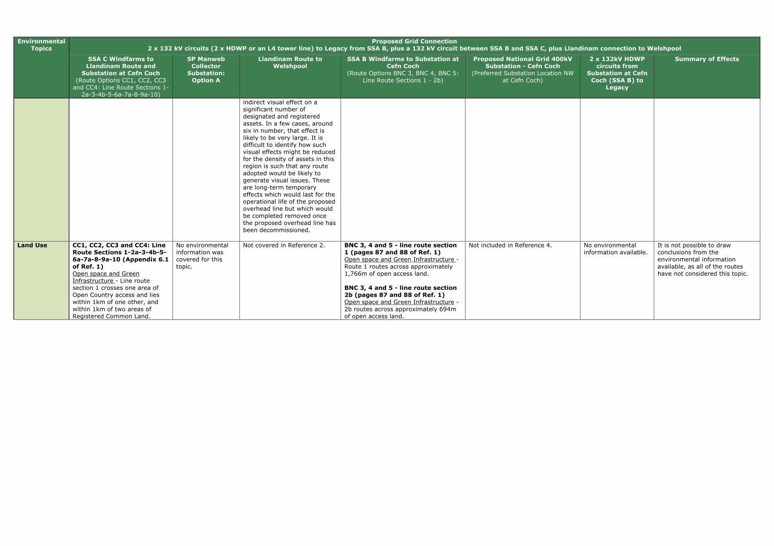
Environmental Topics
Proposed Grid Connection 2 x 132 kV circuits (2 x HDWP or an L4 tower line) to Legacy from SSA B, plus a 132 kV circuit between SSA B and SSA C, plus Llandinam connection to Welshpool
SSA C Windfarms to Llandinam Route and
Substation at Cefn Coch (Route Options CC1, CC2, CC3 and CC4: Line Route Sections 1-
2a-3-4b-5-6a-7a-8-9a-10)
SP Manweb Collector
Substation: Option A
Llandinam Route to Welshpool
SSA B Windfarms to Substation at Cefn Coch
(Route Options BNC 3, BNC 4, BNC 5: Line Route Sections 1 - 2b)
Proposed National Grid 400kV Substation - Cefn Coch
(Preferred Substation Location NW at Cefn Coch)
2 x 132kV HDWP circuits from
Substation at Cefn Coch (SSA B) to
Legacy
Summary of Effects
indirect visual effect on a significant number of designated and registered assets. In a few cases, around six in number, that effect is likely to be very large. It is difficult to identify how such visual effects might be reduced for the density of assets in this region is such that any route adopted would be likely to generate visual issues. These are long-term temporary effects which would last for the operational life of the proposed overhead line but which would be completed removed once the proposed overhead line has been decommissioned.
Land Use CC1, CC2, CC3 and CC4: Line Route Sections 1-2a-3-4b-5-6a-7a-8-9a-10 (Appendix 6.1
of Ref. 1) Open space and Green Infrastructure - Line route section 1 crosses one area of Open Country access and lies within 1km of one other, and within 1km of two areas of Registered Common Land.
No environmental information was covered for this topic.
Not covered in Reference 2. BNC 3, 4 and 5 - line route section 1 (pages 87 and 88 of Ref. 1) Open space and Green Infrastructure - Route 1 routes across approximately 1,766m of open access land. BNC 3, 4 and 5 - line route section 2b (pages 87 and 88 of Ref. 1) Open space and Green Infrastructure - 2b routes across approximately 694m of open access land.
Not included in Reference 4. No environmental information available.
It is not possible to draw conclusions from the environmental information available, as all of the routes have not considered this topic.
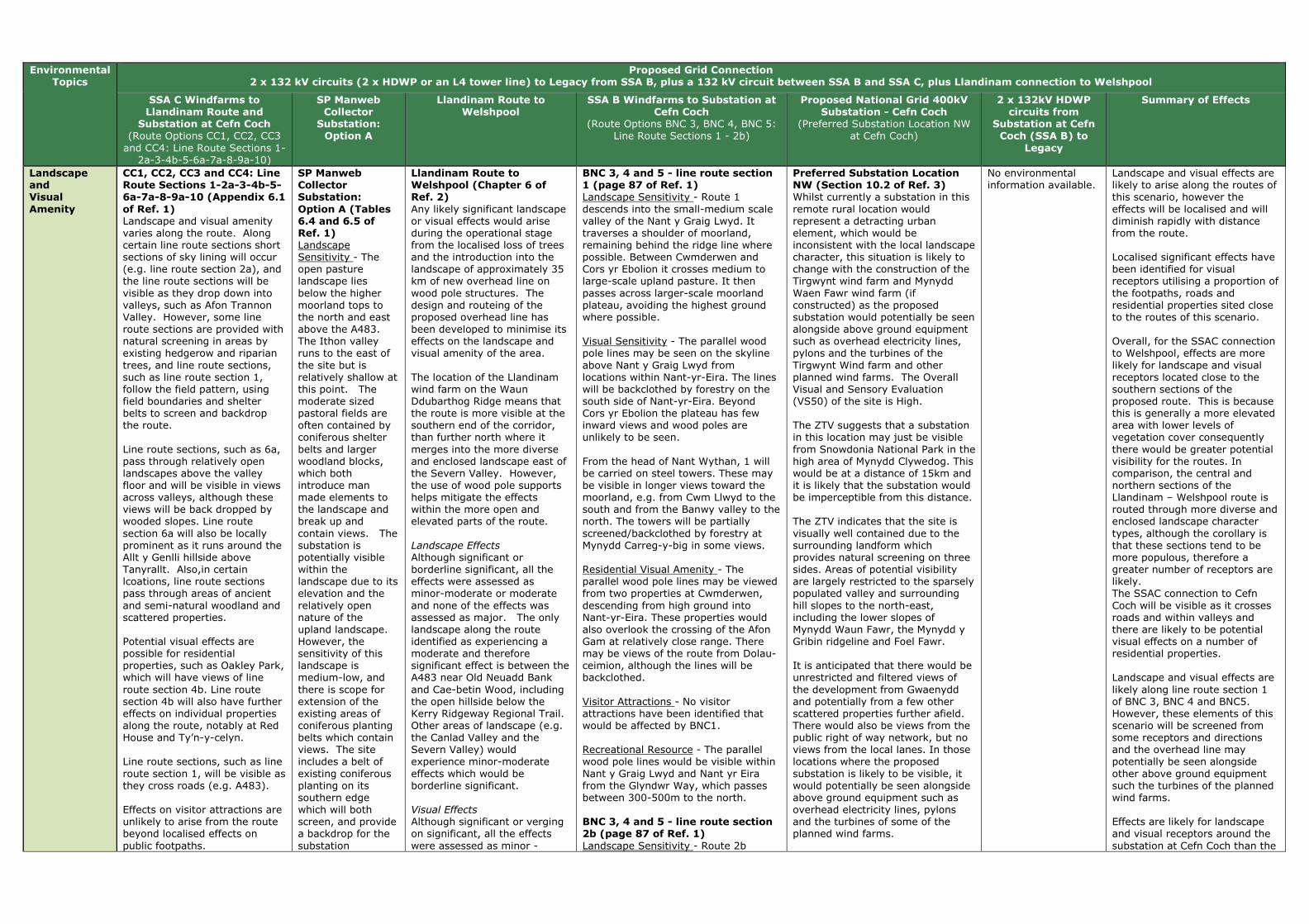
Environmental Topics
Proposed Grid Connection 2 x 132 kV circuits (2 x HDWP or an L4 tower line) to Legacy from SSA B, plus a 132 kV circuit between SSA B and SSA C, plus Llandinam connection to Welshpool
SSA C Windfarms to Llandinam Route and
Substation at Cefn Coch (Route Options CC1, CC2, CC3 and CC4: Line Route Sections 1-
2a-3-4b-5-6a-7a-8-9a-10)
SP Manweb Collector
Substation: Option A
Llandinam Route to Welshpool
SSA B Windfarms to Substation at Cefn Coch
(Route Options BNC 3, BNC 4, BNC 5: Line Route Sections 1 - 2b)
Proposed National Grid 400kV Substation - Cefn Coch
(Preferred Substation Location NW at Cefn Coch)
2 x 132kV HDWP circuits from
Substation at Cefn Coch (SSA B) to
Legacy
Summary of Effects
Landscape and Visual
Amenity
CC1, CC2, CC3 and CC4: Line Route Sections 1-2a-3-4b-5-6a-7a-8-9a-10 (Appendix 6.1
of Ref. 1) Landscape and visual amenity varies along the route. Along certain line route sections short sections of sky lining will occur (e.g. line route section 2a), and the line route sections will be visible as they drop down into valleys, such as Afon Trannon Valley. However, some line route sections are provided with natural screening in areas by existing hedgerow and riparian trees, and line route sections, such as line route section 1, follow the field pattern, using field boundaries and shelter belts to screen and backdrop the route. Line route sections, such as 6a, pass through relatively open landscapes above the valley floor and will be visible in views across valleys, although these views will be back dropped by wooded slopes. Line route section 6a will also be locally prominent as it runs around the Allt y Genlli hillside above Tanyrallt. Also,in certain lcoations, line route sections pass through areas of ancient and semi-natural woodland and scattered properties. Potential visual effects are possible for residential properties, such as Oakley Park, which will have views of line route section 4b. Line route section 4b will also have further effects on individual properties along the route, notably at Red House and Ty’n-y-celyn. Line route sections, such as line route section 1, will be visible as they cross roads (e.g. A483). Effects on visitor attractions are unlikely to arise from the route beyond localised effects on public footpaths.
SP Manweb Collector Substation:
Option A (Tables 6.4 and 6.5 of Ref. 1) Landscape Sensitivity - The open pasture landscape lies below the higher moorland tops to the north and east above the A483. The Ithon valley runs to the east of the site but is relatively shallow at this point. The moderate sized pastoral fields are often contained by coniferous shelter belts and larger woodland blocks, which both introduce man made elements to the landscape and break up and contain views. The substation is potentially visible within the landscape due to its elevation and the relatively open nature of the upland landscape. However, the sensitivity of this landscape is medium-low, and there is scope for extension of the existing areas of coniferous planting belts which contain views. The site includes a belt of existing coniferous planting on its southern edge which will both screen, and provide a backdrop for the substation
Llandinam Route to Welshpool (Chapter 6 of Ref. 2)
Any likely significant landscape or visual effects would arise during the operational stage from the localised loss of trees and the introduction into the landscape of approximately 35 km of new overhead line on wood pole structures. The design and routeing of the proposed overhead line has been developed to minimise its effects on the landscape and visual amenity of the area. The location of the Llandinam wind farm on the Waun Ddubarthog Ridge means that the route is more visible at the southern end of the corridor, than further north where it merges into the more diverse and enclosed landscape east of the Severn Valley. However, the use of wood pole supports helps mitigate the effects within the more open and elevated parts of the route. Landscape Effects
Although significant or borderline significant, all the effects were assessed as minor-moderate or moderate and none of the effects was assessed as major. The only landscape along the route identified as experiencing a moderate and therefore significant effect is between the A483 near Old Neuadd Bank and Cae-betin Wood, including the open hillside below the Kerry Ridgeway Regional Trail. Other areas of landscape (e.g. the Canlad Valley and the Severn Valley) would experience minor-moderate effects which would be borderline significant. Visual Effects
Although significant or verging on significant, all the effects were assessed as minor -
BNC 3, 4 and 5 - line route section 1 (page 87 of Ref. 1) Landscape Sensitivity - Route 1 descends into the small-medium scale valley of the Nant y Graig Lwyd. It traverses a shoulder of moorland, remaining behind the ridge line where possible. Between Cwmderwen and Cors yr Ebolion it crosses medium to large-scale upland pasture. It then passes across larger-scale moorland plateau, avoiding the highest ground where possible. Visual Sensitivity - The parallel wood pole lines may be seen on the skyline above Nant y Graig Lwyd from locations within Nant-yr-Eira. The lines will be backclothed by forestry on the south side of Nant-yr-Eira. Beyond Cors yr Ebolion the plateau has few inward views and wood poles are unlikely to be seen. From the head of Nant Wythan, 1 will be carried on steel towers. These may be visible in longer views toward the moorland, e.g. from Cwm Llwyd to the south and from the Banwy valley to the north. The towers will be partially screened/backclothed by forestry at Mynydd Carreg-y-big in some views. Residential Visual Amenity - The parallel wood pole lines may be viewed from two properties at Cwmderwen, descending from high ground into Nant-yr-Eira. These properties would also overlook the crossing of the Afon Gam at relatively close range. There may be views of the route from Dolau-ceimion, although the lines will be backclothed. Visitor Attractions - No visitor attractions have been identified that would be affected by BNC1. Recreational Resource - The parallel wood pole lines would be visible within Nant y Graig Lwyd and Nant yr Eira from the Glyndwr Way, which passes between 300-500m to the north. BNC 3, 4 and 5 - line route section 2b (page 87 of Ref. 1)
Landscape Sensitivity - Route 2b
Preferred Substation Location NW (Section 10.2 of Ref. 3) Whilst currently a substation in this remote rural location would represent a detracting urban element, which would be inconsistent with the local landscape character, this situation is likely to change with the construction of the Tirgwynt wind farm and Mynydd Waen Fawr wind farm (if constructed) as the proposed substation would potentially be seen alongside above ground equipment such as overhead electricity lines, pylons and the turbines of the Tirgwynt Wind farm and other planned wind farms. The Overall Visual and Sensory Evaluation (VS50) of the site is High. The ZTV suggests that a substation in this location may just be visible from Snowdonia National Park in the high area of Mynydd Clywedog. This would be at a distance of 15km and it is likely that the substation would be imperceptible from this distance. The ZTV indicates that the site is visually well contained due to the surrounding landform which provides natural screening on three sides. Areas of potential visibility are largely restricted to the sparsely populated valley and surrounding hill slopes to the north-east, including the lower slopes of Mynydd Waun Fawr, the Mynydd y Gribin ridgeline and Foel Fawr. It is anticipated that there would be unrestricted and filtered views of the development from Gwaenydd and potentially from a few other scattered properties further afield. There would also be views from the public right of way network, but no views from the local lanes. In those locations where the proposed substation is likely to be visible, it would potentially be seen alongside above ground equipment such as overhead electricity lines, pylons and the turbines of some of the planned wind farms.
No environmental information available.
Landscape and visual effects are likely to arise along the routes of this scenario, however the effects will be localised and will diminish rapidly with distance from the route. Localised significant effects have been identified for visual receptors utilising a proportion of the footpaths, roads and residential properties sited close to the routes of this scenario. Overall, for the SSAC connection to Welshpool, effects are more likely for landscape and visual receptors located close to the southern sections of the proposed route. This is because this is generally a more elevated area with lower levels of vegetation cover consequently there would be greater potential visibility for the routes. In comparison, the central and northern sections of the Llandinam – Welshpool route is routed through more diverse and enclosed landscape character types, although the corollary is that these sections tend to be more populous, therefore a greater number of receptors are likely. The SSAC connection to Cefn Coch will be visible as it crosses roads and within valleys and there are likely to be potential visual effects on a number of residential properties. Landscape and visual effects are likely along line route section 1 of BNC 3, BNC 4 and BNC5. However, these elements of this scenario will be screened from some receptors and directions and the overhead line may potentially be seen alongside other above ground equipment such the turbines of the planned wind farms. Effects are likely for landscape and visual receptors around the substation at Cefn Coch than the

Environmental Topics
Proposed Grid Connection 2 x 132 kV circuits (2 x HDWP or an L4 tower line) to Legacy from SSA B, plus a 132 kV circuit between SSA B and SSA C, plus Llandinam connection to Welshpool
SSA C Windfarms to Llandinam Route and
Substation at Cefn Coch (Route Options CC1, CC2, CC3 and CC4: Line Route Sections 1-
2a-3-4b-5-6a-7a-8-9a-10)
SP Manweb Collector
Substation: Option A
Llandinam Route to Welshpool
SSA B Windfarms to Substation at Cefn Coch
(Route Options BNC 3, BNC 4, BNC 5: Line Route Sections 1 - 2b)
Proposed National Grid 400kV Substation - Cefn Coch
(Preferred Substation Location NW at Cefn Coch)
2 x 132kV HDWP circuits from
Substation at Cefn Coch (SSA B) to
Legacy
Summary of Effects
infrastructure. Residential Visual Amenity - The area is sparsely populated with only four properties within 1km of the substation. Views from residential properties will be limited to the properties at Camnant Farm, Camnant Bridge and one property to the north-west. These views will be screened in part by intervening vegetation. The distance of the sites from the A483, the local landform, and intervening vegetation, reduces visibility from the road. Recreational Resource - There is a relatively dense network of public rights of way in the vicinity of the site; two local public footpaths cross the site but these can be diverted to an existing track around the site. There would be views to the site from the adjacent public footpaths and others in the vicinity; however use of the footpaths does not appear to be high.
moderate or moderate and none of these effects was assessed as major. In terms of settlements, some properties on the edge of Fron Bank/Cilcewydd, which lie within 500m of the overhead line will experience a significant change in their view, where there is no screening afforded by landform, buildings or vegetation. Of the many individual properties scattered throughout the study area, only those close to the overhead line will experience a significant change in their view some of which will have views of the proposed overhead line. However, the nature of the proposed overhead line, combined with the screening effects of landform and vegetation, mean that its effect will be limited, and no views would create effects on residential amenity to the extent that they would become an undesirable place to live. Users of local public rights of way and open access areas will be variably affected. Where a pole is seen in close proximity to these areas (e.g. the public forest, footpaths and local access roads near Bryn-picca), the effect on visual amenity will be significant, although this effect will diminish rapidly with distance. Similarly, road users will be variably affected. Significant residual effects are noted for the A483 and B4355, although these effects would be localised and transient.
crosses open moorland plateau, largely comprising unenclosed grass moor. It avoids the ridge to the north-west of the NG hub, keeping to the flatter ground to the south of the high point above Gors-dyfwch (418m). Visual Sensitivity - Steel towers will be visible in wider views of the moorland plateau. Residential Visual Amenity - The southward alignment of 2b takes it further from the properties at Carreg-y-big and Gwaenydd, and the towers would be a lesser presence in views. Visitor Attractions - There may be views of the towers at the head of the upland valley as seen from the outdoor centre at Plas y drain, 1800m to the north-east. Recreational Resource - No recreational resources have been identified that would be affected by 2b.
The visual effects arising from a substation in this location could be lessened by perimeter mounding supplemented by planting which could include a high proportion of conifers. The proximity of the site to existing mature coniferous plantations and shelter belts provides a structural planting context. However the screening benefits would only be achieved in the long term as the planting reached full maturity. Also the entries and exit for the overhead lines would have to kept free from tall vegetation and views of the infrastructure would potentially be available at these points.
SP Manweb Collector Substation: Option A. It is anticipated that there would be unrestricted and filtered views of the substation at Cefn Coch from the surrounding area, and it would potentially be seen alongside above ground equipment such as overhead electricity lines and the turbines of the planned wind farms.
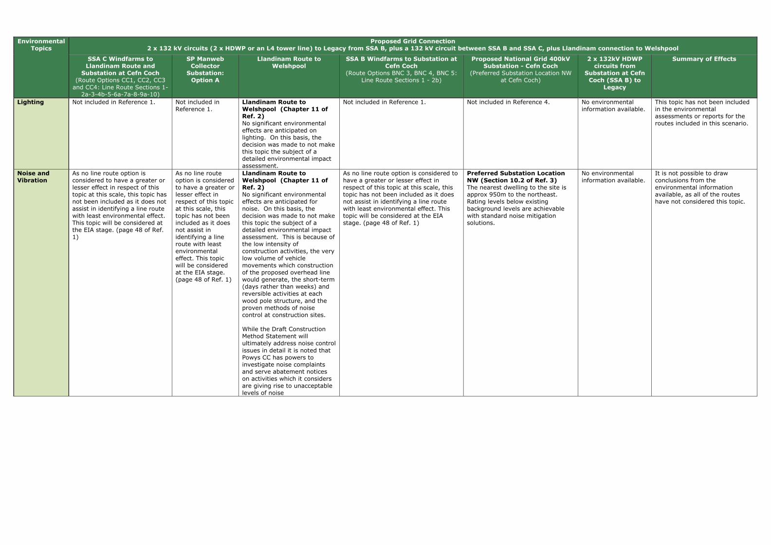
Environmental Topics
Proposed Grid Connection 2 x 132 kV circuits (2 x HDWP or an L4 tower line) to Legacy from SSA B, plus a 132 kV circuit between SSA B and SSA C, plus Llandinam connection to Welshpool
SSA C Windfarms to Llandinam Route and
Substation at Cefn Coch (Route Options CC1, CC2, CC3 and CC4: Line Route Sections 1-
2a-3-4b-5-6a-7a-8-9a-10)
SP Manweb Collector
Substation: Option A
Llandinam Route to Welshpool
SSA B Windfarms to Substation at Cefn Coch
(Route Options BNC 3, BNC 4, BNC 5: Line Route Sections 1 - 2b)
Proposed National Grid 400kV Substation - Cefn Coch
(Preferred Substation Location NW at Cefn Coch)
2 x 132kV HDWP circuits from
Substation at Cefn Coch (SSA B) to
Legacy
Summary of Effects
Lighting Not included in Reference 1. Not included in Reference 1.
Llandinam Route to Welshpool (Chapter 11 of Ref. 2) No significant environmental effects are anticipated on lighting. On this basis, the decision was made to not make this topic the subject of a detailed environmental impact assessment.
Not included in Reference 1. Not included in Reference 4. No environmental information available.
This topic has not been included in the environmental assessments or reports for the routes included in this scenario.
Noise and Vibration
As no line route option is considered to have a greater or lesser effect in respect of this topic at this scale, this topic has not been included as it does not assist in identifying a line route with least environmental effect. This topic will be considered at the EIA stage. (page 48 of Ref. 1)
As no line route option is considered to have a greater or lesser effect in respect of this topic at this scale, this topic has not been included as it does not assist in identifying a line route with least environmental effect. This topic will be considered at the EIA stage. (page 48 of Ref. 1)
Llandinam Route to Welshpool (Chapter 11 of Ref. 2) No significant environmental effects are anticipated for noise. On this basis, the decision was made to not make this topic the subject of a detailed environmental impact assessment. This is because of the low intensity of construction activities, the very low volume of vehicle movements which construction of the proposed overhead line would generate, the short-term (days rather than weeks) and reversible activities at each wood pole structure, and the proven methods of noise control at construction sites. While the Draft Construction Method Statement will ultimately address noise control issues in detail it is noted that Powys CC has powers to investigate noise complaints and serve abatement notices on activities which it considers are giving rise to unacceptable levels of noise
As no line route option is considered to have a greater or lesser effect in respect of this topic at this scale, this topic has not been included as it does not assist in identifying a line route with least environmental effect. This topic will be considered at the EIA stage. (page 48 of Ref. 1)
Preferred Substation Location NW (Section 10.2 of Ref. 3) The nearest dwelling to the site is approx 950m to the northeast. Rating levels below existing background levels are achievable with standard noise mitigation solutions.
No environmental information available.
It is not possible to draw conclusions from the environmental information available, as all of the routes have not considered this topic.

Environmental Topics
Proposed Grid Connection 2 x 132 kV circuits (2 x HDWP or an L4 tower line) to Legacy from SSA B, plus a 132 kV circuit between SSA B and SSA C, plus Llandinam connection to Welshpool
SSA C Windfarms to Llandinam Route and
Substation at Cefn Coch (Route Options CC1, CC2, CC3 and CC4: Line Route Sections 1-
2a-3-4b-5-6a-7a-8-9a-10)
SP Manweb Collector
Substation: Option A
Llandinam Route to Welshpool
SSA B Windfarms to Substation at Cefn Coch
(Route Options BNC 3, BNC 4, BNC 5: Line Route Sections 1 - 2b)
Proposed National Grid 400kV Substation - Cefn Coch
(Preferred Substation Location NW at Cefn Coch)
2 x 132kV HDWP circuits from
Substation at Cefn Coch (SSA B) to
Legacy
Summary of Effects
Socio Economics (including
Tourism and Recreation)
As no line route option is considered to have a greater or lesser effect in respect of this topic at this scale, this topic has not been included as it does not assist in identifying a line route with least environmental effect. This topic will be considered at the EIA stage. (page 48 of Ref. 1)
As no line route option is considered to have a greater or lesser effect in respect of this topic at this scale, this topic has not been included as it does not assist in identifying a line route with least environmental effect. This topic will be considered at the EIA stage. (page 48 of Ref. 1)
Llandinam Route to Welshpool (Chapter 10 of Ref. 2) The design and routeing of the proposed overhead line has been developed to minimise its effects on visual amenity and consequently upon negative perceptions of tourists and residents alike. The proposed overhead line generally avoids major settlements, tourist attractions, and local amenity assets. No significant socio-economic effects would arise from the construction and decommissioning of the proposed overhead line. In respect of the operational stage, the proposed overhead line would not have any significant effects upon the local population, economy, local community assets, tourist attractions or tourism more broadly. The operational stage would be expected to have a moderately significant effect upon tourism accommodation at two sites namely the Tavern Caravan Park and Edderton Hall B&B/Guest House. If proposed mitigation is accepted the residual effects would become not significant at Tavern Caravan Park but remain moderately significant for Edderton Hall B&B/Guest House.
As no line route option is considered to have a greater or lesser effect in respect of this topic at this scale, this topic has not been included as it does not assist in identifying a line route with least environmental effect. This topic will be considered at the EIA stage. (page 48 of Ref. 1)
Preferred Substation Location NW (Section 10.2 of Ref. 3) Economic Activity As the site adjoins Bryn Gwyn Farmhouse the substation development may have a significant negative effect upon the viability of the farm holding. However, it is understood that the farm is to be acquired by the developers of the Tirgwynt windfarm; whose intentions for the use of this holding after acquisition will determine the effect on farm viability which a substation in this location may have. The site is not visible from the local highway network and given the adjoining land is to be developed for a windfarm the substation by itself is unlikely to have a significant detrimental impact upon the local tourism industry.
No environmental information available.
It is not possible to draw conclusions from the environmental information available, as all of the routes have not considered this topic.

Environmental Topics
Proposed Grid Connection 2 x 132 kV circuits (2 x HDWP or an L4 tower line) to Legacy from SSA B, plus a 132 kV circuit between SSA B and SSA C, plus Llandinam connection to Welshpool
SSA C Windfarms to Llandinam Route and
Substation at Cefn Coch (Route Options CC1, CC2, CC3 and CC4: Line Route Sections 1-
2a-3-4b-5-6a-7a-8-9a-10)
SP Manweb Collector
Substation: Option A
Llandinam Route to Welshpool
SSA B Windfarms to Substation at Cefn Coch
(Route Options BNC 3, BNC 4, BNC 5: Line Route Sections 1 - 2b)
Proposed National Grid 400kV Substation - Cefn Coch
(Preferred Substation Location NW at Cefn Coch)
2 x 132kV HDWP circuits from
Substation at Cefn Coch (SSA B) to
Legacy
Summary of Effects
Traffic and Transport
CC1, CC2, CC3 and CC4: Line Route Sections 1-2a-3-4b-5-6a-7a-8-9a-10 (Appendix 6.1
of Ref. 1) The line route sections could be accessed by existing public roads and farm tracks in most cases, however a small number of the line route sections (e.g. 2a, 3, 7a) would have to be accessed via fields involving crossing some existing hedgerows between fields. Also, the steep terrain and lack of existing tracks will need to be taken account of for some line route sections (e.g. 1 and 10).
SP Manweb Collector Substation:
Option A (Tables 6.4 and 6.5 of Ref. 1) The site is accessible from existing farm tracks.
Llandinam Route to Welshpool (Chapter 11 of Ref. 2) No significant environmental effects are anticipated on traffic and transport. On this basis, the decision was made to not make this topic the subject of a detailed environmental impact assessment. The main issue of concern with respect to traffic would be the creation of construction and maintenance accesses and then accessing otherwise inaccessible fields with construction vehicles. This would be set out in the Draft Construction and Method Statement as part of the planning conditions, and would be developed in consultation with Powys Highways Authority.
BNC 3, 4 and 5 - line route section 1 (page 88 of Ref. 1) Access to the route will be via existing forest tracks across steep ground. BNC 3, 4 and 5 - line route section 2b (page 88 of Ref. 1) Access to the route will be via existing forest tracks across steep ground.
Preferred Substation Location NW (Section 10.2 of Ref. 3) The site will require a significant length of new access road from New Road.
No environmental information available.
Most routes/sites in this scenario are accessible by existing farm tracks or main public roads. However, localised instances may occur where the terrain makes access difficult, or large lengths of new access road are required.
Waste Management
As no line route option is considered to have a greater or lesser effect in respect of this topic at this scale, this topic has not been included as it does not assist in identifying a line route with least environmental effect. This topic will be considered at the EIA stage. (page 48 of Ref. 1)
As no line route option is considered to have a greater or lesser effect in respect of this topic at this scale, this topic has not been included as it does not assist in identifying a line route with least environmental effect. This topic will be considered at the EIA stage. (page 48 of Ref. 1)
Llandinam Route to Welshpool (Chapter 11 of Ref. 2) No significant environmental effects are anticipated on waste management. On this basis, the decision was made to not make this topic the subject of a detailed environmental impact assessment.
As no line route option is considered to have a greater or lesser effect in respect of this topic at this scale, this topic has not been included as it does not assist in identifying a line route with least environmental effect. This topic will be considered at the EIA stage. (page 48 of Ref. 1)
Not included in Reference 3. No environmental information available.
This topic has not been included in the environmental assessments or reports for the routes included in this scenario.
Water Environment
CC1, CC2, CC3 and CC4: Line Route Sections 1-2a-3-4b-5-6a-7a-8-9a-10 (Appendix 6.1 of Ref. 1) Water Quality - Line route section 1 crosses four tributaries of the River Wye SAC and River Ithon SSSI. Flood Risk - Line route sections 1, 3, 4b, 5, and 6a cross flood zones (including: the River Ithon flood zone, Severn Valley flood zone, and the Adon Trannon flood zone) and tributaries within these flood
SP Manweb Collector Substation: Option A (Tables 6.4 and 6.5 of Ref. 1) Flood Zones - A narrow flood zone lies 0.3km to the north and 0.7km to the east of the site. It is less than 50m wide and will not be affected by the substation.
Llandinam Route to Welshpool (Chapter 9 of Ref. 2) It is considered that, if the mitigation measures discussed above and detailed fully in the Draft Construction Method Statement are successfully implemented, the construction, operation and decommissioning effects of the proposed overhead line on hydrology, groundwater, flood risk and water quality would not result in any likely significant adverse long term effects.
BNC 3, 4 and 5 - line route section 1 (page 87 of Ref. 1) Flood Risk - Route 1 crosses the Afon Gam flood zone north of Cwmderwen. The Afon Gam is approximately 120m wide at this point and will not pose a constraint to the route. BNC 3, 4 and 5 - line route section 2b (page 87 of Ref. 1) Flood Risk - 2b does not cross any flood zone.
Preferred Substation Location NW (Section 10.2 of Ref. 3) Flood Risk The site is 2km upstream of the limit of EA fluvial flood mapping but given the location of this site at the top of a catchment, there is unlikely to be any flood risk associated with this site. As a small watercourse flows through the site details will need to be developed as to how it is to be managed e.g. culverted, bunded etc. Water Resources and Quality No licensed or unlicensed public or
No environmental information available.
Flood risk is not expected to be an issue for the routes included in this scenario. The routes will cross many tributaries, including rivers within SSSIs and SACs however these can be spanned by wood pole infrastructure and mitigation measures will ensure their protection during construction.

Environmental Topics
Proposed Grid Connection 2 x 132 kV circuits (2 x HDWP or an L4 tower line) to Legacy from SSA B, plus a 132 kV circuit between SSA B and SSA C, plus Llandinam connection to Welshpool
SSA C Windfarms to Llandinam Route and
Substation at Cefn Coch (Route Options CC1, CC2, CC3 and CC4: Line Route Sections 1-
2a-3-4b-5-6a-7a-8-9a-10)
SP Manweb Collector
Substation: Option A
Llandinam Route to Welshpool
SSA B Windfarms to Substation at Cefn Coch
(Route Options BNC 3, BNC 4, BNC 5: Line Route Sections 1 - 2b)
Proposed National Grid 400kV Substation - Cefn Coch
(Preferred Substation Location NW at Cefn Coch)
2 x 132kV HDWP circuits from
Substation at Cefn Coch (SSA B) to
Legacy
Summary of Effects
zones, which may form a constraint to routeing in some locations.
private water supplies or abstractions are located within the area or within 500m of the site. As a series of small streams drain the site area, there is a potentially low risk for minor effect to both the surface water flows and quality, with the proposed substation potentially affecting both ground water recharge and surface run-off characteristics within the site area.
Technical Review
CC1, CC2, CC3 and CC4: Line Route Sections 1-2a-3-4b-5-6a-7a-8-9a-10 (Appendix 6.1
of Ref. 1) Existing and Proposed OHL Infrastructure 33kV and 132kV - This route would cross existing 33kV OHL at certain line route sections, however, this could be undergrounded. Existing and Proposed Wind Turbines - Line route section 1 passes within proximity of turbines; however it will be possible to maintain the required distance. Line route sections 9a and 10 also pass within proximity of turbines but it may not be possible to maintain the required distance for line route section 9a. Altitude and Topography - The altitude and topography varies throughout the route, as demonstrated from the examples detailed below: Line route section 1: The eastern end of this route would cover altitudes of up to 455m at the substation at Llanbadarn Fynydd. Moving west, the land height is 373m at the Neuadd Goch substation. As the line moves south-west, land heights increase to around 420m at Llaithddu and then higher to around 550m at Hirddywel. Gradients range between 0-15°. As the line passes west of Hirddywel, there is a section of land with a gradient of between 15-22°. The height of land then
SP Manweb Collector Substation:
Option A (Tables 6.4 and 6.5 of Ref. 1) This site could accommodate the required equipment.
Not covered in Reference 2. BNC 3, 4 and 5 - line route section 1 (page 88 of Ref. 1) Existing and Proposed OHL Infrastructure 33kV and 132kV - This route would be crossed by the Nant y Moch Wind Farm OHL route. Existing and Proposed Wind Turbines - The route passes within proximity of a number of turbines, however the required distance from turbines can be maintained during the detailed design stage. Altitude and Topography - The route would start at a height of 340m, reducing to 260m at the Afon Gam before increasing in height to 380m. Gradients would be 0-150. BNC 3, 4 and 5 - line route section 2b (page 88 of Ref. 1) Existing and Proposed OHL Infrastructure 33kV and 132kV - This route would be crossed by the Nant y Moch OHL route. Existing and Proposed Wind Turbines - The route passes within proximity of a number of potential turbines, and it may not be possible to maintain the required distance at the eastern end. Altitude and Topography - The land height increases from 360m to 410m before reducing to 370m at the substation. Gradients are between 0-150.
Preferred Substation Location NW (Section 10.2 of Ref. 3) The site sits within a shallow valley with ground levels rising steeply towards the southern part of the site. To create a development plateau, some earthworks will be required. Earthworks should be easier in Glacial soils than, although the thickness of these is unknown. If required, cutting operations through sandstone bedrock will likely necessitate the use of hydraulic breakers or blasting. A watercourse runs through the centre of the site from West to East and will need diverting using surface ditches.
No environmental information available.
This information is not applicable to the summary of effects as it has been included for reference only.

Environmental Topics
Proposed Grid Connection 2 x 132 kV circuits (2 x HDWP or an L4 tower line) to Legacy from SSA B, plus a 132 kV circuit between SSA B and SSA C, plus Llandinam connection to Welshpool
SSA C Windfarms to Llandinam Route and
Substation at Cefn Coch (Route Options CC1, CC2, CC3 and CC4: Line Route Sections 1-
2a-3-4b-5-6a-7a-8-9a-10)
SP Manweb Collector
Substation: Option A
Llandinam Route to Welshpool
SSA B Windfarms to Substation at Cefn Coch
(Route Options BNC 3, BNC 4, BNC 5: Line Route Sections 1 - 2b)
Proposed National Grid 400kV Substation - Cefn Coch
(Preferred Substation Location NW at Cefn Coch)
2 x 132kV HDWP circuits from
Substation at Cefn Coch (SSA B) to
Legacy
Summary of Effects
reduces to around 320m as the route moves west before turning north. Line route section 5: Route 5 runs north-south over land heights between 170 – 300m. The northern section crosses gradients of between 15 -220. Line route section 9a: The southern section of 9a crosses a section of land with a gradient of 15 to 220. As it moves north, land heights range from 420m to 370m before increasing again to 440m.
References (Ref.): (1) SP MANWEB (Sept 2013). SP Mid Wales Connections, Line Routing Methodology & Appraisal - Phase 3 Report. (2) SP MANWEB (Oct 2013). Volume 1: New 132kV Overhead Line Connection from Llandinam Wind Farm to Welshpool Substation - Updated Environmental Statement. (3) National Grid (Sept 2013). Mid Wales Connection Project, Draft Substation Site Report. (4) National Grid (Sept 2013). Mid Wales Connection Project, Draft Route Report.

Table J: Scenario 8b - National Grid 400kv circuit to Lower Frankton from National Grid 400kV substation at Cefn Coch, plus a 132 kV circuit between
SSA B and SSA C, plus Llandinam connection to Welshpool
Environmental Topics
Proposed Grid Connection National Grid 400kv circuit to Lower Frankton from National Grid 400kV substation at Cefn Coch, plus a 132 kV circuit between SSA B and SSA C, plus Llandinam connection
SSA C Windfarms to Llandinam Route and
Substation at Cefn Coch
(Route Options CC1, CC2, CC3 and CC4: Line Route Sections 1-2a-3-4b-5-6a-7a-8-9a-10)
SP Manweb Collector
Substation: Option A
Llandinam Route to Welshpool
SSA B Windfarms to Substation at Cefn Coch
(Route Options BNC 3, BNC 4, BNC 5: Line Route
Sections 1 - 2b)
Proposed National Grid 400kV Substation - Cefn Coch
(Preferred Substation Location NW at Cefn Coch)
Preferred National Grid 400kV Line (Connected from National Grid Preferred Substation Location NW at Cefn Coch to Grid Supply Point at
Lower Frankton)
Summary of Effects
Air Quality and Emissions (incl. dust)
As no line route option is considered to have a greater or lesser effect in respect of this topic at this scale, this topic has not been included as it does not assist in identifying a line route with least environmental effect. This topic will be considered at the EIA stage. (page 48 of Ref. 1)
As no line route option is considered to have a greater or lesser effect in respect of this topic at this scale, this topic has not been included as it does not assist in identifying a line route with least environmental effect. This topic will be considered at the EIA stage. (page 48 of Ref. 1)
Not covered in Reference 2.
As no line route option is considered to have a greater or lesser effect in respect of this topic at this scale, this topic has not been included as it does not assist in identifying a line route with least environmental effect. This topic will be considered at the EIA stage. (page 48 of Ref. 1)
Preferred Substation Location NW (Section 10.2 of Ref. 3) The site is more than 1km northwest of Tan-y-Foel Quarry and therefore unlikely to be significantly affected by dust from quarry.
Not included in Reference 4. It is not possible to draw conclusions from the environmental information available, as all of the routes have not considered this topic.
Ecology/Biodi
versity and Geological Conservation
CC1, CC2, CC3 and
CC4: Line Route Sections 1-2a-3-4b-5-6a-7a-8-9a-10 (Appendix 6.1 of Ref. 1) Wind farm Habitat Management Plan Area (HMP) - Line route sections 1, and 6a-10 pass through and/or are within 2km of HMP areas for Hirddywell Wind Farm and the Tirgwynt HMP area. Protected Species - The route passes through and passes within 730m to 2km of many potential protected species hotspots. Peatland Habitats - Line route sections 1 passes through two large areas of potential peat. It also passes through areas identified in Environmental Statements as supporting peat habitats. Ornithological ‘Hot Spots’
SP Manweb
Collector Substation: Option A (Tables 6.4 and 6.5 of Ref. 1) SAC - The River Wye SAC headwaters lie 0.75km to the south east of the site with associated freshwater sensitivities. SSSI - The site lies less than 1km from Gweunydd Camnant SSSI, designated for habitats, the River Ithon SSSI and the Esgairdraenllwyn Pastures SSSI, designated for habitats.
Llandinam Route to
Welshpool (Chapter 7 of Ref. 2) It is considered that the proposed overhead line is not likely to result in any significant adverse long-term effects. If the mitigation measures discussed in Chapter 7 (Ref. 2) are fully implemented any risk of adverse effects will be further reduced. The potential for collisions with overhead lines is probably the most significant effect likely to arise. This represents a long-term, permanent hazard to certain groups of birds, primarily the larger species such as swans and to a lesser extent the smaller wildfowl. However, the erection of bird deflectors in appropriate locations will reduce the risk of birds colliding with the overhead line, and the erection of devices to
BNC 3, 4 and 5 - line
route section 1 (page 87 of Ref. 1) Wind farm Habitat Management Plan Area (HMP) - The route passes through the Llanbrynmair Wind Farm HMP At its very eastern extent, the route borders provisional areas set out for the Tirgwynt HMP. Peatland Habitats - The route passes through potential peat habitat to the south and east of Llanbrynmair Wind Farm, along the northern boundary of the woodland. Ornithological ‘Hot Spots’ - There are no ornithological hotspots associated with the route; however the Foel Quarry hotspot is approximately 360m to the south. BNC 3, 4 and 5 - line route section 2b (page 87 of Ref. 1) Wind farm Habitat Management Plan Area
Preferred Substation Location NW
(Section 10.2 of Ref. 3) This site is primarily located within an area of semi-improved grassland with low species diversity. Areas of valuable habitat do occur to the north east of the site and are represented by wetland/peatland habitats along a stream valley, therefore indirect hydrological effects are a consideration in this area. Consideration of ornithological effects is also required given proximity to habitats of bird value noted in Tirgwynt EIA (e.g. nesting curlew). There is a concern that the movements and noises associated with the construction of the substation may have a detrimental effect upon the curlews and other breeding bird that nest nearby. However, the EIA for the consented Tirgwynt wind farm did not identify this as a significant impact. Due to the location of the substation site it is highly likely that the site, and the indicative incoming connections and potentially the outgoing National Grid route associated with the site, will affect valuable ecological features such as peatland and/or ornithology.
Route Section - Cefn Coch to Afon Banwy
(Chapter 12 of Ref. 4) Ecological features within the area include peat deposits, ancient woodland, hedgerows and other semi-natural habitats. The peatland areas to the west of Cefn Coch include valuable habitat and associated species. Natural Resources Wales (formerly Countryside Council for Wales) have previously raised the issue of potential effects on peat in this area. Designated sites requiring consideration are the Elenydd – Mallaen Special Protection Area (SPA) - located c.12km to the north-west
Route Section - Meifod Valley (Chapter 14 of Ref. 4) Local habitats support a range of fauna and flora including legally protected species. Otter are present along the River Vyrnwy. The nearby Tanat and Vyrnwy Bat SAC is designated for the lesser horseshoe bat. Other desginated sites along the route included the Elenydd - Mallaen SPA (c. 12km to th north-west) and the Main Oxbow CWS. Route Section - Waen-Fach to A483 (Chapter 15 of Ref. 4) Much of the area comprises arable land or species poor grassland, however mature trees, hedgerows, small scattered pockets of woodland and ponds are also present. The nearby Tanat and Vyrnwy Bat SAC is designated for the lesser horseshoe bat. The Montgomery / Shropshire Union Canal is an SAC (water plantain) and is crossed by the preferred route corridor.
Birds: There are a number of ornithological 'hot-spots' in proximity to the proposed routes, whereby there is potential for larger species, (such as swans) to collide with overhead lines which presents a long-term permanent hazard to birds, however the use of bird deflectors is likely to reduce this risk. There is also a concern that the movements and noises associated with the construction of the NG substation may have a detrimental effect upon birds that nest nearby. Designated Sites: The Montgomery / Shropshire Union Canal SAC and Montgomery Canal SSSI are crossed by the 400kV preferred route corridor. No other designated sites are likely to be directly affected by the proposed grid connections, however there are a number of designated sites which lie in close proximity to the routes.

Environmental Topics
Proposed Grid Connection National Grid 400kv circuit to Lower Frankton from National Grid 400kV substation at Cefn Coch, plus a 132 kV circuit between SSA B and SSA C, plus Llandinam connection
SSA C Windfarms to Llandinam Route and Substation at Cefn
Coch
(Route Options CC1, CC2, CC3 and CC4: Line Route Sections 1-2a-3-4b-5-6a-7a-8-9a-10)
SP Manweb Collector
Substation: Option A
Llandinam Route to Welshpool
SSA B Windfarms to Substation at Cefn Coch (Route Options BNC 3,
BNC 4, BNC 5: Line Route Sections 1 - 2b)
Proposed National Grid 400kV Substation - Cefn Coch
(Preferred Substation Location NW at Cefn Coch)
Preferred National Grid 400kV Line (Connected from National Grid Preferred Substation Location NW at Cefn Coch to Grid Supply Point at
Lower Frankton)
Summary of Effects
- The route passes through and within 300m to 1.1km of many hot spots, including the Tylwch tip hotspot (to the south of the route) and Bwlch y Garreg (to the north of the route). Sites Designated for Nature Conservation Importance (SPA, SAC, SSSI) - The route does not pass through any statutory designated sites; however several designated areas are within a 2km radius, including the River Wye SAC and the Llan Mawr SSSI. The closest site is the Gweunydd Camnant SSSI, approx. 55m to the north of line route section 1.
discourage or prevent roosting on wood pole supports will reduce the risk of predation on ground nesting birds.
(HMP) - Approx. 700m of the route passes through provisional areas set out for the Tirgwynt HMP. Peatland Habitats - No potential peat areas were identified within the route. Ornithological ‘Hot Spots’ - Approximately 450m of the route passes through the Foel Quarry ornithological hotspot.
Route Section - A483 to Woolston (Chapter 16 of Ref. 4) Much of the area comprises arable land; however mature trees, hedgerows, small scattered pockets of woodland and ponds are also present. The Montgomery Canal is an SAC (water plantain) and is crossed by the preferred route corridor. The Morton Pool and Pasture Ramsar site forms part of the Midland Meres and Mosses Phase 2 Ramsar sites. Due to the nature of habitats present, this section is not considered to be of high value for collision risk bird species and ground nesting bird species including waders. Route Section - Woolston to Lower Frankton (Chapter 17 of Ref. 4) Much of the area comprises arable land or species poor grassland; however mature trees, hedgerows, small scattered pockets of woodland and ponds are also present. The Montgomery Canal is an SSSI (water plantain) and is crossed by the preferred route corridor near Bromwich Park. The nearby Morton Pool and Pasture Ramsar site forms part of the Midland Meres and Mosses Phase 2 Ramsar sites, and lie approximately 1km to the west of the route corridor. Due to the nature of habitats present, this section of the preferred route corridor is not considered to be of high value for collision risk bird species and ground nesting bird species including waders.
Habitat Management Plans: Due to the location of the wind farm substations the routes will pass through a number of wind farm HMP areas. Protected Species: Protected species are likely to be located in proximity to the routes. However full compliance with relevant protected species legislation is likely to help to minimise any effects. Peatland Habitats: A number of the routes pass through areas of potential peatland habitat.
Climate Change
As no line route option is considered to have a greater or lesser effect in respect of this topic at this scale, this topic has not been included as it does not assist in identifying a line route with least environmental effect. This topic will be considered at the EIA stage. (page 48 of Ref. 1)
As no line route option is considered to have a greater or lesser effect in respect of this topic at this scale, this topic has not been included as it does not assist in identifying a line route with least environmental effect. This topic will be considered at the EIA stage. (page 48 of Ref. 1)
Not covered in Reference 2.
As no line route option is considered to have a greater or lesser effect in respect of this topic at this scale, this topic has not been included as it does not assist in identifying a line route with least environmental effect. This topic will be considered at the EIA stage. (page 48 of Ref. 1)
Not included in Reference 3. Not included in Reference 4. This topic has not been included in the environmental assessments or reports for the routes included in this scenario.
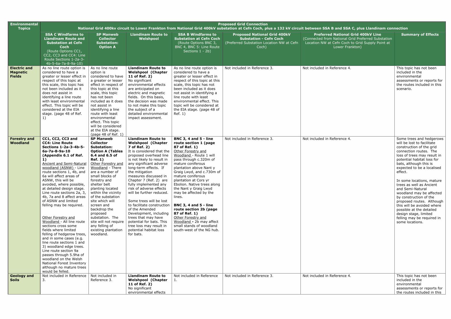
Environmental Topics
Proposed Grid Connection National Grid 400kv circuit to Lower Frankton from National Grid 400kV substation at Cefn Coch, plus a 132 kV circuit between SSA B and SSA C, plus Llandinam connection
SSA C Windfarms to Llandinam Route and Substation at Cefn
Coch
(Route Options CC1, CC2, CC3 and CC4: Line Route Sections 1-2a-3-4b-5-6a-7a-8-9a-10)
SP Manweb Collector
Substation: Option A
Llandinam Route to Welshpool
SSA B Windfarms to Substation at Cefn Coch (Route Options BNC 3,
BNC 4, BNC 5: Line Route Sections 1 - 2b)
Proposed National Grid 400kV Substation - Cefn Coch
(Preferred Substation Location NW at Cefn Coch)
Preferred National Grid 400kV Line (Connected from National Grid Preferred Substation Location NW at Cefn Coch to Grid Supply Point at
Lower Frankton)
Summary of Effects
Electric and
Magnetic Fields
As no line route option is considered to have a greater or lesser effect in respect of this topic at this scale, this topic has not been included as it does not assist in identifying a line route with least environmental effect. This topic will be considered at the EIA stage. (page 48 of Ref. 1)
As no line route option is considered to have a greater or lesser effect in respect of this topic at this scale, this topic has not been included as it does not assist in identifying a line route with least environmental effect. This topic will be considered at the EIA stage. (page 48 of Ref. 1)
Llandinam Route to
Welshpool (Chapter 11 of Ref. 2) No significant environmental effects are anticipated on electric and magnetic fields. On this basis, the decision was made to not make this topic the subject of a detailed environmental impact assessment.
As no line route option is considered to have a greater or lesser effect in respect of this topic at this scale, this topic has not been included as it does not assist in identifying a line route with least environmental effect. This topic will be considered at the EIA stage. (page 48 of Ref. 1)
Not included in Reference 3. Not included in Reference 4. This topic has not been included in the environmental assessments or reports for the routes included in this scenario.
Forestry and Woodland
CC1, CC2, CC3 and CC4: Line Route Sections 1-2a-3-4b-5-
6a-7a-8-9a-10 (Appendix 6.1 of Ref. 1) Ancient and Semi-Natural woodland (ASNW) - Line route sections 1, 4b, and 6a will affect areas of ASNW, this will be avoided, where possible, at detailed design stage. Line route sections 2a, 3, 4b, 7a and 8 affect areas of ASNW and limited felling may be required. Other Forestry and Woodland - All line route sections cross some fields where limited felling of hedgerow trees, and in some cases (e.g. line route sections 1 and 3) woodland edge trees. Line route section 9a passes through 5.9ha of woodland on the Welsh National Forest Inventory although no mature trees would be felled.
SP Manweb Collector Substation:
Option A (Tables 6.4 and 6.5 of Ref. 1) Other Forestry and Woodland - There are a number of small blocks of forestry and shelter belt planting located within the vicinity of the substation site which will screen and backdrop the proposed substation. The site will not require any felling of existing plantation woodland.
Llandinam Route to Welshpool (Chapter 7 of Ref. 2)
It is considered that the proposed overhead line is not likely to result in any significant adverse long-term effects. If the mitigation measures discussed in Chapter 7 (Ref. 2) are fully implemented any risk of adverse effects will be further reduced. Some trees will be lost to facilitate construction of the Amended Development, including trees that may have potential for bats. This tree loss may result in potential habitat loss for bats.
BNC 3, 4 and 5 - line route section 1 (page 87 of Ref. 1) Other Forestry and Woodland - Route 1 will pass through c.320m of mature coniferous plantation above Nant y Graig Lwyd, and c.730m of mature coniferous plantation at Cors yr Ebolion. Native trees along the Nant y Graig Lwyd may be affected by the lines. BNC 3, 4 and 5 - line route section 2b (page 87 of Ref. 1) Other Forestry and Woodland - 2b may affect small stands of woodland south-west of the NG hub.
Not included in Reference 3. Not included in Reference 4. Some trees and hedgerows will be lost to facilitate construction of the grid connection routes. The loss of trees may result in potential habitat loss for bats, although this is expected to be a localised effect.
In some locations, mature trees as well as Ancient and Semi-Natural woodland may be affected by construction of the proposed routes. Although this will be avoided where possible at the detailed design stage, limited felling may be required in some locations.
Geology and Soils
Not included in Reference 3.
Not included in Reference 3.
Llandinam Route to Welshpool (Chapter
11 of Ref. 2) No significant environmental effects
Not included in Reference 1.
Not included in Reference 3. Not included in Reference 4. This topic has not been included in the environmental assessments or reports for the routes included in this

Environmental Topics
Proposed Grid Connection National Grid 400kv circuit to Lower Frankton from National Grid 400kV substation at Cefn Coch, plus a 132 kV circuit between SSA B and SSA C, plus Llandinam connection
SSA C Windfarms to Llandinam Route and Substation at Cefn
Coch
(Route Options CC1, CC2, CC3 and CC4: Line Route Sections 1-2a-3-4b-5-6a-7a-8-9a-10)
SP Manweb Collector
Substation: Option A
Llandinam Route to Welshpool
SSA B Windfarms to Substation at Cefn Coch (Route Options BNC 3,
BNC 4, BNC 5: Line Route Sections 1 - 2b)
Proposed National Grid 400kV Substation - Cefn Coch
(Preferred Substation Location NW at Cefn Coch)
Preferred National Grid 400kV Line (Connected from National Grid Preferred Substation Location NW at Cefn Coch to Grid Supply Point at
Lower Frankton)
Summary of Effects
are anticipated on geology or soil resources. On this basis, the decision was made to not make this topic the subject of a detailed environmental impact assessment.
scenario.
Historic Environment
CC1, CC2, CC3 and CC4: Line Route Sections 1-2a-3-4b-5-6a-7a-8-9a-10 (Appendix 6.1 of Ref.
1) SAMs - The northen area of the route contains more SAMs that are within 2km of the route. For example, no SAMs are located within line route section 1 but 24 SAMs lie in 14 groups within 2km of the route and line route sections 2a-5 have no SAMs within 2km of the route. Whereas line route sections 6a-10 all have SAMs located within 2km of the route. Virtually all the SAMs are prehistoric burial and ritual monuments, some with wide-ranging views, others are rare prehistoric house sites. Listed Buildings (LBs) - All line route sections, apart from 9a and 10 are within 2km of LBs, the majority of which are lower grade II. However, some line route sections (e.g. 5) have LBs of higher grade II* desginated status. LBs that are within close proximity (i.e. 150m) of the route such as Ystradfaelog which is the higher grade II* building along line route section 5, could be the possibility
SP Manweb Collector Substation: Option A (Tables 6.4 and 6.5 of
Ref. 1) Undesignated Archaeology - An undesignated site of historical interest (a single storey derelict stone building) lies immediately adjacent to the site to the northeast.
Llandinam Route to Welshpool (Chapter 8 of Ref. 2) The proposed overhead line from the Llandinam Repowering Wind Farm to the Welshpool Grid Substation, some 35 km long, adopts a course to the south and east of the Severn Valley which takes it past and through some of the richest cultural heritage landscapes in mid Wales. There are 55 SAMs located within 2km of the overhead line, two of them (Crugyn Bank Dyke and Bryn Cwmyrhiwdre Round Barrow) within the 100m wide corridor. There are also 452 Listed Buildings, five Registered Historic Parks and Gardens, seven Conservation Areas, and one of Wales’ Registered Historic Landscapes would be crossed by the proposed overhead line. It is the heritage assets within the 100 m wide corridor that are most at risk from the proposed overhead line and could be adversely affected by its construction. Most of these are considered to be of low (local) or
BNC 3, 4 and 5 - line route section 1 (page 87 of Ref. 1) SAMs - There is 1 SAM within the route but none within 2km. The proximity of the scheduled Bon-y-maen root store and on the farm of which it forms a part will form a key consideration for the detailed line design stage and effects on its setting will form a key consideration during the EIA stage. Listed Buildings (LBs) - There are no LBs within the route section. There are 2 LBs within 2km of it, both of lower grade II. Undesignated Archaeology - There are 2 undesignated archaeological features in the route section. Direct effects will be avoided, where possible, during detailed design. BNC 3, 4 and 5 - line route section 2b (page 87 of Ref. 1) SAMs - There are no SAMs within the route but two within 2km, the Bon-y-maen root store and Y Capel stone circle. Listed Buildings (LBs) - There are no Listed Buildings within 2km of the route section.
Preferred Substation Location NW (Section 10.2 of Ref. 3) The site is located in an area where there are no key local receptors, but it is located roughly equidistant between a scheduled Kerb Cairn (WSM MG 327), a scheduled stone circle (WSM MG 179), and a root store (WSM MG 218). These sites are situated approximately 2km away from the substation, and outside of any identified areas of theoretical visibility. However, whilst the substation site will not be visible from any of these monuments, the proposed overhead line is potentially visible from the root store and may have a slightly adverse effect upon its landscape context. An undesignated group of pillow mounds (WNMR 9448) of regional importance is located to the south east. Whilst the substation site will not be visible, the proposed overhead lines into and out of the substation, are potentially visible and may have a slightly adverse effects upon their landscape context.
Route Section - Cefn Coch to Afon Banwy (Chapter 12 of Ref. 4) The head of the valley and upland plateau has a number of scheduled ancient monuments and their situation in the surrounding landscape is important to their designation. Listed buildings exist in low numbers within the area, and all are of the lowest grade (II) and consideration is required of their immediate setting. Route Section - Meifod Valley (Chapter 14 of Ref. 4) The area is very important in cultural heritage terms and is particularly noted for its hillforts around Pentre-uchaf and Mathrafal. The valley is also likely to contain many undiscovered sites. Several higher grade listed buildings are located around Meifod and there is a further one at Colwyn. Immediate setting is significant to their designation and hence they require consideration in the routeing process. The Meifod Conservation Area is also location within this route section. The Meifod Valley is also expected to contain many undiscovered sites.
Route Section - Waen-Fach to A483 (Chapter 15 of Ref. 4) This section of the preferred route corridor is rich in cultural heritage features and includes nine Scheduled Monuments, four prehistoric hillforts one of which (Llanymynech) is substantial, and a Roman settlement near Colfryn and a Roman camp located at Llansantffraid-ym-Mechain, and Offa’s Dyke Scheduled Monument. There are Conservation Areas at Llansantffraid-ym-Mechain and Llanymynech both of which have views up and down the valley. Also, there are several hillforts on both sides of the valley which are not scheduled, and undesignated below-ground site that require careful consideration during later stages. Route Section - A483 to Woolston (Chapter 16 of Ref. 4) A number of important cultural heritage features relate to Llanymynech Hill and the area around Llanymynech (such as two scheduled monuments) and Four Crosses and as outlined in the previous
Two designated features (SAMs) are located within the Llandinam route and one within the SP MWC BNC route. There are also multiple SAMs located within the 400kV preferred route. The Llandinam Route and other routes included in this scenario pass within 1-2km of other historic assets, including: SAMs, Conservation Areas, Listed Buildings (primarily lower grade II but also including higher grade), historic landscapes, Registered Historic Parks and Gardens and undesignated below-ground sites/features. Mitigation measures will be deployed to minimise direct effects on features, however significant effects on the setting of a number of features are predicted. Only the Llandinam route passes through a Registered Historic Landscape resulting in significant effects.
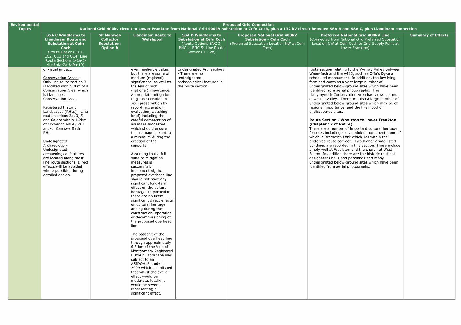
Environmental Topics
Proposed Grid Connection National Grid 400kv circuit to Lower Frankton from National Grid 400kV substation at Cefn Coch, plus a 132 kV circuit between SSA B and SSA C, plus Llandinam connection
SSA C Windfarms to Llandinam Route and Substation at Cefn
Coch
(Route Options CC1, CC2, CC3 and CC4: Line Route Sections 1-2a-3-4b-5-6a-7a-8-9a-10)
SP Manweb Collector
Substation: Option A
Llandinam Route to Welshpool
SSA B Windfarms to Substation at Cefn Coch (Route Options BNC 3,
BNC 4, BNC 5: Line Route Sections 1 - 2b)
Proposed National Grid 400kV Substation - Cefn Coch
(Preferred Substation Location NW at Cefn Coch)
Preferred National Grid 400kV Line (Connected from National Grid Preferred Substation Location NW at Cefn Coch to Grid Supply Point at
Lower Frankton)
Summary of Effects
of visual impact. Conservation Areas - Only line route section 3 is located within 2km of a Conservation Area, which is Llanidloes Conservation Area. Registered Historic Landscapes (RHLs) - Line route sections 2a, 3, 5 and 6a are within 1-2km of Clywedog Valley RHL and/or Caersws Basin RHL. Undesignated Archaeology - Undesignated archaeological features are located along most line route sections. Direct effects will be avoided, where possible, during detailed design.
even negligible value, but there are some of medium (regional) significance, as well as the few of high (national) importance. Appropriate mitigation (e.g. preservation in situ, preservation by record, excavation, evaluation, watching brief) including the careful demarcation of assets is suggested which should ensure that damage is kept to a minimum during the erection of the supports. Assuming that a full suite of mitigation measures is successfully implemented, the proposed overhead line should not have any significant long-term effect on the cultural heritage. In particular, there are no likely significant direct effects on cultural heritage arising during the construction, operation or decommissioning of the proposed overhead line. The passage of the proposed overhead line through approximately 6.5 km of the Vale of Montgomery Registered Historic Landscape was subject to an ASIDOHL2 study in 2009 which established that whilst the overall effect would be moderate, locally it would be severe, representing a significant effect.
Undesignated Archaeology - There are no undesignated archaeological features in the route section.
route section relating to the Vyrnwy Valley between Waen-fach and the A483, such as Offa's Dyke a scheduled monoument. In addition, the low lying farmland contains a very large number of undesignated below-ground sites which have been identified from aerial photographs. The Llanymynech Conservation Area has views up and down the valley. There are also a large number of undesignated below-ground sites which may be of regional importance, and the likelihood of undiscovered sites. Route Section - Woolston to Lower Frankton (Chapter 17 of Ref. 4) There are a number of important cultural heritage features including six scheduled monuments, one of which is Bromwich Park which lies within the preferred route corridor. Two higher grade listed buildings are recorded in this section. These include a holy well at Woolston and the church at West Felton. In addition there are the historic (but not designated) halls and parklands and many undesignated below-ground sites which have been identified from aerial photographs.
Environmental Topics
Proposed Grid Connection National Grid 400kv circuit to Lower Frankton from National Grid 400kV substation at Cefn Coch, plus a 132 kV circuit between SSA B and SSA C, plus Llandinam connection
SSA C Windfarms to Llandinam Route and Substation at Cefn
Coch
(Route Options CC1, CC2, CC3 and CC4: Line Route Sections 1-2a-3-4b-5-6a-7a-8-9a-10)
SP Manweb Collector
Substation: Option A
Llandinam Route to Welshpool
SSA B Windfarms to Substation at Cefn Coch (Route Options BNC 3,
BNC 4, BNC 5: Line Route Sections 1 - 2b)
Proposed National Grid 400kV Substation - Cefn Coch
(Preferred Substation Location NW at Cefn Coch)
Preferred National Grid 400kV Line (Connected from National Grid Preferred Substation Location NW at Cefn Coch to Grid Supply Point at
Lower Frankton)
Summary of Effects
Inevitably during the operational life of the proposed overhead line, it would have an indirect visual effect on a significant number of designated and registered assets. In a few cases, around six in number, that effect is likely to be very large. It is difficult to identify how such visual effects might be reduced for the density of assets in this region is such that any route adopted would be likely to generate visual issues. These are long-term temporary effects which would last for the operational life of the proposed overhead line but which would be completed removed once the proposed overhead line has been decommissioned.
Land Use CC1, CC2, CC3 and CC4: Line Route Sections 1-2a-3-4b-5-6a-7a-8-9a-10
(Appendix 6.1 of Ref. 1) Open space and Green Infrastructure - Line route section 1 crosses one area of Open Country access and lies within 1km of one other, and within 1km of two areas of Registered Common Land.
No environmental information was covered for this topic.
Not covered in Reference 2.
BNC 3, 4 and 5 - line route section 1 (pages 87 and 88 of Ref. 1) Open space and Green Infrastructure - Route 1 routes across approximately 1,766m of open access land. BNC 3, 4 and 5 - line route section 2b (pages
87 and 88 of Ref. 1) Open space and Green Infrastructure - 2b routes across approximately 694m of open access land.
Not included in Reference 4. Route Section - Cefn Coch to Afon Banwy (Chapter 12 of Ref. 4) Land use in this area is primarily agricultural. There are also areas of Open Access Land and Common Land. There are a number of Powys County Council Candidate Sites (potential allocations) the majority of which are proposed for residential development. These are located within c.0.5km of settlement boundaries at Cefn Coch, Adfa, Llanerfyl and Llanfair Caereinion. Route Section - Meifod Valley (Chapter 14 of Ref. 4) Land use in this area is principally for agriculture. There are a number of Powys County Council Candidate Sites (potential allocations) within the vicinity; the majority of which are proposed for residential development. These are primarily located within c.0.5km of settlement boundaries including at Meifod and Trefnanney. Route Section - Waen-Fach to A483 (Chapter 15 of Ref. 4) Land use within this area is predominantly agricultural. BMV agricultural land extends within
It is not possible to draw conclusions from the environmental information available, as all of the routes have not considered this topic.
Environmental Topics
Proposed Grid Connection National Grid 400kv circuit to Lower Frankton from National Grid 400kV substation at Cefn Coch, plus a 132 kV circuit between SSA B and SSA C, plus Llandinam connection
SSA C Windfarms to Llandinam Route and Substation at Cefn
Coch
(Route Options CC1, CC2, CC3 and CC4: Line Route Sections 1-2a-3-4b-5-6a-7a-8-9a-10)
SP Manweb Collector
Substation: Option A
Llandinam Route to Welshpool
SSA B Windfarms to Substation at Cefn Coch (Route Options BNC 3,
BNC 4, BNC 5: Line Route Sections 1 - 2b)
Proposed National Grid 400kV Substation - Cefn Coch
(Preferred Substation Location NW at Cefn Coch)
Preferred National Grid 400kV Line (Connected from National Grid Preferred Substation Location NW at Cefn Coch to Grid Supply Point at
Lower Frankton)
Summary of Effects
and to the north of the preferred route corridor near Wern. There are a number of planning designations associated with the settlements, including the Llanymynech Conservation Area. Powys County Council Candidate Sites (potential allocations) are primarily associated with settlements including Llansantffraid, Waen, Wern and Llanymynech. Route Section - A483 to Woolston (Chapter 16 of Ref. 4) Land use in this area is primary agricultural. Agricultural land classification Grades 1 and 2 covers the majority of the preferred route corridor between Morton and Woolston. Shropshire Council’s ‘Site Allocations and Management of Development (SAMDev) Plan’ which includes a number of Preferred Sites. These may be adopted into the future Local Development Framework, i.e. are potential allocations. A number of these sites are located within community hubs near Pant and at Knockin. Route Section - Woolston to Lower Frankton (Chapter 17 of Ref. 4) Land use in this area is primarily agricultural. Agricultural land classification Grades 1 and 2 is located within the preferred route corridor in two large pockets. The first of these is located near Maesbury Marsh and extends north-west from this village to outside the preferred route corridor. The second area extends across approximately the entire preferred route corridor at its eastern end. Other land uses include a golf course and several parks and gardens used as event venues. The settlements include Woolston, Maesbury Marsh, Maesbury, West Felton, Twyford, Queen’s Head, Wootton, Babbinswood, Whittington, Lower Frankton and Welsh Frankton. Shropshire Council’s ‘Site Allocations and Management of Development (SAMDev) Plan’ which includes a number of Preferred Sites within the vicinity, and which may be adopted into the future Local Development Framework, i.e. are potential allocations. These sites are located within community cluster settlements of Babbinswood and Lower Frankton.

Environmental Topics
Proposed Grid Connection National Grid 400kv circuit to Lower Frankton from National Grid 400kV substation at Cefn Coch, plus a 132 kV circuit between SSA B and SSA C, plus Llandinam connection
SSA C Windfarms to Llandinam Route and Substation at Cefn
Coch
(Route Options CC1, CC2, CC3 and CC4: Line Route Sections 1-2a-3-4b-5-6a-7a-8-9a-10)
SP Manweb Collector
Substation: Option A
Llandinam Route to Welshpool
SSA B Windfarms to Substation at Cefn Coch (Route Options BNC 3,
BNC 4, BNC 5: Line Route Sections 1 - 2b)
Proposed National Grid 400kV Substation - Cefn Coch
(Preferred Substation Location NW at Cefn Coch)
Preferred National Grid 400kV Line (Connected from National Grid Preferred Substation Location NW at Cefn Coch to Grid Supply Point at
Lower Frankton)
Summary of Effects
Landscape
and Visual Amenity
CC1, CC2, CC3 and
CC4: Line Route Sections 1-2a-3-4b-5-6a-7a-8-9a-10 (Appendix 6.1 of Ref. 1) Landscape and visual amenity varies along the route. Along certain line route sections short sections of sky lining will occur (e.g. line route section 2a), and the line route sections will be visible as they drop down into valleys, such as Afon Trannon Valley. However, some line route sections are provided with natural screening in areas by existing hedgerow and riparian trees, and line route sections, such as line route section 1, follow the field pattern, using field boundaries and shelter belts to screen and backdrop the route. Line route sections, such as 6a, pass through relatively open landscapes above the valley floor and will be visible in views across valleys, although these views will be back dropped by wooded slopes. Line route section 6a will also be locally prominent as it runs around the Allt y Genlli hillside above Tanyrallt. Also,in certain lcoations, line route sections pass through areas of ancient and semi-natural woodland and scattered properties. Potential visual effects are possible for residential properties, such as Oakley Park,
SP Manweb
Collector Substation: Option A (Tables 6.4 and 6.5 of Ref. 1) Landscape Sensitivity - The open pasture landscape lies below the higher moorland tops to the north and east above the A483. The Ithon valley runs to the east of the site but is relatively shallow at this point. The moderate sized pastoral fields are often contained by coniferous shelter belts and larger woodland blocks, which both introduce man made elements to the landscape and break up and contain views. The substation is potentially visible within the landscape due to its elevation and the relatively open nature of the upland landscape. However, the sensitivity of this landscape is medium-low, and there is scope for extension of the existing areas of coniferous planting belts which contain views. The site includes a belt of existing coniferous planting on its southern edge which will both screen, and
Llandinam Route to
Welshpool (Chapter 6 of Ref. 2) Any likely significant landscape or visual effects would arise during the operational stage from the localised loss of trees and the introduction into the landscape of approximately 35 km of new overhead line on wood pole structures. The design and routeing of the proposed overhead line has been developed to minimise its effects on the landscape and visual amenity of the area. The location of the Llandinam wind farm on the Waun Ddubarthog Ridge means that the route is more visible at the southern end of the corridor, than further north where it merges into the more diverse and enclosed landscape east of the Severn Valley. However, the use of wood pole supports helps mitigate the effects within the more open and elevated parts of the route. Landscape Effects
Although significant or borderline significant, all the effects were assessed as minor-moderate or moderate and none of the effects was assessed as major. The only landscape along the route identified as experiencing a moderate and therefore
BNC 3, 4 and 5 - line
route section 1 (page 87 of Ref. 1) Landscape Sensitivity - Route 1 descends into the small-medium scale valley of the Nant y Graig Lwyd. It traverses a shoulder of moorland, remaining behind the ridge line where possible. Between Cwmderwen and Cors yr Ebolion it crosses medium to large-scale upland pasture. It then passes across larger-scale moorland plateau, avoiding the highest ground where possible. Visual Sensitivity - The parallel wood pole lines may be seen on the skyline above Nant y Graig Lwyd from locations within Nant-yr-Eira. The lines will be backclothed by forestry on the south side of Nant-yr-Eira. Beyond Cors yr Ebolion the plateau has few inward views and wood poles are unlikely to be seen. From the head of Nant Wythan, 1 will be carried on steel towers. These may be visible in longer views toward the moorland, e.g. from Cwm Llwyd to the south and from the Banwy valley to the north. The towers will be partially screened/backclothed by forestry at Mynydd Carreg-y-big in some views. Residential Visual Amenity - The parallel wood pole lines may be viewed from two properties at Cwmderwen, descending from high ground into Nant-yr-Eira. These
Preferred Substation Location NW
(Section 10.2 of Ref. 3) Whilst currently a substation in this remote rural location would represent a detracting urban element, which would be inconsistent with the local landscape character, this situation is likely to change with the construction of the Tirgwynt wind farm and Mynydd Waen Fawr wind farm (if constructed) as the proposed substation would potentially be seen alongside above ground equipment such as overhead electricity lines, pylons and the turbines of the Tirgwynt Wind farm and other planned wind farms. The Overall Visual and Sensory Evaluation (VS50) of the site is High. The ZTV suggests that a substation in this location may just be visible from Snowdonia National Park in the high area of Mynydd Clywedog. This would be at a distance of 15km and it is likely that the substation would be imperceptible from this distance. The ZTV indicates that the site is visually well contained due to the surrounding landform which provides natural screening on three sides. Areas of potential visibility are largely restricted to the sparsely populated valley and surrounding hill slopes to the north-east, including the lower slopes of Mynydd Waun Fawr, the Mynydd y Gribin ridgeline and Foel Fawr. It is anticipated that there would be unrestricted and filtered views of the development from Gwaenydd and potentially from a few other scattered properties further afield. There would also be views from the public right of way network, but no views from the local lanes. In those locations where the proposed substation is likely to be visible, it would potentially be seen alongside above ground equipment such as overhead electricity lines, pylons and the turbines of some of the planned wind farms. The visual effects arising from a substation in this location could be lessened by perimeter mounding supplemented by planting which could
Route Section - Cefn Coch to Afon Banwy
(Chapter 12 of Ref. 4) The landform around the Cefn Coch substation siting area is an upland plateau situated around 415m AOD, which is drained by tributary streams of the rivers Rhiw, Einion and Banwy which flow through well-defined valleys off the plateau edge. The plateau is remote and rural with an open moorland landscape that is typical of upland Wales. The elevated landform provides expansive views across rolling ridgelines, punctuated by geometric blocks of coniferous plantations and occasional clusters of wind turbines. Prominent landscape features include Mynydd Clogau Wind Farm, Tan Y Foel Quarry, the Mynydd Waen Fawr ridgeline and the rounded hill of Foel Fawr. Settlement is either dispersed along the network of narrow lanes, or clustered into small hamlets and the villages of Cefn Coch and Adfa, both of which lie within c.5km of the substation sites. Views are variable depending on localised topography and tree cover. Route Section - Meifod Valley (Chapter 14 of Ref. 4) This section meets and follows the A495 and passes through the narrow and well wooded Yr Hafesb Valley south of Ffridd Mathrafal. Residential receptors in this part of the valley include a few properties, the Tanhouse Inn and Tan-y-Ffridd Caravan Park which are all located adjacent to the A495 tourist route which runs through the valley. The combination of large deciduous and coniferous woodlands on the higher slopes and a high prevalence of scrub and individual trees lower down enclose longer views along and across the valley. The landform of the Meifod Valley is one of its distinctive features; the steep valley sides providing a strong contrast with the flat, low-lying valley floor. The small villages of Pentre and Meifod are situated on the north side of the valley at its narrowest point. Elsewhere the settlement pattern comprises a dispersed pattern of individual or small clusters of properties typically situated on the lower valleys sides. Overall the valley has a high scenic quality with few detracting features. Route Section - Waen-Fach to A483 (Chapter
15 of Ref. 4) This section of the draft route primarily comprises the Vyrnwy Valley as it widens east of Waen-fach and swings around the southern side of Llansantffraid-ym-Mechain where it is joined by the tributary valleys of the Rivers Cain and Tanat. Fields are bound by hedgerows and fences and
Landscape and visual effects are likely to arise along the routes of this scenario, however the effects will be localised and will diminish rapidly with distance from the route. Views are also variable depending on localised topography and tree cover. Localised significant effects have been identified for visual receptors utilising a proportion of the footpaths, roads and residential properties sited close to the routes of this scenario. In some locations along the 400kV line preferred route, settlements, including a number of large villages are affected. Also, the popular viewpoint of Llanymynech Hill with its Heritage Trail overlooks this section of the preferred route corridor. While the existing 400 kV line is noticeable in locations along the route it is not a dominant landscape feature, particularly towards the eastern end of the route. Overall, for the SSAC connection to Welshpool, effects are more likely for landscape and visual receptors located close to the southern sections of the proposed route. This is because this is generally a more elevated area with lower levels of vegetation cover consequently there would be greater potential visibility for the routes. In comparison, the central and northern sections of the Llandinam – Welshpool route is routed through

Environmental Topics
Proposed Grid Connection National Grid 400kv circuit to Lower Frankton from National Grid 400kV substation at Cefn Coch, plus a 132 kV circuit between SSA B and SSA C, plus Llandinam connection
SSA C Windfarms to Llandinam Route and Substation at Cefn
Coch
(Route Options CC1, CC2, CC3 and CC4: Line Route Sections 1-2a-3-4b-5-6a-7a-8-9a-10)
SP Manweb Collector
Substation: Option A
Llandinam Route to Welshpool
SSA B Windfarms to Substation at Cefn Coch (Route Options BNC 3,
BNC 4, BNC 5: Line Route Sections 1 - 2b)
Proposed National Grid 400kV Substation - Cefn Coch
(Preferred Substation Location NW at Cefn Coch)
Preferred National Grid 400kV Line (Connected from National Grid Preferred Substation Location NW at Cefn Coch to Grid Supply Point at
Lower Frankton)
Summary of Effects
which will have views of line route section 4b. Line route section 4b will also have further effects on individual properties along the route, notably at Red House and Ty’n-y-celyn. Line route sections, such as line route section 1, will be visible as they cross roads (e.g. A483). Effects on visitor attractions are unlikely to arise from the route beyond localised effects on public footpaths.
provide a backdrop for the substation infrastructure. Residential Visual Amenity - The area is sparsely populated with only four properties within 1km of the substation. Views from residential properties will be limited to the properties at Camnant Farm, Camnant Bridge and one property to the north-west. These views will be screened in part by intervening vegetation. The distance of the sites from the A483, the local landform, and intervening vegetation, reduces visibility from the road. Recreational Resource - There is a relatively dense network of public rights of way in the vicinity of the site; two local public footpaths cross the site but these can be diverted to an existing track around the site. There would be views to the site from the adjacent public footpaths and others in the vicinity; however use of the footpaths does not appear to be high.
significant effect is between the A483 near Old Neuadd Bank and Cae-betin Wood, including the open hillside below the Kerry Ridgeway Regional Trail. Other areas of landscape (e.g. the Canlad Valley and the Severn Valley) would experience minor-moderate effects which would be borderline significant. Visual Effects
Although significant or verging on significant, all the effects were assessed as minor - moderate or moderate and none of these effects was assessed as major. In terms of settlements, some properties on the edge of Fron Bank/Cilcewydd, which lie within 500m of the overhead line will experience a significant change in their view, where there is no screening afforded by landform, buildings or vegetation. Of the many individual properties scattered throughout the study area, only those close to the overhead line will experience a significant change in their view some of which will have views of the proposed overhead line. However, the nature of the proposed overhead line, combined with the screening effects of landform and vegetation, mean that
properties would also overlook the crossing of the Afon Gam at relatively close range. There may be views of the route from Dolau-ceimion, although the lines will be backclothed. Visitor Attractions - No visitor attractions have been identified that would be affected by BNC1. Recreational Resource - The parallel wood pole lines would be visible within Nant y Graig Lwyd and Nant yr Eira from the Glyndwr Way, which passes between 300-500m to the north. BNC 3, 4 and 5 - line route section 2b (page 87 of Ref. 1) Landscape Sensitivity - Route 2b crosses open moorland plateau, largely comprising unenclosed grass moor. It avoids the ridge to the north-west of the NG hub, keeping to the flatter ground to the south of the high point above Gors-dyfwch (418m). Visual Sensitivity - Steel towers will be visible in wider views of the moorland plateau. Residential Visual Amenity - The southward alignment of 2b takes it further from the properties at Carreg-y-big and Gwaenydd, and the towers would be a lesser presence in views. Visitor Attractions - There may be views of the towers at the head of the upland valley as seen from the outdoor centre at Plas
include a high proportion of conifers. The proximity of the site to existing mature coniferous plantations and shelter belts provides a structural planting context. However the screening benefits would only be achieved in the long term as the planting reached full maturity. Also the entries and exit for the overhead lines would have to kept free from tall vegetation and views of the infrastructure would potentially be available at these points.
there is high prevalence of trees. The landscape of the valley sides is smaller scale and there is a higher density of settlement including a number of large villages in addition to Llansantffraid-ym-Mechain and Llanymynech. The popular viewpoint of Llanymynech Hill with its Heritage Trail overlooks this section of the preferred route corridor from the north side of the valley. The farmland is attractive but lacks the dramatic contrasts of the Meifod Valley. Around Llanymynech, the road infrastructure which includes a new bypass around Four Crosses, coalescing settlements, low voltage electricity lines and telegraph poles impart a more developed character with greater human influence. By contrast the valleys sides are more tranquil and natural in appearance. Views within and along the valley are locally contained by vegetation but there are longer views. Route Section - A483 to Woolston (Chapter 16 of Ref. 4) After crossing the A483 the landscape widens out into a broad, low-lying expanse of large, mainly arable fields. The settlement pattern is one of clustered villages, including Maesbrook, Crickheath, Osbaston, Maesbury Marsh and Woolston, with dispersed farms and properties. Some large estate farms are identified as ‘halls’. These include Morton Hall which lies just off the B4396 between Morton and Osbaston. Overall the landscape is one of pleasant and well managed farmland. Prominent landscape features include Llanymynech Hill and Breidden Hill. Route Section - Woolston to Lower Frankton (Chapter 17 of Ref. 4) East of Maesbury the preferred route corridor crosses a lowland farmland landscape of pastures and arable fields, blocks of woodland, plantations and coverts. The parkland associated with nearby historic halls and the Oswestry Golf Course gives the area a traditional managed quality. The landform is more undulating than in the previous section with occasional low rounded hills. The farmland provides the setting for a number of clustered villages and dispersed properties including West Felton Queen’s Head, Babbinswood, Lower Frankton and Welsh Frankton. The A5 and Shrewsbury to Chester railway line run in a north-west to south-east direction through the area. This locally disturbs the tranquillity of the landscape. The existing 400 kV line is a noticeable but not dominant landscape feature. Llanymynech Hill and Breidden Hill are more distant but still noticeable landscape features, but otherwise there are few
more diverse and enclosed landscape character types, although the corollary is that these sections tend to be more populous, therefore a greater number of receptors are likely. The SSAC connection to Cefn Coch will be visible as it crosses roads and within valleys and there are likely to be potential visual effects on a number of residential properties. Landscape and visual effects are likely along line route section 1 of BNC 3, BNC 4 and BNC5. However, these elements of this scenario will be screened from some receptors and directions and the overhead line may potentially be seen alongside other above ground equipment such the turbines of the planned wind farms. Effects are likely for landscape and visual receptors around the substation at Cefn Coch than the SP Manweb Collector Substation: Option A. It is anticipated that there would be unrestricted and filtered views of the substation at Cefn Coch from the surrounding area, and it would potentially be seen alongside above ground equipment such as overhead electricity lines and the turbines of the planned wind farms.
Environmental Topics
Proposed Grid Connection National Grid 400kv circuit to Lower Frankton from National Grid 400kV substation at Cefn Coch, plus a 132 kV circuit between SSA B and SSA C, plus Llandinam connection
SSA C Windfarms to Llandinam Route and Substation at Cefn
Coch
(Route Options CC1, CC2, CC3 and CC4: Line Route Sections 1-2a-3-4b-5-6a-7a-8-9a-10)
SP Manweb Collector
Substation: Option A
Llandinam Route to Welshpool
SSA B Windfarms to Substation at Cefn Coch (Route Options BNC 3,
BNC 4, BNC 5: Line Route Sections 1 - 2b)
Proposed National Grid 400kV Substation - Cefn Coch
(Preferred Substation Location NW at Cefn Coch)
Preferred National Grid 400kV Line (Connected from National Grid Preferred Substation Location NW at Cefn Coch to Grid Supply Point at
Lower Frankton)
Summary of Effects
its effect will be limited, and no views would create effects on residential amenity to the extent that they would become an undesirable place to live. Users of local public rights of way and open access areas will be variably affected. Where a pole is seen in close proximity to these areas (e.g. the public forest, footpaths and local access roads near Bryn-picca), the effect on visual amenity will be significant, although this effect will diminish rapidly with distance. Similarly, road users will be variably affected. Significant residual effects are noted for the A483 and B4355, although these effects would be localised and transient.
y drain, 1800m to the north-east. Recreational Resource - No recreational resources have been identified that would be affected by 2b.
distinctive focal points and many views fade out into distant rolling skylines.
Lighting Not included in Reference 1.
Not included in Reference 1.
Llandinam Route to Welshpool (Chapter
11 of Ref. 2) No significant environmental effects are anticipated on lighting. On this basis, the decision was made to not make this topic the subject of a detailed environmental impact assessment.
Not included in Reference 1.
Not included in Reference 4. Not included in Reference 4. This topic has not been included in the environmental assessments or reports for the routes included in this scenario.
Noise and Vibration
As no line route option is considered to have a greater or lesser effect in respect of this topic at this scale, this topic has not been included as it does not assist in identifying a line route with least environmental effect. This topic will be considered at the EIA
As no line route option is considered to have a greater or lesser effect in respect of this topic at this scale, this topic has not been included as it does not assist in identifying a line
Llandinam Route to Welshpool (Chapter
11 of Ref. 2) No significant environmental effects are anticipated for noise. On this basis, the decision was made to not make this topic the subject of a detailed environmental
As no line route option is considered to have a greater or lesser effect in respect of this topic at this scale, this topic has not been included as it does not assist in identifying a line route with least environmental effect. This topic will be considered at the EIA stage. (page 48 of
Preferred Substation Location NW (Section 10.2 of Ref. 3) The nearest dwelling to the site is approx. 950m to the northeast. Rating levels below existing background levels are achievable with standard noise mitigation solutions.
Not included in Reference 4. It is not possible to draw conclusions from the environmental information available, as all of the routes have not considered this topic.

Environmental Topics
Proposed Grid Connection National Grid 400kv circuit to Lower Frankton from National Grid 400kV substation at Cefn Coch, plus a 132 kV circuit between SSA B and SSA C, plus Llandinam connection
SSA C Windfarms to Llandinam Route and Substation at Cefn
Coch
(Route Options CC1, CC2, CC3 and CC4: Line Route Sections 1-2a-3-4b-5-6a-7a-8-9a-10)
SP Manweb Collector
Substation: Option A
Llandinam Route to Welshpool
SSA B Windfarms to Substation at Cefn Coch (Route Options BNC 3,
BNC 4, BNC 5: Line Route Sections 1 - 2b)
Proposed National Grid 400kV Substation - Cefn Coch
(Preferred Substation Location NW at Cefn Coch)
Preferred National Grid 400kV Line (Connected from National Grid Preferred Substation Location NW at Cefn Coch to Grid Supply Point at
Lower Frankton)
Summary of Effects
stage. (page 48 of Ref. 1)
route with least environmental effect. This topic will be considered at the EIA stage. (page 48 of Ref. 1)
impact assessment. This is because of the low intensity of construction activities, the very low volume of vehicle movements which construction of the proposed overhead line would generate, the short-term (days rather than weeks) and reversible activities at each wood pole structure, and the proven methods of noise control at construction sites. While the Draft Construction Method Statement will ultimately address noise control issues in detail it is noted that Powys CC has powers to investigate noise complaints and serve abatement notices on activities which it considers are giving rise to unacceptable levels of noise
Ref. 1)
Socio
Economics (including Tourism and Recreation)
As no line route option is considered to have a greater or lesser effect in respect of this topic at this scale, this topic has not been included as it does not assist in identifying a line route with least environmental effect. This topic will be considered at the EIA stage. (page 48 of Ref. 1)
As no line route option is considered to have a greater or lesser effect in respect of this topic at this scale, this topic has not been included as it does not assist in identifying a line route with least environmental effect. This topic will be considered at the EIA stage. (page 48 of Ref. 1)
Llandinam Route to
Welshpool (Chapter 10 of Ref. 2) The design and routeing of the proposed overhead line has been developed to minimise its effects on visual amenity and consequently upon negative perceptions of tourists and residents alike. The proposed overhead line generally avoids major settlements, tourist attractions, and local amenity assets. No significant socio-economic effects would arise from the construction and
As no line route option is considered to have a greater or lesser effect in respect of this topic at this scale, this topic has not been included as it does not assist in identifying a line route with least environmental effect. This topic will be considered at the EIA stage. (page 48 of Ref. 1)
Preferred Substation Location NW
(Section 10.2 of Ref. 3) Economic Activity As the site adjoins Bryn Gwyn Farmhouse the substation development may have a significant negative effect upon the viability of the farm holding. However, it is understood that the farm is to be acquired by the developers of the Tirgwynt wind farm; whose intentions for the use of this holding after acquisition will determine the effect on farm viability which a substation in this location may have. The site is not visible from the local highway network and given the adjoining land is to be developed for a wind farm the substation by itself is unlikely to have a significant detrimental impact upon the local tourism industry.
Route Section - Cefn Coch to Afon Banwy
(Chapter 12 of Ref. 4) Tourism and recreation facilities include some caravan parks and other tourist accommodation and the Red Ridge Activity Centre. The area is bisected by the A458 which is unavoidable by routeing. The road is an important tourist route. The area is also crossed by a network of public rights of way, including two National Trails. Route Section - Meifod Valley (Chapter 14 of Ref. 4) Meifod village is an active hub, which includes a Conservation Area, school, rugby club, and several small businesses. Other settlements include Plas Coch, Newbridge, Pentre, Clolyn, Main, Trefnanney and Cefn-llyfnog. Tourism and recreation facilities include caravan parks and other tourist accommodation in nearby Meifod and other villages. Glyndŵr’s Way is crossed by the preferred route corridor. The A495 which is an important tourist route runs through the valley.
It is not possible to draw conclusions from the environmental information available, as all of the routes have not considered this topic.

Environmental Topics
Proposed Grid Connection National Grid 400kv circuit to Lower Frankton from National Grid 400kV substation at Cefn Coch, plus a 132 kV circuit between SSA B and SSA C, plus Llandinam connection
SSA C Windfarms to Llandinam Route and Substation at Cefn
Coch
(Route Options CC1, CC2, CC3 and CC4: Line Route Sections 1-2a-3-4b-5-6a-7a-8-9a-10)
SP Manweb Collector
Substation: Option A
Llandinam Route to Welshpool
SSA B Windfarms to Substation at Cefn Coch (Route Options BNC 3,
BNC 4, BNC 5: Line Route Sections 1 - 2b)
Proposed National Grid 400kV Substation - Cefn Coch
(Preferred Substation Location NW at Cefn Coch)
Preferred National Grid 400kV Line (Connected from National Grid Preferred Substation Location NW at Cefn Coch to Grid Supply Point at
Lower Frankton)
Summary of Effects
decommissioning of the proposed overhead line. In respect of the operational stage, the proposed overhead line would not have any significant effects upon the local population, economy, local community assets, tourist attractions or tourism more broadly. The operational stage would be expected to have a moderately significant effect upon tourism accommodation at two sites namely the Tavern Caravan Park and Edderton Hall B&B/Guest House. If proposed mitigation is accepted the residual effects would become not significant at Tavern Caravan Park but remain moderately significant for Edderton Hall B&B/Guest House.
There is a possibility that the Welsh National Eisteddfod may be held at Mathrafal in 2015. Potential effects on this event could arise during the construction phase of the project. Route Section - Waen-Fach to A483 (Chapter 15 of Ref. 4) The settlements of Llansantffraid-ym-Mechain and Llanymynech are outside but in proximity to the preferred route corridor and are the largest communities along the preferred route corridor. Tourism and recreation facilities include caravan parks and other tourist accommodation in nearby Llansantffraid-ym-Mechain and Llanymynech. Offa’s Dyke and the Montgomery / Shropshire Union Canal are crossed by the preferred route corridor. There are a number of large caravan parks in the valley east of Llansantffraid-ym-Mechain. The B4398, Montgomery / Shropshire Union Canal, Offa’s Dyke Path and the Oswestry Cycle Route cross the valley between Four Crosses and Llanymynech, whilst further east the A483 Corridor is a major transport route along the Severn Valley. Route Section - A483 to Woolston (Chapter 16 of Ref. 4) Settlements include Llandysilio, Four Crosses, Pant, Maesbrook, Crickheath, Llynclys, Morton, Morton Common, Osbaston and Knockin. Tourism and recreation facilities include a caravan site at Domgay, regional trails/cycle routes and the potential expansion of the Cambrian Heritage Railways Project currently extending between Pant and Llynclys and north of Llynclys to Oswestry. There are also regional recreational trails associated with the Montgomery Canal tow path (Shropshire cycle route and Wats Dyke walk) which should be considered. Route Section - Woolston to Lower Frankton
(Chapter 17 of Ref. 4) Considerations for routeing in this area included, amongst others: The golf course at Oswestry; the Montgomery / Shropshire Union Canal, which is navigable through this section of the preferred route corridor; the proposed Queen’s Head Marina development; a number of Parks and Gardens, some of which are event venues, including Pradoe, Tedsmore Hall, Aston Hall, Whittington Castle, Halston Hall, Woodhouse and Park Hall (The Countryside Experience); Knockin and Rednal airfields; and the Knockin telescope.

Environmental Topics
Proposed Grid Connection National Grid 400kv circuit to Lower Frankton from National Grid 400kV substation at Cefn Coch, plus a 132 kV circuit between SSA B and SSA C, plus Llandinam connection
SSA C Windfarms to Llandinam Route and Substation at Cefn
Coch
(Route Options CC1, CC2, CC3 and CC4: Line Route Sections 1-2a-3-4b-5-6a-7a-8-9a-10)
SP Manweb Collector
Substation: Option A
Llandinam Route to Welshpool
SSA B Windfarms to Substation at Cefn Coch (Route Options BNC 3,
BNC 4, BNC 5: Line Route Sections 1 - 2b)
Proposed National Grid 400kV Substation - Cefn Coch
(Preferred Substation Location NW at Cefn Coch)
Preferred National Grid 400kV Line (Connected from National Grid Preferred Substation Location NW at Cefn Coch to Grid Supply Point at
Lower Frankton)
Summary of Effects
Traffic and
Transport
CC1, CC2, CC3 and
CC4: Line Route Sections 1-2a-3-4b-5-6a-7a-8-9a-10 (Appendix 6.1 of Ref. 1) The line route sections could be accessed by existing public roads and farm tracks in most cases, however a small number of the line route sections (e.g. 2a, 3, 7a) would have to be accessed via fields involving crossing some existing hedgerows between fields. Also, the steep terrain and lack of existing tracks will need to be taken account of for some line route sections (e.g. 1 and 10).
SP Manweb
Collector Substation: Option A (Tables 6.4 and 6.5 of Ref. 1) The site is accessible from existing farm tracks.
Llandinam Route to
Welshpool (Chapter 11 of Ref. 2) No significant environmental effects are anticipated on traffic and transport. On this basis, the decision was made to not make this topic the subject of a detailed environmental impact assessment. The main issue of concern with respect to traffic would be the creation of construction and maintenance accesses and then accessing otherwise inaccessible fields with construction vehicles. This would be set out in the Draft Construction and Method Statement as part of the planning conditions, and would be developed in consultation with Powys Highways Authority.
BNC 3, 4 and 5 - line
route section 1 (page 88 of Ref. 1) Access to the route will be via existing forest tracks across steep ground. BNC 3, 4 and 5 - line
route section 2b (page 88 of Ref. 1) Access to the route will be via existing forest tracks across steep ground.
Preferred Substation Location NW
(Section 10.2 of Ref. 3) The site will require a significant length of new access road from New Road.
Route Section - Cefn Coch to Afon Banwy
(Chapter 12 of Ref. 4) Access restrictions due to the extent of the local road network and the steep terrain will need to be considered. Whether the connection is made underground or by overhead line there will be a need to access the construction areas in order to deliver plant, labour and materials to the route and working areas. Construction access and associated enabling works would be required and it is likely access to the route and a working easement would be required across private land. Route Section - Meifod Valley (Chapter 14 of
Ref. 4) The location of the A495 may make it easier to transport materials to site hence minimising environmental effects. Route Section - Waen-Fach to A483 (Chapter 15 of Ref. 4)
Access - there is potential access from the B4393 in the west but limited access from the east so there could be a requirement for a temporary bridge over the River Vyrnwy. Access to the south side of the river is difficult and via narrow lanes. Route Section - Woolston to Lower Frankton
(Chapter 17 of Ref. 4) Any route will need to cross the A5 and the Shrewsbury to Chester railway line (Network Rail Route 75) to join into the existing 400 kV overhead line.
Most routes/sites in this scenario are accessible by existing farm tracks or main public roads. However, localised instances may occur where the terrain makes access difficult, or lengths of new access road are required. Some routes, particularly the 400kV line, will need to cross rail lines and major roads.
Waste Management
As no line route option is considered to have a greater or lesser effect in respect of this topic at this scale, this topic has not been included as it does not assist in identifying a line route with least environmental effect. This topic will be considered at the EIA stage. (page 48 of Ref. 1)
As no line route option is considered to have a greater or lesser effect in respect of this topic at this scale, this topic has not been included as it does not assist in identifying a line route with least environmental effect. This topic will be considered at the EIA stage. (page 48 of Ref. 1)
Llandinam Route to Welshpool (Chapter 11 of Ref. 2) No significant environmental effects are anticipated on waste management. On this basis, the decision was made to not make this topic the subject of a detailed environmental impact assessment.
As no line route option is considered to have a greater or lesser effect in respect of this topic at this scale, this topic has not been included as it does not assist in identifying a line route with least environmental effect. This topic will be considered at the EIA stage. (page 48 of Ref. 1)
Not included in Reference 3. Not included in Reference 5. This topic has not been included in the environmental assessments or reports for the routes included in this scenario.

Environmental Topics
Proposed Grid Connection National Grid 400kv circuit to Lower Frankton from National Grid 400kV substation at Cefn Coch, plus a 132 kV circuit between SSA B and SSA C, plus Llandinam connection
SSA C Windfarms to Llandinam Route and Substation at Cefn
Coch
(Route Options CC1, CC2, CC3 and CC4: Line Route Sections 1-2a-3-4b-5-6a-7a-8-9a-10)
SP Manweb Collector
Substation: Option A
Llandinam Route to Welshpool
SSA B Windfarms to Substation at Cefn Coch (Route Options BNC 3,
BNC 4, BNC 5: Line Route Sections 1 - 2b)
Proposed National Grid 400kV Substation - Cefn Coch
(Preferred Substation Location NW at Cefn Coch)
Preferred National Grid 400kV Line (Connected from National Grid Preferred Substation Location NW at Cefn Coch to Grid Supply Point at
Lower Frankton)
Summary of Effects
Water
Environment
CC1, CC2, CC3 and
CC4: Line Route Sections 1-2a-3-4b-5-6a-7a-8-9a-10 (Appendix 6.1 of Ref. 1) Water Quality - Line route section 1 crosses four tributaries of the River Wye SAC and River Ithon SSSI. Flood Risk - Line route sections 1, 3, 4b, 5, and 6a cross flood zones (including: the River Ithon flood zone, Severn Valley flood zone, and the Adon Trannon flood zone) and tributaries within these flood zones, which may form a constraint to routeing in some locations.
SP Manweb
Collector Substation: Option A (Tables 6.4 and 6.5 of Ref. 1) Flood Zones - A narrow flood zone lies 0.3km to the north and 0.7km to the east of the site. It is less than 50m wide and will not be affected by the substation.
Llandinam Route to
Welshpool (Chapter 9 of Ref. 2) It is considered that, if the mitigation measures discussed above and detailed fully in the Draft Construction Method Statement are successfully implemented, the construction, operation and decommissioning effects of the proposed overhead line on hydrology, groundwater, flood risk and water quality would not result in any likely significant adverse long term effects.
BNC 3, 4 and 5 - line
route section 1 (page 87 of Ref. 1) Flood Risk - Route 1 crosses the Afon Gam flood zone north of Cwmderwen. The Afon Gam is approximately 120m wide at this point and will not pose a constraint to the route. BNC 3, 4 and 5 - line route section 2b (page
87 of Ref. 1) Flood Risk - 2b does not cross any flood zone.
Preferred Substation Location NW
(Section 10.2 of Ref. 3) Flood Risk The site is 2km upstream of the limit of EA fluvial flood mapping but given the location of this site at the top of a catchment, there is unlikely to be any flood risk associated with this site. As a small watercourse flows through the site details will need to be developed as to how it is to be managed e.g. culverted, bunded etc. Water Resources and Quality No licensed or unlicensed public or private water supplies or abstractions are located within the area or within 500m of the site. As a series of small streams drain the site area, there is a potentially low risk for minor effect to both the surface water flows and quality, with the proposed substation potentially affecting both ground water recharge and surface run-off characteristics within the site area.
Route Section - Cefn Coch to Afon Banwy
(Chapter 12 of Ref. 4) The area between Cefn Coch and the Afon Banwy includes the indicative floodplains of the Afon Rhiw and the Afon Einion / Afon Banwy. The area also contains peat particularly in the north. Areas of marsh/wetland are present in the west, with the majority particularly to the north of the area, near Mynydd y Gribin. Route Section - Meifod Valley (Chapter 14 of Ref. 4) Various river courses extend across the route corridor including through the Meifod Valley. NRW (previously Environment Agency Wales) has noted that the valley contains examples of rock sequencing which may be affected by routeing. Extensive areas of indicative flood risk (Flood Zones 2 and 3) and indicative areas of reservoir flood risk associated with Lake Vyrnwy. Goundwater movement including within the Vyrnwy floodplain needs to be considered. Route Section - Waen-Fach to A483 (Chapter 15 of Ref. 4) Considerations for routeing in this area include, amongst other things: the extensive floodplain (indicative Flood Zones 2 and 3) associated with the River Vyrnwy and Afon Cain. The River Vyrnwy also has associated areas of indicative reservoir flood risk; and groundwater flows associated with floodplain areas. Route Section - A483 to Woolston (Chapter 16 of Ref. 4) Considerations for routeing in this area include, amongst others: the extensive floodplain in the west (indicative Flood Zones 2 and 3) associated with the River Vyrnwy; the River Vyrnwy has associated areas of indicative reservoir flood risk; groundwater flows associated with floodplain areas; and a small extent of Environment Agency Source Protection Zone 3 (SPZ3) (total catchment) is located at the north-east corner of the preferred route corridor. Route Section - Woolston to Lower Frankton (Chapter 17 of Ref. 4) Considerations for routeing in this area included, amongst others: the indicative Flood Zones 2 and 3 associated with the River Morda and its tributaries in the west and tributaries to the River Perry in the east; and the northern half of the preferred route corridor lies within an extensive area of Environment Agency Source Protection Zone 3 (SPZ3) (total catchment). This SPZ also extends within the east of the route corridor.
Flood risk is not expected to be an issue for most routes included in this scenario. However, the 400kV line preferred route crosses extensive areas of flood plain, areas of indicative reservoir flood risk and groundwater flows associated with floodplain areas, which all requires consideration. The routes will cross many tributaries, including rivers within SSSIs and SACs however these can be spanned by wood pole infrastructure and mitigation measures will ensure their protection during construction.
Environmental Topics
Proposed Grid Connection National Grid 400kv circuit to Lower Frankton from National Grid 400kV substation at Cefn Coch, plus a 132 kV circuit between SSA B and SSA C, plus Llandinam connection
SSA C Windfarms to Llandinam Route and Substation at Cefn
Coch
(Route Options CC1, CC2, CC3 and CC4: Line Route Sections 1-2a-3-4b-5-6a-7a-8-9a-10)
SP Manweb Collector
Substation: Option A
Llandinam Route to Welshpool
SSA B Windfarms to Substation at Cefn Coch (Route Options BNC 3,
BNC 4, BNC 5: Line Route Sections 1 - 2b)
Proposed National Grid 400kV Substation - Cefn Coch
(Preferred Substation Location NW at Cefn Coch)
Preferred National Grid 400kV Line (Connected from National Grid Preferred Substation Location NW at Cefn Coch to Grid Supply Point at
Lower Frankton)
Summary of Effects
Technical
Review
CC1, CC2, CC3 and
CC4: Line Route Sections 1-2a-3-4b-5-6a-7a-8-9a-10 (Appendix 6.1 of Ref. 1) Existing and Proposed OHL Infrastructure 33kV and 132kV - This route would cross existing 33kV OHL at certain line route sections, however, this could be undergrounded. Existing and Proposed Wind Turbines - Line route section 1 passes within proximity of turbines; however it will be possible to maintain the required distance. Line route sections 9a and 10 also pass within proximity of turbines but it may not be possible to maintain the required distance for line route section 9a. Altitude and Topography - The altitude and topography varies throughout the route, as demonstrated from the examples detailed below: Line route section 1: The eastern end of this route would cover altitudes of up to 455m at the substation at Llanbadarn Fynydd. Moving west, the land height is 373m at the Neuadd Goch substation. As the line moves south-west, land heights increase to around 420m at Llaithddu and then higher to around 550m at Hirddywel. Gradients range between 0-15°. As the line passes west of Hirddywel, there is a
SP Manweb
Collector Substation: Option A (Tables 6.4 and 6.5 of Ref. 1) This site could accommodate the required equipment.
Not covered in Reference 2.
BNC 3, 4 and 5 - line
route section 1 (page 88 of Ref. 1) Existing and Proposed OHL Infrastructure 33kV and 132kV - This route would be crossed by the Nant y Moch Wind Farm OHL route. Existing and Proposed Wind Turbines - The route passes within proximity of a number of turbines, however the required distance from turbines can be maintained during the detailed design stage. Altitude and Topography - The route would start at a height of 340m, reducing to 260m at the Afon Gam before increasing in height to 380m. Gradients would be 0-150. BNC 3, 4 and 5 - line
route section 2b (page 88 of Ref. 1) Existing and Proposed OHL Infrastructure 33kV and 132kV - This route would be crossed by the Nant y Moch OHL route. Existing and Proposed Wind Turbines - The route passes within proximity of a number of potential turbines, and it may not be possible to maintain the required distance at the eastern end. Altitude and Topography - The land height increases from 360m to 410m before reducing to 370m at the substation. Gradients are between 0-150.
Preferred Substation Location NW
(Section 10.2 of Ref. 3) The site sits within a shallow valley with ground levels rising steeply towards the southern part of the site. To create a development plateau, some earthworks will be required. Earthworks should be easier in Glacial soils than, although the thickness of these is unknown. If required, cutting operations through sandstone bedrock will likely necessitate the use of hydraulic breakers or blasting. A watercourse runs through the centre of the site from West to East and will need diverting using surface ditches.
Route Section - Cefn Coch to Afon Banwy
(Chapter 12 of Ref. 4) This material is normally compressible and creates greater difficulties for an underground connection, for example for the laying out of cable and for cable joints to avoid settlement issues. It is likely that the increased construction activity for the installation of an underground cable could have a greater detrimental impact on the peat.
This information is not applicable to cumulative impacts as it has been included for reference only.

Environmental Topics
Proposed Grid Connection National Grid 400kv circuit to Lower Frankton from National Grid 400kV substation at Cefn Coch, plus a 132 kV circuit between SSA B and SSA C, plus Llandinam connection
SSA C Windfarms to Llandinam Route and Substation at Cefn
Coch
(Route Options CC1, CC2, CC3 and CC4: Line Route Sections 1-2a-3-4b-5-6a-7a-8-9a-10)
SP Manweb Collector
Substation: Option A
Llandinam Route to Welshpool
SSA B Windfarms to Substation at Cefn Coch (Route Options BNC 3,
BNC 4, BNC 5: Line Route Sections 1 - 2b)
Proposed National Grid 400kV Substation - Cefn Coch
(Preferred Substation Location NW at Cefn Coch)
Preferred National Grid 400kV Line (Connected from National Grid Preferred Substation Location NW at Cefn Coch to Grid Supply Point at
Lower Frankton)
Summary of Effects
section of land with a gradient of between 15-22°. The height of land then reduces to around 320m as the route moves west before turning north. Line route section 5: Route 5 runs north-south over land heights between 170 – 300m. The northern section crosses gradients of between 15 -220. Line route section 9a: The southern section of 9a crosses a section of land with a gradient of 15 to 220. As it moves north, land heights range from 420m to 370m before increasing again to 440m.
References (Ref.): (1) SP MANWEB (Sept 2013). SP Mid Wales Connections, Line Routing Methodology & Appraisal - Phase 3 Report. (2) SP MANWEB (Oct 2013). Volume 1: New 132kV Overhead Line Connection from Llandinam Wind Farm to Welshpool Substation - Updated Environmental Statement. (3) National Grid (Sept 2013). Mid Wales Connection Project, Draft Substation Site Report. (4) National Grid (Sept 2013). Mid Wales Connection Project, Draft Route Report.

")
")")
")
")
")
!
!
!! !
!
!!
!
!
!
!
!
!!
!!!
!!
!!
!
!
!
!!!
!
!
!! !!
!
!
!
!
! !
!!!
! !!!
!
!
!
!
!
!!
!!
!
!
!!
!
!
!
!
!
!
!
!
!! !! !!!!!
!
!
!!
!!
!!
!
!
!!!
!!!
!
!
!
! !
!
!
!
!
!
!
! !
!
!
!!
!!
! !
!!
!
!
!
!
!
!
!
!
!!
!
!
!
!
!
!
!
!
!
!
!!
!
!
!
!
!!
!!
!!
!
!
!!!
!!
!!
!
Powys
Shropshire
Sir Ddinbych -Denbighshire Wrecsam
- Wrexham
Gwynedd
Sir Ceredigion- Ceredigion
LlandinamRepowering
Llaithddu
Llanbadarn Fynydd
CarneddWen
Llanbrynmair
Shrewsbury
LowerFrankton
Legacy
Welshpool
Reproduced from Ordnance Survey digital map data © Crown copyright 2013. All rights reserved.
0 5 10 152.5 km
LUC GLA FIG01-00_5920-001-r2_Scenario_1_A3L 23/12/2013
Map Scale @ A3:1:300,000
I
Scenario 1
Mid-Wales (Powys) Conjoined Wind Farms Public Inquiry
Figure 1
Existing Grid Connection Network400kV Overhead Network132kV Overhead Network
Proposed Substation Locations") Contracted Substation Location") SP Manweb Collector Substation
(Option A)National Grid Potential Substation
Mid Wales Conjoined Wind Farm Inquiry:Grid Session 4 EvidenceSupplementary Environmental Information on Grid Scenarios
Note: SPEN Proposed Grid Connection Network All 100m Wide Line Routes are Subject to Further Environmental and Technical Evaluation.
SPEN Proposed Grid Connection Network
National Grid Proposed Grid Connection Network
Llandinam Proposed Grid Connection
BNC 132kV Proposed OverheadLine ConnectionCC 1-4 - 132kV/33kV Proposed OverheadLine Connection
400kV Draft National Grid Route - Overhead400kV Draft National Grid Route - Underground
132kV Proposed Llandinam Overhead Line Connection
Scenario 1132 kV HDWP line from SSA C to connect to the SP Manweb network at Welshpool. Requires significant SP Manweb reinforcements north of Welshpool
Wind Farm Application Boundaries
Planning Authority Boundary
5 PLI Schemes - Turbine Locations! Llanbrynmair, 30 turbines, 126.5m to tip! Carnedd Wen, 50 turbines, 137m to tip! Llandinam Repowering, 34 turbines,
121.2m to tip! Llanbadarn Fynydd, 17 turbines, 125m to tip! Llaithddu, 27 turbines, 115.5m to tip

")
")")
")
")
")
!
!
!! !
!
!!
!
!
!
!
!
!!
!!!
!!
!!
!
!
!
!!!
!
!
!! !!
!
!
!
!
! !
!!!
! !!!
!
!
!
!
!
!!
!!
!
!
!!
!
!
!
!
!
!
!
!
!! !! !!!!!
!
!
!!
!!
!!
!
!
!!!
!!!
!
!
!
! !
!
!
!
!
!
!
! !
!
!
!!
!!
! !
!!
!
!
!
!
!
!
!
!
!!
!
!
!
!
!
!
!
!
!
!
!!
!
!
!
!
!!
!!
!!
!
!
!!!
!!
!!
!
Powys
Shropshire
Sir Ddinbych -Denbighshire Wrecsam
- Wrexham
Gwynedd
Sir Ceredigion- Ceredigion
LlandinamRepowering
Llaithddu
Llanbadarn Fynydd
CarneddWen
Llanbrynmair
Shrewsbury
LowerFrankton
Legacy
Welshpool
Reproduced from Ordnance Survey digital map data © Crown copyright 2013. All rights reserved.
0 5 10 152.5 km
LUC GLA FIG02-00_5920-002-r2_Scenario_2_A3L 23/12/2013
Map Scale @ A3:1:300,000
I
Scenario 2
Mid-Wales (Powys) Conjoined Wind Farms Public Inquiry
Figure 2
Existing Grid Connection Network400kV Overhead Network132kV Overhead Network
Proposed Substation Locations") Contracted Substation Location") SP Manweb Collector Substation
(Option A)National Grid Potential Substation
Mid Wales Conjoined Wind Farm Inquiry:Grid Session 4 EvidenceSupplementary Environmental Information on Grid Scenarios
Note: SPEN Proposed Grid Connection Network All 100m Wide Line Routes are Subject to Further Environmental and Technical Evaluation.
SPEN Proposed Grid Connection Network
National Grid Proposed Grid Connection Network
Llandinam Proposed Grid Connection
BNC 132kV Proposed OverheadLine ConnectionCC 1-4 - 132kV/33kV Proposed OverheadLine Connection
400kV Draft National Grid Route - Overhead400kV Draft National Grid Route - Underground
132kV Proposed Llandinam Overhead Line Connection
Scenario 2The connection to Welshpool, as outlined in option 1, plus a 132 kV HDWP connection to Shrewsbury
Wind Farm Application Boundaries
Planning Authority Boundary
5 PLI Schemes - Turbine Locations! Llanbrynmair, 30 turbines, 126.5m to tip! Carnedd Wen, 50 turbines, 137m to tip! Llandinam Repowering, 34 turbines,
121.2m to tip! Llanbadarn Fynydd, 17 turbines, 125m to tip! Llaithddu, 27 turbines, 115.5m to tip

")
")")
")
")
")
!
!
!! !
!
!!
!
!
!
!
!
!!
!!!
!!
!!
!
!
!
!!!
!
!
!! !!
!
!
!
!
! !
!!!
! !!!
!
!
!
!
!
!!
!!
!
!
!!
!
!
!
!
!
!
!
!
!! !! !!!!!
!
!
!!
!!
!!
!
!
!!!
!!!
!
!
!
! !
!
!
!
!
!
!
! !
!
!
!!
!!
! !
!!
!
!
!
!
!
!
!
!
!!
!
!
!
!
!
!
!
!
!
!
!!
!
!
!
!
!!
!!
!!
!
!
!!!
!!
!!
!
Powys
Shropshire
Sir Ddinbych -Denbighshire Wrecsam
- Wrexham
Gwynedd
Sir Ceredigion- Ceredigion
LlandinamRepowering
Llaithddu
Llanbadarn Fynydd
CarneddWen
Llanbrynmair
Shrewsbury
LowerFrankton
Legacy
Welshpool
Reproduced from Ordnance Survey digital map data © Crown copyright 2013. All rights reserved.
0 5 10 152.5 km
LUC GLA FIG03-00_5920-003-r2_Scenario_3_A3L 23/12/2013
Map Scale @ A3:1:300,000
I
Scenario 3
Mid-Wales (Powys) Conjoined Wind Farms Public Inquiry
Figure 3
Existing Grid Connection Network400kV Overhead Network132kV Overhead Network
Proposed Substation Locations") Contracted Substation Location") SP Manweb Collector Substation
(Option A)National Grid Potential Substation
Mid Wales Conjoined Wind Farm Inquiry:Grid Session 4 EvidenceSupplementary Environmental Information on Grid Scenarios
Note: SPEN Proposed Grid Connection Network All 100m Wide Line Routes are Subject to Further Environmental and Technical Evaluation.
SPEN Proposed Grid Connection Network
National Grid Proposed Grid Connection Network
Llandinam Proposed Grid Connection
BNC 132kV Proposed OverheadLine ConnectionCC 1-4 - 132kV/33kV Proposed OverheadLine Connection
400kV Draft National Grid Route - Overhead400kV Draft National Grid Route - Underground
132kV Proposed Llandinam Overhead Line Connection
Scenario 3The connection to Welshpool, as outlined in option 1, plus a 132 kV HDWP from SSA C to SSA B. This assumes there must be (at least) one circuit to Legacy (see the following options)
Wind Farm Application Boundaries
Planning Authority Boundary
5 PLI Schemes - Turbine Locations! Llanbrynmair, 30 turbines, 126.5m to tip! Carnedd Wen, 50 turbines, 137m to tip! Llandinam Repowering, 34 turbines,
121.2m to tip! Llanbadarn Fynydd, 17 turbines, 125m to tip! Llaithddu, 27 turbines, 115.5m to tip

")
")")
")
")
")
!
!
!! !
!
!!
!
!
!
!
!
!!
!!!
!!
!!
!
!
!
!!!
!
!
!! !!
!
!
!
!
! !
!!!
! !!!
!
!
!
!
!
!!
!!
!
!
!!
!
!
!
!
!
!
!
!
!! !! !!!!!
!
!
!!
!!
!!
!
!
!!!
!!!
!
!
!
! !
!
!
!
!
!
!
! !
!
!
!!
!!
! !
!!
!
!
!
!
!
!
!
!
!!
!
!
!
!
!
!
!
!
!
!
!!
!
!
!
!
!!
!!
!!
!
!
!!!
!!
!!
!
Powys
Shropshire
Sir Ddinbych -Denbighshire Wrecsam
- Wrexham
Gwynedd
Sir Ceredigion- Ceredigion
LlandinamRepowering
Llaithddu
Llanbadarn Fynydd
CarneddWen
Llanbrynmair
Shrewsbury
LowerFrankton
Legacy
Welshpool
Reproduced from Ordnance Survey digital map data © Crown copyright 2013. All rights reserved.
0 5 10 152.5 km
LUC GLA FIG04-00_5920-004-r2_Scenario_4_A3L 23/12/2013
Map Scale @ A3:1:300,000
I
Scenario 4
Mid-Wales (Powys) Conjoined Wind Farms Public Inquiry
Figure 4
Existing Grid Connection Network400kV Overhead Network132kV Overhead Network
Proposed Substation Locations") Contracted Substation Location") SP Manweb Collector Substation
(Option A)National Grid Potential Substation
Mid Wales Conjoined Wind Farm Inquiry:Grid Session 4 EvidenceSupplementary Environmental Information on Grid Scenarios
Note: SPEN Proposed Grid Connection Network All 100m Wide Line Routes are Subject to Further Environmental and Technical Evaluation.
SPEN Proposed Grid Connection Network
National Grid Proposed Grid Connection Network
Llandinam Proposed Grid Connection
BNC 132kV Proposed OverheadLine ConnectionCC 1-4 - 132kV/33kV Proposed OverheadLine Connection
400kV Draft National Grid Route - Overhead400kV Draft National Grid Route - Underground
132kV Proposed Llandinam Overhead Line Connection
Scenario 4132 kV HDWP circuit to Welshpool from SSA B
Wind Farm Application Boundaries
Planning Authority Boundary
5 PLI Schemes - Turbine Locations! Llanbrynmair, 30 turbines, 126.5m to tip! Carnedd Wen, 50 turbines, 137m to tip! Llandinam Repowering, 34 turbines,
121.2m to tip! Llanbadarn Fynydd, 17 turbines, 125m to tip! Llaithddu, 27 turbines, 115.5m to tip

")
")")
")
")
")
!
!
!! !
!
!!
!
!
!
!
!
!!
!!!
!!
!!
!
!
!
!!!
!
!
!! !!
!
!
!
!
! !
!!!
! !!!
!
!
!
!
!
!!
!!
!
!
!!
!
!
!
!
!
!
!
!
!! !! !!!!!
!
!
!!
!!
!!
!
!
!!!
!!!
!
!
!
! !
!
!
!
!
!
!
! !
!
!
!!
!!
! !
!!
!
!
!
!
!
!
!
!
!!
!
!
!
!
!
!
!
!
!
!
!!
!
!
!
!
!!
!!
!!
!
!
!!!
!!
!!
!
Powys
Shropshire
Sir Ddinbych -Denbighshire Wrecsam
- Wrexham
Gwynedd
Sir Ceredigion- Ceredigion
LlandinamRepowering
Llaithddu
Llanbadarn Fynydd
CarneddWen
Llanbrynmair
Shrewsbury
LowerFrankton
Legacy
Welshpool
Reproduced from Ordnance Survey digital map data © Crown copyright 2013. All rights reserved.
0 5 10 152.5 km
LUC GLA FIG05-00_5920-005-r2_Scenario_5_A3L 23/12/2013
Map Scale @ A3:1:300,000
I
Scenario 5
Mid-Wales (Powys) Conjoined Wind Farms Public Inquiry
Figure 5
Existing Grid Connection Network400kV Overhead Network132kV Overhead Network
Proposed Substation Locations") Contracted Substation Location") SP Manweb Collector Substation
(Option A)National Grid Potential Substation
Mid Wales Conjoined Wind Farm Inquiry:Grid Session 4 EvidenceSupplementary Environmental Information on Grid Scenarios
Note: SPEN Proposed Grid Connection Network All 100m Wide Line Routes are Subject to Further Environmental and Technical Evaluation.
SPEN Proposed Grid Connection Network
National Grid Proposed Grid Connection Network
Llandinam Proposed Grid Connection
BNC 132kV Proposed OverheadLine ConnectionCC 1-4 - 132kV/33kV Proposed OverheadLine Connection
400kV Draft National Grid Route - Overhead400kV Draft National Grid Route - Underground
132kV Proposed Llandinam Overhead Line Connection
Scenario 5132 kV HDWP circuit (124 MVA or 176 MVA) to Legacy from SSA B, plus connection option 1
Wind Farm Application Boundaries
Planning Authority Boundary
5 PLI Schemes - Turbine Locations! Llanbrynmair, 30 turbines, 126.5m to tip! Carnedd Wen, 50 turbines, 137m to tip! Llandinam Repowering, 34 turbines,
121.2m to tip! Llanbadarn Fynydd, 17 turbines, 125m to tip! Llaithddu, 27 turbines, 115.5m to tip

")
")")
")
")
")
!
!
!! !
!
!!
!
!
!
!
!
!!
!!!
!!
!!
!
!
!
!!!
!
!
!! !!
!
!
!
!
! !
!!!
! !!!
!
!
!
!
!
!!
!!
!
!
!!
!
!
!
!
!
!
!
!
!! !! !!!!!
!
!
!!
!!
!!
!
!
!!!
!!!
!
!
!
! !
!
!
!
!
!
!
! !
!
!
!!
!!
! !
!!
!
!
!
!
!
!
!
!
!!
!
!
!
!
!
!
!
!
!
!
!!
!
!
!
!
!!
!!
!!
!
!
!!!
!!
!!
!
Powys
Shropshire
Sir Ddinbych -Denbighshire Wrecsam
- Wrexham
Gwynedd
Sir Ceredigion- Ceredigion
LlandinamRepowering
Llaithddu
Llanbadarn Fynydd
CarneddWen
Llanbrynmair
Shrewsbury
LowerFrankton
Legacy
Welshpool
Reproduced from Ordnance Survey digital map data © Crown copyright 2013. All rights reserved.
0 5 10 152.5 km
LUC GLA FIG06-00_5920-006-r2_Scenario_6_A3L 23/12/2013
Map Scale @ A3:1:300,000
I
Scenario 6
Mid-Wales (Powys) Conjoined Wind Farms Public Inquiry
Figure 6
Existing Grid Connection Network400kV Overhead Network132kV Overhead Network
Proposed Substation Locations") Contracted Substation Location") SP Manweb Collector Substation
(Option A)National Grid Potential Substation
Mid Wales Conjoined Wind Farm Inquiry:Grid Session 4 EvidenceSupplementary Environmental Information on Grid Scenarios
Note: SPEN Proposed Grid Connection Network All 100m Wide Line Routes are Subject to Further Environmental and Technical Evaluation.
SPEN Proposed Grid Connection Network
National Grid Proposed Grid Connection Network
Llandinam Proposed Grid Connection
BNC 132kV Proposed OverheadLine ConnectionCC 1-4 - 132kV/33kV Proposed OverheadLine Connection
400kV Draft National Grid Route - Overhead400kV Draft National Grid Route - Underground
132kV Proposed Llandinam Overhead Line Connection
Scenario 6132 kV HDWP circuit (176 MVA) to Legacy from SSA B, plus connection option 1, plus 132 kV HDWP between SSA B and SSA C
Wind Farm Application Boundaries
Planning Authority Boundary
5 PLI Schemes - Turbine Locations! Llanbrynmair, 30 turbines, 126.5m to tip! Carnedd Wen, 50 turbines, 137m to tip! Llandinam Repowering, 34 turbines,
121.2m to tip! Llanbadarn Fynydd, 17 turbines, 125m to tip! Llaithddu, 27 turbines, 115.5m to tip

")
")")
")
")
")
!
!
!! !
!
!!
!
!
!
!
!
!!
!!!
!!
!!
!
!
!
!!!
!
!
!! !!
!
!
!
!
! !
!!!
! !!!
!
!
!
!
!
!!
!!
!
!
!!
!
!
!
!
!
!
!
!
!! !! !!!!!
!
!
!!
!!
!!
!
!
!!!
!!!
!
!
!
! !
!
!
!
!
!
!
! !
!
!
!!
!!
! !
!!
!
!
!
!
!
!
!
!
!!
!
!
!
!
!
!
!
!
!
!
!!
!
!
!
!
!!
!!
!!
!
!
!!!
!!
!!
!
Powys
Shropshire
Sir Ddinbych -Denbighshire Wrecsam
- Wrexham
Gwynedd
Sir Ceredigion- Ceredigion
LlandinamRepowering
Llaithddu
Llanbadarn Fynydd
CarneddWen
Llanbrynmair
Shrewsbury
LowerFrankton
Legacy
Welshpool
Reproduced from Ordnance Survey digital map data © Crown copyright 2013. All rights reserved.
0 5 10 152.5 km
LUC GLA FIG07-00_5920-007-r2_Scenario_7_A3L 23/12/2013
Map Scale @ A3:1:300,000
I
Scenario 7
Mid-Wales (Powys) Conjoined Wind Farms Public Inquiry
Figure 7
Existing Grid Connection Network400kV Overhead Network132kV Overhead Network
Proposed Substation Locations") Contracted Substation Location") SP Manweb Collector Substation
(Option A)National Grid Potential Substation
Mid Wales Conjoined Wind Farm Inquiry:Grid Session 4 EvidenceSupplementary Environmental Information on Grid Scenarios
Note: SPEN Proposed Grid Connection Network All 100m Wide Line Routes are Subject to Further Environmental and Technical Evaluation.
SPEN Proposed Grid Connection Network
National Grid Proposed Grid Connection Network
Llandinam Proposed Grid Connection
BNC 132kV Proposed OverheadLine ConnectionCC 1-4 - 132kV/33kV Proposed OverheadLine Connection
400kV Draft National Grid Route - Overhead400kV Draft National Grid Route - Underground
132kV Proposed Llandinam Overhead Line Connection
Scenario 72 x 132 kV HDWP circuits to Legacy from SSA B, plus connection option 1
Wind Farm Application Boundaries
Planning Authority Boundary
5 PLI Schemes - Turbine Locations! Llanbrynmair, 30 turbines, 126.5m to tip! Carnedd Wen, 50 turbines, 137m to tip! Llandinam Repowering, 34 turbines,
121.2m to tip! Llanbadarn Fynydd, 17 turbines, 125m to tip! Llaithddu, 27 turbines, 115.5m to tip

")
")")
")
")
")
!
!
!! !
!
!!
!
!
!
!
!
!!
!!!
!!
!!
!
!
!
!!!
!
!
!! !!
!
!
!
!
! !
!!!
! !!!
!
!
!
!
!
!!
!!
!
!
!!
!
!
!
!
!
!
!
!
!! !! !!!!!
!
!
!!
!!
!!
!
!
!!!
!!!
!
!
!
! !
!
!
!
!
!
!
! !
!
!
!!
!!
! !
!!
!
!
!
!
!
!
!
!
!!
!
!
!
!
!
!
!
!
!
!
!!
!
!
!
!
!!
!!
!!
!
!
!!!
!!
!!
!
Powys
Shropshire
Sir Ddinbych -Denbighshire Wrecsam
- Wrexham
Gwynedd
Sir Ceredigion- Ceredigion
LlandinamRepowering
Llaithddu
Llanbadarn Fynydd
CarneddWen
Llanbrynmair
Shrewsbury
LowerFrankton
Legacy
Welshpool
Reproduced from Ordnance Survey digital map data © Crown copyright 2013. All rights reserved.
0 5 10 152.5 km
LUC GLA FIG08-00_5920-008-r2_Scenario_8a_A3L 23/12/2013
Map Scale @ A3:1:300,000
I
Scenario 8a
Mid-Wales (Powys) Conjoined Wind Farms Public Inquiry
Figure 8
Existing Grid Connection Network400kV Overhead Network132kV Overhead Network
Proposed Substation Locations") Contracted Substation Location") SP Manweb Collector Substation
(Option A)National Grid Potential Substation
Mid Wales Conjoined Wind Farm Inquiry:Grid Session 4 EvidenceSupplementary Environmental Information on Grid Scenarios
Note: SPEN Proposed Grid Connection Network All 100m Wide Line Routes are Subject to Further Environmental and Technical Evaluation.
SPEN Proposed Grid Connection Network
National Grid Proposed Grid Connection Network
Llandinam Proposed Grid Connection
BNC 132kV Proposed OverheadLine ConnectionCC 1-4 - 132kV/33kV Proposed OverheadLine Connection
400kV Draft National Grid Route - Overhead400kV Draft National Grid Route - Underground
132kV Proposed Llandinam Overhead Line Connection
Scenario 8a2 x 132 kV circuits (2 x HDWP or an L4 tower line) to Legacy from SSA B, plus a 132 kV circuit between SSA B and SSA C, plus connection option 1
Wind Farm Application Boundaries
Planning Authority Boundary
5 PLI Schemes - Turbine Locations! Llanbrynmair, 30 turbines, 126.5m to tip! Carnedd Wen, 50 turbines, 137m to tip! Llandinam Repowering, 34 turbines,
121.2m to tip! Llanbadarn Fynydd, 17 turbines, 125m to tip! Llaithddu, 27 turbines, 115.5m to tip

")
")")
")
")
")
!
!
!! !
!
!!
!
!
!
!
!
!!
!!!
!!
!!
!
!
!
!!!
!
!
!! !!
!
!
!
!
! !
!!!
! !!!
!
!
!
!
!
!!
!!
!
!
!!
!
!
!
!
!
!
!
!
!! !! !!!!!
!
!
!!
!!
!!
!
!
!!!
!!!
!
!
!
! !
!
!
!
!
!
!
! !
!
!
!!
!!
! !
!!
!
!
!
!
!
!
!
!
!!
!
!
!
!
!
!
!
!
!
!
!!
!
!
!
!
!!
!!
!!
!
!
!!!
!!
!!
!
Powys
Shropshire
Sir Ddinbych -Denbighshire Wrecsam
- Wrexham
Gwynedd
Sir Ceredigion- Ceredigion
LlandinamRepowering
Llaithddu
Llanbadarn Fynydd
CarneddWen
Llanbrynmair
Shrewsbury
LowerFrankton
Legacy
Welshpool
Reproduced from Ordnance Survey digital map data © Crown copyright 2013. All rights reserved.
0 5 10 152.5 km
LUC GLA FIG09-00_5920-009-r2_Scenario_8b_A3L 23/12/2013
Map Scale @ A3:1:300,000
I
Scenario 8b
Mid-Wales (Powys) Conjoined Wind Farms Public Inquiry
Figure 9
Existing Grid Connection Network400kV Overhead Network132kV Overhead Network
Proposed Substation Locations") Contracted Substation Location") SP Manweb Collector Substation
(Option A)National Grid Potential Substation
Mid Wales Conjoined Wind Farm Inquiry:Grid Session 4 EvidenceSupplementary Environmental Information on Grid Scenarios
Note: SPEN Proposed Grid Connection Network All 100m Wide Line Routes are Subject to Further Environmental and Technical Evaluation.
SPEN Proposed Grid Connection Network
National Grid Proposed Grid Connection Network
Llandinam Proposed Grid Connection
BNC 132kV Proposed OverheadLine ConnectionCC 1-4 - 132kV/33kV Proposed OverheadLine Connection
400kV Draft National Grid Route - Overhead400kV Draft National Grid Route - Underground
132kV Proposed Llandinam Overhead Line Connection
Scenario 8bNational Grid 400kv circuit to Lower Frankton from National Grid 400kV substation at Cefn Coch, plus a 132 kV circuit between SSA B and SSA C, plus connection option 1
Wind Farm Application Boundaries
Planning Authority Boundary
5 PLI Schemes - Turbine Locations! Llanbrynmair, 30 turbines, 126.5m to tip! Carnedd Wen, 50 turbines, 137m to tip! Llandinam Repowering, 34 turbines,
121.2m to tip! Llanbadarn Fynydd, 17 turbines, 125m to tip! Llaithddu, 27 turbines, 115.5m to tip