21 st century approach to open water ditching. are we training effectively? before the 1990s the...
TRANSCRIPT

21st CENTURY APPROACH TO OPEN WATER DITCHING

ARE WE TRAINING EFFECTIVELY?
• BEFORE THE 1990s THE AIRLINE, AIR-CARGO, CORPORATE AND MILITARY TRAINED DITCHING AS A SIGNIFICANT EVENT
• OUR CURRENT SIGNIFICANT SAFETY IMPROVEMENTS HAVE CROWDED OUT COMPREHENSIVE DITCHING TRAINING

TRAINING SHORTFALLS
• 121.5 VS 406 MHz TRAINING (NON-RADAR)
• SQUAWKING 7700 EMERGENCY WHILE OCEANIC
• REAL TIME 30 MINUTES OF PREPARATION FOR THE DESCENT INCLUDING PRESSURIZATION, ELECTRICAL, COMMUNICATIONS CHALLENGES

AVIATION SAFETY OBSTACLES
• FATE AND MOTHER NATURE
• COMPLACENCY

FATE AND MOTHER NATURE• I define fate (in aviation) as bad luck or indeterminate outcome.
• I define mother nature (in aviation) as weather, human error, and gravity.
• The week of November 4-10, 2010 was the ‘perfect storm week’ with three totally un-related, yet perfect examples of fate and mother nature conspiring against us.
• The following three examples serve my point.

FATE AND MOTHER NATUREExample #1
• November 4, 2010 an Airbus A-380 experienced an un-contained engine failure. The engine failed four minutes after takeoff. There were 26 A-380s on the line that week. The exploding engine caused severe damage to electrical lines, hydraulic lines, fuel lines and pneumatic lines. The crew struggled for hours with erroneous CAS messages, fire messages, fuel problems and many others.

Rolls Royce Trent 900 EngineQantas FL32 (Singapore to Sydney)

FATE AND MOTHER NATUREExample #2
• November 8, 2010 the 952 feet long luxury liner Carnival Splendor (with 4,446 people onboard) was 200 miles south of San Diego when a fire in the engine room cut all phone, power, air conditioning and most importantly the control of the ship. The ship was towed to port.

FATE AND MOTHER NATUREExample #3
• November 9, 2010 a Boeing 787 flying test bed aircraft, made an emergency landing in Laredo, Texas. The crew had to evacuate the aircraft via slides. There were four B-787s flying that week.
•

FATE AND MOTHER NATURE Summation
• The week November 4-9, 2010:• The cause or outcome of these incidents is not important.• What is important the very best engineers in the world at Airbus (France)
and Boeing (USA) and Fincantiere Ship Company (Italy) can design, and the most talented production personnel in the world can build the most remarkable machines mankind has ever made, and FATE AND MOTHER NATURE can still wreak havoc on us.
• This one week beautifully illustrates my point. FATE AND MOTHER NATURE influenced the Wright brothers and will influence all operators FOREVER.

COMPLACENCY
• COMPLACENCY: a feeling of being satisfied with how things are and not wanting to try to make them better.
• COMPLACENCY: normalization of deviance

SPACE SHUTTLE CHALLENGERJAN 28, 1986

STS 51L Challenger Jan 28, 1986Fuel Tank O-Rings Certified Down to 40°
Temperature At Launch: 28°

SPACE SHUTTLE COLUMBIAJAN 16, 2003

STS 107 FEB 1, 2003Foam falling off fuel tank during liftoff damaged heat tiles under the left
wing.

COSTA CONCORDIA CRUISE SHIPRun aground off west coast of Italy Jan 13, 2012
Responsibility of the 52 year old captain.

ASIANA 214Landed short and hit sea wall at approach end of Runway 28R at SFO,
July 26, 2013.
Responsibility of the captain.

COMPLACENCYEFFECTS ON SAFETY
• STS 51 CHALLENGER• STS 107 COLUMBIA• COSTA CONCORDIA GROUNDING• ASIANA FLT 214
• ANY bets we will never have another ditching?

THE NEXT DITCHING1. On board fire which cannot be extinguished. Cockpit, cargo, or pax.2. Hail damage to engines which does not allow restart.3. Volcanic ash encounter which does not allow restart.4. Fuel exhaustion or contamination.5. Electrical failure (cascading?) leading to navigation failure.6. Subterfuge or terrorism.
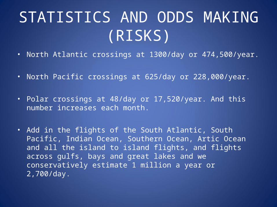
STATISTICS AND ODDS MAKING (RISKS)
• North Atlantic crossings at 1300/day or 474,500/year.
• North Pacific crossings at 625/day or 228,000/year.
• Polar crossings at 48/day or 17,520/year. And this number increases each month.
• Add in the flights of the South Atlantic, South Pacific, Indian Ocean, Southern Ocean, Artic Ocean and all the island to island flights, and flights across gulfs, bays and great lakes and we conservatively estimate 1 million a year or 2,700/day.

WE ARE FAILING OUR AIRCREWS
• Inadequate training for the scenario • No simulator scenarios• No exposure to emergency planning
documents• Little aircraft system knowledge for the
disaster• No teaching of modern ELT operations

SAR SATTELITE OVERVIEW
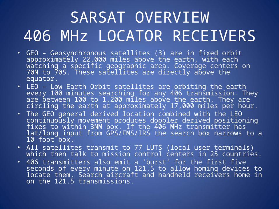
SARSAT OVERVIEW406 MHz LOCATOR RECEIVERS
• GEO – Geosynchronous satellites (3) are in fixed orbit approximately 22,000 miles above the earth, with each watching a specific geographic area. Coverage centers on 70N to 70S. These satellites are directly above the equator.
• LEO – Low Earth Orbit satellites are orbiting the earth every 100 minutes searching for any 406 transmission. They are between 100 to 1,200 miles above the earth. They are circling the earth at approximately 17,000 miles per hour.
• The GEO general derived location combined with the LEO continuously movement produces doppler derived positioning fixes to within 3NM box. If the 406 MHz transmitter has lat/long input from GPS/FMS/IRS the search box narrows to a 10 foot box.
• All satellites transmit to 77 LUTS (local user terminals) which then talk to mission control centers in 25 countries.
• 406 transmitters also emit a ‘burst’ for the first five seconds of every minute on 121.5 to allow homing devices to locate them. Search aircraft and handheld receivers home in on the 121.5 transmissions.

MARITIME ROLE IN SAR• The aviation website www.flightaware.com presents aircraft on IFR flight
plans. • Websites marinetraffic.com/ais and sailwx.com and AMVER present
oceanic traffic on the world map.• Rescue coordination centers around the world use the maritime websites
to coordinate for ‘at sea’ assistance and rescues.• Ships are obligated under maritime law to help other distressed vessels.• Ships are required to maintain ‘visual’ watch in accordance with Maritime
Law. So in theory there is always someone looking out ahead. Just in case you ever have to do a low altitude fly by (or glide by).
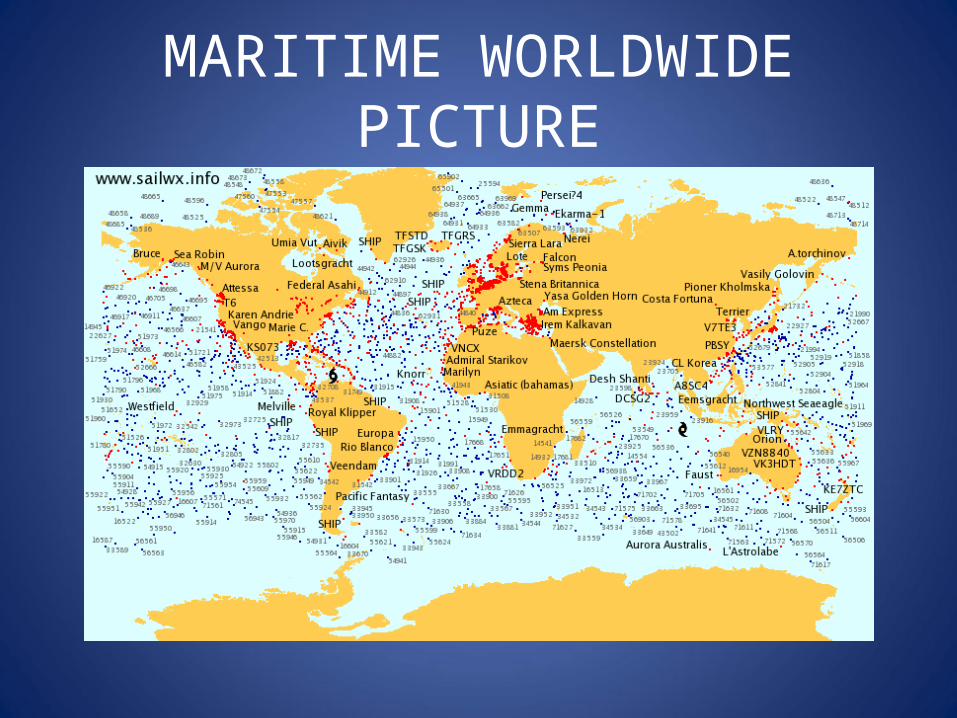
MARITIME WORLDWIDE PICTURE

DITCHING SELF STUDY(home or in the simulator)
Study your airframe• Driftdown speeds and do they change in the descent.• Driftdown distance and how will winds at altitude affect your ground distance.• Driftdown time. Crew and passengers and aircraft within radio range ALL need to
know your approximate landing time.• Configuration for glide. Would you use flaps, slats, or any other device.• What altitude block do you put down flaps and how do flaps change glide.• What systems produce power and what will be powered.
• TCAS/ AUTOPILOT/ HF RADIO/ VHF RADIO/PHONE/INTERCOM• How will you communicate in and out of the airframe.• How will you exploit aircraft systems to your advantage (trim for glide, use
autopilot if powered).• How long will battery power only last.• Altitude for start of APU/HMG/RAT and exactly what busses are powered.
• Chair fly an approach and touchdown on symmetrical swells and one for mixed chop.
• Chair fly (glide) a pattern to prepare for a ship on the water.

PRE-FLIGHT TASKS(like you don’t already have enough to do)
• Onboard equipment review.• Review SAR asset locations.• Segmented chart for First Turn Headings.• SAR center phone numbers.• Review with crew importance of not opening any exit until after the
aircraft float posture is established and OPEN commands are given. Make sure everyone knows what float posture means.
• Navy website data for ditching headings, swell heights, baro settings (see charts below).

ENROUTE CONCERNS AND TASKINGS
• A heading bug on charted ditching heading, and a standby altimeter set to charted QNH will give the crew the ‘best guess’ data in the event of a descent at night or in IMC.
• Hourly update heading bug to ditch headings taken off the charts.• Hourly update standby altimeter to baro setting.• Hourly update First Turn Heading (constant changing diversion field) using
segmented map of flight route.

DITCHING HEADINGS

SWELL HEIGHTS

BAROMETRIC PRESSURE
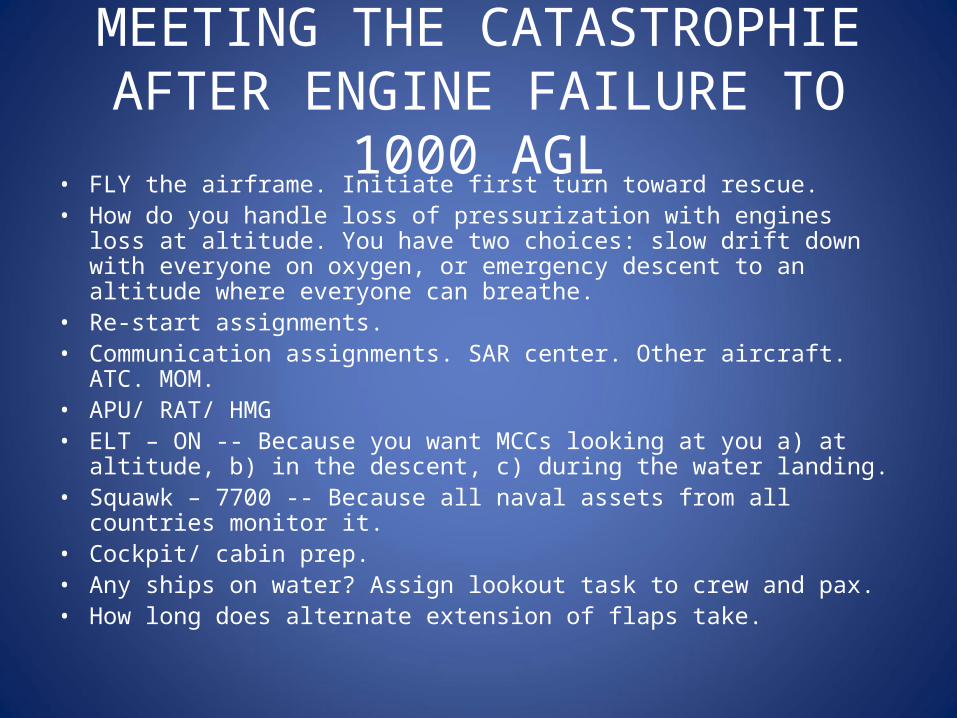
MEETING THE CATASTROPHIEAFTER ENGINE FAILURE TO 1000 AGL
• FLY the airframe. Initiate first turn toward rescue.• How do you handle loss of pressurization with engines loss at altitude.
You have two choices: slow drift down with everyone on oxygen, or emergency descent to an altitude where everyone can breathe.
• Re-start assignments.• Communication assignments. SAR center. Other aircraft. ATC. MOM.• APU/ RAT/ HMG• ELT – ON -- Because you want MCCs looking at you a) at altitude, b) in the
descent, c) during the water landing.• Squawk – 7700 -- Because all naval assets from all countries monitor it.• Cockpit/ cabin prep.• Any ships on water? Assign lookout task to crew and pax.• How long does alternate extension of flaps take.
THE LAST 100 FEET• Lessen glide ground speed by into wind if it fits with water conditions.• Wings level. Wings level. Especially if you have under wing engines as
today they are not engines, but water brakes.• Not too fast or you risk greater damage to the hull or skip.• Not too slow as you risk loss of elevator or rudder and thus control.• Top or back of swell is the best landing zone followed by the trough.• Prepare for brutalness of contact with any padding you can place around
knees and torso.• Don O2 mask and goggles.• Seats moved rearward (back) and belts locked.

DEEP WATER DITCHING SURVIVAL• Stay together if at all possible for a magnitude of reasons.• Signaling starts with you: mirrors, flares, sea dye marker, laser pointers,
smoke canisters, whistles.• Communication starts with you: aircraft radios on VHF, HF, data. Satellite
phones, handheld radios, cell phones.• Assignments to crew and pax: bailing, maintenance, water production and
allocation, food allocation, first aid, equipment, spiritual, entertainment.

WORLD WIDE SAR PHONESRCC Area of SAR Coordination Responsibility Phone Number
Atlantic Coordinator North Atlantic Ocean out to 40 west +1 757 398-6700
Pacific Coordinator Areas covered by Seattle, Honolulu and Juneau. +1 510 437-3700
RCC Miami Caribbean Sea. +1 305 415-6800
RCC Honolulu(operated as JRCC with DOD)
Hawaii, U.S. Pacific Islands and waters of Central Pacific Ocean +1 808 535-3333
Sector Guam(under RCC Honolulu) Western Pacific Ocean +1 671 355-4824
RCC Juneau North Pacific Ocean +1 907 463-2000
RCC Argentina Buenos AiresUshuaia
+54 1144 8024 86+54 2901 4310 98
RCC Australia Canberra +61 262 306811
RCC Chili SantiagoPunta Arenas
+56 25305 941+56 61202 161
RCC Fiji Suva +679 331 5380
RCC Mexico Mazatlan +52 669 985 3078
RCC New Zealand Lower Hutt +64 4577 8030
RCC South Africa Cape Town +27 2193 83300
RCC Tahiti Papeete +689 4624 32
RCC United Kingdom Falmouth +44 1326 317 575

VITAL READING AND WATCHING• Personal survival gear: www.equipped.org• Testimonial by Capt. Al Haynes:
http://clear-prop-org/aviation/haynes.html• Movie: Castaway with Tom Hanks (watch it with a survivalist’s eye)• Movie: The Life Of Pi• AF447 CVR/FDR:
www.popularmechanics.com/technology/aviation/crashes/what-really-happened-aboard-air-france-447-6611877
• Our Last Chance• Greatest Survival Stories Ever Told
SIMULATOR SCENARIOS #1• #1 Is a ‘Quick Ditch’ with an onboard fire.• Aircraft at maximum cruise altitude at 50°N/ 30°W on an Atlantic crossing;
or at 25°N/ 140°W on a Pacific crossing; or 80°N/ 40°W for a polar crossing; or 10°S/ 80°E for an Indian Ocean crossing. Day or night, IMC/VMC at operator's discretion.
• These scenarios are tailored for large aircraft but obviously can be tailored for any size operation.
• Players required are SO - simulator operator. CAPT - captain, FO - first officer, LFA - lead flight attendant or purser, OAV - other aircraft in vicinity, ATC -air traffic controller, PM - phone monitor who also sends/responds to data messages.

FINAL THOUGHTS
• Success or failure is determined by the pilot actions leading up to the last 30 seconds.
• Pilot actions are determined by preparation.
• NOT PLANNING IS PLANNING TO FAIL