2.1 aesthetics - san diego county, california · the reservation, just north of i-8. circular areas...
TRANSCRIPT

2.1 Aesthetics
December 2019 10212.0023
Campo Wind Project with Boulder Brush Facilities Draft Environmental Impact Report 2.1-1
2.1 Aesthetics
This section evaluates the potential changes to the existing aesthetic and visual characteristics of the Campo Wind Project with Boulder Brush Facilities (Project). The analysis is based on a review of existing resources, technical data, and applicable laws, regulations, and guidelines, as well as the Visual Resources Report for the Project (Appendix B), prepared in accordance with the County of San Diego (County) Report Format & Content Requirements – Visual Resources.
Comments received in response to the Notice of Preparation included concerns regarding flashing lights, light pollution, community character, degraded views, and visual impacts. These concerns are considered in the preparation of this section where applicable. A copy of the Notice of Preparation and comment letters received are included in Appendix A of this Environmental Impact Report (EIR).
The Project would involve construction and operation of a renewable wind energy generation facility and associated infrastructure to connect energy generated by the Project to the existing San Diego Gas & Electric Company (SDG&E) Sunrise Powerlink.
The Project consists of both the Campo Wind Facilities that would be located on land within the Campo Band of Diegueño Mission Indians Reservation (Reservation) Boundary under the jurisdiction of the Bureau of Indian Affairs (BIA) and the Boulder Brush Facilities that would be located on adjacent private lands within the Boulder Brush Boundary. The Campo Wind Facilities would be located within the approximately 2,200-acre Campo Corridor within the approximately 16,000 acres of Reservation land inside the Reservation Boundary while the Boulder Brush Facilities would be located within the approximately 320-acre Boulder Brush Corridor within the approximately 2,000 acres of Private Lease land inside the Boulder Brush Boundary adjacent to the northeast portion of the Reservation. Collectively, the Campo Corridor and the Boulder Brush Corridor compose the approximately 2,520-acre Project Site. The Project Area includes the land within the Reservation Boundary and the Boulder Brush Boundary.
Although the County as Lead Agency is analyzing the Project as a whole, the County’s land use jurisdiction is limited to the Boulder Brush Facilities. The Campo Wind Facilities are outside the County and state’s authority. The BIA has jurisdiction over the Campo Wind Facilities and has prepared an Environmental Impact Statement (EIS) to evaluate potential impacts under the National Environmental Policy Act (NEPA) (BIA 2019).

2.1 Aesthetics
December 2019 10212.0023
Campo Wind Project with Boulder Brush Facilities Draft Environmental Impact Report 2.1-2
2.1.1 Existing Conditions
2.1.1.1 Reservation Boundary
Lands within the Reservation Boundary include moderate to steep terrain atop a semiarid plateau, which is adjacent to the Laguna Mountains on the west and slopes descending to valleys to the east. Consisting of largely undeveloped high desert rolling hills, the Project Vicinity lies within a transitional region between the California Peninsular Ranges physiographic province (to the west) and the westernmost reach of the Colorado Desert (to the east).
Lands within the Reservation Boundary support a variety of habitat types and vegetation communities. For example, the valley terrain on the Reservation is dominated by coast live oak woodland, nonnative grassland, and southern willow scrub vegetation. Despite the diversity of vegetation within valleys, chamise chaparral and mixed chaparral that populate hilly and mountainous terrain dominate the area. Additionally, red shank chaparral, big sagebrush scrub, and upper Sonoran subshrub scrub are distributed throughout the Reservation. Various large rock-outcrops of light-colored boulders are also scattered throughout the Reservation and are regularly distributed along ridgelines.
Existing On-Reservation development includes the Kumeyaay Wind Farm, the Golden Acorn Casino and Travel Center, rural residences, tribal facilities, and paved and dirt access roads. The Kumeyaay Wind project is located On-Reservation, just north of Interstate 8 (I-8). This development consists of 25 regularly spaced wind turbines installed atop the Tecate Divide and a nearby electrical substation located north of I-8 and off Williams Road. Located immediately south of I-8 and west of the Tecate Divide, the Golden Acorn Casino and Travel Center occupies an approximately 40-acre site that includes separate large surface parking lots for passenger vehicles and semi-trailer trucks and a tall, single-story peach and off-white colored building (approximately 40 feet high) featuring an attached travel center/filling station. A tall, LED advertisement sign for the casino is installed to the south of I-8 and California Department of Transportation (Caltrans) right-of-way (ROW). A single, modern wind turbine is installed near the casino’s eastern semi-trailer truck surface parking lot.
Rural residences are scattered throughout the Reservation, both north and south of I-8, but tend to be concentrated within narrow valleys along Campo Road/State Route 94 (SR-94) and Church Road. In addition to residences, several Tribal facilities (including a two-story education center, single-story church, and health center housed in a tan concrete-masonry unity and red-tiled roof structure) are located off Church Road to the north of SR-94.

2.1 Aesthetics
December 2019 10212.0023
Campo Wind Project with Boulder Brush Facilities Draft Environmental Impact Report 2.1-3
Photographs of the Boulder Brush Boundary and surrounding area were taken and are referenced in Sections 2.1.1.2 and 2.1.1.3, below. The location of the referenced photographs are illustrated on Figure 2.1-1, Existing Conditions Photographs Key Map.
2.1.1.2 Boulder Brush Boundary
The majority of the private lands within the Boulder Brush Boundary are covered with scrubby shrubs and, occasionally, trees in moderate to dense stands and clusters. For example, montane buckwheat scrub consisting of generally low and mounded, green to greyish shrubs with small, seasonal white to rust-colored flower clusters is generally distributed throughout the approximately 2,000-acre area, with the exception of the herb, annual, and grass species on the wildflower field (field/pasture) mapped areas in the lower elevation on the western portions of the Boulder Brush Boundary. Soft and woody shrubs of the big sagebrush scrub community are common in central and southern portions of the Boulder Brush Boundary. Chaparral communities are commonplace throughout the central, southern, and eastern portions and consist of various low and tall shrubs. Small to house-sized granitic boulders are interspersed with low and tall chamise on rocky-sloped areas. Photographs depicting existing features within the Boulder Brush Boundary comprise Figure 2.1-2, Existing Conditions: Boulder Brush Boundary. Existing vegetation and boulder outcrops are depicted in Photos A, B, and C on Figure 2.1-2.
Limited visible development occurs and no structures are present in the southern, western, or eastern portions of lands comprising the Boulder Brush Boundary. There are also disturbed areas caused by off-highway vehicles.
The northern portion of the Boulder Brush Boundary is traversed in a general southeast-to-northwest alignment by the 500-kilovolt (kV) Sunrise Powerlink transmission line. Three approximately 170-foot-tall geometric lattice steel towers (CPUC and BLM 2008) are located in the northernmost portion of the Project Area. Two of the towers are located entirely within the Boundary Brush Boundary and the third is partially within the Boundary Brush Boundary. Metal post and wire fencing and signage posted on an approximately 5-foot-tall tubular steel gate installed at the northern terminus of Ribbonwood Road notes that “Off Road Activity [is] Prohibited.” Photographs of existing fencing and signage is captured in Photos B and D on Figure 2.1-2.
2.1.1.3 Surrounding Area
Land bordering the Project Area includes a mix of privately owned lands, public agency lands managed by the Bureau of Land Management (BLM), and Tribal lands of the Manzanita Band of Diegueño Mission Indians and the La Posta Band of Diegueño Mission Indians. The surrounding area, which includes the communities of Boulevard, Manzanita, and Live Oak Springs, can be characterized as a predominantly rural landscape featuring large-lot ranches and single-family homes with a mixture of recreational opportunities and vast areas of undeveloped lands. Recent

2.1 Aesthetics
December 2019 10212.0023
Campo Wind Project with Boulder Brush Facilities Draft Environmental Impact Report 2.1-4
renewable energy projects have resulted in a change to the physical setting that includes major infrastructure elements, such as wind turbines, transmission towers, and other related components, which are described below. I-8 bisects the Project Area through the Reservation. Photographs of the surrounding area are provided on Figure 2.1-3, Existing Conditions: Surrounding Area.
Renewable energy projects in the surrounding area include the Tule Wind project, the Kumeyaay Wind project, and the wind turbine for the Golden Acorn Casino. The SDG&E Sunrise Powerlink runs through the north end of the Boulder Brush Boundary and is supported by large steel lattice towers that dot the landscape. The Tule Wind project, which includes 57 wind turbines ranging from 328 feet to 492 feet in height, surrounds the Boulder Brush Boundary, spanning from the northwest to the east. The Kumeyaay Wind project follows a northwest-to-southeast alignment on the Reservation, just north of I-8. Circular areas of disturbance linked by dirt access roads associated with existing turbines of the Tule Wind and Kumeyaay Wind projects are visible on the aerial base map of Figure 1-3, Project Site Plan. The character of existing turbines is illustrated in Figure 2.1-3 (see Photos E, F, and H).
As discussed above, the surrounding area includes the communities of Boulevard, Manzanita and Live Oak Springs. Old Highway 80 runs through these communities and functions as the main street. Single-family residences and limited commercial businesses line Old Highway 80 from Boulevard north through Manzanita to Live Oak Springs. Large lot rural residential properties are located to the south of the Boulder Brush Boundary and these areas a typically characterized by single-family residences surrounded by areas of cleared vegetation and further, native scrub vegetation. Photos F and F on Figure 2.1-3 capture the character of existing residential properties near the Boulder Brush Boundary.
Lands surrounding the Boulder Brush Boundary include privately owned property, public lands managed by BLM, and Tribal lands. The BLM lands are identified in the Eastern San Diego County Resource Management Plan as the McCain Valley Recreation Management Zone. Most of the Tule Wind turbines are located on BLM lands identified in the Eastern San Diego County Resource Management Plan as “Lands Available for Wind Energy Development” (BLM 2008). As part of the greater Boulevard/Jacumba Destination Special Recreation Management Area, the McCain Valley Recreation Management Zone is managed to support multi-recreational activities, including hiking, camping, off-highway-vehicle riding, hunting, and horseback riding (BLM 2008). The McCain Valley Recreation Management Zone is also identified as a limited off-highway-vehicle (OHV) management area where OHV use is restricted at certain times, in certain areas, and/or to certain vehicular use (BLM 2008). The Lark Canyon OHV Area staging area is accessible off McCain Valley Road and is located 1.1 miles east of the Boulder Brush Boundary. Numerous narrow dirt trails for motorcycles and ATVs less than 40 inches wide branch and extend to the north, west, and south of the staging area; traverse nearby slopes and ridges; and connect to several loop trails that traverse the local ridge and valley terrain (DesertUSA 2019). According to the BLM, in Fiscal Year 2019 (i.e., October 1, 2018 through October 30, 2019), approximately

2.1 Aesthetics
December 2019 10212.0023
Campo Wind Project with Boulder Brush Facilities Draft Environmental Impact Report 2.1-5
4,500 persons visited the OHV Area (Williams 2019). With the exception of the OHV Area and campgrounds, BLM lands are largely unprogrammed (i.e., formal trails and trailheads are not provided). Regarding the Upper and Lower Lark Canyon Campgrounds that are adjacent to the OHV Area and accessible of McCain Valley Road, approximately 283 persons visited/used campgrounds in Fiscal Year 2019 (Williams 2019). The existing character of the Upper Lark Canyon Campground and adjacent development is captured in Photo H in Figure 2.1-3.
Within the McCain Valley Recreation Management Zone and to the east of the Project Site, BLM lands comprise the In-Ko-Pah Mountains Area of Critical Environmental Concern. Areas of Critical Environmental Concern are established to provide protection for relevant and important values, including special-status species, wildlife, scenic values, and significant cultural resources values (BLM 2008). The In-Ko-Pah Mountains Area of Critical Environmental Concern is specifically managed for biological and cultural values (BLM 2008). The Carrizo Gorge Wilderness is located approximately 2 miles east of the most northern portion of the Project Site. Use of wilderness areas is defined in the United States Code (USC) under the Wilderness Act of 1964 (16 USC 1131–1136), and certain uses, including temporary roads, motorized vehicles and other forms of mechanical transport, and structures or installation, are prohibited. Hiking and camping are permitted in the Carrizo Gorge Wilderness (BLM 2008).
Scenic Vistas
Although there are no designated scenic vistas or lookouts on the Reservation or in the Project Vicinity, the local landscape is bordered by mountainous terrain that may provide opportunities for elevated scenic views. Specifically, the In-Ko-Pah Mountains, Cuyamaca Mountains, and Laguna Mountains are located to the west; the In-Ko-Pah Mountains and Tierra Blanca Mountains are located to the north; and the In-Ko-Pah and Jacumba Mountains are located to the east. Prominent peaks in these ranges include Monument Peak (Laguna Mountains; 11.3 miles northwest of the Reservation), Sombrero Peak (Tierra Blanca Mountains; 7 miles north of the Reservation), and Mount Tule (In-Ko-Pah Mountains; 5 miles east of the Reservation). With the exception of the Monument Peak Trail (an approximately 2.8-mile moderately trafficked trail on United States Forest Service lands and accessible off Sunrise Highway), trails to these peaks experience a low volume of foot traffic relative to other more popular trails (i.e. Laguna Mountain) due to their remote locations, and lack of formal trailheads, staging areas, and information signage on nearby roads.
In regard to public roads, long and broad views toward the McCain Valley area and distant mountainous terrain in California and Mexico (including unnamed peaks) are available from I-8. However, these views are typically interrupted by road cuts (i.e., an engineered cut through terrain for purposes of road construction) and generally rising terrain located north of the interstate. Scenic views of local valleys and nearby chaparral and boulder covered terrain are also available from SR-94 on the Reservation and occasionally, from Old Highway 80, McCain Valley Road, and Ribbonwood Road.

2.1 Aesthetics
December 2019 10212.0023
Campo Wind Project with Boulder Brush Facilities Draft Environmental Impact Report 2.1-6
Scenic Highways
While state and local regulations pertaining to scenic highways are not applicable to tribal lands and the Reservation, they are applicable to private lands traversed by the Boulder Brush Facilities.
There are no official state designated highways in the Project viewshed. However, the majority of I-8 through San Diego County (including the segment east of the Tecate Divide to the San Diego/Imperial County border) and SR-94 (from SR-125 east to I-8 near Jacumba) are eligible state scenic highways and are components of the County Scenic Highway System (Caltrans 2018; County of San Diego 2011a). The On-Reservation gen-tie line spans I-8 near the Tecate Divide and the nearest segment of the Off-Reservation gen-tie line located approximately 2 miles north of I-8. The interstate also traverses the Reservation (see Figure 1-2 in Chapter 1 of this EIR) and the closest Project wind turbines within the Campo Corridor are located within 500 feet and 800 feet, respectively, of I-8. Near the Tecate Divide, the interstate is located approximately 1.15 mile southwest of private lands within the Boulder Brush Boundary.
Views to the north from I-8 near the Reservation are limited in length by mountain terrain that tends to rise abruptly to the north of the interstate; views to the south are typically long and occasionally extend to distant mountainous terrain in Mexico. Views to the Boulder Brush Boundary from I-8 are limited and generally obstructed by rising terrain including road cuts located to the north between the Tecate Divide and McCain Valley Road.
From SR-79 in Pine Valley and I-8 in Jacumba, Old Highway 80 is included on the County Scenic Highway System (County of San Diego 2011a). This segment of the highway traverses the Reservation and would be spanned by the On-Reservation gen-tie line (see Figure 1-2). Project wind turbines within the Campo Corridor would also be visible from the highway as it traverses the Reservation. The Off-Reservation gen-tie line (and generally, private lands within the Boulder Brush Boundary) would be screened from view of highway motorists by intervening terrain and vegetation.
Recreation Areas
Please refer to the discussion above regarding the recreational opportunities available on BLM-managed lands located to the east of the Reservation in the McCain Valley area.
While local regulations pertaining to scenic views available from state and local trail systems are not applicable to the Reservation, state and local trail systems are discussed in regard to the Reservation for purposes of disclosure in this EIR. No state trail systems are located near the Reservation. The nearest segment of the California Riding and Hiking Trail is located west of SR-79 and in Cuyamaca Rancho State Park, more than 18 miles northwest of the Reservation. Trail segments between Pine Valley and Mt Laguna are visually separated from the Reservation and McCain Valley by the Laguna and Cuyamaca Mountains.

2.1 Aesthetics
December 2019 10212.0023
Campo Wind Project with Boulder Brush Facilities Draft Environmental Impact Report 2.1-7
Two proposed trail facilities identified in the Boulevard Community Trails and Pathways Plan (County of San Diego 2005) are located north of I-8. Users of these trails would be provided views to the Boulder Brush Facilities and proposed wind turbines on the Reservation. Located on Ribbonwood Road, the Ribbonwood Road Pathway would extend north from the I-8 underpass for approximately 2 miles. Land uses adjacent to this segment of Ribbonwood Road include the U.S. Customs and Border Protection Boulevard Station (located approximately 0.15 miles north of I-8); scattered rural residential development; and primarily vacant, undeveloped land dotted with desert shrubs and occasional oak trees. The Ribbonwood Road Trail would extend north of the Ribbonwood Road Pathway and traverse existing dirt access roads and Lost Valley Road for approximately 4.4 miles. The trail alignment (and existing access roads) traverses the majority of the Boulder Brush Boundary from north to south, and joins McCain Valley Road near the northeastern corner of the Project Site. The northernmost section of the Ribbonwood Road Pathway is located 1.1 miles east of the Reservation Boundary and the Ribbonwood Road Trail (primarily located within the Boulder Brush Boundary) is spanned by the Off-Reservation gen-tie line.
Several trail alignments in the Boulevard Community Trails and Pathways Plan are depicted as crossing the southern portion of the Reservation. These facilities include the San Diego & Arizona Eastern Railway Trail, Shockey Truck Trail, and Shockey Loop Trail. The Campo Band of Diegueño Mission Indians (Tribe) is not required to dedicate ROW to the County for public trail use or provide public access across the Reservation via recreational trails. Therefore, the County has no land use authority to create or manage trails that traverse the Reservation. Despite this issue, those trails crossing the Reservation are identified for informational purposes only.
Several proposed trails and pathway identified in the Campo/Lake Morena Community Trails and Pathways Plan are located west of the Reservation. At this time, public ROW has not been established for the trail alignments. Due to proximity and the height of proposed wind turbines within the Reservation Boundary, future users of these trails (if public ROW is established) would be provided views to Campo Wind Facilities. Nearby proposed trails and pathways include the Shockey Truck Trail/San Diego & Arizona Eastern Connector Trail, Shockey Truck Trail Pathway, SR-94 Pathway, and San Diego & Arizona Eastern Rail Road Trail.
2.1.2 Regulatory Setting
2.1.2.1 Federal
Federal Aviation Administration
Federal Aviation Administration (FAA) Advisory Circular 70/7460-1L with Change 2states that “any temporary or permanent structure, including all appurtenances, that exceeds an overall height of 200 feet above ground level (AGL) should be marked or lighted” (FAA 2018). The tallest

2.1 Aesthetics
December 2019 10212.0023
Campo Wind Project with Boulder Brush Facilities Draft Environmental Impact Report 2.1-8
structures proposed on the Project Site (wind turbines measured from base to blade tip) would be over 200 feet and therefore would require the installation of obstruction lighting atop wind turbine nacelles. Not all Project wind turbines would be lighted. Both temporary and permanent meteorological (MET) towers greater than 200 feet AGL would also be installed on the Reservation and would also require obstruction lighting.
According to the FAA, all structures that are more than 499 feet AGL are designated as obstructions and must be evaluated by the FAA through an aeronautical study to determine the effects on navigable airspace.
Chapter 13 of FAA Advisory Circular 70/7460-1L with Change 2 is dedicated to marking and lighting wind turbine farms. Wind turbine farms are defined as wind turbine developments containing three or more turbines of heights more than 200 feet AGL. Chapter 13.5, Lighting Standards, contains the following general standards established for wind turbine farm lighting:
In most cases, not all wind turbine units within a wind turbine farm need to be lighted. Obstruction lights should be placed along the perimeter of the wind turbine farm so that there are no unlit separations or gaps more than 1/2 statute mile (sm) (804 m). Wind turbines within a grid or cluster should not have an unlighted separation or gap of more than 1 sm (1.6 km) across the interior of a grid or cluster of turbines. (Night wind turbine obstruction lighting should consist of the preferred FAA L-864 aviation red flashing, strobe, or pulsed obstruction lights. Studies have shown that red lights provide the most conspicuity to pilots.)
Daytime lighting of wind turbine farms is not required.
Light fixtures should be placed as high as possible on the turbine nacelle, so they are visible by a pilot approaching from any direction.
For linear turbine configurations, lights should be placed on each turbine positioned at each end of the line or string of turbines. Lights should also be placed along the line of turbines so that there is no more than a 1/2-sm (2,640-foot (805-m)) gap between the lighted turbines. In the event the gap between lights on the last segment of turbines is significantly short, it may be appropriate to move the lights on the turbine string back toward the starting point to present a well-balanced string of lights. High concentrations of lights should be avoided.
The following standards established in Chapter 13.6, Wind Turbines Above 499 Feet, are applicable to wind turbines above 499 feet but below 699 feet:
In addition to the lighting standards established in Chapter 13.5, the top of the turbine’s nacelle should be equipped with a second L-864 flashing red light.

2.1 Aesthetics
December 2019 10212.0023
Campo Wind Project with Boulder Brush Facilities Draft Environmental Impact Report 2.1-9
The two obstruction lights should be arranged horizontally, positioned on opposite sides of the nacelle, visible to a pilot approaching from any direction, and flash simultaneously. This lighting configuration ensures the turbines in this size category are always lighted.
In the event one of the two obstruction lights fails, no light failure notification is required; however, the light should be restored to service as soon as possible.
All turbines within this size category should be illuminated, regardless of their location within a wind turbine farm, and should be configured to flash simultaneously with the other turbines in the same farm. This requirement ensures the pilots operating at 500 feet AGL have sufficient warning that a wind turbine obstruction may be within their flight path.
The following standard established in Chapter 13.8, Lighting of Wind Turbines During Construction Phase, is applicable to the Campo Wind Facilities:
To ensure proper conspicuity of turbines at night during construction, all turbines should be lighted with temporary lighting once they reach a height of 200 feet (61 m) or greater until the permanent lighting configuration is turned on. As the structure’s height continues to increase, the temporary lighting should be relocated to the structure’s uppermost height. The temporary lighting may be turned off for short periods if they interfere with construction personnel. If practical, permanent obstruction lights should be installed and operated at each level as construction progresses. An L-810 steady burning red light shall be used to light the structure during the construction phase, if the permanent L-864 flashing-red lights are not in place. If power is not available, turbines should be lighted with a self-contained, solar-powered, LED, steady-burning red light that meets the photometric requirements of an FAA L-810 lighting system. The lights should be positioned to ensure a pilot has an unobstructed view of at least one light at each level. Using a NOTAM (D) to justify not lighting the turbines until the entire project is completed is prohibited.
2.1.2.2 State
State regulations are applicable to the Boulder Brush Facilities that are proposed to be located on private lands within the County. State regulations are not applicable to the Reservation.
California Scenic Highway System
There are no officially designated state scenic highways in the Project Vicinity. The nearest scenic highway, I-8, is an eligible state scenic highway from SR-67 to the eastern San Diego County border (Caltrans 2019). I-8 bisects the Reservation at and to the east and west of the Tecate Divide for a distance of approximately 2.6 miles. At its closest location, I-8 is located approximately 1.3 miles south of the Boulder Brush Boundary. Also, SR-94 is an eligible state scenic highway from SR-125 east to I-8 near Jacumba (Caltrans 2019). At its closest location, SR-94 is located approximately 2.9 miles south of the Boulder Brush Boundary.

2.1 Aesthetics
December 2019 10212.0023
Campo Wind Project with Boulder Brush Facilities Draft Environmental Impact Report 2.1-10
California State Historic Routes
Old Highway 80 is a designated California State Historic Route. In 2006, the state legislature granted this designation in recognition of the highway’s “outstanding natural, cultural, historic, and scenic qualities.” This designation does not influence the “future planning or development of adjacent public and private properties” (Assembly Concurrent Resolution 123 (State of California Legislature 2006)). South of I-8, Old Highway 80 traverses the Reservation southeast–northwest.
2.1.2.3 Local
Local regulations are applicable to the Boulder Bush Facilities are located on private land within the County. Local regulations are not applicable to the Reservation.
San Diego County General Plan
The San Diego County General Plan, through elements established to address the various issues accompanying planning and development, provides guidance for the protection of visual resources. Select policies within the Land Use, Mobility, and Conservation and Open Space Elements of the General Plan (County of San Diego 2011a) address the protection of existing visual character and quality of areas, and contain general direction regarding the minimization of adverse impacts to visual resources. Policies from the remaining elements of the San Diego County General Plan were not considered applicable since they do not concern the protection of visual resources.
The following goals and policies of the Land Use (LU), Mobility (M), and Conservation and Open Space (COS) Elements concern the preservation of visual and scenic resources (County of San Diego 2011a) and are applicable to the Project:
Goal LU-2: Maintenance of the County’s Rural Character. Conservation and enhancement of the unincorporated County’s varied communities, rural setting, and character.
o Policy LU-2.8: Mitigation of Development Impacts. Require measures that minimize significant impacts to surrounding areas from uses or operations that cause excessive noise, vibrations, dust, odor, aesthetic impairment and/or are detrimental to human health and safety.
o Policy LU-2.9: Maintaining Rural Character. Consider level of service criteria, in accordance with Policy M-2.1, to determine whether adding lanes to a Mobility Element road would adversely impact the rural character of a community or cause significant environmental impacts. In those instances, consider other options to mitigate LOS [level of service] where appropriate.

2.1 Aesthetics
December 2019 10212.0023
Campo Wind Project with Boulder Brush Facilities Draft Environmental Impact Report 2.1-11
Goal LU-6: Development – Environmental Balance. A built environment in balance with the natural environment, scarce resources, natural hazards, and the unique local character of individual communities.
o Policy LU-6.6: Integration of Natural Features into Project Design. Require incorporation of natural features (including mature oaks, indigenous trees, and rock formations) into proposed development and require avoidance of sensitive environmental resources.
o Policy LU-6.9: Development Conformance with Topography. Require development to conform to the natural topography to limit grading; incorporate and not significantly alter the dominant physical characteristics of a site; and to utilize natural drainage and topography in conveying stormwater to the maximum extent practicable.
o Policy LU-10.2: Development – Environmental Resource Relationship. Require development in Semi-Rural and Rural areas to respect and conserve the unique natural features and rural character, and avoid sensitive or intact environmental resources and hazard areas.
o Policy LU-11.2: Compatibility with Community Character. Require that commercial, office, and industrial development be located, scaled, and designed to be compatible with the unique character of the community.
o Policy LU-12.4: Planning for Compatibility. Plan and site infrastructure for public utilities and public facilities in a manner compatible with community character, minimize visual and environmental impacts, and whenever feasible, locate any facilities and supporting infrastructure outside preserve areas. Require context sensitive Mobility Element road design that is compatible with community character and minimizes visual and environmental impacts; for Mobility Element roads identified in Table M-4, an LOS D or better may not be achieved.
o Policy M-4.5: Context Sensitive Road Design. Design and construct roads that are compatible with the local terrain and the uses, scale and pattern of the surrounding development. Provide wildlife crossings in road design and construction where it would minimize impacts in wildlife corridors.
o Policy COS-11.1: Protection of Scenic Resources. Require the protection of scenic highways, corridors, regionally significant scenic vistas, and natural features, including prominent ridgelines, dominant landforms, reservoirs, and scenic landscapes.
o Policy COS‐11.2: Scenic Resource Connections. Promote the connection of regionally significant natural features, designated historic landmarks, and points of regional historic, visual, and cultural interest via designated scenic corridors, such as scenic highways and regional trails.

2.1 Aesthetics
December 2019 10212.0023
Campo Wind Project with Boulder Brush Facilities Draft Environmental Impact Report 2.1-12
o Policy COS-11.3: Development Siting and Design. Require development within visually sensitive areas to minimize visual impacts and to preserve unique or special visual features, particularly in rural areas, through the following:
Creative site planning;
Integration of natural features into the project;
Appropriate scale, materials, and design to complement the surrounding natural landscape;
Minimal disturbance of topography;
Clustering of development so as to preserve a balance of open space vistas, natural features, and community character; and
Creation of contiguous open space networks.
o Policy COS-11.7: Underground Utilities. Require new development to place utilities underground and encourage “undergrounding” in existing development to maintain viewsheds, reduce hazards associated with hanging lines and utility poles, and to keep pace with current and future technologies.
o Policy COS‐12.1: Hillside and Ridgeline Development Density. Protect undeveloped ridgelines and steep hillsides by maintaining semi‐rural or rural designations on these areas.
o Policy COS‐12.2: Development Location on Ridges. Require development to preserve the physical features by being located down and away from ridgelines so that structures are not silhouetted against the sky.
o Policy COS-13.1: Restrict Light and Glare. Restrict outdoor light and glare from development projects in Semi‐Rural and Rural Lands and designated rural communities to retain the quality of night skies by minimizing light pollution.
o Policy COS-13.2: Palomar and Mount Laguna. Minimize, to the maximum extent feasible, the impact of development on the dark skies surrounding Palomar and Mount Laguna observatories to maintain dark skies which are vital to these two world‐class observatories by restricting exterior light sources within the impact areas of the observatories.
In addition to goals and policies, the General Plan Conservation and Open Space Element establishes a San Diego County Scenic Highway System that is composed of scenic corridors that includes County roads, state routes, and interstate freeways. Within the Project Area, I-8, SR-94, and Old Highway 80 are included within the County Scenic Highway System (County of San Diego 2011c).

2.1 Aesthetics
December 2019 10212.0023
Campo Wind Project with Boulder Brush Facilities Draft Environmental Impact Report 2.1-13
Mountain Empire Subregional Plan
The Boulder Brush Corridor is located within the Mountain Empire Subregion of the County of San Diego. The Mountain Empire Subregional Plan (County of San Diego 2011b) contains policies that concern the protection of visual resources and thus are applicable to the Boulder Brush Facilities. The following goals, policies, and recommendations established in the subregional plan are relevant to the Boulder Brush Facilities:
Land Use – General Goal (Policy and Recommendation 1): The landforms of the Subregion are an important environmental resource that should be respected in new development. Hillside grading shall be minimized and designed to blend in with the existing natural contours.
Land Use – General Goal (Policy and Recommendation 2): New industrial development should be clean, non-polluting, and complementary to a rural area.
Land Use – General Goal (Policy and Recommendation 5): New industrial development should consider all views into the property from public streets, adjacent properties, and residences on nearby hills.
Conservation – Environmental Resources (Policy and Recommendation 4): The dark night sky is a significant resource for the Subregion and appropriate steps shall be taken to preserve it.
Conservation – Environmental Resources (Policy and Recommendation 6): Development shall not adversely affect the habitat of sensitive plant and wildlife species or those areas of significant scenic value.
Boulevard Community Plan
The Mountain Empire Subregion is further separated into distinct community planning areas and lands within the Boulder Brush Boundary are located in the Boulevard Community Plan area (County of San Diego 2011c). Policies of the Boulevard Community Plan that concern visual resources and Boulder Brush Facilities include Policy LU1.1.2 (encourage development to protect visual resources and are relevant to the Boulder Brush Facilities including the following:
Policy LU 1.1.2: Encourage development to protect the quality and quantity of ground and surface water resources, air quality, dark skies, visual resources, and low ambient noise levels, as well as retain and protect the existing natural and historic features characteristic of the community’s landscape and natural environment.
Policy LU 1.1.3: Encourage development to respectfully incorporate existing topography and landforms, watersheds, riparian areas, oaks, and other native vegetation and wildlife, ridgelines, historic and cultural resources, views, and sustainability design factors.
2.1 Aesthetics
December 2019 10212.0023
Campo Wind Project with Boulder Brush Facilities Draft Environmental Impact Report 2.1-14
Policy LU 1.1.4: Require commercial and public development along scenic and historic routes to apply designs standards that will blend the development in with the terrain and rustic south western nature of the community character, while keeping outdoor lighting to an absolute and well shielded minimum.
Policy LU 3.1.1: Encourage development to preserve dark skies with reduced lighting and increased shielding requirements.
Policy LU 6.1.1: Require commercial, industrial development and large-scale energy generation projects to mitigate adverse impacts to the rural community character, charm, quiet ambiance and life-style, or the natural resources, wildlife, and dark skies of Boulevard, if feasible, in accordance with the California Environmental Quality Act.
Policy LU 6.1.2: Encourage commercial, industrial development and large scale energy generation projects to create and maintain adequate buffers between residential areas and incompatible activities that create heavy traffic, noise, infrasonic vibrations, lighting, odors, dust and unsightly views and impacts to groundwater quality and quantity.
Policy LU 6.1.3: Encourage commercial, industrial development and large-scale energy generation projects to provide buffers from public roads, adjacent and surrounding properties and residences, recreational areas, and trails.
The Boulevard Community Plan area does not have established design guidelines.
Boulevard Community Trails and Pathways Plan
According to the Boulevard Community Trails and Pathways Plan (County of San Diego 2009a), a community pathway is proposed on Ribbonwood Road and a community trail is proposed on a private road that extends north of Ribbonwood Road to the east of the Reservation and north of I-8. South of I-8, four community trails are proposed that would traverse or border the Reservation. While these trails are proposed, they typically would traverse private lands for which the County has yet to acquire public ROW to establish public-use trails. The nearest community pathways and trails to the Reservation and Boulder Brush Boundary include the following:
Proposed Ribbonwood Road Pathway (parallels Ribbonwood Road from I-8 north and is located east of the Reservation; approximately 2.2 miles in length)
Proposed Ribbonwood Trail (extends from the terminus of the proposed Ribbonwood Road Pathway north across the Boulder Brush Boundary); approximately 4.4 miles in length and the Off-Reservation gen-tie line spans the proposed trail alignment).
Proposed San Diego & Arizona Eastern Railway Trail (parallels the San Diego & Arizona Eastern Railway ROW that is bordered by the Reservation; approximately 13 miles in length)

2.1 Aesthetics
December 2019 10212.0023
Campo Wind Project with Boulder Brush Facilities Draft Environmental Impact Report 2.1-15
Proposed Tierra Del Sol Trail (follows Tierra Del Sol Road and terminates the southeastern corner of the Reservation; approximately 4.8 miles in length)
Proposed Shockey Truck Trail (parallels Tierra Del Sol Road which parallels the southern boundary of the Reservation; approximately 2.9 miles in length)
Proposed Shockey Loop Trail (extends north and west from the Shockey Truck Trail across two areas of the Reservation; approximately 2.55 miles in length)
Campo/Lake Morena Community Trails and Pathways Plan
The nearest community pathway and trails identified in the Campo/Lake Morena Community Trails and Pathways Plan (County of San Diego 2009b) are located south of the I-8 and west of the Reservation. These pathways and trails include:
Proposed San Diego & Arizona Eastern Road Trail
Proposed SR-94 Pathway
Proposed Shockey Truck Trail/San Diego & Arizona Eastern Railroad Connector Trail
Proposed Shockey Truck Trail Pathway
Proposed Shockey Truck Trail
San Diego Light Pollution Code
The Light Pollution Code was developed by the County of San Diego Department of Planning & Development Services and Department of Public Works in cooperation with lighting engineers, astronomers, and land use planners from SDG&E, Palomar and Mount Laguna Observatories, and local planning and sponsor groups to address and minimize the impact of new sources of light pollution on night views.
For purposes of lighting requirements, the Light Pollution Code separates the unincorporated portion of San Diego County into two zones: Zone A and Zone B. Zone A includes all unincorporated lands located within a 15-mile radius of the Palomar or the Mount Laguna Observatory, and Zone B includes all areas not included in Zone A. Section 59.105 of the Light Pollution Code includes general lighting requirements applicable to all unincorporated lands in San Diego County, and Section 59.106 includes shielding requirements per fixture by lighting type (i.e., outdoor lighting used for outdoor sales, eating areas, or advertisements (Class I); security lighting (Class II); and decorative lighting (Class III)) and according to location (Zone A or B).

2.1 Aesthetics
December 2019 10212.0023
Campo Wind Project with Boulder Brush Facilities Draft Environmental Impact Report 2.1-16
Because the Mount Laguna Observatory is located within 15 miles of the Project Site, the Project is located in Zone A (San Diego County Code of Regulatory Ordinances, Title 5, Chapter 2, Light Pollution).
The Campo Wind Facilities are not subject to the County’s Light Pollution Code.
2.1.3 Analysis of Project Effects and Determination of Significance
The Campo Wind Facilities would be located on Reservation lands that are administered under the jurisdiction of the BIA. The Boulder Brush Facilities would be located on private lands under the jurisdiction of the County, the California Environmental Quality Act (CEQA) Lead Agency.
For the purposes of this EIR, inventory and analysis of visual resources was conducted using a hybrid evaluation methodology, combining elements of federally adopted guidelines including those provided by Federal Highway Administration, the Bureau of Land Management Visual Resources Manual, and the United States Forest Services Scenery Management System. Additional information about the inventory and analysis is provided in the Visual Resources Report (Appendix B). However, no jurisdictional authority beyond that of the BIA should be inferred for the Campo Wind Facilities.
As previously stated, the Boulder Brush Facilities are subject to a MUP from the County. Therefore, the analysis included herein was conducted in accordance with the County’s Report Format and Content Requirements for Visual Resources (County of San Diego 2007a) and for Dark Skies and Glare (County of San Diego 2007b).
Methodology and Assumptions
The assessment process began with preparation of a Project viewshed analysis. The limits of a viewshed are defined as the potential visual limits of available views to a particular project and is primarily based on topography and the height of prominent project features. Included within the viewshed are vantage points and the locations of viewers that are likely to be affected by visual changes brought about by specific referenced project features. The screening effects of intermediate vegetation and structures at specific vantage points are rarely referenced or included in viewshed analyses.
Although the County as Lead Agency is analyzing the Project as a whole, the County’s land use jurisdiction for the Project is limited to the Boulder Brush Facilities. The BIA has sole jurisdiction over the Campo Wind Facilities and has also prepared an EIS to evaluate Project effects. This analysis hereby adopts, and incorporates by reference, the EIS. The analysis herein addresses the Campo Wind Facilities and Boulder Brush Facilities collectively, as the viewshed includes the entire Project Site and the Project Vicinity. Further, Project elements would be visible from both On- and Off-Reservation vantage points; as such, an analysis of the Campo Wind Facilities and Boulder Brush Facilities is provided in Sections 2.1.3.1 through 2.1.3.5.
2.1 Aesthetics
December 2019 10212.0023
Campo Wind Project with Boulder Brush Facilities Draft Environmental Impact Report 2.1-17
Shadow flicker is a term used to describe the flickering of shadows that are cast by a wind turbine’s rotating blades when the sun is behind them. It is caused when the rotor of the turbine is between the observer and the sun, and generally occurs during the morning or evening hours when the sun is low in the sky (AWS 2019). There are no federal, state or local regulations applicable to shadow flicker. Although the County does not have local regulations pertaining to shadow flicker, a shadow flicker analysis was conducted by AWS Truepower LLC to analyze potential shadow flicker effects from turbines associated with the Campo Wind Facilities (Appendix O, Shadow Flicker Analysis). There are no regulations under CEQA applicable to shadow flicker; however, shadow flicker is included in the discussion below to address concerns raised in response to the Notice of Preparation for the Project.
Site Observations
Visual fieldwork was conducted in the Project Vicinity on July 20, 2018. Winds were mild, and local conditions were sunny and clear. Digital photographs were taken with a location-services-enabled iPhone 6s to photodocument the characteristics of the Project Vicinity. Photographs were also taken to capture views from public vantage points to the Project Site, and for use as baseline images in visual simulations. Photographs were primarily taken from public roads in the Project Vicinity at On- and Off-Reservation locations.
Project Viewshed
The Project viewshed is defined by the presence of steep mountainous terrain to the northwest, north, and northeast more moderate hilly and valley terrain to the east and west of the Reservation, and by the scale of proposed wind turbines (approximately 586 feet tall from tower base to fully extended blade tip) within the Campo Corridor. Wind turbines are proposed throughout the Reservation within the Campo Corridor, but are concentrated in the central and southern areas (i.e., south of I-8) on higher-elevation slopes and ridges. Relative to the Campo Wind Facilities, the Boulder Brush Facilities would have a noticeably smaller viewshed due to the proposed scale of the tallest components (i.e., 150-foot tall gen-tie line poles).
A topographic viewshed of the Project is presented in Figure 2.1-4, Modeled Topographic Viewshed Analysis: Campo Wind Facilities. The figure illustrates the approximate viewshed of the Project and is solely based on topography in the Project Vicinity and the height of proposed wind turbines within the Campo Corridor. The figure represents the potential extent of the available views to prominent Campo Wind Facilities (i.e., wind turbines) from the Project Vicinity and is representative of the worst-case scenario regarding Project visibility. The potential extent of available views to prominent components of the Boulder Brush Facilities, gen-tie line poles, is illustrated in Figure 2.1-5, Modeled Topographic Viewshed Analysis: Boulder Brush Facilities. Potential screening effects at specific locations or viewpoints due to vegetation and/or structures are not considered or reflected on Figures 2.1-4 and 2.1-5.
2.1 Aesthetics
December 2019 10212.0023
Campo Wind Project with Boulder Brush Facilities Draft Environmental Impact Report 2.1-18
Generally, the presence of hill and valley terrain bordered by mountains and ridges within the Project Vicinity creates opportunities for elevated vantage points and occasionally, long and broad views from peaks and public roads. The Project Vicinity is bound by the Laguna Mountains to the west and the distant In-Ko-Pah and Jacumba Mountains to the east and north.
Due to the presence of prominent ridgelines, hills and mountains, and typically low desert shrub vegetation, vertical elements including existing wind turbines and transmission line support structures that extend above the horizon line are visible from long distances. In these instances and in clear visual conditions, motorists and recreationists may be able to readily discern silhouetted wind turbines that extend above the horizon line for distances approaching 5 miles or greater. Vertical features that do not extend above the horizon line are generally not visually prominent and are better able to blend into the landscape. This blending ability is increased with similar colors and/or semi-transparent, latticed forms and lines.
Existing development in the viewshed includes wind turbines (Kumeyaay Wind project and Tule Wind project), I-8, state highways and local roads, rural residences, high-voltage transmission infrastructure and electrical substations, limited commercial, health, institutional and casino development, and ranch lands. Abandoned homes and structures are also located in the Project viewshed. As depicted on Figures 2.1-4 and 2.1-5, views to the Project from more distant locations to the east of the Project Site are not available. More specifically, views to the Project Site from locations to the east and north of the Jacumba Valley are obscured by the In-Ko-Pah and Jacumba Mountains. Terrain to the north (In-Ko-Pah Mountains) and northeast (Laguna Mountains) defines the topographical extent of the viewshed to these areas. A 10-mile-radius area on the Reservation is depicted in Figure 2.1-4 as it presents a reasonable limit to the depiction of the viewshed. Views in excess of 10 miles are generally considered distant and specific visual elements located 10 miles or greater away would be difficult to discern clearly.
Key Observation Points
Analyzing all the views in which the proposed project would be seen is not feasible. Key observation points (KOPs) were selected as representative vantage points in the landscape that offer sensitive receptors views to the Project Site. A total of twelve KOPs were selected from which to evaluate changes to existing views, visual character, and visual quality resulting from implementation of the Project. As shown on Figure 2.1-6, Key Observation Points – Campo Wind Facilities, nine KOPs were selected for the Campo Wind Facilities. Three KOPs were selected for the Boulder Brush Facilities (see Figure 2.1-7, Key Observation Points – Boulder Brush Facilities). The KOPs are representative of views to the Project Site from public roads in the Project Vicinity. Lastly, and consistent with County requirements, the KOPs were selected because they would clearly illustrate the visual effects of the various Project components.

2.1 Aesthetics
December 2019 10212.0023
Campo Wind Project with Boulder Brush Facilities Draft Environmental Impact Report 2.1-19
Although KOPs were not established on private property, the KOPs are representative of viewing angles and distances available to viewer groups (including residences) in the Project Vicinity. KOPs were not established on mountain trails or peaks in the surrounding area because these areas are assumed to receive relatively low use. In addition, the selection of public roads as KOPs is appropriate because motorists represent the largest viewer group in the Project viewshed. Although KOPs were not located within the Lark Canyon OHV area or lesser trafficked recreation lands near the Boulder Brush Boundary due to the relatively low use, KOP 12 (McCain Valley Road) is located on BLM-administered lands and approximately within 1 mile of the proposed switchyard and high-voltage substation. In addition, a publically curated online trail forum/application identifies McCain Valley Road as a moderately trafficked (and publically reviewed) OHV trail (alltrails.com 2019). Thus, OHV use of McCain Valley Road is assumed for purposes of this analysis. Also, visual simulations were not prepared from the OHV area or lesser-trafficked recreation lands near the Boulder Brush Boundary; however, potential aesthetics impacts to the views of public land recreationists are assessed in this section (see Section 2.1.3).
KOP number, location, and view orientation to Project components are listed in Table 2.1-1, Key Observation Points, and are discussed below.
Visual Assessment
Visual character is qualitatively described by four primary components: form, line, color, and texture. Projects that create a high level of contrast with existing visual character of a project setting are more likely to generate significant visual impacts due to visual incompatibility. Conversely, projects that create a low level of contrast with existing visual character are less likely to generate significant visual impacts due to inherent visual compatibility. Campo Wind Facilities and Boulder Brush Facilities and related physical effects to the landscape are evaluated on this basis for impact analysis purposes. The visual assessment includes a descriptive inventory of existing landscape conditions as viewed from KOPs and an analysis of visual change associated with Project implementation. The existing visual conditions, and anticipated changes to visual character and quality, associated with proposed development as viewed from the selected KOPs is provided below.
KOP 1
KOP 1 is located on eastbound I-8 and is situated approximately 0.7 miles west of the Reservation Boundary and 0.8 miles west of Crestwood Road. Consistent vehicular traffic passes this KOP daily and existing Kumeyaay Wind project wind turbines are visible from this east-southeast-oriented KOP. While only one existing three-blade rotor wind turbine is visible in the east-southeast-oriented view captured at KOP 1 (the wind turbine is installed at the Golden Acorn Casino’s eastern parking lot; see Figure 2.1-8, Key Observation Point 1), the tower and/or blades

2.1 Aesthetics
December 2019 10212.0023
Campo Wind Project with Boulder Brush Facilities Draft Environmental Impact Report 2.1-20
of approximately 20 additional existing wind turbines atop the Tecate Divide to the north of the interstate are visible to motorists at KOP 1. The landscape to the southeast consists of rugged shrub and boulder-covered hill and valley terrain that supports scattered rural residential development and ranches. Undeveloped lands are also located to the southeast of KOP 1. In addition, electrical lines supported by thin and tall wood and steel poles traverse the landscape south of the interstate. The available view to the southeast is long and extends to the hazy and greyish silhouette of low, distant mountains in Mexico.
KOP 2
KOP 2 is located on eastbound SR-94 and is just within the western boundary of the Reservation. Intermittent vehicular traffic passes this KOP each day. View orientation is to the east toward a rugged, chaparral and boulder-covered slope that creates an elevated, slightly undulating ridgeline (see Figure 2.1-9, Key Observation Point 2). In the foreground, asphalt surface of SR-94 creates a winding line that disappears behind terrain and vegetation and then cuts an ascending, diagonal line in the distance. In addition to the highway, visible developments include simple post and rail fencing, highway signage, a single distribution line and wood support poles, and a dirt road. The length of the view is short, extending approximately 1.2 miles east to the visible ridgeline. Existing Kumeyaay Wind project wind turbines are not visible from KOP 2.
KOP 3
KOP 3 is located approximately 575 feet north of SR-94 and looks west-northwest from northbound Church Road toward the On-Reservation Campo Education Center (see Figure 2.1-10, Key Observation Point 3). KOP 3 is representative of views available to Church Road motorists as it winds through the narrow valley landscape between SR-94 to the south and Old Highway 80 to the north. In addition to the tan-red tones displayed by the administration center buildings, an existing greyish single-story structure is visible along Church Road and an electrical distribution line supported by thin wood poles spans the road. While not visible in the KOP 3 photograph, residences and additional tribal facilities including a small church and health center housed in a tan concrete masonry unit structure are located to the north and northeast of KOP 3.
As experienced from KOP 3, the local terrain falls west of Church Road and is partially cleared and/or thinned of vegetation. Several large trees with dense, green spherical crowns is located west and north of the education center. Oak trees are also present along the Church Road corridor. In the distance, the local terrain rises and forms a series of mounded hills that are covered with chaparral vegetation intermixed with light-colored boulders. Existing Kumeyaay Wind project wind turbines are not visible from KOP 3.

2.1 Aesthetics
December 2019 10212.0023
Campo Wind Project with Boulder Brush Facilities Draft Environmental Impact Report 2.1-21
KOP 4
KOP 4 is located at the same location as KOP 3 however; the view at KOP 4 is oriented to the west/southwest toward SR-94 and a rugged ridgeline. From KOP 4 (see Figure 2.1-11, Key Observation Point 4), the view encompasses Church Road and the Church Road/SR-94 intersection and extends across a shrub and oak tree dotted valley landscape bordered toward a low, chaparral and boulder covered ridgeline. Visible vegetation includes gold hued grasses, drab toned desert shrubs, and smooth, dark green toned chaparral shrubs and oak trees. Two lightly colored, single-story structures are visible on the valley terrain to the south but these elements are easily overlooked due to their low-profile and low, simple lines. Existing Kumeyaay Wind project wind turbines are not visible from KOP 4.
KOP 5
KOP 5 is located on westbound SR-94 at the SR-94/Live Oak Springs intersection, approximately 0.6 mile from western Reservation Boundary. The view from KOP 5 is to the west from the highway across private ranchlands located within a narrow valley (i.e., Hill Valley). Further, the KOP 5 view extends across the low valley terrain and toward a low, east-facing slope along the eastern Reservation Boundary (see Figure 2.1-12, Key Observation Point 5). In the foreground, a north–south line of trees notes the presence of a local drainage. Higher-elevation areas on the east-facing slope are covered with dense chaparral vegetation and dotted with light colored boulders. Intermittent vehicular traffic passes this KOP each day and existing Kumeyaay Wind project wind turbines are not visible from KOP 5.
KOP 6
KOP 6 is located off Tierra del Sol Road, approximately 0.15 miles south of Shasta Way, on unincorporated County lands in the Boulevard Subregional Group Area. As depicted on Figure 2.1-13, Key Observation Point 6, the view at KOP 6 looks to the north-northwest across a series of slightly rolling chaparral-covered hills to prominent On-Reservation rocky ridges and darker, somewhat subdued ridgelines in the Project Vicinity. For example, the Tecate Divide is indistinct in the northward view but is marked by existing wind turbines of the Kumeyaay Wind project. While faint and located low in the landscape relative to wind turbines of the Kumeyaay Wind project, the existing wind turbine installed at the Golden Acorn Casino eastern parking lot creates a thin, white line and is visible from KOP 6. Distant mountain terrain including the In-Ko-Pah Mountains and Laguna Mountains is visible and creates rugged, dark forms in the distance.

2.1 Aesthetics
December 2019 10212.0023
Campo Wind Project with Boulder Brush Facilities Draft Environmental Impact Report 2.1-22
KOP 7
KOP 7 is located at the intersection of Tierra Real Lane and Tierra Real Road, near scattered rural residential development in the unincorporated community of Tierra Del Sol. The view looks west down Tierra Real Lane and across private, primarily undeveloped ranchlands and is represented of westward views available to rural residential properties across the southern portion of the Reservation. The dense, chaparral covered terrain of the Reservation is located approximately 1 mile away (see Figure 2.1-14, Key Observation Point 7). Limited development is visible in the view and primarily consists of the tan, graded dirt surface of Tierra Real Lane, aged fencing in the foreground, and cylindrical metal silos on private property to the southwest. The view is long and stretches to distant, dark ridgelines of mountains in Mexico. Existing Kumeyaay Wind project wind turbines are visible from KOP 7.
KOP 8
KOP 8 is located off the westbound lanes of I-8, approximately 0.35 miles from the Tecate Divide and the On-Reservation Live Oak Trail/Manzanita Road interstate underpass. The view looks northwest along the I-8 corridor toward existing wind turbines of the Kumeyaay Wind project atop the Tecate Divide (see Figure 2.1-15, Key Observation Point 8). From KOP 8, the local terrain generally falls east of the interstate and is densely covered with olive colored chaparral shrubs. Boulder outcrops are visible on slopes and ridges to the north. With the exception of distant mountains that are framed by mounded terrain and the extents of the photograph, the view is short and is limited to the foreground. The towers and/or blades of approximately 15 wind turbines atop the Tecate Divide are visible at KOP 8 and the prominence of these features increases with proximity. Lastly, as shown in the photograph, the westbound travel lanes are located at a lower elevation that the eastbound travel lanes and are separated by metallic highway guardrail and shrub-dotted slope (see Figure 2.1-15).
KOP 9
KOP 9 is located off the dirt segment of Ribbonwood Road, approximately 0.85 miles north of Opalocka Road, on unincorporated County of San Diego lands (see Figure 2.1-16, Key Observation Point 9). In addition, KOP 9 is located 1.1 miles east of the Reservation Boundary and looks west across a visibly modified McCain Valley landscape and primarily horizontal ridgeline. Fencing and low shrubs dominate the immediate foreground of the view and the seemingly smooth, tan surface of cleared areas to the west creates noticeable color contrast with adjacent green tones. Isolated rural residential development is detectable in the view and displays light colors that stand out when viewed alongside the characteristic vegetation of the area. The boulder and chaparral covered ridgeline is topped by wind turbines of the Kumeyaay Wind Farm. The lines displayed by towers and blades are visible but tend to be washed out in the KOP 9 photograph (see Figure 2.1-16).
2.1 Aesthetics
December 2019 10212.0023
Campo Wind Project with Boulder Brush Facilities Draft Environmental Impact Report 2.1-23
KOP 10
KOP 1 is situated on westbound I-8, approximately 0.4 mile southeast of the Tecate Divide and 1.9 miles from the SR-94/Campo/Boulevard exit (Exit 65). The view from the KOP encompasses an approximately 0.25-mile-long viewing window to the McCain Valley area that is created by falling terrain to the east and north of westbound lanes. As shown in Figure 2.1-17, Key Observation Point 10, the available view extends to the eastern horizon distant that is created by rugged terrain of the In-Ko-Pah Mountains and a low ridge in McCain Valley. Situated at an elevation of approximately 4,095 feet amsl, KOP 10 is located 1.3 miles southwest of the southwestern corner of the Boulder Brush Boundary (see Figure 2.1-17). Assuming a travel speed of 70 miles per hour, views to the McCain Valley from the viewing window represented by KOP 10 are available to westbound motorists for approximately 13 seconds. Due to the presence of interstate median vegetation, similar views to eastbound motorists are available for a shorter duration (approximately 9 seconds).
The KOP 10 view encompasses rolling terrain that is densely to moderately cover with woody, dark to light green shrubs. Several lines of tall oak trees following drainages are visible and interrupt the otherwise consistent coverage of low woody shrubs. Gaps between vegetation and grading activities on mounded to flat terrain approximately 0.3-mile away contribute light-tan coloring to the landscape. Several outcrops of granitic boulders mark the terrain with their lightly colored piles. A single residential structure is visible on low terrain in the foreground (i.e., 0 to 0.5 miles) and is easily overlooked in the wide view. The rolling terrain eventually rises and creates a slightly undulating horizon line that is dotted by the dark to light silhouettes of tall and thin towers, each topped with three rotating blades. As experienced from KOP 10, the heights of visible wind turbines of the Tule Wind project (located 3 miles or more away) vary but their silhouettes are prominent on the horizon. Wind turbines and exposed soils resulting from grading activities in the foreground reduce the intactness of the view; however, these same features increase overall memorability through the creation of a diverse visual pattern of undisturbed terrain covered with native vegetation juxtaposed with visible disturbance and wind energy development.
KOP 11
KOP 11 is located on westbound Opalocka Road, approximately 150 feet west of Ribbonwood Road near its transition from paved to dirt road. Located 1 mile south of the Boulder Brush Boundary, KOP 11 is oriented to the north toward the McCain Valley and Boulder Brush Boundary. As shown in Figure 2.1-18, Key Observation Point 11, the KOP looks across the eastern portion of a residential property (single-story residential and storage structures on the western portion of the property are not visible in Figure 2.1-18) in McCain Valley that is abutted on the south by Opalocka Road and Ribbonwood Road to the east. The straight, lightly colored band of soil bordered by short post-and-wire fencing in the foreground marks Ribbonwood Road in the

2.1 Aesthetics
December 2019 10212.0023
Campo Wind Project with Boulder Brush Facilities Draft Environmental Impact Report 2.1-24
photograph. In addition to greyish-green sagebrush vegetation that transitions to dense, golden grasses, oak trees dot the foreground landscape. An electrical distribution line traverses the area in a general east/west alignment and is supported by thin wood poles. The distribution line is backscreened by various tones of green vegetation and rolling McCain Valley terrain and as such, wood poles and distribution line are somewhat difficult to detect in Figure 2.1-18. Tall and lightly colored wind turbines irregularly line the rocky ridgeline to the northeast and north (the closest wind turbine in the KOP 11 photograph is located 1.75 miles away), and the visual prominence of these features decreases with distance from KOP 11. Lastly, the rugged and darkly colored terrain of the In-Ko-Pah Mountains are visible approximately 8 miles to the north-northeast.
KOP 12
Key View 12 is located on east/southbound McCain Valley Road, approximately 5 miles north of KOP 11 and the paved extents of Ribbonwood Road. Key View 4 is located on BLM-managed lands and is approximately 0.45 miles from the Boulder Brush Boundary. View orientation is to the southeast along McCain Valley Road, and as depicted in Figure 2.1-19, Key Observation Point 12, extends to the southeast toward the dense shrub covered valley and boulder strewn ridges of McCain Valley. Wide and rectangular Thumb Rock and the peak of Mount Tule is visible to the southeast of KOP 12. The KOP is situated on McCain Valley Road and looks across dense shrub-covered topography that gradually rises to the east toward a series of low and mounded, rocky ridges. As viewed from KOP 12, groups of wind turbines are clustered atop ridges and other elevated terrain. An electrical transmission lines supported by tall, rust-color poles parallels McCain Valley Road. A geometric lattice steel tower and horizontal transmission lines are visible on a ridge to the southeast. Additional lattice steel towers are present in the landscape but are obscured by distance or backing vegetation and topography.
Visual Simulations
Photographs from public vantage points to the Project Site serve as the baseline image for 3D simulations of the Campo Wind Facilities and Boulder Brush Facilities. Visual simulations were created to depict the anticipated visual change and characteristics associated with the Campo Wind Facilities and Boulder Brush Facilities. Using available topography or digital elevation maps, a 3D surface was created for the existing terrain and then imported into 3D Studio Max. This 3D surface was used to camera-match the baseline photos to the terrain model. 3D models were created for all Project facilities that would be visible from the selected KOPs. These 3D models were then merged into the 3D scene at their finished grade elevations. Lighting was added to the scene to match the time of day the photographs were taken and to cast realistic shadows. Each view was rendered into a high-resolution photograph from the selected KOPs taken by Dudek. The final product depicts a photorealistic before-and-after simulation of the Project Site with Campo Wind Facilities and/or Boulder Brush Facilities. Upon completion of the visual simulations, the existing

2.1 Aesthetics
December 2019 10212.0023
Campo Wind Project with Boulder Brush Facilities Draft Environmental Impact Report 2.1-25
setting photographs were compared to the “with Project” conditions to analyze potential impacts to existing visual character and quality. Where visible, Campo Wind Facilities and Boulder Brush Facilities are evaluated from the selected KOPs and visual simulations are used as a tool to analyze Project effects to existing views from scenic vistas and highways, public vantage points, visual character and quality, and applicable policies and regulations.
Visual simulations of the Project from the identified KOPs are presented on Figures 2.1-8 through 2.1-19. Resulting visual change and contrast are analyzed in Sections 2.1.3.1 through 2.1.3.4.
2.1.3.1 Visual Character and/or Quality
Guidelines for the Determination of Significance
Pursuant to Appendix G of the CEQA Guidelines, the project would substantially degrade the existing visual character or quality of the project site and its surroundings if it would introduce substantially incompatible uses or features to the existing landscape. Additionally, as stated in the County guidelines (County of San Diego 2007a), a significant effect on visual character and/or quality and community character would occur if:
The project would introduce features that would detract from or contrast with the existing visual character and/or quality of a neighborhood, community, or localized area by conflicting with important visual elements or the quality of the area (such as theme, style, setbacks, density, size, massing, coverage, scale, color, architecture, building materials, etc.) or by being inconsistent with applicable design guidelines.
Analysis
Project
Historically the visual theme and style of the Boulder Brush Boundary and surrounding area has been defined by traditional rural patterns of development and natural landscapes. On the Reservation, development is clustered amongst large swaths of undeveloped land. Undeveloped meadows, oak-dotted valleys and chaparral-covered hillsides with occasional outcrops of boulders also contribute the visual character of the Project Area.
In more recent years, wind energy and transmission line development has altered the viewshed and introduced elements which contrast with the traditional rural patterns. This existing infrastructure includes high-voltage transmission lines traversing the northern portion of the Boulder Brush Boundary and the Kumeyaay Wind project and Tule Wind project on adjacent lands. The existing wind turbines associated with these projects are visible throughout the Project Vicinity. The Boulder Brush Facilities would display comparable (or reduced) size, scale, massing, color, and

2.1 Aesthetics
December 2019 10212.0023
Campo Wind Project with Boulder Brush Facilities Draft Environmental Impact Report 2.1-26
materials when compared to components of these existing wind projects that include tall wind turbines and gen-tie lines, electrical substations and O&M facilities, and permanent access roads. Visual simulations of the Boulder Brush Facilities as viewed from I-8, Opalocka Road and McCain Valley Road are presented on Figures 2.1-17 through 2.1-19. Due to the existing infrastructure development in the Project Vicinity, the proposed 3.5 mile gen-tie line on private lands, collector substation and switchyard, and access roads would not substantially detract from or contrast with the existing visual character or quality through conflicts with important visual elements of the area.
Campo Wind Facilities wind turbines that would be located south of I-8 (wind turbines are also proposed north of I-8) would be located atop visually prominent ridgelines. Due to their prominent locations, the scale of Project wind turbines would be emphasized and these features would dominate views from the central and southern portion of the Reservation and in westward views from the Tierra del Sol area of Boulevard. While wind turbine development is present in the Project Vicinity, distance and the presence of intervening terrain blocks or diminishes the contribution of existing wind turbines to the visual character of the central and southern portions of the Reservation and the Tierra del Sol area of Boulevard. Therefore, due to the anticipated size and scale disparity between proposed wind turbines in the central and southern portions of the Reservation and existing scattered development in these areas, Project wind turbines would substantially contrast with existing visual character. Impacts would be potentially significant (Impact AE-A).
Boulder Brush Facilities
Existing Visual Setting
According to the Boulevard Community Plan, outside of the rural village area, Boulevard is characterized by “large lot single family residences,” “large and small ranches,” and “undeveloped meadows, extensive open spaces and ridgelines” (County of San Diego 2011e). Located north of I-8, the McCain Valley portion of the Boulevard area includes scattered single-story residences, ranches, and undeveloped lands within an undulating hill and valley landscape. As further described above, undeveloped lands are generally covered with low, scrubby shrubs and, occasionally, mature trees in moderate to dense stands and clusters. For example, lines of dark leafed trees regularly dot the extents of the Tule Creek floodplain are coupled with an understory of grasses; pockets of bare ground; and small, scattered shrubs and boulders. In addition to native vegetation, mature landscape trees are also installed on residential properties to the south of the Boulder Brush Boundary.
Lands surrounding the Boulder Brush Boundary include private property, Tribal lands, and public lands managed by the BLM. In addition to undeveloped shrub-covered lands that also include rock-strewn ridges and oak-lined drainages, Tribal and public lands are developed with existing

2.1 Aesthetics
December 2019 10212.0023
Campo Wind Project with Boulder Brush Facilities Draft Environmental Impact Report 2.1-27
wind turbine development. Specifically, 25 wind turbines are located on higher-elevation Tribal lands approximately 1.35 miles southwest of the Boulder Brush Boundary, and wind turbines of the Tule Wind project are on public lands adjacent to the Boulder Brush Boundary.
The Kumeyaay Wind project is located on the Campo Band of Diegueño Mission Indians Reservation, just north of I-8 and to the west of the Boulder Brush Boundary. Twenty-five regularly spaced wind turbines installed atop the Tecate Divide and an associated electrical substation is located north of I-8, off Williams Road and approximately 0.60 mile west of the Tecate Divide. For nearby interstate motorists, the existing wind turbines dominant northward views on the approach to Tecate Divide. While the existing substation is blocked from view by intervening terrain and mature oak, pine, and other trees, the tall, visually prominent wind turbines are visible throughout the McCain Valley and other locations outside of Boulevard’s rural village area. A single modern wind turbine is also installed south of the interstate and near the eastern parking lot at the Golden Acorn Casino. East of Boulder Brush Boundary, 57 wind turbines of the Tule Wind project are scattered in the eastern and northern extent of McCain Valley, generally along the unpaved alignment of McCain Valley Road. Although the southernmost Tule Wind project wind turbine is located more than 3 miles north of I-8, the white and tall, tubular steel towers and rotating three-blade rotors are intermittently visible along I-8 through the Boulevard area.
In addition to wind turbines, electrical substations (SDG&E Boulevard and Tule Wind project collector), lattice steel towers supporting Sunrise Powerlink, and weathered steel poles supporting the Tule Wind project gen-tie line are existing features in the local landscape that contribute to existing visual character and quality of the northern Boulevard area landscape.
Theme, Style, Size, Massing, Scale, Color, and Building Materials
Of the 11 visual elements included in the thresholds for visual character and/or quality, theme, style, size, massing, scale, color, and building materials are particularly relevant to the Boulder Brush Facilities. Setbacks, density, coverage, and architecture are more applicable to traditional residential and commercial development. Since the Boulder Brush Facilities would include a gen-tie line, high-voltage substation, switchyard and access roads, setbacks, density, coverage, and architecture are not assessed herein. In addition, neither the Mountain Empire Subregional Plan nor the Boulevard Community Plan include design guidelines. Therefore, consistency with design guidelines is not analyzed.
Theme and Style
As proposed, the Boulder Brush Facilities would include the construction and operation of a gen-tie line, a high-voltage substation, switchyard, and various access roads. This assortment of components would be situated on undeveloped private lands located north of I-8 in the McCain Valley. The valley is located in the northern portion of the Boulevard Subregional Group area.

2.1 Aesthetics
December 2019 10212.0023
Campo Wind Project with Boulder Brush Facilities Draft Environmental Impact Report 2.1-28
The existing theme and style of the established visual character of the Boulevard subregion is informed by the Boulevard Community Plan. Specifically, the Community Plan’s discussion of community theme includes the area’s “existing natural and historic features”, the natural terrain and “rustic south western nature” and “rustic rural character” (County of San Diego 2011c). Further, the lands within the Boulder Brush Boundary and surrounding areas in the Boulevard Community Plan area is defined by large-lot residential development, undeveloped meadows, and chaparral-covered hillsides. For example, the undeveloped portion of the Project Site on private lands consists of oak-tree-lined meadows, boulder outcrops, and chaparral-covered hillsides. The traditional rural pattern of development characterized by large-lot single-family residences and large and small ranches is evident on properties to the immediate south of the Boulder Brush Boundary and on several Ribbonwood Road–adjacent properties. A private, 22-lot estate residential development is also located south of the Boulder Brush Boundary off Opalocka Road and Ribbonwood Road.
Development other than rural residences and ranches occurs west, north, and east of the Boulder Brush Boundary, and consists of large-scale (and visually prominent) wind turbines and high-voltage electrical transmission lines including the Sunrise Powerlink, as discussed above under existing visual setting. A 30-acre U.S. Customs and Border Protection facility is also located to the south of the Boulder Brush Boundary.
Visual simulations of the Boulder Brush Facilities are included on Figures 2.1-17 through 2.1-19 of this report. As shown on these figures, while the proposed gen-tie line within the Boulder Brush Corridor would be installed across an undeveloped site (i.e., the Boulder Brush Boundary), existing wind development and electrical distribution infrastructure is visible in the surrounding landscape. For example, existing ridgeline wind turbines are perched above the McCain Valley and as experienced from I-8, new gen-tie line poles and lines within the Boulder Brush Boundary would be difficult to detect (see Figure 2.1-17). In addition to gen-tie lines, the thin and light-colored poles within the Boulder Brush Corridor would be located approximately 1.6 miles from motorists at KOP 10. Due to distance, the apparent scale of 150-foot tall poles would be reduced as viewed from I-8 and would produce weak contrast with the surrounding landscape. At Opalocka Road (i.e., KOP 11), an electrical distribution infrastructure is installed in the foreground and and visually prominent wind turbines line the easterly ridge above McCain Valley. As at KOP 10, new gen-tie line poles would be relatively distant (approximately 1.8 miles) from viewers at KOP 11 and would be difficult to detect in the landscape. After exiting the Tribal lands to the west of the Boulder Brush Boundary, the gen-tie line crosses the landscape in a west/east alignment prior to proceeding north toward the high-voltage substation. Light colored gen-tie poles and lines would be backed by the typical dark green color of valley vegetation; however, poles and lines would produce weak color and line contrast. As experienced from KOP 11, the bulk of gen-tie line poles would be reduced by distance and the presence of backing vegetation and terrain.

2.1 Aesthetics
December 2019 10212.0023
Campo Wind Project with Boulder Brush Facilities Draft Environmental Impact Report 2.1-29
Located in the narrow, northernmost portion of the Project Site, the high-voltage substation and switchyard would be constructed approximately 230 feet south of the Sunrise Powerlink transmission line alignment. The high-voltage substation and switchyard in the Boulder Brush Corridor would be situated on undeveloped lands that are surrounded to the east, north, and west by existing wind turbines of the Tule Wind project. While the high-voltage substation and switchyard would not be visible from I-8, Opalocka Road, or other public, County-maintained roads in the Boulevard Community Plan area, they would be visible from BLM-managed public lands and a dirt segment of McCain Valley Road located on BLM-managed lands. As demonstrated in the visual simulation prepared from McCain Valley Road (i.e., KOP 12), the view consists of densely vegetated and undeveloped terrain that is located adjacent to lands on which visually prominent, vertical structures have been installed. Existing lattice steel towers, tubular steel poles supporting electrical lines, and tall wind turbines dot the landscape surrounding the northernmost portion of the Project Site (see Figure 2.1-19). Gen-tie line poles and other infrastructure installed at the high-voltage substation and switchyard would be experienced as a collection of indistinct forms at KOP 12. More so than high-voltage substation and switchyard components, color and line contrasts associated with vegetation removal, grading, and the construction of light-colored manufactured slopes would be noticeable at KOP 12 (see Figure 2.1-19). However, the visual effects of grading would occur in a landscape that has been visibly altered by existing wind turbine and electrical transmission line development that, in the case of wind turbines, has created similar visual effects at the ground plane. Further, the visual effects of grading at the high-voltage substation and switchyard would be somewhat diminished by the presence of existing wind turbines and electrical transmission poles that are dominant features in the landscape.
In summary, historically the visual theme and style of the Boulder Brush Boundary and surrounding area has been defined by traditional rural patterns of development, undeveloped meadows, and hillsides covered with natural vegetation and boulder outcroppings. In more recent years, wind energy and transmission line development has altered the viewshed and introduced elements which contrast with the traditional rural patterns. Although the proposed Boulder Brush Facilities would introduce additional infrastructure elements that would contrast with the traditional theme and style of the Boulevard Community Plan area, Off-Reservation gen-tie poles and lines would be indistinct in views available from the majority of public roads, including Ribbonwood Road and Opalocka Road. In addition, the high-voltage substation and switchyard would not be visible from public roads in the community plan area and would be blocked from view of residences in the surrounding area. Due to being located in the narrow, northernmost portion of the Boulevard Community Plan area, the switchyard and high-voltage substation are visually separated from the remainder of the community planning area, and would be experienced from public BLM-managed lands where wind energy and transmission line development currently exists and dominates views and existing visual character. Therefore, for the reasons discussed above, the proposed Boulder Brush Facilities would not substantially contrast with the traditional theme and style of the Boulevard Community Plan area.

2.1 Aesthetics
December 2019 10212.0023
Campo Wind Project with Boulder Brush Facilities Draft Environmental Impact Report 2.1-30
Size, Scale, and Massing
Approximately 3.5 miles in length, the Off-Reservation gen-tie line would be supported by approximately 32 regularly spaced steel poles that would be a maximum of 150 feet tall each. The proposed Off-Reservation gen-tie line is included in visual simulations prepared from I-8 and Opalocka Road (KOPs 10 and 11; see Figures 2.1-17 and 2.1-18). As viewed from these locations, the size and scale of gen-tie line poles in the Boulder Brush Corridor would be indistinct and these features would not attract the attention of motorists. While taller and visually prominent wind turbines and lattice steel towers are present on Tribal and BLM-managed public lands to the west and east of the Boulder Brush Boundary, the Off-Reservation gen-tie line poles would be taller than existing distribution utility poles, rural residences, water tanks, and other traditional rural structures in the Boulevard Community Plan area.
In addition, a high-voltage substation and switchyard are proposed in the northeastern corner of the Project Site, a loop-in of the existing Sunrise Powerlink transmission line would also be constructed near the proposed switchyard. A visual simulation of the switchyard, high-voltage substation, loop-in, and associated vegetation removal and grading effects, is included as Figure 2.1-19. As depicted in Figure 2.1-19, the substation and switchyard facilities would be constructed in a lower elevation area situated between nearby boulder-strewn hills to the north and south. The 6.9-acre fenced-in footprint switchyard would include numerous vertical components, including an approximately 1,000 feet of 500kV transmission line in-coming and out-going legs connecting the switchyard to the Sunrise Powerlink, three 500 kV breakers and a single-story control house that would be located in a fenced-in graveled yard. The 1.6-acre fenced in footprint high-voltage substation would include vertical bays, racks, transformers, breakers, and a control house and parking area. Three 10,000-gallon water tanks dedicated for firefighting purposes would also be installed at the high-voltage substation footprint. Including site grading and clearing associated with fuel modification zones, the combined total disturbance area proposed for the high-voltage substation and switchyard would be approximately 18.5 acres.
As demonstrated in Figure 2.1-19, the size, scale, and massing of proposed substation, switchyard, and interconnection infrastructure would produce visible contrast with the characteristic vegetation and topography of the northern McCain Valley area. The introduction of a concentrated collection of poles, bays, and vertical lines would be highlighted by the removal of vegetation and smooth surface of manufactured slopes and related areas of disturbance. Although the size, scale and massing of substation and switchyard infrastructure would contrast with the existing undeveloped character of the Boulder Brush Boundary, taller and larger existing steel features are visually prominent in the surrounding landscape. The high-voltage substation and switchyard facilities are proposed on undeveloped lands bordered by the Sunrise Powerlink to the immediate north and BLM-administered lands developed with wind turbines of the Tule Wind project to the east, north, and west. As experienced from McCain
2.1 Aesthetics
December 2019 10212.0023
Campo Wind Project with Boulder Brush Facilities Draft Environmental Impact Report 2.1-31
Valley Road and nearby public lands, these visually prominent features display greater size, scale, and massing than the proposed high-voltage substation and switchyard. In addition, the visual experienced of McCain Valley Road motorists at KOP 12 includes the Tule Wind project substation. Located off McCain Valley Road and approximately 4 miles to the southeast of KOP 12, the Tule Wind project substation includes vertical components, including metallic racks and bays, a single-story operations and maintenance (O&M) facility, and an approximately 50-foot tall, 138 kV pull-off structure. Due to the presence of taller and larger wind turbine and electrical infrastructure in the surrounding area and along the McCain Valley Road corridor, and the relatively low siting of the high-voltage substation and switchyard in the landscape relative to KOP 12, the size, scale, and massing of the proposed high-voltage substation and switchyard would be subdued and would create weak color and line contrasts.
Color and Building Materials
The Off-Reservation gen-tie line would be supported by non-specular, tubular steel poles that would be light grey in color. As demonstrated in the visual simulations prepared from KOP 10 and 11, the color and steel material of gen-tie poles and lines would be obscured and would produce weak color contrasts when viewed from distances greater than 1 mile (see Figures 2.1-17 and 2.1-18). While contrasts would be clearer when viewed from closer distances, close range viewing opportunities are infrequent from public roads and residential properties in the Boulevard Community Plan area. Similarly, access roads through the Boulder Brush Boundary would produce color contrasts with adjacent areas of undisturbed vegetation; however, weak to no color contrasts associated with these features would be detectable outside of the Boulder Brush Boundary. Regarding the switchyard and high-voltage substation, metallic hardware and steel components would be the primary elements within the facility footprints. Facility elements would typically display a light color that, when viewed from public vantage points in the surrounding area, would result in relatively weak color contrasts that would not be visually prominent or striking.
The most apparent visual change associated with the proposed widening and paving of Ribbonwood Road north of Opalocka Road would be color based. More specifically, the installation of a grey asphalt concrete surface in place of the existing dirt road surface would create moderately lot color contrast (see Figure 2.1-18). While the darker, linear extension of Ribbonwood Road would be perceptible, the presence of existing paved roads in the immediate area would reduce the severity of visual effects and overall color and material contrast. In addition, proposed improvements would be experienced primarily by a small volume of daily viewers consisting of residents on properties located off Ribbonwood Road (i.e., north of Opalocka Road). Lastly, improvements are proposed to an existing roadway that has itself created existing (and visible) linear disturbance in the local landscape.
2.1 Aesthetics
December 2019 10212.0023
Campo Wind Project with Boulder Brush Facilities Draft Environmental Impact Report 2.1-32
Summary
Historically, the visual theme and style of the Boulder Brush Boundary and surrounding area has been defined by traditional rural patterns of development and natural settings. In more recent years, wind energy and transmission line development has altered the landscape and introduced elements which contrast with the traditional rural and natural patterns. The Off-Reservation gen-tie line, high-voltage substation, and switchyard would be experienced in the context of existing development, including the the Kumeyaay Wind project and Tule Wind project. Compared to existing energy-related development, the Bounder Brush Facilities would be noticeably smaller (or similar) in size, scale, and massing. The Boulder Brush Facilities would also display similar colors and be constructed of similar materials as existing infrastructure development. Therefore, the Boulder Brush Facilities would not substantially detract from or contrast with the existing visual character or quality through conflicts with important visual elements of the area. Impacts would be less than significant.
Campo Wind Facilities
Development on the Reservation is limited to clusters of development amongst large swaths of undeveloped land. This includes the Golden Acorn Casino, wind turbines, transmission and distribution electrical lines, rural residences, tribal facilities, and paved and dirt access roads. Undeveloped meadows, oak-dotted valleys, and chaparral-covered hillsides with occasional outcrops of boulders also contribute to the visual character of the Reservation. Although the existing character of the Reservation is partially defined by patterns of traditional rural development and landscape features, wind turbines and transmission and distribution electrical lines also contribute to the existing setting of the Reservation and surrounding Boulevard area. Wind turbines and electrical transmission facilities were previously described above in the discussion pertaining to the Boulder Brush Facilities.
A discussion of potential conflicts between the Campo Wind Facilities and important visual elements of development in the area is provided below.
Theme, Style, Size, Massing, Scale, Color, and Building Materials
Of the 11 visual elements included in the threshold for visual character and/or quality, theme, style, size, massing, scale, color, and building materials are particularly relevant to the Campo Wind Facilities. Since the Campo Wind Facilities would primarily be a wind turbine development with ancillary facilities, including a collector substation and MET towers, setbacks, density, coverage, and architecture are not specifically assessed herein.
2.1 Aesthetics
December 2019 10212.0023
Campo Wind Project with Boulder Brush Facilities Draft Environmental Impact Report 2.1-33
Theme and Style
The Campo Wind Facilities entail the construction and operation of 60 wind turbines, an underground electrical collection system, a collector substation, an O&M facility, a temporary staging and parking area, a temporary batch plant, temporary and permanent MET towers, water collection and septic systems, and various access roads. This assortment of Project components would be distributed in a generally linear organization throughout the Reservation. The Project layout, including the Campo Wind Facilities, is depicted on Figure 1-3, Project Site Plan, in Chapter 1, Project Description, of this EIR.
The existing theme and style of the Reservation’s visual setting is largely informed by oak-tree-lined meadows, boulder outcrops, and chaparral-covered hillsides. Pockets of rural development are also located on the Reservation. For example, residences and tribal facilities are clustered within the central portions of the Reservation, along Church Road/BIA Road 10, and along SR-94. In addition to natural elements and rural development, high-voltage electrical transmission and large and visually prominent wind turbines are located on the Reservation. Specifically, wind turbines are located along the I-8 atop or near the Tecate Divide, and in the northern and eastern extents of McCain Valley in the Project Vicinity. Wind turbines are visually prominent features within the landscape.
As proposed, most wind turbines would be installed in the central and southern areas of the Reservation that currently do not support wind turbines. The introduction of Project wind turbines in the central and south areas of the Reservation would be apparent and would create predominant theme and style of the existing visual environment of the Reservation. South of I-8, the visual environment is predominantly informed by scattered rural residences, tribal governmental facilities, and natural vegetation and topography. Visual simulations of Project wind turbines in the central and southern portions of the Reservation are included on Figure 2.1-9 through 2.1-12 (see KOPs 2 through 5), and 2.1-14 (see KOP 7).
While existing wind turbines are generally concentrated On-Reservation and on BLM-administered lands to the north of I-8, their tall and prominent form creates a wide viewshed. Due to their proposed size, scale and massing, proposed wind turbines would also have a large viewshed that would extend to most of the Boulevard subregion. As depicted on Figure 2.1-4, the modeled viewshed for the Campo Wind Facilities encompasses the segment of Old Highway 80 through the Reservation, higher-elevation ridges in the central and southern portions of the Reservation, and locations outside of the Boulevard rural village area. Existing wind turbines in the Project Vicinity are captured in Figure 2.1-8 (see KOP 1), 2.1-13 (see KOP 6), 2.1-15 (see KOP 8), and Figure 2.1-16 (KOP 9). As demonstrated in the existing conditions photographs from these KOPs, wind turbines are visually prominent in the existing visual setting of the Project Vicinity. The existing visual setting of tall contrasting infrastructure elements created by existing wind turbines

2.1 Aesthetics
December 2019 10212.0023
Campo Wind Project with Boulder Brush Facilities Draft Environmental Impact Report 2.1-34
on the Tecate Divide, at the Golden Acorn Casino, and atop ridges to the north and east of McCain Valley would be replicated by the placement of Project wind turbines atop ridges and/or higher-elevation terrain across the Reservation. In addition, up to three permanent MET towers would be sited atop prominent terrain on the Reservation. Up to six temporary MET towers would be sited at specific turbine locations for a short time prior to erecting the turbines. While existing wind turbines are present in the landscape, the wide distribution of visually prominent wind turbines on the Reservation and south of I-8 would contrast with the predominant theme and style of the area that is exemplified by oak-tree-lined meadows, boulder outcrops, chaparral-covered hillsides and pockets of rural development.
While less visually prominent, non-wind-turbine Project components would generally be sited on hillsides and ridges on the Reservation. For example, the centrally located collector substation would be located west of BIA Road 10 and immediately east of a ridge that would be topped with Project wind turbines. The underground collection system and access roads would be constructed off existing roads to provide access between Project wind turbines and poles supporting the gen-tie line. In addition, an O&M facility that includes an O&M building, parking and an equipment storage area may be constructed near the base of sloping terrain along the eastern boundary of the Reservation. Due to the potential southern location on the Reservation, the O&M facility may have limited visibility.
Alternatively, the O&M facility may be constructed off Old Highway 80 and near the Golden Acorn Casino. Specifically, the facility would be located approximately 0.15 miles east of the casino’s eastern parking lot and the existing approximately 0.65-acre On-Reservation electrical substation. Similar to the existing substation, the O&M facility would be located adjacent to the highway, would be surrounded by perimeter fencing, and would feature vertical components that would be visible from the highway. In addition, the O&M facility would be constructed near the Live Oak Springs Resort. The resort currently features an assortment of A-frame and rectangular buildings and displays a developed character. While the O&M facility would be visible from Old Highway 80, these facilities would not substantially contrast with existing substation, casino, and Live Oak Springs Resort. Therefore, significant contrast with the predominant theme and style of the Reservation due to the introduction of the Old Highway 80 O&M facility would not occur.
Size, Scale, and Massing
The Project includes 60 approximately 374-foot-tall towers topped with three-blade rotors would be installed within the Campo Corridor on the Reservation. Turbine towers would be a tapered tubular steel structure manufactured in three to six sections, depending on height. The rotor diameter (i.e., the diameter of the circle swept by the blades) would be approximately 460 feet, and each blade would be approximately 230 feet long. Total height of each wind turbine would be approximately 586 feet. Turbine towers would display a simple, vertical, and subtly narrowing form from base to hub height. Rotors would exhibit a long, Y-shaped form that would continually rotate at variable speeds.

2.1 Aesthetics
December 2019 10212.0023
Campo Wind Project with Boulder Brush Facilities Draft Environmental Impact Report 2.1-35
As previously stated, the surrounding area is characterized by rural residential development, including large-lot single-family residences and ranches, undeveloped meadows and hillsides, open spaces, and boulder- and shrub-covered ridgelines. In addition, wind turbines are installed atop the Tecate Divide (i.e., Kumeyaay Wind project) and in the northern and eastern extent of McCain Valley (i.e., Tule Wind project). Also, a single modern wind turbine comparable in scale to existing wind turbines of the Tule Wind project is installed within a cleared area adjacent to the Golden Acorn Casino’s eastern truck stop parking lot. As viewed from eastbound I-8, the existing wind turbine towers over the nearby casino building and is noticeably taller than wind turbines of the Kumeyaay Wind project installed atop the Tecate Divide.
From adjacent ground level to fully extended blade tip, approximately 586-foot-tall wind turbines would display greater scale than existing development and would produce a distinct Y-shaped massing. Although the scale and mass conflicts between residences, tribal facilities, and Project wind turbines would be strong, overall contrasts would be somewhat reduced by the presence of existing wind turbines in the landscape. As previously stated, 25 wind turbines are installed atop the Tecate Divide within the Reservation Boundary, and 57 wind turbines (each approximately 438 feet tall) are installed on ridgelines and other high-elevation terrain to the northwest, north, and east of the Boulder Brush Boundary. Although existing and proposed wind turbine towers would display a similar simple vertical and subtly narrowing form from base to hub height, and rotors exhibit a long, Y-shaped form that rotate at variable speeds, the scale of Project wind turbines would be greater than existing wind turbines. In addition, Project wind turbines would be located atop visually prominent ridgelines across the Reservation. Installation atop visually prominent terrain would emphasize the scale of Project wind turbines and these features would dominate views in the central and southern portion of the Reservation and westward views from the Tierra del Sol area of Boulevard. See Figure 2.1-9 (KOP 2), Figure 2.1-10 and Figure 2.1-11 (KOP 3 and KOP 4), Figure 2.1-12 (KOP 5), and Figure 2.1-14 (KOP 7). Therefore, due to the anticipated size and scale disparity between proposed wind turbines in the central and southern portions of the Reservation and existing On- and Off-Reservation scattered development in these area (and size/scale contrast with existing wind turbines atop the Tecate Divide), Campo Wind Facilities wind turbines would substantially contrast with the size, scale massing of existing On- and Off-Reservation development. Impacts would be potentially significant (Impact AE-A).
The Campo Wind Facilities would also include a collector substation, O&M facility, and temporary and permanent MET towers. The collector substation would be located within a fenced yard, and the transformer and switching equipment would be approximately 25 feet tall. The O&M building would be an approximately 50-foot by 100-foot, rectangular, single-story (approximately 18 feet high from finished floor to roof eave), pre-engineered metal building with a slightly pitched roof. Both temporary and permanent MET towers would be up to approximately 374 feet tall. The permanent MET towers would be free-standing, tapered, lattice steel structures while the temporary MET towers would be guyed lattice steel structures.

2.1 Aesthetics
December 2019 10212.0023
Campo Wind Project with Boulder Brush Facilities Draft Environmental Impact Report 2.1-36
In addition to existing wind turbines at or near the Tecate Divide and in the McCain Valley area, other development in the Project Area also includes the Golden Acorn Casino and Travel Center, Live Oaks Springs Resort, scattered residential development and tribal facilities, electrical substations, and electrical distribution and transmission lines. The Golden Acorn Casino consists of a wide, approximately 40-foot-tall structure located south of I-8 and off Old Highway 80. An existing electrical substation is located north of Old Highway 80 and near the casino’s eastern parking lot. Located off Old Highway 80 and just outside of the Reservation Boundary, Live Oaks Springs Resort is composed of an A-frame main office and several rectangular, single-story buildings. Scattered residential structures are also located near the A-frame resort building. Rural residences in the area are typically one- to two-story structures that display a rectangular form and feature slightly pitched roofs. Buildings of similar one- to two-story scale and rectangular form are also present along the Old Highway 80 commercial corridor through the nearby rural village area of Boulevard. The collector substation would include components and elements of comparable size and scale to existing substations along Old Highway 80, both On- and Off-Reservation and in the adjacent Boulevard area. The O&M building would display a scale and mass comparable to that of existing residential, commercial, and tribal facilities in the Project Vicinity. The size and scale of temporary and permanent MET towers would be comparable to that of existing Kumeyaay Wind project wind turbines. Therefore, the size, scale, and massing of the on-site substation, O&M buildings, and MET towers would be consistent with existing similar development in the Project Vicinity. Impacts would be less than significant.
Color and Building Materials
Consistent with FAA regulations, all proposed turbine components would be painted or finished using low-reflectivity, neutral white or light grey colors similar to the color and finish of adjacent wind turbines on the Kumeyaay Wind project and Tule Wind project. The proposed pre-engineered metal O&M building would be painted with a low-reflectivity, greyish or light-tan finish, and components at the collector substation would predominantly display metallic, greyish tones. Rust-colored steel or tubular steel poles would support the On-Reservation gen-tie line. MET towers would be constructed of greyish lattice steel. While not a color or finish applied to Campo Wind Facilities components, construction of access roads and creation of fuel modification zones around each turbine pad would produce thin, linear bands and circular areas of tan-colored disturbance.
The majority of the Project Site is covered with scrubby shrubs, trees (occasionally) in moderate to dense stands and clusters, and granitic boulder outcrops. Earth-tone colors are prevalent on the Project Site and consist of seasonally golden grasses of meadows; blueish to seasonally vibrant green foliage of sagebrush, the dark green crowns of oak trees; and the light tans displayed by denuded areas, patches of exposed soil, trails, and boulders. Vegetation on rural residential properties display a similar earth-tone palette; however, residential properties tend to include larger expanses of tan due to vegetation removal practices, grazing areas, and creation of fuel

2.1 Aesthetics
December 2019 10212.0023
Campo Wind Project with Boulder Brush Facilities Draft Environmental Impact Report 2.1-37
modification zones. In addition, facilities, residences, sheds, corrals, and aboveground storage tanks in the surrounding area are often painted with earth-tone colors, as well as white and grey.
While not commonly displayed by vegetation on the Project Site or in the surrounding area, white is a recurring color and is a distinct feature of wind turbine development in the Project Vicinity. Further, lightly colored (i.e., tan, light grey, and white) buildings are visible north of I-8 on the approach to the Project Site via Ribbonwood Road, and lightly colored residential and commercial buildings are constructed along the Old Highway 80 corridor. In addition, white fencing and walls are present at the entrance to the Rancho Ribbonwood Private Estates development, and residential and commercial structures in the Project Vicinity are typically constructed of wood or feature a stucco-clad exterior. While not commonplace, concrete masonry unit and pre-fabricated steel/miscellaneous metal buildings are present along Ribbonwood Road (e.g., U.S. Customs and Border Protection facility, storage structures on private property), on Old Highway 80 (e.g., Boulevard Substation and Caltrans Boulevard facility), and along McCain Valley Road (e.g., Tule Wind project O&M facility). While the color and building materials used for the Campo Wind Facilities are not commonly display in the natural landscape setting, the colors and building materials would be similar to existing wind turbine development and other facilities located north of I-8 and along the Old Highway 80 corridor in the Boulevard area. Impacts would be less than significant.
2.1.3.2 Community Character
Guidelines for the Determination of Significance
Per CEQA Appendix G, a significant impact would result if the project would substantially damage scenic resources, including, but not limited to, trees, rock outcroppings, and historic buildings within a state scenic highway or, in a non-urbanized area, would substantially degrade the existing visual character or quality of public views of the site or its surroundings. As stated in the County’s Visual Resources Guidelines (County of San Diego 2007a), a significant impact to community character would occur if:
The project would result in the removal or substantial adverse change of one or more features that contribute to the valued visual character or image of the neighborhood, community, or localized area, including but not limited to landmarks (designated), historic resources, trees, and rock outcroppings.

2.1 Aesthetics
December 2019 10212.0023
Campo Wind Project with Boulder Brush Facilities Draft Environmental Impact Report 2.1-38
Analysis
Project
Installation of both the Campo Wind Facilities and Boulder Brush Facilities would alter the existing (or remaining) openness of the landscape and quality of existing views. The Project would also result in the removal of rock outcrops and oak trees. Landscape “openness,” rugged natural ridgelines, rock outcrops and oak trees are features and notable attributes that contribute to the existing visual character of the Project Area. The severity of visual change and impacts to existing visual character would be most pronounced in locations where existing wind turbines are screened or obscured from view. As such, visual impacts associated with the Project would be potentially significant (Impact AE-1 and Impact AE-B).
Boulder Brush Facilities
There are no designated landmarks or historic resources present within the Boulder Brush Boundary.
In the Project Vicinity, the Boulevard area has been historically characterized by large-lot single-family residences, large and small ranches, undeveloped meadows, extensive open spaces, and ridgelines. Private lands within the Boulder Brush Boundary are in the northern portion of the Boulevard Subregional Group area. The private lands are primarily undeveloped, dotted with rock outcroppings of various size, and covered with native vegetation communities including chaparral and coast live oak woodland. While existing wind turbines are installed on BLM-managed lands to the immediate east, north, and northwest of the Boulder Brush Boundary, the lack of development within the Boulder Brush Boundary generally creates an openness in the landscape that is detectable via somewhat narrow viewing corridors. According to the Boulevard Community Plan, openness or open space is one of several features contributing to the valued visual character of the area. The value of open space and rock outcroppings as notable community attributes is further reinforced by reference to Boulevard being known for “vast scenic vistas,” “oak-filled valleys,” and “boulder outcroppings” (County of San Diego 2011e).
The Boulder Brush Facilities include an Off-Reservation gen-tie line, a high-voltage substation, switchyard, and access roads. The Off-Reservation gen-tie line would extend east from the adjacent Reservation Boundary, spanning the Tule Creek corridor, and proceed to the north atop rugged, west-facing slopes to the high-voltage substation. As previously stated, the private lands traversed by the Boulder Brush Facilities are primarily undeveloped and the southern and central portions including the Tule Creek corridor are relatively wide compared to the northern extent. The lack of development along the corridor and the presence of distant and rugged In-Ko-Pah Mountains to the northwest create opportunities for broad scenic views. The introduction of vertical features within the Boulder Brush Corridor would alter existing views. However, steel

2.1 Aesthetics
December 2019 10212.0023
Campo Wind Project with Boulder Brush Facilities Draft Environmental Impact Report 2.1-39
poles that would support the Off-Reservation gen-tie line would be installed immediately west and east of Tule Creek and would be relatively low in the landscape as viewed from outside of the Boulder Brush Boundary. For example, when viewed from public vantage points in the surrounding area, including I-8, Opalocka Road, and McCain Valley Road (see Figures 2.1-17 through 2.1-19), Off-Reservation gen-tie line poles would be experienced as a series of distant, thin low lines in the landscape and would not substantially change the visual character or image of the area. As demonstrated in the visual simulations, the steel poles and gen-tie lines would be viewed against dark mountain and hill terrain and would reduce the visual prominence of the gen-tie line. However, the stringing of multiple strands of conductors between poles would occasionally be viewed against the sky. From locations including the northerly extension of Ribbonwood Road (see KOP 9, Figure 2.1-16), the resulting line and color contrast created by conductor wires within the Boulder Brush Corridor would interrupt the remaining openness of views across the Boulder Brush Boundary and detract from available vistas. Although the majority of the view from KOP 9 is focused on components of the Campo Wind Facilities, a short segment of the Off-Reservation gen-tie line is included.
In addition to the alteration of the remaining open characteristics of the landscape within the Boulder Brush Boundary, construction of the Boulder Brush Facilities would result in impacts to oak woodland vegetation. As stated in the Boulevard Community Plan, the value of open space, oak vegetation, and rock outcroppings as notable community attributes is reinforced by reference to Boulevard being known for “vast scenic vistas,” “oak-filled valleys,” and “boulder strewn outcroppings.” However, the Boulder Brush Facilities would result in less than 1 acre of permanent impacts to oak woodland vegetation (approximately 4.5 acres of oak woodland would be temporarily impacted; see Appendix D, Biological Resources Technical Report), and the visual effects of oak woodland impacts would be difficult to detect from public viewing locations outside of the Boulder Brush Boundary. While oak woodland impacts would not be significant from public vantage point perspective, the Off-Reservation gen-tie line would impact notable landscape features that contribute to the valued visual character of the Boulevard area (e.g., openness). As such, the visual character impacts of the Off-Reservation gen-line line would be potentially significant (Impact AE-1).
Both the high-voltage substation and switchyard would be developed in the northernmost portion of the Boulder Brush Corridor, in an area that coincides with the narrow, northern extent of the Boulevard Subregional Group area. This portion of the subregional group area is visually isolated from most of the Boulevard area. In addition, this area is generally obscured from public view by surrounding hilly terrain and as such, the effects of construction activities would not be experienced by residents or motorists within the Boulevard Community Plan area. Also, the high-voltage substation and switchyard would be located adjacent to the Sunrise Powerlink with the nearest steel lattice tower supporting the 500 kV transmission line installed approximately 230 feet north of the

2.1 Aesthetics
December 2019 10212.0023
Campo Wind Project with Boulder Brush Facilities Draft Environmental Impact Report 2.1-40
switchyard. Existing Tule Wind project wind turbines are located on BLM-administered lands to the west, north, and east of the proposed switchyard and high-voltage substation. Specifically, the closest existing wind turbine to the proposed switchyard site is approximately 0.60-mile to the south and northeast, 0.50-mile to the north, and 0.50-mile to the west.
Due to the factors described above, the high-voltage substation and switchyard sites and immediate surrounding private lands within the Boulder Brush Boundary do not generally display the valued “openness” present in other landscapes of the Boulevard area such as along the Tule Creek corridor. While construction and operation of the Boulder Brush Facilities would permanently alter the existing undeveloped character of the switchyard and high-voltage substation sites, visual effects would not entail the removal of particularly open landscape characteristics as viewed from regularly trafficked public vantages points (i.e., McCain Valley Road) in the area. The switchyard and high-voltage substation sites are visible from lesser-trafficked public lands in the surrounding area, yet as viewed from these public vantage points, existing wind turbines (and related ground disturbance), access roads, and transmission lines, are common features in the landscape. Development of the Boulder Brush Facilities would entail the removal of rock outcroppings, numerous outcroppings are located in the surrounding area and the switchyard and high-voltage substation sites are relatively remote. As such, the visual effect of removing several existing rock outcroppings would be lessened by the existing frequency of similar outcroppings in the surrounding area and by the remote location of the switchyard and high-voltage substation sites. As such, impacts from the switchyard and high-voltage substation would be less than significant.
Campo Wind Facilities
The existing character of the Reservation is described in Section 2.1.1, Existing Conditions. In addition, features and notable community attributes that contribute to the valued visual character of the Boulevard area are described in the preceding subsection under “Boulder Brush Facilities.” In addition to Boulevard, the Reservation is bordered on the west and south by the Campo/Lake Morena Subregional Group area. Similar to the Boulevard Subregional Group Area, the Campo/Lake Morena Subregional Group Area identifies natural areas as important features and notable attributes of the local community character. Specifically, the Campo/Lake Morena Community references “open spaces, long views, rugged natural ridgelines, night skies, and oak and chaparral woodlands” as notable attributes of the Campo/Lake Morena community (County of San Diego 2016).
Following the clearing of vegetation and grading at each turbine base, a permanent turbine foundation would be constructed and crane pads would be installed. Clearing and grading associated with the construction of crane pads would create visible form, line, and color contrasts where visible to local receptors (ridgeline locations may somewhat screen select crane pad locations from view). The pads would be constructed to support cranes that are instrumental in the

2.1 Aesthetics
December 2019 10212.0023
Campo Wind Project with Boulder Brush Facilities Draft Environmental Impact Report 2.1-41
erection of wind turbines components (i.e., towers, nacelles, and rotors). Cranes would be on site (and would be visible from the surrounding area) during turbine assembly and installation. The presence of cranes and the rise of wind turbine tower sections and other components from hillsides and ridgelines would introduce massing and vertical scale to the Project Site. These components would would create strong form, line, and color contrast with the characteristic landscape (see Figure 2.1-9, KOP 2; Figures 2.1-10 and 2.1-11, KOP 3 and KOP 4; Figure 2.1-12, KOP 5; and Figure 2.1-14, KOP 7). Due to their vertical scale, cranes and wind turbine components would be visible throughout the Reservation and Project Vicinity. During the wind turbine assembly and installation period, the hillsides and ridgelines within the Campo Corridor would begin to take on similar vertical and visually prominent attributes as the Kumeyaay Wind project atop the Tecate Divide. While Project wind turbines near the I-8 corridor would be viewed in the context of the Kumeyaay Wind project, the existing wind turbine at the Golden Acorn Casino, and the Tule Wind project, the introduction of Project wind turbines to the central and southern areas of the Reservation would produce strong contrast and would dominate views. In addition, visual effects would be heightened at locations such as Church Road, SR-94, and local roads in the Tierra del Sol area where existing wind turbines are not typically not visible due to landform or vegetation screening or are significantly diminished due to distance.
While Project wind turbines would be visually prominent when viewed from On- and Off-Reservation vantage points, the Campo Corridor would also be altered by construction of less visually prominent components of the Campo Wind Facilities. However, these components would largely be screened from most public receptors and as such, the viewshed of visual effects would be limited. For example, the underground electrical collection system, collector substation, O&M facility, and construction of temporary facilities (i.e., batch plant and laydown yard) would be located in the central or southern areas of the Reservation. Construction activities associated with these components would be generally be outside the viewshed of the largest viewer group in the Project Vicinity (i.e., I-8 motorists). However, construction activities and resulting visual effects would be experienced by Tribal residents on the Reservation and by motorists on Old Highway 80, SR-94, and Church Road. If selected, the temporary batch plant, temporary laydown yard, and O&M facility location identified in the southeastern portion of the Reservation would be visible to limited Off-Reservation viewers in the Tierra del Sol area of Boulevard (i.e., east of the Reservation Boundary).
Once operational, 60 wind turbines would line ridges on the Reservation to the north and south of I-8. Campo Wind Facilities and ancillary facilities would display comparable massing and form to existing wind turbine developments in the Project Vicinity. As previously stated, 25 wind turbines of the Kumeyaay Wind project operate in a generally southeast-northwest alignment atop the Tecate Divide, one modern wind turbine is installed at the Golden Acorn Casino, and 57 wind turbines are located on BLM-administered lands to the northeast and east of the Reservation Boundary. The Kumeyaay Wind project and Golden Acorn Casino are located On-Reservation.
2.1 Aesthetics
December 2019 10212.0023
Campo Wind Project with Boulder Brush Facilities Draft Environmental Impact Report 2.1-42
As viewed from I-8 and segments of Old Highway 80 near the Golden Acorn Casino, Project wind turbines would be viewed alongside existing wind turbine development. In these instances, Project wind turbines would be viewed in the context of the Project Vicinity landscape, which has been noticeably altered by existing wind turbine and electrical transmission line development. However, as viewed from Church Road and SR-94, and from Off-Reservation vantage points south of SR-94, existing wind turbines along the I-8 corridor are obstructed or occasionally masked from view and their presence in the visual landscape is distant and/or indistinct. For example, as viewed from Church Road and SR-94, existing wind development is not generally visible and implementation of the Campo Wind Facilities would transform the undeveloped character of On-Reservation hillsides to an active wind energy development. See Figure KOPs 2 through 5 (Figures 2.1-9 through 2.1-12) and Figure 2.1-14, KOP 7. Further, and as viewed from these locations, the installation of Project wind turbines would alter the existing openness of the landscape and degrade the quality of existing views to natural ridgeline. Landscape “openness” and natural ridgelines are features and notable attributes that contribute to the existing visual character of the Reservation and the valued visual character of the Boulevard and Campo/Lake Morena areas. Because development of the Campo Wind Facilities would alter these features and attributes, impacts would be potentially significant (Impact AE-B).
2.1.3.3 Scenic Vistas
Guidelines for the Determination of Significance
Pursuant to Appendix G of the CEQA Guidelines, a project would result in a significant impact if it would have a substantial adverse effect on a scenic vista. As stated in the County’s Visual Resources Guidelines (County of San Diego 2007a), a significant effect on scenic vistas would occur if:
The project would substantially obstruct, interrupt, or detract from a valued focal and/or panoramic vista from:
o A public road,
o A trail within an adopted County or state trail system,
o A scenic vista or highway, or
o A recreational area.

2.1 Aesthetics
December 2019 10212.0023
Campo Wind Project with Boulder Brush Facilities Draft Environmental Impact Report 2.1-43
Analysis
Project
Due to the visibility of the Project and the proximity to public roads in the surrounding area, and the availability of open and unencumbered views of the landscape from these roadways, introduction of the Project would substantially interrupt or degrade existing focal or panoramic vistas available from I-8, Ribbonwood Road, McCain Valley Road, and Old Highway 80. Impacts would be potentially significant (Impact AE-2 and Impact AE-C).
If the trails and pathways of the Boulevard and Campo/Lake Morena Community Trails and Pathways Plan discussed below are developed, Project components including wind turbines, On- and Off-Reservation gen-tie line poles and conductor wires, access roads, and the On-Reservation O&M facility would be visible from numerous potential future County trails in the Project Vicinity. However, each of the local trails and pathways identified above are potential future facilities at this time. Because future users of the potential future pathways and trails are not a part of the baseline condition and the trails and pathways are not existing recreation facilities, a significance determination in regard to potential impacts to focal or panoramic vistas from potential future trails and pathways is not required. Instead, the general effects to visual quality and views associated with visible components of the Boulder Brush Facilities and Campo Wind Facilities were disclosed above.
Project impacts to existing focal and panoramic vistas from state and local scenic highways in the Project viewshed were determined to be potentially significant from I-8 and Old Highway 80 (Impact AE-C and Impact AE-2). I-8 is an eligible state scenic highway and both I-8 and Old Highway 80 are included in the County Scenic Highway System. Impacts to SR-94, an eligible state highway that is included in the County Scenic Highway System, were determined to be less than significant due to the general lack of focal and panoramic vistas from the SR-94.
Project impacts to focal and panoramic vistas available from the nearest recreation area, the Lark Canyon OHV Area, are determined to be less than significant.
Boulder Brush Facilities
Public Roads
Interstate 8
Rising terrain to the north of I-8 and generally to the west of Ribbonwood Road would effectively screen most components of the Boulder Brush Facilities from view of eastbound and westbound interstate motorists. Views to gen-tie line poles (each approximately 150 feet tall) within the
2.1 Aesthetics
December 2019 10212.0023
Campo Wind Project with Boulder Brush Facilities Draft Environmental Impact Report 2.1-44
Boulder Brush Boundary would generally be screened from view by higher, intervening terrain north of the interstate, including mounded road cuts. Where brief views to the McCain Valley area are available such as at KOP 10, gen-tie poles and line within the Boulder Brush Corridor would be distant (the nearest pole would be set back more than 1.6 miles from I-8 and low in the landscape [see Figure 2.1-17]) and viewed as low and thin lines in the landscape. As experienced from east and westbound I-8, the form and line displayed by gen-tie line poles and conductor wires in the Boulder Brush Corridor would generally be indistinct in the view. As demonstrated in Figure 2.1-17, existing Tule Wind project wind turbines perched atop the ridgeline to the east of the Boulder Brush Boundary, and existing wind turbines atop the Tecate Divide, would continue to attract the attention of motorists near KOP 10 such that Off-Reservation gen-tie poles and lines within the Boulder Brush Corridor would not be focused on by interstate travelers.
The high-voltage substation and switchyard sites are located greater than 4.5 miles from I-8 at KOP 10. Due to distance and the location of the proposed facilities in relation to the brief viewing location available at KOP 10, the high-voltage substation and switchyard would not be visible to interstate motorists.
Because the Off-Reservation gen-tie line within the Boulder Brush Corridor would be distant, low in the landscape, and would not be visually prominent, and because the high-voltage substation and switchyard would not be visible, effects to existing focal or panoramic vistas from I-8 associated with the Boulder Brush Facilities would be less than significant.
Ribbonwood Road
The Off-Reservation gen-tie line within the Boulder Brush Corridor would be visible to northbound motorists on Ribbonwood Road. Specifically, Off-Reservation gen-tie line would be visible at the pronounced westerly turn where Ribbonwood Road transitions to Opalocka Road. A visual simulation of the Boulder Brush Facilities (and wind turbines of the Campo Wind Facilities) is included on Figure 2.1-18. At KOP 11 and as demonstrated in the visual simulation, the form and line of Off-Reservation gen-tie line poles would be experienced as distant and low lines in the landscape. In addition, the collection of lines strung between Off-Reservation gen-tie line support poles would be faint and difficult to clearly see. At KOP 11, the nearest Off-Reservation gen-tie line support poles would be 1.75 miles to the north. As motorists travel west of KOP 11, scattered oak trees in the foreground would occasionally block the Off-Reservation gen-tie line support poles from view and further diminished view effects associated with the feature.
Closer proximity views to the Off-Reservation gen-tie line may be available to motorists on the northerly dirt, unpaved extension of Ribbonwood Road to the north of Opalocka Road. This segment is predominantly used by private residents to access residential properties and is typically situated at a lower elevation than that of Opalocka Road (see Figure 2.1-18). As experienced from

2.1 Aesthetics
December 2019 10212.0023
Campo Wind Project with Boulder Brush Facilities Draft Environmental Impact Report 2.1-45
the northerly extension of Ribbonwood Road (see KOP 9; Figure 2.1-16), of the conductor wires within the Boulder Brush Corridor would be briefly silhouetted against the background sky and the stringing of these features would interrupt the remaining openness in views to the northwest across the Boulder Brush Boundary. While a relatively short segment of the Off-Reservation gen-tie line would be silhouetted as viewed from Ribbonwood Road, impacts to existing wide views across the Boulder Brush Boundary would be potentially significant (Impact AE-2).
Due to distance and intervening terrain, the proposed switchyard and high-voltage substation would not be clearly visible to Ribbonwood Road motorists. A visual simulation of the Boulder Brush Facilities as viewed from Opalocka Road has been included as Figure 2.1-18. Similar to visual screening of the Boulder Brush Facilities associated with an intervening ridgeline, the switchyard and high-voltage substation would not be clearly visible from Ribbonwood Road. Therefore, impacts to focal or panoramic vistas from Ribbonwood Road due to the switchyard and high-voltage substation would be less than significant.
Improvements to Ribbonwood Road would consist of paving and where needed, widening of an existing road. Because the visual effects of paving and widening would be experienced at the ground level and would follow the alignment of an existing road, the color and line displayed by the paved road would create weak visual contrast. Further, the paved road would not include vertical elements that would obstruct or impede existing views from Ribbonwood Road. Therefore, impacts to focal or panoramic vistas from Ribbonwood Road due to road improvements would be less than significant.
McCain Valley Road
Views to the Boulder Brush Facilities would be available to southbound motorists over a continuous, approximately 2-mile-long segment of McCain Valley Road to the northwest and north of the Boulder Brush Boundary. Existing southward views from this segment of McCain Valley Road are long and occasionally extend through the McCain Valley and to distant mountains in Mexico. While existing transmission lines, and wind turbines are visually prominent, the view toward McCain Valley retains some openness that is visible in “gaps” between wind turbines and transmission structures. Lastly, the available view is particularly long from the elevated segment of McCain Valley Road located west of Manzanita Cottonwood Road.
The Off-Reservation gen-tie line spans over the Tule Creek corridor and would be detectable from McCain Valley Road, but the form and line of conductor wires and steel poles would be somewhat indistinct in available views. The location where the Off-Reservation gen-tie line crosses Tule Creek would be located more than 3.6 miles from motorists on McCain Valley Road and conductor wires would be viewed against a backdrop of dark and distant terrain. In addition, motorists’ perception of the 150-foot-high scale of steel gen-tie line support poles would be reduced by

2.1 Aesthetics
December 2019 10212.0023
Campo Wind Project with Boulder Brush Facilities Draft Environmental Impact Report 2.1-46
distance and the elevated viewing angle available from McCain Valley Road. However, the northerly segment of the Off-Reservation gen-tie line would be installed in a generally straight alignment (see Figure 1-3 in Chapter 1). From east and westbound McCain Valley Road, the Off-Reservation gen-tie line would be visible beyond visually prominent steel lattice towers and existing silhouetted conductor wires in the foreground and existing wind turbines installed off the road; however, would not be visually prominent. See KOP 12, Figure 2.1-19 that includes a short segment of the Off-Reservation gen-tie line as it interconnects to the high-voltage substation. As demonstrated in the KOP 12 visual simulation, the Off-Reservation gen-tie line would be located in a viewshed that has been noticeably modified by existing transmission lines and wind turbine development. Because views from McCain Valley Road include taller and visually prominent vertical structures, and because the Off-Reservation gen-tie line alignment would be experienced as faint and distance lines, the Off-Reservation gen-tie line would not substantially impact a focal or panoramic vista available from McCain Valley Road. Impacts would be less than significant.
In addition to the Off-Reservation gen-tie line, the high-voltage substation and switchyard would be visible from a segment of McCain Valley Road on BLM-managed public lands. Available views to the facilities would not be continuous and would be broken by intervening terrain. From the west and north of Lost Valley Road, the available view is short (i.e., limited to the foreground) and consists of the characteristic terrain and vegetation of the area. Therefore, due to its short length, the available view from McCain Valley Road to the high-voltage substation and switchyard does not display focal or panoramic qualities. From the north (i.e., west of Manzanita Cottonwood Road), the high-voltage substation and switchyard would be visible from McCain Valley Road. However, the high-voltage substation and switchyard would be surrounded on three sides by existing wind turbines of the Tule Wind project and spanned by the Sunrise Powerlink (see Figure 1-3). While construction of the switchyard and high-voltage substation would require vegetation removal, grading and the creation of manufactured slopes (the visual effects of these activities are highlighted in Figure 2.1-19), the color contrast would not substantially impede the available southeasterly view to Mount Tule. Given the proximity of visually prominent features, and the distance between the proposed facilities and motorists, the introduction of the switchyard and high-voltage substation would not substantially impact a focal or panoramic vista available from McCain Valley Road. Impacts would be less than significant.
Trails
Ribbonwood Road Pathway and Ribbonwood Trail are proposed trail facilities identified in the Boulevard Community Trails and Pathways Plan (County of San Diego 2005a), a component of the adopted County Community Trails Master Plan. Public ROWs have not been established and the proposed trails have not been constructed as of 2019. However, these trails, if developed, would offer trail users views of and across the McCain Valley landscape. Thus, views to the Boulder Brush Facilities would be available to future users of the Ribbonwood Road pathway and trail.

2.1 Aesthetics
December 2019 10212.0023
Campo Wind Project with Boulder Brush Facilities Draft Environmental Impact Report 2.1-47
However, as these users are not a part of the baseline condition and the pathway and trail are not existing facilities, a significance determination in regards to potential impacts to focal or panoramic vistas from these facilities is not required. An assessment of potential impacts to views from these future facilities is provided below for disclosure purposes only.
Aligned on Ribbonwood Road, the proposed Ribbonwood Road Pathway would extend north from the I-8 underpass for approximately 2 miles at which point it would transition to the proposed Ribbonwood Road Trail. The Ribbonwood Road Trail would traverse existing dirt access roads and Lost Valley Road for approximately 4.4 miles. The proposed trail alignment traverses a private dirt access road within the Boulder Brush Boundary from north to south and would connect to McCain Valley Road near the northeastern corner of the Project Site.
The proposed Ribbonwood Road Trail alignment generally bisects the Boulder Brush Boundary from south to north. Existing wind turbines of the Tule Wind project and Kumeyaay Wind project are visible from the potential future pathway and trail alignments, yet the perception of their scale as viewed from Ribbonwood Road is reduced by distance. More specifically, existing wind turbines are set back approximately 0.90 mile or greater more from most of the Ribbonwood Road Trail alignment (greater setbacks are provided from the potential future pathway alignment) and Boulder Brush Facilities would be located immediately adjacent to the segments of the proposed trail. Due to proximity, components of the Boulder Brush Facilities adjacent to the proposed trail segment across the private lands would dominate views and would be focal features in the landscape.
Scenic Highway
There are no official state designated highways in the viewshed of the Project, which includes the Boulder Brush Facilities. Two eligible state scenic highways, I-8 and SR-94 (both of which are also included in the County Scenic Highway System), are located in the Project Area and both roadways traverse the Reservation. Impacts to views from I-8 are described under “Public Roads.”
The nearest Boulder Brush Facilities component, an Off-Reservation gen-tie line pole, would be located more than 2.7 miles from the nearest segment of Old Highway 80 which is included in the County Scenic Highway System. At its intersection with Old Highway 80, SR-94 is located more than 3.75 miles from the nearest component of the Boulder Brush Facilities. Due to the presence of intervening terrain and vegetation, the Boulder Brush Facilities within the Boulder Brush Corridor would be blocked from view for SR-94 and Old Highway 80 motorists. Therefore, Boulder Brush Facilities would not obstruct, interrupt, or detract from existing views from SR-94 and Old Highway 80 and no impacts to focal or panoramic vistas would occur.

2.1 Aesthetics
December 2019 10212.0023
Campo Wind Project with Boulder Brush Facilities Draft Environmental Impact Report 2.1-48
Recreational Areas
The Lark Canyon OHV Area is located on BLM-administered lands, off McCain Valley Road, to the east of the Boulder Brush Boundary. In addition to motorcycle and ATV trails, a staging area and an upper and lower campground are available and located off McCain Valley Road. Both the staging area (approximately 1.65 mile east of the nearest Off-Reservation gen-tie line pole) and the Lark Canyon campgrounds (approximately 1.3 miles east of the nearest Off-Reservation gen-tie line pole) are buffered from the Boulder Brush Facilities by a ridge that is developed with wind turbines of the Tule Wind project. The intervening ridge with existing wind turbines to the west of the Lark Canyon staging area and campgrounds limits the length of westward views and would block the Off-Reservation gen-tie line poles and conductor wires from view of recreationists at the staging area and campgrounds. As such, the Off-Reservation gen-tie line poles are not visible from the staging area or Upper and Lower Lark Canyon campgrounds. However, OHV trails extend west of the staging area and west of the intervening ridge and offer westerly views extending to the Tecate Divide. Therefore, views to the Off-Reservation gen-tie line would be available to trail users.
The Off-Reservation gen-tie line would be experienced by OHV users on motorcycles/dirt bikes and ATVs. According to the BLM, in Fiscal Year 2019 (i.e., October 1, 2018 through October 30, 2019), approximately 4,500 persons visited the OHV Area (Williams 2019). Users of the OHV area are considered to have low viewer sensitivity due to their focus on the trail and higher speed of travel while actively recreating. In addition, viewer sensitivity and expectations of these users is reduced by the presence of existing wind turbines and electrical transmission lines in the McCain Valley landscape. As viewed from the OHV Area and more specifically, trails extending west from the McCain Valley Road-adjacent staging area, the nearest gen-tie line poles within the Boulder Brush Boundary would be located 0.80 miles away and near the base of a west-facing slope. Because OHV users would typically experience the proposed gen-tie line from higher-elevation vantage points and from 0.80 miles (or farther) away, the vertical poles and horizontal lines of the Off-Reservation gen-tie line would not substantially obstruct or impede upon available westerly views that include existing wind turbines on the Tecate Divide. Therefore, focal or panoramic vista impacts to OHV users of the Lark Canyon OHV Area due to the Off-Reservation gen-tie line would be less than significant.
Due to distance and intervening terrain, the proposed switchyard and high-voltage substation would not be clearly visible or visually prominent to users of the Lark Canyon OHV Area. Further, these facilities would be constructed at the base of a low slope and would not include features that would substantial alter or obstruct existing views from OHV area trails. The Upper and Lower Lark Canyon campgrounds are located at the base of an east-facing slope that blocks the Boundary Brush Boundary from view. Due to intervening terrain and distance (the campgrounds are located more than 2 miles away from the proposed switchyard and high-voltage substation sites), the proposed switchyard and high-voltage substation would not be
2.1 Aesthetics
December 2019 10212.0023
Campo Wind Project with Boulder Brush Facilities Draft Environmental Impact Report 2.1-49
visible from the Upper or Lower Lark Canyon campgrounds. Therefore, impacts would be less than significant. Campo Wind Facilities
Public Roads
Interstate 8
Once constructed, components of the Campo Wind Facilities that would be visible from I-8 include Project wind turbines and the On-Reservation gen-tie line. As illustrated on Figure 2.1-6, Project wind turbines would be installed On-Reservation to the north and south of I-8Due to their proposed height and location on ridges or higher-elevation terrains, wind turbines installed on the Reservation and south of the interstate would be prominent in the views of eastbound and westbound motorists generally between Crestwood Summit on the west and SR-94/Ribbonwood Road on the east. The remaining Campo Wind Facilities (i.e., a temporary batch plant and laydown yard, O&M facility, and collector substation) would typically be blocked from view of motorists by intervening terrain.
As viewed from westbound I-8 on the approach to the Tecate Divide, Project wind turbines and the On-Reservation gen-tie line would be viewed in the context of 25 existing wind turbines of the Kumeyaay Wind project located to the north of the interstate. However, Project wind turbines would be over 200 feet taller than the existing wind turbines, and would display a stronger form and line and (south of the interstate) atop an undeveloped ridgeline. As experienced from eastbound motorists near the Tecate Divide, the available view to the west is somewhat shortened in length by a ridge (i.e., the Tecate Divide) and is occasionally blocked by mounded median terrain. Still, the addition of visually prominent wind turbines atop a prominent ridge would impede existing easterly and westerly views and wind turbines would be focal points in the landscape to the south of I-8. As such, impacts would be potentially significant (Impact AE-C).
In addition to Project wind turbines, the proposed I-8 crossing by the On-Reservation gen-tie line would be visible to motorists (see Figure 2.1-15, KOP 8). Upon passing the Tecate Divide, westbound motorists are provided long views across the Reservation that stretch to distant terrain in Mexico. Where these views occur, the On-Reservation gen-tie line would roughly parallel the interstate. The On-Reservation gen-tie line would generally be set back between approximately 400 feet and 1,600 feet south of I-8. While the presence of steel poles and conductor wires running roughly parallel to the interstate would interrupt available southward views, the duration of exposure to particularly long views to the south is brief. Further, these views are located peripherally to motorists and passengers. In addition, an interstate advertisement billboard, wooden poles supporting distribution lines, and the existing wind turbine installed at the Golden Acorn Casino eastern parking lot are present to the south of the interstate and the Tecate Divide and Williams Road. Located south of the interstate, these existing features contribute vertical elements that tend to interrupt the existing view.

2.1 Aesthetics
December 2019 10212.0023
Campo Wind Project with Boulder Brush Facilities Draft Environmental Impact Report 2.1-50
Project wind turbines would be visible to eastbound interstate motorists on the approach to the Golden Acorn Casino from the west. As experienced from the interstate, northward views available to I-8 motorists are generally shortened in length by the rising, hilly terrain of the local landscape. Therefore, from approximately Crestwood Summit east to the Tecate Divide, northward views available to eastbound I-8 motorists are typically short in length and are not considered focal or panoramic vistas for purposes of this analysis.
Lastly, between Old Highway 80 and Crestwood Summit (approximately 0.95 miles), southward views offered to interstate motorists are generally long and extend to distant mountain terrain located more than 20 miles away in Mexico. An existing view from eastbound I-8, and a visual simulation of the Campo Wind Facilities, is included in Figure 2.1-8. As demonstrated in Figure 2.1-8, the views from this segment of I-8 are scenic and look across the densely vegetated hill and valley terrain of the Reservation and Campo/Lake Morena area. Upon completion of the Campo Wind Facilities, the existing southward views would include Project wind turbines installed atop parallel north-south ridgelines in the western extent of the Reservation (see Figure 2.1-8 visual simulation). Project wind turbines would be installed both north and south of the interstate on the Reservation. As viewed from KOP 1, the nearest Project wind turbines in these parallel rows would be located approximately 1.5 miles away. While more proximate ridgelines and terrain in the foreground occasionally create limits to view length, an unnamed, distant, dark, and pyramidal peak in Mexico is a focal feature in the southern landscape and may attract the attention of passing I-8 motorists. While the duration of the available view is relatively short, Project wind turbines would noticeably diminish the available southward view and quality of the existing open views characteristic of the landscape. As such, impacts would be potentially significant (Impact AE-C).
Old Highway 80
Somewhat clear and long, southward and westward views from Old Highway 80 to Project wind turbines would occasionally be offered to motorists near the Golden Acorn Casino. Off-Reservation, views to Project turbines would be available to highway motorists generally west of Tierra Heights Road and east of Live Oak Springs Road (a distance of approximately 1 mile). The On-Reservation gen-tie line would also span Old Highway 80 west of Williams Road. Lastly, one of the two potential locations identified for the O&M facility and temporary concrete batch plant and laydown yard would be off Old Highway 80 near the Golden Acorn Casino and Williams Road and would be visible to passing motorists. An alternative location for the O&M facility and temporary concrete batch plant and laydown yard is also identified in the southeast area of the Reservation (see Figure 1-3). The alternative location is not visible to Old Highway 80 motorists. In addition, both the batch plant and laydown yard would be temporary facilities and would not be permanent visual elements in the landscape.

2.1 Aesthetics
December 2019 10212.0023
Campo Wind Project with Boulder Brush Facilities Draft Environmental Impact Report 2.1-51
Where visible, Project wind turbines would be situated atop On-Reservation ridges. As experienced from Old Highway 80, Project wind turbines would not typically block focal features such as distant mountain terrain from view; however, their tall form and distinct massing would substantially reduce the quality of available views through noticeable reduction in landscape intactness. The installation of wind turbines and poles of the On-Reservation gen-tie line to the west and east of BIA Road 10/Church Road would interrupt the existing long and relatively open southward views from eastbound Old Highway 80. While the duration of view exposure to Project wind turbines and On-Reservation gen-tie line poles would be brief, the prominence and distribution of these features in the landscape would diminish the quality of the existing long and scenic views. Project wind turbines would be located on ridgelines more than 1.5 miles away as viewed from passing motorists on Off-Reservation westbound Old Highway 80. In addition, between Tierra Real Heights Road and Live Oak Springs Road, westward and southwestward views from Old Highway 80 are occasionally limited in length by tall landscape trees installed on private property or oak trees and large manzanita shrubs that occasionally parallel the highway in the foreground. Where views from Old Highway 80 are unencumbered by foreground vegetation and distribution line infrastructure, the local hill and valley landscape appears intact. Distant, prominent peaks in Mexico are also occasionally visible from the highway. While the duration of these available views is brief, westward views are currently free of particularly prominent vertical structures. As such, the introduction of Project wind turbines to the south of I-8 would noticeably diminish the quality of existing open views available to westbound Old Highway 80 motorists generally between Tierra Real Heights Road and Live Oak Springs Road. As such, impacts to focal or panoramic vistas from Old Highway 80 would be potentially significant (Impact AE-C).
The On-Reservation gen-tie line crossing of Old Highway 80, O&M facility, and temporary laydown yard and concrete batch plant off the highway would be visible to Old Highway 80 motorists. However, the views available to motorists near these Campo Wind Facilities components are shortened in length by elevated terrain to the immediate north and south and as such, panoramic views do not typically occur. In addition, these components would be viewed in the context of existing wind turbines (i.e., wind turbines of the Kumeyaay Wind project and the single wind turbines installed at the Golden Acorn Casino) that are located in the foreground of the highway. Based on these factors, impacts to focal or panoramic vistas experienced from Old Highway 80 associated with non-wind-turbine components of the Campo Wind Facilities (i.e., On-Reservation gen-tie line, O&M facility, and temporary laydown yard and concrete batch plant) would be less than significant.
State Route 94
Off-Reservation, views available to motorists from westbound SR-94 are typically shortened in length by the regular presence of oak trees adjacent to the highway. Where oak trees are not present or are less numerous/dense, such as briefly at Live Oak Springs Road, views broaden to reveal

2.1 Aesthetics
December 2019 10212.0023
Campo Wind Project with Boulder Brush Facilities Draft Environmental Impact Report 2.1-52
grass-covered and oak-dotted valleys and chaparral- and boulder-covered hills. The Project wind turbines would be visible to westbound SR-94 motorists; however, available views are generally short in length and limited to the foreground. For example, as illustrated on Figure 2.1-12 (see KOP 5), Project wind turbines would be visually prominent at KOP 5 and would create substantial contrast in the landscape. However, the view available at this location is not a focal or panoramic vista. No significant or particularly unique scenic features are present and the presence of oaks flanking the valley minimize opportunities for wide, panoramic views.
On-Reservation, available views from SR-94 are similarly short and limited in length by the various north–south ridges that traverse the Reservation. Although situated on Church Road, Figure 2.1-11 (see KOP 4) illustrates the regular occurrence of ridges and hills on the Reservation that effectively limit opportunities for long and broad views from SR-94. Off-Reservation, regular north–south ridges on the Reservation limit the length of eastward views available from eastbound SR-94. As illustrated on Figure 2.1-9 (see KOP 2), Project wind turbines would be visually prominent atop the visible ridgeline as viewed from SR-94. While the eastward view encompasses the characteristic vegetation and terrain on the Reservation and in the Project Area, the landscape generally lacks a focal feature. In addition, the visible ridge to the east and similar limiting landforms to the north and south shorten the length of the available view. Thus, the view offered to motorists at KOP 2 is not a focal or panoramic vista. Based on the analysis presented above for the Campo Wind Facilities, impacts to focal or panoramic vistas experienced from SR-94 would be less than significant.
Ribbonwood Road
From Ribbonwood Road, the smaller scale of On-Reservation gen-tie line poles (each approximately 150 feet tall) relative to the scale of wind turbines would result in a more limited viewshed for these features. Specifically, On-Reservation gen-tie line poles and conductor wires roughly parallel Manzanita Road would be intermittently visible in northwestward views from northbound Ribbonwood Road between I-8 and Opalocka Road. North of Opalocka Road, the visibility of the On-Reservation gen-tie line could increase due to the lower elevation of dirt segment of Ribbonwood Road. However, westward and northwestward views from the dirt segment of Ribbonwood Road are occasionally blocked by landscape trees planted on private properties.
Between I-8 and Opalocka Road, Project wind turbines at the Tecate Divide and west of the Tecate Divide would be viewed in the context of existing wind turbines of the Kumeyaay Wind project. While Project wind turbines would be noticeably taller and more distinct due to larger components (i.e., towers and blades), westward views from Ribbonwood Road toward the Tecate Divide have been noticeably modified by existing wind turbine development. Project wind turbines and the On-Reservation gen-tie line would be sited near existing wind turbines and located a similar (or greater) distance from motorists. Further, these Campo Wind Facilities components would be

2.1 Aesthetics
December 2019 10212.0023
Campo Wind Project with Boulder Brush Facilities Draft Environmental Impact Report 2.1-53
generally viewed in line with existing wind turbine development. As such, Project wind turbines installed atop and west of the Tecate Divide and the On-Reservation gen-tie line would not substantially interrupt or detract from westward views available to Ribbonwood Road motorists. As shown in the KOP 9 visual simulation (see Figure 2.1-16), the available westward view is short in length and ridgetop wind turbines (and the On-Reservation gen-tie line) would not block or otherwise interrupt a focal feature from view.
At the Ribbonwood Road/Opalocka Road intersection and along Opalocka Road, views offered to the north and northwest are somewhat long and stretch to dark, distant terrain of the In-Ko-Pah Mountains. At these locations, Project wind turbines would be the primary visible component of the Campo Wind Facilities and ridgetop wind turbines would be viewed in line with a prominent peak of the In-Ko-Pah Mountain range. While existing wind turbines of the Kumeyaay Wind project and Tule Wind project are present in the landscape, these elements are located at the extents of the McCain Valley and atop prominent ridges in the area. At the intersection of Ribbonwood Road and Opalocka Road, existing wind turbines of the Tule Wind project are visible to the north. However, as these structures are located approximately 5.6 miles away, they are slightly indistinct and are viewed against the backdrop of dark mountain terrain. As shown on Figure 1-3, up to eight Project wind turbines may be installed on a low ridge northwest of Opalocka Road. The introduction of Project wind turbines would interrupt and detract from the remaining openness of the existing northwardly and northwestwardly views, as viewed from the intersection of Ribbonwood Road and Opalocka Road. Due to the placement of the Project wind turbines in the landscape, impacts to focal or panoramic vistas experienced from Ribbonwood Road would be potentially significant (Impact AE-C).
McCain Valley Road
Views to Project wind turbines and the On-Reservation gen-tie line crossing of I-8 would be visible to motorists on the paved segment of McCain Valley Road. This segment of McCain Valley Road extends north from I-8 for approximately 2.1 miles and is located 3.1 miles east of the Reservation Boundary. Other Campo Wind Facilities, including the collector substation, O&M facility, temporary laydown yard and temporary batch plant, would be blocked from view of McCain Valley Road motorists by intervening terrain and vegetation.
As experienced from the County-administered segment of McCain Valley Road, Project wind turbines installed north of I-8 on the Reservation would be intermittently visible in westward views. The closest Project wind turbine to McCain Valley Road motorists would be more than 3.6 miles away. In westward views, the silhouettes of distant Project wind turbines would be noticeable but experienced in the context of the 25 existing Kumeyaay wind turbines installed north of I-8 and atop the Tecate Divide and wind turbines of the Tule Wind project. While the Project wind turbines would be taller than the existing wind turbines, the Kumeyaay Wind project

2.1 Aesthetics
December 2019 10212.0023
Campo Wind Project with Boulder Brush Facilities Draft Environmental Impact Report 2.1-54
and Tule Wind project have noticeably altered the quality of distant views from McCain Valley Road to the Tecate Divide. Therefore, the introduction of Project wind turbines on distant ridges in westward views would not substantially degrade the quality of existing available views from the County-administered segment of McCain Valley Road.
From the unpaved segment of McCain Valley Road (i.e., the segment located on BLM-administered lands), westward views to Campo Wind Facilities would be blocked by intervening ridges for a distance of approximately 5.5 miles. Specifically, the alignment of McCain Valley Road roughly parallels a rugged, north–south ridge that is within approximately 0.40 miles (or closer) and is partially developed with modern wind turbines of the Tule Wind project. Farther north and west of this ridge, Project wind turbines installed atop and near the Tecate Divide would be visible in southwestwardly and southwardly views from McCain Valley Road. Views to Project wind turbines would generally be available from the segment of McCain Valley Road located north of the Project Area. While numerous wind turbines of the Tule Wind project are visible and both the Sunrise Powerlink and Tule Wind project gen-tie line roughly parallel the road, visual gaps between steel lattice towers and poles in the foreground offer opportunities for long, scenic views from McCain Valley Road. Specifically, southward views available from this segment of McCain Valley Road are occasionally unencumbered and extend to the Tule Creek corridor and ridgelines located south of I-8.
Due to the elevated vantage point offered along this particular segment of McCain Valley Road and visual gaps between existing wind turbines and electrical transmission infrastructure, the southward view is occasionally unencumbered and long, stretching into Mexico. While the introduction of Project wind turbines in the northeastern corner of the Reservation would not reduce the length of the available view (wind turbines would be located more than 3.25 miles away), the placement of up to eight Project wind turbines on a low ridge would partially block views to Boundary Peak. The duration of features blockage would be brief; however, Project wind turbines would detract from the available openness of the southwardly view toward Tule Creek corridor and distant mountain terrain; therefore, scenic vista impacts would be potentially significant (Impact AE-C).
Trails
If public ROW is established and the trail facilities are developed, views to Project wind turbines, the On-Reservation gen-tie line, and the O&M facility on the Reservation would be available to future users of trails identified in the Boulevard and Campo/Lake Morena Community Trails and Pathways Plans.
Regarding the Boulevard Community Trails and Pathways Plan, Campo Wind Facilities would be visible from the potential future alignments of the Ribbonwood Road Pathway and Ribbonwood

2.1 Aesthetics
December 2019 10212.0023
Campo Wind Project with Boulder Brush Facilities Draft Environmental Impact Report 2.1-55
Road Trail (both located north of I-8). In addition, components of the Campo Wind Facilities that would be in the central and southern portion of the Reservation would be visible from several future trails, including the San Diego & Arizona Eastern Railway Trail, Tierra del Sol Trail, Shockey Truck Trail, and Shockey Loop Trail. Each of these trails is identified as a proposed facility in the Boulevard Community Trails and Pathways Plan Map (County of San Diego 2009a). However, because the County has no land use jurisdiction over the Campo Wind Facilities and Reservation, this section does not analyze potential impacts to future views that may be established on segments of the San Diego & Arizona Eastern Railway Trail and the Shockey Loop Trail that are shown on the Boulevard Community Trails and Pathways Plan as traversing the Reservation. Therefore, the analysis below focuses on those segments of trail alignments located Off-Reservation and off private roads.
As previously stated, the Ribbonwood Road Pathway and Ribbonwood Road Trail are potential future trail alignments. While views to the Campo Wind Facilities would be available to future users of the pathway and trail if developed, a significance determination in regard to potential impacts to focal or panoramic vistas from these facilities is not required because these users are not a part of the baseline condition and the pathway and trail are not existing facilities. However, an assessment of potential impacts to views from these future facilities is provided for disclosure purposes only. Because the Ribbonwood Road Pathway and Ribbonwood Road Trail alignments parallel/overlie Ribbonwood Road, effects to views associated with the introduction of components of the Campo Wind Facilities would generally be similar as discussed above for Ribbonwood Road.
Located in the southern portion of the Boulevard Subregional Group Area, the San Diego & Arizona Eastern Railway Trail, Tierra del Sol Trail, Shockey Truck Trail, and Shockey Loop Trail offer trail users westward views across the Tierra del Sol area and the Reservation. Each of these trails is identified as a proposed facility in the Boulevard Community Trails and Pathways Plan (County of San Diego 2009a). The potential future San Diego & Arizona Eastern Railway Trail follows an inactive largely east-west railway corridor that passes between the Tecate Divide and Rattlesnake Mountain and extends approximately 3.2 miles west to the Reservation Boundary. At Tierra Real Lane (approximately 0.85 miles east of the Reservation Boundary), the potential future San Diego & Arizona Eastern Railway Trail alignment is situated atop a slightly elevated berm. Due to the elevated vantage point, westward views available to trail users of the remaining segment on County lands are generally unencumbered by tall, foreground elements. However, a low ridge on the Reservation limits the length of the available westward view. Project wind turbines and O&M facility, temporary laydown yard, and concrete batch plant (one of the two potential locations) would be located as close as 0.35 miles from the potential future trail. As viewed from the potential future trail, Project wind turbines would dominate views. However, the short westward view is considered neither a focal nor a panoramic vista. Similarly, views to the northwest from the non-private road
2.1 Aesthetics
December 2019 10212.0023
Campo Wind Project with Boulder Brush Facilities Draft Environmental Impact Report 2.1-56
segment of the potential future Tierra del Sol Trail (essentially a 1-mile, east–west segment of the paved Tierra del Sol Road) are shortened by north–south ridges in the central and southern portion of the Reservation. Project wind turbines in the central and southern areas of the Reservation would be visible from the potential future trail; however, the views to the northwest, which are generally short in length, are not considered focal or panoramic vistas.
The potential future Shockey Truck Trail and potential future Shockey Loop Trail are primarily east–west alignments located along the southern Reservation Boundary. The potential future Shockey Truck Trail is located on an approximately 20-foot-wide dirt road (i.e., Tierra del Sol Road) and northward views toward the Reservation are typically short in length due to the presence of series of parallel north–south ridges on the Reservation. Intervening canyons situated between ridges occasionally lengthen views from the potential future trail alignment but these landforms tend to support tall oak trees that block or otherwise limit northward views. In addition, an existing 500 kV transmission line supported by tall lattice steel towers (i.e., Southwest Powerlink) parallels the potential future trail alignment to the immediate north. While Project wind turbines would be visible to future users of the trail, the short length of the available northward views and the presence of the Southwest Powerlink reduce opportunities for focal or panoramic northward views.
An approximately 1.3-mile-long segment of the potential future Shockey Loop Trail is located on County jurisdictional lands and is accessible from the south via a narrow trail off the proposed Shockey Truck Trail. Partially located atop north–south ridges, the County segment of the potential future trail offers long and open views to the west, north, and east. Project wind turbines on the Reservation would be installed within 0.15-mile of the potential future trail alignment and atop ridges surrounding the trail segment on three sides. Given the proximity of the wind turbines and the general lack of comparable vertical features in the immediate area, the installation of wind turbines would substantially interrupt and diminish the quality of future public views from the potential future trail.
Trails and pathways identified in the Campo/Lake Morena Community Trails and Pathways Plan from which future users would be offered views that include components of the Campo Wind Facilities include the San Diego & Arizona Eastern Road Trail, SR-94 Pathway, Shockey Truck Trail/San Diego & Arizona Eastern Railroad Connector Trail, Shockey Truck Trail Pathway, and Shockey Truck Trail. Each of these facilities is identified as a proposed facility in the Campo/Lake Morena Community Trails and Pathways Plan.
Similar to the potential future San Diego & Arizona Eastern Railway Trail, the potential future San Diego & Arizona Eastern RailRoad Trail is situated atop the defunct railway corridor and extends west from the Reservation Boundary. From the segment of the potential future trail located west of the Reservation and east of La Posta Road, the railway corridor encircles a narrow valley and track is aligned at the base of an east-facing slope or between parallel north–south ridges.

2.1 Aesthetics
December 2019 10212.0023
Campo Wind Project with Boulder Brush Facilities Draft Environmental Impact Report 2.1-57
While scenic and encompassing the characteristic rugged and rocky terrain of the Project Vicinity, available westward views are short and generally limited to the foreground distance. Up to 15 Project wind turbines in the western portion of the Reservation and north of SR-94 would installed atop a ridge located within 1.2 miles of future trail users. While Project wind turbines would dominate westward views from the east-facing slope segment of the trail, the presence of several north–south ridges limit opportunities for long, panoramic views. As such, the westward view is neither a focal nor a panoramic vista.
Because the potential future SR-94 Pathway alignment parallels/overlies SR-94, effects to future views from the pathway associated with the introduction of Campo Wind Facilities would be similar as discussed above for SR-94.
Most views offered to future users of north–south segments of the potential future Shockey Truck Trail/San Diego & Arizona Eastern Railroad Connector Trail are shortened in length by nearby ridges on the Reservation. However, a short east–west segment of the alignment is in a narrow canyon situated east of Shockey Truck Trail and west of the Reservation Boundary. The eastward view from this potential future trail segment is enclosed and somewhat elongated by canyon walls. Due to the descending terrain of canyon walls, the westward view becomes a focal point in the landscape. The introduction of Project wind turbines approximately 1 mile away and atop the elevated terrain would substantially interrupt the existing focal feature in the westward view and result in diminished visual quality along the approximately 1,000-foot-long, east–west segment of the potential future trail.
Future eastward views from the potential future Shockey Truck Trail Pathway (parallel to the eastward extension of Shockey Truck Trail off SR-94) are similar to those available to motorists on SR-94. As previously mentioned, the available views from SR-94 are shortened in length by nearby north–south ridges. While eastward views from the potential future pathway contain scenic qualities, opportunities for focal or panoramic vistas are generally limited due to the proximity of nearby ridges. As with other potential future trails, views from the potential future pathway would be altered by the introduction of new, tall, and visually prominent wind turbines on the Reservation. Further, Project wind turbines would diminish the existing quality of eastward views that encompass rugged and occasionally rocky, chaparral covered terrain.
Lastly, the potential future Shockey Truck Trail is a north–south alignment situated between parallel north–south ridges located east of the Reservation Boundary. While north–south views through narrow valleys are somewhat long, eastward views to the Reservation are extremely shortened in length by abruptly rising terrain to the east. Project wind turbines in the southwestern corner of the Reservation would be visible from the potential future Shockey Truck Trail but would not substantially interrupt or degrade the quality of north–south views through the narrow canyon landscape. Due to the limitations imposed on views by nearby north–south ridges, panoramic vistas are not typically available from the potential future Shockey Truck Trail.

2.1 Aesthetics
December 2019 10212.0023
Campo Wind Project with Boulder Brush Facilities Draft Environmental Impact Report 2.1-58
Scenic Highway
Two eligible state scenic highways, I-8 and SR-94 (both of which are also included in the County Scenic Highway System), traverse the Reservation. In addition, Old Highway 80 traverses the Reservation and is included in the County Scenic Highway System. Impacts to views from I-8, SR-94, and Old Highway 80 are described above under “Public Roads.”
Recreational Areas
In addition to Project wind turbines installed on and east and west of the Tecate Divide, the On-Reservation gen-tie line located north of I-8 would be visible to users of the Lark Canyon OHV Area. The trails in the OHV Area are used primarily by motorcycles and ATVs. While the OHV area includes a staging area and two campgrounds, westward views available to visitors at these distinct locations are limited to the foreground (i.e., within 0 to 0.5 miles) by a prominent north–south ridgeline located to the west. As previously stated above for the Boulder Brush Facilities, OHV trail users are not generally considered particularly sensitive viewers due to their focus on the trail and higher speed of travel. In addition, and due to the closer proximity of existing Tule Wind project wind turbines to the trail and Kumeyaay Wind project wind turbines atop the Tecate Divide, the sensitivity of OHV trail users to visual changes in the landscape is considered low. Therefore, impacts to focal or panoramic vistas offered on trails at the Lark Canyon OHV area would be less than significant.
2.1.3.4 Consistency with Applicable Plans and Policies
Guidelines for the Determination of Significance
As stated in the County’s Visual Resources Guidelines (County of San Diego 2007), a significant effect on visual resources would occur if:
The project would not comply with applicable goals, policies or requirements of an applicable County Community Plan, Subregional Plan, or Historic District’s Zoning.
The Boulder Brush Facilities are proposed on private lands under the land use jurisdiction of the County; thus, they are subject to County’s applicable Subregional and community plans, and zoning. Specifically, the Boulder Brush Facilities are located within the Mountain Empire Subregional Plan and Boulevard Community Plan areas. Detailed consistency analyses with the Mountain Empire Subregional Plan and the Boulevard Community Plan are provided below in Tables 2.1-2 and 2.1-3, respectively. The Boulder Brush Boundary is not located within a historic district and therefore, consistency with Historic District Zoning is not applicable and is not further discussed.

2.1 Aesthetics
December 2019 10212.0023
Campo Wind Project with Boulder Brush Facilities Draft Environmental Impact Report 2.1-59
County Subregional and community plans are not applicable to the Campo Wind Facilities and the Reservation, as the County has no land use jurisdiction over tribal lands. The Reservation is also not subject to County zoning requirements. The Reservation is not under the jurisdiction of the State of California or the County. The Tribe and the Reservation are subject to federal and Tribal law. The Tribe’s land use and environmental regulations include the Campo Environmental Protection Agency (CEPA) statutes, the Campo Band of Diegueño Mission Indians Land Use Code (Land Use Code), and the Campo Band of Diegueño Mission Indians Land Use Plan (Land Use Plan). However, under the Campo Lease, these Tribal regulations and plans are not applicable to the Campo Wind Facilities.
Analysis
Project
The BIA has jurisdiction over the Campo Wind Facilities and has prepared an EIS to evaluate Project effects under NEPA. Generally, the EIS analysis finds the Campo Wind Facilities would be consistent with applicable regulations. The analysis and conclusions contained in the EIS are hereby incorporated by reference in this analysis.
The Campo Wind Facilities are located within four different land use designations per the Campo Band of Diegueño Mission Indians Land Use Plan. Renewable energy projects are expressly allowed in all land use categories if reviewed and approved by the Tribe’s General Council, as was the lease. The Project would not conflict with an applicable Tribal land use regulation (see Table 2.1-4, Campo Land Use Plan Consistency Analysis for Campo Wind Facilities).
As described below, the Boulder Brush Facilities are located within the Mountain Empire Subregional Plan and Boulevard Community Plan areas. Applicable policies of these plans are listed below in Tables 2.1-2 and 2.1-3 and include the minimization of hillside grading and effects to existing topography, complimentary development in rural areas, preservation of night skies and scenic areas, and maintenance of existing community character. As demonstrated in Tables 2.1-2 and 2.1-3, the Boulder Brush Facilities would be consistent with the relevant goals and policies of the Mountain Empire Subregional Plan and Boulevard Community Plan.
Therefore, with MUP approval for the Boulder Brush Facilities by the County, the Project would not conflict with an applicable goals, policies or requirements of an applicable Community, Subregional, or Land Use Plan or Historic District’s Zoning. Therefore, impacts associated with conflicts with an applicable land use plan or policy would be less than significant.
2.1 Aesthetics
December 2019 10212.0023
Campo Wind Project with Boulder Brush Facilities Draft Environmental Impact Report 2.1-60
Boulder Brush Facilities
Relevant goals and policies of the Mountain Empire Subregional Plan and Boulevard Community Plan are listed below in Tables 2.1-2 and 2.1-3. A consistency analysis for the Boulder Brush Faculties is provided for each applicable goal and policy. As demonstrated in the tables below, the Boulder Brush Facilities would be consistent with applicable goals and policies of the Mountain Empire Subregional Plan and Boulevard Community Plan. Therefore, impacts would be less than significant.
Campo Wind Facilities
As previously stated, the County Subregional and community plans are not applicable to the Campo Wind Facilities and the Reservation, as the County has no land use jurisdiction over tribal lands. The Reservation is also not subject to County zoning requirements. While the Project is not required to comply with Tribal plans and regulations under the Campo Lease, the Campo Wind Facilities would not conflict with an applicable Tribal land use regulation. These standards are defined in Section 6 (7) of the Campo Land Use Plan. Table 2.1-4 discusses the Campo Wind Facilities’ consistency with each standard. Additionally, as discussed in Table 2.1-4, the Project would be consistent with all other applicable Tribal Regulations. As such, impacts would be less than significant.
2.1.3.5 Light and Glare
Guidelines for the Determination of Significance
The County of San Diego’s Guidelines for Determining Significance and Report Format and Content Requirements – Dark Skies and Glare (County of San Diego 2007b) was used to assess the significance of visual impacts resulting from the Project. As such, the Project is considered to have a significant impact if it proposes any of the following, absent specific evidence to the contrary:
1. The project would install outdoor light fixtures that do not conform to the lamp type and shielding requirements described in Section 59.105 (Requirements for Lamp Source and Shielding) and are not otherwise exempted pursuant Section 59.108 or Section 59.109 of the San Diego County Light Pollution Code.
2. The project would operate Class I or Class III outdoor lighting between 11:00 p.m. and sunrise that is not otherwise exempted pursuant Section 59.108 or Section 59.109 of the San Diego County Light Pollution Code.
3. The project would generate light trespass that exceeds 0.2-foot-candles measured five feet onto the adjacent property
4. The project would install highly reflective building materials, including but not limited to reflective glass and high-gloss surface color that would create daytime glare and be visible

2.1 Aesthetics
December 2019 10212.0023
Campo Wind Project with Boulder Brush Facilities Draft Environmental Impact Report 2.1-61
from roadways, pedestrian walkways or areas frequently used for outdoor activities on adjacent properties.
5. The project does not conform to applicable federal, state or local statute or regulation related to dark skies or glare, including but not limited to the San Diego County Light Pollution Code.
Analysis
Lighting (Including Required FAA Lighting)
Project
Construction of the Project is anticipated to last approximately 14 months. Construction activities would generally occur during daylight hours at least 6 days per week. Some delivery activity at nighttime to accommodate requirements by California Department of Transportation (Caltrans) and/or the California Highway Patrol (CHP) is expected. When activities on the Reservation must occur at night, all Project lighting (e.g., staging areas, equipment storage sites, roadway) would be directed downward. Boulder Brush Facilities construction activities would occur during the County’s allowable hours of operation (i.e., 7:00 a.m. to 7:00 p.m.), 6 days per week (Monday through Saturday), but may involve extended hours for material deliveries, as needed and as approved by the County. For example, placing concrete is dependent on temperature, so this activity could be shifted to early morning depending on forecasted temperatures, and the gen-tie line crossing of I-8 would be subject to Caltrans approval and time requirements. While On-Reservation development is not subject to County land use jurisdiction and local policies are not applicable, both the Boulevard and Campo/Lake Morena areas contain limited sources of night lighting. The Boulevard and Campo/Lake Morena Community Plans also contain policies that encourage development proposals to preserve the dark-sky environment. It should be noted that FAA obstruction lighting is installed on existing wind turbines on the Tecate Divide and on BLM-administered lands in the McCain Valley (i.e., wind turbines of the Tule Wind project). The FAA obstruction lighting operates, as required by the FAA, during evening, night, and early morning hours.
The use of night construction lighting during the anticipated 14-month construction period would be limited. When required, portable construction night lighting would temporarily illuminate construction areas and would be focused onto the area of active construction. Potential temporary effects to dark skies would be further reduced through compliance with the County’s Light Pollution Code (i.e., for Boulder Brush Facilities construction). In these instances, portable night lighting used during construction would be fully compliant with the lamp type and shielding requirements for Class II lighting as established by Section 51.204 of the County Light Pollution Code. Specifically, lighting would be fully shielded and directed downward to minimize opportunities for unnecessary sky glow and light trespass. Temporary lighting used on the Reservation would also be hooded and directed down to minimize the unnecessary illumination of dark skies.

2.1 Aesthetics
December 2019 10212.0023
Campo Wind Project with Boulder Brush Facilities Draft Environmental Impact Report 2.1-62
Due to the anticipated limited frequency of night construction lighting use, through the use of hooded and downward directed lighting, and compliance with the lamp type and shielding requirements of the County Light Pollution Code (i.e., for Boulder Brush Facilities), short-term construction lighting impacts would be less than significant.
Non-wind-turbine lighting installed within the Boulder Brush Boundary and On-Reservation would be kept to the minimum required for security and safety, and all lighting would be hooded and directed downward. Downcast lighting would be installed around the perimeter of the collector substation, O&M facility, high-voltage substation, and switchyard for safety and security and would be motion sensitive rather than steady burning. During evening, night, and morning hours, FAA obstruction lighting installed atop Project wind turbines and MET towers on the Reservation would be visible throughout the viewshed. The presence of existing wind turbine development and associated FAA obstruction lighting north of I-8 and atop the Tecate Divide (i.e., the 25-wind-turbine Kumeyaay Wind project) and public lands to the east (the 57-wind-turbine Tule Wind project) has altered the night environment in the area. However, Project wind turbines on the Reservation would also be located south of I-8, where prominent night lighting is not generally installed. For example, very few obtrusive sources of night lighting operate in the rural residential community of Tierra Del Sol (located east of the Reservation Boundary and southeast of SR-94). Due to the visibility FAA obstruction lighting and the general lack of bright night lighting installed On- and Off-Reservation south of I-8, and because obstruction lighting would not conform to the lamp type and shielding requirement of the County Light Pollution Code, the operation of FAA obstruction lighting would adversely affect existing night views in the surrounding area. Impacts would be potentially significant (Impact AE-D).
Boulder Brush Facilities
For construction lighting, please refer to the Project construction lighting discussion, above. As stated therein, lighting impacts during construction of the Boulder Brush Facilities would be less than significant.
Permanent source of lighting would be limited to fixtures installed at the high-voltage substation and potentially, at the adjacent switchyard. No lighting would be installed on Off-Reservation gen-tie line poles. Outdoor night lighting at the high-voltage substation would be kept to the minimum required for security and safety, and all lighting would be hooded and directed downward. Some perimeter lighting installed at the high-voltage substation would remain on all night for safety purposes. These sources would be shielded and directed toward accesses or signs. The limited sources of lighting installed within the Boulder Brush Boundary would be hooded, directed downward and would be fully compliant with the County’s Light Pollution Code. The high-voltage substation would also be surrounded on three sides by BLM-administered lands developed with wind turbines topped with FAA obstruction lighting. Due to the existing sources of night lighting

2.1 Aesthetics
December 2019 10212.0023
Campo Wind Project with Boulder Brush Facilities Draft Environmental Impact Report 2.1-63
in the immediate area, the distance between the high-voltage substation and the nearest residential receptor (nearly 3 miles), and through compliance with the Light Pollution Code, lighting installed at the high-voltage substation and switchyard would not adversely affect night views. In addition, the Boulder Brush Facilities would not install Class I lighting (i.e., outdoor lighting for outdoor sales, eating, vehicle fueling (or repair) areas) or Class III lighting (i.e., decorative effects lighting). Therefore, impacts would be less than significant.
Campo Wind Facilities
For construction lighting, please refer to the Project construction lighting discussion, above. As stated therein, lighting impacts during construction of Campo Wind Facilities would be less than significant.
Outdoor lighting would be installed at the collector substation and the O&M facility and would be kept to the minimum required to ensure adequate lighting for O&M staff to perform as-needed and/or emergency maintenance. Downcast lighting would be installed around the perimeter of the O&M facility for safety and security and would be motion sensitive rather than steady burning. The total amount of non-wind-turbine and MET tower lighting to be installed on the Reservation would be relatively low. Further, all facility lighting would be hooded, directed downward, and turned off when not required. While the night sky environment near the proposed O&M facility off Old Highway 80 has been altered by nearby Live Oak Resort Springs development, the Golden Acorn Casino, and Kumeyaay wind turbines, existing sources of night lighting are limited near the alternative O&M facility in the southeastern corner of the Reservation. However, through implementation of lighting controls (i.e., hooded and downward-directed lighting at the substation and downcast, motion-sensitive lighting at the O&M facility) and turning off lighting when not in use, impacts associated with night lighting at the collector substation and O&M facility would be less than significant.
Project wind turbines and temporary and permanent MET towers would exceed a height of 200 feet; therefore, marking and lighting of these components would be required by the FAA to ensure the safety of aircraft pilots and the efficient use of navigable airspace. The Developer would develop a lighting plan in accordance with FAA standards and submit the plan to the FAA for approval. While the FAA has the final authority to review and approve lighting plans for wind projects (FAA determines the number, location, and type of lighting to be installed atop wind turbines), installation of single or double lamp fixtures with red or white cover lenses and adjustable rate flashing lights (or steady burning lights) is assumed. The obstruction lighting would be top-mounted, well above the surface of the nacelle (and near the top of the MET towers), to enhance visibility. The flashing obstruction lighting would be synchronized to clearly define the limits of the periphery of Project wind turbine and MET tower development on the Reservation. In addition to obstruction lighting, a low-voltage, shielded light on a motion sensor would be installed at the entrance door to each Project wind turbine at the base of the turbine tower for security purposes.
2.1 Aesthetics
December 2019 10212.0023
Campo Wind Project with Boulder Brush Facilities Draft Environmental Impact Report 2.1-64
During evening, night, and morning hours, FAA obstruction lighting installed atop Project wind turbines and MET towers would be visible throughout the viewshed. The presence of existing wind turbine development and associated obstruction lighting atop the Tecate Divide (i.e., the 25-wind-turbine Kumeyaay Wind project) and public lands to the east (the 57-wind-turbine Tule Wind project) has altered the night environment in the area. However, Project wind turbines on the Reservation would also be located south of I-8, where existing prominent night lighting is generally not installed. Due to the visibility of FAA obstruction lighting and the general lack of bright night lighting installed on and off-Reservation to the south of I-8, the operation of FAA obstruction lighting would adversely affect existing night views in the surrounding area. Impacts would be potentially significant (Impact AE-D).
Glare
Project
Consistent with FAA rules established in Advisory Circular 70/7460-1L: Obstruction Marking and Lighting, all turbine components (including towers, nacelles, and rotors) would be painted or finished using low-reflectivity, neutral white or light grey colors (FAA 2018). The majority of equipment at the collector substation (Campo Wind Facilities) and at the high-voltage substation and switchyard (Boulder Brush Facilities) would feature a low-reflectivity finish to minimize glare. In addition, collector substation and high-voltage substation equipment would feature dull, non-sheen-colored insulators that would be used to minimize visibility. The pre-engineered metal O&M building located On-Reservation would be painted with a low-reflectivity, greyish or light tan finish to minimize potential for glare and color contrast. The overhead On- and Off-Reservation gen-tie lines would be supported by tubular steel poles. Chain-link fencing (6 feet tall and topped with an additional 2 feet of security wire) would be installed around the perimeter of the collector substation and O&M facility (Campo Wind Facilities) and the high-voltage substation (Boulder Brush Facilities). Up to 30-feet tall fencing would be installed around the perimeter of the switchyard, in accordance with SDG&E requirements.
The finish and color of the wind turbines, the collector substation and O&M facility (Campo Wind Facilities), and the high-voltage substation and switchyard (Boulder Brush Facilities) would be selected to generally match that of wind turbines, substations, and O&M facilities of nearby wind projects. Painting or low-reflectivity finishes would also be incorporated to minimize glare and visibility. In addition, the collector substation, O&M facility, high-voltage substation, and switchyard would be partially screened from view of nearby On- and Off-Reservation residential properties by intervening vegetation and terrain. Tubular steel poles supporting transmission lines are not typically considered to be highly reflective. Lastly, all outdoor night and building exterior lighting would be hooded, directed downward, and turned off when not required. As discussed above, Project components and associated operational lighting would not produce substantial glare

2.1 Aesthetics
December 2019 10212.0023
Campo Wind Project with Boulder Brush Facilities Draft Environmental Impact Report 2.1-65
that would adversely affect day or nighttime views in the area. Therefore, potential glare impacts would be less than significant.
Boulder Brush Facilities
Please refer to the Project section above that details the use of low-reflectivity finishes or dull colors on the Off-Reservation gen-tie line and equipment at the high-voltage substation and switchyard. In addition, Off-Reservation gen-tie line conductor wires would be non-specular (non-reflective) and all outdoor night and building exterior lighting installed at the high-voltage substation and, potentially, at the switchyard would be hooded, directed downward, and turned off when not required. As such, potential glare impacts generated by components of the Boulder Brush Facilities would be less than significant.
Campo Wind Facilities
Please refer to the Project section above that details the use of low-reflectivity finishes or dull colors on the proposed wind turbines, On-Reservation gen-tie line, and equipment at the collector substation and O&M buildings/facilities. In addition, gen-tie line conductor wires would be non-specular and all outdoor night and building exterior lighting installed at the collector substation would be hooded, directed downward, and turned off when not required. Lighting would be installed at the O&M facility site near the parking area and on the O&M building exterior for general illumination purposes. Downcast lighting would be installed around the perimeter of the O&M facility for safety and security and would be motion sensitive rather than steady burning. As such, potential glare impact generated by components of the Campo Wind Facilities would be less than significant.
2.1.3.6 Shadow Flicker
As described under Section 2.1.3, above, there are no specific guidelines under CEQA applicable to shadow flicker; however, shadow flicker is included in the discussion below to address concerns raised in response to the Notice of Preparation for the Project.
There are no federal regulations under NEPA applicable to shadow flicker. In addition, there are no state or local regulations under CEQA applicable to shadow flicker. While shadow flicker is not regulated in applicable state or federal law, Alameda County in the Final Program EIR for the Altamont Pass Wind Resource Area Repowering (Appendix O) employed a guideline indicating that where shadow flicker could result from the installation of wind turbines proposed near receptors (i.e., within 500 meters [1,640 feet] in a generally east or west direction to account for seasonal variations), the project applicant shall prepare a graphic model and study to evaluate potential shadow flicker impacts on nearby receptors. Per Alameda County’s EIR, receptors that experience shadow flicker in excess of 30 minutes in a given day or 30 hours in a given year would

2.1 Aesthetics
December 2019 10212.0023
Campo Wind Project with Boulder Brush Facilities Draft Environmental Impact Report 2.1-66
require minimization measures to reduce potential effects (Appendix O). Per Alameda County’s EIR, shadow flicker in excess of this guideline could be disruptive to residents who would be exposed to these conditions for long periods of time. For the purpose of this analysis, a receptor location is defined as a structure visible on aerial imagery found within the Project Site and surrounding area that is potentially habitable (Appendix O).
Project
A Shadow Flicker Analysis prepared for the Project and is included as Appendix O to this EIR. This analysis uses the Alameda County guideline as suggested by the County to evaluate potential shadow flicker effects from Project turbines on receptors both On- and Off-Reservations. For the purposes of this analysis, the term “On-Reservations” refers to anything within the reservation boundaries of the Campo, La Posta, and Manzanita tribes, while the term “Off-Reservations” refers to anything outside of the Campo, La Posta, and Manzanita tribal reservation boundaries.
As described in Appendix O of this EIR, the number of annual hours of shadow flicker at a given location can be modeled with specialized software that incorporates topographic variation, wind turbine specifications (hub height and rotor diameter), trajectory of the sun, probability of cloud cover, and probable direction of prevailing winds. The likelihood and duration of shadow flicker depends on a number of variables, namely the following:
1. Orientation of the receptor location relative to the turbine;
2. Wind direction: The shape and intensity of the shadow are determined by the position of the sun relative to turbine blades (the turbine rotor continuously yaws to face the wind so the rotor plane will always be perpendicular to the wind direction);
3. Distance from turbine: The farther the observer from the turbine, the less pronounced the effect;
4. Turbine height and rotor diameter: A larger turbine rotor diameter will cast a larger shadow, meaning a larger area would be prone to incidences of shadow flicker;
5. Time of year and day: Position of sun relative to the horizon;
6. Weather conditions: Cloud cover reduces the occurrence of shadow flicker;
7. Vegetation and other obstacles that help to mask shadows;
8. Operational status of turbines
In accordance with the Campo Lease, no Project turbines would be sited within 0.25-mile (or 1,320 feet) of any receptor on the Reservation. In addition, and based on the modeled 76-turbine layout, no Project turbines are sited within 1,000 feet of any receptor outside of the Campo Reservation. As described in the Shadow Flicker Analysis (Appendix O), the modeling results are conservative

2.1 Aesthetics
December 2019 10212.0023
Campo Wind Project with Boulder Brush Facilities Draft Environmental Impact Report 2.1-67
as it analyzes 76 turbine sites, 16 more turbines than will be constructed under the terms of the Campo Lease. However, based on the shadow flicker modeling conducted as part of the analysis, On- and Off-Reservations receptors may experience shadow flicker effects. Shadow flicker would result from turbines associated with the Campo Wind Facilities which are located within the Reservation Boundary, and thus, turbine siting and approval are outside the control of the County.
While shadow flicker is not regulated in applicable state or federal law, because some receptors may experience shadow flicker, Project Design Feature (PDF) PDF-AE-1 and PDF-AE-2 included in the EIS for the Project, would be implemented for the Campo Wind Facilities. PDF-AE-1 and PDF-AE-2 outlined in Section 2.1.6, are included to reduce potential shadow flicker experienced at On- or Off-Reservations receptors.
Boulder Brush Facilities
As stated above, Shadow flicker would result from turbines associated with the Campo Wind Facilities which are located within the Reservation Boundary. Implementation of the Boulder Brush Facilities would not result in shadow flicker effects.
Campo Wind Facilities
As described under the Project analysis above, based on the shadow flicker modeling conducted as part of the analysis (Appendix O of this EIR), On- and Off-Reservations receptors may experience shadow flicker effects. Shadow flicker would result from turbines associated with the Campo Wind Facilities which are located within the Reservation Boundary. While shadow flicker is not regulated in applicable state or federal law, because some receptors may experience shadow flicker, PDF-AE-1 and PDF-AE-2 included in the EIS for the Project, would be implemented for the Campo Wind Facilities. PDF-AE-1 and PDF-AE-2 outlined below and in Section 1.2.2.2 of Chapter 1, Project Description, of this EIR, are included to reduce potential shadow flicker experienced at On- or Off-Reservations receptors.
2.1.4 Cumulative Impact Analysis
In addition to existing wind turbine, electrical substation, and solar energy generation development, implementation of the Project and other foreseeable projects considered in the cumulative scenario would result in an increasingly modified landscape, diminished day and night views, and reduced visual quality. Contrasts in structure and facility scale, size, massing, color, and materials associated with cumulative projects and less intensely developed (and undeveloped) lands would be visible to a relatively large volume of viewers within the cumulative study area, including motorists on federal and state highways, local road motorists and recreationists, and rural and tribal communities. The cumulative effects of identified projects from a given vantage point would ultimately be dependent on the vertical scale of components, proximity of observers to

2.1 Aesthetics
December 2019 10212.0023
Campo Wind Project with Boulder Brush Facilities Draft Environmental Impact Report 2.1-68
projects, and the presence (or lack) of intervening elements (terrain, structures, vegetation) to screen or obstruct specific components from view.
The number of completed and proposed wind and solar energy generation developments, electrical substations, and electrical transmission lines in the Boulevard and Jacumba areas and, specifically, within the I-8 viewshed, would entail viewshed-scale visual change. Further, the introduction of numerous prominent structures and facilities would moderately to strongly contrast with the valued rural visual character of the local communities in the cumulative study area.
Existing development in the cumulative study area (defined as the Boulevard and Jacumba areas and the I-8 viewshed) primarily displays a rural residential and ranching/grazing character. However, the cumulative study area is also marked by interstate and local road development, regional electrical infrastructure and substations, and utility-scale solar and wind energy development. Regional electrical infrastructure and solar and wind development, including the Tule Wind and Kumeyaay Wind projects and the Jacumba Solar project, occur along the I-8 corridor, and power lines traverse the Jacumba and McCain Valley landscapes. With the exception of developed sites supporting wind, electrical transmission, solar energy, or substation facilities, landscapes throughout the cumulative study area generally have moderate to high intactness and unity. In these areas, rural residential, commercial, and public service development and other modifications display relatively unobtrusive characteristics and design features, and a consistency in scale, form, and theme. As a result, these traditional types of existing development are well-integrated into the landscape and tend not to command the attention of receptors in the area.
Implementation of projects considered in the cumulative scenario would result in an increasingly modified landscape, diminished day and night views, and reduced visual quality. For example, in the McCain Valley, development of more than 70 megawatts of solar development on approximately 765 acres of previous grazing lands located off McCain Valley Road (i.e., Rugged Solar) would combine with visible wind turbines of the Project and Tule Wind project to introduce highly visible features that would contrast with the existing form and colors in the hill and valley landscape. Along with Sunrise Powerlink support poles and the Tule Wind project substation and O&M facility, visually prominent wind turbines and solar panels would dominate available views to local mountains and other scenic features.
Similarly, development of the Torrey Wind project and introduction of 30 wind turbines on private lands to the immediate east of the Reservation and north of I-8 would contribute prominent forms to the visual landscape. Depending on the proximity of receptors to proposed Torrey wind turbine locations, these structures may dominate views. Also, additional wind turbines in the McCain Valley would interrupt existing long, scenic views across the valley from McCain Valley Road and Ribbonwood Road.

2.1 Aesthetics
December 2019 10212.0023
Campo Wind Project with Boulder Brush Facilities Draft Environmental Impact Report 2.1-69
Although motorists on I-8 and public land recreationists in the McCain Valley area would not experience the visual effects, development of a primarily natural, undeveloped 420-acre site to an industrial solar facility in the Tierra del Sol area of Boulevard would expand the footprint of solar development in the study area. In addition, the 60-megawatt Boulevard Solar project would result in strong visual change and contrast with adjacent areas of intact vegetation and terrain. Further, development of the Boulevard Solar project would modify the chaparral-covered, gently rolling terrain of the 420-acre site such that existing visual quality would be degraded and existing views available local residents and motorists in the Tierra del Sol area would be substantially diminished.
Similar visual change would also occur outside of the Boulevard area and is proposed in the Jacumba area. Although wind development is not proposed in the portion of the cumulative study area located Jacumba and north of the U.S./Mexico border, up to an additional 300 megawatts of wind turbine development may ultimately be constructed south of the border in the Sierra de Juarez Mountains. As with existing wind turbines of Phase I, proposed wind turbines of future phases of the Energia Sierra Juarez Wind project would be constructed atop visually prominent mountain terrain and would visible from Jacumba and I-8. In addition to their distinct massing and tall vertical form, wind turbines of future phases may include obstruction lighting that operates during evening and nighttime hours.
Within the United States, existing solar development (i.e., Jacumba Solar) and the proposed Jacumba Valley Ranch Solar project would result in the introduction of hundreds of thousands of solar panels to the Jacumba Valley landscape. Solar panels and ancillary facilities would modify the existing landscape visible from I-8, Old Highway 80, the community of Jacumba, and recreational lands in the surrounding area. Proposed immediately east of the community of Jacumba, the JVR Energy Park project would introduce more than 300,000 solar panels to approximately 680 acres of currently inactive agricultural lands located north and south of Old Highway 80. The Jacumba Solar and JVR Energy Ranch projects are located within 2.5 miles of each other, and along with the ECO Substation, have altered and would noticeably alter the local landscape and result in reduced visual quality and strong visual contrast with existing features in the landscape, including vegetation and other natural landforms. In regard to the JVR Energy Ranch project, reduced visual quality and strong contrast would be experienced from I-8, Old Highway 80, and local roads; recreational areas, including public lands, mountain terrain, and Jacumba Community Park; and private residences in Jacumba. Of these viewer groups, I-8 motorists would also experience the visual effects of the Project. Also, as the primary transportation corridor in the region, the other viewer groups listed above use I-8 and would experience the visual change associated with Project implementation.
As proposed, implementation of the Project would result in potentially significant cumulative impacts on the visual environment (Impact AE-CU-A).

2.1 Aesthetics
December 2019 10212.0023
Campo Wind Project with Boulder Brush Facilities Draft Environmental Impact Report 2.1-70
As previously described, there are no state or local regulations under CEQA applicable to shadow flicker. The Shadow Flicker Analysis (Appendix O of this EIR) modeled the cumulative potential shadow flicker from the Project combined with existing and foreseeable future cumulative projects. Based on the shadow flicker model, both On- and Off-Reservations receptors may experience cumulative shadow flicker. However, with implementation of PDF-AE-1 and PDF-AE-2, potential shadow flicker experienced at On- or Off-Reservation receptors would be reduced.
2.1.5 Significance of Impacts Prior to Mitigation
2.1.5.1 Visual Character and/or Quality
Would the project would introduce features that would detract from or contrast with the existing
visual character and/or quality of a neighborhood, community, or localized area by conflicting
with important visual elements or the quality of the area (such as theme, style, setbacks, density,
size, massing, coverage, scale, color, architecture, building materials, etc.) or by being
inconsistent with applicable design guidelines?
Project
The Project would be experienced in the context of the Kumeyaay Wind project and Tule Wind project components and existing distribution and transmission line infrastructure. Project facilities would display comparable (or lesser) size, scale, massing, color, and materials as these developments. However, given the anticipated size and scale disparity between Project wind turbines in the central and southern portions of the Reservation and existing scattered development in the area, Project wind turbines would substantially contrast with existing visual character. Impacts would be potentially significant (Impact AE-A).
Boulder Brush Facilities
Historically, the visual theme and style of land within the Boulder Brush Boundary and surrounding area has been defined by traditional rural patterns of development and natural settings. In more recent years, wind energy and transmission line development has altered the landscape and introduced elements which contrast with the traditional rural and natural patterns. The Off-Reservation gen-tie line, high-voltage substation, and switchyard would be experienced in the context of existing development, including the Kumeyaay Wind project and Tule Wind project. Compared to existing energy-related development in the Project Vicinity, the Bounder Brush Facilities would be noticeably smaller (or similar) in size, scale, and massing. The Boulder Brush Facilities would also display similar colors and be constructed of similar materials as existing infrastructure development. Therefore, the Boulder Brush Facilities would not substantially detract from or contrast with the existing visual character or quality through conflicts with important visual elements of the area. Impacts would be less than significant.

2.1 Aesthetics
December 2019 10212.0023
Campo Wind Project with Boulder Brush Facilities Draft Environmental Impact Report 2.1-71
Campo Wind Facilities
Wind turbines of the Campo Wind Facilities that would be located south of I-8 (wind turbines are also proposed north of I-8) would be located atop visually prominent ridgelines. Due to their prominent locations, the scale of Project wind turbines would be emphasized and these features would dominate views from the central and southern portion of the Reservation and in westward views from the Tierra del Sol area of Boulevard. While wind turbine development is present in the Project Vicinity, distance and the presence of intervening terrain blocks or diminishes the contribution of existing wind turbines to the visual character of the central and southern portions of the Reservation and the Tierra del Sol area of Boulevard. Therefore, due to the anticipated size and scale disparity between Project wind turbines in the central and southern portions of the Reservation and existing scattered development in these areas (see KOPs 2, 3, 4, 5, and 7 [Figures 2.1-9 through 2.1-12 and 2.1-14]), Project wind turbines would substantially contrast with existing visual character. Impacts would be potentially significant (Impact AE-A).
2.1.5.2 Community Character
Would the project result in the removal or substantial adverse change of one or more features
that contribute to the valued visual character or image of the neighborhood, community, or
localized area, including but not limited to landmarks (designated), historic resources, trees,
and rock outcroppings?
Project
The installation of some of the Project components would alter the existing (or remaining) openness of the landscape and quality of existing views. The Project would also result in the removal of some rock outcrops and oak trees, as needed within the Project development footprint. Landscape openness, rugged natural ridgelines, rock outcrops and oak trees are features and notable attributes that contribute to the existing visual character of the Reservation and the valued visual character of the Community of Boulevard. The severity of visual change and impacts to visual character would be most pronounced in locations where existing wind turbines are screened or obscured from view. As such, impacts associated with the Project would be potentially significant (Impact AE-1 and Impact AE-B).
Boulder Brush Facilities
The scale of the Off-Reservation gen-tie line would be noticeably shorter than existing wind turbines in the area (i.e., wind turbines of the Kumeyaay Wind project and Tule Wind project (see Figures 2.1-17 through 2.1-19). In addition, and as viewed from identified KOPs, the Off-Reservation gen-tie line would be viewed as a series of faint lines in the landscape. However, the installation of the Off-Reservation gen-tie line in the Boulder Brush Corridor would result in the

2.1 Aesthetics
December 2019 10212.0023
Campo Wind Project with Boulder Brush Facilities Draft Environmental Impact Report 2.1-72
removal of boulders and limited oak vegetation . While limited boulder removal and oak woodland impacts would not substantially change existing visual character (and would not be prominent as viewed from public vantage points), installation of conductor wire between steel poles across the Tule Creek would interrupt the remaining openness of the landscape within the Boulder Brush Boundary as viewed from the northerly extension of Ribbonwood Road. Therefore, impacts associated with the gen-tie line would be potentially significant (Impact AE-1).
Installation of the high-voltage substation and switchyard would permanently alter the existing undeveloped character of the two sites, which are in the remote northern portion of the Boulder Brush Corridor. However, the high-voltage substation and switchyard would be located adjacent to the existing Sunrise Powerlink with the nearest steel lattice tower supporting the 500kV transmission line installed approximately 230 feet north of the switchyard site (see Figure 1-3). Furthermore, existing Tule Wind project wind turbines are located on BLM-administered lands to the west, north, and east of the proposed switchyard and substation. Specifically, the closest existing wind turbines to the proposed switchyard site is approximately 0.60 mile to the south and northeast, 0.50 mile to the north, and 0.50 mile to the west. Existing rock outcroppings would be removed during construction of the high-voltage substation and switchyard; however, these elements are especially numerous in the surrounding area and removal would generally be unnoticeable due to the remote location of the high-voltage substation and switchyard sites. As such, visual impacts to community character associated with substation and switchyard would be less than significant.
Campo Wind Facilities
The installation of the Campo Wind Facilities would alter the existing (or remaining) openness of the landscape and quality of existing views. Installation of the Campo Wind Facilities would also result in the removal of rock outcrops and oak trees, as needed within the development footprint. Landscape openness, natural ridgelines, rock outcrops and oak trees are features and notable attributes that contribute to the existing visual character of Reservation.
Once operational, Project wind turbines (approximately 586 feet tall) would line ridges on the Reservation to the north and south of I-8. As viewed from I-8 and segments of Old Highway 80 near the Golden Acorn Casino, Project wind turbines on the Reservation would be viewed alongside existing wind turbines on the Reservation. Twenty-five wind turbines of the Kumeyaay Wind project are installed atop the Tecate Divide and a single wind turbine is installed near the eastern parking lot of the Golden Acorn Casino. Therefore, when viewed in the context of existing wind turbines, the visual effects of Project wind turbines would be somewhat moderated; however, as viewed from Church Road, SR-94, and On- and Off-Reservation vantage points to the south of SR-94, existing wind turbines in the Project Vicinity are either screened from view by intervening terrain and vegetation or are distant and occupy a small portion of the available view. Further, installation of Project wind turbines as viewed from these locations would substantially alter the
2.1 Aesthetics
December 2019 10212.0023
Campo Wind Project with Boulder Brush Facilities Draft Environmental Impact Report 2.1-73
existing openness of the landscape and quality of existing views to rugged natural ridgeline. As such, visual impacts to community character would be potentially significant (Impact AE-B).
2.1.5.3 Scenic Vistas
Would the project would substantially obstruct, interrupt, or detract from a valued focal and/or
panoramic vista from:
A public road?
A trail within an adopted County or State trail system?
A scenic vista or highway?
A recreational area?
Project
Due to the visibility of the Project and the proximity to public roads in the Project Vicinity, and the availability of open and unencumbered views of the landscape from these roadways, introduction of the Project would substantially interrupt or degrade existing focal or panoramic vistas available from I-8, Ribbonwood Road, McCain Valley Road, and Old Highway 80. Impacts would be potentially significant (Impact AE-2 and Impact AE-C).
If the trails and pathways of the Boulevard and Campo/Lake Morena Community Trails and Pathways Plan discussed above are developed, Project components including wind turbines, On- and Off-reservation gen-tie line poles and conductor wires, access roads and the On-Reservation O&M facility would be visible from numerous potential future County trails in the Project Vicinity. However, each of the local trails and pathway identified in the Boulder Brush Facilities and Campo Wind Facilities discussions above are potential future facilities at this time. Because future users of the potential future pathways and trails are not a part of the baseline condition and the trails and pathways are not existing recreation facilities, a significance determination in regards to potential impacts to focal or panoramic vistas from potential future trails and pathways is not required. Instead, the general effects to visual quality and views associated with visible components of the Boulder Brush Facilities and Campo Wind Facilities were disclosed above.
Project impacts to existing focal and panoramic vistas from state and local scenic highways in the Project viewshed were determined to be potentially significant from I-8 and Old Highway 80 (Impact AE-C and Impact AE-2). I-8 is an eligible state scenic highway and both I-8 and Old Highway 80 are included in the County Scenic Highway System. Impacts to SR-94, an eligible state highway and included in the County Scenic Highway System, were determined to be less than significant due to the general lack of focal and panoramic vistas from SR-94. Project impacts to focal and panoramic vistas available from the nearest recreation area, the Lark Canyon OHV Area, were determined to be less than significant.
2.1 Aesthetics
December 2019 10212.0023
Campo Wind Project with Boulder Brush Facilities Draft Environmental Impact Report 2.1-74
Boulder Brush Facilities
With the exception of Ribbonwood Road, potential impacts to focal or panoramic vistas from public roads, state or local designated scenic highways, and recreation areas were determined to be less than significant.
As viewed from the northerly extension of Ribbonwood Road, the stringing of conductor wires between poles across the Tule Creek corridor would interrupt the remaining open views across the Project Site to the northwest (see KOP 9, Figure 2.1-16 that shows a partial view to the silhouetted gen-tie line within the Boulder Brush Boundary). Supported by steel poles up to 150 feet tall each, a short segment of Off-Reservation gen-tie line conductor wires would be viewed against the background sky and against the distant In-Ko-Pah Mountains. Where viewed against the sky, the resulting contrast in dark and light color and visibility of multiple lines would attract the attention of motorists and detract from the available view. While the volume of viewers on the particular segments of Ribbonwood Road and Opalocka Road is low and duration of view exposure is brief, introduction of the Off-Reservation gen-tie line would interrupt the remaining openness of views to the northwest across the Project Site from Ribbonwood Road and Opalocka Road. Therefore, impacts to Ribbonwood Road would be potentially significant (Impact AE-2).
Components of the Boulder Brush Facilities, including gen-tie line poles and conductor wires, access roads, and the high-voltage substation and switchyard, would be visible from the potential future alignment of the Ribbonwood Road Pathway and Ribbonwood Trail. Because future users of the potential future pathways and trails are not a part of the viewer group represented in the baseline condition and the facilities are not existing, a significance determination in regards to potential impacts to focal or panoramic vistas from potential future trails and pathways was not provided and is not required.
Campo Wind Facilities
Impacts to focal or panoramic vistas from Old Highway 80, Ribbonwood Road, and McCain Valley Road would be potentially significant (Impact AE-C). Impacts to all other locations (i.e., identified public roads, SR-94, and recreation areas) were determined to be less than significant.
Components of the Campo Wind Facilities, including On-Reservation gen-tie line poles and conductor wires, access roads, the collector substation and O&M facility, and temporary laydown areas and batch plant, would be visible from potential future trails and pathways identified in the Boulevard and Campo/Lake Morena Community Trails and Pathways Plans. However, the trails and pathways are potential futurefacilities and as such, the general alignments currently receive no official or authorized recreational use. Because future users of the potential future pathways and trails are not a viewer group represented in the baseline condition and the facilities are not existing, a significance determination in regards to potential impacts to focal or panoramic vistas from potential future trails and pathways was not provided and is not required.

2.1 Aesthetics
December 2019 10212.0023
Campo Wind Project with Boulder Brush Facilities Draft Environmental Impact Report 2.1-75
The installation of 60 wind turbines with FAA obstruction lighting, as well as the On-Reservation gen-tie line, would substantially interrupt and/or degrade focal or panoramic vistas from I-8, Old Highway 80, Ribbonwood Road, and McCain Valley Road; therefore, impacts would be potentially significant (Impact AE-C).
2.1.5.4 Consistency with Applicable Plans or Policies
As shown in Tables 2.1-2 through 2.1-4, the Boulder Brush Facilities would be consistent with relevant goals and policies of the Mountain Empire Subregional Plan and the Boulevard Community Plan. Therefore, impacts would be less than significant.
As previously stated, the County Subregional and community plans are not applicable to the Campo Wind Facilities on the Reservation, as the County has no land use jurisdiction over tribal lands. The Reservation is also not subject to County zoning requirements. The Project would not conflict with an applicable Tribal land use regulations, as discussed in Table 2.1-4. As such, impacts would be less than significant.
2.1.5.5 Light and Glare
Project
Due to the anticipated limited frequency of night construction lighting use, through the use of hooded and downward directed lighting, and compliance with the lamp type and shielding requirements of the County Light Pollution Code (i.e., for Boulder Brush Facilities), short-term construction lighting impacts would be less than significant.
Non-wind-turbine lighting installed at other Project components would be kept to the minimum required for security and safety, and all lighting would be hooded and directed downward. The presence of existing wind turbine development and associated obstruction lighting atop the Tecate Divide (i.e., the 25-wind-turbine Kumeyaay Wind project) and public lands to the east (the 57-wind-turbine Tule Wind project) has altered the night environment in the area. Due to the visibility of simultaneously flashing red obstruction lights and the general lack of bright night lighting installed On- and Off-Reservation to the south of I-8, the operation of FAA obstruction lighting on Campo Wind Facilities wind turbines would adversely affect existing night views in the surrounding area. Impacts would be potentially significant (Impact AE-D).
Based on the shadow flicker modeling conducted as part of the analysis (Appendix O of this EIR), On- and Off-Reservation receptors may experience shadow flicker effects from turbines associated with the Campo Wind Facilities, located within the Reservation Boundary. While shadow flicker is not regulated in applicable state or federal law, because some receptors may experience shadow flicker, PDF-AE-1 and PDF-AE-2 included in the EIS for the Project, would be implemented for the Campo Wind Facilities.

2.1 Aesthetics
December 2019 10212.0023
Campo Wind Project with Boulder Brush Facilities Draft Environmental Impact Report 2.1-76
Boulder Brush Facilities
Lighting impacts during construction of the Boulder Brush Facilities would be less than significant.
Permanent sources of lighting associated with the Boulder Brush Facilities would be limited to outdoor fixtures installed at the high-voltage substation and potentially, at the switchyard. No lighting would be installed on support poles of the Off-Reservation gen-tie line. The limited sources of lighting installed within the northern portion of the Boulder Brush Boundary would be hooded and directed downward and would be fully compliant with the County’s Light Pollution Code. Further, these lighting sources are distant from occupied residential properties under the jurisdiction of the County and as such, occupied residential properties would not be substantially affected by exterior lighting installed at the high-voltage substation and adjacent switchyard. Therefore, impacts would be less than significant.
As stated above, Shadow flicker would result from turbines associated with the Campo Wind Facilities which are located within the Reservation Boundary. Implementation of the Boulder Brush Facilities would not result in shadow flicker effects.
Campo Wind Facilities
Lighting impacts during construction of the Campo Wind Facilities would be less than significant.
Non-wind-turbine lighting installed on Project components On-Reservation would be kept to the minimum required for security and safety, and all lighting would be hooded and directed downward to reduce potential for skyglow and light trespass onto adjacent properties. Through implementation of lighting controls (i.e., hooded and downward-directed lighting at the substation and downcast, motion-sensitive lighting at the O&M facility) and turning off lighting when not in use, night lighting at the collector substation and O&M facility would not substantially affect nighttime views. However, the operation of FAA obstruction lighting on Project wind turbines would adversely affect existing night views in the surrounding area. While obstruction lighting atop the wind turbines of the Kumeyaay Wind project and Tule Wind project is visible in the Project Vicinity, the wide distribution of Project wind turbines on the Reservation and particularly, in the central and southern portions of the Reservation, would entail the operation of obstruction lighting in closer proximity to occupied On- and Off-Reservation residential properties. As such, impacts would be potentially significant (Impact AE-D).
Based on the shadow flicker modeling conducted as part of the analysis (Appendix O of this EIR), On- and Off-Reservation receptors may experience shadow flicker effects from turbines associated with the Campo Wind Facilities. While shadow flicker is not regulated in applicable state or federal law, because some receptors may experience shadow flicker, PDF-AE-1 and PDF-AE-2 included in the EIS for the Project, would be implemented for the Campo Wind Facilities.

2.1 Aesthetics
December 2019 10212.0023
Campo Wind Project with Boulder Brush Facilities Draft Environmental Impact Report 2.1-77
2.1.5.6 Cumulative Impacts
Implementation of the Project would result in significant adverse direct cumulative impacts on the visual environment due to the tall prominent form, large footprint, and scale of wind turbines On-Reservation and in the Project Vicinity, prominent contrasting components (i.e., wind turbines) cannot be more successfully integrated into the landscape. Therefore the Project would result in potentially significant cumulative impacts on the visual environment (Impact AE-CU-A).
2.1.6 Mitigation Measures
Boulder Brush Facilities
With the exception of effects to community character/valued visual character and focal or panoramic vistas, impacts of the Boulder Brush Facilities would be less than significant. No feasible mitigation has been identified for impacts to valued visual character and focal or panoramic vistas associated with the silhouetted segments of the Off-Reservation gen-tie line.
Campo Wind Facilities
M-AE-A through M-AE-H are recommended in the EIS (BIA 2019) and would reduce impacts associated with visual resources to the extent feasible. These measures are recommended mitigation measures in the EIS for the Campo Wind Facilities on the Reservation, subject to the BIA’s record of decision.
M-AE-A Temporary Screening. If visible from nearby roads, residences, public gathering areas, recreational areas, or trails, stationary construction sites and staging areas and temporary staging areas shall be visually screened (to the extent feasible) using temporary screening fencing. Temporary screening fencing shall be of an appropriate design and color intended to compliment the surrounding area. Where practical, construction staging shall be screened with opaque fencing.
M-AE-B Activity Limit/Signposting Guidelines. No paint or permanent discoloring agents shall be applied to rocks or vegetation to indicate survey or construction activity limits.
M-AE-C Minimization of Views of Graded Terrain. Permanent access or spur roads shall be constructed at appropriate angles from the originating primary travel facilities to minimize extended in-line views of newly graded terrain, when feasible. Contour grading should be used where feasible to better blend graded surfaces with existing terrain.

2.1 Aesthetics
December 2019 10212.0023
Campo Wind Project with Boulder Brush Facilities Draft Environmental Impact Report 2.1-78
M-AE-D Revegetation of Disturbed Areas. All graded roads and areas not required for ongoing operation, maintenance, or access shall be revegetated and/or returned to preconstruction conditions, as feasible.
M-AE-E Minimization of Vegetation and Topsoil Removal. To the extent feasible and wherever the limits of grading areas are adjacent to sensitive vegetation communities or other biological resources, the minimum amount of vegetation necessary for construction of structures and facilities shall be removed.
M-AE-F Color Mitigation. Substation components shall be painted Shadow Gray (or a similar dark gray color) from the BLM Standard Environmental Colors Chart CC-00 or equivalent. Color mitigation would not be required on facilities that are treated in accordance with safety and engineering concerns.
M-AE-G Conductor Design Requirements. All transmission line conductors are to be non-specular in design to reduce conductor visibility and visual contrast.
M-AE-H FAA Approved Lighting. The Developer would implement a lighting plan in accordance with current Federal Aviation Administration (FAA) standards. These lights would have the minimum number of flashes per minute and the briefest flash duration allowable per current FAA standards. The number of wind turbines that would be lit would be minimized to the extent allowable by the FAA.
The Project’s EIS includes implementation of Project Design Feature (PDF) PDF-AE-1 and PDF-AE-2 for the Campo Wind Facilities. PDF-AE-1 and PDF-AE-2 are outlined below, and in Section 1.2.2.2 of Chapter 1 of this EIR. While shadow flicker is not regulated in applicable state or federal law, PDFs are included to reduce potential shadow flicker experienced at On- or Off-Reservation receptors.
PDF-AE-1 Shadow Flicker (On-Reservation). The Developer will coordinate with the relevant tribe to assess shadow flicker complaints made within one year from the initial operations date of the Project by the resident of any existing (existing as of the date of ROD approval) On-Reservations receptor located within a distance of 15 x Rotor Diameter (i.e. approximately 6,750 feet) of a Project turbine. This assessment would include possible remedies that the Developer may implement depending upon the level of shadow flicker impacts occurring at the On-Reservations receptor, including financial assistance for the installation of screening vegetation or window coverings. Requests for assistance can be made through a Project hotline to be established by the Developer and published to the Developer’s website.

2.1 Aesthetics
December 2019 10212.0023
Campo Wind Project with Boulder Brush Facilities Draft Environmental Impact Report 2.1-79
PDF-AE-2 Shadow Flicker (Off-Reservation). While BIA lacks jurisdiction to impose Project conditions implemented Off-Reservations, the Developer will coordinate with the resident of any existing (existing as of the date of ROD approval) Off-Reservations receptor located within a distance of 15 x Rotor Diameter (i.e. approximately 6,750 feet) of a Project turbine to assess their shadow flicker complaints made within one year from the initial operations date of the Project. This assessment would include possible remedies that the Developer may implement depending upon the level of shadow flicker impacts occurring at the Off-Reservations receptor, including financial assistance for the installation of screening vegetation or window coverings. Requests for assistance can be made through a Project hotline to be established by the Developer and published to the Developer’s website.
2.1.7 Conclusion
This section provides a synopsis of the conclusion reached in each of the impact analyses, and the level of impact that would occur after mitigation measures are implemented.
While the County cannot guarantee that the BIA will require the implementation of recommended mitigation measures on tribal land as part of its lease approval decision under the regulations governing the leasing of tribal land in Title 25 of the Code of Federal Regulations, Part 162, the BIA has prepared an EIS for the Project with these same recommended mitigation measures, and BIA can and should include these measures as a requirement of the BIA approval and record of decision.
Visual Character and/or Quality
Project
Visual character and quality tmpacts associated with the Boulder Brush Facilities would be less than significant. With implementation of M-AE-A through M-AE-H, impacts to visual character and/or quality due to the Campo Wind Facilities would be reduced to the extent practicable but would remain significant and unavoidable (Impact AE-A).
Additionally, implementation of the Project would result in significant adverse direct cumulative impacts on the visual environment. Implementation of design features and recommended mitigation measures proposed for the Project (as recommended in the EIS [BIA 2019]) would reduce anticipated visual contrast and view impacts to the extent feasible; however, due to the tall prominent form of wind turbines and large footprint and scale, prominent contrasting components (i.e., wind turbines) cannot be more successfully integrated into the landscape. Therefore the Project would result in significant direct and unavoidable cumulative impacts on the visual environment (Impact AE-CU-A).

2.1 Aesthetics
December 2019 10212.0023
Campo Wind Project with Boulder Brush Facilities Draft Environmental Impact Report 2.1-80
Boulder Brush Facilities
Impacts associated with visual character and quality were determined to be less than significant with no mitigation measures.
Campo Wind Facilities
With implementation of M-AE-A through M-AE-H, impacts to visual character and/or quality would be reduced to the extent practicable but would remain significant and unavoidable (Impact AE-A).
Implementation of design features and recommended mitigation measures proposed for the Project (as recommended in the EIS [BIA 2019]) would reduce anticipated visual contrast and view impacts to the extent feasible; however, due to the tall prominent form of wind turbines, the Project would result in significant direct and unavoidable cumulative impacts on the visual environment (Impact AE-CU-A).
Community Character
Project
With implementation M-AE-A through M-AE-H, impacts to community character would be reduced to the extent practicable but would remain significant and unavoidable (Impact AE-1 and Impact AE-B).
Boulder Brush Facilities
Implementation of the Boulder Brush Facilities would result in the removal of and substantial change in the remaining openness of the landscape. Impacts to openness with silhouetted segments of the Off-Reservation gen-tie line across the Tule Creek corridor would result in a significant visual impact to notable landscape feature that contributes to the valued visual character of the Boulevard area. As such, impacts to visual character associated with the Boulder Brush Facilities would be significant and unavoidable (Impact AE-1).
Campo Wind Facilities
Even with implementation of M-AE-A through M-AE-H listed in Section 2.1.6, implementation of the Campo Wind Facilities (particularly, Project wind turbines in the central and southern portion of the Reservation) would transform the largely undeveloped character of the Campo Corridor to wind energy development. Further, installation of wind turbines as experienced from On- and Off-Reservation vantage points, including Church Road, SR-94, and in general, the Tierra del Sol area of Boulevard, would substantially alter the existing openness of the landscape and

2.1 Aesthetics
December 2019 10212.0023
Campo Wind Project with Boulder Brush Facilities Draft Environmental Impact Report 2.1-81
quality of existing views. As such, even with implementation of applicable mitigation measures, impacts to community character associated with the Campo Wind Facilities would be significant and unavoidable (Impact AE-B).
Scenic Vistas
Project
Impacts to focal or panoramic views from the northerly extension of Ribbonwood Road resulting from implementation of the Off-Reservation gen-tie line would be significant and unavoidable (Impact AE-2). The installation of 60 wind turbines with FAA-obstruction lighting, even with implementation of M-AE-A through M-AE-G, On-Reservation gen-tie line, would substantially interrupt and/or degrade focal or panoramic views from I-8, Ribbonwood Road, McCain Valley Road, and Old Highway 80 would be reduced to the extent practicable but would remain significant and unavoidable (Impact AE-C).
Boulder Brush Facilities
Impacts to focal or panoramic views from the northerly extension of Ribbonwood Road resulting from implementation of the Off-Reservation gen-tie line would be significant and unavoidable (Impact AE-2).
Campo Wind Facilities
The installation of 60 wind turbines with FAA-obstruction lighting, as well as the On-Reservation gen-tie line would substantially interrupt and/or degrade focal or panoramic views from I-8, Old Highway 80, Ribbonwood Road, and McCain Valley Road. Even with implementation of M-AE-A through M-AE-G, impacts would be significant and unavoidable (Impact AE-C).
Consistency with Applicable Plans or Policies
Project
As shown in Tables 2.1-2 and 2.1-3, the Boulder Brush Facilities would be consistent with relevant goals and policies of the Mountain Empire Subregional Plan and the Boulevard Community Plan. Therefore, impacts would be less than significant.
The County Subregional and community plans are not applicable to the Campo Wind Facilities on the Reservation, as the County has no land use jurisdiction over tribal lands. The Reservation is also not subject to County zoning requirements. The Project would not conflict with an applicable Tribal land use regulations, as discussed in Table 2.1-4. As such, impacts would be less than significant.
2.1 Aesthetics
December 2019 10212.0023
Campo Wind Project with Boulder Brush Facilities Draft Environmental Impact Report 2.1-82
Boulder Brush Facilities
As shown in Tables 2.1-2 and 2.1-3, the Boulder Brush Facilities would be consistent with relevant goals and policies of the Mountain Empire Subregional Plan and Boulevard Community Plan. Therefore, impacts would be less than significant.
Campo Wind Facilities
The Project would not conflict with an applicable Tribal land use regulations, as discussed in Table 2.1-4. As such, impacts would be less than significant.
Light and Glare
Project
Lighting impacts during construction of the Project would be less than significant.
For the Boulder Brush Facilities, permanent source of lighting would be limited to fixtures installed at the high-voltage substation and, potentially, at the switchyard. No lighting would be installed on Off-Reservation gen-tie line poles. The limited sources of lighting installed at the high-voltage substation and switchyard and the collector substation and O&M facility would be hooded and directed downward. Lighting sources associated with the Boulder Brush Facilities would be fully compliant with the County’s Light Pollution Code. Regardng the Campo Wind Facilities, permanent FAA obstruction lighting would be installed on wind turbines and MET towers. Even with implementation of M-AE-H, impacts would remain significant and unavoidable (Impact AE-D).
While shadow flicker is not regulated in applicable state or federal law, PDF-AE-1 and PDF-AE-2 would be implemented to reduce potential shadow flicker experienced at On- or Off-Reservations receptors as a result of Project turbines.
Boulder Brush Facilities
Impacts relative to light and glare during construction and operation of the Boulder Brush Facilities would be less than significant.
Implementation of the Boulder Brush Facilities would not result in shadow flicker effects.
Campo Wind Facilities
As with existing wind turbine development, FAA obstruction lighting would be installed atop the wind turbines of the Campo Wind Facilities and would adversely affect night views in the area. Further, obstruction lighting would contribute to a reduced dark sky environment. Due to their height of greater than 200 feet, Project wind turbines and MET towers would require marking

2.1 Aesthetics
December 2019 10212.0023
Campo Wind Project with Boulder Brush Facilities Draft Environmental Impact Report 2.1-83
and/or lighting to ensure the safety of aircraft pilots and navigable airspace. During evening, night, and morning hours, obstruction lighting installed atop Project wind turbines and MET towers could be visible throughout the Project viewshed. A lighting plan based on final design would be prepared for the Campo Wind Facilities for approval by the FAA. The FAA would make the final determination regarding the number, location, and type of lighting to be installed atop wind turbines. Even with implementation of M-AE-H, impacts are would be significant and unavoidable (Impact AE-D).
PDF-AE-1 and PDF-AE-2 would be implemented to reduce potential shadow flicker experienced at On- or Off-Reservations receptors as a result of Project turbines.
Table 2.1-1 Key Observation Points
KOP # Location View Orientation to
Project Components Project Components
Visible1
1 Eastbound I-8 (Off-Reservation) E/SE Campo Wind Facilities
2 SR-94 at western Reservation Boundary E Campo Wind Facilities
3 Church Road/BIA Road 10 (On-Reservation) N/NW Campo Wind Facilities
4 Church Road/BIA Road 10 (On-Reservation) S/SW Campo Wind Facilities
5 SR-94 at Live Oaks Springs Road (Off-Reservation) W/NW Campo Wind Facilities
6 Tierra Del Sol Road (Off-Reservation) N/NW Campo Wind Facilities
7 Tierra Real Lane (Off-Reservation) W/SW Campo Wind Facilities
8 I-8 near Tecate Divide (Off-Reservation) NW Campo Wind Facilities
9 Ribbonwood Road (Off-Reservation) W Campo Wind Facilities
10 Westbound I-8 (Off-Reservation) NE Boulder Brush Facilities
11 Opalocka Road (Off-Reservation) N Boulder Brush Facilities
12 McCain Valley Road (Off-Reservation) S/SE Boulder Brush Facilities
1 Visibility as presented in visual simulation. The information presented in this column is not intended to imply that views from a particular KOP are limited to only the angle and orientation present at KOPs presented in Figures 2.1-8 through 2.1-19.
Table 2.1-2 Mountain Empire Subregional Plan Consistency Analysis for Boulder Brush Facilities
Policy and Recommendation Project Consistency with Policy
2. Land Use – General Goal
(Policy and Recommendation 1)
The landforms of the Subregion are an important environmental resource that should be respected in new development. Hillside grading shall be minimized and designed to blend in with the existing natural contours.
Consistent. The northern portion of lands within the Boulder Brush Boundary that would be traversed by the Off-Reservation gen-tie line includes slopes and ridgelines. Site grading would be required to construct the Boulder Brush Facilities, including the gen-tie line, high-voltage substation, switchyard and access roads. Hillside grading would be limited to that needed for Boulder Brush Facilities components and would be designed to conform to existing contours to the extent feasible.

2.1 Aesthetics
December 2019 10212.0023
Campo Wind Project with Boulder Brush Facilities Draft Environmental Impact Report 2.1-84
Table 2.1-2 Mountain Empire Subregional Plan Consistency Analysis for Boulder Brush Facilities
Policy and Recommendation Project Consistency with Policy
2. Land Use – Industrial Goal
(Policy and Recommendation 2)
New industrial development should be clean, non-polluting, and complementary to a rural area.
Consistent. The Project would deliver renewable energy and is inherently clean and non-polluting. The Boulder Brush Facilities include a portion of the gen-tie line and access roads, the switchyard and substation. An electrical transmission line is not considered an industrial use under the County’s zoning and therefore, the goal would not apply to the gen-tie line and access roads. The switchyard and high-voltage substation are proposed on undeveloped sites. While the Boulder Brush Boundary and surrounding lands have been historically of rural character, the switchyard and high-voltage substation sites are currently transected by the Sunrise Powerlink transmission line and wind turbines exist on adjacent BLM lands.
2. Land Use – Industrial Goal
(Policy and Recommendation 5)
New industrial development should consider all views into the property from public streets, adjacent properties, and residences on nearby hills.
Consistent. The Boulder Brush Facilities include a portion of the gen-tie line, associated access roads, a switchyard and high-voltage substation. The electrical transmission line is not considered an industrial use under the County’s zoning. However, an analysis of the visual impacts of the Boulder Brush Facilities on public streets and adjacent properties is included in this Visual Resources Report. In regards to the Boulder Brush Facilities, impacts to existing views are assessed from I-8, Opalocka Road, Ribbonwood Road, and McCain Valley Road. Thus, views were considered for the Boulder Brush Facilities.
6. Conservation – Environmental Resources
(Policy and Recommendation 4)
The dark night sky is a significant resource for the Subregion and appropriate steps shall be taken to preserve it.
Consistent. Lighting installed on private lands for Boulder Brush Facilities would be hooded, directed downwards, and turned off when not required. Some of the perimeter lighting installed at the high-voltage substation would remain on all night for safety purposes, though shielded and directed toward accesses or signs. Metallic equipment at the high-voltage substation and switchyard (Boulder Brush Facilities) would feature a low-reflectivity finish to minimize glare. Lighting for the Boulder Brush Facilities would be fully compliant with the County’s Light Pollution Code. No lights would be installed on gen-tie line poles within the Boulder Brush Boundary.
6. Conservation – Environmental Resources
(Policy and Recommendation 5)
Development shall not adversely affect the habitat of sensitive plant and wildlife species or those areas of significant scenic value.
Consistent. Regarding significant scenic value, the Boulder Brush Facilities have been designed to minimize impacts to the scenic value of the area to the extent practicable. Visual simulations for the Boulder Brush Facilities were prepared and are included on Figures 2.1-17 through 2.1-19. As demonstrated on the figures, the proposed gen-tie line would generally appear as faint, vertical lines in the landscape. The proposed switchyard and high-voltage substation would create noticeable color contrast; however, the facilities would be viewed in the context of visually prominent wind turbines and electrical transmission infrastructure (see Figure 2.1-19). Also, and as shown on Figure 2.1-19, the scenic value of the vicinity has been altered by the existing Sunrise Power link and Tule Wind project turbines on adjacent lands. This Visual Resources Report found that that the impacts of the Boulder Brush Facilities to the visual character would be less than significant.

2.1 Aesthetics
December 2019 10212.0023
Campo Wind Project with Boulder Brush Facilities Draft Environmental Impact Report 2.1-85
Table 2.1-3 Boulevard Community Plan Consistency Analysis for Boulder Brush Facilities
Policy and Recommendation Project Consistency with Policy
Policy LU 1.1.2: Encourage development to protect the quality and quantity of ground and surface water resources, air quality, dark skies, visual resources, and low ambient noise levels, as well as retain and protect the existing natural and historic features characteristic of the community’s landscape and natural environment.
Consistent. The Boulder Brush Facilities have been designed to protect the quality and quantity of existing natural and historic features characteristic of the community’s landscape and natural environment to the extent practicable. Off-Reservation gen-tie line poles and conductor wires would primarily be viewed against the backdrop of existing and proposed wind turbines installed atop and near the Tecate Divide and would not entail the introduction of proposed or particularly prominent structures to existing westward views from Ribbonwood Road that would result in a significant scenic vista impact. Lighting installed within the Boulder Brush Boundary would be hooded, directed downwards, and turned off when not required. Some perimeter lighting would remain on all night for safety purposes, though shielded and directed toward accesses or signs. Metallic equipment at the high-voltage substation and switchyard would feature a low-reflectivity finish to minimize glare. Lighting for the Boulder Brush Facilities would be fully compliant with the County’s Light Pollution Code.
Policy LU 1.1.3: Encourage development to respectfully incorporate existing topography and landforms, watersheds, riparian areas, oaks, and other native vegetation and wildlife, ridgelines, historic and cultural resources, views, and sustainability design factors.
Consistent. The Boulder Brush Facilities have been designed to minimize impacts to existing topography, landforms, and views to the extent practicable. For example, the Off-Reservation gen-tie line would be located off prominent ridgelines within the Boulder Brush Boundary. This Visual Resources Report includes an assessment of impacts to visual character and quality from public roads and trails. Specifically, impacts to existing views associated with the Boulder Brush Facilities are assessed from I-8, Opalocka Road, Ribbonwood Road, McCain Valley Road, and proposed trails identified in the Boulevard Community Trails and Pathways Plan (see Section 2.1.3.3). Visual simulations of the Boulder Brush Facilities as viewed from I-8, Opalocka Road, and McCain Valley Road are included as Figures 2.1-17 through 2.1-19.
Policy LU 1.1.4: Require commercial and public development along scenic and historic routes to apply designs standards that will blend the development in with the terrain and rustic south western nature of the community character, while keeping outdoor lighting to an absolute and well shielded minimum.
Consistent. The Boulder Brush Facilities are not considered a commercial or public development. The Boulder Brush Facilities are located over 1.6 miles north of an eligible state scenic segment of I-8 that is also included in the County’s Scenic Highway System. As assessed in Section 2.1.3.3, above, Off-Reservation gen-tie line poles and would be viewed as low (relative to existing wind turbines) and thin lines in the landscape (see Figure 2.1-17). Further, views to the Off-Reservation gen-tie line would be offered along discontinuous stretches of east- and westbound I-8 between the Tecate Divide and Ribbonwood Road. The form and line of gen-tie line poles and conductor wires would generally be indistinct and would not be visually prominent in the broken views offered from the interstate.
Boulder Brush Facilities would not be visible from SR-94 (eligible state scenic highway and included on County Scenic Highway System) or Old Highway 80. Old Highway 80 is also included on the County’s Scenic Highway System. Additionally, outdoor

2.1 Aesthetics
December 2019 10212.0023
Campo Wind Project with Boulder Brush Facilities Draft Environmental Impact Report 2.1-86
Table 2.1-3 Boulevard Community Plan Consistency Analysis for Boulder Brush Facilities
Policy and Recommendation Project Consistency with Policy
lighting installed at the high-voltage substation and switchyard would be hooded, directed downwards, turned off when not required, and kept to a minimum required for safety purposes. Some of the perimeter lighting at the high-voltage substation would remain on all night for safety purposes, though shielded and directed toward accesses or signs.
Policy LU 3.1.1: Encourage development to preserve dark skies with reduced lighting and increased shielding requirements
Consistent. Please refer to the consistency analysis for Policy LU 1.1.4.
Policy LU 6.1.1: Require commercial, industrial development and large-scale energy generation projects to mitigate adverse impacts to the rural community character, charm, quiet ambiance and life-style, or the natural resources, wildlife, and dark skies of Boulevard, if feasible, in accordance with the California Environmental Quality Act.
Consistent. The Boulder Brush Facilities include a portion of the Project’s gen-tie line. As proposed, the 230k Off-Reservation gen-tie line would be approximately 3.5 miles long and supported by steel poles (each a maximum of 150 feet tall). The gen-tie line would deliver power generated by a proposed wind energy generation project on adjacent Reservation to a high-voltage substation within the Boulder Brush Boundary. Impacts associated with the Boulder Brush Facilities have been evaluated in accordance with CEQA. While the Project Vicinity has been historically of rural character, there has been a recent increase in renewable energy development in the region. The Boulder Brush Facilities would be located in proximity to existing turbines, including Kumeyaay Wind project and Tule Wind project, the Sunrise Powerlink, and Tule Wind gen-tie line.
The installation of permanent lighting within the Boulder Brush Boundary would generally be limited to security lighting at the high-voltage substation and switchyard. All outdoor lighting would be hooded, directed downwards, turned off when not required, and kept to a minimum for safety purposes. Some perimeter lighting would remain on all night for safety purposes, though shielded and directed toward accesses or signs. All lighting installed on private lands would be fully compliant with the lamp type and shielding requirements of the County Light Pollution Code.
Policy LU 6.1.2: Encourage commercial, industrial development and large scale energy generation projects to create and maintain adequate buffers between residential areas and incompatible activities that create heavy traffic, noise, infrasonic vibrations, lighting, odors, dust and unsightly views and impacts to groundwater quality and quantity
Consistent. Please refer to the consistency analysis for Policy LU 6.1.1.
Policy LU 6.1.3: Encourage commercial, industrial development and large-scale energy generation projects to provide buffers from public roads, adjacent and surrounding properties and residences, recreational areas, and trails.
Consistent. Buffers would be provided from public roads, surrounding properties, recreational areas, and trails. The Boulder Brush Facilities would comply with the setback regulations as indicated in the County’s Municipal Code – Development Regulations Section 4800.

2.1 Aesthetics
December 2019 10212.0023
Campo Wind Project with Boulder Brush Facilities Draft Environmental Impact Report 2.1-87
Table 2.1-4 Campo Land Use Plan Consistency Analysis for Campo Wind Facilities
Campo Land Use Regulations
Policy Consistency with Policy
Section 4. Policies, Goals, and Objectives of Land Use
4.3 Retention of Wilderness Areas. A balanced land use plan will include preservation of certain areas of the Reservation as wilderness, for aesthetic reasons as well as environmental considerations.
Consistent. The Project avoids most of the designated wilderness area to the maximum extent feasible. While the Project would result in impacts within the designated wilderness area, the disturbance area would be approximately 800 acres, less than half the possible lease lands area, and the lease itself limits the number of turbines that can be installed. The disturbance area is minimized to the extent feasible avoiding both resources and unnecessary expenditure.
Section 5. Specific Actions to Reach Objectives
5.1 Tribally Controlled Development. The specific intent of the Campo Band is that all development and projects on the Reservation shall be under the total and complete control of the Campo Band. The Campo Band and Muht Hei may initiate projects or development, propose land use designations or changes in land use designations, and seek involvement of outside suppliers, vendors, and/or operators. Leases or subleases for development or activities on the Reservation shall be initiated, developed, and approved only by the Campo Band and/or its entities and the Bureau of Indian Affairs. All outside suppliers, vendors, and/or operators shall function under the direction of the Campo Band and/ or its entities.
The Campo Band and Muht Hei may involve CEPA in development projects as appropriate, when the proposed use may potentially impact the environment of the Reservation. Such involvement may include, but not be limited to, the development of regulations and procedures including permitting for submittal to the General Council to address environmental concerns raised by the development, the review of development applications and submittals, and the monitoring of operation and closure activities.
Consistent. While development of the Project would be undertaken by a private developer, development would be completed consistent with a Resourced Development Plan to be approved by the Tribe and the BIA as part of the lease.
5.2 Continuous Wilderness area (North to South). The Campo Band has set aside a portion of the Reservation for preservation as a wilderness area to protect the native vegetation and wildlife habitat. No development is to take place in this area; it is to remain in its natural state to the maximum extent feasible.
Consistent. Development of the Campo Wind Facilities would avoid most of the designated wilderness area to the maximum extent feasible. While development of the Campo Wind Facilities would result in impacts within the designated wilderness area, the lease itself limits the number of turbines that can be installed within the wilderness area. The disturbance area is minimized to the extent feasible, avoiding both resources and unnecessary expenditure.

2.1 Aesthetics
December 2019 10212.0023
Campo Wind Project with Boulder Brush Facilities Draft Environmental Impact Report 2.1-88
Table 2.1-4 Campo Land Use Plan Consistency Analysis for Campo Wind Facilities
Campo Land Use Regulations
Policy Consistency with Policy
Section 7. Campo Renewable Energy Zones
7.1 (a) Five-Percent Standard Analysis. The CREZ shall not adversely impact the land use designation of any district by more than five percent (5%) without completion of a detailed impact analysis and approval of the General Council. This is a threshold impact analysis (to determine if the 5% standard is exceeded. The analysis shall cover the categories defined in the National Environmental Policy Act (NEPA) and its implementing regulations, but will use standards defined by the Band in this Plan. The Executive Committee may assign the impact analysis to CEPA, an independent, qualified consulting firm or rely upon an existing impact analysis completed within the last three (3) years that was prepared by either CEPA or a consulting firm, so long as the analysis satisfies the CREZ criteria set forth in this Section (7) of this Plan.
Consistent. The Project EIS involves a detailed impact analysis pursuant to NEPA and its implementing regulations, as well as the standards defined by the Tribe in the Campo Land Use Plan.
7.2 (b) Impact to Receptors Analysis. The CREZ must include an analysis of impacts to receptors (homes, businesses, offices, clinics, etc.) for safety, noise and visual impacts prior to any permanent development. The Executive Committee will determine if this analysis shall be conducted exclusively by CEPA or by a consultant pursuant to the NEPA. If a consultant completes this analysis, then the NEPA will govern the compliance process. In that event,, CEPA will review and advise the Executive Committee as to any conflicts or omissions in the analysis that do not comply with tribal regulatory standards and the CEPA review, to the greatest extent possible, will be conducted concurrently with the work of the consultant so as to avoid delays in completion of the NEPA process and designation of the CREZ.
Consistent. The Project EIS includes analysis of impacts to receptors (i.e., homes, businesses, offices, clinics, etc.) for safety, noise and visual impacts prior to any permanent development, pursuant to NEPA. The Project will be developed in accordance with the Resource Development Plan approved by the BIA as part of the lease approval process.
It should also be noted that this Visual Resources Report includes an assessment of visual impacts associated with the Project.
7.3 CREZ Permitted Uses. The CREZ may be used for commercial wind, solar, geothermal, hydrological and other types of renewable energy generation that exploit existing energy resources not created by combustion, chemical or radioactive sources and that leverage market opportunities associated with the renewable energy sector for the benefit of the Band. The CREZ may include, without limitation, overhead and underground electrical distribution, collection, transmission and communications lines, electric transformers, electric substations, energy storage facilities, telecommunications equipment, and power generation facilities for the transmission of electrical energy, including, without limitation, the electrical energy generated by any wind turbines or solar panels; roads
Consistent. Development of the Project would result in a large-scale renewable wind energy facility and associated equipment.

2.1 Aesthetics
December 2019 10212.0023
Campo Wind Project with Boulder Brush Facilities Draft Environmental Impact Report 2.1-89
Table 2.1-4 Campo Land Use Plan Consistency Analysis for Campo Wind Facilities
Campo Land Use Regulations
Policy Consistency with Policy
and crane pads; meteorological towers, wind and solar measurement equipment; control buildings, maintenance yards, and related facilities and equipment; and, any other undertakings or activities reasonably necessary, useful or appropriate to accomplish development of renewable energy resources and renewable energy business enterprises that may be developed in connection therewith.

2.1 Aesthetics
December 2019 10212.0023
Campo Wind Project with Boulder Brush Facilities Draft Environmental Impact Report 2.1-90
INTENTIONALLY LEFT BLANK

Da
te:
11/1
3/2
019
- L
ast
save
d b
y: m
mcG
inn
is -
Pa
th: Z
:\P
roje
cts\
j10
2120
1\M
AP
DO
C\D
OC
UM
EN
T\E
IR_E
IS\B
oul
de
rBru
sh_
EIR
\2.1
_A
esth
etic
s\F
igur
e2_
1_1_
Exi
stin
gC
ond
ition
s_P
ho
toK
ey.
mxd
Photo A
Photo B
Photo C
Photo D
Photo E
Photo F
Photo H
Photo G
8
Existing Conditions Photographs Key MapCampo Wind Project with Boulder Brush Facilities
SOURCE: SANGIS 2017NOTE: Existing Conditions Photographs included on Figures 2.1-2 and 2.1-3
0 1,750875Feet
Reservation Boundary
Boulder Brush Boundary
Sunrise PowerlinkTransmission Line
Existing ConditionsPhotographs
Boulder BrushFacilities
Off-Reservation gen-tie
Pole Structures
High Voltage Substation
Switchyard
Gen-tie Pole Access Road
Paved Access Road
Boulder Brush DisturbanceLimits
Campo WindFacilities
Turbines
On-Reservation gen-tie
Temporary Batch Plant
Temporary Laydown Yard
O&M Facility
Collector Substation
Campo Disturbance Limits
FIGURE 2.1-1

2.1 Aesthetics
December 2019 10212.0023
Campo Wind Project with Boulder Brush Facilities Draft Environmental Impact Report 2.1-92
INTENTIONALLY LEFT BLANK

Existing Conditions: Boulder Brush BoundaryCampo Wind Project with Boulder Brush Facilities
FIGURE 2.1-2
Pat
h: Z
:\Pro
ject
s\
Photo A:View west from north-south trail across center of Boulder Brush Boundary toward Tule Creek floodplain
Photo B: View south from central portion of Boulder Brush Boundary to simple post and wire fencing
Photo C: View north from central- portion of Boulder Brush Boundary to boulder outcropping
Photo D: Existing site fencing and gate located in the southeastern corner of the Boulder Brush Boundary at the
northern terminus of Ribbonwood Road

2.1 Aesthetics
December 2019 10212.0023
Campo Wind Project with Boulder Brush Facilities Draft Environmental Impact Report 2.1-94
INTENTIONALLY LEFT BLANK

Existing Conditions: Surrounding AreaCampo Wind Project with Boulder Brush Facilities
FIGURE 2.1-3
Pat
h: Z
:\Pro
ject
s\
Photo E: View east from McCain Valley Road to existing wind turbine and transmission line development
Photo F: View southwest from Ribbonwood Road to developed and undeveloped lands south of the Boulder Brush Boundary
Photo G: View east from Ribbonwood Road to rural residential property and wind turbine development
Photo H: View west from McCain Valley Road to Upper Lark Canyon Campground

2.1 Aesthetics
December 2019 10212.0023
Campo Wind Project with Boulder Brush Facilities Draft Environmental Impact Report 2.1-96
INTENTIONALLY LEFT BLANK

Da
te:
11/1
3/2
019
- L
ast
sa
ved
by:
mm
cGin
nis
-
Pa
th:
Z:\
Pro
ject
s\j1
021
201
\MA
PD
OC
\DO
CU
ME
NT
\EIR
_E
IS\B
ould
erB
rush
_EIR
\2.1
_A
esth
etic
s\F
igur
e2_
1_4
_Vie
wsh
ed
_Ca
mp
o.m
xd
188
79
94
8
8
8
8
M E X I C OM E X I C O
Modeled Topographic Viewshed Analysis: Campo Wind FacilitiesCampo Wind Project with Boulder Brush Facilities
SOURCE: SANGIS 2017Note: While not depicted on this figure, views to proposed wind turbines would be available in Mexico. Ten-mile modeled viewshed based on terrain and height of tallest proposed component on the Project Site (i.e., wind turbines).
0 31.5Miles
Boulder Brush Boundary
Reservation Boundary
Project FeatureVisibility
Visible As
Not Visible As
FIGURE 2.1-4
2.1 Aesthetics
December 2019 10212.0023
Campo Wind Project with Boulder Brush Facilities Draft Environmental Impact Report 2.1-98
INTENTIONALLY LEFT BLANK

Da
te:
11/1
3/2
019
- L
ast
save
d b
y: m
mcG
inn
is -
Pa
th:
Z:\
Pro
ject
s\j1
021
201\
MA
PD
OC
\DO
CU
ME
NT
\EIR
_EIS
\Bo
uld
erB
rush
_EIR
\2.1
_A
esth
etic
s\F
igur
e2_
1_5_
Vie
wsh
ed_
Bou
lder
Bru
sh.m
xd
Rib
bon
wo
odR
d
Mc
Ca
inValley
Rd
Opalacka Rd
94
8
M E X I C OM E X I C O
Modeled Topographic Viewshed Analysis: Boulder Brush FacilitiesCampo Wind Project with Boulder Brush Facilities
SOURCE: SANGIS 2017NOTE: Ten-mile radius modeled viewshed analysis based on maximum height of gen-tie transmission poles (150 feet high)
0 16,0008,000Feet
Reservation Boundary
Boulder Brush Boundary
Off-Reservation gen-tie
Project Feature Visibility
Visible As Modeled
Not Visible As Modeled
FIGURE 2.1-5

2.1 Aesthetics
December 2019 10212.0023
Campo Wind Project with Boulder Brush Facilities Draft Environmental Impact Report 2.1-100
INTENTIONALLY LEFT BLANK

Da
te:
11/2
1/2
019
- L
ast
save
d b
y: m
mcG
inn
is -
Pa
th: Z
:\P
roje
cts\
j10
2120
1\M
AP
DO
C\D
OC
UM
EN
T\E
IR_E
IS\B
oul
de
rBru
sh_
EIR
\2.1
_A
esth
etic
s\F
igur
e2_
1_6_
Ca
mp
oFac
ilitie
s_K
OP
s.m
xd 94
8
KOP 7
KOP 6
KOP 4KOP 2
KOP 5
KOP 1
KOP 8
KOP 9
KOP 3
Key Observation Points - Campo Wind FacilitiesCampo Wind Project with Boulder Brush Facilities
SOURCE: SANGIS 2017
0 4,4002,200Feet
Reservation Boundary
Boulder Brush Boundary
Sunrise PowerlinkTransmission Line
Key Observation Point
Boulder BrushFacilities
Off-Reservation gen-tie
Pole Structures
High Voltage Substation
Switchyard
Gen-tie Pole Access
Paved Access
Boulder Brush DisturbanceLimits
Campo WindFacilities
Turbines
On-Reservation gen-tie
Temporary Batch Plant
Temporary Laydown Yard
O&M Facility
Collector Substation
Campo Disturbance Limits
FIGURE 2.1-6

2.1 Aesthetics
December 2019 10212.0023
Campo Wind Project with Boulder Brush Facilities Draft Environmental Impact Report 2.1-102
INTENTIONALLY LEFT BLANK

Da
te:
11/2
1/2
019
- L
ast
save
d b
y: m
mcG
inn
is -
Pa
th: Z
:\P
roje
cts\
j10
2120
1\M
AP
DO
C\D
OC
UM
EN
T\E
IR_E
IS\B
oul
de
rBru
sh_
EIR
\2.1
_A
esth
etic
s\F
igur
e2_
1_7_
Bo
uld
erB
rush
Fa
cilit
ies_
KO
Ps.
mxd
8
KOP 10KOP 11
KOP 12
Key Observation Points - Boulder Brush FacilitiesCampo Wind Project with Boulder Brush Facilities
SOURCE: SANGIS 2017
0 1,900950Feet
Reservation Boundary
Boulder Brush Boundary
Sunrise PowerlinkTransmission Line
Key Observation Point
Boulder BrushFacilities
Off-Reservation gen-tie
Pole Structures
High Voltage Substation
Switchyard
Gen-tie Pole Access Road
Paved Access Road
Boulder Brush DisturbanceLimits
Campo WindFacilities
Turbines
On-Reservation gen-tie
Campo Disturbance Limits
FIGURE 2.1-7

2.1 Aesthetics
December 2019 10212.0023
Campo Wind Project with Boulder Brush Facilities Draft Environmental Impact Report 2.1-104
INTENTIONALLY LEFT BLANK

Key Observation Point 1Campo Wind Project with Boulder Brush Facilities
FIGURE 2.1-8
Pat
h: Z
:\Pro
ject
s\
Existing view looking east from Interstate 8 towards Golden Acorn Casino and existing wind development
Visual Simulation of Project (Campo Wind Facilities)

2.1 Aesthetics
December 2019 10212.0023
Campo Wind Project with Boulder Brush Facilities Draft Environmental Impact Report 2.1-106
INTENTIONALLY LEFT BLANK

Key Observation Point 2Campo Wind Project with Boulder Brush Facilities
FIGURE 2.1-9
Pat
h: Z
:\Pro
ject
s\
Existing view looking east from SR-94 at western Reservation boundary towards Project Site
Visual Simulation of Project (Campo Wind Facilities)

2.1 Aesthetics
December 2019 10212.0023
Campo Wind Project with Boulder Brush Facilities Draft Environmental Impact Report 2.1-108
INTENTIONALLY LEFT BLANK

Key Observation Point 3Campo Wind Project with Boulder Brush Facilities
FIGURE 2.1-10
Pat
h: Z
:\Pro
ject
s\
Existing view looking northwest from Church Road towards Campo Education Center
Visual Simulation of Project (Campo Wind Facilities)
2.1 Aesthetics
December 2019 10212.0023
Campo Wind Project with Boulder Brush Facilities Draft Environmental Impact Report 2.1-110
INTENTIONALLY LEFT BLANK

Key Observation Point 4Campo Wind Project with Boulder Brush Facilities
FIGURE 2.1-11
Pat
h: Z
:\Pro
ject
s\
Existing view looking southwest from Church Road towards SR-94 and Project Site
Visual Simulation of Project (Campo Wind Facilities)

2.1 Aesthetics
December 2019 10212.0023
Campo Wind Project with Boulder Brush Facilities Draft Environmental Impact Report 2.1-112
INTENTIONALLY LEFT BLANK

Key Observation Point 5Campo Wind Project with Boulder Brush Facilities
FIGURE 2.1-12
Pat
h: Z
:\Pro
ject
s\
Existing view looking west from SR-94 near Live Oak Springs Road towards Project Site
Visual Simulation of Project (Campo Wind Facilities)

2.1 Aesthetics
December 2019 10212.0023
Campo Wind Project with Boulder Brush Facilities Draft Environmental Impact Report 2.1-114
INTENTIONALLY LEFT BLANK

Key Observation Point 6Campo Wind Project with Boulder Brush Facilities
FIGURE 2.1-13
Pat
h: Z
:\Pro
ject
s\
Existing view looking northwest from Tierra del Sol Road towards existing wind development and local terrrain
Visual Simulation of Project (Campo Wind Facilities)

2.1 Aesthetics
December 2019 10212.0023
Campo Wind Project with Boulder Brush Facilities Draft Environmental Impact Report 2.1-116
INTENTIONALLY LEFT BLANK

Key Observation Point 7Campo Wind Project with Boulder Brush Facilities
FIGURE 2.1-14
Pat
h: Z
:\Pro
ject
s\
Existing view looking west from Tierra Real Lane towards Project Site
Visual Simulation of Project (Campo Wind Facilities)

2.1 Aesthetics
December 2019 10212.0023
Campo Wind Project with Boulder Brush Facilities Draft Environmental Impact Report 2.1-118
INTENTIONALLY LEFT BLANK

Key Observation Point 8Campo Wind Project with Boulder Brush Facilities
FIGURE 2.1-15
Pat
h: Z
:\Pro
ject
s\
Existing view looking northwest from I-8 towards Tecate Divide and Kumeyaay Project Turbines
Visual Simulation of Project (Campo Wind Facilities)

2.1 Aesthetics
December 2019 10212.0023
Campo Wind Project with Boulder Brush Facilities Draft Environmental Impact Report 2.1-120
INTENTIONALLY LEFT BLANK

Key Observation Point 9Campo Wind Project with Boulder Brush Facilities
FIGURE 2.1-16
Pat
h: Z
:\Pro
ject
s\
Existing view looking west from Ribbonwood Road across McCain Valley towards Tecate Divide
Visual Simulation of Project (Campo Wind Facilities and Boulder Brush Facilities)

2.1 Aesthetics
December 2019 10212.0023
Campo Wind Project with Boulder Brush Facilities Draft Environmental Impact Report 2.1-122
INTENTIONALLY LEFT BLANK
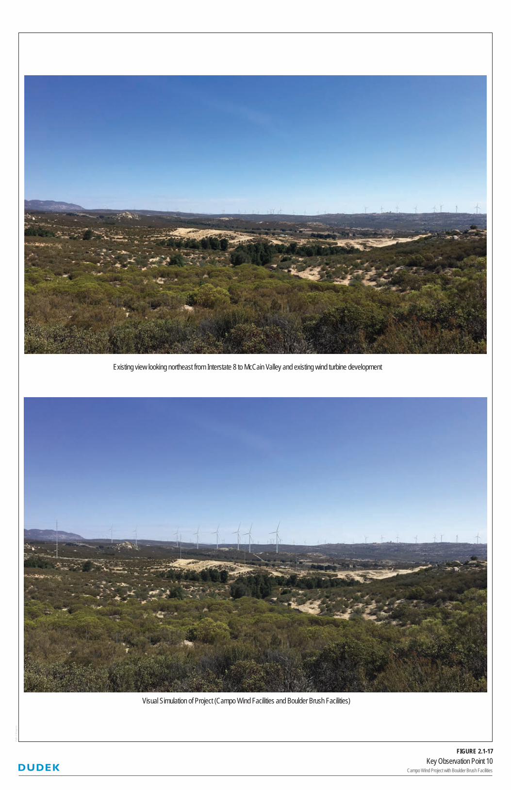
Key Observation Point 10Campo Wind Project with Boulder Brush Facilities
FIGURE 2.1-17
Pat
h: Z
:\Pro
ject
s\
Existing view looking northeast from Interstate 8 to McCain Valley and existing wind turbine development
Visual Simulation of Project (Campo Wind Facilities and Boulder Brush Facilities)

2.1 Aesthetics
December 2019 10212.0023
Campo Wind Project with Boulder Brush Facilities Draft Environmental Impact Report 2.1-124
INTENTIONALLY LEFT BLANK

Key Observation Point 11Campo Wind Project with Boulder Brush Facilities
FIGURE 2.1-18
Pat
h: Z
:\Pro
ject
s\
Existing view looking north from Opalocka Road across private property and wind turbine development in McCain Valley
Visual Simulation of Project (Campo Wind Facilities and Boulder Brush Facilities)

2.1 Aesthetics
December 2019 10212.0023
Campo Wind Project with Boulder Brush Facilities Draft Environmental Impact Report 2.1-126
INTENTIONALLY LEFT BLANK

Key Observation Point 12Campo Wind Project with Boulder Brush Facilities
FIGURE 2.1-19
Pat
h: Z
:\Pro
ject
s\
Existing view looking southeast from McCain Valley Road to McCain Valley and existing transmission and wind turbine development
Visual Simulation of Project (Boulder Brush Facilities)

2.1 Aesthetics
December 2019 10212.0023
Campo Wind Project with Boulder Brush Facilities Draft Environmental Impact Report 2.1-128
INTENTIONALLY LEFT BLANK