208 water quality management plan for mahoning...
TRANSCRIPT

208 Water Quality Management Planfor
Mahoning and Trumbull Counties
May 2008
Prepared By
Eastgate Regional Council of GovernmentsCity Centre One
100 East Federal Street, Suite 1000Youngstown, Ohio 44503
Office: (330) 779-3800Fax: (330) 779-3838
This report was financed by the Ohio Environmental Protection Agency (Ohio EPA) using604 (b) funds and through a contractual agreement between Eastgate and the Ohio EPApursuant to Section 208 of the Clean Water Act. The contents of this report reflect theviews of Eastgate, who is responsible for the facts and accuracy of the data presentedherein. The contents do not necessarily reflect the official views or policy of the Ohio EPA.

EASTGATE REGIONAL COUNCIL OF GOVERNMENTSServing Northeast Ohio since 1973
The Eastgate Regional Council of Governments is a multipurpose Regional Council of Governments for Mahoning and TrumbullCounties, as established by Section 167.01 of the Ohio Revised Code. Eastgate is the agency designated or recognized toperform the following functions:
C Serve as the Metropolitan Planning Organization (MPO) in Mahoning and Trumbull Counties, with responsibility forthe comprehensive, coordinated and continuous planning for highways, public transit and other transportation modesas defined in the Safe Accountable Flexible and Efficient Transportation Equity Act - A Legacy for Users (SAFETEA-LU).
C Perform continuous water quality planning functions in cooperation with Ohio and U.S. EPA.
C Provide planning to meet air quality requirements under SAFETEA-LU and the Clean Air Act Amendments of 1990.
C Administration of the Economic Development District Program.
C Administration of the State Capital Improvement Program for the District 6 Public Works Integrating Committee.
C Administration, in coordination with the Mahoning Valley Economic Development Corporation, of the Department ofDefense Procurement Program.
C Administer the area clearinghouse function, which includes providing local government with the opportunity to reviewa wide variety of local or state applications for federal funds.
C Administration of the regional Rideshare! Program for Ashtabula, Mahoning and Trumbull Counties.
C Conduct demographic, economic, and land use research.
C At General Policy Board direction, provide planning assistance to local governments that comprise the Eastgateplanning area.
C Administration of the Clean Ohio Conservation & Revitalization Funds.
C Local sponsor & Regional Coordinator of the Mahoning River Dredging Project’s Feasibility Study.
GENERAL POLICY BOARD (2008)
Chairman - Fred Hanley, Hubbard TownshipVice-Chairman - Mark Buccilli, Mahoning County Engineer’s Office
Michael Chaffee, Mayor, Village of Lordstown Eric M. Czetli, District Deputy Director, ODOT District 4Jack Dill, Mayor, City of CampbellLarry Ellis, Mayor, Village of Craig BeachJames Ferraro, Director, Western Reserve Transit AuthorityFrank Fuda, Trumbull County Commissioner Warren Harrell, Citizens Advisory Board RepresentativePaul E. Heltzel, Trumbull County CommissionerMark Hess, City of NilesGlenn Holmes, Mayor, Village of McDonaldRalph Infante, Mayor, City of Niles James Iudiciani, Mayor, Village of LowellvilleHarry Kale, Mayor, Village of New MiddletownWilliam E. Kay, Mayor, City of CanfieldAlan Knapp, Director, Trumbull County Planning Comm.John Latell, Trumbull County EngineerPatrick Layshock, Mayor, Village of Newton FallsDavid Ludt, Mahoning County Commissioner
Arthur Magee, Mayor, City of HubbardRichard Marsico, Mahoning County EngineerJohn McNally, IV, Mahoning County CommissionerMary McNatt, Mayor, Village of BeloitJames Melfi, Mayor, City of Girard Curt Moll, Mayor, City of CortlandMichael O’Brien, Mayor, City of WarrenAllen Patchin, Mayor, Village of West FarmingtonDaniel Polivka, Trumbull County CommissionerTimothy Sicafuse, Mayor, Village of PolandBill Skowronski, OEPA NE District ChiefJohn Smith, Mayor, Village of SebringNorm Sommers, Mayor, Village of WashingtonvilleTerry Stocker, Mayor, City of StruthersBill Totten, City of WarrenAnthony Traficanti, Mahoning County CommissionerJay Williams, Mayor, City of YoungstownHeflin Willingham, Citizens Advisory Board Representative
TECHNICAL ADVISORY COMMITTEEChairman - Mark Buccilli Vice-Chairman - Randy Smith
CITIZENS ADVISORY BOARDChairman - James J. Pirko Vice-Chairman - Ray DeCarlo

Table of Contents
List of Figures
List of Tables
List of Appendices
Acknowledgments
Chapter 1: Introduction and Overview of the Plan
Chapter 2: Water Quality Conditions in Mahoning and TrumbullCounties
Chapter 3: Population and Economic Profiles for Mahoning andTrumbull Counties
Chapter 4: Regionally Important Critical Resources
Chapter 5: Management of Home Sewage and Regulated TreatmentSystems
Chapter 6: Management of Nonpoint Sources of Pollution andStormwater Runoff
Chapter 7: Wastewater Management Facility Planning
Chapter 8: Facility Planning Area Amendment Process and Process forState Certification

List of Figures
Figure 2-1: Mahoning and Trumbull Counties Watershed Overview
Figure 3-1: Population Change for Mahoning and Trumbull Counties
Figure 3-2: Mahoning County Educated Workforce
Figure 3-3: Trumbull County Educated Workforce
Figure 3-4: Mahoning County Poverty
Figure 3-5: Trumbull County Poverty
Figure 4-1: Mahoning and Trumbull Counties Watershed and SurfaceDrinking Watersheds
Figure 4-2: Mahoning and Trumbull Counties Wetlands and Floodplains
Figure 4-3: Mahoning and Trumbull Counties Preserved Lands
Figure 5-1: Mahoning and Trumbull Counties Home Sewage TreatmentSystem (HSTS) Areas of Concern

List of Tables
Table 2-1: Water Quality Attainment Summary for Secondary Tributaries (lessthan 5 mi2)
Table 2-2: Water Quality Attainment Summary for Primary Tributaries (5-20mi2)
Table 2-3: Water Quality Attainment Summary for Primary Tributaries (20-50mi2)
Table 2-4: Water Quality Attainment Summary for Principle Streams (50-500mi2)
Table 4-1: Public Water Systems
Table 4-2: Surface Drinking Water Supplies
Table 5-1: Number of Bedrooms and HSTS Tank Capacity Comparison
Table 5-2: HSTS Areas of Concern
Table 5-3: Summary of Regulated Sewage Treatment Systems
Table 6-1: Phase II Stormwater Regulated Entities
Table 7-1: Management Agencies (MA) with Facility Planning Areas
Table 7-2: MA’s without Facility Planning Areas Serving Areas with SanitarySewer Infrastructure

List of Appendices
Appendix A: Mahoning County Townships Establishment of Riparian Setbacks
Appendix B: Wastewater Treatment Planning Prescriptions and Options
Appendix C: 201 Facility Planning Areas for Mahoning and TrumbullCounties

Acknowledgments
The Eastgate Regional Council of Governments (Eastgate) 208 Water QualityManagement Plan (208 Plan) is a compilation of government documents and regulatoryinformation provided by Eastgate’s partnering agencies. In addition to Eastgate’s GeneralPolicy Board, Technical Advisory Committee, and Citizens Advisory Board, and theEnvironmental Planning Advisory Committee, Eastgate would like to acknowledge thepartners who have worked side by side with the Environmental Planning Department informing a relevant, regional update to the 208 Plan. The following partners providedknowledge and assistance in molding the 208 Plan:
Ohio EPA, Northeast District OfficeMahoning and Trumbull County Sanitary EngineersMahoning and Trumbull County Engineers OfficeMahoning and Trumbull County Planning CommissionsMahoning County Soil and Water Conservation DistrictTrumbull Soil and Water Conservation DistrictMahoning County District Board of HealthTrumbull County General Health DistrictThe Alliance for Watershed Action and Riparian Easements (AWARE)The Mahoning River Consortium (MRC)

Eastgate Regional Council of Governments 208 Water Quality Management Plan
Chapter 1Introduction and Overview of the Plan
In the early 1970's, the Governor of Ohio under the provisions of the CleanWater Act, designated Eastgate, formerly Eastgate Development and TransportationAgency (EDATA), as the planning agency for Mahoning and Trumbull Counties.Under Section 208 of the Clean Water Act, each designated planning agency was tocreate and submit a plan identifying alternatives to wastewater management.Eastgate submitted their first 208 Plan in 1977. This chapter provides an overviewof Eastgate Regional Council of Government’s (Eastgate) current 208 planningefforts, summarizes the original 208 Water Quality Management Plan (208 Plan)submitted in 1977, and outlines information and goals for the updated plan.
1.1 Introduction
Since the inception of the 208 Plan its purpose to protect water quality has remainedsteady, but the focus of the plan has expanded. In the past, the 208 Plan focused on theconstruction of wastewater treatment plants and control of industrial, municipal andnonpoint source pollution. Today’s 208 Plan continues to focus on controlling nonpointsource pollution, but expands to include discussions on home and state regulated sewagetreatment systems, population and economic trends, and the protection of our area’scritical resources such as drinking water sources, floodplains, and wetlands. Eastgatecollaborated with its designated counties, municipalities, sewer agencies, county healthdepartments and planning commissions, conservation and watershed groups, andrepresentatives from the Ohio EPA to gather and incorporate relative, chapter specificinformation and recommendations for the plan update.
Eastgate’s 208 Plan focuses on water quality management issues within Mahoningand Trumbull County’s four major watersheds: (from north to south) the Grand RiverWatershed, in northwest Trumbull County; the Mahoning River Watershed in centralTrumbull County and Mahoning County; the Pymatuning-Shenango Watershed in easternTrumbull County; and the Little Beaver Creek Watershed spanning in and out of southernMahoning County.
1.2 Clean Water Act: Section 208
The Clean Water Act (CWA) addresses water pollution in the United States andprovides measures for protecting our Nation’s surface waters. The main goal of the CWAis to “restore and maintain the chemical, physical, and biological integrity of the Nation’s

1Clean Water Act, Section 101(a).
Eastgate Regional Council of Governments 208 Water Quality Management Plan
Waters”1. Water quality management planning is addressed within Section 208 of theCWA. Section 208 sets forth requirements to achieve the goals of the CWA on a state bystate basis. Section 208 established shared responsibilities for water quality managementplanning for areawide and state agencies. Water quality management plans are createdunder this section and used to address municipal waste treatment issues and nonpointsource pollution management and control measures. These management plans directlocal and regional implementation by defining implementation responsibilities specific toagencies with municipal waste treatment or nonpoint source management responsibilitieswho have been designated to perform specific control.
An areawide water quality management plan is one of many tools set forth by theCWA and utilized by the State of Ohio to combat water pollution and restore the waterquality of the state’s waters. Other components of the CWA utilized include water qualitymonitoring and assessments, the administering of the National Pollution Discharge andElimination System (NPDES) permit program to control discharges, financial assistancefor wastewater treatment management facilities, and enforcement. Water qualityassessments are the responsibility of the State of Ohio and help the state determine atwhat capacity a water body can receive pollutant loads without degrading its intended use.The Ohio EPA established the Total Maximum Daily Load (TMDL) program and otherwater quality effluent limits for streams to provide the foundations for permit issuance. The208 Plan utilizes all of the aforementioned programs, gathering background informationand data, to mold and support Eastgate’s 208 plan update efforts in creating an essentialtool that addresses local and regional environmental needs.
1.3 Eastgate Regional Council of Governments: The original 208 Water QualityManagement Plan
The first 208 Plan produced by Eastgate was submitted to the Ohio EPA in 1977and covered Mahoning and Trumbull Counties. The focus of the original 208 Plan wascentered around designing and the construction of wastewater treatment plants to servethe established sewer districts. Elements of Eastgate’s 208 Plan included:
• A Municipal Collection and Treatment volume dedicated to developing atechnical plan for the Eastgate 208 planning area, consistent with Section208 of the Clean Water Act. This volume identified the sanitary sewerswithin the 208 study area;

Eastgate Regional Council of Governments 208 Water Quality Management Plan
• A Wastewater Management volume identifying and defining themanagement responsibilities and requirements of entities involved in the 208planning process;
• A Storm Water Pollution Control volume consisting of education tools, a listof best management practices, and a list of continuing 208 planningfunctions representing a plan to abate storm water runoff pollution;
• A Nonpoint Source Pollution volume identifying potential sources andstrategies to remove them from surface waters; and
• An Industrial Wastewater Control volume discussing the possibility ofmunicipal wastewater treatment plants treating industrial waste water as wellas domestic sewage. The volume suggests a performing a feasibility todetermine the possibility of any Wastewater Treatment Plant (WWTP) withina 201 area treating such waste in addition to their municipal treatment load.This volume was constructed during the steel era of the Youngstown-Warrenarea.
1.4 Implementation of the Original 208 Plan
Over the past twenty-nine years, some of the municipal wastewater treatment plansset forth in the original plan have been completed as illustrated by the number of PublicallyOwned Treatment Works (POTWs) constructed, while others did not prosper due tofunding constrictions. Original 201 Facility Planning Area (FPA) boundaries wereseparated and redefined to illustrate the service area for each newly constructed POTWand management agencies (MAs) were established for those areas. Although therecommendations of the original plan were predicted for a twenty-year time span, decadeshave passed before an update to the plan began. Minor updates were made to addressthe wastewater treatment options within recent years.
1.5 Water Quality Problems in Eastgate’s 208 Planning Area
Public participation and investments in wastewater treatment have improved greatlysince the 1977 plan due to the addition of extra stages to water treatment process.However, significant water quality problems continue to exist within the urbanized areas,mainly due to stormwater and combined sewer overflows (CSO).
Controlling water quality problems is a pressing issue within the developing areasof Mahoning and Trumbull Counties. Land use plays an integral role in the protection ofour area’s water quality. As more rural, open vegetated green spaces are sold fordevelopment and/or infrastructure upgrading, the land characteristics that once protected

Eastgate Regional Council of Governments 208 Water Quality Management Plan
our area’s water quality are compromised for an increase in impervious surfaces (i.e.rooftops, buildings, parking lots, and roadways). A new group of pollution challengesemerged threatening our area’s water quality and forcing new measures to be created dueto changes in development and environmental trends.
1.6 Goals for Eastgate’s Updated 208 Plan
Goals for the original 208 Plan were developed based on needs to collect and treatmunicipal wastewater. Since the late 1970's water quality improved with the developmentof several wastewater treatment plants, leaving new goals to be established to complimentthe update of the 208 Plan. The following goals have been created for the continualdevelopment and update of the 208 Plan:
• The plan should utilize a regional watershed approach to protect the region’ssurface waters and the watersheds that feed into them by coordinatingresource agency efforts as the basis for management planning;
• The plan should be protective of the environmental gains our region hasachieved and continue to reinforce the benefits of such gains by promotingthe further protection of the planning area’s critical resources;
The plan should incorporate and reinforce protective measures utilized bygoverning agencies and outline additional measures to assure the region’swater resources achieve state attainment standards;
• The plan should provide a locally driven ideal for development density thatsupports existing infrastructure and is supportive of water quality protectionand protection of the region’s other critical resources; and
• The plan should serve as an educational tool for local officials and the publicon regional water quality management issues.
1.7 Focus of the 208 Plan Update
The focus of the plan update centers around restoring the region’s watersheds tofull attainment and addressing the existing water quality threats. In turn, attention shiftedfrom establishing wastewater treatment facilities and addressing point source pollution, tosanitary sewer planning, improved management of home sewage treatment systems andsemi-public sewage disposal systems, controlling nonpoint sources of pollution, andprotecting the region’s critical resources.

Eastgate Regional Council of Governments 208 Water Quality Management Plan
Eastgate’s 208 Plan contains two forms of guidance: recommendations andpolicies. Recommendations include proposed regional actions for local and/or stateagencies to implement the plan under current authorities of state law. They also includewords of support for initiatives underway in our counties and encourage the continuationof such efforts within the region. Policies are established water quality managementresponsibilities of the designated areawide planning agency.
1.8 Planning Process to Date
This is the first major update of Eastgate’s 208 Plan since 1977. Over the past fewyears, Eastgate has worked with local government officials, planning agencies, healthdepartments, and watershed groups to restructure the plan’s chapters and form relevantregional recommendations and/or policies. Chapters developed for this plan include:
Chapter 1- introduces and provides an overview of the plan.
Chapter 2- discusses the region’s water quality conditions.
Chapter 3- discusses the current regional population trends and developmentprojections.
Chapter 4- discusses the significant critical resources of the region and presentsrecommendations to promote or enhance their protection.
Chapter 5- provides a discussion of the current state and local home sewage andOhio EPA regulated sewage treatment systems. It presents best managementpractice recommendations aimed at protecting water quality and represents stateand local health department regulations.
Chapter 6- introduces and discusses the growing phenomenon of stormwater runoffand its affects on the region’s water quality. Recommendations for alleviating thenonpoint sources of pollution introduced in Chapter 2 are provided here.
Chapter 7- draws a comparison between Eastgate’s initial 208 plan and theupdated plan. It outlines the FPA’s and wastewater treatment options reflecting thegrowth trend of the region.
Chapter 8- highlights the process by which DMA’s request amendments to thefacility plans between official updates of the 208 Plan.

Eastgate Regional Council of Governments 208 Water Quality Management Plan
Chapter 2 Water Quality Conditions in Mahoning and Trumbull Counties
Water is the DNA of all watersheds. Water can indicate the health of awatershed’s ecosystem by studying and identifying the organisms found within itand it can summarize the land use activities within a watershed when analyzed forcontaminants and their sources. This chapter highlights current water qualityconditions of the water courses in the watersheds of Mahoning and TrumbullCounties. Information presented in this chapter was drawn from official waterquality reports, community plans, and watershed action plans.
2.1 Clean Water Act Applications and Reporting
The Clean Water Act (CWA) contains a comprehensive reporting programprotecting the Nation’s valuable water resources. Under Section 303 (b) and 303(d) of theCWA, states are required to create summaries of surface water conditions and develop alist of water bodies not meeting state water quality standards. In order to address impairedwaters, the state creates measures to improve conditions via the development of totalmaximum daily loads (TMDLs), water quality specific permitting, and nonpoint sourcepollution control measures.
In 2002, the Ohio EPA transitioned to a watershed based style of reporting,combining the 305(b) water quality reports with 303(d) list of impaired waters. The newreporting style, the “Integrated Water Quality Monitoring and Assessment Report”(Integrated Report), was initiated in 2002 under federal guidance and satisfies CWAreporting requirements for both Section 303(b) and 303(d). Rather than produce reportssummarizing water quality conditions on an individual stream, the Integrated Reportprovides the sampling results of large rivers and summarizes the conditions on anassigned watershed assessment units, or Hydrologic Unit Code (HUC), basis. In otherwords, the Integrated Report provides a summary of water quality conditions of streamson a watershed level, leaving out the name or names of streams sampled.
2.2 Ohio Water Quality Standards
Since the passage of the 1972 Federal Water Pollution Control Act, the Ohio EPAhas seen substantial improvement in the overall water quality of its inland streams andrivers. Driven by the growing concern for ecosystem stability, Ohio’s water qualitystandards are based on a set of criteria concentrating on beneficial use designations andbiological indices found in Ohio Administrative Code (OAC) section 3745-1-07.

1Ohio EPA Division of Surface Water OAC Chapter 3745-1-07.
Eastgate Regional Council of Governments 208 Water Quality Management Plan
Beneficial use designations are based on how humans use a particular watersystem and how well the water system is able to nourish a dependant biologicalcommunity. These designations are made up of two broad groups: Non-Aquatic LifeHabitat and Aquatic Life Habitat. Non-Aquatic Life Habitat uses are broken down into twocategories1:
1) Water Supply:
• Public Water Supply (PWS) are waters that, with conventionaltreatment, are suitable for human consumption and meet federalregulations for drinking water;
• Agricultural Water Supply (AWS) are waters that are suitable forirrigation and livestock watering without treatment; and
• Industrial Water Supply (IWS) are those waters suitable forcommercial and industrial uses, with or without treatment.
2) Recreation (uses in effect only during the recreation seasons, May 1st through October 15th):
• Bathing Waters (BW) are waters suitable for swimming where alifeguard and/or bathhouse facilities are present, and include anyadditional such areas where the water quality is approved by thedirector;
• Primary Contact Recreation (PCR) are waters suitable for full-bodycontact recreation such as, but not limited to, swimming, canoeing,and scuba diving; and
• Secondary Contact Recreation (SCR) include those waters suitablefor partial body contact recreation such as, but not limited to, wading.
In July 2003, the Antidegradation Rule (OAC 3745-1-05) underwent a revision. Therevised rule categorized rivers as either General High Quality Waters, Superior HighQuality Waters, Outstanding State Waters, or Outstanding National Resource Waters.General High Quality Waters are category 2 or 3 wetlands in accordance with Ohio EPArule 3745-1-54 of the Administrative Code and surface waters not categorized as one ofthe following three categories:

2 Complete, legal definitions of each Aquatic Life Habitat use designation are found in OAC Section 3745-1-07.
Eastgate Regional Council of Governments 208 Water Quality Management Plan
• Superior High Quality Waters are water systems having exceptionalecological values. Ecological values are based upon the combination of thepresence of federal and/or state threatened or endangered species and ahigh level of biological integrity;
• Outstanding State Waters are water systems having special significanceto the state due to exceptional ecological and/or recreational values; and
• Outstanding National Resource Waters are water systems having anational ecological or recreational significance. National ecologicalsignificance may include providing habitat for populations of federalendangered or threatened species or displaying some unique combinationof biological characteristics. National recreation significance may includedesignation in the national wild and scenic river system.
The Ohio EPA lists all designated Superior and Outstanding State Waters in OACSection 3745-1-05, Tables 5-4 through 5-7. Mill Creek, a waterway traversing throughMahoning County’s largest metropolitan park, is recognized as a General High QualityWater based on the fact it is not found within the Superior High Quality Waters,Outstanding State Waters, or Outstanding National Resource Waters tables located inOAC Chapter 3745-1-05 (Tables 5-4 through 5-7). According to Table 5-4, BaughmanCreek, a tributary to the Grand River in Trumbull County, is listed as a Superior HighQuality Water. A portion of the Grand River in Ashtabula County is designated as anOutstanding State Water based on exceptional ecological value (Table 5-5). Though thissegment is not located within Eastgate’s planning area, it is important to note the segmentis located downstream of Trumbull County. Therefore, any activity within TrumbullCounty’s stretch of the Grand River poses a threat to the Outstanding portion of the river.
Complimenting the Non-Aquatic Life Habitat category are Aquatic Life Habitat usedesignations. These designations are broken down into five categories defined by theOhio Water Quality Standards that apply to Northeast Ohio. The following is a summaryof each category2:
• Warmwater Habitat (WWH) - these are waters capable of supporting andmaintaining a balanced, integrated, adaptive community of warmwateraquatic organisms;
• Exceptional Warmwater Habitat (EWH)- these waters are capable ofsupporting and maintaining an exceptional or unusual community of aquaticorganisms characterized by a high diversity of species, especially by those

Eastgate Regional Council of Governments 208 Water Quality Management Plan
who are highly intolerant and/or rare, threatened, endangered, or of a specialstatus (i.e declining species);
• Coldwater Habitat (CWH)- these waters support cold water organismsand/or those which are stocked with salmonids with the intent to facilitate aput-and-take fishery on a year round basis;
• Modified Warmwater Habitat (MWH)- waters in this category have beenfound to be incapable of supporting and maintaining a balanced, integrated,adaptive, community of warmwater organisms due to extensive modificationsof physical habitat; and
• Limited Resource Water (LRW)- are small water systems with drainageareas less than 3 square (sq.) miles that have been irretrievably altered tothe extent that no aquatic life can be supported. The Ohio EPA will applythis designation to streams having “natural background conditions” precludeother types of biology being present.
Embedded within the Ohio EPA’s Water Quality Standards are tables summarizingOhio’s water quality and aforementioned categories on a drainage basin level. Eachdrainage basin table includes surveyed water body segments, a life use designation(Aquatic and Non-Aquatic), water supply, and a recreation use summary. According to thetables for the Grand River, Little Beaver Creek, and the Mahoning River (includes thePymatuning drainage basin) drainage basins (OAC 3745-1-10, 3745-1-15, 3745-1-25respectively), the water segments surveyed all have a non-aquatic use designation of bothindustrial and agricultural water supplies with primary contact recreation. All assessed riverand stream segments located within the Trumbull and Mahoning County portions of theGrand River, Pymatuning, Mahoning River, and Little Beaver Creek Watersheds haveWarmwater Habitat aquatic life use designations, with the exception of a Grand Riverstream segment located in Farmington Township, Trumbull County. An ExceptionalWarmwater Habitat designation was assigned to that segment of the Grand River.
Aquatic life beneficial use designations were designed to protect aquatic life in ourwater bodies. When assessing stream health, biological indices are used to measurecurrent biological communities compared to expectations for its assigned use designation.Those biological indices include the Index of Biotic Integrity (IBI), Modified Index of Well-being (Miwb), and the Invertebrate Community Index (ICI). Attainment of the streams usedesignation, i.e. WWH, is based on a measurement of the current biological community,by means of the indices, and is assigned one of the following:
• Full Attainment- all three indices meet applicable criteria specified by OhioWater quality standards;
Eastgate Regional Council of Governments 208 Water Quality Management Plan
• Partial Attainment- at least one of the indices does not attain and biologicalcommunity performance is fair; and
• Non-Attainment- all indices fail to attain, or any index indicates poor or verypoor performance.
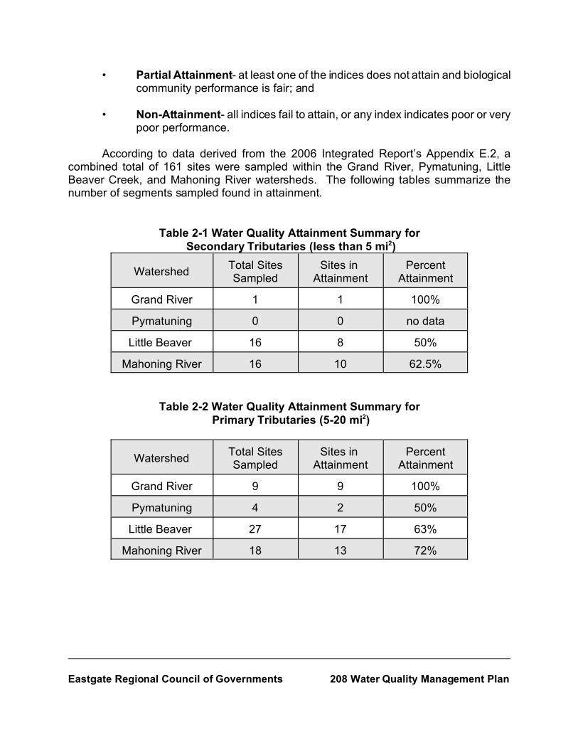
According to data derived from the 2006 Integrated Report’s Appendix E.2, acombined total of 161 sites were sampled within the Grand River, Pymatuning, LittleBeaver Creek, and Mahoning River watersheds. The following tables summarize thenumber of segments sampled found in attainment.
Table 2-1 Water Quality Attainment Summary for Secondary Tributaries (less than 5 mi2)
WatershedTotal SitesSampled
Sites in Attainment
PercentAttainment
Grand River 1 1 100%
Pymatuning 0 0 no data
Little Beaver 16 8 50%
Mahoning River 16 10 62.5%
Table 2-2 Water Quality Attainment Summary for Primary Tributaries (5-20 mi2)
WatershedTotal SitesSampled
Sites in Attainment
PercentAttainment
Grand River 9 9 100%
Pymatuning 4 2 50%
Little Beaver 27 17 63%
Mahoning River 18 13 72%

Eastgate Regional Council of Governments 208 Water Quality Management Plan
Table 2-3 Water Quality Attainment Summary for Primary Tributaries (20-50 mi2)
WatershedTotal SitesSampled
Sites in Attainment
PercentAttainment
Grand River 1 1 100%
Pymatuning 10 1 10%
Little Beaver 6 2 33%
Mahoning River 6 1 17%
Table 2-4 Water Quality Attainment Summary for Principle Streams (50-500 mi2)
WatershedTotal SitesSampled
Total RiverMiles Sampled*
River Milesin
Attainment
PercentAttainment
Grand River 3 35.2 19.9 57%
Pymatuning 7 18.0 0.0 0
Little Beaver 16 46.2 36.9 80%
Mahoning River 21 34.7 2.6 7% *Results calculated in river miles
2.3 Water Quality Impairments
Within the past decade, a new pattern has emerged in the State regarding point andnonpoint source pollution: impairments caused by point source pollution decreased, whilethose caused by nonpoint sources increased. Based on results from state wide surveys,the Ohio EPA states, “Impacts from nonpoint sources of pollution, such as combined seweroverflows (CSOs), urban storm water, siltation of substrates, and habitat degradation arebecoming increasingly evident as historically more pronounced impacts from point sources(i.e municipal WWTPs, some industrial effluents) are reduced. Since 1988, there has beena 48% decline in point sources as a major source of impairment in reassessed stream andriver segments... Nonpoint sources have emerged as a major source of impairment instreams and rivers during this period, with increases including 70% for agricultural sourcesto 123% for hydromodification related nonpoint source impairments. While successesresulting from the abatement of point sources have been documented, there are other

4Cause and Source are defined as “causes of impairments are the agents that damage or impair theaquatic life in a stream, while sources of impairment are the origin of the agent”. Ohio Water Resources Inventory(Ohio EPA, 2000) p. 4-1 - 4-9.
Eastgate Regional Council of Governments 208 Water Quality Management Plan
indications that impacts from nonpoint source runoff, habitat degradation, and watersheddisturbances may be worsening. Siltation of substrates and habitat degradation are nowthe second and third leading causes of aquatic life impairment in Ohio streams and rivers,surpassing ammonia and heavy metals. These impairments are principally the result ofagricultural land use, intensive urbanization, and suburban development, the latter of whichis emerging as one of the most significant threats to watersheds...Increasingly, waterpollution problems are associated with nonpoint sources such as construction sites, farmland, abandoned mines, landfills, pits and lagoons, oil and gas wells, domestic sewagesystems, manure and treatment processing residuals”.3
According to the Ohio EPA, the top seven major causes of impairment (state-wide),based on current, monitored-level data are habitat modification, siltation, organicenrichment/low dissolved oxygen (D.O.), flow alteration, nutrients, metals, and ammonia.The major sources of impairment include hydro-modification, agriculture, municipal(including CSOs) and industrial discharges, mining, and urban runoff4. On a local level,based on Appendix E.2 of the 2006 Integrated Report, the leading “High MagnitudeCauses” of impairment in Mahoning County and Trumbull County surface water systemsinclude:
• Direct Habitat Alterations;• Organic Enrichment/Dissolved Oxygen;• Nutrients;• Flow Alteration, Siltation, Wetland Alteration, and Unionized Ammonia; and• Unknown sources.
The sources complimenting the causes are “High Magnitude Sources”, and those include:
• Channelization Due to Development and Natural Causes;• Major Municipal Point Sources, Dam Construction, Urban Runoff/Storm
Sewers, Combined Sewer Overflows (CSO);• Unknown sources;• Contaminated Sediments; and• Riparian/Stream Bank Vegetation Removal.
A complete listing of High Magnitude Causes and Sources can be found within AppendixE.2 of the 2006 Integrated Report located on the Ohio EPA’s website,http://www.epa.state.oh.us/dsw/tmdl/2006IntReport/2006OhioIntegratedReport.html.

5Ohio EPA, State of Ohio Combined Sewer Overflow Strategy, March 1995.
Eastgate Regional Council of Governments 208 Water Quality Management Plan
CSO systems are a major source of water quality impairment in the two counties.CSOs are systems that collect sanitary and industrial wastewater, as well as stormwaterrunoff. This wastewater mixture is then transported to treatment facilities during normalperiods of rain. However, if the volume of stormwater and wastewater exceeds thetreatment facility’s or combined sewer’s capacity then a portion of the raw water is directedto flow into an open ditch, stream, river, or lake. In turn, such discharges must be coveredunder an National Pollutant Discharge Elimination System (NPDES) Permit.
In 1994, the US EPA established a national CSO Control Policy that later becamethe model for the Ohio EPA’s 1995 CSO Control Strategy. The national policy was madepart of the Clean Water Act in 2000, when Congress passed the Wet Weather WaterQuality Act. This act required all consistency in actions taken to implement CSO controlmeasures with provisions of the national policy. The national policy established threeobjectives for CSOs:
• In the event CSO’s occur, they are only a direct result of wet weather;
• To make all wet weather CSO discharge points compliant with technoloy-based and water quality-based requirements of the CWA; and
• Minimize any and all water quality, aquatic biota, and human health impactsresulting from CSOs.
The Ohio EPA’s CSO Control Strategy created a set of statewide goals5 for communitiesin Ohio with CSOs:
• Discharges from combined sewer overflows shall not cause or significantlycontribute to the violations of water quality standards or impairment ofdesignated uses;
• During wet weather, the total loading of pollutants discharged from the entirewastewater treatment system shall be minimized; and the discharge ofpollutants from CSOs should not increase above current levels; and
• Combined sewer overflows shall be eliminated when this is a cost effective,economically achievable control option, and when it does not cause new orsignificantly increased overflows elsewhere in the system.
Under the strategy, CSO laden communities must develop and implement a CombinedSewer System Operational Plan that “incorporates the nine minimum CSO controls,maximizes the treatment of wet weather flows by a wastewater treatment plan via wet

6IBID. p. 2.
7Ohio EPA, Ohio CSO Inventory list, September 2006.
Eastgate Regional Council of Governments 208 Water Quality Management Plan
weather stress testing, and develop and implement a long-term CSO control plan6”. Thenine control measures identified by the Ohio EPA include:
• Proper operation and maintenance programs for the sewer system and CSOpoints;
• Maximum use of the collection system for storage;
• Review and modification of pretreatment programs or other local programsto minimize the impact of nondomestic discharges from CSOs;
• Maximization of flow to POTW for treatment;
• Prohibition of dry weather overflows;
• Control of solid and floatable materials in CSO discharges;
• Required inspection, monitoring, and reporting of CSOs;
• Pollution prevention to reduce CSO impacts; and
• Public notification for any areas affected by CSOs, especially beach areasand areas where contact recreation occurs. (Ohio EPA expects communitiesto develop and implement an effective public advisory system that informsthe public of the possible health and environmental impacts associated withCSOs, that notifies the public when discharges from CSOs occur andadvises against contact recreation when elevated bacteria levels mayendanger public health).
All CSO communities are required to implement the above control measures that apply totheir system. Individual plans should include a section on how each of the nine measureswill be implemented. All plans are incorporated into NPDES Permits each communtiyholds.
Ohio currently has 1,340 active CSOs, a decrease of 28 from the August 2005inventory7. Within the two counties three communities have CSOs: the City of Youngstown(101 CSOs), the City of Newton Falls (25 CSOs), and the City of Girard (4 CSOs). Inconjunction with their Downtown Sewer Separation Project, the City of Warren eliminated

Eastgate Regional Council of Governments 208 Water Quality Management Plan
their four CSOs, as well as the City of Niles. The City of Youngstown, as part of a controlstrategy, placed health warning signs along many of their larger CSO locations.
2.4 Water Quality Conditions: A Watershed Perspective
The water quality of Mahoning and Trumbull County is dependant upon activitiesexisting within the four watersheds: Grand River Watershed, Pymatuning Watershed,Mahoning River Watershed, and the Little Beaver Creek Watershed. The followingdiscussion takes an in depth look at the unique characteristics and water quality conditionsof the watersheds within Mahoning and Trumbull County. Figure 2-1 illustrates the two-county area and delineates the boundaries of the four watersheds that reside withinMahoning and Trumbull Counties.
2.4.1 Grand River Watershed: The northwest portion of Trumbull Countyoccupies 141.48 square miles of the watershed and is identified as both aWarmwater Habitat and Exceptional Warmwater Habitat by the Ohio EPA.
The 2006 Integrated Report surveyed fourteen sites within the TrumbullCounty portion of the Grand River. Seven of the fourteen sites sampled werelocated along the Grand River from its headwaters, in Geauga County, todownstream Swine Creek in Trumbull County. Those areas sampled representprimary tributaries (5-20mi2) and a principal stream (50-500mi2). Both sites reached100 percent attainment. The remaining seven sites sampled were located along theGrand River from downstream Swine Creek to upstream Rock Creek in AshtabulaCounty. One secondary tributary (less than 5mi2) and four primary tributary(three5-20mi2 sites and one 20-50mi2 site) sites were sampled, all of which were in 100percent attainment of Ohio’a water quality standards. Two principal stream (50-500mi2) sites were sampled along this reach of the Grand River, for a total of 25principal streams miles sampled. The attainment status of the sampled mileageincludes 9.7 miles (38.8%) in full attainment and the remaining 15.3 miles (61.2%)in partial attainment. According to comments within the appendix, the Ohio EPAattributes over 15 miles of partial attainment status “to the habitat-limiting nature ofthe extensive wetland stream complex (natural conditions)”. According to the OhioEPA, an intensive survey of the upper reaches (includes areas in Trumbull County)of the Grand River will be conducted sometime in 2007 and 2008 with a projectedTMDL report due in 2009.
The Grand River watershed is home to a State Wild and Scenic designatedriver. This designation was given to segments located in Ashtabula County onJanuary 17, 1974, marking Ohio’s second wild and scenic river. To ensurepreservation of water quality within the wild and scenic portions, the Ohio EPAaffords wild and scenic designated rivers additional protection under theAntidegradation Rule by limiting the amount of activity within the segment that would

Figure 2-1: Mahoning and Trumbull Counties Watershed Overview
Source: Ohio Environmental Protection Agency
May 2007
Grand River Watershed
Mahoning River Watershed
Pymatuning Watershed
Little Beaver Creek (LBC) Watershed
LBCLBC
/
Mosq
uito R
eserv
oir
Pymatuning Creek
Mean
der R
eserv
oir
Evans
Lake
Mahoning River
Lake
Milto
n
Grand
River
Pine L
ake
Yello
w Cr
eek
Mill C
reek
Honey Cre ek
Middl
e Fork
Little B
eav
er Creek
Berlin
Rese
rvoir
We st Bran
ch
Eagle Creek
Mahoning Ri ver
Mahoning River
Grand River
Littl e Yankee Creek
Yankee Creek
Mean
der C
reek
East
Branch
Mahoning River
LegendCounty Boundary
Watershed Boundary
LakeStream
Mosquito Creek
0 3 6 9 121.5Miles

Eastgate Regional Council of Governments 208 Water Quality Management Plan
lower water quality. Although none of the wild and scenic portions fall within theboundaries of Trumbull County, it is important to note on-going activities (i.e.agricultural, urban and/or residential development, septic system nuisances) withinthe county impact downstream water quality.
In the Spring of 2003, the Ohio State University Extension joined with theGrand River Partners and the Trumbull County General Health Department toconduct a survey of residents within the upper portion of the Grand Riverwatershed. The survey was constructed to determine resident’s attitudes towardwater quality protection and land preservation within the watershed, specificallythose lands abutting the Grand River and its tributaries. Respondents rated theirviews on the extent to which activities or events posed a threat to the watershed.Results from the survey indicated the perceived problems in the watershed werefailing septic systems and urban sprawl. Trailing the top two concerns, but notlacking importance, were habitat alteration, industry, construction, logging, flooding,animal farming, crop farming, and mining.
2.4.2 Pymatuning Watershed: Mahoning and Trumbull counties occupy acombined total of 189.84 square miles (4.79 square miles in Mahoning County and185.05 square miles in Trumbull County) of the watershed that is designated as aWarmwater Habitat by the Ohio EPA.
The mainstem of Pymatuning Creek flows through northeast Trumbull Countyand was included in the 2006 Integrated Report. A total of ten sites were sampled:three primary tributaries (two 5-20mi2 sites and one 20-50mi2 site) and sevenprinciple stream sites (50-500mi2). Each of the three attainment statuses was wellrepresented within this stretch of the watershed. Of the primary tributaries, 50%were found in non attainment, while remaining 50% was split between reaching fulland partial attainment status. The final seven principal stream sites, comprised of18 miles, were all found to be in non attainment. Tributaries Yankee Run and LittleYankee Run, share a wide spectrum of attainment with portions of the streams inFull, Partial, and Non-Attainment. Eleven sites were sampled, all primary tributaries(two 5-20mi2 and nine 20-50mi2), with the following sampling results: 58.3% nonattainment, 11.1% partial attainment, and 30.6% full attainment. According to theIntegrated Report, nutrients, flow alteration, direct habitat alterations, organicenrichment/dissolved oxygen, and pathogens were cited as causes of impairment.The report further lists contributing impairment sources to include major municipalpoint sources, urban runoff/storm sewer, hydromodification due to development,habitat modifications other than hydromidification, channelization due to agriculture,natural and unknown sources. An intensive survey of the upper reaches of thePymatuning River will be conducted in 2008 and 2009 with a projected TMDL reportdue in 2010.

8Untreated discharge is any water that is discharged directly into a stream, river, or lake without first beingtreated by a WWTP.
Eastgate Regional Council of Governments 208 Water Quality Management Plan
Though most of the watershed is buffered by wetlands, tributaries toPymatuning Creek are not and serve as express lanes for sediment and pollutiontransport. The creek and its tributaries flow through rural residential areas ofTrumbull County troubled by failing septic systems. In addition, some tributariessuch as Little Yankee Creek and Yankee Creek flow through commercial areas andreceive point source pollution in the form of untreated discharge8.
2.4.3 Little Beaver Creek Watershed: Though the watershed is mainly located inColumbiana County, 60.83 square miles is within Mahoning County. The areas ofthe watershed extending into southern Mahoning County, the Middle Fork LittleBeaver Creek and the North Fork Little Beaver Creek, are designated a WarmwaterHabitat, Exceptional Warmwater Habitat, and Limited Resource Waters by the OhioEPA.
The Middle Fork Little Beaver Creek traverses through mid-southernMahoning County. A total of 33 stream sites were sampled within the vicinity of theMiddle Fork Little Beaver Creek. Seven of the 33 sampled sites were secondarytributaries, 18 were primary tributaries (thirteen 5-20mi2 and five 20-50mi2), and theremaining 8 sites (total of 21.5 miles) were principal streams. Those secondary andprimary tributaries within the sampled area shared a variety of attainment: 40.1%of the combined sites were in non attainment, 23.8% reached partial attainment,and 36.1% reached full attainment status of water quality standards. The 8 principalstream sites sampled all reached either full or partial attainment status, 56.7% and43.3% respectively. The second region within the Little Beaver Creek Watershedsampled was the Mahoning County portion of the North Fork Little Beaver Creek(referenced in the 2006 Integrated Report as the Little Beaver Creek- downstreamMiddle and West Forks to mouth). Thirty-two stream sites were sampled within thisregion and include: 24 Secondary and Primary Tributaries (fourteen 5-20mi2 andone 20-50mi2) and 8 principal streams (totaling 24.7 miles). According to theIntegrated Report, all Principal Streams sampled were found in attainment. Themajority of Secondary and Primary Tributaries were found in full attainment (79.9%),with 5.4% in partial attainment and 14.7% in non attainment. A list of highmagnitude causes of impairment includes nutrients, siltation, pesticides, organicenrichment/dissolved oxygen, unionized ammonia, flow alteration, natural limits(wetlands), and direct habitat alterations. Sources of the causes include majorindustrial point sources, combined sewer overflows, pasture lands, channelization(development/agriculture), removal of riparian vegetation, onsite wastewatertreatment systems (septic systems), and surface mining. Though it is not knownif any of the 65 sites were located in Mahoning County, it is important to note that

Eastgate Regional Council of Governments 208 Water Quality Management Plan
activities taking place within the county pose potential threats to downstream waterquality and could have been causes/sources of impairment.
According to the Columbiana County Soil and Water Conservation District(SWCD), the leading stressors impacting the watershed’s water quality aredevelopment, sediment overload, toxic substances, failing septic systems, damagedriparian areas, urban runoff, logging, and animal manure applications. The southand southeastern portion of Mahoning County contain abandoned mines withyellow, acid-laden waters draining into nearby waterways. According to a series ofwater sampling conducted by the Watershed Coordinator for the ColumbianaSWCD, acid mine drainage is a factor affecting water quality in tributaries of theLittle Beaver Creek. Among those waterways showing signs of acid mine drainageare segments of Middle Fork Little Beaver Creek, an unnamed tributary to MiddleFork Little Beaver Creek and Cherry Valley Run, located in mid-southern MahoningCounty.
The Little Beaver Creek Watershed is home to a designated a State Wild andScenic River and is included on the National Wild and Scenic River’s List. The LittleBeaver Creek was designated a State Wild and Scenic River on January 15, 1974and was designated a National Wild and Scenic River in October, 1975. The LittleBeaver is one of three Ohio rivers having received the National distinction. Toensure the preservation of water quality within the wild and scenic portion, the OhioEPA affords wild and scenic designated rivers additional protection under theAntidegradation Rule by limiting the amount of activity within the segment that wouldlower water quality. Although none of the wild and scenic portions fall within theboundaries of Mahoning County it is equally important to note that the on-goingactivities (i.e. agricultural, urban and/or residential development, septic systems)within the county have impacts on downstream water quality.
2.4.4 Mahoning River Watershed: The Mahoning River watershed spans acrosssix counties: Columbiana, Stark, Mahoning, Portage, Geauga, and TrumbullCounties. Mahoning and Trumbull Counties occupy 667.66 square miles of thewatershed: 357.62 square miles occupied by Mahoning County and 310.04 squaremiles occupied by Trumbull County. According to the 2006 Integrated Report, thewatershed’s aquatic life use designation includes Warmwater, Coldwater, andLimited Resource Water habitats.
The watershed’s stream attainment varies greatly from segment to segment.Due to the format of the Integrated Report, it is not known which tributaries to theMahoning River and what specific river mile segments were sampled. Therefore,it is important to note that areas outside Eastgate’s planning area, such as thoseportions of the watershed located in Columbiana, Stark, and Portage Counties, havethe potential to impact the stream attainment of Mahoning and Trumbull County’s

Eastgate Regional Council of Governments 208 Water Quality Management Plan
reaches. However, a general idea from the report’s Appendix E.2 can provideinsight to the attainment status within Eastgate’s planning region.
A survey of the upper reaches of the Mahoning River (headwaters inColumbiana County to Leavittsburg in Trumbull County) was completed in 2006, butadditional sampling will take place in mid-2007. A TMDL report is projected to bepublished in 2009. The following is a summary of the water quality conditions withinthe watershed, as reported in Appendix E.2:
• Mahoning River (headwaters to downstream Beech Creek): This areaof the Mahoning River includes a portion of southwest MahoningCounty and is designated a warmwater habitat. According toAppendix E.2 of the Integrated Report, one Primary Tributary (5-20mi2) was sampled and found to be in full attainment. Four PrincipleStream sites were surveyed for a total of 11.6 miles. A majority of themileage, 77.6%, was in non attainment and the remaining 22.4 %were in full attainment. Cited as high magnitude causes forimpairment are unknown causes and metals. The sources of suchimpairments were identified as minor industrial and municipal pointsources, spills, contaminated sediments, and unknown sources.
• Mahoning River (downstream Berlin Dam to downstream WestBranch): This area extends into western Mahoning County andsouthwestern Trumbull County and is designated a Warmwater andLimited Resource Water Habitat. A total of nine sites were sampledwithin this region, seven secondary tributaries and two primarytributaries (5-20mi2). The area surveyed was mainly in full attainment,46.5%, while 32.1% of the surveyed sites were in partial attainmentand 21.4% in non attainment. Causes of impairment included organicenrichment/dissolved oxygen, flow alteration, direct habitat alterations,suspended solids, turbidity, and siltation. Sources of such causesinclude channelization, dam construction, flow regulation/modification,and streambank modification due to development.
• Mahoning River (downstream West Branch to upstream Duck Creek):This region of the Mahoning River Watershed extends into westernTrumbull County and is designated both a coldwater and warmwaterhabitat. A total of twenty sites were sampled- seven secondarytributaries and thirteen primary tributaries ( twelve 5-20mi2 and one20-50mi2). Full attainment (98%) was reached in most of thesegments surveyed, with the remaining 2% in partial attainment ofOhio’s water quality standards. According to the Integrated Report,causes of impairment included organic enrichment/dissolved oxygen,

Eastgate Regional Council of Governments 208 Water Quality Management Plan
direct habitat alterations, and natural limits (wetlands). Sources ofimpairment include channelization, dam construction, and flowregulation/modification due to development.
• Mosquito Creek: Mosquito Creek, located in mid-Trumbull County, isdesignated as a warmwater habitat. A total of 12.5 miles of principalstreams (totaling 7 surveyed sites) were sampled. The attainmentstatus of the samples included partial and non attainment, 13.6% and86.4% respectively. Suspended solids were identified as the majorcauses of impairment, while the sources of impairment included minorindustrial and major municipal point source and upstreamimpoundment.
• Mahoning River (downstream Mosquito Creek to upstream MillCreek), excluding the Mahoning River: This surveyed area includesstreams within mid-Trumbull and Mahoning Counties, but excludeswhich sections of the Mahoning River were surveyed. Four principlestream sites were sampled, totaling 3.0 miles, and were in nonattainment of Ohio’s water quality standards. The report cited metals,unionized ammonia, nutrients, organic enrichment/dissolved oxygen,direct habitat alterations, and suspended solids as causes of the nonattainment status. Two sources were identified as causingimpairments- major municipal point source and dam construction.
• Mahoning River (upstream Mill Creek to mouth), excluding theMahoning River mainstem: This surveyed area includes streamswithin the watershed upstream of the confluence of Mill Creek and theMahoning River in Mahoning County to the river’s mouth at theOhio/Pennsylvania border. According to the Integrated Report, thisarea of the watershed is designated a warmwater habitat. A total ofsixteen sites were sampled: two secondary tributaries, eight primarytributaries (three 5-20mi2 and five 20-50mi2), and six principal streamsites (7.6 miles). This area within the watershed is mainly in nonattainment, 100% non attainment for the principal streams surveyedand 91.7% of the secondary and primary tributaries. The remaining8.3% of the secondary and principal streams were in partialattainment. Metals, unionized ammonia, nutrients, siltation, organicenrichment/dissolved oxygen, and unknown causes were listed ascauses of impairment for the surveyed area. Additionally, majormunicipal point source, CSOs, nonirrigated crop production, urbanrunoff/storm sewers, channelization and dam construction due toagriculture, natural, unknown sources were listed as sources of thewatershed’s impairment.

Eastgate Regional Council of Governments 208 Water Quality Management Plan
The impairment of water quality in the Mahoning River watershed is a productof the heavy nonpoint and point source pollution problems within the two counties.Nonpoint source pollution such as agricultural practices, failing septic systems, andurban sprawl have aided in the impairment of tributaries flowing into the MahoningRiver. Point source pollution from industries, waste water treatment plants, CSOs,and Sanitary Sewer Overflows (SSOs) are a major source of pollution plaguing theMahoning River and some of its tributaries.
Nonpoint sources of pollution appear numerous and sporadic throughout thewatershed. Agricultural practices along main tributaries such as Meander Creek,the southern segments of Mill Creek and Yellow Creek, in Mahoning County, andalong Mosquito Creek and Eagle Creek in Trumbull County appear to contributeorganic enrichment, nitrate-nitrite, nutrients, and phosphorus to the impairment ofthe watershed’s water quality. Riparian zones along some tributaries, such as thesouthern portions of Yellow Creek and Mill Creek, were destroyed by unrestrictedlivestock access and by farming in riparian zones and urban development.Residential and commercial development sprawled out of central cities and intorural areas of southern and southeastern Mahoning County and throughoutTrumbull County. The outward migration of development leads to deterioration ofwater quality via habitat and flow alterations and the importing of sediment andnutrients into the tributaries which decreases the amount of dissolved oxygen withinthe waters. Failing commercial and home septic systems are a nuisance throughoutthe watershed with “hot spots” occurring near Mosquito Creek Reservoir, a drinkingwater supply in Trumbull County and along tributaries to Yellow Creek and MillCreek in Mahoning County.
Point source pollution, although more problematic in the past, continues toimpair the water quality of the Mahoning River. Wastewater treatment plants arelocated throughout the watershed and, although they have improved water qualityover the years, discharge into the Mahoning River or one of its main tributaries.Higher levels of nitrate-nitrite, ammonia, chlorine, total suspended solids, andeffluent are often recorded incidents associated downstream of a wastewatertreatment plant. In addition to treatment plants, CSO discharges contribute to waterquality degradation by unloading untreated effluent and stormwater into theMahoning River and its tributaries.
The legacy of pollution in the Mahoning River expands beyond current daypolluters. For almost a century, the industrial artery of the watershed, the lowerMahoning River (from Warren to Lowellville), was bruised by industries residingalongside its banks. From the early 1900's until the late 1970's, the river served asa highway for steel and steel-related industries. These industries utilized the river’swater in their cooling process, returning the pollutant laden water (by-products of theprocesses) to the river at higher temperatures. Contaminants such as

Eastgate Regional Council of Governments 208 Water Quality Management Plan
polychlorinated biphenyls (PCBs), polycyclic aromatic hydrocarbons (PAHs), andheavy metals were unloaded into the river. Years of contaminant buildup produceda thick layer of black goo that smothers the river bottom and is gathered up behindthe river’s low-head dams. Today, the Mahoning River is the center of a UnitedStates Army Corps Of Engineer’s (USACE) Ecological Restoration Project. Asurvey of the lower portion of the river, to include the contaminated portions, isscheduled to be surveyed in 2013 and 2014, with a TMDL report due in 2015.According to the Ohio EPA, the sampling and TMDL report was pushed forward inhopes of coordinating efforts with the dredging project.

1http://www.odod.state.oh.us/research/files/S0/Trumbull.pdf and http://www.odod.state.oh.us/research/files/S0/Mahoning.pdf
Eastgate Regional Council of Governments 208 Water Quality Management Plan
0
40000
80000
120000
160000
200000
240000
280000
320000
1950 1960 1970 1980 1990 2000 2010 2020 2030 0
40000
80000
120000
160000
200000
240000
280000
1950 1960 1970 1980 1990 2000 2010 2020 2030
Chapter 3Population and Economic Profiles
for Mahoning and Trumbull Counties
In updating Eastgate’s 208 Water Quality Plan a population distribution at thesub-county level was needed. When looking at the future infrastructure needs, the208 Plan must use population projections from the Ohio Department of DevelopmentOffice of Strategic Research (OSR).
3.1 Population Profile for Mahoning and Trumbull Counties
Mahoning and Trumbull Counties saw a significant reduction in population over thelast 20-30 years, yet experienced notable growth in suburban areas. In 2003 the OSRdetermined Mahoning and Trumbull Counties lost population and would continue adownward trend through the year 2030. Already, from 2000 to 2004 Mahoning County lost0.7% of its population, while Trumbull County lost 0.5% of its population. Figure 3-1illustrates the population change for both counties.
Figure 3-1 Population Change for Mahoning and Trumbull Counties1

Eastgate Regional Council of Governments 208 Water Quality Management Plan
Population peaked in Mahoning County in 1970 (population of 303,424) andTrumbull County peaked in 1980 (population of 241,863). Mahoning County lost 15.1% ofits residents since 1970 , bringing the population to 257,555 while Trumbull County lost3.2% from 1970 - 2000 bringing the population to 225,116. Overall, Eastgate’s planningarea seen a net loss of 53,332 residents since the 1970 census.
Despite the region’s shrinking population, the number of new suburban housingareas increased, implying a redistribution of regional population. Out of Mahoning County’s14 suburban townships only two lost population from 1970 - 2000: Coitsville and SmithTownship. In the 30-year period, 20,520 people moved into Mahoning County’s suburbanareas, while 64,492 people moved out of Youngstown and three of its closestmunicipalities. This migration represents a population preferences for newer housing,larger lots, and rural character. The census reported Mahoning County dwelling unitsincreasing from 96,662 in 1970 to 111,762 units in 2000. Data collected by Eastgateindicates new housing starts from 2000 to 2003 number 2,174 in Mahoning County. ForTrumbull County, the census shows dwelling units increasing from 71,295 in 1970 to95,117 in 2000. Eastgate’s data for Trumbull County from 2000-2003 show 1,770 newhousing starts.
Throughout the planning region are areas where sewers are desperately needed,especially in areas with failing septic systems. These areas should be a priority whenlooking at infrastructure needs. What should not be mistaken as a priority is housingdevelopments further away from existing sewer lines. Mahoning and Trumbull countieshave abundant open space to accommodate the increasing demands of home buyers. Thismove outward places stressors on the local environment. The land’s ability to absorb andfilter water naturally is greatly diminished due to an increase in the amount of non-pervioussurfaces. Nonpoint source pollution in waterways, a by-product of developing/developedareas, places overall water quality in jeopardy. The expense to the natural environmentand to citizens of the region only increases as the decreasing population moves further outinto rural areas.
3.2 Economic Profile
The state of this region’s economy is rooted in the loss of the steel industry andoverall erosion of manufacturing in the nation. After the steel mills closed in theYoungstown-Warren area the employment in the region changed from manufacturing toservice based. The manufacturing industry declined between 1970 - 2000 by 66.6% inMahoning County and 31.9% in Trumbull County. During the time period of 1970-2000 thefinance, insurance, and real estate sectors increased by 30% in Mahoning County and108% in Trumbull County. The service industry saw the most growth in the 30 year time

2 Comprehensive Economic Development Strategy (CEDS)2007 The long range development plan for theEastgate Economic Development District - Mahoning and Trumbull Counties, Ohio. Eastgate Regional Council ofGovernments.
3The Ohio Department of Job and Family Services. Job Outlook to 2014 Northeast Ohio EconomicDevelopment Region 12; August 2007.
4Trumbull County Planning Commission 5CEDS 2007
6CEDS 2007
Eastgate Regional Council of Governments 208 Water Quality Management Plan
frame with employment increasing 232% in Mahoning County and 299% in TrumbullCounty.2
Over the 2004-2014 period, the Northeast Ohio (Mahoning, Trumbull and AshtabulaCounties) economy is projected to create 9,600 new jobs. Service sector industries, ledby health and business services, will account for virtually all of the job growth. Onlyconstruction is expected to add significant number of jobs in the goods-producing sector.3
Employment growth slowed from the demographic makeup of the region. InTrumbull County the loss of working-age population left it with “an extremely highdependency ratio. Based on 2000 census data, 30% of the county’s population is under18 and over 64".4 Employment growth may be slowed in this region due to the lack of ahighly educated work force. Mahoning and Trumbull Counties both fall behind the Stateand National averages for baccalaureate and graduate degree attained work force (seeFigures 3-2 and 3-3).5 Because of the area’s history of heavy reliance on manufacturing,which did not require any higher education, much of the region’s citizens felt there washardly a need for a post-secondary degree. Unfortunately this belief left a legacy,therefore reducing the chances that investment from high value added companies relyingon a highly educated work force will locate in the Youngstown-Warren region.6

Eastgate Regional Council of Governments 208 Water Quality Management Plan
Figure 3-2Mahoning County Educated Workforce
Figure 3-3 Trumbull County Educated Workforce

7CEDS 2007
Eastgate Regional Council of Governments 208 Water Quality Management Plan
Manufacturing and service stand out as extreme examples of reduction andexpansion in the region. Though the service sectors are expanding, the are not at thesame rate as the rest of the state. While manufacturing has shrunk to near nonexistencefrom its former stature, they are still present in the area, and hoping for more investmentfrom the industry-side sector. However, the fact remains the region is not performing aswell as the state in terms of retaining or creating jobs of all types. In the sectors wherethere was growth in the region, the state grew at a faster percentage; and in sectors wherethere was decline in both the region and the state, the state’s numbers showed a slowerdecline.7
A quick look at the earnings and unemployment demographics of the region showsome of the problems the population faces. In 2005 the median household income in Ohiowas $43,493. In Mahoning County in 2005 the median household income was $36,294with 49% of households earning below $35,000. In Trumbull County the median householdincome was $40,922 with 43% of all households earning below $35,000. Unemploymentin the region is higher than the state average. Unemployment in Mahoning County issignificantly higher than the unemployment rate in Ohio and the Nation. Theunemployment rate for Mahoning County in 2005 was 7.7 and Trumbull County was6.1(neither seasonally adjusted in 2005). The state’s rate in May of 2005 was 6.1.
The population shift from the central cities to the outlying areas of the countiesfollowed the economic shift from manufacturing to service based industries. The jobs inthe real estate, insurance, and financial sectors are easily moved from town to town andcan follow the population. This was not true of the heavy manufacturing jobs whichremained in the same industrial location. Workers remained in the cities in close proximityto their jobs. Now the jobs and the wealthier people can easily move from location tolocation and those who remain in the core cities are disproportionately living in poverty(Figures 3-4 and 3-5). For example, in January of 2005, nearly one-third of MahoningCounty’s jobless (approx. 3,000 people) were in Youngstown which posted anunemployment rate of 9.9%. Well over half of Youngstown’s population falls into the low-and-moderate income level and 24% of the city’s population lives in poverty, according tothe 2000 census. A full 23,000 people out of a population of 46,832 in the City of Warrenare in the low-and-moderate income brackets and 19% of the population has met povertystatus.

Eastgate Regional Council of Governments 208 Water Quality Management Plan
Figure 3-4Mahoning County Poverty

Eastgate Regional Council of Governments 208 Water Quality Management Plan
Figure 3-5Trumbull County Poverty
What Eastgate’s region offers to prospective employers is abundant, low-cost landin the cities that is ripe for redevelopment as well as an underutilized workforce. While theservice sector jobs follow the population out of the cities, vacant land is plentiful andavailable for competitive industrial districts in the urban areas. Areas in Warren andYoungstown are ready for growth with the Mahoning River Corridor of Opportunity (MRCO)as an example. The MRCO, comprised of former steel mill sites, consists of 635 acres inYoungstown, 384 acres in Campbell and 452 in Struthers. With the existence of basicinfrastructure needed for business , including rail and highway connections, the MRCOworked hard with local and regional agencies to redevelop the abandoned mill sites. Thepopulation of Youngstown and surrounding municipalities as described above has beenhungry for new jobs. There are hurdles remaining in the cities, most common of which isclean-up of the contaminated brownfields. With help from the state, these issues are beingdealt with. With the land, infrastructure, and workforce in place the attractiveness of thecities to businesses leave little reason to develop rural green spaces.
Water quality is affected by the new trends in rural living. Attention shifted from thewater quality issues of the 1970's, mainly controlling pollutants from point sources insurface waters, to nonpoint source pollution caused by run off from impervious surfaces

Eastgate Regional Council of Governments 208 Water Quality Management Plan
and from land disturbances from residential and commercial construction. The rapidlydeveloping rural areas are home to sources of clean drinking water–places once thoughtsecure from threats of pollution (upland drinking water reservoirs, headwater areas, andhigh quality streams). Due to encroaching populations, these sources face an unsecuredfuture, as do all of the streams and rivers from increased water flow and velocity from non-porous surfaces and loss of clarity from soil erosion in construction sites. All of theseimpacts form new threats to water quality, cumulating from the outward migration trendsof the new century.

Eastgate Regional Council of Governments 208 Water Quality Management Plan
Chapter 4Regionally Important Critical Resources
A list of critical resources was identified in the planning process as areaswarranting protection under Eastgate’s 208 Plan. These categories representregionally significant resources either facing harsh deterioration and needingadditional support for their restoration or will face deterioration if protectivemeasures are not adopted. This chapter emphasizes the need to facilitate propermanagement and protection of regionally important resources sensitive to local landuse activities.
4.1 Defining Critical Resources
Critical Resources are defined on a regional basis, but may be similar due to theirrecognized value. The following categories represent critical resources valuable toMahoning and Trumbull Counties:
• Surface Drinking Water Resources;
• Ground Water Resources;
• Wetlands;
• Floodplains and Riparian Zones;
• Ohio EPA Headwater Streams;
• Green Space;
• Endangered Species and;
• Unique Water Resources.
4.2 Surface Drinking Water Resources:
The Safe Drinking Water Act defines a public drinking water system as a systemproviding piped water to at least 25 people or 15 service connections for at least 60 daysper year. Private water supplies are defined as not originating from a public supply andserving only one or a few homes. In Ohio there are three types of public water systems:Community Public Water Systems, Non-Transient Non-Community (NTNC) Public WaterSystems, and Transient Non-Community (TNC) Public Water Systems. A CommunityPublic Water System (CWS) serves at least 15 service connections used by year roundresidents or regularly serves 25 year round residents (i.e. cities, villages, mobile homes,nursing homes, public utilities). An NTNC is a public water system regularly serving at

Eastgate Regional Council of Governments 208 Water Quality Management Plan
least 25 of the same people for over 6 months per year (i.e. schools, places ofemployment, etc.). TNC public water systems serve at least 25 people for at least 60 daysper year (i.e. churches, campgrounds, gas stations). Table 4-1 illustrates the number ofPublic Water Supplies, as provided by the Ohio EPA , and total populations served forMahoning and Trumbull Counties.
Table 4-1 Public Water Systems
County NTNC TNC CWS Total Systems
Mahoning 83 (11,275) 11 (1,966) 15 (248,526) 109
Trumbull 55 (6,657) 22 (5,819) 33 (164,783) 110
The quality of surface drinking water supplies varies by location and is dependantupon activities taking place within the watershed. Table 4-2 summarizes the active drinkingwater sources and their location:
Table 4-2 Surface Drinking Water Supplies
Drinking Water Source Watershed Subwatershed County
Meander Reservoir Mahoning River Meander Creek Mahoning County
M o s q u i t o C r e e kReservoir
Mahoning River Mosquito Creek Trumbull County
Evans Lake Mahoning River Yellow Creek Mahoning County
Lake Hamilton Mahoning River Yellow Creek Mahoning County
Mahoning River Mahoning River N/A Trumbull County
Grand River Grand River Dead Branch-MudRun
Trumbull County
Two additional surface waters serve populations in Eastgate’s 208 Planning area,but have water intakes located outside the region. These two sources are the ShenangoReservoir, located in Mercer County, Pennsylvania, and a segment of the Mahoning Riverlocated in Columbiana County. McKelvey Lake, located in Mahoning County, is utilized bythe City of Campbell as a drinking water source only during emergencies. Figure 4-1illustrates the surface waters in Mahoning and Trumbull Counties that serve as primarypublic drinking water supplies and the watersheds draining into them.
Drinking water can be drawn from the surface or ground. Surface waters such asrivers, lakes, and reservoirs provide ample amounts of drinking water as they arerecharged by the flow of streams leading into them. However, due to their open nature,

Figure 4-1: Mahoning and Trumbull Counties Watersheds and Surface Drinking Watersheds
Source: Ohio Environmental Protection Agency
October 2007
Grand River Watershed
Mahoning River Watershed
Pymatuning Watershed
Little Beaver Creek (LBC) Watershed
LBCLBC
/
0 2 4 6 81Miles
Meander Creek
Dead Branch-Mud Run
Mosquito Creek
Pymatuning
Yellow Creek
East BranchMahoning River
LegendCounty Boundry
LakesStreamsWatershed BoundrySurface Drinking Watershed

1 In 1996, an amendment to the Safe Drinking Water Act initiated a state-by-state assessment of all surfacewaters that serve as public drinking water systems. In Ohio, source waters are evaluated via the Source WaterAssessment and Protection Program (SWAP). The purpose of the SWAP is to identify where and how sourcewaters are at risk of being contaminated. According to the Ohio EPA, the goal of the program is to “ensure the longterm availability of abundant and safe drinking water for the present and future citizens of Ohio”.
Eastgate Regional Council of Governments 208 Water Quality Management Plan
surface waters are accessible and become easily contaminated by chemicals orpathogens. Protection of drinking water sources is a critical issue across the Nation asmore sources are degraded by activities within their watersheds. The need to protect ourdrinking water is critical.
The Ohio EPA established a Source Water Assessment and Protection Program,(SWAP)1 to protect the state’s drinking water sources. According to the Division ofDrinking and Ground Water’s SWAP website, “Ohio’s SWAP program is an innovativeprogram to protect Ohio’s streams, rivers, lakes, reservoirs, and ground waters used forpublic drinking water from future contamination”. Under the program, water assessmentsfor public drinking water sources are created to identify possible contaminant sources andmethods to reduce the potential for source contamination. The SWAPs delineate drinkingwater source protection areas and inventories the potential contaminant sourcesimmediately within those areas. The protection area in SWAPs are further broken downinto two categories, Corridor Management Zones (CMZ) and the Emergency ManagementZones (EMZ). The CMZ is the area within 1,000 feet of the reservoir’s bank (starting at theintake) and extending 500 feet from the banks of each tributary. The EMZ is within theimmediate vicinity of a surface water intake. The following section discusses generalcharacteristics of the public drinking water sources within Mahoning and Trumbull Countiesand the information found within their SWAPS.
4.2.1 Meander Creek Reservoir
The reservoir serves as the primary drinking water source for numeroustownships and municipalities in Mahoning and Trumbull Counties. It is owned andmaintained by the Mahoning Valley Sanitary District (MVSD) and at full capacity, itcan hold 1,546 million cubic feet. Berlin Reservoir, a recreational water sourcelocated in western Mahoning County, provides Meander Reservoir with water in theevent of a drought Berlin Reservoir and is owned and maintained by the UnitedStates Army Corps of Engineers (USACE).
The Meander Reservoir is protected by a natural, forested buffer createdfrom surrounding lands owned by the MVSD. The buffer acts as a filtration system,filtering pollutants such as excess nutrients, sediment, and other contaminatesoriginating from agriculture, residential and commercial development activity.However, tributaries feeding Meander Creek and the reservoir remain unprotected.

2 Ohio EPA, Division of Drinking and Ground Water; “Drinking Water Source Assessment for the Mahoning
Valley Sanitary District”, (April, 2003).
Eastgate Regional Council of Governments 208 Water Quality Management Plan
The Meander Creek watershed encompasses 54,534 acres or 85.2 squaremiles. Land use activities within the watershed have the potential to impair thewater quality of the drinking water source. Agricultural activities, such asunrestricted livestock access to waterways, manure application, and agriculturalproduct application (i.e. fertilizer, herbicides, pesticides) harm water quality byadding nutrients, chemicals, and sediment to the waters. As the watershedtransitions to a suburban setting along its eastern boundary, activities fromcommercial establishments and residential developments, via storm sewer systems,add additional sediment, excess nutrients, chemicals, and litter. Constructionactivities from surrounding development increases sediment loads, while unseweredareas of the watershed add additional concerns for water quality. According to theMahoning County District Board of Health, areas of failing HSTS’s are located withinthe watershed, along tributaries to Meander Creek. Miles of roadways traverse thewatershed adding litter, road salts, and other roadway-related pollutants. Two majorinterstate systems bisect the reservoir, I-80 and I-76, and both contain high volumesof truck traffic. Construction to widen I-76, to protect the reservoir from hazardousmaterial spills, began in Spring of 2006.
According to the reservoir’s SWAP, land use in the MVSD protection area iscomprised of deciduous forest and agricultural land uses such as pasture/hay androw crop. The SWAP’s summary indicated possible impacts to the surface watersource from the surrounding environment include “agricultural runoff from row cropsand animal feed lots, oil/gas wells, road/rail stream crossings, failing home andcommercial septic systems, and new housing and commercial development thatcould increase runoff from roads and parking lots”2. Many of the these mentionedimpacts have already been detected within the CMZ area as findings of pesticidesand septic system effluent are or were present in the finished water. Sulfur Run, atributary to the reservoir has been noted to contain effluent from upstream septicsystems. Although not a source of contamination, but a potential source due to itsage, is a 72 inch sanitary sewer line crossing the reservoir and carrying wastewaterto the Meander Wastewater Treatment Plant. Other potential sources include anumber of oil and gas wells located throughout the CMZ.
4.2.2 Mosquito Creek Reservoir
The Mosquito Creek Reservoir, an impoundment in the Mosquito Creekwatershed, is owned and maintained by the USACE. The reservoir drains 24,220acres in Trumbull County and southern Ashtabula County and at full capacity, thereservoir stores 4,535 million cubic feet of water. The reservoir serves as a drinking

3The Village of Sebring distributes drinking water to the Village of Beloit.
Eastgate Regional Council of Governments 208 Water Quality Management Plan
water source for the City of Warren and surrounding unincorporated areas ofTrumbull County.
Many activities taking place within the Mosquito Creek Watershed, anddirectly adjacent to the reservoir, can impair the water quality of the reservoir. Thewatershed tributary to the reservoir is mainly rural in nature, but transitions to asuburban setting along its southeastern boundary. Agricultural and suburban landuses can impact water quality by introducing nutrients, sediment, and landapplication products into the reservoir via its tributaries. Activities from commercialestablishments and roadway systems add other pollutants such as litter, road salts,and sometimes hazardous materials. The unsewered areas of the watershed area problem as well. According to the Trumbull County General Health Department,areas of failing HSTS’s are located within the watershed and within the immediatevicinity of the reservoir.
Almost all of the USACE owned land along the northern and northwesternarea is leased to ODNR’s Division of Wildlife for fish and wildlife management. Thenorthern, wildlife refuge is a haven for migratory birds and host to a blue heronrookery. The refuge is closed to the public except during designated field days. Thesouthern portion of the reservoir contains Mosquito Lake State Park and is open torecreational usage. The recreational use of the drinking water source isconcentrated in the southern portion of the reservoir and just upstream of thedrinking water intake. According to ODNR’s website for Mosquito Creek Lake,“unlimited horsepower boating is permitted on the lake. (Watercraft) Fuel...isavailable”. Due to the presence of recreational watercraft and their known usageof petroleum based products, the threat of petroleum leaks exist that in turn canharm the quality of the drinking water.
4.2.3 East Branch Mahoning River
The East Branch Mahoning River drains the upper reaches of the MahoningRiver watershed. The upper Mahoning serves as a surface drinking water sourcefor two communities, the Village of Sebring3, Mahoning County, and the City ofNewton Falls, Trumbull County. In its entirety, the Mahoning River flows throughfive Ohio counties, is 108 miles in length, and drains approximately 1,133 squaremiles.
The Village of Sebring manages a community public water system thatprovides drinking water drawn from the Mahoning River to households insouthwestern Mahoning County. Raw water is drawn from the river at a locationupstream of the village in Columbiana County. Due to this location, any

4Ohio EPA, Division of Drinking and Ground Water; “Drinking Water Source Assessment for the City of
Newton Falls”, (February, 2003) p. 5.
Eastgate Regional Council of Governments 208 Water Quality Management Plan
impairments to the drinking water source would originate within Columbiana County,outside Eastgate’s 208 Planning Area. Land use in this portion of the MahoningRiver protection area is predominantly agricultural with pasture/hay comprising theremaining area. Additional uses include deciduous forest and row crops. Accordingto the SWAP, possible impacts to surface water quality from the surroundingenvironment include “agricultural runoff from row crop agriculture, manure handlingfacilities and runoff from animal feedlot operations, oil and gas wells, failing homeand commercial septic systems, spills and releases from recreational boating onpublic and private lakes, new housing and commercial development that couldincrease runoff from roads and parking lots, and numerous road bridges over thestreams/rivers”.
The City of Newton Falls withdraws water from the East Branch of theMahoning River and within city limits. The Mahoning River flows mainly throughrural, agricultural-based areas before reaching the water intake for the city. The citymanages a community public water system providing drinking water drawn from theMahoning River to households within the city, Newton Township, and southernportions of Braceville Township. Land use within this portion of the river’s protectionarea includes agriculture, pasture/hay farms, deciduous forests, and row crops.According to the SWAP summary, possible impacts to surface water quality fromthe surrounding environment include “agricultural runoff from row crop agriculture,oil and gas wells, failing home and commercial septic systems, spills and releasesfrom recreational boating on public and private lakes, new housing and commercialdevelopment that could increase runoff from roads and parking lots, numerous roadcrossings over the Mahoning River and its tributaries, and wastewater dischargefrom treatment facilities upstream of the intake”. Reports from water treatment plantpersonnel indicate that an increase in raw water turbidity occurs after a series ofheavy rainfalls and is noticeable in Kale Creek, a tributary upstream of the waterintake4. The increase in turbidity is indicative of the agricultural activities and soilerosion problems upstream. Levels of Atrazine and increased algal growths aroundthe intake increase during the summer months when the agricultural growingseason is at its peak. The unsewered areas of Newton Township (i.e. Scott Street)are existing concerns for water quality. The Trumbull County has identified thisarea as a high priority for funding to remedy the failing septic systems by installingsanitary sewer.

5Consumer Ohio Water Company, Struthers/Mahoning Valley Division SWAP, Phase I- Boundary
Determination and Contamination Assessment, (November, 1998) p. 31.
Eastgate Regional Council of Governments 208 Water Quality Management Plan
4.2.4 Yellow Creek
Yellow Creek is a subwatershed of the Mahoning River and is the primarywatercourse that supplies water to two drinking water sources. Beginning inColumbiana County, Yellow Creek flows through, in order of succession, BeaverLake (Columbiana County), Pine Lake, Evans Lake, and Lake Hamilton. Pine Lake,Evans Lake, and Lake Hamilton are maintained and operated by Aqua Ohio, Inc.,of which Evans Lake and Lake Hamilton, are drinking water sources for residentsin Mahoning County.
The Yellow Creek watershed is mainly rural, but transitions to a suburbanand urban setting as it travels to its confluence with the Mahoning River in the Cityof Struthers. Many activities take place within the watershed have the potential toimpair the water quality of the watershed and its lakes. According to AWARE’s AdHoc committee notes for the Yellow Creek Watershed Action Plan, nutrients,pathogens, and acid mine drainage are impairments to water quality within thewatershed. Land within the watershed is rapidly developing, especially in the vicinityof Pine and Evans Lakes. Though protected by a thin natural buffer, the lakes haveexperienced some bank erosion and increased sedimentation loads fromdevelopment. Areas of growth within the watershed are occurring, for the most part,in unsewered areas.
The Struthers/Mahoning Valley Division of Aqua Ohio provides drinking waterdrawn from Evans Lake to residents in mid and eastern Mahoning County. Landuses in the overall protection area of Evans Lake gradually changes from rural tosuburban as the water flows north. According to Aqua Ohio’s SWAP, potentialsources of contamination include inactive surface mine drainage, failing septicsystems, gas and oil wells, overhead power transmissions, and chemical spills.Water hardness, as a product of acid mine drainage (AMD) has become a largeissue for Evans Lake and Lake Hamilton as indicated by water samples. TheSWAP report indicates that numerous mines discharging into the two drinking watersource lakes. Sewage is also an issue of concern. Although the report indicatedthat near Evans Lake, residential septic system failures is minimal, and accordingto the Mahoning County District Board of Health, a small area of failing HSTS’slocated west of Evans Lake were identified, as well as sewage discharged from twoRSTS’s, as problematic. The two RSTS’s, located west of Evans Lake, dischargewaste into the lake and have had “reported problems with high total coliform counts,high total phosphates, and nitrate-nitrogen concentrations”5. Raw sewage has alsobecome a problem for Lake Hamilton, as it discharges from a main interceptor alongYellow Creek. Additional contaminants of concern noted in the SWAP include

6Ohio EPA, Division of Drinking and Ground Water; “Drinking Water Source Assessment for the City of
Campbell”, (October, 2002), Summary.
Eastgate Regional Council of Governments 208 Water Quality Management Plan
runoff containing herbicides, pesticides, and fertilizers into Evans Lake and productsof road salt applications (chloride content) within the vicinity of Lake Hamilton andYellow Creek. Additional information on potential contaminant sources can befound in The City of Campbell’s SWAP, as the SWAP covers the broaderwatershed.
The City of Campbell manages a community public water system providingdrinking water drawn from Lake Hamilton also to residents in eastern MahoningCounty. Potential contaminant sources for the protection area are based on thosefound within the Yellow Creek Subwatershed , which overlaps information found inAqua Ohio’s SWAP. Land use within the protection area is comprised of cropland,pasture, woodland, strip mining, and developing suburban and urban areas.According to the SWAP summary, possible impacts to surface water quality fromthe surrounding environment include “agricultural runoff, leaking undergroundstorage tanks (USTs), oil and gas wells, failing home and commercial septicsystems, and new housing and commercial development that could increase runofffrom roads and parking lots”6.
Additionally, strip mining and mine spoil piles in Yellow Creek’s protectionarea could impact the Lake Hamilton’s source water”. Lake Hamilton is one of threesurface impoundments along Yellow Creek, with Pine Lake and Evans Lake beingthe other impoundments located upstream. Development pressures are increasingalong Yellow Creek and within the subwatershed, causing more erosion andsediment loads to trickle downstream into Lake Hamilton. Areas located near LakeHamilton are urban in nature. As such, activities from urban areas not only increaserunoff, but also carry pollutants from streets, parking lots, and lawns into stormsewers that discharge directly into rivers and tributaries. Posing a greater threat tothe protection area is the list of leaking UST’s. An Ohio EPA review of the Bureauof Underground Storage Tank database found 40 leaking UST sites within theprotection area, 17 of which were found within the CMZ. Leaking UST’s pose agreat threat to the drinking water source as the liquids are petroleum-basedproducts.
4.2.5 Dead Branch-Mud Run
The Dead Branch-Mud Run is a subwatershed of the Grand RiverWatershed. Beginning at its headwaters in the marshlands of SoutheasternGeauga County, the [Grand] river flows into Trumbull County, across a largeextensive wetland complex, and then north through Ashtabula and Lake Counties.

7Ohio EPA, Division of Drinking and Ground Water; “Drinking Water Source Assessment for the Village of
West Farmington”, (January, 2003) Summary.
8Ibid. p. 4
Eastgate Regional Council of Governments 208 Water Quality Management Plan
The Village of West Farmington manages a community public water systemproviding drinking water drawn from the Grand River to residents within the village.The Grand River flows through rural, agricultural areas before reaching the waterintake. Similar to the previous subwatersheds, agricultural practices such asunrestricted livestock access, land application products, and manure applicationscan add nutrients, sediment, and chemicals to the river either directly or via atributary.
Land use within the protection area is comprised of evergreen and deciduousforests, pasture land, row crops, and wetlands. According to the SWAP, possibleimpacts to surface water quality from the surrounding environment include “livestockaccess to the drainage systems and streams, agricultural runoff from row cropagriculture, inadequate on-lot sewage treatment systems, oil/gas productionactivities, new housing and commercial development that could increase runoff fromroads and parking lots, and numerous road crossings over the streams”7. A fieldsurvey, conducted by the Ohio EPA, found areas of unrestricted livestock accessalong the Grand River’s mainstem and tributaries. This unrestricted access canpromote streambank erosion, increasing the sediment load and the amount ofpathogens entering the stream. Soil surveys of the protection area conclude soilsare not suitable for HSTS’s with on-lot treatment8.
4.2.6 Pymatuning Creek
The Pymatuning Watershed, located in northeastern Trumbull County andnortheast Mahoning County, feeds a surface drinking water source locateddownstream and outside Eastgate’s 208 Planning area. The PymatuningWatershed feeds the Shenango Reservoir, located in Mercer County, Pennsylvania,via the Pymatuning Creek and its tributaries. Drinking water from the ShenangoReservoir is distributed to a limited number of residents in eastern Trumbull County.
According to the Interstate Pymatuning/Shenango Watershed Plan, one-thirdof the watershed is agricultural in nature, including the portion in Trumbull County.As with the previous subwatersheds, agricultural practices such as unrestrictedlivestock access, land application products, and manure applications can addnutrients, sediment, and chemicals to the river either directly or via a tributary.Activities within the watershed can increase the amount of sediment within the riversystem in addition to pollutants such as litter and road salts from roadwaystraversing the watershed. According to the Trumbull County General Health

Eastgate Regional Council of Governments 208 Water Quality Management Plan
Department, areas of failing HSTS’s are located within the immediate vicinity of thePymatuning Creek and its tributaries.
4.3 Ground Water Resources
Numerous residents in the City of Cortland, Trumbull County, rely on ground wateras their source for drinking water. Protection of ground water systems is more difficult thansurface waters as ground water ignores political boundaries.
The Ohio EPA and ODNR work together to assist local governments in managingand protecting ground water supplies on a county-wide basis. The Ohio EPA assists inthe protection of community ground water supplies and its Division of Drinking and GroundWaters (DDAGW) administers the Ohio Ground Water Protection Program that serves asa guide for other state programs with groundwater responsibilities. This program, inconjunction with Ohio’s Well Head Protection Program, helps protect present and futureavailability of uncontaminated ground water for those on a public well system. Theprograms monitor the quality of water and conduct studies to identify possible groundwatercontaminants and ways to prevent future contamination. The DDAGW maintains anAmbient Ground Water Monitoring Network to describe the general quality of ground waterin Ohio. Originally established in 1967 with 12 large production wells, the network samplesraw, untreated water from the wells in the program that now consists of 212 wells (181public well systems and 31 industrial, commercial, and/or residential systems), whichincludes the City of Cortland’s community well system. Raw water from the wells isanalyzed for a range of inorganic parameters and for volatile organic compounds (VOCs).
The Ohio EPA’s Well Head Protection Program (WHP) focuses exclusively oncommunity public water systems serving more than 500 people in a year. This programwas established through an amendment of the 1986 Safe Drinking Water Act. Accordingto the Ohio EPA, a WHP consists of “determining the area in which ground water will travelto the wells in five years (protection area), inventorying all of the potential sources ofcontamination located within the protection area, and developing a plan for protecting theirdrinking water supply”. The SWAP and WHP programs share very similar components,with one exception: the evaluation of susceptibility of the drinking water source is includedin a SWAP. According to the Ohio EPA, the SWAP program was expanded to include allpublic water systems- small systems, public water systems, and community public wellsystems- so that all public water systems assessments are consistent. Due to thisinclusion, the WHP program was replaced by the SWAP in which all public, community wellsystems that serve greater than 25 different people per day for a period of 60 days peryear are required to complete a SWAP.
The Ohio EPA completed a SWAP for the City of Cortland in December of 2002.The protection area takes into consideration a number of factors such as pumping rate ofwells, hydraulic conductivity of the aquifer, and the porosity of the aquifer. The general

9Vol. 60, Iss.1, p. 95
Eastgate Regional Council of Governments 208 Water Quality Management Plan
protection area for the city’s well system consists of an area containing an inner and outerprotection zone. The inner protection zone is the area providing ground water to the city’swells within one year of pumping, while the outer zone is the area providing water when thewells are pumped for five years. According to the Ohio EPA, the number of pumping yearstranslates to the travel time for a drop of water to reach the well. Based on the Ohio EPA’smodeling program, the City of Cortland has two protection areas, due to their two sets ofwells and the protection areas not overlaping during the modeling process. Based on theaerial photograph included in the SWAP, land use within both protection and surroundingareas is urban in nature. The contamination susceptibility of the aquifer was determinedusing site-specific information (i.e. aquifer composition, topography, soils, rate of waterrecharge, etc.), pollution potential rating of protections areas, available groundwater qualitydata, and potential contaminant sources within the protection area. The results of theSWAP evaluation concluded that the aquifers in the protection area have a lowsusceptibility for contamination due to their 71 to 216 foot protective layer of shale andclay, the depths of the aquifers (174 and 312 feet below the surface) and the water table(145 and 160 feet below surface), and water quality results indicate that there has beenno impact to the aquifer. The Ohio EPA surveyed the protection area and produced a listof potential contaminant sources including UST’s (gas stations, auto repair shops),businesses with the potential to leak petroleum products (i.e. maintenance garages, autorepair shops, gas stations, etc.), cemeteries (associated with arsenic and formaldehyde ingroundwater), medical facilities (pathogens and medical wastes), and photo shops(chemicals utilized in photo processing may contain metals, solvents, and organicchemicals).
A study reported in the Winter 1994 edition of Journal of the American PlanningAssociation9 identified that an increase in surface runoff can represent a net loss ingroundwater recharge. Impervious surfaces, along with stormwater collection systems andsewers reduce residential and municipal ground water supplies and wetlands that rely onground and soil water. Due to the increase in impervious surfaces, stormwater is directedinto catch basins and storm sewer systems preventing it from permeating into the ground.Focused on the affects land use has on groundwater recharging, the journal approachesthe topic by taking a look at how the loss of recharge correlates to development via amodel that determines how much of a given rainfall event becomes surface runoff. Thismodel is based on the Soil and Conservation Service’s curve-number method and providesan insight to the impact development has on ground water recharge.
4.4 Consumer Confidence Reports
In accordance with the 1996 amendments to the Safe Drinking Water Act,community public water systems are required to create and distribute a ConsumerConfidence Report (CCR) to the Ohio EPA and its customers. The annual reports contain

Eastgate Regional Council of Governments 208 Water Quality Management Plan
information on a community’s drinking water source, contaminants detected in the finishedwater, probable sources of the contaminants, the availability of source water assessments,and any violations the supplier received or incurred during the previous, reporting year.
A public water supplier may receive violations due to operation and maintenancedifficulties, chemical imbalances, or to water contamination. According to the Ohio EPA,when a Notice of Violation (NOV) is issued, a public water system must follow the publicnotification requirements adopted from the U.S. EPA’s “tier” system (OAC 3745-81-32).The tier system is based on the severity of violation and is as follows:
• Tier 1: Any violation/situation that poses an acute health risk to human healthmust notify the public within 24 hours of the violation’s occurrence.Examples of an acute violation include the occurrence of a waterbornedisease outbreak or emergency and violation of the maximum contaminantlevel (MCL) for total coliforms, nitrate or nitrite;
• Tier 2: Non-acute violations such as failure to comply with terms andconditions associated with any variance or exemption or variance in place orany other situation as specified by the director a notification to the publicmust be given as soon as possible, but no later than30 days of when theviolation occurred; and
• Tier 3: Violations such as exceeding the fluoride secondary maximumcontaminant level (SMCL), violations of the monitoring and testing procedurerequirements, or operation under a variance or exemption requires the publicto be notified as soon as possible or within 30 days to one year of when theviolation occurred.
4.4.1 Healthy Valley Alliance: PACE EH
A 13-task methodology was created to assist local communities in identifyingand addressing environmental health priorities. The methodology, Protocol forAssessing Community Excellence (PACE) in Environmental Health, was developedthrough a partnership between the National Center for Environmental Health(NCEH) of the Centers for Disease Control and Prevention (CDC) and the NationalAssociation of County and City Health Officials (NACCHO). PACE address thefollowing challenges:
• Community-level identification of environmental health issues;
• Identification of populations at risk of environmental exposure and adversehealth effects;
Eastgate Regional Council of Governments 208 Water Quality Management Plan
• Discover, collect, and analyze meaningful environmental health data; and
• Allocate resources to address community environmental health concerns.
In 2003, funds were awarded to the Mahoning County District Board ofHealth to serve as a PACE demonstration site, which included Trumbull County.A team of local stakeholders, including Eastgate, worked to identify localenvironmental health concerns, establish relevant indicators, and to coordinatesignificant interventions for the identified concerns. Twenty-six environmentalhealth concerns were identified in Mahoning and Trumbull Counties. A survey wasthen developed and distributed to te public to gauge their perception of the 26concerns. According to the survey results, the top concern was safe drinking water.
The PACE committee addressed the concerns in a published report,“Improving Environmental Health in the Mahoning Valley: Report of the HealthyAlliance PACE Project”. The goal shared by the committee is to protect andimprove the drinking water quality of the Mahoning Valley. In order to meet thisgoal, the committee devised a list of recommendations of which included assistingEastgate in completing their 208 Water Quality Management Plan Update,implement the evaluation and elimination of illicit discharges in the watersheds thatdrain into surface drinking water sources (Phase II Storm Water Plan), and assistsmaller public water systems to implement items listed within their SWAPS.However, a program to assess whether or not public water suppliers areimplementing their SWAP’s remains to be implemented.
4.5 Wetlands
Wetlands are some of the most diverse, valuable areas within the United States.According to the Ohio EPA, a wetland is “an area that is inundated or saturated by surfaceor ground water at a frequency and duration to support, and that under normalcircumstances do support, a prevalence of vegetation typically adapted for life in saturatedsoil conditions”. Figure 4-2 illustrates the remaining wetlands in Mahoning and TrumbullCounties as designated by ODNR.
Wetlands provide a land to water transition for water while filtering out pollutantsduring the transitional period. Wetlands are beneficial to water quality due to their abilityto remove, break down, absorb, or transform pollutants before entering a water body.Other functions wetlands perform include:
• Slowing or removing sediment;
• Prevent metal pollutants (i.e. lead, zinc, cadmium) from entering waters;

Figure 4-2: Mahoning and Trumbull Counties Wetlands and Floodplains
October 2007
0 2.5 5 7.5 101.25Miles
/
LegendRoadwayStream
Floodplains
Lake
Wetlands
100 Year Floodplain
500 Year Floodplain

10Ohio Wetland Restoration and Mitigation Strategy Blueprint, ODNR .
Eastgate Regional Council of Governments 208 Water Quality Management Plan
• Absorbing nutrients via the plants that live within the wetland;
• Slowing and retaining storm/flood water in order to prevent downstream soilerosion by holding water and releasing it slowly; and
• Recharging surface and groundwater supplies.
Aside from water quality benefits, wetlands support a diversity of plant, insect,wildlife, and fish species, containing one-third of all threatened or endangered wildlifespecies10. Wetlands provide areas for rest, spawning, nesting, and food for mammals, fish,birds, reptiles, amphibians, and other forms of wildlife. Examples of wildlife and plantspecies indicative of both state-wide and local wetlands include:
• Amphibians- Eastern Newt, Salamander;
• Birds- Bald Eagle, Blue Heron, Marsh Wren, Common Yellowthroat;
• Mammals- Beaver;
• Fish- Central Mud Minnow, Warmouth; and
• Plant- Poison Sumac, Skunk Cabbage, Pin Oak, Cattail.
Not all wetlands are created equal. Each wetland varies in part by its soils,landscape, climate, water characteristics, vegetation, animal species, and amount ofhuman degradation. In Ohio they are categorized by a measure of quality according to theOhio EPA’s assessment. Adopted from the Washington State Wetland Rating System, theOhio EPA created its Ohio Rapid Assessment Method for Wetlands (ORAM) to delineatewetland boundaries and determine the level of quality they possess. Each wetlandassessment is placed into one of three categories: Category 1, Category 2, or Category3 (corresponding to respective quality levels of low, medium, and high), with Category 3being the most protected due to its superior habitat diversity, hydrogeological functions.Additional information on each category can be found on the Ohio EPA’s Division ofSurface Water’s Wetlands Ecology Section website.
Wetlands are also known as fens, bogs, or swamps and are classified by their waterlevels, plant species, and hydric soil types. However, some wetlands may not be easilyidentified as some dry up during the year. Additionally, some lands may be saturated withwater for extended periods of time due to hydric soils. Hydric soils are not indicitive of awetland because an area in question may lack other, pertinent wetland characteristics.

Eastgate Regional Council of Governments 208 Water Quality Management Plan
Over the past decade, Ohio lost nearly 90 percent of its original wetland coveragedue to human activity. Development pressure is the largest threat to wetlands today.Fertile soils and prime locations make wetlands attractive to farmers and to developers.Developers who wish to fill in or remove a wetland or part of a wetland, they must obtaina Clean Water Act Section 404 permit and Section 401 water quality certification.According to the Ohio EPA’s “Ohio Wetland Restoration and Mitigation Strategy Blueprint”,permit applicants must show justification for the proposed wetland impact and must avoidand minimize impacts before a mitigation proposal is considered. Wetland mitigationinvolves the restoration of wetlands on the same property as it was removed, participatingin a wetland bank, participating in a fee arrangement, or partnering with ODNR on amitigation project.
Wetlands can support a strong economy. Their natural value in buffering, storing,filtering and recharging far exceeds their commercial value. Additionally, they provide theperfect environment for spawning nurseries and provide plant food for commercial andrecreational fisheries. Wetlands, where limited recreational activities are permitted suchas birdwatching, fishing, photography, and hunting, can add to the strength of the localeconomy and to the over all attractiveness of an area.
4.6 Floodplains and Riparian Areas
Floodplains are delineated areas along rivers and streams that help store floodwaters during heavy rain events. Floodplains are comprised of two main boundaries, the100 year floodplain and 500 year floodplain. The 100 year floodplain is located close tothe river and indicates a 1 percent chance a flooding event will stretch to the outerboundaries of the 100 year floodplain. The 500 year floodplain is located further out fromthe river, indicates that a 1 percent chance a flooding event will stretch to the outerboundaries of the 500 year floodplain. Figure 4-2 illustrates the 100 year and 500 yearfloodplains in Mahoning and Trumbull Counties as designated by ODNR. Undisturbed,natural floodplains perform many beneficial flood management techniques at no cost.Natural floodplains can retain and absorb stormwaters peaking over top stream banks andreduce non-point source pollution by filtering stormwater. Aside from their functions, floodplains add aesthetic beauty to rivers and streams and provide vital habitats for plants andanimals via the riparian area.
Riparian areas, or zones, are the vegetated lands adjacent to waterways (streams,lakes, ponds, rivers, wetlands) and located within the floodplain. Riparian zones areclosely related to flood plains as riparian areas perform similar functions and may also bedelineated based upon floodplain boundaries. Also known as a stream side corridor or astream side forest, riparian zones act as natural buffers filtering out pollutants beforereaching the water. According to ODNR’s Division of Water, riparian zones “reduce watertemperatures by sheltering and shading, provide wildlife habitat and protect and createaquatic habitat, provide detritus (leaves and woody debris), which is the basic source of

Eastgate Regional Council of Governments 208 Water Quality Management Plan
energy for the stream ecosystem, and reduces streambank erosion through the highdurability of tree root mass”.
Development is the number one threat to the intrinsic functions of floodplains andriparian zones. The removal of trees and their root structures within the riparian zoneweakens streambanks, promotes erosion, and prematurely widens the stream. Withoutvegetated streambanks, pollutants gain easy access to the water, as they are no longerabsorbed by vegetation. The addition of sediment to a stream makes the stream shallowand destroys instream habitats. Programs are in place throughout the State of Ohio toprotect riparian zones and flood plains and include developing riparian model ordinancesand establishing conservation easements.
A Riparian Model Ordinance establishes distance lines set back from the banks ofa river or stream in order to maintain proper riparian functions. They are geared towardnew development, but address current land owners who want to expand their home orbusiness within the setback area. When sized properly, a riparian setback will allow roomfor riparian zones to distribute the volume and force of flood waters. Numerouslandowners in Mahoning and Trumbull Counties have experienced property damage fromflooding or loss of land due to streambank erosion. Riparian setbacks can protectstructures and reduce the damaging affects of flood waters.
Riparian setback ordinances are established at a local level and tailored to fit eachcommunity’s needs. Beaver Township, located in Mahoning County, wrote a ripariansetback ordinance into their Comprehensive Land Use Plan. In November 2004, Eastgateworked with the Mahoning County Engineer’s Office, township officials, the Alliance forWatershed Awareness and Riparian Easements (AWARE), and other resource agenciesto develop a riparian setback model for the county and its townships. The committeedeveloped riparian setback regulations modeled after the Chagrin River WatershedPartner’s language. Mahoning County has adopted a county-wide riparian setback for anysite regulated by the Mahoning County Erosion and Sediment Control Rules which includessites one acre and larger or less than one acre but part of a larger common plan ofdevelopment or sale which results in the disturbance of one or more acres. These sitesmust follow the criteria set forth in the Mahoning County Model for the Establishment ofRiparian Setbacks also developed from the Chagrin River Watershed Partners Model. Inaddition, several townships within the county have modified and adopted township wideresolutions. Trumbull County has setbacks established in their subdivision regulations andis currently in the process of adopting a county-wide resolution.
On a watershed level, riparian setbacks have been identified within severalwatershed action plans. The Mill Creek Watershed Action Plan identifies the need toimplement riparian setbacks for the entire watershed due to unrestricted livestock access,stream channelization, flow alteration, urban runoff impairments, and constructionactivities. The Grand River Watershed Action Plan identified adding riparian setbacks to

Eastgate Regional Council of Governments 208 Water Quality Management Plan
zoning regulations to prevent agricultural-related erosion. Meanwhile, the Pymatuning Planrecognizes the need to protect riparian corridors based on public health and safety and aswildlife corridors, recreation areas, and other natural areas. The draft Lower MahoningRiver and Mosquito Creek Watershed Action Plan identifies using riparian setbacks to helpeliminate sediment loadings into the water systems caused by construction activities, urbanrunoff, agricultural practices, and stream bank erosion.
A conservation easement is another tool that aids in the protection of riparian zones.In conjunction with Section 319 of the Clean Water Act, the Ohio EPA facilitates a 319Grant Program to provide financial assistance for projects that eliminate or reduce andprevent water quality impairments caused by non-point source pollution. Priority fundingis given to rivers listed under the Ohio EPA’s 303(d) reports, with identified non-pointsource impairments, or listed within an endorsed watershed action plan. Under this grantriparian restoration and protection projects, conservation easements, and other non-pointsource elimination projects can be funded. An easement is a legally binding agreementthat preserves a land’s conservation value in perpetuity. Protection under a conservationeasement limits actions taking place. Once the easement is established, ownership of theeasement is passed onto a legally qualified conservation organization (i.e. land trust) or agovernment agency.
4.7 Ohio EPA Headwater Streams
Headwater streams are networks of smaller streams that are the origin of a river.Headwater streams with a watershed covering an area less than one square mile isconsidered a primary headwater stream. Primary headwater streams make up over 80percent of the stream miles in Ohio. The health of larger streams and rivers depends uponthe health and stability of primary headwater networks.
Primary headwaters are divided into three categories: ephemeral, intermittent, orperennial. Ephermeral streams are streams that contain flowing water after large rainevents or for a short amount of time throughout the year. Intermittent streams flow onlyduring wet periods of the year, while perennial streams continuously contain water. OhioEPA field biologists have concluded that there are three different classes of primaryheadwater streams: Class I, Class II, and Class III Primary Headwater Habitat Streams.A Class I Primary Headwater Habitat Stream is a perennial stream with cold waterconditions and supports permanent aquatic communities. A Class II contains perennial orintermittent streams with warm water conditions and has less demanding habitatrequirements than a Class I. Lastly, a Class III is generally an ephemeral or intermittentstream with warm water conditions that has minimal habitat requirements than its previousclasses.
Primary headwaters have a large influence on the value and future health of a river,stream, lake, and its surrounding environment. The health of our primary headwaters not

Eastgate Regional Council of Governments 208 Water Quality Management Plan
only benefits the natural environment, but also humans. A primary headwater, with anintact, vegetated buffer can help reduce the amount of sediment entering a river/stream,thus reducing sediment dredging costs, flood frequency, water treatment costs, and thesiltation of in river/stream habitats. Healthy primary headwaters can help alleviate thedestruction of floods by controlling the flow and force of water entering a larger stream andpreventing excessive erosion. Additional benefits include increased property value,increase in biological diversity, and maintenance of flow during periods of drought.
4.8 Green Space
Protecting the land along waterways is a simple and cost effective way to protect theregion’s water quality while establishing parklands and recreational corridors. Communitiesare now developing plans to include extensive green space in an effort to address waterquality and potential flooding issues, to maintain the good water quality they currentlyenjoy, or to protect the resources they value. Figure 4-3 illustrates the preserved landsthroughout the 208 Facility Planning area.
The value of recreation has increased over years. Local parks play an intricate rolein healthy life styles by providing opportunities for various recreational activities and byproviding an outlet for educational activities. Numerous parks exist within Mahoning andTrumbull Counties. Though too numerous to mention, two of the more noted park entitiesare Mill Creek (Mahoning County) and Trumbull County Metro Parks.
Established in 1891 by Volney Rogers, Mill Creek Park began its legacy as the firstpark district in the State of Ohio. Since its redesignation to a Metropolitan Park District in1989, the park has expanded its boundaries throughout Mahoning County with the help ofcounty levies, grant monies, and private donations. In 1990, the park district created a“General Plan” document, summarizing the goals for the future of the park. The documentidentifies areas within Mill Creek, Meander, Yellow Creek, Lower Mahoning, and LittleBeaver Creek watersheds that are important to preserve. More recently, the districtcreated a map of parcels along the main stem of Mill Creek and its tributaries. The mapserves as a guide for Mill Creek Park to identify parcels worth preserving, via outrightpurchase or conservation easement, due to the condition of the stream/riparian corridor,the location of the parcel with respect to headwaters, or the parcel’s location within a highprofiled developmental area.
The Trumbull County Metro Parks mission is to “preserve, conserve, protect andpromote Trumbull County, Ohio's land and water resources, and provide the opportunityfor people to enjoy and appreciate these open spaces". With the help of funding fromgrant monies, Trumbull County Commissioners, and other county funds, the metro parkhas been able to purchase land through out Trumbull County. Currently, the Metro Parksystem is comprised of 300 acres, which is divided up between five parks: Canoe City,Foster Park, Clarence Darrow Park, Western Reserve Greenway, and Mosquito Creek

/
Bike Trails
LegendRoadwayStreamLake
ExistingProgrammed
Preserved Land
Figure 4-3: Mahoning and Trumbull Counties Preserved Lands
0 3 6 9 121.5Miles
October 2007

Eastgate Regional Council of Governments 208 Water Quality Management Plan
Nature Preserve. Managed by volunteers, the Trumbull County Metro Parks hasconsidered future creation of other parks for the county, all of which will depend on fundingfrom the aforementioned money sources.
4.8.1 Clean Ohio Fund
The Clean Ohio Conservation Program, one of four other programs within in thefund, was initiated by a state wide ballot vote in 2000 and scheduled for four fundingrounds. The fund provided $1,429,047 for each round in Eastgate’s district, which wasbased on a formula that considers the population of the district’s geographical area. Thefund is open to all local governments, park and joint recreation districts, soil and waterconservation districts, and non-profit organizations and supplies a 75 percent match aslong as the applicant produces a 25 percent local match. The Clean Ohio Conservationprogram has been a success throughout the whole state. There has been a tremendousresponse to the program since its inception and can be seen in the number of acres ofwetlands, floodplains, sensitive lands, and river corridors preserved. Eastgate is theadministrator of Clean Ohio Conservation (green space) funds for District 6, which iscomprised of Mahoning and Trumbull Counties. Thus far the fund has provided Eastgate’splanning region the opportunity to preserve a total of 1,847 acres of wetlands, rivercorridors, flood plains, and restore approximately 230 feet of riparian corridor restoration.The fund has been popular within the planning area, but approached its final funding roundin the Fall of 2006. However the need for preservation continues to grow within Eastgate’splanning area as development pressures continue and water quality degradation continuesto rise as a result.
4.9 Endangered Species:
The loss or destruction of critical resources has caused native wildlife to becomethreatened or endangered. According to ODNR, habitat loss and degradation are the mostserious problems faced by wildlife. The most critical types of habitat loss include loss ofwetland and forested areas, contamination by chemicals, and degradation of naturalwaters. Protection of critical habitats and natural and undisturbed areas is vital if we areto cease from adding any new names to the endangered list.
The first step in protecting our endangered wildlife is realizing and understandingnot only the natural benefits, but the economical benefits our species provide. Our foodsupply relies on natural pollinators such as moths, butterflies, and bees to help maintainhealthy crops and promote diversity. Extinction of valuable species restricts the medicalfield from finding potential medical advances that may be derived from a species.Economically, wildlife related activities such as birding and fishing, generates a healthycash flow to businesses that support such recreational opportunities. Finally, species areperfect indicators of the ecosystem’s health. A healthy ecosystem can properly regulatethe water cycle, weather, temperature, decomposition of waste, flood control, and insect

Eastgate Regional Council of Governments 208 Water Quality Management Plan
pests. Although we may try, technological replication of habitats cannot duplicate thecomplex ecosystems we are destroying.
Rather than destroy now and replicate later, protection needs to begin at the initialplanning stages. Through proper planning and land use management practices,destruction of critical habitats can be avoided. Protective measures of the EndangeredSpecies Act and state-wide protection legislation, endangered species have beenrecognized and adopted by the State of Ohio. The ODNR produces a list of stateendangered and threatened species that is updated every five years. A copy of this list canbe found on ODNR’s website: http://ohiodnr.com/ .
4.10 Distinctive Regional Water Resources
Every watershed and subwatershed within the 208 Planning Area hascharacteristics deserving of regional attention and protective measures. This chapter ofthe 208 Plan broadly discussed, the regionally significant critical resources that pertain toall watersheds and subwatersheds within the planning area. However, this section of thechapter goes a step further to identify and discusses waterways and waterways corridorsdistinctive to this area due to the level of destruction, attraction to development, and highecological diversity. The lower Mahoning River, Mosquito Creek Corridor, and Mill Creekare three distinctive water resources that exemplify the water systems that have or areundergoing the aforementioned alterations at an accelerated rate.
4.10.1 Lower Mahoning River
The lower Mahoning River is a distinctive water resource that flows throughMahoning and Trumbull County due to the heavy destruction it experienced over theyears. Prior to the industrial years of the river, it flowed freely and was buffered bya lush forested riparian zone. Early naturalists and Ichthyologists, Spencer F. Bairdand Jared P. Kirkland, identified species of fish unique to North America within theMahoning River and several of its tributaries. One of the more famous fishes, theOhio Muskellunge, was first discovered within the Mahoning River and is only oneof few original species to have survived the heavy industrialization of the river. Earlydepictions of the Mahoning River show it as a navigable waterway for canoeing, apristine water for swimming, and a perfect location for flour mills. However, the ironore and related industries found their way into the heart of the planning area andbegan to utilize the river’s waters to their benefit. As industrial development cameto the water’s edge, so too did transportation routes (i.e. rail and road).
The pollution legacy of the Mahoning River expands beyond current daypolluters. For almost a century, the industrial artery of the watershed, the lowerMahoning River (sections Warren to Lowellville), was bruised by the industries thatresided along its banks. From the early 1900's until the late 1970's, the river served

11 Williams, Bridgett M., “The Legacy of Mill Creek Park- The Biography of Volney Rogers”, p. 85.
Eastgate Regional Council of Governments 208 Water Quality Management Plan
as a highway for the steel and steel-related industries and the river’s water wasutilized in cooling processes. Waters from the processes were returned to the riverat higher temperatures and with industrial by-products. According to informationposted within Chapter 2 of the Plan, the river has well over 100 CSO’s dischargingraw and untreated sewage.
In the words of Mill Creek’s founder, Volney Rogers, “A clear, beautiful,unpolluted river flowing through our city is our rightful heritage....we must maintainthe purity of the Mahoning River, and stop all deposits of old tin cans, rubbish, andfilth upon its banks or into the stream. The rubbish there should be removed, grassseed sown in its stead, trees planted along the river borders, and out naturallybeautiful Mahoning made an object of attraction instead of repulsion”11. TheMahoning River Dredging Project is helping to make Roger’s statement a reality aswe enter into new phases of the project. Several dams along the river have beenremoved by the Ohio Department of Transportation, returning more of the river toits free flowing state. Cities along the river have been actively seeking WRLF fundsto correct the CSO problems along their stretches of the river. Additionally, aneducational program for schools within communities along the river, has beencreated by Youngstown State University’s Center for Urban Studies to educate theyouth of our region about the importance of protecting the water resources wecurrently have and the environment that surrounds them. This program is asuccessful tool to help children rally around the importance of reaching the goal ofcleaning up the Mahoning River and essentially recreating the vision of VolneyRogers.
4.10.2 Mosquito Creek Corridor
The Mosquito Creek Corridor is an area spanning from the southern tip of theMosquito Creek Reservoir to the Mahoning River and is located within the midst ofa developing metropolitan area. The Mosquito Creek and its corridor flow parallelto highly traveled, commercialized transportation routes and undeveloped lands arenow considered attractive, prime commercial property. The corridor is covered bya lush forest system, high quality wetlands, natural stream channels, functioningfloodplains, and other scarce natural amenities supporting diverse naturalresources. A blue heron rookery is present within the corridor, supporting itsuniqueness from other natural amenities within the 208 Planning Area. The corridoris home to federal and state rare, threatened, and endangered species such as theIndiana Bat, Clubshell Mussel, and Bald Eagle. Additionally it serves as a restingspot for many migratory birds such as Canadian geese, robins, warblers, swallows,herons, tundra swans, great egrets, goshawks, and osprey. One of Ohio’s rarerspecies of reptiles, the massasauga rattlesnake, can also be found in the area.

Eastgate Regional Council of Governments 208 Water Quality Management Plan
4.10.3 Mill Creek
Formerly considered a State Resource Water, Mill Creek, a waterwaytraversing through Mahoning County’s largest metropolitan park, is recognized asa General High Quality Water. Over the past few years, Mill Creek has experiencedrapid degradation due to activities outside its borders. This degradation continuestoday as the subwatershed is rapidly developing, threatening the dynamics of theCreek, its tributaries, headwaters, and surrounding environment. As mentionedearlier in the chapter, development has a direct effect on the dynamics of a streamsystem. Due to the on-going development within the two townships, Mill Creek, itsheadwaters and its tributaries all have experienced increased rates of stream bankerosion. This erosion places increased amounts of unwanted sediment into thestreambeds causing flood not only in the immediate vicinity, but also downstream.
The Mill Creek MetroParks District has four objectives for helping it fulfill itsgoal, “to participate in creating a balanced, county-wide, park/recreation and openspace system”. Of the four objectives, one includes being environmentally soundby giving the highest priority to protecting valuable natural resources. Many areaswithin the subwatershed contain diverse habitats and sensitive ecological areas.High quality wetlands, natural stream channels, streamside forests, and rare,threatened, and endangered species have been noted within the subwatershedand/or within the vicinity of Mill Creek.
4.11 Recommendations
Most of the threats mentioned in this chapter have been identified elsewhere in theplan and are identified as non point sources of pollution. In its many forms, nonpointsources of pollution continue to degrade not only the critical resources of our region, butthe quality of life. Recommendations for this chapter not only echo those written in otherchapters, but reinforce how this plan is intertwined with other watershed plans in Eastgate’s208 planning area.
Recommendation 4-1: Public Drinking Water Suppliers are strongly encouraged topreserve any and all lands surrounding not only their drinking water sources, butthose lands immediately surrounding the rivers, streams, and tributaries to thesurface water source.
According to the SWAPs, many of the impacts to surface water are forms ofnonpoint source pollution. Each SWAP provides strategies and recommendations publicwater suppliers can take to minimize their surface water impacts. One suchrecommendation includes purchasing the lands adjacent to the drinking water sources. Byprotecting the lands surrounding the source, a buffer is created to help filter pollutionbefore it enters the waters.

Eastgate Regional Council of Governments 208 Water Quality Management Plan
Although protection of immediate, adjacent lands is important, many pollutants findtheir way into our surface drinking water via a tributary. According to Chapter 2 of thisPlan, many of the problematic pollution areas are located outside the drinking water sourceareas and along the tributaries.
The same recommendation can apply to those communities, such as the City ofCortland, that rely on ground water for their drinking water supply. Within their SWAP, theOhio EPA identified protective strategies that can help prevent contamination of groundwater. Of the suggestions, the SWAP identified purchasing property and developing rightsto guard from contamination.
Recommendation 4-2: Located within each SWAP are recommended protectivestrategies for each drinking water supplier to consider enacting to protect theirdrinking water source. The Ohio EPA is encouraged to follow up on the actions andrecommendations listed for drinking water suppliers in their Source WaterAssessment and Protection (SWAP) program.
In 1996 the Safe Drinking Act was amended to establish a national Source WaterProtection Program, targeting all public water drinking sources in the United States. Theprogram addresses both surface waters and ground water wells that are utilized as publicdrinking water sources. Under the amendment, public water suppliers are required tocreate Source Water Assessment and Protection (SWAP) reports that identify drinkingwater protection areas and provide possible contamination sources and information on howto reduce the contamination risk for the waters.
Each report discusses potential contaminant sources and provides a series ofprotective strategies. The Ohio EPA‘s Division of Surface Water is responsible forrestoring and maintaining the quality of Ohio's rivers and streams, while the Division ofDrinking and Ground Water informs citizens of where their drinking water comes from(surface or ground sources) and informs Ohio’s citizens of whether or not their drinkingwater is safe to drink. The Ohio EPA is encouraged to develop a system that will monitorthe progress of public drinking water suppliers in their ability to address the protectivestrategies mentioned in their SWAP. Meanwhile, each drinking water supplier isencouraged to follow the recommendations within their SWAP to protect not only theirasset, but to protect the public’s health and the water quality of their supply source.
Recommendation 4-3: Both counties and their zoned communities are encouragedto adopt and implement riparian setbacks on all streams, rivers, and their tributarieswithin their respective communities. Because flowing water does not follow politicalboundaries, it is important for communities that share a common water course worktogether to create uniform language. Uniform language will help preventdownstream flooding and ensure the health of the watershed as a whole.

Eastgate Regional Council of Governments 208 Water Quality Management Plan
The purpose of a riparian setback ordinance, when properly applied, is to protectthe health, safety, and welfare of residents and to prevent property damage or loss due toflooding and erosion, and to protect the water quality of the creeks, streams, and riverswithin a watershed system. Healthy, well-vegetated riparian zones benefit communitiesby:
• Decreasing the stream flow energy and reducing stream bank erosion rates,property damage, and threats to public safety;
• Storing water within wetlands and natural floodplains for protection againstflooding;
• Minimizing public investment in future stormwater management and streamrestoration projects;
• Improving property values, while improving aesthetic green space; and
• Protecting valuable drinking water sources by filtering out pollutants prior toentering the water system.
Riparian setback ordinances do not make lots unbuildable, but regulate uses ofriparian areas and limit development within specific distances of streams. By creatingsetbacks, the riparian area is allowed to naturally slow, store, and release stornwater overtime, thus providing cost effective flood and erosion control and water quality protection.
Educational programs and workshops are a crucial component to making ripariansetbacks acceptable to officials and residents. Many misconceptions regarding theordinance are common. Township officials and residents need to be assured that ripariansetbacks are designed with the landowner as well as the environment in mind.
Recommendation 4-4: Each community within the 208 Plan region is encouraged todevelop land use plans that incorporate measures protecting the region’s criticalresources while allowing communities to grow.
Land Use planning allows communities to grow while sustaining their identity andnatural, open space areas. Land use plans help direct growth by mapping out areas of thecommunity set aside for commercial/industrial growth, residential/agricultural growth, andnatural, open space preservation.
Preserving open space through land use planning can be an economic value, aswell as contribution to the quality of life for communities. Incorporating open space withina development plan not only provides recreational opportunities, via the creation of parks,but it provides a greater economic value to homes adjacent to it. Conserving large,continuous areas of land reduces and slows storm water runoff, absorbs pollutants, and

Eastgate Regional Council of Governments 208 Water Quality Management Plan
reduces flooding. On a watershed scale, open space serves as a filter and sponge thatabsorbs storm water carrying pollutants, debris, and trash on its way to a water course.Both scenarios provide economic values to communities via a reduction in the cost ofstorm water infrastructure and water treatment.
Recommendation 4-5: The 208 Plan encourages the State to continue fundingprograms to help communities and agencies preserve lands integral to the healthof our region’s critical resources.
Over the past few years, communities have been able to conserve more than 1,700acres of land throughout Mahoning and Trumbull Counties thanks to the Clean OhioConservation Fund. Programs such as the Clean Ohio Conservation Fund, the Ohio EPA’s319 grant program, and other land preservation minded programs have afforded numeroussensitive areas protection and the chance for natural restoration.
The Ohio EPA houses the 319 Grant program through their Division of SurfaceWater and utilizes the program to fund projects that help curb non point source pollution.319 grant funds have been utilized by the planning area’s soil and water conservationdistricts and non profit groups to establish several conservation easements along impactedstreams. The same grant has also provided funding for the creation of conditionallyendorsed watershed action plans for several of the watersheds in our region. Endorsedwatershed action plans open up other funding avenues that can be utilized to preserveadditional sensitive lands within the planning area, especially within the drinking waterwatersheds.
Recommendation 4-6: Watershed Action Plans need to be created for all majorwatersheds and sub-watersheds within the Eastgate 208 Planning Area.
All of the major watersheds, along with one subwatershed, within Eastgate’s 208Planning Area have created and submitted for review and approval draft watershed actionplans. According to the Ohio EPA, the plans have been reviewed and returned to theirrespective entities with comments and questions needing addressed. However, many ofthese plans are awaiting help with their final touches in order to be resubmitted. Once theyare resubmitted and approved, the plans will need implementation assistance, as many ofthe entities who created the plans lack the resources and personnel to implement theplans.
Three vital subwatersheds within Mahoning and Trumbull Counties are withoutwatershed action plans- the Meander Creek, Yellow Creek, and Mosquito Creek/LowerMahoning watersheds. These watersheds contain our region’s sources of drinking water,the Meander Reservoir, Evans Lake, and Mosquito Creek Reservoir (respectively).Without watershed action plans, funding sources to protect the land within the watershedand surrounding the sources are more difficult to obtain. This 208 Plan update

Eastgate Regional Council of Governments 208 Water Quality Management Plan
recommends those entities who manage the region’s drinking water sources and localgovernment agencies come together to create and submit watershed action plans for theirrespective areas. An Ohio EPA and ODNR endorsed watershed action plan can helpcreate protective goals and measures to assure consumers that their drinking water isbeing protected. An endorsed watershed action plan can access funding sources for theestablishment of conservation easements along tributaries and mainstems and for theprotection of the lands surrounding the sources.
Recommendation 4-7: Wetlands, whether they are low or high quality, play anintegral role in the protection of our region’s water quality. As more wetlandsbecome increasingly threatened by development, it is encouraged that they are leftin their natural state or incorporated into development plans.
The economic benefits of wetlands are endless. Similar and in addition to ripariansetbacks, wetlands provide a natural buffer and filtering system that intercepts pollutantsbefore they enter surface water systems. Wetlands not only provide a gradual rechargeof groundwater, but they also moderate groundwater levels. Incorporating wetlands withina proposed development can minimize development costs by utilizing nature as a detentionbasin. Wetlands not only provide economic benefits to a development they also addaesthetic values.

Eastgate Regional Council of Governments 208 Water Quality Management Plan
Chapter 5 Management of Home Sewage and
Regulated Sewage Treatment Systems
With a high concentration of existing on-site systems, it is important tounderstand the types of systems being authorized and how decentralized wastetreatment infrastructure is governed and managed. Such an understanding enablesdecision makers and planners to address future wastewater needs. This chapterpresents basic descriptions of the various on-site and Ohio EPA regulated systemsfound throughout the planning area as well as factors contributing to system failureand the impact system failure has on water quality. Identified in the chapter arecurrent management structures and agency roles in regulating home sewage andstate regulated systems. Recommendations were formed, aimed at enhancing theperformance of these systems through better management and cooperativeplanning. 5.1 Introduction:
While some suburban corridors are serviced by a centralized sewage treatmentsystem, most of the unincorporated areas depend on some form of private, ordecentralized, on-site systems for wastewater treatment. Both Mahoning and TrumbullCounties are unified in recognizing failing on-site septic systems pose human health andpublic nuisance problems and adversely affect the water quality. According to an OhioState University’s evaluation, less than five percent of Trumbull County soils can effectivelysupport on-site leachfield sewage treatment systems. In Mahoning County, it’s less thanseven percent. Both local health departments are responding to regulatory needs for bettermanagement of existing on-site systems and adequate permitting standards of new on-sitesystems.
5.2 On-Site Sewage, or Decentralized, Wastewater Treatment: An Overview:
On-site sewage treatment describes the treatment and disposal of sewage withinthe property constraints as its point of origin. The concept of on-site sewage treatment issimilar to a municipal wastewater treatment plant: provide adequate, cost-effective meansof removing pollutants and pathogens from wastewater before sewage effluent enters theground via an “on-lot” soil absorption system or surface water via a discharging “off-lot”system. On-site treatment must be performed in a manner avoiding odor and othernuisance conditions. On-site sewage treatment systems service both residential andcommercial needs within the Eastgate 208 Planning area. In general, one-family, two-family, and three-family residential dwellings are served by Household Sewage TreatmentSystems (HSTS), regulated by the local health department. Recent changes to state

1Waters of the state, as defined by the Ohio EPA, are water bodies ( i.e. rivers, lakes, creeks, wetlands, etc.)and systems such as ditches and storm sewers used to convey water.
Eastgate Regional Council of Governments 208 Water Quality Management Plan
regulations provide health departments the option of assuming regulatory authority of othersmall on-lot sewage systems, referred to as “Small Flow On-site Sewage TreatmentSystems (SFOSTS)”, from Ohio EPA. All other sewage systems are regulated by theOhioEPA. In addition all off-lot discharging systems, discharging to waters of the state1,are required to be covered by a Nation Pollution Discharge Elimination System (NPDES)Permit.
In unsewered areas, the most common type of Ohio EPA regulated HSTS is thesemi-public sewage disposal system (SPSDS). SPSDS’s are defined in the Ohio RevisedCode (ORC Sec. 3709.085) and Ohio Administrative Code (OAC Section 3745-33) as “adisposal system that treats sanitary sewage discharged from publicly or privately ownedbuildings or places of assemblage, entertainment, recreation, education, correction,hospitalization, housing, or employment, but does not include a disposal system that treatssewage in amounts of more than twenty-five thousand gallons per day”. The term “OhioEPA HSTS” can be applied to both discharging and non-discharging systems. The OhioEPA should be contacted for more site and system specific requirements.
5.3 Home Sewage Treatment Systems
According to the Ohio Department of Health, more than one million individual homeseptic treatment systems (HSTS) exist in Ohio and over 25 percent of new homes beingbuilt incorporate an HSTS to treat wastewater. It is estimated 49,000-50,000 home septictreatment systems exist in Eastgate’s 208 Planning Area- 32,000 in Trumbull County and17,000-18,000 in Mahoning County.
An HSTS is designed to retain wastewater long enough on-site to allow solids toseparate out through settling and flotation. However, methods of treatment and dispersalof treated effluent make every HSTS system different. In Mahoning and Trumbull Countiesseptic tanks with leachfields, or soil absorption systems, are traditional and widelyrecognized systems and used unless site constraints indicate otherwise. In those cases,an aeration or mound system is issued for treatment of wastewater.
Illustrations 5-1 through 5-3, taken from the Ohio State University Extension FactSheet: AEX-743-93, provide an overview of a septic system. Incoming wastewater entersthe septic tank via an inlet baffle forcing wastewater down into the tank, resulting in thesettling of solids and the flotation of lightweight materials (i.e. grease, waxes, etc). Anoutlet baffle prevents the scum layer from entering the soil absorption system as clarifiedeffluent traverses into the leachfield system. After receiving effluent, the leachfield filtersand disperses it in the soil for treatment. In Ohio, leachfields are divided into two sections

Eastgate Regional Council of Governments 208 Water Quality Management Plan
Illustration 5-2: Septic tank cross section Illustration 5-3: Leachfield cross section
Illustration 5-1: HSTS overview
with a diversion device to alternate the flow of wastewater from one side of the system tothe other. This alternation alleviates possible backup problems by allowing one side’spipes to clear out while the other side accepts waste.

Eastgate Regional Council of Governments 208 Water Quality Management Plan
Illustration 5-4: Aeration Chamber
A residential septic tank has varying capacities determined by the number ofbedrooms in a house. Table 5-1 compares the minimum capacities according to the OhioAdministrative Code (OAC), Mahoning County District Board of Health, and TrumbullCounty General Health District:
Table 5-1 Number of Bedrooms and HSTS Tank Capacity Comparison
Ohio Department of Health (OAC regs.)
Trumbull General HealthDistrict
Mahoning County District Board of Health
One to Two Bedroom:1,000 gallon tanks or compartments
One to Four Bedroom: 2,000gallons in two tanks orcompartments
One to Four Bedrooms: 2,000 gallons intwo tanks or compartments
Three Bedrooms: 1,500gallons in two tanks orcompartments
Five or More Bedrooms:3,000 gallons in two tanks orcompartments
Five or More Bedrooms: 3,000 gallons intwo tanks or compartments
Four to Five Bedrooms:2,000 gallons in two tanksor compartments
Six or more Bedrooms:2,500 gallons in two tanksor compartments* Information is based on a single-family dwelling.
Aerobic systems are similar to traditional septic systems by treating wastewaterusing natural processes. Some aerationsystems include a pretreatment tank orcompartment prior to an aeration chamber.Pretreatment for an aeration system issimilar to a septic tank- solids separate outvia settling and flotation. Alternatively,aerobic systems require addition of oxygento treat wastewater. After pretreatment,effluent flows into the aeration chamberwhere a mechanism injects and circulatesair into the chamber via mixing device.Illustration 5-4 shows a cross section of atypical aeration chamber.
The addition of oxygen supports thegrowth of bacteria to digest the solids. Athird, optional settling or filtering chamber

Eastgate Regional Council of Governments 208 Water Quality Management Plan
may exist to promote the settling of excess solids before entering the final disinfectingstage. Effluent treatment for an aerobic system can consist of several methods andincludes using a leachfield, sand filter, or disinfection. Sand filters may be used to treateffluent before entering the ground environment. Wastewater pumped out to a sand filteris pumped evenly over numerous layers of sand and gravel, located above or belowground. Purification of effluent is assisted by the natural bacteria existing within the sand.Disinfection, via chlorination or Ultraviolet (UV) light is a costly, yet effective method to treateffluent before it enters the environment. After disinfection, treated effluent eitherpercolates into the ground or is discharged on-lot to a lake or pond or off-lot to a ditch,stream, pond, or lake.
In many areas of Ohio, soils with shallow depth to limiting substrate layers and ahigh percolation rate are not compatible with traditional septic systems. For these sites,the local health department can issue a permit for an Ohio Department of Health (ODH)approved alternate treatment system such as the mound or drip distribution system.Mound systems are utilized in the 208 Planning Area, but the pretreatment stage differs bycounty and can include a septic tank, a trash trap, aerobic aeration system, and/or aneffluent filter. After the initial stage(s) the effluent travels into a dosing chamber where apump delivers the effluent to the mound for distribution in the soil. The mound system usessand placed on top of natural soil to treat and dispose of septic tank effluent. The depthof sand is determined by the depth of the natural soil layer above the limiting layer andvaries by county regulation due to soil constraints. The distribution pipes are placed on topof the sand layer and a layer of gravel is placed around the pipes. The pipes are thencovered with a construction fabric and a layer of soil is placed over the entire mound toallow grass and non-woody plants to grow and prevent erosion.
The drip distribution system is another alternative treatment system used in theregion. Drip irrigation systems apply treated wastewater slowly and uniformly through anetwork of narrow tubes. Wastewater flows through a primary treatment stage to settle outsolids and floatable materials via a traditional or aerobic septic system. Primary treatmentis followed by a filtration to filter out fine particles so as to protect the tubing from clogging.Wastewater is then stored until a predetermined volume is reached and is then pumped,under pressure, through the network of narrow tubes that are either at ground surface levelor below the ground at a predetermined depth. The wastewater drips slowly out from thetubes through evenly-spaced holes.
5.4 Home Sewage Treatment System Failure
Regardless of age, numerous problems and failures with individual HSTS systemshave been documented across Ohio. In Eastgate’s 208 Planning area soil suitability, theage of the system, and the establishment of subdivision and environmental regulations areleading causes of system failure.

Eastgate Regional Council of Governments 208 Water Quality Management Plan
Soil suitability has become a prevalent failure factor in the region. If effluent cannotpercolate efficiently, then it remains in the leachfield and can cause a system backup orimproper discharge. Effluent percolates faster in soil composed of sand and gravel thanin clay-like soil. Numerous systems in the planning area are old and predate subdivisionand environmental regulations. The elevation of a site’s water table will also have a directaffect on the percolation of effluent. Other factors that can prohibit the proper HSTSfunction include:
• Shallow depth to bedrock;
• Slope exceeding 15 percent;
• Frequency of flooding- both counties state that an HSTS shall not be placedin a one hundred (100) year flood plain (delineated using FEMA maps);
• Improper installation and lack of maintenance (i.e. switching leachfielddistribution baffle);
• Excessive water use in the home;
• Change in property drainage i.e. position of down spouts or rain gutters, orthe installation of paved areas that drain to excess water to yard area of theseptic system; and
• Failure to pump the septic tank.
Failing septic systems are a nuisance in Mahoning and Trumbull Counties.Inspections of septic systems occur in both counties either prior to the sale of a house, landre-plats, home additions, owner repair request, or if a nuisance report has been filed.According to county health departments, systems with minor problems are allowed tocontinue functioning under the condition the problem is fixed through maintenance,servicing, or alternative system permit. Systems brought back into compliance requireproper documentation of compliance to be submitted to the appropriate board of health.
The Trumbull County General Health District created and approved a “TemporaryHome Sewage Nuisance Abatement Policy” on January 17, 2007 for residents currentlyserviced by HSTSs and receiving sanitary sewers within a ten year time frame. Sanitarysewer projects slated beyond ten years are not applicable. This policy allows residents toforgo complete septic system upgrades and to continue utilizing existing systems. InMahoning County, failing septic systems in areas designated to be sewered within 12months may be considered for a Board of Health approved holding tank variance and other

Eastgate Regional Council of Governments 208 Water Quality Management Plan
interim controls. However, once sanitary sewer is accessible, the system must be properlyabandoned and a sanitary sewer tie in is required.
Both Mahoning and Trumbull Counties continue to address infrastructure needs ofcommunities with areas of concentrated failing septic systems. Along with state and federalgoverning agencies, the counties continue to secure funds from various sources to providesanitary sewer service to these areas. Table 5-2 was compiled from information providedby the Trumbull County Planning Commission, and both county health departments andsanitary engineers. The table highlights known areas that have documented septic systemfailures either identified by the Ohio EPA and/or the local health department. The locationsof these areas are mapped in Figure 5-1.

Eastgate Regional Council of Governments 208 Water Quality Management Plan
Area(s) of ConcernPolitical Boundary
Trumbull County:Lakeshore AllotmentBazetta Twp.
BlackstubPlank/HoaglandElm Rd./Johnson
Jacoby/Northview Dr.SR 305/McCleary
Brookfield Cntr. Phase IBrookfield Twp.Brookfield Cntr. Phase IICenter St. WestChampion Twp.Sunnyfield EstatesPhalan LakesFarmington Twp.BolindaleHowland Twp.MorgandaleBellwick/Shadydale Dr.City of Hubbard
Dr.Kurmount Hts./White Oak
Maplewood ParkKinsman VillageVillage of KinsmanMarch & Vienna Ave.Liberty Twp.Lucretia Dr.Wilson Ave.Lakeview Dr.Mecca Twp.Scott St.City of Newton Falls
(Little Squaw Creek)SR 193&82/BelmontVienna Twp.
422)Templeton Rd. (S of Rt.Warren Twp.
Meadowbrook McKinley Hts. Phase IIWeathersfield Twp.Gilbert St.
Morris/McKinley Hts.Anderson
HilltopHeaton Shute
Mahoning County:
BowmanFinland / Meander / Austintown Twp.
Viola/VirginiaRockwell/ E.East&West Radio/
Burkey Rd. (Ax Factory)Woodworth Rd. Phase IIBeaver Twp.CallawoodsHaus/ Granview/ ParadiseWest GlennBoardman Twp.Hitchcock/LockwoodRevere RunCanfield Twp.
Spring Run/ GibsonWhispering Meadow/ Deer
CalicoCaymen Bluff & Ct./
Summit Rd.Sugarbush/Spring Lake
LydiaMeadowood/ Briarwood/
Shields Rd. (E of SR 46)
View/ Fox HavenAlladin/ Alvacardo/ ClearJoyce/ Ann/ Fawn/Messerly/ McCarty/Youngstown-Salem/
borderUS 422, near PA StateCoitsville Twp.
Greenford/SR 165Green Twp.South Duck CreekJackson/Milton Twps.Lake Milton/Craig BeachMilton Twp.
borderSR 224, near PA StatePoland Twp.
Spitler Rd.LuteranE. Alliance Smith Twp.Maple RidgeGrant/ Maple/ WoodworthSpringfield Twp.PetersburgNew Springfield
Table 5-2 HSTS Areas of Concern

§̈¦
§̈¦
§̈¦
§̈¦
§̈¦
§̈¦
§̈¦
§̈¦
§̈¦
£¤
£¤
£¤
£¤
£¤
£¤
£¤
£¤
£¤
£¤
£¤
£¤
£¤
£¤
£¤
!(
!(
!(
!(
!(
!(
!(
!(
!(
!(!(
!(
!(
!(
!(
!(
!(
!(
!(
!(
!(
!(
!(
!(!(
!(
!(!(
!(
!(
!(
!(
!(!(
!(
!(
!(
!(
!(
!(
!(
!(
!(
!(
!(!(
!(
!(
!( !(
!(
!(
!(
!(
!(
!(
!(
!(
!(
!(
!(!(
!(
!(
!(!(76
76
80
80
76
80
80
76
680
62
62
62
62
62
62
62
62
422
422
422
422
224224
422
7
7
7
7
5
55
5
7
7
7
7
82
14
46
11
45
14
82
87
45
45
46
46
46
11
11
45
88
11
88
87
11
82
626 164
173
625
616
616
616
289
711
193
289
193
616625
626
170
617
170
165
164
165
534
165
165
534
534
305305
534
193
193
304
Figure 5-1: Mahoning and Trumbull Counties Home Sewage Treatment System (HSTS) Areas of Concern
LegendRoadStreamLake/ReservoirHSTS Area of Concern
/
0 2 4 6 81 MilesSource:
Ohio Environmental Protection AgencyMahoning County District Board of HealthTrumbull County General Health District
January 2005

2 Three county plants under 100,000 gpd.
Eastgate Regional Council of Governments 208 Water Quality Management Plan
5.4.1 Blueprint Trumbull County
The Blueprint Trumbull County Committee was formed in the summer of 2006 toaddress failing home sewage treatment systems within Trumbull County and the costassociated with system replacement. The committee included representation fromEastgate, state and local government officials (state congressmen representation andcounty commissioners, planning commission, and health department), wastewatertreatment plant operators, and the county realtor association. The goal of the committeewas to address the failing septic areas stated in the county’s consent order with the Stateof Ohio (#2006-CV-2248). Under the order, Trumbull County agreed to construct sanitarysewers in 11 defined areas by 2022. Several subcommittees were established to identifyfunding avenues to help alleviate some if not all of the septic grade costs, createhomeowner education pamphlets regarding septic system maintenance and the sanitarysewer petition process, identify regulatory and legislative measures regarding septicsystems and funding sources, and map out existing and future needs for sanitary sewersand areas with failing septic systems.
5.5 Ohio EPA Regulated Sewage Treatment Systems (RSTSs)
There are approximately 1,402 RSTSs in the Eastgate 208 Planning area: 514 inMahoning County and 888 in Trumbull County. Of the 514 RSTS in Mahoning County, 18are Ohio EPA regulated package plants and in Trumbull County 97 of the 888 RSTSs areOhio EPA permitted package plants. Table 5-3 offers an RSTS summary of both Mahoningand Trumbull Counties.
Table 5-3 Summary of Regulated Sewage Treatment Systems
Ohio EPA Regulated Sewage Treatment Systems
Area Total # Systems Semi-public Package Plants
Mahoning County 514 496 18 (0 County Owned)2
Trumbull County 888 791 97 (7 County Owned)
Totals 1402 1287 115

3OAC 3745-33.
4ORC Section 3709.085
Eastgate Regional Council of Governments 208 Water Quality Management Plan
5.5.1 Semi-Public Disposal System (SPDS)
An SPDS is “a disposal system that treats the sanitary sewage dischargedfrom publicly or privately owned buildings or places of assemblage, entertainment,recreation, education, correction, hospitalization, housing, or employment, but doesnot include a disposal system that treats sewage in amounts of more than twenty-five thousand gallons per day; a disposal system for the treatment of sewage thatis exempt from the requirements of section 6111.04 of the Ohio Revised Codepursuant to division (F) (6) of that section; or a disposal system for the treatment ofindustrial waste”3. A nondischarging SPDS generally includes two septic tanksfollowed by either a leaching tile field or a mounded subsurface sand filter followedby an evapotranspiration tile field. A discharging SPDS generally includes apackage aeration plant followed by surface sand filters, chlorination anddechlorination facilities. However, older models constructed prior to the early 1970'sor systems that have malfunctioned, may discharge effluent quality that does notmeet water quality standards. The regulation of these systems falls upon the OhioEPA although most of these systems currently lack an NPDES permit. The localhealth department, through contract with the Ohio EPA, inspect these systems andrecord and maintain inspection results. Through this cooperation, the Ohio EPA isable to gather more state-wide information about Ohio’s SPDSs and identify thosesystems functioning without the owner of the system having to acquire an NPDESpermit.
On May 31, 1984 House Bill (HB) 110 amended sections 3709.085 and6111.01 of the ORC. HB110 allows local boards of health the authority to perform,via a contractual agreement with the Ohio EPA, operation and maintenance,education, inspections and informal enforcement on SPSDSs treating sanitary onlyflows of 0-25,000gpd throughout their respective jurisdiction. Local healthdepartments annually inspect SPSDS RHSTS facilities for compliance with Ohio’swater pollution control laws and regulations. In the event an SPSDS is found inviolation of Ohio’s water pollution laws, a notice of violation is generally sent to theOhio EPA for enforcement as done by the Mahoning County District Board ofHealth. Taking enforcement a step further, the Trumbull County General HealthDepartment adopted a county-wide program in which enforcement is resolvedthrough the health department. Applicable inspection fees are paid by the facilityto the respective local health department, but include one exception, “recreationalvehicle park, recreation camp, or combined park-camp that is licensed under ORCSection 3729.05 or at any manufactured home park that is licensed under ORCSection 3733.03"4.

Eastgate Regional Council of Governments 208 Water Quality Management Plan
5.5.2 Package Plants
A package plant is a prefabricated, discharging treatment facility typicallytreating wastewater volumes less than 100,000 gpd. An extended aeration systemis a typical system utilized in Mahoning and Trumbull County. With this system,incoming wastewater is initially screened to remove large suspended solids. Solidsnot caught in this process are ground to reduce the particle size. Wastewatercontinues flowing into an aeration chamber where, similar to the home aerationsystem, oxygen is added to the microorganisms. If the flow is required to beregulated, wastewater will pass through equalization tanks to regulate peakwastewater flows before proceeding to the aeration chamber. After leaving theaeration chamber, the mixed liquor (the combination of wastewater andmicroorganisms) flows into a clarifier where microorganisms settle to the bottom anda portion of them are pumped back into the wastewater at the beginning of theprocess. This returned material is called return activated sludge, while the materialthat is not removed is called waste activated sludge. The waste activated sludgeis removed from the treatment process and is disposed of. The clarified water issent over a weir and into a collection channel prior to entering the dosing chamberand sand filters. Prior to discharge, disinfection of wastewater is carried out by eitherchlorination/dechlorination or UV technology.
Problems with extended aeration plants can generally be traced to improperoperation, maintenance, or management of the system. The following is a list ofsome advantages and disadvantages:
Advantages:
• Package Plants are staffed on limited time scale;
• Package Plants are easy to install as they usually come preassembledand are mounted on a concrete pad or above or below grade; and
• With proper maintenance, systems are generally odor free andperform well and meet effluent quality standards.
Disadvantages:
• Extended aeration plants do not achieve denitrification or phosphorusremoval without additional processes;
• There is limited flexibility in the systems adapting to effluent criteriachanges due to regulatory changes;
• The extended aeration process increases energy demand; and

5Of Ohio EPA Division of Surface Water, “Types of NPDES Permits”.
Eastgate Regional Council of Governments 208 Water Quality Management Plan
• Require a year-round flowing stream which allows Water QualityStandards to be maintained with the treated discharge.
Both on-site nondischarging and discharging RHSTSs are regulated by theOhio EPA and may be considered for approval provided a detailed plan of thesystem is certified by a professional engineer (P.E.), a Permit-To-Install is approvedby the Director of the Ohio EPA, the plans have been through an anti-degradationreview, and a NPDES permit has been issued to a proposed discharge to Watersof the State. All applications must conform with the 208 Plan.
5.5.3 National Pollution Discharge Elimination System (NPDES) Permit
Under the jurisdiction of local health departments, HSTSs are approved andinstalled based upon site conditions. In cases where leachfield systems are notapplicable, off-lot discharging systems may be acceptable allowing the discharge ofwastewater treatment system effluent into a nearby waterway. Under the CleanWater Act, a receiving stream is protected by an NPDES permit which is requiredof all point sources. The NPDES permit creates a means of operating, monitoring,reporting, and sets numerical limitations on the amount of specified pollutantsauthorized for discharge. The Ohio EPA issues two types of NPDES permits:individual and general. An individual NPDES permit is unique to each facility. Theindividual permit set limitations on pollutants based on the applicant’s operations,type and amount of discharge, receiving stream and other factors5.
The implementation of HB 231 required the Ohio EPA to create a generalpermit for all residential systems that discharge to Waters of the State. On February17, 2006, the Ohio EPA introduced a draft General NPDES Permit (No.OHK000001) to be issued for new and replacement discharging sewage treatmentsystems. The general permit received final approval in December of 2006. OnJanuary 1, 2007 the Ohio EPA adopted the general permit, authorizing wastewaterdischarges for selected new and replacement HSTS’s under the NPDES program.Both county health departments signed a memorandum of understanding (MOU)with the Ohio EPA to administer the General NPDES permit program. According tothe Ohio EPA, the general permit is issued to dischargers that will have a minimalimpact on the environment and covers a one, two, or three family or residentialdwelling. In order to ensure compliance with the discharge standards of each permitand proper system operation, the Ohio EPA requires each permit holder to annuallysample and test the discharge from the system. The sampling results are thensubmitted to the jurisdictional local health department and available at the Ohio

Eastgate Regional Council of Governments 208 Water Quality Management Plan
EPA’s request. A second General NPDES permit is scheduled to be in place byMarch of 2008 for existing discharging HSTSs that do not need replaced, modified,or updated.
5.6 Impacts to Water Quality
Inadequate sewage treatment impacts surface water as well as ground water quality.The three primary pollutants in raw sewage are nitrates, phosphates, and parasiticorganisms. Fecal coliform bacteria is a standard measure of microbial pollution and is anindicator of disease potential of a water source. The following is a summary of waterquality impairments probable by septic systems failure.
Mahoning River Watershed: A Watershed Action Plan for the Lower Mahoning Riverand Mosquito Creek including Mosquito Creek Reservoir, the City of Warren’s drinkingwater supply, is currently in its draft stages. Within the plan, numerous water qualityimpairments are identified, including failing septic systems. The Mill Creek WatershedAction Plan identified several tributaries along the mainstem of Mill Creek as not meetingtheir water quality standards. The plan identifies failing septic systems as one factorcontributing to the decrease in water quality.
Elsewhere in the watershed, a developing area located along the southern banksof Lake Milton utilizes septic systems. However, due to site constraints, a limited leach fieldwith a straight pipe is utilized, discharging semi-treated effluent into Lake Milton, arecreational water resource. This area has been identified as an area of concern basedon documented effluent that is black or grey in color, indicating incomplete treatment.
Pymatuning Watershed: The Interstate Pymatuning/Shenango Watershed ActionPlan, through public forums, has identified failing septic systems as a major concern.According to data presented by the Trumbull County Soil and Water Conservation District,“Pymatuning Creek has experienced elevated fecal coliform and E. Coli bacteria countsdownstream from the Kinsman area”. It is not known whether or not failing septic systemshad an impact on the creek below Kinsman, but factors such as recorded older septicsystems (20+ years), lack of available sanitary sewers, and clay soils, can indicateimpeding water quality.
Grand River Watershed: The Grand River Watershed encompasses the northwestportion of rural Trumbull County. Public participation in a recent survey for the watershedaction plan’s development indicated residents felt failing septic systems were a major threatto the health of the watershed.

Eastgate Regional Council of Governments 208 Water Quality Management Plan
5.7 Domestic Septage Disposal
HSTS’s failure can be attributed to many factors, one of which is a lack ofhomeowner education regarding their system and the maintenance required to keep thesystem functioning properly. In order for an HSTS to function, regularly scheduledmaintenance needs to be administered within the planning area. Such maintenance wouldinclude pumping the septic tank when the tank is 1/3 full of each: scum/grease, liquid, andsludge. The Ohio State University Extension has produced Fact Sheet AEX-740-98,“Septic Tank Maintenance”, that recommends the frequency at which a septic tank shouldbe pumped based on the tank size and number of people within a household.
As maintenance and education programs begin to expand and households begin tofollow a regular maintenance pumping schedule, additional domestic septage will begenerated and need to be properly disposed. The disposal or treatment of septage fromHSTS’s is regulated under the U.S. EPA’s Part 503 provision, “Standards for the Use orDisposal of Sewage Sludge”. This provision establishes a list of acceptable options forstate and local health departments to consider. Disposal methods include:
• Discharge to an accepting licensed Wastewater Treatment Plant;
• Land Application;
• Discharge to an approved waste lagoon or drying bed;
• Discharge to a permitted incinerator; and
• Discharge to a permitted sanitary landfill that has a Permit-To-Installauthorization to accept such waste.
In both Mahoning and Trumbull Counties, septic tank cleaners are required to holdvalid registrations issued by the respective local health department and are required to berenewed on an annual basis. The registration can be suspended or revoked by the healthcommissioner if the tank cleaner is found to be in violation of the respective county’sSeptage Disposal Rules. In addition, septic tank cleaners are required to keep records ofeach septic tank pumped and the volume removed, and submit the records to theappropriate local health department.
The methods of disposal vary by County- Trumbull County only allows disposal viaan Ohio EPA NPDES Permitted Publically Owned Wastewater Treatment Plant. Currently,only the City of Warren waste water treatment plant (WWTP) is an approved septagereceiving facility. Mahoning County expands the possibility for disposal. Mahoning Countyhas three septage receiving facilities (Campbell, Struthers, and Boardman). Additionally,

6Mahoning County District Board of Health, “Regulation of Servicing and Disposal of Septage”, Section 4.3(C).
Eastgate Regional Council of Governments 208 Water Quality Management Plan
the Mahoning County District Board of Health allows land application of treated sewage,a technique prohibited in Trumbull County.
Land Application
Land application of treated sewage is a process that reuses treated sewagein a manner that reduces or eliminates the discharge of pollutants into the watersof the state. Generally, land application is done by spray irrigation and is applied tofarmland. However, other application areas can include golf courses andrecreational fields.
The Ohio EPA is in the process of establishing a new rule for land applicationsystems, OAC 3745-42-13. This rule creates a permit application and operation andmaintenance requirements for land application of treated sewage systems. Therule, once adopted, will create a uniform design and permitting process throughoutOhio for existing and new facilities.
A site cannot be utilized for land application without prior approval from thehealth commissioner. Prior to approval, the political subdivision in which the site islocated is notified, a site inspection is conducted by the health commissioner, anda fee established by the board of health. The land applier must state that he/sheis applying only domestic septage to the proposed land. Adopted from “Part 503",the land applier must notify the land owner of the following harvesting restrictions6:
• Food crops with harvested parts that touch the surface and are totally abovethe ground (i.e. melons, tomatoes, cucumbers, etc.) shall not be harvestedfor 14 months after application of domestic septage;
• Food crops with harvested parts below the surface (i.e. potatoes, onions,etc.) shall not be harvested for 20 months after application of domesticseptage when the domestic septage remains on the land surface for fourmonths or longer prior to incorporation into the soil;
• Food crops with harvested parts below the surface (i.e. potatoes, onions,etc.) shall not be harvested for 38 months after application of domesticseptage when the domestic septage remains on the land surface for lessthan four months prior to incorporation into the soil;

7Mahoning County District Board of Health, “Regulation of Servicing and Disposal of Septage”, Section 4.14.
Eastgate Regional Council of Governments 208 Water Quality Management Plan
• Animal feed, fiber, and those food crops that do not touch the soil surface(i.e. corn, apples, peaches, wheat, oats, etc.) shall not be harvested for 30days after application of domestic septage; and
• Turf grown on land where domestic septage is applied shall not be harvestedfor one year after application of domestic septage when the harvested turf isplaced on either lawn or land with a high potential for public exposure, unlessotherwise specified by the board of health.
• Due to the fact that land application has a tendency of forming a nuisance tothe surrounding environment, a series of isolated distances7 have beenestablished:
• Field drainage swale, wet weather streams, intermittent streams, open fielddrain tile - 33 ft;
• Lakes, ponds, rivers, creeks - 500 feet, unless specified otherwise;
• Occupied dwellings - 500 feet;
• Potable water supplies (i.e wells, cisterns) - 500 feet; and
• Property lines, roads, and streets- 50 feet.
Lagoons or holding ponds are used as an alternative storage method in theevent that the capacity of spreading or saturation has been affected by heavyrainfall, snow, or other weather conditions. According to county regulations, thefacilities are to be built to prevent surface water runoff, ground water contamination,and nuisance conditions while the septage is being stored or retrieved for landapplication.
The Mahoning County District Board of Health requires the maintenance ofrecords for businesses handling the disposal of domestic septage for a period of fiveyears. Information required within each record includes, but is not limited to, methodof disposal and location of disposal site. If the disposal method includes landapplication, then further information must be provided such as acreage of applicationsite, date and time of application, and methods used for vector control.

Eastgate Regional Council of Governments 208 Water Quality Management Plan
5.8 Regulation and Management of On-Site or Decentralized WastewaterTreatment Systems
A majority of the responsibility of regulating residential on-site sewage treatmentsystems rests with the Ohio Department of Health(ODH), ODH’s Public Health Council, andwith the local health department. The local health department can further refine rules toengage stricter standards and are responsible for enforcement and the development ofmaintenance programs. The Ohio EPA provides initial review of plans for certaindevelopment types. The following paragraphs briefly explain the roles of the agencies intheir regulating and management of on-site sewage treatment systems.
Ohio Environmental Protection Agency (Ohio EPA)
The Ohio EPA initially reviews wastewater treatment options in the unsewered areasof the 208 planning area that do not involve one, two, or three-family dwellings asauthorized under the ORC, Sections 6111.44 and 6111.45. The Ohio EPA reviews thewastewater design plans of new commercial, industrial, and institutional facilities in additionto and any expansion plans of existing structures.
Ohio Department of Health (ODH)
Regulation of HSTSs and small flow on-site sewage treatment systems are just twoof many programs the state department oversees. Under OAC Section 3701-29, ODH hasthe authority to regulate one, two, or three-family dwellings. However, the department’srole in managing and regulating household sewage treatment systems is best describedby taking a closer look at its rule making bodies, the Public Health Council and TechnicalAdvisory Committee.
Technical Advisory Committee
Members of ODH’s TAC are appointed by the director and consist ofrepresentatives from educational institutions, public health professionals, membersof the wastewater industry, soil scientists, engineers, and a designee from the ODH.The Technical Advisory Committee (TAC) aids in developing standards andguidelines to assist the Director in approving or disapproving systems or relatedcomponents differing in design and function from those mentioned in the sewageregulations. The committee makes recommendations to the Director for the approvalor disapproval of such systems or components and functions under authorityprovided by ORC Sections 3718.03 and 3718.04.

8Ohio Department of Health’s Home Sewage Treatment Website,www.odh.ohio.gov/odhPrograms/eh/sewage/sewage1.aspx
Eastgate Regional Council of Governments 208 Water Quality Management Plan
Public Health Council
A seven member council comprises the rule-making arm of ODH. TheCouncil adopts, amends, or rescinds rules applicable to public health and formsthem into laws. According to ORC Chapter 3701.34, the Council “...prescribes byrule the number and functions of divisions and bureaus and the qualifications ofchiefs or divisions and bureaus within the department” and “considers any matterrelating to the preservation and improvement of the public health and advises thedirector thereon with such recommendations as it considers wise”. However, theCouncil does not have executive or administrative duties.
Rules created by the Council are filed with the Secretary of State LegislativeServices Commission Joint Committee on Agency Rule Review (JCARR) and theoffice of Small Business. Following JCARR’s procedures, subject to ORC 119, apublic review and hearing on the proposed rule must be carried out. Once the publicreview period has expired the rule is heard by JCARR and is sent to those on theCouncil’s mailing list and to local health departments if passed.
In October of 2006, the council adopted new sewage treatment system ruleswith an effective date of January 1, 2007. The new rules created stricterrequirements for installers, service providers and pumpers, system approval andinstallation, and included rules for small flow on-site sewage treatment systemscompatible with the Ohio EPA’s rules. However, Substitute HB 119, passed in Julyof 2007, suspended the new rules for two years so “further work and research willbe done to assess the available technologies, consider the current types of systemsand rates of failure across Ohio and determine the best ways to ensure that futuresystems achieve treatment of sewage to protect the public health, the environment,and homeowners' investment in their property in a cost effective manner”8. In themeantime, each county health department has reverted to their post January 1,2007 regulations. Additionally, each department has the option to create morestringent rules based on the prior set of ODH rules.
Local Health Departments
On a county-wide level, Household Sewage Treatment Systems for single, two, andthree-family dwellings are regulated under OAC Section 3701-29, through the managementof the local health department via the ODH. Local health department’s are required toenforce the code, investigate nuisance complaints, and perform mandated inspections.Further demonstrating their authority is ORC Section 3709-21, which states:

9OAC 3701-29-02(M).
Eastgate Regional Council of Governments 208 Water Quality Management Plan
“the board of health of a general health district may make such orders andregulations as are necessary for its own government, for the public health, theprevention or restriction of disease, and the prevention, abatement, or suppressionof nuisances. Such board my require that no human, animal, or household wastesfrom sanitary installations within the district be discharged into a storm sewer, openditch, or watercourse without a permit therefore having been secured from the boardunder such terms as the board requires....all orders and regulations not for thegovernment of the board, but intended for the general public, shall be adopted,recorded, and certified...”
Backed by OAC Sections 3701-29-01 through 3701-29-18, local health departmentshave the duty of approving HSTS systems for individual dwellings and subdivisions, andregistering installers and septage haulers. In unsewered areas, should sewer becomeaccessible, local health departments mandate homeowners to tie into the system inaccordance with their regulations9.
Local health departments have authority over proposed subdivisions within theirrespective counties. Under OAC Section 3701-29-03, plans for a proposed subdivisionmust pass through the local health department. Under Section 3701-29-03 (B), an HSTScannot be installed unless it has been deemed impracticable or inadvisable by thedepartment and the Ohio EPA to install a central sewage system. In the event HSTSs areproposed, the plans must also show information including:
• Total land size;
• Location and size of all lots;
• Properties and characteristics of soils in subdivision;
• Depth to normal ground water table and rock strata; and
• Location of all bodies of water, streams, ditches, sewers, drain tile, andproposed potable water supply sources and lines on this or adjacent lotswithin one hundred feet of the proposed subdivision, or any other informationwhich may affect the installation or operation of household sewage disposalsystems or the enforcement of OAC rules 3701-29-01 to 3701-29-18.
The Mahoning County District Board of Health expanded on the OAC’s subdivisionregulations. The Mahoning County District Board of Health defines a major subdivision asa parcel of land divided into 10 or more lots (regardless of size). However, if the 10 lots are

Eastgate Regional Council of Governments 208 Water Quality Management Plan
divided up into lots larger than 5 acres in size and do not require review of the PlanningCommission, the lots are now considered acreage and will not require District Board ofHealth involvement until the lot owner requires a septic system approval prior to creationof the lot. Additionally, all property splits involving the creation of a parcel less than 5 acresis evaluated to determine septic suitability prior to the lot being recorded. The TrumbullCounty General Health District defines a major subdivision as any parcel of land shown asa unit or continuous unit that is divided up into two or more parcels of less than five acres.Under their definition, an HSTS system will only be considered if a letter is received by theTrumbull County General Health District from the Ohio EPA and Trumbull County SanitaryEngineer stating that sewer or a centralized system (i.e. package plant) is not feasible forthe proposed new subdivision. If such letter is received, a review of riparian setbacks andhydric soils review is performed by the Trumbull County Soil and Water ConservationDistrict (TCSWCD). With TCSWCD’s help, the General Health District is able to design andapprove an HSTS suitable for the subdivision.
In their respective regulations, both require soil evaluations prepared by aprofessional soil scientist certified by the American Registry of Certified Professional inAgronomy, Crops, and Soils or by the Association of Ohio Pedologists. Within each soilevaluation soil permeability, soil-gravel interface area, and slope must be documented. Ifthe subdivision plans include service by a sanitary sewer system, then the plans areforwarded to the Ohio EPA as per Section 6111.44 of the Ohio Revised Code (ORC).
5.9 FINANCIAL ASSISTANCE
There are financial assistance programs at the federal, state, and local levels ofgovernment that provide communities with the financial and technical aid needed to providesanitary sewer service to areas experiencing the effects of failing septic systems or off-lotsystems and to assist low income families with tap-in fees.
U.S. Army Corps of Engineers’ Section 594 Ohio Infrastructure Program
Section 594 of the Federal Water Resource Development Act (WRDA) establisheda financial assistance program, under the direction of the U.S. Army Corps of Engineers,specifically for Ohio communities who may be seeking assistance for water relatedenvironmental infrastructure projects. Projects may include: wastewater treatment;combined sewer overflows; water supply, storage, and treatment; environmentalrestoration; surface water resource protection; and acid mine drainage. U.S. Department of Agriculture Rural Development
The USDA Rural Development’s Home Repair Loan and Grant Programs or Section504, offers low interest loans to low income families and individuals living in rural Americato install new septic systems. To qualify, the applicants’ income must fall below 50 percent
Eastgate Regional Council of Governments 208 Water Quality Management Plan
of the area’s median household income. Grants up to $7,500 are available for residentsover 62 who may be unable to afford a loan. The USDA’s Rural Utilities Service’s Waterand Waste Disposal Program makes available guaranteed loans, loans, and grants forsewer facilities in cities with up to 10,000 people and to rural areas.
Ohio Department of Development’s (ODOD’s) Office of Housing and CommunityPartnership
Community Development Block Grant’s Water and Sanitary Sewer and FormulaAllocation programs provides grants to communities that need to address infrastructureneeds of low to moderate income neighborhoods. The Water and Sanitary Sewer Programprovides grants to communities faced with mandates relating to the correction of unsanitaryconditions due to septic system failures. The goal of the Water and Sanitary SewerProgram is to fashion a safe and sanitary living environment for all Ohio communities.
Ohio Water Pollution Control Loan Fund (WPCLF)
The WPCLF is a state revolving loan fund administered jointly by the Ohio WaterDevelopment Authority and the Ohio EPA. The program provides funds to communities forsewage treatment facilities, interceptor sewers, and collection systems. Applications to thisfund are made to the Ohio EPA’s Division of Environmental and Financial Assistance. Visittheir website for details http://www.epa.state.oh.us/defa/wpclf_new.html.
Reduced interest rates are available to communities that qualify based on economicneed. Interest rate reductions can also be realized through an innovative program offeredby the Ohio EPA and linked to the WPCLF. A community applying for financial assistancethrough the WPCLF can choose to sponsor a restoration or preservation project. Thesponsoring community must officially nominate such a project through the Water ResourceRestoration Sponsor Program (WRRSP). The WRRSP is a statewide competitive programthat is allocated $15,000,000 annually. If the sponsored project ranks within fundingcapabilities, the sponsoring community will be given a reduction in their interest rates onthe WPCLF project resulting in a net savings with two water quality enhancing projectsmoving forward rather than just the WPCLF project.
The linked deposit program is an alternative funding solution for financing certainWPCLFs. Rather than borrowing from the WPCLF, an eligible applicant receives loanfunds through a participating private lender at below market interest rates. The loan isguaranteed by the WPCLF through a certificate of deposit. Both county healthdepartments,provide a low interest loan option to homeowners which is administered bylocal banking institutions.

Eastgate Regional Council of Governments 208 Water Quality Management Plan
State Capital Improvement Program (SCIP)
The State Capital Improvement Program (SCIP) is administered at the state by theOhio Public Works Commission. Applications are submitted to the District 6 Public WorksIntegrating Committee (Mahoning/Trumbull) who then discuss and recommend qualifyingprojects for funding. The SCIP receives monies from bond issuance. Eligible projectsinclude wastewater treatment and water supply systems, solid waste disposal facilities,storm water and sanitary collection, storage and treatment systems and facilities. The SCIPrequires a local match equaling a minimum of 10% for repair or replacement projects,50% for new or expansion projects, and 0% for loans. To apply for SCIP, subdivisionswithin Mahoning and Trumbull counties must apply to the District 6 Public Works IntegratingCommittee (D6PWIC). D6PWIC evaluates and scores pre-applications using a locallydeveloped methodology based on criteria listed in Chapter 164 of the Ohio Revised Code.These evaluation criteria focus on the financial need of the subdivision, the project'sstrategic importance to the district and subdivision, and emphasize the repair andreplacement of infrastructure rather than new or expansion of infrastructure.
5.10 Recommendations
This chapter’s recommendations encourage all appropriate, governing entities tocoordinate and support efforts to create a solid and effective HSTS program for not onlythe State, but for Mahoning and Trumbull Counties. Overall, this Plan supports thecooperative efforts by the local and regional entities that are working and have worked tocreate strategies and plans addressing and fixing the nuisance and failing HSTS areas inMahoning and Trumbull Counties.
Recommendation 5-1: This plan encourages the counties and their respectivegovernmental entities, along with the Ohio EPA, to continue to prioritize and updateareas in need of sanitary sewer service. In addition, the Counties and theirgovernment entities are encouraged to continue seeking and/or creating fundingsources to address areas of failing septic systems and/or assist homeowners withsystem upgrades or sanitary sewer connection.
Costly septic system upgrades or replacements are becoming more prevalent dueto new septic design standards, state and local regulations, and the sanitary sewerinfrastructure cost. However, the cost to upgrade, replace, or tie into sewer does not haveto be solely born by the homeowner. As outlined by this chapter and provided by localhealth departments, numerous funding sources are available to the regulating or governingentities and homeowners to help absorb the cost of sanitary sewer infrastructure or septicsystem upgrades.

10 OAC, Section 3701-29-16.2(A)
Eastgate Regional Council of Governments 208 Water Quality Management Plan
Recommendation 5-2: The ODH is encouraged to establish an educationalcomponent, supportive of local initiatives that can be staffed at the local level.
Without proper resources or funding, educational components cannot be carried out.Aside from an initial information packet and hand outs, homeowner education is neededin both counties. Whether it is hands on or via a series of workshops, education can be atool that prevents a septic system from failing by increasing homeowner awareness.Funding and resources should be created at the state level that support the local healthdepartment’s initiatives to promote homeowner education. Additionally, an educatorposition should be established within each health department to work closely withhomeowners on educating them on their system and the benefits of proper maintenance.
Recommendation 5-3: Local health departments are encouraged to continuesending reminders to HSTS owners regarding the importance of septic systemmaintenance. In addition, homeowners are strongly encouraged to have their HSTSpumped and maintained according to their respective county health department’sregulations.
Lack of maintenance and failure to pump an HSTS are two factors that wereidentified within the chapter that prohibit an HSTS from functioning properly. Both countyhealth departments aid residents with HSTS maintenance by either mailing out pumpingreminders, septic system general information, or permit to operate regulations.
Under Trumbull County’s annual permit to operate program, HSTSs are required tobe pumped on a regular basis and a pumping receipt sent to the department for filing10.The Mahoning County District Board of Health requires septic tanks to be pumped as partof their real estate inspection prior to property transfers, if the tank has not been pumpedon a regular basis with a pumping receipt or report sent to the board of health for filing.Additionally, Mahoning County mails reminders to county residents, on a townshiprotational basis, reminding of the time to have their septic tanks pumped.
Recommendation 5-4: Whether identified as an Ohio EPA Phase II community or not,each county, municipality, township, or village with HSTS’s present should investtime in identifying, mapping, and correcting illicit discharges.
Discharges from an HSTS into a ditch or stream without an NPDES permit or froman HSTS illegally connected to a storm sewer system are considered illicit discharges.Such discharges have slowly emerged over the last few years and have added to thedeterioration of water quality in our streams. These illicit discharges find their outlet viaroadside ditches or illegal connections to storm sewer systems. For those communities

Eastgate Regional Council of Governments 208 Water Quality Management Plan
that have been designated by the Ohio EPA as a Phase II Community, addressing illicitdischarges is required as one of their six minimum control measures identified in theirStorm Water Management Plan (SWMP). As required, each individual or joint SWMP mustdevelop, implement, and enforce a program that detects and eliminates illicit discharges.Both Mahoning and Trumbull County have SWMPs that identify partnerships amongst thecounty, municipalities, townships, villages, and the local health departments in regards toaddressing the HSTS’s illicitly discharging. Through the support and cooperative effortsof the counties and government entities, such discharges can be eliminated or corrected.The importance of such programs will hold those entities accountable for illicitly dischargingand prevent unhealthy conditions from forming within our streams and roadside ditches.
Recommendation 5-5: In an effort to improve HSTS performance, homeowners areencouraged to install water conserving devices when building or repairing existingsanitary infrastructure.
The life span of a septic system, on average, is 20-30 years. In order to ensure themaximum life, the Ohio EPA and both local health departments encourage the proper useof septic systems. Simple, low cost water conservation techniques can ensure ahomeowner gets the most out of their septic system by decreasing the amount of water,organic load, and waste strength entering it. Overloading the system with water, organics,and wastes can cause a leachfield to fail and a system to malfunction. Simple techniquessuch as washing full loads of laundry or dishes, quickly repairing leaky faucets and otherplumbing parts, and eliminating exterior draining (i.e. roof drains, down spouts, swimmingpools) can prevent a system overload. Conservation devices such as low flow showerheads, low flow toilets, and front loading washers can decrease the amount of water usedwithin a household, thus minimizing the amount going into a septic system. Both localhealth departments discourage the use of garbage disposals in homes served by an HSTS.Using a garbage disposal increases the amount of organic waste entering a system, andin turn increases the frequency of HSTS pumping and maintenance.

1Section 502(19)
Eastgate Regional Council of Governments 208 Water Quality Management Plan
Chapter 6 Management of Nonpoint Source Pollution and Stormwater Runoff
Nonpoint source pollution has become an overbearing problem to all waterbodies across the Nation. Due to their dispersed nature, nonpoint sources are noteasily identified and have become the fastest growing threat to the health andstability of our surface waters. This chapter expands on the sources of nonpointpollution identified in Chapter 2 of the 208 plan and explores the phenomenon ofstormwater that overwhelms our waterways with runoff pollution.
6.1 Introduction
The Clean Water Act defines pollution as “man-made or man-induced alterationsof the chemical, physical, biological, and radiological integrity of the water”1. Nonpointsource pollution is a direct result of activities taking place on land or from a disturbance ofa natural stream system. Natural pollutant agents such as flow alteration, loss of riparianzone, physical habitat alteration, and the introduction of nonnative species to a watersystem produce nonpoint source pollution byproducts directly correlated to man-madealterations. According to the Ohio EPA’s Division of Surface Water, nonpoint sources areclassified into two categories: polluted run-off and physical alterations, a result of howwater moves over land surfaces or infiltrates into the ground.
All land use activities have the potential to pollute our critical water resources.Loose sediment, pesticides and fertilizers, petroleum products, harmful bacteria, pet waste,septage from failing HSTS’s, and trash are all common sources of nonpoint sourcepollution. As water moves across our changing land surfaces, the aforementionedpollutants are carried away and deposited in our surface waters via storm sewers or directdeposition.
The amount of impervious surfaces increases as land transitions into urbanizedsettings. Associated with development, roadways, parking lots and household drivewaysprohibit the infiltration of stormwater into the ground, forcing rainwater to linger on thesurface. Eventually the water will run off the surface and carry with it pollutants, such asgasoline, vehicle oil, diesel fuel, and other toxic chemicals, on its way to a storm sewer.Once in the storm sewer system, stormwater gathers velocity as it is channeled throughstraight conduits, and empties into a nearby surface water.
Landscaping and poor housekeeping practices produce potential nonpoint sourcesof pollution in urban runoff. Fertilizers, herbicides, and pesticides contain nitrogen andphosphorous that both lead to water quality impacts. When applied incorrectly and/or

Eastgate Regional Council of Governments 208 Water Quality Management Plan
abundantly, these chemicals can easily wash away during a rain event and flow into stormsewers and receiving surface waters. Although aquatic plants thrive on phosphorus, toomuch phosphorus can cause algal bloom formation, which in turn can harm fishpopulations. These blooms decrease the amount of light entering the water and eventuallydecreases the amount of food available for some organisms.
Agricultural practices have never been exempt from falling under the nonpointsource pollution category. Historically, the agricultural community has been cited as aleading contributor of sediment, nutrients, and chemicals (fertilizers and pesticides) insurface waters. Unrestricted livestock access to streams has forced stream banks toerode, adding extra sediment to streams. Land application of manure and the use ofpesticides, fertilizers, and herbicides, when carried away by water, add excess nutrientsand organics that impact surface water quality. However, with better conservationpractices in place, their contribution has moderately decreased.
The lack of adequate erosion control measures at construction sites has alsoincreased the amount of sediment entering our surface waters. Because soil is exposedduring the stages of development, it is easily carried away during a rain event, collectingother pollutants on its way to a storm sewer system. Increasing the sediment load intowater systems has been proven to be detrimental to the aquatic ecosystems. Whensediment is suspended in water, it prohibits light penetration, thus impairingphotosynthesis, modifies oxygen demands, and reduces the food supply for manyorganisms. As sediment settles, it destroys fish populations by covering spawning beds,and increases the potential for flooding by reducing a water body’s holding capacity.
6.2 Summary of Nonpoint Sources in Mahoning and Trumbull Counties
Over the years, a new pattern has emerged in Ohio regarding point and nonpointsource pollution. Impairments caused by point source pollution are decreasing, while thosecaused by nonpoint sources are increasing. Based on results from state wide surveys, theOhio EPA asserts that nonpoint source impacts, such as:
“ urban storm water, siltation of substrates, and habitat degradation are becomingincreasingly evident as historically more pronounced impacts from point sources (i.emunicipal WWTPs, some industrial effluents) are reduced. Since 1988, there hasbeen a 48% decline in point sources as a major source of impairment in reassessedstream and river segments... Nonpoint sources have emerged as a major source ofimpairment in streams and rivers during this period, with increases including 70%for agricultural sources to 123% for hydromodification related nonpoint sourceimpairments. While successes resulting from the abatement of point sources havebeen documented, there are other indications that impacts from nonpoint sourcerunoff, habitat degradation, and watershed disturbances may be worsening.Siltation of substrates and habitat degradation are now the second and third leading

2Cause and Source are defined as “causes of impairments are the agents that damage or impair the
aquatic life in a stream, while sources of impairment are the origin of the agent”. Ohio Water Resources Inventory(Ohio EPA, 2000) p. 4-1 - 4-9.
Eastgate Regional Council of Governments 208 Water Quality Management Plan
causes of aquatic life impairment in Ohio streams and rivers, surpassing ammoniaand heavy metals. These impairments are principally the result of agricultural landuse, intensive urbanization, and suburban development, the latter of which isemerging as one of the most significant threats to watersheds...Increasingly, waterpollution problems are associated with nonpoint sources such as construction sites,farm land, abandoned mines, landfills, pits and lagoons, oil and gas wells, domesticsewage systems, manure and treatment processing residuals”.
According to the Ohio EPA the top seven major causes of impairment (state-wide)are habitat modification, siltation, organic enrichment/low dissolved oxygen (D.O.), flowalteration, nutrients, metals, and ammonia. The major sources of impairment includehydro-modification, agriculture, municipal (including CSOs) and industrial discharges,mining, and urban runoff2. According to Appendix E.2 of the 2006 Integrated Report, theleading “High Magnitude Causes” of impairment in Mahoning County and Trumbull Countysurface water systems include:
• Direct Habitat Alterations;• Organic Enrichment/Dissolved Oxygen;• Nutrients;• Flow Alteration, Siltation, Wetland Alteration, and Unionized Ammonia; and• Unknown sources.
The sources complimenting the causes are “High Magnitude Sources”, and those include:
• Channelization Due to Development and Natural Causes;• Major Municipal Point Sources, Dam Construction, Urban Runoff/Storm
Sewers, Combined Sewer Overflows (CSO);• Unknown sources;• Contaminated Sediments; and• Riparian/Stream Bank Vegetation Removal.
The water quality of Mahoning and Trumbull County is dependant upon land useactivities that exist within four watersheds: Grand River Watershed, PymatuningWatershed, Mahoning River Watershed, and the Little Beaver Creek Watershed. Figure2-1 illustrates the two-county area and the four watershed boundaries. The following is asummary of the nonpoint sources of pollution existing within the watersheds based on theOhio EPA’s 2006 Integrated Report and existing watershed action plans. Pollution sourcesmentioned are of those found within Eastgate’s 208 Planning region. However, it isimportant to note that pollution originating outside and downstream of the planning region

Eastgate Regional Council of Governments 208 Water Quality Management Plan
can and does find its way into the watersheds shared by Mahoning and Trumbull Counties(i.e. Mahoning River Watershed).
6.2.1 Grand River
The Grand River watershed is located in rural, northwest Trumbull County.The 2006 Integrated Report surveyed fourteen sites within the Trumbull Countyportion of the Grand River. Seven of the fourteen sites sampled were located alongthe Grand River from its headwaters, in Geauga County, to downstream SwineCreek in Trumbull County. According to comments within the appendix, the OhioEPA attributes the over 15 miles of partial attainment status “to the habitat-limitingnature of the extensive wetland stream complex (natural conditions)”. According tothe report, agricultural practices make up the majority of the watershed’s nonpointsource polluters. Animal and crop farming practices lend some of the heaviestnonpoint sources within the watershed. Runoff of agricultural chemicals (i.e.fertilizer, pesticides) have affected the health of aquatic life, while unrestrictedlivestock access to streams has contributed to stream bank erosion, depositingsediment into the waters. Land application of manure has been identified by theWatershed Action Plan as a runoff concern for the abutting surface waters.According to the draft Grand River Watershed Action Plan, habitat destruction hasremoved valuable riparian cover that is utilized to keep exposed sediment in place.According to the Ohio EPA, an intensive survey of the upper reaches of the GrandRiver, including those in Trumbull County, will be conducted sometime in 2007 and2008 with a projected TMDL report due in 2009
In the Spring of 2003, the Ohio State University Extension joined with theGrand River Partners and the Trumbull County General Health Department toconduct a survey of residents within the upper portion of the Grand Riverwatershed. The survey was constructed to determine resident’s attitudes towardwater quality protection and land preservation within the watershed, specificallythose lands abutting the Grand River and its tributaries. Respondents rated theirviews on the extent to which activities or events posed a threat to the watershed.Results from the survey indicated the perceived problems in the watershed werefailing septic systems and urban sprawl. Trailing the top two concerns, but notlacking importance, were habitat alteration, industry, construction, logging, flooding,animal farming, crop farming, and mining.

Eastgate Regional Council of Governments 208 Water Quality Management Plan
6.2.2 Pymatuning Watershed
The Pymatuning watershed covers the rural, northeast portion of TrumbullCounty, but transitions to an urban setting as it stretches south towards MahoningCounty. Though the mainstem of Pymatuning Creek is buffered by the PymatuningWildlife Area, tributaries to it are not and serve as express lanes for sediment andpollution transport. According to the Integrated Report, nutrients, flow alteration,direct habitat alterations, organic enrichment/dissolved oxygen, and pathogens havebeen cited as causes of impairment. The report further lists contributing impairmentsources include major municipal point sources, urban runoff/stormsewer,hydromodification due to development, habitat modifications other thanhydromidification, channelization due to agriculture, natural and unknown sources.Additionally, the creek and its tributaries flow through several rural townships ofTrumbull County troubled by failing septic systems. An intensive survey of theupper reaches of the Pymatuning River will be conducted in 2008 and 2009 with aprojected TMDL report due in 2010.
6.2.3 Little Beaver Creek Watershed
The Little Beaver Creek watershed weaves in and out of southern MahoningCounty. Though mainly located in Columbiana County, land activities upstream inMahoning County can be detrimental to downstream water quality. The 2006Integrated Report lists nutrients, siltation, pesticides, organic enrichment/dissolvedoxygen, unionized ammonia, flow alteration, natural limits (wetlands), and directhabitat alterations as high magnitude causes of impairment within the watershed .Sources of the causes include major industrial point sources, combined seweroverflows, pasture lands, channelization (development/agriculture), removal ofriparian vegetation, onsite wastewater treatment systems (septic systems), andsurface mining. According to the Columbiana County Soil and Water ConservationDistrict, the leading nonpoint sources that impact the watershed’s water qualityinclude development, sediment, toxic substances, failing septic systems, damagedriparian areas, urban runoff, logging, and animal manure applications.
6.2.4 Mahoning River Watershed
The Mahoning River watershed spans across six counties (Columbiana,Stark, Mahoning, Portage, Geauga, and Trumbull Counties) and is the largestwatershed within the two county area. Nonpoint sources of pollution appearnumerous and sporadic throughout the watershed. Agricultural practices alongmain tributaries such as Meander Creek, the southern segments of Mill Creek andYellow Creek, in Mahoning County, and along Mosquito Creek and Eagle Creek inTrumbull County appear to contribute organic enrichment, nitrate-nitrite, nutrients,and phosphorus to the impairment of the watershed’s water quality. Riparian zones

3CWA, Section 101(a).
4CWA, Section 101(a)(1).
Eastgate Regional Council of Governments 208 Water Quality Management Plan
along some tributaries, such as the southern portions of Yellow Creek and MillCreek, have been destroyed by unrestricted livestock access and by farming inriparian zones and urban development. Residential and commercial developmenthave sprawled out of the central cities and into the rural areas as seen happeningin southern and southeastern Mahoning County and throughout Trumbull County.The outward migration of development leads to deterioration of water quality byhabitat and flow alterations, the importing of sediment and nutrients into thetributaries, and by decreasing the amount of dissolved oxygen within the waters.Failing commercial and home septic systems have become a nuisance throughoutthe watershed with “hot spots” occurring near Mosquito Creek Reservoir, a drinkingwater supply in Trumbull County and along tributaries Yellow Creek and Mill Creekin Mahoning County. The Integrated Report cites numerous nonpoint sources thatimpair the watershed’s water quality including (but not limited to) metals, suspendedsolids, siltation and urban runoff/storm sewers.
6.3 Policy Implementations
Two laws exist to aid in controlling runoff: one focusing on point source pollution andthe second focusing on nonpoint sources. Under the Clean Water Act’s (CWA) NationalPollution Discharge Elimination System (NPDES) Program, stormwater runoff and pointsources are addressed. Meanwhile, nonpoint source programs are covered under Section319 of the CWA. According to the Ohio EPA, the “Total Maximum Daily Load (TMDL)Program focuses on identifying and restoring polluted rivers, streams, lakes, and othersurface waterbodies”.
6.3.1 NPDES Program
The Clean Water Act (CWA) of 1972 was established to enforce regulations underthe Federal Water Pollution Control Act of 1948. The CWA was written with the intent to“restore and maintain the chemical, physical, and biological integrity of our nation’s waters3”by achieving two goals4:
• to eliminate the discharge of pollutants into surface waters; and
• to achieve a level of water quality that allots the protection and propagationof fish, shellfish, and wildlife and for recreation in and on the water.

5CWA, Section 101(a)(3).
Eastgate Regional Council of Governments 208 Water Quality Management Plan
The CWA also contains a national policy measure that states the “discharge of toxicpollutants in toxic amounts” is prohibited5.
The CWA’s original intent was to combat industrial and municipal waste discharginginto surface waters. The Act prohibits any discharge of pollutants into waters of the UnitedStates, unless authorized by an NPDES permit. The NPDES program tracks pointsources, monitors discharges from permitted sources, and minimizes the amount ofpollutants discharged. However, as pollution measures were implemented and redefined,newer, more diffuse sources of water pollution were emerging and causing significantwater quality impairments. Stormwater runoff, in connection with urban land use practicesand construction site activity, and agricultural practices have been identified as the newcauses of water quality impairments.
In 1987, the CWA was amended by Congress to establish regulations and issuepermits for addressing non-agricultural stormwater discharges. The amendment createda phased implementation strategy for the NPDES Permit. In 1990, Phase I of the plan wasactivated, followed by Phase II in 2002.
6.3.2 Phase I
Phase I of the two-phase strategy was established in 1990 and depends on theNPDES permit coverage to address storm water runoff from:
• Medium or Large Municipal Separate Storm Sewer Systems (MS4s) servinga population of 100,000 or more;
• Construction activity disturbing 5 acres of land or more; and
• Ten categories of industrial activity listed in 40 CFR Subpart 122.26(b)(14).
Phase I entities are required to obtain an NPDES stormwater permit and implementstormwater pollution prevention measures or management programs that efficiently reduceor prevent the discharge of pollutants to surface waters. Under Phase I, Best ManagementPractices (BMPs) are encouraged to help achieve site-specific NPDES requirements.
6.3.3 NPDES Phase II
The second phase of the stormwater water regulation expands Phase I to requiresmall sized MS4s in urbanized areas as well as construction site operators to apply forNPDES permitting. Phase II was designed to create programs and practices to curbstormwater runoff. The phase covers two classes of stormwater dischargers:

Eastgate Regional Council of Governments 208 Water Quality Management Plan
• Operators of small MS4s located in “urbanized areas” as defined by theBureau of Census; and
• Operators of construction sites that disturb 1-5 acres of land.
In addition, the following federal, state, local, and tribal agencies are regulated under thisphase:
• US Department of Defense;
• State Hospitals;
• State Prisons;
• State Departments of Transportation (not previously covered under PhaseI);
• Universities; and
• Tribal Areas identified as a small MS4owner/operator.
Phase II of the program was finalized in December 1999 and the Ohio EPA passed thefinal permit requirements to meet the Phase II rule in December 2002. Under the finalizedphase, 6 minimum control measures must be addressed as requirements of the program.The 6 measures include:
• Public Education and Outreach;
• Public Involvement and Public Participation/Involvement;
• Illicit Discharge Detection and Elimination;
• Construction Site Runoff Control;
• Post- Construction Runoff Control; and
• Pollution Prevention/Good Housekeeping.

Eastgate Regional Council of Governments 208 Water Quality Management Plan
Many of the communities in the Eastgate 208 Planning Area have begunimplementing Stormwater Management Plans (SWMPs) to fulfill their Phase IIrequirements. Table 6-1 summarizes the entities within Mahoning and Trumbull Countieshaving SWMPs, with both counties having regional programs in place that include jointpermittees.
Table 6-1: Phase II Stormwater Regulated Entities
Mahoning County Trumbull County
Mahoning County* Trumbull County**
Austintown Township* Bazetta Township**
Beaver Township* Brookfield Township**
Boardman Township* Champion Township**
Canfield Township* Howland Township**
Coitsville Township* Hubbard Township**
Poland Township* Liberty Township**
Springfield Township* Newtown Township**
Mill Creek MetroPark* Vienna Township**
City of Struthers Warren Township**
City of Campbell Weathersfield Township**
City of Canfield City of Cortland**
Village of New Middletown City of Girard**
Village of Poland City of Hubbard**
City of Newton Falls**
Village of McDonald**
City of Niles**
City of Warren* Joint, regional plan with the Mahoning County Engineers Office as the lead role.** Joint, regional plan with Trumbull County with Trumbull County Soil and Water implementation.

Eastgate Regional Council of Governments 208 Water Quality Management Plan
Under the State of Ohio’s Phase II regulations, operators of construction sites arerequired to implement site BMPs as required by the Ohio EPA General Permit for StormWater Discharges Associated with Construction Activity. In addition, Phase II designatedcommunities are required to adopt a local ordinance or regulatory mechanism as stringentor more stringent than OEPA requirements addressing storm water runoff from earthdisturbing construction projects resulting in the disturbance of one or more acres of land.The Boards of Commissioners in Mahoning and Trumbull Counties, by the authority givenunder O.R.C 307.79, as modified by H.B. 411, adopted Erosion and Sediment ControlRules applicable to the entire unincorporated area of each county. Administration of theRules was assigned to the County Engineers office in Mahoning County and the Soil andWater Conservation District Office in Trumbull County. Subsequently, each zoned, PhaseII designated township began adopting local zoning legislation requiring compliance withthe Rules prior to the issuance of a zoning permit.
An Erosion and Sediment Control (E&SC) Manual is a tool created by counties andutilized to assist developers with compliance in storm water management regulations atconstruction sites . The purpose of an E&SC manual is to provide detailed and supportiveinformation and examples allowing developers, designers, contractors, builders, andplanners the appropriate information necessary to address state and local requirementsfor construction site runoff and post-construction stormwater management. BMPs are acomponent of an E&SC and must be discussed throughly (standards and specifications)and submitted with a construction site E&SC plan. A BMP’s goal is to prevent thedischarge of pollutants into a surface water. In addition, the Ohio Department of NaturalResources Division of Soil and Water created the 2006 edition of the Rainwater and LandDevelopment Manual as a guide for BMP selection and preparation of E&SC plans.
The Illicit Discharge Detection and Elimination minimum control measure is centraland interrelated and a component of the other five. This control measure requiresregulated communities develop a storm sewer system map detailing the locations of MS4discharges into natural drainageways or “waters of the state”. In addition, communitiesmust provide a map and a list by address of residences operating a home sewagetreatment system that discharges to the MS4 otherwise referred to as off-lot septicsystems. Communities are required to adopt ordinances prohibiting non-storm waterdischarges to their MS4. However, many communities such as county and townshipgovernment lack the legal authority to adopt such regulations. Therefore in Mahoning andTrumbull Counties, a protocol has been established utilizing existing authority given by thestate legislature. Discharge of septic or grey water from HSTS’s is currently enforced underORC 3745, 3701.352 and OAC 3701-29, illicit plumbing connections are enforceable under4104.41, 4104.43 and Chapter 6 of the Ohio Plumbing Code, litter is enforceable underORC 3767, solid waste and open dumping by ORC 3734 and OAC 3745 and spills by ORC3745 and ORC 6111. Finally, as mentioned above, sediment discharge is regulated underORC 307.79 for the unincorporated area of the counties.

Eastgate Regional Council of Governments 208 Water Quality Management Plan
MS4 outfalls must be mapped and observed for flow. Each outfall location must beobserved once throughout the permit term in a dry weather screening process following 72hours without a rain event. Flows composed entirely of storm water such as sump pumpdischarge or infiltration into the storm sewer system are possible during such anobservation. Sampling of flows is not required by the permit but will be performed inpotential enforcement cases.
The Ohio Agricultural Pollution Abatement Rules, passed by the legislature in 1979,handles nonpoint source sediment pollution from agricultural communities. Additionally,the 1987 Water Quality Act exempted nonpoint source pollutants from agriculturalactivities, (i.e. runoff from orchards, cultivated crops, pastures, and range lands) from stormwater regulations. The Chief of the Ohio Department of Natural Resources’s (ODNR)Division of Soil and Water Conservation is responsible for handling the agriculturalcommunity’s. Through an agreement with local Soil and Water Conservation Districts(SWCD), the local Districts’s Board of Supervisors have the ability to address agriculturalnonpoint source pollution complaints from landowners.
Due to the fact the Ohio EPA is empowered to regulate urban stormwater, theagricultural communities in our region work with the Mahoning County Soil and WaterConservation District and the Trumbull Soil and Water Conservation District (respectively)to address and manage sediment and nutrient issues through various BMPs. SeveralBMPs encouraged include conservation tillage, contour strip cropping, the establishmentof buffer or filter strips along streams, and exclusionary fencing for livestock. Numerousgovernmental programs, such as the Ohio EPA’s 319 Grant and funds from the U.S.Department of Agriculture, are accessible to help farmers design and pay for BMPs thatprevent and control nonpoint source pollution on their lands.
6.4 Ohio Nonpoint Source Pollution Control Program
6.4.1 CWA Section 319
The CWA was amended in 1987 to include Section 319, which established aNonpoint Source (NPS) Management Program that recognized the need for greaterleadership to focus on State and local NPS efforts. Section 319 enables states to receivegrant money to support a variety of activities such as providing technical and financialassistance, education, training, technology transfer, demonstration projects, and monitoringto assess the success of specific nonpoint source implementation projects.
The Ohio EPA is the designated water quality agency in Ohio and is responsible,through the Division of Surface Water, for administering the 319 Grant Program. Since1990, Ohio EPA has annually applied for, received and distributed 319 Grant funds tocorrect water quality impairments to Ohio's surface and groundwater resources caused bynonpoint sources. Education, public participation, and implementation based on

6Ohio EPA, Division of Surface Water, TMDL Program.
7Ibid.
8Ibid.
Eastgate Regional Council of Governments 208 Water Quality Management Plan
innovation, cost-sharing and voluntary compliance with locally developed watershedmanagement plans are the focal point of the Ohio 319 Grant Program.
In the Eastgate 208 Planning area, numerous entities are actively engaged in Ohio’s319 Grant Program. Through this program, watershed action plans for the Grand River,Pymatuning, Lower Mahoning River and Mosquito Creek, and Mill Creek (subwatershedof the greater Mahoning River Watershed) watershed have been created and submittedto the Ohio EPA for review and approval. AWARE, in conjunction with the MahoningCounty Soil and Water Conservation District, has utilized the 319 Grant monies topurchase various conservation easements within the Mill Creek and Yellow Creekwatersheds. The Trumbull County Soil and Water Conservation District has utilized 319Grant money for agricultural exclusionary fencing alongside streamside agricultural lands.Additionally, volunteer stream monitoring and educational components have been initiatedwith grant monies from the program.
6.4.2 Total Maximum Daily Load (TMDL)
Established under the CWA’s Section 303(d), the TMDL program emphasizesidentifying and restoring polluted rivers, streams, lakes, and other surfaces waters. ATMDL is a “written, quantitative assessment of water quality problems in a waterbody andcontributing sources of pollution”6. It specifies the amount a pollutant needs to be reducedto meet water quality standards (WQS), allocates pollutant load reductions, and providesthe basis for taking actions needed to restore a waterbody. The TMDL Program is awatershed approach to quantifying and reducing point and nonpoint sources of pollutionin impaired surface waters. The program builds on current “monitoring, modeling,permitting, and grant programs and works”7 within their “five-year monitoring strategy”8.
Ohio is required to submit a list of prioritized impaired waters to the U.S. EPA forapproval. This list identifies the waters in Ohio that are currently impaired and requireTMDL development to achieve Ohio’s water quality standards. Based on informationprovided in the Ohio EPA’s 2006 303(d) List of Impaired Waters, the following surfacewaters are scheduled for field monitoring and projected TMDL reporting:
• Upper Mahoning River: 2006-2007 (field survey), 2009 (projected TMDLreport);
• Lower Mahoning River: 2013-2014 (field survey), 2015 (TMDL report);

Eastgate Regional Council of Governments 208 Water Quality Management Plan
• Upper Grand River (headwaters to upstream Rock Creek): 2007 (fieldmonitoring), 2009 (projected TMDL);
• Pymatuning River: 2008-2009 (field survey), 2010 (TMDL Report) .
The Mahoning River Watershed has a fecal coliform TMDL report that was approved bythe US EPA in 2005.
6.5 Regional Policy Recommendations
Several nonpoint source management programs have been identified forimplementation and continuation by local and county agencies in the Eastgate planningarea. Recommendations for this chapter echo those found within other chapters of the208 Plan and reinforces action items found within the region’s watershed action plans.
Recommendation 6-1: Both counties and their zoned communities are encouragedto adopt and implement riparian setbacks on all streams, rivers, and their tributaries.Because flowing water does not follow political boundaries, it is important forcommunities that share a common water course work together to create uniformlanguage. Uniform Language will help prevent downstream flooding and ensure thehealth of the watershed as a whole.
Riparian setbacks have been identified as non-structural BMPs in theaforementioned SWMPs. When the NPDES Phase II regulations were finalized inDecember of 1999, 6 minimum control measures were required, of which “post-construction runoff control” measures were identified. Section 3.2.5.2.3.1 of both county’sPhase II, SWMPs, require “policies or ordinances that provide requirements and standardsto direct growth to identified areas, protect sensitive areas such as wetlands andriparian areas, maintain and/or increase open space (including dedicated fundingsource for open space acquisition), provide buffers along sensitive water bodies,minimize impervious surfaces, and minimize disturbance of soil and vegetation”. Ripariansetbacks are just one tool utilized to fulfill this requirement.
The purpose of a riparian setback ordinance is two fold. When properly applied, asetback protects the health, safety, and welfare of residents, prevents property damageor loss due to flooding and erosion, and protects the water quality of the creeks, streams,and rivers within a watershed system. The second purpose of riparian setback ordinancesis not to make lots unbuildable, but to regulate uses of riparian areas and limitdevelopment within specific distances of streams. By creating setbacks, the riparian areais allowed to naturally slow stormwater, store this water, and release it over time, thusproviding cost effective flood and erosion control and water quality protection.

Eastgate Regional Council of Governments 208 Water Quality Management Plan
Educational programs and workshops are a crucial component to making ripariansetbacks acceptable to officials and residents. Many misconceptions regarding theordinance are common. Township officials and residents need to be assured that ripariansetbacks are designed with the landowner as well as the environment in mind.
Recommendation 6-2: Developing communities within the Eastgate 208 PlanningArea are encouraged to consider incorporating conservation design developmenttechniques within their subdivision or zoning regulations to enhance stormwatermanagement within the watersheds.
A well designed conservation development benefits the whole community and thewatershed it resides in via its built-in stormwater management techniques. Through thepractice of reducing the amount of impervious surface cover (road surfaces) and landpreservation, natural, stormwater infiltration is able to occur. By instilling theserequirements in a development, the amount of stormwater runoff exiting a conservationdevelopment is reduced, decreasing the chances the new development will add todownstream flooding problems. The preserved open space areas set aside within aconservation development naturally help control the flow of stormwater by reducing thevolume of stormwater runoff and by cleaning the stormwater during infiltration. Unliketraditional subdivision construction, where engineered sediment and erosion controlmeasures are utilized, a conservation development relies on grassy swales (as roadditches) instead of curb and gutter techniques to catch soil runoff from land disturbingactivities.
Subdivision regulations are created, adopted, and enforced by county planningcommissions for unincorporated areas and by the municipalities for incorporated areas.Conservation design developments can be required by both city and village zoning districts.Zoned townships within the counties can adjust their zoning regulations to includeconservation design development.
Recommendation 6-3: The Ohio EPA is encouraged to follow up on the actions andrecommendations drinking water suppliers list in their Source Water Assessmentand Protection (SWAP) program as steps to be taken to reduce the risk ofcontaminating public drinking water source.
The Ohio EPA‘s Division of Surface Water is responsible for restoring andmaintaining the quality of Ohio's rivers and streams, while the Division of Drinking andGround Water informs citizens of where their drinking water comes from (surface or groundsources) and informs Ohio’s citizens of whether or not their drinking water is safe to drink.The Ohio EPA is encouraged to develop a system to monitor the progress of publicdrinking water suppliers in their ability to address the protective strategies mentioned intheir SWAP. Meanwhile, each drinking water supplier is encouraged to follow therecommendations within their SWAP to protect not only their asset, but to protect thepublic’s health and the quality of their supply source.

Eastgate Regional Council of Governments 208 Water Quality Management Plan
Recommendation 6-4: Watershed Action Plans need to be created for all majorwatersheds and sub-watersheds within the Eastgate 208 Planning Area.
Several watersheds within Eastgate’s 208 Planning Area have watershed actionplans and received conditional endorsement from the Ohio EPA. However, these plansare awaiting help to address the Ohio EPA’s comments. Once they are resubmitted andapproved, the plans will need implementation assistance.
Three vital subwatersheds within Mahoning and Trumbull Counties are withoutwatershed action plans- the Meander Creek, Yellow Creek, and Mosquito Creekwatersheds. These watersheds contain our region’s sources of drinking water, theMeander Reservoir, Evans Lake, and Mosquito Creek Reservoir (respectively). Withoutwatershed action plans, funding sources to protect the land within the watershed andsurrounding the sources are more difficult to obtain.
Recommendation 6-5: Public Drinking Water Suppliers are strongly encouraged topreserve any and all lands surrounding not only their drinking water sources, butthose lands immediately surrounding the rivers, streams, and tributaries to thesurface water source.
Many impacts to surface water are in the form of nonpoint source pollution. EachSWAP provides strategies and recommendations public water suppliers can take tominimize impacts to their surface water. One such recommendation includes purchasingthe lands adjacent to the drinking water sources. By protecting the lands surrounding thesource, a buffer is created to help filter pollution before it enters the waters. Althoughprotection of immediate, adjacent lands is important, many pollutants find their way into oursurface drinking water via a tributary.
Recommendation 6-6: Although agricultural activities are exempt from stormwaterregulations, a number of BMPs should be carefully selected to not only protect thewater bodies, but to allow farmers to continue with their respective business.
As noted in this chapter, many of the waterways located in the rural portions of eachcounty have been impacted by agricultural activity. It has been recognized by thewatershed action plans that through funding, cooperative agreements, and education abalance between water quality and agricultural activity can be reached. This planencourages the local SWCD to continue educating local farmers on the BMPs that areavailable to them at no cost. Additionally, where a cost to implement a BMP is involved,local SWCDs are encouraged to continue reapplying for Section 319 Grant funding to helpfarmers implement BMPs. In the same turn, the Ohio EPA is encouraged to continue the319 program to offer cost sharing benefits for farmers for the purchase of conservationtillage equipment, riparian planting, and animal exclusionary fencing. Other funding

Eastgate Regional Council of Governments 208 Water Quality Management Plan
sources available for BMPs include the Environmental Quality Incentives Program (EQIP)from the Natural Resource Conservation Service (NRCS) for farmers to install conservationpractices.

Eastgate Regional Council of Governments 208 Water Quality Management Plan
Chapter 7Wastewater Management Facility Planning
This chapter updates Eastgate’s wastewater management facility planningareas (FPAs). It confirms FPA boundaries and identifies wastewater managementand treatment planning options within each FPA. Treatment planning options wereestablished for each county by management agencies (MA), or the agenciesresponsible for the operation and maintenance of a wastewater treatment systemwith the input and concurrence of any affected local jurisdiction. These optionsreflect current decisions regarding sanitary sewer extension and identify wastewatertreatment methods for areas where sanitary sewer infrastructure is not available.
7.1 Introduction
The MA’s, their 201 FPA boundaries, and the wastewater treatment planningoptions are a vital component to the region’s certified water quality management plan. TheOhio EPA bases decisions to grant National Pollutant Discharge Elimination System(NPDES) permits, Permits-To-Install (PTIs), and State Revolving Fund (SRF) loans forwastewater treatment on the consistency with the 208 Plan.
This chapter presents policies governing the regional coordination of localwastewater management planning addressing:
• MAs and their FPA boundaries for wastewater management planning;
• Modifications to FPA boundaries;
• Development of Local Wastewater Treatment Planning options;
• Ohio EPA and United States EPA 208 Plan Consistency Actions;
• Utilization of Areawide Population Projections;
• Modifications to MA information;
7.2 A History of the Clean Water Act and the Water Quality Management Plan
The Federal Water Pollution Control Act, or Clean Water Act (CWA) was createdin 1948 to govern pollution affecting our Nation’s surface waters. However, the 1972revision and amendments of the CWA shaped the Act as we know it today. The CWAestablished programs such as the NPDES program and municipal wastewater treatmentprograms, and created federal financial assistance for the construction of municipalsewage treatment plants. The objective of the Act is to “restore and maintain the chemical,

1Clean Water Act, Section 101(a).
Eastgate Regional Council of Governments 208 Water Quality Management Plan
physical, and biological integrity of the Nation’s waters”1. To achieve this objective theCWA established the following goals:
• create uniform, enforceable standards for clean water and establishregulations for such standards;
• establish a national permitting program to adequately control dischargesfrom all point sources: industrial, municipal, commercial, agricultural, andother facilities releasing discharges via pipes and sewers;
• generate federal funds for the creation of sewage treatment systems; and
• form state and areawide water quality planning programs to coordinatepollution control decisions and implement methods to improve water qualityconditions over the long term.
The Act underwent additional reauthorizations and amendments in 1977, 1981, and1987. Changes to the Act included a shift in management and funding responsibility fromthe federal government to state and local agencies. Under Section 201, original AreawideWater Quality Management Plans of the 1970's were utilized to issue federal grant moniesfor construction of wastewater treatment facilities and sanitary sewer systems. Since then,federal construction grants were replaced by State Revolving Loan programs.
Areawide water quality planning and management efforts fall under Section 208 ofthe CWA. Section 208 requires each State Governor to identify areas within their stateexperiencing significant water quality control problems. Once identified, the boundariesare delineated for those areas and entities designated to develop wastewater treatmentmanagement plans.
Ohio’s Governor identified six urban areas for regional pollution control planning inthe 1970's . Regional Councils of Government, such as Eastgate, were designated as leadplanning agencies for developing water quality management plans, also known as 208Plans. The Ohio EPA was designated the water quality management agency for allundesignated areas in Ohio. Each agency, along with the State, is charged withmaintaining a local water quality plan. All 208 Plans from the State, with their significantupdates and amendments, are included in a State Water Quality Management Plan, arequirement under the CWA.

2EDATA Areawide Water Quality Plan, Volume 1, “Municipal Wastewater Treatment”, P.1.
Eastgate Regional Council of Governments 208 Water Quality Management Plan
When the 208 Water Quality Management Plans were first introduced, they wereupdated every five years. Due to a shift in priorities, federal funding was not available tomaintain an updating schedule. However, as a result from a court challenge to an Ohio208 Plan, the Ohio EPA now requires regular updating of 208 Plans.
Eastgate submitted its first Areawide Water Quality Plan to the Ohio EPA in 1977.The purpose of the original plan was to “develop a technical plan for municipal collectionand treatment of wastewater in the EDATA 208 Study Area that is consistent with Section208 of the Federal Water Pollution Control Act Amendments of 1972"2. The original plancreated an evaluation process for any and all proposed sewering plans. As the 208Wastewater Management Planning Agency for Mahoning and Trumbull Counties, Eastgatestudied the municipal, industrial, and nonpoint source pollution for the area, and developeda 208 Plan suggesting the best process or method to remove or control nonpoint sourcepollution.
7.3 Eastgate’s Management Agencies Under the Original 208 Plan
The 1977 plan created an evaluation process for proposed sewering plans over atwenty-year time frame. In the areas where sewers were planned a local managementagency, responsible for facility planning, was identified. These agencies became knownas management agencies (MA’s) and include municipalities, counties, and sanitary sewerdistricts as authorized by Ohio law. Integrated into the designation process,owners/operators of Publicly Owned Treatment Works (POTWs) were identified to haveauthority for sewer-related planning within their respective 201 FPA. Local wastewatermanagement agencies became the Primary MA for sewer plans within their delineatedFPA. In cases where unincorporated areas are inside and/or outside 201 FPAs, theMahoning and Trumbull County Sanitary Engineers were recognized as the Primary MA.In instances where unincorporated areas lie within the 201 FPA, county wastewater planswere incorporated into the Primary MA’s facility plans. Either MA type was recognized inthe original 208 Plan as a lead agency within its respective FPA and was empowered withidentifying plans to solve existing wastewater treatment problems and to accommodate forprojected growth over a twenty year time frame.
Several FPAs encompass areas lying outside political, jurisdictional boundaries ofthe MA responsible for wastewater planning. Eastgate’s 208 Plan acknowledges serviceagreements between the POTW owner/operator and the adjacent jurisdiction it serves.Each entity named in an agreement is recognized as an MA for wastewater managementplanning in accordance with a POTW owner/operator service agreement.

Eastgate Regional Council of Governments 208 Water Quality Management Plan
7.4 Facility Planning Areas Under the Original 208 Plan
Eastgate delineated the 208 Planning area into regional sewer districts: MosquitoCreek, Meander Creek, Warren-Newton Falls-Craig Beach, McDonald-Girard-Niles (MGN),Hubbard- Brookfield, Campbell-Struthers-Lowellville, and Youngstown (includingBoardman). These seven districts were delineated based on the sewershed concept:sewered areas tributary to an integrated sewer system and surrounding areas that werelikely to connect within the planning period. According to the original 208 Plan, all theregional districts were the same as 201 FPAs with the exception of the Warren-NewtonFalls-Craig Beach and Campbell-Struthers-Lowellville districts. The plan further explainsthe Warren and Newton Falls 201 planning areas combined to form the Warren-NewtonFalls-Craig Beach Regional District, while the Campbell-Struthers 201 planning areacombined with Lowellville’s 201 planning area to form the Campbell-Struthers-LowellvilleRegional District. Though the aforementioned districts preform the same function as therest of the 201 FPAs, the 208 Plan did not cite why they were not official 201 FPAs.
Several outlying areas or sub-regional systems were identified due to futuresewering plans or because of existing sewer systems. Those outlying areas identifiedincluded New Middletown and Petersburg in Mahoning County and Kinsman and WestFarmington in Trumbull County. Of these four areas, New Middletown had an existingPOTW. At the time, the Sebring-Beloit area, located in southwestern Mahoning County,was identified as part of the Alliance 201 Planning Area.
Areas within the 201 FPAs and regional districts were divided into three categories:existing facilities, short range future facilities, and long range future facilities. Short rangeconstruction schedules were 1977-1984 and the long range construction schedule wasestablished for 1984-1995. The decision to classify such areas was made by theappropriate MA in accordance with planning guides established by the USEPA. Each MAwas required to prepare a plan, based on perceived population growth and availablewastewater treatment options, to provide adequate wastewater treatment for their areaover a twenty year time frame.
The delineation decisions were evaluated by the Ohio EPA before adoption into the208 Plan. The suggested wastewater treatment options were based on best availableinformation from either previous engineering reports or from the Ohio EPA’s requirementsand policies on varied discharged effluent limitations. Expansions of existing service areasbeyond a demarcated area was permitted as long as applicable water quality standardswere met and the expansion was allowed by affected communities.
7.5 Consistency Reviews Under the Original 208 Plan
Although an official consistency review was not created for Eastgate’s original 208Plan, there were methods of assuring future sanitary sewer plans were consistent with the208 Plan’s vision. Eastgate, via ORC 167.03, had the authority to ”....review, evaluate,

3EDATA Areawide Water Quality Plan, Volume 2, “ Wastewater Management”, p.15.
4CWA, Section 208 (c)(2)(A-G)(I).
Eastgate Regional Council of Governments 208 Water Quality Management Plan
comment upon, and make recommendations relative to the planning and programming,and the location, financing, and scheduling of public facility projects within the region andaffecting the development of the area” and “act as an areawide agency to performcomprehensive planning for the programming, locating, financing, and scheduling of publicfacility projects within the region and affecting the development or uses of the area and forother proposed land development or uses, which projects or uses have public metropolitanwide or interjurisdictional significance”. The 208 Plan also cites “EDATA will ultimately beresponsible for coordinating the activities of these agencies and evaluating the Plan, andwill conduct the continuing planning process to adjust the Plan from time to time asprogress is made and local criteria dictate. Additionally, Eastgate in its capacity as aregional planning organization and Council of Governments, will work closely with eachpolitical subdivision to insure that the plan remains cost-effective and avoids duplicationof effort”3. According to Volume 1 (p.3) of the 208 Plan, “Any alternative for collection andtreatment other than those presented herein may be considered consistent with the 208Plan if they are shown to be cost effective, environmentally sound and politically feasible”.
7.6 Updating Eastgate’s Designation of Management Agencies, Facilities PlanningAreas, and Creating a Consistency Review Policy
7.6.1 Definition of Primary MA and Secondary MA
Management agencies were separated into two categories: Primary MAs andSecondary MAs. Primary MA’s have the authority to plan for wastewater treatmentand conveyance within their respective FPA. Such entities, according to Section208 (c)(1), consist of existing or newly formed local, regional, or state agency orpolitical subdivision. Section 208 (c)(2)(H) requires the Primary MA to be capableto “refuse to receive any waste from any municipality or subdivision thereof, whichdoes not comply with any provisions of the Clean Water Act”. Other requirements4
of a Primary MA are as follows:
A Primary MA must have the authority to:
• have legal authority to provide service to its area;
• carry out appropriate portions of an area wide waste treatmentmanagement plan;
• manage waste treatment works and related facilities effectively inorder to serve such areas in conformance with the 208 Plan andeffectively manage POTW and related point and nonpoint source

Eastgate Regional Council of Governments 208 Water Quality Management Plan
facilities and practices in conformance with the Plan;
• directly or by contract, design and construct new works, and operateand maintain new and existing works as required by the Plan;
• accept and utilize grants, or other funds from any source, for waste(water) treatment management purposes or nonpoint source controlpurposes;
• raise revenues, including the assessment of waste treatment chargesor other necessary funding, to implement its assigned portion of thePlan. Needed revenues may include staff funding, or for MAs thatown or operate POTWs, assessments of wastewater treatmentcharges;
• cooperate with and assist the Eastgate staff in performance of Planresponsibilities;
• incur short- and long-term indebtedness;
• assure implementation of an areawide waste treatment managementplan that each participating community pays its proportionate shareof treatment costs; and
• accept treatment of industrial wastes (wastewater).
The Primary MA is typically the county or municipality who owns andoperates the central POTW. In some instances where an MA utilizes the servicesof a Primary MA’s POTW or where a 6119/6117 township and county sewer districtexists, these entities are considered Secondary MAs. Under a 6119/6117 (ORC6119) agreement the county may establish areas of one or more contiguouscounties or municipalities and are able to form a regional sewer district. ASecondary MA can be a county, municipality, or a political entity that builds,operates, and maintains the sewers within their jurisdiction, but transports thegenerated waste to the Primary MA’s POTW. Oftentimes, there may be more thanone Secondary MA within an FPA due to the size of the FPA boundary. Like aPrimary MA, a Secondary MA has the ability to propose modifications to theEastgate 208 WQMP, within the boundaries covered by their respective sewerdistrict. For unincorporated areas, within or outside an FPA, the respective countyis the wastewater planning agency. Tables 7-1 and 7-2 outline the managementagencies within Eastgate’s planning area.

Eastgate Regional Council of Governments 208 Water Quality Management Plan
TABLE 7-1: Management Agencies (MA) with Facility Planning Areas
FacilitiesPlanning
Area(FPA)
Primary Management Agency (MA)Secondary
ManagementAgency(s)
Area(s)Serviced
ReceivingWaterway
(watershed)Owner/Operator
WastewaterDestination
Youngstown City of Youngstown Youngstown POTW* MCSETCSE
City of Youngstown, Boardman Twp.(p)***, Austintown Twp. (p),Canfield Twp. (p), Liberty Twp. (p) inTrumbull County
Mahoning River
Struthers City of Struthers Struthers POTW MCSE City of Struthers, Boardman Twp. (p),Poland Twp. (p), Poland Village (p),Springfield Twp. (p), Beaver Twp. (p).
Mahoning River
Campbell MCSE** Campbell POTW City of Campbell Mahoning River
Lowellville Village of Lowellville Lowellville POTW Village of Lowellville Mahoning River
Craig Beach MCSE Craig Beach POTW Craig Beach, Milton Twp. (p). Mahoning River
New Middletown MCSE New MiddletownPOTW
New Middletown (p), Springfield Twp.(p),Petersburg.
Honey Creek(Beaver Creek)
Boardman MCSE Boardman POTW Boardman Twp. (p), Canfield Twp. (p),Beaver Twp. (p).
Mill Creek(Mahoning)
Meander MCSE Meander POTW TCSE City of Canfield, Austintown Twp. (p),Canfield Twp., (p), Jackson Twp., (p),Weathersfield Twp (p) in TrumbullCounty
Meander Creek(Mahoning)
Diehl Lake POTW Ellsworth Twp. (p) Meander Creek(Mahoning)
Alliance (NEFCO) City of Alliance Alliance POTW Smith Twp. (p). Beech CreekTributary to BerlinReservoir
Damascus MCSE Damascus POTW Goshen Twp. (p), Perry Twp. (p) inColumbiana County.
Unnamed Streamdraining toWestfield Lake

Eastgate Regional Council of Governments 208 Water Quality Management Plan
FacilitiesPlanning
Area(FPA)
Primary Management Agency (MA)Secondary
ManagementAgency(s)
Area(s)Serviced
ReceivingWaterway
(watershed)Owner/Operator
WastewaterDestination
Warren City of Warren Warren POTW Village of LordstownTCSE
City of Warren, Village of Lordstown,Champion Twp. (p), Warren Twp. (p),Howland Twp. (p).
Mahoning River
Niles City of Niles Niles POTW Village of McDonaldTCSE
City of Niles, Weathersfield Twp. (p),Howland Twp. (p), Village of McDonald(p)
Mahoning River
Girard City of Girard Girard POTW TCSE City of Girard, Weathersfield Twp. (p),Liberty Twp. (p)
Little Squaw Creek (Mahoning River)
Hubbard City of Hubbard Hubbard POTW TCSE City of Hubbard, Hubbard Twp. (p) Little Yankee Run(PymatuningCreek)
Newton Falls City of Newton Falls Newton Falls POTW TCSE City of Newton Falls, Newton Twp. (p),Braceville Twp. (p)
Mahoning River
Mosquito Creek TCSE** Mosquito Creek POTW City of WarrenCity of NilesCity of Cortland
City of Warren (p), City of Niles (p), City of Cortland,Howland Twp. (p), Mecca Twp. (p),Bazetta Twp. (p), Vienna Twp. (p).
Mosquito Creek(Mahoning River)
Brookfield TCSE Brookfield POTW Brookfield Twp. (p), Hubbard Twp. (p). Little Yankee Run(PymatuningCreek)
Updated: 11/07*POTW- Publically Owned Treatment Works** MCSE/TCSE- Mahoning County/Trumbull County Sanitary Engineer***(p)- Portion

Eastgate Regional Council of Governments 208 Water Quality Management Plan
TABLE 7-2: MA’s without Facility Planning Areas Servicing Areas with Sanitary Sewer Infrastructure
Management Agency Owner/ OperatorWastewaterDestination
Areas Serviced Receiving Waters
City of Sebring City of Sebring Sebring POTW Sebring Fish Creek
Village of Beloit Village of Beloit Beloit POTW Beloit, Smith Twp. (p)Unnamed Trib to Mahoning
River
City of Columbiana City of Columbiana Columbiana POTWCity of Columbiana (Mahoning
County)Mill Creek
Village ofWashingtonville
Village ofWashingtonville
WashingtonvillePOTW
Washingtonville(Mahoning County)
Cherry Valley Run
Updated: 11/07

Eastgate Regional Council of Governments 208 Water Quality Management Plan
7.6.2 Updating the Eastgate’s FPAs and Wastewater Treatment PlanningOptions
In the early 1990's, Eastgate received a grant to update its 208 Plan in whichthree reports were created, summarizing the region’s wastewater treatment facilityconstruction efforts. Many of the POTWs from the original plan were eitherupgraded or expanded, and several 201 FPAs had POTWs constructed within theirboundaries. Facility updates, expansions, and/or additions were identified involume one, “Assessment Report to Review Local Efforts to Construct Facilities”.Since the new POTW facilities serviced areas within an original 201 FPA, Eastgatefelt it necessary to revisit the FPA boundaries and redefine them.
Beginning in 1999, Eastgate, with help from the MAs, updated the FPA’s ofthe planning region. The MGN 201 FPA was separated into three FPAs, theMeander 201 FPA, Girard 201FPA, and Niles 201 FPA, with each FPA having theirown POTW and service area. Likewise, the Hubbard-Brookfield, Campbell-Struthers-Lowellville, and the Warren-Newton Falls-Craig Beach FPAs wereseparated into individual FPAs with each FPA having an individual POTW.Additional MA’s were identified for the created FPAs.
Continuing the update process, each MA identified wastewater treatmentoptions available for their serviced areas using the following criteria:
• Areas currently serviced by sanitary sewers (yellow);
• Areas programmed for sewers within the next 20 years (blue);
• Areas that will be serviced by a POTW or by on-site non-dischargingsystems (green);
• Areas for which no sewering plans exist (white); and
• Trumbull County only - Areas that will be served by on-site non-discharging systems (pink).
In 2001,Eastgate’s General Policy Board Resolution (GPB) #024-2001,amended the 208 Plan adopting the revised 201 FPA boundaries andaforementioned wastewater treatment options.
Since 2001, environmental issues, such as failing septic systems, havesurfaced and development trends exploded further from the region’s urban areas.Such trends warranted a revision of the wastewater treatment planning options. In2005, Eastgate began updating the wastewater treatment prescription language forthe 208 Planning Area. Eastgate worked with each respective county SanitaryEngineer, Health Department, Planning Commission, and the Ohio EPA to updatethe language according to each county’s environmental issues and developmenttrends. In keeping with the prescription language trend of other 208 areawideplanning agencies in Ohio, the following treatment options were designed for

Eastgate Regional Council of Governments 208 Water Quality Management Plan
Eastgate’s region:
• Areas currently sewered (yellow);
• Areas serviced by sewer only (orange); and
• Areas that may be serviced by POTW or OSND (green).
The 201 FPA maps were adjusted, according to each county’s sanitary sewerplans, utilizing the new options and color coding. General Policy Board (GPB)Resolution #036-2006 adopted the language for Trumbull County, while GPBResolution #008-2007 adopted Mahoning County’s language. The new languagefor each county and correlating maps are included as Appendix A and Brespectively.
7.7 Recommended Policies for Determining Consistency with the Eastgate 208WQMP
This section presents recommended policies for managing changes to the MAs,FPAs, and 208 Plan consistency procedures. These policies include:
7-1 MAs and their current FPA boundaries for wastewater managementplanning;
7-2 Endorsement of modifications to FPA bo undaries;
7-3 Development of local wastewater managem ent and treatment options;
7-4 208 Plan consistency actions for the Ohio EPA and USEPA;
7-5 Updating/Revising the FPA's of the MA's; and
7-6 Nomination of New Management Agencies.
Policy 7-1 MAs and their current FPA boundaries
With the adoption of this plan update by Eastgate’s General Policy Board, thelocal entities identified in Table 7-1 are the acknowledged MAs for wastewatermanagement planning within the FPAs.
Management agencies were given copies of their respective FPA boundaries andrequested to make adjustments according to changes that occurred since 2001 and toaccount for any future sewering plans. This process allowed the MAs to redefine sewerexpansions and those areas where sanitary sewer service is not programmed.
Several FPAs extend into other political jurisdictions lying outside the politicaljurisdictional boundary of the MA responsible for wastewater planning (Table 7-1). In suchinstances, Eastgate’s 208 Plan recognizes the service agreements existing between the

Eastgate Regional Council of Governments 208 Water Quality Management Plan
POTW owner and the jurisdictions serviced by that POTW. These agreements definewhich wastewater planning functions are assumed by the MAs involved. All plansdeveloped for the MAs are recognized by this 208 Plan.
Easgate’s GIS Department maintains detailed mapping files of the Eastgate 208Plan. With the adoption of each update by Eastgate’s GPB, the files are the determinedboundaries unless an MA produces a more detailed map. In the event an MA producesa map of its boundaries that has been submitted to and approved by the Ohio EPA,Eastgate will accept the boundary with the consent of all affected jurisdictions. A requestfor a boundary change must be submitted to Eastgate by the requesting MA. Such requestwill follow the adopted amendment procedure discussed in Chapter 8 of the plan and willbe recognized in the 208 Plan once Eastgate’s Technical Advisory Committee (TAC),Citizens Advisory Board (CAB) and GPB review and approve the change. Eastgate willprovide the appropriate Ohio EPA’s Northeast District Office (NEDO) staff with all approvedupdates.
Each MA should develop and update individual wastewater treatment plans (201Plans) on a regular basis. The best time for development of such plans is correlated to thelife expectancy of each treatment plant. Should the existing facility plan upgrade orexpand, a review of the wastewater needs for those areas within the facility’s FPA shouldbe included as part of the planning process. Eastgate will submit results of the planningto the Ohio EPA for approval and inclusion into the State Water Quality Management Plan.
Policy 7-2: Endorsement of Modifications to FPA boundaries
The TAC, CAB, and ultimately the GPB must approve changes to the FPAboundary definitions. The GPB must also approve any new FPAs. These changesare effective upon GPB approval and are reflected in the following updatessubmitted for certification.
After updates to the 208 Plan have been certified, any FPA change requests mustbe submitted to Eastgate by the FPA’s respective MA for governing board approvals. TheMA is required to follow Eastgate’s adopted amendment process. This request will requirethe MA to solicit comments from affected parties (Primary MAs, Secondary MAs, cities,villages, townships, and counties) and any other MA that may be affected by suchchanges.
Policy 7-3: Development of Local Wastewater Management and Treatment PlanningOptions
Eastgate’s MAs are encouraged to develop and update their wastewatermanagement and treatment planning options within their FPA in conjunction withaffected government agencies. The options must comply with provisions set forthby the CWA. In the event a treatment option involves the enlargement of an existingPOTW, the construction of a new POTW, or the extension of sewers, the option mustconform with this plan.

Eastgate Regional Council of Governments 208 Water Quality Management Plan
Currently, the Primary MAs develop sewering plans considered cost effective withintheir FPAs. Many of these plans are addressing state and local environmental issues andfulfilling the needs of local communities. Because Eastgate’s two-county planning area ishighly diversified in regards to wastewater needs, communication between affectedgoverning agencies is critical for wastewater planning. Disagreements between multi-jurisdictional entities regarding sewering plans are encouraged to be worked out prior toEastgate’s review.
Both county health and sanitary engineering departments have communicatedeffectively to produce wastewater treatment options for areas currently not sewered. Incases where planning identified wastewater treatment can only be on-site systems, severalconditions must be met:
1) The county or municipal health departments responsible for managing homesewage treatment systems (HSTS) must authorize their use for the area indiscussion; and
2) The provisions of ORC 6111 and/or applicable local city or county regulations(Trumbull County General Health District and Mahoning County District Board ofHealth, HSTS Regulations Sec. 3701-29-02 (L)(M)) require connection to sanitarysewer when they become available by order of the respective county healthdepartment or the Ohio EPA.
Some governmental units within the planning area are serviced by neighboringsewer systems owned by a different government entity. The preferences expressed bythese units of government are subject to the acceptance of the MA providing service.
Existing policies of state and local management agencies that have legalresponsibility and authority to influence wastewater treatment are recognized under thisproposed policy. The policies of the Trumbull General Health Department and MahoningCounty District Board of Health are specifically recognized.
This plan recognizes all documented wastewater related problems currently existingor occurring in the future need remediated in a timely manner and by the best meansavailable. In areas where wastewater related problems do not exist, MA’s with authoritycan decide if they want to protect water quality via on-site HSTSs or sanitary sewer. Byidentifying areas that may be serviced by a POTW or OSND (green option), jurisdictionsare notifying landowners of the need for the installation, operation, maintenance, andreplacement of HSTS systems until sanitary sewers become available, if they do becomeavailable. Under this wastewater treatment prescription, the option for sanitary sewer isstill available for the outlying areas and can be built/extended if feasible. In areas wheresanitary sewers are likely to be extended, a repair or maintenance and/or complete systemupgrade may be warranted for problematic HSTSs, depending on the governing countyhealth department’s decision. The FPA maps indicate the generalized preferences of localofficials regarding the future of sanitary sewer service for Mahoning and Trumbull Counties.In all cases, landowners are encouraged by this Plan to consult with local governingentities before proceeding with wastewater plans.

Eastgate Regional Council of Governments 208 Water Quality Management Plan
Policy 7-4: 208 Plan consistency actions for the Ohio EPA and USEPA
Consistency reviews of the current 208 Plan, by the Ohio EPA will be required whenan application is submitted to the Ohio EPA for (1) a permit to discharge pollutants into thewaters of the state (NPDES) or (2) a PTI. In addition, a consistency review will beperformed for applications for grants and/or loans under the Clean Water Act, as per OhioEPA’s Division of Environmental and Financial Assistance (DEFA) policy.
Policy 7-5: Updating/Revising the FPAs of the MAs
MAs owning POTWs for wastewater treatment are the lead responsible partiesfor sewering plans that include revising and updating FPA boundaries. The countysanitary engineer continues to have responsibility for sewer planning, in accordancewith the MA and 201 Facility Plan, for all unincorporated areas either outside orinside an FPA, and where sanitary sewer agreements with the county exist.Additionally, the county sanitary engineer must submit sewer plans to the affectedMAs in order for the plans to be incorporated into their 201 Plan. However, all theaforementioned processes must go through the appropriate Eastgate 208Amendment Process and are subject to Eastgate’s General Policy Board approval,as mentioned under this Policy.
This process discusses the responsibility of sewer planning and the procedure thatmust be taken to update sewer plans. It also provides affected jurisdictions direction forchallenging MA decisions. The Ohio EPA will not issue a permit for any sewering actioninconsistent with a 208 Plan. Disputes regarding FPA boundaries are encouraged to beresolved prior to review by Eastgate staff.
Policy 7- 5a: In the event of a challenge, the Primary MA in each establishedFPA has the responsibility for sewer planning when it can demonstrate anyof the following:
1) The existing POTW or its collection system affordability would benegatively impacted by the proposed change;
2) The POTW would not be able to meet its NPDES permitrequirements;
3) The rated capacity of the sewer system would be exceeded;
4) If the MA illustrates it would suffer significant hardship, or if it candemonstrate that the proposed change will affect the integrity of thesystem, then it must be given the opportunity to retain primacy; or
5) That the current Primary or Secondary MA has expended funds toconstruct infrastructure for their sewer systems (POTW or collectionsystem) to service the requested area change in the FPA. No changewill proceed without just compensation for the expended capitalimprovements.

Eastgate Regional Council of Governments 208 Water Quality Management Plan
Conflicts may arise from time to time related to established FPA boundaries.When this happens, FPA boundaries may take on new dimensions not recognizedduring the development of the original Plan. For instance, an MA may want toextend sewers into an area where the POTW owner does not have plans to allowthe request for sanitary sewer service. To resolve this conflict, an MA can requesta boundary change in which the amendment process would have to be followed.
Under this policy, the MA for the approved FPA will continue to have primacyover sewer planning, but to a limited extent. The requests of any MA to remove anarea from an established FPA may be considered. A process to address theevaluation of each application must follow established guidelines. For example, anexisting MA can continue to provide sewer service to the designated area providedthey can demonstrate that they will not be harmed by the redesignation. The MAwill need to demonstrate the proposed change will cause significant economic harmto the existing or future affordability, as set forth by federal guidelines forwastewater treatment affordability. Should an disagreement occur between theMAs involved, an approval for the FPA boundary change will be dependant uponany existing prorated capital (POTW or sewer collection system) for established orfuture servicing of the requested area being reimbursed to the existingPrimary/Secondary MA. System efficiency and integrity concerns must be tied toreasonable expectations that a POTW will be unable to meet their compliancestandards with its discharge limitations. The USEPA or Ohio EPA must certify thecases where 201 Facility Grant or State Revolving Loan Fund conditions prevent arequested FPA boundary change.
In cases where central sewers are needed and are the only resourcesavailable to comply with an Ohio EPA order to correct existing water quality issues,the Primary and/or Secondary MA’s primacy standing would be dependant upon itsability and willingness to extend sanitary sewer and expand its plant capacity ifnecessary. In the event the Primary and/or Secondary MA is not ready to or ableto proceed in a timely manner, the MA applicant for change can request a redrawingof the FPA boundary in order to accompany its request. However, the Primary MAwill have the authority to extend sanitary sewers and make any capacity upgradesshould the Secondary MA be unable to or unwilling to make such extensions orupgrades.
Policy 7-5b: Planning responsibility for limited areas can be transferred fromthe MA in an established FPA in cases of challenge when a MA applicant forchange can demonstrate all of the following:
1) None of the conditions in Policy 7-5a are applicable;
2) The existing MA is unprepared or unwilling to extend sanitary service to thearea of challenge, or they have conditions that are unreasonable for the MAapplicant community;
3) An alternative sewering plan exists that protects the environment, istechnically achievable, economically feasible, and politically acceptable; and

Eastgate Regional Council of Governments 208 Water Quality Management Plan
4) The proposed MA has the authority to act.
All transfers must be approved by the Ohio EPA and an amendment to theEastgate 208 Plan adopted. A MA’s planning standing would be dependant uponits ability and willingness to extend sanitary sewer and expand its plant capacity ifnecessary. In the event the Primary and/or Secondary MA is not ready or able toproceed in a timely manner, the MA applicant for change can request a redrawingof the FPA boundary in order to accompany its request. A request for a redraw ofan FPA boundary would indicate the intention of identifying alternative wastewateralternatives. The applicant for change would be required to show evidence analternative exists and the alternative is technically achievable, economically feasible,and politically acceptable. When required, Eastgate will facilitate a forum for allaffected parties to reach a consensus.
Should no other acceptable alternatives be available, a community that ispart of another community’s FPA can request to develop plans to direct theirwastewater to an alternative treatment works, such as an existing POTW, or to anewly constructed POTW (if feasible). All applications requesting a redraw of anFPA boundary must be accompanied by plans that demonstrate environmentallyacceptable and affordable alternatives exist. These plans must demonstrate thatthe receiving POTW will not jeopardize the conditions set forth in it’s NPDES permitby accepting additional waste. The plans must also estimate the impacts on theexisting rate structure of the POTW.
Policy 7-6: Nomination of New Management Agencies
New MAs can be created to provide sanitary sewer service to a newly createdFPA. Both the proposed MA and FPA, if applicable, are to be submitted to the OhioEPA for review, comment, and approval. An amendment to the Eastgate 208 Plan isrequired in order for the new MA and FPA to be recognized in the plan. Onceamended, the new MA and FPA will be incorporated into the 208 Plan.
Government entities not designated as MAs, but seeking such designation, mustapply for such status before their permit application can be processed. Applicants musthave adequate legal authority under Ohio law and must clearly identify the geographicalboundary of the proposed facility planning and sanitary sewer service area. The proposedMA must demonstrate it has consulted with all affected local governments involved in thedevelopment of the projects. Comment letters by all affected jurisdictions (municipalitiesfor incorporated areas and county government for unincorporated areas) must berequested and copies submitted to Eastgate at the time of application. Any FPAinfringements are encouraged to be resolved with the approval of the infringed upon MA,prior to Eastgate’s amendment process.
Applicants may propose an FPA area larger than the current or proposed projectedservice area in order to accommodate future sewer plans. Eastgate staff will seekcomment from the Ohio EPA on all new MAs and FPAs. Following the amendmentprocedure and Eastgate GPB approval, the Ohio EPA will utilize the new designation in itspermitting process.

Eastgate Regional Council of Governments 208 Water Quality Management Plan
Chapter 8Facility Planning Area Amendment Process and
Process for State Certification
The amendment process was created out of a collaborative effort among localand state governing agencies. Adopted in 2003, the amendment process assuresa thorough procedure for future amendments to Eastgate’s 208 Plan. Aside fromlocal processes, this chapter outlines the process by which Eastgate’s 208 Plan iscertified by the State of Ohio.
8.1 Management Agency (MA) - Defined:
In each Facilities Planning Area (FPA), a single government entity is designated asthe Management Agency (MA), and as such, possesses the right to plan for wastewaterconveyance and treatment within their designated FPA boundaries. According to Section208 of the Clean Water Act, an MA must have the capacity to:
• Carry out appropriate portions of the Areawide Water Quality ManagementPlan;
• Manage effectively waste treatment works and related facilities serving areasin conformance with the Plan and effectively manage POTW and relatedpoint and nonpoint source facilities and practices in conformance with thePlan;
• Directly or by contract, design and construct new works, and operate andmaintain new and existing works as required by the Plan;
• Accept and utilize grants, or other funds from any source for waste treatmentmanagement purposes;
• Raise revenue, including the assessment of waste treatment charges;
• Incur short and long term indebtedness;
• Assure in the implementation of an Areawide Water Quality ManagementPlan that each participating community pays its proportionate share oftreatment costs;
• Refuse to receive wastes from any municipality or subdivision thereof, whichdoes not comply with provisions of the Plan; and

Eastgate Regional Council of Governments 208 Water Quality Management Plan
• Accept industrial wastes for treatment.
The MA’s are further identified as a Primary or Secondary MA. The Primary MA isthe county or municipality owning and operating the central wastewater treatment plant,while Secondary MA’s are those entities that forged sewer agreements with another MAto utilize their treatment facility or where a 6119/9188 township exists. Often times thereis more than one Secondary MA within a single FPA. The Primary and Secondary MA’sfor each facility planning area are identified in Chapter 7, Table 7-1, “ManagementAgencies with Facility Planning Areas” and Table 7-2, “Management Agencies withoutFacility Planning Areas Servicing Areas with Sanitary Sewer Infrastructure”. Mahoning andTrumbull Counties are the wastewater planning agencies for all unincorporated areas withintheir respective county, whether located inside or outside an FPA.
8.2 Facility Planning Area Amendment Process
Both Primary and Secondary MA’s are authorized to propose modifications to the208 Plan within the boundaries covered by their sewer district. MA’s shall follow theamendment process when seeking to modify existing FPA boundaries, wastewatertreatment options/prescriptions, or when establishing a new FPA.
Application Packet
The MA proposing a 201 modification will submit the following items with theproposed 201 modification application to the Eastgate Regional Council of Governments(Eastgate):
• A brief statement of why the 201 needs to be updated;
• A description of the existing 201 FPA boundary including a map;
• A description of existing wastewater prescriptions;
• A map of proposed 201 changes -include 25 color copies for distribution atEastgate’s Technical Advisory Committee (TAC) meeting;
• Any updated wastewater treatment planning prescriptions (contact Eastgatefor the language and corresponding map);and
• Any associated correspondence including comment letters or letters ofconcurrence.

Eastgate Regional Council of Governments 208 Water Quality Management Plan
Process for Review
The MA requesting a 201 modification must submit the proposed 201 modificationby certified mail to the MA having primacy over the area in question (if other than therequesting MA), Eastgate, and to all local governments affected by the proposed 201modification. The MA (other than the requesting MA) and affected local governments willhave a maximum of 45 days upon receipt of the certified mail to review and respond tothe MA requesting the modification.
The MA requesting the modification shall request comment letters from the primaryMA and any local governments within the proposed 201 FPA affected by the modification.In order to allow Eastgate to conduct a 201/208 consistency review, the MA will submit theproposed 201 modification application packet with any letters to Eastgate for review atleast two weeks prior to Eastgate’s next scheduled TAC and Citizens Advisory Board(CAB) meetings (contact Eastgate for meeting dates).
Eastgate Staff 201/208 Consistency Review
Eastgate staff will conduct a 201/208 Consistency Review of the proposed 201modification and prepare a recommendation for TAC and CAB on the proposedmodification based on the following criteria:
• Is the proposed 201 FPA boundary consistent with the current boundaries?
• Is the selected treatment alternative(s) consistent with Eastgate’s approvedwastewater treatment planning prescriptions?
Eastgate TAC, CAB, and General Policy Board (GPB) Review.
Eastgate staff will present the proposed 201 modification, along with Eastgate’sconsistency review, to Eastgate’s TAC and CAB (it is recommended that the MA requestingthe 201 update be present at the TAC and CAB meetings to answer any questions that theTAC or CAB may have). The TAC and CAB will conduct a review of the proposal andforward their recommendation to the GPB, via Eastgate staff. Eastgate will present theconsistency review results and the TAC and CAB recommendations to the GPB. The GPBwill then make a decision on the proposed modification. Eastgate staff will notify theapplicant of the GPB’s recommendation.
Upon GPB approval, the 201 amendment will be incorporated into Eastgate’s 208Water Quality Management Plan. Additionally, the 201 amendment will be forwarded tothe Ohio EPA - Northeast District Office and Central Office for inclusion in the 208Areawide Water Quality Management Plan for Mahoning and Trumbull Counties. Afterreceiving the documentation, the Ohio EPA will immediately use the amended plan in their

Eastgate Regional Council of Governments 208 Water Quality Management Plan
review of all new Permit-to-Install and National Pollution Discharge Elimination System(NPDES) applications.
8.3 State Certification Procedures
Following Eastgate’s GPB approval, the amendments or updates to the 208 Planare submitted to the Ohio EPA for inclusion in the State Water Quality Management Plan.The Ohio EPA provides a public review period and hearing on all Water QualityManagement Plan updates and amendments each year. Based on an internal review andthe outcome of the public review, the director of the Ohio EPA will make a recommendationto the Governor for state certification. The basis of the director’s recommendation isdetermined by a plan’s adequate technical basis, local government involvement, and publicparticipation. The final plan is certified by the Governor, pending it meets the followingconditions:
• geographical relevance;
• addresses specific water quality management functions;
• the plan will undergo annual updates or amendments as needed; and
• sufficient technical content and public and local jurisdictional involvement.
Upon certification by the Governor, the plan is sent to Region V of the US EPA for finalapproval.