2018 virginia pmp temporal distribution analysis · 2018 virginia pmp temporal distribution...
TRANSCRIPT

2018 Virginia PMP Temporal Distribution Analysis
Prepared for Virginia Department of Conservation and Recreation
600 East Main Street, 24th Floor, Richmond, VA 23219-2094 (804) 371-6095
www.dcr.virginia.gov
Prepared by Applied Weather Associates, LLC
PO Box 175, Monument, CO 80132 www.appliedweatherassociates.com
Bill Kappel, Project Manager and Chief Meteorologist Doug Hultstrand, Senior Hydrometeorologist
Kristi Steinhilber, Staff Meteorologist Geoff Muhlestein, Senior GIS Analyst
Jake Rodel, GIS Analyst
June 2018

Table of Contents
1.0 Introduction .......................................................................................................................... 1
2.0 Development of the Temporal Patterns ............................................................................. 3 2.1 Standardized Timing Distributions by Storm Type ..................................................................... 3
2.1.1 Parameters used in the temporal analysis process ........................................................................... 3 2.1.2 Procedure used to calculate parameters ........................................................................................... 6
2.2 Results of the Analysis ................................................................................................................ 6 2.3 Huff Curve Methodology .......................................................................................................... 31
3.0 Meteorological Description of Recommended Temporal Patterns ............................... 38 3.1 Local Storms West of the Appalachian Crest ............................................................................ 38 3.2 Local Storms East of the Appalachian Crest ............................................................................. 38 3.3 General Storms West of the Appalachian Crest ........................................................................ 39 3.4 General Storms East of the Appalachian Crest .......................................................................... 39 3.5 Tropical Storms West of the Appalachian Crest ....................................................................... 39 3.6 Tropical Storms East of the Appalachian Crest ......................................................................... 39
4.0 Temporal Distribution Outfall Curves ............................................................................ 40
5.0 Application of Temporal Patterns to PMP Depths ......................................................... 44
References .................................................................................................................................... 45
Appendix A .................................................................................................................................. 46
List of Figures
Figure 1. Virginia PMP analysis domain with Appalachian crest drainage divide shown ........................... 2 Figure 2. SPAS Rainfall (R) versus time for general storms east of the Appalachian Crest ....................... 7 Figure 3. SPAS rainfall (R) versus time for general storms west of the Appalachian Crest ........................ 8 Figure 4. Normalized rainfall (Rn) versus time for general storms east of the Appalachian Crest .............. 9 Figure 5. Normalized rainfall (Rn) versus time for general storms west of the Appalachian Crest ........... 10 Figure 6. Normalized rainfall (Rn) versus shifted time (Ts) for general storms east of the Appalachian Crest ............................................................................................................................................................ 11 Figure 7. Normalized rainfall (Rn) versus shifted time (Ts) for general storms west of the Appalachian Crest ............................................................................................................................................................ 12 Figure 8. Maximum 24-hour point rainfall versus time for general storms east of the Appalachian Crest (NRCS Type II curve included for comparison) ......................................................................................... 13 Figure 9. Maximum 24-hour point rainfall versus time for general storms west of the Appalachian Crest (NRCS Type II curve included for comparison) ......................................................................................... 14 Figure 10. SPAS rainfall (R) versus time for local storms east of the Appalachian Crest .......................... 15 Figure 11. SPAS rainfall (R) versus time for local storms west of the Continental Divide ........................ 16 Figure 12. Normalized rainfall (Rn) versus time for local storms east of the Appalachian Crest .............. 17 Figure 13. Normalized rainfall (Rn) versus time for local storms west of the Appalachian Crest ............. 18 Figure 14. Normalized rainfall (Rn) versus shifted time (Ts) for local storms east of the Appalachian Crest ............................................................................................................................................................ 19 Figure 15. Normalized rainfall (Rn) versus shifted time (Ts) for local storms west of the Appalachian Crest ............................................................................................................................................................ 20 Figure 16. Maximum 6-hour point rainfall versus time for local storms east of the Appalachian Crest .... 21 Figure 17. Maximum 6-hour point rainfall versus time for local storms west of the Appalachian Crest ... 22 Figure 18. SPAS rainfall (R) versus time for tropical storms east of the Appalachian Crest ..................... 23

Figure 19. SPAS rainfall (R) versus time for tropical storms west of the Continental Divide ................... 24 Figure 20. Normalized rainfall (Rn) versus time for tropical storms east of the Appalachian Crest .......... 25 Figure 21. Normalized rainfall (Rn) versus time for tropical storms west of the Appalachian Crest ......... 26 Figure 22. Normalized rainfall (Rn) versus shifted time (Ts) for tropical storms east of the Appalachian Crest ............................................................................................................................................................ 27 Figure 23. Normalized rainfall (Rn) versus shifted time (Ts) for tropical storms west of the Appalachian Crest ............................................................................................................................................................ 28 Figure 24. Maximum 6-hour point rainfall versus time for tropical storms east of the Appalachian Crest 29 Figure 25. Maximum 6-hour point rainfall versus time for tropical storms west of the Appalachian Crest .................................................................................................................................................................... 30 Figure 26. Raw Huff temporal curves for general storms east of the Appalachian Crest ........................... 32 Figure 27. Raw Huff temporal curves for general storms west of the Appalachian Crest .......................... 33 Figure 28. Raw Huff temporal curves for local storms east of the Appalachian Crest ............................... 34 Figure 29. Raw Huff temporal curves for local storms west of the Appalachian Crest .............................. 35 Figure 30. Raw Huff temporal curves for tropical storms east of the Appalachian Crest .......................... 36 Figure 31. Raw Huff temporal curves for tropical storms west of the Appalachian Crest ......................... 37 Figure 32. Local storm PMP temporal distribution curve for locations east of the Appalachian Crest ...... 41 Figure 33. Local storm PMP temporal distribution curve for locations west of the Appalachian Crest .... 41 Figure 34. General storm PMP temporal distribution curve for locations east of the Appalachian Crest .. 42 Figure 35. General storm PMP temporal distribution curve for locations west of the Appalachian Crest . 42 Figure 36. Tropical storm PMP temporal distribution curve for locations east of the Appalachian Crest . 43 Figure 37. Tropical storm PMP temporal distribution curve for locations west of the Appalachian Crest 43
List of Tables
Table 1. SPAS storm events used in Virginia temporal distribution development ....................................... 4
1
1.0 Introduction
The information provided is a companion to the Virginia Probable Maximum Precipitation (PMP) study completed by Applied Weather Associates (AWA) in December 2015 (Kappel et al., 2015). This study addresses the discussion from Section 8.8 of that report. In terms of temporal patterns for dam and spillway designs, Virginia previously deferred to the Natural Resource Conservation Service (NRCS) and its guidelines. The NRCS design manual, TR-60, Earth Dams and Reservoirs, provides a Dimensionless Design Storm temporal distribution curve (Figure 2-4, page 2-12) that has been used in Virginia in the past (NRCS, 2005). In addition to the TR-60 Dimensionless Design Storm temporal distribution curve, Virginia has also allowed the use of the NRCS 5-point 24-hour dimensionless rainfall distribution for 24-hour events only (NRCS, Version 2.2 2010). This study provides background regarding the information analyzed, the methods used to quantify and evaluate each storm's temporal accumulation pattern, the recommended temporal patterns that resulted from this evaluation, and how to apply the data. AWA analyzed all storms utilized in the Virginia PMP study to develop temporal accumulation patterns associated with each storm type and general region. Rainfall accumulation of each storm and the time over which the main rainfall accumulated were completed during these investigations. Storms were grouped by geographic location (east versus west of the Appalachian Crest) and by storm type: local, general, and tropical. Figure 1 provide an image of the study region with the Appalachian crest, which divides the drainage between the Atlantic Ocean and Gulf of Mexico. This boundary separates the geographic grouping used in this analysis. During these analyses, consideration was given to the synoptic meteorological patterns that created each storm type, access to moisture sources, and the general topographical setting. Discussions with the Virginia Department of Conservation and Recreation dam safety personnel aided significantly in the development of the recommended temporal patterns.

2
Figure 1. Virginia PMP analysis domain with Appalachian crest drainage divide shown

3
2.0 Development of the Temporal Patterns
2.1 Standardized Timing Distributions by Storm Type
All storms used to determine the PMP values for Virginia were used to derive the preceding temporal accumulation patterns. Each storm was analyzed using the SPAS program, which provides hourly gridded rainfall data as part of the standard output. This allowed explicit evaluations of the rainfall accumulation to be analyzed in detail. The storms analyzed are provided in Table 1. The location of the storm center associated with each SPAS Depth-Area-Duration zone was used for the temporal distribution calculations.
In terms of storm types, local storms are characterized by short duration (6-hours or less) and small area size high intensity rainfall accumulations. They can be associated with large-scale weather patterns and/or influenced by local moisture sources. General storms produce precipitation over longer durations (greater than 6-hours) and cover larger areas with comparatively lower intensity rainfall accumulations. General storms are produced by large-scale synoptic patterns generally associated with areas of low pressure and fronts. Tropical storms produce precipitation over longer durations (greater than 6-hours) and cover larger areas similar to general storms. However, tropical storms often include embedded convection that can produce intense rainfall accumulations. Tropical storms are associated with direct landfalling tropical systems and/or remnant tropical moisture originating most often from the Atlantic Ocean and occasionally the Gulf of Mexico.
The Significant Precipitation Period (SPP) for each storm was selected by excluding relatively small rainfall accumulations at the beginning and end of the rainfall duration for each storm. Accumulated rainfall (R) amounts during the SPP were used in the analysis for the hourly storm rainfall. The total rainfall during the SPP was used to normalize the hourly rainfall amounts. The time scale (TS) was computed to describe the time duration when half of the rainfall accumulated (R). The procedures used to calculate these parameters are listed below.
2.1.1 Parameters used in the temporal analysis process
SPP - Significant Precipitation Period when the majority of the rainfall occurred R - Accumulated rainfall at the storm center during the SPP Rn - Normalized R T - Time when R occurred T50 - Time when Rn = 0.5 Ts - Shifted time around when 50% of the rainfall occurred max24hr - Maximum 24-hour point rainfall at storm center location max12hr - Maximum 12-hour point rainfall at storm center location max6hr - Maximum 6-hour point rainfall at storm center location

4
Table 1. SPAS storm events used in Virginia temporal distribution development

5
Table 1. SPAS storm events used in Virginia temporal distribution development (continued)

6
2.1.2 Procedure used to calculate parameters
1. Determine the SPP. Inspect each storm's rainfall data for "inconsequential" rainfall at either the beginning and/or the end of the records. Remove these "tails" from calculations. Generally, used criteria < 0.1 inch/hour intensity. No internal rainfall data are deleted.
2. Recalculate the accumulated rainfall records for R. 3. Plot the SPAS rainfall and R mass curves and inspect for reasonableness. 4. Normalize the R record by dividing all values by the total R to produce Rn for each hour,
Rn ranges from 0.0 to 1.0. 5. Determine T50 using the time when Rn = 0.5. 6. Calculate Ts by subtracting T50 from each value of T. Negative time values precede the
time to 50% rainfall, and positive values follow. 7. Determine max24hr and max6hr precipitation, convert accumulations into a ratio of the
cumulative rainfall to the total accumulated rainfall for that duration. 8. Prepare graphs of a) T vs R, b) T vs Rn, c) Ts vs Rn, and d) maximum point precipitation
for General (24-hour), Tropical (24-hour), and Local (6-hour) storm events.
2.2 Results of the Analysis
To further categorize the storms for final analysis, the storms were separated by storm type (local, general, tropical) and whether they occurred east or west of the Appalachian Crest. This delineation was applied because of the difference in the low-level moisture source region, with the Gulf of Mexico and local sources providing moisture west of the Appalachian Crest and the Atlantic Ocean providing moisture east of the Appalachian Crest. In addition, topographical interactions are different between the regions. These differences result in different rainfall accumulation patterns. The effects of topographic differences within each of these regions (such as the Blue Ridge or interior valleys) are captured in the PMP magnitudes but do not affect the temporal pattern of accumulation derived by storm type in each region.
Following the procedures and description from the previous section, results are presented below for the each storm type. Figures 1-8 show graphs for general and Figures 17-24 show graphs for tropical SPAS storm events comparing (a) T vs R, (b) T vs Rn, (c) Ts vs Rn, and (d) maximum point precipitation for storm events east and west of the Appalachian Crest. Figures 9-16 show similar graphs except for the local SPAS storm events.

7
Figure 2. SPAS Rainfall (R) versus time for general storms east of the Appalachian Crest
0
5
10
15
20
25
0 20 40 60 80 100 120 140 160
R, in
ches
T, hours
R v T (General)
1047_1 1194_1 1195_1 1195_2 1201_1 1339_1 1340_1 1350_1 1514_1 1533_1

8
Figure 3. SPAS rainfall (R) versus time for general storms west of the Appalachian Crest
0
5
10
15
20
25
30
0 20 40 60 80 100 120 140 160
R, in
ches
T, hours
R v T (General)
1183_1 1208_1 1218_1 1305_1 1311_1 1312_1 1312_2 1346_1
1357_1 1380_1 1428_1 1430_1 1431_1 1433_1 1435_1

9
Figure 4. Normalized rainfall (Rn) versus time for general storms east of the Appalachian Crest
0
0.1
0.2
0.3
0.4
0.5
0.6
0.7
0.8
0.9
1
0 10 20 30 40 50 60 70 80 90 100 110 120 130 140 150 160
R n, u
nitle
ss
T, hours
Rn v T (General)
1047_1 1194_1 1195_1 1195_2 1201_1 1339_1 1340_1 1350_1 1514_1 1533_1

10
Figure 5. Normalized rainfall (Rn) versus time for general storms west of the Appalachian Crest
0
0.1
0.2
0.3
0.4
0.5
0.6
0.7
0.8
0.9
1
0 10 20 30 40 50 60 70 80 90 100 110 120 130 140 150 160
R n, u
nitle
ss
T, hours
Rn v T (General)
1183_1 1208_1 1218_1 1305_1 1311_1 1312_1 1312_2 1346_1
1357_1 1380_1 1428_1 1430_1 1431_1 1433_1 1435_1

11
Figure 6. Normalized rainfall (Rn) versus shifted time (Ts) for general storms east of the
Appalachian Crest
0
0.1
0.2
0.3
0.4
0.5
0.6
0.7
0.8
0.9
1
‐80 ‐70 ‐60 ‐50 ‐40 ‐30 ‐20 ‐10 0 10 20 30 40 50 60 70 80 90
R n, u
nitle
ss
Ts, hours
Rn v Ts (General)
1047_1 1194_1 1195_1 1195_2 1201_1 1339_1 1340_1 1350_1 1514_1 1533_1

12
Figure 7. Normalized rainfall (Rn) versus shifted time (Ts) for general storms west of the
Appalachian Crest
0
0.1
0.2
0.3
0.4
0.5
0.6
0.7
0.8
0.9
1
‐80 ‐70 ‐60 ‐50 ‐40 ‐30 ‐20 ‐10 0 10 20 30 40 50 60 70 80 90
R n, u
nitle
ss
Ts, hours
Rn v Ts (General)
1183_1 1208_1 1218_1 1305_1 1311_1 1312_1 1312_2 1346_1
1357_1 1380_1 1428_1 1430_1 1431_1 1433_1 1435_1

13
Figure 8. Maximum 24-hour point rainfall versus time for general storms east of the Appalachian Crest (NRCS Type II curve included for
comparison)
0
0.1
0.2
0.3
0.4
0.5
0.6
0.7
0.8
0.9
1
0 2 4 6 8 10 12 14 16 18 20 22 24
Percen
t 24h
r Maxim
um Accum
ulation
T, hours
Maximum 24hr Precipitation (General)
1047_1 1194_1 1195_1 1195_2
1201_1 1339_1 1340_1 1350_1
1514_1 1533_1 10% percentile 90% percentile
average median Type II

14
Figure 9. Maximum 24-hour point rainfall versus time for general storms west of the Appalachian Crest (NRCS Type II curve included for
comparison)
0
0.1
0.2
0.3
0.4
0.5
0.6
0.7
0.8
0.9
1
0 2 4 6 8 10 12 14 16 18 20 22 24
Percen
t 24h
r Maxim
um Accum
ulation
T, hours
Maximum 24hr Precipitation (General)
1183_1 1208_1 1218_1 1305_1 1311_1 1312_1 1312_2 1346_1 1357_1 1380_1 1428_1 1430_1 1431_1 1433_1 1435_1 10% percentile 90% percentile average median Type II

15
Figure 10. SPAS rainfall (R) versus time for local storms east of the Appalachian Crest
0
5
10
15
20
25
30
0 5 10 15 20 25 30 35 40 45 50 55
R, in
ches
T, hours
R v T (Local)
1017_1 1040_1 1049_1 1340_1 1406_1
1415_1 1489_1 1534_1 1546_1

16
Figure 11. SPAS rainfall (R) versus time for local storms west of the Continental Divide
0
5
10
15
20
25
30
35
40
0 5 10 15 20 25 30 35 40
R, in
ches
T, hours
R v T (Local)
1343_1 1344_1 1345_1 1362_1 1376_1 1402_2 1426_1 1427_1 1429_2 1432_1 1434_1 1536_1 1548_1 1550_1

17
Figure 12. Normalized rainfall (Rn) versus time for local storms east of the Appalachian Crest
0
0.1
0.2
0.3
0.4
0.5
0.6
0.7
0.8
0.9
1
0 5 10 15 20 25 30 35 40 45 50 55
R n, u
nitle
ss
T, hours
Rn v T (Local)
1017_1 1040_1 1049_1 1340_1 1406_1
1415_1 1489_1 1534_1 1546_1

18
Figure 13. Normalized rainfall (Rn) versus time for local storms west of the Appalachian Crest
0
0.1
0.2
0.3
0.4
0.5
0.6
0.7
0.8
0.9
1
0 5 10 15 20 25 30 35 40
R n, u
nitle
ss
T, hours
Rn v T (Local)
1343_1 1344_1 1345_1 1362_1 1376_1 1402_2 1426_1 1427_1 1429_2 1432_1 1434_1 1536_1 1548_1 1550_1

19
Figure 14. Normalized rainfall (Rn) versus shifted time (Ts) for local storms east of the
Appalachian Crest
0
0.1
0.2
0.3
0.4
0.5
0.6
0.7
0.8
0.9
1
‐22 ‐17 ‐12 ‐7 ‐2 3 8 13 18
R n, u
nitle
ss
Ts, hours
Rn v Ts (Local)
1017_1 1040_1 1049_1 1340_1 1406_1
1415_1 1489_1 1534_1 1546_1

20
Figure 15. Normalized rainfall (Rn) versus shifted time (Ts) for local storms west of the
Appalachian Crest
0
0.1
0.2
0.3
0.4
0.5
0.6
0.7
0.8
0.9
1
‐22 ‐17 ‐12 ‐7 ‐2 3 8 13 18
R n, u
nitle
ss
Ts, hours
Rn v Ts (Local)
1343_1 1344_1 1345_1 1362_1 1376_1 1402_2 1426_1 1427_1 1429_2 1432_1 1434_1 1536_1 1548_1 1550_1

21
Figure 16. Maximum 6-hour point rainfall versus time for local storms east of the Appalachian Crest
0
0.1
0.2
0.3
0.4
0.5
0.6
0.7
0.8
0.9
1
0 1 2 3 4 5 6
Percen
t 6hr
Maxim
um Accum
ulation
T, hrs
Maximum 6hr Precipitation (Local)
1017_1 1040_1 1049_1 1340_1 1406_1 1415_1 1489_1 1534_1 1546_1 10% percentile 90% percentile average median Type II

22
Figure 17. Maximum 6-hour point rainfall versus time for local storms west of the Appalachian Crest
0
0.1
0.2
0.3
0.4
0.5
0.6
0.7
0.8
0.9
1
0 1 2 3 4 5 6
Percen
t 6hr
Maxim
um Accum
ulation
T, hrs
Maximum 6hr Precipitation (Local)
1343_1 1344_1 1345_1 1362_1 1376_1 1402_2 1426_1 1427_1 1429_2 1432_1 1434_1 1536_1 1548_1 1550_1 10% percentile 90% percentile average median Type II

23
Figure 18. SPAS rainfall (R) versus time for tropical storms east of the Appalachian Crest
0
5
10
15
20
25
30
0 10 20 30 40 50
R, in
ches
T, hours
R v T (Tropical)
1003_1 1006_1 1198_1 1224_1 1243_1 1275_2 1276_1 1298_1
1299_1 1299_2 1373_1 1490_1 1491_1 1515_1 1517_2 1517_3
1526_1 1535_1 1535_2 1551_1 1552_1 1552_2 1552_3 1552_4

24
Figure 19. SPAS rainfall (R) versus time for tropical storms west of the Continental Divide
0
5
10
15
20
25
30
0 10 20 30 40 50 60 70 80 90 100 110 120
R, in
ches
T, hours
R v T (Tropical)
1198_2 1275_1 1312B_2 1317_1 1342_1 1516_1 1516_2

25
Figure 20. Normalized rainfall (Rn) versus time for tropical storms east of the Appalachian Crest
0
0.1
0.2
0.3
0.4
0.5
0.6
0.7
0.8
0.9
1
0 10 20 30 40 50
R n, u
nitle
ss
T, hours
Rn v T (Tropical)
1003_1 1006_1 1198_1 1224_1 1243_1 1275_2 1276_1 1298_1
1299_1 1299_2 1373_1 1490_1 1491_1 1515_1 1517_2 1517_3
1526_1 1535_1 1535_2 1551_1 1552_1 1552_2 1552_3 1552_4

26
Figure 21. Normalized rainfall (Rn) versus time for tropical storms west of the Appalachian Crest
0
0.1
0.2
0.3
0.4
0.5
0.6
0.7
0.8
0.9
1
0 10 20 30 40 50 60 70 80 90 100 110 120
R n, u
nitle
ss
T, hours
Rn v T (Tropical)
1198_2 1275_1 1312B_2 1317_1 1342_1 1516_1 1516_2

27
Figure 22. Normalized rainfall (Rn) versus shifted time (Ts) for tropical storms east of the
Appalachian Crest
0
0.1
0.2
0.3
0.4
0.5
0.6
0.7
0.8
0.9
1
‐80 ‐70 ‐60 ‐50 ‐40 ‐30 ‐20 ‐10 0 10 20 30 40 50 60 70 80
R n, u
nitle
ss
Ts, hours
Rn v Ts (Tropical)
1003_1 1006_1 1198_1 1224_1 1243_1 1275_2 1276_1 1298_1
1299_1 1299_2 1373_1 1490_1 1491_1 1515_1 1517_2 1517_3
1526_1 1535_1 1535_2 1551_1 1552_1 1552_2 1552_3 1552_4

28
Figure 23. Normalized rainfall (Rn) versus shifted time (Ts) for tropical storms west of the
Appalachian Crest
0
0.1
0.2
0.3
0.4
0.5
0.6
0.7
0.8
0.9
1
‐80 ‐70 ‐60 ‐50 ‐40 ‐30 ‐20 ‐10 0 10 20 30 40 50 60 70 80
R n, u
nitle
ss
Ts, hours
Rn v Ts (Tropical)
1198_2 1275_1 1312B_2 1317_1 1342_1 1516_1 1516_2

29
Figure 24. Maximum 6-hour point rainfall versus time for tropical storms east of the Appalachian Crest
0
0.1
0.2
0.3
0.4
0.5
0.6
0.7
0.8
0.9
1
0 2 4 6 8 10 12 14 16 18 20 22 24
Percen
t 24h
r Maxim
um Accum
ulation
T, hours
Maximum 24hr Precipitation (Tropical)
1003_1 1006_1 1198_1 1224_1 1243_1 1275_2 1276_1 1298_1 1299_1 1299_2 1373_1 1490_1 1491_1 1515_1 1517_2 1517_3 1526_1 1535_1 1535_2 1552_1 1552_2 1552_3 1552_4 10% percentile 90% percentile

30
Figure 25. Maximum 6-hour point rainfall versus time for tropical storms west of the
Appalachian Crest
0
0.1
0.2
0.3
0.4
0.5
0.6
0.7
0.8
0.9
1
0 2 4 6 8 10 12 14 16 18 20 22 24
Percen
t 24h
r Maxim
um Accum
ulation
T, hours
Maximum 24hr Precipitation (Tropical)
1198_2 1275_1 1312B_2 1317_1 1342_1 1516_1 1516_2 10% percentile 90% percentile average median Type II

31
2.3 Huff Curve Methodology
Huff curves provide a method of characterizing storm mass curves. They are a probabilistic representation of accumulated storm depths for corresponding accumulated storm durations expressed in dimensionless form. The development of Huff curves are described in detail in Huff (1967) and Bonta (2003), a summary of the steps are listed below.
For each SPAS storm center mass curve, the SPP amounts (R, noted in above section) were identified, the SPP were non-dimensionalized and convert into percentages of the total precipitation amount at one-hour time step. The non-dimensionalized duration values were interpolated and extracted at 0.02 increments from 0 to 1. Storms were grouped by geographic location (east versus west of the Appalachian Crest) and by storm type: local, general, and tropical. The uniform incremental storm data (by duration and location) were combined and probabilities of occurrence were estimated at each 0.02 increment. Probabilities were estimated as 0.1 increments. Recommended curves (50th) were smoothed using a non-linear regression.
The curves can be generically described as:
90th curve - the 90th curve indicates that 10% of the corresponding storms had distributions that fell above and to the left of the curve (front-loaded)
50th curve - the 50th curve indicates that 50% of the corresponding storms had distributions that fell above and below the curve (mid-loaded)
10th curve - the 10th curve indicates that 10% of the corresponding storms had distributions that fell below and to the right of the curve (back-loaded)
The raw data results are presented below (Figures 25-30); the final curves selected for use were smoothed and provided at 6-minute time steps. Based on several discussions with AWA and VA DCR about which Huff Curve represented a critical temporal pattern that was meteorologically appropriate to apply for Virginia basins it was decided that the 50th percentile curve would be utilized for all storm types and locations. The raw 50th percentile data (Figures 25-30) were smoothed using a best-fit non-linear regression, time-steps were provided at 6-minute intervals (Figures 31-36) For 24-hour storm duration, two temporal patterns were provided: i) 24a pattern represents a continuous rainfall for the entire period (based on Huff curve) and ii) 24b pattern maintains the 12-hour temporal pattern with a uniform distribution for the last 12-hours (represents a storm were most precipitation occurs in a 12-hour period). The final four temporal patterns by storm type and location are shown in Figures 31-36. The final curves were placed into a spreadsheet that performs all calculations for all temporal scenarios for use in hydrologic modeling. The Excel spreadsheet “VA_Temporal_50th_Final” was provided as a digital appendix.

32
Figure 26. Raw Huff temporal curves for general storms east of the Appalachian Crest
0.00
0.10
0.20
0.30
0.40
0.50
0.60
0.70
0.80
0.90
1.00
0.00 0.10 0.20 0.30 0.40 0.50 0.60 0.70 0.80 0.90 1.00
Dim
ension
lessDep
th (fraction)
Dimensionless Duration (fraction)
Huff Curves General East
90% 80% 70% 60% 50% 40% 30% 20% 10% Type II NRCS‐DCR

33
Figure 27. Raw Huff temporal curves for general storms west of the Appalachian Crest
0.00
0.10
0.20
0.30
0.40
0.50
0.60
0.70
0.80
0.90
1.00
0.00 0.10 0.20 0.30 0.40 0.50 0.60 0.70 0.80 0.90 1.00
Dim
ension
lessDep
th (fraction)
Dimensionless Duration (fraction)
Huff Curves General West
90% 80% 70% 60% 50% 40% 30% 20% 10% Type II NRCS‐DCR

34
Figure 28. Raw Huff temporal curves for local storms east of the Appalachian Crest
0.00
0.10
0.20
0.30
0.40
0.50
0.60
0.70
0.80
0.90
1.00
0.00 0.10 0.20 0.30 0.40 0.50 0.60 0.70 0.80 0.90 1.00
Dim
ension
lessDep
th (fraction)
Dimensionless Duration (fraction)
Huff Curves Local East
90% 80% 70% 60% 50% 40% 30%

35
Figure 29. Raw Huff temporal curves for local storms west of the Appalachian Crest
0.00
0.10
0.20
0.30
0.40
0.50
0.60
0.70
0.80
0.90
1.00
0.00 0.10 0.20 0.30 0.40 0.50 0.60 0.70 0.80 0.90 1.00
Dim
ension
lessDep
th (fraction)
Dimensionless Duration (fraction)
Huff Curves Local West
90% 80% 70% 60% 50% 40% 30% 20% 10% Type II Un‐scaled Type II NRCS‐DCR

36
Figure 30. Raw Huff temporal curves for tropical storms east of the Appalachian Crest
0.00
0.10
0.20
0.30
0.40
0.50
0.60
0.70
0.80
0.90
1.00
0.00 0.10 0.20 0.30 0.40 0.50 0.60 0.70 0.80 0.90 1.00
Dim
ension
lessDep
th (fraction)
Dimensionless Duration (fraction)
Huff Curves Tropical East
90% 80% 70% 60% 50% 40% 30% 20% 10% Type II NRCS‐DCR

37
Figure 31. Raw Huff temporal curves for tropical storms west of the Appalachian Crest
0.00
0.10
0.20
0.30
0.40
0.50
0.60
0.70
0.80
0.90
1.00
0.00 0.10 0.20 0.30 0.40 0.50 0.60 0.70 0.80 0.90 1.00
Dim
ension
lessDep
th (fraction)
Dimensionless Duration (fraction)
Huff Curves Tropical West
90% 80% 70% 60% 50% 40% 30% 20% 10% Type II NRCS‐DCR

38
3.0 Meteorological Description of Recommended Temporal Patterns
Each of the recommended temporal patterns were derived through visual inspection, comparisons, and discussions. This was completed by separating each storm by storm type (local, general, tropical) and location (east or west of the Appalachian Crest), then plotting the values as shown in Section 3. The recommended temporal patterns reflect the meteorological conditions that produce each storm type. Therefore, it is useful to understand the meteorology associated with each temporal pattern.
3.1 Local Storms West of the Appalachian Crest
For regions west of the Appalachian Crest, local storms are usually one of two types, either a thunderstorm developing in-place and interacting with topography or a Mesoscale Convective Systems (MSC). A typical MCS begins as an area of thunderstorms over regions to the west and north. As these storms begin to form, the predominantly westerly winds aloft move them in a generally eastward direction. The storms often undergo rapid development as they encounter increasingly warm and humid air from the Gulf of Mexico, usually associated with the low-level jet (LLJ) 3,000-5,000 feet above the ground. The area of thunderstorms will often form a ring around the leading edge of the mesoscale high and continue to intensify, producing heavy rain, damaging winds, hail, and/or tornadoes. An MCS will often remain at a constant strength as long as the LLJ continues to provide an adequate supply of moisture. The storms often move through the region during the evening or early morning hours from the west/northwest at rapid speeds. This is reflected in the temporal patterns as well, with the majority of the rainfall occurring within 6 hours for this particular storm type
Isolated thunderstorms in this region can produce some of the most significant short duration rainfall on record. These include storms such as Simpson, KY July 1939 and Glenville, WV August 1943 events. In these situations, extreme levels of moisture move into the region and are pooled along the topography where a combination of lift from atmospheric dynamics and topography can trigger severe storms and heavy rainfall. Again, these storms produce the most significant rainfall in 6 hours or less. The moisture source region for these storms is the Gulf of Mexico.
3.2 Local Storms East of the Appalachian Crest
For regions east of the Appalachian Crest, both isolated thunderstorms and modified MCSs can result in the local storm PMP. MCSs in this region are often modified by the topography of the Appalachians or through interaction with a front or remnant tropical moisture (Letkewitcz and Parker, 2010). In these situations, the intense rainfall can occur in separate bursts and last between 6 and 12 hours.
Isolated thunderstorms in this region can produce some of the most significant short duration rainfall on record. These include storms such as the Rapidan, VA storm of June 1995. In these situations, a very moist air mass moves into the region from the Atlantic Ocean. The moist air then requires a mechanism to cause lift in the air mass. This lift initiates the process of converting the moisture in the air to precipitation. Lift in these situations is caused by one or more of the following factors:

39
Forced ascent as it encounters terrain Forces ascent as it encounters air masses with different density. This boundary between
air masses with different densities is called a front or frontal boundary. Heating of the surface or lower levels of the atmosphere so that they are warmer than the
air above. This results in positive buoyancy and rising air motion
Again, this storm type produces the most significant rainfall in 6 hours or less.
3.3 General Storms West of the Appalachian Crest
General storm patterns analyzed west of the Appalachian Crest showed a consistent pattern of accumulation through 24 hours. This is reflective of the meteorological environment associated with the general storm type. Moisture for these events is supplied by the Gulf of Mexico and is significantly altered by interactions with terrain in the region. The lift required to generate the rainfall is driven by the local topographic interactions as well as the thermodynamics associated with cold air aloft and frontal interactions at the surface. Because these factors can remain uniform over a large area during the storm events, general rainfall can occur for a significant period of time with similar intensities. These storms are most frequent in the fall and spring.
3.4 General Storms East of the Appalachian Crest
General storm patterns east of the Appalachian Crest are associated with frontal system either crossing the Appalachian or moving up the coast. Moisture for these events is supplied by the Atlantic Ocean. The lift required to generate the rainfall is provide by the frontal interaction as well as the topography of the Appalachians. These storms generally do not last as long as region west of the Appalachian crest because the storm pattern moves them out of the region quicker, but still produce significant rainfall over long durations and large area sizes. Again, these storms are most frequent in the fall and spring.
3.5 Tropical Storms West of the Appalachian Crest
Tropical systems west of the Appalachian Crest are significantly weaker than their counterparts to the east. This is a result of the storms having to move a long distance from their original source (either the Gulf of Mexico or Atlantic Ocean) and the fact that they have interacted with topography by the time they reach the region. This limits the amount of moisture available and the storm dynamics to convert moisture to rainfall. Therefore, the most intense rainfall with this storm type generally lasts less than 24 hours.
3.6 Tropical Storms East of the Appalachian Crest
Tropical systems east of the Appalachian Crest are the result of direct tropical system landfall in the region. In some cases the storms skirt the coastline moving south to north across the entire region (e.g. Hurricane Floyd September 1999) while at other times the storms may move east to west across the region. Each of the patterns can produce extreme rainfalls. The storms moving east to west into the region are also enhanced by interaction with the Appalachian Mountains. In all cases, moisture is supplied by the Atlantic Ocean. Intense rainfall can last 24 hours or longer with this storm type, especially when storms move south to north across the region.

40
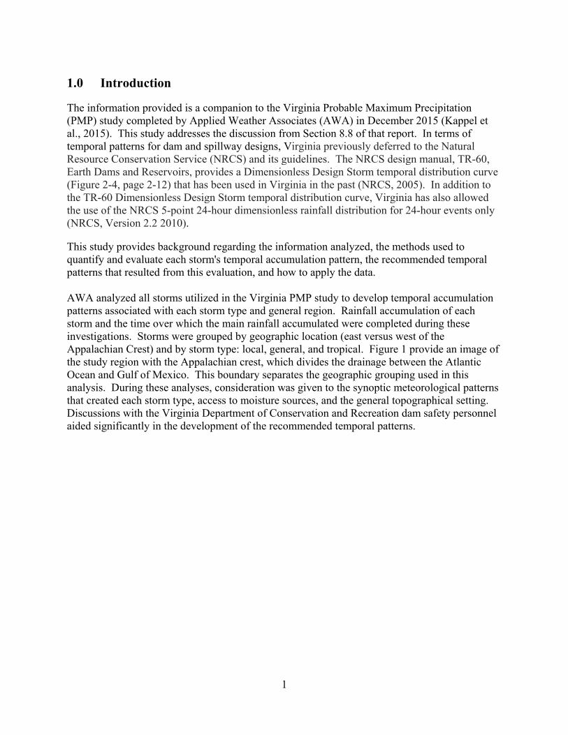
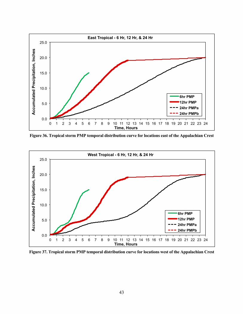
4.0 Temporal Distribution Outfall Curves
A total of twenty-four temporal distribution curves were developed as part of this study with 12 curves utilized in the portion of Virginia west of the Appalachian Crest and 12 curves utilized in the portion of Virginia east of the Appalachian crest. The curves are organized into three time durations based on the Local, General, and Tropical storm types. When applying these temporal patterns, the user should determine whether the basin being analyzed is east or west of the Appalachian crest, then apply the appropriate curve by storm type. The 24-hour curves were broken into two distinct types (A & B) as shown in Figures 31-36 in this section. The 24-hour “A” curves should be utilized when the 12-hour controlling PMP value differs from the 24-hour controlling PMP value meaning rainfall occurred within the controlling storm event after the 12-hour period. The 24-hour “B” curves should be utilized when the 12-hour controlling PMP value matches the 24-hour controlling PMP value meaning no additional rainfall occurred within the controlling storm event after the 12-hour period. The derivation of the values presented in Figures 31-36 started with visual inspections of the rainfall accumulation patterns of the analyzed storms. This was followed by the manual development of characteristic curves intended to best represent the rainfall accumulation patterns by storm type. An iterative approach, which included several discussions and evaluations internally with AWA personnel and with Virginia DCR, was used along with manual manipulation of the values to obtain the recommended curves. The cumulative values were derived to ensure they started at zero and ended at one and produced an accumulation curve, which matched the characteristic distribution. The incremental values were derived to ensure they produced an accumulation intensity that replicated the characteristic distribution.
41
Figure 32. Local storm PMP temporal distribution curve for locations east of the Appalachian Crest
Figure 33. Local storm PMP temporal distribution curve for locations west of the Appalachian Crest
0.0
5.0
10.0
15.0
20.0
0 1 2 3 4 5 6 7 8 9 10 11 12 13 14 15 16 17 18 19 20 21 22 23 24
Acc
um
ula
ted
Pre
cip
ita
tio
n, I
nch
es
Time, Hours
East Local - 6 Hr, 12 Hr, & 24 Hr
6hr PMP
12hr PMP
24hr PMPa
24hr PMPb
0.0
5.0
10.0
15.0
20.0
0 1 2 3 4 5 6 7 8 9 10 11 12 13 14 15 16 17 18 19 20 21 22 23 24
Acc
um
ula
ted
Pre
cip
itat
ion
, In
ches
Time, Hours
West Local - 6 Hr, 12 Hr, & 24 Hr
6hr PMP
12hr PMP
24hr PMPa
24hr PMPb

42
Figure 34. General storm PMP temporal distribution curve for locations east of the Appalachian Crest
Figure 35. General storm PMP temporal distribution curve for locations west of the Appalachian Crest
0.0
5.0
10.0
15.0
20.0
25.0
0 1 2 3 4 5 6 7 8 9 10 11 12 13 14 15 16 17 18 19 20 21 22 23 24
Acc
um
ula
ted
Pre
cip
itat
ion
, In
ches
Time, Hours
East General - 6 Hr, 12 Hr, & 24 Hr
6hr PMP
12hr PMP
24hr PMPa
24hr PMPb
0.0
5.0
10.0
15.0
20.0
25.0
0 1 2 3 4 5 6 7 8 9 10 11 12 13 14 15 16 17 18 19 20 21 22 23 24
Acc
um
ula
ted
Pre
cip
ita
tio
n, I
nch
es
Time, Hours
West General - 6 Hr, 12 Hr, & 24 Hr
6hr PMP
12hr PMP
24hr PMPa
24hr PMPb
43
Figure 36. Tropical storm PMP temporal distribution curve for locations east of the Appalachian Crest
Figure 37. Tropical storm PMP temporal distribution curve for locations west of the Appalachian Crest
0.0
5.0
10.0
15.0
20.0
25.0
0 1 2 3 4 5 6 7 8 9 10 11 12 13 14 15 16 17 18 19 20 21 22 23 24
Acc
um
ula
ted
Pre
cip
itat
ion
, In
ches
Time, Hours
East Tropical - 6 Hr, 12 Hr, & 24 Hr
6hr PMP
12hr PMP
24hr PMPa
24hr PMPb
0.0
5.0
10.0
15.0
20.0
25.0
0 1 2 3 4 5 6 7 8 9 10 11 12 13 14 15 16 17 18 19 20 21 22 23 24
Acc
um
ula
ted
Pre
cip
itat
ion
, In
ches
Time, Hours
West Tropical - 6 Hr, 12 Hr, & 24 Hr
6hr PMP
12hr PMP
24hr PMPa
24hr PMPb

44
5.0 Application of Temporal Patterns to PMP Depths
Virginia DCR will provide guidance and training documents detailing how the temporal curves shown in Section 4.0 are to be applied in conjunction with the Commonwealth of Virginia PMP values / DCR Dam Safety Regulations. These documents should be consulted when applying the temporal curves discussed in this document to ensure proper application of the temporal patterns for a particular basin. Please note that any documents provided by DCR are considered “living documents” and could be updated at any time to include information that is more accurate. It is up to the user to consult / utilize the most up to date version of these two documents. Please consult DCR Dam Safety’s website at http://www.dcr.virginia.gov/dam-safety-and-floodplains/ to access said documents.

45
References
Bonta, J. V., and A. Shahalam. 2003. Cumulative storm rainfall distributions: comparison of Huff curves. J. of Hydrology (NZ) 42(1): 65−74.
Bonta, J. V., 2004. Development and utility of Huff curves for disaggregating precipitation amounts. Applied Engineering in Agriculture.
Huff, F. A. 1967. Time distribution of rainfall in heavy storms. Water Resources Research 3(4): 1007−1019.
Kappel, W.D., Hultstrand, D.M., Muhlestein, G.A., Steinhilber, K., McGlone, D., Rodel, J., and B. Lawrence, November 2015: Statewide Probable Maximum Precipitation or Virginia. Prepared for the Virginia Department of Conservation and Recreation.
Letkewicz, C.E., M.D. Parker, 2010: Forecasting the Maintenance of Mesoscale Convective Systems Crossing the Appalachian Mountains. Wea. Forecasting, 25, 1179–1195.
Natural Resources Conservation Service (NRCS), Conservation Engineering Division. 2010, NRCS 5-point 24-hour dimensionless rainfall distribution for 24-hour events only version 2.2.
Virginia Department of Conservation and Recreation, Dam Safety Document, http://www.dcr.virginia.gov/dam-safety-and-floodplains/dcrdsdocs.

46
Appendix A
Temporal Analysis Excel Spreadsheet-provided via electronic format