2018 ipl symposium on landslides
TRANSCRIPT

2018 IPL SYMPOSIUM
ON LANDSLIDES
03 December 2018 Kyoto University, Uji campus, Kyoto, Japan
Organized by International Consortium on Landslides (ICL)

Picture on the cover page Kure landslide in Hiroshima after the heavy rainfall in July 2018 Taken from UAV by Kyoji Sassa, Khang Dang, and Nguyen Duc Ha
2018 IPL SYMPOSIUM ON LANDSLIDES
03 December 2018 Kyoto University, Uji campus, Kyoto, Japan
Kyoji Sassa・Khang Dang Editors
Organized by International Consortium on Landslides (ICL)
Supported by
Disaster Prevention Research Institute of Kyoto University

Editors
Kyoji Sassa, Khang Dang
International Consortium on Landslides
Kyoto, Japan
This proceedings is registered in the Online Public Access Catalog of the National Diet Library of Japan ISBN 978-4-9903382-0-6 Published by: The International Consortium on Landslides
Proceedings of 2018 IPL Symposium on Landslides, Kyoto, Japan
IPL Project 181 – Study of slow moving landslide Umka near Belgrade, Serbia – progress report for 2017 & 2018
Uroš Đurić (1), Biljana Abolmasov (2), Miloš Marjanović (2), Mileva Samardžić‐Petrović (1), Marko Pejić (1), Nenad Brodić (1), Jovan Popović (1) 1) University of Belgrade, Faculty of Civil Engineering, Belgrade, Bulevar Kralja Aleksandra 73/I, Serbia, +381113218587, e‐mail: [email protected]
2) University of Belgrade, Faculty of Mining and Geology, Đušina 7, Serbia
Abstract This paper presents a brief working progress report on realization of the IPL project 181 “Study of slow moving landslide Umka near Belgrade, Serbia”. In this paper we will present results of the project targets performed by Project participants during 2017 and 2018, with plans for future project realization.
Keywords questionnaire, historical aerial images, elements at risk, PSInSAR
Introduction
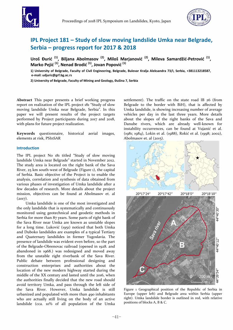
The IPL project No 181 titled “Study of slow moving landslide Umka near Belgrade” started in November 2012. The study area is located on the right bank of the Sava River, 25 km south‐west of Belgrade (Figure 1), the capital of Serbia. Basic objective of the Project is to enable the analysis, correlation and synthesis of data obtained from various phases of investigation of Umka landslide after a few decades of research. More details about the project mission, objectives can be found at Abolmasov et. al (2017).
Umka landslide is one of the most investigated and the only landslide that is systematically and continuously monitored using geotechnical and geodetic methods in Serbia for more than 87 years. Some parts of right bank of the Sava River near Umka are known as unstable slopes for a long time. Luković (1951) noticed that both Umka and Duboko landslides are examples of a typical Tertiary and Quaternary landslides in former Yugoslavia. The presence of landslide was evident even before, so the part of the Belgrade‐Obrenovac railroad (opened in 1928. and abandoned in 1968.) was redesigned and moved away from the unstable right riverbank of the Sava River. Public debate between professional designing and construction enterprises and authorities about the location of the new modern highway started during the middle of the XX century and lasted until the 2016, when the authorities finally decided that the new road should avoid territory Umka, and pass through the left side of the Sava River. However, Umka landslide is still urbanized and populated with more than 490 inhabitants who are actually still living on the body of an active landslide (cca. 10% of all population of the Umka
settlement). The traffic on the state road IB 26 (from Belgrade to the border with BiH), that is affected by Umka landslide, is showing increasing number of average vehicles per day in the last three years. More details about the slopes of the right banks of the Sava and Danube rivers, which are already well‐known for instability occurrences, can be found at Vujanić et al. (1981; 1984), Lokin et al. (1988), Rokić et al. (1998; 2002), Abolmasov et. al (2015).
Figure 1 Geographical position of the Republic of Serbia in Europe (upper left) and Belgrade area within Serbia (upper right). Umka landslide border is outlined in red, with relative positions of blocks A, B & C.
-41-
U. Đurić, B. Abolmasov, M. Marjanović, M. Samardžić‐Petrović, M. Pejić, N. Brodić, J. Popović – IPL Project 181 – Study of slow moving landslide Umka near Belgrade, Serbia – progress report for 2017 & 2018
Previous research
Most of the Umka landslide investigation and research during the 1970‐1990 period, were performed for the Main Design for the Belgrade‐Obrenovac highway and for the Umka urban plans and regulations (Mitrović & Jelisavac, 2006). During the 1990‐2005, on the Umka landslide there were more than 70 boreholes (wherein, many of these had inclinometer construction installed), 19 standard penetration tests, 10 geological wells, 6 geological pits, 4 deep shafts, and more than 30 surveying benchmarks that were monitored. During the 1990 investigation campaign more than 430 objects were surveyed for deformations and damage. This number includes dozens of objects in the stable part near the landslide boundaries.
Geometry, geological setting, mechanism and dynamics of the Umka landslide were well defined by previous research. A summary of the geotechnical investigations results until 1995 can be found in Vujanić et al. (1996), while the summary of investigations until 2005 can be found in Jelisavac et al. (2006) and Mitrović & Jelisavac (2006).
Since the monitoring of the landslide was interrupted and discontinued after 1990 and 2005 geotechnical investigation campaigns, there was a need for setting up permanent geotechnical and geodetic monitoring. Automated continuous real‐time GNSS monitoring was established in March 2010 (Abolmasov et al. 2012b; 2013). Simultaneously, the levels of the Sava river are observed in near‐real time, i.e. on daily basis, as well as the average daily temperature and type and amount of precipitation. More detailed report with results of monitoring and conclusions about landslide recent dynamics can be found in Abolmasov et al. (2014, 2015). Photogelogical analysis was performed by Marković (1980) and later for a new landslide inventory of Belgrade by Lokin et al. (2010). Basic photogrammetric analyses of the Umka landslide have been revealed from aerial images from 1970–2007 period and orthophotos that were taken in 2001, 2005 and 2010 (Abolmasov et al., 2012).
Previous research has shown that Umka landslide can be described as complex landslide within the stiff fissured clayey marls (Abolmasov et. al., 2015). Landslide is active, with various phases of deceleration and acceleration, which are mostly in correlation with the Sava River level drop, while landslide velocity is characterized as slow to very slow. More details and brief report of investigations conducted by IPL 181 project until 2017 can be found at Abolmasov et al. (2017).
Research and investigation performed during 2017.
Control borehole and inclinometer
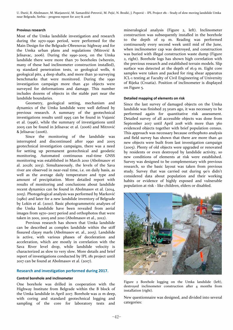
One borehole was drilled in cooperation with the Highway Institute from Belgrade within the B block of the Umka landslide in April 2017. Borehole was 21 m deep, with coring and standard geotechnical logging and sampling of the core for laboratory tests and
mineralogical analysis (Figure 2, left). Inclinometer construction was subsequently installed in the borehole to the depth of 19 m. Reading was performed continuously every second week until mid of the June, when inclinometer cap was destroyed, and construction was buried with illegal construction waste dump (Figure 2, right). Borehole logs has shown high correlation with the previous research and established terrain models. Slip surface was detected at the depth of 16.9 m. Eight core samples were taken and packed for ring shear apparatus ICL‐1 testing at Faculty of Civil Engineering of University of Rijeka (Croatia). Position of inclinometer is displayed on Figure 5.
Detailed mapping of elements on risk
Since the last survey of damaged objects on the Umka landslide was finished 25 years ago, it was necessary to be performed again for quantitative risk assessment. Detailed survey of all accessible objects was done from September 2017 until April 2018 with more than 360 evidenced objects together with brief population census. This approach was necessary because orthophoto analysis and field survey has shown that there are more than 40 new objects were built from last investigation campaign (2005). Plenty of old objects were upgraded or renovated by residents or even destroyed by landslide activity, so new conditions of elements at risk were established. Survey was designed to be complementary with previous research, so the basic layout was taken from previous study. Survey that was carried out during 90’s didn’t considered data about population and their working habits or evidence of highly exposed and vulnerable population at risk ‐ like children, elders or disabled.
Figure 2 Borehole logging on the Umka landslide (left), destroyed inclinometer construction after 4 months from installation (right).
New questionnaire was designed, and divided into several categories:
-42-
Proceedings of 2018 IPL Symposium on Landslides, Kyoto, Japan
‐ Basic data about object; This category included basic info about exposed
object like: location, position, coordinates info about cadaster parcel number, type of object (resident, cottage, ancillary...), number of floors, roofs, ground floor area and number of vehicles in household.
‐ Data about construction; This category included questions about type of
dominant building material (concrete, reinforced concrete, brick, and block) and construction type (supporting walls, armored concrete beams, wooden beams etc.).
‐ Damage classification; Herein two descriptive scales were used for typology
of damage on objects, first scale was adopted from previous questionnaire (Highway institute) and all objects were categorized in 5 classes (without damage ‐ destroyed). Second scale divided objects in 6 classes by damage and this scale is still the only official one, defined by “Unique methodology for damage assessment from natural hazards in SFR Yugoslavia”, adopted and published in Official Gazette in 1987.
‐ Data about foundation; This category included questions about type of
foundations and material. ‐ Data about household; This category includes questions of number of
inhabitants within the object and their employment, number of children and number of disabled if any.
‐ Data about damage estimation, emergency measures and possible remediation measures;
Those three categories, include field about relative damage estimation (expressed in total value of the housing or object and % of damage), estimation of a possible emergency geotechnical measures (drainage, construction works) and possibility of remediation measures (descriptive: possible, not possible, not needed).
‐ Information about surface and groundwater; This category includes fields about ground and
underground waters, presence of water system, drainage system, position of water wells and their conditions, water level in wells, and presence of sewage system with current condition.
‐ Object and surface deformation This category contains blank sketch of all four sides
of an object. Walls are always oriented in such manner, that A side is looking toward general slide direction. Other sides are named B, C & D and they are always oriented clockwise from A. During surveying, all cracks are drawn on these sketches, with their relative position, width, and intensity. This category also includes information about house or object tilt toward predefined directions, as well as sinking and deformation of surrounding terrain.
‐ Other remarks This field represent blank text field for general
remarks and description of all other relevant information
that are not covered by previous field investigations, but could be significant for other conclusions.
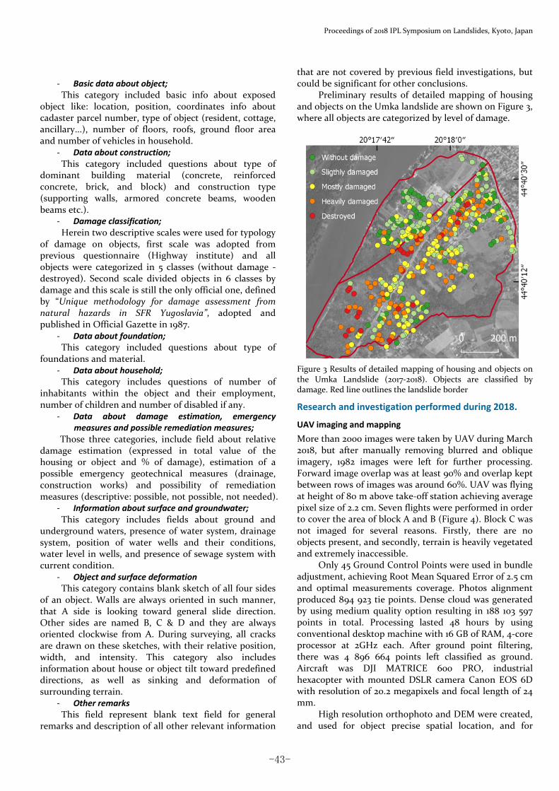
Preliminary results of detailed mapping of housing and objects on the Umka landslide are shown on Figure 3, where all objects are categorized by level of damage.
Figure 3 Results of detailed mapping of housing and objects on the Umka Landslide (2017‐2018). Objects are classified by damage. Red line outlines the landslide border
Research and investigation performed during 2018.
UAV imaging and mapping
More than 2000 images were taken by UAV during March 2018, but after manually removing blurred and oblique imagery, 1982 images were left for further processing. Forward image overlap was at least 90% and overlap kept between rows of images was around 60%. UAV was flying at height of 80 m above take‐off station achieving average pixel size of 2.2 cm. Seven flights were performed in order to cover the area of block A and B (Figure 4). Block C was not imaged for several reasons. Firstly, there are no objects present, and secondly, terrain is heavily vegetated and extremely inaccessible.
Only 45 Ground Control Points were used in bundle adjustment, achieving Root Mean Squared Error of 2.5 cm and optimal measurements coverage. Photos alignment produced 894 923 tie points. Dense cloud was generated by using medium quality option resulting in 188 103 597 points in total. Processing lasted 48 hours by using conventional desktop machine with 16 GB of RAM, 4‐core processor at 2GHz each. After ground point filtering, there was 4 896 664 points left classified as ground. Aircraft was DJI MATRICE 600 PRO, industrial hexacopter with mounted DSLR camera Canon EOS 6D with resolution of 20.2 megapixels and focal length of 24 mm.
High resolution orthophoto and DEM were created, and used for object precise spatial location, and for
-43-
U. Đurić, B. Abolmasov, M. Marjanović, M. Samardžić‐Petrović, M. Pejić, N. Brodić, J. Popović – IPL Project 181 – Study of slow moving landslide Umka near Belgrade, Serbia – progress report for 2017 & 2018
mapping damage on the road and local street infrastructure.
Figure 4 Positions of the drone take‐off stations, GCP’s and image footprint coverage. Red line outlines the landslide border.
Road damage assessment
Field campaign and UAV mapping, included all streets and roads, mapped for accessing landslide damage during 2018. Streets were treated as linear objects that were segmented and categorized by level of damage and accessibility. Beside visual field inspection, high resolution ortophoto was used for damage assessment. Beside the state road IB 26, there is a network of local streets across the Umka landslide affected by the landslide. Most of the streets in lower part of block B are totally damaged and inaccessible, while situation is slightly better in the upper parts of block B, where some areas and parts are accessible by standard passenger vehicles. The best situation is in block A, where most of the streets are accessible with slight damage or cracks in the upper part.
Collecting and analyzing the traffic data
Annual average daily traffic (AADT) data were collected for landslide risk assessment from the Public Enterprise Roads of Serbia for the period 2005–2016. These data include information about daily traffic on section of road Barič – Umka, with details about vehicle category, velocity and traffic direction per hour. Information about car accidents was collected from OpenData portal of the Republic of Serbia (https://data.gov.rs). This data contains information about traffic accidents on the territory of Belgrade. All data are tabular with most important parameters such as: accident ID, date and time, location, type of accident, number of vehicle and people affected, as well as a brief description.
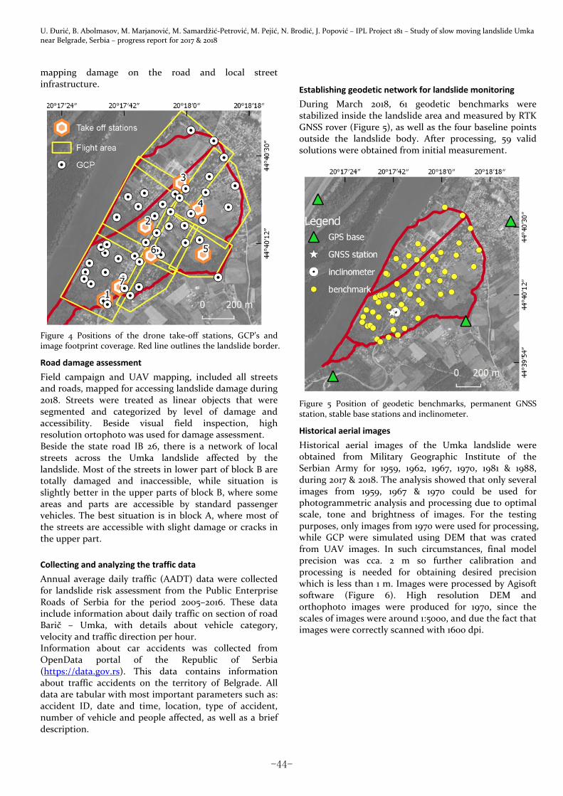
Establishing geodetic network for landslide monitoring
During March 2018, 61 geodetic benchmarks were stabilized inside the landslide area and measured by RTK GNSS rover (Figure 5), as well as the four baseline points outside the landslide body. After processing, 59 valid solutions were obtained from initial measurement.
Figure 5 Position of geodetic benchmarks, permanent GNSS station, stable base stations and inclinometer.
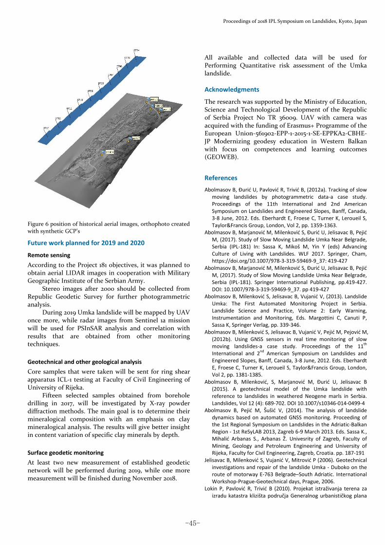
Historical aerial images
Historical aerial images of the Umka landslide were obtained from Military Geographic Institute of the Serbian Army for 1959, 1962, 1967, 1970, 1981 & 1988, during 2017 & 2018. The analysis showed that only several images from 1959, 1967 & 1970 could be used for photogrammetric analysis and processing due to optimal scale, tone and brightness of images. For the testing purposes, only images from 1970 were used for processing, while GCP were simulated using DEM that was crated from UAV images. In such circumstances, final model precision was cca. 2 m so further calibration and processing is needed for obtaining desired precision which is less than 1 m. Images were processed by Agisoft software (Figure 6). High resolution DEM and orthophoto images were produced for 1970, since the scales of images were around 1:5000, and due the fact that images were correctly scanned with 1600 dpi.
-44-
Proceedings of 2018 IPL Symposium on Landslides, Kyoto, Japan
Figure 6 position of historical aerial images, orthophoto created with synthetic GCP’s
Future work planned for 2019 and 2020
Remote sensing
According to the Project 181 objectives, it was planned to obtain aerial LIDAR images in cooperation with Military Geographic Institute of the Serbian Army.
Stereo images after 2000 should be collected from Republic Geodetic Survey for further photogrammetric analysis.
During 2019 Umka landslide will be mapped by UAV once more, while radar images from Sentinel 1a mission will be used for PSInSAR analysis and correlation with results that are obtained from other monitoring techniques.
Geotechnical and other geological analysis
Core samples that were taken will be sent for ring shear apparatus ICL‐1 testing at Faculty of Civil Engineering of University of Rijeka.
Fifteen selected samples obtained from borehole drilling in 2017, will be investigated by X‐ray powder diffraction methods. The main goal is to determine their mineralogical composition with an emphasis on clay mineralogical analysis. The results will give better insight in content variation of specific clay minerals by depth.
Surface geodetic monitoring
At least two new measurement of established geodetic network will be performed during 2019, while one more measurement will be finished during November 2018.
All available and collected data will be used for Performing Quantitative risk assessment of the Umka landslide.
Acknowledgments
The research was supported by the Ministry of Education, Science and Technological Development of the Republic of Serbia Project No TR 36009. UAV with camera was acquired with the funding of Erasmus+ Programme of the European Union‐561902‐EPP‐1‐2015‐1‐SE‐EPPKA2‐CBHE‐JP Modernizing geodesy education in Western Balkan with focus on competences and learning outcomes (GEOWEB).
References
Abolmasov B, Đurić U, Pavlović R, Trivić B, (2012a). Tracking of slow moving landslides by photogrammetric data‐a case study. Proceedings of the 11th International and 2nd American Symposium on Landslides and Engineered Slopes, Banff, Canada, 3‐8 June, 2012. Eds. Eberhardt E, Froese C, Turner K, Leroueil S, Taylor&Francis Group, London, Vol 2, pp. 1359‐1363.
Abolmasov B, Marjanović M, Milenković S, Đurić U, Jelisavac B, Pejić M, (2017). Study of Slow Moving Landslide Umka Near Belgrade, Serbia (IPL‐181) In: Sassa K, Mikoš M, Yin Y (eds) Advancing Culture of Living with Landslides. WLF 2017. Springer, Cham, https://doi.org/10.1007/978‐3‐319‐59469‐9_37: 419‐427
Abolmasov B, Marjanović M, Milenković S, Đurić U, Jelisavac B, Pejić M, (2017). Study of Slow Moving Landslide Umka Near Belgrade, Serbia (IPL‐181). Springer International Publishing, pp.419‐427. DOI: 10.1007/978‐3‐319‐59469‐9_37. pp 419‐427
Abolmasov B, Milenković S, Jelisavac B, Vujanić V, (2013). Landslide Umka: The First Automated Monitoring Project in Serbia. Landslide Science and Practice, Volume 2: Early Warning, Instrumentation and Monitoring, Eds. Margottini C, Canuti P, Sassa K, Springer Verlag, pp. 339‐346.
Abolmasov B, Milenković S, Jelisavac B, Vujanić V, Pejić M, Pejović M, (2012b). Using GNSS sensors in real time monitoring of slow moving landslides‐a case study. Proceedings of the 11
th
International and 2nd American Symposium on Landslides and
Engineered Slopes, Banff, Canada, 3‐8 June, 2012. Eds. Eberhardt E, Froese C, Turner K, Leroueil S, Taylor&Francis Group, London, Vol 2, pp. 1381‐1385.
Abolmasov B, Milenković, S, Marjanović M, Đurić U, Jelisavac B (2015). A geotechnical model of the Umka landslide with reference to landslides in weathered Neogene marls in Serbia. Landslides, Vol 12 (4): 689‐702. DOI 10.1007/s10346‐014‐0499‐4
Abolmasov B, Pejić M, Šušić V, (2014). The analysis of landslide dynamics based on automated GNSS monitoring. Proceeding of the 1st Regional Symposium on Landslides in the Adriatic‐Balkan Region ‐ 1st ReSyLAB 2013, Zagreb 6‐9 March 2013. Eds. Sassa K., Mihalić Arbanas S., Arbanas Ž. Univesrity of Zagreb, Faculty of Mining, Geology and Petroleum Engineering and University of Rijeka, Faculty for Civil Engineering, Zagreb, Croatia. pp. 187‐191
Jelisavac B, Milenković S, Vujanić V, Mitrović P (2006). Geotechnical investigations and repair of the landslide Umka ‐ Duboko on the route of motorway E‐763 Belgrade–South Adriatic. International Workshop‐Prague‐Geotechnical days, Prague, 2006.
Lokin P, Pavlović R, Trivić B (2010). Projekat istraživanja terena za izradu katastra klizišta područja Generalnog urbanističkog plana
-45-

U. Đurić, B. Abolmasov, M. Marjanović, M. Samardžić‐Petrović, M. Pejić, N. Brodić, J. Popović – IPL Project 181 – Study of slow moving landslide Umka near Belgrade, Serbia – progress report for 2017 & 2018
područja Beograda. J.P. Direkcija za građevinsko zemljište grada Beograda (in Serbian). Unpublished material. (in Serbian)
Lokin P, Sunarić D, Cvetković T (1988). Landslides in Neogene sediments on the right Danube bank, Yugoslavia. Proceedings of the 5
th International Symposium on Landslides, 10‐15 July 1988,
Lausanne, Ed Ch Bonnard, Vol 1, Balkema Rotterdam, pp. 213‐217
Luković M, (1952). Važniji tipovi naših klizišta i mogućnosti njihovog saniranja. Geološki vesnik. Vol IX.275‐310 (in Serbian)
Marković M, (1980) Fotogeološka ispitivanja stabilnosti na području Umka‐Barič, Fond stručnih dokumenata Instituta za puteve ‐ Beograd (in Serbian)
Mitrović P, Jelisavac B, (2006). Sanacija klizišta “Duboka”. Materijali i konstrukcije 49(1‐2): 46‐59 (in Serbian)
Rokić Lj, Vujanić V (2002). A contribution on the study of landslide origins in Neogene sediments of Danube river coastal area.
Proceedings of the 1st European Conference on Landslides,
Prague, Czech Republic, June 24‐26 2002, Eds, Rybar J, Stemberk J, Wagner P, Balkema Publishers, pp. 291‐298.
Rokić Lj, Vujanić V, Jotić M (1998). Forecast of the landslide development processes based on the study of erosion processes of rivers in the plains. Proceedings of 8
th International IAEG
Congress, 21‐25 September 1998, Vancouver, Canada, Eds, Moore D, Hungr O, Vol 3, Balkema Rotterdam: 1485‐1491.
Vujanić V, Livada N, Božinović D (1984). On an Old Landslide in Neogene Clays on the Right Bank of the Sava near Belgrade. Proceedings of 4
th International Symposium on Landslides,
Toronto, Canada, 1984, Vol 2: 227‐233. Vujanić V, Livada N, Jotić M, Gojković S, Ivković J, Božinović D,
Sunarić D, Šutić J (1981). Klizište “Duboko” na Savi kod Beograda. Zbornik radova Simpozijuma istraživanje I sanacija klizišta, Bled 1981, Knjiga 1, pp. 119‐134 (in Serbian).
-46-