2018 annual conference schedule - ofwim.org · 2018 ofwim annual conference “let’s partner-...
TRANSCRIPT

2018 OFWIM Annual Conference Proceedings
Partnered with
Sponsored By:

2018 OFWIM Annual Conference
“Let’s Partner- Moving Forward Together”
Partnered With
Welcome to the 2018 Organization of Fish and Wildlife Information Managers Conference and Business Meeting. We are thrilled that you have been able to join us and have an outstanding schedule lined up for you. We have a diverse group of presentations and our always popular Hackers Ball with posters and technical demonstrations. Field sessions will be tours hosted by staff from USGS and the Yakima Nation. We are excited about our free workshop, “Intro to Survey 123 and Collector”. Geocache OFWIM another popular event allows you to meet and reconnect with fellow OFWIM members and learn about the geography of the area. Join us for the Wednesday lunch and business meeting and help us shape the future of OFWIM. Find a committee to join and be a part of OFWIM. We hope that you find this week educational and enjoyable. If there is anything we can do to help out this week, feel free to contact any of the conference planning committee. Enjoy Hood River and welcome to OFWIM 2018!
OFWIM Conference Planning Committee
Beth Stys Dyan Pursell
Emily K. Tracy-Smith Jeanette Jones
Joe Kirby Julie Prior-Magee Karen Horodysky
Keith Hurley Lynn Barrett
MaryEllen Wickett Megan Dethloff
Sabra Tonn Susan Watson Jennifer Bayer Chris Wheaton

2018 OFWIM Annual Conference
“Let’s Partner- Moving Forward Together”
Partnered With
Schedule at a Glance Sunday, November 4th
5:00 PM ExCom/Conference Planning Meeting 6:00 PM Dinner and Social at Cebu Lounge
Monday, November 5th
7:45 AM Registration 8:15 AM OFWIM Welcome, Announcements & Introduction 9:30 AM Break 9:45 AM Session I
11:50 AM Lunch- On your own 1:10 PM Session II 2:50 PM Break 3:05 PM Session III 5:10 PM Field Techniques Session Logistics
5:20 PM Poster Set Up/ Geocache 6:00 PM Hackers Ball (Dinner Provided)
Tuesday, November 6th
8:35 AM Depart for The Field Techniques Session (Departure time rain dependent, Lunch Provided)
5:00 PM Return to Hotel (Dinner on your own)
Wednesday, November 7th 8:00 AM Session IV 9:40 AM Break 9:55 AM Session V
12:00 PM Business Meeting and Lunch (Lunch Provided) 1:20 PM Committee Breakout Sessions 1:55 PM Session VI 3:10 PM Break 3:25 PM Session VII 5:05 PM Geocache 6:00 PM Banquet (Dinner Provided)
Thursday, November 8th 8:00 AM Workshop: Collector and Survey123 for ArcGIS
12:00 PM Closing Remarks
2018 OFWIM Annual Conference
“Let’s Partner- Moving Forward Together”
Partnered With
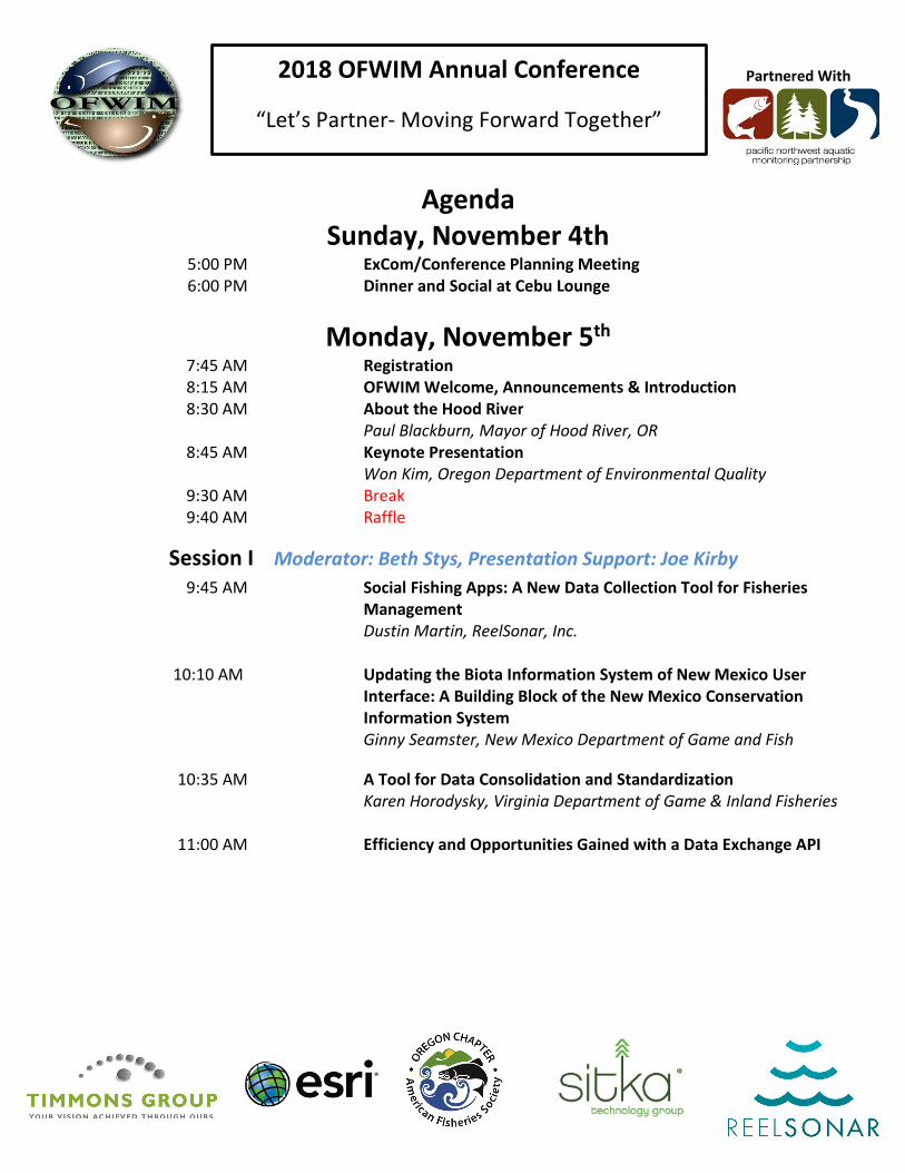
Agenda Sunday, November 4th
5:00 PM ExCom/Conference Planning Meeting 6:00 PM Dinner and Social at Cebu Lounge
Monday, November 5th 7:45 AM Registration 8:15 AM OFWIM Welcome, Announcements & Introduction 8:30 AM About the Hood River
Paul Blackburn, Mayor of Hood River, OR 8:45 AM Keynote Presentation
Won Kim, Oregon Department of Environmental Quality 9:30 AM Break 9:40 AM Raffle
Session I Moderator: Beth Stys, Presentation Support: Joe Kirby 9:45 AM Social Fishing Apps: A New Data Collection Tool for Fisheries
Management Dustin Martin, ReelSonar, Inc.
10:10 AM Updating the Biota Information System of New Mexico User
Interface: A Building Block of the New Mexico Conservation Information System
Ginny Seamster, New Mexico Department of Game and Fish
10:35 AM A Tool for Data Consolidation and Standardization Karen Horodysky, Virginia Department of Game & Inland Fisheries
11:00 AM Efficiency and Opportunities Gained with a Data Exchange API
2018 OFWIM Annual Conference
“Let’s Partner- Moving Forward Together”
Partnered With
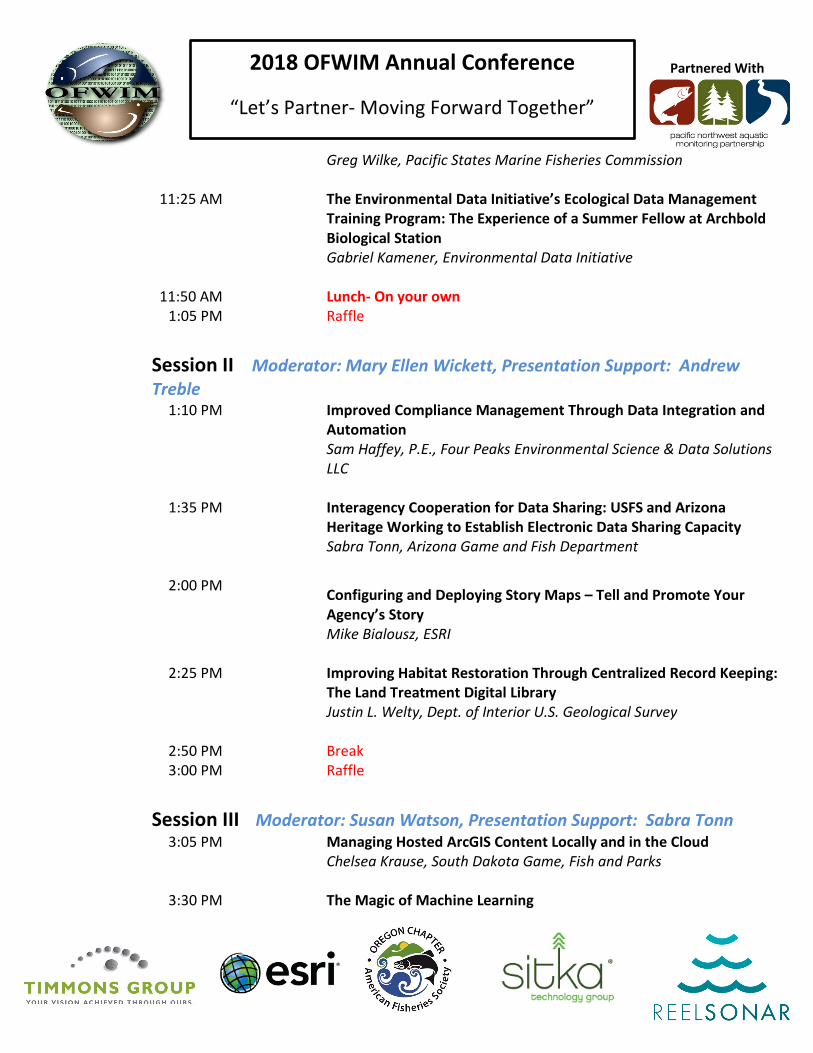
Greg Wilke, Pacific States Marine Fisheries Commission
11:25 AM The Environmental Data Initiative’s Ecological Data Management Training Program: The Experience of a Summer Fellow at Archbold Biological Station
Gabriel Kamener, Environmental Data Initiative
11:50 AM Lunch- On your own 1:05 PM Raffle
Session II Moderator: Mary Ellen Wickett, Presentation Support: Andrew Treble
1:10 PM Improved Compliance Management Through Data Integration and Automation Sam Haffey, P.E., Four Peaks Environmental Science & Data Solutions LLC
1:35 PM Interagency Cooperation for Data Sharing: USFS and Arizona Heritage Working to Establish Electronic Data Sharing Capacity Sabra Tonn, Arizona Game and Fish Department
2:00 PM Configuring and Deploying Story Maps – Tell and Promote Your Agency’s Story Mike Bialousz, ESRI
2:25 PM Improving Habitat Restoration Through Centralized Record Keeping: The Land Treatment Digital Library Justin L. Welty, Dept. of Interior U.S. Geological Survey
2:50 PM Break 3:00 PM Raffle
Session III Moderator: Susan Watson, Presentation Support: Sabra Tonn
3:05 PM Managing Hosted ArcGIS Content Locally and in the Cloud Chelsea Krause, South Dakota Game, Fish and Parks
3:30 PM The Magic of Machine Learning

2018 OFWIM Annual Conference
“Let’s Partner- Moving Forward Together”
Partnered With
Keith Hurley, Nebraska Game and Parks Commission
3:55 PM Introducing GeoOptix: Tools for Fueling Collaboration and Secure Environmental Data Management in the Cloud Keith Steele, Sitka Technology Group
Student Session 4:20 PM Assessing the association between freshwater mussel beds and
hydrogeomorphic features in two Ozark Drainages Jordan Holtswarth
4:45 PM Impacts of Intermittency to Stream Biota Community Structure
Isabel Papraniku,
5:10 PM Field Techniques Session Logistics
5:20 PM Poster Set Up / Geocache 6:00 PM Hackers Ball (Dinner Provided)
Assessing the Protection Status of Vegetation Types in the Conterminous U.S., Alexa McKerrow, USGS
MonitoringResources.org as a Documentation and Sharing Tool for eDNA Investigations, Sam Cimino, Pacific Northwest Aquatic Monitoring Partnership/ U.S. Geological Survey
An online collaborative data sharing and conservation planning platform , Beth Stys, Florida Fish and Wildlife Conservation Commission
Vyond: Using Animated Videos to Convey Concepts, Heather Konell, Atlantic Coastal Cooperative Statistics Program
Pacific Northwest Aquatic Monitoring Partnership, Sheryn Olson, Pacific Northwest Aquatic Monitoring Partnership/ U.S. Geological Survey
Configuring and Deploying Story Maps – Tell and Promote Your Agency’s Story, Mike Bialousz, ESRI
The Tennessee Wildlife Legacy Plan – Utilizing the State Wildlife Action Plan, Jeanette Jones, Tennessee Wildlife Resources Agency

2018 OFWIM Annual Conference
“Let’s Partner- Moving Forward Together”
Partnered With
Here We Go Again! Rebuilding the Virginia Fish and Wildlife Service to better meet needs of our staff, our constituents, and our partners, Amy Ewing, VA Department of Game and Inland Fisheries
Conservation Efforts Database V2.0: Conservation Planning and Effectiveness Monitoring, Justin L. Welty, Dept. of Interior U.S. Geological Survey
Planning for the Future by Studying the Past: The Land Treatment Exploration Tool Justin L. Welty, Dept. of Interior U.S. Geological Survey
Bathymetric Mapping and the WV Interactive Hunting & Fishing Map, Jessica Perkins, WV Division of Natural Resources
Maine’s Electronic Game Registration Application, MaryEllen Wickett, Maine Dept. of Inland Fisheries and Wildlife Improving Data Access Using JSON Web Services, Keith Hurley, Nebraska Game and Parks Commission
First Comprehensive List of Non-Native Species Established in the United States, Segregated by Major Regions, Annie Simpson, USGS
How the Yakama Nation Shares Fish and Habitat Restoration Information, Michelle Steg-Geltner, Yakama Nation Fisheries
Mobile Apps for Texas Game Wardens, Dyanne Cortez, Texas Parks and Wildlife Department
Tuesday, November 6th 8:35 AM Gather for The Field Techniques Session (Time Rain Dependent) 8:45 AM Depart for The Field Techniques Session
(Lunch Provided) 5:00 PM Return to Hotel
Dinner- On your own
Wednesday, November 7th 7:50 AM Raffle
Session IV Moderator: Rebecca Scully, Presentation Support: Sam Cimino 8:00 AM Data Visualization Tools for Aquatic Habitat Evaluation and Species
Recovery Prioritization Jon Walker, ICF

2018 OFWIM Annual Conference
“Let’s Partner- Moving Forward Together”
Partnered With
8:25 AM Data Driven Decision Making using Tableau Joe Kirby, Missouri Dept. of Conservation
8:50 AM Evaluation and Prioritization of Restoration Actions in Three Urban Aquatic Environments for Salmonids Under Current and Climate Change Conditions Laura E. McMullen, ICF
9:15 AM Building for the Future: Bringing MOFEP into the 21st Century Dyan Pursell, Missouri Department of Conservation
9:40 AM Break 9:50 AM Raffle
Session V Moderator: Jeanette Jones, Presentation Support: Rebecca Scully
9:55 AM Using Deep Learning to Screen Time-Lapse Pictures for Vehicles Keith Hurley, Nebraska Game and Parks Commission
10:20 AM The Power of ARCGIS Story Maps for Informing Decision-Makers
Nancy Leonard, NW Power and Conservation Council
10:45 AM The COTS - Custom Mixer - Maine's Conservation Actions Tracker (Shaken not Stirred)
Chris Gereck, Timmons Group
11:10 AM Species Habitat Distribution Maps to Support Conservation Planning at a National Scale.
Alexa McKerrow, USGS
11:35 AM Predicting Forest Fires with Machine Learning Ian Downard, MapR
12:00 PM Business Meeting (Lunch Provided)
Innovation Awards Committee Presentations
1:20 PM Committee Breakout Sessions

2018 OFWIM Annual Conference
“Let’s Partner- Moving Forward Together”
Partnered With
1:50 PM Raffle
Session VI Moderator: Jen Bayer, Presentation Support: Chelsea Krause 1:55 PM Building Wildlife Models with Cloud-Based Mapping Techniques
James R. Hatten, USGS
2:20 PM The Nonindigenous Aquatic Species Flood and Storm Transport (NAS FAST) Mapper Matthew Neilson, U.S. Geological Survey
2:45 PM How to Deal with and Use All That GPS Tracking Data... What a Mess!
Eric Edgley, Utah Division of Wildlife Resources
3:10 PM Break 3:20 PM Raffle
Session VII Moderator: Keith Hurley, Presentation Support: Sabra Tonn 3:25 PM Using MonitoringResources.org to Track Sampling Locations
Rebecca A. Scully, USGS/PNAMP
3:50 PM Survey123 and Collector – What’s New? Matt Taraldsen, ESRI
4:15 PM ArcGIS Solutions: Getting the Most Out of Your Existing GIS Investment
Mike Bialousz, ESRI
4:40 PM Mapping and Quantifying Xeroriparian Across the Arid Deserts Austin Smith, Arizona Game and Fish Department
5:05 PM Geocache 6:00 PM Banquet (Dinner Provided)
Thursday, November 8th 8:00 AM Workshop: Collector and Survey123 for ArcGIS
12:00 PM Closing Remarks

2018 OFWIM Annual Conference
“Let’s Partner- Moving Forward Together”
Partnered With
Field Techniques Session
Tour of the Gorge We have quite a day planned touring and learning about Columbia River Gorge habitat, hydropower, and fish ecology. We will start with a tour of restoration sites on the White Salmon River. On October 26th, 2011 the Condit Dam was removed and for the first time in 100 years salmon and steelhead have returned to the upper stretch of the river. The Yakama Nation will give us a tour of two different restoration sites and share their story. Watch this National Geographic video of the dam removal.
Condit dam site right after dam removal
While at the river, we will also get a demo from USGS on using UAV technology to count salmon redds. After we have finished on the White Salmon, we will drive down the Columbia River Gorge, stopping in Stevenson, WA for lunch then continuing over the Bridge of the Gods to the Bonneville Dam. A Bonneville guide will take us through the energy facilities and a tour of the fish ladder. While at the dam, you can stop by the fish Hatchery to visit Herman the Sturgeon. Herman is 11 feet long, 500 pounds, an estimated 70-year-old white sturgeon. After a full day we will return to Hood River, along the south side of the Gorge getting an up-close look at site of the 2017 Eagle Creek Fire. If your car is craving some additional activates you can stop at Starvation Creek for a shot hike to a beautiful waterfall.

2018 OFWIM Annual Conference
“Let’s Partner- Moving Forward Together”
Partnered With
Times Destination/Activity Description Gather at 8:35 Depart at 8:45am
Parking lot Gather in Best Western Parking lot to car pool and split into 2 groups.
Session 1 9-10:30 am
Group A
White Salmon River Restoration
The Yakama Nation tour of two different restorations. Watch this National Geographic video of the dam removal. • Site 1 – In Lieu Site • Site 2 - Former Condit Dam site
Group B USGS Drone Demo at
Northwestern Park • Demonstration of drone use for surveying salmon
redds Session 2
10:30-12 pm Group A USGS Drone Demo at
Northwestern Park • Demonstration of drone use for surveying salmon
redds Group B
White Salmon River Restoration
The Yakama Nation tour of two different restorations. Watch this National Geographic video of the dam removal.
• Site 1 - Former Condit Dam • Site 2 - In Lieu Site
12:30 -1:30 pm Everyone meet at Hegewald
Center in Stevenson, WA Box Lunch – Geocache
2:00-3:30 pm Bonneville Dam 1.5 hour tour at the Bonneville Dam. One tour focused on energy and the other focused on fish passage then switch
3:30-4:30 pm Hatchery Optional Self-Guided Hatchery Tour • Stop by to see Herman the Sturgeon
4:30-5:00 pm Starvation Creek Optional Waterfall Walk at Starvation Creek

2018 OFWIM Annual Conference
“Let’s Partner- Moving Forward Together”
Partnered With
Rain Plan
Times Destination/Activity Description Gather at 9:25 Depart 9:15 am
Parking lot Gather in Best Western Parking lot to car pool and split into 2 groups.
Session 1 9:30-10:45 am
Group A
In-Lieu Northwestern Lake
The Yakama Nation tour of two different restorations. Watch this National Geographic video of the dam removal. • Site 1 – In Lieu Site • Site 2 – Northwestern Lake
Group B Condit Dam Tour of the Former Condit Dam
Second Session
10:45-12 pm Group A
Condit Dam Tour of the Former Condit Dam
Group B Northwestern Lake In-Lieu
The Yakama Nation tour of two different restorations. Watch this National Geographic video of the dam removal. • Site 1 – Northwestern Lake • Site 2 – In Lieu Site
12:30 -1:30 pm Hegewald Center in
Stevenson, WA Box Lunch – Geocache
2:00-3:30 pm Bonneville Dam 1.5 hour tour at the Bonneville Dam. One tour focused on energy and the other focused on fish passage then switch
3:30-4:30 pm Hatchery Optional Self-Guided Hatchery Tour • Stop by to see Herman the Sturgeon
4:30-5:00 pm Starvation Creek Optional Waterfall Walk at Starvation Creek

2018 OFWIM Annual Conference
“Let’s Partner- Moving Forward Together”
Partnered With
GROUP A
Hood River, OR to In-Lieu Site
The Yakama Nation Fisheries Program working with contractor Tapani, Inc., of Battle Ground, Washington, to restore habitat and boat access to the Underwood In-Lieu Site and historic Native Indian village site at the mouth of the White Salmon River in Skamania County, Washington.
Drive Directions: From the Best Western head north, cross the Button Bridge ($2 toll cash only). After crossing bridge, turn left and head west on Washington State Route 14, drive across the White Salmon River and make a right onto Cook-Underwood Rd and then your first immediate right down to the boat ramp. There will be someone directing you where to park.
In-Lieu Site to Former Condit Dam
Former site of the Condit Dam.
Driving Directions: From In-Lieu turn left, and then left onto Washington State Route 14 after bridge take left onto Washington State 141 Alternative. Travel 2.2 miles, turn left on Powerhouse Road, road ends at powerhouse.
Former Condit Dam to Northwestern Park
Driving Directions: Head northeast on Powerhouse Rd, and then left onto Washington State Route 141 N, then left onto Northwestern Lake Rd, turn left into parking lot.
In-Lieu Site to Hegewald Center - Stevenson, WA
Hegewald Center in Stevenson, WA is our shelter from the Northwest weather. We will bring in box lunches and eat in the auditorium. Feel free to enter at the auditorium entrance.
Driving Directions: Take a right and get back on Washington 14, drive west towards Stevenson, WA. Stay on Washington 14 for 20 miles, turn right on SW Rock Creek Road. Hegewald Center is .5 miles on the left.

2018 OFWIM Annual Conference
“Let’s Partner- Moving Forward Together”
Partnered With
GROUP B
Hood River, OR to Northwestern Park, WA
Northwestern Park was the site of a reservoir, before Condit Dam was removed from the White Salmon River in 2011.
Driving Directions: From the Best Western, cross the Button Bridge ($2 toll cash only), turn left and travel west along Washington State Route 14 until its intersection with Washington State Route 141 Alternative. Turn right (north) and travel approximately 4 miles. Turn left onto Northwestern Lake Road and park in lot at Northwestern Park.
Northwestern Park to Former Condit Dam
Former site of the Condit Dam.
Driving Directions: Start at Northwestern Lake Road, turn right (south) on Washington State Route 141 Alternative. Travel 1.2 miles, turn right on Powerhouse Road, road ends at powerhouse.
Former Condit Dam to In-Lieu
Driving Directions: Head northeast on Powerhouse Rd, turn right onto Washington State Route 141 S, stay right at the fork, right onto head west on Washington State Route 14, drive across the White Salmon River and make a right onto Cook-Underwood Rd and then your first immediate right down to the boat ramp. There will be someone directing you where to park.
Northwestern Park, WA to Hegewald Center - Stevenson, WA
Hegewald Center in Stevenson, WA is our shelter from the Northwest weather. We will bring in box lunches and eat in the auditorium. Feel free to enter at the auditorium entrance.
Driving Directions: From Northwestern Park, turn right (south) on Washington State Route 141 South. Take 141 South to Washington State Route 14. Turn left on Washington 14, drive west towards Stevenson, WA. Stay on Washington 14 for 20 miles, turn right on SW Rock Creek Road. Hegewald Center is .5 miles on the left.

2018 OFWIM Annual Conference
“Let’s Partner- Moving Forward Together”
Partnered With
Hegewald Center to Bonneville Dam
Located in the Columbia River Gorge National Scenic Area 40 miles east of Portland, Oregon and Vancouver, Washington, Bonneville Lock and Dam spans the Columbia River and links the two states. The U.S. Army Corps of Engineers operates and maintains Bonneville Lock and Dam for hydropower production, fish and wildlife protection, recreation and navigation.
Driving Directions: Follow SW Rock Creek to Washington 14 West. Turn Right on Washington 14 West and drive a little over a mile. Turn left onto the Bridge of the Gods (toll is 1 ticket or $2), once over the bridge turn left on US-30/Wa Na Pa St towards I-84 West. Take 84 West for 2.5 miles to Exit 40 towards Bonneville Dam. Take Exit 40 and follow signs to the Visitor Center.
Optional Bonneville Fish Hatchery
The hatchery, which was built in 1909 and continues to be the largest of Oregon’s 33 hatcheries, is in the Columbia River Gorge, near Bonneville Dam. The hatchery is to the left of the entrance to the dam. Stop to see Herman the Surgeon, one of Oregon’s most famous fish at 11 ft long and nearly 500lbs.
Bonneville Dam to Starvation Creek State Park, OR
Starvation Creek Falls, is a 190-ft two-tier waterfall located in the Starvation Creek State Park.
Directions - Starvation Creek Trailhead: Traveling east on I-84, take Exit #55/Starvation Creek State Park and Rest Area (eastbound exit only). Traveling west on I-84, you'll continue past Exit #55 to Exit #51/Wyeth and come back east. The Starvation Ridge and Mt. Defiance trails begin at the west end of the parking lot by walking alongside the freeway. Starvation Creek Falls is east of the restrooms.
Hiking Directions: From the parking area go left past the bathrooms and around the corner to Starvation Creek Falls (0.1mi). Once you are done you can head back to the parking area or you can get on the trail that follows west along I-84. The first waterfall you’ll see on this section of the trail is Cabin Creek Falls (0.3mi). It’s hidden back behind giant basalt boulders, you can walk back in to get a good look at it. Continue along the new elevated walkway/bridge as you start to pull away from the freeway a bit. At the split go left and you’ll reach Hole-in-the-Wall Falls (0.6mi). It is a total of 1.2 miles round trip to Hole-in-the-Wall Falls and a great way to end a tour of the Columbia River Gorge.
2018 OFWIM Annual Conference
“Let’s Partner- Moving Forward Together”
Partnered With
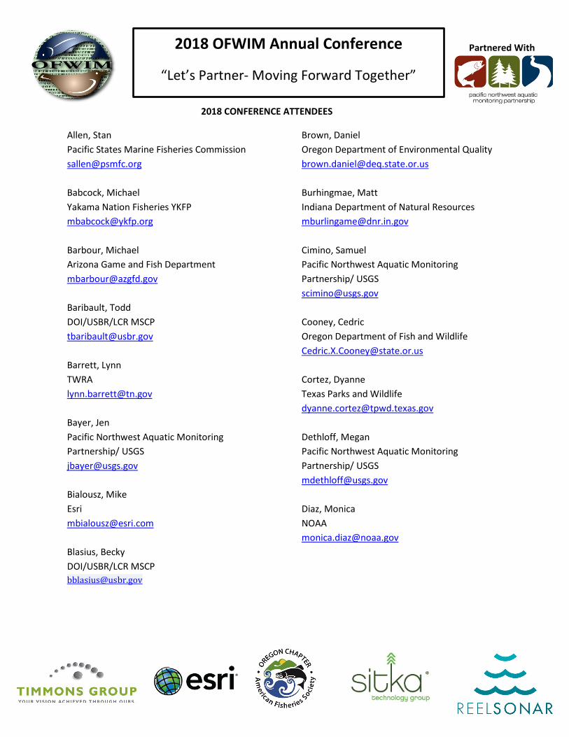
2018 CONFERENCE ATTENDEES
Allen, Stan Pacific States Marine Fisheries Commission [email protected] Babcock, Michael Yakama Nation Fisheries YKFP [email protected] Barbour, Michael Arizona Game and Fish Department [email protected] Baribault, Todd DOI/USBR/LCR MSCP [email protected] Barrett, Lynn TWRA [email protected] Bayer, Jen Pacific Northwest Aquatic Monitoring Partnership/ USGS [email protected] Bialousz, Mike Esri [email protected] Blasius, Becky DOI/USBR/LCR MSCP [email protected]
Brown, Daniel Oregon Department of Environmental Quality [email protected] Burhingmae, Matt Indiana Department of Natural Resources [email protected] Cimino, Samuel Pacific Northwest Aquatic Monitoring Partnership/ USGS [email protected] Cooney, Cedric Oregon Department of Fish and Wildlife [email protected] Cortez, Dyanne Texas Parks and Wildlife [email protected] Dethloff, Megan Pacific Northwest Aquatic Monitoring Partnership/ USGS [email protected] Diaz, Monica NOAA [email protected]
2018 OFWIM Annual Conference
“Let’s Partner- Moving Forward Together”
Partnered With
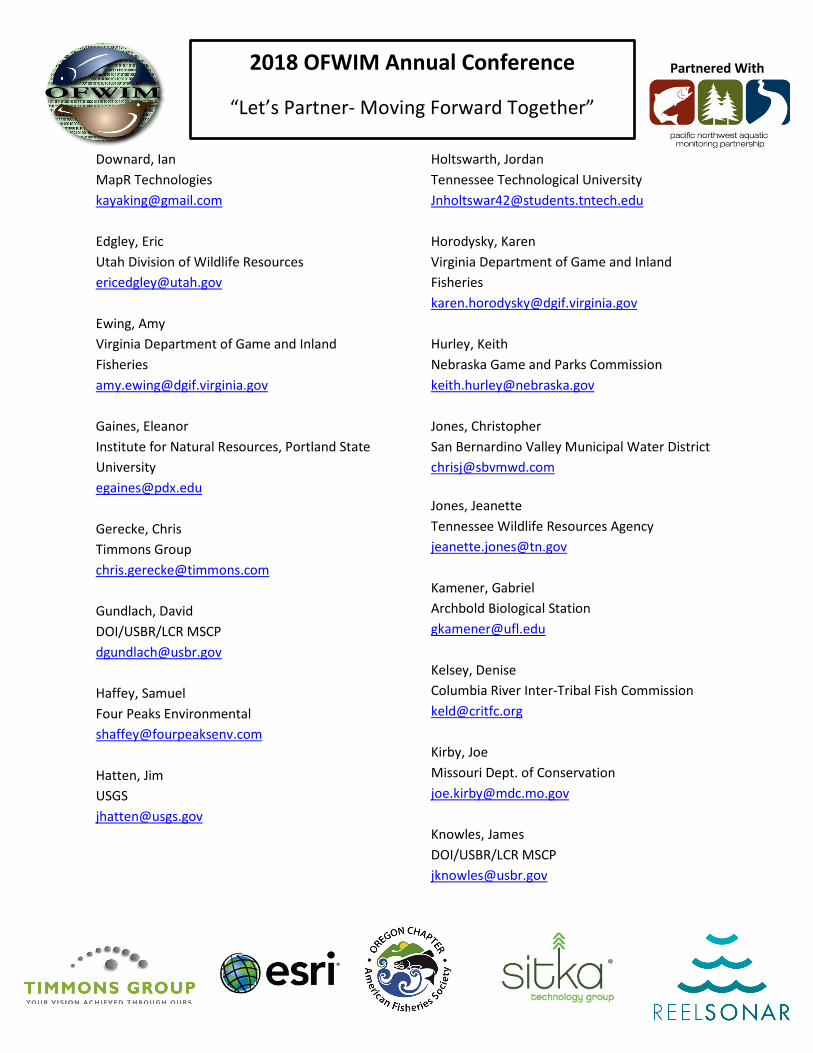
Downard, Ian MapR Technologies [email protected] Edgley, Eric Utah Division of Wildlife Resources [email protected] Ewing, Amy Virginia Department of Game and Inland Fisheries [email protected] Gaines, Eleanor Institute for Natural Resources, Portland State University [email protected] Gerecke, Chris Timmons Group [email protected] Gundlach, David DOI/USBR/LCR MSCP [email protected] Haffey, Samuel Four Peaks Environmental [email protected] Hatten, Jim USGS [email protected]
Holtswarth, Jordan Tennessee Technological University [email protected] Horodysky, Karen Virginia Department of Game and Inland Fisheries [email protected] Hurley, Keith Nebraska Game and Parks Commission [email protected] Jones, Christopher San Bernardino Valley Municipal Water District [email protected] Jones, Jeanette Tennessee Wildlife Resources Agency [email protected] Kamener, Gabriel Archbold Biological Station [email protected] Kelsey, Denise Columbia River Inter-Tribal Fish Commission [email protected] Kirby, Joe Missouri Dept. of Conservation [email protected] Knowles, James DOI/USBR/LCR MSCP [email protected]

2018 OFWIM Annual Conference
“Let’s Partner- Moving Forward Together”
Partnered With
Konell, Heather ACCSP [email protected] Krause, Chelsea South Dakota Game, Fish and Parks [email protected] Kydd, Tyler Environment and Climate Change Canada [email protected] Leonard, Nancy Northwest Power and Conservation Council [email protected] Martin, Dustin ReelSonar, Inc [email protected] McKerrow, Alexa U.S. Geological Survey [email protected] McMullen, Laura ICF [email protected] Mikolajczyk, Julie AGFD [email protected] Nelson, Matt USGS [email protected]
Olson, Sheryn Pacific Northwest Aquatic Monitoring Partnership/ USGS [email protected] Papraniku, Isabel Tennessee Technological University [email protected] Perkins, Jessica WV Division of Natural Resources [email protected] Pursell, Dyan Missouri Department of Conservation [email protected] Reilly, Michelle DOI/USBR/LCR MSCP [email protected] Rogers, Kristin Florida Fish and Wildlife [email protected] Scully, Rebecca Pacific Northwest Aquatic Monitoring Partnership/ USGS [email protected] Seamster, Virginia New Mexico Department of Game and Fish [email protected] Simpson, Annie U.S. Geological Survey [email protected]

2018 OFWIM Annual Conference
“Let’s Partner- Moving Forward Together”
Partnered With
Smith, Austin Arizona Game and Fish Department [email protected] Steele, Keith Sitka Technology Group [email protected] Steffen, Susan Kansas Dept of Wildlife, Parks and Tourism [email protected] Steg-Geltner, Michelle Yakama Nation Fisheries [email protected] Stys, Beth Florida Fish and Wildlife Conservation Commission [email protected] Taraldsen, Matt Esri [email protected] Tonn, Sabra Arizona Game and Fish Department [email protected] Treble, Andrew Colorado Parks and Wildlife [email protected]
Walker, Jon ICF [email protected] Watson, Susan Virginia Department of Game and Inland Fisheries [email protected] Welty, Justin Dept of Interior U.S. Geological Survey [email protected] Wheaton, Chris PSMFC [email protected] Wickettt, MaryEllen Maine Dept. of Inland Fisheries and Wildlife [email protected] Wilke, Greg PSMFC [email protected] Williams, Mari NOAAF NWFSC/OAI [email protected]