2017 burning river information guide · 2017 burning river information guide ... the burning river...
TRANSCRIPT
2017 BURNING RIVER INFORMATION GUIDE
7/19/2017 Rev2 www.westernreserveracing.com Page 1 of 33
Welcome
Welcome and thank you for participating in the Eleventh Annual Burning River 100-Mile, 50-Mile Endurance
Runs and Relay! The following packet contains all the information you and your crew need to make your race
and your weekend a success. Updates will be made periodically and we suggest checking our web site often.
Participants will be emailed when the course packet is updated – please make sure emails from
westernreserveracing.com are not going to your spam folder.
After you have completed reading this document, if you have additional questions, the following options are
available to you:
- Our web site contains the most current information (www.westernreserveracing.com)
- Check out the Burning River 100 Facebook event -
https://www.facebook.com/events/1765040263769466/
- Email us at [email protected]
History
The Cuyahoga River Valley has significant historical value. Many early American Indian tribes took advantage of
the fertile valley to raise crops, hunt, and called the valley their home. As part of Connecticut’s Western Reserve,
the Cuyahoga River served as the western border of the United States. Many of the trails on the course
originate from Indian and early settlers. The Cuyahoga River permitted transportation into the interior of the
Western Reserve Territory, which lead to the construction of the Ohio & Erie Canal. As you run on portions of
the Towpath Trail, you will be following the same path the donkeys used to tow canal boats between Cleveland
and Akron. Transportation methods continued to advance and the railroad replaced the canal system. The
Cuyahoga Valley National Park is the only national park with a train – the Cuyahoga Valley Scenic Railroad. As
the river valley continued to be developed, early industrialization led to a demise of the river valley. Yes, the
Cuyahoga River has a history of catching on fire. These events are also accredited to helping lead the
environmentalist movement of the late 1960’s. We are moving forward with wonderful park systems,
sustainable farming, and world-class trails. The flames of the Cuyahoga were extinguished long ago. Today, the
Cleveland and Akron areas are on fire!
2017 BURNING RIVER INFORMATION GUIDE
7/19/2017 Rev2 www.westernreserveracing.com Page 2 of 33
Sponsors
Clif Bar – Feed your adventure!
Vertical Runner - Adventure Starts Here.
Saucony – Find your Strong!
Hoka - Light and surefooted during a race, with more cushioning at the end, HOKA makes runners feel like
they’re gliding over the ground.
HiHo Brewing Company – Spreading happiness, community and craft by brewing awesome beer in the most
responsible, sustainable manner possible. HiHo will remain open Saturday evening and serve beer until 2:00a.m.
they will reopen at 8:00a.m. Sunday morning.
Mr. Heater - America’s Most Popular Brand Of Heaters.
SaltStick - Trusted by Professional Athletes, since 2006

2017 BURNING RIVER INFORMATION GUIDE
7/19/2017 Rev2 www.westernreserveracing.com Page 3 of 33
Awards
Solo 100 mile Participants will receive a newly designed belt buckle. A gold sub-24 buckle will also be offered for
those participants finishing under the 24 hour mark. These one-of-kind special designs are buckles you’ll be
proud to wear! Top finisher awards will be recognized to the Top 5 Overall and Top 1 in the following age
groups by gender: 0-29, 30-39, 40-49, 50-59, 60+.
50 mile Participants will receive a 50 mile specific finisher’s medal featuring the Burning River logo. Top finisher
awards will be recognized to the Top 5 Overall and Top 1 in the following age groups by gender: 0-29, 30-39, 40-
49, 50-59, 60+.
Relay Participants will receive a relay specific finisher’s medal featuring the Burning River logo. Top finisher
awards will be awarded to the Top 1 Male, Female, and Coed teams in the 4 and 8 person categories. For co-ed
teams, female participants must run at least 25% of the segments to be considered for awards.
Donations
Western Reserve Racing is proud to be an active community partner. A portion of this event’s and all of our
events’ revenue goes to supporting the parks in our community. In addition, you can experience everything
Burning River has to offer and waive your registration fees by helping to raise money and awareness for these
three park systems. Please consider joining us in supporting the following fundraising campaigns:
Conservancy for Cuyahoga Valley National Park’s Trails Forever Campaign - The Trails Forever mission is to
directly engage the public in helping ensure that the trail system in Cuyahoga Valley National Park is adequately
maintained, enhanced, expanded, and preserved for all time, for all people. Information is available at
http://www.conservancyforcvnp.org/help/trails-forever .
The Cleveland Metroparks Trails Fund - Cleveland Metroparks is embarking on a long term effort to repair,
rehabilitate, and redesign our trails to protect natural resources and enhance public experience. Trails are vital
to community health and wellness and are a key economic tool in making our region a more desirable place to
visit and live. We are committed to improving trails for all, including hikers, mountain bikers, equestrians,
runners, and skiers. Information is available at http://www.clevelandmetroparks.com/Main/Trails-United.aspx
The Summit Metro Parks Foundation - The Summit Metro Parks Foundation is a nonprofit endowment that was
established in 1991 to further the goals and mission of Summit Metro Parks. The Foundation accepts gifts and
grants to support the park district's charitable, educational and scientific initiatives. Information is available at
http://www.summitmetroparks.org/GetInvolved/MetroParksFoundation.aspx

2017 BURNING RIVER INFORMATION GUIDE
7/19/2017 Rev2 www.westernreserveracing.com Page 4 of 33
Volunteers
The point-to-point aspect of this race is beloved by participants. It also presents many challenges! The amount
of volunteer hours needed to support this event easily exceeds the hours spent by participants. With over
twenty aid stations to setup and staff, supplies to deliver to each aid station, trash removal, drop bag service,
100 miles of course marking covered multiple times, traffic control, and various other activities, we want to
thank all the people who volunteer their time to make this event special for our entire community. Please join
us in recognizing and thanking the following individuals/organizations:
Vertical Runner (Vince Rucci)
Medina County Road Runners (Renee Harden)
OutRUN (Laurie Rehbarger)
Cleveland Metroparks (Nancy Desmond)
Cleveland Clinic
Black Girls Run (Candice Toney)
Mike and Jennifer Erhardt)
NEOFit (Lori Karpinecz, Brenda Runion, Lee Anne Sabol)
SARC (Steve Hailer)
Ray Bovaird
Jessica Croisant
Running Dog (Beverly Dillon)
John Delcalzo
Kate Koewler
Special thanks to Michele Wisniewski for singing the National Anthem.

2017 BURNING RIVER INFORMATION GUIDE
7/19/2017 Rev2 www.westernreserveracing.com Page 5 of 33
Schedule
Friday, July 28th
2:00pm-8:00pm
Packet Pickup Drop Bag Collection
The Sheraton Ballroom 1989 Front St, Cuyahoga Falls, OH 44221
3:30, 5:00, 6:30 Rules Meeting The Sheraton Ballroom Foyer
5:30pm-8:00pm Optional Pre-Race Dinner The Sheraton
Saturday, July 29th
2:15am-2:30am Board Shuttle Buses 100M Solo Participants
Corner of Broad Blvd & 2nd, Cuyahoga Falls, Ohio
3:30am-5:45am
Late Arrival Packet Pickup
Start Line Squire’s Castle North Chagrin Reservation Willoughby, Hills Ohio
4:00am 100M SOLO RACE START Squire’s Castles
3:15am-3:30am Board Shuttle Buses 50M Participants
Boston Mills Ski Resort Lot Corner of Riverview and Boston Mills Road, Peninsula, Ohio
5:00am 50M RACE START Squire’s Castle
6:00am RELAY RACE START Squire’s Castle
6:14am Sunrise NE Ohio
4:15pm-4:30pm Board Shuttle Buses 50M Back Half Participants
Corner of Broad Blvd & 2nd, Cuyahoga Falls, Ohio
5:00pm 50M Awards Ceremony (weather dependent)
Boston Mills Ski Resort Lot
5:00pm Late Arrival Packet Pickup (50M BH) Boston Mills Ski Resort Lot
6:00pm 50M BACK HALF RACE START Boston Mills Ski Resort Lot
8:00pm 50M RACE CLOSE Boston Mills Ski Resort Lot
8:52pm Sunset NE Ohio
Sunday, July 30th
8:00 am Awards Ceremony HiHo Brewing Company 1707 Front St. Cuyahoga Falls, Ohio
10:00am RACE CLOSE HiHo Brewing Company 1707 Front St. Cuyahoga Falls, Ohio
10:30am Drop Bag Pickup Deadline HiHo Brewing Company 1707 Front St. Cuyahoga Falls, Ohio
2017 BURNING RIVER INFORMATION GUIDE
7/19/2017 Rev2 www.westernreserveracing.com Page 6 of 33
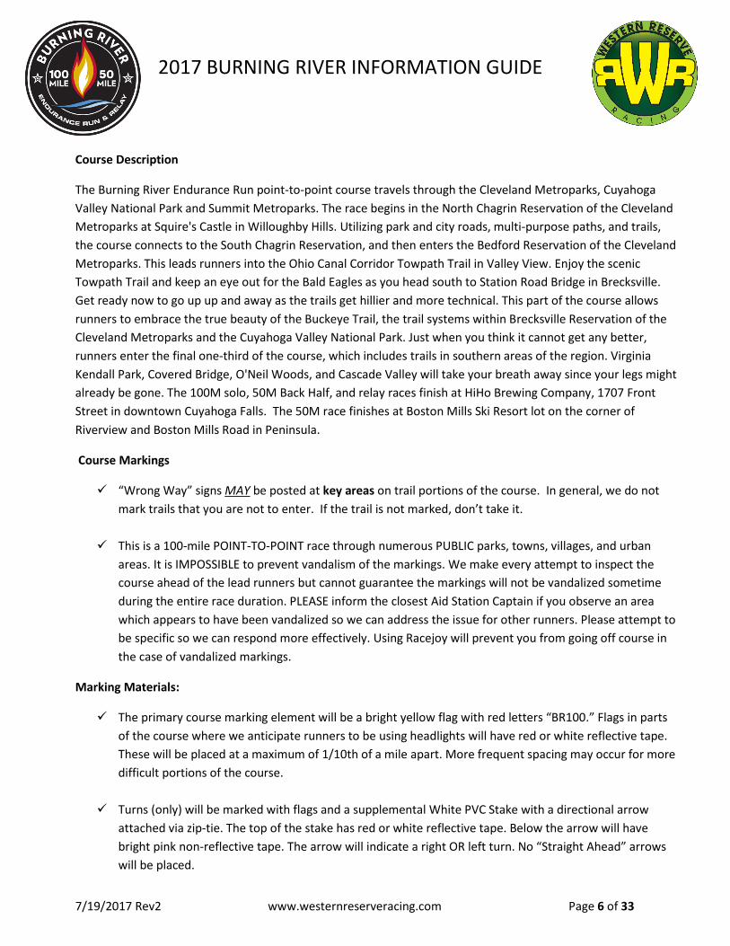
Course Description
The Burning River Endurance Run point-to-point course travels through the Cleveland Metroparks, Cuyahoga
Valley National Park and Summit Metroparks. The race begins in the North Chagrin Reservation of the Cleveland
Metroparks at Squire's Castle in Willoughby Hills. Utilizing park and city roads, multi-purpose paths, and trails,
the course connects to the South Chagrin Reservation, and then enters the Bedford Reservation of the Cleveland
Metroparks. This leads runners into the Ohio Canal Corridor Towpath Trail in Valley View. Enjoy the scenic
Towpath Trail and keep an eye out for the Bald Eagles as you head south to Station Road Bridge in Brecksville.
Get ready now to go up up and away as the trails get hillier and more technical. This part of the course allows
runners to embrace the true beauty of the Buckeye Trail, the trail systems within Brecksville Reservation of the
Cleveland Metroparks and the Cuyahoga Valley National Park. Just when you think it cannot get any better,
runners enter the final one-third of the course, which includes trails in southern areas of the region. Virginia
Kendall Park, Covered Bridge, O'Neil Woods, and Cascade Valley will take your breath away since your legs might
already be gone. The 100M solo, 50M Back Half, and relay races finish at HiHo Brewing Company, 1707 Front
Street in downtown Cuyahoga Falls. The 50M race finishes at Boston Mills Ski Resort lot on the corner of
Riverview and Boston Mills Road in Peninsula.
Course Markings
“Wrong Way” signs MAY be posted at key areas on trail portions of the course. In general, we do not
mark trails that you are not to enter. If the trail is not marked, don’t take it.
This is a 100-mile POINT-TO-POINT race through numerous PUBLIC parks, towns, villages, and urban
areas. It is IMPOSSIBLE to prevent vandalism of the markings. We make every attempt to inspect the
course ahead of the lead runners but cannot guarantee the markings will not be vandalized sometime
during the entire race duration. PLEASE inform the closest Aid Station Captain if you observe an area
which appears to have been vandalized so we can address the issue for other runners. Please attempt to
be specific so we can respond more effectively. Using Racejoy will prevent you from going off course in
the case of vandalized markings.
Marking Materials:
The primary course marking element will be a bright yellow flag with red letters “BR100.” Flags in parts
of the course where we anticipate runners to be using headlights will have red or white reflective tape.
These will be placed at a maximum of 1/10th of a mile apart. More frequent spacing may occur for more
difficult portions of the course.
Turns (only) will be marked with flags and a supplemental White PVC Stake with a directional arrow
attached via zip-tie. The top of the stake has red or white reflective tape. Below the arrow will have
bright pink non-reflective tape. The arrow will indicate a right OR left turn. No “Straight Ahead” arrows
will be placed.

2017 BURNING RIVER INFORMATION GUIDE
7/19/2017 Rev2 www.westernreserveracing.com Page 7 of 33
Marking Materials Cont.
Paved areas of the course will be marked with a combination of WHITE (Duct Tape) Arrows. The arrow
will indicate direction of travel and will typically be placed on the left side of the road/trail where the
runner shares the pavement with vehicles. Paved areas where no vehicular traffic is anticipated will be
marked in the most conspicuous/convenient manner. Arrows will be placed to highlight the runners
intended direction of travel. Flags will also be typically placed along the edge of paved areas. Flags will
be on the left where you share the route with vehicles. Flags will typically be on the right where you will
not share the route with cars. In select locations where flags cannot be placed on the right (sidewalk
adjacent to curb & street), they will be on the left side of the sidewalk. RUN ON LEFT, FACING TRAFFIC
ON ACTIVE STREETS.
Street crossings: These will be marked with WHITE duct tape arrows on the pavement indicating the
direction of the runner. Additional flags will be placed within 20-50 feet of the crossing on the far side of
the crossing.
RaceJoy has the capability to help you navigate the course. See details under Live Results/Participant
Tracking. We strongly encourage you to use it.
Ground Marking Ground Marking Stake Marking Posted Sign

2017 BURNING RIVER INFORMATION GUIDE
7/19/2017 Rev2 www.westernreserveracing.com Page 8 of 33
Timing
The 2017 course will be chip timed at 8 locations/aid stations. Participants should pass over the timing mats located just prior to the aid station.
Timing points will be located at following locations (not all aid stations are timing points): o Polo Fields o Egbert o Ottawa Point o Boston Mills
o Ledges o Pine Hollow o Botzum o Front Street (100M Finish)
Participants do not need to announce bib numbers or check in at each aid station. Participants should report their intention to DROP to the aid station. Participants should wear bibs pinned to the front of their person and on the outermost layer of clothing.
RELAY ONLY: Outgoing relay runners should not go near the aid stations/timing points while waiting for
their incoming runner. If the outgoing runner is picked up on the timing mat, we will record the outgoing relay runner as the person finishing the segment instead of the incoming runner. The incoming runner will NOT have a posted time. Once your incoming runner passes over the timing mat, you can greet them and start your leg.
Results/Participant Tracking
Overall Participant Results - all race day information including results will be available on our website westernreserveracing.com
Live On-Course Participant Tracking - RaceJoy This service received rave reviews last year and we are looking forward to the advantages it offers. This service is included with your race registration. The participant keeps the app running during the race. The app displays the course and gives the participant the ability to know if they are on/off course. It also will notify when the participant enters into an aid station. Spectators can see where the participant is currently located and send messages. As this requires a smartphone, participants will need to make plans to have battery life throughout the event. Portable chargers work well and the Anker brand has worked well for participants in other events. This app does not report participant’s times – it is to be used as a tracking device. We see many benefits for the participants, crew, and others that want real-time information on the location of a participant relevant to the course. Sign up now!

2017 BURNING RIVER INFORMATION GUIDE
7/19/2017 Rev2 www.westernreserveracing.com Page 9 of 33
Race Day Communications
Please direct race day questions and report drops to [email protected]. This email will be
monitored Thursday, July 20th through Tuesday, August 1st.
A dispatcher will be available at all times during the race to answer questions or contact race directors
as needed. The race day phone number is (330) 322-0366. This line will only be in use Thursday, July
27th through Monday, July 31st.
We will do our best to update you on race day via
o Facebook - facebook.com/westernreserveracing/
o Twitter - @WReserveRacing
o Instagram - western_reserve_racing
For those of you on Instagram, use #BR100 as your hashtag and your photos post live on our
website - https://www.westernreserveracing.com/br100/ This page is live NOW!
2017 BURNING RIVER INFORMATION GUIDE
7/19/2017 Rev2 www.westernreserveracing.com Page 10 of 33
Relay Exchange Instructions
Relay runners do not need to declare which legs they are running. You are free to decide which legs
each registered team member runs.
Relay runners are asked to wear a back bib to be easily identified by solo runners.
Relay runners should announce “Relay” when passing out of courtesy to solo runners.
Exchanges at aid stations are on the honor system. There will be no formal exchange area. Once the
incoming runner has entered the aid station, the outgoing runner is free to start the next leg.
Relay runners must not drop between exchange points.
If a relay participant cannot complete their segment due to injury, the next person can start at the last
aid station completed that allows crew access. If this is not an exchange area, the results will show that
the second runner completed both segments. You cannot start mid-course or at aid stations that do not
permit access.
If for some reason a relay runner cannot make it to the next designated relay exchange point due to
injury or aid station time cut off, later runners may still complete their legs and receive their medals.
Team results will not be posted. Please notify timing crew if your team is unable to complete all legs.
4 person team members can run consecutive sections or choose to alternate legs. Example: Runner#1
on a 4 person team may choose to run legs 1 and 5, Runner#2 may choose legs 2 and 3, Runner#3 may
choose legs 4 and 6 and let Runner#4 run legs 7 and 8.
Relay participants are asked to only eat and drink from aid station supplies during their leg of the race.
Relay runners who graze at aid stations other than their own may be shot or laughed and pointed at.
This is an area of emphasis this year based on aid station feedback from 2016.
Due to limited parking, relay teams are permitted one car at relay exchange points. Relay teams should
coordinate carpool efforts and exchange keys at relay exchange points. Example: Runner A gets
dropped off at the start. Runner A runs to the relay exchange point. Runner B awaits their arrival and
leaves keys to vehicle for runner A. Runner A can then head home for a shower or go to the movies.
Runner C would then meet runner B at the next exchange zone and this pattern would continue to the
finish. The other alternative is a team car or van follows their team the entire event designating drivers.
A parking pass will be required to enter the parking lot at Egbert and Ottawa Point. One parking pass
will be issued per team. Overflow parking for Ottawa Point is available at Brecksville Stables, a short
walk away.
Relay teams wishing to cross the finish line together are welcome to park at the finish line and meet
their final runner at mile 99. You must walk/hike the course back 1 mile from the finish to meet them.
Please have team members remove bibs – only final leg runner should wear their bib across finish.
Outgoing relay runners should not go near the aid stations/timing points while waiting for their
incoming runner. If the outgoing runner is picked up on the timing mat, we will record the outgoing
relay runner as the person finishing the segment instead of the incoming runner. The incoming runner
will NOT have a posted time. Once your incoming runner passes over the timing mat, you can greet
them and start your leg.
2017 BURNING RIVER INFORMATION GUIDE
7/19/2017 Rev2 www.westernreserveracing.com Page 11 of 33
Aid Stations
There are aid stations approximately every 4 to 7 miles. (See Aid Station descriptions in the appendix of this
packet.)
Water will be available for sale at every aid station.*
CLIF Hydration Electrolyte Drink Mix is the official electrolyte sports drink of Burning River.
First Aid supplies will be very limited such as band-aids, bug spray, and sunscreen. We cannot provide
any form of medications. Marijuana is illegal in the state of Ohio.
Runners cannot accept aid from anyone (crew, family, friend, Santa, moving vehicle, bicycle) beyond
100’ of a Crew Access Aid Station.
Please plan to put any special food requirements into drop bags. We will do our best to provide a
variety of foods but cannot guarantee vegan, vegetarian, or gluten free foods at every aid station.
Relay participants are asked to only eat and drink from aid station supplies during their leg of the race.
An aid station survey will be sent after the completion of the race. You can vote for your favorite
station-the top 3 favs will win prizes!
There will not be cups provided at unmanned water stations. These should be used to refill handheld
water bottles.
*Just kidding. All-you-can-drink water is included with your registration.
Standard Aid Station Food
Standards are typical “ultra” food and are available at all manned aid stations.
Standards include and are not limited to: pretzels, chips, Clif Gels, SaltStick, Clif hydration, water, and
candy.
Aid station food is subject to change according to weather conditions. Ex-Hot soup at night, popsicles
on a hot day.
Ice is available at all manned aid stations.
Leftover food items are donated to Campus Kitchen at Kent State University, a student-run kitchen that utilizes
food from dining services, local farmers, and grocers for hunger relief.

2017 BURNING RIVER INFORMATION GUIDE
7/19/2017 Rev2 www.westernreserveracing.com Page 12 of 33
Aid Station Food Availability
Aid Station
Name
Stan
dar
ds
Sod
a (C
oke
, Gin
ger
Ale
) C
off
ee
Ho
t C
ho
cola
te
Ch
icke
n &
Veg
an
Ram
en
P
BJ
or
Nu
tella
Wat
erm
elo
n
Ban
anas
Co
oki
es
Trai
l Mix
Po
tato
es
Piz
za
Gri
lled
Ch
eese
Gra
pes
Glu
ten
Fre
e B
read
Ora
nge
s
Cer
eal B
ars
Reg
&
Glu
ten
Fre
e
Har
d B
oile
d E
ggs
Bac
on
Pic
kles
Exceptions A START - *
*Water Only
B Old Mill / Chagrin River Rd
* *Water & Clif
Hydration Only
C Polo Fields
D Harper Ridge
E Shadow Lake
F Egbert
G Alexander Road
G2 Frazee * *Water Only
Unmanned H Meadows
I Ottawa Point * *Water & Clif
Hydration Only J Snowville
K Boston Mills/ 50M Finish
L Brandywine Falls
M Pine Lane
M2 Boston Mills H&B
* *Water Only
Unmanned N Ledges
O Pine Hollow I
P Pine Hollow II
Q Covered Bridge I
R Covered Bridge II
S Botzum Parking
T Memorial Parkway
U Front Street/ 100M/ Back 50 Finish
2017 BURNING RIVER INFORMATION GUIDE
7/19/2017 Rev2 www.westernreserveracing.com Page 13 of 33
Participant Rules & Responsibilities
Participants cannot accept any aid from anyone (crew, family, friend, Santa Claus, moving vehicle, bicycle)
beyond 100 feet of a Crew Access Aid Station.
Runners receiving aid from crews outside the designated crew access points are subject to disqualification.
Crews must abide by the instructions of the aid station personnel. Runners are responsible for their crew.
Absolutely no littering! You may not stash supplies along the course. Violators will be subject to
disqualification.
Wear your Race Bib in front (and back for Relay participants) where it is visible.
Know which direction to enter and exit the Aid Station.
Properly tag your drop bags.
Review the maps of the course and be familiar with race trail markings.
Adhere to posted signs and rules of the race and park districts.
If you find yourself off-course, take time to assess your situation. Re-trace your steps until you come to a
race/trail marking.
Do NOT drop out of the race without notifying an aid station or Finish Line. BR100 dispatch phone number-
(330) 322-0366 can also be used to report drops.
Participants choosing to drop from the race are responsible for arranging their own transportation.
Volunteers may or may not be willing to transport runners. As an example, Uber may be a viable option for
participants without crew. We understand this is not ideal; however that is one of the challenges for
participants who choose not to have a crew on a point-to-point race course!
100M participants who wish to drop to the 50M distance mid-race are not eligible for 50M awards, but will
be posted in the official results and receive a 50M medal. This drop can be reported at Boston Mills.
The following 3 Burning River officials have the sole authority to disqualify a runner and make decisions
regarding the official rules: Jim Christ, Joe Jurczyk, and Vince Rucci. Disqualification may be done in person
or via telephone. If you feel a decision has been made in error, you have the right to request a review of the
decision by another race official. Notify an aid station volunteer or call the dispatch phone at (330) 322-0366
to request a review.
In case of inclement weather (thunderstorm, tornado) your safety is your own responsibility. Aid stations
may be shut down temporarily until the storm passes.
Use common sense! Know your limits, take care of yourself and enjoy your run!
Runners can use cell phones on the course, but in some areas there may be limited coverage.
The close times are firm. Participants entering an aid station after the close time will not be required to turn
in their bib. They are required to report to the aid station whether they plan on dropping. Course markings,
aid stations, race support, and other associated activities will not be available if the participant chooses to
continue. We strongly encourage participants to drop if they cannot make the close time at each aid
station. Participants who complete the course after the close time are not eligible to have their times
posted.

2017 BURNING RIVER INFORMATION GUIDE
7/19/2017 Rev2 www.westernreserveracing.com Page 14 of 33
Pacers & Crew Rules & Responsibilities
Pacers are allowed for 100M solo participants beginning at Boston Mills Aid Station, mile 50.
Pacers are not permitted for 50M runners except those ages 60 and over, see below.
100M Pacers are welcome to register for the Back Half 50M distance and start when their runner enters the
Boston Mills Aid Station by notifying timing of their start time. Back Half 50M runners who start before or
after the official Back Half start time are not eligible for awards.
No pacing by bicycles, motorized vehicles, rickshaws, or other wheeled vehicle is allowed.
We will not be able to provide transportation for pacers.
Pacers cannot carry supplies/water bottles for the runner – no muling.
Pacer is allowed anytime throughout the course for 50M and 100M solo runners 60 years or older.
Only one pacer at a time. A runner may have several pacers, but only one pacer at a time.
All pacers will register, sign a waiver, and pick up a PACER BIB at the Aid Station before he/she joins the
runner. Pacer bibs are not required for family and friends joining their runner for the final mile.
Pacers may pre-register at https://www.westernreserveracing.com/race-registration/burning-river-
registration/
The only case when multiple pacers are acceptable is at Mile 99 (Front St.). Families and friends are
welcome to join runners during mile 99 to the finish. If doing so, please follow the rules of the road.
Families and friends are also welcome to join 50 mile solo runners from mile 49 to the finish. To do so, park
in the Boston Mills Ski Resort lot and hike the course backward 1 mile.
See course overview for pacer pickup locations.

2017 BURNING RIVER INFORMATION GUIDE
7/19/2017 Rev2 www.westernreserveracing.com Page 15 of 33
Rules for Participants, Pacers, and Spectators
BR100 utilizes trails in the CVNP, Cleveland Metroparks, and Summit Metroparks. Please be courteous and
observe all park rules. Some of these rules include:
NO ACCESS Aid Stations – only the participant is permitted in these areas. Crew, family, and spectators
supporting participants at these locations are not allowed. Race Directors reserve the right to disqualify
participants for violating this rule.
Do not exceed park speed limits.
No campfires.
No camping overnight at aid stations.
Vehicle parking only at designated areas.
No nailing or stapling on any forest property.
Put garbage in OUR bags. Do not use park barrels.
DO NOT LITTER – may result in disqualification.
Dogs must be on leashes.
When on a horse trail, runners are very strongly advised that it is good practice to announce yourself when
approaching a horse/rider, wait until the rider acknowledges your presence and gives you an all-clear.
Horses spook if surprised or they feel threatened (or if they smell something that reminds them of death).
Be safe and do not crowd or startle the horse. Walk past the horse. DO NOT RUN, as this may spook the
horse and could injure the rider, the horse, or most likely YOU. Runners identified as failing to practice this
courtesy to horses/riders may be penalized, beaten, or disqualified.
Children and leashed pets are welcome at Burning River; aid station volunteers are not responsible for them.
To insure there is sufficient food and beverages for runners, the crew, including children and pets, are asked
NOT to eat/drink from the Aid Station supplies. This includes water.
Please clean up after your pets, including on the trail or towpath.
Please be responsible for your family and friends.
2017 Spectator Guide – Coming Soon!

2017 BURNING RIVER INFORMATION GUIDE
7/19/2017 Rev2 www.westernreserveracing.com Page 16 of 33
Drop Bags
Drop bag service is available for 100M solo runners as well as limited drop bag service for 50M runners. See
chart on page 17 (50M Drop Bags at Egbert & Finish, 50M Back Half Drop Bags at Pine Hollow & Finish)
All 100M and 50M Drop Bags must be brought to the Packet Pickup on FRIDAY no later than 8PM with the
exception of Finish Line Drop Bags. All Finish Line Drop Bags should be brought to the respective Start Line.
Back 50 participants may take their own drop bags to Pine Hollow beginning at 1:45p.m. on Saturday, July
29th if they choose to do so. Please be sure they are marked as stated below.
Drop bags will be organized at aid stations according to race bib numbers.
For faster and easier drop bag access at aid stations, mark each drop bag clearly with your Bib Number, Last
Name and Aid Station Letter. Example: #201 Simpson H (Bart Simpson with bib #201 at H-Meadows).
Maximum drop bag size is 16"x20." NO hard cases.
Waterproof your drop bag ID tags. We suggest using duct tape and permanent marker.
For 100M solo runners choosing to start with a flashlight or headlamp, a drop will be available at Harper
Ridge Aid Station. For 50M runners choosing to start with a flashlight or headlamp, a drop will be available
at Old Mill. Headlamps will then be available for pick up at Boston Mills. Please mark your headlamp with
Bib number and last name. Headlamps are not provided.
A bag can be left at the start for transport to the finish. Please use drop bag labeling instructions above.
100M and 50M Back Half drop bags will be brought to the Cuyahoga Falls finish line on SUNDAY morning,
50M drop bags will be brought to 50M finish line on Saturday afternoon.
Items left at the Finish Lines will NOT be mailed and will be either donated, recycled, or tossed. 100M and
50M Back Half drop bags must be picked up by 10:30am on Sunday, 50M drop bags by 9:00pm on Saturday.
Please check that you have everything or make arrangements for others to pick up your items.
Don’t use black plastic garbage bags-they can be mistaken for trash and disposed of accidentally.
Don’t use plastic grocery bags-they tear easy and may rip during transport.
Don’t pack any glass containers.
Use large ziplock bags or string packs.
Pack any special diet needs/medications that are not available at aid stations
See course overview for drop bag locations.

2017 BURNING RIVER INFORMATION GUIDE
7/19/2017 Rev2 www.westernreserveracing.com Page 17 of 33
Medical
IN CASE OF EMERGENCY CALL 9-1-1 and be prepared to communicate your position.
The entire course is located within several minutes of public services, including EMS.
Each entrant is responsible for knowing his or her own physical limitations. We encourage each entrant to
get a complete physical before participating in this race.
If in the opinion of the race director or aid station captains, your physical or mental condition deteriorates to
the point of endangering your safety, you will be withdrawn from the race and an ambulance may be called.
Any medical expenses incurred are the responsibility of the individual.
Please complete the emergency medical information on the back of your bib prior to starting the race.
We strongly recommend participants and pacers print and carry the following chart containing emergency
aid station information. While 911 is always an option, both the CVNP and Cleveland Metroparks
recommend calling their emergency numbers first. Their rangers are extremely familiar with the trails and
can dispatch responders and emergency vehicles to the precise location of the emergency. All aid stations
are also equipped with this information. A printable pdf is available on the Western Reserve Racing
website.

2017 BURNING RIVER INFORMATION GUIDE
7/19/2017 Rev2 www.westernreserveracing.com Page 18 of 33
2017 BURNING RIVER INFORMATION GUIDE
7/19/2017 Rev2 www.westernreserveracing.com Page 19 of 33
Parking & Transportation
Transportation to Start Line –
Shuttle buses will take 100M solo runners to start line from the intersection of 2nd Street and Broad
Blvd. (in front of Pilgrim Church, 130 Broad Blvd.) in Cuyahoga Falls at 2:15am Saturday morning.
Shuttle buses will take 50M Back Half runners to start line from the intersection of 2nd Street and Broad
Blvd. (in front of Pilgrim Church, 130 Broad Blvd.) in Cuyahoga Falls at 4:15pm Saturday afternoon.
Shuttle buses will take the 50M runners to start line from the intersection of Riverview and Boston Mills
Road, near Boston Mills Ski Resort in Peninsula at 3:15 Saturday morning.
Shuttle buses are an optional add on during race registration. A shuttle bus info email will be sent on
July 10th including instructions on how to register if you did not do so during registration.
Parking at Start Line - Parking at Squire’s Castle is limited only for the race start. Any vehicles remaining at
Squire’s Castle after 9:00am will be towed at the owner’s expense per Cleveland Metroparks.
Parking at Relay Exchange Points - Due to limited parking, relay teams are permitted one car at relay exchange
points. Relay teams should coordinate carpool efforts and exchange keys at relay exchange points.
Parking at Finish Line - Free weekend finish line parking is available at the public parking garages on Olde Town
Loop near Broad Blvd and 2nd Street (100M, 50M BH) as well as the Boston Mills Ski Resort Lot (50M). Please
place a Burning River sticker on your dashboard when parking in one of these garages. Stickers will be provided
at packet pickup.
Lodging - Burning River is happy to return to The Sheraton for lodging in 2017!
The Sheraton in Cuyahoga Falls-Sheraton Suites Akron Cuyahoga Falls is located only steps from the BR 100M
finish line and will host the 2017 packet pick up and optional prerace dinner. The Sheraton is the area's most
established full-service hotel, offering all-suite rooms, intimate dining options and superb comfort and
hospitality. This hotel stands out in that the rooms aren't just rooms, they are full suites. These suites include
separate sleeping and living quarters, wet bar and kitchen with refrigerator. For Burning River participants this
means suites with 2 double beds, a pull out couch and no additional guest fees for $149/night* - perfect for
sharing with pacers and crew! Your reservation is fully refundable until 24 hours before your stay.
*Booking by phone or using the regular Sheraton booking site will not give you our negotiated rate and you will
be charged a per person fee. Please review details and book by clicking here.

2017 BURNING RIVER INFORMATION GUIDE
7/19/2017 Rev2 www.westernreserveracing.com Page 20 of 33
Packet Pickup
Packet Pickup will be held on Friday, July 28th, from 2:00 p.m. until 8:00p.m. at The Sheraton located at
1989 Front St, Cuyahoga Falls, OH 44221.
An optional pre-race dinner at the Sheraton from 4:00 p.m. until 8:00 p.m. This dinner includes a pasta
buffet. It is available for pre-order during registration and through the gear store on our website.
An extremely limited quantity of BR Gear will be available for sale at packet pick up and the finish line.
For the best selection, please preorder now at westernreserveracing.com
Bibs will be available at both start lines for participants who cannot make it to packet pick up. Swag for
these participants will then be available at the finish line in Cuyahoga Falls beginning at 7:00 pm on
Saturday.
Pre-race rules meetings will be held at 3:30, 5:00, and 6:30 in the Ballroom Foyer of the Sheraton. These
recommended meetings are brief and will conclude with a question/answer period.
Post-Race
Showers for 100 mile solo participants will be available at the Cuyahoga Falls Natatorium on Sunday, July
29th, between 9:00am-1:00pm. You will need ID to access. Bring your own towels - Nat does not supply
towels. The facility is located within ¾ mile of the finish line.
Kent State College of Podiatric Medicine will be at both finish lines to take care of your feet.
An awards ceremony will be held at the 100M/BH50M Finish Line at 8:00 a.m. on Sunday. Stick around
(or come back) for awards and cheer on the final 2 hours of finishers!
HiHo Brewing Company will remain open Saturday evening and serve beer until 2:00a.m. they will
reopen at 8:00a.m. Sunday morning.

2017 BURNING RIVER INFORMATION GUIDE
7/19/2017 Rev2 www.westernreserveracing.com Page 21 of 33
Appendix A – Course Overview
Segment Distances & Drop Bag/Crew Access/Pacer Locations
Aid Station Name
Course Maps from Aid Station to Next Station Strava
Dist. from Prev
Total Elapsed Dist.
Terrain to Next Aid Station
Pacer, Crew, & Drop Bag Locations
GPS
Coordinates A START -
Squires
Castle
https://www.strava.com/segments/12085617
0 Road CREW ACCESS 41.581398, -81.418726
B Old Mill /
Chagrin
River Rd
https://www.strava.com/segments/12085650
6.7 6.7 Road NO ACCESS/
50 MILE
FLASHLIGHT
DROP
41.518867, -81.404239
C Polo Fields https://www.strava.com/segments/12086172
4.8 11.5 Bridle Trail CREW ACCESS 41.45689, -81.407143
D Harper
Ridge
Picnic Area
https://www.strava.com/segments/12086193
6.7 18.2 75% Bridle Trail, 25%
Road
NO ACCESS/100
MILE FLASHLIGHT
DROP
41.413513, -81.459916
E Shadow
Lake
https://www.strava.com/segments/12086213
3.5 21.7 25% Bridle Trail, 55%
Single Track, 20%
Road
DROP BAG/
CREW ACCESS
41.382602, -81.480678
F Egbert https://www.strava.com/segments/12086256
4.8 26.5 75% Bridle Trail, 20%
Single Track, 5%
Road
NO 100/50 mi
ACCESS - RELAY
EXCHANGE ONLY
50 MILE DROP
BAG
41.385084, -81.539813
G Alexander
Road
https://www.strava.com/segments/12086274
4.4 30.9 10% Bridle Trail, 40%
Single Track, 40%
Crushed Limestone,
10% Road
NO ACCESS 41.3581609, -81.5682786
G2 FRAZEE N/A – UNMANNED WATER STATION located between Alexander Road & Meadows – included in segment link above.
1.9 32.8 Part of segment G-H –
see description above
NO ACCESS 41.352278, -81.593064
H Meadows https://www.strava.com/segments/12086286
5.5 38.3 75% Bridle Trail, 25%
Single Track
DROP BAG/
CREW ACCESS
41.31525, -81.617708
I Ottawa
Point
https://www.strava.com/segments/15375219 3.9 42.2 Single Track NO 100/50 mi
ACCESS - RELAY
EXCHANGE ONLY
41.301518,-81.598963
J Snowville https://www.strava.com/segments/12086324
3.6 45.8 Single Track NO ACCESS 41.285102, -81.575903
K Boston
Mills
https://www.strava.com/segments/12562566 4.9 50.7 50% Crushed
Limestone, 25%
Road, 15% Single
track (rocky), 10%
boardwalk
PACERS/ CREW/
DROP BAG/
FLASHLIGHT
PICKUP
41.2626392, -81.5605951
L Brandywine https://www.strava.com/segments/12562621 3.5 54.2 80% Single Track,
10% Crushed
Limestone, 10% Road
NO ACCESS 41.276819, -81.540297

2017 BURNING RIVER INFORMATION GUIDE
7/19/2017 Rev2 www.westernreserveracing.com Page 22 of 33
M Pine Lane https://www.strava.com/segments/12180312 5.9 60.1 10% Bridle Trail, 35%
Single Track, 55%
Road
NO ACCESS 41.239444, -81.537809
M2 BM H&B
Trailhead
N/A– UNMANNED WATER STATION located between Pine Lane & Ledges – included in segment link above.
2.4 62.5 Part of Segment M to
N– see description
above
NO ACCESS 41.254926, -81.518300
N Ledges https://www.strava.com/segments/12279846 4.4 66.9 10% Crushed
Limestone, 65%
Single Track, 25%
Grassy Trail
CREW ACCESS/
PACERS
41.223964, -81.510577
O Pine Hollow
I
https://www.strava.com/segments/12279867
5.8 72.7 85% Single Track,
15% Road
PACERS/ DROP
BAG/ CREW
ACCESS/BH 50
MILE DROP BAG
41.2141, -81.53125
P Pine Hollow
II
https://www.strava.com/segments/12503502
3.8 76.5 10% Grassy Trail,
80% Bridle Trail, 10%
Road
PACERS/ DROP
BAG/ CREW
ACCESS
41.2141, -81.53125
Q Covered
Bridge I
https://www.strava.com/segments/12503506
6.5 83 Single Track NO ACCESS 41.20441, -81.58266
R Covered
Bridge II
https://www.strava.com/segments/12503524
4.6 87.6 45% Road, 45%
Single Track, 10%
Crushed Limestone
NO ACCESS 41.20441, -81.58266
S Botzum
Parking
https://www.strava.com/segments/12503487
5.0 92.6 85% Crushed
Limestone, 10%
Concrete Sidewalk,
5% Wood Boardwalk
PACERS/ DROP
BAG/ CREW
ACCESS
41.15929, -81.57438
T Memorial
Parkway
https://www.strava.com/segments/12503475
5.4 98 40% Road, 50%
Single Track, and
10% Compacted
Gravel
PACERS/ CREW
ACCESS
41.10488, -81.52768
U Finish 4.2 102.2 EVERYONE!
DROP BAG
41.128244, -81.485178
Note: Back 50-mile runners are to assemble at the Boston Mills Ski Resort a minimum of 15 minutes before their
start time. They will walk as a group with the race starter to the start line on the Tow Path just north of Boston
Mills Road – at the south end of the wooden fence on the west side of the towpath.
2017 BURNING RIVER INFORMATION GUIDE
7/19/2017 Rev2 www.westernreserveracing.com Page 23 of 33
Composite Trail Maps
Please note that these are composite maps and in order to upload the sections as one file, multiple runs have
been compiled into one map/activity. You may notice that there is additional distance in the composite maps as
the runs were completed without stopping the Garmin devices used to measure the course during
familiarization runs. During these runs we pause and recollect the group similar to what happens race day as you
are fueling at aid stations. The moral to this story is, be careful how much time you spend at aid stations and
even a dozen steps per station can add up quickly to become serious distance on race day! These maps can be
used to get a general feel for the entire course and its elevation. For accurate detailed maps, please see the
individual section maps above.
100 Mile Composite Map: Part One: https://www.strava.com/activities/576712500
Part Two: https://www.strava.com/activities/633827324
Front 50 Mile Composite Map: https://www.strava.com/activities/576712500
Back 50 Mile Composite Map: https://www.strava.com/activities/633841027
Terrain Descriptions
Road – Paved surface, open to traffic.
Bridle Trail – Wide dirt trail, constructed to withstand horse traffic and usually more durable than a typical hiking
trail. Runners MUST yield to horses until riders acknowledge runner and indicates it is alright to pass. Do not run
– walk – past the horse and do not attempt to pet. They won’t like the smell of you, especially later in the day!!!
Single Track – Hiking trail, typically dirt but may also consist of other erosion prevention materials.
Crushed Limestone – Towpath, flat, firm surface similar to the unpaved shoulder of a rural road.
Terrain Percentages
Terrain percentages are not exact. These have been estimated to give an overall feel for each segment.

2017 BURNING RIVER INFORMATION GUIDE
7/19/2017 Rev2 www.westernreserveracing.com Page 24 of 33
2017 Burning River Aid Station Setup/Open/Close & Race Cut-Off times
Aid Station
Dist. to
Next
Station Elapsed
AID
STATION
ARRIVE/
SET-UP
Aid
Station
OPEN
Aid
Station
CLOSE
100 mile
cutoff
times
Front 50
Cut-off
Times
Back 50
Cut-off
Times
Relay Cut-
off Times
START - Squires Castle 0
3:00 AM 3:30 AM 6:00 AM 4:00 AM 5:00 AM
6:00 AM
Old Mill / Chagrin River
Rd
6.7 6.7 4:05 AM 4:35 AM 7:50 AM 5:58 AM 7:00 AM
7:50 AM
Polo Fields 4.8 11.5 4:45 AM 5:15 AM 9:12 AM 7:25 AM 8:28 AM
9:12 AM
Harper Ridge Picnic Area 6.7 18.2 5:30 AM 6:00 AM 11:00 AM 9:21 AM 10:25 AM
11:00 AM
Shadow Lake 3.5 21.7 6:00 AM 6:30 AM 11:53 AM 10:18 AM 11:23 AM
11:53 AM
Egbert 4.8 26.5 6:35 AM 7:05 AM 1:13 PM 11:44 AM 12:49 PM
1:13 PM
Alexander Road 4.4 30.9 7:10 AM 7:40 AM 2:25 PM 1:01 PM 2:07 PM
2:25 PM
Frazee 1.9 32.8 7:30 AM 8:00 AM 2:55 PM 1:33 PM 2:39 PM
2:55 PM
Meadows 5.5 38.3 8:15 AM 8:45 AM 4:25 PM 3:09 PM 4:17 PM
4:25 PM
Ottawa Point 3.9 42.2 9:00 AM 9:25 AM 5:30 PM 4:18 PM 5:25 PM
5:25 PM
Snowville 3.6 45.8 9:25 AM 9:55 AM 6:31 PM 5:22 PM 6:31 PM
6:29 PM
Boston Mills 4.9 50.7 10:10 AM 10:40 AM 8:00 PM 6:48 PM 8:00 PM 6:00 PM 7:49 PM
Brandywine 3.5 54.2 11:10 AM 11:40 AM 8:39 PM 7:52 PM
7:04 PM 8:39 PM
Pine Lane 5.9 60.1 11:45 AM 12:15 PM 10:25 PM 9:35 PM
8:55 PM 10:25 PM
BM H&B Trailhead 2.4 62.5 12:05 PM 12:35 PM 11:04 PM 10:17 PM
9:40 PM 11:04 PM
Ledges 4.4 66.9 12:50 PM 1:20 PM 12:17 AM 11:35 PM
11:02 PM 12:17 AM
Pine Hollow I 5.8 72.7 1:45 PM 2:15 PM 1:52 AM 1:17 AM
12:49 AM 1:52 AM
Pine Hollow II 3.8 76.5 2:20 PM 2:50 PM 2:54 AM 2:23 AM
1:59 AM 2:54 AM
Covered Bridge I 6.5 83 3:20 PM 3:50 PM 4:37 AM 4:14 AM
3:55 AM 4:37 AM
Covered Bridge II 4.6 87.6 4:05 PM 4:35 PM 5:52 AM 5:34 AM
5:20 AM 5:52 AM
Botzum Parking 5 92.6 4:45 PM 5:15 PM 7:13 AM 7:01 AM
6:52 AM 7:13 AM
Memorial Parkway 5.4 98 5:30 PM 6:00 PM 8:43 AM 8:36 AM
8:33 AM 8:43 AM
Finish 4.2
102.2
6:15 PM 6:45 PM 10:00 AM 10:00 AM
10:00 AM 10:00 AM
2017 BURNING RIVER INFORMATION GUIDE
7/19/2017 Rev2 www.westernreserveracing.com Page 25 of 33
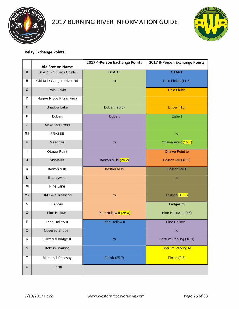
Relay Exchange Points
Aid Station Name 2017 4-Person Exchange Points 2017 8-Person Exchange Points
A START - Squires Castle START START
B Old Mill / Chagrin River Rd to Polo Fields (11.5)
C Polo Fields Polo Fields
D Harper Ridge Picnic Area
E Shadow Lake Egbert (26.5) Egbert (15)
F Egbert Egbert Egbert
G Alexander Road
G2 FRAZEE to
H Meadows to Ottawa Point (15.7)
I Ottawa Point Ottawa Point to
J Snowville Boston Mills (24.2) Boston Mills (8.5)
K Boston Mills Boston Mills Boston Mills
L Brandywine to
M Pine Lane
M2 BM H&B Trailhead to Ledges (16.2)
N Ledges Ledges to
O Pine Hollow I Pine Hollow II (25.8) Pine Hollow II (9.6)
P Pine Hollow II Pine Hollow II Pine Hollow II
Q Covered Bridge I to
R Covered Bridge II to Botzum Parking (16.1)
S Botzum Parking Botzum Parking to
T Memorial Parkway Finish (25.7) Finish (9.6)
U Finish

2017 BURNING RIVER INFORMATION GUIDE
7/19/2017 Rev2 www.westernreserveracing.com Page 26 of 33
Segment Descriptions
Segment A - Squire’s Castle to Old Mill Rd. (Front 50-Mile, 100-Mile, Relay) Start in the field at Squire’s Castle and make a right turn out to River Rd. Stay on River Rd. through the intersection of Ox Bow Lane and Rogers Road. Turn right turn onto the second occurrence of Oxbow Rd. Continue (stay left) on Ox Lane to the top of the hill. Veer to the left onto Cleveland Metro Park Drive, cross the road and merge onto the Multi-Purpose Path. Follow the paved path all the way down the hill on the Multi-Purpose Path to Wilson Mills Rd. Left onto Wilson Mills Rd. followed by an immediate right onto Chagrin River Rd. Continue south on Chagrin River Road. Cross Rt. 322 and continue south on Chagrin River Road to Gates Mills. The aid station will be on the right side of the road just south of the post office. Segment Distance 6.7 miles. ATTN: BE SURE TO RUN SINGLE FILE AS THE COURSE IS OPEN TO TRAFFIC!!! Segment B - Old Mill to Polo Fields - (Front 50-Mile, 100-Mile, Relay) Turn right as you leave the Aid Station and cross the pedestrian bridge. Turn left onto the street (Old Mill Road). In approximately 200m, turn right (south) onto Chagrin River Road. Continue south on Chagrin River Road for approximately 4.3 miles. Turn left on South Woodland Road and right into the Polo Fields entrance drive. Follow the driveway straight ahead through the parking lot. Veer right to the Aid Station located in the Pavilion. Segment Distance 4.8 miles. ATTN: BE SURE TO RUN SINGLE FILE AS THE COURSE IS OPEN TO TRAFFIC!!! Segment C - Polo Fields to Harper Ridge Picnic Area (Front 50-Mile, 100-Mile, Relay) Leave the aid station at the southeast corner of the pavilion and head east along the dirt perimeter road keeping the tree line on your left. Follow the dirt road to the south side of the polo fields and turn left onto the bridle trail at the trailhead kiosk. In approximately 100 feet turn right onto the bridle trail and follow this wide horse trail to Miles Road. Remain on this trail and do not turn off on side trails. The course will go under the bridge at Chagrin Blvd (stay on the trail as it veers to the left just before Chagrin Blvd.). Continue on this trail as it winds through the woods and meadows finally emerging beside the south end of Chagrin River Road at Miles. As you climb a slight grade parallel to Chagrin River Road, veer to the left and follow the trail down the hill and under the Miles Road bridge. Cross the stream at the far side of the bridge. As you emerge from the stream take the trail to the right and continue to follow this horse trail up a slight grade, cross a paved driveway for a picnic area and continue until the trail dead ends into another horse trail. Turn LEFT onto the new horse trail and cross Sulphur Springs Drive. In approximately a quarter mile, take the first trail to the right and cross Hawthorn Parkway and cross the paved multipurpose trail. Continue straight on the horse trail and veer to the right as it comes into a clearing and follow it across Arbor Lane. Continue on the Bridle trail on far side of Arbor Lane as it winds through the woods and descends to cross Hawthorn Parkway and pave multipurpose trail. Follow the trail as it drops from the multipurpose trail. Turn left at the next trail intersection and follow this horse trail up a long (approximately 3/4 mile) up to SOM Center Road (Rt. 91). Carefully cross Rt. 91, watching for traffic and follow the horse trail for approximately another 3/4 mile. Turn left on a secondary horse trail connector and cross Hawthorn Parkway and the paved multipurpose trail. Follow the horse trail for approximately 75 yards and turn right into a grassy area just as you approach a split rail wood fence. Proceed west through the grass to the aid station at the Harper Ridge pavilion (it is just beyond the restroom building). Segment Distance 6.7 miles.
2017 BURNING RIVER INFORMATION GUIDE
7/19/2017 Rev2 www.westernreserveracing.com Page 27 of 33
Segment Descriptions Cont.
Segment D - Harper Ridge to Shadow Lake (Front 50-Mile, 100-Mile, Relay) Leave Harper Ridge shelter and turn left on paved multi-purpose trail (stay on paved trail) until it comes to Harper Road. Turn LEFT on Harper Road and run in the bike lane facing traffic down the hill. Carefully cross Harper Road at the stoplight and turn RIGHT (west) onto Cannon Road and proceed under RT 422. Follow Cannon Road across Hawthorn Parkway and turn left onto the horse trail at the west side of Hawthorn Parkway. This portion of the horse trail is also the Buckeye Trail (marked with light blue blazes on trees). Follow horse trail as it crosses the parkway (again), then Aurora Road and finally Solon Road. After crossing Solon Road, proceed through the open grassy valley and veer left at the far end - climb up the slope to follow the horse trail into the woods. In approximately .25 miles, take a sharp right turn and follow this short connector to emerge at the Shadow Lake picnic area. Note this trail is a very sharp right and can be hard to see as you approach it. On race day it will be clearly marked with streamer tape at ground level. Do not cross the tape or you will miss the aid station as you will rejoin the course in a short distance. Segment Distance 3.5 miles.
Segment E - Shadow Lake to Egbert Shelter - (Front 50-Mile, 100-Mile, Relay) Leave Shadow Lake aid station heading west toward the lake. Follow the trail to the left and climb the stairs at the far side of the lake. Turn LEFT at the top of this slope. In approximately 200m turn RIGHT and follow the BT down the hill until the trail emerges at Richmond Road. Turn left at Richmond Rd (follow BT blazes). Continue across the railroad tracks and the bridge. At the far side of the bridge, cross the road and turn right onto the multipurpose trail on the north side of Bedford Chagrin Parkway. Follow the multipurpose approximately 300m (far end of a wood rail fence) turn right into the woods on the BT (blue blazes). Follow the BT along the river and continue on the BT until it rejoins the multipurpose trail (slight right). Follow the Multipurpose trail under the Rt. 271 bridges and continue on the paved path approximately another 200m and turn right onto the BT as it re-enters the woods. Follow the BT along the river, and across the parkway. Continue on the BT and climb the hill on the south side of the Parkway. Watch closely for the right hand turn near the top of the hill. Turn right on the BT, down the hill and cross the parkway again to the multipurpose trail on the north side of the street. Turn left onto the multipurpose trail and remain on this as it crosses Rt. 14 (Broadway), under Northfield Road cross Union Street. After a long climb and crossing a bridge over railroad tracks, turn right into Bedford Reservation and follow BT to Egbert Shelter aid station. Segment Distance 4.8 miles. Segment F - Egbert Shelter to Alexander Rd - (Front 50-Mile, 100-Mile, Relay) From Egbert Shelter, run across the grass field behind the pavilion towards the Bridle trail where it enters the woods. Continue straight on this bridle trail as the BT rejoins the course. Follow the BT/Bridle Trail through Bedford Reservation. Cross Egbert Road and continue to follow the BT. Cross Dunham Road and continue on the BT until it emerges from the woods and turn RIGHT on the multipurpose trail approximately 400m before the Alexander Rd. aid station. Distance 4.4 miles.

2017 BURNING RIVER INFORMATION GUIDE
7/19/2017 Rev2 www.westernreserveracing.com Page 28 of 33
Segment Descriptions Cont. Segment G - Alexander Rd. to Meadows Picnic Area - (Front 50-Mile, 100-Mile, Relay) Leave Alexander Rd. aid station on Hike and Bike (Multipurpose) Trail for 300 meters and turn right down a short, steep single track trail marked with blue blazes. Follow this trail until it emerges on the north side of Sagamore Road. Follow the road west (slight downhill) until it dead ends into Canal Road. Turn RIGHT and run on the RIGHT side of Canal Road to the Frazee House Parking Lot. (There will be a water station in this area – it is NOT a crew access point – nor a full aid station. It will be approximately 1.9 miles into this segment.) Turn Left and cross Canal Road, cross the canal on the wood bridge and immediately turn LEFT and head SOUTH on the towpath for approximately 2.5 miles. You are approaching Station Bridge area when you begin to see a large arched bridge ahead of you. When the towpath splits just before the bridge, stay to the right along the river (on your right - canal on left). After going under the bridge, stay to the right where the towpath comes back together. In approximately 150 feet, turn RIGHT onto the connector trail for Station Road Bridge. Cross the bridge and railroad tracks. Turn left and pass between the station and tracks (you may use the restrooms and refill your water at the bottle fill station). Turn RIGHT onto the paved multipurpose trail just beyond the south end of the station. Follow the paved trail and cross River Road and enter Brecksville Reservation. Continue on the paved multipurpose trail on the north side of Chippewa Creek Drive. Cross the stream on the footbridge. Approximately 200 yards past the bridge, veer right onto the dirt and mulch trail. Follow dirt trail over a cable and wood suspension bridge (slight left at far side of bridge) and stay on the main trail. Continue on trail, over a short wood bridge and straight ahead. As you approach a split in the trail ahead, veer to the left over the wooden boardwalk. Climb the hill and continue to follow this trail keeping the split rail wood fence, drop-off and creek (below) on your right. DO NOT take trails to the left. Follow trail (and fence) until it opens to a grass area and parking lot. Turn left through the grass along the tree line (on your left-hand side) and to the right of the kiosk. Climb the short dirt trail to the paved multi-purpose trail and turn left. Follow paved multi-purpose trail to the first crosswalk sign and cross the road at the painted crosswalk graphics on the road. Enter the trail directly ahead and follow it for approximately 200 feet to the Harriet Keeler Memorial. Turn right at Memorial and another immediate right onto the first trail after leaving the memorial. Within 10-20 feet, turn (sharp) left onto dirt trail and descend the hill/stairs. Follow the trail along a stream, and turn RIGHT at the FIRST trail intersection. Follow this trail straight to the Meadows Picnic Area. Aid Station will be to the right in the grass or at the pavilion. This is the 100-mile and 50-mile Aid Station. This is NOT the end point of the relay! Segment Distance 1.9 + 5.5 = 7.6 miles
Segment H – Meadows Picnic Area to Ottawa Point – (Front 50-Mile, 100-Mile, Relay) Leave the aid station on the trail heading straight past the kiosk and toward the far end of the parking area. As you approach the parking follow the trail as it turns to the left and into the trees. At the first intersection, turn RIGHT onto a short connector trail (watch the roots). Follow this trail several 100 yards. At intersection with bridle trail, veer to the left. At the next split in the trail, veer to the right and follow this trail along the rim of a valley and descend a gradual slope. DO NOT TAKE SMALL UNMARKED TRAILS TO THE RIGHT. Veer slightly right at the bottom of the hill where this trail dead-ends into a bridle trail. Follow the bridle trail through a water crossing and straight ahead. When the bridle trail splits, follow the trail to the RIGHT along the bottom of the hill (on your right-hand side). Remain on this bridle trail and do NOT turn
2017 BURNING RIVER INFORMATION GUIDE
7/19/2017 Rev2 www.westernreserveracing.com Page 29 of 33
Segment Descriptions Cont.
onto trails (marked or unmarked) that turn off to the right. Cross 2 water crossings and climb a moderately steep hill. At the top of the hill veer right, and in approximately 50 feet, take the first left and cross Valley Parkway and CROSS the multipurpose trail, staying on the Bridle Trail 3. Follow the bridle trail, which merges with the Buckeye Trail in approximately one half mile. Continue to follow the joined Buckeye Trail and bridle trail until they split at the road by the stables. DO NOT CROSS THE ROAD. Veer slightly left and follow the single track Buckeye Trail (follow the blue blazes on the trees). The BT will emerge onto a driveway for Ottawa Point Picnic Area. Turn left and follow the driveway (along a split rail wood fence on your left). Follow the driveway until it opens into the parking area. Cross the driveway and run behind the restroom and continue to the aid station at the Ottawa Point Pavilion. This is the 8-person relay exchange point, no 100M or 50M Crew are allowed at this aid station. Segment Distance 3.2 miles.
Segment I – Ottawa Point to Snowville Rd – (Front 50-Mile, 100-Mile, Relay)
Leave the aid station through the grass to the right of the sidewalk and proceed to the trailhead for the Buckeye Trail. Turn right onto the Buckeye Trail. Follow this trail ALL THE WAY to the bottom of the hill until it comes to a stream. Turn right and cross the stream. Proceed up the bank and onto the trail at the top of the slope. Follow it a short distance and turn RIGHT and proceed to follow the NEW BT as it veers off uphill to the LEFT. DO NOT FOLLOW THE OLD BT ROUTE DOWN THE OLD PAVED ROAD BED THRU THE HIGH WEEDS). (Good news - they've rerouted the Buckeye Trail around the first 2/3 of the Bog of Despair...; Bad News, that leaves 1/3 for your "enjoyment"!). Follow the new BT section of trail until it merges with the existing BT course and continue south as it turns to the RIGHT. Continue to follow the single track trail (BT with the blue blazes on the trees) to Snowville Aid Station. Segment Distance 3.9 miles.
Segment J - Snowville Rd. to Boston Mills Ski Resort (south end of parking area)- (Front 50-Mile, 100-Mile, Relay) Continue on Buckeye Trail south, cross Columbia Road and Boston Mills Road, and proceed along Buckeye Trail to the bottom of the hill where it opens onto Boston Mills Road just west of Riverview Road. CROSS BOSTON MILLS ROAD and follow markings to cross split rail wood fence to reach the aid station and Front 50-mile Finish. Segment Distance 4.9 miles.
Segment K: Boston Mills Ski Resort to Brandywine Falls - (Back 50-Mile, 100-Mile, Relay) From the aid station, turn east (left), cross Riverview Road. Run on left (north side of Boston Mills Road and turn LEFT onto the Towpath and run north on Towpath. DO NOT TURN OFF ON CONNECTOR TO STANFORD HOUSE. Continue on towpath approximately one mile north of Boston Mills Road. As the towpath begins to curve to the right, take a sharp right (U-turn) turn down a small slope and onto the Valley Bridle Trail. Follow the bridle trail paralleling the Towpath (where you just ran) and continue as it turns to the left heading east. Continue to follow the trail as it makes a sharp right into the woods and emerges at the corner of Stanford Road (abandoned). Turn LEFT onto the road and run UP THE HILL. Continue down the other side of the hill on the road and at the bottom of the slope, turn LEFT onto the Brandywine Gorge

2017 BURNING RIVER INFORMATION GUIDE
7/19/2017 Rev2 www.westernreserveracing.com Page 30 of 33
Segment Descriptions Cont.
Trail. Cross the stream and continue on the trail on the far side of the trail. Follow the trail up the slope on the far side of the stream. At the top of the hill, turn RIGHT onto the paved bike and hike trail. Immediately after it crosses a bridge over Brandywine Creek, turn RIGHT (do not go through the tunnel) and proceed on the trail down several steps to the head of Brandywine falls and proceed along the wooden walkways. At the far end of the walkways, turn RIGHT onto the gravel road/path (you can stop at the restrooms near the end of the walkway). Aid Station will be located adjacent to gravel path. Segment Distance 3.5 miles. Segment L – Brandywine Falls to Pine Lane -(Back 50-Mile, 100-Mile, Relay)
Follow the gravel path for approximately 200 yards and turn LEFT onto Stanford Trail connector. Follow this trail and at the bottom of the stairs, take the trail to the LEFT. Cross the stream on 2 separate bridges. In approximately .5 miles (after climbing stairs and a minor slope), turn LEFT and follow the trail 200 yards. Stay to the right where the trail appears to split. Continue on the Stanford Trail until it emerges at the trail head at the Stanford house barn. Turn LEFT on the driveway and right again at the far side of the barn. (note there is a "water buffalo and port-a-potty in the parking lot behind the barn - feel free to use these.) Continue through the grass to the pond and run counterclockwise along the west end of the pond and join the Valley Trail heading south. Follow the trail through the grass/woods along each side of Stanford Road. Where Stanford Road dead-ends into Boston Mills Road, continue across the road and continue to follow the Valley Bridle trail south under Route 271 and MERGE WITH THE TOWPATH. (NEW FOR 2017:) Follow the Towpath south for approximately .5 miles. Immediately at the top of a small climb, turn LEFT and continue to climb, entering the path at a red metal gate. Proceed around the gate and continue for approximately .25 miles. Turn RIGHT immediately prior to going under the Route 80 (Turnpike) Bridge. Follow the gravel and stone access road/valley bridle trail connector up "Turnpike Hill". At the top of the long climb, follow the bridle trail as it veers to the right. Continue straight ahead on the Valley Trail at the intersection with the Buckeye Trail (BT to left will be blocked with a fence and trail closed signage). Follow the Valley Bridle Trail as it curves to the right and parallels the "rooty section" of the Buckeye Trail. Turn RIGHT at the intersection with the trail to Hudson Woods and a sharp LEFT in approximately 75 feet onto the Buckeye Trail. Continue to follow the Buckeye Trail and the blue blazes on the trees to the Pine Lane Aid Station. There is a larger creek crossing about 0.5 mile before the Pine Lane aid station. Segment Distance 5.9 miles.
Segment M - Pine Lane to Ledges Shelter-(Back 50-Mile, 100-Mile, Relay) Pine Lane to Ledges Shelter - Leave Pine Lane aid station turning left on to the Valley Bridle Trail, turn right on the abandoned section of old Akron Peninsula Road go around the red metal gate and continue on AP Road past the girl scout camp (Camp Ledgewood) and follow it to Boston Mills Road. Turn right on Boston Mills Road and immediately right again onto the Bike & Hike Trail heading SOUTH. (There will be an unmanned – NO CREW ACCESS – water station in the gravel parking area located between the Hike & Bike and Old AP Road – do not cross Boston Mills Road! It is located approximately 2.4 miles after Pine Lane Aid Station.) Stay on the Bike & Hike for 1.5 miles and turn right on a small trail through the grass and pines to the Boston Run Trail. Go RIGHT on Boston Run Trail, turn left on “shortcut trail” (how many races actually allow you to take the shortcut?! - especially in a 100-mile race!?!). Turn left at end of shortcut trail. Follow the trail, staying to the right at all trail intersections to the Happy Days Visitor Center parking lot. Continue counter-clockwise around the outside of the parking lot in the grass adjacent to the pavement, descend the

2017 BURNING RIVER INFORMATION GUIDE
7/19/2017 Rev2 www.westernreserveracing.com Page 31 of 33
Segment Descriptions Cont.
stairs and pass through the tunnel under Rte. 303. At the far end of the tunnel, turn left onto the driveway and run to the trail entrance at the far end of the driveway. Follow the trail to the Ledges trail connector. Turn LEFT and climb the steps. Veer left on the Ledges trail loop towards Ice Box Cave. Continue on the trail past the Caves and rock outcroppings. DO NOT TAKE ANY TRAILS WHICH TURN TO THE RIGHT OFF THE MAIN TRAIL. When the trail crosses a paved driveway (watch for traffic), proceed across the road and continue directly into the mown grass field. Run through the grass up the hill and turn RIGHT at the top of the hill. Follow along the tree line (tree line will be on your right between you and the parking lot beyond). The Aid Station is ahead near the Ledges Shelter. Segment Distance 2.4 + 4.4 = 6.8 miles.
Segment N - Ledges Shelter to Pine Hollow ONE-(Back 50-Mile, 100-Mile, Relay) Depart Ledges Shelter north through grass and connect to the gravel drive along the outside the field, follow the trail along the tree line counterclockwise & continue to Ledges Overlook. Descend half the way down the stairs, and take a SHARP RIGHT onto the Ledges Trail. Caution - this section is more technical than the preceding trails. Continue to follow the Ledges trail along the base of the rock outcroppings above. Take the first primary trail to the left. Turn left near the kiosk onto the Pine Grove/Ledges connector. Follow the Connector trail across a paved driveway and up a set of stairs. TURN RIGHT at the intersection with Pine Grove Trail. Follow the trail and take the second main trail to the right, down a series of stairs and across a bridge. Continue to follow this trail to Truxell Road. Cross Truxell Road and run along the paved exit drive to the Lake Shelter. Run along the paved trail between the lake and shelter. You may use the restroom and refill water bottles at the lower level of the shelter - this is not an aid station. Continue past the shelter and through the grass to the far side of the grassy area. Take the trail that veers left into the woods and follow this trail until it dead-ends into the Lake Loop trail. Turn LEFT away from the tunnel. In approximately 50 yards, turn RIGHT uphill onto the Cross Country Loop. Follow the Cross Country Loop (do NOT take trails to Buckeye Sports, or Little Meadow). Follow the trail down a steep grassy hill. At the intersection with several trails, turn to the LEFT and run straight up the “Sound of Music Hill”. Continue down the “Sound of Music Hill” and straight up the next grassy hill to the Pine Hollow Aid Station. This is THE FIRST ENTRY to the Pine Hollow Aid Station. Segment Distance 5.8 miles.
Segment O - Pine Hollow ONE to Pine Hollow TWO - (Back 50-Mile, 100-Mile, Relay) Leave the station and run down the slope through the grass. join the trail and veer slightly to the right onto Salt Run Connector trail. In approximately 50 yards take a SHARP LEFT UP a hill onto the Salt Run Trail. Note - if you reach the lake, you missed your turn. Follow the Salt Run Trail for approximately 1.7 miles. Take a right OFF of the Salt Run Trail and take the connector trail approximately 100 yards to Akron Peninsula Road. Turn LEFT (south) and run along the berm of the road. WATCH TRAFFIC!! Cross Quick Road. In approximately .25 miles, turn LEFT onto the Valley Bridle Trail. Follow this trail through a grassy/meadow area. When the trail turns and descends into the woods, take the first LEFT onto Wetmore Trail and climb the hill. Continue to follow the Wetmore Trail through 2 stream crossings and up a climb. At the top of the climb continue straight to the road (DO NOT TAKE THE TRAIL TO THE RIGHT). Cross Quick Road, climb the embankment on the other side and carefully cross the parking lot and return to the Pine Hollow Aid Station. This is your SECOND stop at this Aid Station. Segment Distance 3.8 miles.
2017 BURNING RIVER INFORMATION GUIDE
7/19/2017 Rev2 www.westernreserveracing.com Page 32 of 33
Segment Descriptions Cont.
Segment P - Pine Hollow to Covered Bridge (via Langes Trail) - (Back 50-Mile, 100-Mile, Relay) Depart Pine Hollow aid station running through grass along edge of parking lots (parking will be on right). Continue along the trail through the grass to the far end of the furthest parking area. Turn RIGHT and cross the parking lot and cross the road. Enter the trail connector on the far side of the Road and take Wetmore Trail to the LEFT. Follow Wetmore Trail for approximately 1.5 miles. Turn LEFT onto Langes Trail. Follow Langes Trail. It will cross Wetmore Road and continue on the far side. Follow the trail until it descends a long hill and emerges into a grassy field. Run across the field (slight left turn from bottom of hill) across a small bridge and along the gravel driveway out to Akron Peninsula Road. Cross the road and veer left onto the Valley Bridle Trail. Stay on the Bridle Trail until you reach Bolanz Road. Take Bolanz Road to the Bridle Trail entrance behind the white buildings. Stay on the Bridle Trail to the Towpath Trail. Turn right on the Towpath until you cross the bridge. Take an immediate left onto the bridle trail. Cross Riverview Road and continue on the trail. Veer right as you approach a corn field and stay on the trail until you reach the Everett Road Covered Bridge ONE. This is your FIRST entry to the Covered Bridge Aid Station. Segment Distance 6.5 miles. Segment Q - Covered Bridge ONE to Covered Bridge TWO -(Back 50-Mile, 100-Mile, Relay)
NOTE: In order to avoid confusion and runners missing the Loop, the Aid Station has been redesigned. Covered Bridge One aid station is located on the EAST or bridge side) of the guard rail/barrier. Once you've completed the Loop, you will return on the paved road to the WEST side of the guard rail for Covered Bridge Two Aid Station. Depart Covered Bridge leaving to your right and follow along the guardrail (keep rail on your left). At the end of the guard rail, veer to the LEFT across Oak Hill Road and enter Perkins Trail. Proceed up the first steep hill and follow the trail. Stay to the left at ALL trail intersections. We will be running the loop in a CLOCKWISE direction. Cross Everett Road and continue on the trail. Turn LEFT and climb the trail gently uphill. At the top of the hill, turn RIGHT and enjoy the next mile or so of trail (long gentle runnable downhill - enjoy it - you earned it) until you reach the next road. Cross the road and follow the trail through the pines along the river. It will emerge onto the closed portion of Oak Hill Road and you continue straight ON THE PAVED ROAD to the Covered Bridge Aid Station TWO (west side of the guard rail). This is your SECOND entry to the Covered Bridge Aid Station. Segment Distance 4.6 miles. (When you leave the aid station the second time, know you only have approximately three somewhat significant climbs and a lot of generally flat miles ahead of you!)
Segment R - Covered Bridge TWO to Botzum – (Back 50-Mile, 100-Mile, Relay) Leave the Covered Bridge Aid Station heading SOUTH on Oak Hill Road. Note this is an active road so watch for traffic. Follow the road PAST Hale Farm. Continue along the road straight through the intersection with Ira Road. At the point Martin Road intersects with Ira proceed straight across the street and into the woods onto the Buckeye Trail. Follow the Buckeye Trail across the stream and up the hill and continue straight ahead on this trail (do not take trails to left). At the split in the Buckeye Trail, continue straight ahead (do not turn left). Turn Right where the trail dead ends into the O’Neil Woods (Deer Run) trail. Follow the trail down the hill to the right and veer left through the O’Neil Woods parking lot. At the far side of the parking lot, turn left and follow the trail through the grass and down the hill into the woods. Turn LEFT onto Bath Road. (BATH ROAD MAY BE VERY BUSY - USE CAUTION). Veer left and continue on Bath Road at the next intersection. Immediately after crossing the railroad tracks, turn right (south) onto the Towpath.
2017 BURNING RIVER INFORMATION GUIDE
7/19/2017 Rev2 www.westernreserveracing.com Page 33 of 33
Segment Descriptions Cont.
Continue on Towpath as it opens into the Botzum Parking Lot Aid Station. Restroom available at Botzum Aid Station (no running water). Segment Distance 5.0 miles. Segment S - Botzum Parking Lot to Memorial Parkway -(Back 50-Mile, 100-Mile, Relay) Continue to follow the Towpath across Riverview Road at the crosswalk. Follow towpath behind the Compost Plant. Approximately 2 miles after leaving the aid station, you will emerge onto concrete sidewalk with street lights and run along Riverview Road. Follow the sidewalk south until the towpath veers to the left (east) near a drive-through bank. Follow the Towpath around curve, down the hill and around the parking lot/car wash. Continue on towpath under bridge and up the ramp, west (left) along the sidewalk and turn left (south) on the Towpath Trail at the statue of the Indian carrying a canoe just before the street intersection. Follow the Towpath (do not take trails to the left or right) ending at the Memorial Parkway Aid Station. This section is all Towpath Trail. Restroom Available at Memorial Parkway Aid Station. Segment Distance 5.4 miles. Segment T - Memorial Parkway to HiHo Brewing Co. (Finish) - (Back 50-Mile, 100-Mile, Relay) Leaving the Memorial Parkway Station, cross the Cuyahoga River on Memorial Parkway, then turn left onto Uhler Street (brick road). At the top of the hill, turn left on Cuyahoga Street and head down the hill. Turn right into the Chuckery Metro Park entrance road. Enter the trail to the RIGHT at the painted crosswalk. Stay on this trail until it becomes the Highbridge Trail. DO NOT DESCEND the stone steps (on left-hand side) - continue straight onto the High Bridge Trail. Follow the High Bridge Trail until it dead ends at Front Street. Go left onto Front Street and continue up the hill on Front Street to the Finish Line. (Front Street veers to the right at the traffic light at the top of a climb. From that traffic light you have approximately 3/4 mile to the finish! Run like the wind!! Segment Distance 4.2 miles.