2016 mining management plan for rc...
TRANSCRIPT

CORE EXPLORATION LTD
2016
MINING MANAGEMENT PLAN
FOR RC DRILLING (PHASE 1) AT THE
FINNISS PROJECT
EL 29698
September 2016

MMP – Finniss Project EL29698 – Sept 2016 2
CONTENTS
1. OPERATOR DETAILS 3
1.1 ORGANISATIONAL STRUCTURE / CHART 3 1.2 WORKFORCE 4
2. IDENTIFIED STAKEHOLDERS AND CONSULTATION 4
3. PROJECT DETAILS 5
3.1 MAP OF SITE LOCATION AND LAYOUT 6 3.2 HISTORY OF DEVELOPMENT AND CURRENT STATUS 8
HISTORICAL MINING/EXPLORATION CHRONOLOGY 8 EXPLORATION BY CXO 8
3.3 PROPOSED ACTIVITIES 9
4. CURRENT PROJECT SITE CONDITIONS 10
GEOLOGY 10 HYDROLOGY 10 LAND USE 10 VEGETATION 10 FLORA 11 WEEDS 12 FAUNA 13
5. ENVIRONMENTAL MANAGEMENT SYSTEM / PLAN 20
5.1 ENVIRONMENTAL POLICY AND RESPONSIBILITIES 20 5.2 STATUTORY AND NON-STATUTORY REQUIREMENTS 20 5.3 INDUCTION AND TRAINING 21 5.4 ENVIRONMENTAL ASPECTS AND POTENTIAL IMPACTS 21
5.4.1 ENVIRONMENTAL ASPECTS 21 5.4.2 POTENTIAL IMPACTS 21 5.4.3 PROPOSED IMPACT REDUCTION, MITIGATION AND REHABILITATION METHODS 21 5.4.4 RISK ASSESSMENT 26
5.5 ENVIRONMENTAL AUDITS AND INSPECTIONS 35 5.6 ENVIRONMENTAL PERFORMANCE 36
5.6.1 OBJECTIVES AND TARGETS 36 5.7 EMERGENCY PROCEDURES AND INCIDENT REPORTING 38
5.7.1 POTENTIAL ENVIRONMENTAL EMERGENCIES 38 EMERGENCY PROCEDURES – ENVIRONMENTAL 39 INCIDENT REPORTING 39
INCIDENT ASSESSMENT 39 INCIDENT REPORTING 40
CONSULTATION AND COMMUNICATION 40 COMMUNICATION 40 CONSULTATION 41 HEALTH AND SAFETY REPRESENTATIVES 41 REPORTING 41 KEY DELIVERABLES 41
6. EXPLORATION REHABILITATION 42
7. REFERENCES 44
MMP – Finniss Project EL29698 – Sept 2016 3
ATTACHMENT A – GLOSSARY OF TERMS 45
1. OPERATOR DETAILS
Operator Name: Core Exploration Ltd.
Relationship to tenement holders
Core Exploration (CXO) is the current operator for all exploration on EL 29698.
Key Contact Person/s: David Rawlings – Exploration Manager
Postal Address: PO Box 12025, Sturt St, Adelaide, SA, 5000
Street Address: 26 Grey Court, Adelaide, SA, 5000
Phone: (08) 7324 2987
Table 1 Operator details
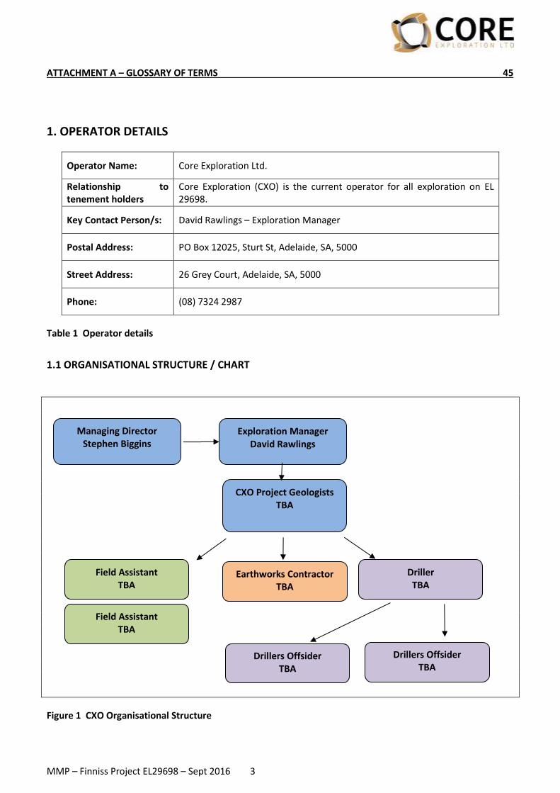
1.1 ORGANISATIONAL STRUCTURE / CHART
Figure 1 CXO Organisational Structure
Exploration Manager David Rawlings
CXO Project Geologists TBA
Field Assistant TBA
Driller TBA
Drillers Offsider TBA
Drillers Offsider TBA
Managing Director Stephen Biggins
Earthworks Contractor TBA
Field Assistant TBA

MMP – Finniss Project EL29698 – Sept 2016 4
1.2 WORKFORCE Core Exploration Ltd 1 Geologist – David Rawlings or Project Geologist (Figure 1) David or the delegated project geologist will supervise the project on site. They will be responsible for all aspects of the drilling program including
• Managing the logistical and technical aspects of the drilling program
• Environmental management
• Emergency response and HSE
• Heritage, Cultural and Sacred Site management
• Interactions with the public on site
• Rehabilitation management 1 Technical Assistant – TBA The technical assistant to the geologist, carrying out a variety of tasks, including monitoring access, positioning drill pads and sumps, maintaining sample integrity, collecting sub-samples for the laboratory, wash-downs of vehicles, liaison with driller and offsiders, acquiring and managing consumables etc. Contract Drilling Company – WDA Drilling 1 Driller – TBA The role of the driller will be to operate equipment and complete all jobs in a safe, cost effective manner whilst complying with Company and Client policies/procedures, and to recover an accurate sample as per Client specifications. The driller will also have the responsibility to mobilise and maintain drill rigs and associated tools and equipment, and complete all reporting, inspection and other documentation correctly; in a timely manner. 2-3 Offsiders - TBA Trainee drillers learning how to operate equipment and complete all jobs in a safe, cost effective manner under the guidance of the driller whilst complying with Company and Client policies/procedures, and to recover an accurate sample as per Client specifications. The Offsiders will assist in maintaining drill rigs and associated tools and equipment, and the completion of reporting, inspection and other documentation as directed by the driller. Earthworks – Wildman River Stock Company 1 Operator The operator is responsible for operation, maintenance and management of plant machinery (Loader). The loader will be used to assist access as outlined in this document and undertake rehabilitation at the end of the drilling program.
2. IDENTIFIED STAKEHOLDERS AND CONSULTATION
• Department of Land Resource Management: Flora & Fauna, Bushfires, Weeds, Water
• Department of Mines and Energy: Exploration Licence and MMP
• Bushfires NT
• NT Worksafe
• Neighbours and community
• Neighbouring exploration licence holders Consultation has included the following:
Department of Land Resource Management Environmental group SLR Consulting were commissioned by CXO to interrogate various publicly accessible datasets and documentation on land management and land management issues for the Finniss Project area, including the NT Department of Land Resource Management. Results are outlined in Section 4 – Current Project Site Conditions.
Department of Mines and Energy

MMP – Finniss Project EL29698 – Sept 2016 5
CXO has applied to the Department of Mines and Energy for permission to conduct substantial disturbance activities within EL 29698 (this document), and in it has outlined its philosophy, policies and procedures for this operation.
Bushfires NT CXO will maintain contact with Bushfires NT through its web portal to establish the daily fire regime within the broader Observation Hill area to ascertain the level of fire danger pertinent to the site. CXO have also liaised with Bushfires NT on the ground over the month of June 2016.
NT Worksafe CXO has ascertained its level of obligation to NT Worksafe through its adherence to National Health & Safety (National Uniform Legislation) Act and will continue to meet its obligations under this act. Neighbours and Community
As the planned small drilling program is well within the Vacant Crown land boundaries CXO does not consider
it necessary to needlessly inform those members of the wider public community that are not directly affected
by its planned activities.
Neighbouring EL Holders CXO will inform neighbouring exploration licence holders when undertaking activities that are adjacent to or on the boundaries of EL 29698.
3. PROJECT DETAILS
Project Name: Finniss Project
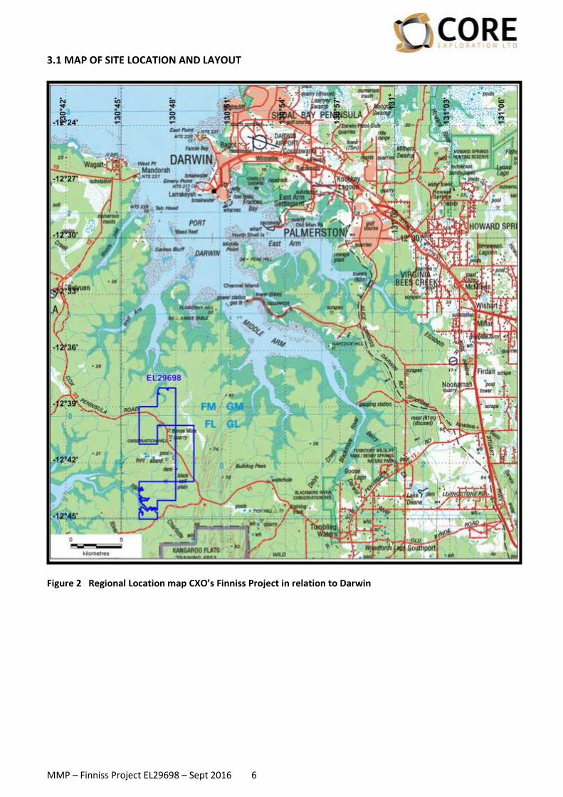
Location: The Finniss Project is located approximately 32km west of Darwin in the Cox Peninsula area (Figure 2; Figure 3).
Site Access: Access into the area is good from Darwin via the Stuart Highway and sealed Cox Peninsula Rd and then by dirt roads and tracks which traverse the Project area.
Mining Interest/s: EL 29698
Title holder/s: 100% - Au Exploration Pty Ltd Optioned to Core Exploration Ltd under agreement March 2016 Core Exploration is the Operator
Table 2 Project details
MMP – Finniss Project EL29698 – Sept 2016 6
3.1 MAP OF SITE LOCATION AND LAYOUT
Figure 2 Regional Location map CXO’s Finniss Project in relation to Darwin
MMP – Finniss Project EL29698 – Sept 2016 7
Figure 3 Location of work areas in relation to CXO tenure

MMP – Finniss Project EL29698 – Sept 2016 8
3.2 HISTORY OF DEVELOPMENT AND CURRENT STATUS Historical Mining/Exploration chronology
• The history of mining in the Bynoe Harbour – Middle Arm area dates back to 1886 when tin was discovered by Mr C Clark.
• By 1890 the Leviathan Mine and the Annie Mine were discovered and worked discontinuously until 1902.
• In 1903 the Hang Gong Wheel of Fortune was found and 109 tons of tin concentrates were produced in 1905. In 1906, the mine produced 80 tons of concentrates, but it was exhausted and closed down the following year after a total of 189 tons of concentrates had been won.
• By 1909 activity was limited to Leviathan and Bells Mona mines in the area with little activity in the period 1907 to 1909.
• Renewed activities in 1925 coincided with the granting of exclusive prospecting licences over an area of 26 square miles in the Bynoe Harbour – West Arm section but once again nothing eventuated.
• The records of production for many mines are not complete, and in numerous cases changes have been made to the names of the mines and prospects which tend to confuse the records still further. In many cases the published names of mines cannot be linked to field occurrences.
• In the early 1980s the Bynoe Pegmatite field was reactivated during a period of high tantalum prices by Greenbushes Tin which owned and operated the Greenbushes Tin and Tantalite (and later spodumene) Mine in WA. Greenbushes Tin Ltd entered into a JV named the Bynoe Joint Venture with Barbara Mining Corporation, a subsidiary of Bayer AG of Germany.
• Greenex (the exploration arm of Greenbushes Tin Ltd) explored the Bynoe pegmatite field between 1980 and 1990 and produced tin and tantalite from its Observation Hill Treatment Plant between 1986 and 1988.
• They then tributed the project out to a company named Fieldcorp Pty Ltd who operated it between 1991 and 1995.
• Since 1996 the field has been defunct until recently when exploration has begun on ascertaining the lithium prospectivity of the Bynoe pegmatites.
Exploration by CXO CXO has started exploring EL 29698 for lithium mineralisation in early 2016 and to date has undertaken mapping activities within this licence to locate named pegmatites and the existing access tracks. Mapping is currently being undertaken to allow the location and sighting of a number of drill programs over the highest ranked pegmatites with the intention of investigating their lithium prospectivity. Rock and soil sampling programs are currently being undertaken as part of the CXO exploration strategy.

MMP – Finniss Project EL29698 – Sept 2016 9
3.3 PROPOSED ACTIVITIES
Mining Interests (i.e. titles) EL 29698
What time of the year will exploration occur? September-November 2016
How long is exploration expected to occur? 3-5 weeks
Type of drilling (i.e. RAB, RC, Diamond, Aircore) RC, Aircore/RAB, DDH
Target commodity Lithium
Is drilling likely to encounter radioactive material?
No
Number of proposed drill holes 210 (DDH x10, RC x50 and
Aircore/RAB x150)
Maximum depth of holes 160 m
Number of drill pads (Length: 15 m x Width: 15 or 20 m)
60 (RC and DDH only)
Is drilling likely to encounter groundwater? (Y, N, unsure)
No, area has very limited groundwater recognised by
Water Resources Branch
Number of sumps (Length: 3m x Width: 2m x Depth: 1.2 m)
70 (1 per RC hole and 2 per DDH hole)
Length of line / track clearing (Kilometres: Width: 2.5 m)
5.3 km
Number of costeans (Length: x Width: x Depth: m)
Nil
Total bulk sample (tonnes) (Length: x Width: x Depth: m)
Nil
Will topsoil be removed for rehabilitation purposes?
No
Previous disturbance yet to be rehabilitated on title (ha) if known
0
Camp (Length: x Width: m)
Camping off site at commercial site
Total area disturbed (hectares) 3.6
Table 3 2016 Proposed Activities EL29698
MMP – Finniss Project EL29698 – Sept 2016 10
4. CURRENT PROJECT SITE CONDITIONS
Site Conditions
Description
Geology
EL 29698 covers most of the northern extremity of a swarm of complex zoned rare element pegmatites which comprise the 55km long by 10km wide West Arm – Mt Finniss pegmatite belt. The main pegmatites in this belt are: Mt Finniss, Grants, BP33, Bilato’s (Pickett’s), Hang Gong and Bells Mona are up to 300m long and 100m wide. The Finniss pegmatites have intruded early Proterozoic shales, siltstones and schists of the Burrell Creek Formation which lies on the northwest margin of the Pine Creek Geosyncline. To the south and west are the granitoid plutons and pegmatitic granite stocks of the Litchfield Complex. The source of the fluids that have formed the intruding pegmatites is generally accepted as being the Two Sisters Granite to the west of the belt, and which probably underlies the entire area at depths of 5-10 km. Lithium mineralisation has been identified as occurring at Bilato’s (Pickett’s), Saffums 1 (amblygonite) and more recently at Hang Gong (spodumene). The Burrell Creek Formation increases in metamorphic grade westward from sub-greenschist facies siltstone, phyllite and siltstone, to upper greenschist facies gneiss and schist. Sedimentary features and lithologies, typical of the lower grade units of the Burrell Creek Formation, can be recognised until the sillimanite isograd is approached, whereafter these features are obliterated by recrystallisation.
Hydrology
The Bynoe-Cox Peninsula area has very poor groundwater resources due to the “tight” nature of the Proterozoic rock. The only registered bore in the vicinity of the program is RN023177 at Hang Gong, immediately adjacent to the work area (Figure 3). Flow of 0.5 to 1.6 l/sec relate to local fracture permeability.
Land Use There is no current land use stated for the area underlying EL 29698 as the land is Vacant Crown Land owned by the NT Government. Sections 02746 Hundred of Hughes, Section 00001 Hundred of Parsons and NTP 03283 which is owned by the NT Land Corporation.
Vegetation
Vegetation community data across EL29698 was obtained from the following datasets:
• NVIS Version 3.1 National Vegetation Information System (NVIS), NT Data Compilation (Scale 1:1,000,000) (Source: Department of Land Resource Management)
• Landcover Vegetation Mapping for the Greater Darwin Region (Landcover Vegetation Mapping) (Scale 1:100,000) (Source: Department of Land Resource Management).
As shown in Figure 4, most mapped vegetation in EL29698, according to the NVIS dataset, consists of:
• Eucalyptus mid open forest\Livistona low sparse palmland\Heteropogon tall tussock grassland
• Eucalyptus mid woodland\Gardenia tall open shrubland\Heteropogon mid tussock grassland
These communities are also mapped widely within the surrounding region. There is also ‘Melaleuca mid open forest’ across the centre of the southern portion of the lease, being replaced by a mangrove (‘Ceriops’) community closer to the Darwin Harbour reaches. Similarly, along the northern border of the lease, mangrove communities border the Darwin Harbour reaches. In the ‘Hills’ drilling polygon, the finer scale Landcover Vegetation Mapping appears to show the western portion as being cleared, and the eastern and central sections as ‘drainage open woodland’. The drainage open woodland community is described in Hempel (2003) as:

MMP – Finniss Project EL29698 – Sept 2016 11
Open woodland dominated by Lophostemon lactifluus, occuring on broad flats with seasonally waterlogged soils and impeded drainage. Frequently recorded species include Lophostemon lactifluus, Pandanus spiralis, Grevillea pteridifolia, Livistona humilis, Eriachne burkittii (perennial grass), Melaleuca viridiflora, Melaleuca nervosa, Themeda triandra (perennial grass), Xyris complanata (sedge), Ectrosia leporina (annual grass), Ischaemum australe (perennial grass), Erythrophleum chlorostachys, Heteropogon triticeus (perennial grass), Corymbia polycarpa, Corymbia polysciada, Acacia auriculiformis, Drosera petiolaris (herb), Banksia dentata and Xanthostemon paradoxus. Indicator species include Lophostemon lactifluus, Themeda triandra (perennial grass) and Grevillea pteridifolia. The ‘Grants’ drilling polygon is wholly mapped as ‘Eucalypt open woodland’ in the Landcover vegetation mapping dataset and Eucalyptus mid open forest in NVIS. Similar vegetation communities exist in the ‘Far West Central’, ‘Central’ and ‘Far West North’ drilling polygons. These are mapped widely in the surrounding region. The ‘BP33’, ‘Ah Hoy’, ‘Ah Hoy SE’, ‘Vickmans’ and ‘Kellys’ drilling polygons are mapped as ‘Eucalyptus mid woodland\Gardenia tall open shrubland\Heteropogon mid tussock grassland’ in NVIS, with fairly consistent Landcover Vegetation Mapping including ‘Eucalypt woodland’, ‘drainage open woodland’, and ‘Eucalypt open woodland’. These communities are described above for ‘drainage open woodland’ and for the other two as (Hempel, 2003): ‘Eucalypt woodland’ - Woodland occurring in shallow soils on undulating uplands, rises and rugged low hills. Grassland ground cover interspersed with a variety of shrubs and vines... Frequently recorded species include Livistona humilis, Pandanus spiralis, Erythrophleum chlorostachys, Grevillea pteridifolia, Lophostemon latifluus, Themeda triandra (perennial grass), Buchanania obovata, Heteropogon triticeus (perennial grass), Petalostigma pubescens, Planchonia careya, Terminalia ferdinandiana, Eucalyptus tetrodonta, Eriachne triseta (perennial grass), Eucalyptus miniata, Persoonia falcata, Xanthostemon paradoxus, Cycas armstrongii, Alloteropsis semialata (perennial grass), Petalostigma quadriloqulare, and Pseudopogonatherum contortum (annual grass). ‘Eucalypt open woodland’ - Open woodland again occurring in shallow soils on undulating uplands, rises, rugged low hills and plains, with grasses beginning to dominate the ground layer. Frequently recorded species include Livistona humilis, Pandanus spiralis, Grevillea pteridifolia, Themeda triandra (perennial grass), Heteropogon triticeus (perennial grass), Eragrostis cumingii (perennial grass), Petalostigma pubescens, Erythrophleum chlorostachys, Buchanania obovata, Schizachyrium fragile (annual grass), Triodia bitextura (perennial grass), Terminalia ferdinandiana, Pseudopogonatherum contortum (annual grass), Cycas armstrongii, Planchonia careya, Eriachne avenacea (perennial grass), Mnesithia rottboellioides (perennial grass), Petalostigma quadriloculare, Eriachne triseta (perennial grass) and Persoonia falcata. Indicator species include Eragrostis cumingii (perennial grass). ‘Ah Hoy’ also contains a strip of ‘Melaleuca mid woodland\Melaleuca low open woodland\Chrysopogon mid open tussock grassland’ running through the south-west corner.
Flora
General flora NR Maps lists 141 native flora species as occurring within 5 km of EL29698 Threatened species A search of the following biodiversity databases was undertaken in an area up to 5 km from the boundaries of EL29698:
• Australian Government’s ‘Protected Matters Search Tool’ (DoE, 2016)
• NT Government’s ‘NR Maps’ (NR Maps, 2016
MMP – Finniss Project EL29698 – Sept 2016 12
• NRM Infonet (NRM Infonet, 2016). The 5 km buffer was considered adequate given the proximity of the site to Darwin and the volume of flora records in the region. The search identified two threatened flora species - Armstrong’s Cycad (Cycas armstrongii) and Trigger Plant (Stylidium ensatum) (DoE, 2016; NR Maps (NR Maps, 2016), NT NRM Infonet (NRM Infonet, 2016)). Only Armstrong’s Cycad is considered possible to occur in EL29698. Further information regarding their conservation status, preferred habitats and likelihood of occurrence within EL29698 is presented in Table 5.
Weeds
NR Maps contains records of 11 species of weeds in, or within 5km of, EL29698, these being (in order of abundance, highest first) (NR Maps, 2016):
1. Mission grass – perennial (Cenchrus polystachios) 2. Mission grass – annual (Cenchrus pedicellatus) 3. Common Lantana (Lantana camara) 4. Gamba Grass (Andropogon gayanus) 5. Cynodon radiatus 6. Euphorbia heterophylla 7. Coffee Bush (Leucaena leucocephala) 8. Ruellia tuberosa 9. Sicklepod Senna (Senna obtusifolia) 10. Flannel Weed (Sida cordifolia) 11. Paddys Lucerne (Sida rhombifolia).

MMP – Finniss Project EL29698 – Sept 2016 13
Fauna
General Fauna NR Maps lists 156 native fauna species as occurring within 5 km of EL29698 (NR Maps, 2016). Many of these are common in the Darwin region, including several species of finches, honeyeaters, kingfishers, parrots, lorikeets and cockatoos. Kites, Black Cockatoos, lorikeets and sea eagles are also common. Common mammals found in the vegetation communities to those identified as occurring in EL29698 include Antilopine Wallaroos and Sugar Gliders. Threatened Species A search of the following biodiversity databases was undertaken in an area up to 5 km from the boundaries of EL29698:
• Australian Government’s ‘Protected Matters Search Tool’ (DoE, 2016)
• NT Government’s ‘NR Maps’ (NR Maps, 2016)
• NRM Infonet (NRM Infonet, 2016). The 5 km buffer was considered adequate given the proximity of the site to Darwin and the volume of fauna records in the region. A total of 20 threatened species, and no threatened ecological communities, was identified as possibly occurring. Of note:
• 9 possibly occur
• 11 are unlikely to occur, including the wading birds because their preferred habitats are unlikely to be present, and the Northern Quoll (Dasyurus hallucatus) as it has not been recorded in the search area since Cane Toads arrived in the region.
• Only two, the Bar-tailed Godwit and Northern Quoll, have previously been recorded within 5 km of EL29698.
Whilst the database reports contain records of marine fauna (e.g. dolphins, whales, sharks and turtles) and/or their habitats as occurring, suitable habitat for these species is not known to occur within EL29698 and therefore this report does not further address them.
Feral Animals
Only two species of feral animals have been recorded within 10 km of EL29698 – Dingo (Canis lupus) and Pig (Sus scrofa) (NR Maps, 2016). It is possible that a range of other feral animals exists in the area also including introduced rats and feral cats.
Historical, Aboriginal, Heritage Sites
Requests were made of the AAPA and the Heritage Branch of the DLPE to identify known historical, aboriginal and heritage site within EL 29698. The AAPA request returned the information that there are no known Aboriginal sites of significance within the EL. The Heritage search showed 1 Aboriginal site (Site 5) and this is well away from areas that are to be investigated in the drill program under this MMP (Figure 2).
Table 4 Current Project Site Conditions

MMP – Finniss Project EL29698 – Sept 2016 14
Figure 4 Vegetation Communities in EL29698

MMP – Finniss Project EL29698 – Sept 2016 15
Scientific Name
Common Name
TPWC1 Status
EPBC2 Status
Preferred Habitats
Records within 5 km (most recent year recorded)3, 4
Likelihood of Occurrence in EL29698
Plants
Cycad armstrongii
Armstrong’s Cycad
Vulnerable
-
Mainly in open grassy woodland on yellow and red earths, limited in the area by drainage
Nil
Possible – NR Maps lists the closest record as ~15 km to the east however advice from DME indicates its presence in the area.
Stylidium ensatum
Trigger Plant
Endangered
- Margins of drainage areas in damp heavy clay or peaty soil
Nil
Unlikely – NR Maps lists the closest record as only ~7 km to the south-west and it has not been collected anywhere across its range since 1974 (Cowie & Westaway, 2012).
Reptiles
Acanthophis hawkei
Plains Death Adder
Vulnerable
Vulnerable
Cracking soils on floodplains of the Adelaide, Mary and Alligator Rivers
Nil Unlikely – not within, or near to, the known distribution of the species.
Birds
Calidris tenuirostris
Great Knot Vulnerable
Critically Endangered
Tidal flats and beaches, occasionally inland
Nil Unlikely – no previous records and preferred habitat not present.
1 NT Territory Parks and Wildlife Conservation Act 2 Commonwealth Environment Protection and Biodiversity Conservation Act 1999 3 NR Maps, 2016 4 NRM Infonet, 2016

MMP – Finniss Project EL29698 – Sept 2016 16
Scientific Name
Common Name
TPWC1 Status
EPBC2 Status
Preferred Habitats
Records within 5 km (most recent year recorded)3, 4
Likelihood of Occurrence in EL29698
Charadrius leschenaultii
Greater Sand Plover
Vulnerable
Vulnerable
Sheltered mudflats, sandy beaches, estuaries and mangroves, inland saline wetlands but always close to the coast
Nil Unlikely – no previous records and preferred habitat not present.
Charadrius mongolus
Lesser Sand Plover
Vulnerable
Endangered
Sheltered mudflats, sandy beaches, estuaries and mangroves, inland saline wetlands but always close to the coast
Nil Unlikely – no previous records and preferred habitat not known to be present.
Erythrotriorchis radiatus
Red Goshawk
Vulnerable
Vulnerable
Forests and woodlands1 Nil Possible – foraging habitat likely to be present.
Erythrura gouldiae
Gouldian Finch
Vulnerable
Endangered
Wooded hills with snappy or salmon gums in the breeding season, and surrounding lowland grasslands during the non-breeding season.
Nil Unlikely – no previous records and preferred habitat not known to be present.
Geophaps smithii smithii
Partridge Pigeon (eastern)
Vulnerable
Vulnerable
Lowland eucalypt open forests and woodlands that have grassy understoreys, where they nest on the ground, and feed on fallen seeds between grass tussocks.
Nil Possible – habitat likely to occur.
Limosa lapponica baueri
Bar-tailed Godwit (baueri)
Vulnerable
Vulnerable
Intertidal mudflats or in shallow water.
1 (1994) Unlikely – preferred habitat not present.

MMP – Finniss Project EL29698 – Sept 2016 17
Scientific Name
Common Name
TPWC1 Status
EPBC2 Status
Preferred Habitats
Records within 5 km (most recent year recorded)3, 4
Likelihood of Occurrence in EL29698
Limosa lapponica menxbieri
Bar-tailed Godwit (menzbieri)
Vulnerable
Critically Endangered
Intertidal mudflats or in shallow water.
Nil Unlikely – no previous records and preferred habitat not present.
Rostratula australis
Australian Painted Snipe
Vulnerable
Endangered
On shallow, grassy, freshwater swamps, claypans and seasonally flooded grasslands. In the Northern Territory, most suitable habitat occurs on pastoral land.
Nil Unlikely – no previous records and preferred habitat not present.
Tyto novaehollandiae kimberli
Masked Owl (northern)
Vulnerable
Vulnerable
Eucalypt tall open forests (especially those dominated by Darwin Woollybutt (Eucalyptus miniata) and Darwin Stringybark (E. tetrodonta)), but also roosts in monsoon rainforests, and forages in more open vegetation types, including grasslands
Nil Possible – foraging habitat likely to be present.
Mammals
Antechinus bellus
Fawn Antechinus
Endangered
Vulnerable
Savannah woodland and tall open forest
Nil Possible – preferred habitat likely to occur, although no records exist
Conilurus penicillatus
Brush-tailed Rabbit-rat
Endangered
Vulnerable
Eucalypt tall open forest Nil Possible – preferred habitat likely to occur, although no records exist

MMP – Finniss Project EL29698 – Sept 2016 18
Scientific Name
Common Name
TPWC1 Status
EPBC2 Status
Preferred Habitats
Records within 5 km (most recent year recorded)3, 4
Likelihood of Occurrence in EL29698
Dasyurus hallucatus
Northern Quoll
Critically Endangered
Endangered
Near-coastal forests and woodlands, most commonly in rocky country
3 (1995)
Unlikely – although preferred habitat probably exists, all records are pre-2000 and numbers reduced drastically elsewhere following Cane Toad arrival to the Darwin region (approx. 2006).
Macroderma gigas
Ghost Bat Near Threatened
Vulnerable
Tropical savanna woodlands and rainforests
Nil Possible – preferred habitat likely to occur, although no records exist
Mesembriomys gouldii gouldii
Black-footed Tree-rat
Vulnerable
Endangered
Continuous forest with large trees with tree hollows and diverse shrubby understorey
Nil Possible – suitable habitat likely to exist, however there are no records.
Petrogale concinna canescens
Nabarlek (Top End)
Vulnerable
Endangered
Restricted to rocky areas (sandstone or granite), especially on steep slopes, with large boulders, caves and crevices
Nil Unlikely – no records and preferred habitat not present.
Phascogale pirata
Northern Brush-tailed Phascogale
Endangered
Vulnerable
Tall open forests dominated by Darwin Woollybutt (E. miniata) and Darwin Stringybark (E. tetrodonta)
Nil Possible – suitable habitat likely to exist, however there are no records.
Saccolaimus saccolaimus nudicluniatus
Bare-rumped Sheath-tailed Bat
- Critically Endangered
Coastal lowlands, where they have been recorded in open screw-palm woodland, eucalypt tall open forest and rainforest.
Nil Possible – suitable habitat may exist, however there are no records.

MMP – Finniss Project EL29698 – Sept 2016 19
Scientific Name
Common Name
TPWC1 Status
EPBC2 Status
Preferred Habitats
Records within 5 km (most recent year recorded)3, 4
Likelihood of Occurrence in EL29698
Xeromys myoides
Water Mouse
Data Deficient
Vulnerable
Mangroves and the associated saltmarsh, sedgelands, clay pans, heathlands and freshwater wetlands
Nil Unlikely – no previous records and preferred habitat not present.
Table 5 Conservation Status, Preferred Habitats and Likelihood of Occurrence of Threatened Species Listed under the TPWC or EPBC Acts within 5 km of EL29698

MMP – Finniss Project EL29698 – Sept 2016 20
5. ENVIRONMENTAL MANAGEMENT SYSTEM / PLAN
5.1 ENVIRONMENTAL POLICY AND RESPONSIBILITIES In addition to the requirements of legislation in the Northern Territory, CXO maintains a strict policy to monitor the environmental impact of all exploration activities. CXO’s policy is that compliance with statutory obligations is a minimum standard and strives for best practice in all aspects of environmental management. Exploration Manager will be the person responsible for environmental management.
5.2 STATUTORY AND NON-STATUTORY REQUIREMENTS
Mining operations have obligations to meet the requirements of several Northern Territory laws, principally: Northern Territory Mining Management Act and Regulations
• Section 35 of the Mining Management Act Application for an Authorisation
• Part 4, Division 4, Section 43, 44 of the Mining Management Act Security Calculation Mineral Titles Act & Regulations 2011. There are also certain obligations under the:
• Weeds Management Act
• Bushfires Act
• Heritage Act 2011
• NT Aboriginal Sacred Sites Act
• Native Title Act
• Aboriginal Land Rights (Northern Territory) Act
• Environment Protection & Biodiversity Conservation Act
• Atomic Energy Act
• Work Health & Safety(National Uniform Legislation) Act 2011
• Soil Conservation & Land Utilisation Act
• Territory Parks and Wildlife Conservation Act
• Waste Management and Pollution Control Act
• Licence conditions
• Authorisation conditions There are currently no non-statutory agreements in place.
MMP – Finniss Project EL29698 – Sept 2016 21
5.3 INDUCTION AND TRAINING
CXO will induct all contract field staff involved in the program in relation to the HSE risks and management requirements of the specific work program in addition to the specific environmental and cultural sensitivities of the licence area. The CXO site manager or appointed qualified team member will distribute a hard copy and read through the Induction pack, followed by some project specific information. Some specific induction items for this project are presented below. The role of the Inductee determines which of these items are presented. For example, the earthworks crew won’t be briefed on items 7 and 8.
1. Travel mudmap for access to and around work sites. Local hazards around the work area and en route to the area from the accommodation.
2. Bushfire conditions expected. 3. Endangered flora and fauna species in the area – how to identify and avoid (with the aid of illustrated
fact sheets). 4. Archaeological artefacts – how to recognise and procedures to follow should their preservation be
threatened (with the aid of illustrated fact sheets). 5. Weed identification – outline the important weeds to recognise and the specific management
system that will be used whilst on site (with the aid of illustrated fact sheets or “weed decks”). 6. Clearing methods agreed in the MMP – articulate these to the earthworks crew 7. Groundwater conditions expected and agreed procedures in the vent of groundwater intersection. 8. Sampling procedures. 9. Tool box meetings – when, how, what. 10. Emergency response procedures. 11. Contact numbers for routine and emergency communications.
The level of knowledge required for each of these is either implicit with the qualifications of the operator (e.g., driller will be qualified for groundwater procedures) or is consistent with that expected of the general public (e.g., the recognition of a weed species by way of comparison to an identification kit designed for public consumption). If in the companies view the level of knowledge of inductees isn’t sufficient, CXO will arrange for appropriate training.
5.4 ENVIRONMENTAL ASPECTS AND POTENTIAL IMPACTS 5.4.1 Environmental Aspects CXO has identified a number of aspects of the program that have the potential to have an environmental impact. CXO has identified the activities with the greatest risk of an environmental impact as;
a) Implementing new tracks; b) Drillhole sites; c) The camp site; d) Intersection of groundwater in drilling and potential for spillage; e) Drilling sample bags and waste; f) Rubbish; g) Weed management; h) Hydrocarbon storage & management.
5.4.2 Potential Impacts Unregulated drilling and mining has the potential to impact vegetation, soil, air, and water. Drilling operations present a range of environmental issues that need to be managed at every step of the process. Identified impacts, along with a range of measures to avoid and mitigate these impacts, have been described below. 5.4.3 Proposed Impact Reduction, Mitigation and Rehabilitation Methods

MMP – Finniss Project EL29698 – Sept 2016 22
In all fieldwork and field operations it is CXO’s policy and intention to cause minimal impact on the environment. CXO endeavours to leave all areas visited in the same state as they were before visiting that area. CXO proposes to minimise the potential impacts of the field activities have an environmental impact as follows.
a) Implementing new tracks and refurbishing existing tracks Tracks will be prepared and cleared with a minimum of disturbance to the environment and will be rehabilitated in such a way as to promote rapid revegetation and prevent the initiation of erosion. Whilst existing tracks will be used wherever possible, up to 8750m of track clearing may be required. Of this, 2000m is refurbishing existing access tracks, 3600m is RC lines or tie lines, and 3150m is aircore/RAB lines (assuming they are needed and cross-country traversing is not possible due to vegetation). These are shown in Figure 3.
Access tracks
• Tracks will be located where possible in flat areas with low slopes, naturally clear routes. No sensitive habitat areas were identified in the Desktop study undertaken by environmental group SLR Consulting.
• Existing tracks will be utilised where available and the use of earthworks will be minimised.
• Deep wheel ruts will be mitigated by avoiding driving in the same wheel ruts every time a road is used (i.e. spread the load), as wheel ruts quickly channel water, increasing erosion potential.
• No windrows will be created.
• Land clearing will only be undertaken for the establishment of drill sites or access tracks where it is deemed necessary. Wherever possible, vegetation will only be flattened by vehicle/loader tyres to retain root structure and surface soil stability. Sandpalms that are extensively developed in the area pose a significant problem for access, as they tend to be elastic and spring back into an upright or inclined position after they have been run over. In this position they are a significant safety risk to vehicles. In the worst case scenario, a sandpalm impacting on the front of an oncoming vehicle has the capacity to overturn the vehicle. Most incidents involving sandpalms are the rupturing of the vehicle cooling system. To alleviate this problem, CXO will utilise two runs of back-blade techniques with a front-end loader that is able to flatten most sandpalms. If this proves ineffective, particularly difficult sandpalms will be either dug out by the root ball or will be cut off at ground level with a chainsaw.
• Where large trees overhang existing access tracks and pose a safety issue they will be pruned using a chainsaw. On most occasions these trees can be avoided.
• Portions of routinely-used tracks will be sheeted to enable access at the start of the wet season, so as to avoid equipment and vehicles getting bogged and causing damage. Gravel materials will be sought from local gravel pits and bought in by tipper truck, then levelled by loader. It is worth noting that there are already some sheeted tracks in the area dating back to the operational times of the tin-tantalum mining/processing, for example, the majority of the tracks into BP33 and Grants. A total of 1500 m of scarification is allowed for in the security calculation, of which 1000 m is allocated to newly sheeted (compacted) tracks.
Ephemeral creek crossings
• Existing creek crossings are used in most instances and will be maintained in good condition.
• Ephemeral drainage will be kept clear of soil and debris to allow water to cross roads.
• Ephemeral creek crossings will be located where the bank edge is lowest
• Tracks will be designed to intersect creeks at a right angle to the direction of flow.
• If/where creek banks are too steep for vehicles; ramps will be constructed to a suitable approach angle. Material will be moved away from the drainage line (i.e. no sand to be deposited within drainage). Material from scraping will be used to make a low bank at the top of the ramp to direct water away from the track. This will reduce risk of gully erosion, as in the event of rainwater will be directed into stable soils.
Implementing new tracks will be done in accordance with the Department of Mines and Energy’s advisory note AA7-005 “Clearing and Rehabilitation of Lines and Tracks Guide”.

MMP – Finniss Project EL29698 – Sept 2016 23
Armstrong’s Cycad
The following information has been developed utilising information in Liddle (2009) and Origin Energy (2014). Armstrong’s Cycad occurs around the Darwin area south to near Hayes Creek, and to the north-western corner of Kakadu National Park in the east, as well as on the Tiwi Islands, Cobourg Peninsula, and Cox Peninsula. It occurs mainly in open grassy woodland on yellow and red earths. Armstrong’s Cycad, like all cycads, is a long-lived, slow-growing, woody plant, with male and female individuals. Reproductive age is unknown, but can be 15 years under cultivation. Seeding may be annual or sporadic. Pollination appears to be mainly through insects, in particular beetles in the family Boganiidae. Seeds are dispersed through gravity, water and animals. Cycads live in symbiosis with cyanobacteria which provide the plant with nitrogen. The species is relatively resilient to low intensity fires, and can regenerate from crown damage, apical growing shoot damage, and even from destruction of the entire above ground stem, through regrowth from the stem base or root stock. However, populations decline when subjected to high intensity fires (Liddle, 2004). The species is threatened by:
• Conversion of its habitat for residential and rural pursuits
• Through changes in prevailing fire regimes, facilitated by the influx of weeds into the species’ habitat, resulting in enhanced fuel loads and higher intensity fires.
Armstrong’s Cycad will be appropriately conserved, should any individuals of this species be encountered in the area to be cleared. The performance criterion and indicator for this issue includes the following:
• Number of Armstrong’s Cycad individuals present in areas to be cleared, number successfully translocated, and the number successfully planted.
• Number of seed collected, number of seed successfully grown into plants, number of seedlings successfully planted.
• No loss in the number of healthy Amstrong’s Cycad individuals two years after translocation. Recognition Armstrong’s Cycad grows to a height of 6 m, with a slender trunk 6-12 cm in diameter. Branching occurs, with occasional offsets and basal suckers. The crown is obliquely erect to spreading, with 84-156 leaflets. Leaflet have a prominent midrib on the upper surface, and are attached to the rhachis at an angle of about 56-70 degrees. Additional description is available in Hill (1996), Hill and Osborne (2001), Jones (2002) and Dixon (2004). Management Measures The following management measures have been formulated specifically for Armstrong’s Cycad. Procedures for propagation and translocation are summarised from Origin Energy (2014). Pre-Clearing Survey The following measures will be employed prior to disturbance activities commencing:
• The tracks and drill sites to be cleared will be surveyed by personnel suitably skilled in the recognition of Armstrong’s Cycad. Should any individuals of Armstrong’s Cycad encountered within this area, plants will be avoided or, where avoidance is not possible, clearly marked for appropriate removal during clearing operations.
• The northern side of the plant will be marked with marker paint or fluorescent dye to facilitate re-planting with the same orientation.

MMP – Finniss Project EL29698 – Sept 2016 24
• Seed encountered on the forest floor surrounding the plants will be collected for propagation and rehabilitation purposes either elsewhere on the site or at the collection location once mining operations have ceased.
• Operational Phase The following measures will be employed during mining operations, where plants cannot be avoided:
• During clearing operations, Armstrong’s Cycad individuals marked during pre-clearing surveys will be removed for relocation in rehabilitation areas elsewhere on the site or for temporary storage for rehabilitation at the proposed gravel pits once mining operations have ceased.
• Prior to removal, the area around plants will be cleaned by hand or with machinery (e.g. front end loader) and foliage removed to where the rhachis is attached to the stem. Using a spade, excavator or backhoe, soils surrounding the root ball is loosened prior to excavation ensuring that as much of the rootball around the plant roots remains intact. Damaged roots are to be trimmed and treated with Banrot® and/or Formula20®. To initiate root growth, Vitamin B or Seaweed can be sprayed on the roots. Roots are bagged in breathing material, such as hessian, and moistened with water prior to transport to a temporary holding location or to a prepared rehabilitation location elsewhere on the site. Care should be taken not to bruise plant stems during transport, using soft materials such as hessian to stabilise the plant.
• Upon arrival, plants are to be immediately potted or put into woven fibre planter bags for temporary holding or, if used for rehabilitation elsewhere on the site, in a prepared hole of a size suitable for the inserted root ball. Plants should be positioned in their original orientation. Washed sand or sandy loam should be used to for packing around the roots, to provide a suitable medium for root growth. The crown of each cycad will be sprayed with an insecticide (either Confidor® at a rate of application of 10 millilitres (mL) per 9 litres (L) of water or application of Crown® at a rate of application of 5 mL per 9 L of water). Translocated plants will also be watered with 5-9 L of water around each root ball with a systemic fungicide (Banrot® at the recommended rate). Rocks can be placed around the base of plants to assist in the stability of plants and to provide protection from fires and hot weather.
• Seed collected from the cleared areas will be propagated in pots using standard horticultural methods or direct seeded in areas to be rehabilitated.
• Translocation and propagation operations will be supervised by a suitably trained horticulturalist or arborist.
Post-Operation The following measures will be employed following mining operations:
• Translocation of individuals held in the temporary storage area back to the original area of extraction will follow similar procedures as outlined above. Each plant will be watered about once a month (10-20 L) depending on rainfall for six months after replanting or as appropriate and any new expanding leaves will be sprayed with insecticide.
• Plants will be monitored for new growth, death, insect attack, reproduction, gender etc. for a period of at least two years after planting in the ground.
Monitoring and Reporting Monitoring will be the responsibility of CXO’s Exploration Manager to ensure the health of translocated individuals in accordance with the performance indicators outlined above. This person will be responsible for reporting the number of individuals found on areas to be cleared (if any) to the DME upon completion of the pre-clearing search. Further reports will be submitted on completion of the initial translocation and once again on completion of replanting of the translocated stock on completion of mining and revegetation operations.
b) Drillhole sites CXO anticipates up to 210 holes are to be completed during this program, 50 of which are RC, 150 are Aircore/RAB and 10 are Diamond Drill Core (DDH). They will be constructed on an as-needs basis along the drill

MMP – Finniss Project EL29698 – Sept 2016 25
lines discussed above, and are essentially a widening of these lines from the standard 2.5m to between 4.5 m and 15 m, over a length of 20 m to accommodate the drill rig and support vehicles. Where possible, holes will be designed to occur on relatively flat areas of ground that are naturally clear of trees and rocky outcrops. If the drill site is vegetated, CXO will need to clear grass and shrubs from an area of 225 m2 for RC and 300 m2 for DDH to allow the drill rig and geological crew to operate safely. This is particularly critical where the work area has not been burnt by the regular fires that pass through the area – fire safety is a significant issue in this area. During the first phase of drilling in August 2016, CXO identified the need to enlarge the pads in areas where vegetation encroached on the work area, to provide a safe working environment for the drilling crew and CXO geology crew. Sample bags need to be protected from fires as well as people. Previously, pads were made to 10x15 m (150m2), while now CXO propose to utilise pads up to 15x15m (225 m2) for RC and 15x20m (300 m2) for DDH. If groundwater becomes an issue, sumps will be dug at each RC drill site for containment of excess ground water that is encountered. The nominal size of the sumps will be 3m x 2m x 1.2m, which will be dug using a front-end loader. There is no need to use a liner as water is not recirculated, and the groundwater will not pose a problem to the sub-soil environment. For the reverse circulation (RC) and diamond drill core (DDH) drill holes, the hole diameter is ~150mm at the top of hole and ~130mm at depth. Aircore/RAB holes will be ~125 mm along their length. Depending on the competence of the thin soil profile, PVC collars may need to be used in the top 1 to 10 metres but will be removed or cut down below surface during rehabilitation. Drill hole depths are expected to be between 50 and 160 m for RC/DDH and 1 to 20 m for aircore/RAB, depending on purpose of hole and lithology intersected at depth. RC Sample materials are collected in green plastic bags and placed in rows of 20. A subsample is taken from each bag and used for analysis. A chip tray is kept for each metre drilled. For DDH, core is laid out in plastic core trays. The rehabilitation process for all of the drill sites will be to back-fill the sample spoils/cuttings down the hole and/or sump as much as possible. Excess spoils are spread on the work site and raked into the soil, unless they are substantially different in colour to the surface. The top section of the hole is plugged >40 cm below surface, using a recommended hole plug. Soil is heaped over the collar to allow for natural subsidence. Rehabilitation of sumps will ensure correct reconstruction of natural soil profiles. Topsoil is stored separately so it can be spread over the top of the sump. All waste, including the plastic bags, will be removed from site and disposed as detailed below. All drill holes will be rehabilitated according to the Department of Mines and Energy’s advisory note AA7-008 Drill Hole Capping and Plugging Guide and AA7-029 Construction and Rehabilitation of Exploration Drill Sites. Measures relating to the avoidance and mitigation of impacts on Armstrong’s Cycad are described in the previous section.
c) Camp site
CXO will locate its drill camp at the Sand Palms Roadhouse which is located outside EL 29698. Exploration crew will drive in to site each day.
d) Groundwater in drilling
CXO’s targets during this program are all hard rock targets. As such no aquifer bearing cover sequences are expected to be intersected. The holes will be drilled to a vertical depth of ~50-90m. Ground water is not expected to be intersected given the paucity of bores in the area, however, there is a small chance that existing

MMP – Finniss Project EL29698 – Sept 2016 26
structures could act as a zone of weakness in the rock and therefore be a conduit or trap for groundwater. If this is the case CXO will trap the water in the drill sump and isolate it from the surrounding environment. Should groundwater flows be significant the hole will be grouted to reseal the aquifer. The significance of groundwater flow will be determined by consultation with the Water Resources Branch.
e) Waste
Core anticipates the only waste produced during the drilling to be isolated to green plastic cuttings bags, empty additive (for drilling fluids) containers and miscellaneous rubbish. All hydrocarbon waste, any contaminated soil and other waste aside from plastic bags will be transported to an appropriately licenced waste disposal facility such as Shoal Bay. The remaining “household” type waste will be disposed of in the Berry Springs waste transfer station.
f) Rubbish
All rubbish will be removed from around the drill holes.
g) Weed management There are many weed species known to occur in the local area. Site inductions will include discussion on weed management and cover identification of main weed species (largely Mission and Gamba Grass, Mimosa). Exploration activities may result in introduction or spread of weed species if appropriate planning and weed control measures are not implemented. The following mitigations will be adopted (at minimum) by CXO to reduce weed impact on the site as a result of the exploration drilling operation. All machinery and vehicles will be cleaned in suitable facility in Darwin prior to mobilisation to site. Likewise if moving between areas and at the completion of the program prior to demobilisation all vehicles and equipment will be washed / blown-down at site at the nominated weed washdown and inspection site. The nominated site for this program is the Observation Hill Government borrow pit at waterbore RN023177 (695400e, 8595800n; Figure 3). This site has substantial existing disturbance and weeds are already prevalent. Vehicles and equipment are inspected daily which includes an inspection of cleanliness for weed management purposes. Records of inspections are stored in CXO’s HSE database system and are available on request. No vehicles will go off-road on transit to site and approved access routes will be strictly adhered to. Follow up weed monitoring activities will occur as part of site inspections conducted by CXO, and will target weed blow down points, drill pads, and access tracks. Any suspected weeds will be photographed and supplied to an ecologist for identification. If weeds are identified, CXO will inform DME and initiate relevant controls for the species.
h) Hydrocarbon Storage & Management
Diesel fuel and oils (including: engine oil, gear oil, hammer oil, grease, penetrating oils, hydraulic oils/fluids) will be required to operate the drilling equipment. The drilling contractor will be responsible for providing and safely storing both fuel and other hydrocarbon products. CXO requires all hydrocarbons brought to CXO’s worksites be appropriately bunded and stored as part of our HSE contractor management. A full list of MSDS sheets of all chemical products brought to site is available at request and maintained onsite. Several spill kits and absorbent matting are readily available should an incident occur (located close to all hydrocarbon / chemical storage and work areas), which will be fully documented and investigated. Should any soil be contaminated it will be bagged and disposed at a licensed waste disposal facility.
5.4.4 Risk Assessment

MMP – Finniss Project EL29698 – Sept 2016 27
A qualitative risk assessment has been applied to the environmental risks associated with CXO’s Finniss Project. It has been applied in accordance with AS/NZS ISO 31000:2009 Risk management – Principles and guidelines (Standards Australia, 2009). Each environmental risk has been given a rating in terms of likelihood and consequence using the criteria in Table 6. These ratings were then combined to generate a risk rating in the absence of mitigation measures (i.e. inherent risk) as well as following the application of the mitigation measures identified above (i.e. residual risk). The objective of the risk assessment process is to ensure that significant risks are identified and evaluated in order to ensure an appropriate level of risk treatment is applied to mitigate such risks.
Table 6 Risk matrix and key
CONSEQUENCE (C)
Low Little to no impact
Medium Medium term -ve impact
High Irreversible or long term –ve impact
LIK
ELIH
OO
D (
L)
High >75% Chance event will occur in life of plan
4 7 9
Medium 25%<>75% Chance event will occur in life of plan
2 5 8
Low <25% Chance event will occur in life of plan
1 3 6
KEY
Critical Risk
High Risk
Moderate Risk
Low Risk

MMP – Finniss Project EL29698 – Sept 2016 28
Table 7 Results of the Environmental Risk Assessment
Aspect Impact Inherent Risk Rating
Management measures (prevention) Management measures (remediation) Residual
Risk Rating
Native vegetation disturbance
Potential for damage to native vegetation
M
The Finniss Prospect has an established network of existing access tracks, albeit over-grown in the 30 years since last used intensively. These will be used where possible, but not all of the target areas are serviced by existing tracks and will require new access track construction. New tracks or drill pads at Finniss will need to be “cleared” along at least part of their length because the vegetation is thick, particularly with sandpalms. Naturally clear pathways between large trees will be utilised, but shrubs and grass will need to be driven over using a loader with blade-up techniques, thereby reducing the disturbance to the topsoil, and allowing for a greater chance of quick regeneration from in-situ root systems. Large trees will be avoided by not drilling near them and directing tracks around them. Difficult sandpalms will either be removed by the rootball or will be cut off at ground level with a chainsaw. The extent of this sandpalm problem can only be gauged once the access is being created. It is likely that the area will be burnt by the time access is being put in place, so the “clearing” process will be minimised further.
Where continued use of vehicle pathways results in the development of a firm track the site will be scarified after use to even the ground surface and encourage the regeneration of native vegetation. If vegetation is physically removed from the track route, it will be placed back over the track upon rehabilitation.
L
Soil disturbance
Potential for erosion of soil due to exploration activities
M
The drill sites/pads for this program will preferably be located in naturally clear areas and as such will not require clearing. They will also be located greater than 50 m from waterways. This greatly reduces the potential impact of the drilling in terms of soil disturbance and vegetation
By utilising natural clear paths and avoiding soil disturbance constructing the new tracks, it is planned that little to no scarification will be necessary during rehabilitation. However, if it is deemed necessary and
L

MMP – Finniss Project EL29698 – Sept 2016 29
Aspect Impact Inherent Risk Rating
Management measures (prevention) Management measures (remediation) Residual
Risk Rating
disturbance. This should be the case for many of the already-disturbed historic mine sites. However, at least some “clearing” will be required for drill pads, as described above. Regardless, allowance has been made in this MMP for all 50 RC pads to be cleared. As discussed, new access tracks are locally required to undertake this drill program. The tracks are planned to begin at existing tracks and/or public roads. The new tracks are located along routes designed to have the minimum impact on the natural environment, as determined from imagery and from field reconnaissance. The tracks are designed to avoid, when possible, steep topography and large or significant vegetation. The tracks will largely be simple flattened paths clear of upright vegetation, however, if vegetation is thick and not responding to flattening techniques, it may be necessary to physically remove specific vegetation (e.g., sandpalms) off the track route, as described above. The tracks will not be graded or have topsoil cleared/removed. Vehicle speeds will be restricted (variant on style and condition of track). CXO believes that by utilising these techniques the program will have only minor disturbance to the soil profile from its proposed new tracks and drill pads. Where soil is disturbed due to earthworks activities, where possible the topsoil will be separately stockpiled and restored in its correct position in the soil profile during rehabilitation. In the event of heavy rain, works will cease to prevent damage to tracks, soils and vegetation.
beneficial, tracks and drill pads will be scarified. Tracks will be blocked by vegetation to discourage future use by the general public. The speed restrictions on tracks will reduce the potential for tracks to degrade or “bull dust”. In the event that this occurs CXO will endeavour to rehabilitate the problem area before continuing use.

MMP – Finniss Project EL29698 – Sept 2016 30
Aspect Impact Inherent Risk Rating
Management measures (prevention) Management measures (remediation) Residual
Risk Rating
Scientific & cultural sites
Disturbance of sites of cultural or scientific interest
M
There are no recorded specific scientific or cultural sites within the confines of the proposed work program. Disturbance of un-recorded sites will be avoided through fact sheets provided to field staff with feed-back as determined by the AAPA and the DLPE Heritage Branch.
Any un-recorded culturally significant site that is encountered during reconnoitre will be avoided during clearing. If CXO earthworks, by accident, encroach on a site, work will be suspended in that area while the AAPA is consulted.
L
Fauna disturbance Disturbance of vulnerable or endangered fauna
L
A desktop study undertaken by environmental consultants SLR and has shown that the potential disturbance to fauna, especially threatened species, from this program is low. They did not recommend a specific on-ground survey of the work area. Regardless, suitably skilled CXO personnel will walk new access tracks and drill pads prior to construction to avoid specific threatened fauna occurrences. All Employees will be inducted using the materials provided by SLR, including a threatened species identification information pack. All sites are located outside of the Darwin Harbour Site of Conservation Significance declared area.
Any habitat that is damaged through CXO works will be re-established. Recognition of NTG INFONET listed species or significant damage to fauna or fauna habitat will be reported to NT Department of Land Resource Management (DLRM) by calling (08) 8995 5000.
L
Flora disturbance Disturbance of vulnerable or endangered flora
L
One threatened species possibly occurs within the proposed drill sites – Armstrong’s Cycad (Table 5) (refer Section 4). All Employees will be inducted to be able to recognise this species. Disturbance of vegetation will be minimised by careful management of all earthworks. Individuals of Armstrong’s Cycad will be avoided, or where disturbance is
Recognition of NTG INFONET species or damaged flora of significance will be reported to NT Department of Land Resource Management (DLRM) by calling (08) 8995 5000.
Individuals of Armstrong’s Cycad will be avoided, or where disturbance is unavoidable, translocated in accordance with the process described in Section 5.4.3.
L

MMP – Finniss Project EL29698 – Sept 2016 31
Aspect Impact Inherent Risk Rating
Management measures (prevention) Management measures (remediation) Residual
Risk Rating
unavoidable, translocated in accordance with the process described in Section 5.4.3. Suitably skilled personnel will walk new access tracks and drill pads prior to construction to identify any species of conservation significance.
Visual impact
Evidence of increased vehicle activity in the area.
L
Through implementing the land use techniques discussed in this document CXO is reducing the impact of the program on the environment and therefore having a lesser effect on the visual impact on the area. All works are well off the main roads and won’t be visible or audible to passers-by in vehicles. There are no residences within 10 km of the work area.
It is expected that once the program is completed and rehabilitation has taken place the evidence of the work program on the area will be restricted to increased tyre tracks due to increased traffic in an otherwise rarely used area, it will be evident that vehicles have used the new proposed tracks and the drillhole locations will be visible due to the lack of grasses and other small vegetation in the immediate radius of the hole. Over time natural regeneration will remediate the visual impacts of this program to their pre disturbance state.
L
Fire
Ignition of a fire from hot exhausts/ equipment Threat to safety of people or equipment by wild fire
L
CXO believes fire risk from this program is likely to be minimal, as it will have been burnt by the regular burning regime of the Bushfires NT (Government). However, if work areas have not been burnt, there is a high risk of a wild fire starting in the area (generally by members of the public) and resulting in a threat to CXO people and equipment. Drilling operations will cease on total fire ban days. No vehicles with petrol engines which can have hot exhausts will be allowed on site. This should drastically reduce the chances of CXO starting a fire.
For non-emergency situations call NT Emergency Services 24-hour call 131444 For information on controlled burns call Bushfires NT: Batchelor office (08) 8976 0098 Darwin office (08) 8922 0844 L

MMP – Finniss Project EL29698 – Sept 2016 32
Aspect Impact Inherent Risk Rating
Management measures (prevention) Management measures (remediation) Residual
Risk Rating
All vehicles on site will carry fire extinguishers and shovels. Vehicles and equipment will only be parked on open ground.
Groundwater contamination
Cross contamination of fresh aquifers with saline aquifers
L
There is little or no cross contamination of aquifers expected during this program, as all groundwater is in tight fracture controlled situations.
If significant aquifers are encountered cement plugs will be placed between and above aquifers to preserve the integrity of the seals. Water Resources will be consulted first by calling (08) 8999 4455.
L
Surface drainage interference
Disturbance of natural drainage systems and erosion
L
The proposed work area has only minor low-order surface drainage with no significant or steeply banked drainage systems. No clearing will occur within 25m of any significant drainage features and will follow the guidelines discussed in Section 5.4.3.
Any works will be removed/cleared at the completion of the program back to as close to its original state as possible. L
Introduced weeds
Introduction and spread of weeds from vehicles and equipment
M
CXO anticipates that the risk from introduced species is low for this work program. Induction processes will inform all Employees of potential weed species and their management to prevent weed propagation. As a precautionary measure CXO will ensure that all CXO staff and contractors vehicles are cleaned before entering the site and when moving between sites, to reduce the risk of contamination. Fact sheets and/or weed-decks will be distributed to CXO staff during the program.
Weed monitoring will be periodically ongoing to ensure any blow down areas do not become infested. Weeds Hotline number is 1800 084 881 Weeds Management Branch (08) 8999 4567
L
Feral Animals
Increased potential for disturbance by introduced animals such as
L
Monitoring Manage impacts.
Treatment of disturbed areas.
L

MMP – Finniss Project EL29698 – Sept 2016 33
Aspect Impact Inherent Risk Rating
Management measures (prevention) Management measures (remediation) Residual
Risk Rating
horses, donkeys or feral pigs.
Rubbish and waste
Contamination of drill sites and tracks with rubbish and waste
H
CXO will induct all staff and contractors on the appropriate actions when dealing with rubbish and waste.
As per Section 4, all rubbish at the drill sites will be collected and removed from site.
L
Soil contamination exposure
Exposure of contaminants such as hazardous materials or ASS
L
Monitoring during drilling and appropriate control if suspected contaminated materials located
Appropriate remediation, if required. All contaminated material will be disposed of in accordance with relevant legislation
L
Landowner activities/interests
Disturbance of landowner activities/assets
M As the land is freehold land owned by the NT Government there are no landowner activities or interests present on the site.
The exploration manager will be responsible for managing any unforeseen conflicts with the wishes of the stakeholders.
L
Fuel Storage
Hydrocarbon leak / spill – contamination of soil, surface and ground water
H
No refuelling is to take place within 50 m of any water source. Spill Kits and absorbent matting will be available at all areas where there is potential to spill hydrocarbons (ie drill sites). Where possible, full or partial bunding will be deployed to storage tanks/drums to contain any leaks (exceptions include fitted vehicle fuel tanks). Water based dust suppression, where required.
Any contaminated soil will be removed, bagged and disposed of at an appropriately licenced facility with contaminated areas replaced with clean topsoil. All leaks of hydrocarbons over 20L will be recorded as an environmental incident and will thus be fully investigated and reported to the Department with the rehabilitation report. Environmental Emergency procedures are outlined the body of this document.
L
Air Quality Potential for excessive dust
L Dust suppression of access roads and mining areas, where required.
Water based dust suppression, where required.
L
Public or third party activities
Disturbance of public activities. Access by unauthorized
M
All drilling activities will be undertaken away from areas generally accessed by the public. Signs will be placed at all public entrances stating no unauthorised access.
Any unauthorized access to drill sites will be managed by the supervising geologist who will be on site at all times while drilling.
L

MMP – Finniss Project EL29698 – Sept 2016 34
Aspect Impact Inherent Risk Rating
Management measures (prevention) Management measures (remediation) Residual
Risk Rating
parties to drill sites.
Potential Impact significance: - = Not applicable, L = low/negligible, M = medium, H = high

5.5 ENVIRONMENTAL AUDITS AND INSPECTIONS
CXO plans to monitor exploration impacts during the program and upon completion of the program. The first step is to accurately record (through photographs) the natural environment before any work is undertaken, which CXO will undertake upon receipt of MMP approval. CXO will then monitor the drill program whilst it is underway specifically focusing on the state of the tracks and the state of the drill sites. These will be accessed daily and if issues are beginning to arise they will be rectified by the site manager immediately. These will be recorded and photographed.
Upon completion of the program CXO will observe, record and photograph the rehabilitation process and the immediate results. Roughly one in ten drill sites covering all work area polygons will be nominated as ongoing monitoring sites, these being easily accessible and representative of the environment in which the disturbance has taken place. Similarly, representative sites along access tracks and the camp site (if the particular program utilises one) will be nominated for ongoing monitoring. Approximately 12 months after rehabilitation has taken place, observations and photographs are taken at the monitoring sites to assess progress of rehabilitation. This is to ensure a seasonal cycle has ensued and any remediation issues will have arisen. In some cases, more regular monitoring will take place if the seasonality/burning off etc warrant it. These steps will be recorded and the areas photographed as part of the usual rehabilitation procedures undertaken by CXO in accordance with its responsibilities as an exploration company. During this monitoring process if any areas are deemed to need to be further rehabilitated CXO will arrange to have that work undertaken and further document and photograph the results. Exploration Manager will be responsible for environmental audits and inspections.

MMP – Finniss Project EL29698 – Sept 2016 36
5.6 ENVIRONMENTAL PERFORMANCE 5.6.1 Objectives and Targets Performance targets relevant to this phase of exploration are the rehabilitation of tracks, drill pads and collars, the removal of waste from sites and, where appropriate, back-filling of drill sumps within 3 months after completion of the drill holes. In regards to the management of Armstrong’s Cycad where individuals of the species cannot be avoided, the performance target is that all individuals are successfully translocated and remain healthy for a further two years. The Site Geologist will be responsible to ensure the tracks and drill sites are fully rehabilitated before the onset of the next wet season. If exploration results are sufficiently encouraging and indicate that further work is warranted during the next field season in the same prospect areas, then existing tracks and drill pads, if any, maybe required for this work. In this eventuality, they will not be rehabilitated until work has been finalised in the area. Control and reporting on the rehabilitation work will be managed by establishing a Rehabilitation Register (see Section 6 below), in which the nature of the disturbance and the state of rehabilitation efforts will be recorded. The Exploration Manager will verify the completeness of rehabilitation before signing off. A periodic review will ensure that steady progress on rehabilitation is maintained and no areas are overlooked. To provide a measurable basis for the rehabilitation works a photographic record will be started and maintained throughout the exploration program. Photographs of tracks and areas that have previously been cleared will be taken. Prior to any ground disturbing work occurring photographs of the area to be affected will be taken. The photographs will be used as base line data against which the effectiveness of the rehabilitation work will be assessed. Additional photographic evidence will be collected at designated monitoring sites to monitor the progress of the rehabilitation; these will also include photos at the time of drilling, at completion of rehabilitation, and 12 months after completion of rehabilitation.
Management Issue Performance Objective
Timeframe Responsibility
Clearing of vegetation and other types of disturbance to fauna
Minimal clearance of vegetation to a level that allows for a safe work place. No removal of topsoil and preservation of roots systems to allow quick regeneration of flora.
Assessment 12 months after drilling completed
Exploration Manager
Soil erosion and stream sedimentation
No observed soil erosion or stream sedimentation as a result of exploration activities
Assessment 12 months after drilling completed or after the wet season.
Exploration Manager
Spreading of weeds
No spread of weeds from outside or within the tenement
Assessment 12 months after drilling completed or after the wet season.
Exploration Manager
Noise, light and dust levels
Noise, light and dust levels to be within acceptable limits according to Government
Ongoing assessment through program and review at completion.
Exploration Manager

MMP – Finniss Project EL29698 – Sept 2016 37
Regulations (Work Health and Safety Act – NUL, 2011).
Disturbance to culturally significant sites
Identification of all culturally sensitive sites within the tenement
Prior to commencement of works within the area. Walk new tracks and drill pads prior to “clearing”.
Exploration Manager
Disruption to other land users
No disruption to the normal activities of the general public, landowners or tourists
Ongoing assessment through program and review at completion.
Exploration Manager
Contamination of soil and water
No adverse contamination of soil or water due to exploration activities
Assessment 12 months after drilling completed or after the wet season.
Exploration Manager
Injury to, or detrimental effects on the health and wellbeing of employees, other persons at work and the public
Zero lost time due to injuries from employees and contractors and no effect on the public.
Ongoing assessment through program and review at completion.
Exploration Manager
MMP – Finniss Project EL29698 – Sept 2016 38
5.7 EMERGENCY PROCEDURES AND INCIDENT REPORTING
5.7.1 Potential Environmental Emergencies
Environmental incident or emergency Risk rating Assessment
Responsibility: CXO
CXO:
Management actions/ procedures
CXO:
Monitoring and reporting procedures
FIRE Risk rating; 5
To avoid causing outbreak of fire during exploration activities. To minimise personal safety risk associated with wild fires. To prevent loss of equipment due to wild fire.
1) Clear access tracks of ignition source (grass) prior to program. 2) Park on clear areas. 3) Field vehicles to carry fire extinguisher and shovel. 4) Area is prescribed to be burnt by Bushfires NT each year and if this is carried out, it will limit bushfire risk.
1) Liaise with stakeholders in event of fire. 2) Liaise with Bushfires NT in relation to planned burns and in the event of wild fire.
HYDROCARBON (FUEL) SPILLAGE Risk rating; 2
To avoid hydrocarbon spillage. To contain any hydrocarbon spillage.
1) MSDS sheets available for all hydrocarbons used. 2) Bulk hydrocarbons stored within self-bunded tanks. 3) Hydrocarbon spill kit to be employed in case of hydrocarbon spillage, with appropriate PPE used.
Substantial spillage to be reported to the CEO, of the NT Department Mines and Energy in accordance to the procedures set out in the Guideline at the first practical opportunity.
CHEMICAL SPILLAGE Risk rating; 1
To avoid chemical spillage. To contain any chemical spillage.
1) Chemicals stored within certified containers and stored in appropriate location. 2) MSDS sheets available for all chemicals used. 3) Chemical use to be conducted according to safe handling procedure, using appropriate PPE. 3) Chemical spillage to be contained, removed for disposal at approved site using appropriate PPE.
Substantial spillage not currently anticipated, owing to a maximum of <1L of any chemical to be used for current operations.
SIGNIFICANT HERITAGE SITES Risk rating; 1
To avoid damage or destruction of significant sites (including undocumented heritage sites)
1) Review AAPA survey. 2) Plan field program to avoid AAPA and other delineated sites (1km buffer zone). 3) No sites recognised in the work area from DLPE heritage register search.
Maintain awareness for artefacts during earthworks via Fact sheets. Damage to undocumented sites to be reported to Heritage Branch of DLPE, plus reported to the CEO, of the NT Department Mines and Energy in accordance to the procedures set out in the Guidelines. Cease work in area if suspected site encroached upon,

MMP – Finniss Project EL29698 – Sept 2016 39
and alert Heritage Branch on 08 89995039 (Darwin) or 89519247 (Alice Springs).
CONTAINMENT OF EXCESS GROUND WATER Risk rating; 2
To restrict discharge of potentially contaminated ground water. To contain all ground water.
1) Establish drilling sump at drill site if groundwater becomes a problem (on a case by case basis). 2) Contain/direct all ground water flow to drillhole sump. 3) Contain any additional spillage or residues and contain within the drill sump.
Substantial damage to be reported to the CEO, of the NT Department Mines and Energy in accordance to the procedures set out in the Guidelines at first opportunity.
Emergency Procedures – Safety CXO’s emergency procedures for this program are provided to all staff and contractors during induction.
EMERGENCY PROCEDURES – ENVIRONMENTAL In the event of an environmental emergency, the following general procedures are to be followed:
1. Ensure the safety of workers and anyone else present. 2. Prevent, control and stop the incident and its impact from spreading 3. Advise the Exploration Manager or Site Geologist and seek his assistance 4. Advise the Chief Executive of the NTDME by telephone of the incident and the steps undertaken to
mitigate the impact and control the source of the incident if the incident rating is Class 2 or above, according to Guidelines “AT8-006_S29_Reporting_Guideline”.
5. Record the incident. 6. Submit a written report on Form “CF7-001 Notification of an Environmental Incident” to the Chief
Executive as soon as practical after assessing the incident 7. Undertake all instructions as issued by the mining officers.
INCIDENT REPORTING Environmental Incidents must be reported to the NT Department of Mines and Energy in accordance with Section 29 of the Mining Management Act. The appropriate form to report an environmental incident is NTDME Form CF7-001. The following guide to Incident assessment and reporting has been sourced from the NTDME advisory note AT8-006 “Environmental Incident Reporting”.
Incident Assessment When assessing an incident and making decisions about reporting on an environmental incident or serious environmental incident an operator should have regard to the definition of “environment” in the MMA.
“Environment” is defined under Section 4 of the MMA as follows: land, air, water, organisms and ecosystems on a mining site and includes:
(a) the well-being of humans;
(b) structures made or modified by humans;
(c) the amenity values of the site; and
(d) economic, cultural and social conditions.
Operators should conduct an appropriate assessment of the incident in order to determine the severity of the incident and whether the operator will be required to report the incident to the Chief Executive Officer of DME. For the purpose of classifying the severity of an incident and determining whether a report is required an operator may be guided by the assessment matrix above.

MMP – Finniss Project EL29698 – Sept 2016 40
Operators should also have regard to the obligations set out in Section 16 of the MMA, the conditions of authorisation, the permitted activities and the relevant procedures contained in the operator’s own management plan, including its associated systems. It is not always necessary for there to have been an environmental impact for the requirement to report an incident to be triggered. The potential for any incident to have an impact on the environment should also be taken into account when considering whether to make a report to the Chief Executive Officer. The definition of “environment” is broad and careful consideration should be given to each aspect of the environment before a determination is made.
Incident Reporting Incidents likely to be the subject of a Section 29 incident report may include, but are not limited to, the following:
(a) Escape (by any means such as a spill or leak) of a fuel, chemical, product or residue in solid, liquid
or gaseous form including fumes, smoke, vapours, contaminated water, or dust;
(b) Emissions of noise (beyond reasonable permitted levels);
(c) Uncontrolled or accidental fire on any land, structure or infrastructure;
(d) Unauthorised, uncontrolled, or both, discharge of controlled waters to surface or ground waters;
(e) Damage to a Sacred Site, Aboriginal Protected Area, other protected area, archaeological or
heritage site;
(f) Unauthorised mining, whether the activity is undertaken on or off an authorised mining site;
(g) Unauthorised clearing of vegetation or disturbance of the ground on or off an authorised mining
site; and,
(h) Harm to human well-being.
In accordance with Section 29 of the MMA operators are required to report an environmental incident or serious environmental incident:
(1) As soon as practicable after the operator for a mining site becomes aware of the occurrence of an environmental incident or serious environmental incident on the site, the operator must notify the Chief Executive Officer of the occurrence.
Section 29 also states: (2) An operator who gives notice orally must, as soon as practicable after doing so, give a written
notice to the Chief Executive Officer. Operators should also be aware of Section 33 of the MMA, which states: (1) A person commits an offence if:
(a) the person releases waste or a contaminant that is from a mining site; and
(b) the release is not authorised by the mining management plan for the site.
CONSULTATION AND COMMUNICATION Core Exploration needs to ensure that the WHS Plan and company Policies have been communicated to all workers and that they understand their obligation to cooperate with that policy (via an Induction). Communication Communication on WHS matters need to be in place at all levels of the organisation. This is carried out at Core Exploration operations through:
• The induction process
• Conducting regular toolbox talks to ensure transfer of information. All workers should attend the project toolbox meetings

MMP – Finniss Project EL29698 – Sept 2016 41
• Involving our site workers in workplace inspections
• Having in place a hazard reporting systems which allows immediate hazards to be raised outside of regular meetings
• Management Review Meetings
• Notice Boards & E-mail Consultation Consultation between all workers will be facilitated during the development, implementation and regular review of plans, policies, procedures & SWI’s. The Core Exploration workers are to be consulted regarding the following health and safety matters that could affect their health and safety:
• when identifying hazards and assessing risks to health and safety arising from the work carried out;
• when making decisions about ways to eliminate or minimise those risks;
• when making decisions about the adequacy of facilities for the welfare of workers;
• when proposing changes that may affect the health or safety of workers;
• when making decisions about the procedures for—
• consulting with workers;
• resolving work health or safety issues at the workplace;
• monitoring the health of workers;
• monitoring the conditions at any workplace;
• providing information and training for workers. Meeting minutes, documentation and other relevant WHS information & communications will be disseminated via notice boards & email. Health and Safety Representatives If the workers are represented by a health and safety representative, the consultation must involve that representative. Reporting The Exploration Manager will ensure Contract companies who are part of the work force participate in all communication processes undertaken on Core Exploration projects. This includes reporting of incidents and all necessary information to comply with regulations. This can be completed by the contractor supervisor. Key Deliverables
• Regular toolbox meetings shall be held and minutes recorded on the toolbox meeting form.
• Workers are consulted regarding proposed changes that could affect their health and safety.
• Relevant WHS information shall be communicated during meetings, via noticeboards and email. Relevant WHS information shall be completed and sent through to Core Exploration office for review and recording purposes.

MMP – Finniss Project EL29698 – Sept 2016 42
6. EXPLORATION REHABILITATION
Disturbance Rehabilitation
Activities Schedule (Timing)
Closure Objectives / Targets
Monitoring Techniques
Drill holes
• Cement plugs at the interface of any significant aquifers encountered
• Remove PVC casing >40 cm below surface
• Backfill hole with cuttings/spoils if possible
• Plug collar >40 cm below surface
• Cover over collar with top soil
• Within 3 months of completion of drilling
• Return drill hole as close as possible to pre-drilling conditions
• All holes filled, plugged and stable
• Photograph and record site conditions prior to drilling.
• Photograph and record site conditions immediately after rehabilitation.
• Photograph and record site conditions 12 months after rehabilitation.
Drill pads
• Remove all rubbish and waste from site
• Spread or rake excess cuttings into soil
• If needed, scarify dill pad with bucket combs and hand tools and distribute any dead vegetation available to encourage regrowth
• Within 3 months of completion of drilling
• Return drill pads as close as possible to pre-drilling conditions
• All drill sites cleaned and rehabilitated.
• Photograph and record site conditions prior to drilling.
• Photograph and record site conditions immediately after rehabilitation.
• Photograph and record site conditions 12 months after rehabilitation (1 in 20 drill holes nominated as “environmental monitoring site”).
MMP – Finniss Project EL29698 – Sept 2016 43
Sumps
• Remove all rubbish and waste from sump (plastic liners will not be used)
• Backfill sumps with stockpiled soil, restoring the original soil horizons
• Within 3 months of completion of drilling
• Return sumps as close as possible to pre-drilling conditions including the separate stockpiling and appropriate replacement of topsoil
• Photograph and record site conditions prior to drilling.
• Photograph and record site conditions immediately after rehabilitation.
• Photograph and record site conditions 12 months after rehabilitation (environmental monitoring sites).
Tracks and
Gridlines
• Remove all rubbish and waste from sites
• If needed, scarify tracks with bucket combs and hand tools and distribute any dead vegetation available to encourage regrowth
• Block off entrances from public tracks to discourage use
• Within 3 months of completion of drilling (unless to be utilised on the next program)
• Return tracks as close as possible to pre-drilling conditions.
• All tracks prepared for natural regeneration and stable.
• Photograph and record site conditions prior to drilling.
• Photograph and record site conditions immediately after rehabilitation.
• Photograph and record site conditions 12 months after rehabilitation (representative sites).

MMP – Finniss Project EL29698 – Sept 2016 44
7. REFERENCES
Cowie, I. and Westaway, J. (2012). Threatened Species of the Northern Territory – Stylidium ensatum. Department of Land Resource Management.
Dixon D., (2004). The Gymnosperms of the Northern Territory. The Beagle, Records of the Museum and Art Galleries of the Northern Territory. 20: 1-24.
DoE (Department of the Environment), (2016). EPBC Act Protected Matters Report. http://www.environment.gov.au/epbc/pmst/, Accessed 27 June 2016. Australian Government, Canberra.
Hempel, C.J., (2003). The application of Landsat imagery to land cover mapping in the greater Darwin region. Technical report number 74, ISBN 1 9207 7217 0. Biodiversity Unit, Department of Infrastructure, Planning and Environment, Darwin.
Hill, K. and Osborne R. (2001). Cycads of Australia. Kangaroo Press, Sydney.
Hill, K.D. (1996). A taxomomic revision of the genus Cycas (Cycadaceae) in Australia. Telopea 7: 1-63.
Jones, D.L. (2002). Cycads of the World. 2nd Edition. Reed. Sydney, NSW.
Liddle, D.T. (2004) The ecology of Cycas armstrongii and management of fire in Australia’s tropical savannas. Unpublished PhD Thesis, Charles Darwin University, Darwin, Northern Territory.
Liddle, D.T. (2009). Management Program for Cycads in the Northern Territory of Australia 2009-2014. Northern Territory Department of Natural Resources, Environment, the Arts and Sport, Darwin.
NR Maps, (2016). NR Maps Database, http://nrmaps.nt.gov.au/. Accessed 27 June 2016. NT Government, Darwin.
NRM Infonet, (2016). NT NRM Report. http://www.infonet.org.au/infonet2/#. Accessed 27 June 2016.
Origin Energy (2014). Cycas megacarpa Management and Translocation Plan. Origin Energy.

MMP – Finniss Project EL29698 – Sept 2016 45
ATTACHMENT A – GLOSSARY OF TERMS
TERM MEANING
Audit Means any systematic investigation or appraisal of procedures or operations for the purpose of determining conformity with prescribed procedures.
CEO Means the Chief Executive Officer, within the meaning of the Public Sector Employment and Management Act, of the Agency administering this Act.
CXO Core Exploration Ltd
Contractor Means a person who under a contract performs work or supplies a service in connection with an exploration activity on a site.
Critical Incidents Means an event on a mining site that has the potential to cause a significant adverse effect on the environment.
Emergency Response A plan for the minimisation of environmental harm in the event of an emergency.
Employee Means a person employed by a company.
Environment Means land, air, water, organisms and ecosystems on a site and includes:
• the well-being of humans;
• structures made or modified by humans;
• the amenity values of the site; and
• economic, cultural and social conditions
Environmental Aspects The elements of an organisations activities or products or services that can interact with the environment.
Environmental Impacts Any change to the environment, whether adverse or beneficial, wholly or partially resulting from an organisation’s environmental aspects.
Hazardous Material A substance having properties capable of having adverse effects on the environment.
Issues An important topic of discussion or point in question i.e. management of risk.
HSE Health, Safety & Environment
MMA Mining Management Act.
MSDS Material Safety Data Sheet. It is provided by manufacturer or supplier of hazardous materials, and describes the properties and nature of the material.
Operator Means the operator for a mining site referred to in Mining Management Act Section 10.
Plant Includes machinery, pressure vessels, equipment, appliances, implements, scaffolding and tools, any component of the plant and anything fitted or connected to the plant.
Serious Accidents Means an event on a site that causes material environmental harm.

CORE EXPLORATION LTD
2016
MINING MANAGEMENT PLAN
FOR RAB DRILLING (PHASE 3) AT THE
FINNISS PROJECT
EL 29698
Amendment October 2016

MMP – Finniss Project EL29698 – Amendment October2016 47
AMENDMENTS Amendment to the Prevailing MMP are outlined below.
Section Amendment
Section 3 – Project details Table 3 is updated with the details of the new work proposed. It entails an additional 150 RAB holes as per previous specifications. No new tracks or pads are required.
Section 3 – Project details Diamond and RC drill holes previously expected to be drilled to 160m now will exceed this and 300 m is now the maximum. These do not materially affect the security calculation.
Section 6.1 Costing and closure estimates
Security calculated using the proposed 150x RAB drill holes.
Appendix 1 Accumulative works, disturbance and security table
Appendix 2 Security calculation worksheet

MMP – Finniss Project EL29698 – Amendment October2016 48
3.3 PROPOSED ACTIVITIES
Mining Interests (i.e. titles) EL 29698
What time of the year will exploration occur? October-November 2016
How long is exploration expected to occur? 3-5 weeks
Type of drilling (i.e. RAB, RC, Diamond, Aircore) Aircore/RAB
Target commodity Lithium
Is drilling likely to encounter radioactive material?
No
Number of proposed drill holes (beyond the 100 holes approved in July 2016)
Aircore/RAB x150
Maximum depth of holes 30 m (mostly 3-6 m)
Number of drill pads (Length: 15 m x Width: 15 or 20 m)
0
Is drilling likely to encounter groundwater? (Y, N, unsure)
No, holes are too shallow to encounter groundwater
Number of sumps (Length: 3m x Width: 2m x Depth: 1.2 m)
Nil
Length of line / track clearing (Kilometres: Width: 2.5 m)
Nil
Number of costeans (Length: x Width: x Depth: m)
Nil
Total bulk sample (tonnes) (Length: x Width: x Depth: m)
Nil
Will topsoil be removed for rehabilitation purposes?
No
Previous disturbance yet to be rehabilitated on title (ha) if known
Nil
Camp (Length: x Width: m)
Camping off site at commercial site
Total area disturbed (hectares) Nil
Table 3

CORE EXPLORATION LTD
2016
MINING MANAGEMENT PLAN
FOR RAB DRILLING (PHASE 4) AT THE
FINNISS PROJECT
(Authorisation 876-01)
EL 29698
Amendment November 2016

MMP – Finniss Project EL29698 – Amendment November 2016 50
AMENDMENTS Amendment to the Prevailing MMP are outlined below.
Section Amendment
Section 3 – Project details Table 3 is updated with the details of the new work proposed. It entails an additional 250 RAB holes as per previous specifications. 3 km of new access tracks are required, adding 0.75 Ha of vegetation disturbance to the MMP register (Appendix 10B). Figure 3 is updated to show the new drilling polygons.
Section 4 - Current site conditions
New drilling areas are placed in context of vegetation communities. There is no material change to the flora and fauna risk.
Section 6.1 Costing and closure estimates
Security calculated using the proposed 250x RAB drill holes and 3 km of new access tracks. Refer to Appendix 10A.
Appendix 3 Revised outline and detailed maps showing NEW drilling polygons and access tracks, and the existing work areas.
Appendix 10A Revised Security calculation worksheet.
Appendix 10B Accumulative works, disturbance and security table.
Spatial data Showing existing and new work areas.
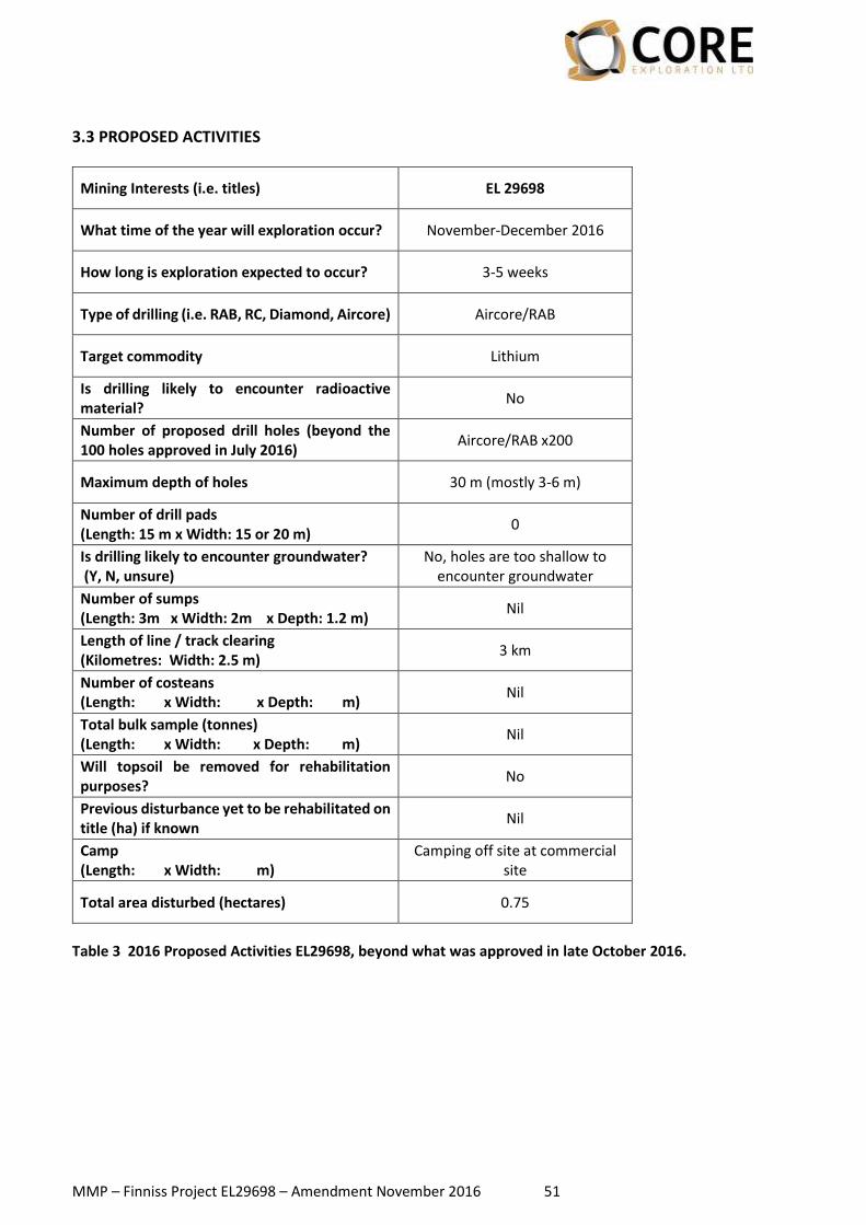
MMP – Finniss Project EL29698 – Amendment November 2016 51
3.3 PROPOSED ACTIVITIES
Mining Interests (i.e. titles) EL 29698
What time of the year will exploration occur? November-December 2016
How long is exploration expected to occur? 3-5 weeks
Type of drilling (i.e. RAB, RC, Diamond, Aircore) Aircore/RAB
Target commodity Lithium
Is drilling likely to encounter radioactive material?
No
Number of proposed drill holes (beyond the 100 holes approved in July 2016)
Aircore/RAB x200
Maximum depth of holes 30 m (mostly 3-6 m)
Number of drill pads (Length: 15 m x Width: 15 or 20 m)
0
Is drilling likely to encounter groundwater? (Y, N, unsure)
No, holes are too shallow to encounter groundwater
Number of sumps (Length: 3m x Width: 2m x Depth: 1.2 m)
Nil
Length of line / track clearing (Kilometres: Width: 2.5 m)
3 km
Number of costeans (Length: x Width: x Depth: m)
Nil
Total bulk sample (tonnes) (Length: x Width: x Depth: m)
Nil
Will topsoil be removed for rehabilitation purposes?
No
Previous disturbance yet to be rehabilitated on title (ha) if known
Nil
Camp (Length: x Width: m)
Camping off site at commercial site
Total area disturbed (hectares) 0.75
Table 3 2016 Proposed Activities EL29698, beyond what was approved in late October 2016.

MMP – Finniss Project EL29698 – Amendment November 2016 52
Figure 3 Location of work areas in relation to CXO tenure (Amended Nov 2016). Detailed maps are presented below for each new target area (Richmond and Almandin). Spatial data in digital form.

MMP – Finniss Project EL29698 – Amendment November 2016 53
SECTION 4 – CURRENT SITE CONDITIONS
Figure 4 Vegetation Communities in EL29698, including new drilling poly

CORE EXPLORATION LTD
2016
MINING MANAGEMENT PLAN
FOR RAB DRILLING (PHASE 4) AT THE
FINNISS PROJECT
(Authorisation 876-01)
EL 29698
Amendment March 2017

MMP – Finniss Project EL29698 – Amendment March 2017 55
AMENDMENTS Amendment to the Prevailing MMP are outlined below.
Section Amendment
Section 3 – Project details Table 3 is updated with the details of the new work proposed. It entails 10 water bores holes, with specifications outlined below. 1 km of new access tracks are required, adding 0.75 Ha of vegetation disturbance to the MMP register (Appendix 10B). Figure 3 is updated to show the new drilling locations. The specifications of the water bores is outlined in this section.
Section 4 - Current site conditions
New drilling locations are placed in context of vegetation communities. There is no material change to the flora and fauna risk.
Section 6.1 Costing and closure estimates
Security calculated using the proposed 10x waterbores and 1 km of new access tracks. Refer to Appendix 10A.
Appendix 3 Revised outline and detailed map showing NEW drilling locations and access tracks, and the existing work areas.
Appendix 10A Security calculation worksheet.
Appendix 10B Accumulative works, disturbance and security table.
Spatial data Proposed bore locations and access tracks.

MMP – Finniss Project EL29698 – Amendment March 2017 56
3.3 PROPOSED ACTIVITIES Core is aiming to drill a series of waterbores to commence early-stage groundwater monitoring and modelling should the Company decide to proceed towards mining. Results from exploration thus far, while not definitive, do suggest there is potential for mining should resources at Grants reach a threshold and should mining studies indicate positive economics. Core is aware that early monitoring is of great value in the process of approval, so wishes to install bores in positions that will allow robust modelling of existing groundwater flow, water chemistry, water volumes and a variety of parameters that could have an impact on the mining scenario and the surrounding environment.
Mining Interests (i.e. titles) EL 29698
What time of the year will exploration occur? March-June 2017
How long is exploration expected to occur? 2-3 weeks
Type of drilling (i.e. RAB, RC, Diamond, Aircore) Mud rotary or RC water bores
Target commodity Environmental monitoring bores
for Grants
Is drilling likely to encounter radioactive material?
No
Number of proposed drill holes (beyond the 100 holes approved in July 2016)
Bores x10
Maximum depth of holes 160 m (mostly 70 m)
Number of drill pads (Length: 15 m x Width: 15 or 20 m)
10
Is drilling likely to encounter groundwater? (Y, N, unsure)
Holes are hoping to encounter groundwater, but probably not significant based on knowledge
of area
Number of sumps (Length: 3m x Width: 2m x Depth: 1.2 m)
20
Length of line / track clearing (Kilometres: Width: 2.5 m)
Nil
Number of costeans (Length: x Width: x Depth: m)
Nil
Total bulk sample (tonnes) (Length: x Width: x Depth: m)
Nil
Will topsoil be removed for rehabilitation purposes?
No
Previous disturbance yet to be rehabilitated on title (ha) if known
Nil
Camp (Length: x Width: m)
Camping off site at commercial site
Total area disturbed (hectares) 0.75
Table 3 2017 Proposed Activities EL29698, beyond what was approved in November 2016.

MMP – Finniss Project EL29698 – Amendment March 2017 57
Figure 3 Location of work areas in relation to CXO tenure (Amended Mar 2017). A detailed map is presented below for the water bore sites. Spatial data in digital form.

MMP – Finniss Project EL29698 – Amendment March 2017 58
Waterbore location and specifications Waterbores will be drilled via Mud Rotary or RC method, depending on which is more suitable for the hole depth and for access conditions at the time. A rubber track mounted rig is more desirable in the wet season because it is able to traverse boggy ground and limits the need for a heavily-cleared access track. If mud rotary method is required, a track-mounted rig is utilized, along with two sumps per hole. For RC, only one sump is required per hole. New access has been minimized where possible, utilizing existing tracks. Some holes will need to be placed in positions where there is no current access, and cross-country travel or a cleared path will be required. Those holes placed on the edge of the current floodplain will be positioned more precisely at the time of drilling, to account for rig can access. The Security calculation assumes clearing of all these access tracks and pads, following procedures outlined in the original MMP. However, the tracks and pads will only be cleared if it is needed. A large contingency is assumed in the Security calculation. Holes have been designed according the need for data collection in relation to regional water flow, pit dewatering and interaction of surface waters with the current groundwater system. Their position and specifications were determined via consultation with the supervising hydrogeologist at GHD. At least one drillhole within the likely outline of a pit, where mining may take place, needs to be 160m deep, while those on the periphery only need to be about 60-70m deep, assuming the groundwater table is at 20-30m. Two holes are planned on the fringe of the floodplain to test the hydrologic regime associated with the near-surface aquifer and only need to be 10-20m deep. These depths may be modified according to data recorded while drilling, such as water cut, standing water table, groundwater flow, discrete aquifers etc. Holes are drilled to greater than 100m diameter to allow for Class 18 100 mm PVC to be secured in the hole. The typical hole diameter is 150 mm. PVC lines the hole, slotted/screened over target intervals, and sealed over the rest. This is then gravel packed with suitable material to develop the bore. It is also important to keep surface water out of the hole, so near surface it is sealed with bentonite and cement. The design will enable a pump to run down the hole to extract water for testing, or indeed for production in the event that water is required by the project. The hole will be tested and “conditioned” firstly by airlifting water out of the hole, ensuring that there is good connection between the bore and the aquifer(s). They will then be regularly monitored. The bores will be drilled under supervision of a suitably licenced waterbore driller, according to NT Regulations. In addition, Core has commissioned GHD to take an over-all supervisory role in the development of the bores. GHD have a qualified hydrogeologist who has been assigned to the project, who will be at site.
Core aims to register the bores with the NT Government and therefore they would be present for an on-going period. The area around Grants is poorly understood in terms of groundwater, with very few bores in the vicinity. The bores that Core plan to drill will be a valuable source of data, and potentially water for the area more generally.

MMP – Finniss Project EL29698 – Amendment March 2017 59
SECTION 4 – CURRENT SITE CONDITIONS
Figure 4 Vegetation Communities in EL29698, including currently approved drilling polygons and the outline of where water bores are proposed. All but two bores lie outside the Darwin Harbour SOC, and these two are immediately adjacent to an existing track and close to the easement of the Cox Peninsula Road. The remaining 8 bores lie within existing approved MMP drilling polygons or very close to them. There is no material change to the vegetation community impacted and the works are not an expanded risk to flora and fauna.

CORE EXPLORATION LTD
2016
MINING MANAGEMENT PLAN
FOR DRILLING (Phase 1, 2017) AT THE
FINNISS PROJECT
(Authorisation 876-01)
EL 29698
Amendment April 2017

MMP – Finniss Project EL29698 – Amendment April 2017 1
AMENDMENTS Amendment to the Prevailing MMP are outlined below. Figure, Table and Appendix numbers match the original MMP.
Section Amendment
3.3 – Proposed Activities Table 3 is updated with the details of the new work proposed. It entails additional drill holes and track access as per previously documented methodologies. The vegetation disturbance estimated for this work program has been added to the MMP Register (Appendix 10B). Figure 3 is updated to show the new drilling polygons. Detailed maps are presented in Appendix 3.
4 – Current site conditions New drilling areas are placed in context of vegetation communities. A number of the new drilling areas overlap with the Darwin Harbour SOCS. As such, an additional review of potential threatened flora and fauna was undertaken. There is no material change to the flora and fauna risk. Figure 4 is updated to reflect the changed work areas.
5.4.3 – Proposed Impact Reduction, Mitigation and Rehabilitation Methods
This section has been updated to bring management of Armstrong’s Cycad in line with what is occurring at CXO’s other project areas (Zola and Ringwood).
5.4.4 – Risk Assessment Risk Assessment – Flora disturbance. Additional management measures for Armstrong’s cycad added.
6.1 – Costing and closure estimates
Security calculated using the proposed drill holes and new access tracks.
Appendix 3 Revised detailed maps showing NEW drilling polygons and access tracks, and the existing work areas.
Appendix 10A Revised Security calculation worksheet.
Appendix 10B Accumulative works, disturbance and security table.
Spatial data Showing existing and new work areas.

MMP – Finniss Project EL29698 – Amendment April 2017 2
3.3 PROPOSED ACTIVITIES
Table 3: 2017 Proposed Activities EL29698, beyond what was approved in the last amendment in March 2017.
Mining Interests (i.e. titles) EL 29698
What time of the year will exploration occur? April-August 2017
How long is exploration expected to occur? 6-12 weeks
Type of drilling (i.e. RAB, RC, Diamond, Aircore)
Aircore/RAB, RC and DDH
Target commodity Lithium
Is drilling likely to encounter radioactive material?
No
Number of proposed drill holes Aircore/RAB: x800
RC: x40 DDH: x10
Maximum depth of holes AC/RAB: 30 m (mostly 3-6 m)
RC: 180 m DDH: 300 m
Number of drill pads (Length: 20 m x Width: 20 m)
50
Is drilling likely to encounter groundwater? (Y, N, unsure)
Potentially, the groundwater in the area is relatively limited from experience and NTG data; AC holes are too shallow to encounter
groundwater
Number of sumps (Length: 3m x Width: 2m x Depth: 1.2 m)
60
Length of line / track clearing (Kilometres: Width: 2.5 m)
45 km
Number of costeans (Length: x Width: x Depth: m)
Nil
Total bulk sample (tonnes) (Length: x Width: x Depth: m)
Nil
Will topsoil be removed for rehabilitation purposes?
No
Previous disturbance yet to be rehabilitated on title (ha) if known (Grants-FWC tracks and pads)
1.8
Camp (Length: x Width: m)
Camping off site at commercial site
Total area disturbed (hectares) 12.25

MMP – Finniss Project EL29698 – Amendment April 2017 3
Core proposes to undertake a new round of drilling at Finniss, within previous approved drill polygons and within a number of new polygons (quantified in the table above and illustrated in the maps below). To enable access to these areas, Core will utilise existing tracks where possible, but also proposes a series of new cleared access tracks and drill lines. Core also proposes to undertake drilling along any portion of the approved access tracks if they are within Core’s tenure and it is deemed not detrimental to the environment (e.g., avoiding well defined creeks and steep terrain). These various components are outlined on the Map below and illustrated in the detailed maps in Appendix 3. Some assumptions made in calculating disturbance include:
• Drill lines will be allocated to the various polygons as the program progresses, according to results and priorities. Drill lines may also be allocated to previously approved polygons.
• The existing/historic tracks (6 km total) are in various physical conditions, which may change from year to year, especially during the recent large wet season. Experience suggests that 20% of the total length of these tracks will need refurbishment in terms of vegetation clearing or pruning.
• New tracks (12 km total) that will receive regular travel to and from work areas will need to be cleared such that vehicle access is facilitated and safety is not compromised.
• New drill lines (27 km total) will only be cleared if vegetation is too thick to enable passage of the aircore drill rig, likely to be a small rubber track mounted rig. In most cases a “beaten path” or “blade up” approach is taken, as detailed in the MMP. However, for the Security calculation it is assumed that the lines will be cleared in full. Hence there is sufficient contingency in the calculations.
• Drill pad size for RC and DDH holes is increased to 20x20m, as recent experience has shown the pads were too small and compromised safety during rig set-up and operation.

MMP – Finniss Project EL29698 – Amendment April 2017 4
Figure 3 Location of work areas in relation to CXO tenure (Amended April 2017). Detailed maps are presented below for each new work area. Spatial data in digital form.

MMP – Finniss Project EL29698 – Amendment April 2017 5
4 CURRENT SITE CONDITIONS Given that the original MMP assessments for geology, hydrology, land use, weeds, feral animals and historical Aboriginal heritage sites covered the entirety of EL29698, information on these site conditions remain the same as the previously submitted MMP amendment. Unlike the original MMP and subsequent amendments, some of the drilling locations proposed in this MMP Amendment are located within the northern portion of EL29698, which partially overlaps with a small portion of the Darwin Harbour Site of Conservation Significance (SOCS). This SOCS is dominated by coastal and mangrove environments backed by savannah woodlands and patches of monsoon rainforest. Additional information relating to the flora, fauna and vegetation cover on the new drilling polygons has therefore been provided below: Vegetation As per the original 2016 MMP, vegetation community data across EL29698 was obtained from the following datasets:
• NVIS Version 3.1 National Vegetation Information System (NVIS), NT Data Compilation (Scale 1:1,000,000) (Source: Department of Land Resource Management)
• Landcover Vegetation Mapping for the Greater Darwin Region (Landcover Vegetation Mapping) (Scale 1:100,000) (Source: Department of Land Resource Management).
As shown in Figure 4, most mapped vegetation in EL29698, according to the NVIS dataset, consists of:
• Eucalyptus mid open forest\Livistona low sparse palmland\Heteropogon tall tussock grassland
• Eucalyptus mid woodland\Gardenia tall open shrubland\Heteropogon mid tussock grassland These communities are also mapped widely within the surrounding region. There are 21 new drilling polygons proposed as part of this MMP amendment. Of these, nine are located within the southern portion of EL29698, with the remaining 12 drilling polygons in the northern portion of EL29698. Six of the 21 new drilling polygons lie within the Darwin Harbour SOCS. The table below provides details of the vegetation cover for each of the new drilling polygons. Descriptions of the various vegetation landcovers present for the proposed drilling polygons (eucalyptus woodland, eucalyptus open woodland, and drainage open woodland) have been provided in the original 2016 MMP.

MMP – Finniss Project EL29698 – Amendment April 2017 6
Vegetation cover of proposed drilling polygons Drilling Polygon
NVIS Level 4 Description Vegetation Landcover Name (Greater
Darwin Community) SOCS
Ah Hoy East
Eucalyptus mid woodland\ Gardenia tall open
shrubland\ Heteropogon mid tussock grassland
Eucalyptus woodland and drainage open woodland with a small portion of
eucalyptus open woodland N/A
Ah Bung Eucalyptus woodland
Eucalyptus open woodland Drainage open woodland
N/A
Bells Eucalyptus woodland N/A
Caeseum Majority eucalyptus woodland with a
small portion of eucalyptus open woodland
N/A
Bourbon Majority eucalyptus open woodland with a small portion of eucalyptus
woodland and drainage open woodland N/A
Fortescue Eucalyptus open woodland Drainage open woodland
N/A
Two Sisters
Eucalyptus mid open forest\ Livistona low sparse
palmland\ Heteropogon tall tussock grassland
Eucalyptus woodland Eucalyptus open woodland Drainage open woodland
N/A
BP31 Majority drainage open woodland with a small portion of eucalyptus woodland
N/A
BP53 Eucalyptus woodland
Eucalyptus open woodland Drainage open woodland
N/A
Central South Eucalyptus woodland
Eucalyptus open woodland Drainage open woodland
N/A
FWS Eucalyptus woodland
Eucalyptus open woodland Drainage open woodland
N/A
Grants South Eucalyptus woodland
Eucalyptus open woodland N/A
Lonesome Eucalyptus woodland
Eucalyptus open woodland N/A
Slipper Eucalyptus woodland
Eucalyptus open woodland Drainage open woodland
N/A
Rabbit Eucalyptus woodland
Drainage open woodland
Majority within the Darwin
Harbour SOCS
Dead Pig Eucalyptus woodland
Eucalyptus open woodland Drainage open woodland
Darwin Harbour SOCS
BP7 Eucalyptus woodland
Eucalyptus open woodland Drainage open woodland
BP2 Eucalyptus woodland
Eucalyptus open woodland Drainage open woodland
Arltunga Eucalyptus woodland
Vicki’s Eucalyptus woodland
Mammoth Eucalyptus woodland
Eucalyptus open woodland

MMP – Finniss Project EL29698 – Amendment April 2017 7
Figure 4 Vegetation Communities in EL29698, including new drilling polygons (April 2017)

MMP – Finniss Project EL29698 – Amendment April 2017 8
Flora The following threatened flora species have been known to occur within the Darwin Harbour SOCS (National/NT Listing):
• Armstong’s Cycad Cycas armstrongii (-/VU)
• Utricularia singeriana (-/VU) It should be noted that there are only historic records of Utricularia singeriana from this site, and suitable habitat may no longer be present. Armstrong’s Cycad was the only species of threatened flora to be identified within both the SOCS and NR Maps/NT NRM Infonet searches. This species was also recognised in the search carried out for the original MMP and a management plan was devised. However, CXO wishes to update this management plan to be consistent with the nearby MMP Authorisations for Zola (0907-01) and Litchfield (0901-01). Additional specific environmental management for the species has been provided in Section 5.4.3 of this MMP Amendment in the event that the species is encountered during the proposed drilling events. Fauna The following threatened fauna species have been known to occur within the Darwin Harbour SOCS (National/NT Listing):
• Australian Bustard Ardeotis australis (-/VU)
• Christmas Frigatebird Fregata andrewsi (VU/-)
• Gouldian Finch Erythrura gouldiae (EN/EN)
• Masked Owl Tyto novaehollandiae kimberli (VU/VU)
• Partridge Pigeon Geophaps smithii (VU/VU)
• Red Goshawk Erythrotriorchis radiatus (VU/VU)
• Northern Quoll Dasyurus hallucatus (EN/CR)
• Merten's Water Monitor Varanus mertensi (-/VU)
• Yellow-spotted Monitor Varanus panoptes (-/VU)
• Flatback Turtle Natator depressus (VU/DD)
• Green Turtle Chelonia mydas (VU/LC)
• Hawksbill Turtle Eretmochelys imbricata (VU/-) It should be noted that there are only historic records of the Atlas Moth from this site, and suitable habitat may no longer be present. The Northern Quoll was the only species of threatened fauna to be identified within both the SOCS and NR Maps/NT NRM Infonet searches. CXO staff inductions include identification and avoidance measures for threatened and endangered flora and fauna in the area. The threatened species identification information pack used in these inductions was previously provided as Appendix 11 of the original 2016 MMP. In addition, suitably skilled CXO personnel will walk new access tracks and drill pads prior to construction to avoid specific threatened fauna occurrences. 5.4.3 Proposed Impact Reduction, Mitigation and Rehabilitation Methods CXO proposes to undertake exploration drilling within EL29698. Activities will include clearing vegetation for drill pads and some new access tracks (locations shown in Figure 3). These activities have the potential to impact on threatened species occurring or potentially occurring on the site

MMP – Finniss Project EL29698 – Amendment April 2017 9
through removal of habitat, habitat fragmentation, erosion and sedimentation, introduction of weeds and pests, and death or injury of wildlife through contact with machinery and vehicles. In order to bring management of threatened species in line with CXO’s other project areas (Zola and Ringwood), the following section has been added (in addition to the information previously provided in Section 5.4.3 of the original 2016 MMP) for management of Armstrong’s Cycad, if it is identified on site during the exploration process. Armstrong’s Cycad (Note - Information in this section supersedes that which was previously submitted, as CXO aims for management of Armstrong’s Cycad to be consistent across its Top End project areas) Armstrong’s Cycad occurs around the Darwin area south to near Hayes Creek, and to the north-western corner of Kakadu National Park in the east, as well as on the Tiwi Islands, Cobourg Peninsula, and Cox Peninsula. It occurs mainly in open grassy woodland on yellow and red earths. Armstrong’s Cycad, like all cycads, is a long-lived, slow-growing, woody plant, with male and female individuals. Reproductive age is unknown, but can be 15 years under cultivation. Seeding may be annual or sporadic. Pollination appears to be mainly through insects, in particular beetles in the family Boganiidae. Seeds are dispersed through gravity, water and animals. Cycads live in symbiosis with cyanobacteria which provide the plant with nitrogen. The species is relatively resilient to low intensity fires, and can regenerate from crown damage, apical growing shoot damage, and even from destruction of the entire above ground stem, through regrowth from the stem base or root stock. However, populations decline when subjected to high intensity fires (Liddle, 2004). A species profile for Armstrong’s Cycad is provided in Appendix 11. The species is threatened by:
• Conversion of its habitat for residential and rural pursuits
• Through changes in prevailing fire regimes, facilitated by the influx of weeds into the species’ habitat, resulting in enhanced fuel loads and higher intensity fires.
The performance criterion and indicator for this issue includes the following:
• Number of Armstrong’s Cycad individuals to be impacted and where relevant, the number successfully translocated.
• Number of seed collected, number of seed successfully grown into plants, number of seedlings successfully planted.
• Majority (>80 %) of translocated Armstrong’s Cycad individuals survive two years after translocation.
Recognition Armstrong’s Cycad grows to a height of 6 m, with a slender trunk 6-12 cm in diameter. Branching occurs, with occasional offsets and basal suckers. The crown is obliquely erect to spreading, with 84-156 leaflets. Leaflet have a prominent midrib on the upper surface, and are attached to the rachis at an angle of about 56-70 degrees. Additional description is available in Hill (1996), Hill and Osborne (2001), Jones (2002) and Dixon (2004). Management Measures The following management measures have been formulated specifically for Armstrong’s Cycad. Procedures for propagation and translocation are summarised from Origin Energy (2014).

MMP – Finniss Project EL29698 – Amendment April 2017 10
Pre-Clearing Survey The following measures should be employed prior to disturbance activities commencing:
• Proposed new tracks and drill sites should be surveyed by personnel suitably skilled in the recognition of Armstrong’s Cycad. Should any individuals of Armstrong’s Cycad be encountered within these areas, plants should be avoided as much as practically possible. Where it is anticipated that a substantial number of individuals (>10) cannot be avoided, the plants should be clearly marked for appropriate removal during clearing operations with the aim of translocation.
• The northern side of the plant should be marked with marker paint or fluorescent dye to facilitate re-planting with the same orientation.
• Seed encountered on the forest floor surrounding the plants should be collected for propagation and rehabilitation purposes either elsewhere on the site or at the collection location once exploration operations have ceased.
Operational Phase The following measures should be employed during drilling operations, where a substantial number of plants (>10) cannot be avoided:
• During clearing operations, Armstrong’s Cycad individuals marked during pre-clearing surveys must be removed for relocation in rehabilitation areas elsewhere on the site or for temporary storage for rehabilitation at a later date.
• Prior to removal, the area around plants must be cleaned by hand or with machinery (e.g. front end loader) and foliage removed to where the rhachis is attached to the stem. Using a spade, excavator or backhoe, soils surrounding the root ball is loosened prior to excavation ensuring that as much of the rootball around the plant roots remains intact. Damaged roots are to be trimmed and treated with Banrot® and/or Formula20®. To initiate root growth, Vitamin B or Seaweed can be sprayed on the roots. Roots are bagged in breathing material, such as hessian, and moistened with water prior to transport to a temporary holding location or to a prepared rehabilitation location elsewhere on the site. Care should be taken not to bruise plant stems during transport, using soft materials such as hessian to stabilise the plant.
• Upon arrival, plants are to be immediately potted or put into woven fibre planter bags for temporary holding or, if used for rehabilitation elsewhere on the site, in a prepared hole of a size suitable for the inserted root ball. Plants should be positioned in their original orientation. Washed sand or sandy loam should be used to for packing around the roots, to provide a suitable medium for root growth. The crown of each cycad must be sprayed with an insecticide (either Confidor® at a rate of application of 10 millilitres (mL) per 9 litres (L) of water or application of Crown® at a rate of application of 5 mL per 9 L of water). Translocated plants must also be watered with 5-9 L of water around each root ball with a systemic fungicide (Banrot® at the recommended rate). Rocks can be placed around the base of plants to assist in the stability of plants and to provide protection from fires and hot weather.
• Seed collected from the cleared areas must be propagated in pots using standard horticultural methods or direct seeded in areas to be rehabilitated.
• Translocation and propagation operations must be supervised by a suitably trained horticulturalist or arborist.
Post-Operation The following measures should be employed following mining operations:
• Translocation of individuals held in the temporary storage area back to the original area of extraction must follow similar procedures as outlined above. Each plant must be watered about once a month (10-20 L) depending on rainfall for six months after replanting or as appropriate and any new expanding leaves must be sprayed with insecticide.

MMP – Finniss Project EL29698 – Amendment April 2017 11
• Plants must be monitored for new growth, death, insect attack, reproduction, gender etc. for a period of at least two years after planting in the ground.
Monitoring and Reporting Monitoring will be the responsibility of CXO’s Exploration Manager to ensure the health of translocated individuals in accordance with the performance indicators outlined above. This person will be responsible for reporting the number of individuals found on areas to be cleared (if any) to the DME upon completion of the pre-clearing search. Further reports will be submitted on completion of the initial translocation and once again on completion of replanting of the translocated stock on completion of mining and revegetation operations.

MMP – Finniss Project EL29698 – Amendment April 2017 12
5.4.4 Risk Assessment (Note – additional management measures from that which was submitted in the original 2016 MMP, have been added in highlighted text)
Table 7 Results of the Environmental Risk Assessment
Aspect Impact Inherent
Risk Rating
Management measures (prevention) Management Measures (Remediation) Residual
Risk Rating
Flora disturbance
Disturbance of vulnerable or endangered flora
L
One threatened species possibly occurs within the proposed drill sites – Armstrong’s Cycad (Table 5) (refer Section 4). All Employees will be inducted to be able to recognise this species. Disturbance of vegetation will be minimised by careful management of all earthworks. Individuals of Armstrong’s Cycad will be avoided, or where disturbance is unavoidable, translocated in accordance with the process described in Section 5.4.3. Suitably skilled personnel will walk new access tracks and drill pads prior to construction to identify any species of conservation significance.
Recognition of NTG INFONET species or damaged flora of significance will be reported to NT Department of Land Resource Management (DLRM) by calling (08) 8995 5000. Individuals of Armstrong’s Cycad will be avoided, or where disturbance is unavoidable, translocated in accordance with the process described in Section 5.4.3. Whilst several individuals of Armstrong’s Cycad may exist in the areas proposed for drilling activities (including new tracks), the avoidance and/or translocation measures detailed in Section 5.4.3 are likely to reduce the residual level of potential impact sufficiently. For example, all individuals of the species will be avoided as much as possible and even where there may be impacts to a small number of individuals (<10), given that the species is locally abundant (Clugston & Nagalingum, 2016; Kerrigan et al, 2006), it is expected that such impacts are unlikely to be significant. Where there is a higher number of individuals (>10) that may be unavoidably impacted, they should be translocated as per the guidelines in Section 5.4.3. The implementation of the above measures (as detailed in Section 5.4.3) is likely to ensure:
• Minimal impact on local population numbers
• Area affected negligible compared to total population
• Minimal or acceptable impact on population size.
L