2016 coc bulletin 2 v3 - barebonesbarebones.ca/2016 coc/2016 coc bulletin 2 v3.pdfbulletin 2 the...
TRANSCRIPT

July 26, 2016
BULLETIN2The Alberta Orienteering Association, Edmonton Overlanders and Foothills Wanderers orienteering clubs, together with Orienteering Canada welcome you to the 2016 Icefields Parkway Orienteering Festival, including the 2016 Canadian Orienteering Championships and the 2016 Western Canadian orienteering championships. Events will be held in the outstanding natural beauty of the Canadian Rockies, from one end of the world famous Icefields Parkway to the other on challenging, fun, high quality new and updated maps of some very special terrain. The Icefields Parkway is considered by many to be the most spectacular drive on the planet. It passes through the UNESCO World Heritage site Canadian Rockies Parks, with their rugged mountain peaks, icefields and glaciers, alpine meadows, lakes, waterfalls, extensive karst cave systems and deeply incised canyons. The festival begins near Jasper then travels south along the Icefields Parkway, past the Columbia Icefield in Jasper National Park, to the rocky peaks and lush valley of Banff National Park and the historic mountain towns of Canmore and Banff. This journey shows off Canada's unparalleled natural beauty and offers up lots of extra-curricular activities - including hiking, hot springs, biking, and top-tier golf.

July 26, 2016
Sponsors&SupportersThe Icefields Parkway Orienteering Festival organizers wish to recognize the invaluable support and sponsorship from the following organizations:
Orienteering Canada and its many volunteers
The Alberta Government, Alberta Parks, and the Alberta Sport Connection
The Town of Canmore
Cochrane Search & Rescue
The O-Store
And our various corporate sponsors and supporters: Out There Adventure Centre, Trail Sports, Bear Cozy, Gem Trek maps

July 26, 2016
Region
OrganizationandInformationWCOC Event Director: Mary Lou Hogg COC Event Director: Eduard Spelier Event website: www.coc2016.ca Event email: [email protected] IOF WRE Event Advisor: John Rance (GVOC, Canada)
RegistrationCentreParticipants will be required to sign a waiver in the presence of the registrar when they pick up their event package. Participants must pick up their event package before you go to your first race (you need to sign your waiver in the presence of the registrar, and collect your bib). Package pickup is available at the following locations / times:
• Friday July 22: 10am - 8pm - Royal Canadian Legion Hall, 250 Pembina Avenue, Hinton. Turn south off the Yellowhead (Hwy 16) - between the Shell gas station and the Visitor Information Centre - onto Jasper Street. Drive for one block, then turn right onto Pembina Avenue. The Legion Hall will be on your right. If you want to buy orienteering equipment, the O-Store will be on-site from approximately 10:00am at the Legion Hall.
• Friday July 29: 10am - 5pm - Canmore Nordic Centre Day Lodge If you want to buy orienteering equipment, the O-Store will be on-site from approximately 10:00am.
• On race days - at the Registration tent in the competition area
July 26, 2016
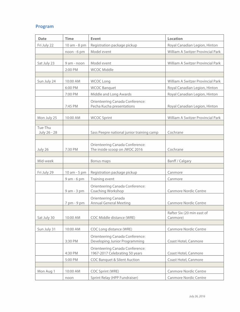
Program
Date Time Event Location
Fri July 22 10 am - 8 pm Registration package pickup Royal Canadian Legion, Hinton
noon - 6 pm Model event William A Switzer Provincial Park
Sat July 23 9 am - noon Model event William A Switzer Provincial Park
2:00 PM WCOC Middle
Sun July 24 10:00 AM WCOC Long William A Switzer Provincial Park
6:00 PM WCOC Banquet Royal Canadian Legion, Hinton
7:00 PM Middle and Long Awards Royal Canadian Legion, Hinton
7:45 PM Orienteering Canada Conference: Pecha Kucha presentations Royal Canadian Legion, Hinton
Mon July 25 10:00 AM WCOC Sprint William A Switzer Provincial Park Tue-Thu July 26 - 28 Sass Peepre national junior training camp Cochrane
July 26 7:30 PM Orienteering Canada Conference: The inside scoop on JWOC 2016 Cochrane
Mid-week Bonus maps Banff / Calgary
Fri July 29 10 am - 5 pm Registration package pickup Canmore
9 am - 6 pm Training event Canmore
9 am - 3 pm Orienteering Canada Conference: Coaching Workshop Canmore Nordic Centre
7 pm - 9 pm Orienteering Canada Annual General Meeting Canmore Nordic Centre
Sat July 30 10:00 AM COC Middle distance (WRE)
Rafter Six (20 min east of Canmore)
Sun July 31 10:00 AM COC Long distance (WRE) Canmore Nordic Centre
3:30 PM Orienteering Canada Conference: Developing Junior Programming Coast Hotel, Canmore
4:30 PM Orienteering Canada Conference: 1967-2017 Celebrating 50 years Coast Hotel, Canmore
5:00 PM COC Banquet & Silent Auction Coast Hotel, Canmore
Mon Aug 1 10:00 AM COC Sprint (WRE) Canmore Nordic Centre
noon Sprint Relay (HPP Fundraiser) Canmore Nordic Centre

July 26, 2016
WelcomefromOrienteeringCanadaIt is with great pleasure that I welcome everyone, on behalf of Orienteering Canada, to the Icefields Parkway Orienteering Festival and both the 2016 Canadian and the 2016 Western Canadian Orienteering Championships. One of the things I like most about the Canadian Championships and its accompanying events each year is that the week always serves as a reunion for orienteers from across our vast country. That, and the fact that we all get a chance to orienteer on maps and in forests that are new to us. Great orienteering and great friends! In my role as President of Orienteering Canada, I get a glimpse of some of the things that go on behind the scenes in preparing for an event of this magnitude. I know that our orienteering friends in Alberta have put in a huge effort to overcome many hurdles along the way. And I imagine I know of only a small percentage of the challenges. I want to thank the volunteers from the Edmonton Overlanders Orienteering Club, the Foothills Wanderers Orienteering Club, and the Alberta Orienteering Association for everything that they have done, all the hard work, all the headaches and worries they have endured in bringing this Festival to us. Your effort and time is so gratefully appreciated! I look forward, very much, as I am sure we all are, to the many races and to the social times, to catching up with old friends and meeting new ones between July 23 and August 1, 2016. Happy orienteering everyone, have a wonderful week in Alberta!
Anne Teutsch President, Orienteering Canada | Course d'orientation Canada
SocialMediaPlease engage with us on social media. Use the hashtag #coc2016
www.facebook.com/canadianorienteeringchampionships
twitter.com/CanadianOChamps

July 26, 2016
EmbargoedAreas,PreviousMapsPrevious maps exist for all of the competition areas. Copies of the previous maps are available on the event website: coc2016.ca WilliamSwitzerProvincialPark(WCOCraces)The entire Cache Lake map in William A Switzer provincial Park is embargoed for all use. NB the embargoed area includes Cache Lake campground, Graveyard Lake campground, and Beaver Ranch campground. (Participants may, however, register at Jarvis Lake campground, which is west of the highway, and Gregg Lake campground which is north of the map area.) CanmoreNordicCentre(COCLongDistance&Sprint)The Nordic Centre is a very busy place and is Canmore's major centre for nordic skiing, mountain biking, and various running races. It will not be realistic to completely restrict access to the orienteering area, however the following embargoes are be in effect:
• Until July 1st, 2016: it is not allowed to be in the Canmore Nordic Centre with an
orienteering map.
• From July 1st, 2016: A complete embargo is in effect, and no access to the area will be
allowed with the following exceptions: It will be allowed to access: the
Daylodge; TrailSports; the Bill Warren Centre; and the biathlon shooting range.
• In accordance with IOF rule 26.6 the organizers will bar from the competition any
competitor who is so well acquainted with the terrain or the map, that the competitor
would have a substantial advantage over other competitors.
Rafter6/Ti-Jurabi-Chubi(COCMiddleDistance)This is another popular recreational area and so the following embargoes are in effect:
• Until July 1st, 2016: it is allowed to travel on trails through the embargo area, but it is never
allowed to have an orienteering map in the area.
• From July 1st, 2016: A complete embargo is in effect, and no access to the embargo area
will be allowed.
Training
WCOCModelEvent,July22-24Kelley's Bathtub, William A Switzer Provincial Park Full details are further on in this bulletin.
COCTraining,July29Quarry Lake, Canmore Full details are further on in this bulletin.
BonusMapPackageThe organizers have created a package of maps to help you enjoy your time in the Bow Valley area. These maps will help you make the most of your time between the WCOC and COC events by taking you to a variety of places - for a run, a hike, or for some fun training. Map 1 - Banff Tourist-O. Trivia O, taking in the highlights of the historic town of Banff

July 26, 2016
Map 2 - Banff Centre campus. Sprint map, with no flags - set your own course, or just wander through the lovely campus. Map 3 - Bow Valley Provincial Park. No flags. Use the map for hiking or trail running in this fabulous park with glorious views. Map 4 - Canmore "Mines & Meadows" scenic course. Control locations marked on the map, ribbons hung in the forest. Map 5 - Sass Peepre map 1. Control locations marked on the map, ribbons hung in the forest. Map 6 - Calgary Fish Creek. Control locations marked on the map, ribbons hung in the forest.
COCWarm-upmapsAt the COC Middle, Long, an Sprint races there will be a small warm-up map available in the area close to the start. This will give you a chance to experience the mapping style, terrain, and vegetation. ClimateThe competition takes place during the summer with temperatures expected in the range of 20 – 25 degree Celsius. The competitions all take place at between 1,000m and 1,400m above sea level. StartlistsStarts lists are available on coc2016.ca Entries&CompetitionClassesAs of July 16, there are 349 entries.
• Championship classes: standard Orienteering Canada age groups are used: M/W 12, M/W13‐14, M/W15‐16, M/W 17‐20, M/W21‐34E, M/W35‐44, M/W45‐54, M/W55-64, M/W65‐74, M/W75‐79, M/W80‐84, M/W85+
• Open classes: Beginner, Intermediate, Advanced, Expert, and Sport. On the day entry is available in the Open Beginner & Sport classes. In addition a very few entries may be available at premium cost in other classes. PrizeGiving,MedalsandMementoesPrize giving for the WCOC Middle and WCOC Long will take place after the Sunday evening banquet. Prize giving for all other events will take place at the end of each race. Medals will be given to the top three eligible orienteers in each championship age class. The top finisher in each championship age class, regardless of eligibility, will be given a small memento prize. Eligibility requirements to win the Canadian Orienteering Championships shall be only those who are full members of the provincial/territorial associations and who are: a) Canadian citizens or b) Permanent residents as defined by Citizenship and Immigration Canada Eligibility requirements to win the Western Canadian Orienteering Championships shall be only those who are full members of the provincial/territorial associations and who are: a) Canadian citizens or b) Permanent residents as defined by Citizenship and Immigration Canada, and normally resident in Western Canada (MB, SK, AB, BC, YT, NWT). All medal winners must be prepared to submit proof of eligibility.

July 26, 2016
WhistlesWhistles are compulsory - any kind will do. Or purchase one from the registrar for a small donation to Orienteering Canada's High Performance Program. PunchingSystem The SPORTident (SI) electronic punching system will be used for all races. SI cards can be rented when registering. During the race, in case of SI unit failure (no flash or no beep) it's the runner's responsibility to punch the map with the backup pin-punch, which will be either hanging from the flag or attached to the control stand. StartProcedure Be sure to allow enough time to arrive at the start area at least five minutes before your actual start time. Everyone will require the following at the start line:
• Bib - you must have your correct bib! • SI punch - you must have your correct SI finger stick • Whistle - more mandatory gear • COC races - bear spray ... adults (18 and over) must carry bear spray; it is optional for those
under 18. See the bear spray info page for more details. • WRE classes - GPS devices are not allowed
Championship Classes – assigned start times. There will be the usual three-line call up:
• Three minutes prior to your start: Go to the call-up line, and be checked-in. Punch a “Check” control and move into the first “box”
• Two minutes prior to your start: Go into the next “box", and pick up loose control descriptions
• One minute prior to your start: Go into the final “box” and wait beside your map. Write your name on the reverse of the map.
• Start time: begin your race by picking up your map and following the marked route to the start triangle. There is no punch at the start triangle. The distance to the start triangle may be marked on your map, as shown in the example below.
If you are late for your assigned start time through some fault of the organizers then you will be assigned a new start time. If you are late due to your own fault you will be started as soon as practical by the Start Team, but will not use a punching start so that you will be timed from your assigned start time. Open Classes – no assigned start times.
• Check-in with the Start Crew when you are ready to start. • The start crew will let you into the “Open Box”, where you can pick up loose control
descriptions. • The wait beside your map. Write your name on the reverse of the map. • The start crew will tell you to start at an appropriate time. Begin your race by punching the
“Start” control and then following the marked route to the start triangle. There is no punch

July 26, 2016
at the start triangle. The distance to the start triangle may be marked on your map, as shown in the example below.
Example of how the distance to the start may be indicated. In this example, there will be a 65m marked route from the start of timing (map pickup) to the start triangle. This route will be marked on the map and in the terrain. Note that not all races will use this technique. In races that don't use the technique, the distance to the start triangle will be noted at the map pickup.
ClothingRestrictionsThere are no clothing restrictions for orienteering in Canada. However, leg protection is recommended for all races. TransportNo official transport will be offered. Competitors are advised to hire a car. Roads are good and all events are accessible by paved roads. AccommodationAccommodation info is available on www.coc2016.ca
Shadowing
• Shadowing is allowed on the Open "Beginner" and Open "Sport" classes and in the championship classes M/W12 and M/W13-14. In the championship classes however, all participants who run on their own will be placed ahead those who were shadowed.
• Here is an example to help explain how this applies to M/W12 and M/W13-14: If a shadowed kid has the second fastest time of three kids, the results will show the shadowed kid in 3rd place behind the two who were not shadowed – all three will earn a medal, if eligible, in this example.
• For people who will do the shadowing, if you are entered in a championship class you must run your race first and then do the shadowing. In addition, regarding shadowing in the COC Long distance race: since the COC Sprint is in the same competition area on the following day, if you are competitive in your Sprint championship class then in the spirit of fair play we encourage you to find someone else to shadow your kids in the Long. The organizers reserve the right to declare shadowers in the Long race ineligible for medals & prizes in the Sprint.
RulesThe competition takes place under the rules of Orienteering Canada and the International Orienteering Federation.
• International Orienteering Federation rules apply to the WRE classes • Orienteering Canada rules apply to all other classes.
GPSdevicesA reminder for those competing in the WRE classes that IOF Competition Rules forbid the use of GPS devices unless there is "no display or audible feedback". If you are wearing one of these devices at the start it can be removed and left with the start crew. You will obviously be disqualified if you are found on the course with a forbidden device. Note - there is no such ban for non-WRE classes.

July 26, 2016
MapStandardsThe IOF’s mapping standards will apply
• ISOM • ISSOM (sprint standard)
ControldescriptionsIOF symbolic control descriptions are printed on all maps, with the following exceptions:
• M/W12 - in addition, English-language control descriptions are printed on the map
• Sport - only English-language descriptions are printed.
Loose control descriptions are available in the pre-start area.
Complaints/ProtestProcedure A competitor may make a complaint about infringements of the applicable rules. Any competitor wishing to make a complaint should go to the trouble desk where a printed version of the Orienteering Canada and IOF rules will be available. He/she will be able to discuss their issue with an event official. If the issue is not resolved by discussion, the competitor will be given a complaint form, which must be completed and submitted to the Event Director as soon as possible and no later than 15 minutes after final results are posted. Complaints received after this time limit will only be considered if there are valid exceptional circumstances (which must be explained in the complaint). The Event Director will take the complaint to the Event Committee, which usually consists of the Event Director, the Course Planner and the Controller, but any experienced orienteer can be included, to reach a decision, which is given to the complainant. A protest can be made against the event committee’s decision about a complaint. The protest shall be made on a protest form within 15 minutes of receiving the decision about the complaint. The protest will be taken to the Jury for resolution. The Controller or IOF Event Advisor will chair the Jury, but may not vote. The Event Director can attend the Jury’s deliberations, but may not vote. There is a no cost for making a complaint. There is no cost for making a protest on a WRE class. A protest on any other class must be accompanied by a fee of $30 which shall be returned if the protest is upheld.
JuryIf a jury is required it will be made up of three individuals from the jury pool consisting of the following, plus other qualified officials if required: WCOC: Dave Graupner (Manitoba), Jennifer Hamilton (Manitoba), Ted Finch (GBR) COC: Anne Teutsch (Ontario), Dave Graupner (Manitoba), David Ross (New Brunswick), Erik Blake (Yukon), Meghan Rance (BC/Ontario), Stefan Bergstrom (Ontario), Ted Finch (GBR)

July 26, 2016
DopingcontrolforCanadianHPPathletesDoping control may be in effect. Canadian athletes in the HPP are subject to doping control under the Canadian Anti-Doping Program (CADP). Coaches and other athlete support personnel are also subject to the rules of the CADP. Athletes are strongly encouraged to:
• Visit www.cces.ca/athletezone for helpful information and resources;
• Know their rights and responsibilities as athletes with regards to anti-doping;
• Understand the sample collection procedures;
• Check all medications and products before taking them to ensure they do not contain
banned substances;
• Avoid taking supplements (but if they choose to, learn how to minimize their risk);
• Verify medical exemption requirements; and
• Contact the CCES directly should they have any questions or would like additional
information (call 1-800-672-7775 or email [email protected]).
Athletes who test positive risk being sanctioned in accordance to the rules of the CADP. Athletes are responsible for reviewing this information prior to competition. Athlete support personnel are also encouraged to become familiar with anti-doping rules and regulations.

July 26, 2016
SocialEvents
WCOCBanquetThe WCOC banquet will take place in Hinton on Sunday July 24 Doors open 5pm, cash bar from 5pm, meal served at 6pm. Awards for Middle and Long at approximately 7pm PechaKucha* presentations sessions starting around 7:45 pm It will be at the Royal Canadian Legion Hall 250 Pembina Avenue, Hinton. Turn south off the Yellowhead (Hwy 16) - between the Shell gas station and the Visitor Information Centre - onto Jasper Street. Drive for one block, then turn right onto Pembina Avenue. The Legion Hall will be on your right. Parking is after the building. *PechaKucha - orienteering style Have you heard of PechaKucha? It's a presentation methodology in which 20 slides are shown for 20 seconds each for a max of 6 minutes, 40 seconds/presenter. There will be different presenters on a wide range of orienteering related topics. Each presentation will be short and sweet. We have done this a few times and it is lots of fun! Are you interested in doing a presentation? If so, contact Anne Teutsch (president AT orienteering DOT ca).
COCBanquetAndSilentAuctionThe COC Banquet and Silent Auction will take place Sunday July 31st in Canmore at the Coast Hotel (511 Bow Valley Trail). Doors open at 5 pm with dinner at 6 pm. Tickets are available for sale at the registration table up until end of day on Sunday July 24. During the Banquet will be the always fun silent auction that raises funds for Orienteering Canada's High Performance Program (HPP) which helps to develop Canada's elite orienteers. Please consider donating something to the silent auction, a handmade goodie from your kitchen, a gift certificate from a local running shop, an event entry from one of your club's upcoming events, a personal guided tour of an interesting place (maybe even of your workplace?)... For any questions related to the auction, please email hpp AT orienteering DOT ca. You can come to the Coast Hotel early and participate in a couple conference sessions as well. We'll be talking about junior programming at 3:30 and Orienteering Canada's 50th anniversary at 4:30. More details here. Here's the menu for the Banquet:
• Barbeque Roasted Chicken • Roast Potatoes • Seasonal Vegetables • Braised Lentil Ragout (Vegan) • Classic Caesar Salad (ingredients will be separate for those with sensitivities/allergies) • Tomato & Cucumber Salad (dressing on the side) • Chef’s choice dessert and fruit • Coffee & Tea • Cash bar
July 26, 2016
OrienteeringCanadaConferenceThe Orienteering Canada conference is held in conjunction with the Canadian Orienteering Championships. It’s an ideal opportunity for Canadian orienteers to share information and ideas and to learn from interesting, topical speakers. It’s also a great time to learn about and get involved with the priority projects of Orienteering Canada and to contribute your ideas and energy. PechaKucha-orienteeringstyleHave you heard of PechaKucha? It's a presentation methodology in which 20 slides are shown for 20 seconds each for a max of 6 minutes, 40 seconds/presenter. There will be different presenters on a wide range of orienteering related topics. Each presentation will be short and sweet. We have done this a few times and it is lots of fun! Are you interested in doing a presentation? If so, contact Anne Teutsch (president AT orienteering DOT ca). Where: Royal Canadian Legion Hall - 250 Pembina Avenue - Hinton When: Sunday July 24 around 7:45 pm (immediately following the WCOC awards at the WCOC banquet) TheinsidescooponJWOC2016Athletes who competed at the Junior World Orienteering Championships in Switzerland just a few week earlier will describe their experiences competing for Canada. They will also be talking about the process to make the JWOC team. This presentation is part of the Sass Peepre Jr Training Camp, and is open to all. Where: Camp Jubilee = Girl Guide facility on South edge of Cochrane. Directions: Camp Jubilee is a 30 minute drive from the west edge of Calgary. From the TransCanada Highway, take Highway 22 north towards the south edge of Cochrane. The Camp property has Highway 22 along its west boundary and the Bow River along its north boundary. Look for an orienteering sign on Highway 22 directing you onto the dirt road leading into camp. When: Tuesday July 26 at 7:30-8:30pm CoachingWorkshop:We will be offering the Coaching Association of Canada’s Multi-Sport Teaching and Learning module (6.5 hours). Get in touch with Bill Anderson at: bill at wgacarto dot ca if you are interested in this workshop. Where: Day lodge (Banquet Room, 2nd floor), Canmore Nordic Centre, Canmore AB When: Friday July 29, 9 am - 3 pm TheOrienteeringCanadaAnnualGeneralMeetingThe AGM is the one time of year when representatives of the Provincial and Territorial Associations gather to discuss and decide on the business tasks of Orienteering Canada (such as electing board members, making changes to the by-laws, reviewing the financial statements, etc). All are welcome to attend, though only the Associations' confirmed representatives will be able to vote. All the details are here. Where: Day lodge (Banquet Room, 2nd floor), Canmore Nordic Centre, Canmore AB When: Friday July 29, 7 - 9 pm DevelopingJuniorProgramming–aroundtablediscussionAt last year's conference at the COCs in the Maritimes, an enthusiastic group met to talk about jr programming in Canada. One of the key outcomes of that discussion was a desire for Orienteering Canada to develop resources to enhance jr. programming. We had good progress creating an Athlete Development Matrix to help determine what skills to teach at which level (and in which
July 26, 2016
order) and we developed some lesson plans as well. Come and join us to discuss this project and give your input on the next directions. Where: Coast Hotel, Wolverine Room, 511 Bow Valley Trail, Canmore AB When: Sunday, July 31 at 3:30 - 4:30 pm OrienteeringCanada's50thanniversaryin2017Orienteering Canada turns 50 in 2017! We have been having a lot of fun brainstorming idea for how to celebrate. Come learn about Orienteering Canada's plans, and provide you ideas too. This is an opportunity for young and old to celebrate orienteering in Canada - please come talk to us about how you want to celebrate this great milestone. Where: Coast Hotel, Wolverine Room, 511 Bow Valley Trail, Canmore AB When: Sunday, July 31 at 4:30 - 5:30 pm SilentAuctionJoin us Sunday evening at the Banquet for the always fun silent auction. This is a key fundraiser for Orienteering Canada's High Performance Program. Please consider donating an item to the auction - and have fun bidding on the great items! Where: Coast Hotel, 511 Bow Valley Trail, Canmore AB When: Sunday, July 31, doors open at 5:00 pm
SassPeepreJuniorTrainingCampFor many years, the Sass Peepre Junior Development Committee has organized an annual training camp for juniors from across Canada. Junior athletes of all abilities from 11 to 20 years of age are invited to participate in the 3 day camp, which always has amazing volunteer coaches coming from the ranks of the Senior National Team, High Performance Programme athletes, ex-national team members, and parents wanting to help their kids. Our 2016 National Junior Training Camp will be held at Camp Jubilee, which is near the south edge of Cochrane, Alberta (a half hour drive west of Calgary). For whom Juniors ages 11 – 20. Participants age 10 and under are welcome only if a parent volunteers at camp full time and only after obtaining permission from Kitty to attend. Non-Canadian juniors are welcome. Schedule Coaches’ Meeting: probably Tuesday morning July 26. Details TBA. Start Tuesday, July 26 (approx. midday) Finish Thursday, July 28 (approx. early afternoon) Maps Training will be on maps in the Elbow Valley (south of Cochrane) and possibly on maps north of Sundre (north of Cochrane). Transport to the maps will be in coaches’ cars and possibly a rental van. Accommodation Camp Jubilee is a Girl Guide facility with several buildings of different sizes Camp Coordinator: Kitty Jones (Calgary) For information: Contact [email protected]

July 26, 2016
EnvironmentalImpactOrienteering relies fundamentally on being able to access wilderness terrain. Therefore issues of environmental impact have been subject to various studies and theInternational Orienteering Federation’s Environment Commission maintains a record of these studies and provides event organizers around the world with information regarding the environmental impact of the sport and best practises in planning and executing events to further reduce the impact. Of particular interest are two reports by Brian Henry Parker, Chairman of the IOF Environment Commission:
1. “Orienteering, A nature sport with low ecological impact” (2010).
Summary: A view expressed by some ecologists is that orienteering, by its off-track nature
and often with large numbers of competitors, has the potential for damaging flora and
fauna. This potential appears not to be realised in practice. In the many thousands of
orienteering events that are held worldwide each year ecological incidents resulting in
unacceptable damage are extremely rare, close to zero. This document gives reasons why
this is so and tests the expectation that orienteering has low ecological impact against a
summary of reported scientific studies.
2. “Review of Research into the Ecological impact of orienteering” (2005)
Summary (excerpt): Research has been conducted in the three main areas of
environmental concern: the trampling of vegetation, the disturbance of large mammals
and the disturbance of birds. Some studies are reported in refereed journals but most of
the others are only available in documentation with very limited circulation. Those studies
which have come to the notice of the IOF are critically reviewed and, for each of the three
areas of concern, are used to test the hypothesis that orienteering does cause significant
long-term ecological damage. The conclusion to be drawn from the general vegetation
impact studies is that orienteering has low to very low impact with generally rapid
recovery. With respect to sensitive vegetation, the sport takes precautionary measures and
no evidence of significant long-term damage has been reported. The hypothesis is
rejected. With respect to the disturbance of large mammals the sport takes precautionary
action and no evidence of long-term detriment has been reported. The hypothesis is
rejected. In general these studies show that there is minimal impact on the environment.
To give some of the highlights from the 2010 report, this is due to several factors
including:
* Dispersal in space. A wide range of courses are offered to accommodate different ages
and abilities (the youngest age group is under 10 and the oldest is over 80). The
combination of many control points, different courses, and the individual inter-control
route choice results in competitors being spread out in the terrain and not concentrated as
in a cross country race or a marathon.
* Dispersal in time. Most orienteering races are a “time trial” format which uses a
staggered start with intervals between competitors on the same course of at least one
minute or more. This disperses the athletes in time so that there are never large groups of
runners travelling together.

July 26, 2016
* Low competitor density. The dispersal in time and space results in a low competitor
density at any point in the competition terrain, far less than might be envisaged by those
not familiar with the conduct of the sport.
* Episodic, short period activity. Orienteering is episodic, it is infrequent. It is also short in
duration, an event completing in a few hours.
* Refuges for large mammals. Guidelines are followed during the course planning stages
as follows: i. If the terrain covered by the various courses is large, then refuge areas should
be provided for animals. Ideally these will be areas of thick forest. These will be marked as
out of bounds on the maps and courses will be designed so all sensible route choices will
stay away from these areas. Courses that go past these refuge areas will be designed to
circulate around them in the same direction. ii. If the terrain covered by the various courses
is relatively small (perhaps 2-3 sq km or less) then no refuge areas are required as animal
flight distances will take them outside of the competition terrain.
* Sensitive areas. If sensitive areas are notified to the planners, they will place controls not
only outside the notified areas but also in such positions that the logical route choices do
not pass through them.
2016 Environmental Impact Study on the Icefields Parkway Orienteering Festival Alberta Parks requires that we perform an Environmental Impact Study of the effect of the COC Middle Distance event on wildlife in the area. The results of this study will be used by Alberta Parks to guide their decision making about future orienteering events. The study is quite expensive, involving acquiring motion-sensitive cameras and a lot of manpower to design and implement the study. For this reason a $10 surcharge has been applied to this event which will cover a small portion of the cost of the study. The study will add to the growing body of research on the impact of orienteering on the environment. Previous studies have shown that orienteering event have minimal impact on the environment. 2002 Environmental Impact Study A study on the Environmental Impact of the 2002 Asia Pacific Championships in the Bow Valley concluded that: "This study concludes that the impacts of APOC 2002 on the BVWP are negligible in the long term, in spite of having been mildly significant in the short term. The impacts were mitigated naturally, localized, and fully reversible. However, it should be emphasized that the vegetation recovery time was a key factor. There should be enough time left for the vegetation to recover before the same sites (for controls, start and finish) are used in another event of similar magnitude."
BearSprayRequirementatCOC2016races

July 26, 2016
IMPORTANT!
Due to our land access permissions, carrying bear spray is mandatory for all adults at the COC 2016 events July 29th - August 1st in the Canmore area All COC 2016 participants should read this document which explains the rationale for the bear spray requirement, and includes a detailed FAQ section.
Here is some more information that we hope will be useful for you. The requirement is for the COC 2016 races (Middle, Long, Sprint, and Sprint Relay). Background: The COC 2016 events will take place in Alberta's Bow Valley corridor in the Canadian Rockies. This is an area known for its beauty and wildlife, but it is also experiencing rapid change in the natural landscape as a result of human settlement and large increases in human use. This has increased the possibility of encounters with large wild animals such as bears. COC 2016 organizers have been working with Alberta Parks ecologists to minimise negative encounters during our COC 2016 events. Research shows that one of the most effective strategies for avoiding a negative encounter with the larger wildlife, especially bears, is carrying bear spray and knowing how to use it. Alberta Parks requires all adult participants in COC 2016 events to carry bear spray. This has been their policy for all non-winter events at the Canmore Nordic Centre since spring of 2014. As a COC 2016 participant 18 years of age or older, you will be required to carry bear spray while you are on your course, despite the small likelihood of an encounter with a large animal. You will not be permitted to start your race without your canister of bear spray. You will be disqualified without it. . If you are younger than 18 years old, you will not be required to carry bear spray unless you choose to and if your parent or guardian agrees. Alternate measures will be taken at the event to ensure your safety on the course. More details about this will be sent to your parents by email in July. This includes:
1. Younger participants will start later in the start window, after a significant number of adults have started.
2. Marshals will be stationed along the two shortest courses to monitor the safety of all minors on those courses. The marshals will carry bear spray and know how to use it.
3. Volunteers, including members of a Search and Rescue team, will spread out in the competition area to monitor the safety of older minors and adults running Course 3 and up. These volunteers will be in radio/cellphone contact and they will carry bear spray and will know how to use it. It is important to understand that competitors on Courses 3 and higher may be alone on their course a lot of the time.
4. The child, with their parent or guardian, will be required to sign an “Informed Consent and Assumption of Risk Agreement” when the child’s package is collected at Registration.
It is very important that you know how to use bear spray. Information about how to use bear spray can be found online at this Parks Canada website http://www.pc.gc.ca/eng/pn-np/mtn/ours-bears/securite-safety/gaz-spray.aspx. You are expected to watch this 2-minute video AND attend one of the 20-minute Bear Safety demonstrations in the Registration area before your first COC race (presentation schedule will be announced shortly). How to carry bear spray during your race: We recommend two options:
July 26, 2016
• Bear Cozy – a bear spray holder that fits directly into the water bottle holder on your waist-belt (or back pack or water bottle holder on your mountain bike). Available for purchase with your online registration for a special COC price of $10. http://www.bearcozy.com/
• Scat Belt – a special waist belt designed to carry bear spray. Available for purchase with your onlines registration. http://www.scatbelt.com/
Bear Spray Purchase: Bear spray canisters can be purchased with your registration. These are to be picked up in person from Trail Sports (at the Canmore Nordic Centre) - in addition they can be purchased at most outdoor stores. Bear Spray Rentals: a limited number of bear spray rentals (scatBelt & bear spray canister combo) are available through Trail Sports (at the Canmore Nordic Centre). These can be booked with your online registration and picked up in person from Trail Sports. If you are coming from outside Canada, you are strongly advised to obtain your bear spray in Canada. Transport Canada prohibits passengers from carrying animal repellant sprays on all flights (TP 14628 E - Prohibited Items List). If you are crossing the border between USA and Canada, note that it is legal to carry animal repellant sprays (but NOT legal to carry pepper spray which is intended for use on humans). However, you must declare it and you could encounter difficulties with customs officials. How to transport bear spray in your vehicle: In hot weather, avoid leaving a canister of bear spray in your car. Do not store or transport a canister of bear spray in a passenger compartment. If you do have to carry it in a passenger compartment, then store it in many layers of plastic bags/Ziploc bags or in a closed container. Thank you for your understanding and cooperation with this mandated safety practice for COC 2016. "Carrying bear spray is like wearing a bike helmet - you probably won't fall off your bike, but if you do fall it is good to be wearing a helmet. Likewise, you probably won't run into a bear, but if you do it will be really good to have bear spray", Alaric FIsh, Canmore resident and former national team member “Personally, I would never ride/run in Canmore area without it [bear spray], so I guess it makes sense…. they do have some resident bears.” Dave Roberts, former Canmore resident “After decades of research on bears and the efficacy of bear spray, evidence shows that carrying bear spray while participating in orienteering competitions in the Bow Valley Corridor should be the best way to minimize the chances of a negative encounter with bears. It is my belief that widespread use of bear spray will promote human safety and bear conservation.” Steve Herrero, Professor Emeritus of Environmental Science, University of Calgary – Jan 15, 2016

July 26, 2016
CourseStats WCOCMiddleDistance
Course Classes Start# Lengthkm Climbm Controls Mapscale
1 M12,W12,Beginner 1 1.8 55 9 1:7,500
2 M13-14,W13-14 1 2.2 80 16 1:7,500
3 M15-16,W15-16,Intermediate 1 2 75 12 1:7,500
4 M80,M85,W75,W80,W85 2 1.4 40 9 1:7,500
5 M75,W55,W65 1 1.6 60 10 1:7,500
6 M65,W45,Advanced 1 2 75 11 1:7,500
7 M45,M55 1 2.2 85 14 1:7,500
8 W35,Expert 1 2.3 90 15 1:7,500
9 M35,W17-20,W21 1 3.5 130 14 1:10,000
10 M17-20,M21 1 4.3 170 19 1:10,000
Sport SportscoreO 1
21 1:7,500
WCOCLongDistance
Course Classes Start# Lengthkm Climbm Controls Mapscale
1 M12,W12,Beginner 1 3.3 70 17 1:7,500
2 M13-14,W13-14 1 2.6 70 17 1:7,500
3 M15-16,W15-16,Intermediate 1 3.7 125 9 1:10,000
4 M80,M85,W75,W80,W85 2 2.7 105 9 1:7,500
5 M75,W55,W65,Advanced 2 3.1 100 8 1:7,500
6 M65,W45 2 3.5 125 13 1:10,000
7 M45,M55,Expert 1 4.4 150 13 1:10,000
8 W35,W17-20 1 5.1 185 16 1:10,000
9 M35 1 7.8 285 23 1:10,000
9 M17-20,W21 1 7.8 285 23 1:15,000
10 M21 1 10.2 370 29 1:15,000
Sport SportscoreO 1
22 1:7,500
WCOCSprintDistance
Course Classes Lengthkm Climbm Controls Mapscale
1 M12,M13-14,W12,W13-14,Beginner 1.2 10 12 1:4,000
2 M75,M80,M85,W65,W75,W80,W85 1.3 25 16 1:4,000 3 M55,M65,W45,W55,Adv.Int. 1.5 20 17 1:4,000 4 M15-16,W15-16,W17-20,W21,W35,Exp. 2.2 40 23 1:4,000 5 M17-20,M21,M35,M45 2.8 65 24 1:4,000
Sport SportscoreO
26 1:4,000

July 26, 2016
COCMiddleDistance
Course Classes Lengthkm Climbm Controls Mapscale 1 M12,W12 2.6 30 10 1:7,500 2 M13-14,W13-14,Beginner 2.6 45 10 1:7,500 3 M15-16,W15-16,Intermediate 1.8 40 8 1:7,500 4 M80,M85,W75,W80,W85 1.2 30 8 1:7,500 5 M75,W55,W65 2.1 34 9 1:10,000 6 M65,W45,Advanced 2.3 44 9 1:10,000 7 M55,Expert 3 50 10 1:10,000 8 M45,W35 3.4 65 10 1:10,000 9 M35,W17-20,W21 3.8 80 13 1:10,000 10 M17-20,M21 4.3 110 14 1:10,000 Sport SportscoreO
16 1:7,500
COCLongDistance
Course Classes Start# Lengthkm Climbm Controls Mapscale
1 M12,W12,Beginner 1 2.7 40 13 1:10,000
2 M13-14,W13-14 1 3.2 100 12 1:10,000
3 M15-16,W15-16,Intermediate 1 3.9 115 11 1:10,000
4 M80,M85,W75,W80,W85 2 2.2 70 9 1:7,500
5 M75,W55,W65,Advanced 1 4.1 140 12 1:10,000
6 M65,W45 1 4.3 140 11 1:10,000
7 M45,M55,W35,W17-20,Expert 1 6.1 235 12 1:10,000
8 -none- 1 5.9 245 11 1:10,000
9 M35 1 7.8 310 18 1:10,000
9 M17-20,W21 1 7.8 310 18 1:15,000
10 M21 1 12 505 25 1:15,000
Sport SportscoreO 1
25 1:10,000
COCSprintDistance
Course Classes Lengthkm Climbm Controls Mapscale
1 M12,M13-14,W12,W13-14,Beginner 1.5 20 15 1:4,000
2 M75,M80,M85,W65,W75,W80,W85 1.5 30 12 1:4,000
3 M55,M65,W45,W55,Adv.Int. 1.9 50 14 1:4,000
4 M15-16,W15-16,W17-20,W21,W35,Exp. 2.3 55 19 1:4,000
5 M17-20,M21,M35,M45 2.8 85 20 1:4,000
Sport SportscoreO
20 1:4,000

July 26, 2016
WesternCanadiansAll three WESTERN CANADIAN CHAMPIONSHIP EVENTS are in the area covered by the old Cache Lake map. Carrying a WHISTLE is mandatory (Orienteering Canada Rule) THEMAPSThe area was completely re-mapped in 2015 by Ales Hejna and Martin Poklop, using contours developed from LiDAR. The areas for the middle and long distance events were drawn to ISOM at a scale of 1:10,000 with 5 m contour interval. The Sprint map was drawn to ISSOM at a scale of 1:5000 with 2.5 m contour interval. THETERRAINAs can be seen on the old map, there are areas with many small contour features, other areas with deep depressions separated by narrow ridges as well as some areas with very little contour detail. Approximately 70% of the area is mapped as white forest, 20% as slow run, either light green or wide spaced green lines and 8% as rough open. The forest is largely coniferous but with some deciduous mixed in. Varying height of ground covering shrubs from very low, up to about knee high will affect running speed. There are very few trails marked on the middle and long distance map areas, but many small indistinct game trails can help running speed, particularly where ground cover is relatively deep. The sprint map covers an area with a better developed trail network. (video) PARKINGParking for the Model map is at Kelley's Bathtub, William A Switzer Provincial Park Visitor Centre, off Hwy 40 approximately 20 km north of Hwy 16 (Yellowhead Hwy). Parking for all three competitions is at the old Blue Lake Centre parking lot. (GPS coordinates: N53 28.965, W117 48.264), off Hwy 40 approximately 21km north of Hwy 16 (Yellowhead Hwy). NB: the Blue Lake Centre is no longer operational. STARTproceduresClear and check punches will be at the starts, before the call-up line.
• For competitive age-based classes, standard 3 line start; competitors called up 3 minutes before the time on their bib. -3 - call up, check SI number, check for mandatory whistle, -2 - loose control descriptions available -1 - competitor will print name on back of map 0 - GO! on long beep, no start punch used, each competitor will proceed to Start triangle, marked with a stand and flag but no punch (distance to start shown on a sign at map pick- up)
• For open classes (beginner, intermediate, advance, expert, sport) - no pre-assigned start times given. Proceed to start during the start window at a time convenient to you. The start crew will find you a suitable vacant spot. You will have a punching start, then follow the flagging to the start triangle marked with a stand and flag (but no punch). Distance to start shown on a sign at map pick- up.

July 26, 2016
WCOCModelEvent,July22-24Kelley's Bathtub, William A Switzer Provincial Park The model map is an opportunity for participants to see what the terrain is like, and how the mappers have mapped it. Fifteen controls will be hung. Electronic timing will NOT be available at the model event, but there will be samples of the type of stand and units used. Schedule Open during daylight hours from Friday July 22 12:00 noon until Sunday July 24 12:00 noon. There will be an official on site at the following times: - Friday July 22 from 12:00 noon until 6:00pm - Saturday July 23 from 9:00am until 12:00 noon The model map will be included in participants' packages if they ordered the WCOC package or if they ordered a separate model map. Participants may purchase additional model maps from the on-site official for $10 each, or from the registrar at other times.
WCOCMiddle,SaturdayJuly23rdCache Lake North ScheduleIMPORTANT: A shuttle bus will take competitors from Parking to the Starts only, spectators to the Finish, and everybody from the Finish back to Parking. Competitors' gear can be left near Registration/Info tent for transport to the Finish area. No clothing return from the starts. Registration desk open: from 11:00am First bus to starts: 12:45pm and then approximately every 15 minutes. Buses to take spectators to the finish will leave later. More info below. Start times: from 2:00pm - 4:00pm Max time allowed: 2 hours Buses finish to parking from approx 3pm then every 15 minutes or sooner if full. More info below. Course closes: 6 pm Awards: after the Sunday evening banquet (approx 7pm)
MAPINFOCache Lake North ISOM Scale: 1:7,500 for most categories, 1:10,000 for M21+ and W21+. Contours: 5m Remapped: 2015 by Martin Poklop Elevation: 1,170m (approx) Last used: 2005 for a club event TERRAINDESCRIPTIONAs can be seen on the old map, there are areas with many small contour features, other areas with deep depressions separated by narrow ridges as well as some areas with very little contour detail. Approximately 70% of the area is mapped as white forest, 20% as slow run, either light green or wide spaced green lines and 8% as rough open. The forest is largely coniferous but with some deciduous mixed in. Varying height of ground covering shrubs from very low, up to about

July 26, 2016
knee high will affect running speed. There are very few trails marked, but many small indistinct game trails can help running speed, particularly where ground cover is relatively deep OFFICIALSCourse planner: Geraint Edmunds Controller: Sheldon Friesen (MOA) DIRECTIONSTOSTART&FINISHFor the middle distance only, a shuttle bus will be provided to take participants to drop off points near the starts (3.5km - 10 minutes bus ride) First bus to the starts at 12:45pm, then about every 15 minutes. Buses will take spectators to the finish much later. Another vehicle will deliver items such as chairs, kit bags etc. to the finish if left at a designated point close to the registration/info tent at the parking area. No clothing return from the starts. First drop off point: is for most categories. Walking distance from the first drop-off point to the start 450m . Toilets at the first drop off. Second drop off point: For W75, W80, M80, W85, M85, Walking distance from the second drop-off point to their start is 20m. It is about 300m between starts. Finish pick-up point: Walking distance from the finish to the pick-up point: 100m. 15 minute service back to parking starting at 3:00pm. For those adults who need to return to the start to shadow a junior after doing their own course, alternative arrangements will be made. FACILITIESTOILETS: Portable toilets will be located at the parking/registration area. An additional portable toilets will be at the first start drop off point, and at the finish pick-up area. WATER at the starts and finish. There will also be water at one control on every course except those for M/W-12 and M/W 13-14. REFRESHMENTS: Near the finish. Sorry, no food trucks. OTHERNOTESCarrying a WHISTLE is mandatory. Carrying bear spray is NOT mandatory in this event, but you may carry some if you wish. (NB if you ordered some with your registration you will not be able to pick it up until you get to Canmore)
WCOCLong,SundayJuly24thCache Lake SCHEDULERegistration desk open: from 8:30am Start times: 10:00 - 12:00 Max time allowed: 3 hours Course closes: 4:00pm Awards: at the end of the Sunday evening banquet (at approx 7pm) MAPINFOCache Lake ISOM Scale:

July 26, 2016
1:15,000 for M21+, W21+, M17-20 1:10,000 for M35+, M45+ , M55+, M65, W35+, W45, W17-20, M15/16, W15/16, Open intermediate, Open expert 1:7,500: M12, W12, M13-14, W13-14, M75+, M80+, M85+, W55+, W65+, W75+, W80+, W85+ Open Beginner, Open sport Contours: 5m Remapped: 2015 by Martin Poklop and Ales Hejna Elevation: 1,170m (approx) Last used: 2005 for a club event TERRAINDESCRIPTIONAs can be seen on the old map, there are areas with many small contour features, other areas with deep depressions separated by narrow ridges as well as some areas with very little contour detail. Approximately 70% of the area is mapped as white forest, 20% as slow run, either light green or wide spaced green lines and 8% as rough open. The forest is largely coniferous but with some deciduous mixed in. Varying height of ground covering shrubs from very low, up to about knee high will affect running speed. There are very few trails marked, but many small indistinct game trails can help running speed, particularly where ground cover is relatively deep OFFICIALSCourse planner: Greg Yarkie Controller: Sheldon Friesen (MOA) DIRECTIONSTOSTART&FINISHStart 2 for W45, W55, W65, W75, W80, W85, M65, M75, M80, M85 and Open Advanced classes is a 2km walk from the parking lot along the highway with a very wide grassy verge for safe walking. A shuttle can be provided for participants M/W 75/80/85 if requested in advance. Start 1 for all other categories will be at the north end of the parking lot. The Finish is close to the parking. Everyone must check in at the finish and download their SI cards, whether or not they have completed the course. FACILITIESTOILETS: Portable toilets will be located at the parking/registration area. An additional one or two portable toilets will be near start 2. WATER near the starts and at the finish, as well as water at controls on the course. O STORE will be in the parking lot during this event. REFRESHMENTS at the finish. Sorry, no food trucks. OTHERNOTESCarrying a WHISTLE is mandatory. Carrying bear spray is NOT mandatory in this event, but you may carry some if you wish. (NB if you ordered some with your registration you will not be able to pick it up until you get to Canmore)
WCOCSprint,MondayJuly25thBlue Lake SCHEDULERegistration desk open: from 9:00am Start times: 10:00am - 12:00 noon Max time allowed: 1 hour

July 26, 2016
Courses close: 1:00pm Awards: approximately 12:30pm MAPINFOBlue Lake ISSOM Scale: 1:4,000 Contours: 2.5m Remapped: 2015 by Ales Hejna Elevation: 1,170m (approx) Last used: 2005 for a club event TERRAINDESCRIPTIONAs can be seen on the old map, there is a grouping of old buildings (unoccupied) in the centre of the map, suitable for urban-type sprinting, surrounded by open forest with a reasonable network of trails. The extreme north and south ends of the map have more limited trail network and the ground cover of moss and kinnikinnik (bearberry) can reduce running speed. OFFICIALSCourse planner: Greg Yarkie Controller: Sheldon Friesen (MOA) DIRECTIONSTOSTART&FINISHStarts for all classes are 450m along a roadway from the parking lot. The finish is close to the parking lot (same place as the previous day) FACILITIESTOILETS: Portable toilets will be located at the parking/registration area. WATER: available at the start and finish REFRESHMENTS: at the finish. Sorry, no food trucks. OTHERNOTESCarrying a WHISTLE is mandatory. Carrying bear spray is NOT mandatory in this event, but you may carry some if you wish. (NB if you ordered some with your registration you will not be able to pick it up until you get to Canmore)
COCTraining,July29Quarry Lake, Canmore The training map is adjacent to the Canmore Nordic Centre which is the venue for the COC Long & Sprint. The training event is an opportunity to become familiar with the local vegetation, and to practice technique. However the terrain is considerably different than the Nordic Centre – much flatter, fewer trails, and more open areas. Also the area was mapped by a different mapper. The lake itself is very scenic and we recommend a picnic! Schedule The training area will be available Friday July 29 from 10am – 6pm. There will not be any officials on site.

July 26, 2016
The training map will be included in participants’ packages if the ordered it with their registration. Additional training maps are available for $10 from the registration desk.
COCMiddle,SaturdayJuly30thWorld Ranking Event Rafter Six Map SCHEDULERegistration desk open: 9:00am - 1:00pm Start times: 10:00am - 11:30am Max time allowed: 2 hours Course closes: 1:30pm Awards: 1:00pm, approx MAPINFORafter Six (aka Bow Valley Provincial Park South) ISOM Scale:
• 1:7,500: M/W12, M/W13-14, M/W15-16, W75+, M/W80+, M/W85+, Beginner, intermediate, Sport
• 1:10,000: all other classes
Contours: 5m Updated: Remo Madella, 2015 Elevation: 1,300m (approx) Last major events: 2011 Alberta Champs, Middle distance. Click here to view courses & routes.
OFFICIALSCourse planner: Don Bayly, FWOC Controller: Bill Jarvis, FWOC IOF Event Advisor: John Rance, GVOC TERRAINDESCRIPTION
• The terrain at Bow Valley Provincial Park South has gentle to moderate slopes. Some areas are flat and others have more detailed contours. Part of the navigational challenge will be to cross the flat areas and either accurately hit your target, or be able to relocate on the subtle contour detail.
• Forest is a mix of pine, spruce and poplar. On average the runnability and visibilty are good. Patches of deadfall and spruce saplings can be avoided with minor course deviations.
• There are a few boulders up to about 2 metres in size. • For simplicity, no rootstocks are marked on the map. • There are a few marshes but no significant streams or ponds in the competition area.
Courses have been designed to avoid wet ground in one of the deeper re-entrants

July 26, 2016
ARENAINFORMATION There is a remote arena today with limited facilities. From the parking there is a relatively easy 2km walk along flat terrain. We encourage you to bring all your gear to the arena and enjoying the atmosphere of the scenic location. Things to bring include: drinks, food & snacks, change of clothing, shade (tent or tarp for example), bug spray (just in case). Vendors: there will be no vendors at this event. If you need orienteering gear please visit the O-Store on Friday at the registration pickup. Food: please bring your own. Water: very limited water available for finishers only. Please bring your own drinks. Toilets: There are toilets at the Owl and Grouse Group Camps (permanent facilities), which are at the parking area. We were not allowed to have portable toilets at the Start or Finish areas. Distance from Parking to Arena: 1.5km (approx), flat walk on smooth trail / meadow. Distance from Arena to Start: approx 500m, with some steep climb. Be sure to budget enough time for walking from the parking to the arena & on to the start. You can leave extra clothing at the arena.
site map
WARM-UPMAP There will be a small warm-up map available in the area close to the start. This will give you a chance to experience the mapping style, terrain, and vegetation. The warm up area is all to the west side of the major power line. The east side of the major power line is out of bounds except during your race. Pick up your copy of the warm-up map at registration desk.
July 26, 2016
RACENOTES See the site map for out of bounds areas. These include Camp Chief Hector and the large pond that is west of the Finish. You should not go on Rafter Six Ranch property before or during the event (but might want to check out horseback riding there another time). Note that there will be additional safety marshals on the courses. They will have bear spray and noise makers. You may hear more noise than typical during the event. DIRECTIONSTOPARKING Parking is at the Owl Group Campsite. Please do not park along the campground access road - it needs to be clear in case of emergencies.
• From Canmore - drive east on the Trans Canada highway and take the "Rafter Six" turn off (approx. 25 minutes in normal traffic conditions).
• From Calgary - drive west on the Trans Canada highway and take the "Rafter Six" turn off.
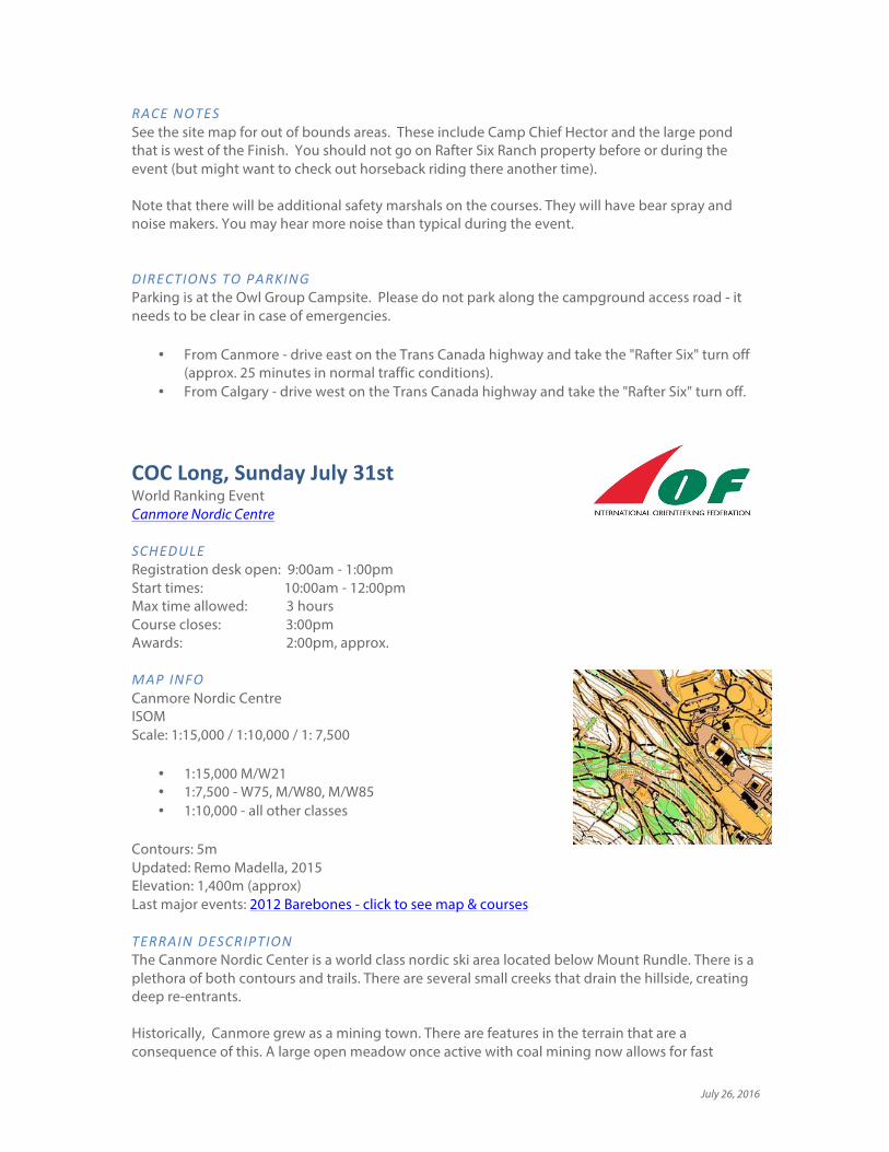
COCLong,SundayJuly31stWorld Ranking Event Canmore Nordic Centre SCHEDULERegistration desk open: 9:00am - 1:00pm Start times: 10:00am - 12:00pm Max time allowed: 3 hours Course closes: 3:00pm Awards: 2:00pm, approx. MAPINFO Canmore Nordic Centre ISOM Scale: 1:15,000 / 1:10,000 / 1: 7,500
• 1:15,000 M/W21 • 1:7,500 - W75, M/W80, M/W85 • 1:10,000 - all other classes
Contours: 5m Updated: Remo Madella, 2015 Elevation: 1,400m (approx) Last major events: 2012 Barebones - click to see map & courses
TERRAINDESCRIPTION The Canmore Nordic Center is a world class nordic ski area located below Mount Rundle. There is a plethora of both contours and trails. There are several small creeks that drain the hillside, creating deep re-entrants. Historically, Canmore grew as a mining town. There are features in the terrain that are a consequence of this. A large open meadow once active with coal mining now allows for fast

July 26, 2016
running. There are also pits, cut lines, ruined foundations, and even spilled coal in some places. The forest is categorized mostly as white or pale green. In recent years wind storms have caused blow down: both the wider and narrow vertical green lines are used to reflect this. Mountain bikers enjoy this terrain too. In addition to the wider ski trails there are many narrow winding bike trails. In fact there is very active work in building more small mountain bike trails and and in June alone we have added six more to the map. Almost certainly there will be new sections of trails built between the final map updates and race day. Picnic benches and garbage bins are not marked but larger ski shelters are. There are a number of boulders. Small game trails and old bike paths which have been reclaimed are generally not marked. The trail network is very dense and it can be very challenging to interpret which trail is which. OFFICIALS Course planner: Jane Rowlands, FWOC Controller: Alan Vyse, Sage IOF Event Advisor: John Rance, GVOC ARENAINFORMATION Vendors: the O-Store will be at the arena. Food: bring your own. There is a small cafe in the day lodge. Water: bring your own. There are water fountains in the day lodge. Toilets & showers: toilets with running water are available in the wax building and the team building. The bathrooms in the Wax Building have a coin-operated shower. NOTE: On Sunday during the Long distance race the Men's bathroom in the Wax Building will be closed as it will be used for Doping Control (instead use the washrooms in the Team Building) Distance from Parking to Arena: approximately 500m easy. Distance from Arena to Start 1: 1km, 80m climb along good trails Distance from Arena to Start 2: 450m, 10m climb along good trails
site map

July 26, 2016
STARTS There are two start locations, a higher start (Start 1) for most classes and a lower start (Start 2) for older age groups. Start 1 Follow the marked route through the warm-up map. Allow plenty of time for the big climb, and think how wonderful it is to do the climb before starting the race! Start 2 - M80, M85+, W75, W80, W85+ Meet at the Registration Desk at the "Wax Building" at 10:15. Everyone will be escorted together to the Start 2 location. Your assigned times will not apply, instead you will be started on a Start Punch by the Start Crew volunteer. Think how wonderful it is to not have to do the climb at all! WARM-UPMAP There will be a small warm-up map available covering the area close to Start 1. This will give you a chance to experience the mapping style, terrain, and vegetation. Pick up a copy at the Registration desk. RACENOTES We share CNC with other outdoor enthusiasts. There will be mountain bikers using the trails. Be alert and respect them, and realize that they may not be able to stop as fast as you can. The paved trails have been closed for roller skiing during our event and so there should not be any roller skiers, but if there are remember these folks do not have brakes. On the more advanced courses please take care around the cliffs. There are three out of bounds areas: the biathlon range; the bike park which is under construction; and Frozen Thunder snow storage – you must not cross this mound of sawdust-covered snow even where there is no fence. We also share the terrain with wildlife, stay alert at all times. Note that there will be additional safety marshals and search & rescue personnel on the course. They will have bear spray and noise makers. You may hear more noise than typical during the event. OTHERNOTES Carrying bear spray is mandatory in this event. Please see the Bear Spray page for more information. DIRECTIONS The Canmore Nordic Centre is a short (5 minute) drive from downtown Canmore. Jump to the Canmore Nordic Centre page for a map. Note: There is often photo radar on the bridge over the Bow River where the speed limit is 30km/hr. Take this speed zone very seriously to avoid a ticket! Please respect our contract with the Canmore Nordic Centre and park only in the area designated for the Canadian Orienteering Champs.

July 26, 2016
COCSprint,MondayAugust1stWorld Ranking Event Canmore Nordic Centre SCHEDULERegistration desk open: 9:00am - 1:00pm (at the Arena) Quarantine closes: 9:50am - all competitors must be in the quarantine area by this time Start times: 10:00am - 11:00am Max time allowed: 60 minutes Course closes: 12:30pm Awards: 2:00pm, approx (after Sprint relay) MAPINFOCanmore Nordic Centre ISSOM Scale: 1:5,000 Contours: 2.5m New: Remo Madella, 2015 from ISOM map Updates: 2016: Marion Owen, Don Bayly, Alan Vyse Elevation: 1,400m (approx) TERRAINDESCRIPTION As the name suggests, the Canmore Nordic Centre has a dense trail network, both cross country ski trails and mountain bike trails. The trails vary from the wide asphalt roller ski trails to narrow twisty mountain bike trails, and everything in between. The surface also varies – from asphalt, to rocky, to gravel, to grassy. Shoes with an aggressive tread would be recommended. Off trail, much of the forest is white, but there are rose bushes and areas of deadfall, so leg cover is recommended. Some deadfall is covered in moss (yes, really, in Alberta!) so can be harder to see. CNC is generally on a north facing slope which is steep in places OFFICIALS Course planner: Marion Owen, FWOC Controller: Alan Vyse, Sage IOF Event Advisor: John Rance, GVOC
Snippet of the ISSOM map
showing how the asphalt roller ski trail is mapped with solid
black edge line while natural-surfaced trails have dashed
edges..
ARENAINFORMATION Vendors: the O-Store will be at the arena. Food: bring your own. There is a small cafe in the day lodge. Water: bring your own. There are water fountains in the day lodge. Toilets & showers: toilets with running water are available in the wax building and the team building. The bathrooms in the Wax Building have a coin-operated shower. Additional showers & toilets are in the Day Lodge. Distance from Parking to Arena: approximately 500m easy. Distance from Arena to Quarantine: approximately 300m easy walk. Distance from Quarantine to Start: 800m, with 50m climb

July 26, 2016
QUARANTINEAll competitors must enter the quarantine area by 9:50am. No one is allowed to enter quarantine after 9:50am, including runners who have finished their course. The quarantine area includes: * the south-eastern part of the Cross Country (CC) Stadium (plenty of room for warming up & stretching); * the Daylodge (toilets are available in the daylodge); * the Warm-up map / route to the start. Before entering quarantine you are allowed to go to the arena to drop off clothing/snacks/etc and to check out the last control and the finish chute - just be sure to leave enough time. After finishing your race you are only allowed to be in the arena or in the parking lots until everyone has begun their race. So, for example, you are not allowed back into the quarantine area, including the Day Lodge, nor into the forest anywhere in the Canmore Nordic Centre. When can I leave the stadium area to go to the start? There is quite a long way from the stadium to the start. You can leave the stadium holding area at any time after 9:30am. When you leave the stadium area you will be given a small warm-up map covering the area to the start. This will give you a chance to experience the mapping style, terrain, and vegetation. Why have quarantine? In the spirit of fair competition it is necessary to keep early finishers separated from runners waiting to start. Generally, in Long & Middle distance races, this is not a big issue because most runners have started their race before the first finishers arrive. But in Sprint races where winning times are very short and route choices are more significant it is necessary to make a quarantine area. We hope you enjoy the experience - it is quite fun.

July 26, 2016
RACENOTESThe ISSOM map of the Canmore Nordic Centre (CNC) was converted from the ISOM map by Remo Madella remotely, field checked by your course planning team and updates drawn by Don Bayly. There are many different sizes and types of trails, ranging from the asphalt roller ski trails (see snippet above) which are shown as a narrow road with a solid black edge, to smaller gravel trails, which are shown with a dashed black edge, to the smaller single track bike trails which are shown as a dashed line. There are also rides, both wide and narrow. There are a couple of bridges with very old orange snow fencing at their ends - these are not out-of-bounds, you can cross them. The white forest is open with good visibility but there is scattered deadfall. The green vertical hatching almost always indicates a heavier accumulation of deadfall. The sprint occurs in a relatively small area – so many runners, and many controls! In the finish arena there are several controls. Spectators are allowed but make sure not to obstruct runners or obstruct/give away controls. There are three Out-Of-Bounds areas at CNC and are shown with the purple over-printing.
1. The biathlon range 2. The area close to the finish where a Bike Skills Park is under construction 3. ‘Frozen Thunder’ – this is a long pile of stock-piled snow, covered in a deep layer of
sawdust. It will be used in October to make the first ski trails for next winter
The Canmore Nordic Centre hosts many sports. During our two days of competition the trails will be open to Mountain Bikers. So you need to be very alert especially when crossing the twisty narrow bike trails. The Roller Ski Trails around the biathlon area will be closed during competition, but there may be roller skiers on the trails further out during the Long Distance race. Roller skis do not have brakes so please be aware and avoid collisions! There is a Disc Golf Course on a subset of trails around the arena and the “golf holes” are small towers with a basket for catching discs. They are marked as man-made objects with a circle. The course is closed to disc golfers for the 2 days of competition. Note that there will be additional safety marshals and search & rescue personnel on the course. They will have bear spray and noise makers. You may hear more noise than typical during the event. OTHERNOTESCarrying bear spray is mandatory in this event. Please see the Bear Spray page for more information. DIRECTIONSThe Canmore Nordic Centre is a short (5 minute) drive from downtown Canmore. Jump to the Canmore Nordic Centre page for a map. Note: There is often photo radar on the bridge over the Bow River where the speed limit is 30km/hr. Take this speed zone very seriously to avoid a ticket! Please respect our contract with the Canmore Nordic Centre and park only in the area designated for the Canadian Orienteering Champs.

July 26, 2016
COCSprintRelay,MondayAugust1stCanmore Nordic Centre The sprint-relay will take place immediately following the individual Sprint race. SCHEDULERegistration desk open: 9:00am - 1:00pm Sprint distance race: 10:00am - first start; 12:30pm - course closing. Kids race mass start: 12:30pm (approx) Sprint relay start: Mass Start at 1:00pm (approx) Max time allowed: 90 minutes Course closes: 2:30pm Awards: 2:15pm - (approx, or sooner if possible) we'll give out awards for both the individual Sprint race and the Sprint Relay. MAPINFOCanmore Nordic Centre ISSOM Scale: 1:5,000 Contours: 2.5m New: Remo Madella, 2015 from ISOM map Updates: 2016: Marion Owen, Don Bayly, Alan Vyse Elevation: 1,400m (approx)
TERRAIN Some steep hillsides with some relatively flat areas. Detailed ski & bike trail network with several man-made features. Forest is generally either quite open or quite slow - not much in-between. All courses require steep climbs and descents. OFFICIALS Course planners: Adrian Zissos. Assistance: Forest Pearson, YOA; Tori Owen, Marion Owen, FWOC RELAYFORMAT
• Four runners per team, each runner runs one leg. • Approx leg lengths / navigational difficulty / expected fastest time (subject to change)
Leg 1 – 2.5km / medium / 13 minutes Leg 2 – 2.0km / easier / 12 minutes Leg 3 – 3.0km / medium / 15 minutes Leg 4 – 2.5km / medium / 13 minutes All legs might have significant climb
TEAMCOMPOSITION
• You should make teams if possible from your club. Orienteers from far away should make teams from your region, or your country
• Each runner is assigned a score based on their gender and their age (on December 31st). • The four individual scores are added up to create a team score, which determines the
team’s class.
July 26, 2016
CLASSES
• Open Classes o 0-3 points, 4-7 points, 8-11 points, 12+ point o Award to top team in each category
• Club Championship o All teams are eligible (regardless of their ‘score’), so long as
they meet the following requirements: ! All team members from the same club ! At least two females ! Woman to run Leg 1 and Leg 4
o Awards to top three club teams overall, regardless of their team's "score".
Age Male Female Under 15 3 3 15-16 2 2 17-20 1 2 21-34 0 1 35-49 1 3 50-59 2 4 60-69 3 5 70 & over 5 6
REGISTERINGYOURTEAM Fill in the Sprint Relay Registration form and submit to the Registration Desk as early as possible (to allow time for volunteers to transfer data to the timing system) and no later than 2pm on Sunday (this is very late for the volunteers, so please be earlier than that!). Copies of the form will be available at the Registration desk or you can download the registration form here. LEGCHANGEOVER The leg change over will be described on-site (that gives us more time to figure it out). Probably the incoming runner will pick up the next runner's map and hand it off. CATCH-UPMASSSTART In order to ensure the event finishes early, we will have a mass start of all remaining runners at about one hour after the mass start. Times will be counted normally, even if you are in the catch up mass start. KIDS'RACE This relay is not suitable for children 12 years old and under. For these young stars we will hold a mass-start race before the Sprint Relay. There will be two courses based on the regular age groups. The courses will be in the vicinity of the arena and will allow for lots of cheering. NON-RELAYOPTION For adults who really, absolutely, positively, definitely don’t want to take part in the relay (which would be a tragic decision ;-) we will have a number of extra Leg 1 maps prepared. You will be part of the mass start - to make a big spectacle! OTHERNOTES Carrying bear spray is mandatory in this event. Please see the Bear Spray page for more information. OrienteeringCanadaHighPerformanceProgram The Sprint Relay is a fundraiser for the Canadian High Performance Program. The athletes, coaches, officials, and other volunteers thank you for your support and hope you will enjoy this team race format. The format was introduced at the World Championships a few years ago and has quickly become one of the most exciting and fun races at the World Champs. We hope you enjoy this taste of this increasingly popular race format.