2015 foss4g track: foss4g adoption in local government – opportunities and challenges by dave...
TRANSCRIPT

GIS in the Rockies 2015
FOSS4G Adoption in Local
Government – Opportunities and
Challenges
Dave Murray, GISP
GIS Coordinator
City of Westminster
2
GIS in the Rockies 2015
Abstact• Across the globe Free and Open Source for Geospatial
applications have gained increasing popularity among public and
private sectors. In America, the adoption of FOSS4G has not
been as prevalent as in Europe, Asia and South America.
Proprietary GIS vendors have served our markets well but there
may be new opportunities available to those that might consider
integrating FOSS4G into their geospatial portfolios. This
presentation will review the opportunities and impediments to
FOSS4G adoption in local government and give the attendees
options for further investigation. No prior knowledge of GIS or
FOSS4G is required, only an open mind and a sense of
adventure.

3
GIS in the Rockies 2015
A bit about me
• GIS Coordinator for the City of Westminster
• Lecturer at the University of Colorado at
Denver
• Background in:
– Planning
– Oil and Gas
– Mechanical Engineering
– Education

4
GIS in the Rockies 2015
Have you ever had this conversation?• Manager, Finance Guy/Gal, Elected Official:
“What are the alternatives to paying our
GIS software support?”

5
GIS in the Rockies 2015
https://www.google.com/search?site=imghp&tbm=isch&source=hp&biw=1691&bih=903&q=ostrich+head+in+sand&oq=ostrich&gs_l=img.1.3.0l10.2289.4306.0.6138.7.6
.0.1.1.0.75.414.6.6.0....0...1ac.1.64.img..0.7.418.k3h63oEWyjs#imgrc=N6IriA-Rce9jVM%3A

6
GIS in the Rockies 2015
My response has been:
“There are alternatives but they will cost
and take a good deal of time.”
https://www.google.com/search?site=&tbm=isch&source=hp&biw=1873&bih=903&q=time+and+money&oq=time+and+money&gs_l=img.3..0l10.2372.647
0.0.6769.20.13.3.4.4.0.106.803.11j2.13.0....0...1ac.1.64.img..0.20.835.hxe3wOsaBjg#imgrc=9-NuSmOJ3aMmgM%3A

7
GIS in the Rockies 2015
• My role as GIS Coordinator
– Keep current systems and applications running
– Implement new capabilities
– Promote and train users on GIS capabilities
– Keep on top of technologies that are in
development
– Match business requirements with technologyhttps://www.google.com/search?site=&tbm=isch&source=hp&biw=1873&bih=903&q=tanker&oq=tanker&gs_l=img.3..0l10.1992.3250.0.3661.
6.6.0.0.0.0.101.249.5j1.6.0....0...1ac.1.64.img..0.6.245.6N6REhDdw7M#imgrc=KuyNbTMcPOSpeM%3A
8
GIS in the Rockies 2015
My investigation to alternatives to COTS GIS
https://www.google.com/search?site=&tbm=isch&source=hp&biw=1873&bih=903&q=search&oq=search&gs_l=img.3..0l10.2866.3966.0.4281.6.5.
0.1.1.0.62.269.5.5.0....0...1ac.1.64.img..0.6.272.CSa46K92EWw#imgrc=QLuogUjuHu2_OM%3A

9
GIS in the Rockies 2015
• COTS
– Commercial Of-The-Shelf
– It is a Federal Acquisition Regulation (FAR)
term
– The principal set of rules in the Federal
Acquisition Regulation System.
– FAR regulates items and services purchased
under government contracts
–Pay for product or service
–Has licensing and contracting
terms
10
GIS in the Rockies 2015
• Local Government (In this context)
– Municipal
– County
– Special District
– Non-Profit
– Environmental
– Consultants
– Citizen Activist
– Developing Countries
– Start-ups
– Many Others… https://www.google.com/search?site=&tbm=isch&source=hp&biw=1873&bih=903
&q=local+goverment&oq=local+goverment&gs_l=img.3..0i10l10.2522.7478.0.77
28.17.13.1.3.3.0.75.751.13.13.0....0...1ac.1.64.img..0.17.771.5lNmbtG_XeU#img
rc=4gTwLNyVyhsFpM%3A
11
GIS in the Rockies 2015
• Definitions
– FOSS4G
• The term FOSS4G was first coined in
early 2004 as an acronym for Free and
Open Source Software for
Geoinformatics by a research group
working on GRASS and MapServer.*
• FOSS4G has a long tradition of being
used in the context of Free and Open
Source Software for Geospatial.
*http://wiki.osgeo.org/wiki/FOSS4G
12
GIS in the Rockies 2015
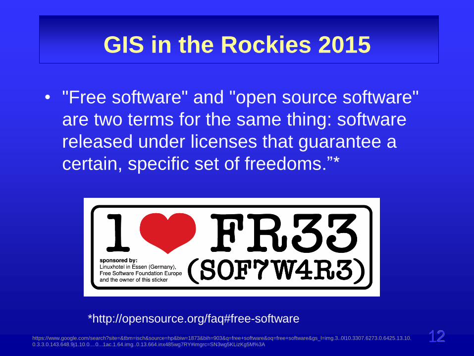
• "Free software" and "open source software"
are two terms for the same thing: software
released under licenses that guarantee a
certain, specific set of freedoms.”*
*http://opensource.org/faq#free-software
https://www.google.com/search?site=&tbm=isch&source=hp&biw=1873&bih=903&q=free+software&oq=free+software&gs_l=img.3..0l10.3307.6273.0.6425.13.10.
0.3.3.0.143.648.9j1.10.0....0...1ac.1.64.img..0.13.664.inx485wg7RY#imgrc=SN3wg5KLizKg5M%3A
13
GIS in the Rockies 2015
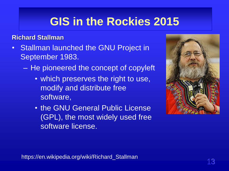
Richard Stallman
• Stallman launched the GNU Project in
September 1983.
– He pioneered the concept of copyleft
• which preserves the right to use,
modify and distribute free
software,
• the GNU General Public License
(GPL), the most widely used free
software license.
https://en.wikipedia.org/wiki/Richard_Stallman

14
GIS in the Rockies 2015
Free/Open Source Software
• What are Stallman's four freedoms as presented on the
Free Software Foundation website; http://www.fsf.org/
– Freedom 0: The freedom to run the program for any
purpose.
– Freedom 1: The freedom to study how the program
works, and change it to make it do what you wish.
– Freedom 2: The freedom to redistribute copies so you
can help your neighbor.
– Freedom 3: The freedom to improve the program, and
release your improvements (and modified versions in
general) to the public, so that the whole community
benefits.

15
GIS in the Rockies 2015
• Three general models for organizing
Open Source projects
– Volunteer
• Moodle – Education
• Python
– Corporate Sponsor
• Microsoft
• HP
• IBM
– Commercial Open Source
• Most companies – Choose your favorite
https://www.google.com/search?site=&tbm=isch&source=hp&biw=1873&bih=851&q=organization&oq=organizat&gs_l=img.1.1.0l10.10944.14281.0.15591.15
.9.3.3.3.0.143.548.7j1.8.0....0...1ac.1.64.img..1.14.576.kQIJMVOiLSg
16
GIS in the Rockies 2015
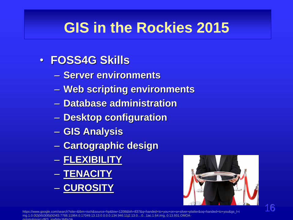
• FOSS4G Skills
– Server environments
– Web scripting environments
– Database administration
– Desktop configuration
– GIS Analysis
– Cartographic design
– FLEXIBILITY
– TENACITY
– CUROSITY
https://www.google.com/search?site=&tbm=isch&source=hp&biw=1208&bih=837&q=handed+to+you+on+a+silver+platter&oq=handed+to+you&gs_l=i
mg.1.0.0l2j0i5i30l5j0i24l3.7768.11964.0.17049.13.13.0.0.0.0.134.946.11j2.13.0....0...1ac.1.64.img..0.13.931.OMOA-
qnIots#imgrc=fRS_ipafHIpJiM%3A

17
GIS in the Rockies 2015
• Example Open Source and Non Open
Source Initiatives

18
GIS in the Rockies 2015
• Leading FOSS4G Example Programs – Cloud
• CartoDB
• MapBox
– Web
• Leaflet, Openlayers
– Server
• Geoserver, Mapserver
– Database
• Postgres/PostGIS
• MySQL
– Desktop
• QGIS
• gvSIG
http://2010.foss4g.org/presentations/3577.pdf
19
GIS in the Rockies 2015
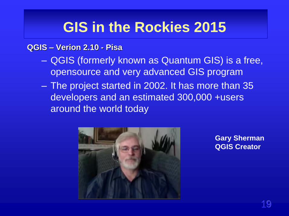
QGIS – Verion 2.10 - Pisa
– QGIS (formerly known as Quantum GIS) is a free,
opensource and very advanced GIS program
– The project started in 2002. It has more than 35
developers and an estimated 300,000 +users
around the world today
Gary Sherman
QGIS Creator
20
GIS in the Rockies 2015
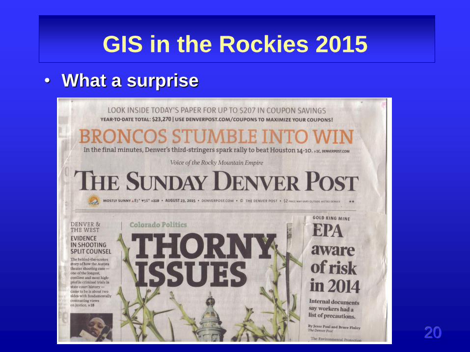
• What a surprise
21
GIS in the Rockies 2015
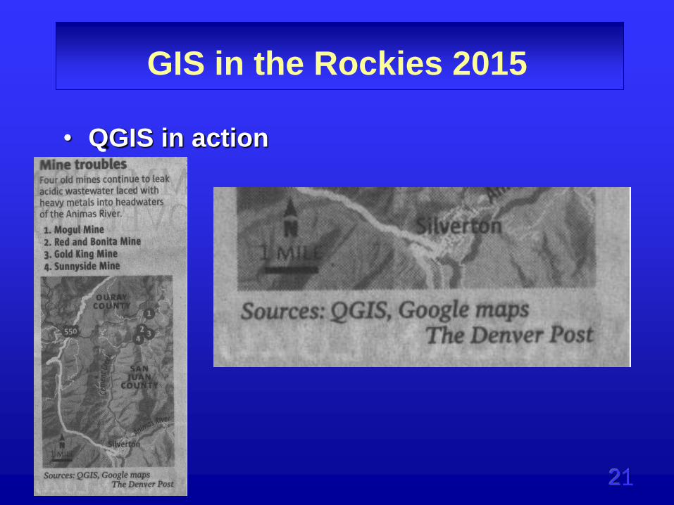
• QGIS in action

22
GIS in the Rockies 2015
• PostGres/PostGIS

23
GIS in the Rockies 2015
• GeoServer
• an open source server for sharing
geospatial data. Designed for
interoperability, it publishes data
from any major spatial data source
using open standards.

24
GIS in the Rockies 2015
• OpenLayers
– A high-performance, feature-packed
library for all your mapping needs.

25
GIS in the Rockies 2015
• Leaflet
– an open-source JavaScript library
for mobile-friendly interactive
maps

26
GIS in the Rockies 2015
• MapBox

27
GIS in the Rockies 2015
• CartoDB

28
GIS in the Rockies 2015
• IT Innovation Environment
– Organizational approach to technology
– Staff
– Flexibility
– Road Blocks
– Side projects
– Time and materials billing
– Accountability
– Mission Critical applications
– Bad experiences
https://www.google.com/search?site=&tbm=isch&source=hp&biw=1208&bih=785&q=It+innovation&oq=It+innovation&gs_l=img.3..0j0i30l3j0i24l6.2918.5258.0.5599.
13.9.0.4.4.0.160.690.8j1.9.0....0...1ac.1.64.img..0.13.721.bHb9DNfQ6Ac#imgrc=idzXdckPKh68uM%3A
29
GIS in the Rockies 2015
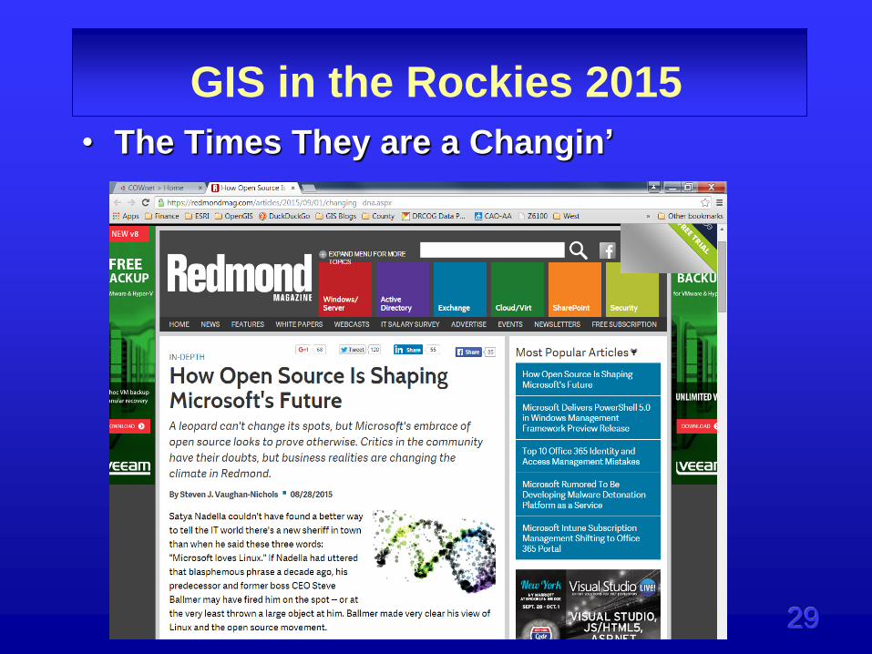
• The Times They are a Changin’

30
GIS in the Rockies 2015
• Training
– Google search
– GIS Stack Exchange
– Online Training classes
– YouTube
– PackT books
– Universities
– Communities – GeoSpatial Amateurs
– Consultants?
GeoAms 5/12/2015
31
GIS in the Rockies 2015
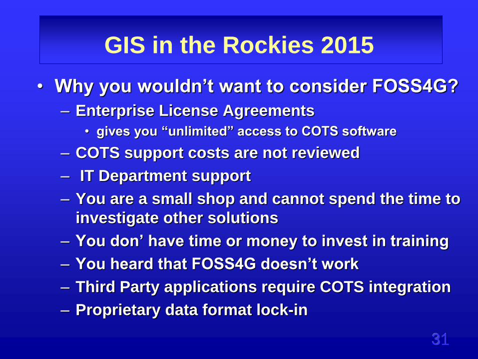
• Why you wouldn’t want to consider FOSS4G?
– Enterprise License Agreements
• gives you “unlimited” access to COTS software
– COTS support costs are not reviewed
– IT Department support
– You are a small shop and cannot spend the time to
investigate other solutions
– You don’ have time or money to invest in training
– You heard that FOSS4G doesn’t work
– Third Party applications require COTS integration
– Proprietary data format lock-in

32
GIS in the Rockies 2015
• Why you may want to consider FOSS4G?
– Your COTS vendor is charging on a per seat license
– Your IT Department is willing to support your effort
– You are a small shop and have a business reason to
investigate FOSS4G
– You believe that the FOSS4G community support system
will help you with your implementation
– The money you saved on software can be invested in
training
– You heard that FOSS4G does work
– You are interested in joining the FOSS4G community
– You require rapid scalability

33
GIS in the Rockies 2015
• Why you may want to consider FOSS4G?
– Independence from proprietary technology
• Mandated update cycles
– Security
• According to the Department of Homeland Security,
software security is a serious risk of using COTS software*
– Instant availability
– Develop custom products and give back to the
community
– COTS product obsolescence can require
customized support or development of a
replacement system.
*https://en.wikipedia.org/wiki/Commercial_off-the-shelf

34
GIS in the Rockies 2015
Charles Rudder
“Open source GIS software, due to its
nature of being constantly updated and
improved by the user community, is much
more nimble and open to innovation. I
see it driving changes in the way GIS
software operates.”
http://opensource.com/government/12/9/geographic-information-systems-
technician
35
GIS in the Rockies 2015
• Consider your career viability
– FOSS4G can enhance your skills
– Marketable in multiple arenas
– Broaden your IT skills
– Build lasting friendships
– Update your Googling ability

36
GIS in the Rockies 2015
• How to get started?
– Read blogs and support sites
• GIS Stack Exchange
– Decide where your entry point will
be
• Server – Web – Desktop
– Decide what resources you will need
– Try some online hosted solutions
• CartoDB
• Mapbox

37
GIS in the Rockies 2015
• To see the LARGE LIST of open source
GIS applications that was listed here,
please visit:
• http://opensourcegis.org/.

38
GIS in the Rockies 2015
• Beware of Shiny Objects
39
GIS in the Rockies 2015
• Examples
– Denver Public Schools – Matt Baker
– Richland County, S.C. – Brian Fitzgerald
& Elijah Robinson
– Greenwood Mapping in Wyoming – Rich
Greenwood
– Consultants – David Parr and Mark Heil

40
GIS in the Rockies 2015
• A word about this Course

41
GIS in the Rockies 2015
• A word about this Course
42
GIS in the Rockies 2015
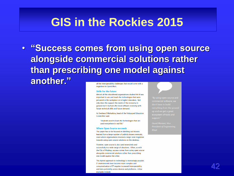
• “Success comes from using open source
alongside commercial solutions rather
than prescribing one model against
another.”

43
GIS in the Rockies 2015
http://www.esri.com/news/arcnews/spring11articles/open-source-technology-and-esri.html

44
GIS in the Rockies 2015
• “Deciding between open source and ArcGIS
is not an either/or question. Esri encourages
users to choose a hybrid model, a
combination of open source and closed
source technology, based on their needs.”
• “The ArcGIS Desktop web help includes a list
of all open source tools, languages, and
libraries used in ArcGIS. In fact, there are
over 80 open source components, including
GDAL libraries.”

45
GIS in the Rockies 2015
• Thought Provoking . . .
http://www.researchgate.net/publication/228956987_Open-
source_geographic_information_systems_software_Myths_and
_realities - 2004

46
GIS in the Rockies 2015
Thank you