2015 annual report - wvnet.edu€¦ · · 2016-02-02mapping of coal quality parameters is being...
TRANSCRIPT

2015 ANNUAL REPORT
Cover Photos Top: Williamsport Sandstone near Alvon, West Virginia
Photo by Paula J. Hunt Inset: Small-Scale Folding and Faulting in the Foreknobs
Formation, North Fork Anthony Creek, Neola, West Virginia Photo by Mary Sue Burns
West Virginia Geological and Economic Survey Mont Chateau Research Center
1 Mont Chateau Road
Morgantown, WV 26508-8079
Phone: 304-594-2331
FAX: 304-594-2575
E-mail: [email protected]
Web Site: http://www.wvges.org
1
West VirginiaGeological and Economic Survey
The West Virginia Geological and Economic Survey (WVGES) has a broad mandate to acquire and make publicly available detailed knowledge of the geology, mineral, energy, and water resources of West Virginia for the benefit of all citizens. Established in 1897,
WVGES is an executive state agency within the Department of Commerce.
The mission of the Survey is to make publicly available timely, responsive, and credible geoscience information to promote wise
public policy; to create wealth and general prosperity; and to maintain a high level of environmen-tal quality, economic opportunity, and quality of life for all West Virginians.
COAL RESOURCES
Survey coal geologists continue to characterize West Virginia’s large coal resources using the state-wide GIS (Geographic Information System). Seam-based GIS layers include: structural contours; outcrops; mined areas; isopachs; and percent partings.
Mapping of coal quality parameters is being developed. All products are regularly updated and can be viewed on the Survey’s web site. Shapefiles of all products are made available to all interested parties upon request. In addition, the various products used by the West Virginia Department of Tax and Revenue to generate tax revenues fund many important parts of the State’s infrastructure, notably, county education systems. Personnel losses continue to adversely impact progress towards completion of the project. The past fiscal years have been challenging as training replacement staff continues to impact productivity. However, nearly 98% of the coal measures have been mapped to date and barring future personnel disruptions, we anticipate completing the initial mapping of the entire State in the near future. Resources are being focused on updating, refining, and increasing products provided to customers.
We continually add new data to our Oracle-based stratigraphic database through cooperation with various industrial and governmental agencies, targeting areas of low data density. These additions allow continual refinement of the various map products.
Mission
Coal-bed Mapping Project (CBMP)
Cover photo: Williamsport Sandstone outcrop near Alvon, WV. Photo by Paula J. Hunt.

GEOLOGICAL AND ECONOMIC SURVEY
2
Coal Program geologists continue to participate in the federally-funded STATEMAP project, mapping quadrangles that lie between internally mapped Elk Map areas and eastern panhandle areas
currently being mapped by other Survey’s staff geologists. Numerous data have been collected, geologic contacts have been drawn and the new products are constantly being reviewed by Survey geologists. These projects produce 1:24,000-scale geologic maps in digital format for parts of the State that have received little attention since the early 1900s. These geologic maps will enhance on-going efforts in adjacent areas to update the State’s geology. The Harman quadrangle map was completed this spring: Bowden quadrangle is currently being mapped.
The Coal Program maintains a large and growing computerized database of various chemical and physical characteristics of West
Virginia coals. This valuable database has been very effective in aiding potential customers to identify specific West Virginia coals that meet their needs for power generation and to serve as chemical feedstock or as a source of coal-to-liquid applications. Work had begun on the mammoth task of integrating this database into the Coal Program’s Oracle-based stratigraphic database. Discussions with various parties continue into determining the REE (rare earth elements) content of West Virginia coal beds and partings. Early data collected by the Survey through past projects suggest that some coal beds contain high enough concentrations of a suite of REEs to be economically viable. Early results are promising and several funding proposals have been submitted to continue this research.
This long-running cooperative research initiative between the U.S. Geological Survey and the WVGES Coal Program has enabled both partners to maintain and grow their respective coal databases. In addition to facilitating important research on
various aspects of coal, coal mining, and resource analyses, the cooperative has resulted in the collection of valuable data on the occurrence, distribution and quantities of various trace elements found in West Virginia’s coal measures. While many federal programs are under economic stress, the NCRDS program in West Virginia was continued for 5 years through June, 2020, on a year by year basis.
Coal Program geologists, in conjunction with West Virginia’s Office of Miners, Health, Safety and Training (MHST), continue to expand the large collection of coal mine maps by obtaining
previously unavailable historic underground mine maps from various repositories. The footprints of newly obtained maps are digitized and added to the Survey’s coal bed GIS. Ancillary information is entered into the WVGES stratigraphic database for use in the State-wide coal bed GIS. This massive task continues.
Geologic Mapping Projects
Coal Quality
National Coal Resources Data System (NCRDS)
Underground Mine Mapping Project
ANNUAL REPORT 2015
3
Work continues on updating and expanding WVGES’ Mine Information Database System (MIDS) as new mine maps and information become available. The MIDS database contains
information on mine maps, including bed mined, mine names, company names, location information and permit numbers. MIDS contains records of every mine map available at the WVGES and is comprised of over 44,000 documents depicting over 71,000 mines. Submissions and comments from online users are requested to make the system more complete and user-friendly.
Brief Status of Work. In FY2015 the Coal Section:
Examined several thousand submitted DDH (diamond drill hole) records and • checked for need.
Added 3990 new data points to the Stratigraphy database.• Edited 5914 existing data points.• Examined several thousand submitted mine maps for need.• Added or edited 476 underground mine polygons.• Made 670 modifications to MIDS database.•
GEOSCIENCE PROGRAM
Geologic mapping at WVGES consists of the direct acquisition of new geological information through field reconnaissance and the
conversion of new and existing geological information from hard copy (paper, mylar, etc.) to digital format.
Acquisition of new geological data is carried out under the auspices of the STATEMAP •program funded jointly by the United States Geological Survey (USGS) and WVGES. During the summer and fall of 2014 and spring of 2015, field work was conducted on three 7.5 minute topographic quadrangles in central and eastern West Virginia (Masontown, Lake Sherwood, and Harman). Published as WVGES Open File Reports, the data are currently available as paper maps, PDF files, and geographic information system (GIS) geodatabases. In September 2014, the STATEMAP Advisory Committee, composed of individuals from industry, government, and academia, met to evaluate new potential map areas within West Virginia for the upcoming 2015 field season. In November 2014, a multi-project proposal was successfully submitted to the USGS and mapping of the Alvon, Bowden, Valley Point, Cuzzart, and Sang Run (WV portion) quadrangles was partially funded. Fieldwork on new STATEMAP projects began in June 2015.
Mine InformationDatabase System
Geologic Mapping

GEOLOGICAL AND ECONOMIC SURVEY
4
Environmental and geochemical work at WVGES deals primarily with the evaluation of geologic site characteristics for Underground Injection Control (UIC) permits for injection of fluids into subsurface rock formations; the assembly of a database
of selected metals content of the State’s rock formations; and responding to inquiries regarding geology, surface water, groundwater, geologic hazards, and bedrock chemistry.
Under West Virginia State Code §22-11-11, the Director of WVGES furnishes consultation •to the State’s Department of Environmental Protection (WVDEP) concerning UIC draft permits. During FY 2014, WVGES provided input regarding geologic conditions at injection sites for 36 Class V UIC draft permits.
Geochemical analyses for 34 rock samples collected during STATEMAP mapping •reconnaissance were added to the existing stratigraphic geochemical database, bringing the number of samples to 1068 and covering West Virginia rock units ranging in age from Precambrian through the Pennsylvanian. The database is available as a GIS layer that can be
EnvironmentalGeoscience andGeochemistry
ANNUAL REPORT 2015
5
combined with or superimposed on other maps of West Virginia for use in environmental and economic assessments of the near-surface bedrock of a particular geographic location.
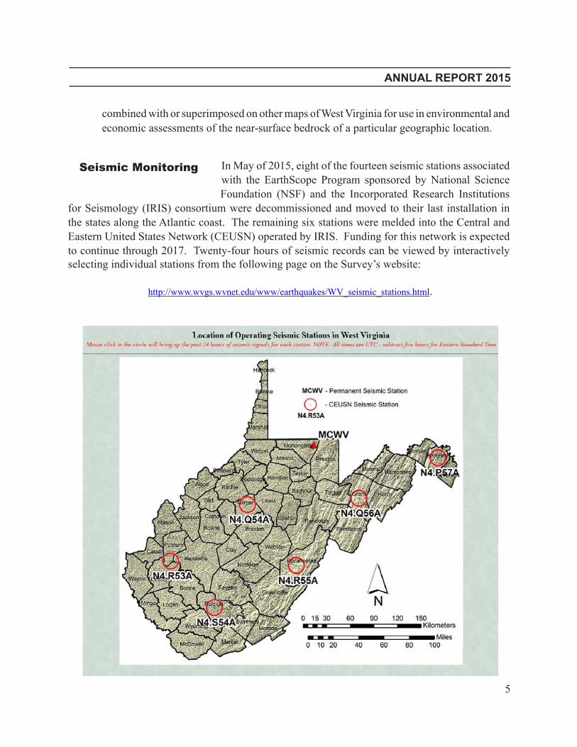
In May of 2015, eight of the fourteen seismic stations associated with the EarthScope Program sponsored by National Science Foundation (NSF) and the Incorporated Research Institutions
for Seismology (IRIS) consortium were decommissioned and moved to their last installation in the states along the Atlantic coast. The remaining six stations were melded into the Central and Eastern United States Network (CEUSN) operated by IRIS. Funding for this network is expected to continue through 2017. Twenty-four hours of seismic records can be viewed by interactively selecting individual stations from the following page on the Survey’s website:
http://www.wvgs.wvnet.edu/www/earthquakes/WV_seismic_stations.html.
Seismic Monitoring
GEOLOGICAL AND ECONOMIC SURVEY
6
Geoscience EducationOutreach
Outreach Activities
Geoscience Education Outreach continues to operate a completely digital program providing K-12 teachers with products designed for their classroom use. The link to this information on the
Survey’s website is http://www.wvgs.wvnet.edu/www/geoeduc/geoeduc.htm.
OIL AND GAS PROGRAM
The last few years have been busy ones for the Oil and Gas Program, and FY2015 proved no different. With the meteoric rise of Marcellus Shale development came an influx of information and activity: new permits and completions; requests for legacy data; description
and analysis of physical samples held in WVGES core and well cuttings collections. Few people anticipated the magnitude of the shale gas boom, and an even smaller number would have predicted the volume of gas, largely produced from the Marcellus, could create a surplus sufficient enough to depress gas markets to historic lows. Lack of available infrastructure remains a problem: midstream operators work diligently to permit and construct a network of pipelines, compressor stations and processing facilities to transfer hydrocarbons out of West Virginia to external markets—a heavily labor and time-intensive process. And, coming on the heels of the Marcellus is the Utica Shale. The beginning of FY2015 marked completion of a two-year, industry-sponsored consortium to characterize and assess potential of the Utica Shale play in the Appalachian basin. Researchers from geological surveys and academic departments across the region compiled legacy data and early results of the play in Ohio, Pennsylvania, and West Virginia to create a comprehensive overview of macro- to micro-scale geologic trends. WVGES geoscientists were responsible for the resource assessment portion of the research. Results from both production-based and volumetric assessments were significant, and suggest the Utica play holds potential to rival, or perhaps eclipse, the Marcellus in dry gas production.
Geoscience personnel participated in internet webinars and •attended local and regional meetings featuring topics including geological hazards, induced seismicity, and environmental issues related to oil and gas exploration and development, protection of groundwater resources in karst regions, hazard mitigation, and disaster preparedness.
In August 2014, Geoscience personnel conducted a half-day fossil •identification workshop at the Grave Creek Mound Museum Complex in Moundsville, WV.
Geoscience personnel taught evening classes in Geological •Hazards and Historical Geology at Fairmont State University.
Outreach Activities

ANNUAL REPORT 2015
7
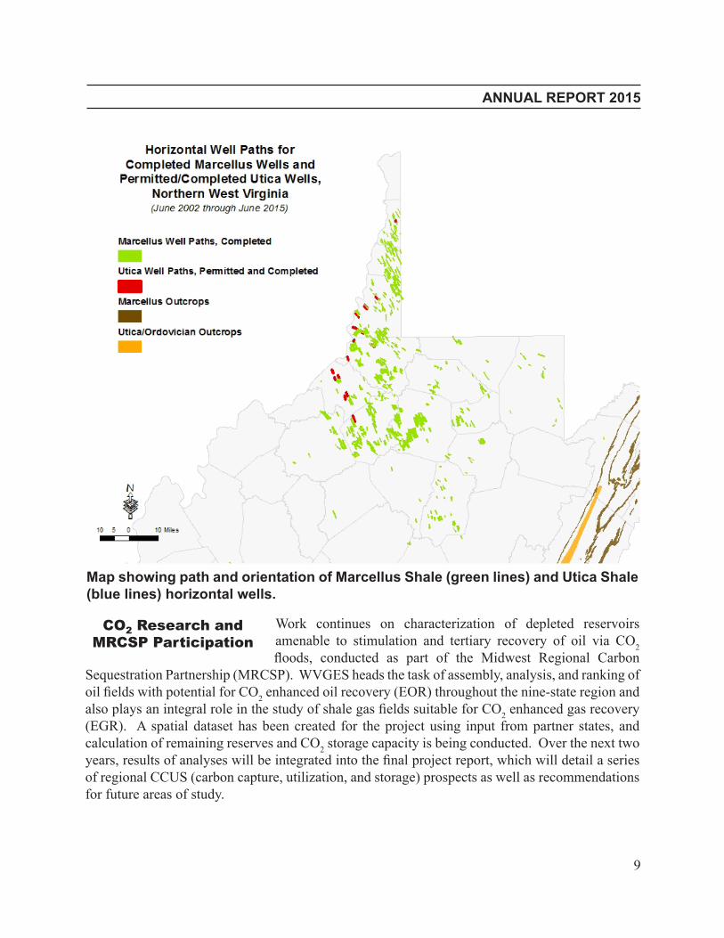
Nearly all exploratory drilling in West Virginia is now horizontal: out of 345 new completions reported to the State during FY2015, greater than 80 percent were completed horizontally. A majority of horizontal wells target the Marcellus (208 completions and
615 permits issued in the fiscal year), but other Devonian units such as the Lower Huron and Geneseo shales continue to be tested. Three wells were completed in the Ordovician Utica/Point
Horizontal Drilling:No Longer Justthe Marcellus

GEOLOGICAL AND ECONOMIC SURVEY
8
Pleasant interval, and an additional four permitted. Conventional and tight sand targets such asthe Mississippian Berea and Big Injun are also being revisited with horizontal drilling techniques; initial results suggest horizontal completions are able to recover significant volumes of oil and gas from these reservoirs. This shift to a variety of targets suggests that operators are willing to diversify their holdings and test not only other shale units, but also conventional targets previously thought to be depleted.
ANNUAL REPORT 2015
9
Work continues on characterization of depleted reservoirs amenable to stimulation and tertiary recovery of oil via CO2
floods, conducted as part of the Midwest Regional Carbon Sequestration Partnership (MRCSP). WVGES heads the task of assembly, analysis, and ranking of oil fields with potential for CO2 enhanced oil recovery (EOR) throughout the nine-state region and also plays an integral role in the study of shale gas fields suitable for CO2 enhanced gas recovery (EGR). A spatial dataset has been created for the project using input from partner states, and calculation of remaining reserves and CO2 storage capacity is being conducted. Over the next two years, results of analyses will be integrated into the final project report, which will detail a series of regional CCUS (carbon capture, utilization, and storage) prospects as well as recommendations for future areas of study.
CO2 Research andMRCSP Participation
Map showing path and orientation of Marcellus Shale (green lines) and Utica Shale (blue lines) horizontal wells.
GEOLOGICAL AND ECONOMIC SURVEY
10
A second project sponsored by the U.S. Department of Energy neared conclusion in FY 2015. The Research Partnership to Secure Energy for America (RPSEA) Brine Disposal Framework
study examined operational data from existing Class II brine disposal wells and evaluated the geology of current and potential injection targets in eastern Kentucky, Ohio, Pennsylvania, and West Virginia. The study estimates that nearly 10,000 barrels of brine were injected into the subsurface for every billion cubic feet (Bcf) of gas produced in the Northern Appalachian basin from 2008 to 2012. Preliminary results derived from geocellular modeling of several subsurface targets, ranging in age from Cambrian to Mississippian, suggest a relatively limited zone of influence adjacent to brine injection wells as well as limited potential for long-term brine migration.
The Oil and Gas Program received a grant from the U.S. Geological Survey to assess and archive core and well cuttings samples held in the WVGES repository. The one-year project
aims to implement barcode technology to accurately catalog the sample collection. Data embedded within the barcodes will enable linking of analytical results to the physical samples at the box level. An additional goal of the project will be to purchase new boxes and re-box nearly 4,000 feet of continuous core taken from the Sandhill well (Wood County). This well marked the first test of Precambrian basement strata in the state and represents a cornerstone of the WVGES collection.
Service remains an important priority for the Oil and Gas Program. Requests for service originate from both the public and private sector, and every geoscientist in the Program remains
committed to providing optimal levels of service, no matter the size or scope of the request. One such request came from researchers at West Virginia and Cornell universities. These researchers are involved in a project to assess potential for low-temperature geothermal fairways in West Virginia, Pennsylvania, and New York. WVGES provided data, service, and assistance for the first phase of their study—an evaluation and risk assessment of areas with increased potential for geothermal resources. A generous award from IHS Global’s University Grant Program aided in completion of service requests—in May of 2015 the company renewed a seven-seat license of Kingdom Suite® subsurface mapping software. The award is based on a three-year term and is valued at more than $200,000.
Brine Disposal andRPSEA Participation
Data Preservation
Service, Awards,and Outreach

ANNUAL REPORT 2015
11
Geographic Information System Program
This program is responsible for planning, organizing, coordinating and delivering high level Geographic Information System (GIS) services to agencies in state government; it is headed by the statewide GIS Coordinator, based in Charleston.
The program continues to make headway in a number of critical areas: promoting data sharing between agencies; providing technical assistance to state, county, and local government and the public; and fostering efficient and effective use of the state’s geospatial capabilities.
The GIS Coordinator continues to provide general administrative oversight of the Mineral Lands Mapping Program in collaboration with the Survey’s Coal Bed Mapping Project and the State Tax Department, Property Tax Division. During the year, the GIS Coordinator assisted in the development of the Property Tax Division’s Statewide GIS Cadastral platform.
The coordinator provided support to the Division of Homeland Security, Department of Environmental Protection, the Water Development Authority (WDA), Infrastructure and Jobs
Development Council (IJDC) of the National Guard, the WV Intelligence Fusion Center, Hazard Mitigation section, and other state, regional and local agencies in their search for GIS contract services, funding, and GIS application development.
The State GIS Coordinator participated in the development of the Geographical Information Professional (GISP) exam. This exam will be used by the Geographical Information Systems
Certification Institute (GISCI) in future GISP certifications.
Data exchange protocols to enhance data sharing and exchange between state and local agencies established in the previous years have proven to be successful. The protocol began the inclusion
of state and locally produced datasets in the GIS Clearinghouse.
The Broadband Mapping and Planning project funded by the National Telecommunications and Information Administration (NTIA) was completed with great results. The program funded
the development of eleven regional and a statewide broadband strategic plans. The program also included a very successful and popular mini-grant program which assisted state, county and local agencies in the development of online tools. During the year, the final data collection package was submitted to NTIA for inclusion in the National Map. This data was verified and then used to update the interactive and static state online maps.
GIS Support
GISP Certification
Data Exchange
Broadband MappingProgram

GEOLOGICAL AND ECONOMIC SURVEY
12
GIS workshops created in collaboration with the WV Association of Geospatial Professionals, WV GIS Technical Center, State Revenue Department Property Tax Division, County Assessors,
and 911 directors continue to be popular among GIS professionals. These workshops were designed to inform, train and advise county and local government officials that have GIS programs in the latest technology and at the same time to educate those officials that have not embraced GIS technology in their own organizations. The workshops emphasize inter-agency collaboration and are given at different locations throughout the state.
The GIS Coordinator attended sessions and made presentations at the mid-year National States Geographic Information Council (NSGIC) in Annapolis, MD, and the West Virginia Association
of Geospatial Professionals 2015 membership meeting held in Charleston, WV. The coordinator participated in sessions of the GISCI Board of Directors, NSGIC Leadership group, WV Information Technology Council, WV Broadband Deployment Council, E911 Council, WV Association of Professional Surveyors, and NSGIC’s NextGen 911 and Broadband workgroups.
GIS Training
Outreach

13
ANNUAL REPORT 2015
Principal Staff Directory and Points of Contact June 2015
Director and State Geologist Michael Ed. Hohn
GIS Program and Statewide GIS Coordinator Tony Simental
Coal Resources Bascombe M. Blake, Jr.
Geoscience Education Thomas E. Repine, Jr.
Geoscience and Mapping Ronald R. McDowell
Oil and Gas Resources Jessica Pierson Moore
Water Issues and Geologic Hazards Jane S. McColloch
Information Services and Publications Mary C. Behling
Earth Science Information Center Paul R. Liston
Public Service Kenneth C. Ashton
West Virginia Geological and Economic Survey Mont Chateau Research Center 1 Mont Chateau Road • Morgantown, WV 26508-8079 304.594.2331 • fax: 304.594.2575 www.wvgs.wvnet.edu • [email protected] 39 39’ 30” N 79 50’ 57” W
Charleston GIS Coordinator 1124 Smith Street, Suite LM-10 Charleston, WV 25301 304.558.4218 • fax: 304.558.4963 www.gis.wv.gov 38 21’ 1” N 81 37’ 31” W
Hours: 8 a.m. to 5 p.m. Monday through Friday (closed holidays)