2013 annual report storm water management plan … · storm water management plan carnegie state...
TRANSCRIPT

2013 Annual Report
Storm Water Management Plan
Carnegie State Vehicular Recreation Area
Off-Highway Motor Vehicle Recreation Division
Department of Parks and Recreation
State of California
OCTOBER 2013
REPORT PREPARED BY:
CLINT ELSHOLZ
ENVIRONMENTAL SCIENTIST
CALIFORNIA STATE PARKS
JUSTIN MYNK
PARK MAINTENANCE SUPERVISOR
CALIFORNIA STATE PARKS
ELISE MCFARLAND
PARK INTERPRETER
CALIFORNIA STATE PARKS
REVIEWED AND APPROVED BY:
RANDY CALDERA
SECTOR SUPERINTENDENT
CALIFORNIA STATE PARKS
Table of Contents
Executive Summary 8
Introduction 8
Development and Implementation of the SWMP 11
Public Education and Outreach 15
Public Involvement and Participation 18
Illicit Discharge Detection and Elimination 23
Construction Site Storm Water Runoff Control 26
Post-Construction Storm Water Management 28
Pollution Prevention Good Housekeeping 30
OHV Trails and Facilities Management 33

4
Maps
Map 1. Regional Map of Carnegie SVRA 10
Map 2. Illicit Discharge Detection and Elimination Program Monitoring Locations. 24
Map 3. Resource Management Areas. 37
Map 4. Sub-RMA 4x4 Area Improvements. 47
Map 5. The Status of the RMAs and the Sub-RMAs. 49
Map 6. The Black Bear Sub-RMA. 50
Map 7. Zone 47 Sub-RMA. 52
Map 8. BMP Monitoring-Turbidity Locations. 54
Map 9. Soil Moisture Meter Locations. 57
Map 10. Trail Ratings for 2012. 60
Map 11. Trail Types for 2012. 61
Figures
Figure 1. The Information Station. 16
Figure 2. Employee Training Presentation. 30
Figure 3. OHV Trails and Facilities Adaptive Management Flowchart. 40
Figure 4. SRI Loop RMA Off-trail Violation, Dec. 2012. 45
Figure 5. Off-trail Riding Correction Measure. 45
Figure 6. The Kiln East RMA. 48
Figure 7. The Black Bear Sub-RMA. 51
Figure 8. Rehabilitation Work in Zone 47. 53
Figure 9. Wet Weather Closures. 55
Figure 10. Soil Moisture Meter at Site 5. 56
Figure 11. Vegetation/Trail Density Line Intersect Surveys. 62
Figure 12. Kiln Basin Cleanout. 63
Figure 13. Carrol Basin Cleanout. 63
5
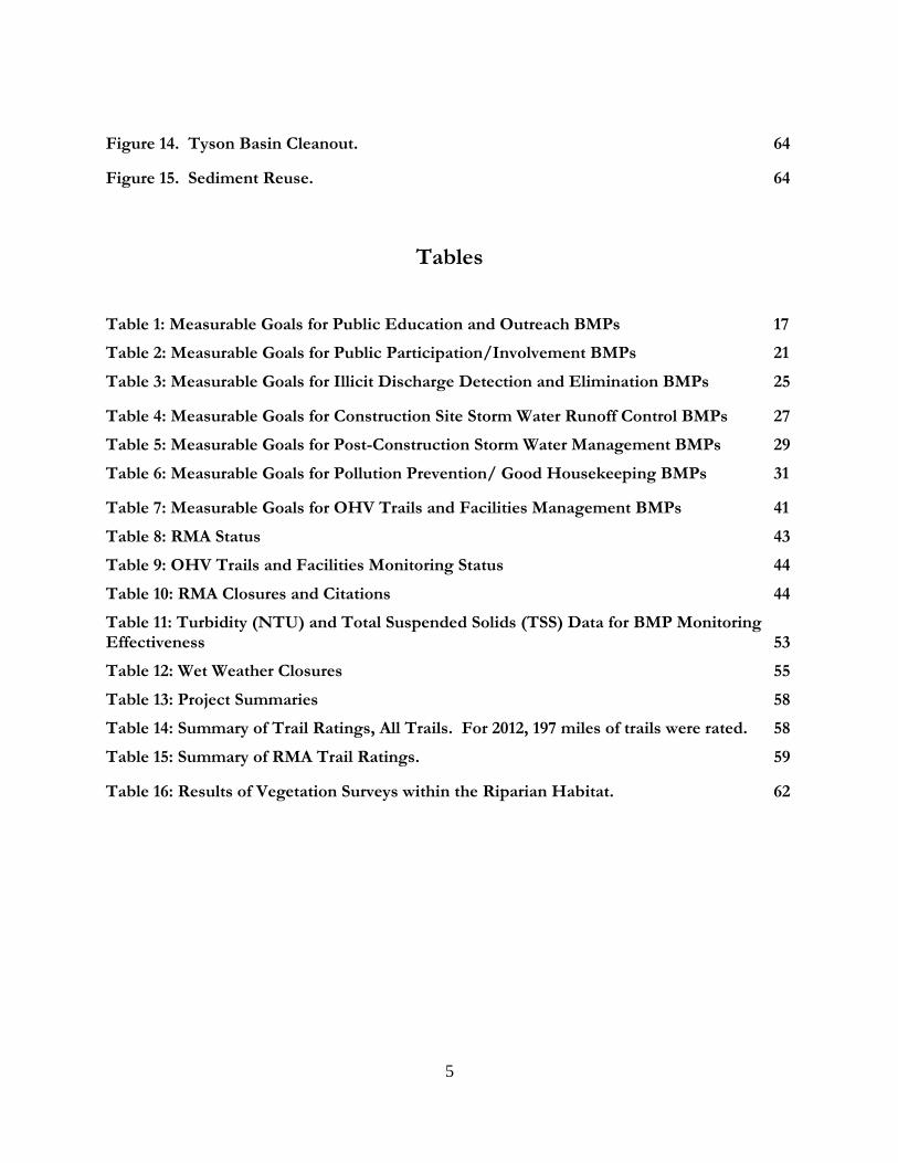
Figure 14. Tyson Basin Cleanout. 64
Figure 15. Sediment Reuse. 64
Tables
Table 1: Measurable Goals for Public Education and Outreach BMPs 17
Table 2: Measurable Goals for Public Participation/Involvement BMPs 21
Table 3: Measurable Goals for Illicit Discharge Detection and Elimination BMPs 25
Table 4: Measurable Goals for Construction Site Storm Water Runoff Control BMPs 27
Table 5: Measurable Goals for Post-Construction Storm Water Management BMPs 29
Table 6: Measurable Goals for Pollution Prevention/ Good Housekeeping BMPs 31
Table 7: Measurable Goals for OHV Trails and Facilities Management BMPs 41
Table 8: RMA Status 43
Table 9: OHV Trails and Facilities Monitoring Status 44
Table 10: RMA Closures and Citations 44
Table 11: Turbidity (NTU) and Total Suspended Solids (TSS) Data for BMP Monitoring Effectiveness 53
Table 12: Wet Weather Closures 55
Table 13: Project Summaries 58
Table 14: Summary of Trail Ratings, All Trails. For 2012, 197 miles of trails were rated. 58
Table 15: Summary of RMA Trail Ratings. 59
Table 16: Results of Vegetation Surveys within the Riparian Habitat. 62

6
List of Attachments
Attachment A: Education Brochure and Certification Sheet
Attachment B: Storm Water and Habitat/Wildlife Panels
Attachment C: Locations of Interpretive Panels
Attachment D: Maps of Pollutant Sources for the Illicit Discharge Detection and Elimination Program
Attachment E: Photo Points for the Illicit Discharge Detection and Elimination Program
Attachment F: Forms for the Illicit Discharge Detection and Elimination Program
Attachment G: Inspections for the Illicit Discharge Detection and Elimination Program
Attachment H: Informational Sign for the Illicit Discharge Detection and Elimination Program
Attachment I: Construction Site Inspection Form
Attachment J: Photo Monitoring-RMAs
Attachment K: Hillclimb Facility
Attachment L: Turbidity Readings
Attachment M: Wet Weather Closures and Storm Event Inspections
Attachment N: Quarterly Evaluations (Projects)
Attachment O: Soil Monitoring Photo Point Annual Report
Attachment P: Precipitation Data
Attachment Q: Road Reconstruction Project
Attachment R: Basin Modernization Project
Attachment S: 2012 Map of BMP Features

Attachment F: Sediment Basins Modernization Working Drawings
Attachment G: Precipitation Data
8
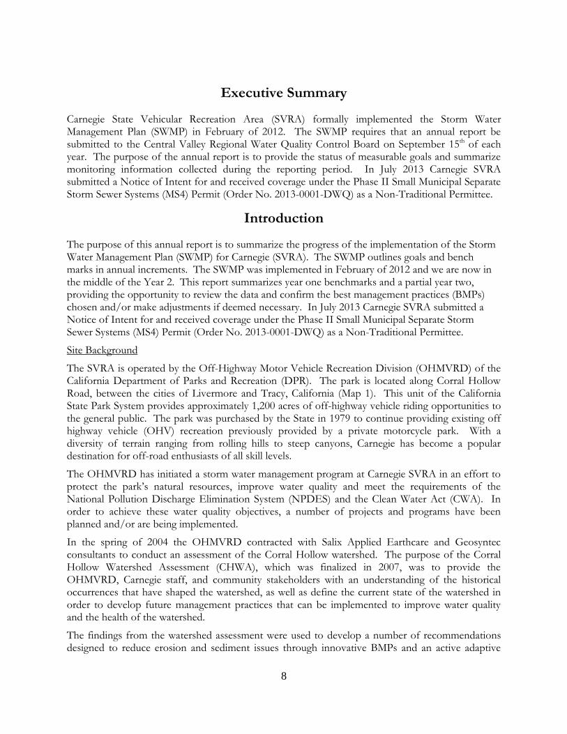
Executive Summary
Carnegie State Vehicular Recreation Area (SVRA) formally implemented the Storm Water Management Plan (SWMP) in February of 2012. The SWMP requires that an annual report be submitted to the Central Valley Regional Water Quality Control Board on September 15th of each year. The purpose of the annual report is to provide the status of measurable goals and summarize monitoring information collected during the reporting period. In July 2013 Carnegie SVRA submitted a Notice of Intent for and received coverage under the Phase II Small Municipal Separate Storm Sewer Systems (MS4) Permit (Order No. 2013-0001-DWQ) as a Non-Traditional Permittee.
Introduction
The purpose of this annual report is to summarize the progress of the implementation of the Storm Water Management Plan (SWMP) for Carnegie (SVRA). The SWMP outlines goals and bench marks in annual increments. The SWMP was implemented in February of 2012 and we are now in the middle of the Year 2. This report summarizes year one benchmarks and a partial year two, providing the opportunity to review the data and confirm the best management practices (BMPs) chosen and/or make adjustments if deemed necessary. In July 2013 Carnegie SVRA submitted a Notice of Intent for and received coverage under the Phase II Small Municipal Separate Storm Sewer Systems (MS4) Permit (Order No. 2013-0001-DWQ) as a Non-Traditional Permittee.
Site Background
The SVRA is operated by the Off-Highway Motor Vehicle Recreation Division (OHMVRD) of the California Department of Parks and Recreation (DPR). The park is located along Corral Hollow Road, between the cities of Livermore and Tracy, California (Map 1). This unit of the California State Park System provides approximately 1,200 acres of off-highway vehicle riding opportunities to the general public. The park was purchased by the State in 1979 to continue providing existing off highway vehicle (OHV) recreation previously provided by a private motorcycle park. With a diversity of terrain ranging from rolling hills to steep canyons, Carnegie has become a popular destination for off-road enthusiasts of all skill levels.
The OHMVRD has initiated a storm water management program at Carnegie SVRA in an effort to protect the park’s natural resources, improve water quality and meet the requirements of the National Pollution Discharge Elimination System (NPDES) and the Clean Water Act (CWA). In order to achieve these water quality objectives, a number of projects and programs have been planned and/or are being implemented.
In the spring of 2004 the OHMVRD contracted with Salix Applied Earthcare and Geosyntec consultants to conduct an assessment of the Corral Hollow watershed. The purpose of the Corral Hollow Watershed Assessment (CHWA), which was finalized in 2007, was to provide the OHMVRD, Carnegie staff, and community stakeholders with an understanding of the historical occurrences that have shaped the watershed, as well as define the current state of the watershed in order to develop future management practices that can be implemented to improve water quality and the health of the watershed.
The findings from the watershed assessment were used to develop a number of recommendations designed to reduce erosion and sediment issues through innovative BMPs and an active adaptive

9
management framework focused on meeting water quality objectives. This framework includes continual assessment of erosion and sediment generators, implementation of appropriate BMPs, on-going monitoring and evaluation of these actions and plans for long-term maintenance to ensure the success of these actions.
Other components of the OHMVRD storm water management program include the ongoing development and implementation of the Trails Management Plan, the implementation, monitoring and maintenance of projects associated with the OHMVRD Soil Conservation Standard and Guidelines, implementation of annual species surveys and habitat rehabilitation activities related to the Habitat Monitoring System program and use of the OHV-specific BMP manual for selecting, implementing and maintaining appropriate BMPs. These components are discussed in greater detail in the OHV Trails and Facilities Management section.
In February of 2012, the SWMP was implemented. The purpose of this SWMP is to reduce or eliminate pollutant discharges from Carnegie SVRA through the use of site-specific structural and non-structural BMPs in order to protect and improve water quality while allowing for high quality OHV recreational opportunities. Elements of the SWMP include public education and outreach, public involvement and participation, illicit discharge detection and elimination, construction site storm water management, post-construction storm water management and pollution prevention/good housekeeping. This SWMP also includes an OHV element dedicated to discussing management goals and activities for maintaining OHV trails and facilities as they relate to meeting our water quality objectives.
This SWMP is designed to meet the requirements set forth in the California State Water Resources Control Board’s (SWRCB) Water Quality Order No. 2003-0005-DWQ, General Permit No. CAS000004, NPDES Waste Discharge Requirements (WDRs) for Storm Water Discharges from Small Municipal Separate Storm Water Systems, (General Permit) adopted on April 30, 2003. As described in more detail in Section 3 of this SWMP, Phase II of the Municipal Storm Water Permitting Program regulates storm water discharges from municipal separate storm sewer systems (MS4s) and construction sites disturbing between 1 and 5 acres of land. An MS4 is defined by the USEPA as a “conveyance or system of conveyances (including roads with drainage systems, municipal streets, catch basins, curbs, gutters, ditches, man-made channels, or storm drains): (i) owned or operated by a state, city, town, borough, or county.” The MS4 permits require the discharger to develop and implement a SWMP with the goal of reducing the discharge of pollutants to the maximum extent practicable (MEP).
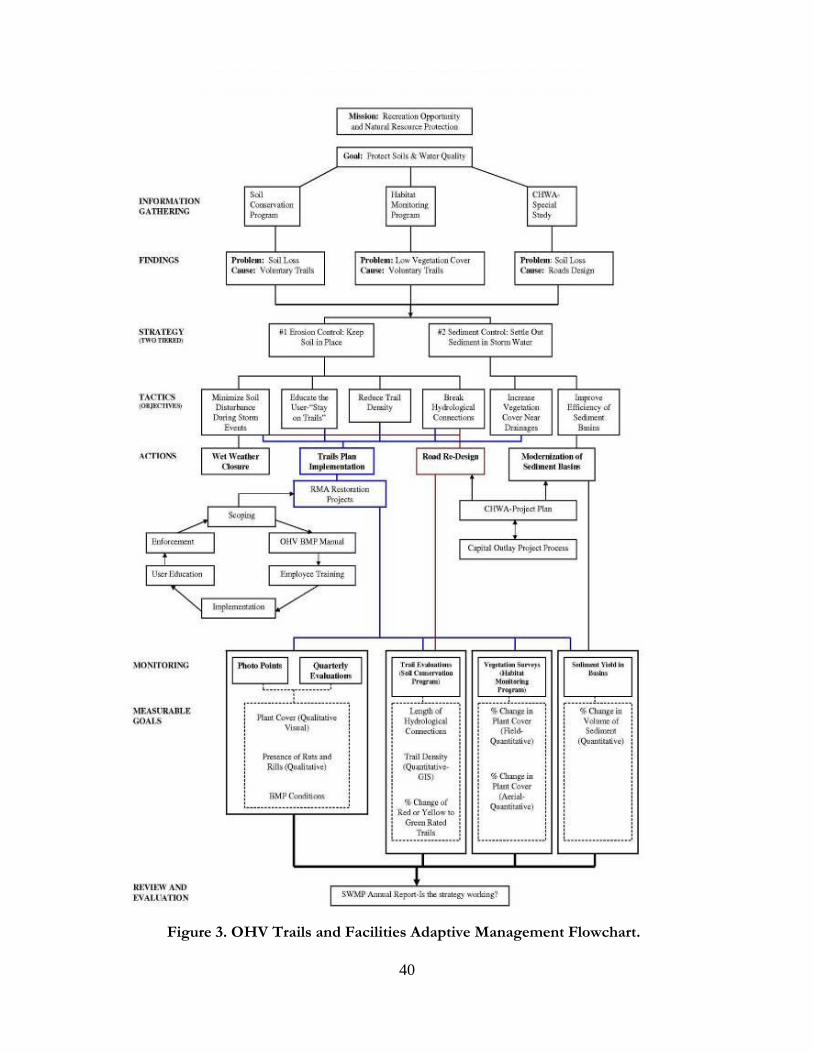
Carnegie SVRA is committed to responsible land management, recreation, and meeting our water quality objectives. This SWMP provides an outline for and implementation of Phase II compliance using our OHV adaptive management framework (Figure 3). OHMVRD and SVRA staff, including the district services manager, environmental scientist, archaeologist, maintenance supervisor, park maintenance worker 1, park interpreter and civil engineering geologist are responsible for implementing this SWMP and submitting the annual report.

10
Map 1. Regional Map of Carnegie SVRA.

11
Development and Implementation of the SWMP
The purpose of the SWMP is to reduce or eliminate pollutant discharges from Carnegie SVRA to the
Maximum Extent Practicable (MEP). The SWMP achieves this by providing a description of the BMPs that
are currently being used or that have been proposed for storm water management at the park. The General
Permit requires a description of BMPs for each of the following six program areas (also referred to as
Minimum Control Measures). This SWMP also contains a seventh program area related specifically to OHV
management:
Public Education
Public Participation
Illicit Discharge Detection and Elimination
Construction Site Storm Water Runoff Control
Post Construction Storm Water Management
Pollution Prevention/Good Housekeeping
OHV Trails and Facilities Management
In order to monitor the effectiveness of the BMPs, the SWMP includes a series of measurable goals established for each Minimum Control Measure. Measurable goals are intended to gauge the effectiveness of the SWMP. They are specifically selected for each BMP and take into account the site conditions, climate, and land use activities. Examples of measurable goals include the construction of a sediment basin, the implementation of a public awareness program, or the continued use of a properly installed and maintained wheel wash facility. Measurable goals could also include quantifiable assessments of the number of educational brochures distributed, the averaging score on a training quiz, or the number of illicit discharges recorded during the permitting cycle.
The SWMP also includes an implementation schedule for each BMP. The implementation schedule generally follows the five-year permitting cycle. For example, the SWMP might indicate that a sediment basin will be installed by the end of year 1 and that routine maintenance of the basin will occur in years 2, 3, 4, and 5. The implementation schedule (i.e. year 1) will start the year following the adoption of the SWMP.
12
Pollutants of Concern
Pollutants of concern consist of any pollutants that could potentially be stored or generated onsite and that could have an adverse impact on the quality of the receiving waters. The pollutants of concern for Carnegie SVRA were selected based on applicable water quality regulations and potential activities that could act as sources of pollutants. The purpose of the SWMP is to prescribe BMPs that will reduce or remove the pollutants of concern to the maximum extent practicable.
Selection Criteria
Pollutants of concern include any pollutants that could potentially be generated by past, present, and future
land use activities. This includes historic activities such as mining that may have created a perpetual source
of pollutants (i.e. tailing piles), present activities such as OHV use, and planned future activities that could
create a new source of pollutants.
The Water Quality Control Plan (Basin Plan) for the Central Valley Region sets forth water quality standards for the surface and ground waters of the region, which include both designated beneficial uses of the water and the narrative and numeric objectives that must be maintained or attained to protect those uses. The Basin Plan does not specify beneficial uses or specific water quality objectives for Corral Hollow Creek. According to the tributary rule, the beneficial uses assigned to any downstream water body would also apply to the creek. The Basin Plan does specify general water quality objectives for all water bodies within the Sacramento and San Joaquin River Basin. These objectives include numeric and narrative standards designed to preserve the quality of the receiving waters.
When selecting the pollutants of concern, the past, present, and planned future activities at Carnegie SVRA
were evaluated to identify potential pollutant sources. Once the sources had been identified, the typical
pollutants associated with each source were then compared to regulatory criteria to select the pollutants of
concern for Corral Hollow Creek and its tributaries.
Selected Pollutants of Concern
Based on the potential pollutant sources at Carnegie SVRA and water quality objectives presented in the
Basin Plan, the following constituents were selected as pollutants of concern:
Sediment
Heavy Metals
Nutrients
Pathogens
Petroleum Hydrocarbons
Trash and Debris
13
The following sections provide a description of the potential sources and hazards of each pollutant of
concern.
Sediments include total suspended solids (TSS), total dissolved solids (TDS), and bed load material. Erosion, transport, and deposition of sediment in surface waters has proven to be a significant form of pollution resulting in water quality problems, which have impaired riparian habitat by inundating riparian vegetation, and reducing beneficial habitat structure in stream channels. Sources of sediment include deposition of materials from Mitchells Ravine and the adjacent County Road, earth disturbance by OHV activities, low volume (access) roads, wind and water erosion, and construction and maintenance activities. Sediments are associated with the following pollutant categories provided in the Basin Plan: Sediment, Suspended Sediment, Settleable Sediment and Turbidity.
Recent water quality sampling conducted by Geosyntec (OHMVRD, 2007) revealed the heavy metal concentrations were generally low and only exceed the California Toxics Rule (CTR) criteria for copper in one sample. However, metals such as copper, zinc, and chromium have been selected as pollutants of concern since they are prevalent in OHV components and can be deposited in the watershed through typical vehicle wear and leaks. Additional sources of metals include fuels, adhesives, paints and other coatings, buildings, infrastructure, and the remnants of tailing piles associated with historic mining activities. Metals are of concern because of their acute and chronic toxic effects on aquatic life and the potential to bioaccumulate in aquatic organisms. Heavy metals are associated with the following pollutant categories provided in the Basin Plan: Taste, Odor and Toxicity.
Nutrients are inorganic forms of nitrogen and phosphorus. The potential sources of nutrients at Carnegie SVRA include decomposition of organic matter, fertilizers from landscaped areas, and atmospheric deposition. Excess nutrients can contribute to surface algal scum and water discoloration. Nutrients are inclusive of the following pollutant categories provided in the Basin Plan: Biostimulatory Substances.
Elevated levels of pathogens are typically caused by the transport of domestic animals, wildlife, or human fecal wastes from the watershed. Even runoff from natural areas can contain pathogens (e.g., from wildlife). At Carnegie SVRA, potential sources of pathogens include domestic pet waste, wildlife waste, cattle and livestock waste, human waste, and leaking septic tanks. If transported to the receiving waters, pathogens can pose a direct health risk to humans. Pathogens are associated with the following pollutant categories provided in the Basin Plan: bacteria.
Pesticides (including herbicides, insecticides and fungicides) are chemical compounds commonly used to control insects, rodents, plant diseases, and weeds. Excessive application of a pesticide may result in runoff containing toxic levels of its active component. Common types of pesticides include organochlorine pesticides or organophosphorus. However, the use of organophosphorus pesticides, including diazinon and chlorpyrifos, has been restricted by USEPA and are not used by Carnegie SVRA. Herbicides, insecticides, and fungicides are associated with the following pollutant categories provided in the Basin Plan: pesticides.
The potential sources of oil, grease, and other petroleum hydrocarbons at Carnegie SVRA include
spills and leaks of fuels and lubricants, atmospheric deposition, wearing of tires, and deposition from
vehicle exhaust. Petroleum hydrocarbons, such as polycyclic aromatic hydrocarbons (PAHs), can
accumulate in aquatic organisms from contaminated water, sediments, and food and are toxic to

14
aquatic life at low concentrations. Hydrocarbons can persist in sediments for long periods of time
and result in adverse impacts on the diversity and abundance of benthic communities.
Hydrocarbons can be measured as total petroleum hydrocarbons (TPH), oil and grease, or as
individual groups of hydrocarbons, such as PAHs. Petroleum Hydrocarbons are associated with the
following pollutant categories provided in the Basin Plan: Oil, Grease and Floating Materials.
Trash (such as paper, plastic, polystyrene packing foam, and aluminum materials) and biodegradable organic matter (such as leaves, grass cuttings, and food waste) are general waste products deposited by anthropogenic and natural processes. The primary source of trash and debris at Carnegie SVRA is deposition by park visitors. The presence of trash and debris may have a significant impact on the recreational value of a water body and aquatic habitat. Excess organic matter can create a high biochemical oxygen demand in a stream and thereby lower the water quality. Also, in areas where stagnant water exists, the presence of excess organic matter can promote septic conditions resulting in the growth of undesirable organisms and the release of odorous and hazardous compounds such as hydrogen sulfide. Trash and Debris are associated with the following categories provided in the Basin Plan: Dissolved Oxygen, Floating Materials, Taste and Odor.
15
Public Education and Outreach
Public education and outreach are needed for effective implementation of the SWMP to ensure
water quality objectives are met. More specifically, education is one of the main tools used to ensure
recreationalists stay on trial. With education and outreach, the public will support projects, BMPs
and actions undertaken by management to protect water quality. The public education and outreach
program will provide information and resources to our park visitors and stakeholders that will
improve each person’s understanding of the SWMP and effectively inform people about the
importance of protecting and improving water quality by recreating responsibly. Public education
and outreach promote better compliance with other minimum control measures by teaching
individuals about the responsibilities expected of them and others in the community, including
individual actions they can take to protect or improve their environment.
To meet the minimum requirements for public education and outreach, the USEPA encourages
operators to use educational materials, such as brochures, fact sheets, guides, signage, educational
programs, and seminars to address the viewpoints and concerns of all members of the public. The
USEPA has developed an extensive database of public education and outreach materials that can be
used at Carnegie SVRA. Whenever appropriate, the OHMVRD will work with other governmental
agencies, as well as utilize these materials as they are peer-reviewed documents that target specific
storm water management issues. The materials can be found on the USEPA’s website:
http://cfpub.epa.gov/npdes/stormwatermonth.cfm
Educational Brochure
Carnegie staff created an educational brochure to help visitors understand how they can protect their riding opportunity and improve water quality by reducing sediments, vehicle parts, germs, vehicle fluids, and trash in storm water runoff. This brochure is available at the park kiosk and is given out at the educational booth and information station (see Attachment A). It is also available on-line at http://ohv.parks.ca.gov/?page_id=26339. The certification sheet can also be found in Attachment A.
Interpretive Panels
An interpretive panel about protecting water quality has been created and placed throughout the park. Visitors can further learn about their role in preventing water pollution through reading this panel (see Attachment B). Several habitat and wildlife panels were also drafted and are scheduled to be printed and displayed in the Fall of 2013. The proposed locations are mapped in Attachment C.

16
Educational Booth and Information Station
Carnegie hosts approximately four special events per year. At each of these events an educational booth is set up. Each weekend during the riding season (October through March) an information station is set up in the park. Both of these outreach booths allow us to educate and inform our park users about protecting wildlife and habitat, cultural resources, and water quality. The educational booth at special events typically reaches three hundred visitors per weekend. The information station reaches around thirty visitors per day.
Additionally, the park’s superintendent developed a Microsoft PowerPoint presentation and held
campfire style programs to help inform and educate the public on the SWMP. Each presentation
was no less than an hour followed up by a question and answer session. The interest regarding the
SWMP, especially in regards to staying on trail, was evident by the attendance and participation of
the visitors.
Figure 1. The Information Station. The information station is open during peak visitation
periods and is near the concession store.

17
Table 1: Measurable Goals for Public Education and Outreach BMPs
BMP
Year of
Implementation Measurable Goals
Educational
Brochures
1
Generate an educational brochure
Generate a certification sheet for the brochure
Post the brochure on the Carnegie SVRA website
2
Existing staff will read the brochure and will sign the certification sheet
Contractors and subcontractors currently conducting work in the park will read the brochure and will sign
the certification sheet
Carnegie staff will begin distributing the brochure to park visitors
3 Continue to distribute the brochure to park visitors
Continue to distribute the brochure to new staff and contractors
Update the brochure as necessary
4
5
Interpretive
Panels
And
Informational
Signage
1
Complete a draft of the interpretive panels for wildlife and habitat
Complete a draft of the informational signs
Identify the posting locations for each interpretive panel and sign
Obtain funding and materials for panels and signs
2
Post the interpretive panels in their designated locations near the associated habitat type
Post the informational signs in their designated locations
Develop and post interpretive panels for rehabilitation and rehabilitation projects as they arise
3 Inspect, update, and maintain each panel and sign
Develop and post interpretive panels for rehabilitation and rehabilitation projects as they arise 4
5
Educational
Booth
And
Information
Station
1 Continue to provide the Educational Booth and Information Station
2 Assemble the booth at the hill climbing events and cross country event
Continue to provide the Information Station
3 Assemble the booth at the hill climbing events and cross country event
Assemble the booth at all events that are expected to attract at least 2,000 spectators
Continue to provide the Information Station
Inspect, maintain and update the material in the booths
4
5
Law
Enforcement
1
Continue enforcement of regulations and laws pertaining to resource protection and water quality
Effective communications with park visitors, both verbal and written
Annual evaluation of law enforcement program effectiveness
2
3
4
5

18
Public Involvement and Participation
The success of the SWMP is largely dependent on the involvement and support of the community. Stakeholders who participate in the development and decision making processes of the SWMP become partially responsible for deciding what actions should be taken and ensuring success of the program. Stakeholders who are involved with the development of the SWMP are more likely to take an active role in its implementation. Public involvement and participation will ensure the SWMP reflects the actions and efforts stakeholders have committed to in support of reducing pollutant discharges, promoting safe and responsible use of park facilities and following all park rules in order to protect and improve water quality.
Individuals who involve themselves in the development of the SWMP can serve as valuable connections to other citizen and government groups in the community. This promotes an intra-community distribution of knowledge and support and can be particularly valuable when implementing a watershed-based approach to storm water management.
To meet the minimum requirements for public participation and outreach, the USEPA encourages operators to include the public in developing, implementing, updating, and reviewing their SWMP. Carnegie SVRA will solicit public participation and involvement from the community and will utilize creative but effective means of advertising. For example, notification of public review for the SWMP will not only be posted in the newspaper, but also on the website, and at the park entrance kiosk. Notification may also be distributed by newsletter, flyers and email. Whichever medium is selected for advertisement, notifications of public involvement and participation will reach as much of the community as possible.
Carnegie SVRA’s web site currently has a link to the Storm Water Management Plan and a link to current weather conditions. Educational materials related to the SWMP are available on the website. SWMP related materials are also available on the park’s Facebook page.
Public Meetings
A public meeting was held on August 22nd, 2012. The purpose of this meeting was to provide
information on the SWMP and allow stakeholders to ask questions. Approximately twenty
individuals attended. Although no survey was distributed, training is being drafted for interested
public members. The attendees will be given a quiz to help assess the effectiveness of the training.
Additionally, the park’s superintendent developed a PowerPoint presentation and held campfire style
programs to help inform the public on the SWMP. Each presentation was no less than an hour
followed up by a question and answer session.
19
Public Interpretive Program
Components:
Panels program
Brochures
Social media
Education booth
Public meetings
Component Summaries:
Panels: A series of six panels to explain the SWMP and its components to Carnegie SVRA’s visitors
was created. Four of the panels are about different habitats in the park, the plants and animals that
live in those habitats, and how they are affected by water quality. One of the panels is about
preventing illicit discharges. The sixth panel outlines the pollutants of concern and what visitors can
do to protect water quality. One of each of these panels will be installed at the park store, where
visitors congregate. Additional panels will be placed throughout the park in well-trafficked areas.
The goal of these panels is to make visitors aware of the importance of protecting water quality, and
ways in which they can help.
Brochures: A brochure has been developed that describes the pollutants of concern and how
visitors can prevent them from affecting water quality. This brochure is available on Carnegie
SVRA’s web site, at the entrance station, and at the educational booth during special events and
some weekends.
Social media: Carnegie seeks to inform and educate visitors through its Facebook page. Park
conditions are regularly updated on the page, and sometimes lead to questions about park policies.
This gives us an opportunity to inform our users about the SWMP and the importance of protecting
water quality.
Education booth: An education booth is set up at least four weekends a year within the park for
special events. This same booth is taken to events outside the park two to three times a year. The
same materials used in the booth are set up on Sundays during riding season next to the park store.
Materials available at the education booth include the SWMP brochure and information on animals
and habitats found within the park. For events within the park a taxidermy specimen is usually on
display, frequently a bobcat or great horned owl, which gives those staffing the booth an
opportunity to talk about the importance of protecting habitat.

20
Public meetings: Public meetings, such as those held for Carnegie’s General Plan effort, provide
park staff with an opportunity to discuss park policies such as the SWMP. Users regularly have
questions about the creek closure whenever they interact with park staff, which allows staff to
present the importance of managing water quality.
Volunteer Led OHV Maintenance Training Program
On February 21, 2013 the Carnegie Advisory Team (CAT) met for the first time. The CAT’s
mission is to provide input on park projects and operations that relate to the user’s recreational
experience and safety. The overall goal is to give stakeholders a voice with park staff to present
ideas, complaints, and views on current projects, future projects, operations, and public
outreach. CAT meetings provide a forum for park staff to inform stakeholders on park functions,
park planning, and regulations and how they pertain to the way the park is or will be operated. This
partnership will allow management to hear the visitor’s ideas and concerns and take them into
account when making decisions on activities that will affect the park. The partnership also brings
transparency to the stakeholders on management decisions regarding park planning and operations.
Meetings are held at least once each quarter and consist of a combination of field and office
meetings.
The park’s superintendent also gave a presentation at the cross country special event on how to
properly maintain OHVs and made absorbent cloths available to participants. Proper fueling and
maintenance methods are also included in the draft public presentation that will be available for staff
and the public.
Website
A copy of the SWMP is available on the Carnegie SVRA website at
http://ohv.parks.ca.gov/pages/25010/files/carnegie-svra_swmp.pdf. A project folder is also being
drafted to provide the public with information for projects.

21
Table 2: Measurable Goals for Public Participation/Involvement BMPs
BMP
Year of
Implementation Measurable Goals
Public Meeting
1
Public meeting notification
Hold public meeting
Distribute the survey at the end of the meeting
2
If necessary, 2nd
public meeting notification
If necessary, hold 2nd
public meeting
If necessary, distribute the survey at the end of the 2nd
meeting
Compile results from the survey(s) and include in the Annual Report
Report the number of attendees for each meeting in the Annual Report
Public
Interpretive
Program
1 Develop a draft of the interpretive program
2
Finalize the program presentation
Provide presentation on the status of SWMP implementation
Distribute the survey at the end of the presentation
Compile results from the survey and include in the Annual Report
Report the number of attendees in the Annual Report
3
Update the presentation
Give annual presentation on the status of SWMP implementation
Distribute the survey at the end of the presentation
Compile results from the survey and include in the Annual Report
Report the number of attendees in the Annual Report
4
5
Volunteer Led
OHV
Maintenance
Training Program
1 Develop a volunteer lead OHV maintenance training program
2
Use existing park volunteers and seek a qualified volunteer instructor for the program
Train the volunteers
Organize and implement the training session
Provide a survey at the end of the training session
Record the number of participants and the results of the survey in the Annual Report
3 Continue to implement the training sessions
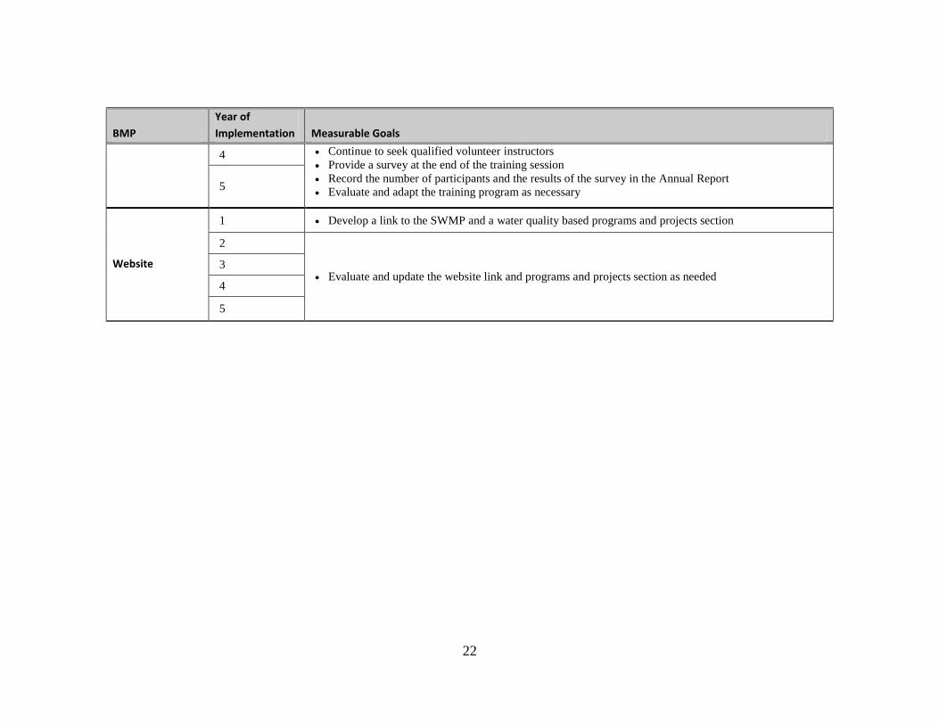
22
BMP
Year of
Implementation Measurable Goals
4 Continue to seek qualified volunteer instructors
Provide a survey at the end of the training session
Record the number of participants and the results of the survey in the Annual Report
Evaluate and adapt the training program as necessary 5
Website
1 Develop a link to the SWMP and a water quality based programs and projects section
2
Evaluate and update the website link and programs and projects section as needed 3
4
5
23
Illicit Discharge Detection and Elimination
One of the primary objectives of the illicit discharge detection and elimination program is to encourage operators to develop an extensive awareness of their storm sewer system and the potential situations that can result in an illicit discharge. Currently, Carnegie SVRA does not have a storm sewer system to manage storm water runoff from the site. Runoff from the park infiltrates into the subsurface, evaporates, or directly enters Corral Hollow Creek and its tributaries as surface water runoff. A storm drain system is not needed since less than 5 percent of the area is impervious. The majority of impervious area is not directly connected and not all non-storm water discharges are detrimental to the receiving waters. According to the General Permit, the following categories of non-storm water discharges do not need to be addressed and as such are not addressed in this illicit discharge detection and elimination program provided they are not a significant source of pollutants:
Water line flushing
Incidental runoff from landscaped areas
Diverted stream flows
Rising ground water
Uncontaminated ground water infiltration to separate storm sewers
Uncontaminated pumped ground water
Discharges from potable water sources
Foundation drains
Air conditioning condensation
Springs
Water from crawl space pumps
Footing drains
Individual residential car wash water
Flows from riparian habitats and wetlands
Dechlorinated swimming pool discharges
Pollutant Source Maps
The pollutant source maps can be found in Attachment D. Five facilities are monitored as part of
the illicit discharge detection elimination program and include the maintenance yard, the ranger
station, the store, the campground, and the water treatment facility. The baseline photos for the
photo points are included in Attachment E.

24
Illicit Discharge Detection and Elimination Program
The inspection forms for monthly and storm event inspections can be found in Attachment F.
Beginning in April, monthly inspections have been made for the facilities identified previously and
the inspections are included in Attachment G.
Notification Signage
An illicit discharge information panel was created and can be found in Attachment H. These signs will be posted at the store and in the campground. Additional signage is being drafted to warn visitors that illicit discharges are prohibited and make them more aware of the connectivity of conveyance systems to the creek.
Map 2. Illicit Discharge Detection and Elimination Program Monitoring Locations. The locations of the five facilities monitored as part of the illicit discharge detection and elimination
program. From left to right: maintenance yard, the ranger station, the store, the campground, and the water treatment facility

25
Table 3: Measurable Goals for Illicit Discharge Detection and Elimination BMPs
BMP
Year of
Implementation Measurable Goals
Pollutant Source
Mapping
1 Generate a map of pollutant sources within Carnegie SVRA
2
Update the pollutant source map as necessary 3
4
5
Illicit Discharge
Inspection and
Elimination
Program
1 Generate an inspection form for monthly and storm event inspections
Generate an inspection form for complaint-driven inspections and incidents
2
Begin conducing monthly and storm event inspections of pollutant sources
Update inspection forms to be consistent with pollutant source map
Implement complaint-driven illicit discharge inspection and elimination program
Record the number of complaints and responses in the Annual Report
3 Conduct monthly inspections of pollutant sources
Update inspection forms to be consistent with pollutant source map
Continue to implement complaint-driven illicit discharge inspection and elimination program
Record the number of complaints and responses in the Annual Report
4
5
Notification
Signage
1 Complete a draft of the informational sign
Identify the posting locations for each sign
2 Post all signs
3
Inspect, update, and maintain each sign 4
5
Educational
Materials
1
See Table 1
2
3
4
5

26
Construction Site Storm Water Runoff Control
Clearing, grubbing, and grading activities associated with construction sites can denude large areas of
vegetation, which can expose and destabilize the underlying soils. Since the natural erosion control
mechanisms are removed, sediment is more easily detached and entrained in surface water runoff.
Because of this, runoff from construction sites can have a significant impact on the quality of the
receiving waters.
Construction sites can be a source of a number of pollutants, including nutrients from fertilizers,
pesticides, oil and grease, alkalinity from concrete washouts, hydrocarbons from fuels, lubricants and
sealants, and construction debris. However, the primary pollutant of concern at construction sites is
sediment since it is available in such large quantities. Excess sediment can cause physical, chemical,
and biological harm to the receiving waters and reduce water quality. Particulate-bound pollutants,
such as heavy metals and hydrocarbons, can also be transported to the receiving waters with the
sediment.
Per the USEPA’s minimum requirements, permittees are required to develop, implement, and
enforce a program to minimize or prevent water quality impacts associated with runoff from all
construction sites greater than or equal to one acre. The program shall also include disturbances of
less than one acre if the disturbance is part of a larger common plan of development. This would
include any site or feature specific to the current or future General Plan.
Construction Site Inspection Form
The inspection form can be found in Attachment I. No construction project was greater than one
acre during the reporting period within the park boundary.
Presentation of Training Program
The first draft of the Microsoft PowerPoint presentation was developed by a consultant, RBF, and is
currently being revised based on staff comments. This version is available upon request. The
training quiz is also currently being developed.

27
Table 4: Measurable Goals for Construction Site Storm Water Runoff Control BMPs
BMP
Year of
Implementation Measurable Goals
Construction Site
Inspection
Program
1 Develop the construction site inspection forms
2
Conduct monthly SWPPP inspections of each active construction site
Summarize the number and nature of the deficiencies in the Annual Report
Review and update the construction site inspection form as necessary
3
4
5
BMP Manual
1 Continue to use the BMP Manual
2
Conduct monthly inspections of each active construction site for compliance with the BMP Manual
Summarize the number of deficiencies for each BMP in the Annual Report
Update the Manual to incorporate new innovative BMPs cross referenced with CASQA and CalTrans
specifications
3
4
5
Engineer
and
Contractor
Training
1 Develop the presentation phase of the training program
2
Develop the field-demonstration phase of the training program or find an existing BMP workshop
Generate the training quiz
Implement the training program
Summarize the effectiveness of the training in the Annual Report
3
Evaluate and update the training program and quiz
Summarize the effectiveness of the training in the Annual Report 4
5
28
Post-Construction Storm Water Management
Permanent storm water management and control is essential to protecting the quality of the state’s
receiving waters. New development and redevelopment projects can be a considerable source of
pollutants. If exposed to storm water runoff, these pollutants are readily transported into the
receiving waters through ditches and pipes or as sheet flow. Increases in impervious area associated
with new development and redevelopment typically increase the volume and peak flow rate of the
runoff, thus increasing the mobilization potential of the pollutants. Development of storm water
management controls and practices during the planning stages of new development and
redevelopment projects is one of the most effective and economical ways of meeting the
requirements of the General Permit and the storm water management objectives of this SWMP.
New development projects that require coverage under the General Permit consist of projects that
disturbed one or more acres of land during the construction phase. Similarly, redevelopment
projects are defined as projects that alter the footprint of an existing site or building in such a way
that there is a disturbance of at least one acre. At Carnegie SVRA, facility development and
modification could be considered new development or redevelopment projects. Each will have to
be evaluated for compliance requirements.
Post-construction storm water management primarily consists of non-structural and structural
BMPs. Non-structural BMPs include strategies and planning procedures for guiding growth and
development away from sensitive areas. Preservation of riparian zones, minimization of disturbance
and imperviousness, and maximization of open space are also considered non-structural BMPs.
Structural BMPs include treatment devices designed to reduce pollutants through sedimentation,
adsorption, decomposition, filtration, plant up-take and infiltration. Sediment basins, media
filtration, vegetated buffers and bioswales are all considered structural BMPs
This section’s measurable goals are being met and are reported in the next section.
29
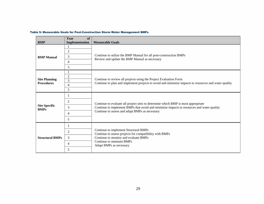
Table 5: Measurable Goals for Post-Construction Storm Water Management BMPs
BMP
Year of
Implementation Measurable Goals
BMP Manual
1
Continue to utilize the BMP Manual for all post-construction BMPs
Review and update the BMP Manual as necessary
2
3
4
5
Site Planning
Procedures
1
Continue to review all projects using the Project Evaluation Form
Continue to plan and implement projects to avoid and minimize impacts to resources and water quality
2
3
4
5
Site Specific
BMPs
1
Continue to evaluate all project sites to determine which BMP is most appropriate
Continue to implement BMPs that avoid and minimize impacts to resources and water quality
Continue to assess and adapt BMPs as necessary
2
3
4
5
Structural BMPs
1
Continue to implement Structural BMPs
Continue to assess projects for compatibility with BMPs
Continue to monitor and evaluate BMPs
Continue to maintain BMPs
Adapt BMPs as necessary
2
3
4
5

30
Pollution Prevention Good Housekeeping
The goal of proper pollution prevention and housekeeping practices is to ensure that routine operation and maintenance activities are conducted in a manner that minimizes the potential for pollutants to come in contact with storm water runoff. Typical operation and maintenance activities include equipment and vehicle fueling, repair, and maintenance, equipment and vehicle washing, roadway and trail repair, landscaping, vector and weed control, painting, sanitary waste removal, and litter control.
Routine operation and maintenance activities often require the use of chemicals and materials that can be detrimental to the quality of the receiving water including fuels, lubricants, paints, solvents, waste materials, fertilizers, insecticides, and herbicides. Proper storage and use of these materials can provide an effective and economical means of reducing pollutant-laden storm water runoff.
Employee Training
The first draft of the PowerPoint presentation was developed by a consultant, RBF, and is currently
being revised based on staff comments (See Figure 2). This version is available upon request. The
training quiz is also currently being developed.
Vehicle and Equipment Washing
Plans have been drafted for the vehicle and equipment washing facility. These plans are being reassessed due to quality concerns experienced in other park locations.
All other measurable goals for this section are continuing to be implemented.
Figure 2. Employee Training Presentation. This presentation is in the final revisions.

31
Table 6: Measurable Goals for Pollution Prevention/ Good Housekeeping BMPs
BMP
Year of
Implementation Measurable Goals
Employee
Training
1 Develop a training presentation for the maintenance personnel
Develop a quiz for the presentation
2
Implement the training program and quiz
Evaluate the training program and update accordingly
Summarize the effectiveness of the training in the Annual Report
3
4
5
Vehicle and
Equipment
Maintenance
1
Continue to implement the current vehicle and equipment maintenance procedures
2
3
4
5
Vehicle and
Equipment
Fueling
1
Continue to implement the current vehicle and equipment fueling procedures
2
3
4
5
Vehicle and
Equipment
Washing
1 Develop plans for a vehicle and equipment washing facility
Continue to use appropriate vehicle and equipment washing procedures
2
Continue to use appropriate vehicle and equipment washing procedures
Secure funds for the vehicle and equipment washing facility
Install vehicle and equipment washing facility when funds are available
3
4
5
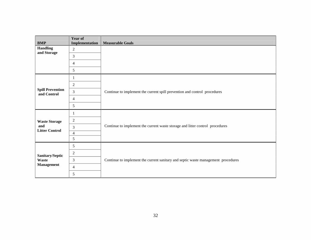
Material 1 Continue to implement the current materials handling and storage procedures
32
BMP
Year of
Implementation Measurable Goals
Handling
and Storage 2
3
4
5
Spill Prevention
and Control
1
Continue to implement the current spill prevention and control procedures
2
3
4
5
Waste Storage
and
Litter Control
1
Continue to implement the current waste storage and litter control procedures
2
3
4
5
Sanitary/Septic
Waste
Management
5
Continue to implement the current sanitary and septic waste management procedures
2
3
4
5

33
OHV Trails and Facilities Management
Introduction
This section is composed of the site background and monitoring results, along with a discussion.
Considering the monitoring cycle was not completed at press time, information to draw insights and
conclusions is limited. Sufficient monitoring data does exist for analysis of the current BMP
approach. This is also an opportunity to determine the best format for future reports.
Site Background
Trail systems have the potential to alter a landscape’s storm water drainage patterns. These
alterations can lead to higher rates of erosion and have a negative effect on storm water quality. For
this reason, careful consideration must be given to trails system design and layout. Once trails are
established, careful monitoring is warranted to ensure excessive erosion does not occur.
While most of the SVRA’s facilities are found within the flood plain of Corral Hollow Creek, the
trail system is primarily located in the steep hills to the south of the creek. These hills have four well
defined sub-watersheds which drain to Corral Hollow Creek. There are several smaller drainages
which drain to Corral Hollow Creek, typically in the form of sheet flow. The trail system itself is
divided into two areas: open-riding and trails-only. Approximately half of the trail system, the north
side, is open-riding, which typically consists of grassland habitat with durable clay soils. While park
visitors are generally free to travel throughout this area, many portions, including the hill slopes
adjacent to the valley floor, have been fenced and closed in order to maintain vegetation cover and
limit erosion. The other half is the trails-only area, which consists mostly of coastal scrub, oak
woodlands and friable sand/loam soils. Here, visitors are required to stay on established trails and
fencing, along with signage and law enforcement actions, is used to increase compliance.
The trails are categorized as primary, secondary, tertiary, and other. The primary trails are accessible
by all sizes of vehicles including emergency vehicles. The secondary trails are accessible to ATVs
and motorcycles. The tertiary trails are limited to motorcycle use. Lastly, the “other” trails are
voluntary trails which have been created by unauthorized OHV recreation. The primary and
secondary trails receive annual maintenance which includes grading, out sloping, installing and
reconditioning of BMPs, removing outside berms and pruning vegetation. Tertiary trails are
maintained as needed, often by hand. The “other” trails are targeted for closure.
Exclusion of OHV activities occurs throughout the park. Access for OHV use has been restricted
in several areas of the park in order to improve storm water quality and protect natural and cultural
resources. For example, 70 acres of the Corral Hollow Creek floodplain is permanently closed to
OHV activity using split-rail fencing. Designated creek crossings were installed for park visitors to
travel from parking and staging facilities to the trail system south of the creek. A minimum 75 foot
buffer was established between the creek and recreational use for a majority of the creek’s reach. In
a few areas, the creek meanders within 75 feet of established park facilities or historic sites. While

34
the maximum allowable flood plain area has been closed in these instances, meeting the 75 foot goal
would significantly alter park operations. Solution measures are being explored which involve
realigning portions of the creek and reestablishing riparian vegetation within the closure zone, which
will also improve creek function. The closed areas are heavily patrolled by the park’s law
enforcement officers in order to achieve a high level of compliance from the public. The public is
restricted to five creek crossings, two of which are hard-surfaced. (Hard-surfacing is being planned
for each crossing). The closure of portions of the flood plain will allow for a vegetative buffer
between the creek and OHV use areas. This vegetative buffer allows for the storm water to slow
and sediments to settle prior entering the creek.
Just upslope of the creek, running the length of the park unit, are several steep hills that were used
for OHV recreation during the 20th century. In 2002, these hills were closed to the public due to the
proximity to the creek and the difficulty of settling the sediment out of the storm water. Most of the
hills were restored to a more natural contour while others have recovered naturally. Use is still
allowed on one hill, known as the hillclimb facility, for occasional competitive hillclimbing events
only. This hill has a berm at the bottom to collect sediment and capture storm water, and the
hillside is seeded and covered with straw twice each year.
Throughout the park, pockets of sensitive areas are closed permanently to OHV use. These include
culturally significant sites including the Carnegie Brick and Pottery Company ruins and Carnegie
lime kiln and quarry site. Environmentally sensitive areas are also closed for various reasons. For
example, the exclusion of OHV activity from the lower sections of the main tributaries and the
sediment basins protect breeding habitat of amphibian species as well as storm water quality. As a
part of the park’s strategic trail plan (see Trails Plan section), all major drainages will be targeted for
protective measures using fencing, rock, and/or landscape features to ensure OHV use is limited.
In other instances, portions of the park are closed temporarily in order to repair and rehabilitate the
trails and habitat. These closures allow for vegetation to become reestablished providing clearer
distinctions between sanctioned trails and unauthorized routes. A unique example of this
management tactic was utilized when the 2009 Corral Fire burnt approximately two hundred acres
of vegetation within the park. The result was a barren landscape. The area was subsequently closed
to the public in order to allow the vegetation to recover and ensure no off trail riding occurred. The
trail system and all erosion features were rehabilitated and this area was opened in 2011 (aka Kiln-
East RMA).
Hillside rehabilitation activities are performed throughout the year to reduce the density of trails,
prevent soil loss, and restore habitat. Typically, these activities include permanent removal of
unauthorized trails by closing, re-contouring, seeding, and protecting the hillside. Denuded areas are
often seeded with a native grass and legumes seed mix, along with mulch and tackifier. Fiber rolls
are also installed across the slopes to slow storm water velocity. The rolls are spaced 20 to 50 feet
apart, depending on hill slope and contour, and are anchored with wooden stakes every four feet.
35
Occasionally, in certain grassland areas, fiber rolls are installed with biodegradable jute netting to
create a mutually-reinforcing system. Monitoring and evaluation of these BMPs reveal that project
activities and erosion control materials are highly effective in minimizing erosion, stabilizing soil and
rapidly reestablishing vegetation. These types of projects have been implemented for many years
and reaffirm that we are successfully selecting, installing, monitoring and maintaining the BMPs
which protect and improve water quality to the maximum extent practicable.
The Trails Plan
Although several projects and programs were developed and implemented successfully, there was a
need to consolidate the years of experience and outline a strategy to provide for more substantial
environmental improvements. The trails program is a strategy developed by the park to address a
variety of trail issues. It distills the years of experience in rehabilitation and park management along
with the OHV BMP manual into one cohesive approach aimed at reducing voluntary trails,
increasing vegetation cover, improving water quality, protecting habitat and providing a quality
recreational experience.
A new trails program was adopted in 2009. This program uses the lessons of the past to derive the
key principals that make up the foundation of the new plan. Similar to the SWMP program, the goal
of this program is to protect the health of the soil and bring the trails system into a well-managed
trail network. The principals that guide this plan are:
The new approach is long term. The problem can often be fixed within one or two seasons but may take several years of monitoring and possible maintenance to ensure sustainability.
Individual projects use a three-tiered approach of physical barriers, education, and enforcement to help ensure off-trail riding does not reoccur.
The implementation of the trails program focuses on one resource management area with subsequent projects being implemented within adjacent areas. This continuity helps with enforcement and education.
Individual projects are designed with sustainable trails that anticipate upcoming projects in the adjacent areas. This is done in order to provide connectivity from one project area to another resulting in an improved park wide trails network and better recreational experience, thereby lessoning the temptation to go off-trail.
The type of riding use allowed is determined by soil characteristics. Some soils are durable enough to allow for longer vertical trails while other areas only permit trails that are cross slope, with frequent breaks in grade.

36
Resource Management Areas
Following these principals, resource management areas (RMAs) have been established for the park.
The RMAs are discrete zones established to better plan and implement management activities of
areas that share common characteristics. For the most part, the RMAs were divided by sub-
watersheds and cover the entire SVRA (Map 3).
Implementing the SWMP Tactics
The trails program utilizes five of the six erosion control tactics of the SWMP program and two of
the three sediment control tactics.
Erosion Control
Reduce trail density
Break hydrological connections
Reduce the velocity of concentrated flows
Develop sustainable trails
Educate the OHV user to “stay on trail”
Sediment Control
Increase vegetation cover near drainages
Slow and settle storm water in the sub-tributaries
RMA Rehabilitation Projects-The Process
Scoping: Rehabilitating a RMA begins with a scoping meeting that identifies the problems and goals
for each project. The project planning process takes into consideration several items including trail
layout, connectivity, emergency access, user interest, enforcement strategy, education methods,
buffer zones and a timeline for completion of the project.

37
Map 3. Resource Management Areas. Corral Hollow, SRI-Loop, and Kiln-East RMAs are completed and open as “trails-only”.
Although open, Kiln-West and Los Osos RMAs are currently undergoing rehabilitation efforts.
38
Rehabilitation: The on-the-ground rehabilitation work begins with identifying any trails that have
proven to be sustainable and that do not convey high concentrations of storm water elsewhere.
These trails are usually incorporated into the RMAs trail network. Trails that have been identified as
erosive per the soil conservation programs dataset are eliminated from the trails network and the
area restored. Eliminating these trails from the network often involves using heavy equipment to
place soil back on the hillside and bring the hillside back to grade. Once in place, the soil is
protected using BMPs from the OHV BMP manual. Typically, the BMPs used are a combination of
straw wattles, which prevent the concentration of water, and hydro mulch, which protects the soil
from precipitation. If the hydro mulch machine is unable to access the area then straw is used to
cover the bare soil. Staff is trained in proper implementation techniques and the work is supervised
by experienced rehabilitation specialists. These efforts result in an overall reduction in trail density
for the area, along with a shortening of hydrological connections, two tactics outlined in this
program. Special attention will be given to developing buffer zones near drainages by limiting trail
density and soil disturbance within these areas to provide adequate bio-filtration (sediment control).
Once the rehabilitation is complete, the focus turns toward providing sustainable trail access. Over
the past several years, park personnel have received classroom and field training from Trails
Unlimited, an enterprise of the U.S. Forest Service, on proper trail design and construction to
achieve minimal impact on the soil and habitat. This is achieved primarily by preventing
accumulation of storm water using a BMP called breaks-in-grade. By changing the elevation to a
positive grade at regular intervals, storm water volume is divided into lower concentrations. Most of
these methods have been used in the park for several years and have shown high levels of success.
The most innovative approach to the trails plan has been a redesign of the methods used to protect
the trails and restored areas. In the past, drift fencing was the primary tool to keep riders off of a
rehabilitated area. In this plan, fencing will be used differently. Each rehabilitated RMA will now
have perimeter fencing with access gates at the entry points. If/when voluntary trails are created the
access gates are closed for a predetermined amount of time to allow for staff to make repairs and to
reinforce the trails only message. The progress of this methodology is discussed in the next section.
Education: The public education and outreach component of the trail plan includes tours,
brochures, and interpretive panels. State Park Peace Officers (SPPO) lead tours for park visitors
through newly rehabilitated areas to discuss the issues of off-trail riding and the park’s plan
regarding future riding opportunity. These tours give mangers an opportunity to hear from the
public about the trail plan and incorporate any suggestions into future projects. Just as important,
this provides a forum to discuss and educate the public on the negative effects of off-trail riding.
Only a fraction of the users can attend the tours, so other educational methods are warranted. Large
interpretation panels are posted throughout the park and handouts are distributed at the front kiosk.
Similar to the tours, the literature explains the issues associated with high trail density, rehabilitation
efforts, and the importance of protecting and improving water quality.

39
Enforcement: After the rehabilitation work is completed and the area is open to the public, the
RMA is heavily patrolled by SPPOs. Off-trail violations will result in temporary closure of the entire
area and citation(s) are given to the offender(s) when possible. This is critical to ensure the areas do
not relapse into eroded hillsides and rutted trails. The violations that resulted in the closure are
highly publicized so the users understand the consequences of riding off-trail. This publicized
message is inclusive of photos and details of the damage and displayed on the bulletin boards at the
trail head and at the kiosk.
40
Figure 3. OHV Trails and Facilities Adaptive Management Flowchart.
41
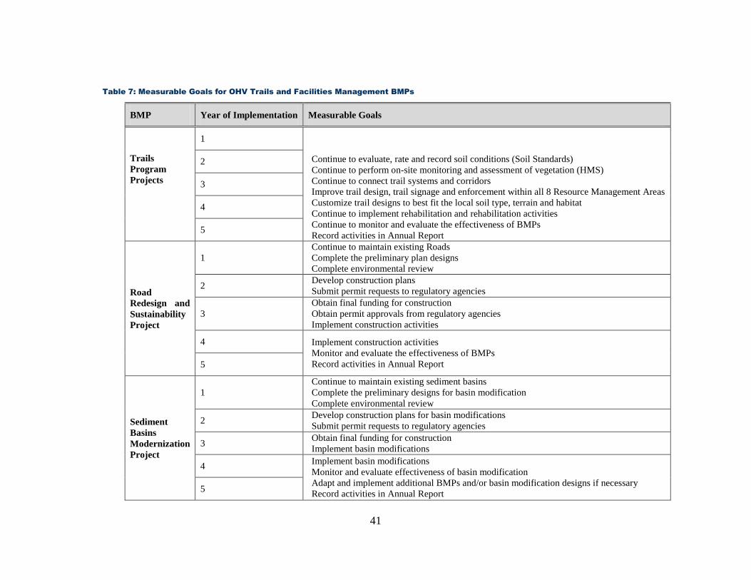
Table 7: Measurable Goals for OHV Trails and Facilities Management BMPs
BMP Year of Implementation Measurable Goals
Trails
Program
Projects
1
Continue to evaluate, rate and record soil conditions (Soil Standards)
Continue to perform on-site monitoring and assessment of vegetation (HMS)
Continue to connect trail systems and corridors
Improve trail design, trail signage and enforcement within all 8 Resource Management Areas
Customize trail designs to best fit the local soil type, terrain and habitat
Continue to implement rehabilitation and rehabilitation activities
Continue to monitor and evaluate the effectiveness of BMPs
Record activities in Annual Report
2
3
4
5
Road
Redesign and
Sustainability
Project
1
Continue to maintain existing Roads
Complete the preliminary plan designs
Complete environmental review
2 Develop construction plans
Submit permit requests to regulatory agencies
3
Obtain final funding for construction
Obtain permit approvals from regulatory agencies
Implement construction activities
4 Implement construction activities
Monitor and evaluate the effectiveness of BMPs
Record activities in Annual Report 5
Sediment
Basins
Modernization
Project
1
Continue to maintain existing sediment basins
Complete the preliminary designs for basin modification
Complete environmental review
2 Develop construction plans for basin modifications
Submit permit requests to regulatory agencies
3 Obtain final funding for construction
Implement basin modifications
4 Implement basin modifications
Monitor and evaluate effectiveness of basin modification
Adapt and implement additional BMPs and/or basin modification designs if necessary
Record activities in Annual Report 5
42
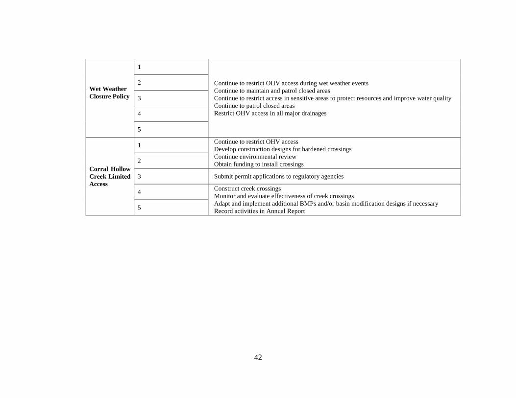
Wet Weather
Closure Policy
1
Continue to restrict OHV access during wet weather events
Continue to maintain and patrol closed areas
Continue to restrict access in sensitive areas to protect resources and improve water quality
Continue to patrol closed areas
Restrict OHV access in all major drainages
2
3
4
5
Corral Hollow
Creek Limited
Access
1 Continue to restrict OHV access
Develop construction designs for hardened crossings
Continue environmental review
Obtain funding to install crossings 2
3 Submit permit applications to regulatory agencies
4 Construct creek crossings
Monitor and evaluate effectiveness of creek crossings
Adapt and implement additional BMPs and/or basin modification designs if necessary
Record activities in Annual Report 5

43
RMA Discussion
The trails program continued with the RMA model of rehabilitating areas with the goal of reopening themfor trails-only recreation. During this reporting period, rehabilitation efforts and planning for the next two RMA rehabilitations continued (see Table 8). As a recap, Corral Hollow Creek RMA was established and operational in 2009, the SRI Loop RMA reopened in January of 2011 and the Kiln East RMA reopened in October of 2011. Currently, this model makes up 27 percent (410 ac) of the park. The planning and rehabilitation efforts are now focused on the Kiln West and the Los Osos RMAs. Introduced during this reporting period is a new concept to the strategy called Sub-RMAs which focus on smaller areas within the larger RMA. Four sub-RMAs are actively being worked on or nearing the initiation of rehabilitation efforts: Black Bear, Zone 47, the 4x4 Facility, the Hillclimb Facility (see Map 5). Table 8 summarizes the status of each RMA and Sub-RMA in regards to the planning effort. Table 9 summarizes the data included in this section or attached to this report.
The early monitoring results suggest the RMA model in general is effective and it is an appropriate approach for achieving the park’s water quality objectives. As stated earlier, sediment is a pollutant of concern for the park and one of the ways to address this concern is increasing vegetation cover and provide for long term protection. In general, the photo points collected during this reporting period show an increase in vegetation cover (see Attachment J) and little to no off-trail activity in the RMAs completed. Although violations and off-trail riding do occur (see Table 10), the photos show that, at least in the field of view, they do not persist. This is likely a result of a combination of education, visitor cooperation, enforcement, physical barriers, and signage. Figure 4 shows the damage observed during the December 2012 offense. This is the typical level of damage that would trigger a closure or citation.
Table 8: RMA Status
RMAs SubRMAs Status Comments Acres
4x4 Facility PlanningBMPs are planned to be installed and protection for
vegetation buffer increased9
Hillclimb Facility Planning
BMPs are being planned to improve/extend the berm,
improve the parking surfaces, and providing for a vegeation
buffer
9
Remaining Areas Complete, Monitoring ongoingSplit rail fence installed in February 2012. As a result, no
citations have been issued142
SRI Loop - Complete, Monitoring ongoing Five closures, three citations during reporting period. 108
Kiln East - Complete, Monitoring ongoing Three closures during reporting period 140
Black BearPlanning, Rehabilitation
activities
Perimeter fencing is being installed, off-trail acitivity is being
rehabbed, trail design and circulation is being planned.27
Remaining AreasPlanning, Rehabilitation
activitiesDrift fencing 178
Zone 47Rehabilitation Activities
Complete
Perimeter fencing was installed, off-trail acitivity has been
rehabed, trail design and circulation is being planned.
Planned to be opened in the Fall of 2013.
8
Remaining Areas Routine maintenance and monitoring on-going 187
Hillclimb Facility PlanningPlanning for improvements to the middle track trail are
beginning41
Remaining Areas
Maintenance on-going with
planning to follow completion
of other RMAs
Routine maintenance and monitoring on-going 136
Dead Cow Canyon -
Maintenance on-going with
planning to follow completion
of other RMAs
Routine maintenance and monitoring on-going 195
Franciscan -
Maintenance on-going with
planning to follow completion
of other RMAs
Routine maintenance and monitoring on-going 145
TransAm - Planning, Restoration activities Routine maintenance and monitoring on-going 196
Kiln West
Corral Hollow Creek
Los Osos
Carrol Canyon
44
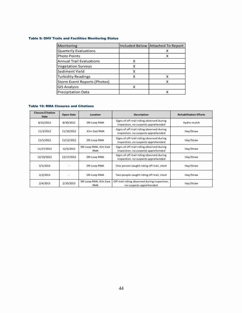
Table 9: OHV Trails and Facilities Monitoring Status
Monitoring Included Below Attached To Report
Quarterly Evaluations X
Photo Points X
Annual Trail Evaluations X
Vegetation Surveys X
Sediment Yield X
Turbidity Readings X X
Storm Event Reports (Photos) X
GIS Analysis X
Precipitation Data X
Table 10: RMA Closures and Citations
Closure/Citation
DateOpen Date Location Description Rehabilitation Efforts
8/22/2012 8/30/2012 SRI Loop RMASigns of off-trail riding observed during
inspection, no suspects apprehendedHydro-mulch
11/3/2012 11/10/2012 Kiln East RMA Signs of off-trail riding observed during
inspection, no suspects apprehendedHay/Straw
11/5/2012 11/12/2012 SRI Loop RMASigns of off-trail riding observed during
inspection, no suspects apprehendedHay/Straw
11/27/2012 12/5/2012SRI Loop RMA, Kiln East
RMA
Signs of off-trail riding observed during
inspection, no suspects apprehendedHay/Straw
12/10/2012 12/17/2012 SRI Loop RMASigns of off-trail riding observed during
inspection, no suspects apprehendedHay/Straw
2/1/2013 - SRI Loop RMA One person caught riding off-trail, cited Hay/Straw
2/2/2013 - SRI Loop RMA Two people caught riding off-trail, cited Hay/Straw
2/4/2013 2/10/2013SRI Loop RMA, Kiln East
RMA
Off-trail riding observed during inspection,
no suspects apprehendedHay/Straw

45
Figure 4. SRI Loop RMA Off-trail Violation, Dec. 2012. This RMA was closed for one week due to this violation.
Figure 5. Off-trail Riding Correction Measure. Immate crews are often used to implement corrective measures. Hay is typically spread over the exposed soils to reduce raindrop erosion and
also to communicate to visitors that the created trail is not sanctioned.
Corral Hollow RMA
One of the more diverse RMAs is the Corral Hollow Creek RMA as it includes many biological, cultural, operational, and recreational values. The Corral Hollow Creek RMA was established in 2009 with the aim of formalizing the recreational and natural boundaries. Ensuring a vegetation buffer between the recreation activity and the creek helps improve water quality. The first methodology used to create this delineation was the installation of several signs spaced evenly apart (approximately 25ft). In February 2012 the signs were replaced with a split-rail fence. In general, the photos show the exclusion zone as being successful in preventing unwanted recreation within the setbacks and some signs of vegetation reestablishing, although the vegetation appears to be recolonizing at a slow rate. The time elapsed between many of the photos was three years. In that
46
time, the park has experienced both a wet winter (2011) and two dry winters (2012 and 2013). Perhaps the dry conditions these past two winters have slowed the regrowth of the riparian habitat. Monitoring of vegetation will continue and if the passive rehabilitation continues slowly then active rehabilitation methods will be considered. This rehabilitation can potentially accompany the sediment basin modernization project (see Project Summary section below) since portions of the creek will need to be realigned as part of that effort. Vegetation surveys (see the Vegetation Surveys section below) were also conducted this year and the results show an increase in the cover grasses/forbes from 33 percent (2010) to 43 percent (2013). Tree cover and shrub cover essentially remained unchanged. As a result of the high flows during the winter of 2011, channelization and braiding increased from 4 percent to 15 percent between survey periods. Two areas within the Corral Hollow Creek RMA have been identified as needing improvements. These two areas, the hillclimb facility and the 4x4 area, are within the RMA and have been identified as Sub-RMAs. As for the 4x4 area the plan is to address some of concerns regarding the recreations proximity to the creek and the unimproved recreational surfaces. Plans have been drawn to increase the setbacks between this area and the creek by approximately 200 ft. Some of the unimproved areas will be hardened with rock and articulated concrete block (see Map 4). These measures will be implemented in the 2013/14 reporting cycle. As for the hillclimb facility, planning is underway to improve the parking surface and access roads and build up the existing berm at the base of the hill (see Project Summary section below). See Map 5 for the spatial locations of the two Sub-RMAs. SRI Loop RMA
The SRI Loop RMA was re-opened in January of 2011 for trails-only recreation. This RMA has approximately 1.08 mi of trail. Immediately prior to this project, the total amount of trail was around 5 mi open within the RMA. This RMA has shown improvements in regards to vegetation recovery and storm water quality as compared to pre-rehabilitation conditions (see Attachment J). This was the pilot test for the RMA model which relies primarily on visitor education and park enforcement to keep visitors on established trails. Using the available monitoring data, the RMA model appears to be highly effective in this area. The quarterly monitoring reports (see Attachment N) show very little to no flow during winter storms observed. Although not quantitative, the pre-rehabilitation condition of the area showed a significant rut near the eastern shoulder of the road suggesting high flows in the area. Since the rehabilitation activities reduced trail density and established vegetation, almost all of the subsequent storm water runoff has infiltrated into the soil and little flow has been observed in the drainage. Perhaps this is due to the drier winters but 2011 year’s observations were similar and it was a wetter than average year. Most importantly, the photo points (see Attachment J) also convey an area that is managed with high amounts of vegetation cover and little off-trail activity. During the reporting period, the area was closed four times and three citations were issued for off-trail activity (see Table 10).
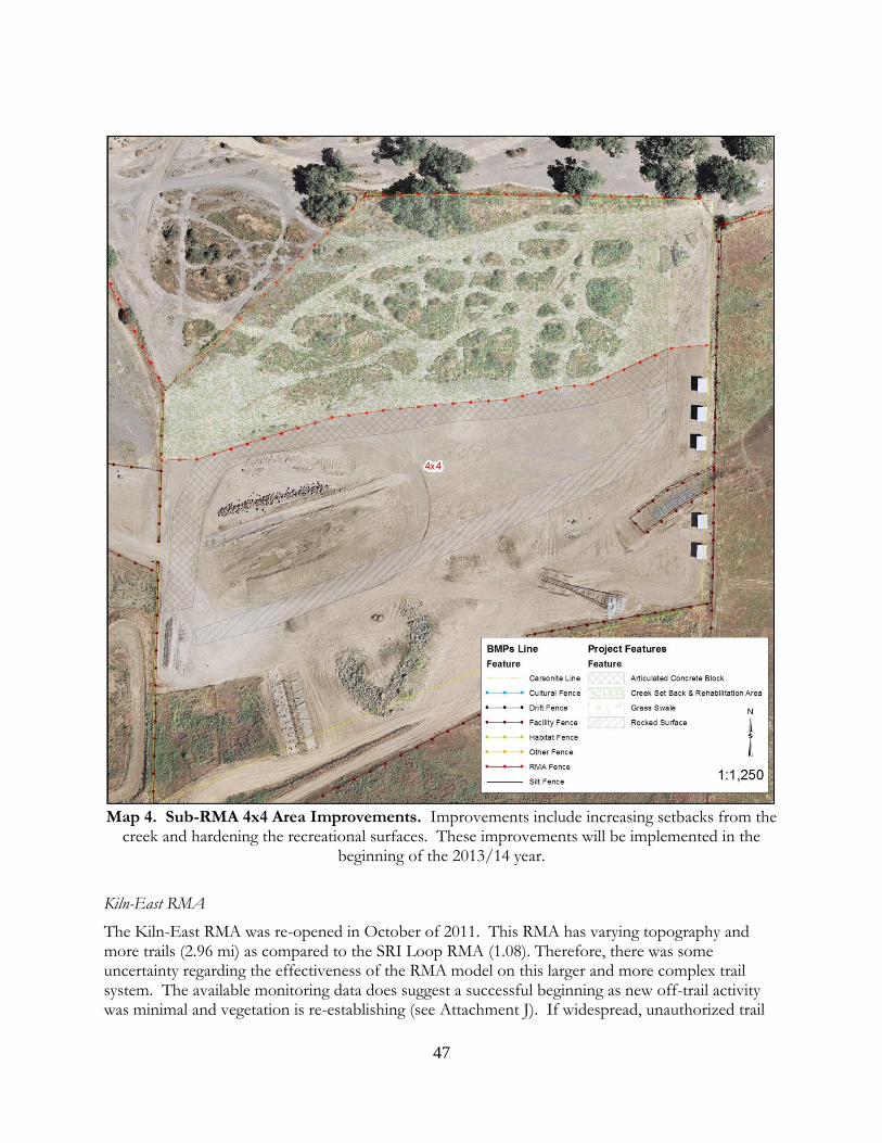
47
Map 4. Sub-RMA 4x4 Area Improvements. Improvements include increasing setbacks from the
creek and hardening the recreational surfaces. These improvements will be implemented in the beginning of the 2013/14 year.
Kiln-East RMA
The Kiln-East RMA was re-opened in October of 2011. This RMA has varying topography and more trails (2.96 mi) as compared to the SRI Loop RMA (1.08). Therefore, there was some uncertainty regarding the effectiveness of the RMA model on this larger and more complex trail system. The available monitoring data does suggest a successful beginning as new off-trail activity was minimal and vegetation is re-establishing (see Attachment J). If widespread, unauthorized trail

48
use was occurring then it would be apparent in these landscape level photographs (see Figure 6). This level of compliance has been achieved with three closures of the RMA (see Table 10) within this reporting period.
Figure 6. The Kiln East RMA. This photo of Kiln East RMA was taken in April 2013 and shows
no obvious signs of off-trail riding. Although some off-trail riding did occur, it is limited.

49
Map 5. The Status of the RMAs and the Sub-RMAs. “Completed” means most of the measures are in place. Through monitoring or
other means, areas can be improved to protect the natural and cultural environment and provide recreation.
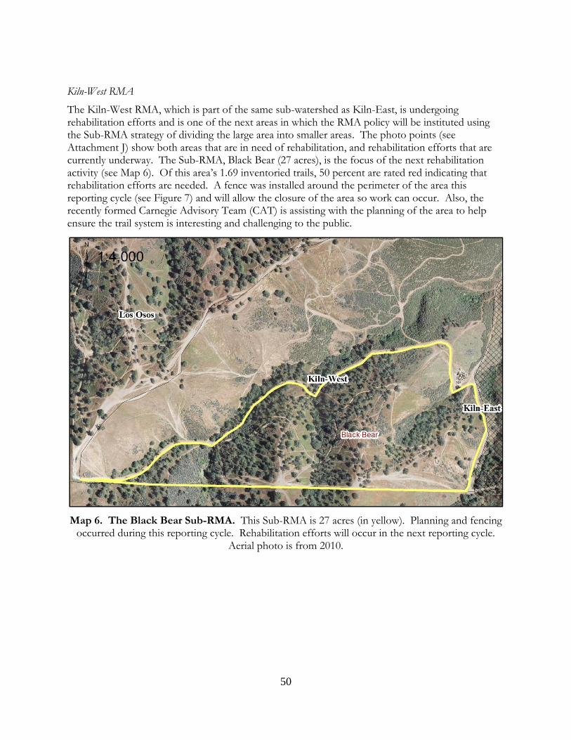
50
Kiln-West RMA
The Kiln-West RMA, which is part of the same sub-watershed as Kiln-East, is undergoing rehabilitation efforts and is one of the next areas in which the RMA policy will be instituted using the Sub-RMA strategy of dividing the large area into smaller areas. The photo points (see Attachment J) show both areas that are in need of rehabilitation, and rehabilitation efforts that are currently underway. The Sub-RMA, Black Bear (27 acres), is the focus of the next rehabilitation activity (see Map 6). Of this area’s 1.69 inventoried trails, 50 percent are rated red indicating that rehabilitation efforts are needed. A fence was installed around the perimeter of the area this reporting cycle (see Figure 7) and will allow the closure of the area so work can occur. Also, the recently formed Carnegie Advisory Team (CAT) is assisting with the planning of the area to help ensure the trail system is interesting and challenging to the public.
Map 6. The Black Bear Sub-RMA. This Sub-RMA is 27 acres (in yellow). Planning and fencing occurred during this reporting cycle. Rehabilitation efforts will occur in the next reporting cycle.
Aerial photo is from 2010.
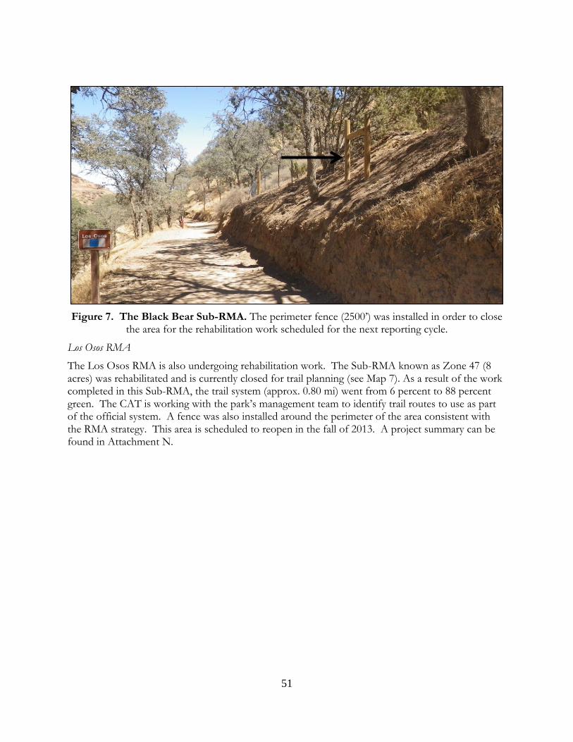
51
Figure 7. The Black Bear Sub-RMA. The perimeter fence (2500’) was installed in order to close the area for the rehabilitation work scheduled for the next reporting cycle.
Los Osos RMA
The Los Osos RMA is also undergoing rehabilitation work. The Sub-RMA known as Zone 47 (8 acres) was rehabilitated and is currently closed for trail planning (see Map 7). As a result of the work completed in this Sub-RMA, the trail system (approx. 0.80 mi) went from 6 percent to 88 percent green. The CAT is working with the park’s management team to identify trail routes to use as part of the official system. A fence was also installed around the perimeter of the area consistent with the RMA strategy. This area is scheduled to reopen in the fall of 2013. A project summary can be found in Attachment N.

52
Map 7. Zone 47 Sub-RMA. This Sub-RMA is within the Los Osos RMA and is 8 acres in size. In this reporting cycle, all of the rehabilitation work was completed to reduce the off-trail riding. Aerial
photo is from 2010.

53
Figure 8. Rehabilitation Work in Zone 47. The photos are of the Zone 47 Sub-RMA and show the rehabilitation work done to eliminate the some of the off-trail riding in the area.
Storm Water Monitoring
The results of the storm water monitoring are below (see Table 11). This data can be used to evaluate the effectiveness of the BMPs chosen as part of the strategy. Total suspended solids and turbidity data were both collected to explore the possible correlation between these two measurements. Storm event reports can be found in Attachment M. See Map 8 for sampling locations.
Table 11: Turbidity (NTU) and Total Suspended Solids (TSS) Data for BMP Monitoring Effectiveness
Start Date End Date CHC In Ty 1 Ty 2 Car 1 Car 2 Kiln 1 Kiln 2 CHC Out
11/30/2012 11/30/2012 0.92 #1 No Flow 22000/14400 No Flow 15300/12500 15000/12300 8210/9790 No Flow No Flow
12/2/2012 12/2/2013 0.79 #1 No Flow 22900/1420 No Flow 35600/821 43200/260 6480/3130 5310/3310 17600/952
12/5/2012 12/5/2012 0.53 #1 No Flow 27500/246 6450/816 27700/298 25100/244 5680/837 1390/436 32200/106
#1 No Flow 43000/217 3590/695 45000/164 40500/98 16600/702 6810/814 14500/452
#2 ND/6 NS NS NS NS NS NS 31/83
1/5/2013 1/6/2013 0.36 #1 No Flow 23000/2 No Flow 20500/4 No Flow 7280/62 No Flow No Flow
Storm Event Precip Total
(Inches)Inspection
Monitoring Locations (TSS/NTU)
12/22/2012 12/25/2012 2.25
July 2012 March 2013

54
Map 8. BMP Monitoring-Turbidity Locations.

Wet Weather Closures
Wet weather closures occurred at least five times this reporting cycle (see Table 12). Once precipitation reaches the identified thresholds the trailhead gates are closed and recreational access to the hills is restricted. The hills remain closed for minimum of 24 hours and only reopened once condition assessments determined the soils are stable and safety concerns are minimalized.
Table 12: Wet Weather Closures
Closure Date Closure Time Opening Date Opening TimeStorm Event Precipitation
(Inches)
11/30/2012 800 12/1/2012 830 0.92
12/2/2012 800 12/3/2012 850 0.79
12/5/2012 800 12/6/2012 850 0.53
12/22/2012 800 12/24/2012 1200 2.25
1/6/2013 800 1/7/2013 1500 0.36
Figure 9. Wet Weather Closures. These closures occurred five times this reporting cycle.
The wet weather closures are currently based on estimates derived from hydrological models. Since conditions can be affected by other factors like wind, temperature, and duration since
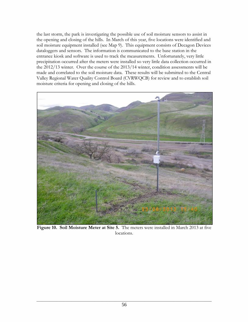
________________________________________________________________________________________________
56
the last storm, the park is investigating the possible use of soil moisture sensors to assist in the opening and closing of the hills. In March of this year, five locations were identified and soil moisture equipment installed (see Map 9). This equipment consists of Decagon Devices dataloggers and sensors. The information is communicated to the base station in the entrance kiosk and software is used to track the measurements. Unfortunately, very little precipitation occurred after the meters were installed so very little data collection occurred in the 2012/13 winter. Over the course of the 2013/14 winter, condition assessments will be made and correlated to the soil moisture data. These results will be submitted to the Central Valley Regional Water Quality Control Board (CVRWQCB) for review and to establish soil moisture criteria for opening and closing of the hills.
Figure 10. Soil Moisture Meter at Site 5. The meters were installed in March 2013 at five
locations.
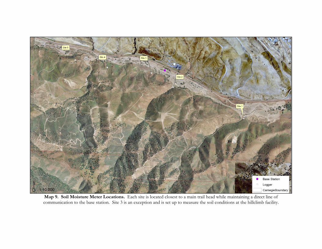
Map 9. Soil Moisture Meter Locations. Each site is located closest to a main trail head while maintaining a direct line of communication to the base station. Site 3 is an exception and is set up to measure the soil conditions at the hillclimb facility.
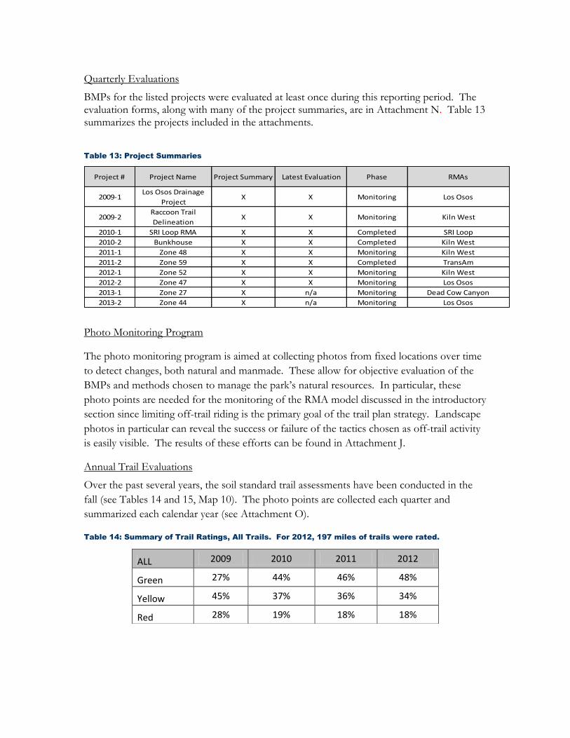
Quarterly Evaluations
BMPs for the listed projects were evaluated at least once during this reporting period. The evaluation forms, along with many of the project summaries, are in Attachment N. Table 13 summarizes the projects included in the attachments.
Table 13: Project Summaries
Project # Project Name Project Summary Latest Evaluation Phase RMAs
2009-1Los Osos Drainage
ProjectX X Monitoring Los Osos
2009-2Raccoon Trail
DelineationX X Monitoring Kiln West
2010-1 SRI Loop RMA X X Completed SRI Loop
2010-2 Bunkhouse X X Completed Kiln West
2011-1 Zone 48 X X Monitoring Kiln West
2011-2 Zone 59 X X Completed TransAm
2012-1 Zone 52 X X Monitoring Kiln West
2012-2 Zone 47 X X Monitoring Los Osos
2013-1 Zone 27 X n/a Monitoring Dead Cow Canyon
2013-2 Zone 44 X n/a Monitoring Los Osos
Photo Monitoring Program
The photo monitoring program is aimed at collecting photos from fixed locations over time
to detect changes, both natural and manmade. These allow for objective evaluation of the
BMPs and methods chosen to manage the park’s natural resources. In particular, these
photo points are needed for the monitoring of the RMA model discussed in the introductory
section since limiting off-trail riding is the primary goal of the trail plan strategy. Landscape
photos in particular can reveal the success or failure of the tactics chosen as off-trail activity
is easily visible. The results of these efforts can be found in Attachment J.
Annual Trail Evaluations
Over the past several years, the soil standard trail assessments have been conducted in the
fall (see Tables 14 and 15, Map 10). The photo points are collected each quarter and
summarized each calendar year (see Attachment O).
Table 14: Summary of Trail Ratings, All Trails. For 2012, 197 miles of trails were rated.
ALL 2009 2010 2011 2012
Green 27% 44% 46% 48%
Yellow 45% 37% 36% 34%
Red 28% 19% 18% 18%

________________________________________________________________________________________________
59
Table 15: Summary of RMA Trail Ratings. The percentages are based on trial mileage. A small
percentage of trails do not get evaluated since they may have been cataloged after the annual
evaluations. These trails will be evaluated the next annual cycle.
RMA Rating 2009 2010 2011 2012
Corral Hollow Creek
Green 55% 90% 92% 92%
Yellow 34% 2% 2% 2%
Red 5% 1% 0% 0%
SRI Loop
Green 46% 91% 98% 98%
Yellow 35% 9% 2% 2%
Red 19% 0% 0% 0%
Kiln East
Green 26% 64% 74% 86%
Yellow 22% 15% 11% 2%
Red 44% 13% 7% 4%
Kiln West
Green 28% 48% 49% 52%
Yellow 38% 31% 30% 28%
Red 35% 21% 22% 20%
Los Osos
Green 40% 43% 36% 38%
Yellow 31% 30% 35% 32%
Red 29% 26% 29% 30%
Carrol Canyon
Green 41% 50% 53% 52%
Yellow 40% 35% 33% 30%
Red 20% 15% 14% 18%
Dead Cow
Green 31% 41% 40% 44%
Yellow 59% 50% 52% 46%
Red 10% 9% 8% 10%
Franciscan
Green 16% 22% 20% 23%
Yellow 39% 36% 38% 35%
Red 40% 37% 37% 38%
Trans Am
Green 26% 39% 36% 41%
Yellow 42% 45% 48% 45%
Red 32% 16% 15% 14%
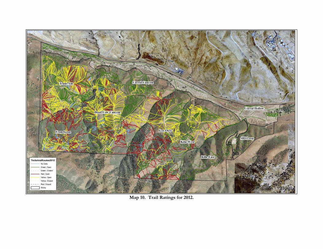
Map 10. Trail Ratings for 2012.

________________________________________________________________________________________________
61
Map 11. Trail Types for 2012.

Vegetation Surveys
The vegetation/trail density surveys were completed for the riparian habitat (see Table 16). Data collection for the blue oak habitat is near completion for 2013 and results will be available for the 2014 annual report. The protocols for the vegetation surveys can be found in the parks habitat monitoring report.
Table 16: Results of Vegetation Surveys within the Riparian Habitat. Some segments of the
transect sample were closed to OHV recreation in the SVRA (2010: 63%, 2013: 66%).
2010 2013 2010 2013 2010 2013
SVRA (n=10) 33% 43% 2% 3% 7% 7%
Control (n=9) 91% 91% 7% 7% 3% 4%
2010 2013 2010 2013 2010 2013
SVRA (n=10) 26% 37% 39% 37% 4% 15%
Control (n=9) 4% 2% 11% 11% 1% 7%
Gravel MixBare Soil
Trees (Canopy)ShrubsForbes/Grasses
Channel
Figure 11. Vegetation/Trail Density Line Intersect Surveys.

________________________________________________________________________________________________
63
Sediment Yield from Basins
Sediment removal occurs annually in September. This year’s estimates from each basin are
400 yd³, 1000 yd³, and 1500 yd³ for Kiln, Carrol, and Tyson basins, respectively. See Figures
12-14 for before and after photos of the cleanout. The sediment from the basins is used for
rehabilitation projects (see Figure 15).
Figure 12. Kiln Basin Cleanout.
Figure 13. Carrol Basin Cleanout.
Before After
Before After

________________________________________________________________________________________________
64
Figure 14. Tyson Basin Cleanout.
Figure 15. Sediment Reuse. The sediment from the basins is used for rehabilitation
projects in the park. The photo shows Zone 47 being rehabbed.
Precipitation Data
The precipitation total for the reporting period was 6.72 inches. The records can be found
in Attachment P. Technical issues resulted in a loss of data after March 13th, 2013.
Precipitation during this time period was minimal to nonexistent.
Project Summaries
Road Reconstruction Project
One of the recommendations from the CHWA was to redesign the roads within the park to reduce their erosion potential. The CHWA identified past, present, and future sources of erosion from the road and trail reaches, stream crossings, and the associated gullies within the park. The researchers evaluated the relative quantities of sediment lost, the probability
Before After
________________________________________________________________________________________________
65
of future erosion, the likelihood of sediment delivery to the creek, and the feasibility and chance of successful treatment. The researchers used a “geomorphic” approach to the inventory that was developed by the National Park Service and DPR. Once the issues were identified, rehabilitation measures were developed for each inventoried feature. These rehabilitation measures were designed to provide economical and feasible solutions to mitigate current erosion and sediment mobilization issues while preventing potential future issues.
The road and trail reconstruction measures are intended to be cost effective, reduce maintenance, increase seasonal access for staff and most importantly, reduce the down slope impacts of improper road and trail drainage (gullies, landslides, and sediment delivery). The recommended rehabilitation efforts would be implemented by Carnegie SVRA staff, equipment contractors, and/or Trails Unlimited. California Conservation Corps (CCC) members, California Department of Forestry and Fire Protection (CDFFP) inmate crews and other volunteer groups may also be included in the rehabilitation process to provide an additional workforce or assist with public education and outreach.
Many of the objectives are aimed at reducing the overall soil disturbance and hydrological connections that currently exist. Breaking these connections will rely on a number of methods including out sloping, rolling dips, reducing trail width, reroutes, and hard surfacing. Hard surfacing will include the installation of rock and road base on a majority of the roads to reduce erosion and allow staff safe access in the hills during and after rain events. The improvements will be made to 8.1 miles of roads along with several stream crossings.
This project has been funded as a capital outlay improvement and the CEQA work has been completed (State Clearinghouse #2011092030). Working drawings are nearing finalization (see Attachment Q). This project is on-track to meet the year 2 SWMP measurable goals. Fall Creek Engineering, Inc. (FCE) has prepared the working drawings for this project (see Attachment Q). The anticipated timeline for this project is for the permitting and building to occur in the 2013/14 reporting cycle and construction to occur in the 2014/15 reporting cycle.
Sediment Basin Modernization
Sediment control is the second tier of the SWMP strategy which minimizes suspended sediment entering Corral Hollow Creek. Two of the three sediment control tactics identified earlier, increasing vegetative buffers near drainages and settling sediment out of storm water in the sub-tributaries, will be utilized in the trails plan and road reconstruction projects. The third tactic, capturing storm water within the main tributaries, is the focus of the sediment basin modernization project. Over the past thirty years, the sediment control strategy of the park has relied on three basins at the mouths of the three largest tributaries within the park. Collectively, these basins receive runoff from approximately 70 percent of the park’s hills, which is the primary area of recreation. Many of the basins were originally constructed as stock ponds and have not been properly sized for storm water treatment. However, the basins appear to be effective at reducing sediment loads to Corral Hollow Creek as indicated by the amount of sediment that is recovered from the basins each year. Once dry, the sediment in the basins is removed and used for upland rehabilitation projects throughout the park. In order to maintain the

________________________________________________________________________________________________
66
treatment effectiveness of the existing basins, the OHMVRD is in the process of redesigning and relocating the basins as necessary to provide a more stable and effective means of sediment control. The basins help to manage storm water runoff from the trails and roads located in the upper portions of the park. Improving the efficiency of the sediment basins is the focus of this project. The CHWA research found that the present design of the sediment basins are too deep, do not allow for proper settling of sediment or evaporation of the water and recommends upgrading these systems to meet current industry standards. Recommendations are based on the individual basins tributary characteristics and ranged from adding or relocating basins to using skimmers to drain each basin. FCE proposes new multi-celled basins at each of the three locations. The proposed basins will increase the overall detention volume and have been sized to detain the 90th percentile 24-hour storm event. The basins have been designed to function in series via gravity flow. A hydraulic model has been prepared and the methodology and results are presented in the ‘Hydrologic and Hydraulic Analysis, Proposed Sediment Basins” prepared by Fall Creek Engineering, dated August 22, 2011. Flow from the natural channel will be diverted from the existing drainage channel into each basin using an inlet diversion structure. The inlet diversion structure will be designed using slide gates that will direct the majority of runoff and sediment into the new basins and bypass excess flows to Corral Hollow Creek via a grass lined swale. If approved, the basins will be constructed with earthen berms and in some areas excavated to attain an effective depth of 6 feet. The top of the berm will be approximately 10 feet wide to provide access to the basins for routine maintenance and sediment removal. The berm slopes will be shaped to a slope of 2H:1V. An overflow outlet will be located 6 feet above the bottom of the basin. Each basin will have an additional two feet of freeboard for an overall depth of 8 feet. The berms on the creek side of the basins will include a bench at approximately 4 feet from the top of the berm. The bench will be approximately 10 feet wide and may be planted with native vegetation. The lower portion (approximately 4 feet) of the berm will be reinforced with rip rap. The primary outlets for each basin will be skimmers, which are designed to take only the cleanest water from the top portion of the water column. FCE anticipates that two 8” skimmers will provide adequate capacity to convey runoff through the basins while capturing the majority of sediment. An overflow outlet will be installed to provide additional outflow capacity, if needed. The overflow pipe outlet will include a 24-inch diameter stand pipe with perforations located six (6) feet from the bottom of the basin (2 feet from the top of berm). The spillway and skimmers will be directed into rock lined swales that will convey treated runoff to Corral Hollow Creek.

________________________________________________________________________________________________
67
Channel realignment is proposed for Corral Hollow Creek at two of the three basin locations and includes Kiln Canyon Basins and Carrol Canyon Basins. The creek realignment will shift the creek to the north approximately 50 to 80 feet. At the two locations where channel realignment is proposed, new creek crossings are also proposed where the road/trail crosses Corral Hollow Creek. The creek crossing proposed for Kiln Canyon (aka SRI Crossing) is a precast three sided bridge with wing walls. The three sided bridge has a natural creek bottom that will allow for sediment and debris to move through the channel. The creek crossing proposed for Carrol Canyon (aka Los Osos crossing) is a low creek crossing (ford) that will include a low spot in the channel where water will flow over the road surface. The ford crossing will be armored with a paver system (possibly articulated concrete block) to support large service and emergency vehicles. Topographic grading models were developed for each basin to provide the information necessary to estimate grading volumes. The working drawings for this project can be found in Attachment R. The permitting process has begun and revisions have been made based on initial feedback from outside agency review. The anticipated timeline for this project is for the permitting and biding to occur in the 2013/14 reporting cycle and construction to occur in the 2014/15 reporting cycle.
Hillclimb Facility
The purpose of this project is to implement BMPs to improve storm water quality within the
hillclimb facility. Hillclimb competitions are closed-course events that occur four times each
year (October, November, March, April) at Carnegie SVRA. These events are part of the
national and state competition circuit series. Features within the 50 acre facility include
varying uses within the boundary including a competition hill (11.25 ac), a practice hill (4 ac),
a pit area/parking area (3.25 ac), secondary parking (3.5 ac), and a low impact use area that
allows competitors to return to the pit area (22 ac).
The facility has several BMPs in place currently. The competition hill has a berm (2-3’ tall)
at the base to collect sheet flow and sediment. The competition and practice hills are
covered in straw and seed after the events in November and April. Soil is placed back on
the hill as needed to prevent rutting and accelerated erosion.
The goal of the project is to evaluate the hydrology of the hillclimb facility and upgrade the
BMPs to reduce the potential of sediment discharging from the hillclimb facility. Through
this evaluation a site specific wet weather policy could be established using less stringent
precipitation thresholds. These thresholds could be justified by a combination of data,
modeling, and BMP upgrades. This project will have three tasks and we will utilize the
Department’s engineer resources to assist in completing each task.

________________________________________________________________________________________________
68
Summarized below are preliminary discussions that have occurred with the park’s storm
water specialists. These are only conceptual and would need to be vetted through the
department’s engineering team. The project’s final design will be provided to the CVRWQB
for review. Below is a summary of the BMP features (see Attachment K):
Extend the berms to include containment of the practice hill and pit/parking areas (a
berm at the competition hill already exists).
Improve (hard-face) or reroute a portion of the return path the competitors use to re-enter the pit area.
Use fill to slope the parking areas away from the creek (this may eliminate the need
for the proposed berm). Also, use a base rock and/or amendment to allow for more
infiltration and reduce the turbidity from the parking areas.
At the facilitie’s discharge locations, provide vegetative buffers to help filter storm
water.
BMP Status Update
The 2013 BMP status report will be submitted on November 15th. In Attachment R, an
inventory of the BMPs from 2012 can be found.
Metals Assessment
Due to the drought conditions, Corral Hollow Creek produced little flows in 2012/13.
Inherent in the study design for the metals assessment (see SWMP August 2012), many
samples are located in stream and therefore flow needs to occur. After corresponding with
the CVRWQCB, all agreed that sampling will occur, if feasible during the winter of
2013/14.