2012 hungary
TRANSCRIPT
JOINT WMO TECHNICAL PROGRESS REPORT ON THE GLOBAL DATA PROCESSING AND FORECASTING SYSTEM AND NUMERICAL
WEATHER PREDICTION RESEARCH ACTIVITIES FOR 2013
HUNGARIAN METEOROLOGICAL SERVICE, BUDAPEST
1. Summary of highlightsBoth global (ECMWF) and limited area models (LAM: ALADIN, AROME, WRF) models are used in the forecasting practice. LAMs are run locally at the Hungarian Meteorological Service (OMSZ) on a IBM IDataPlex Linux cluster. ECMWF is used for medium range forecasts including its EPS component, ALADIN and AROME are used for short and very short range forecasts, including an EPS component of ALADIN. A local 3DVAR data assimilation system is run operationally for both ALADIN and AROME. Radar data (radial wind and reflectivity) are experimentally assimilated in the AROME 3DVAR system. Besides data assimilation, local developments on the ALADIN and AROME model are done regarding physical parametrizations and ensemble prediction. The WRF model is used as an numerical weather prediction background for the MEANDER nowcasting system developed at OMSZ.
2. Equipment in useIBM iDataPlex Server with 280 Intel Xeon X5550 processors (4 core/proc), SGI Altix 3700 server with 200 Itanium2 processors (1,5 GHz processors), HP L3000 cluster server with 2x4 processors, HP RX7640 cluster server with 2x6 Itanium2 processors, SGI Altix 350 server with 16 Itanium2 processors; PC (Linux and Microsoft) workstations, EMC2 CLARiiON CX4-480, CX-700 (backup) and IBM DS3400 disk storage systems (95 Tbyte native capacity), IBM 3584 LTO4 Ultrium 8/220 Tape Library (around 200 Tbyte capacity), 24 Linux/Unix servers (used for: Message Switching System, FTP, mail server, and other special meteorological purposes), 7 Windows servers, as well as CISCO routers and switches.
3. Data and Products from GTS in useThe daily statistics of bulletins:
SYNOP (SM,SI,SN) - 5500 SYNBUFR (ISM, ISI, ISM) - 7400 TEMP (US,UK,UL,UE) – 880 TEMPBUFR (IUK, IUS) - 670 METAR (SA) – 8600 GRID (G) – 0 GRIB (H) – 3600 FAX (P,QGD) – 36 PNG (PH,PT,PW,Q) - 460 RADAR (PA) – 950 Windprofiler (IUPD) – 11700 AMDAR (IUAD, UD) - 1200
4. Forecasting system
4.1 System run schedule and forecast ranges
The ALADIN short range forecasting model is executed on the IBM machine four times a day (at 00, 06, 12 and 18 UTC network times) providing 54h, 48h, 48h, 36h forecasts, respectively. Model runs are coupled with the ECMWF deterministic forecast with a 6h time lag, using CANARI surface analysis and local 3D-VAR data assimilation for upper air. The AROME ultra-short range forecasting model receives its initial- and boundary conditions from the ECMWF model too, a 3
hourly 3DVAR data assimilation cycle provides its initial conditions for the upper air, and interpolated surface (soil) fields are used from the ALADIN model. AROME is also executed four times a day (with the same starting times as for ALADIN), and is integrated for 48 hours (for 00 and 12 UTC runs) or for 36 hours (for 06 UTC and 18 UTC runs). The 11 ALADIN LAMEPS members are computed with PEARP initial and boundary conditions for 60 hours once a day at 18 UTC. The medium, extended and long range forecasts are provided on the basis of the ECMWF products. The data processing and visualisation are made on HP RX servers, workstations and also on linux PC-s.
4.2 Medium range forecasting system (4-10 days)
4.2.1 Data assimilation, objective analysis and initialization4.2.1.1 In operationLocally none (see ECMWF)
4.2.1.2Research performed in this fieldLocally none (see ECMWF)
4.2.2 Model4.2.2.1 In operationLocally none (see ECMWF)
4.2.2.2Research performed in this fieldLocally none (see ECMWF)
4.2.3 Operationally available Numerical Weather Prediction ProductsLocally none (products are received through ECMWF dissemination channels).
4.2.4 Operational techniques for application of NWP products (MOS, PPM, KF, Expert Systems, etc..)
4.2.4.1 In operation10 days forecasts of ECMWF deterministic model and ensemble prediction system are operationally used. Meteorological fields are displayed on workstations by the HAWK (Hungarian Advanced WorKstation) visualisation software. Automatic forecast generation is carried out based on the outputs of the ECMWF model until 10 days. The products of the ensemble prediction system are clustered with a clustering algorithm targeted to the Carpathian Basin.
4.2.4.2Research performed in this fieldPotential improvements to the clustering method and potential for EPS calibration were investigated.
4.2.5 Ensemble Prediction System (EPS)4.2.5.1 In operationLocally none (see ECMWF) 4.2.5.2 Research performed in this field EPS calibration using ECMWF’s reforecast model climate data was investigated and calibration method has been operationally introduced.
4.2.5.3 Operationally available EPS ProductsIndividual members Two-dimensional fields: mean sea level pressure, 10m windspeed and wind gusts, 2m temperature and relative humidity, convective and frontal precipitation (including snow), sunshine duration and solar radiation. Calibrated 2m temperature, precipitation and 10m wind speed are available for area of Hungary.
Three-dimensional fields: These fields are obtained on 5 pressure levels (on 1000, 925, 850, 700 and 500 hPa). The variables, covering all Europe are as follows: geopotential, temperature, wind field, relative humidity. In addition to standard pressure fields 62 model level fields are also available covering Carpathian-basin.
Wide range of locally developed products like EPS meteograms, EPS plumes probability of exceeding a given limit are available. Complementing standard ECMWF EPS products, local clustering is made, cluster means and representative members are provided. Ensemble vertical profile based on full 62 model levels are also provided for the forecasters.
4.3 Short-range forecasting system (0-72 hrs)
4.3.1 Data assimilation, objective analysis and initialization4.3.1.1 In operationThe operational numerical weather prediction model ALADIN/HU is applied using a three-dimensional variational data assimilation (3D-VAR) algorithm for the computation of initial fields for the numerical model. The main characteristics of the data assimilation system are as follows:
Observations: SYNOP surface measurements (surface pressure, 2 metre temperature and relative humidity), TEMP upper air soundings (temperature, wind, geopotential, specific humidity), AMDAR aircraft reports (temperature, wind), ATOVS satellite observations (AMSU-A, AMSU-B, MHS radiances), MSG2/SATOB, MSG2/SEVIRI satellite observations and windprofiler data.
Assimilation cycle: 6 hours Analyses method: Optimal interpolation (CANARI) for the surface and three-dimensional
variational data assimilation for upper air Analysed variables: soil temperature and moisture, temperature, humidity, wind
components, surface pressure First guess: ALADIN 6h forecasts Coverage: Continental Europe Horizontal resolution: 8 km Vertical resolution: 49 levels Initialisation: digital filter initialisation Boundary conditions: ECMWF global model
An operational 3DVAR data assimilation system is also in place for the AROME model (at 2.5 km with 60 vertical levels) resolution for the region of the Carpathian-basin. The assimilation cycle is run with a 3 hour frequency using surface, radiosond and aircraft observations.
4.3.1.2 Research performed in this fieldContinuous improvement of the operational data assimilation system in observation usage and background error modelling (ALADIN model). Development of the AROME data assimilation system will involve the use of satellite data (such as used in the ALADIN assimilation system but in higher resolution) and of radar observations (radial wind and reflectivity).
4.3.2 Model
4.3.2.1 In operationThe operational ALADIN/HU limited area NWP model is a version of the ALADIN model designed for the region over continental Europe. The main characteristics of the ALADIN model are as follows:
Hydrostatic primitive equations; The equations are solved using the spectral method having elliptical truncation of bi-Fourier
series; Hybrid vertical co-ordinates; Two-time level semi-Lagrangian advection scheme; Semi-implicit time-stepping;
Davies-Kallberg coupling (relaxation) scheme; The new ALARO physical parameterization package is used (radiation, microphysics, deep
convection, boundary layer turbulence)
The main characteristics of the ALADIN/HU application are the following:
Domain covering continental Europe; Integration four times a day (at 00, 06, 12 and 18 UTC) for 54, 48, 48, 36 hours, respectively; 360*320 points in horizontal and 49 vertical model levels, Approximately 8 km of horizontal resolution; Coupling to the ECMWF global model at every 3 hours; Post-processed products every hour on 32 pressure and 9 height levels, high resolution (5km
horizontal, 10 m vertical up to 500 m) dynamical adaptation of wind every 15 min.
The main characteristics of the operational AROME model are the following: Non-hydrostatic primitive equations; physics based on MesoNH The equations are solved using the spectral method having elliptical truncation of bi-Fourier
series; Hybrid vertical co-ordinates; Two-time level semi-Lagrangian advection scheme; Semi-implicit time-stepping; Davies-Kallberg coupling (relaxation) scheme; Domain covering the Carpathian Basin; Integration four times a day (at 00, 06, 12 and 18 UTC) for 48, 36, 48, 36 hours,
respectively; 500*320 points in horizontal and 60 vertical model levels, Approximately 2.5 km of horizontal resolution; Coupling to the ECMWF model at every hour; Post-processed products every hour on 21 pressure and 17 height levels.
4.3.2.2 Research performed in this fieldThe model developments focus on the improvement of the AROME model under different conditions, where currently drawbacks are observed. These cover the study of horizontal diffusion for convective cases, the development of the turbulence scheme for winter inversion cases and late afternoon transition and the improvement of the wind gust parameterization. Regarding the ALADIN/HU model, latest developments focused on the improvement of the diagnostics of 2m temperature and relative humidity as well as 10m wind gusts and cloudiness.
4.3.3 Operationally available NWP productsTwo-dimensional fields
mean sea level and surface pressure, surface temperature convective (ALADIN) and frontal precipitation, including snow and graupel (AROME) cloudiness, including low, medium, high level and convective (ALADIN) clouds snow-water equivalent, snow depth (AROME) 10m wind and wind gust 2m temperature, 2m dew point temperature and 2m relative humidity 2m minimum and maximum temperature pressure and temperature of the ICAO jet surface pressure tendency total precipitable water short wave radiation arriving to the surface planetary boundary layer height (AROME) stability indices (K, SSI, etc.)
Three-dimensional fields
These fields are obtained on 9 height levels in the planetary boundary layer: 20, 100, 300, 500, 600, 750, 900, 1250, 1500 meters for ALADIN and 20, 50, 100, 250, 300, 500, 600, 750, 900, 1000, 1250, 1500 meters for AROME
and on 32 pressure levels: 1000, 990, 980, 970, 960, 950, 940, 925, 900, 880, 860, 850, 840, 820, 800, 780, 760, 740,
720, 700, 650, 600, 550, 500, 450, 400, 350, 300, 250, 200, 150, 100 hPa for ALADIN and AROME
The variables are as follows: pressure (only on height levels and only for ALADIN) temperature wind field relative humidity pseudo-potential temperature (only on pressure levels for AROME) cloud water and ice (AROME) rain, snow, graupel (AROME) geopotential (only on pressure levels), vertical velocity (only on pressure levels), divergence (only on pressure levels), potential temperature (only on pressure levels), potential vorticity (only on pressure levels) absolute vorticity (only on pressure levels)
Dynamical adaptation of wind: High resolution wind fields at 2, 10, 20, 30, 40, 50, 60, 70, 80, 90, 100, 110, 120, 130, 140, 150, 160, 170, 180, 190, 200, 210, 220, 230, 240, 250, 260, 270, 280, 290, 300, 310, 320, 330, 340, 350, 360, 370, 380, 390, 400, 410, 420, 430, 440, 450, 460, 470, 480, 490, 500 m.
4.3.4 Operational techniques for application of NWP products4.3.4.1 In operationAutomated product (image, text, code) generation.
4.3.4.2 Research performed in this fieldNone
4.3.5 Ensemble Prediction System 4.3.5.1 In operationThe operational numerical weather prediction model ALADIN/HU is used in the LAMEPS, with the following properties:
Domain and resolution are identical to the deterministic ALADIN: Domain is covering continental Europe Approximately 8 km of horizontal resolution 360*320 points in horizontal 49 vertical levels
11 members Coupling in every 6 hours to the first 11 members of the 18UTC run of PEARP (global EPS
of Meteo France) Integration is started at 18 UTC for 60 hours ALARO physics is used as in deterministic ALADIN
4.3.5.2 Research performed in this field Research about initial condition perturbations:
Perturbation generation with targeted local singular vectors Perturbation generation with perturbed observation in data assimilation cycle
Experiments with coupling to different global EPS (comparison of PEARP and ECMWF
EPS) Experiments with an AROME EPS at 2.5 km resolution. This involves the representation
initial uncertainties (downscaling of the PEARP Singular Vector + Ensemble Data Assimilation) and the model errors (SPPT: Stochastically Perturbed Parametrization Tendencies)
4.3.5.3 Operationally available EPS Products Individual members can be visualized for the next parameters:
Near surface fields: mean sea level pressure, 2m temperature and relative humidity, convective and frontal precipitation (including snow), 10m wind speed and wind gust, cloudiness (total, convective and three levels)Pressure level fields: These fields are obtained on 8 pressure levels (on 1000, 925, 850, 700, 500, 300, 200, 100 hPa). The variables are as follows: geopotential, temperature, wind field, relative humidity.
EPS mean values for the same parameters than at individual members Probabilities with different thresholds for the following parameters: 2 meter temperature,
precipitation, wind speed, wind gust. Plume diagrams for the bigger Hungarian cities with the following parameters: 2 meter
temperature, 10 meter wind speed, precipitation, 850hPa temperature, 500hPa geopotential
4.4 Nowcasting and Very Short-range Forecasting Systems (0-6 hrs)
4.4.1 Nowcasting system (MEANDER-WRF system)
The nowcasting system of the Hungarian Meteorological Service (MEANDER) was developed as a tool for recognizing and predicting severe weather phenomena in objective way. The system has two main parts: a non linear dynamical and a linear extrapolation part.
The non linear segment is based on the WRF model. The first segment of the WRF model runs on a domain that covers the Carpathian basin and produces +36 hours forecast every six hours. This segment (named WRF-ALPHA) uses ECMWF data for boundary conditions. The second segments of the WRF model (WRF-BETA) runs in every hour and uses nudging technique of the model. The 3D nudging procedure applies hourly surface observations and radar reflectivity and WRF-ALPHA data as first guess. The length of the nudging term is 2 hours. The WRF-BETA provides 3 hours forecast with 15 minutes time resolution for the linear nowcasting segment.
The linear nowcasting segment is the MEANDER system which runs every 15 minutes and produces nowcasting and warnings for the next 3 hours. The MEANDER system applies actual surface observations, radar and satellite data and WRF-BETA outputs. The MEANDER makes its own objective analysis every 15 minutes and the basic parameters (like wind, temperature, humidity, etc) are smoothed in such a way that at the beginning of the 3 hours period the analysis and at the end the WRF-BETA the forecast are considered. In this way instead of extrapolation, the interpolation is applied for the basic parameters. Using dynamically based methods MEANDER system calculates atmospheric replacement vectors to describe motion of precipitating (radar observed) weather systems like thunderstorms or stratiform cloudiness. Real time measured radar echoes are moved by these motion vectors making ultra short range precipitation forecast. Phase of precipitation (snow, rain, freezing rain) or possible hail sizes of thunderstorms are calculated by vertical cloud physic models. The nowcasting system issues weather warnings for all regions of Hungary.
4.4.1.1 In operation(1) MEANDER system: The present version of MEANDER has been in operative usage since July of 2010. The system issues objective analysis and 3 hours forecast in every 15th minutes. Using
predicted (nowcasted) parameters MEANDER systems provides special warnings for wind gusts (70 km/h- 90 km/h), hail storms, torrential precipitations and flash floods.
(2) See very short range above (AROME)
4.4.1.2 Research performed in this field(1) Research activity is focusing to severe convective phenomena like supercells and torrential rain and flash flood cases. The nowcasting system is planned to recognize and warn for squall lines, supercells or MCC. The main issue is to connect radar based linear forecast with non-hydrostatic numerical forecast.
(2) See very short range above (AROME)
4.4.2 Models for Very Short-range Forecasting SystemsOutputs of ECMWF deterministic model support first guess and boundary conditions for local models WRF-ALPHA. WRF-ALPHA non-hydrostatic model produces 36 hours forecast ( 4 times a day). WRF-BETA non-hydrostatic model uses outputs of WRF-ALPHA model and produces 6 hours forecast (in every hour) for the nowcasting system. The WRF-BETA assimilates radar reflectivity and surface observation using nudging method. The linear prediction system MEANDER provides 3 hours nowcasting in every 15 minutes using WRF-BETA outputs, radar, satellite and surface observations.
4.4.2.1 In operation(1) See 4.4.2. above.
(2) See very short range above (AROME)
4.4.2.2 Research performed in this field(1) Research activity is focusing to forecast severe convective phenomenalike supercells and torrential rain and flash flood cases. The linear nowcasting system is planned to recognize and warn for squall lines, supercells or MCC. The main issue is to approach the linear forecast (based on advection) to non-hydrostatic numerical forecast.
(2) See very short range above (AROME)
4.5 Specialized numerical predictions The outputs of the numerical weather prediction models used at the Hungarian Meteorological Service are intensively used for wide-range of applications like trajectory, air quality and dispersion modelling.
4.5.1 Assimilation of specific data, analysis and initialization (where applicable)4.5.1.1 In operationNone
4.5.1.2.Research performed in this field Development of an input emission database for the CHIMERE chemistry-transport modell for the area of Budapest based on yearly emission reporting and traffic count data.
4.5.2 Specific Models 4.5.2.1 In operation FLEXTRA 4.0 trajectory model, FLEXPART 8.0 Lagrangian particle dispersion modell, CHIMERE chemistry-transport model for 24-48 air quality forecasts over Budapest, AERMOD regulatory modell for case studies
4.5.2.2Research performed in this fieldDeveleoping the CHIMERE model for air quality forecasts over Hungary
4.5.3 Specific products operationally availableConcentration and deposition fields
4.6 Extended range forecasts (ERF) (10 days to 30 days)
4.6.1 Models 4.6.1.1 In operationThe products received from ECMWF are used in the operational regime.
4.6.1.2Research performed in this fieldNone
4.6.2 Operationally available NWP model and EPS ERF productsNone
4.7 Long range forecasts (LRF) (30 days up to two years) 4.7.1 In operationThe products received from ECMWF are used in the operational regime.
4.7.2 Research performed in this fieldResearch on the calibration of seasonal forecasts.
4.7.2 Operationally available EPS LRF productsNone
5. Verification of prognostic productsECMWF and ALADIN/HU products are verified and compared operationally computing simple statistical measures (bias and RMSE) using all the SYNOP and TEMP observations inside the domain of the ALADIN/HU domain via the comprehensive verification system (OVISYS: Objective Verification Interactive SYStem). The automatically generated forecasts are also verified and compared to the forecasts issued by the forecasters. Comprehensive verification made at OMSZ is annually available on ECMWF web: http://www.ecmwf.int/products/greenbook/
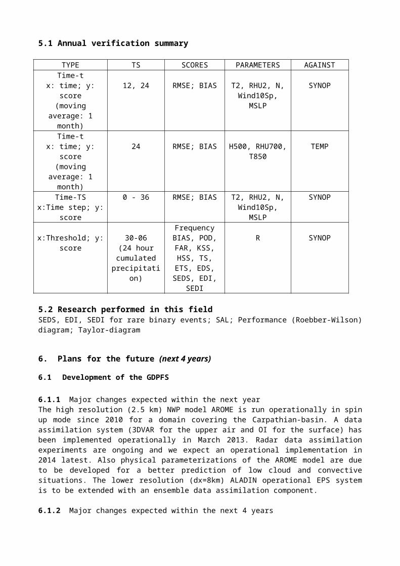
5.1 Annual verification summary
TYPE TS SCORES PARAMETERS AGAINSTTime-t
x: time; y: score(moving average: 1
month)
12, 24 RMSE; BIAS T2, RHU2, N, Wind10Sp, MSLP
SYNOP
Time-tx: time; y: score
(moving average: 1 month)
24 RMSE; BIAS H500, RHU700, T850
TEMP
Time-TSx:Time step; y:
score
0 - 36 RMSE; BIAS T2, RHU2, N, Wind10Sp, MSLP
SYNOP
x:Threshold; y: score
30-06(24 hour
cumulated
Frequency BIAS, POD, FAR, KSS,
HSS, TS, ETS,
R SYNOP
precipitation) EDS, SEDS, EDI, SEDI
5.2 Research performed in this fieldSEDS, EDI, SEDI for rare binary events; SAL; Performance (Roebber-Wilson) diagram; Taylor-diagram
6. Plans for the future (next 4 years)
6.1 Development of the GDPFS
6.1.1 Major changes expected within the next yearThe high resolution (2.5 km) NWP model AROME is run operationally in spin up mode since 2010 for a domain covering the Carpathian-basin. A data assimilation system (3DVAR for the upper air and OI for the surface) has been implemented operationally in March 2013. Radar data assimilation experiments are ongoing and we expect an operational implementation in 2014 latest. Also physical parameterizations of the AROME model are due to be developed for a better prediction of low cloud and convective situations. The lower resolution (dx=8km) ALADIN operational EPS system is to be extended with an ensemble data assimilation component.
6.1.2 Major changes expected within the next 4 yearsThe above three directions for development will remain. Sensitivity studies with AROME on 1 km resolution are planned as well as research on very high resolution EPS using a small size (5-10 members) AROME ensemble system. It is also anticipated that benefits are taken at every possible way from developments made on the driving global models (ECMWF/IFS, Meteo-France/ARPEGE).
6.2 Planned research Activities in NWP, Nowcasting and Long-range Forecasting
6.2.1 Planned Research Activities in NWPThe following research activities are planned concerning the AROME model: i) radar, GPS, and high resolution satellite assimilation; ii) improvements on the cloud physics and turbulence (convection and low stratus situations); iii) very high resolution small size (5-10 members) EPS with the AROME model accounting for the uncertainties in the initial conditions and in physical parameterizations.
6.2.2 Planned Research Activities in NowcastingSome efforts have been made for object oriented severe weather nowcasting using high performance radar data (dual polarization and Doppler wind). Special objective analysis is planned to develop for describing mezo-beta scale weather phenomena.
6.2.3 Planned Research Activities in Long-range ForecastingNone
6.2.4 Planned Research Activities in Specialized Numerical PredictionsNone
7. Consortium
7.1 System and/or modelOMSZ is a member of the ALADIN and LACE consortia, which develops the ALADIN, ALARO and AROME models (these 3 models own the same dynamical core and similar data assimilation systems but differ a lot in physical parametrizations and are aimed for different spatial scales).
7.1.1 In operationsAt OMSZ the ALARO and AROME models are used in operations (see section 4.3)
7.1.2 Research performed in this fieldSee section 6.1.1.
7.2 System run schedule and forecast rangesSee section 4.3.2.
7.3 List of countries participating in the ConsortiumAlgeria, Austria, Belgium, Bulgaria, Croatia, Czech Republic, France, Hungary, Morocco, Poland, Portugal, Romania, Slovakia, Slovenia, Tunisia, Turkey
7.4 Data assimilation, objective analysis and initializationBoth the ALADIN/ALARO and AROME models use local data assimilation systems (the latter is under development), namely an upper air 3DVAR and an OI surface assimilation scheme (see section 4.3.1 for more details).
7.5 Operationally available NWP productsSee section 4.3.3.
7.6 Verification of prognostic productsSee section 5.
7.7 Plans for the futureSee section 6.
8. References
Ács, F., Horváth, Á, Breuer, B., and Rubel, F., 2010: Sensitivity of local convective precipitation to parameterization of the field capacity and wilting point soil moisture contents. Időjárás, 114, 39-55.
Ács, F.; Horváth, Á.; Hajnalka, B.; Rubel, F., 2010: Effect of soil hydraulic parameters on the local convective precipitation Meteorologische Zeitschrift, 19, 143-153(11)
Adamcsek, E., Bölöni, G., Csomós, P. and Horányi, A., 2010: Application of the Ensemble Transform Kalman Filter technique at the Hungarian Meteorological Service: Preliminary results. Időjárás, 114, 21-38.
Bölöni, G., 2006: Development of a variational data assimilation system for a limited area model at the Hungarian Meteorological Service. Időjárás, 110, 309-327.
Bölöni, G., Kullmann L. and Horányi A., 2009: Use of ECMWF lateral boundary conditions and surface assimilation for the operational ALADIN model in Hungary. ECMWF Newsletter, 119, 29-35.
Csomós P. és Bölöni G., 2008: First steps towards the application of the Ensemble Transform Kalman Filter technique at the Hungarian Meteorological Service, HIRLAM Newsletter No. 54, pp 9-19 http://hirlam.org/index.php?option=com_docman&task=doc_download&gid=127&Itemid=70
Ferenczi, Z. and Ihász, I., 2003: Validation of Eulerian dispersion model MEDIA at the Hungarian Meteorological Service. Időjárás, 107, 115-132.
Geresdi, I. and Horváth, Á., 2000: Nowcasting of precipitation type. Part I: Winter Precipitation. Időjárás 104, 241-252.
Geresdi, I., Horváth, Á., Mátyus, Á., 2004: Nowcasting of the precipitation type Part II: Forecast of thunderstorms and hailstone size. Időjárás 108, 33-49.
Hágel, E., and Horányi, A, 2006: The development of a limited area ensemble prediction (LAMEPS) system at the Hungarian Meteorological Service: sensitivity experiments of global singular vectors. Időjárás, 110, 229-252.
Hágel, E., 2010: The quasi-operational LAMEPS system of the Hungarian Meteorological Service. Időjárás, 114, 121-134.
Horányi, A., Ihász, I., and Radnóti, G., 1996: ARPEGE/ALADIN: A numerical weather predicition model for Central-Europe with the participation of the Hungarian Meteorological Service. Időjárás, 100, 277-300.
Horányi, A., Kertész, S., Kullmann, L., and Radnóti, G., 2006: The ARPEGE/ALADIN mesoscale numerical modelling system and its application at the Hungarian Meteorological Service. Időjárás, 110, 203-227.
Horányi, A, Mile, M. and Szűcs, M., 2011: Latest developments around the ALADIN operational short-range ensemble prediction system in Hungary. Tellus 63A, 642-651.
Horváth, A. and Geresdi I. 2001. Severe convective storms and associated phenomena in HungaryAtmospheric Research 56 pp.127-146
Horváth, Á. and Geresdi, I. 2003: Severe Storms and Nowcasting in the Carpathian Basin Atmos. Res., 67-68, 319-332
Horváth, Á., Geresdi, I., Csirmaz, K., 2006: Numerical simulation of a tornado producing thunderstorm: A case study. Időjárás Vol. 104. 279-297.
Ihász, I., Üveges, Z., Mile, M. and Németh, Cs., 2010: Ensemble calibration of ECMWF's medium range forecasts. Időjárás, 114, 275-286.
Ihász I. and Tajti D., 2011: Use of ECMWF’s ensemble vertical profiles at the Hungarian Meteorological Service. ECMWF Newsletter, 129, 25-29.
Randriamampianina R., 2006: Impact of high resolution satellite observations in the ALADIN-HU model. Időjárás, 110, 329-347.
Szintai, B., and Ihász, I., 2006: The dynamical downscaling of ECMWF EPS products of ECMWF EPS products with the ALADIN mesoscale limited area model: Preliminary evolution. Időjárás, 110, 253-277.
Szépszó, G. and Horányi, A., 2010: Validation of the dynamically adapted high-resolution wind forecasts for the wind power stations in Hungary. Időjárás, 114, 57-78.
Application and verification of ECMWF products, 2012: http://www.ecmwf.int/products/greenbook/