2012 far west desert tortoise survey … · follow text) figure 1. vicinity map : figure 2. ......
TRANSCRIPT

Prepared for:
102 Magma Heights
P. O. Box 1944 Superior, Arizona 85173
Prepared by:
4001 E. Paradise Falls Drive
Tucson, Arizona 85712
February 2013 Project No. 807.81
2012 FAR WEST DESERT TORTOISE SURVEY
______________________________
RESOLUTION COPPER MINING

2012 Far West Desert Tortoise Survey Resolution Copper Mining
WestLand Resources, Inc. 1 Engineering and Environmental Consultants Q:\jobs\800's\807.81\ENV\2012 Far West Desert Tortoise\Final Report\FINAL 2012 Far West Tortoise Survey Report 021313.docx
TABLE OF CONTENTS
EXECUTIVE SUMMARY ...................................................................................................................... 1 1. INTRODUCTION ........................................................................................................................... 1 2. BACKGROUND ............................................................................................................................. 1 3. METHODS ..................................................................................................................................... 2 4. RESULTS AND DISCUSSION ....................................................................................................... 3 5. REFERENCES ................................................................................................................................ 5
TABLE
Table 1. 2012 Far West Desert Tortoise Survey Findings. ............................................................ 4
FIGURES (follow text)
Figure 1. Vicinity Map Figure 2. Desert Tortoise Survey Findings
APPENDIX
Appendix A. Representative Photographs of Survey Areas Appendix B. Complete Photographic Record of 2012 Far West Desert Tortoise Survey

2012 Far West Desert Tortoise Survey Resolution Copper Mining
WestLand Resources, Inc. ES-1 Engineering and Environmental Consultants Q:\jobs\800's\807.81\ENV\2012 Far West Desert Tortoise\Final Report\FINAL 2012 Far West Tortoise Survey Report 021313.docx
EXECUTIVE SUMMARY
Resolution Copper Mining (Resolution) retained WestLand Resources, Inc. (WestLand) to conduct surveys for the Morafka’s desert tortoise (Gopherus morafkai, formerly G. agassizii, Sonoran population) within the Far West property (Study Area) located near Florence Junction, Arizona (Figure 1). The purpose of this study was to provide information on the occurrence and distribution of the tortoise within the Study Area. The tortoise is a candidate for listing as threatened or endangered under the Endangered Species Act (ESA). Pursuant to an agreement between the US Fish & Wildlife Service (USFWS) and WildEarth Guardians and Western Watersheds Project, the USFWS has agreed to publish a proposed rule to list the Sonoran desert tortoise or withdraw it from the candidate list by 2015.
Surveys for Sonoran desert tortoise were conducted by crews of two to four biologists over 14 days from August 13-30, 2012. These surveys were conducted along washes and apparently suitable upland areas in the northern, eastern, and southern portions of the Study Area. Fourteen live desert tortoises, 28 scats, 31 tortoise track-ways, 23 active burrows, one set of skeletal remains, and 93 suitable burrows were documented during this study.
Tortoises and evidence of tortoise activity were observed primarily in the eastern portions of the areas surveyed, with a notable cluster of tortoises in the northeast portion of the Study Area. These surveys indicate that tortoises are present in approximately 60 percent of the Study Area, but tortoises are generally rare to absent in the western portion of the Study Area, which generally lacks suitable habitat.

2012 Far West Desert Tortoise Survey Resolution Copper Mining
WestLand Resources, Inc. 1 Engineering and Environmental Consultants Q:\jobs\800's\807.81\ENV\2012 Far West Desert Tortoise\Final Report\FINAL 2012 Far West Tortoise Survey Report 021313.docx
1. INTRODUCTION
Resolution Copper Mining (Resolution) retained WestLand Resources, Inc. (WestLand) to conduct surveys to determine the occurrence and distribution of Morafka’s desert tortoise (Gopherus morafkai, formerly G. agassizii, Sonoran population) within the Far West property (Figure 1; Study Area). This was the second of two consecutive years of tortoise surveys conducted within the Far West property, an area being considered by Resolution for development of waste rock and tailings deposition facilities.
The Study Area is situated south of US 60 and east of SR 79 near Florence Junction in Pinal County, Arizona (Figure 1). The Study Area is 7,000 acres (2,833 hectares [ha]) of Arizona State Trust land and private land. The highest elevation in the Study Area is 2,966 ft (904 m) at a ridge near its eastern boundary, and the lowest elevation is 1,950 ft (594 m) near the western boundary of the Study Area. Boulder-strewn hills in the east give way to fluvial sands and gravels to the west, and the area is dissected by numerous xeroriparian desert washes. The Study Area is mapped within the Arizona Upland Subdivision of Sonoran Desertscrub (Brown 1994), and the vegetation therein is consistent with this classification. Saguaro (Carnegiea gigantea) and fishhook barrel cactus (Ferocactus wislizenii) are common on the eastern, hilly portion of the parcel. Desert ironwood (Olneya tesota) and palo verde (Parkinsonia spp.) occur along washes, and creosote (Larrea tridentata) dominates upland flats on the western portion of the Study Area.
The purpose of this study was to provide information on the occurrence and distribution of tortoise in the Study Area.
2. BACKGROUND
The recognition of Morafka’s desert tortoise (Gopherus morafkai; Murphy et al. 2011) as a valid taxon is a recent development. It was formerly included with G. agassizii, which as a whole occupied an area from the Mojave and Colorado/Sonoran deserts of California, east and south through the Sonoran Desert of Arizona and into Sonora and Sinaloa, Mexico, where it is also found in foothills thornscrub and tropical deciduous forest/coastal thornscrub. The desert tortoise population west and north of the Colorado River was commonly referred to as the Mojave population while the population east and south of the Colorado River was referred to as the Sonoran population.
Based on genetic, physiological, morphological, and ecological differences between the Mojave and Sonoran populations, Murphy et al. (2011) split G. agassizii into two species, the Mojave or Agassiz’s desert tortoise (G. agassizii) west and north of the Colorado River, and the Sonoran or Morafka’s desert tortoise, G. morafkai, east and south of the Colorado River. Until recently, the US Fish and Wildlife Service (USFWS) referred to the Sonoran desert tortoise as G. agassizii, Sonoran DPS (Distinct Population Segment) in their 2011 annual review of candidate species (USFWS 2011). However, they mentioned a recent genetic study (likely the Murphy paper) and stated that they would be considering the evidence for adopting the new taxon. Now, both their General Species Information (USFWS 2012a) and their profile page (USFWS 2012b) refer to the Sonoran desert tortoise as G. morafkai.
In 1990, the Mojave population of the desert tortoise was listed as threatened (USFWS 1990), but the Sonoran population did not have status under the Endangered Species Act (ESA). The Sonoran

2012 Far West Desert Tortoise Survey Resolution Copper Mining
WestLand Resources, Inc. 2 Engineering and Environmental Consultants Q:\jobs\800's\807.81\ENV\2012 Far West Desert Tortoise\Final Report\FINAL 2012 Far West Tortoise Survey Report 021313.docx
population was petitioned for listing as a DPS with critical habitat on October 9, 2008 (WildEarth Guardians and Western Watersheds Project 2008). On August 28, 2009, the USFWS published its 90-day finding that the Sonoran DPS warranted a status review to determine if it should be listed or not (USFWS 2009). At the end of the 12-month review period, they announced that listing of the Sonoran DPS was warranted but precluded by higher priority items, and the species was added to the USFWS list of candidate species (USFWS 2010). A US District Court settlement1 reached with the WildEarth Guardians on May 10, 2011, outlined a timetable for resolving listing decisions on 251 species. The Sonoran desert tortoise is one of 24 species in Arizona affected by the settlement agreement, and, as outlined in the settlement agreement, the USFWS must issue a proposed listing rule or “not warranted” determination by the end of the US Fiscal Year (September 30), 2015.
The Sonoran desert tortoise is also designated Arizona State Wildlife of Special Concern (AGFD 1996), Forest Service Sensitive (USFS 2007), and Bureau of Land Management sensitive (BLM 2010).
3. METHODS
Surveys for tortoise were conducted along washes and some upland areas of the Study Area where the habitat appears to be most suitable (Figure 2). Surveys were conducted by crews of two to four biologists over 14 days from August 13-30, 2012. These surveys focused within areas in the eastern and southern portions of the Study Area. Transects were walked and visually scanned for tortoises and evidence of tortoises including: scat (feces), tracks, burrows, and skeletal remains. Burrows were classified as either “active” or “suitable”. Burrows were considered to be active if live tortoises, tortoise skeletal remains, scat, or tortoise tracks were observed either inside or at the entrance of a burrow. Suitable burrows were those that could potentially harbor tortoises based on their size, depth, and accessibility, but exhibited no conclusive evidence of recent utilization. All evidence of tortoise activity was photographed and recorded on data sheets and field maps. For discussion purposes, the Study Area was divided into eight survey areas depicted in Figure 2.
1 United States District Court for the District of Columbia (Case 1:10-mc-00377-EGS Document 31 Filed 05/10/11).

2012 Far West Desert Tortoise Survey Resolution Copper Mining
WestLand Resources, Inc. 3 Engineering and Environmental Consultants Q:\jobs\800's\807.81\ENV\2012 Far West Desert Tortoise\Final Report\FINAL 2012 Far West Tortoise Survey Report 021313.docx
4. RESULTS AND DISCUSSION
Surveyors documented 14 live tortoises, 28 tortoise scats, 31 tortoise track-ways, one set of skeletal remains, 23 active burrows, and 93 suitable burrows during pedestrian transect surveys (Table 1, Figure 2)2. Representative photographs of tortoises, tortoise scat, tortoise skeletal remains, and active and suitable burrows are provided in Appendix A. All photographs taken during survey are provided in Appendix B.
The 14 tortoises observed included eight males, one female, and five individuals of undetermined sex. These animals ranged from 5-13.4 inches (13-34 cm) in length. They were located in Areas 2, 4, 5, 7 and 8 that encompass the northeast, east, and southeastern portions of the Study Area (Figure 2). These areas are characterized by boulder-strewn hillsides and/or incised washes that have caliche caves developed along their banks. The western portion of the Study Area consists primarily of flat fluvial fans and generally lacks suitable substrate for burrows. No Sonoran desert tortoises or evidence of tortoises were detected within areas survey on the western portion of the site and they are likely to be rare or absent in this area.
2 On some occasions, more than one feature (tortoise, burrow, tracks, scat, etc.) was observed and recorded at a particular location. In these
cases, only the most significant feature is depicted on Figure 2. For example, in the event that a live tortoise was observed in an active burrow with tracks and scat present, all these features are recorded on the data forms but only the live tortoise is depicted on Figure 2.

2012 Far West Desert Tortoise Survey Resolution Copper Mining
WestLand Resources, Inc. 4 Engineering and Environmental Consultants Q:\jobs\800's\807.81\ENV\2012 Far West Desert Tortoise\Final Report\FINAL 2012 Far West Tortoise Survey Report 021313.docx
Table 1. 2012 Far West Desert Tortoise Survey Findings Survey Area
Live Tortoise Scat Track-
ways Active
Burrow Skeletal Remains
Suitable Burrow Description of Area
1 - 1 - - - 4
This survey area is located on the northern portion of the Study Area. Moderately incised washes on the eastern portion of this area provide good substrate for burrows. The western portion of this area is generally flat, lacks cave-bearing incised washes and other suitable tortoise shelters.
2 8 25 20 13 1 26
This survey area is located on the Study Area’s northeast boundary and contains both stony upland areas as well as incised washes containing caliche caves and other suitable burrow sites. This survey area contains the highest level of observed tortoises and evidence of tortoise found within the Study Area.
3 - - 1 - - 11
Located in the north-central portion of the Study Area, survey area 3 contains a limited number of incised washes with potentially suitable burrows. Eight of the 10 suitable burrows were located along the major drainage that divides this survey area. Westward along this drainage, the washes become open and are not incised, lacking suitable burrow substrates.
4 1 1 2 - - 14
This survey area is located along the Study Area’s eastern edge and is dominated by two incised drainages and a significant rock outcrop where WestLand previously located the skeletal remains of a large tortoise in 2011 (WestLand 2012).
5 - - 1 - - 5 This survey area is also located along the Study Area’s eastern edge and is dominated by two moderately incised drainages.
6 - - 1 - - 5
Located at the southwest corner of the Study Area, this survey area generally lacks suitable tortoise habitat. This area is flat and the wash that dominates this area is low with banks that generally lack suitable burrows.
7 3 - - 2 - 14 This survey area, located in the southeast portion of the Study Area, contains a number of incised washes containing suitable burrows.
8 2 1 6 8 - 14 This survey area is located in the Study Area’s southeast corner. Dominated by a long incised wash and an isolated volcanic hill, survey area 8 contains numerous suitable and active burrows.
TOTAL 14 28 31 23 1 93

2012 Far West Desert Tortoise Survey Resolution Copper Mining
WestLand Resources, Inc. 5 Engineering and Environmental Consultants Q:\jobs\800's\807.81\ENV\2012 Far West Desert Tortoise\Final Report\FINAL 2012 Far West Tortoise Survey Report 021313.docx
5. REFERENCES
Arizona Game & Fish Department (AGFD). 1996. Wildlife of Special Concern in Arizona. Draft. Non-Game and Endangered Wildlife Program, Arizona Game & Fish Department, Phoenix, Arizona. October 14, 1996.
Brown, D. E. (Ed.) 1994. Biotic Communities: Southwestern United States and Northwestern Mexico. University of Utah Press. Salt Lake City, Utah.
Bureau of Land Management. 2010. Arizona Bureau of Land Management Sensitive Species List. Instructional Memorandum No. AZ-2011-005, December 22, 2010. BLM Internet Web Site: http://www.blm.gov/pgdata/etc/medialib/blm/az/pdfs/efoia/2011IM_IB.Par.64105.File.dat/IMAZ-2011-005.pdf.
Murphy R.W., Berry K.H, Edwards T, Leviton A.E., Lathrop A., Riedle, J.D. 2011. The dazed and confused identity of Agassiz’s land tortoise, Gopherus agassizii (Testudines, Testudinidae) with the description of a new species, and its consequences for conservation. ZooKeys 113: 39–71. doi: 10.3897/zookeys.113.1353
U. S. Fish & Wildlife Service (USFWS). 1990. Endangered and threatened wildlife and plants; determination of threatened status for the Mojave population of the desert tortoise; final rule. Federal Register 55:12178–12191.
______. 2009. Endangered and threatened wildlife and plants; 90-day finding on a petition to list the Sonoran population of desert tortoise (Gopherus agasizzii) [sic] as a Distinct Population Segment (DPS) with Critical Habitat. Federal Register 74:44335–44344.
______. 2010. Endangered and threatened wildlife and plants: 12-month finding on petition to list the Sonoran desert tortoise as threatened or endangered; proposed rule. Federal Register 75:78094–78145.
______. 2011. Endangered and Threatened Wildlife and Plants; Review of Native Species That Are Candidates for Listing as Endangered or Threatened; Annual Notice of Findings on Resubmitted Petitions; Annual Description of Progress on Listing Actions; Proposed Rule.
______. 2012a. General Species Information Sonoran desert tortoise (Gopherus morafkai). Accessed November 2012 at: http://www.fws.gov/southwest/es/arizona/Sonoran_Tort.htm
______. 2012b. Species Profile Sonoran desert tortoise (Gopherus morafkai). Accessed November 2012 at: http://ecos.fws.gov/speciesProfile/profile/speciesProfile.action?spcode=C07G
U.S. Forest Service. 2007. Southwestern Region Sensitive Animals. USFS Internet Web Site: http://www.fs.usda.gov/detail/r3/plants-animals/?cid=FSBDEV3_022105.
2012 Far West Desert Tortoise Survey Resolution Copper Mining
WestLand Resources, Inc. 6 Engineering and Environmental Consultants Q:\jobs\800's\807.81\ENV\2012 Far West Desert Tortoise\Final Report\FINAL 2012 Far West Tortoise Survey Report 021313.docx
WestLand Resources. 2012. 2011 Reptile Surveys of the Far West Parcel and Vicinity. WestLand Resources, Inc., Tucson, Arizona.
WildEarth Guardians and Western Watersheds Project (WG and WWP). 2008. Petition to list the Sonoran desert tortoise (Gopherus agassizii) under the U.S. Endangered Species Act. Accessed online January 2012 at: http://www.westernwatersheds.org/species/desert-tortoise/sonoran/sonoran-tortoise-petition.pdf

FIGURES

YUMATUCSON
PHOENIX
FLAGSTAFF
£¤60
¬«79
Far WestStudy Area
£¤60
ARIZONA
PROJECT LOCATION
Pinal County, Arizona,1:100,000 Globe & Mesa USGS Quadrangles
±0 2 4
Miles
Path: M:\Projects\807.81\FIGURES\MXD\Fig1_Vicinity.mxd Date: 2/7/2013 User: davidp
RESOLUTION COPPER MINING
VICINITY MAPFigure 1
2012 Far West Desert Tortoise Survey
PINALCOUNTY
LegendSurface Management (BLM 2011)
Bureau of Land Management (BLM)
Private Land (No Color)
State Trust Land
US Forest Service (USFS)

ÊÑ
Ê
Ñ
ÑÑ
Ñ
Ñ
Ñ
Ñ
ÑÑ
ÑÑÑÊ
ÑÑ
Ñ
ÑÑ
Ñ
ÊÑ
ÑÑÑ
Ñ
ÊÑ
Ê
Ñ
Ñ
Ñ
Ñ
Ñ
Ñ
ÑÊ
Ñ
Ñ
Ñ
Ñ
Ê
ÑÊ
ÑÑ
Ñ
Ñ
Ñ
ÑÑ
Ñ
Ê Ñ
Ñ
Ñ
Ñ
Ñ Ñ
Ñ
Ñ
Ñ
Ñ
Ñ
Ñ
Ñ
ÑÊ
Ñ
Ñ
Ñ
Ñ
Ñ
Ñ
Ñ
ÑÑ
Ñ
Ñ Ñ
ÑÑ
Ñ
Ñ
Ñ
Ñ
Ñ
Ñ
Ñ
ÑÑÑÑÊ
Ñ
Ê
Ñ
Ñ
Ñ
Ñ T10
T9
T8
T7 T6
T5
T4
T3
T1 & 2
SC9
SC8TR9
T14TR8SC7
T13
SK1
SC6SC5
SC4
SC3
AB8
T12
TR5
T11
SC2
AB7AB6
AB5SC1
TR4
TR3
AB4
AB3AB2
AB1
SB9
SB8
SB7
SB6
SB5
SB4 SB3 SB2
TR2TR1
SB1
SB76SC14
SC13
TR13
TR12
SC12SC11 SC10
SB75SB74
TR11
SB73TR10
AB13SB72SB71
SB70
SB69
AB10
SB68
AB9
SB67 SB66
SB65
SB64
SB63
SB62
SB61SB60
SB59
SB58
SB57SB56SB55
SB54SB53
SB52
SB51SB50
SB49SB48SB47
SB46
SB45
SB44SB43
SB42
SB41
SB40
SB38 SB37SB36
SB35
SB34
SB33
SB31
SB30SB29
SB27
SB26
SB25
SB24SB23
SB22SB21
SB20
SB19
SB18
SB17
SB15
SB14 SB13
SB12
SB10
TR6-7AB11-12
SB39
SB32
SB28
SB16
SB11
1 2
3
4
5
6
7
8
User: davidpDocument Path: M:\Projects\807.81\FIGURES\MXD\Far_West_desert_Tort_Survey_Findings_24x36.mxd
Photo Source:National Agriculture Imagery Program, 2010
±0 800 1,600
Feet
RESOLUTION COPPER MINING
DESERT TORTOISE SURVEY FINDINGSFigure 2
2012 Far West Desert Tortoise Survey
Legend
Tortoise Findings
Far West Study Area
Ñ
Ê Live Tortoise & Number
Active Burrow & Number
Suitable Burrow & Number
Scat & Number
Skeletal Remains & Number
Tortoise Tracks & Number
Transects
1 Transect Area
T1
AB1
SB1
SC1SK1
TR1
Ñ
APPENDIX A
REPRESENTATIVE PHOTOGRAPHS OF
SURVEY AREAS
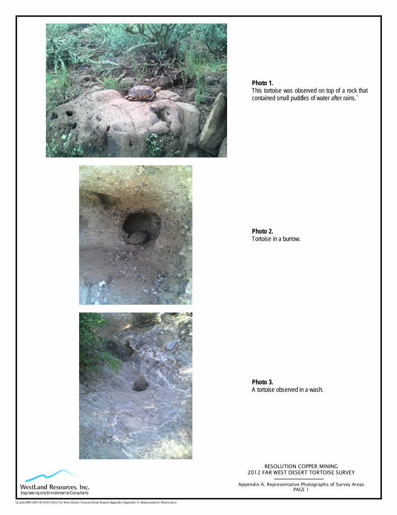
RESOLUTION COPPER MINING 2012 FAR WEST DESERT TORTOISE SURVEY
Appendix A. Representative Photographs of Survey Areas
PAGE 1
Q:\jobs\800's\807.81\ENV\2012 Far West Desert Tortoise\Draft Report\Appendix\Appendix A. Representative Photos.docx
Photo 1. This tortoise was observed on top of a rock that contained small puddles of water after rains.`
Photo 2. Tortoise in a burrow.
Photo 3. A tortoise observed in a wash.

RESOLUTION COPPER MINING 2012 FAR WEST DESERT TORTOISE SURVEY
Appendix A. Representative Photographs of Survey Areas
PAGE 2
Q:\jobs\800's\807.81\ENV\2012 Far West Desert Tortoise\Draft Report\Appendix\Appendix A. Representative Photos.docx
Photo 4. Desert tortoise.
Photo 5. Tortoise scat.
Photo 6. An active burrow in a caliche cave.

RESOLUTION COPPER MINING 2012 FAR WEST DESERT TORTOISE SURVEY
Appendix A. Representative Photographs of Survey Areas
PAGE 3
Q:\jobs\800's\807.81\ENV\2012 Far West Desert Tortoise\Draft Report\Appendix\Appendix A. Representative Photos.docx
Photo 7. Tortoise skeletal remains.
Photo 8. Suitable burrow.

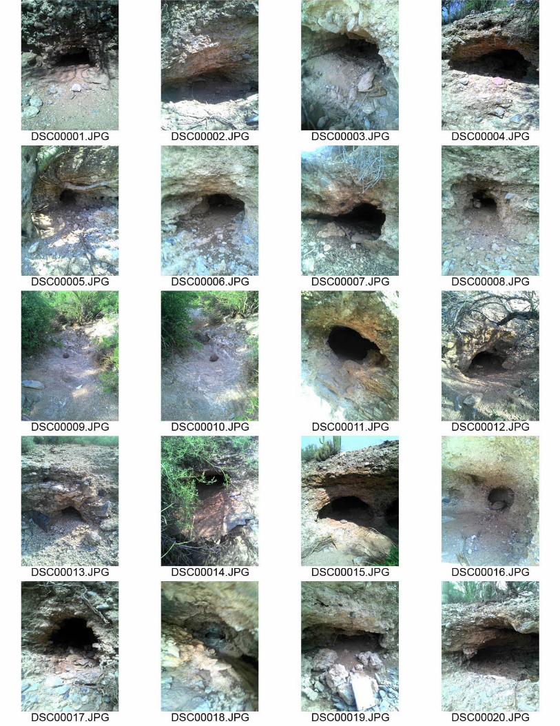
APPENDIX B
COMPLETE PHOTOGRAPHIC
RECORD OF 2012 FAR WEST DESERT TORTOISE SURVEY

TRANSECT 1


TRANSECT 2


TRANSECT 3

TRANSECT 4


TRANSECT 5


TRANSECT 6
