2012 and the old equator by robert berringer
TRANSCRIPT

8/8/2019 2012 and the Old Equator by Robert Berringer
http://slidepdf.com/reader/full/2012-and-the-old-equator-by-robert-berringer 1/25
2012 and the Old EquatorBy Robert Berringer 9/06
There are many signs that extraterrestrial beings, often called gods, periodicallyintervene in the evolution of life on Earth. Some of the most enduring signs like the
Great Pyramid have convinced me that Stone Age humans under Old Kingdom Pharaohs
did not build many of the most ancient and most enduring megaliths. Our world view of the Great Pyramid is shaped by the Egyptologists, the liberal media, government
teachers, parents etc. Studies by many New Age scholars have convinced them that the
Great Pyramid was not built by the Pharoah Khufu as a tomb. Historians note that it is
devoid of authentic inscriptions, unlike later pyramids which contained extensivereligious inscriptions about their builders. The so called coffin found in the Kings
Chamber was carved out of one piece of solid granite, including the cover. It is too large
to have been transported into the pyramid, so like the enigmatic air shafts which point toSirius and Orion, this most massive of all the world’s stone structures was built around
these internal features. Machinists have found tool marks like those made by modern
saws inside this coffin. Robert Bauval and Adrian Gilbert in “The Orion Mystery:
Unlocking the Secrets of the Pyramids” have used many good photos and illustrations tohelp convince me that the Great Pyramid is a prehistoric machine not built by prehistoric
humans. As an engineer, I recognize the following photo as a very strong solid granitefoundation for a heavy machine creating a very large downward force.

8/8/2019 2012 and the Old Equator by Robert Berringer
http://slidepdf.com/reader/full/2012-and-the-old-equator-by-robert-berringer 2/25

8/8/2019 2012 and the Old Equator by Robert Berringer
http://slidepdf.com/reader/full/2012-and-the-old-equator-by-robert-berringer 3/25
Using Archaeoastronomy, Bauval calculates that 10,450BC is the time when theOrion belt and Al Nitak are lowest on the horizon. That is also the date with the best
match between the orientation of the Giza Pyramids and the Orion belt stars. Later in this
article, I will suggest that this “Earth in Upheaval” age and start of the Mayan Third Ageof Man is one of the last three times the gods have visited Earth in mass. Plato and Cayce
recorded that 10.500 BC is one of the date of the destruction of Atlantis. Physical and
mythical signs have convinced me that extraterrestrial gods periodically intervene inhuman physical and cultural evolution. Next I will discuss the location of the most
important of the extraterrestrial signs, a great circle thru Giza that once was the Old
Equator.
A dozen of the most important ancient sacred sites all lie in a straight line on what
some geologists believe was once the equator. This amazing discovery is described in
detail by Jim Alison on his web site (http://home.hiwaay.net/~jalison). Some geologistscalculate that the North Pole was located in Alaska less than a hundred thousand years
ago (Wilson 2001, 314). Alison calculates that the Great Sphinx and the Great Pyramid
were located on that ancient equator which he now locates using sacred sites. The three
oldest known civilizations were also located on that same great circle: Sumer, Egypt andthe Indus River Valley civilizations. (See “Ancient Gods and Their Mysteries: Will They
Return in 2012?” for references.)
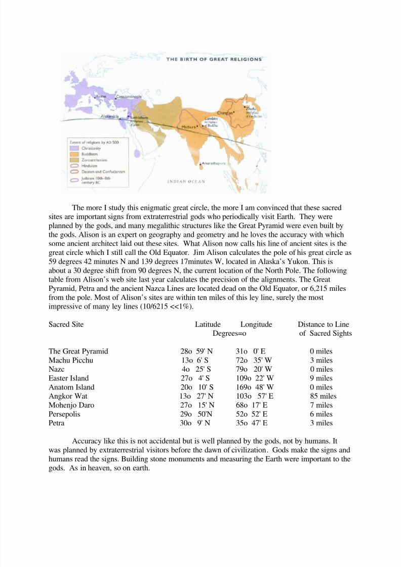
Six major religions were born very near the Old Equator.
8/8/2019 2012 and the Old Equator by Robert Berringer
http://slidepdf.com/reader/full/2012-and-the-old-equator-by-robert-berringer 4/25
The more I study this enigmatic great circle, the more I am convinced that these sacredsites are important signs from extraterrestrial gods who periodically visit Earth. They were
planned by the gods, and many megalithic structures like the Great Pyramid were even built by
the gods. Alison is an expert on geography and geometry and he loves the accuracy with whichsome ancient architect laid out these sites. What Alison now calls his line of ancient sites is the
great circle which I still call the Old Equator. Jim Alison calculates the pole of his great circle as
59 degrees 42 minutes N and 139 degrees 17minutes W, located in Alaska’s Yukon. This is
about a 30 degree shift from 90 degrees N, the current location of the North Pole. The followingtable from Alison’s web site last year calculates the precision of the alignments. The Great
Pyramid, Petra and the ancient Nazca Lines are located dead on the Old Equator, or 6,215 miles
from the pole. Most of Alison’s sites are within ten miles of this ley line, surely the mostimpressive of many ley lines (10/6215 <<1%).
Sacred Site Latitude Longitude Distance to LineDegrees=o of Sacred Sights
The Great Pyramid 28o 59' N 31o 0' E 0 miles
Machu Picchu 13o 6' S 72o 35' W 3 milesNazc 4o 25' S 79o 20' W 0 miles
Easter Island 27o 4' S 109o 22' W 9 miles
Anatom Island 20o 10' S 169o 48' W 0 miles
Angkor Wat 13o 27' N 103o 57' E 85 milesMohenjo Daro 27o 15' N 68o 17' E 7 miles
Persepolis 29o 50'N 52o 52' E 6 milesPetra 30o 9' N 35o 47' E 3 miles
Accuracy like this is not accidental but is well planned by the gods, not by humans. It
was planned by extraterrestrial visitors before the dawn of civilization. Gods make the signs and
humans read the signs. Building stone monuments and measuring the Earth were important to thegods. As in heaven, so on earth.

8/8/2019 2012 and the Old Equator by Robert Berringer
http://slidepdf.com/reader/full/2012-and-the-old-equator-by-robert-berringer 5/25
We will next take a journey around the Earth going east along the Old Equator. Starting
from the Great Pyramid, we come next to Petra, lying just 3miles south of the Old Equator.
Petra is a world heritage site in Jordan on an old caravan route between Egypt and Sumer. It ismentioned in the Bible and is sometimes called the Valley of Moses. Petra is south of Jerusalem,
and most of the Holy Land lies slightly north of the Old Equator. In the fourth century B.C. the
Nabateans established a civilization at Petra. Petra is a dry and rocky place, and the Nabateansdug large cisterns in the solid rock. Water was a valuable commodity at this ancient crossroads,
which also was located on an old north-south route between Arabia and the Mediterranean. In
the first century B.C., the Nabatean Empire stretched from Arabia to the Sinai Peninsula and the
Mediterranean, and included Jerusalem and Damascus. It encompassed what was Solomon’skingdom and the Holy Land. Abraham, Moses, Jesus, Zoroaster and Muhammad all lived within
a day’s donkey or camel journey from Petra. Some historians believe that the Garden of Eden
was in Jordan, which was a rich river valley around 10,000 B.C.
The main tourist attractions in Petra are its ancient and beautiful buildings, monuments,
megaliths and an amphitheater, all carved into reddish-colored bedrock. “The ruins of Petra
constitute one of the most extraordinary and fascinating monumental complexes of the ancientworld, for the outstanding quality of the architecture and for the city’s remarkable position
among ragged hills and narrow gorges. Petra is without a doubt one of the marvels of the world,one of those places that you will never forget”. ( Bourbon 1999, 6). The first photo below (ibid.
102) shows some of the beauty and the impressive way architecture is carved out of solid rock
(Hammerton 1937, 88). The gods love to carve solid rock!
We look forward to experiencing this ancient site and would not be surprised if some of
the caverns and cisterns are much older than the Nabatean culture.
Now that we know that Petra lies on the Old Equator, archeologists should take a new
look. In particular, we would like to know the age and exact location of an obelisk carved out of
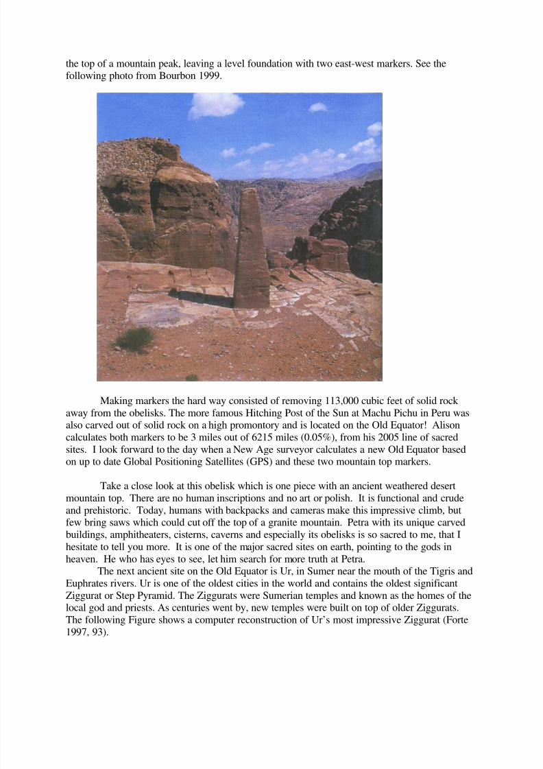
8/8/2019 2012 and the Old Equator by Robert Berringer
http://slidepdf.com/reader/full/2012-and-the-old-equator-by-robert-berringer 6/25
the top of a mountain peak, leaving a level foundation with two east-west markers. See thefollowing photo from Bourbon 1999.
Making markers the hard way consisted of removing 113,000 cubic feet of solid rock away from the obelisks. The more famous Hitching Post of the Sun at Machu Pichu in Peru wasalso carved out of solid rock on a high promontory and is located on the Old Equator! Alison
calculates both markers to be 3 miles out of 6215 miles (0.05%), from his 2005 line of sacred
sites. I look forward to the day when a New Age surveyor calculates a new Old Equator basedon up to date Global Positioning Satellites (GPS) and these two mountain top markers.
Take a close look at this obelisk which is one piece with an ancient weathered desert
mountain top. There are no human inscriptions and no art or polish. It is functional and crude
and prehistoric. Today, humans with backpacks and cameras make this impressive climb, butfew bring saws which could cut off the top of a granite mountain. Petra with its unique carved
buildings, amphitheaters, cisterns, caverns and especially its obelisks is so sacred to me, that Ihesitate to tell you more. It is one of the major sacred sites on earth, pointing to the gods in
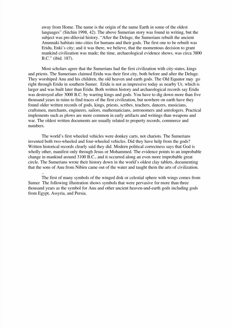
heaven. He who has eyes to see, let him search for more truth at Petra.The next ancient site on the Old Equator is Ur, in Sumer near the mouth of the Tigris and
Euphrates rivers. Ur is one of the oldest cities in the world and contains the oldest significant
Ziggurat or Step Pyramid. The Ziggurats were Sumerian temples and known as the homes of thelocal god and priests. As centuries went by, new temples were built on top of older Ziggurats.
The following Figure shows a computer reconstruction of Ur’s most impressive Ziggurat (Forte
1997, 93).

8/8/2019 2012 and the Old Equator by Robert Berringer
http://slidepdf.com/reader/full/2012-and-the-old-equator-by-robert-berringer 7/25
Ur is the first city known to have extensive indoor plumbing and sewers, long considered to be a
mark of civilization. Some of the oldest bronze tools, wheels, and bronze foundries have been
found in Ur. One of the oldest cuneiform tablets found in Ur is the earliest record of a king. TheBible says that Ur was the home of Abraham. The following photos (Davidson 1967) and
(Hammerton 1937) show how civilized Ur was in the third millennium B.C.

8/8/2019 2012 and the Old Equator by Robert Berringer
http://slidepdf.com/reader/full/2012-and-the-old-equator-by-robert-berringer 8/25
Artistically, these photos from about 2500 BC look more civilized than most musical instruments
and ornaments from current third world kingdoms. They also are signs of trade from distant
lands for gold, silver and rare minerals. Sumer was home to some of the world’s firstprofessional craftsman, including artists and musicians. It was home to the first known kings
and they had a very high regard for women. The ancient Sumerian heaven-and-earth god, Ea,
later called Enki, first brought civilization to man in nearby Eridu, which appears closer to
Alison’s line of sacred sights than Ur. The following long quotation from Sitchin says that theancient Sumerians believed that Eridu was a very important old city.
“There was a time, the Sumerians told, when civilized man was not yet on Earth, whenanimals were only wild and domesticated crops were not yet cultivated. At this long-ago
time (710,000 B.C.) there arrived on Earth a group of fifty Anunnaki (children of the god
Anu). Led by a leader whose name was E.A. (meaning whose home is water), they journeyed from their home planet NIBIRU and, reaching Earth, splashed down in the
water of the Persian Gulf. Their first task was to drain the marshes and clear river
channels, check out food sources (found to be fish and fowl). They then began to make
bricks from the clay of the soil and established the first-ever settlement on Earth by extra-terrestrials. They named the habitat ERIDU, which meant Home in the Faraway or Home
8/8/2019 2012 and the Old Equator by Robert Berringer
http://slidepdf.com/reader/full/2012-and-the-old-equator-by-robert-berringer 9/25
away from Home. The name is the origin of the name Earth in some of the oldestlanguages” (Sitchin 1998, 42). The above Sumerian story was found in writing, but the
subject was pre-diluvial history. “After the Deluge, the Sumerians rebuilt the ancient
Anunnaki habitats into cities for humans and their gods. The first one to be rebuilt wasEridu, Enki’s city; and it was there, we believe, that the momentous decision to grant
mankind civilization was made; the time, archaeological evidence shows, was circa 3800
B.C.” (ibid. 187).
Most scholars agree that the Sumerians had the first civilization with city-states, kings
and priests. The Sumerians claimed Eridu was their first city, both before and after the Deluge.
They worshiped Anu and his children, the old heaven and earth gods. The Old Equator may goright through Eridu in southern Sumer. Eridu is not as impressive today as nearby Ur, which is
larger and was built later than Eridu. Both written history and archaeological records say Eridu
was destroyed after 3000 B.C. by warring kings and gods. You have to dig down more than fivethousand years in ruins to find traces of the first civilization, but nowhere on earth have they
found older written records of gods, kings, priests, scribes, teachers, dancers, musicians,
craftsmen, merchants, engineers, sailors, mathematicians, astronomers and astrologers. Practical
implements such as plows are more common in early artifacts and writings than weapons andwar. The oldest written documents are usually related to property records, commerce and
numbers.
The world’s first wheeled vehicles were donkey carts, not chariots. The Sumerians
invented both two-wheeled and four-wheeled vehicles. Did they have help from the gods?
Written historical records clearly said they did. Modern political correctness says that God iswholly other, manifest only through Jesus or Mohammed. The evidence points to an improbable
change in mankind around 3100 B.C., and it occurred along an even more improbable greatcircle. The Sumerians wrote their history down in the world’s oldest clay tablets, documenting
that the sons of Anu from Nibiru came out of the water and taught them the arts of civilization.
..The first of many symbols of the winged disk or celestial sphere with wings comes from
Sumer The following illustration shows symbols that were pervasive for more than three
thousand years as the symbol for Anu and other ancient heaven-and-earth gods including godsfrom Egypt, Assyria, and Persia.

8/8/2019 2012 and the Old Equator by Robert Berringer
http://slidepdf.com/reader/full/2012-and-the-old-equator-by-robert-berringer 10/25
Originally the disk or globe symbolized Nibiru, Anu’s home planetoid. Note the cobras
in the second “winged disc”, symbolizing a feathered serpent, the major name for several native
American gods, including Quetzalcoatl. These symbols were found in royal tombs anddocuments thru Asia Minor, Egypt and nearby countries. They originally symbolized the flying
planetoid Nibiru and its high god Anu. Later, similar symbols were used for other celestial godssuch as the sun god. Many very historical pharaohs and kings used these symbols to rememberancient gods who flew to earth from heaven.
Continuing east on the Old Equator we cross the Zagros Mountains, where scientists findthe origin of emmer, wheat, barley, grapes and olives over six thousand years ago. New Age
scholars like Sitchin have helped convince many of us that it is very difficult to domesticate
plants. There are major genetic differences between wild wheat and domesticated wheat. Whywould struggling hunter gatherers spend hundreds of years collecting large seeds with special

8/8/2019 2012 and the Old Equator by Robert Berringer
http://slidepdf.com/reader/full/2012-and-the-old-equator-by-robert-berringer 11/25
stalk properties for an inedible seed. No other ape eats grain! Centuries later humans somehowlearned how to make beer and bread. Even then, how did clan chiefs protect wheat seed thru a
severe winter? Domestication of plants is a major sign of extraterrestrial intervention! Note that
grapes also made enigmatic giant leaps forward in size and quality, especially for making wine.I think that extraterrestrial gods helped the Zagros Mountain hunter gatherers make beer and
wine. Since the dawn of history in America, gods have helped shaman find mushrooms and
psychedelic roots in order to better communicate with the gods.
It is harder to trace the domestication of animals, but the oldest signs of domestication of
sheep and goats are near the Old Equator and the Zagros Mountains. Dogs may have been
domesticated in India, but more research is needed. Will Hart in “African Genesis: OurExtraterrestrial DNA and the True Origins of the Species” makes convincing arguments that
humans have never domesticate the grey wolf Canis lupus. All dogs are descended from the grey
wolf and can breed with them and have viable pups. This means that dogs should be in thespecies Canis lupus and not Canis familiaris. Hart reminds us that we can tame many animals
like tigers, zebras, elephants and wolves, but we do not have the ability to domesticate them.
Domesticated animals have smaller brains and are dependent on humans. Some night when you
cannot sleep, ponder the domestication of humans and dogs. Homo sapiens have a smaller brainthan Neanderthal man. Did Anubis domesticate the Egyptians? Did dogs domesticate humans?
At the start of the Mayan Third Age of Man, Neanderthal Man and Homo erectus were
extinct and all humans were of one species, Homo sapiens. Since evolution usually drives for
diversity, the evolution of one species from many is rare. The Cataclysm that smote the northern
hemisphere left few humans surviving north of the Old Equator. By the Fourth Age of Man wefind an immigration of new hunter gatherers into the Fertile Crescent and the Zagros Mountains.
Some signs of dogs or tame wolves appeared, but humans were few and struggling, mostly livingin caves. Big game was very scarce. By the start of the Fifth Age of Man, the domestication of
plants and animals, intensive farming using irrigation, writing, bronze, and the wheel had
changed civilization forever. All this happened near the Old Equator within about 5000 yearswith less humans than the population of Iraq. Did the humans have help? Note that most of the
Homo sapiens on Earth before 3114 BC lived south of he Old Equator and show very few signs
of civilization.
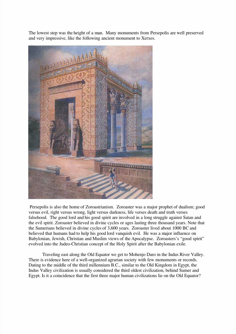
The next sacred site on the Old Equator is Persepolis, the ancient capitol of Persia.
Persepolis was the home of Xerxes, Cyrus and Darius, powerful kings of the Persian Empire.The tomb of Cyrus was a step pyramid using huge white limestone blocks.
8/8/2019 2012 and the Old Equator by Robert Berringer
http://slidepdf.com/reader/full/2012-and-the-old-equator-by-robert-berringer 12/25
The lowest step was the height of a man. Many monuments from Persepolis are well preserved
and very impressive, like the following ancient monument to Xerxes.
Persepolis is also the home of Zoroastrianism. Zoroaster was a major prophet of dualism; good
versus evil, right versus wrong, light versus darkness, life verses death and truth versesfalsehood. The good lord and his good spirit are involved in a long struggle against Satan and
the evil spirit. Zoroaster believed in divine cycles or ages lasting three thousand years. Note that
the Sumerians believed in divine cycles of 3,600 years. Zoroaster lived about 1000 BC and
believed that humans had to help his good lord vanquish evil. He was a major influence onBabylonian, Jewish, Christian and Muslim views of the Apocalypse. Zoroasters’s “good spirit”
evolved into the Judeo-Christian concept of the Holy Spirit after the Babylonian exile.
Traveling east along the Old Equator we get to Mohenjo Daro in the Indus River Valley.
There is evidence here of a well-organized agrarian society with few monuments or records.Dating to the middle of the third millennium B.C., similar to the Old Kingdom in Egypt, the
Indus Valley civilization is usually considered the third oldest civilization, behind Sumer andEgypt. Is it a coincidence that the first three major human civilizations lie on the Old Equator?
8/8/2019 2012 and the Old Equator by Robert Berringer
http://slidepdf.com/reader/full/2012-and-the-old-equator-by-robert-berringer 13/25
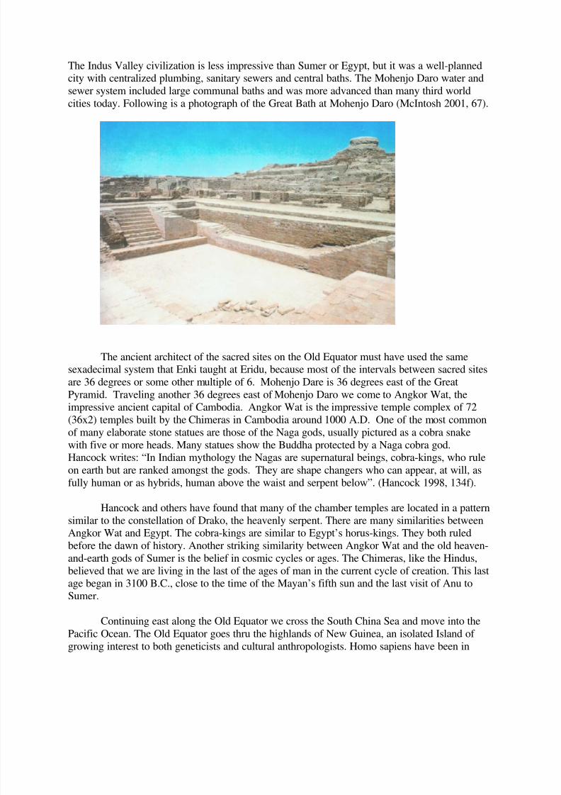
The Indus Valley civilization is less impressive than Sumer or Egypt, but it was a well-plannedcity with centralized plumbing, sanitary sewers and central baths. The Mohenjo Daro water and
sewer system included large communal baths and was more advanced than many third world
cities today. Following is a photograph of the Great Bath at Mohenjo Daro (McIntosh 2001, 67).
The ancient architect of the sacred sites on the Old Equator must have used the samesexadecimal system that Enki taught at Eridu, because most of the intervals between sacred sites
are 36 degrees or some other multiple of 6. Mohenjo Dare is 36 degrees east of the Great
Pyramid. Traveling another 36 degrees east of Mohenjo Daro we come to Angkor Wat, theimpressive ancient capital of Cambodia. Angkor Wat is the impressive temple complex of 72
(36x2) temples built by the Chimeras in Cambodia around 1000 A.D. One of the most commonof many elaborate stone statues are those of the Naga gods, usually pictured as a cobra snake
with five or more heads. Many statues show the Buddha protected by a Naga cobra god.Hancock writes: “In Indian mythology the Nagas are supernatural beings, cobra-kings, who rule
on earth but are ranked amongst the gods. They are shape changers who can appear, at will, as
fully human or as hybrids, human above the waist and serpent below”. (Hancock 1998, 134f).
Hancock and others have found that many of the chamber temples are located in a pattern
similar to the constellation of Drako, the heavenly serpent. There are many similarities betweenAngkor Wat and Egypt. The cobra-kings are similar to Egypt’s horus-kings. They both ruled
before the dawn of history. Another striking similarity between Angkor Wat and the old heaven-
and-earth gods of Sumer is the belief in cosmic cycles or ages. The Chimeras, like the Hindus,believed that we are living in the last of the ages of man in the current cycle of creation. This lastage began in 3100 B.C., close to the time of the Mayan’s fifth sun and the last visit of Anu to
Sumer.
Continuing east along the Old Equator we cross the South China Sea and move into the
Pacific Ocean. The Old Equator goes thru the highlands of New Guinea, an isolated Island of
growing interest to both geneticists and cultural anthropologists. Homo sapiens have been in

8/8/2019 2012 and the Old Equator by Robert Berringer
http://slidepdf.com/reader/full/2012-and-the-old-equator-by-robert-berringer 14/25
Australia and New Guinea for more than thirty thousand years, much longer than in America.Native Australians remained hunter-gatherers for the entire time, while farming evolved in New
Guinea. In fact, New Guinea farmers or their gods first developed their own varieties of the
banana tree, taro, yam and sugar cane around 7000 B.C.
The earliest and most intensive food production, and the densest populations, of Greater
Australia arose in the highland valleys of New Guinea at altitudes between 4,000 and9,000 feet above sea level. Archaeological excavations uncovered complex systems of
drainage ditches dating back nine thousand years ago and becoming extensive by six
thousand years ago, as well as terraces serving to retain moisture in drier areas. The ditch
systems were similar to those still used today in the highlands to drain swampy areas foruse as gardens. By around five thousand years ago, pollen analyses testified to
widespread deforestation of highland valleys, suggesting forest clearance for agriculture
(Diamond 1997, 303).
New Guinea has a cultural evolution similar to that found in the highland valleys of Peru,
which also developed new lands with canals and the terracing of highland valleys. The 7000 B.C.
date is close to the 7121 BC date for the start of the Mayan Fourth Age of Man. The Papuanlanguages found in New Guinea are unique in the world!
Although Australia and New Guinea were one land mass during the last ice age, their
natives are different genetically. Blood types in New Guinea are closer to the rest of the world
than they are to the Australian Aboriginals. The mitochondria DNA in New Guinea come from a
large number of unrelated female ancestors, not from an Australian population (Can 2003, 58).Don’t be surprised to learn that the Polynesians and Eastern Island natives are closely related to
New Guinea natives.
Around 1200 B.C., seafaring farmers from the Bismarck Archipelago ventured east into
the wide open seas of the Pacific with its many islands. If they traveled along the Old Equator, aroute that Enki planned, they would come to Anatom Island, 72 degrees east of Angkor. We note
that the precession rate of the stars is one degree in 72 years, and 72 is a hexadecimal number
built into both the Great Pyramid and Angkor Wat. Anatom Island is the most southern island inthe new Republic of Vanuatu. Stone ruins there once housed the largest missionary church in the
southern hemisphere.
Another 72 degrees east along the Old Equator and we come to Easter Island, a very
auspicious island. There are more than 600 large enigmatic statues on Easter Island. Most of
these statues are more than a thousand years old and some weigh between 100,000 and 150,000
pounds. The following Figure from Hancock’s “Heavens Mirror” is an excellent photograph of
one of the most famous of the Easter Island statues which natives call Moai.

8/8/2019 2012 and the Old Equator by Robert Berringer
http://slidepdf.com/reader/full/2012-and-the-old-equator-by-robert-berringer 15/25
The statues draw our attention to the eyes and head gear. Native American ballplayersare often pictured with helmets, and memorable huge Olmec heads had helmets. Egyptian and
Sumerian illustrations usually picture their gods with helmets and/or horns on their heads. Also,
some eyes on Egyptian statues were painstakingly crafted from convex crystal lenses! Many of the Moai are mounted on immense stone platforms. The statues are not the only sign that a large
civilization once existed on the island. Legend has it that the original three canoes that settled
Easter Island in the fourth century A.D. included scribes who could recite the sacred words onfifty-seven wooden tablets. Like most legends there is some truth here because twenty-four
ancient tablets have been found with hieroglyphic script similar to the symbolic scripts of Egypt
and the early Indus Valley civilization. Another great mystery is that the Easter Island
hieroglyphics have not been deciphered to date. It is different than any other written language.Why did the gods like to invent and scatter new languages along the Old Equator? Are they
signs?
Hancock writes about the mystery of how seafarers in canoes could navigate the
awesome South Pacific to find remote Easter Island.
The mystery also concerns a people who must already have possessed a well-developed
tradition of architecture and engineering when they arrived at the Naval of the World for
there is little trace of experimentation and trial and error in the execution of the great
8/8/2019 2012 and the Old Equator by Robert Berringer
http://slidepdf.com/reader/full/2012-and-the-old-equator-by-robert-berringer 16/25
Moai. On the contrary, the consistent and carefully thought out artistic canon expressedin these unique works of sculpture appears to have been fully elaborated at the beginning
of Easter Island’s remarkable statue-making phase with the best Moai often being the
earliest ones. (ibid. 226).
The architecture Hancock refers to includes sturdy walls and platforms containing many
megaliths and atlars. Scholars theorize on how the natives moved these huge megaliths. Thenatives themselves said Manna, or sorcery, moved them. The people carved the statues in
quarries, but the god kings moved them, often through the air.
One tradition is that the original natives came from a far away island on three canoes.Another tradition is that they came from heaven in a ship.
He (the god king) came down from heaven to earth.To both earths did Hotu-Matua, returning with the help of heaven to both worlds of his
eldest son, to both worlds, to his world.
He came in the ship of his youngest son, his best son, came to earth from heaven. (ibid.
245f).
As in almost all the ancient sacred sites, there are many astronomical orientations. InEaster Island many alignments are solar, like the equinoxes and the solstices. Native traditions
speak of a brotherhood of learned men who studied the sky. The middle of the Pacific Ocean is a
good place to observe the stars. The islanders called their island Eyes Looking at Heaven, a
common motif for the statues.
We have credited Alison for his precise location of the Old Equator, but Hancock andother scholars paved the way. The similarities between Easter Island, Angkor Wat and Giza
include old naval of the earth themes with many “omphalos” or naval of the Earth stone symbols.
Authorities like Peter Tomkins, who worked closely with Stechini and John Michel in hisimportant study At the Center of the World also present compelling evidence that a network of
centers, in constant communication with one another, did once exist, spread out widely around
the globe (ibid. 253). Centered around Egypt, the above scholars identified geographical naval of the world and stone navels marking important meridians and parallels. Alisons’ studies to date
have located Easter Island once and for all as a prominent location on an old important grid. Not
only is it located on the Old Equator, but it is located exactly 180 degrees east of where the OldEquator crosses the Indus River Valley. In other words, if you drill a hole from Easter Island
straight through the center of the earth, you come out in the ancient Indus River Valley, the
location of another undeciphered script. There are only a handful of undeciphered scripts on
earth, and two of them line up through the center of the earth. Easter Island is also the location of
an enigmatic “Hot Spot” which form rows of volcanoes. It is also located above one corner of the Nazca Tectonic Plate, the plate used to form the Andes Mountains (See my Essay on
Intelligent Design).
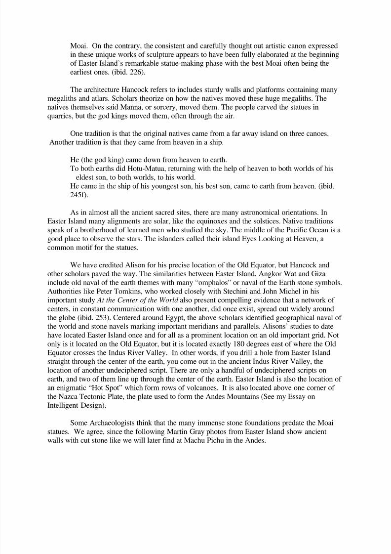
Some Archaeologists think that the many immense stone foundations predate the Moai
statues. We agree, since the following Martin Gray photos from Easter Island show ancientwalls with cut stone like we will later find at Machu Pichu in the Andes.
8/8/2019 2012 and the Old Equator by Robert Berringer
http://slidepdf.com/reader/full/2012-and-the-old-equator-by-robert-berringer 17/25
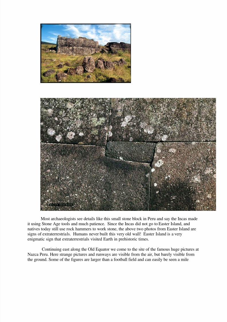
Most archaeologists see details like this small stone block in Peru and say the Incas made
it using Stone Age tools and much patience. Since the Incas did not go to Easter Island, andnatives today still use rock hammers to work stone, the above two photos from Easter Island aresigns of extraterrestrials. Humans never built this very old wall! Easter Island is a very
enigmatic sign that extraterrestrials visited Earth in prehistoric times.
Continuing east along the Old Equator we come to the site of the famous huge pictures at
Nazca Peru. Here strange pictures and runways are visible from the air, but barely visible from
the ground. Some of the figures are larger than a football field and can easily be seen a mile

8/8/2019 2012 and the Old Equator by Robert Berringer
http://slidepdf.com/reader/full/2012-and-the-old-equator-by-robert-berringer 18/25
away in an airplane. Following is an aerial photograph of the Nazca Hummingbird (McIntosh2001, 215).
Some archaeoastronomers calculate that the Nazca ground figures mirror star constellations twothousand years ago. The images were made by scraping dirt and stones away to produce a subtle
two-tone picture. For whom were these pictures made? Since they do not look like much on the
ground, they were made for people with flying machines, like us or extraterrestrial gods.The Nazca coast of Peru had a rich culture long before the Mayans and the Aztecs. The gods left
many signs in Peru, including many skulls with trepanned holes and/or elongated skulls.
Flying due east for an hour brings us to one of the most sacred and mysterious sites in
South America, Machu Pichu in Peru. Located high in the Andes Mountains, 2000 feet above
the sacred Wilcamayu River, the ancient remains are pre-historical. Look closely at the
following photos from Martin Gray’s excellent web site www.sacredsites.com.
8/8/2019 2012 and the Old Equator by Robert Berringer
http://slidepdf.com/reader/full/2012-and-the-old-equator-by-robert-berringer 19/25
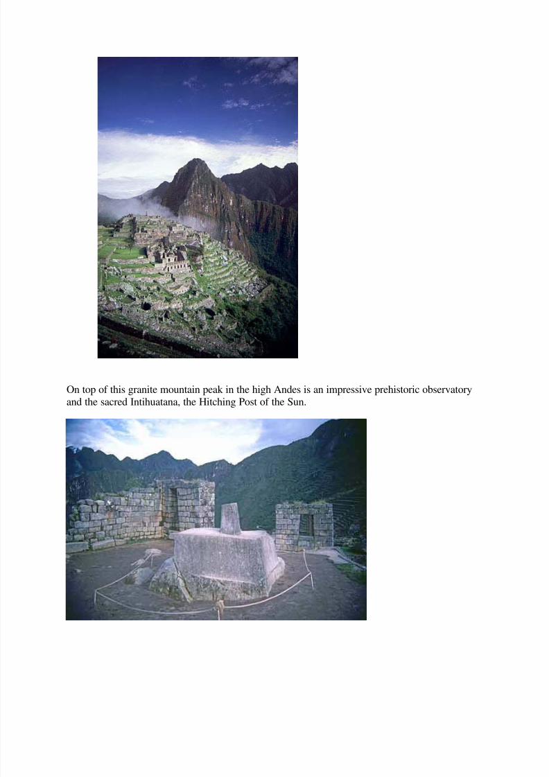
On top of this granite mountain peak in the high Andes is an impressive prehistoric observatory
and the sacred Intihuatana, the Hitching Post of the Sun.

8/8/2019 2012 and the Old Equator by Robert Berringer
http://slidepdf.com/reader/full/2012-and-the-old-equator-by-robert-berringer 20/25
Like the mountain top obelisk at Petra, this structure was not built on top of a level granite peak,but it is actually part of the original solid mountain top. Many tons of granite were removed from
around this functional hitching post for reasons known only by the gods. The wall in the
background with the well built and well preserved trapezoidal window were added after themountain top was leveled. Note the trapezoidal windows which have solar and celestial
alignments as part of an observatory. The following granite walls from the Machu Pichu
mountain top are worth studying.
This ancient granite block was not built by the Incas or other Stone Age humans.
Analysis of the pink granite indicates that it was quarried high up on another mountain on the
other side of the sacred Vilcamaya River (Forte 1997,276). Note that the whole wall looks pink,while the mountain is gray granite like the Intihuatana.
8/8/2019 2012 and the Old Equator by Robert Berringer
http://slidepdf.com/reader/full/2012-and-the-old-equator-by-robert-berringer 21/25
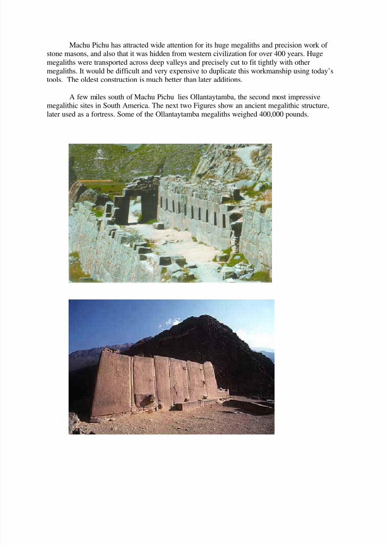
Machu Pichu has attracted wide attention for its huge megaliths and precision work of stone masons, and also that it was hidden from western civilization for over 400 years. Huge
megaliths were transported across deep valleys and precisely cut to fit tightly with other
megaliths. It would be difficult and very expensive to duplicate this workmanship using today’stools. The oldest construction is much better than later additions.
A few miles south of Machu Pichu lies Ollantaytamba, the second most impressivemegalithic sites in South America. The next two Figures show an ancient megalithic structure,
later used as a fortress. Some of the Ollantaytamba megaliths weighed 400,000 pounds.
8/8/2019 2012 and the Old Equator by Robert Berringer
http://slidepdf.com/reader/full/2012-and-the-old-equator-by-robert-berringer 22/25
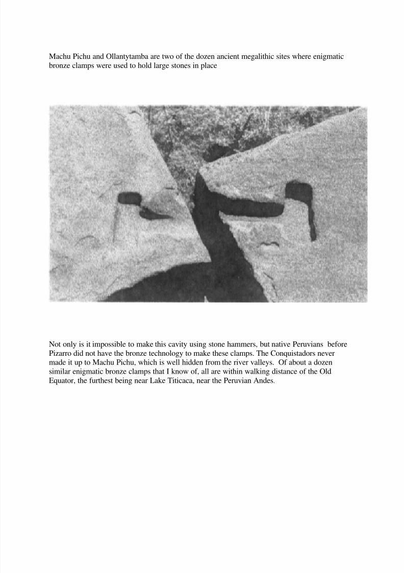
Machu Pichu and Ollantytamba are two of the dozen ancient megalithic sites where enigmatic
bronze clamps were used to hold large stones in place
Not only is it impossible to make this cavity using stone hammers, but native Peruvians before
Pizarro did not have the bronze technology to make these clamps. The Conquistadors nevermade it up to Machu Pichu, which is well hidden from the river valleys. Of about a dozen
similar enigmatic bronze clamps that I know of, all are within walking distance of the Old
Equator, the furthest being near Lake Titicaca, near the Peruvian Andes.

8/8/2019 2012 and the Old Equator by Robert Berringer
http://slidepdf.com/reader/full/2012-and-the-old-equator-by-robert-berringer 23/25
The following photos of ancient Peruvian solid stone foundations are also not of human
origin.

8/8/2019 2012 and the Old Equator by Robert Berringer
http://slidepdf.com/reader/full/2012-and-the-old-equator-by-robert-berringer 24/25
Opening to underground shelter or foundation?
Foundations Carved in Granite
Both photos show impressive foundations carved into solid granite bedrock. I am probably theonly engineer who thinks that they were used to literally move mountains or tectonic plates.
. Traveling east from the Peruvian Andes we cross Brazil and the mouth of the Amazon
River. Satellite photos indicate many ancient canals along the Amazon River, and just recently
an ancient canal has been found on the Old Equator near the mouth of the Amazon. The OldEquator crosses the Cape Verde Islands, halfway between Easter Island and the Indus Valley.
Ancient maps indicate some occupation of the Cape Verde Islands. Will Hart, Jim Alison and Iare among the minority of scholars who think Cape Verde was home to Atlantis. In 11,000 BC,
the ocean was about 300 feet lower and the Cape Verde and Canary Islands to the north were
much larger.
The gods are very interested in time as well as space. They are especially interested incalendars and astronomical signs about space like the precession of the equinox, a very slow
stellar event. The first two historical calendars date to about 3100 BC, the very dawn of history.
The most accurate prehistoric calendar is the Mayan Calendar. If you are interested in Mayan
calendars and celestial alignments, both of which point to the end of the Fifth Age of Man in2012, look up works by John Major Jenkins. Most Mayan scholars agree with Jenkins that the
last three ages of man started on 11,131 BC, 7121 BC and 3114 BC. I have previously
mentioned that 11,000 BC is one of the preferred dates for the destruction of Atlantis and Noah’sDeluge. In 1997 Paul LaViolette published “Earth Under Fire: Humanity’s Survival of the
Apocalypse” which calculates that a mass extinction of large animals on the northern hemisphere
occurred around 10,750 BC. He also calculates that the black hole at the center of our galaxyreached its highest point on 10,890 BC.
8/8/2019 2012 and the Old Equator by Robert Berringer
http://slidepdf.com/reader/full/2012-and-the-old-equator-by-robert-berringer 25/25
Like the Egyptologists, American Anthropologists are outdated. They still think thatClovis big game hunters with improved spears caused the extinction of most large mammals
around 11,000 BC, including the mammoths, mastadons, huge bears, giant sloths, scinter-tooth
tigers and saber-tooth tigers. 2012 will arrive before most anthropologists update their theoriesbased on new scientific evidence, such as that referenced in the excellent 2006 book “The Cycle
of Cosmic Catastrophes: Flood, Fire, and Famine in the History Of Civilization” by Richard
Firestone, Allen West, and Simon-Warwick Smith. They will be surprised to learn that theClovis big game hunters also became extinct around 11,000 BC. Cosmic missiles, probably
comets and radiation from an exploding supernova were the probable cause of an earthly
catastrophe that devastated North America and much of South America, Europe and Asia. Large
mammals in Africa survived. Very few American anthropologists currently believe thisenigmatic mass destruction to have an extraterrestrial cause, and no scientist could publish that
this event was part of an Intelligent Design.
Although scientists are still trying to figure out what caused the last mass destruction of
large mammals, anthropologists agree that this mass destruction hurt the hunters and helped the
farmers. The gods were preparing to introduce humans north of the Old Equator when they
returned in 7121 BC. Remember that the Mayan Third Age of Man with the major cultural leapforward associated with the domestication of most plants and animals occurred near the Old
Equator around 7000 BC. How did the Mayans know that the Fourth Age of Man started on7131 BC and the Bronze Age started on 3114 BC? The Mayans, Toltecs, Zapotecs and the
Olmecs all believed they could communicate with the gods using psychedelic drugs like
mushrooms. Since I now believe that extraterrestrial gods built statues, fabricated walls, built
pyramids, and taught us languages, perhaps they also taught the Mayan Calendar to humans (Seemy Essay on the Mayan Ages).
The end of the Fifth Age of Man ends on December 21, 2012. UFO abductees report that
extraterrestrials are using humans to help breed many hybrids. Note that the grays etc are not
gods. We will know them when the gods arrive in power. Estimates of the number of hybridbabies range from one thousand to one million. Human genes will dilute the hybrid genes long
before the Second Age of Aquarius unless:1). the hybrids are a new species, or 2). most Homo
sapiens are removed from the path of the new hybrids. Both the Mayans and the grays warn of earthquakes and mass destruction. The abductees are often shown an Earth split in two. My
knowledge of evolution and history says that extraterrestrials use mass extinctions for both
physical and cultural evolution. Perhaps extinction will again occur north of the Old Equator,civilization on the Old Equator and preservation of humans and other large mammals will
continue south of the Old Equator. He who has ears to hear, let him hear!