2011 census electoral ward statistics - aberdeen city council
TRANSCRIPT

RESEARCH AND INFORMATION
2011 Census Electoral Ward Statistics
Aberdeen City
2011 Census – Electoral Ward Statistics This booklet contains statistical information from the 2011 census including information on population, households, occupancy, travel to work and economic activity. All tables provide this information by Electoral Ward. A further release of census information is expected Summer 2014. Responsibility for administering the census lies with National Records of Scotland (NRS) and they began publishing data in March 2013. Details of the latest census results, prospectus for future data releases and the NRS online Census Data Explorer can be viewed on the Scotland's Census website: http://www.scotlandscensus.gov.uk/en/ For further information on the 2011 Census, please contact the Research & Information Team: [email protected] or visit our 2011 Census Information page at: http://www.aberdeencity.gov.uk/Census © Crown Copyright

12
3
4 5 6
7 8
9
10
1112
13
2007Electoral Wards
1 Dyce/ Bucksburn/ Danestone2 Bridge of Don3 Kingswells/ Sheddocksley/ Summerhill4 Northfield/ Mastrick North5 Hilton/ Woodside/ Stockethill6 Tillydrone/ Seaton/ Old Aberdeen7 Midstocket/ Rosemount8 George Street/ Harbour9 Lower Deeside10 Hazlehead/ Ashley/ Queens Cross11 Airyhall/ Broomhill/ Garthdee12 Torry/ Ferryhill13 Kincorth/ Nigg/ Cove
I
1:110,000Scale: (c) Crown Copyright. All Rights Reserved. Aberdeen City Council - 100023401 (2014)Date: 2014

2011 Census – Electoral Ward Statistics Contents 1a. Population 28. Hours Worked 1b. Population - Age Bands 29. Time Since Last Worked 2. Household Size 30. Industry 3. Living Arrangements 31. Occupation 4. Marital and Civil Partnership Status 32. Socio-economic 5. Families with Dependent Children 33. Qualifications 6a. Household Composition (households) 34. Method of Travel to Work or Study 6b. Household Composition (people) 35. Communal Establishments - No of People 7a. Tenure (households) 36. Position in Communal Establishment 7b. Tenure (people) 8a. Accommodation Type (households) 8b. Accommodation Type (people) 9. Household Type 10. Number of Rooms 11. Persons per Room (households) 12. Occupancy Rating (rooms) 13. Household Spaces 14. Dwellings 15. Car or Van Availability 16. Ethnic Group 17. Multiple Ethnic Groups 18a. Country of Birth- Detail 18b. National Identity 19. Religion 20. Year of Arrival in the UK 21. Age at Arrival in the UK 22. English Language Skills 23. Proficiency in English 24. Length of Residence in the UK 25. General Health and Limiting Long-term Health Problem or Disability 26. Provision of Unpaid Care 27a. Economically Active 27b. Economically Inactive 27c. Economically Active Full-time Students
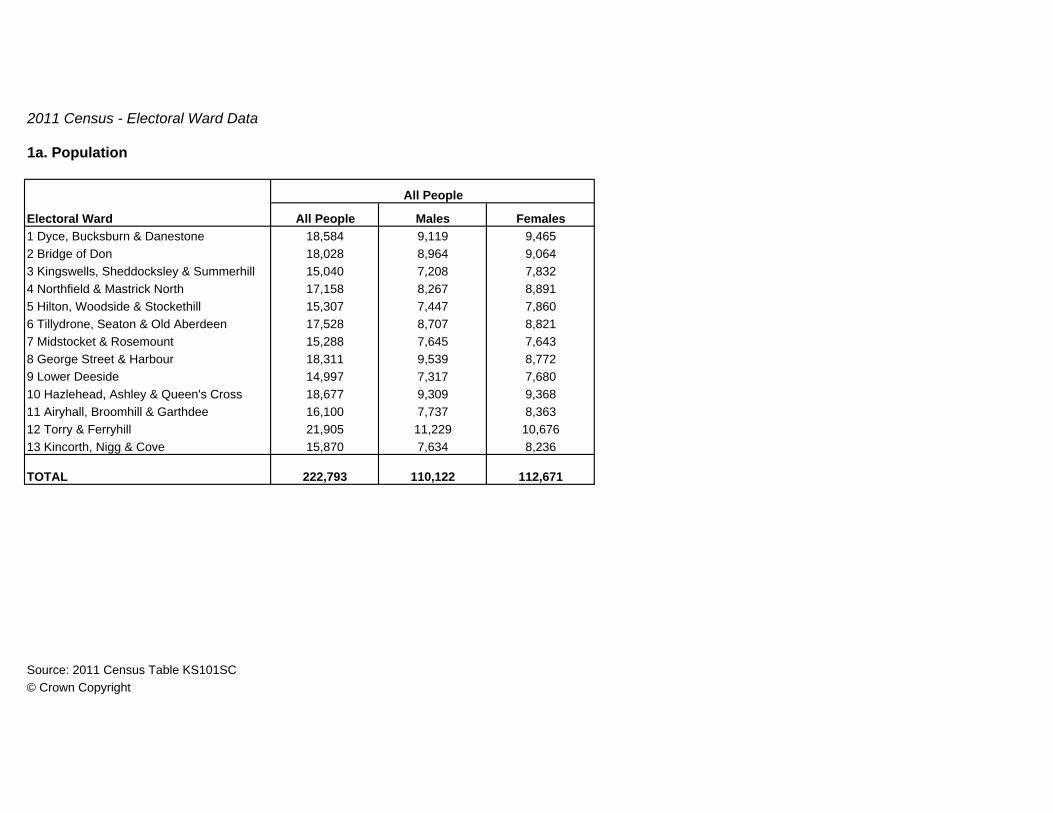
2011 Census - Electoral Ward Data
1a. Population
All People Males Females1 Dyce, Bucksburn & Danestone 18,584 9,119 9,4652 Bridge of Don 18,028 8,964 9,0643 Kingswells, Sheddocksley & Summerhill 15,040 7,208 7,8324 Northfield & Mastrick North 17,158 8,267 8,8915 Hilton, Woodside & Stockethill 15,307 7,447 7,8606 Tillydrone, Seaton & Old Aberdeen 17,528 8,707 8,8217 Midstocket & Rosemount 15,288 7,645 7,6438 George Street & Harbour 18,311 9,539 8,7729 Lower Deeside 14,997 7,317 7,68010 Hazlehead, Ashley & Queen's Cross 18,677 9,309 9,36811 Airyhall, Broomhill & Garthdee 16,100 7,737 8,36312 Torry & Ferryhill 21,905 11,229 10,67613 Kincorth, Nigg & Cove 15,870 7,634 8,236
TOTAL 222,793 110,122 112,671
Source: 2011 Census Table KS101SC © Crown Copyright
All People
Electoral Ward
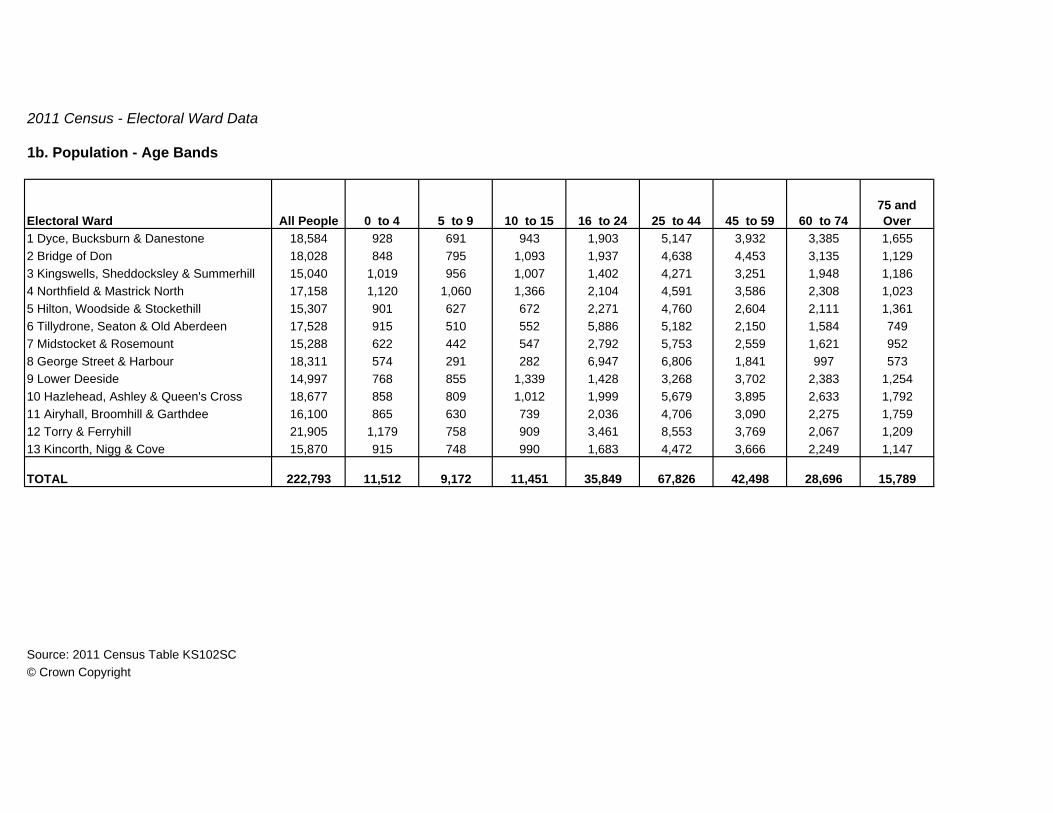
2011 Census - Electoral Ward Data
1b. Population - Age Bands
Electoral Ward All People 0 to 4 5 to 9 10 to 15 16 to 24 25 to 44 45 to 59 60 to 7475 and Over
1 Dyce, Bucksburn & Danestone 18,584 928 691 943 1,903 5,147 3,932 3,385 1,6552 Bridge of Don 18,028 848 795 1,093 1,937 4,638 4,453 3,135 1,1293 Kingswells, Sheddocksley & Summerhill 15,040 1,019 956 1,007 1,402 4,271 3,251 1,948 1,1864 Northfield & Mastrick North 17,158 1,120 1,060 1,366 2,104 4,591 3,586 2,308 1,0235 Hilton, Woodside & Stockethill 15,307 901 627 672 2,271 4,760 2,604 2,111 1,3616 Tillydrone, Seaton & Old Aberdeen 17,528 915 510 552 5,886 5,182 2,150 1,584 7497 Midstocket & Rosemount 15,288 622 442 547 2,792 5,753 2,559 1,621 9528 George Street & Harbour 18,311 574 291 282 6,947 6,806 1,841 997 5739 Lower Deeside 14,997 768 855 1,339 1,428 3,268 3,702 2,383 1,25410 Hazlehead, Ashley & Queen's Cross 18,677 858 809 1,012 1,999 5,679 3,895 2,633 1,79211 Airyhall, Broomhill & Garthdee 16,100 865 630 739 2,036 4,706 3,090 2,275 1,75912 Torry & Ferryhill 21,905 1,179 758 909 3,461 8,553 3,769 2,067 1,20913 Kincorth, Nigg & Cove 15,870 915 748 990 1,683 4,472 3,666 2,249 1,147
TOTAL 222,793 11,512 9,172 11,451 35,849 67,826 42,498 28,696 15,789
Source: 2011 Census Table KS102SC© Crown Copyright

2011 Census - Electoral Ward Data
2. Household Size
1 2 3 4 5 6 7 8 +1 Dyce, Bucksburn & Danestone 8,485 2,794 3,288 1,259 866 225 41 8 42 Bridge of Don 7,621 1,985 2,873 1,333 1,094 270 53 7 63 Kingswells, Sheddocksley & Summerhill 6,541 1,983 2,233 1,182 845 256 33 6 34 Northfield & Mastrick North 7,086 2,054 2,253 1,327 932 395 92 21 125 Hilton, Woodside & Stockethill 7,760 3,237 2,635 1,112 527 188 45 13 36 Tillydrone, Seaton & Old Aberdeen 7,269 3,211 2,328 1,057 474 138 48 9 47 Midstocket & Rosemount 8,272 3,952 2,837 824 482 141 27 7 28 George Street & Harbour 9,336 4,513 3,366 919 377 126 33 1 19 Lower Deeside 5,862 1,475 2,115 937 929 328 63 10 510 Hazlehead, Ashley & Queen's Cross 9,021 3,544 3,201 1,077 873 251 60 12 311 Airyhall, Broomhill & Garthdee 7,812 3,083 2,691 1,026 751 200 48 11 212 Torry & Ferryhill 11,340 5,294 3,631 1,354 752 233 55 12 913 Kincorth, Nigg & Cove 6,966 2,094 2,491 1,213 885 219 47 11 6
TOTAL 103,371 39,219 35,942 14,620 9,787 2,970 645 128 60
Source: 2011 Census Table QS406SC© Crown Copyright
All Occupied Household
SpacesElectoral Ward
Number of People

2011 Census - Electoral Ward Data
3. Living Arrangements (1 of 2)
Total Married
Co-habiting (opposite-
sex)
In a Registered Same-sex
Civil Partnership
or Co-habiting
(same-sex)1 Dyce, Bucksburn & Danestone 15,525 9,749 7,692 1,990 672 Bridge of Don 15,148 10,046 8,566 1,418 623 Kingswells, Sheddocksley & Summerhill 11,937 7,366 5,916 1,387 634 Northfield & Mastrick North 13,497 7,342 5,628 1,658 565 Hilton, Woodside & Stockethill 13,076 6,343 4,570 1,642 1316 Tillydrone, Seaton & Old Aberdeen 12,047 4,956 3,249 1,599 1087 Midstocket & Rosemount 13,348 6,039 4,038 1,875 1268 George Street & Harbour 15,213 5,160 2,552 2,444 1649 Lower Deeside 11,461 7,794 6,866 900 2810 Hazlehead, Ashley & Queen's Cross 15,716 9,349 7,544 1,705 10011 Airyhall, Broomhill & Garthdee 13,698 7,605 5,964 1,553 8812 Torry & Ferryhill 18,446 8,542 5,314 3,061 16713 Kincorth, Nigg & Cove 13,113 8,106 6,332 1,702 72
TOTAL 182,225 98,397 74,231 22,934 1,232
Source: 2011 Census Table QS108SC© Crown Copyright
Electoral Ward
All People Aged 16+ in Households
Living in a Couple

2011 Census - Electoral Ward Data
3. Living Arrangements (2 of 2)
Total
Single (never married or never
registered a same-sex civil partnership)
Married or in a Registered
Same-sex Civil Partnership
Separated (but still legally
married or still in a same-sex
civil partnership)
Divorced or Formerly in a
Same-sex Civil Partnership
Which is Now Legally
Dissolved
Widowed or Surviving
Partner from a Same-sex Civil
Partnership1 Dyce, Bucksburn & Danestone 5,776 3,415 164 328 848 1,0212 Bridge of Don 5,102 3,207 117 255 671 8523 Kingswells, Sheddocksley & Summerhill 4,571 2,610 93 263 763 8424 Northfield & Mastrick North 6,155 3,713 103 402 1,018 9195 Hilton, Woodside & Stockethill 6,733 4,236 186 340 998 9736 Tillydrone, Seaton & Old Aberdeen 7,091 4,909 207 328 1,017 6307 Midstocket & Rosemount 7,309 5,393 209 249 841 6178 George Street & Harbour 10,053 8,272 248 302 799 4329 Lower Deeside 3,667 2,218 104 165 487 69310 Hazlehead, Ashley & Queen's Cross 6,367 4,215 224 285 734 90911 Airyhall, Broomhill & Garthdee 6,093 3,862 169 248 799 1,01512 Torry & Ferryhill 9,904 7,010 373 446 1,261 81413 Kincorth, Nigg & Cove 5,007 3,012 103 270 729 893
TOTAL 83,828 56,072 2,300 3,881 10,965 10,610
Source: 2011 Census Table QS108SC© Crown Copyright
Electoral Ward
Not living in a Couple

2011 Census - Electoral Ward Data
4. Marital and Civil Partnership Status
Electoral Ward
All People Aged 16 and Over
Single (never married or
never registered a
same-sex civil partnership) Married
In a Registered Same-sex Civil
Partnership
Separated (but still legally
married or still legally in a
same-sex civil partnership)
Divorced or Formerly in a
Same-sex Civil Partnership
Which is Now Legally
Dissolved
Widowed or Surviving
Partner from a Same-sex Civil
Partnership1 Dyce, Bucksburn & Danestone 16,022 5,056 7,938 12 429 1,283 1,3042 Bridge of Don 15,292 4,273 8,730 16 317 1,002 9543 Kingswells, Sheddocksley & Summerhill 12,058 3,691 6,036 12 339 1,074 9064 Northfield & Mastrick North 13,612 4,989 5,736 13 526 1,355 9935 Hilton, Woodside & Stockethill 13,107 5,630 4,789 16 406 1,261 1,0056 Tillydrone, Seaton & Old Aberdeen 15,551 9,636 3,538 30 398 1,277 6727 Midstocket & Rosemount 13,677 7,367 4,269 12 298 1,064 6678 George Street & Harbour 17,164 12,433 2,868 16 350 992 5059 Lower Deeside 12,035 3,115 7,058 17 227 741 87710 Hazlehead, Ashley & Queen's Cross 15,998 5,700 7,813 19 359 1,040 1,06711 Airyhall, Broomhill & Garthdee 13,866 5,264 6,191 14 305 1,022 1,07012 Torry & Ferryhill 19,059 9,979 5,802 27 566 1,703 98213 Kincorth, Nigg & Cove 13,217 4,305 6,458 17 353 1,124 960
TOTAL 190,658 81,438 77,226 221 4,873 14,938 11,962
Source: 2011 Census Table KS103SC© Crown Copyright

2011 Census - Electoral Ward Data
5. Families with Dependent Children
Aged 0 to 4
Aged 5 to 11
Aged 12 to 18
Youngest Aged 0 to 4
Youngest Aged
5 to 11
Youngest Aged
12 to 18
Youngest Aged 0 to 4
Youngest Aged
5 to 11
Youngest Aged
12 to 181 Dyce, Bucksburn & Danestone 5,590 3,743 385 252 390 265 249 136 94 63 132 Bridge of Don 5,602 3,587 300 214 500 299 321 179 95 85 223 Kingswells, Sheddocksley & Summerhill 4,498 2,507 357 252 373 343 335 107 131 80 134 Northfield & Mastrick North 4,996 2,705 377 341 446 327 313 138 199 137 135 Hilton, Woodside & Stockethill 4,060 2,472 436 250 280 232 169 68 84 61 86 Tillydrone, Seaton & Old Aberdeen 3,249 1,852 451 219 215 227 126 41 81 33 47 Midstocket & Rosemount 3,493 2,332 270 137 235 171 145 84 64 44 118 George Street & Harbour 2,991 2,144 315 132 123 130 60 23 39 23 29 Lower Deeside 4,364 2,487 224 169 373 248 325 219 132 153 3410 Hazlehead, Ashley & Queen's Cross 5,111 3,255 336 187 384 258 279 172 109 117 1411 Airyhall, Broomhill & Garthdee 4,355 2,811 327 163 295 260 208 120 92 63 1612 Torry & Ferryhill 5,234 3,263 522 272 339 317 229 93 112 74 1313 Kincorth, Nigg & Cove 4,807 2,943 343 236 400 280 290 133 111 63 8
TOTAL 58,350 36,101 4,643 2,824 4,353 3,357 3,049 1,513 1,343 996 171
Source: 2011 Census Table QS118SC© Crown Copyright
Electoral Ward
One Dependent Child Two Dependent Children Three or More Dependent Children
No Dependent
Children
All Families in House-
holds
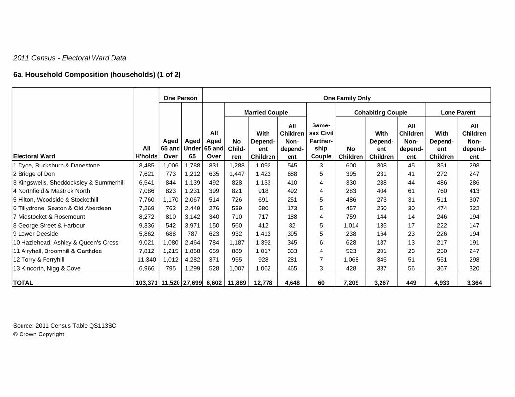
2011 Census - Electoral Ward Data
6a. Household Composition (households) (1 of 2)
No Child-
ren
With Depend-
ent Children
All Children
Non-depend-
entNo
Children
With Depend-
ent Children
All Children
Non-depend-
ent
With Depend-
ent Children
All Children
Non-depend-
ent1 Dyce, Bucksburn & Danestone 8,485 1,006 1,788 831 1,288 1,092 545 3 600 308 45 351 2982 Bridge of Don 7,621 773 1,212 635 1,447 1,423 688 5 395 231 41 272 2473 Kingswells, Sheddocksley & Summerhill 6,541 844 1,139 492 828 1,133 410 4 330 288 44 486 2864 Northfield & Mastrick North 7,086 823 1,231 399 821 918 492 4 283 404 61 760 4135 Hilton, Woodside & Stockethill 7,760 1,170 2,067 514 726 691 251 5 486 273 31 511 3076 Tillydrone, Seaton & Old Aberdeen 7,269 762 2,449 276 539 580 173 5 457 250 30 474 2227 Midstocket & Rosemount 8,272 810 3,142 340 710 717 188 4 759 144 14 246 1948 George Street & Harbour 9,336 542 3,971 150 560 412 82 5 1,014 135 17 222 1479 Lower Deeside 5,862 688 787 623 932 1,413 395 5 238 164 23 226 19410 Hazlehead, Ashley & Queen's Cross 9,021 1,080 2,464 784 1,187 1,392 345 6 628 187 13 217 19111 Airyhall, Broomhill & Garthdee 7,812 1,215 1,868 659 889 1,017 333 4 523 201 23 250 24712 Torry & Ferryhill 11,340 1,012 4,282 371 955 928 281 7 1,068 345 51 551 29813 Kincorth, Nigg & Cove 6,966 795 1,299 528 1,007 1,062 465 3 428 337 56 367 320
TOTAL 103,371 11,520 27,699 6,602 11,889 12,778 4,648 60 7,209 3,267 449 4,933 3,364
Source: 2011 Census Table QS113SC© Crown Copyright
Same-sex Civil Partner-
ship Couple
One Person
Married Couple Cohabiting Couple Lone Parent
One Family Only
All H'holdsElectoral Ward
Aged 65 and Over
Aged Under
65
All Aged
65 and Over

2011 Census - Electoral Ward Data
6a. Household Composition (households) (2 of 2)
With Dependent Children
All Full-time Students
All Aged 65 and Over Other
1 Dyce, Bucksburn & Danestone 105 13 10 2022 Bridge of Don 104 11 11 1263 Kingswells, Sheddocksley & Summerhill 80 10 10 1574 Northfield & Mastrick North 216 20 18 2235 Hilton, Woodside & Stockethill 129 237 13 3496 Tillydrone, Seaton & Old Aberdeen 107 507 7 4317 Midstocket & Rosemount 61 399 12 5328 George Street & Harbour 94 1,071 5 9099 Lower Deeside 74 5 6 8910 Hazlehead, Ashley & Queen's Cross 64 118 14 33111 Airyhall, Broomhill & Garthdee 85 188 26 28412 Torry & Ferryhill 157 263 16 75513 Kincorth, Nigg & Cove 100 11 11 177
TOTAL 1,376 2,853 159 4,565
Source: 2011 Census Table QS113SC© Crown Copyright
Electoral Ward
Other Households

2011 Census - Electoral Ward Data
6b. Household Composition (people) (1 of 2)
Aged 65 and Over
Aged Under
65
No Child-
ren
With Depend-
ent Children
All Children
Non-depend-
entNo
Children
With Depend-
ent Children
All Children
Non-depend-
ent
With Depend-
ent Children
All Children
Non-depend-
ent1 Dyce, Bucksburn & Danestone 18,071 1,006 1,788 1,662 2,576 4,158 1,800 6 1,200 1,079 155 915 6542 Bridge of Don 17,883 773 1,212 1,270 2,894 5,510 2,265 11 790 847 130 715 5523 Kingswells, Sheddocksley & Summerhill 14,919 844 1,139 984 1,656 4,353 1,333 9 660 1,032 138 1,267 6184 Northfield & Mastrick North 17,043 823 1,231 800 1,642 3,638 1,634 10 566 1,573 204 2,238 9155 Hilton, Woodside & Stockethill 15,276 1,170 2,067 1,028 1,452 2,574 822 10 972 988 96 1,279 6526 Tillydrone, Seaton & Old Aberdeen 14,008 762 2,449 552 1,078 2,154 560 11 914 848 95 1,179 4667 Midstocket & Rosemount 14,958 810 3,142 680 1,420 2,713 610 8 1,518 499 46 609 4168 George Street & Harbour 16,353 542 3,971 300 1,120 1,463 261 10 2,028 466 55 544 3209 Lower Deeside 14,367 688 787 1,246 1,864 5,598 1,312 11 476 611 77 605 42310 Hazlehead, Ashley & Queen's Cross 18,392 1,080 2,464 1,568 2,374 5,381 1,139 12 1,256 673 43 558 41211 Airyhall, Broomhill & Garthdee 15,929 1,215 1,868 1,318 1,778 3,883 1,108 8 1,046 724 80 681 53612 Torry & Ferryhill 21,281 1,012 4,282 742 1,910 3,495 932 14 2,136 1,240 161 1,439 64913 Kincorth, Nigg & Cove 15,763 795 1,299 1,056 2,014 4,051 1,540 6 856 1,233 185 1,015 700
TOTAL 214,243 11,520 27,699 13,206 23,778 48,971 15,316 126 14,418 11,813 1,465 13,044 7,313
Source: 2011 Census Table QS112SC© Crown Copyright
Lone Parent
One Family Only
One Person
All People
in H'holdsElectoral Ward
Cohabiting CoupleMarried Couple
Same-sex Civil
Partner-ship
Couple
All Aged
65 and Over

2011 Census - Electoral Ward Data
6b. Household Composition (people) (2 of 2)
With Dependent Children
All Full-time Students
All Aged 65 and Over Other
1 Dyce, Bucksburn & Danestone 472 34 20 5462 Bridge of Don 502 25 24 3633 Kingswells, Sheddocksley & Summerhill 390 25 26 4454 Northfield & Mastrick North 1,005 53 39 6725 Hilton, Woodside & Stockethill 591 645 29 9016 Tillydrone, Seaton & Old Aberdeen 444 1,359 16 1,1217 Midstocket & Rosemount 278 916 26 1,2678 George Street & Harbour 396 2,674 11 2,1929 Lower Deeside 366 15 14 27410 Hazlehead, Ashley & Queen's Cross 304 292 34 80211 Airyhall, Broomhill & Garthdee 379 507 54 74412 Torry & Ferryhill 670 648 36 1,91513 Kincorth, Nigg & Cove 452 33 23 505
TOTAL 6,249 7,226 352 11,747
Source: 2011 Census Table QS112SC© Crown Copyright
Electoral Ward
Other Household Types

2011 Census - Electoral Ward Data
7a. Tenure (households) (1 of 2)
TotalOwns
Outright
Owns with a Mortgage or
Loan
Shared Ownership (part owned
and part rented)
1 Dyce, Bucksburn & Danestone 8,485 6,290 2,758 3,465 672 Bridge of Don 7,621 6,456 2,854 3,562 403 Kingswells, Sheddocksley & Summerhill 6,541 4,003 1,516 2,431 564 Northfield & Mastrick North 7,086 3,247 1,278 1,942 275 Hilton, Woodside & Stockethill 7,760 3,478 1,526 1,902 506 Tillydrone, Seaton & Old Aberdeen 7,269 1,911 835 958 1187 Midstocket & Rosemount 8,272 4,233 1,828 2,351 548 George Street & Harbour 9,336 2,960 927 1,925 1089 Lower Deeside 5,862 4,773 2,548 2,204 2110 Hazlehead, Ashley & Queen's Cross 9,021 6,359 3,309 3,028 2211 Airyhall, Broomhill & Garthdee 7,812 5,162 2,605 2,528 2912 Torry & Ferryhill 11,340 5,150 1,922 3,110 11813 Kincorth, Nigg & Cove 6,966 5,187 1,995 3,154 38
TOTAL 103,371 59,209 25,901 32,560 748
Source: 2011 Census Table QS405SC© Crown Copyright
All HouseholdsElectoral Ward
Owned
2011 Census - Electoral Ward Data
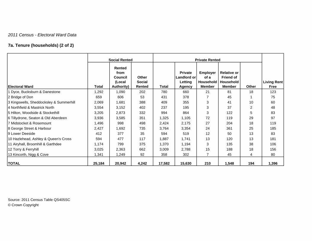
7a. Tenure (households) (2 of 2)
Total
Rented from
Council (Local
Authority)
Other Social Rented Total
Private Landlord or
Letting Agency
Employer of a
Household Member
Relative or Friend of
Household Member Other
1 Dyce, Bucksburn & Danestone 1,292 1,090 202 780 660 21 81 18 1232 Bridge of Don 659 606 53 431 378 7 45 1 753 Kingswells, Sheddocksley & Summerhill 2,069 1,681 388 409 355 3 41 10 604 Northfield & Mastrick North 3,554 3,152 402 237 195 3 37 2 485 Hilton, Woodside & Stockethill 3,205 2,873 332 994 864 3 122 5 836 Tillydrone, Seaton & Old Aberdeen 3,936 3,585 351 1,325 1,105 72 119 29 977 Midstocket & Rosemount 1,496 998 498 2,424 2,175 27 204 18 1198 George Street & Harbour 2,427 1,692 735 3,764 3,354 24 361 25 1859 Lower Deeside 412 377 35 594 519 12 50 13 8310 Hazlehead, Ashley & Queen's Cross 594 477 117 1,887 1,741 13 120 13 18111 Airyhall, Broomhill & Garthdee 1,174 799 375 1,370 1,194 3 135 38 10612 Torry & Ferryhill 3,025 2,363 662 3,009 2,788 15 188 18 15613 Kincorth, Nigg & Cove 1,341 1,249 92 358 302 7 45 4 80
TOTAL 25,184 20,942 4,242 17,582 15,630 210 1,548 194 1,396
Source: 2011 Census Table QS405SC© Crown Copyright
Living Rent FreeElectoral Ward
Social Rented Private Rented

2011 Census - Electoral Ward Data
7b. Tenure (people) (1 of 2)
TotalOwned
Outright
Owned with a Mortgage
or Loan
Shared Owneship
(part owned and part rented)
1 Dyce, Bucksburn & Danestone 18,071 13,798 5,264 8,412 1222 Bridge of Don 17,883 15,538 5,858 9,591 893 Kingswells, Sheddocksley & Summerhill 14,919 9,730 2,979 6,645 1064 Northfield & Mastrick North 17,043 7,758 2,446 5,244 685 Hilton, Woodside & Stockethill 15,276 7,038 2,647 4,293 986 Tillydrone, Seaton & Old Aberdeen 14,008 3,627 1,435 1,971 2217 Midstocket & Rosemount 14,958 7,937 3,149 4,683 1058 George Street & Harbour 16,353 4,852 1,454 3,180 2189 Lower Deeside 14,367 11,677 5,292 6,352 3310 Hazlehead, Ashley & Queen's Cross 18,392 13,406 6,145 7,210 5111 Airyhall, Broomhill & Garthdee 15,929 10,776 4,651 6,072 5312 Torry & Ferryhill 21,281 9,491 3,292 5,989 21013 Kincorth, Nigg & Cove 15,763 11,963 3,870 8,017 76
TOTAL 214,243 127,591 48,482 77,659 1,450
Source: 2011 Census Table QS403SC© Crown Copyright
All People in HouseholdsElectoral Ward
Owned
2011 Census - Electoral Ward Data
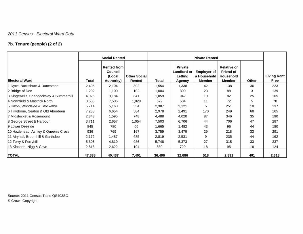
7b. Tenure (people) (2 of 2)
Total
Rented from Council (Local
Authority)Other Social
Rented Total
Private Landlord or
Letting Agency
Employer of a Household
Member
Relative or Friend of
Household Member Other
1 Dyce, Bucksburn & Danestone 2,496 2,104 392 1,554 1,338 42 138 36 2232 Bridge of Don 1,202 1,100 102 1,004 890 23 88 3 1393 Kingswells, Sheddocksley & Summerhill 4,025 3,184 841 1,059 942 10 82 25 1054 Northfield & Mastrick North 8,535 7,506 1,029 672 584 11 72 5 785 Hilton, Woodside & Stockethill 5,714 5,160 554 2,387 2,121 5 251 10 1376 Tillydrone, Seaton & Old Aberdeen 7,238 6,654 584 2,978 2,491 170 249 68 1657 Midstocket & Rosemount 2,343 1,595 748 4,488 4,020 87 346 35 1908 George Street & Harbour 3,711 2,657 1,054 7,503 6,706 44 706 47 2879 Lower Deeside 845 780 65 1,665 1,482 43 96 44 18010 Hazlehead, Ashley & Queen's Cross 936 769 167 3,759 3,479 29 218 33 29111 Airyhall, Broomhill & Garthdee 2,172 1,487 685 2,819 2,531 9 235 44 16212 Torry & Ferryhill 5,805 4,819 986 5,748 5,373 27 315 33 23713 Kincorth, Nigg & Cove 2,816 2,622 194 860 729 18 95 18 124
TOTAL 47,838 40,437 7,401 36,496 32,686 518 2,891 401 2,318
Source: 2011 Census Table QS403SC© Crown Copyright
Living Rent FreeElectoral Ward
Social Rented Private Rented

2011 Census - Electoral Ward Data
8a. Accommodation Type (households) (1 of 2)
Total DetachedSemi-
detached Terraced1 Dyce, Bucksburn & Danestone 8,485 8,485 6,059 1,445 2,809 1,8052 Bridge of Don 7,621 7,621 6,564 1,850 3,501 1,2133 Kingswells, Sheddocksley & Summerhill 6,541 6,541 4,852 1,360 1,444 2,0484 Northfield & Mastrick North 7,086 7,080 4,941 155 1,867 2,9195 Hilton, Woodside & Stockethill 7,760 7,749 2,056 244 888 9246 Tillydrone, Seaton & Old Aberdeen 7,269 7,257 1,273 194 469 6107 Midstocket & Rosemount 8,272 8,261 1,869 401 740 7288 George Street & Harbour 9,336 9,300 607 109 228 2709 Lower Deeside 5,862 5,862 4,643 2,669 1,390 58410 Hazlehead, Ashley & Queen's Cross 9,021 9,003 4,864 1,388 2,355 1,12111 Airyhall, Broomhill & Garthdee 7,812 7,810 4,346 547 2,652 1,14712 Torry & Ferryhill 11,340 11,318 2,500 269 1,218 1,01313 Kincorth, Nigg & Cove 6,966 6,962 5,127 1,208 1,865 2,054
TOTAL 103,371 103,249 49,701 11,839 21,426 16,436
Source: 2011 Census Table QS402SC© Crown Copyright
Electoral Ward
House or BungalowTotal
Unshared Dwellings
All Households

2011 Census - Electoral Ward Data
8a. Accommodation Type (households) (2 of 2)
Total
Purpose Built Block
of Flats
Converted or Shared House
In Commercial
Building1 Dyce, Bucksburn & Danestone 2,340 2,153 169 18 86 02 Bridge of Don 1,034 997 32 5 23 03 Kingswells, Sheddocksley & Summerhill 1,685 1,651 25 9 4 04 Northfield & Mastrick North 2,136 2,107 24 5 3 65 Hilton, Woodside & Stockethill 5,691 5,427 244 20 2 116 Tillydrone, Seaton & Old Aberdeen 5,984 5,763 200 21 0 127 Midstocket & Rosemount 6,392 5,730 593 69 0 118 George Street & Harbour 8,692 7,999 524 169 1 369 Lower Deeside 1,213 1,086 110 17 6 010 Hazlehead, Ashley & Queen's Cross 4,138 3,539 563 36 1 1811 Airyhall, Broomhill & Garthdee 3,464 3,179 264 21 0 212 Torry & Ferryhill 8,815 8,191 553 71 3 2213 Kincorth, Nigg & Cove 1,819 1,776 32 11 16 4
TOTAL 53,403 49,598 3,333 472 145 122
Source: 2011 Census Table QS402SC© Crown Copyright
In a Shared DwellingElectoral Ward
Flat, Maisonette or ApartmentCaravan or
Other Temporary Structure

2011 Census - Electoral Ward Data
8b. Accommodation Type (people) (1 of 2)
Total DetachedSemi-
detached Terraced1 Dyce, Bucksburn & Danestone 18,071 18,071 13,907 3,660 6,309 3,9382 Bridge of Don 17,883 17,883 16,108 5,124 8,317 2,6673 Kingswells, Sheddocksley & Summerhill 14,919 14,919 11,689 3,766 3,370 4,5534 Northfield & Mastrick North 17,043 17,025 12,122 456 4,761 6,9055 Hilton, Woodside & Stockethill 15,276 15,262 4,760 597 2,022 2,1416 Tillydrone, Seaton & Old Aberdeen 14,008 13,986 2,943 460 1,112 1,3717 Midstocket & Rosemount 14,958 14,940 4,507 1,009 1,790 1,7088 George Street & Harbour 16,353 16,306 1,462 256 585 6219 Lower Deeside 14,367 14,367 12,274 7,492 3,488 1,29410 Hazlehead, Ashley & Queen's Cross 18,392 18,370 11,730 3,405 5,650 2,67511 Airyhall, Broomhill & Garthdee 15,929 15,924 10,166 1,345 6,130 2,69112 Torry & Ferryhill 21,281 21,246 6,134 714 3,003 2,41713 Kincorth, Nigg & Cove 15,763 15,759 12,226 3,269 4,362 4,595
TOTAL 214,243 214,058 120,028 31,553 50,899 37,576
Source: 2011 Census Table QS401SC© Crown Copyright
Electoral WardAll People in Households
House or BungalowIn an
Unshared Dwelling

2011 Census - Electoral Ward Data
8b. Accommodation Type (people) (2 of 2)
Total
Purpose Built Block
of Flats
Converted or Shared House
In Commercial
Building1 Dyce, Bucksburn & Danestone 4,051 3,738 276 37 113 02 Bridge of Don 1,746 1,679 54 13 29 03 Kingswells, Sheddocksley & Summerhill 3,222 3,153 45 24 8 04 Northfield & Mastrick North 4,899 4,834 53 12 4 185 Hilton, Woodside & Stockethill 10,497 9,995 462 40 5 146 Tillydrone, Seaton & Old Aberdeen 11,043 10,573 429 41 0 227 Midstocket & Rosemount 10,433 9,283 1,036 114 0 188 George Street & Harbour 14,842 13,542 995 305 2 479 Lower Deeside 2,084 1,823 224 37 9 010 Hazlehead, Ashley & Queen's Cross 6,638 5,564 995 79 2 2211 Airyhall, Broomhill & Garthdee 5,758 5,255 468 35 0 512 Torry & Ferryhill 15,107 14,019 957 131 5 3513 Kincorth, Nigg & Cove 3,504 3,420 61 23 29 4
TOTAL 93,824 86,878 6,055 891 206 185
Source: 2011 Census Table QS401SC© Crown Copyright
In a Shared DwellingElectoral Ward
Flat, Maisonette or ApartmentCaravan or
other Temporary Structure

2011 Census - Electoral Ward Data
9. Household Type (1 of 2)
No Dependent
Children
With Dependent
children1 Dyce, Bucksburn & Danestone 8,485 2,794 2,683 1,152 32 Bridge of Don 7,621 1,985 2,776 1,492 53 Kingswells, Sheddocksley & Summerhill 6,541 1,983 1,764 1,187 44 Northfield & Mastrick North 7,086 2,054 1,777 1,021 45 Hilton, Woodside & Stockethill 7,760 3,237 1,519 752 56 Tillydrone, Seaton & Old Aberdeen 7,269 3,211 1,008 614 57 Midstocket & Rosemount 8,272 3,952 1,263 746 48 George Street & Harbour 9,336 4,513 817 451 59 Lower Deeside 5,862 1,475 1,971 1,459 610 Hazlehead, Ashley & Queen's Cross 9,021 3,544 2,339 1,422 611 Airyhall, Broomhill & Garthdee 7,812 3,083 1,909 1,062 412 Torry & Ferryhill 11,340 5,294 1,654 994 713 Kincorth, Nigg & Cove 6,966 2,094 2,040 1,117 3
TOTAL 103,371 39,219 23,520 13,469 61
Source: 2011 Census Table QS116SC© Crown Copyright
One Person Household
All HouseholdsElectoral Ward
Married Couple Households Same-sex
Civil Partnership
Couple Household
2011 Census - Electoral Ward Data
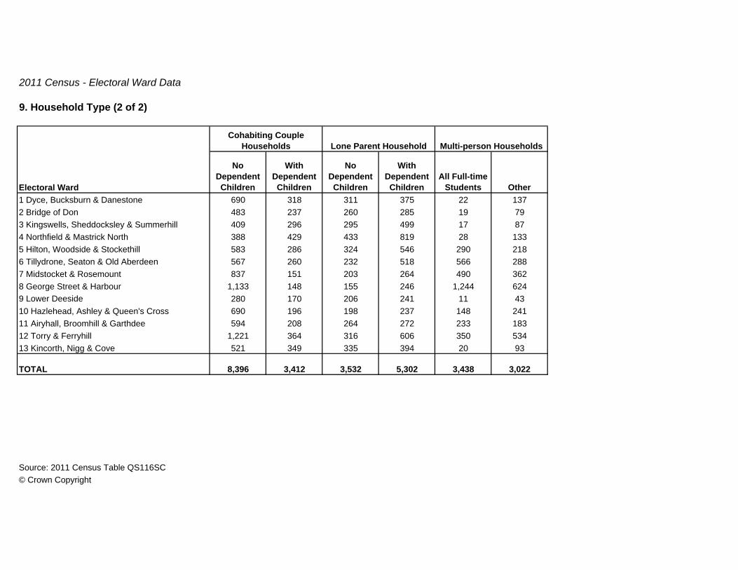
9. Household Type (2 of 2)
No Dependent Children
With Dependent Children
No Dependent Children
With Dependent Children
All Full-time Students Other
1 Dyce, Bucksburn & Danestone 690 318 311 375 22 1372 Bridge of Don 483 237 260 285 19 793 Kingswells, Sheddocksley & Summerhill 409 296 295 499 17 874 Northfield & Mastrick North 388 429 433 819 28 1335 Hilton, Woodside & Stockethill 583 286 324 546 290 2186 Tillydrone, Seaton & Old Aberdeen 567 260 232 518 566 2887 Midstocket & Rosemount 837 151 203 264 490 3628 George Street & Harbour 1,133 148 155 246 1,244 6249 Lower Deeside 280 170 206 241 11 4310 Hazlehead, Ashley & Queen's Cross 690 196 198 237 148 24111 Airyhall, Broomhill & Garthdee 594 208 264 272 233 18312 Torry & Ferryhill 1,221 364 316 606 350 53413 Kincorth, Nigg & Cove 521 349 335 394 20 93
TOTAL 8,396 3,412 3,532 5,302 3,438 3,022
Source: 2011 Census Table QS116SC© Crown Copyright
Lone Parent Household Multi-person Households
Electoral Ward
Cohabiting Couple Households

2011 Census - Electoral Ward Data
10. Number of Rooms
Electoal Ward
All Occupied Household
Spaces1
Rm 2 Rms 3 Rms 4 Rms 5 Rms 6 Rms 7 Rms 8 Rms 9+ Rms1 Dyce, Bucksburn & Danestone 8,485 36 223 1,319 2,392 2,220 1,090 588 332 2852 Bridge of Don 7,621 26 162 846 1,828 1,967 1,358 715 427 2923 Kingswells, Sheddocksley & Summerhill 6,541 20 138 921 2,446 1,315 596 368 357 3804 Northfield & Mastrick North 7,086 34 190 780 2,677 2,811 422 82 53 375 Hilton, Woodside & Stockethill 7,760 45 345 1,770 3,265 1,280 583 274 131 676 Tillydrone, Seaton & Old Aberdeen 7,269 68 435 2,214 3,075 986 277 95 56 637 Midstocket & Rosemount 8,272 78 728 2,539 2,519 812 584 436 301 2758 George Street & Harbour 9,336 141 1,089 3,527 3,317 784 231 136 58 539 Lower Deeside 5,862 7 62 389 1,164 786 772 719 770 1,19310 Hazlehead, Ashley & Queen's Cross 9,021 35 357 1,558 1,943 1,131 1,241 1,023 749 98411 Airyhall, Broomhill & Garthdee 7,812 51 257 1,496 1,740 1,664 1,233 706 361 30412 Torry & Ferryhill 11,340 101 900 3,180 4,104 1,724 642 306 184 19913 Kincorth, Nigg & Cove 6,966 27 116 854 2,177 2,112 838 431 262 149
TOTAL 103,371 669 5,002 21,393 32,647 19,592 9,867 5,879 4,041 4,281
Source: 2011 Census Table QS407SC© Crown Copyright

2011 Census - Electoral Ward Data
11. Persons per Room (households)
Electoal WardAll
Households
Up to 0.5 Persons per
Room
Over 0.5 and up to 1.0
Persons per Room
Over 1.0 and up to 1.5
Persons per Room
Over 1.5 Persons per
Room1 Dyce, Bucksburn & Danestone 8,485 6,226 2,159 77 232 Bridge of Don 7,621 5,352 2,192 60 173 Kingswells, Sheddocksley & Summerhill 6,541 4,543 1,873 100 254 Northfield & Mastrick North 7,086 4,138 2,696 208 445 Hilton, Woodside & Stockethill 7,760 5,534 2,054 121 516 Tillydrone, Seaton & Old Aberdeen 7,269 4,850 2,241 136 427 Midstocket & Rosemount 8,272 6,322 1,851 65 348 George Street & Harbour 9,336 6,426 2,712 105 939 Lower Deeside 5,862 4,709 1,121 20 1210 Hazlehead, Ashley & Queen's Cross 9,021 7,283 1,679 48 1111 Airyhall, Broomhill & Garthdee 7,812 5,945 1,772 62 3312 Torry & Ferryhill 11,340 8,154 2,918 193 7513 Kincorth, Nigg & Cove 6,966 4,771 2,099 75 21
TOTAL 103,371 74,253 27,367 1,270 481
Source: 2011 Census Table QS409SC© Crown Copyright

2011 Census - Electoral Ward Data
12. Occupancy Rating (rooms)
+2 or more +1 0 -1 -2 or less1 Dyce, Bucksburn & Danestone 8,485 3,354 2,393 2,183 458 972 Bridge of Don 7,621 3,495 2,155 1,529 365 773 Kingswells, Sheddocksley & Summerhill 6,541 2,233 1,880 1,903 409 1164 Northfield & Mastrick North 7,086 1,576 2,270 2,319 719 2025 Hilton, Woodside & Stockethill 7,760 1,518 2,407 2,929 703 2036 Tillydrone, Seaton & Old Aberdeen 7,269 777 1,956 3,363 932 2417 Midstocket & Rosemount 8,272 1,931 1,832 3,252 1,041 2168 George Street & Harbour 9,336 638 2,052 4,486 1,742 4189 Lower Deeside 5,862 3,751 1,199 729 152 3110 Hazlehead, Ashley & Queen's Cross 9,021 4,554 1,849 1,973 556 8911 Airyhall, Broomhill & Garthdee 7,812 3,344 1,749 2,117 474 12812 Torry & Ferryhill 11,340 2,013 3,209 4,368 1,365 38513 Kincorth, Nigg & Cove 6,966 2,554 2,178 1,782 357 95
TOTAL 103,371 31,738 27,129 32,933 9,273 2,298
Source: 2011 Census Table QS408SC© Crown Copyright
Occupancy RatingAll
HouseholdsElectoral Ward

2011 Census - Electoral Ward Data
13. Household Spaces
Total
Second Residence,
Holiday Home
Vacant Household
Spaces1 Dyce, Bucksburn & Danestone 8,727 8,485 242 87 1552 Bridge of Don 7,760 7,621 139 34 1053 Kingswells, Sheddocksley & Summerhill 6,796 6,541 255 142 1134 Northfield & Mastrick North 7,308 7,086 222 93 1295 Hilton, Woodside & Stockethill 8,226 7,760 466 287 1796 Tillydrone, Seaton & Old Aberdeen 7,705 7,269 436 284 1527 Midstocket & Rosemount 8,639 8,272 367 144 2238 George Street & Harbour 9,962 9,336 626 336 2909 Lower Deeside 6,113 5,862 251 53 19810 Hazlehead, Ashley & Queen's Cross 9,524 9,021 503 199 30411 Airyhall, Broomhill & Garthdee 8,136 7,812 324 107 21712 Torry & Ferryhill 12,049 11,340 709 448 26113 Kincorth, Nigg & Cove 7,208 6,966 242 145 97
TOTAL 108,153 103,371 4,782 2,359 2,423
Source: 2011 Census Table QS417SC© Crown Copyright
Unoccupied Household Spaces
Occupied Household
Spaces
All Household
SpacesElectoral Ward

2011 Census - Electoral Ward Data
14. Dwellings
Electoral Ward All DwellingsUnshared Dwellings
Shared Dwellings
1 Dyce, Bucksburn & Danestone 8,727 8,727 02 Bridge of Don 7,760 7,760 03 Kingswells, Sheddocksley & Summerhill 6,796 6,796 04 Northfield & Mastrick North 7,305 7,302 35 Hilton, Woodside & Stockethill 8,219 8,215 46 Tillydrone, Seaton & Old Aberdeen 7,699 7,693 67 Midstocket & Rosemount 8,633 8,628 58 George Street & Harbour 9,940 9,926 149 Lower Deeside 6,113 6,113 010 Hazlehead, Ashley & Queen's Cross 9,513 9,506 711 Airyhall, Broomhill & Garthdee 8,135 8,134 112 Torry & Ferryhill 12,037 12,026 1113 Kincorth, Nigg & Cove 7,206 7,204 2
TOTAL 108,083 108,030 53
Source: 2011 Census Table QS418SC© Crown Copyright

2011 Census - Electoral Ward Data
15. Car or Van Availability
No Car or Van One Two Three Four or More
1 Dyce, Bucksburn & Danestone 8,485 1,503 4,314 2,134 411 1232 Bridge of Don 7,621 1,048 3,651 2,299 479 1443 Kingswells, Sheddocksley & Summerhill 6,541 1,728 2,821 1,625 284 834 Northfield & Mastrick North 7,086 2,715 3,011 1,101 210 495 Hilton, Woodside & Stockethill 7,760 3,225 3,398 958 144 356 Tillydrone, Seaton & Old Aberdeen 7,269 3,626 2,903 640 79 217 Midstocket & Rosemount 8,272 3,181 3,762 1,152 137 408 George Street & Harbour 9,336 4,876 3,640 719 83 189 Lower Deeside 5,862 572 2,227 2,312 560 19110 Hazlehead, Ashley & Queen's Cross 9,021 1,768 4,337 2,370 426 12011 Airyhall, Broomhill & Garthdee 7,812 2,101 3,762 1,642 244 6312 Torry & Ferryhill 11,340 4,518 5,215 1,408 167 3213 Kincorth, Nigg & Cove 6,966 1,573 3,334 1,683 293 83
TOTAL 103,371 32,434 46,375 20,043 3,517 1,002
Source: 2011 Census Table KS404SC© Crown Copyright
Number of Cars or Vans
All HouseholdsElectoral Ward

2011 Census - Electoral Ward Data
16. Ethnic Group (1 of 2)
Electoral Ward All PeopleWhite
ScottishOther White
British White Polish
Other White inc Irish and
Gypsy Traveller
1 Dyce, Bucksburn & Danestone 18,584 16,288 1,020 224 4352 Bridge of Don 18,028 15,480 999 137 3593 Kingswells, Sheddocksley & Summerhill 15,040 12,364 820 170 4154 Northfield & Mastrick North 17,158 14,584 533 766 4635 Hilton, Woodside & Stockethill 15,307 11,491 855 763 7236 Tillydrone, Seaton & Old Aberdeen 17,528 10,199 1,563 1,645 1,9617 Midstocket & Rosemount 15,288 10,378 1,424 393 1,3008 George Street & Harbour 18,311 10,643 2,001 827 2,0049 Lower Deeside 14,997 10,636 2,256 66 1,11610 Hazlehead, Ashley & Queen's Cross 18,677 13,808 1,871 210 1,44811 Airyhall, Broomhill & Garthdee 16,100 12,645 1,210 235 80112 Torry & Ferryhill 21,905 15,296 1,641 1,339 1,68413 Kincorth, Nigg & Cove 15,870 13,915 717 256 338
TOTAL 222,793 167,727 16,910 7,031 13,047
Source: 2011 Census Table KS201SC(1) and (2)© Crown Copyright

2011 Census - Electoral Ward Data
16. Ethnic Group (2 of 2)
Electoral Ward
Mixed/ Multiple Ethnic Groups
Indian, Pakistani & Bangladeshi Chinese Other Asian African Caribbean
Other Ethnic Group inc
Arab1 Dyce, Bucksburn & Danestone 58 149 73 83 183 30 412 Bridge of Don 99 281 277 73 188 24 1113 Kingswells, Sheddocksley & Summerhill 93 528 93 132 338 37 504 Northfield & Mastrick North 41 199 29 91 347 59 465 Hilton, Woodside & Stockethill 87 385 108 332 407 34 1226 Tillydrone, Seaton & Old Aberdeen 168 465 371 253 633 69 2017 Midstocket & Rosemount 134 613 243 289 280 48 1868 George Street & Harbour 199 807 384 237 919 76 2149 Lower Deeside 145 246 97 163 143 30 9910 Hazlehead, Ashley & Queen's Cross 156 432 149 188 267 57 9111 Airyhall, Broomhill & Garthdee 95 316 156 148 382 37 7512 Torry & Ferryhill 164 452 135 273 683 74 16413 Kincorth, Nigg & Cove 49 140 72 57 272 13 41
TOTAL 1,488 5,013 2,187 2,319 5,042 588 1,441
Source: 2011 Census Table KS201SC(1) and (2)© Crown Copyright

2011 Census - Electoral Ward Data
17. Multiple Ethnic Groups
Electoral WardAll
HouseholdsOne Person Households
All Household Members in Same Ethnic
Group
Different Ethnic Groups between
Generations Only
Different Identities
within Partnerships
Any Combination
of Multiple Ethnic Groups
1 Dyce, Bucksburn & Danestone 8,485 2,794 4,954 79 586 722 Bridge of Don 7,621 1,985 4,905 81 588 623 Kingswells, Sheddocksley & Summerhill 6,541 1,983 3,893 93 509 634 Northfield & Mastrick North 7,086 2,054 4,497 107 347 815 Hilton, Woodside & Stockethill 7,760 3,237 3,785 100 401 2376 Tillydrone, Seaton & Old Aberdeen 7,269 3,211 3,078 126 405 4497 Midstocket & Rosemount 8,272 3,952 3,185 101 658 3768 George Street & Harbour 9,336 4,513 3,309 76 606 8329 Lower Deeside 5,862 1,475 3,281 180 865 6110 Hazlehead, Ashley & Queen's Cross 9,021 3,544 4,167 125 989 19611 Airyhall, Broomhill & Garthdee 7,812 3,083 3,760 102 683 18412 Torry & Ferryhill 11,340 5,294 4,709 137 851 34913 Kincorth, Nigg & Cove 6,966 2,094 4,282 83 442 65
TOTAL 103,371 39,219 51,805 1,390 7,930 3,027
Source: 2011 Census Table QS202SC© Crown Copyright

2011 Census - Electoral Ward Data
18a. Country of Birth - Detail (1 of 4)
Total EnglandNorthern Ireland Scotland Wales
UK not otherwise
stated1 Dyce, Bucksburn & Danestone 18,584 17,907 17,347 1,108 87 16,095 56 1 3 42 5152 Bridge of Don 18,028 17,120 16,717 1,159 66 15,441 51 0 1 37 3653 Kingswells, Sheddocksley & Summerhill 15,040 13,851 13,402 941 62 12,354 44 1 1 38 4104 Northfield & Mastrick North 17,158 16,465 15,343 690 45 14,580 28 0 0 31 1,0915 Hilton, Woodside & Stockethill 15,307 13,973 12,601 942 99 11,530 29 1 2 49 1,3216 Tillydrone, Seaton & Old Aberdeen 17,528 15,391 12,212 1,662 178 10,308 59 5 4 132 3,0437 Midstocket & Rosemount 15,288 13,468 12,024 1,537 140 10,285 59 3 6 180 1,2588 George Street & Harbour 18,311 15,665 13,132 2,135 218 10,699 76 4 5 306 2,2229 Lower Deeside 14,997 13,662 12,849 2,075 92 10,582 97 3 2 54 75710 Hazlehead, Ashley & Queen's Cross 18,677 16,979 15,723 1,885 128 13,617 89 4 2 130 1,12411 Airyhall, Broomhill & Garthdee 16,100 14,745 13,948 1,258 71 12,550 65 4 3 138 65612 Torry & Ferryhill 21,905 19,923 17,287 1,780 126 15,296 82 3 9 210 2,41713 Kincorth, Nigg & Cove 15,870 15,259 14,772 836 62 13,843 29 2 2 31 454
TOTAL 222,793 204,408 187,357 18,008 1,374 167,180 764 31 40 1,378 15,633
Source: 2011 Census Table QS203SC© Crown Copyright
Electoral WardAll
People
Europe
Total
United KingdomChannel Islands and Isle of Man
Republic of Ireland
Other Europe

2011 Census - Electoral Ward Data
18a. Country of Birth - Detail (2 of 4)
Total France Germany Greece Italy Netherlands Spain
Other Member
Countries1 Dyce, Bucksburn & Danestone 443 132 20 61 3 14 12 4 182 Bridge of Don 312 136 11 73 0 5 10 9 283 Kingswells, Sheddocksley & Summerhill 347 123 29 41 3 4 17 2 274 Northfield & Mastrick North 1,049 102 7 57 0 1 16 6 155 Hilton, Woodside & Stockethill 1,243 263 38 103 8 29 14 9 626 Tillydrone, Seaton & Old Aberdeen 2,880 819 121 287 51 56 35 54 2157 Midstocket & Rosemount 1,126 547 136 146 31 50 53 47 848 George Street & Harbour 2,050 684 119 205 44 64 49 35 1689 Lower Deeside 653 541 48 151 3 20 179 13 12710 Hazlehead, Ashley & Queen's Cross 939 630 280 126 16 37 53 28 9011 Airyhall, Broomhill & Garthdee 585 245 75 49 11 28 18 15 4912 Torry & Ferryhill 2,253 429 130 113 13 40 37 30 6613 Kincorth, Nigg & Cove 412 118 14 46 1 8 22 8 19
TOTAL 14,292 4,769 1,028 1,458 184 356 515 260 968
Source: 2011 Census Table QS203SC© Crown Copyright
Electoral Ward
Other EU Countries
Europe - Cont'd
Total
Member Countries in March 2001

2011 Census - Electoral Ward Data
18a. Country of Birth - Detail (3 of 4)
Total Czech Rep Hungary Latvia Lithuania Poland Romania SlovakiaOther Accession
Countries1 Dyce, Bucksburn & Danestone 311 3 21 10 21 214 22 6 142 Bridge of Don 176 3 4 7 6 131 13 4 83 Kingswells, Sheddocksley & Summerhill 224 7 4 10 17 145 17 9 154 Northfield & Mastrick North 947 3 36 50 101 690 15 22 305 Hilton, Woodside & Stockethill 980 10 40 88 73 690 26 20 336 Tillydrone, Seaton & Old Aberdeen 2,061 37 42 129 187 1,461 33 40 1327 Midstocket & Rosemount 579 34 18 47 31 369 38 20 228 George Street & Harbour 1,366 86 65 115 140 775 45 66 749 Lower Deeside 112 5 17 5 0 64 13 4 410 Hazlehead, Ashley & Queen's Cross 309 18 38 14 12 184 13 12 1811 Airyhall, Broomhill & Garthdee 340 14 23 22 16 216 20 14 1512 Torry & Ferryhill 1,824 34 44 169 194 1,242 48 34 5913 Kincorth, Nigg & Cove 294 3 6 19 25 222 5 8 6
TOTAL 9,523 257 358 685 823 6,403 308 259 430
Source: 2011 Census Table QS203SC© Crown Copyright
Electoral Ward
Europe - Cont'd
Other EU Countries - Cont'd
Accession Countries April 2001 to March 2011

2011 Census - Electoral Ward Data
18a. Country of Birth - Detail (4 of 4)
Total Russia TurkeyOther Non EU
Countries1 Dyce, Bucksburn & Danestone 72 24 1 47 207 317 123 302 Bridge of Don 53 7 6 40 230 531 124 233 Kingswells, Sheddocksley & Summerhill 63 13 5 45 320 650 190 294 Northfield & Mastrick North 42 6 7 29 310 290 76 175 Hilton, Woodside & Stockethill 78 14 17 47 405 787 102 406 Tillydrone, Seaton & Old Aberdeen 163 32 25 106 745 1,004 337 517 Midstocket & Rosemount 132 49 13 70 403 1,058 274 858 George Street & Harbour 172 37 12 123 951 1,305 340 509 Lower Deeside 104 15 8 81 244 570 447 7410 Hazlehead, Ashley & Queen's Cross 185 32 18 135 399 758 437 10411 Airyhall, Broomhill & Garthdee 71 17 3 51 435 614 233 7312 Torry & Ferryhill 164 58 18 88 733 833 347 6913 Kincorth, Nigg & Cove 42 9 4 29 252 242 95 22
TOTAL 1,341 313 137 891 5,634 8,959 3,125 667
Source: 2011 Census Table QS203SC© Crown Copyright
Electoral Ward AfricaMiddle East
& AsiaAmericas and the Caribbean
Antartica & Oceania
Non EU Countries
Europe - Cont'd
2011 Census - Electoral Ward Data
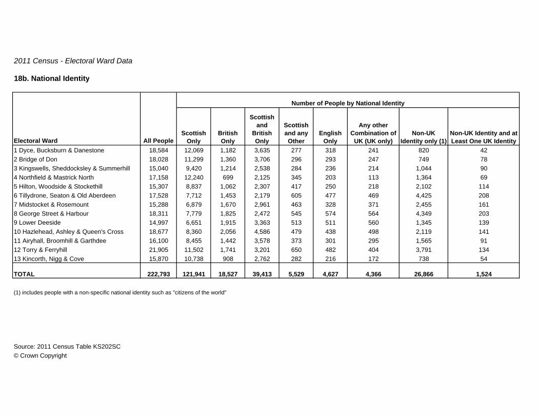
18b. National Identity
Scottish Only
British Only
Scottish and
British Only
Scottish and any Other
English Only
Any other Combination of
UK (UK only)Non-UK
Identity only (1)Non-UK Identity and at Least One UK Identity
1 Dyce, Bucksburn & Danestone 18,584 12,069 1,182 3,635 277 318 241 820 422 Bridge of Don 18,028 11,299 1,360 3,706 296 293 247 749 783 Kingswells, Sheddocksley & Summerhill 15,040 9,420 1,214 2,538 284 236 214 1,044 904 Northfield & Mastrick North 17,158 12,240 699 2,125 345 203 113 1,364 695 Hilton, Woodside & Stockethill 15,307 8,837 1,062 2,307 417 250 218 2,102 1146 Tillydrone, Seaton & Old Aberdeen 17,528 7,712 1,453 2,179 605 477 469 4,425 2087 Midstocket & Rosemount 15,288 6,879 1,670 2,961 463 328 371 2,455 1618 George Street & Harbour 18,311 7,779 1,825 2,472 545 574 564 4,349 2039 Lower Deeside 14,997 6,651 1,915 3,363 513 511 560 1,345 13910 Hazlehead, Ashley & Queen's Cross 18,677 8,360 2,056 4,586 479 438 498 2,119 14111 Airyhall, Broomhill & Garthdee 16,100 8,455 1,442 3,578 373 301 295 1,565 9112 Torry & Ferryhill 21,905 11,502 1,741 3,201 650 482 404 3,791 13413 Kincorth, Nigg & Cove 15,870 10,738 908 2,762 282 216 172 738 54
TOTAL 222,793 121,941 18,527 39,413 5,529 4,627 4,366 26,866 1,524
(1) includes people with a non-specific national identity such as "citizens of the world"
Source: 2011 Census Table KS202SC© Crown Copyright
All PeopleElectoral Ward
Number of People by National Identity

2011 Census - Electoral Ward Data
19. Religion
Electoral WardAll
People
Church of
ScotlandRoman
CatholicOther
Christian Buddhist Hindu Jewish Muslim SikhOther
ReligionNo
Religion
Religion not
Stated1 Dyce, Bucksburn & Danestone 18,584 6,424 953 830 46 65 5 127 4 42 8,848 1,2402 Bridge of Don 18,028 5,897 845 939 42 88 1 310 13 38 8,539 1,3163 Kingswells, Sheddocksley & Summerhill 15,040 3,875 1,072 1,098 53 122 11 226 11 47 7,484 1,0414 Northfield & Mastrick North 17,158 3,235 1,470 739 40 80 8 148 0 71 10,066 1,3015 Hilton, Woodside & Stockethill 15,307 3,602 1,575 1,003 53 252 1 315 6 58 7,407 1,0356 Tillydrone, Seaton & Old Aberdeen 17,528 2,858 2,565 1,495 108 180 24 618 16 105 8,209 1,3507 Midstocket & Rosemount 15,288 3,382 1,522 1,127 89 350 14 517 23 55 7,100 1,1098 George Street & Harbour 18,311 2,633 2,284 1,643 128 415 39 651 30 104 9,142 1,2429 Lower Deeside 14,997 4,715 1,077 1,538 41 81 18 235 7 31 5,794 1,46010 Hazlehead, Ashley & Queen's Cross 18,677 6,020 1,683 1,457 90 222 5 303 10 49 7,553 1,28511 Airyhall, Broomhill & Garthdee 16,100 5,060 1,171 952 53 168 3 307 1 65 7,246 1,07412 Torry & Ferryhill 21,905 4,218 2,665 1,463 95 220 22 414 7 77 11,201 1,52313 Kincorth, Nigg & Cove 15,870 4,348 869 746 46 58 4 122 1 52 8,608 1,016
TOTAL 222,793 56,267 19,751 15,030 884 2,301 155 4,293 129 794 107,197 15,992
Source: 2011 Census Table KS209SCB© Crown Copyright

2011 Census - Electoral Ward Data
20. Year of Arrival in the UK
Before 1941
1941-1950
1951-1960
1961-1970
1971-1980
1981-1990
1991-2000
2001-2003
2004-2006
2007-2009
2010-2011
1 Dyce, Bucksburn & Danestone 18,584 17,347 11 17 24 68 65 84 122 93 275 317 1612 Bridge of Don 18,028 16,717 9 12 34 88 96 112 182 120 224 274 1603 Kingswells, Sheddocksley & Summerhill 15,040 13,402 10 14 26 60 75 70 146 157 443 440 1974 Northfield & Mastrick North 17,158 15,343 13 7 16 52 55 43 90 96 655 606 1825 Hilton, Woodside & Stockethill 15,307 12,601 12 14 27 42 50 90 189 178 753 946 4056 Tillydrone, Seaton & Old Aberdeen 17,528 12,212 4 14 22 56 73 112 359 222 1,165 1,559 1,7307 Midstocket & Rosemount 15,288 12,024 8 11 22 91 98 162 300 258 601 1,041 6728 George Street & Harbour 18,311 13,132 6 4 16 35 70 147 357 255 923 1,833 1,5339 Lower Deeside 14,997 12,849 20 24 49 111 140 156 311 169 275 506 38710 Hazlehead, Ashley & Queen's Cross 18,677 15,723 26 28 47 112 136 139 307 168 472 882 63711 Airyhall, Broomhill & Garthdee 16,100 13,948 25 16 46 73 83 102 195 143 353 624 49212 Torry & Ferryhill 21,905 17,287 12 13 25 64 117 186 263 218 1,164 1,645 91113 Kincorth, Nigg & Cove 15,870 14,772 8 12 9 43 64 58 113 96 298 282 115
TOTAL 222,793 187,357 164 186 363 895 1,122 1,461 2,934 2,173 7,601 10,955 7,582
Source: 2011 Census Tables QS801SC© Crown Copyright
All PeopleElectoral Ward
Born in the UK
Arrived

2011 Census - Electoral Ward Data
21. Age at Arrival in the UK
0 to 4 5 to 7 8 to 910 to
14 1516 to
1718 to
1920 to
2425 to
2930 to
4445 to
5960 to
6465 to
7475 to
8485 to
89
90 and Over
1 Dyce, Bucksburn & Danestone 18,584 17,347 237 43 29 54 8 33 51 227 247 254 45 3 5 1 0 02 Bridge of Don 18,028 16,717 241 83 30 79 13 44 65 214 226 253 51 7 2 1 2 03 Kingswells, Sheddocksley & Summerhill 15,040 13,402 376 88 46 64 8 23 39 239 293 404 51 3 3 1 0 04 Northfield & Mastrick North 17,158 15,343 307 93 57 109 17 50 82 281 304 417 85 8 3 1 1 05 Hilton, Woodside & Stockethill 15,307 12,601 390 97 56 127 24 140 180 529 492 538 116 6 7 1 1 26 Tillydrone, Seaton & Old Aberdeen 17,528 12,212 487 160 72 216 47 478 659 1,412 821 768 181 6 7 2 0 07 Midstocket & Rosemount 15,288 12,024 396 101 58 152 38 201 244 760 656 575 75 2 5 0 0 18 George Street & Harbour 18,311 13,132 415 109 82 168 67 500 602 1,561 956 610 88 8 10 2 0 19 Lower Deeside 14,997 12,849 472 149 80 126 21 54 91 231 202 575 130 7 7 1 2 010 Hazlehead, Ashley & Queen's Cross 18,677 15,723 502 136 75 144 25 97 115 495 539 665 143 9 5 4 0 011 Airyhall, Broomhill & Garthdee 16,100 13,948 341 82 53 88 14 82 105 480 367 456 70 3 7 4 0 012 Torry & Ferryhill 21,905 17,287 505 176 77 178 51 195 312 1,072 906 945 193 4 2 1 1 013 Kincorth, Nigg & Cove 15,870 14,772 214 51 29 42 8 25 45 188 222 240 25 4 1 4 0 0
TOTAL 222,793 187,357 4,883 1,368 744 1,547 341 1,922 2,590 7,689 6,231 6,700 1,253 70 64 23 7 4
Source: 2011 Census Tables QS802SC© Crown Copyright
Electoral WardBorn in the UK
All People
Age at Arrival in the UK

2011 Census - Electoral Ward Data
22. English Language Skills
Electoral Ward
All People Aged 3 and
Over
Understands but does not Speak, Read
or Write English
Speaks, Reads and
Writes English
Speaks but does not Read
or Write English
Speaks and Reads but does not
Write English
Reads but does not Speak or
Write English
Other Combination
of Skills in Engllish
No Skills in English
1 Dyce, Bucksburn & Danestone 17,993 291 16,995 490 128 8 59 222 Bridge of Don 17,526 219 16,643 466 93 1 66 383 Kingswells, Sheddocksley & Summerhill 14,423 252 13,473 502 113 6 53 244 Northfield & Mastrick North 16,508 443 15,110 628 171 8 82 665 Hilton, Woodside & Stockethill 14,692 373 13,597 438 139 8 80 576 Tillydrone, Seaton & Old Aberdeen 16,917 333 15,614 608 168 20 74 1007 Midstocket & Rosemount 14,886 230 14,097 344 104 11 59 418 George Street & Harbour 17,907 245 17,080 340 116 6 52 689 Lower Deeside 14,571 129 13,799 461 113 2 52 1510 Hazlehead, Ashley & Queen's Cross 18,149 214 17,301 440 109 6 47 3211 Airyhall, Broomhill & Garthdee 15,556 225 14,746 417 83 2 51 3212 Torry & Ferryhill 21,159 465 19,533 737 186 25 62 15113 Kincorth, Nigg & Cove 15,310 281 14,351 514 85 4 54 21
TOTAL 215,597 3,700 202,339 6,385 1,608 107 791 667
Source: 2011 Census Tables QS213SC© Crown Copyright

2011 Census - Electoral Ward Data
23. Proficiency in English
Electoral WardAll People Aged 3
and OverSpeaks English
Very WellSpeaks English
WellDoes not Speak
English WellDoes not Speak
English at All1 Dyce, Bucksburn & Danestone 17,993 16,025 1,735 202 312 Bridge of Don 17,526 15,696 1,585 200 453 Kingswells, Sheddocksley & Summerhill 14,423 12,588 1,588 222 254 Northfield & Mastrick North 16,508 13,695 2,308 410 955 Hilton, Woodside & Stockethill 14,692 12,288 1,928 404 726 Tillydrone, Seaton & Old Aberdeen 16,917 13,437 2,657 713 1107 Midstocket & Rosemount 14,886 13,102 1,450 283 518 George Street & Harbour 17,907 15,424 1,986 419 789 Lower Deeside 14,571 13,231 1,174 147 1910 Hazlehead, Ashley & Queen's Cross 18,149 16,494 1,365 246 4411 Airyhall, Broomhill & Garthdee 15,556 13,911 1,441 166 3812 Torry & Ferryhill 21,159 17,768 2,504 708 17913 Kincorth, Nigg & Cove 15,310 13,428 1,654 202 26
TOTAL 215,597 187,087 23,375 4,322 813
Source: 2011 Census Tables QS205SC© Crown Copyright

2011 Census - Electoral Ward Data
24. Length of Residence in the UK
Less than 2 years
2 years or more but
less than 5 years
5 years or more but
less than 10 years
10 years or more
1 Dyce, Bucksburn & Danestone 18,584 17,347 224 383 236 3942 Bridge of Don 18,028 16,717 225 308 235 5433 Kingswells, Sheddocksley & Summerhill 15,040 13,402 297 493 446 4024 Northfield & Mastrick North 17,158 15,343 286 784 467 2785 Hilton, Woodside & Stockethill 15,307 12,601 718 945 616 4276 Tillydrone, Seaton & Old Aberdeen 17,528 12,212 2,145 1,671 855 6457 Midstocket & Rosemount 15,288 12,024 1,058 902 599 7058 George Street & Harbour 18,311 13,132 2,141 1,631 759 6489 Lower Deeside 14,997 12,849 546 449 336 81710 Hazlehead, Ashley & Queen's Cross 18,677 15,723 927 770 452 80511 Airyhall, Broomhill & Garthdee 16,100 13,948 668 604 335 54512 Torry & Ferryhill 21,905 17,287 1,431 1,596 904 68713 Kincorth, Nigg & Cove 15,870 14,772 174 330 284 310
TOTAL 222,793 187,357 10,840 10,866 6,524 7,206
Source: 2011 Census Tables QS803SC© Crown Copyright
Resident in the UK
Born in the UKElectoral Ward All People

2011 Census - Electoral Ward Data
25. General Health and Limiting Long-term Health Problem or Disability
Very Good Health Good Health
Fairly Good Health Bad Health
Very Bad Health
1 Dyce, Bucksburn & Danestone 18,584 3,240 15,344 9,459 6,352 2,117 479 1772 Bridge of Don 18,028 2,511 15,517 9,972 5,869 1,685 361 1413 Kingswells, Sheddocksley & Summerhill 15,040 2,807 12,233 7,929 4,639 1,738 572 1624 Northfield & Mastrick North 17,158 3,609 13,549 7,968 5,724 2,439 791 2365 Hilton, Woodside & Stockethill 15,307 3,100 12,207 7,370 5,145 1,922 659 2116 Tillydrone, Seaton & Old Aberdeen 17,528 2,724 14,804 9,291 5,509 1,846 711 1717 Midstocket & Rosemount 15,288 2,197 13,091 8,906 4,471 1,361 428 1228 George Street & Harbour 18,311 2,184 16,127 10,464 5,644 1,615 465 1239 Lower Deeside 14,997 2,136 12,861 9,344 4,061 1,227 291 7410 Hazlehead, Ashley & Queen's Cross 18,677 2,559 16,118 11,301 5,426 1,508 352 9011 Airyhall, Broomhill & Garthdee 16,100 2,682 13,418 8,830 5,073 1,675 410 11212 Torry & Ferryhill 21,905 3,174 18,731 11,798 6,890 2,343 694 18013 Kincorth, Nigg & Cove 15,870 2,696 13,174 8,249 5,194 1,787 483 157
TOTAL 222,793 35,619 187,174 120,881 69,997 23,263 6,696 1,956
Source: 2011 Census Tables QS302SC and QS303SC© Crown Copyright
General Health
Electoral Ward
With a Limiting
Long-term IllnessAll People
Without a Limiting
Long-term Illness

2011 Census - Electoral Ward Data
26. Provision of Unpaid Care
Electoral Ward All PeopleProvides No Unpaid Care
Provides 1 to 19 Hours Unpaid Care a Week
Provides 20 to 49 Hours Unpaid Care a Week
Provides 50 or More Hours
Unpaid Care a Week
1 Dyce, Bucksburn & Danestone 18,584 17,114 897 216 3572 Bridge of Don 18,028 16,622 913 189 3043 Kingswells, Sheddocksley & Summerhill 15,040 13,765 675 233 3674 Northfield & Mastrick North 17,158 15,650 611 354 5435 Hilton, Woodside & Stockethill 15,307 14,275 568 201 2636 Tillydrone, Seaton & Old Aberdeen 17,528 16,671 461 186 2107 Midstocket & Rosemount 15,288 14,432 597 112 1478 George Street & Harbour 18,311 17,621 423 145 1229 Lower Deeside 14,997 13,774 822 174 22710 Hazlehead, Ashley & Queen's Cross 18,677 17,281 995 143 25811 Airyhall, Broomhill & Garthdee 16,100 14,831 849 168 25212 Torry & Ferryhill 21,905 20,682 725 236 26213 Kincorth, Nigg & Cove 15,870 14,504 806 217 343
TOTAL 222,793 207,222 9,342 2,574 3,655
Source: 2011 Census Tables QS301SCA© Crown Copyright

2011 Census - Electoral Ward Data
27a. Economically Active
Part-time Full-time Part-time Full-time Part-time Full-time1 Dyce, Bucksburn & Danestone 14,367 10,895 1,948 7,261 33 175 158 481 326 5132 Bridge of Don 14,163 10,969 2,210 6,920 42 194 212 495 265 6313 Kingswells, Sheddocksley & Summerhill 10,872 8,146 1,570 5,126 30 181 147 370 376 3464 Northfield & Mastrick North 12,589 8,967 1,921 5,386 22 84 110 280 665 4995 Hilton, Woodside & Stockethill 11,746 8,385 1,457 5,239 16 88 104 280 467 7346 Tillydrone, Seaton & Old Aberdeen 14,802 9,093 1,221 4,387 18 69 108 247 587 2,4567 Midstocket & Rosemount 12,725 9,509 1,159 6,298 29 173 127 368 328 1,0278 George Street & Harbour 16,591 11,664 1,009 6,474 9 95 105 315 518 3,1399 Lower Deeside 10,781 7,632 1,402 4,434 48 290 279 550 176 45310 Hazlehead, Ashley & Queen's Cross 14,206 10,651 1,493 6,953 38 392 214 585 310 66611 Airyhall, Broomhill & Garthdee 12,107 8,926 1,437 5,597 24 207 168 404 322 76712 Torry & Ferryhill 17,850 13,947 1,817 9,292 32 196 201 558 707 1,14413 Kincorth, Nigg & Cove 12,070 9,322 1,736 6,086 23 158 145 440 320 414
TOTAL 174,869 128,106 20,380 79,453 364 2,302 2,078 5,373 5,367 12,789
Source: 2011 Census Tables QS601SC© Crown Copyright
Electoral Ward
EmployeesSelf-employed with
EmployeesSelf-employed
without EmployeesFull-time StudentUnemployed
All People Aged 16-74
Total Economically
Active

2011 Census - Electoral Ward Data
27b. Economically Inactive
Electoral WardAll People Aged 16-74
Total Economically
Inactive Retired Student
Looking After Home or Family
Long Term Sick or
Disabled Other1 Dyce, Bucksburn & Danestone 14,367 3,472 2,175 381 363 384 1692 Bridge of Don 14,163 3,194 1,997 438 390 230 1393 Kingswells, Sheddocksley & Summerhill 10,872 2,726 1,241 309 495 541 1404 Northfield & Mastrick North 12,589 3,622 1,407 415 604 871 3255 Hilton, Woodside & Stockethill 11,746 3,361 1,452 813 303 593 2006 Tillydrone, Seaton & Old Aberdeen 14,802 5,709 986 3,414 385 650 2747 Midstocket & Rosemount 12,725 3,216 1,049 1,225 299 447 1968 George Street & Harbour 16,591 4,927 638 3,320 241 491 2379 Lower Deeside 10,781 3,149 1,614 535 615 234 15110 Hazlehead, Ashley & Queen's Cross 14,206 3,555 1,810 739 574 224 20811 Airyhall, Broomhill & Garthdee 12,107 3,181 1,580 727 418 301 15512 Torry & Ferryhill 17,850 3,903 1,287 873 558 655 53013 Kincorth, Nigg & Cove 12,070 2,748 1,521 323 363 390 151
TOTAL 174,869 46,763 18,757 13,512 5,608 6,011 2,875
Source: 2011 Census Tables QS601SC© Crown Copyright

2011 Census - Electoral Ward Data
27c. Economically Active Full-time Students
In Employment Unemployed1 Dyce, Bucksburn & Danestone 878 452 61 3652 Bridge of Don 1,056 556 75 4253 Kingswells, Sheddocksley & Summerhill 639 301 45 2934 Northfield & Mastrick North 897 387 112 3985 Hilton, Woodside & Stockethill 1,534 602 132 8006 Tillydrone, Seaton & Old Aberdeen 5,821 1,663 793 3,3657 Midstocket & Rosemount 2,226 872 155 1,1998 George Street & Harbour 6,430 2,487 652 3,2919 Lower Deeside 969 415 38 51610 Hazlehead, Ashley & Queen's Cross 1,372 577 89 70611 Airyhall, Broomhill & Garthdee 1,469 648 119 70212 Torry & Ferryhill 1,990 969 175 84613 Kincorth, Nigg & Cove 731 335 79 317
TOTAL 26,012 10,264 2,525 13,223
Source: 2011 Census Tables QS603SC© Crown Copyright
Economically ActiveEconomically
Inactive
All Full-time Students Aged
16-74Electoral Ward

2011 Census - Electoral Ward Data
28. Hours Worked
1 to 2 Hours
3 to 5 Hours
6 to 15 Hours
16 to 30 Hours
31 to 37 Hours
38 to 48 Hours
49 to 59 Hours
60 + Hours
1 Dyce, Bucksburn & Danestone 10,508 2,510 9 52 579 1,870 7,998 1,639 4,987 727 6452 Bridge of Don 10,629 2,941 14 80 788 2,059 7,688 1,730 4,600 723 6353 Kingswells, Sheddocksley & Summerhill 7,725 1,991 13 55 457 1,466 5,734 1,320 3,490 515 4094 Northfield & Mastrick North 8,190 2,372 9 47 527 1,789 5,818 1,457 3,617 412 3325 Hilton, Woodside & Stockethill 7,786 2,087 14 53 540 1,480 5,699 1,433 3,487 431 3486 Tillydrone, Seaton & Old Aberdeen 7,713 2,839 20 130 998 1,691 4,874 1,113 3,007 452 3027 Midstocket & Rosemount 9,026 2,033 20 71 636 1,306 6,993 1,432 4,449 660 4528 George Street & Harbour 10,494 3,366 31 140 1,307 1,888 7,128 1,585 4,515 557 4719 Lower Deeside 7,418 2,081 26 108 623 1,324 5,337 878 3,146 788 52510 Hazlehead, Ashley & Queen's Cross 10,252 2,247 26 88 631 1,502 8,005 1,370 4,953 1,037 64511 Airyhall, Broomhill & Garthdee 8,485 2,190 11 77 636 1,466 6,295 1,277 3,917 667 43412 Torry & Ferryhill 13,065 2,845 21 67 775 1,982 10,220 2,002 6,618 923 67713 Kincorth, Nigg & Cove 8,923 2,183 9 39 516 1,619 6,740 1,481 4,070 636 553
TOTAL 120,214 31,685 223 1,007 9,013 21,442 88,529 18,717 54,856 8,528 6,428
Source: 2011 Census Tables QS604SCB© Crown Copyright
Full-timePart-timeTotal Part-time
All People Aged 16-74 in EmploymentElectoral Ward
Total Full-time

2011 Census - Electoral Ward Data
29. Time Since Last Worked
2011 2010 2009 2008 2007 20062001-2005
Before 2001
1 Dyce, Bucksburn & Danestone 14,367 10,508 3,859 202 509 335 208 191 182 751 1,055 4262 Bridge of Don 14,163 10,629 3,534 188 521 321 214 172 136 676 842 4643 Kingswells, Sheddocksley & Summerhill 10,872 7,725 3,147 136 424 241 198 140 131 527 913 4374 Northfield & Mastrick North 12,589 8,190 4,399 194 549 376 243 192 177 675 1,180 8135 Hilton, Woodside & Stockethill 11,746 7,786 3,960 203 669 338 269 177 154 567 957 6266 Tillydrone, Seaton & Old Aberdeen 14,802 7,713 7,089 500 2,289 557 344 165 161 500 815 1,7587 Midstocket & Rosemount 12,725 9,026 3,699 258 815 338 238 129 125 416 682 6988 George Street & Harbour 16,591 10,494 6,097 586 2,165 515 275 142 120 362 531 1,4019 Lower Deeside 10,781 7,418 3,363 152 392 223 209 137 116 517 1,011 60610 Hazlehead, Ashley & Queen's Cross 14,206 10,252 3,954 216 667 313 222 168 144 565 1,074 58511 Airyhall, Broomhill & Garthdee 12,107 8,485 3,622 195 634 333 230 151 138 551 837 55312 Torry & Ferryhill 17,850 13,065 4,785 342 973 417 311 194 186 621 934 80713 Kincorth, Nigg & Cove 12,070 8,923 3,147 151 452 264 191 168 180 539 813 389
TOTAL 174,869 120,214 54,655 3,323 11,059 4,571 3,152 2,126 1,950 7,267 11,644 9,563
Source: 2011 Census Tables QS612SCB© Crown Copyright
Electoral Ward
Last Worked In:
Never Worked
In Employment
Not in Employment
All People Aged 16-74

2011 Census - Electoral Ward Data
30. Industry (1 of 2)
Electoral Ward
All People Aged 16-74 in Employment
Agriculture, Forestry&
FishingMining and Quarrying
Manufact-uring
Electricity, Gas Water Construction
Wholesale & Retail
SaleTransport & Storage
Accommod-ation & Food
1 Dyce, Bucksburn & Danestone 10,508 73 984 942 39 43 708 1,517 863 5982 Bridge of Don 10,629 34 931 822 38 40 790 1,786 609 5373 Kingswells, Sheddocksley & Summerhill 7,725 41 595 510 21 33 622 1,130 504 3904 Northfield & Mastrick North 8,190 32 380 657 25 86 635 1,305 737 6255 Hilton, Woodside & Stockethill 7,786 27 442 544 15 43 518 1,216 454 5796 Tillydrone, Seaton & Old Aberdeen 7,713 29 317 489 15 46 442 1,452 418 1,0687 Midstocket & Rosemount 9,026 20 892 468 24 23 368 1,199 309 6818 George Street & Harbour 10,494 28 712 561 19 44 401 2,119 409 1,4229 Lower Deeside 7,418 49 907 434 28 15 367 843 281 32410 Hazlehead, Ashley & Queen's Cross 10,252 25 1,507 560 35 19 442 1,090 307 51911 Airyhall, Broomhill & Garthdee 8,485 23 867 502 26 27 502 1,169 371 56412 Torry & Ferryhill 13,065 38 1,359 1,017 29 78 675 1,878 725 1,06713 Kincorth, Nigg & Cove 8,923 26 821 661 22 70 755 1,470 677 469
TOTAL 120,214 445 10,714 8,167 336 567 7,225 18,174 6,664 8,843
Source: 2011 Census Tables QS605SC© Crown Copyright

2011 Census - Electoral Ward Data
30. Industry (2 of 2)
Electoral WardInformation &
Communication
Financial &
Insurance Real
Estate
Professional, Scientific & Technical Activities
Admin & Support Services
Public Admin Education
Human Health & Social Work Other
1 Dyce, Bucksburn & Danestone 224 138 84 993 507 481 769 1,180 3652 Bridge of Don 263 178 114 955 460 544 948 1,187 3933 Kingswells, Sheddocksley & Summerhill 186 123 72 658 367 327 500 1,363 2834 Northfield & Mastrick North 108 63 44 343 691 272 404 1,462 3215 Hilton, Woodside & Stockethill 150 79 55 551 489 285 592 1,409 3386 Tillydrone, Seaton & Old Aberdeen 146 72 48 449 546 249 721 836 3707 Midstocket & Rosemount 303 152 73 1,159 361 372 969 1,335 3188 George Street & Harbour 306 125 69 1,003 524 389 787 1,027 5499 Lower Deeside 181 120 94 1,059 245 251 889 1,039 29210 Hazlehead, Ashley & Queen's Cross 339 256 117 1,739 319 437 1,038 1,121 38211 Airyhall, Broomhill & Garthdee 223 139 88 1,147 362 385 783 1,014 29312 Torry & Ferryhill 319 168 101 1,599 792 463 852 1,447 45813 Kincorth, Nigg & Cove 186 120 62 842 451 346 571 1,023 351
TOTAL 2,934 1,733 1,021 12,497 6,114 4,801 9,823 15,443 4,713
Source: 2011 Census Tables QS605SC© Crown Copyright
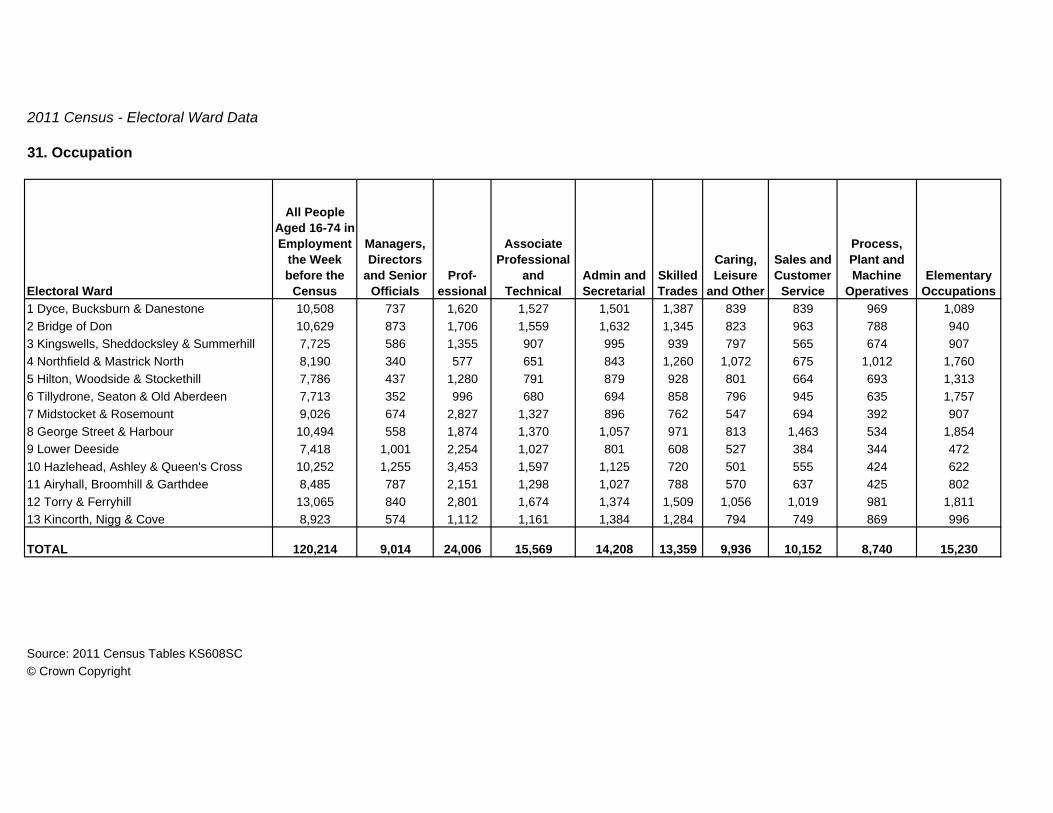
2011 Census - Electoral Ward Data
31. Occupation
Electoral Ward
All People Aged 16-74 in Employment
the Week before the
Census
Managers, Directors
and Senior Officials
Prof-essional
Associate Professional
and Technical
Admin and Secretarial
Skilled Trades
Caring, Leisure
and Other
Sales and Customer
Service
Process, Plant and Machine
OperativesElementary
Occupations1 Dyce, Bucksburn & Danestone 10,508 737 1,620 1,527 1,501 1,387 839 839 969 1,0892 Bridge of Don 10,629 873 1,706 1,559 1,632 1,345 823 963 788 9403 Kingswells, Sheddocksley & Summerhill 7,725 586 1,355 907 995 939 797 565 674 9074 Northfield & Mastrick North 8,190 340 577 651 843 1,260 1,072 675 1,012 1,7605 Hilton, Woodside & Stockethill 7,786 437 1,280 791 879 928 801 664 693 1,3136 Tillydrone, Seaton & Old Aberdeen 7,713 352 996 680 694 858 796 945 635 1,7577 Midstocket & Rosemount 9,026 674 2,827 1,327 896 762 547 694 392 9078 George Street & Harbour 10,494 558 1,874 1,370 1,057 971 813 1,463 534 1,8549 Lower Deeside 7,418 1,001 2,254 1,027 801 608 527 384 344 47210 Hazlehead, Ashley & Queen's Cross 10,252 1,255 3,453 1,597 1,125 720 501 555 424 62211 Airyhall, Broomhill & Garthdee 8,485 787 2,151 1,298 1,027 788 570 637 425 80212 Torry & Ferryhill 13,065 840 2,801 1,674 1,374 1,509 1,056 1,019 981 1,81113 Kincorth, Nigg & Cove 8,923 574 1,112 1,161 1,384 1,284 794 749 869 996
TOTAL 120,214 9,014 24,006 15,569 14,208 13,359 9,936 10,152 8,740 15,230
Source: 2011 Census Tables KS608SC© Crown Copyright

2011 Census - Electoral Ward Data
32. Socio-economic (1 of 2)
Electoral Ward All People
Large Employers and
Higher Managerial &
AdministrativeHigher
Professional
Lower Managerial
Administrative & Professional Intermediate
Small Employers & Own Account
Workers1 Dyce, Bucksburn & Danestone 14,367 268 1,116 3,174 2,252 7962 Bridge of Don 14,163 326 1,210 3,243 2,406 8813 Kingswells, Sheddocksley & Summerhill 10,872 213 948 2,188 1,540 6614 Northfield & Mastrick North 12,589 77 316 1,519 1,382 5425 Hilton, Woodside & Stockethill 11,746 127 826 1,969 1,351 5096 Tillydrone, Seaton & Old Aberdeen 14,802 69 687 1,403 999 4387 Midstocket & Rosemount 12,725 207 2,143 2,894 1,369 4688 George Street & Harbour 16,591 93 1,332 2,333 1,310 3969 Lower Deeside 10,781 472 1,903 2,837 1,294 84310 Hazlehead, Ashley & Queen's Cross 14,206 528 2,895 3,905 1,765 81711 Airyhall, Broomhill & Garthdee 12,107 317 1,578 2,955 1,554 62312 Torry & Ferryhill 17,850 275 2,104 3,296 1,991 78213 Kincorth, Nigg & Cove 12,070 167 768 2,352 1,899 726
TOTAL 174,869 3,139 17,826 34,068 21,112 8,482
Source: 2011 Census Tables KS611SC© Crown Copyright

2011 Census - Electoral Ward Data
32. Socio-economic (2 of 2)
Electoral Ward
Lower Supervisory &
Technical Semi-routine Routine Never WorkedLong-term
UnemployedFull-time Students
1 Dyce, Bucksburn & Danestone 1,569 2,265 1,749 198 102 8782 Bridge of Don 1,338 2,149 1,320 157 77 1,0563 Kingswells, Sheddocksley & Summerhill 1,028 1,716 1,561 239 139 6394 Northfield & Mastrick North 1,372 2,621 3,103 508 252 8975 Hilton, Woodside & Stockethill 1,119 1,934 1,974 228 175 1,5346 Tillydrone, Seaton & Old Aberdeen 1,016 1,754 2,042 342 231 5,8217 Midstocket & Rosemount 877 1,240 953 238 110 2,2268 George Street & Harbour 1,116 1,726 1,414 266 175 6,4309 Lower Deeside 593 1,046 522 246 56 96910 Hazlehead, Ashley & Queen's Cross 808 1,179 644 195 98 1,37211 Airyhall, Broomhill & Garthdee 896 1,434 938 230 113 1,46912 Torry & Ferryhill 1,649 2,566 2,523 449 225 1,99013 Kincorth, Nigg & Cove 1,379 2,033 1,724 182 109 731
TOTAL 14,760 23,663 20,467 3,478 1,862 26,012
Source: 2011 Census Tables KS611SC© Crown Copyright
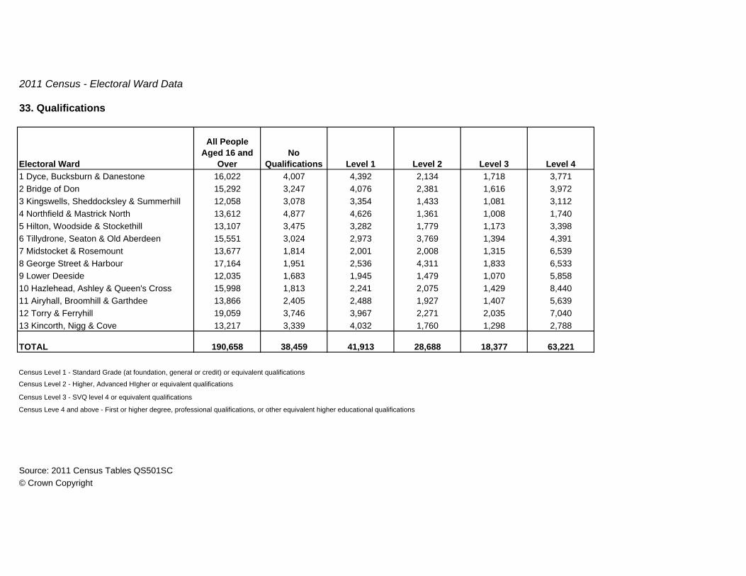
2011 Census - Electoral Ward Data
33. Qualifications
Electoral Ward
All People Aged 16 and
OverNo
Qualifications Level 1 Level 2 Level 3 Level 41 Dyce, Bucksburn & Danestone 16,022 4,007 4,392 2,134 1,718 3,7712 Bridge of Don 15,292 3,247 4,076 2,381 1,616 3,9723 Kingswells, Sheddocksley & Summerhill 12,058 3,078 3,354 1,433 1,081 3,1124 Northfield & Mastrick North 13,612 4,877 4,626 1,361 1,008 1,7405 Hilton, Woodside & Stockethill 13,107 3,475 3,282 1,779 1,173 3,3986 Tillydrone, Seaton & Old Aberdeen 15,551 3,024 2,973 3,769 1,394 4,3917 Midstocket & Rosemount 13,677 1,814 2,001 2,008 1,315 6,5398 George Street & Harbour 17,164 1,951 2,536 4,311 1,833 6,5339 Lower Deeside 12,035 1,683 1,945 1,479 1,070 5,85810 Hazlehead, Ashley & Queen's Cross 15,998 1,813 2,241 2,075 1,429 8,44011 Airyhall, Broomhill & Garthdee 13,866 2,405 2,488 1,927 1,407 5,63912 Torry & Ferryhill 19,059 3,746 3,967 2,271 2,035 7,04013 Kincorth, Nigg & Cove 13,217 3,339 4,032 1,760 1,298 2,788
TOTAL 190,658 38,459 41,913 28,688 18,377 63,221
Census Level 1 - Standard Grade (at foundation, general or credit) or equivalent qualifications
Census Level 2 - Higher, Advanced HIgher or equivalent qualifications
Census Level 3 - SVQ level 4 or equivalent qualifications
Census Leve 4 and above - First or higher degree, professional qualifications, or other equivalent higher educational qualifications
Source: 2011 Census Tables QS501SC© Crown Copyright

2011 Census - Electoral Ward Data
34. Method of Travel to Work or Study
Electoral Ward
All People
Aged 16 to 74
Works or Studies
Mainly at or from Home Train
Bus, Minibus or
Coach TaxiDriving a
Car or Van
Passenger in a Car or
Van
Motorcycle, Scooter or
Moped Bicycle On Foot Other 1 Dyce, Bucksburn & Danestone 12,626 1,012 130 1,353 127 6,541 994 65 154 1,946 3042 Bridge of Don 13,073 967 18 1,585 122 6,692 977 61 147 2,208 2963 Kingswells, Sheddocksley & Summerhill 10,092 952 26 1,413 109 4,548 1,030 45 114 1,635 2204 Northfield & Mastrick North 11,186 1,129 16 2,204 108 4,031 1,166 42 88 2,228 1745 Hilton, Woodside & Stockethill 10,056 929 22 1,694 74 3,633 714 25 181 2,620 1646 Tillydrone, Seaton & Old Aberdeen 13,012 1,790 25 2,105 70 2,751 650 19 242 5,234 1267 Midstocket & Rosemount 11,419 992 80 1,216 72 3,470 569 25 296 4,485 2148 George Street & Harbour 15,062 1,646 118 2,464 100 3,246 513 40 297 6,427 2119 Lower Deeside 10,233 1,095 16 1,205 39 5,001 1,046 34 217 1,387 19310 Hazlehead, Ashley & Queen's Cross 12,955 1,102 56 1,312 94 5,466 961 37 264 3,372 29111 Airyhall, Broomhill & Garthdee 10,734 876 38 1,599 75 4,523 781 42 227 2,369 20412 Torry & Ferryhill 15,818 1,491 185 2,275 146 5,262 952 48 315 4,786 35813 Kincorth, Nigg & Cove 11,110 809 18 1,704 143 5,334 1,090 52 124 1,568 268
TOTAL 157,376 14,790 748 22,129 1,279 60,498 11,443 535 2,666 40,265 3,023
Source: 2011 Census Tables QS702SC© Crown Copyright
2011 Census - Electoral Ward Data
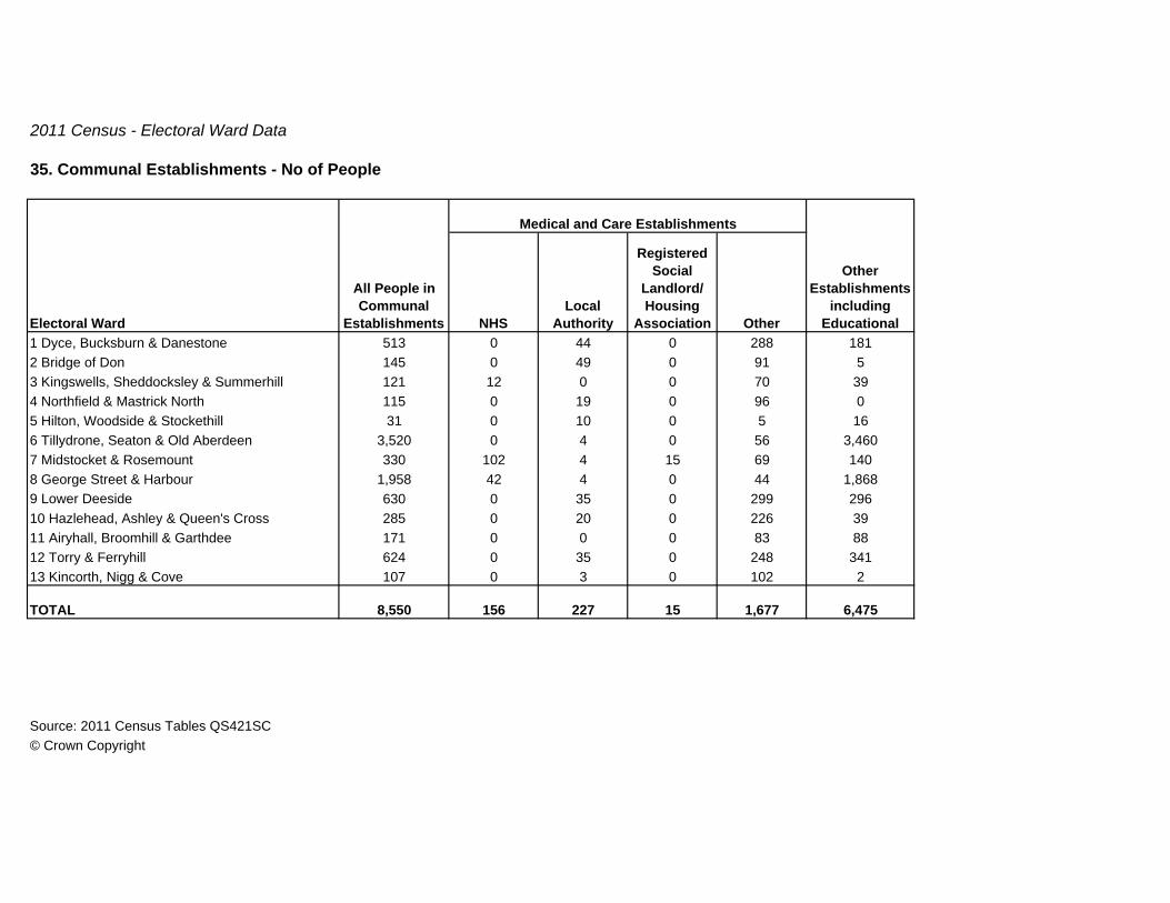
35. Communal Establishments - No of People
NHSLocal
Authority
Registered Social
Landlord/ Housing
Association Other1 Dyce, Bucksburn & Danestone 513 0 44 0 288 1812 Bridge of Don 145 0 49 0 91 53 Kingswells, Sheddocksley & Summerhill 121 12 0 0 70 394 Northfield & Mastrick North 115 0 19 0 96 05 Hilton, Woodside & Stockethill 31 0 10 0 5 166 Tillydrone, Seaton & Old Aberdeen 3,520 0 4 0 56 3,4607 Midstocket & Rosemount 330 102 4 15 69 1408 George Street & Harbour 1,958 42 4 0 44 1,8689 Lower Deeside 630 0 35 0 299 29610 Hazlehead, Ashley & Queen's Cross 285 0 20 0 226 3911 Airyhall, Broomhill & Garthdee 171 0 0 0 83 8812 Torry & Ferryhill 624 0 35 0 248 34113 Kincorth, Nigg & Cove 107 0 3 0 102 2
TOTAL 8,550 156 227 15 1,677 6,475
Source: 2011 Census Tables QS421SC© Crown Copyright
Medical and Care Establishments
All People in Communal
Establishments
Other Establishments
including EducationalElectoral Ward

2011 Census - Electoral Ward Data
36. Position in Communal Establishment
Electoral Ward
All People in Communal
Establishment Resident Staff or Owner
Family Member or Partner of
Staff or Owner1 Dyce, Bucksburn & Danestone 513 492 19 22 Bridge of Don 145 140 1 43 Kingswells, Sheddocksley & Summerhill 121 99 22 04 Northfield & Mastrick North 115 115 0 05 Hilton, Woodside & Stockethill 31 27 3 16 Tillydrone, Seaton & Old Aberdeen 3,520 3,507 8 57 Midstocket & Rosemount 330 321 9 08 George Street & Harbour 1,958 1,949 4 59 Lower Deeside 630 455 127 4810 Hazlehead, Ashley & Queen's Cross 285 269 5 1111 Airyhall, Broomhill & Garthdee 171 148 10 1312 Torry & Ferryhill 624 556 40 2813 Kincorth, Nigg & Cove 107 103 4 0
TOTAL 8,550 8,181 252 117
Source: 2011 Census Tables QS419SC© Crown Copyright

Corporate Governance
Business Hub 18 Fourth Floor West Marischal College
Broad Street Aberdeen AB10 1AB
Telephone 08456 08 09 10
E-mail [email protected]
Visit the Council Website www.aberdeencity.gov.uk