2010 periodic reexamination report of the · pdf fileof its master plan and development...
TRANSCRIPT
2010 PERIODIC REEXAMINATION REPORT
OF THE MASTER PLAN AND DEVELOPMENT REGULATIONS
Township of Mount Olive
Morris County, New Jersey
June 17, 2010 Amended July 15, 2010
Prepared by the Mount Olive Planning Board
with assistance from
Eugene Buczynski, P.E. Van Cleef Engineering Associates
& Banisch Associates, Inc.
111 Main Street Flemington, NJ 08822
Prepared By:
__________________________ Charles T. McGroarty, PP, AICP
License No. 4145
The original of this document has been signed and sealed pursuant to N.J.A.C. 13:41-1.3

Mount Olive Township Master Plan Reexamination Report
June 17, 2010 Amended July 15, 2010
______________________________________________________________________________
2
Mount Olive Planning Board
Howie Weiss, Chairman
Joseph Fleischner, Vice Chairman
David Scapicchio, Mayor
John Mania, Council Member
Rene Gadelha
James Staszak
Nelson Russell
John Cavanaugh
Scott Van Ness
Dan Nelsen
Steve Bedell
Edward Buzak, Esq.
Eugene Buczynski, P.E., P.P., C.M.E.
Chuck McGroarty, P.P., A.I.C.P.
Catherine Natafalusy, Planning Administrator / Planning Board Secretary

Mount Olive Township Master Plan Reexamination Report
June 17, 2010 Amended July 15, 2010
______________________________________________________________________________
3
INTRODUCTION ....................................................................................................................................4 TERMS AND ACRONYMS ......................................................................................................................4 STATUTORY REQUIREMENTS ..............................................................................................................6 [40:55D-89a] The major problems and objectives relating to land development in the municipality at the time of the adoption of the last reexamination Report.................................7 [40:55D-89b] THE EXTENT TO WHICH SUCH PROBLEMS AND OBJECTIVES HAVE BEEN REDUCED OR HAVE INCREASED SUBSEQUENT TO SUCH DATE. ...................................................12 [40:55D-89c] THE EXTENT TO WHICH THERE HAVE BEEN SIGNIFICANT CHANGES IN THE ASSUMPTIONS, POLICIES AND OBJECTIVES FORMING THE BASIS FOR THE MASTER PLAN OR DEVELOPMENT REGULATIONS AS LAST REVISED, WITH PARTICULAR REGARD TO THE DENSITY AND DISTRIBUTION OF POPULATION AND LAND USES, HOUSING CONDITIONS, CIRCULATION, CONSERVATION OF NATURAL RESOURCES, ENERGY CONSERVATION, COLLECTION, DISPOSITION AND RECYCLING OF DESIGNATED RECYCLABLE MATERIALS, AND CHANGES IN STATE, COUNTY AND MUNICIPAL POLICIES AND OBJECTIVES. .............................16 [40:55D-89d] THE SPECIFIC CHANGES FOR THE MASTER PLAN OR DEVELOPMENT REGULATIONS, IF ANY, INCLUDING UNDERLYING OBJECTIVES, POLICIES AND STANDARDS, OR WHETHER A NEW PLAN OR REGULATIONS SHOULD BE PROPOSED. ............................................22 [40:55D-89e] THE RECOMMENDATIONS OF THE PLANNING BOARD CONCERNING THE INCORPORATION OF REDEVELOPMENT PLANS ADOPTED PURSUANT TO THE “LOCAL REDEVELOPMENT AND HOUSING LAW”, P.L. 1992, C. 79 (C. 40A:12A-1 ET SEQ.) INTO THE LAND USE PLAN ELEMENT OF THE MUNICIPAL MASTER PLAN, AND RECOMMENDED CHANGES, IF ANY, IN THE LOCAL DEVELOPMENT REGULATIONS NECESSARY TO EFFECTUATE THE REDEVELOPMENT PLANS OF THE MUNICIPALITY. .................................................................30 APPENDIX A ; RECREATION AND OPEN SPACE INVENTORY ......................................................32 APPENDIX B: MOUNT OLIVE – HIGHLANDS LAND USE CAPABILITY MAP ..............................33 APPENDIX C: MAP UPDATE: COMBE FILL NORTH .......................................................................34 APPENDIX D: STATE PLAN POLICY MAP PROPOSED CHANGE ..................................................35

Mount Olive Township Master Plan Reexamination Report
June 17, 2010 Amended July 15, 2010
______________________________________________________________________________
4
Note: The Mount Olive Planning Board adopted the Master Plan Reexamination Report on June 17, 2010 with a memorializing Resolution adopted on July 15, 2010. The Planning Board also adopted an amended Master Plan Reexamination Report on July 15, 2010 and memorialized that decision in a Resolution adopted on August 19, 2010. The amendment supplemented the Reexamination Report with comments regarding “Planning for Trails’ and “Energy Awareness and Conservation Design” which are now included in Section “d” herein, on pages 28-30. INTRODUCTION The Municipal Land Use Law (MLUL), at N.J.S.A. 40:55D-89, includes the following statement relative to the periodic examination of a municipal Master Plan:
The governing body shall, at least every six years, provide for a general reexamination of its master plan and development regulations by the planning board which shall prepare and adopt by resolution a Report on the findings of such reexamination, a copy of which Report and resolution shall be sent to the county planning board and the municipal clerk of each adjoining municipality. The first such reexamination shall have been completed by August 1, 1982. The next reexamination shall be completed by August 1, 1988. Thereafter, a reexamination shall be completed at least once every 6 years from the previous reexamination.
Mount Olive Township last adopted a Master Plan Reexamination Report along with a new comprehensive Master Plan in December 2003. Subsequently, the Planning Board amended the Land Use Plan Element in December 2004 to clarify policies with regard to the C-2 zone, adopted a Stormwater Management Plan in March 2005, adopted a Natural Resources Inventory in January 2007, further amended the Land Use Plan Element in July 2007 to establish the R-7 Active Adult/Inclusionary Housing Zone district and adopted a new Housing Element and Fair Share Plan in September 2009 to address COAH’s Third Round. Significant changes in the Township’s land use policies will result from the implementation of the Highlands Water Planning and Protection Act enacted by the New Jersey State Legislature and signed into law by Governor McGreevy in August 2004 by virtue of placing 79 percent of Mount Olive within the restrictive Preservation Area. The Highlands Council, established by the Act, produced the Highlands Regional Master Plan (RMP) in 2008 setting forth numerous policies, goals, and objectives. Municipalities affected by the Preservation Area are required to bring their Master Plans and development regulations into conformance with the RMP. This is an multi-year process, beginning with “basic plan conformance” which Mount Olive addressed in 2009 with a Highlands Initial Assessment Report in April 2009 and the Highlands conformance modules in December 2009. This issue is discussed in detail in Section ‘c’ of this Report. TERMS AND ACRONYMS
This Reexamination Report refers to certain terms particular to the subject matter and employs acronyms in the interest of brevity throughout the text. A selected list is as follows:

Mount Olive Township Master Plan Reexamination Report
June 17, 2010 Amended July 15, 2010
______________________________________________________________________________
5
� Age-Restricted. Housing developed for the exclusive use and occupancy of persons 55 years of age or older so as to qualify for the "housing for older persons" within the meaning of the Fair Housing Amendments Act of 1998 and any amendments thereto, including but not limited to the Housing for Older Persons Act of 1995
� Brownfield. Any former or current commercial or industrial site that is currently
vacant or underutilized and on which there has been or there is suspected to have been, a discharge of a contaminant.
� Center. A compact form of development with one or more Cores and residential
neighborhoods. Centers range in scale from an Urban Center to a Regional Center, Town Center, Village and Hamlet. Centers in Fringe, Rural and Environmentally Sensitive Planning Areas must be surrounded by a Center Boundary distinguishing the Center from its Environs. (State Development and Redevelopment Plan, page 319)
� Cluster Development. The Municipal Land Use Law defines cluster as follows:
“Residential cluster” means a contiguous or noncontiguous area to be developed as a single entity according to a plan containing residential housing units which have a common or public open space area as an appurtenance. (N.J.S.A. 40:55D-7)
(The State Development and Redevelopment Plan offers the following definition: “Clustering means a development design technique that concentrates buildings on a part of the site to allow the remaining land to be used for agriculture, recreation, common open space, and preservation of environmentally sensitive features.” page 319)
� Housing Element – means the portion of a municipality’s master plan, required by
the Municipal Land Use Law (MLUL), N.J.S.A. 40:55D-28b(3) and the Act*, that includes all information required by N.J.A.C. 5:97-2 and establishes the municipality’s fair share obligation. (*New Jersey Fair Housing Act)
� Fair Share Plan – means the plan that describes the mechanisms and the funding sources, if applicable, by which a municipality proposes to address its affordable housing obligation as established in the Housing Element, includes the draft ordinances necessary to implement that plan, and addresses the requirements of N.J.A.C. 5:97-3. (N.J.A.C. 5:97-1.4)
� MLUL. Municipal Land Use Law
� N.J.A.C. New Jersey Administrative Code (For example: N.J.A.C. 5:97-1 et seq. – COAH’s Third Round Substantive Rules.)
� N.J.S.A. New Jersey Statutes Annotated (For example: N.J.S.A. 40:55D-1 et seq. – the Municipal Land Use Law.)

Mount Olive Township Master Plan Reexamination Report
June 17, 2010 Amended July 15, 2010
______________________________________________________________________________
6
� State Development and Redevelopment Plan (SDRP). The State Development and Redevelopment Plan, adopted March 1, 2001 by the New Jersey State Planning Commission, pursuant to the State Planning Act is designed to “…establish statewide planning objectives regarding land use, housing, economic development, transportation, natural resource conservation, agriculture and farmlands retention, recreation, urban and suburban redevelopment, historic preservation, public facilities and services and intergovernmental coordination.” (SDRP, page 3)
STATUTORY REQUIREMENTS The Municipal Land Use Law (MLUL) sets forth the following five questions to be addressed in preparing the Reexamination Report: C. 40:55D-89a The major problems and objectives relating to land development in
the municipality at the time of the adoption of the last reexamination Report.
C. 40:55D-89b The extent to which such problems and objectives have been reduced
or have increased subsequent to such date. C. 40:55D-89c The extent to which there have been significant changes in the
assumptions, policies and objectives forming the basis for the master plan or development regulations as last revised, with particular regard to the density and distribution of population and land uses, housing conditions, circulation, conservation of natural resources, energy conservation, collection, disposition and recycling of designated recyclable materials, and changes in State, county and municipal policies and objectives.
C. 40:55D-89d The specific changes for the master plan or development regulations,
if any, including underlying objectives, policies and standards, or whether a new plan or regulations should be proposed.
C. 40:55D-89e The recommendations of the planning board concerning the
incorporation of redevelopment plans adopted pursuant to the “Local Redevelopment and Housing Law”, P.L. 1992, c. 79 (C. 40A:12A-1 et seq.) into the land use plan element of the municipal master plan, and recommended changes, if any, in the local development regulations necessary to effectuate the redevelopment plans of the municipality.

Mount Olive Township Master Plan Reexamination Report
June 17, 2010 Amended July 15, 2010
______________________________________________________________________________
7
Section ‘a’ [40:55D-89a] The major problems and objectives relating to land development in the municipality at the time of the adoption of the last reexamination Report. In 2003 the Planning Board simultaneously adopted a Reexamination Report and a new comprehensive Master Plan. This section lists the Goals and Objectives set forth in the 2003 Master Plan’s component Elements to identify the key issues at that time. The next section (‘b’) will summarize the present state of affairs with regard to this list. The 2003 Master Plan Elements were as follows:
� Land Use Plan encompassing the general categories of Residential; Commercial and Industrial; Open Space; and Farmland
� Housing Plan � Circulation Plan � Community Facilities Plan � Utility Plan � Conservation / Recreation / Open Space / Historic Preservation
Each of the above Elements set forth specific Goals and Objectives as presented below. LAND USE PLAN Residential
1. The single-family residential areas of the Township that are not served nor planned to be served by sanitary sewers should have densities that are commensurate with their environmental conditions. Factors that should be considered include wetlands, stream corridors, road access, steep slopes, aquifer recharge, potable water supply and State Plan Planning Area designation.
2. Amend the cluster standards in order to create meaningful areas of open space in
large parcels. Open space should be linked and contiguous wherever possible. The cluster ordinance should also be amended to permit clustering of noncontiguous parcels as allowed in the Municipal Land Use Law.
3. Establish a location for senior citizen housing to meet the unique housing needs of
this growing segment of the population. Commercial and Industrial
1. Discourage additional strip retail development along the Township’s major arterials of Route 46 and Route 206. Explore alternative land uses for these areas that are more compatible with the neighboring land uses and minimizes the traffic burden.

Mount Olive Township Master Plan Reexamination Report
June 17, 2010 Amended July 15, 2010
______________________________________________________________________________
8
2. The vacant tract that surrounds the former Budd Lake School should be considered for an alternative land use other than the current zoning, which is for commercial and light industrial uses. Public use or senior citizen residential uses should be considered and outlined in the land use plan.
3. The area zoned GI, General Industrial, located in the Flanders area should be
reexamined in light of the environmental conditions including the location of the aquifer and existing land uses in the vicinity. The appropriateness of the current land use designation is uncertain.
Open Space and Farmland
1. Continue to encourage farmland preservation through such measures as the Farmland Preservation Program and by creative application of the transfer of development credits to channel development of non-agricultural land. Maximize preservation efforts by concentrating preserved areas in order to increase opportunities for funding.
2. Coordinate the Land Use Plan with Open Space Plan and other preservation efforts
to prioritize lands proposed for open space acquisition or other forms of preservation.
HOUSING PLAN
1. Provide housing opportunities for senior citizens in appropriate locations in conjunction with the Land Use Plan.
2. Continue proposals in Housing Plan that received substantive certification from the
New Jersey Council on Affordable Housing (COAH) and monitor new requirements as they are published to maintain compliance in the next round.
CIRCULATION PLAN
1. Incorporate the portions of the 1990 Traffic Master Plan that remain relevant to current traffic and transportation conditions.
2. Eliminate the previously proposed connector road between Route 46 and Wolfe
Road from the proposed street network.
3. Develop a transportation problem statement with the New Jersey Department of Transportation (NJDOT). Work with the NJDOT in regard to the design criteria of Route 46 to maximize the highway’s safety within the constraints of the developed lands that front the highway. Encourage the NJDOT to use context sensitive design parameters for improvements to the highway.

Mount Olive Township Master Plan Reexamination Report
June 17, 2010 Amended July 15, 2010
______________________________________________________________________________
9
4. Coordinate efforts with TransOptions, Morris County and the private sector to increase ride sharing programs and public transit options in Mount Olive Township.
5. Address the bicycle and pedestrian networks within the municipality and look for
safe and achievable options to provide pedestrian and bicycle circulation between attraction points within the community.
6. Work with NJDOT to modernize the western portion of Route 46 in the Township
where it is divided. Safety improvements to the U-turns should be examined and undertaken.
COMMUNITY FACILITIES PLAN
1. Continue the plans to construct a new library on the property adjacent to the municipal complex on Flanders-Drakestown Road, and convert the existing library to a community center with appropriate indoor and outdoor amenities.
2. Develop a series of options for the use of the former municipal building and/or site
for civic and/or recreational activities. Plans should be developed to redesign off street parking and for public access to Budd Lake, including a public boat launch facility.
3. Determine the need for and a potential location for a public safety sub-station for
police, fire and first aid services in the vicinity of the International Trade Zone / ITC South.
UTILITY PLAN
1. Coordinate the plans for future wastewater service areas to conform to the land use plan. Limit areas for future wastewater service to those proposed for higher density and intensity development. Coordinate wastewater plans with the proposals in the State Development and Redevelopment Plan (SDRP).
2. Revise the future population projection to be served by the Hackettstown Municipal
Utilities Authority (HMUA) to reflect the Community Development Boundary in the portion of Mount Olive Township that comprises a section of the proposed Hackettstown Regional Center.
3. Revise the future population projection to be served by the Mount Olive Villages
sewer service area to reflect the discontinuation of the PUD, the environmental constraints associated with the South Branch of the Raritan River, wetlands and steep slopes, and land area devoted to the spray irrigation fields for the existing system.
4. Revise the future population projection to be served by the Municipal Sewer Plant
located in Clover Hill to reflect the Community Development Boundary of the
Mount Olive Township Master Plan Reexamination Report
June 17, 2010 Amended July 15, 2010
______________________________________________________________________________
10
Existing Village Center, including limited expansion north along the Route 206 commercial corridor.
5. The five (5) recommendations contained in the 1985 Water Master Plan call for the
Township to take control of all privately run systems; to correct deficiencies in existing systems; to interconnect adjoining systems; to construct transmission mains, booster stations and storage facilities; to implement the recommended improvements to the system; and finally to consider expansion of service into developed areas presently operating on individual site wells.
6. One option is to retain these recommendations in the current utility element with a
specific timetable for implementation, which can be incorporated within the Township’s Capital Improvement Plan for funding allocation.
7. An alternative option would be to limit the expansion of central water systems into
areas that are presently served by on-site wells. A variation on this option would encourage the upgrading of existing systems and their interconnection to serve existing residential, commercial, and industrial areas. To the extent that such an expansion transcends the boundaries of any proposed Center, policy guidelines will be necessary to determine the extent to which potable water service will be available to contiguous undeveloped tracts of land.
8. Implement “Best Management Practices” for stormwater control throughout the
Township including increased direct groundwater discharge where appropriate. Determine the need for curbing on a case by case basis pursuant to the requirements of the Residential Site Improvement Standards (RSIS), when applicable.
CONSERVATION / RECREATION / OPEN SPACE / HISTORIC PRESERVATION
1. Reestablish the Conservation and (Passive) Recreation Plan form the 1986 Master Plan, as the operative map to designate desired conservation easements. Ensure that zoning districts that contain the South Branch of the Raritan River, Musconetcong River, Turkey Brook, Drakes Brook, Mine Brook, Wills Brook, and Conklin Brook have densities or land use intensities that will protect the stream corridor.
2. Establish a greenway plan in conjunction with the Conservation Passive Recreation
Plan to create walkways and bike paths linking parks, schools, the municipal complex and other points of interest within the Township. The greenway plan should utilize, where feasible, abandoned railroad corridors, utility corridors, existing trails and river and stream corridors. Linking open space parcels to form contiguous bands of open space should be a priority. Support the County’s Bike Plan and coordinate the Township’s efforts with that plan where possible.
3. Identify the number, typical size and approximate location for neighborhood and
community level parks and recreational facilities using established standards based on available land area rather than population. Maximize opportunities to create

Mount Olive Township Master Plan Reexamination Report
June 17, 2010 Amended July 15, 2010
______________________________________________________________________________
11
neighborhood and community parks by dedicating Township owned land acquired through tax foreclosure. Continue the development of the 279 acre tract commonly referred to as the Turkey Brook Park Site.
4. Provide a diverse recreation program for all age groups and coordinate programs
with the Mount Olive Board of Education for the shared use of facilities and grounds.
5. Continue coordination with the Morris County Park Commission to extend Patriots
Path through Mount Olive. Encourage more County owned parkland and open space in the Township.
6. Require site and season specific studies in preparation of an Environmental Impact
Study, especially in Planning Area 5, to provide more accurate and detailed information on the impact a project would have upon existing plant and animal species. Habitat protection on a percentage of a site through conservation easements are to be encouraged if not required.
7. Encourage compliance with the aims of the 1992 Congestion and Air Pollution
Control Act by site plan standards which allow for shared parking or reduced parking in favor of mass transit, group transport and ride-sharing plans. Strategies should be coordinated with TransOptions of Morris County.
8. Review Township health and land development regulations to determine if standards
are in place to implement the objectives of the New Jersey Air Pollution Control Act. To the extent that local standards do not accomplish the purpose of the Act, or standards are absent, regulations should be drafted and submitted to NJDEP for approval to implement on the municipal level.
9. Create an historic preservation advisory group to inventory architecturally and
historically significant properties within the Township, and to explore the potential for establishing preservation guidelines.
10. Incorporate the goals and objectives of the 1999 Open Space and Recreation Plan
for Mount Olive Township compiled by the Mount Olive Township Open Space Committee where applicable.
11. Develop and adopt a workable ridgeline protection ordinance that regulates
development and site disturbance along the Township’s ridgelines.
12. Establish a wellhead protection program to help to protect the Township below ground water supplies.
Mount Olive Township Master Plan Reexamination Report
June 17, 2010 Amended July 15, 2010
______________________________________________________________________________
12
Section ‘b’ [40:55D-89b] THE EXTENT TO WHICH SUCH PROBLEMS AND OBJECTIVES HAVE BEEN REDUCED OR
HAVE INCREASED SUBSEQUENT TO SUCH DATE. Some of the concerns raised in the 2003 Master Plan have been addressed such as the establishment of zoning focused on housing for an older segment of the population and the implementation of the affordable housing strategies set forth in the Township’s Housing Element and Fair Share Plan. Other concerns have been addressed but, by their nature, continue to be active such as increasing bike and pedestrian networks and improvements to the Township’s road system. And a few issues in 2003 are no longer pressing such as the need to revise standards in the industrial zones to account for environmental concerns now that the Highlands Preservation Area controls are in force. A review of each Element’s goals and objectives follows below. LAND USE PLAN Residential The 2003 Master Plan reaffirmed the need to retain the residential densities adjusted to reflect environmental conditions in 1998 thus implementing the low density zoning called for in the 1997 Land Use Plan. This lower density zoning also had its foundations in the Environmentally Sensitive Planning Area designation (PA5) established in the State Development and Redevelopment Plan that applied to much of the Township, an approach upheld in Mt. Olive Complex v. Township of Mount Olive. 340 N.J. Super. 511 (App. Div. 2001). Concerning residential cluster standards, the recommendations really did not advance any new ideas. A “qualifying map” had already been instituted following the 1997 Land Use Plan and subsequent development regulation changes in April 1998. Likewise, the call for a “noncontiguous” cluster option had been in place for many years and was employed with the Oak Hill residential subdivision resulting in a 59 acre open space tract of land dedicated to the Township. Further, the concept of linking open space through this process had been part of the process since 1999 as set forth in §400-91. Going forward this issue will be controlled by the emerging regulations applicable to the Highlands Preservation Area. The recommendation concerning senior citizen housing was accomplished with the creation of the R-3/SC Zone District in Flanders, which also predated the 2003 Master Plan. Under the auspices of Lutheran Social Ministries this zone district is now fully developed with one hundred units of senior housing. In addition, Mount Olive created two other zone districts for “age-restricted” housing which targets households of 55 years of age and older. The R-6 Zone District was established in 1998 on the undeveloped lands encompassing the Mount Olive Board of Education offices (the former Budd Lake School) on Rt. 46. Preliminary site plan and major subdivision

Mount Olive Township Master Plan Reexamination Report
June 17, 2010 Amended July 15, 2010
______________________________________________________________________________
13
approvals for 254 age-restricted units and 54 unit of low and moderate income households (non-age restricted) was approved by the Planning Board in 2008. In July 2007 the Land Use Plan Element was amended to establish the R-7 Zone, representing a second age-restricted district, also having a non-age restricted affordable housing set-aside. As of this Report, a Preliminary Site Plan is pending with the Planning Board to create 227 age-restricted dwellings and 57 affordable units for families. Commercial and Industrial The creation of the Professional/Business Zone along the northerly side of Route 46 in Budd Lake addressed the challenge of lots with insufficient depth and incompatibility with adjacent residential neighborhoods. Given the impact of the Highlands Preservation area along the commercial corridors, an amendment to the Land Use Plan was adopted in December 2004 to leave the C-2 commercial district intact so as to allow development to the extent possible under the new restrictive controls imposed by the Highlands Act. The vacant tract contiguous to the former Budd Lake School was rezoned to the R-6 “ active adult” district cited above. No changes have been made to the GI / General Industrial zone in the Flanders. Following the 2003 Master Plan, the Township preferred to defer any action until the ramifications of the Highlands Act were better understood. The area in question now falls within the Highlands Preservation Area which obviates any need to modify existing zoning to account for environmentally sensitive areas. Open Space and Farmland The Township updated its Open Space Plan in 2001 and has continued efforts to secure funding for land preservation. A complete list of the properties listed on the Township’s Recreation and Open Space Inventory (ROSI) is attached in Appendix A. HOUSING PLAN As mentioned above, Mount Olive has the R-3/SC zone district which now is fully developed with 100 units (Abiding Peace / Mt. Olive Manor) and has created two active adult zone districts. In September 2009 the Mount Olive Planning Board adopted a Housing Element & Fair Share Plan (HE/FSP) to address its third round growth share obligation. The HE/FSP, Spending Plan and assorted documents were submitted to COAH with a formal petition seeking substantive certification. As of this Report COAH has not issued its official review. CIRCULATION PLAN The Circulation Plan Element identified six goals and objectives in the 2003 Master Plan. First, it called for the continuation of those road and intersection improvements identified in the 1990 Traffic Master Plan that remained relevant to current traffic and transportation conditions. A specific list of such improvements was set forth in the 2003 Circulation Plan

Mount Olive Township Master Plan Reexamination Report
June 17, 2010 Amended July 15, 2010
______________________________________________________________________________
14
Element (pages 70-71) including those which had been completed. It is advisable to continue to address the aforementioned list and more recent projects in the new Circulation Plan Element to be prepared as part of Highlands Plan Conformance. Efforts have been made to improve pedestrian networks particularly along Route 46 where new sidewalks have been installed through the securing of grants and as part of infrastructure improvements required of certain developments. The recommendation to eliminate a potential connector road between Route 46 and Wolfe Road reflects the direction of the Township towards lower density residential development. The proposed road may have been appropriate years ago when this area was considered for more intensive development and, in any event, the implementation of the Preservation Area policies of the Highlands RMP obviates the need for such infrastructure expansion. Other recommendations in the 2003 Master Plan remain viable and should be part of the analysis during the preparation of a new Circulation Plan Element as part of the Highlands Plan Conformance process. These are:
1. The need to develop a transportation problem statement with the NJDOT in regard to the design criteria of Route 46 to maximize the highway’s safety within the constraints of the developed lands that front the highway, including the use of NJDOT context sensitive design parameters for improvements to the highway.
2. Coordinate efforts with TransOptions, Morris County and the private sector to
increase ride sharing programs and public transit options in Mount Olive Township.
3. Address the bicycle and pedestrian networks within the municipality and look for safe and achievable options to provide pedestrian and bicycle circulation between attraction points within the community.
4. Work with NJDOT to modernize the western portion of Route 46 in the Township
where it is divided. Safety improvements to the U-turns should be examined and undertaken.
COMMUNITY FACILITIES PLAN The new library is in place; the former library building is now occupied with a day care facility. The former municipal building on the shoreline of Budd Lake has since been demolished although the municipal beach is an active component of the Township’s recreational program. The Township has begun discussions with Highlands staff exploring the potential for a Highlands Redevelopment designation for the municipal beach and adjacent land uses. Such a designation would allow some relaxation of the strict controls imposed within the Preservation Area in order to promote the revitalization at this location.

Mount Olive Township Master Plan Reexamination Report
June 17, 2010 Amended July 15, 2010
______________________________________________________________________________
15
To date there are no police, fire or first aid facilities in the vicinity of the ITC. In the event zoning changes are considered in the future to permit residential development in the FTZ-4 sub-district, this issue should remain open. UTILITY PLAN Changes in NJDEP regulations with regard to Water Quality Management Plans has essentially ruled out expansion of sanitary sewer service areas beyond those already approved. And in the Highlands Preservation Area, which covers 79 percent of the Township, no such expansion is permitted. The following synopsis on the Utility Plan issues is provided by the Township Engineer, Eugene Buczynski, P.E.:
The Township of Mount Olive has a Wastewater Management Plan that was prepared by Canger and Cassera, Inc. dated October 1993; revised August 1994, which was adopted by the State of New Jersey Department of Environmental Protection on April 29, 1994. The plan also had several Plan Amendments after adoption. The Township also engaged Schoor DePalma, Inc. to update the adopted Wastewater Management and a “Draft” WMP was prepared dated July 2003, however, it was never finalized by the NJDEP; and therefore, never adopted. The NJDEP readopted the Water Quality Management Rules with Amendments (N.J.A.C.-7:15) effective July 7, 2008 (40 NJR.4000(a)) assigning primary wastewater management planning responsibilities to the twenty-one Counties within the State of New Jersey. The rules originally required Counties to update the County-wide Wastewater Management Plan by April 7, 2009. The difficulty in feasibly meeting these deadlines resulted in the State of New Jersey Department of Environmental Protection approving Administrative Order No. 2010-03 on March 24, 2010, extending the submission deadline for all Wastewater Management Plans to April 7, 2011. The Administrative Order further states that properties that were already included in an adopted sewer service area of an existing Wastewater Management Plan shall not be removed from the future sewer serve area as part of an updated Wastewater Management Plan under the NJDEP rules if the property owner can demonstrate that the project has the approval required by N.J.A.C. 7:15-8.1. The Township of Mount Olive will be included in the Morris County Wastewater Management Plan, and the Township is presently assisting the County of Morris in finalizing the Wastewater Management Plan for the Municipality. The Township of Mount Olive will be included as part of the County Wastewater Management Plan since it did not petition to the Highlands Council for conformance within the Highland’s Planning Area.

Mount Olive Township Master Plan Reexamination Report
June 17, 2010 Amended July 15, 2010
______________________________________________________________________________
16
The Township of Mount Olive is presently reviewing options to engage with a private entity to perform operations and maintenance services to the Township’s municipal well system and also pursuing the possibility of selling the municipal water system to a public utility company. The Township continues to upgrade deficiencies in the existing municipal water system, connecting the Turkey Brook Park well into the municipal water system and interconnecting Goldmine Estates water system with the Morris Chase water system. The Township is also proceeding in interconnecting adjoining municipal systems within the municipality. The extension of water systems may also be limited because of the Highland Regulations and the need to receive waivers or exemptions for future expansion and interconnections of the water systems. The Township continues to implement NJDEP Stormwater Regulations – Best Management Practices for Stormwater Control throughout the Township of Mount Olive to stay in compliance with their Tier “A” Municipal Stormwater General Permit. The Township continues to assure that all future developments are in strict conformance with the Residential Site Improvement Standards (RSIS), when applicable.
CONSERVATION / RECREATION / OPEN SPACE / HISTORIC PRESERVATION Many of the objectives regarding conservation and open space have been or are being addressed through the efforts of the Planning Board and the Open Space Committee. Creation of designated walkways and bike paths continue to be addressed. (Please see Appendix A for the current Recreation and Open Space Inventory (ROSI)). To date no formal historic preservation advisory group has been established for the purpose of updating the inventory architecturally and historically significant properties within the Township, and to explore the potential for establishing preservation guidelines. To date the Township has not adopted a ridgeline protection ordinance. As of this Report, the Planning Board is preparing a wellhead protection ordinance for consideration by the Township Council.
Section ‘c’ [40:55D-89c] THE EXTENT TO WHICH THERE HAVE BEEN SIGNIFICANT CHANGES IN THE
ASSUMPTIONS, POLICIES AND OBJECTIVES FORMING THE BASIS FOR THE MASTER PLAN
OR DEVELOPMENT REGULATIONS AS LAST REVISED, WITH PARTICULAR REGARD TO THE
DENSITY AND DISTRIBUTION OF POPULATION AND LAND USES, HOUSING CONDITIONS, CIRCULATION, CONSERVATION OF NATURAL RESOURCES, ENERGY CONSERVATION, COLLECTION, DISPOSITION AND RECYCLING OF DESIGNATED RECYCLABLE MATERIALS, AND CHANGES IN STATE, COUNTY AND MUNICIPAL POLICIES AND OBJECTIVES.
Mount Olive Township Master Plan Reexamination Report
June 17, 2010 Amended July 15, 2010
______________________________________________________________________________
17
Between the 2003 Master Plan and the present land use policies continue to evolve. As of this report the New Jersey State Legislature is poised to enact sweeping changes to the way municipalities must address affordable housing. Mount Olive may decide to replace its Housing Element and Fair Share Plan should this come to pass and may consider modifications to the R-6 and R-7 inclusionary zone districts. Regulatory controls under the jurisdiction of the New Jersey Department of Environmental Protection continue to grow in complexity, not least with regard to the process for designating future of sanitary sewer service areas, imposing residential densities where served by individual septic systems based upon sub-watershed water quality standards, and stormwater management practices. These continue to be critical areas of concern as indicated by Mr. Buczynski in Section ‘b’ of this Report. Undoubtedly the most significant change at the State level since the last Master Plan / Master Plan Reexamination Report is the implementation of the Highlands Water Planning and Protection Act and the Highlands Regional Master Plan. 1. Highlands Water Planning and Protection Act The New Jersey Legislature enacted the Highlands Water Protection and Planning Act (N.J.S.A.13:20-1 et seq.) on August 10, 2004 placing 88 municipalities – including Mount Olive Township – within the Highlands Region. The Highlands Region consists of some 859,358 acres in northwest New Jersey and is divided between the Planning Area (444,399 acres) and the Preservation Area (414,959 acres). In August 2008 the Highlands Water and Planning Protection Council (Highlands Council) approved the 2008 Highlands Regional Master Plan (RMP) leading to its formal adoption on September 8, 2008. As a result of that legislation Mount Olive Township is now located entirely within the Highlands region with the majority of the Township, 15,865 acres (79 percent of the municipality) situate within the restrictive Preservation Area. Municipalities located within the Preservation Area of the Highlands Region are required to “…submit to the council such revisions of the municipal master plan and development regulations, as applicable to the development and use of land in the preservation area, as may be necessary in order to conform them with the goals, requirements, and provisions of the regional master plan.” (N.J.S.A. 13:20-14). Accordingly Mount Olive completed the requirements of “basic plan conformance” to the Highlands Regional Master Plan (RMP) for the Preservation Area portion of the Township. This process will establish a separate and distinct Master Plan for the Preservation Area along with companion development regulations to comply with the many goals, policies and objectives of the RMP. Seventy-nine percent (15,865 acres) of Mount Olive Township lies within the Preservation Area. The remaining twenty-one percent (4,131 acres) falls within the Planning Area. The Preservation Area portion of Mount Olive encompasses the forested areas of the State park lands to the north, the developed commercial corridors along State highways 46 and 206 and virtually all of the western and southern portions of the municipality. (Please see Appendix B) The Planning Area is located in two distinct areas: the northerly portion of Budd Lake including the R-4 residential district east of the lake, the Village Green shopping center and
Mount Olive Township Master Plan Reexamination Report
June 17, 2010 Amended July 15, 2010
______________________________________________________________________________
18
apartment complex, the International Trade Center and the retail mall known as ITC Crossings, and the Clover Hill area of Flanders encompassing the lands east of Route 206 including Clover Hill, Sutton Plaza shopping center, Flanders Crossing and most of Old Flanders. In order to achieve ultimate compliance with the RMP it will be necessary to adopt a number of new components to the Township’s Master Plan and development regulations. This effort will involve both the expansion upon existing Master Plan Elements and the adoption of other Elements heretofore considered as “optional”. Changes will also be required to the Township’s land use regulations in Chapter 400. The Regional Master Plan (RMP) is not an easy plan to summarize. It outlines 10 major policy areas structured around 66 Goals – “broad statements of intent”. These goals, in turn are further defined with 312 Policies – “a more detailed statement of direction” and 328 Objectives – “the specific, substantive requirements that will be used to measure implementation progress and plan conformance”1 as integral parts that must be understood in order to gauge the RMP’s full impact. Some of the goals, objectives and policies will have a more significant impact upon the Township than others. At minimum Mount Olive will need to update and substantially revise the Land Use, Housing, Circulation, Community Facilities, Utility Service, Recreation, and Conservation plan elements of the 2003 Master Plan. New plan components will also be required. For example, a new municipal-level Water Use and Conservation Management Plan will be necessary along with a host of regulatory changes to implement its aims. In addition, conformance with the RMP will require the preparation and adoption of other such plans including, but not limited to, a Habitat Conservation and Management Plan, a Stream Corridor Protection and Restoration Plan, and a Forest Conservation and Mitigation Plan. An initial analysis of the RMP’s Natural Resources section which consists of seven distinct categories including forest resources, critical habitat and lake management, will require significant adjustments to the Township’s development regulations, at least for the 79 percent of the municipality situate in the Highlands Preservation Area. The Land Use Capability Zone Map established in the RMP is designed to “…address the requirements of the Highlands Act and provide regional guidance for the implementation of the policies contained in the Regional Master Plan.”2 This Map creates what are known as “overlay zones” each having a number of policy objectives that will affect how the Township addresses the issue of consistency.3 The largest overlay zone in Mount Olive is the Protection Zone which comprises approximately 11,785 acres or 59 percent of the Township. It applies to lands with both the Preservation and Planning Areas and covers much of the northern and western portions of the municipality. (Figure 1) As established by the RMP, this zone is described as follows:
1 Highlands Regional Master Plan 2008, page 137. 2 Ibid. Page 110. 3 Ibid. Pages 111-112.

Mount Olive Township Master Plan Reexamination Report
June 17, 2010 Amended July 15, 2010
______________________________________________________________________________
19
The Protection Zone consists of high natural resource value lands that are important to maintaining water quality, water quantity and sensitive ecological resources and processes. Land acquisition is a high priority in the Protection Zone and development activities will be extremely limited; any development will be subject to stringent limitations on consumptive and depletive water use, degradation of water quality, and impacts to environmentally sensitive lands.
The next largest overlay zone is the Existing Community Zone with some 5,437 acres or 27 percent of the total land area. The ECZ is largely confined to the two Planning Areas however it also applies to selected locations in the Preservation Area e.g. residential neighborhoods north and west of the lake and nodes of development along both highways. The ECZ is defined as:
The Existing Community Zone consists of areas with regionally significant concentrated development signifying existing communities. These areas tend to have limited environmental constraints due to previous development patterns, and may have existing infrastructure that can support development and redevelopment provided that such development is compatible with the protection and character of the Highlands environment, at levels that are appropriate to maintain the character of established communities.
A subset of the Existing Community Zone is the Existing Community Zone – Environmentally Constrained Sub-Zone covering approximately 1,255 acres within the ECZ. The RMP describes this sub-zone as follows:
The Existing Community Zone – Environmentally Constrained Sub–Zone consists of significant contiguous Critical Habitat, steep slopes and forested lands within the Existing Community Zone that should be protected from further fragmentation. They serve as regional habitat ‘stepping stones” to larger contiguous Critical habitat and forested areas. As such, they are not appropriate for significant development, and are best served by land preservation and protection. Development is subject to stringent limitations on consumptive and depletive water use, degradation of water quality, and impacts to environmentally sensitive lands.
A second subset of the Existing Community Zone is the Lake Community Sub-Zone which, as the name suggests, covers the area in proximity to the waters of Budd Lake. It affects some 314 acres or 1.5 percent of the Township and is defined as follows:
The Lake Community Sub-Zone consists of patterns of community development that are within the Existing Community Zone within 1,000 feet of lakes. The Highlands Council focused on lakes that are 10 acres or greater and delineated lake management areas consisting of an area of up to 1,000 feet (depending on the protection focus) from the lake shoreline in order to
Mount Olive Township Master Plan Reexamination Report
June 17, 2010 Amended July 15, 2010
______________________________________________________________________________
20
protect water quality, resource features, shoreline development recreation, scenic quality and community character. A future management area is planned, encompassing the full lake watershed, for protection of the lake water quality. This zone has unique policies to prevent degradation of water quality, and watershed pollution, harm to lake ecosystems, and promote natural aesthetic values within the Existing Community Zone.
Finally there is the Conservation Zone and its subset, the Conservation Zone – Environmentally Constrained Sub-Zone which occupy 163 acres (less than one percent) and 1,081 acres (5 percent), respectively. These are:
The Conservation Zone consists of areas with significant agricultural lands and interspersed with associated woodlands and environmental features that should be preserved when possible. Non-agricultural development activities will be limited in area and intensity due to infrastructure constraints and resource protection goals. The Conservation Zone – Environmentally Constrained Sub-Zone consists of significant environmental features within the Conservation Zone that should be preserved and protected from non-agricultural development. Development activities will be limited and subject to stringent limitations on consumptive and depletive water use, degradation of water quality, and impacts to environmentally sensitive lands.
At minimum this effort will need to address the following pursuant to the Programs and Implementation sections of the RMP: Master Plan
� Utility Services Element � Housing Element / Fair Share Plan � Historic Preservation Plan Element � Historic, Cultural, and Scenic Resource Protection Element � Circulation Plan Element � Land Use Plan Element to identify development, redevelopment and brownfield
opportunities � Economic Plan Element � Incorporate programs for community and neighborhood design that support a
variety of housing options, mixed uses, redevelopment, adaptive re-use of historic sites and structures, and infill development (Policy 6N5)
Additional Studies/Plans
� Forest Conservation and Mitigation Plan � Stream Corridor Protection/Restoration Plan � Critical Habitat Conservation and Management Program � Water Use and Conservation Management Plan

Mount Olive Township Master Plan Reexamination Report
June 17, 2010 Amended July 15, 2010
______________________________________________________________________________
21
� Land and Water Resource Planning and Management Programs
Development Regulations � Carbonate Rock Area development ordinance and standards � Septic System Maintenance programs and ordinances � Incorporate programs for community and neighborhood design that support a
variety of housing options, mixed uses, redevelopment, adaptive re-use of historic sites and structures, and infill development
� Shoreland Protection and Water Quality Management Tiers standards New Zoning
� Special Environmental Zone (within Preservation Area)
RMP: Map Adjustments Mount Olive sought and was granted a “map correction” by the Highlands Council to reclassify the former landfill site known as Combe Fill North from Existing Community Zone (ECZ) – Environmentally Constrained to ECZ without the “environmentally constrained” classification. This change is very important because under the more restrictive Environmentally Constrained category NJDEP made it clear that the former landfill would not qualify for inclusion within a sanitary sewer service area, consequently redevelopment of this brownfield site would be put in jeopardy. (Please see Appendix C.) 2. State Development and Redevelopment Plan In August 2007 the Township, in coordination with the Morris County Planning Board submitted a Report to the State Planning Commission’s Office of Smart Growth seeking to revise the State Plan Policy Map to change some 3.5 square miles in the Budd Lake section of Mount Olive Township from Planning Area 5 (PA5) to Planning Area 2 (PA2). This change is now reflected on the Draft Final State Development and Redevelopment Plan, however; as of this Report no date has been set for adoption of the Final SDRP. If this change does go through as proposed it will facilitate the effort by Mount Olive to pursue Center Designation, should the Township wish to do so. (Please see Appendix D.) With regard to Center Designation, the only locations where this will be possible are within the Highlands Planning Area. 3. Affordable Housing Mount Olive Township prepared its Third Round Housing Element and Fair Share Plan (HE/FSP) in accordance with COAH’s Third Round rules. The Township officially petitioned COAH for substantive certification and was scheduled for approval at that agency’s February 2007 meeting, however; a decision at the Appellate Division level several weeks earlier invalidated substantial parts of the Third Round rules, prompting extensive revisions and delays in approval.

Mount Olive Township Master Plan Reexamination Report
June 17, 2010 Amended July 15, 2010
______________________________________________________________________________
22
Mount Olive has subsequently revised its Third Round HE/FSP, adopted by the Planning Board on September 17, 2009 and submitted to COAH shortly thereafter. To date no official review by COAH has been provided. As noted in this Report, pending legislation, if adopted in its current form, will do away with COAH and the current system to address affordable housing at the municipal level. Should that occur, Mount Olive should revisit its options in this regard.
Section ‘d’ [40:55D-89d] THE SPECIFIC CHANGES FOR THE MASTER PLAN OR DEVELOPMENT REGULATIONS, IF ANY, INCLUDING UNDERLYING OBJECTIVES, POLICIES AND STANDARDS, OR WHETHER A
NEW PLAN OR REGULATIONS SHOULD BE PROPOSED. As mentioned throughout this Report, Mount Olive will need to put in place a new Master Plan at least for the 79 percent of the Township situate within the Preservation Area. Should Mount Olive decide not to “opt in” – that is subject the Planning Area to the Highlands jurisdiction as well – it will be necessary to retain the existing Master Plan, with appropriate modifications, for that portion of the municipality. So, too, will new development regulations be required for the Preservation Area. Existing Chapter 400, again with appropriate modifications as described herein, will continue to apply to the Planning Area. 1. Highlands Mount Olive will continue to comply with the requirements of the Highlands Master Plan Element for Plan Conformance in 2010 applicable to the Preservation Area portion of the Township. As of this Reexamination Report, there is no decision by the Township to conform (“opt-in”) for that portion of the municipality located within the Planning Area. 2. Development Regulations In addition to those changes required for conformance in the Preservation Area, Mount Olive recognizes that recent legislation has amended the MLUL to permit wind and solar facilities as a principal use in all industrial zones on parcels of at least 20 contiguous acres. And subsequent legislation has specified that such facilities shall not be calculated as impervious coverage, including development within the Highlands. Accordingly, a review of the Township’s Light Industrial, General Industrial and FTZ zone districts are in order to determine if any modifications are warranted. Apart from changes prompted by Highlands, an analysis of existing development regulations as set forth in Chapter 400, “Land Use” was performed for this Report revealing the need for certain revisions and amendments, including but not limited to the following:
Mount Olive Township Master Plan Reexamination Report
June 17, 2010 Amended July 15, 2010
______________________________________________________________________________
23
� Consider reduction of the permitted intensity in the Commercial/Residential-3 zone district which currently allows up to 10,000 square feet of nonresidential use within converted residential dwellings.
� Update and consolidate all definitions into one section
� Review and update all applicable fees for reviews, inspections, etc.
� Eliminate subsection ‘C’ in §400-77 which allows the Zoning Officer to modify a
zone boundary under limited circumstances. Such decisions should not be resolved on an administrative basis.
� Modify sign regulations to reduce the permitted height of signs, particularly in the
commercial zone districts.
� Eliminate the procedure for an “informal discussion” pertaining to potential subdivisions as presently provided in §400-32, subsection B.
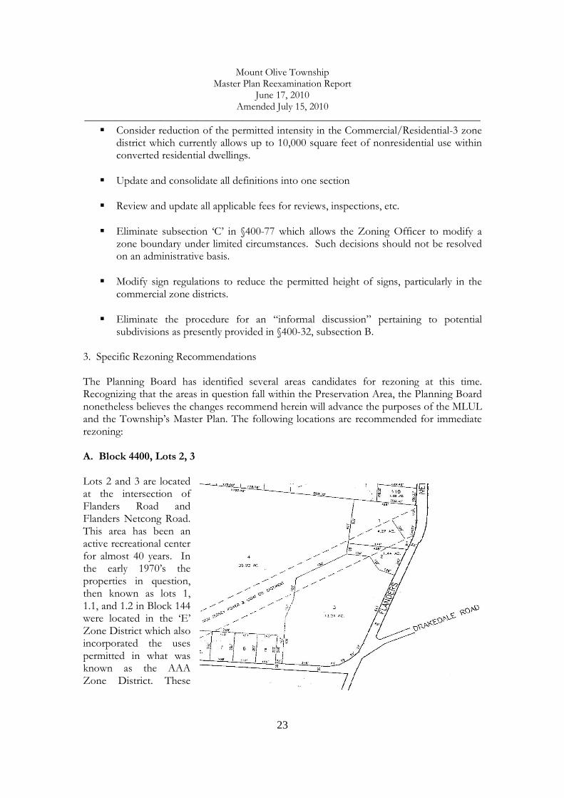
3. Specific Rezoning Recommendations The Planning Board has identified several areas candidates for rezoning at this time. Recognizing that the areas in question fall within the Preservation Area, the Planning Board nonetheless believes the changes recommend herein will advance the purposes of the MLUL and the Township’s Master Plan. The following locations are recommended for immediate rezoning: A. Block 4400, Lots 2, 3 Lots 2 and 3 are located at the intersection of Flanders Road and Flanders Netcong Road. This area has been an active recreational center for almost 40 years. In the early 1970’s the properties in question, then known as lots 1, 1.1, and 1.2 in Block 144 were located in the ‘E’ Zone District which also incorporated the uses permitted in what was known as the AAA Zone District. These

Mount Olive Township Master Plan Reexamination Report
June 17, 2010 Amended July 15, 2010
______________________________________________________________________________
24
included a category known as “Special Exception Uses”. It was under this category, which included “semi-public” facilities that the Solar Swim Club was approved. Township records indicate that the Solar Swim Club existed prior to a May 1975 minor subdivision to establish a separate lot to construct indoor tennis courts. Later, a separate building was constructed on what is now Lot 2 as a fitness center.
This area has been an active recreational center for almost four decades and predates much of the residential development which emerged to the southeast in the late 1980s. In the Township’s 1975 Master Plan, the area in question was identified as “commercial-recreation or predominantly open” on the Existing [1974] Land Use Map. Properties contiguous to this site along Flanders Road were identified as single-family residential as were some dozen lots on the opposite side of Flanders Netcong Road. Much of the area to the southeast was vacant and the land adjacent to the swim club to the northwest was “wooded” (see photo, above). The same 1975 Master Plan proposed that this area be slated for “medium density residential” at 2-to-4 units per acre.
The tennis facility and swim club continued to be identified as “commercial” on the Existing Land Use Map of the 1986 Master Plan reflecting their continued operations yet the Master Plan still proposed this area be designated for residential zoning at a slightly reduced density of one unit per acre on the Land Use and Housing Plan Map. The tennis facility, swim club and fitness center continued to exist at the time of the December 2003 Master Plan/Master Plan Reexamination Report as evidenced on the Existing Land Use Map showing this area to be “commercial”. Again the new Land Use Plan called for a conversion to residential one acre

Mount Olive Township Master Plan Reexamination Report
June 17, 2010 Amended July 15, 2010
______________________________________________________________________________
25
zoning while at the same time recognizing the pool, fitness center and indoor tennis courts as part of the overall recreational facilities serving the Township.4 The purpose in creating a zone district to encompass this recreational complex is to recognize the importance of this community resource which has served the residents of Mount Olive and neighboring communities for many years. Not only is it unlikely that the buildings and related site improvements in place on lots 2 and 3 would be removed to allow for the construction of one single family dwelling on each lot – Highlands Preservation Area restrictions would impose such a limit, local zoning notwithstanding, the power lines that traverse the rear of each lot and the proximity of the JCP&L power substation on Lot 1 (as seen to the right of the larger buildings in the photo, above) further argue against the wisdom of keeping these properties in a residential district. The current R-1 zone district allows for a number of Conditional uses including the following: “Club pools and associated recreation areas with minimum five-acre lots”. An active, vibrant concentration of recreational facilities such as exists on lots 2 and 3 are certainly in the public interest and despite calls dating back to the 1975 Master Plan to see this area developed with residential dwellings, the swim club, indoor tennis courts and fitness center have remained part of the community. At this point the Township finds it appropriate to move away from residential zoning here and elevating the Conditional use status to the Principal use of the area. Although the new zone will be distinct from the ‘P’ – Public zone district that includes much of the surrounding area (Turkey Brook Park Block 7600, Lot 71/267 acres), the former B&H tract (Block 4400, Lot 26/103 acres), and the former Blue Atlas Nursery tract, now owned by the Township and recommended for rezoning to the Public Zone District in this Report (Block 4500, Lot 8/31 acres), it blends well with the concept of establishing a center of active and passive recreational facilities for Township residents. This recreational node also includes the Jewish Community Center – Deeney Ribeck Day Camp (Block 7600, lots 84, 85/25 acres) which is also zoned R-1 but has long existed as a summer day camp with an assortment of active recreation facilities. B. Block 4500, Lot 8 Lot 8 is located along the easterly side of Flanders Netcong Road, north of the intersection with Drakedale Road. The 31-acre parcel, formerly the location of the Blue Atlas Nursery, was purchased with Green Acres funding and is scheduled to be improved with recreational fields. As such the R-1 Residential zoning is no longer appropriate and should be rezoned to the P-Public zone classification. This tract adjoins Lot 29, an undeveloped parcel owned by the Morris County Board of Education as seen on the tax map excerpt, below. Lot 29 is in the P-Public zone district.
4 Mount Olive Township 2003 Master Plan and Master Plan Reexamination, Chapter 3, page 42
Mount Olive Township Master Plan Reexamination Report
June 17, 2010 Amended July 15, 2010
______________________________________________________________________________
26
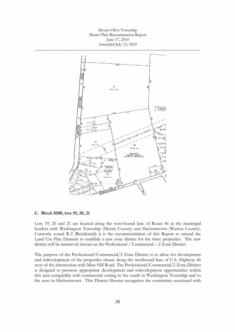
C. Block 8500, lots 19, 20, 21 Lots 19, 20 and 21 are located along the west-bound lane of Route 46 at the municipal borders with Washington Township (Morris County) and Hackettstown (Warren County). Currently zoned R-2 (Residential) it is the recommendation of this Report to amend the Land Use Plan Element to establish a new zone district for the three properties. The new district will be tentatively known as the Professional / Commercial – 2 Zone District The purpose of the Professional/Commercial/2 Zone District is to allow for development and redevelopment of the properties situate along the westbound lane of U.S. Highway 46 west of the intersection with Mine Hill Road. The Professional/Commercial/2 Zone District is designed to promote appropriate development and redevelopment opportunities within this area compatible with commercial zoning to the south in Washington Township and to the west in Hackettstown. This District likewise recognizes the constraints associated with

Mount Olive Township Master Plan Reexamination Report
June 17, 2010 Amended July 15, 2010
______________________________________________________________________________
27
the Musconetcong River along the District’s northerly boundary and the restrictions imposed by the Highlands Regional Master Plan for lands within the Preservation Area.
In the late 1950s this area was located in the ‘C – Retail Business’ zone district. Of the three properties, Lot 21 contains the Pump House Restaurant which, prior to the early 1970s, was a bank. Lot 20 is improved with a single family dwelling which is maintained in excellent condition. Lot 19 likewise contained a residential dwelling although the dwelling and several nonconforming structures eventually deteriorated to the point that the Township initiated

Mount Olive Township Master Plan Reexamination Report
June 17, 2010 Amended July 15, 2010
______________________________________________________________________________
28
property maintenance and zoning enforcement actions some years ago. The current owner has undertaken efforts to clean up the property and restore it to productive use. The new zone could accommodate a limited range of uses including detached single family dwellings, offices for professional, scientific and technical services, medical offices, child care centers (per N.J.S. 40:55D-66.6), retail sales of goods and services, and restaurants. Development standards should limit residential dwellings to a minimum of one acre and two acres for non-residential development. A maximum Floor Area Ratio (FAR) of 0.06 is recommended. 4. Planning for Trails The Mount Olive Open Space Committee, with assistance from The Land Conservancy of New Jersey, prepared a report entitled Trails Plan for Township of Mount Olive, dated October 2009. This Plan was discussed with the Planning Board at a public meeting on October 15, 2009. The possibility of incorporating the Trails Plan into the Circulation Plan Element and possibly the Open Space and Recreation Plan Element of the Township Master Plan was considered but deferred for additional analysis. In particular, concern was raised over potential conflicts between the identification of such trails with GPS and public access in areas where such trails are situate in proximity to existing residential neighborhoods. The Planning Board intends to continue to examine this issue in 2010 as part of the comprehensive Master Plan revisions. In addition to an “Action Plan and Recommendations” section, the Trails Plan sets forth an overall vision and specific goals and objectives, as follows:
Vision Statement Mount Olive Township seeks to provide its residents with opportunities for resource based recreation within its public lands, and to connect its neighborhoods to these public lands, to other community facilities and to recreational opportunities outside its borders with a network of interconnected trails.
Goals and Objectives To create trail systems within the Township’s larger public open spaces that serve all ages and address multiple use needs, thereby expanding the recreational opportunities available to Township residents, promoting healthy lifestyles and enhancing quality of life and livability
� Identify existing Township recreational facilities and trails � Identify other public lands suitable for trail development � Create a variety of trail routes that satisfy the requirements of a variety of � recreational trail users, including hikers, walkers, bicyclists, horseback riders
and cross-county skiers

Mount Olive Township Master Plan Reexamination Report
June 17, 2010 Amended July 15, 2010
______________________________________________________________________________
29
� Include trails that are ADA-compliant � Appropriately match trail type and use with land capabilities � Improve and expand the trail and pathway network within Turkey Brook
Park with both paved and natural surface trails, including a cross-country track route that provides an off-road route for high school runners
To provide connectivity and access to other public lands within the Township, to regional trail systems and to trail systems and open spaces in neighboring communities.
� Identify existing recreational facilities and trails on State, County and other public lands in or near the Township
� Identify regional or neighboring municipal trail systems that travel through or close to Mount Olive Township
� Identify ways to connect to these facilities and trail systems, using a combination of existing and proposed trails, including sidewalks, road walks, bicycle routes and trails through public lands or on easements through private properties
� Provide parking access in or close to these facilities for Mount Olive residents
To establish trail connections that link neighborhoods with parklands and other community facilities such as schools, municipal facilities and shopping.
� Identify existing trails between neighborhoods, schools, municipal facilities and shopping areas
� Identify opportunities for additional connectivity, particularly promoting additional safe routes to schools
� Identify opportunities for connectivity between public transportation routes, such as train stations and bus stops, and community facilities to aid commuters, workers and shoppers
� Identify opportunities for connectivity between apartment complexes and community facilities such as shopping areas
To support healthy lifestyles and improve the quality of life and livability of the community through the creation of trails and pathways in proximity to all Mount Olive residents.
5. Energy Awareness and Conservation Design Mount Olive Township is now a certified Sustainable Jersey Community, an action authorized by the Township Council in a Resolution adopted on December 9, 2008 (Please see Appendix E.) As part of this effort the Township Council also adopted a Resolution on November 10, 2009 committing the Township to adhere to certain principals with regard to land use decisions in order to achieve a more sustainable community. The Resolution,

Mount Olive Township Master Plan Reexamination Report
June 17, 2010 Amended July 15, 2010
______________________________________________________________________________
30
entitled Resolution of the Township Council of the Township of Mount Olive Endorsing A Sustainable Land Use Pledge for the Sustainable Jersey Program calls for the Township’s Master Plan and zoning regulations to reflect the following principles:
Facilities Sitting – We pledge, to the extent feasible, to take into consideration factors such as walkability, bikability, access to transit and proximity to other uses when siting new or relocated municipal facilities. The actions of a municipality when locating their own facilities can set a positive precedent and encourage other public and private sector entities to consider sustainable land-use considerations into account when locating their own facilities. Housing Variety – We pledge, through the use of our zoning and revenue generation powers, to foster a divers mix of housing types to meet the needs of people from all ages and walks of life. A variety of housing options, from single family homes to one-bedroom apartments, including housing affordable to people with low, moderate and middle incomes, is vital to allow residents to live and work in a municipality through various stages of their lives. Natural Resource Preservation – We pledge to preserve open space and create recreational opportunities within our municipality. As the most densely populated state in the nation, open space in New Jersey is at a premium. Preserving what is left of our open space, for its ecological and recreational value, is critical for a sustainable future.
The Resolution also calls for improved transportation choices, including walking, biking, transit opportunities, approximate mixed-use zoning to reduce dependence upon the automobile, “green design” to promote energy and water conservation, consideration of changes to off-street parking standards to reduce the land area devoted for such purposes, and regional cooperation in the planning process. (The complete Resolution is found in Appendix E.) In accordance with the Township’s continued endeavors to be a “sustainable” community the aforementioned considerations will guide the on-going modifications to the Master Plan and the Township’s land use regulations.
Section ‘e’ [40:55D-89e] THE RECOMMENDATIONS OF THE PLANNING BOARD CONCERNING THE
INCORPORATION OF REDEVELOPMENT PLANS ADOPTED PURSUANT TO THE “LOCAL REDEVELOPMENT AND HOUSING LAW”, P.L. 1992, C. 79 (C. 40A:12A-1 ET SEQ.) INTO
THE LAND USE PLAN ELEMENT OF THE MUNICIPAL MASTER PLAN, AND
RECOMMENDED CHANGES, IF ANY, IN THE LOCAL DEVELOPMENT REGULATIONS
NECESSARY TO EFFECTUATE THE REDEVELOPMENT PLANS OF THE MUNICIPALITY.
Mount Olive Township Master Plan Reexamination Report
June 17, 2010 Amended July 15, 2010
______________________________________________________________________________
31
At the present time Mount Olive does not have any active redevelopment plans in place or under consideration. The Township will evaluate “redevelopment” opportunities under the standards established in the RMP. Within the Preservation Area there are several locations that lend themselves to the redevelopment policies set forth in the RMP that the Township may wish to pursue. The Existing Community Zone encompassing the industrial district on the southerly side of Gold Mine Road is one such area. Properties along Route 46 in the Lake Management Zone and along the Rt. 206 corridor in Flanders are other potential locations. Mount Olive will examine the prospects for seeking redevelopment area designation in accordance with the standards of the Highlands Act and the RMP as part of the Plan Conformance process

Mount Olive Township Master Plan Reexamination Report
June 17, 2010 Amended July 15, 2010
______________________________________________________________________________
32
APPENDIX A RECREATION AND OPEN SPACE INVENTORY

Mount Olive Township Master Plan Reexamination Report
June 17, 2010 Amended July 15, 2010
______________________________________________________________________________
33
APPENDIX B
MOUNT OLIVE – HIGHLANDS LAND USE CAPABILITY MAP

Mount Olive Township Master Plan Reexamination Report
June 17, 2010 Amended July 15, 2010
______________________________________________________________________________
34
APPENDIX C
MAP UPDATE: COMBE FILL NORTH

Mount Olive Township Master Plan Reexamination Report
June 17, 2010 Amended July 15, 2010
______________________________________________________________________________
35
APPENDIX D STATE PLAN POLICY MAP PROPOSED CHANGE

Key: new addition to listcorrection to list, see description transferred to State ownershipR= held for recreation purposesC= held for conservation purposes
LOCATION PARK NAME BLOCK LOT ACREAGEFUNDED-UNFUNDED.
HELD FOR: R= RECREATION, C= CONSERVATION DESCRIPTION
Dorset Drive Oak Hill II 800 32.11 4.345 un C water tower, powerlines, openDorset Drive Oak Hill II 801 1 2.021 un C powerlines, open, pondsSmithtown Rd. 900 42 10.54 un C wetlandsStephens State Park Rd. 900 59 51.03 un C undevelopedSmithtown Rd. 900 44 16.15 un C 2 detention basins, wetlands, developers donationSandshore Rd. Green Hills South 910 20 17.63 un C Tabaka Pond, detention basinCamelot Drive Camelot Park 1201 1 29.48 un C stream corridor, wooded, detention basin41 Crease Rd. 1201 9 9 un C foreclosure, forested wetlands, stream corridorAlcrest Drive 1402 11 0.45 un C stream corridor, newCamelot Drive Camelot Park 1402 23 1.3 un C well house, openWampum Trail 1600 2 0.43 un C wetlands,woodedIroquois Trail 1600 3 0.22 un C wetlands,woodedIroquois Trail 1600 4 0.22 un C wetlands, wooded, stream headwaters, foreclosureSandshore Rd. 1600 7 0.1 un C wetlands,woodedSandshore Rd. 1600 8 0.36 un C wetlands, woodedSandshore Rd. 1600 9 0.74 un C wetlands, sewer pump stationWampum Trail 1600 10 0.22 un C wetlands,woodedWampum Trail 1600 11 0.47 un C wetlands,woodedIroquois Trail 1601 1 0.62 un C wetlands,woodedIroquois Trail 1601 4 0.22 un C wetlands,woodedWampum Trail 1601 5 1.76 un C wetlands,woodedWampum Trail 1601 6 0.06 un C wetlands,woodedSandshore Rd. 1601 7 0.13 un C wetlands,woodedDeer Skin Trail 1602 1 2.57 un C wetlands,woodedDeer Skin Trail 1602 2 0.22 un C wetlands,woodedSandshore Rd. 1602 3 0.22 un C wetlands,woodedAlgonquin Trail 1602 6 0.1427 un C wetlands, woodedAlgonquin Trail 1602 8 0.23 un C wetlands, woodedIroquois Trail 1602 9 0.13 un C wetlands, woodedAlgonquin Trail 1603 1 2.5 un C wetlands,woodedAlgonquin Trail 1603 2 0.22 un C wetlands,woodedSandshore Rd. 1603 4 0.5 un C wetlands,woodedSioux Trail 1604 2 0.82 un C wetlands,woodedErie Trail 1604 6 0.23 un C wetlands. WoodedMohawk Trail 1605 1 1.8 un C wetlands,woodedSandshore Rd. 1605 6 0.12 un C wetlands, woodedIroquois Trail 1606 2 1.15 un C wetlands,woodedIroquois Trail 1606 3 0.22 un C wetlands,woodedMohawk Trail 1606 6 0.42 un C wetlands, woodedIroquois Trail 1607 4 1.24 un C wetlands,wooded
revised 9-09 by Council resolution, pink highlighted properties are newly added to the list
Total list of all lands held for open space and recreation purposes
MOUNT OLIVE TOWNSHIP RECREATION AND OPEN SPACE INVENTORY (ROSI)
list is an update of the 2004 official version submitted to Green Acres
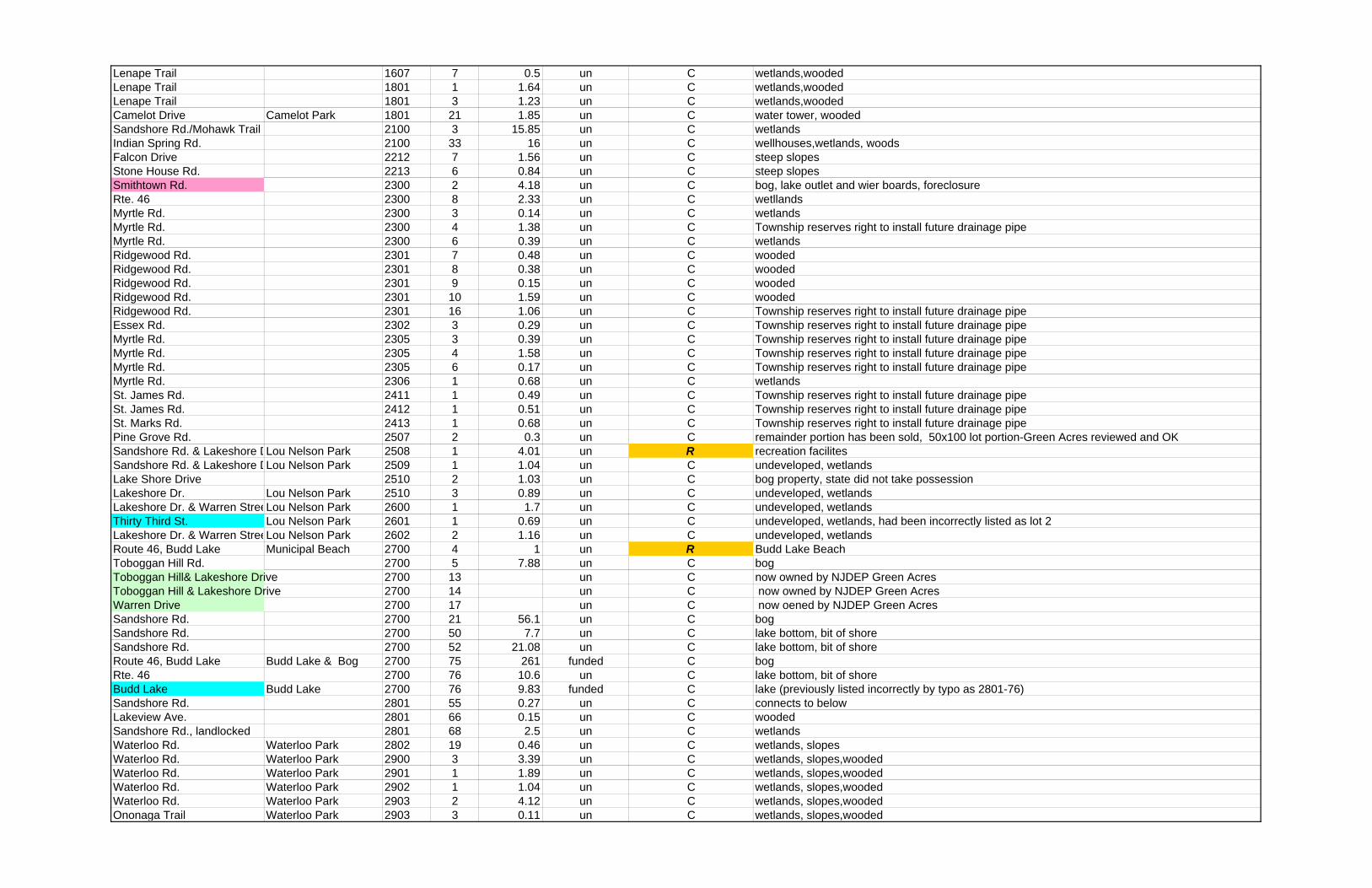
Lenape Trail 1607 7 0.5 un C wetlands,woodedLenape Trail 1801 1 1.64 un C wetlands,woodedLenape Trail 1801 3 1.23 un C wetlands,woodedCamelot Drive Camelot Park 1801 21 1.85 un C water tower, woodedSandshore Rd./Mohawk Trail 2100 3 15.85 un C wetlandsIndian Spring Rd. 2100 33 16 un C wellhouses,wetlands, woodsFalcon Drive 2212 7 1.56 un C steep slopesStone House Rd. 2213 6 0.84 un C steep slopesSmithtown Rd. 2300 2 4.18 un C bog, lake outlet and wier boards, foreclosureRte. 46 2300 8 2.33 un C wetllandsMyrtle Rd. 2300 3 0.14 un C wetlandsMyrtle Rd. 2300 4 1.38 un C Township reserves right to install future drainage pipeMyrtle Rd. 2300 6 0.39 un C wetlandsRidgewood Rd. 2301 7 0.48 un C woodedRidgewood Rd. 2301 8 0.38 un C woodedRidgewood Rd. 2301 9 0.15 un C woodedRidgewood Rd. 2301 10 1.59 un C woodedRidgewood Rd. 2301 16 1.06 un C Township reserves right to install future drainage pipeEssex Rd. 2302 3 0.29 un C Township reserves right to install future drainage pipeMyrtle Rd. 2305 3 0.39 un C Township reserves right to install future drainage pipeMyrtle Rd. 2305 4 1.58 un C Township reserves right to install future drainage pipeMyrtle Rd. 2305 6 0.17 un C Township reserves right to install future drainage pipeMyrtle Rd. 2306 1 0.68 un C wetlandsSt. James Rd. 2411 1 0.49 un C Township reserves right to install future drainage pipeSt. James Rd. 2412 1 0.51 un C Township reserves right to install future drainage pipeSt. Marks Rd. 2413 1 0.68 un C Township reserves right to install future drainage pipePine Grove Rd. 2507 2 0.3 un C remainder portion has been sold, 50x100 lot portion-Green Acres reviewed and OKSandshore Rd. & Lakeshore DLou Nelson Park 2508 1 4.01 un R recreation facilitesSandshore Rd. & Lakeshore DLou Nelson Park 2509 1 1.04 un C undeveloped, wetlandsLake Shore Drive 2510 2 1.03 un C bog property, state did not take possessionLakeshore Dr. Lou Nelson Park 2510 3 0.89 un C undeveloped, wetlandsLakeshore Dr. & Warren StreeLou Nelson Park 2600 1 1.7 un C undeveloped, wetlandsThirty Third St. Lou Nelson Park 2601 1 0.69 un C undeveloped, wetlands, had been incorrectly listed as lot 2Lakeshore Dr. & Warren StreeLou Nelson Park 2602 2 1.16 un C undeveloped, wetlandsRoute 46, Budd Lake Municipal Beach 2700 4 1 un R Budd Lake BeachToboggan Hill Rd. 2700 5 7.88 un C bogToboggan Hill& Lakeshore Drive 2700 13 un C now owned by NJDEP Green AcresToboggan Hill & Lakeshore Drive 2700 14 un C now owned by NJDEP Green AcresWarren Drive 2700 17 un C now oened by NJDEP Green AcresSandshore Rd. 2700 21 56.1 un C bogSandshore Rd. 2700 50 7.7 un C lake bottom, bit of shoreSandshore Rd. 2700 52 21.08 un C lake bottom, bit of shoreRoute 46, Budd Lake Budd Lake & Bog 2700 75 261 funded C bogRte. 46 2700 76 10.6 un C lake bottom, bit of shoreBudd Lake Budd Lake 2700 76 9.83 funded C lake (previously listed incorrectly by typo as 2801-76)Sandshore Rd. 2801 55 0.27 un C connects to belowLakeview Ave. 2801 66 0.15 un C woodedSandshore Rd., landlocked 2801 68 2.5 un C wetlandsWaterloo Rd. Waterloo Park 2802 19 0.46 un C wetlands, slopesWaterloo Rd. Waterloo Park 2900 3 3.39 un C wetlands, slopes,woodedWaterloo Rd. Waterloo Park 2901 1 1.89 un C wetlands, slopes,woodedWaterloo Rd. Waterloo Park 2902 1 1.04 un C wetlands, slopes,woodedWaterloo Rd. Waterloo Park 2903 2 4.12 un C wetlands, slopes,woodedOnonaga Trail Waterloo Park 2903 3 0.11 un C wetlands, slopes,wooded

Waterloo Rd. Waterloo Park 2904 1 0.46 un C wetlands, slopes,woodedWaterloo Rd. Waterloo Park 2905 1 4.51 un C wetlands, slopes,woodedWaterloo Rd. Waterloo Park 2905 3 0.22 un C wetlands, slopes,woodedEisenhower Drive Waterloo Park 2905 11 0.11 un C existing drainage line & drainage right of wayWaterloo Rd. Waterloo Park 2906 1 0.46 un C wetlands, slopes,woodedSouth Rose Lane 3207 12 1.71 un C Township retains rights to drill well, have wellhouseRte. 46 Tulip Park 3700 5 2.3 un C donation from JMI, Townhsip retains right to install future drainage Rte. 46 Tulip Park 3700 15 0.34 un C Township retains rights to install future drainage pipeRte.46 Tulip Park 3700 16 0.17 un C Township retains rights to install future drainage pipeRte. 46 Tulip Park 3700 17 0.38 un C Township retains rights to install future drainage pipeRte. 46 Tulip Park 3700 20 0.15 un C Bruun donation for conservationRte. 46 Tulip Park 3700 26 0.36 un C Township retains rights to install future drainage pipeMt. Olive Rd. Tulip Park 3700 31 0.17 un C Township retains rights to install future drainage pipeColonial St. Tulip Park 3700 41 0.17 un C Township retains rights to install future drainage pipeRte.46 Tulip Park 3700 42 7.17 un C donation from JMI, Townhsip retains right to install future stormwater control and drainage Rte. 46 Tulip Park 3700 42.01 2,57 un C Bruun donation for conservation, wooded wetlandsFoothill Ave. Tulip Park 3700 55 1.12 un C undevelopedTulip Ave. Tulip Park 3700 56 4.09 un R recreation facilitesFoothill Ave. Tulip Park 3700 73 0.31 un C undevelopedFoothill Ave. Tulip Park 3700 74 0.29 un C undevelopedKingden St. Tulip Park 3700 82 2.12 un C undevelopedKingden St. Tulip Park 3700 83 0.28 un C undevelopedBrook St. Tulip Park 3700 89 0.28 un C undevelopedBrook St. Tulip Park 3702 90 1 un C undevelopedMadison Ave. 3906 1 1.42 un C wetlandsGoldmine Rd. 4100 11 38 un C wooded, wetlands, vernal poolsConnelly Ave. Country Oaks H.O.A. 4100 12.01 5.2 un C Country Oaks Homowners Assoc., conservation easement,access to HOA members onlyTanglewood Way 4100 12.33 0.36 un C vacant lotCrestwood Circle Country Oaks H.O.A. 4100 19 3.26 un C Country Oaks Homowners Assoc., conservation easement, water towerGold St. 4100 24 0.84 un C woodedEast Forest Rd. 4100 42 0.25 un C wooded, Township retains rights to future well, wellhouseOld Budd Lake Rd. 4100 89 17.39 un C wooded, wetlands, vernal poolsConnelly Ave. Country Oaks H.O.A. 4110 15 1.73 un C Country Oaks Homowners Assoc., conservation easement,access to HOA members onlyConnelly Ave. Country Oaks H.O.A. 4111 2 6.35 un C Country Oaks Homowners Assoc., conservation easement, access to HOA members onlyConnelly Ave. Country Oaks H.O.A. 4112 2 2 un C Country Oaks Homowners Assoc., conservation easement, access to HOA members onlyConnelly Ave. Country Oaks H.O.A. 4113 2 1.26 un C Country Oaks Homowners Assoc., conservation easement,access to HOA members only
Connelly Ave. Country Oaks H.O.A. 4114 30 10.8 un CCountry Oaks Homowners Assoc., cons.easement,access to HOA memerbs only, exception area of sewer pump station, well
ITC South 4300 9 30.5 un C ITC South Mall, wetlands restoration, conservation easement on portion of lotITC South 4300 19 23 un C ITC South Mall, wetlands restoration, conservation easement on portion of lotFlanders Rd. Turkey Brook Greenwa4400 9 58.04 funded C undeveloped, woodedFlanders Rd. Turkey Brook Greenwa4400 26 102.62 funded C undeveloped, woodedFlanders Rd. 4400 45 0.45 un C wetlandsFlanders Rd. 4400 49 1 un C wetlandsGoldmine Rd. 4400 69 4.3 un C wetlandsGoldmine Rd. 4400 70 0.17 un C wetlandsGold Mine Rd. Turkey Brook Greenwa4400 82 7.73 un C undeveloped, wooded, wetlandsFlanders-Netcong Rd. Drakes Brook Park 4500 8 31 funded R 1 acre exception area unfunded contains buildings, remainder is funded, acquired 3-08 known as BluRte. 206 4500 34 6.98 un C wetlands, powerline easement, stream corridor, foreclosureRte. 206 4600 1 3.8 un C stream corridorRte. 206 4600 1.01 1.34 un C stream corridorChestnut Way Millbrook H.O.A. 4600 10 21.5 un C conservation easement , no public access except for Millbrook Homeowners AssnFlanders-Drakestown Rd. 5000 1 14.48 un C steep slopes, Carlton HillsRte. 206 5000 12 12.13 un C steep slopes, Carlton Hills

Corey Rd. 5200 4 2.43 un C drainage easementCorey Rd. Silver Spring Manor 5201 10 30.46 un C donated by S. Baum for conservation, 3-08, includes 5202 lot 11 in land totalCorey Rd. Silver Spring Manor 5202 11 un C see above - both lots forested wetlands, adjoin TBPFlanders-Drakestown Rd. Silver Spring Manor 5300 8 173.136 funded R fields, woods, acquired from S. Baum, Feb. 2005, possible future recreation fields on portionRte. 206 Silver Spring Manor 5300 8.01 10.9 un C donated by S. Baum for conservation, 3-08Tinc Rd, landlocked Silver Spring Manor 5300 26 funded C land total included with 5300 lot 8Tinc Rd. 5300 54 46 funded C Devlin conservation easement, trail access onlyCrenshaw Drive Flanders Crossing H.O 5400 23 15.77 un C Flanders Crossing Homeowners Assoc. conservation easement, wetlands, no public access26-1 Main Rd. 5401 9.01 3.08 funded R State House Commission trade re MOHS driveway, Ballfields, recreationCrenshaw Drive Flanders Crossing H.O 5410 74 1.5 un C Flanders Crossing Homeowners Assoc. conservation easement, detention basin, no public accessCrenshaw Drive Flanders Crossing H.O 5410 75 6 un C Flanders Crossing Homeowners Assoc. conservation easement, detention basin, no public accessPheasant Court 6000 1 5.24 un C floodplain1 Fox Place 6000 2 8.87 un C foreclosure, stream corridor of Drakes Brook, floodplain, adjoins other OSFox Place 6000 3 16.25 un C donation from Mr. Welpe for conservation, landlocked, wetlands, woods, Drakes brookFlanders-Bartley Rd. Flanders Park 6000 12 18.23 un R recreation facilites(includes former lots 12.03, 12.04, merged with lot 12)Clover Hill Drive 6208 66 8.5 un C undeveloped, under power linesClover Hill Drive 6208 79 3.76 un C foreclosure, floodplain, steam corridor of Drakes Brook, landlocked, adjoins Powerlines ParkClover Hill Drive, Rte. 206 Powerline Park 6300 14 1.57 un R recreation facilitesClover Hill Drive, Glendale RdPowerline Park 6304 33 7.8 un R recreation facilitesBriar Ct. Lions Park 6500 37 13 un R recreation facilitesRte, 206 6502 7 2.34 un C floodplainRte. 206 6600 3 7.07 un C floodplainBartley Rd 6600 11 6.64 un C floodplainBartley Rd 6600 12 14.77 un C floodplainDrakestown Rd. 7000 21 18.64 un C wetlandsTinc Rd. 7100 16 50 un C Devlin conservation easement, trail access onlyNature's Way 7100 53 21.99 un C Turkey Brook corridor, wooded, detention basinKevin Drive 7400 23 11.65 un C existing wellhouses, well, retention pond, possible future added wellBennington Drive 7400 33 14.8 un C existing retention pond, possible future wellHighfield Rd. 7600 48 67 un C Wyndham Pointe developers donation for cluster, forested wetlandsMt. Olive Rd. 7600 64 1.43 un C Township reserves right to install future drainage pipeMt. Olive Rd. 7600 65 1.21 un C Township reserves right to install future drainage pipeFlanders Rd. Turkey Brook Park 7600 71 267.48 funded R trails, beginning recreation on 80 acresFlanders Rd. Turkey Brook Park 7600 74 43.49 funded C trails, wooded, wetlandsSchoolhouse Rd. Turkey Brook Park 7600 87.17 25.44 un C trails, wooded, wetlandsFlanders Rd. Turkey Brook Park 7600 89 3.81 un C trails, wooded, wetlandsVista Dr, Flanders-Drakestown 7600 114 16.77 un C developers donation for cluster, Turkey Brook, (drainage easement, sewer pump station in excepted
Highfield Rd. 7600 147 12 un Cdevelopers donation for cluster as open space (sewer plant, septic fields, water lines in excepted area)
Rte. 46 7700 6 1.5 un C wetlands, drainageKings Arrow Drive 7801 5 12.38 un C wetlandsFlanders-Drakestown Rd. 7801 8 40 funded C Baptist Church purchase, vacant land for conservation, Sunset Brook corridor, wetlands, trailsFlanders-Drakestown Rd. 7801 14 1 funded C historic Mt. Olive Village-Church, school, cemeteryMt. Olive Rd. 7801 41 51.5 un C developers donation for cluster, forested wetlands, Sun Valley Brook heritage trout stream, powerlineMine Hill Rd. 8300 15 4.8 un C donation by Shumann for conservation, very steep slopes, woods, Rte. 46 adjacentMine Hill Rd. 8300 17.01 5 un C Mine Brook corridor, woodedSaunders Lane 8800 9 9.91 un C existing powerlines, Oak Hill I developers donationSaunders Lane 8800 36.24 17.24 un C existing powerlines & detention basins, Oak Hill I developers donationSaunders Lane 8800 36.45 4,47 un C existing powerlines, Oak Hill I developers donationPowatatan Way 8800 44 57 un C Owner:Baduini, conservation easement to town, no public access
Total 2211.9347

RO
UTE
206
RIVER RD
WATERLO
O VALL
EY RD
INTERSTATE 80
SA
ND
SH
OR
E R
D
GOLD MINE RD
ROUTE 46
MINE H
ILL RD
LOZIER RD
TIN
C R
D
WO
LFE RD
SMITHTOWN RD
FLANDERS RD
MA
IN R
D
SHOP LN
CR
EA
SE
RD
CLO
VE
R H
ILL DR
CO
RY
RD
WA
TE
RLO
O R
D
MO
UN
T OLIV
E R
D
DU
FF
Y R
D
IRONIA RD
LISA DR
KINN
Y RD
THIRD ST
PLEASANT HILL RD
KEVIN DR
DRAKEDALE RD
TULIP AVE
NETCONG RD
CO
NTIN
ENTA
L DR
OA
KW
OO
D D
R
JOH
N S
T
CARLTON RD
GA
RY
CT
SVEA DR
OLD WOLFE RD
CAT
HY
LN
BRIARHURST DR
PLA
ZA
RD
HARRIS LN
WOODBINE AVE
DONNA LN
FOREST RD
WOODCREST AVE
CENTER ST
DEER PATH DR
RA
MA
R S
T
INTERSTATE 80
ROUTE 206
Figure 1:
Highlands Regional Master Plan
Land Use Capability Map
Mount Olive Township,
Morris County, NJ
February 2009
B A N I S C H A S S O C I A T E S, I N C.
Planning and Design
µ
Data Sources:NJDEP
Morris County Planning
This map was developed using New Jersey Department of Environmental Protection Geographic Information System digital data, but this secondary product has not been NJDEP verified and is not State-authorized.
Legend
Highlands Planning Area
Water
Overlay Zone Designations
Protection
Conservation
Conservation Constrained
Existing Community
Existing Community Constrained
Lake Community
0 10.5Miles
New Jersey is an Equal Opportunity Employer
State of New Jersey Highlands Water Protection and Planning Council
100 North Road (Route 513) Chester, New Jersey 07930-2322
(908) 879-6737 (908) 879-4205 (fax)
www.highlands.state.nj.us
JON S. CORZINE Governor
JOHN R. WEINGART Chairman
EILEEN SWAN Executive Director
February 20, 2009 VIA FIRST CLASS MAIL Chuck McGroarty, PP, AICP Banisch Associates, INC. 111 Main Street Flemington, NJ 08822
RE: Mount Olive Township RMP Update Request Block 4100, Lot 10; A.K.A. Combe Fill North
Dear Mr. McGroarty: On behalf of the New Jersey Highlands Water Protection and Planning Council (Highlands Council), I write in response to the above referenced request. The Highlands Council is in receipt of your letter dated, January 15, 2009, and supporting documentation that was submitted on behalf of Mount Olive Township. The information provided confirms the current and existing conditions of a majority of the subject parcel and is sufficient for a Regional Master Plan (RMP) Update. The RMP Updates Program is designed to facilitate and coordinate the exchange of “new, corrected or updated factual information and verification by the Highlands Council.” Highlands Regional Master Plan, Policy 6A2 & 6G1, see Chapter 6, Part 1, Subpart B. The purpose of the program is to ensure that the RMP reflects the most current data for use during Plan Conformance. For a municipality or county to receive an RMP Update, the information or data submitted must satisfy the Highlands Council’s Digital Submission Standards set forth in the RMP, and then must be verified by the Highlands Council. Only factual information, where appropriately documented and verified, may be updated by the Highlands Council. Under the RMP’s Land Use Capability Zone Map, the subject parcel is classified as Existing Community Zone – Environmentally Constrained (see attached Land Use Capability Zone Map for Mount Olive Township). The Highlands Council’s GIS-based model, Land Use Analysis Decision Support System (LANDS), initially found a majority of the subject parcel to be inconsistent with the criteria for the Protection Zone and the Existing Community Zone. This occurred because a majority of this parcel had been classified by NJDEP 2002 Land Use Land Cover Classification Code as “Barren” (7000 Series). Given this classification as Barren under the land use land cover data, LANDS classified the subject parcel as Existing Community Zone – Environmentally Constrained.

February 20, 2009 Page 2
The information submitted by Mount Olive Township on January 15, 2009, documents that sixty-five (65) acres of the subject parcel had been used as a sanitary landfill between the years of 1966 and 1981. In addition, the information submitted by the township documents that the parcel was placed on the U.S. Environmental Protection Agency’s National Priorities List of Superfund Sites in 1982, and that after remediation was completed in 2004, the U.S. Environmental Protection Agency removed the parcel from the National Priorities List. Finally, the information demonstrates that a methane venting system, concrete drainage channels and monitoring wells remain on the subject parcel. Given the comprehensiveness of the factual information submitted, and the review conducted by the Highlands Council, the Council believes that the subject parcel more properly should be classified as the Land Use Land Cover Classification “Mixed Urban or Built-Up Land” (1600). This code “typically includes developments along transportation routes and in cities, towns, and built-up areas where separate land uses cannot be mapped individually. Residential, Commercial, Industrial, and occasionally other land uses may be included” (Anderson et al, 1976). As a result of this Land Use Land Cover Classification change, it is appropriate to reclassify the subject parcel Existing Community Zone. Consequently, the Highlands Council hereby approves the RMP Update for Block 4100, Lot 10 sought by Mount Olive Township. The figure – Mount Olive Township: Land Use Capability Zone Map, is attached to demonstrate the approved RMP Update. The Highlands Council looks forward to continued collaboration with Mount Olive Township as we embark on Plan Conformance with the RMP. Should you have any questions or concerns with the foregoing, please contact me at (908) 879-6737.
Sincerely,
Eileen Swan Executive Director
Enclosures

B A N I S C H A S S O C I A T E S, I N C.
Planning and Design
P.O. Box 154, Sergeantsville, NJ 08557-0154
908-782-0835/908-782-7636(fax) [email protected]
November 2, 2006
Ms. Christine Marion, Assistant Planning Director Department of Planning, Development & Technology County of Morris P.O. Box 900 Morristown, NJ 07963 RE: Proposed Planning Area Change Dear Ms. Marion: The Township of Mount Olive requests that the Morris County Planning Board in its capacity as the Negotiating Entity in the Cross Acceptance process, pursue a change to the State Plan Policy Map to reclassify a portion of the Planning Area 5 to Planning Area 2. This request concerns the northeast section of the Township as depicted on U.S.G.S. Quad: Stanhope (OSG Quadrangle # 26). It is the Township’s position that the area in question should be designated Planning Area 2 for the reasons set forth herein. 1. AREA IN QUESTION The area in question is located in the Budd Lake section of Mount Olive Township comprising approximately 3.5 square miles and is depicted on the attached aerial entitled Proposed Planning Areas 2 (Attachment 1). Byram, Stanhope, Netcong and Roxbury border the area from west to east and, as you know Stanhope and Netcong have officially been approved as Town Centers. Direct highway access is provided by both Interstate 80 and State Highways 46 and 206 which traverse the area in question. In addition, New Jersey Transit passenger rail service is available at the platform located within the International Trade Center. 2. CHARACTER OF AREA The area we propose to be reclassified to PA 2 is entirely within the Highlands Region Planning Area, again as represented on the attached aerial. It contains some 3.5 million square feet of office, hotel, and industrial/distribution facilities within the International Trade Center, which includes a designated Foreign Trade Zone, one of only five in the State of New Jersey. The proposed PA 2 area also incorporates 1.3 million square feet of commercial and retail space including the 811,197 square feet of stores and restaurants within the International Crossing regional mall. There is an

Christine Marion, Assistant Planning Director Department of Planning, Development & Technology Proposed Planning Area Change November 2, 2006 Page 2 ________________________________________________________________________________________________________
existing population of approximately 3,400 situate in residential neighborhoods to the north and east of the Lake and in the 1,200 rental apartments in Village Green. This area also has the distinction of containing a 102-acre brownfield site known as Combe Fill North, a capped landfill, located along Gold Mine Road adjacent to the aforementioned regional mall. The recent sale of the landfill for $10 million clearly demonstrates the potential for its redevelopment. 3. UTILITIES The entire area in question is severed by public sanitary sewerage facilities through the Musconetcong Sewerage Authority and the Budd Lake Sewer Service district as shown on the attached map from the Township’s 2003 Master Plan entitled Existing And Proposed Sewer Service Areas (Attachment 2). Most of the area is likewise served by public potable water systems as seen on the Water Systems map from the 2003 Master Plan (Attachment 3). 4. POTENTIAL CENTER DESIGNATION When the Planning Board adopted the Master Plan in 2003 there was an expectation that Center Designation would eventually be sought for several areas of the Township, including a portion of Budd Lake which includes the area in question. The three proposed centers are delineated on the Land Use Plan map from the Master Plan (Attachment 4). With the subsequent enactment of the Highlands Water Protection and Planning Act, which placed approximately 82 percent of the Township into the Preservation Area, the full extent of the proposed centers may not be realized, however; as noted above, the area in question is located entirely within the Highland’s Planning Area. The proposed Budd Lake center was described in the 2003 Master Plan as follows:
Budd Lake Regional Center Budd Lake is listed in the appendix to the State Plan as an identified Village Center. The limits of the proposed Budd Lake Center on the Land Use Plan Map include a wider area with existing and proposed development features that do not conform to the criteria for a Village Center. The proposed Center includes the Foreign Trade Zone and the regional shopping area of the Trade Zone South. It also includes the multi-family developments of the Village Green and those projects off of Wolfe Road. The existing single-family residential areas around Budd Lake provide a mix of single-family detached housing on varying lot sizes. There is also the commercial corridor of Route 46, from the Netcong boundary to Wolfe Road, which includes the Village Green Shopping Center. The size and variety of land uses, which are regional in scope, along with the access within the district to Interstate Route 80, all point to this area meeting the criteria for a Regional Center, rather than a Village Center. It is also adjacent to Netcong, which has been designated as a Town Center. (Mount Olive Township 2003 Master Plan and Master Plan Reexamination, page 60)

Christine Marion, Assistant Planning Director Department of Planning, Development & Technology Proposed Planning Area Change November 2, 2006 Page 3 ________________________________________________________________________________________________________
5. CONSISTENCY WITH PLANNING AREA 2 CRITERIA The established development pattern of the portion of Budd Lake that is the subject of this request is an excellent fit with the Suburban Planning Area (PA2) as set forth in the State Development and Redevelopment Plan. Consider the following Delineation Criteria in the SDRP for PA2 with regard to the conditions described above.
1. Population density of less than 1,000 people per square mile. The area in question consists of approximately 3.5 miles with an estimated population of 3,400 for a density of 971 per square mile. 2. Natural systems and infrastructure systems reasonably anticipated to be in place by 2020 that have the capacity to support development that meets the Policy Objectives of this Planning Area. These systems include public water supply, sewage collection and treatment facilities, stormwater, transportation, public schools and parks. The area is directly served by Interstate 80, two state highways, and a NJ Transit passenger rail line. The entire area is served by public sanitary sewerage facilities and all but the older residential neighborhoods adjacent to the lake are served with public potable water. 3. A land area contiguous to the Metropolitan Planning Area. The land in question is contiguous to the designated Town Centers in Stanhope and Netcong, both of which are classified PA2. 4. Land area greater than one square mile. The area in question comprises approximately 3.5 square miles.
6. CONSISTENCY WITH THE INTENT OF PLANNING AREA 2 The existing character of this section of the Township viewed in conjunction with future redevelopment opportunities along the Rt. 46 commercial corridor, the future build-out of the International Trade Center, the anticipated reclamation of the 102 acre brownfield site into a productive land use and the potential for interconnections with the established Town Centers in Netcong and Stanhope will achieve the intent of PA2, particularly as described in the following excerpt from the SDRP:

Christine Marion, Assistant Planning Director Department of Planning, Development & Technology Proposed Planning Area Change November 2, 2006 Page 4 ________________________________________________________________________________________________________
The Suburban Planning Area is unique in that the availability of public infrastructure offers the opportunity to create a development pattern with reasonable densities and physical continuity—with functional transportation linkages throughout and existing and approved planned sewer systems while protecting the integrity of the area’s natural systems. While much of the growth pattern may already be influenced by the placement of major transportation facilities, sewer alignments, existing development and preliminary development approvals, this Planning Area offers opportunities to expand infrastructure efficiently from neighboring Metropolitan Planning Areas. Extending public services can, in turn, help create compact Centers that support public transportation systems. Better integration between existing, dispersed single-use activities and both existing and new Centers could vastly improve both the image and the performance of this Planning Area. Municipalities should work with each other and their counties to delineate specific areas for redevelopment, retrofitting, rehabilitation or revitalization where growth is expected or desired. The relatively unbroken pattern of development in the Suburban Planning Area makes Center Boundaries, as a tool for delineating growth areas or protecting resources or neighborhoods, less useful than creating comprehensive and strategic local, corridor or regional plans. Center Boundaries are encouraged to be drawn where Centers can be delineated with distinct Environs. Public policy should also focus on making public transportation a reality in suburban areas. Several proposals have been made to provide new service, or to reactivate passenger rail service in them. If coordinated appropriately with transit-supportive local land-use planning and design policies, cost-effective transit service can provide the foundation necessary to revitalize existing Cores or create new Cores for future Centers. (SDRP, pages 196-7)
7. CONSISTENCY WITH THE POLICY OBJECTIVES OF PLANNING AREA 2 Reclassifying this area PA2 would be consistent with the following policy objectives of the SDRP:
� Land Use Guide development and redevelopment into more compact forms—Centers and former single-use developments that have been retrofitted or restructured to accommodate mixed-use development, redevelopment, services and cultural amenities. Plan and zone for a wide range of land uses and users, in order to achieve more balanced communities. Seek to better integrate different land uses, and remove or mitigate physical

Christine Marion, Assistant Planning Director Department of Planning, Development & Technology Proposed Planning Area Change November 2, 2006 Page 5 ________________________________________________________________________________________________________
barriers between them. Encourage densities capable of supporting transit. Preserve the Environs as park land, farmland, or partially developed low-density uses without compromising the Planning Area’s capacity to accommodate future growth. This section of the Township presently reflects these characteristics and the reclassification to PA 2 will facilitate future land use planning decisions on a local level designed to further enhance the mix and scale of development appropriate to the suburban planning area. � Housing Provide a full range of housing choices primarily in Centers at appropriate densities to accommodate the area’s projected growth. Ensure that housing in general—and in particular affordable, senior citizen, special needs and family housing—is developed with maximum access to a full range of commercial, cultural, educational, recreational, health and transportation services and facilities. Focus multi-family and higher-density, single-family housing in Centers. Any housing in the Environs should be planned and located to maintain the existing character. The Budd Lake area contains a range of choices and residential densities. A new R-6 zone district is located in this area designed for an active adult community which, when developed, will include an affordable housing component. Residents within this area have immediate access to the commercial corridor on Rt. 46 and the regional mall. Buss routes and the aforementioned NJ Transit line provide the desired transportation opportunities. � Economic Development Guide opportunities for economic development into Centers or existing pedestrian- and transit-supportive single-use areas and target new jobs to these locations. It is imperative that the International Trade Center/Foreign Trade Zone be situated within a “smart growth” area to maximize both its present and future economic development potential. This is entirely consistent with Governor Corzine’s Economic Growth Strategy for the State of New Jersey 2007 particularly with regard to improving the business incentive programs to retain existing businesses while also attracting new jobs. The aforementioned report states, in part:
Christine Marion, Assistant Planning Director Department of Planning, Development & Technology Proposed Planning Area Change November 2, 2006 Page 6 ________________________________________________________________________________________________________
“The state will commit to ensuring that the State Development and Redevelopment Plan is revised to accurately reflect environmental, infrastructure, and other planning realities.” (p. 19)
Further, the Governor’s economic plan seeks to enhance the global competitiveness of New Jersey’s businesses by specifically supporting the state’s Foreign Trade Zones. An “action step” in this effort calls for a concerted effort to “Enhance Trade Policy and Support While Promoting and Expanding Foreign Trade Zones.”. To that end the Governor’s report states:
As markets for trade become more global, the state must partner with the private sector to proactively market the state and its assets. The state will adopt best practices in order to find and attract foreign partnerships with New Jersey-based businesses. The state currently has five Foreign Trade Zones. Businesses that manufacture or assemble products in these zones are subject to lower duties and tariffs than those that locate in other parts of the state. New Jersey will take steps to encourage participation by businesses in this underutilized federal program. The state will also seek designation of additional Foreign Trade Zones in other areas of the state targeted for economic growth. (p. 30)
� Transportation Maintain and enhance a transportation system that links Centers and existing large single-use areas to each other, to Metropolitan Planning Areas and to major highway and transit corridors. Emphasize the use of public transportation systems and alternative modes of transportation where appropriate and feasible, and maximize circulation and mobility options (including pedestrian and bicycle connections between developments) throughout. Encourage significant redevelopment and intensification around existing and planned rail stations along transit corridors and ferry stations along waterfronts. Promote flexible (variable route) transit and support employer-operated shuttle services. Preserve and stabilize general aviation airports and, where appropriate, encourage community economic development, transportation intermodal hubs, and complementary uses for airport property such as business centers. The NJ Transit platform in the International Trade Center coupled with the new Transit Village in Netcong creates a public transit corridor that will achieve the desired objective. The Township has identified key locations for improved travel lanes and intersection improvements along Rt. 46 and has worked with both NJDOT and developers to implement these objectives. In

Christine Marion, Assistant Planning Director Department of Planning, Development & Technology Proposed Planning Area Change November 2, 2006 Page 7 ________________________________________________________________________________________________________
addition, Mount Olive has actively pursued improved pedestrian linkages by securing grants to install sidewalks along Rt. 46. � Natural Resource Conservation Conserve continuous natural systems, strategically locate open space, and buffer Critical Environmental Sites. Use open space to reinforce neighborhood and community identity, and protect natural linear systems, including regional systems that link into other Planning Areas. Preservation of sections of the Morris Canal still in place along the northwestern perimeter of the International Trade Center area is a key objective. Presently a coordinated effort is underway by the Township’s Planning Board, Environmental Commission and Open Space Committee to protect this vital historical resource and other tracts as part of an ongoing open space plan. � Redevelopment Encourage redevelopment efforts in existing Centers and single-use areas which can be redeveloped into mixed-use areas, and areas within walking distance of train stations or other major public transit facilities. Redevelop at transit-supportive densities, while creating pedestrian-oriented environments. Take full advantage of the opportunities available under the state’s redevelopment statutes to promote new Centers and retrofit existing areas with mixed-uses and higher densities.
The 102 acre landfill presents exactly the type of redevelopment activity promoted by the SDRP and by the Governor’s Economic Growth Strategy for the State of New Jersey 2007, cited above. It will not only restore a brownfield to a productive use, it will generate new jobs within the community. Redevelopment opportunities will also be strengthened by a PA 2 designation particularly for the Rt. 46 commercial corridor and for a former industrial facility on Love Lane, bordering Netcong and Stanhope.
8. SUMMARY The area of Budd Lake in Mount Olive Township described in this report clearly fits the parameters for Planning Area 2. Not only will the reclassification from the present PA 5 to PA 2 better reflect the mix of residential neighborhoods, concentration of businesses and retail facilities, and the supporting road, sanitary sewerage and central water infrastructure, such a change to the State’s Policy Map will help achieve the economic goals and strategies Governor Corzine has put in place for New Jersey.

Christine Marion, Assistant Planning Director Department of Planning, Development & Technology Proposed Planning Area Change November 2, 2006 Page 8 ________________________________________________________________________________________________________
Christine, the Township of Mount Olive expresses its appreciation to the Morris County Planning Board and to the Planning Department for your continued assistance and support in this endeavor. Please feel free to call upon me should you require further information or documentation. Sincerely, Chuck McGroarty, PP, AICP Banisch Associates, Inc. c: Mayor Richard De La Roche
Rick Prill, Business Administrator Robert Greenbaum, Township Council President Jim Smith, Planning Board Chairman
Catherine Natafalusy, Planning Administrator