2010 berkeley county county comp rehensive plan: intr oduction berkeley county comprehensive plan |...
TRANSCRIPT
Planning the Future while Preserving the Past
Comprehensive PlanBerkeley County
2010
BERKELEY COUNTY COMPREHENSIVE PLAN: INTRODUCTION
Berkeley County Comprehensive Plan | 2010 Intro
Introduction
Since the passage of Berkeley County’s 2004 Comprehensive Plan Update, continued growth and development has led to a changing set of issues, goals and needs for the jurisdiction. The 2010 Comprehensive Plan is a document intended to both identify the important positive attributes and components which continue to define Berkeley County, while guiding the growth and development of Berkeley County for the next fifteen to twenty years. It is, in essence, a new blueprint for the County’s future.
The Plan is comprehensive in that it relates long-range objectives to a number of interdependent elements and incremental changes, including population trends and characteristics, housing, economic development, transportation networks, land use, natural environment, and many other factors that impact the quality of life for Berkeley County residents.
The Plan was created through a collaborative effort involving the Berkeley County Planning Commission, interested officials and entities, citizen input, and data research and analysis. An in-depth summary of the public process and input garnered, which serves as the basis for this Plan, is provided as Appendix J.
Purpose
The purpose of the Plan is to provide a snapshot of where the County is currently, and to set forth goals for future land use and development with specific policies and recommended strategies for achieving these goals. The plan will guide decision-makers when making decisions, policies and laws regarding the future development of land, provision of essential community facilities, and preservation of natural and cultural resources. It is intended to generate local pride and enthusiasm about the future of the community, thereby ensuring that citizens are involved with the implementation of the Plan.
The goals in this Plan do not supersede those adopted by individual jurisdictions, however identifies areas where coordinated planning should be done on inter-jurisdictional issues that affect both the County and its municipalities.
The result is a concise, user-friendly document intended to operate in conjunction with adopted and amended zoning and land use regulations, in that issues identified in the Plan may be addressed through the development of suitable regulations and ordinances consistent with the policies identified in the Comprehensive Plan. The purpose of the 2010 Comprehensive Plan is to serve as a mechanism for which future land use and development decisions can be made that will help shape the future of Berkeley County.
Vision
Throughout the planning process, Planning Commission and citizen input has consistently come back to the same basic ideas or principles of how Berkeley County is envisioned. This includes concerns over issues such as rapid growth, adequate infrastructure and quality of life; and hopes such as better planning, more jobs and preservation.
Based on the information gathered, the following overall vision has been expressed and embraced:
Berkeley County is a vibrant community that embraces its history while promoting economic growth and development. The County will continue to promote sustainability and livability by implementing the following five guiding principles of the adopted comprehensive plan:

BERKELEY COUNTY COMPREHENSIVE PLAN: INTRODUCTION
Berkeley County Comprehensive Plan | 2010 Intro
• Protect and promote distinctive, diverse communities;
• Manage infrastructure systems effectively and expand them efficiently;
• Respect and enhance historical and natural resources and expand their public accessibility;
• Make recreational opportunities – both active and passive – available county-wide; and
• Draft a clear, fair plan to be implemented through simplified costs and streamlined processes.
This vision will be achieved through a planning process that ensures all development is consistent with the Comprehensive Plan and does not diminish the quality of life for future generations of Berkeley residents.
BERKELEY COUNTY COMPREHENSIVE PLAN: INTRODUCTION
Berkeley County Comprehensive Plan | 2010 Intro
Acknowledgements
Appointed by elected officials, members of the Berkeley County Planning Commission are both residents and stakeholders of Berkeley County who serve without remuneration. In the spring of 2008, the Berkeley County Planning Commission began the comprehensive planning process. The planning process constituted a complete replacement of the County’s 2004 Comprehensive Plan Update to keep the County in compliance with the requirements of South Carolina Planning Enabling Act of 1994. Over the following several months, the Planning Commission, interested officials, entities, and citizens created the Comprehensive Plan described on the following pages. After adoption by the Commission, the document is forwarded to County Council for final approval.
Berkeley County Council
Daniel W. Davis, Supervisor, Chairman of County Council
Robert O. Call, Jr.
Timothy J. Callanan
Cathy S. Davis
Steve C. Davis
Phillip Farley
Dennis Fish
Caldwell Pinckney, Jr.
Jack H. Schurlknight
Berkeley County Planning Commission
Kenneth W. Day
Thomas Evans
Norman Harris
Gena Glaze
Lynn Hoover
Jake Serrano
Edward L. Southard
Marion Turner

Table of Contents
Introduction, Purpose and Vision ......................................................................................... Intro Section 1: Issues and Opportunities ......................................................................................... 1-1
Section 2: Land Use and Development Principles ...................................................................... 2-1 Principle Growth Area: Land Use Categories ............................................................................ 2-1
Conservation/Recreation ......................................................................................................... 2-1 Constrained Residential Areas ................................................................................................... 2-2 Low Density Suburban ............................................................................................................ 2-3 Moderate Density Suburban ...................................................................................................... 2-3 Employment Centers/Corridors ................................................................................................ 2-4 Commercial Corridors ............................................................................................................ 2-5 Institutional Facilities .............................................................................................................. 2-6 Industrial/Employment Nodes .................................................................................................. 2-6 Neighborhood Centers ............................................................................................................ 2-7 Town Centers ...................................................................................................................... 2-7 Village Centers ..................................................................................................................... 2-8 Rural Crossroads ................................................................................................................... 2-9
Future Land Uses Map ......................................................................................................... 2-10
Section 3: Plan Implementation .............................................................................................. 3-1 Economic Development .......................................................................................................... 3-1 Preservation of Natural Areas .................................................................................................... 3-1 Quality of Life ...................................................................................................................... 3-2 Capital Facilities .................................................................................................................... 3-3
Appendices .......................................................................................................................... A-1 A: Population Element ........................................................................................................... A-1
Population Projections ............................................................................................................ A-2 Household Characteristics ........................................................................................................ A-2 Income Trends and Characteristics .............................................................................................. A-3 Demographic Characteristics ..................................................................................................... A-5
B: Housing Element ............................................................................................................... B-1 Construction by Year .............................................................................................................. B-1 Housing Affordability ............................................................................................................. B-2 Housing Occupancy ............................................................................................................... B-2
C: Land Use Element ............................................................................................................. C-1
Existing Land Use Map ........................................................................................................... C-2
Table of Contents
Existing Land Development Patterns .......................................................................................... C-3 Principal Growth Area (PGA) .................................................................................................. C-5 PGA Map, 2010-2020 ............................................................................................................ C-6 Development Agreements ....................................................................................................... C-6 Heirs’ Property .................................................................................................................... C-7 Growth Management ............................................................................................................. C-7 Costs of Growth ................................................................................................................... C-9
D: Natural Resources Element................................................................................................ D-1 Mineral Resources and Geologic Hazards ..................................................................................... D-1 Water Quality ..................................................................................................................... D-2 Air Quality and Environmental Noise ......................................................................................... D-3 Wildlife Management and Endangered Species .............................................................................. D-3 Natural and Scenic Resources s Map ........................................................................................... D-4 Protected Lands ................................................................................................................... D-4
E: Cultural Resources Element ................................................................................................ E-1 Historic Properties ................................................................................................................. E-1 National Register Historic Districts ............................................................................................. E-1 Cultural Resources and Historic Sites Map .................................................................................... E-3 Archaeological Resources ......................................................................................................... E-4 Historic Settlements and Communities ........................................................................................ E-4 Scenic and Recreational Resources .............................................................................................. E-4 Educational Institutions ........................................................................................................... E-6 Religious Institutions .............................................................................................................. E-7
F: Economic Development Element ......................................................................................... F-1 Labor Force Characteristics ...................................................................................................... F-1 Employment by Industry ......................................................................................................... F-1 Industrial Growth .................................................................................................................. F-2 Employment by Occupation ..................................................................................................... F-2 Class of Worker .................................................................................................................... F-3 Citizen Income and Benefits ...................................................................................................... F-3 Commuter Characteristics........................................................................................................ F-4 Economic Base Analysis ........................................................................................................... F-5 Labor Force Unemployment ..................................................................................................... F-6 Berkeley County Top Ten Employers .......................................................................................... F-6
G: Community Facilities Element ........................................................................................... G-1
Educational Facilities ............................................................................................................. G-1
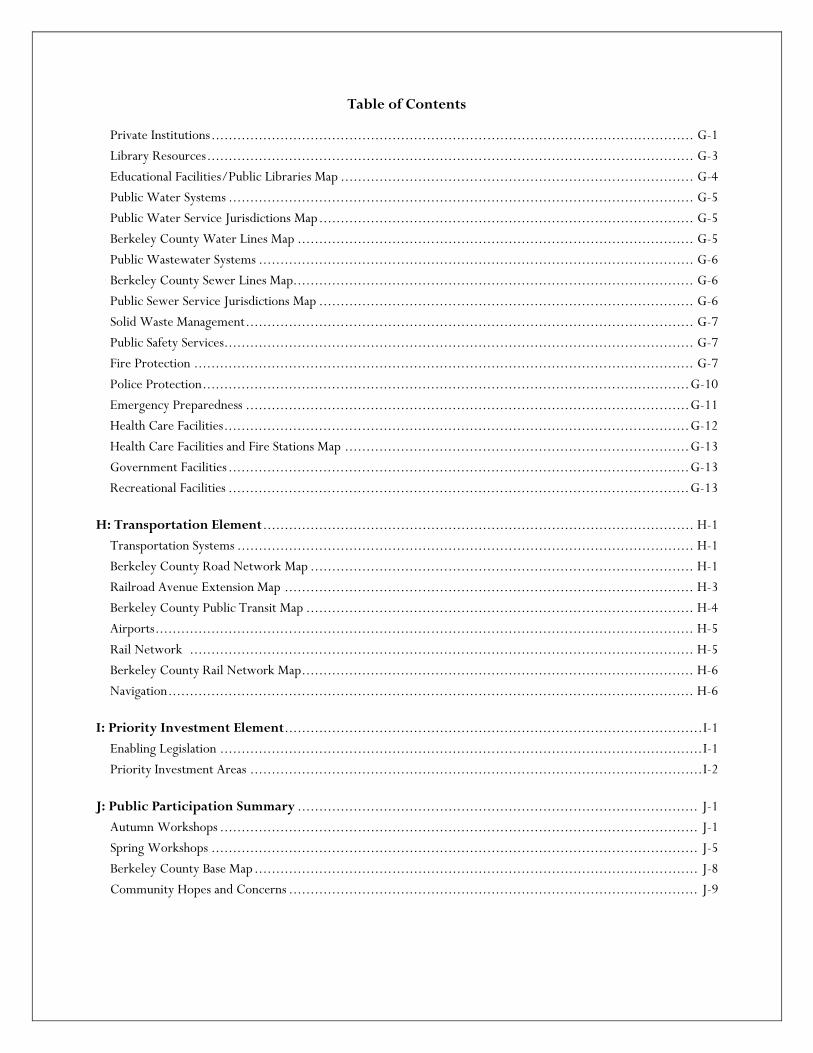
Table of Contents
Private Institutions ................................................................................................................ G-1 Library Resources ................................................................................................................. G-3 Educational Facilities/Public Libraries Map .................................................................................. G-4 Public Water Systems ............................................................................................................ G-5 Public Water Service Jurisdictions Map ....................................................................................... G-5 Berkeley County Water Lines Map ............................................................................................ G-5 Public Wastewater Systems ..................................................................................................... G-6 Berkeley County Sewer Lines Map............................................................................................. G-6 Public Sewer Service Jurisdictions Map ....................................................................................... G-6 Solid Waste Management ........................................................................................................ G-7 Public Safety Services............................................................................................................. G-7 Fire Protection .................................................................................................................... G-7 Police Protection ................................................................................................................. G-10 Emergency Preparedness ....................................................................................................... G-11 Health Care Facilities ............................................................................................................ G-12 Health Care Facilities and Fire Stations Map ................................................................................ G-13 Government Facilities ........................................................................................................... G-13 Recreational Facilities ........................................................................................................... G-13
H: Transportation Element .................................................................................................... H-1 Transportation Systems .......................................................................................................... H-1 Berkeley County Road Network Map ......................................................................................... H-1 Railroad Avenue Extension Map ............................................................................................... H-3 Berkeley County Public Transit Map .......................................................................................... H-4 Airports ............................................................................................................................. H-5 Rail Network ..................................................................................................................... H-5 Berkeley County Rail Network Map ........................................................................................... H-6 Navigation .......................................................................................................................... H-6
I: Priority Investment Element ................................................................................................. I-1 Enabling Legislation ................................................................................................................ I-1 Priority Investment Areas ......................................................................................................... I-2
J: Public Participation Summary ............................................................................................. J-1 Autumn Workshops ............................................................................................................... J-1 Spring Workshops ................................................................................................................. J-5 Berkeley County Base Map ....................................................................................................... J-8 Community Hopes and Concerns ............................................................................................... J-9
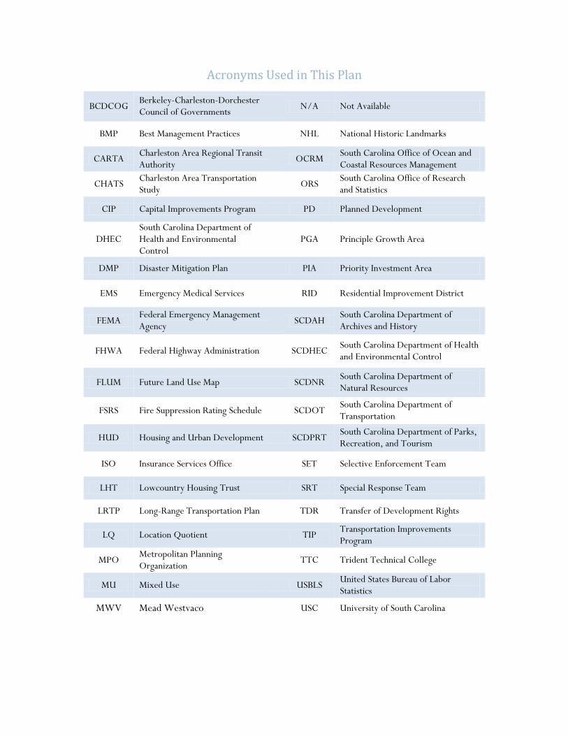
Acronyms Used in This Plan
BCDCOG Berkeley-Charleston-Dorchester Council of Governments N/A Not Available
BMP Best Management Practices NHL National Historic Landmarks
CARTA Charleston Area Regional Transit Authority OCRM South Carolina Office of Ocean and
Coastal Resources Management
CHATS Charleston Area Transportation Study ORS South Carolina Office of Research
and Statistics
CIP Capital Improvements Program PD Planned Development
DHEC South Carolina Department of Health and Environmental Control
PGA Principle Growth Area
DMP Disaster Mitigation Plan PIA Priority Investment Area
EMS Emergency Medical Services RID Residential Improvement District
FEMA Federal Emergency Management Agency SCDAH South Carolina Department of
Archives and History
FHWA Federal Highway Administration SCDHEC South Carolina Department of Health and Environmental Control
FLUM Future Land Use Map SCDNR South Carolina Department of Natural Resources
FSRS Fire Suppression Rating Schedule SCDOT South Carolina Department of Transportation
HUD Housing and Urban Development SCDPRT South Carolina Department of Parks, Recreation, and Tourism
ISO Insurance Services Office SET Selective Enforcement Team
LHT Lowcountry Housing Trust SRT Special Response Team
LRTP Long-Range Transportation Plan TDR Transfer of Development Rights
LQ Location Quotient TIP Transportation Improvements Program
MPO Metropolitan Planning Organization TTC Trident Technical College
MU Mixed Use USBLS United States Bureau of Labor Statistics
MWV Mead Westvaco USC University of South Carolina

Section 1: Issues and
Opportunities

SECTION 1: ISSUES AND OPPORTUNITIES
Berkeley County Comprehensive Plan | 2010 1-1
Overview
This section organizes the various issues and opportunities discussed during preparation of the Comprehensive Plan, in relationship to existing conditions in Berkeley County, the future vision and adopted Guiding Principles of this Plan. Along with a summary of these issues and opportunities, are goals, policies and implementation strategies related to each Guiding Principle. These issues and goals were identified as part of the comprehensive planning process during the public participation phase, which included discussions of existing conditions and future scenarios. The goals are intended to attain an ultimate vision for the County, one that achieves a balance between managing growth while protecting and preserving the character and quality of life for Berkeley County residents.
Following goals and policies are tables of implementation strategies for achieving each guiding principle, along with a suggested time frame and a list of agencies responsible for implementation. Short term projects are to be completed in one to five years, while long term projects are to be completed in five to ten years. Ongoing projects are either already occurring or should be occurring on a regular basis.
Guiding Principle 1
Berkeley County will protect and promote the existence of distinctive and diverse, sustainable communities within its boundaries.
Summary of Issues
Experiencing significant growth over the past sixty years, Berkeley County has seen a population increase of 83.2 percent just between 1980 and 2009. With this growth comes development pressures that have resulted in single family residences on large lots that, should this pattern continue, will quickly consume the County’s agricultural and forested land.
In addition, protection of rural Berkeley County’s historic communities, such as Pringletown, Cross, Lebanon and Honey Hill, along with its natural resources, including the Cooper River and Lake Moultrie, is becoming increasingly important due to these development pressures.
It is also important that as the population becomes more prevalent and diverse, the County strives to find the balance between continued growth while maintaining the level of quality of life for its residents. This includes continuing to provide diverse housing options and businesses in order to meet various needs of its population.
During the public participation phase of the planning process, participants repeatedly expressed their concerns regarding the loss of character and quality of life of their communities. In addition, preservation of community character and quality of life was one of their greatest hopes for the future of Berkeley County. Growth or density of development was also of great concern to participants, meaning they were concerned about the type of development taking place throughout the County.
Goals and Policies
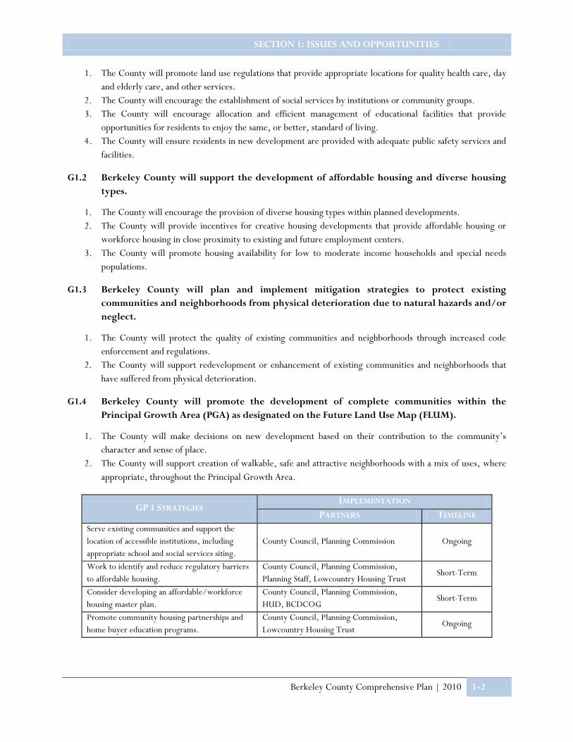
G1.1 Berkeley County will support the provision of community services, essential for all population groups.
SECTION 1: ISSUES AND OPPORTUNITIES
Berkeley County Comprehensive Plan | 2010 1-2
1. The County will promote land use regulations that provide appropriate locations for quality health care, day and elderly care, and other services.
2. The County will encourage the establishment of social services by institutions or community groups. 3. The County will encourage allocation and efficient management of educational facilities that provide
opportunities for residents to enjoy the same, or better, standard of living. 4. The County will ensure residents in new development are provided with adequate public safety services and
facilities.
G1.2 Berkeley County will support the development of affordable housing and diverse housing types.
1. The County will encourage the provision of diverse housing types within planned developments. 2. The County will provide incentives for creative housing developments that provide affordable housing or
workforce housing in close proximity to existing and future employment centers. 3. The County will promote housing availability for low to moderate income households and special needs
populations.
G1.3 Berkeley County will plan and implement mitigation strategies to protect existing communities and neighborhoods from physical deterioration due to natural hazards and/or neglect.
1. The County will protect the quality of existing communities and neighborhoods through increased code enforcement and regulations.
2. The County will support redevelopment or enhancement of existing communities and neighborhoods that have suffered from physical deterioration.
G1.4 Berkeley County will promote the development of complete communities within the Principal Growth Area (PGA) as designated on the Future Land Use Map (FLUM).
1. The County will make decisions on new development based on their contribution to the community’s character and sense of place.
2. The County will support creation of walkable, safe and attractive neighborhoods with a mix of uses, where appropriate, throughout the Principal Growth Area.
GP 1 STRATEGIES IMPLEMENTATION
PARTNERS TIMELINE Serve existing communities and support the location of accessible institutions, including appropriate school and social services siting.
County Council, Planning Commission Ongoing
Work to identify and reduce regulatory barriers to affordable housing.
County Council, Planning Commission, Planning Staff, Lowcountry Housing Trust
Short-Term
Consider developing an affordable/workforce housing master plan.
County Council, Planning Commission, HUD, BCDCOG
Short-Term
Promote community housing partnerships and home buyer education programs.
County Council, Planning Commission, Lowcountry Housing Trust
Ongoing

SECTION 1: ISSUES AND OPPORTUNITIES
Berkeley County Comprehensive Plan | 2010 1-3
GP 1 STRATEGIES (CONTINUED) IMPLEMENTATION
PARTNERS TIMELINE Enforce standard building codes and FEMA flood hazard regulations.
County Building and Code Enforcement Department
Ongoing
Provide incentives for maintenance and renovation of older structures.
County Council, Planning Commission, Planning Staff, Lowcountry Housing Trust, Berkeley County Historic Society
Ongoing
Work with private, non-profit and other government organizations to offer housing options.
County Council, Planning Commission, Lowcountry Housing Trust, Developers
Ongoing
Coordinate with or establish a County housing agency to serve as central point of contact for assistance in the rehabilitation of substandard housing units.
County Council, Planning Commission, Planning Staff, Lowcountry Housing Trust
Short-Term
Explore ways to educate citizens regarding vulnerability to natural hazards so that the community may be more resilient should a disaster occur.
Berkeley County Emergency Preparedness Division
Ongoing
Ensure County’s DMP addresses mitigation of development in known areas of unstable soils or geologic features.
County Building and Code Enforcement Department
Short-Term
Ensure new developments are complete and integrated communities with a mix of uses, ample open space, and network of mobility options.
County Council, Planning Commission, Planning Staff, Developers
Ongoing
Ensure implementation of strategies in its DMP to assure the resiliency of all communities in the County.
County Council, Planning Commission, Planning Staff, Developers
Ongoing
Guiding Principle 2
Berkeley County will manage development and expansion of infrastructure systems efficiently in order to effectively serve residents and employees within Berkeley County.
Summary of Issues
As growth and development pressures continue, Berkeley County must consider the cost of providing facilities and services for new developments, particularly as it relates to gaps in service provision. Inadequate public facilities, longer response times for emergency services, lack of local employment opportunities, potential impact on existing communities, and longer travel and commuting times for residents are all issues to consider when evaluating the feasibility of a new project or development.
One of the greatest concerns coming out of the visioning workshops was the lack of infrastructure “concurrency,” meaning that the capacity and availability of roads, sewer and water lines, schools, and the like should keep pace with demand for service.

SECTION 1: ISSUES AND OPPORTUNITIES
Berkeley County Comprehensive Plan | 2010 1-4
Quality of life often requires economic prosperity; therefore, there is a need to promote economic well being within the County and to provide diverse employment opportunities. By doing so, residents have employment options within the County rather than commuting to neighboring jurisdictions for employment purposes. This leads to decreased mobility and less traffic congestion on the roadways.
The creation of wealth is important not only for individuals and households, but also for the community as a whole, in terms of quality and range of facilities and services available, and for the maintenance of the built and natural environment.
Goals and Policies
G2.1 Berkeley County will guide population growth to areas where supporting infrastructure exists or can efficiently be expanded.
1. The County will make efficient use of existing infrastructure and public facilities in order to minimize the need for costly new/expanded facilities and services.
2. The County will plan infrastructure ahead of growth in identified growth areas, and direct intense land uses to areas where infrastructure and carrying capacity already exist.
3. The County will not support the extension of infrastructure to areas that are outside of the Principal Growth Area (PGA) and areas specified for resource protection.
G2.2 Berkeley County will encourage the provision of infrastructure as needed to support economic and workforce development initiatives.
1. The County will consider impacts on infrastructure and natural resources when making decisions on economic and workforce development projects.
2. The County will identify and promote development of manufacturing/industrial corridors and employment/technology corridors where infrastructure exists.
3. The County will increase recruitment efforts and support the establishment of industries that generate economic development.
4. The County will support workforce development programs that provide skilled labor for existing and recruited industries from County population base.
5. The County will promote establishment and expansion of port-related industries. 6. The County will support the local agricultural industry.
G2.3 Berkeley County will improve the operation and efficiency of its transportation network to serve residents and employers.
1. The County will prioritize transportation improvements that support desired development patterns, better serve residents and employers, and promote connectivity while accommodating multiple functions.
2. The County will continue to support a strategic transportation plan for system improvements addressing existing and projected demand for all modes of transportation countywide.
3. The County will encourage connectivity by expanding the number of alternative routes throughout the County road network for local traffic.
SECTION 1: ISSUES AND OPPORTUNITIES
Berkeley County Comprehensive Plan | 2010 1-5
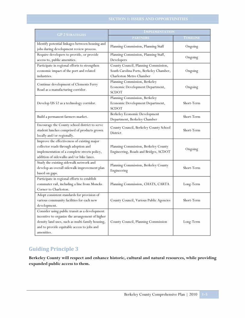
GP 2 STRATEGIES IMPLEMENTATION
PARTNERS TIMELINE Identify potential linkages between housing and jobs during development review process.
Planning Commission, Planning Staff Ongoing
Require developers to provide, or provide access to, public amenities.
Planning Commission, Planning Staff, Developers
Ongoing
Participate in regional efforts to strengthen economic impact of the port and related industries.
County Council, Planning Commission, South Carolina Ports, Berkeley Chamber, Charleston Metro Chamber
Ongoing
Continue development of Clements Ferry Road as a manufacturing corridor.
Planning Commission, Berkeley Economic Development Department, SCDOT
Ongoing
Develop US 52 as a technology corridor. Planning Commission, Berkeley Economic Development Department, SCDOT
Short-Term
Build a permanent farmers market. Berkeley Economic Development Department, Berkeley Chamber
Short-Term
Encourage the County school district to serve student lunches comprised of products grown locally and/or regionally.
County Council, Berkeley County School District
Short-Term
Improve the effectiveness of existing major collector roads through adoption and implementation of a complete streets policy, addition of sidewalks and/or bike lanes.
Planning Commission, Berkeley County Engineering, Roads and Bridges, SCDOT
Ongoing
Study the existing sidewalk network and develop an overall sidewalk improvement plan based on gaps.
Planning Commission, Berkeley County Engineering
Short-Term
Participate in regional efforts to establish commuter rail, including a line from Moncks Corner to Charleston.
Planning Commission, CHATS, CARTA Long-Term
Adopt consistent standards for provision of various community facilities for each new development.
County Council, Various Public Agencies Short-Term
Consider using public transit as a development incentive to organize the arrangement of higher density land uses, such as multi-family housing, and to provide equitable access to jobs and amenities.
County Council, Planning Commission Long-Term
Guiding Principle 3
Berkeley County will respect and enhance historic, cultural and natural resources, while providing expanded public access to them.

SECTION 1: ISSUES AND OPPORTUNITIES
Berkeley County Comprehensive Plan | 2010 1-6
Summary of Issues
Berkeley County has an abundance of cultural and natural resources that provide many benefits to the community. These identify the County’s unique character, help to foster civic pride, offer economic opportunities by helping attract new residents, businesses and visitors, and contribute to the overall quality of life for residents.
Many of the concerns expressed during citizen input revolved around the impact development has had or will have on the County’s historic and cultural resources, as well as its agricultural lands. More specifically, citizens want to ensure: development is occurring in areas where suitable soil and geologic features exist; where impacts on the quality of wetlands and other water resources and natural habitats of site development, infrastructure, and/or structures can be mitigated; and such that air quality standards are maintained and industrial noise reduced or mitigated.
Sites that exemplify Berkeley County’s character and landscape include, but are not limited to, the Francis Marion National Forest, Lakes Marion and Moultrie, Medway Plantation, and Cypress Gardens. Sites such as these provide scenic value, cultural and recreational opportunities, and natural habitats to be protected and enjoyed. Because these resources play such an important role, they should be protected and, where possible, shared with the greater community.
Goals and Policies
G3.1 Berkeley County will support local agricultural and forestry practices through the preservation of its rural areas.
1. The County will support the protection of agriculture and farmlands, including timberlands, from development pressures, recognizing the contributions of farming and the rural character of the community.
2. The County will support policies and programs that provide opportunities for agricultural activities to remain an integral part of the community.
3. The County will promote agri-tourism opportunities. 4. The County will support the aquaculture industry through preservation of water quality.
G3.2 Berkeley County will develop and market heritage and eco-tourism opportunities based on its cultural and natural resources.
1. Protection and conservation of the County’s cultural and natural resources will play a vital role in the decision-making process.
2. The County will promote and support the protection and enhancement of the County’s unique historic resources.
G3.3 Berkeley County will adopt and apply land use principles and development practices which ensure development works in harmony with cultural and natural resources.
1. The County will encourage new development to locate in suitable locations in order to protect and preserve natural resources, environmentally-sensitive areas, or valuable historic or cultural resources from encroachment.
2. The County will adopt and implement policies and standards that minimize impacts of site development, including land disturbance, infrastructure and structures, on the quality of wetlands and other nonrenewable natural resources.
SECTION 1: ISSUES AND OPPORTUNITIES
Berkeley County Comprehensive Plan | 2010 1-7
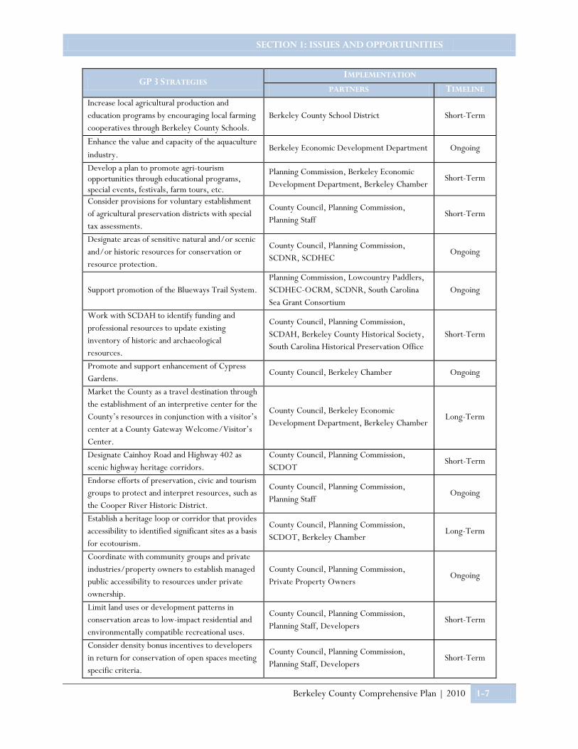
GP 3 STRATEGIES IMPLEMENTATION
PARTNERS TIMELINE Increase local agricultural production and education programs by encouraging local farming cooperatives through Berkeley County Schools.
Berkeley County School District Short-Term
Enhance the value and capacity of the aquaculture industry.
Berkeley Economic Development Department Ongoing
Develop a plan to promote agri-tourism opportunities through educational programs, special events, festivals, farm tours, etc.
Planning Commission, Berkeley Economic Development Department, Berkeley Chamber
Short-Term
Consider provisions for voluntary establishment of agricultural preservation districts with special tax assessments.
County Council, Planning Commission, Planning Staff
Short-Term
Designate areas of sensitive natural and/or scenic and/or historic resources for conservation or resource protection.
County Council, Planning Commission, SCDNR, SCDHEC
Ongoing
Support promotion of the Blueways Trail System. Planning Commission, Lowcountry Paddlers, SCDHEC-OCRM, SCDNR, South Carolina Sea Grant Consortium
Ongoing
Work with SCDAH to identify funding and professional resources to update existing inventory of historic and archaeological resources.
County Council, Planning Commission, SCDAH, Berkeley County Historical Society, South Carolina Historical Preservation Office
Short-Term
Promote and support enhancement of Cypress Gardens.
County Council, Berkeley Chamber Ongoing
Market the County as a travel destination through the establishment of an interpretive center for the County’s resources in conjunction with a visitor’s center at a County Gateway Welcome/Visitor’s Center.
County Council, Berkeley Economic Development Department, Berkeley Chamber
Long-Term
Designate Cainhoy Road and Highway 402 as scenic highway heritage corridors.
County Council, Planning Commission, SCDOT
Short-Term
Endorse efforts of preservation, civic and tourism groups to protect and interpret resources, such as the Cooper River Historic District.
County Council, Planning Commission, Planning Staff
Ongoing
Establish a heritage loop or corridor that provides accessibility to identified significant sites as a basis for ecotourism.
County Council, Planning Commission, SCDOT, Berkeley Chamber
Long-Term
Coordinate with community groups and private industries/property owners to establish managed public accessibility to resources under private ownership.
County Council, Planning Commission, Private Property Owners
Ongoing
Limit land uses or development patterns in conservation areas to low-impact residential and environmentally compatible recreational uses.
County Council, Planning Commission, Planning Staff, Developers
Short-Term
Consider density bonus incentives to developers in return for conservation of open spaces meeting specific criteria.
County Council, Planning Commission, Planning Staff, Developers
Short-Term

SECTION 1: ISSUES AND OPPORTUNITIES
Berkeley County Comprehensive Plan | 2010 1-8
GP 3 STRATEGIES (CONTINUED) IMPLEMENTATION
PARTNERS TIMELINE Evaluate establishment of a Transfer of Development Right (TDR) program to channel development into priority development areas and away from resources to be conserved.
County Council, Planning Commission, Planning Staff, SCDHEC
Short-Term
Support the establishment of collaborative partnership between private property owners and conservation nonprofits to promote placement of easements through tax incentives.
County Council, Planning Commission, Private Property Owners, Nonprofits, Lord Berkeley Land Trust
Ongoing
Review effectiveness of existing special area permit requirements in evaluating existence of sensitive resources prior to land development approvals.
County Council, Planning Commission, Planning Staff
Short-Term
Require BMP’s for all developments to mitigate negative impacts of stormwater on the quality of the County’s water resources.
County Council, Planning Commission, Planning Staff
Ongoing
Guiding Principle 4
Berkeley County will make sure that both active and passive recreational opportunities are available to its residents countywide.
Summary of Issues
Berkeley County has many recreational resources, most of which are commonly found in association with the area’s natural and cultural resources. Examples of these include: recreational boating at Lions Beach on the shore of Lake Moultrie; recreational boating on Lake Marion; Richardson Landing boat-launching facility at Bonneau Beach; boating and fishing on the upper Cooper River and Santee River; and the Berkeley County Blueways paddling trail system.
Despite these resources, citizens who participated in the public workshops expressed concern over the lack of public recreation facilities, playgrounds, and ballparks, particularly in rural areas of the County. Berkeley County has many opportunities to enhance and promote existing facilities while developing new ones to meet the needs of the community.
An exercise conducted at the public workshops asked participants to review photographs of various community components and choose what they felt would be an appropriate addition to their communities. One of the most popular images chosen was that of a neighborhood playground. While these facilities may be provided within a planned community, they are not easily accessed by most rural residents. The need for these types of facilities was concentrated in two rural areas on maps at the community planning workshops: Wando-Huger and New Hope-Longridge.
Community recreation was also desired around Lake Moultrie, often near boat launches; on the west side of Moncks Corner, near existing public schools; and in or near the communities of Pringletown, Sangaree, Oakley, and Macedonia. Participants also expressed a need for access to water on the southwest side of Lake Moultrie, the Goose Creek Reservoir, the upper reaches of the Cooper River, the Wando River, and Four Holes Swamp. There were comments expressing a need for upgrades to existing facilities on the Lake as well.

SECTION 1: ISSUES AND OPPORTUNITIES
Berkeley County Comprehensive Plan | 2010 1-9
Goals and Policies
G4.1 Berkeley County is committed to providing pleasant, accessible public gathering places and parks throughout the community.
1. The County will support initiation of a countywide park planning program, to include trails and blueways networks.
2. The County will promote a balance of recreation opportunities between identified growth areas and existing communities.
3. The County will invest in parks and open space to enhance the quality of life for its citizens.
G4.2 Berkeley County will increase public accessibility to recreation areas within the County.
1. The County will promote connectivity between existing recreational sites and cultural/scenic resources, and communities.
2. The County will explore opportunities for increased and enhanced public access to waterways. 3. The County will seek to establish public beach areas along lake shores to better serve residents.
GP 4 STRATEGIES IMPLEMENTATION
PARTNERS TIMELINE Consider inclusion of open space protection in the Capital Improvements Program (CIP).
County Council, Planning Commission, County Finance Department
Short-Term
Work with state and federal agencies to establish linkages with existing trail facilities.
County Council, Planning Staff, SCPRT Short-Term
Coordinate connectivity of parks with cultural and scenic resources.
Berkeley County Municipalities, County Council, Planning Commission
Long-Term
Develop a master recreational plan. County Council, Planning Commission, Planning Staff
Short-Term
Consider establishment of County parks and recreation department to manage implementation of the developed plan.
County Council, Planning Staff Short-Term
Establish a beach on the shore of Lake Moultrie (particularly southwest side).
County Council, Santee Cooper, MWV Long-Term
Collaborate with nonprofits and private property owners to develop better accessibility to facilities and resources.
County Council, Planning Commission, Planning Staff, Private Property Owners, Nonprofits
Ongoing
Formalize relationships between the County and boat landings to better serve residents.
County Council, County Public Works Ongoing
Guiding Principle 5
Berkeley County will adopt a clear, fair plan that can be implemented through simplified costs and streamlined processes.

SECTION 1: ISSUES AND OPPORTUNITIES
Berkeley County Comprehensive Plan | 2010 1-10
Summary of Issues
One of the best ways to strengthen a community is to create opportunities for citizens to work collaboratively on the challenges that shape their community. The same applies to the development of a comprehensive plan. A comprehensive plan must be created from diverse public input in order to be successfully implemented.
It is through this public participation that the County was able to adequately define its vision for the future and identify goals and strategies for achieving that vision.
It is even more important for citizens to understand that the comprehensive plan is a document intended to guide all development, regardless of size or scope. Therefore, the County has created a comprehensive plan that establishes a clear intent and policy base which can be used to develop and interpret local regulations. The Plan should be used to assist local elected and appointed officials in making land use decisions that are fair, consistent and impartial.
This means that all development proposals and requests for changes in land use and zoning should be considered consistently and processed in a timely and fair manner.
It is also vital that as growth does occur, the County strive towards improved service delivery at all levels of public service. During the public workshops citizens expressed concern over the growth taking place and the burden on taxpayers to build the infrastructure to service this new growth. The County will need to explore new ways of funding these additional facilities and infrastructure in order to mitigate a decline in current levels of service.
Goals and Policies
G5.1 Berkeley County will encourage public participation in achieving goals to ensure that all communities have a voice.
1. The County will seek opportunities to share information and engage the public regarding issues that are likely to have an impact on the community.
2. The County will explore ways to increase public awareness with regards to public meetings and hearings.
G5.2 Berkeley County will make improvements to its service delivery.
1. The County will ensure that new development does not cause a decline in existing levels of service for the community’s residents and employers.
2. The County will support sequential, phased extension of utilities and services to encourage rational expansion of development to areas immediately contiguous to already developed areas of the community.
3. The community will use planned infrastructure expansion to promote development in areas identified (in the comprehensive plan) as ready for development.
4. The County will explore ways in which infrastructure for new development does not cause a burden on current residents.
GP 5 STRATEGIES IMPLEMENTATION
PARTNERS TIMELINE Encourage attendance at public meetings and hearings through various outreach avenues.
County Council, Planning Commission
Ongoing
Provide opportunities for meaningful public involvement in the decision-making process.
County Council, Planning Commission Ongoing

SECTION 1: ISSUES AND OPPORTUNITIES
Berkeley County Comprehensive Plan | 2010 1-11
GP 5 STRATEGIES IMPLEMENTATION
PARTNERS TIMELINE Launch public education and outreach programs that serve to better engage residents and stakeholders.
County Council, Planning Commission Ongoing
Coordinate with the City of Charleston on annexation of “donut holes” and establishment of municipal boundaries.
Berkeley County, City of Charleston Short-Term
Ensure fair and equitable funding of public transportation improvements. County Council, SCDOT Ongoing
Coordinate major public investments with proposed development patterns. County Council, Planning Commission Ongoing
Utilize Residential Improvement Districts (RID’s) to help pay for new infrastructure. County Council, Planning Commission Short-Term

Section 2: Land Use and Development
Principles
SECTION 2: LAND USE AND DEVELOPMENT PRINCIPLES
Berkeley County Comprehensive Plan |2010 2 - 1
Berkeley County strives for a greater overall balance of housing and employment opportunities within areas where infrastructure exists or is planned while rural and natural areas are conserved. The Plan, therefore, proposes designation of a defined Principal Growth Area (PGA) within Berkeley County. The Principal Growth Area is the area within which more intense development of various uses should occur, to be served by existing, and efficiently expanded infrastructure and other public facilities and services. Remaining portions of the County remain designated for limited development and land uses that complement the County’s abundant natural and agricultural lands. This Plan places emphasis on goals and strategies that will ensure future development of any land use throughout the County, will occur such that sensitive cultural and natural resources will not be adversely impacted.
Principal Growth Area
The Principal Growth Area (PGA) includes larger incorporated towns, and limited existing rural areas already experiencing transitional development west of Highway 17A, where infrastructure may become available and some intensification might occur. Development within the PGA is encouraged to focus around existing and identified town and neighborhood centers. The goals and objectives herein emphasize infill and redevelopment of land within the PGA to promote more accessible environments with centers that have connections to nearby neighborhoods. A mix of housing types around these centers will better serve the diverse population growth, providing attainable housing and a variety of other needs. By placing neighborhood services within designated neighborhood centers, close to where people live and work, residents have greater mobility options, including cycling and walking, between destinations.
Land Use Categories
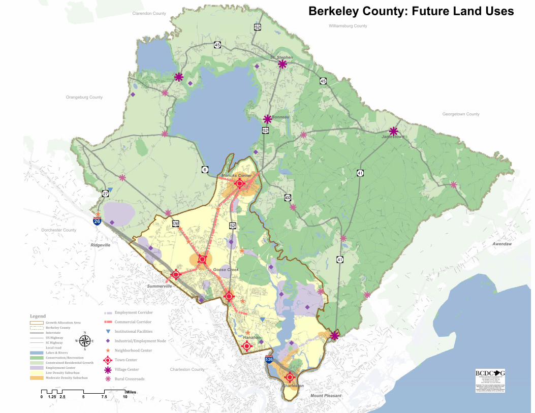
The County seeks to preserve a unique composite of natural and man-made environments. Development objectives seek to maintain a visual and spatial transition between suburban development and designated conservation areas within the rural areas of the County. The following sections describe the land use categories shown on the Future Land Uses map. The Berkeley County Future Land Uses map shows the distribution of conservation, residential,
non‐residential, mixed‐use, employment, and institutional land uses. Each category described below includes a description of the general characteristics and location of each land use type, a listing of primary uses, and development objectives.
Conservation/Recreation
Characteristics and Location:
Conservation/Recreation areas are prioritized for greater protection from development activities in order to maintain natural habitats, provide flood protection, and protect water quality. These areas are also prioritized to provide for recreational opportunities, water access and water-oriented commercial activities. Any development in these areas should be constrained to minimize impacts to these natural features and assets.
Primary Uses:
Active recreation, passive recreation, eco-tourism establishments, wildlife refuges, water-oriented commercial, community and neighborhood parks.

SECTION 2: LAND USE AND DEVELOPMENT PRINCIPLES
Berkeley County Comprehensive Plan |2010 2 - 2
Development Objectives:
1. The County will consider establishment of a conservation zoning designation for application to properties within these areas that incorporates a combination of regulations and incentives to ensure development adequately mitigates any impacts to areas of significant cultural and natural resources. Such techniques may include low impact development standards, minimum buffer requirements along riparian zones, wetlands, and/or floodplains, and wildlife management areas.
2. Limited development of individual properties within designated conservation areas in conjunction with placement of conservation easements will be encouraged.
3. Potential linkages between designated conservation areas and cultural resources with existing trail systems to establish a natural recreation corridor will be identified and encouraged for development by both the public and private sector.
4. Establishment of recreational facilities and accommodations in these areas will be limited to low-impact uses at an appropriate scale.
5. Scenic byway and historic designations will be pursued for identified roads of significance.
Constrained Residential Growth
Characteristics and Location:
Constrained Residential Growth areas are designated where residential development outside of the PGA and incorporated towns/designated Village Centers can be found. These areas will remain rural in character and develop at densities lower than typically found in the Low Density Suburban areas. Land owners may develop large lot single-family rural residential neighborhoods with high proportions of open space (typically 50-70%) or cluster the residential units on smaller lots to conserve comparable open space, agricultural land, historically significant areas, and other natural features.
Primary Uses:
Traditional land practices such as forestry and agriculture, rural residential/detached single-family residences, supporting and complementary uses, including open space and recreation, equestrian uses, schools, places of worship, and other public uses.
Development Objectives:
1. Public sewer should not be extended to serve development in these areas. Individual well and septic systems may be replaced with communal well and septic systems where justified.
2. Rural road standards for a network compatible with low density development and the rural character will be supported by the County.
3. New development will fully integrate the elements of green infrastructure and establish natural open spaces as predominant visual elements and enhance the area’s natural environment.
4. Green infrastructure elements provided in each development will link with that in adjacent developments to facilitate access to conservation areas.
5. The County will encourage clustering through a density bonus approach. Clustering should occur near the edges of property, close to roads to minimize need for driveways and maximize the amount of land left undeveloped.

SECTION 2: LAND USE AND DEVELOPMENT PRINCIPLES
Berkeley County Comprehensive Plan |2010 2 - 3
6. Larger scale residential developments (greater than 10 lots) will develop in clusters of conservation subdivisions or Village Centers (upon approval of an amendment to the Future Land Uses map).
Low Density Suburban
Characteristics and Location:
Low Density Suburban areas will be developed with diverse housing choices, in neighborhoods that promote a sense of community, providing an aesthetically pleasing transition from Constrained Growth Areas to higher-density residential and commercial areas. Development will be concentrated in densities and locations where it can be served efficiently by infrastructure, facilities and services, and transportation networks. All development activity will be designed to mitigate adverse impacts on any cultural and/or natural resources.
Primary Uses:
Single-family residential detached housing, continuation of agricultural uses, open space, civic and recreation, and mixed-uses where appropriate.
Development Objectives:
1. New developments will provide or complement a mix of land uses and project designs to ensure the long-term sustainability, or economic and environmental health, of both the individual and broader community in which it is located.
2. Communities will be developed as efficient, compact, pedestrian oriented communities with a range of residential lots sizes and measurable standards of open space.
3. Connections to key centers of employment, commerce, service and other developments will be provided for and between communities.
4. New development must be served by public water and sewer systems. 5. Interconnectivity between adjacent communities will be fostered to minimize overloading of single
access/entrance points onto principal access roads for each development. 6. Significant areas of sensitive natural resources and protective buffers will be designated for use as passive
recreation or conservation areas, while reallocating development potential of those areas back to privately developed lots within each community.
7. Residential communities will provide a mix of open spaces, including active and passive and/or natural open spaces as appropriate to the scale and location of the site. At least 60% of the required open space should be useable and accessible land, with the majority of it located within the interior of the community. Required buffer areas and outparcels should not account for more than 25% of the total open space required.
8. Density bonus incentives will be considered for developments that conserve open space areas and/or provide buffer areas in excess of ordinance requirements.
9. Development densities of individual communities may average up to 4.0 dwelling units per acre, depending on the adequacy of roads, utilities, and full complement of public services and facilities.
SECTION 2: LAND USE AND DEVELOPMENT PRINCIPLES
Berkeley County Comprehensive Plan |2010 2 - 4
Moderate Density Suburban
Characteristics and Location:
Moderate Density Suburban areas are designated in locations where such development can provide a transition from low-density suburban to already developed residential and commercial areas.
These areas are already proposed for development with various new communities that should strive to include walkable neighborhood units within the community that are about one-half mile wide. To the extent possible, future communities should be co-located with neighborhood centers of nonresidential development. New neighborhoods/neighborhood units should each include a system of interconnected trails or sidewalks that will provide access to parks, recreation, and open space areas focused near and in between residential communities.
Primary Uses:
Single-family residential detached housing, multi-family housing, neighborhood-oriented commercial and/or mixed-uses, civic and recreation facilities.
Development Objectives:
Development Objectives (1) through (8) for Low Density Suburban communities should apply in addition to the following:
1. Principal accessibility to moderate density developments will be coordinated with regional transportation systems. Communities shall each provide for a hierarchy of internal facilities for vehicular, transit, cycling and pedestrian use.
2. New development proposals within these designated areas will demonstrate linkages, or potential linkages, to public transportation facilities.
3. Performance standards will foster integration of compatible use groups. Application of form-based codes will be encouraged.
4. Development densities of individual communities may average up to 12.0 dwelling units per acre, depending on the adequacy of roads, utilities, and full complement of public services and facilities.
Employment Centers/Corridors
Characteristics and Location:
Locations designated for Employment Centers are intended for development of large scale office and light-industrial uses by a major employer or a cluster of multiple employers with a mix of supporting or ancillary uses, such as restaurants, hotels, and limited service retail. In addition, it is envisioned that portions of Clements Ferry Road and US 52 will appropriately be developed as employment corridors. Future employment centers will feature high visual quality site design and accommodate high traffic generating uses. Clustering of buildings within these centers is preferred to preserve open space within the development site. Site plans, building design and landscaping will be sensitive to the natural features of the site, including views. Smaller employment centers may be located adjacent to or in conjunction with Town Centers and/or planned communities.

SECTION 2: LAND USE AND DEVELOPMENT PRINCIPLES
Berkeley County Comprehensive Plan |2010 2 - 5
Primary Uses:
Office, light industry, and ancillary retail/services for employees, some commercial services/housing such as hotels, public/institutional. Specific industrial/employment nodes for heavier industrial uses are designated within employment areas on the Future Land Uses Map (FLUM).
Development Objectives:
1. Employment centers will be located with indirect access to primary highways and arterials as shown on the FLUM.
2. Access to employment areas will be provided via internal collector roads to provide safe and efficient movement of traffic without impeding movement on adjacent roadways.
3. Employment uses will be served by public water and sewer facilities within the PGA. 4. Development plans will meet established performance standards that foster environmentally sensitive
design to complement existing natural features and reduce potential visual impacts on adjacent residential communities.
5. Employment developments will possess adequate on-site parking, storage and loading areas, as well as landscaped screening of these functions from surrounding neighborhoods.
6. Light industrial uses will be limited to those that do not require outdoor storage and have negligible externalities (i.e., noise, odor, vibration).
7. Provision of safe, convenient and attractive pedestrian access to nearby residential areas and local businesses with ancillary retail services and goods will be evaluated for individual proposals.
Commercial Corridors
Characteristics and Location:
Commercial Corridors are designated to accommodate auto-oriented commercial uses that meet the needs of the community, but are incompatible with neighborhood and/or town center developments. These corridors will be regulated in a manner that enhances mobility while creating an inviting and aesthetically pleasing entrance to the centers they link. Designation of these corridors is limited to those where major transportation infrastructure exists, potentially where future transit nodes might develop. These corridors may be developed with destination oriented retail, hotel and restaurant services, and retail commercial that need direct vehicular accessibility, such as automobile dealerships.
Primary Uses:
Auto-oriented destination commercial and services.
Development Objectives:
1. The County will consider creation of an Access Management Plan in order to regulate the placement of curb cuts and require shared access points along arterial and major collector roads to foster maximized separation of access points to individual lots such that the mobility of these corridors is not compromised by new development.
2. Development along these corridors will provide significant buffering and screening of parking and service/storage areas both from adjacent residential uses and access roadways.

SECTION 2: LAND USE AND DEVELOPMENT PRINCIPLES
Berkeley County Comprehensive Plan |2010 2 - 6
3. Business uses serving markets outside immediate neighborhoods will be located at compact nodes/intersections along the corridor as designated on the Future Land Uses Map (FLUM) to facilitate accessibility and mobility.
Institutional Facilities Ó
Characteristics and Location:
Institutional Facility areas designated on the Future Land Use Map are intended to accommodate single uses and activities that already exist and are not compatible with other land use designations both within and outside the PGA. The characteristics and locational requirements of institutional needs will vary on an individual basis. All new institutional facilities of the same magnitude should be co-located with existing areas whenever possible.
Primary Uses:
Public institutional uses such as prison, military, and other regional public facilities.
Development Objectives:
1. Institutional uses will be located along major roadway corridors that provide direct access to interstates and other major transportation facilities, including existing rail lines.
2. Future development of institutional areas within the PGA will be served by public water and/or sewer facilities.
3. Performance standards will be applied to ensure adequate land for separation and buffering from incompatible/lower intensity land uses, including nearby residential and business uses.
Industrial/Employment Nodes Ö
Characteristics and Location:
A limited number of Industrial/Employment Nodes are designated throughout the County to accommodate large labor intensive industrial and commercial uses that produce noxious externalities. Parcels associated with these uses will be large enough to include land and buffers that ensure that negative impacts on adjacent properties are mitigated. These areas are not conducive to mixed use development, however in some cases, less intensive industrial uses may be co-located within these nodes to provide the transition between the industrial use and adjacent communities and/or natural areas of environmental sensitivity.
Primary Uses:
Industrial, supporting office, commercial, wholesale, and warehousing.
Development Objectives:
1. Heavy industry will be located along major roadway corridors that provide direct access to interstates and other major transportation facilities, including existing rail lines.
2. Industrial nodes within the PGA will be served by public water and sewer facilities.
SECTION 2: LAND USE AND DEVELOPMENT PRINCIPLES
Berkeley County Comprehensive Plan |2010 2 - 7
3. Performance standards will be applied to new industrial development to ensure adequate land for separation and buffering from incompatible/lower intensity land uses, including nearby residential and business uses.
4. Proposals for less intense uses within these nodes will be evaluated for potential incompatibility to ensure development does not jeopardize the viability and functional mobility of existing industries.
Neighborhood Centers
Characteristics and Location:
Neighborhood Centers are areas of commercial-oriented community centers that serve needs of nearby neighborhoods and shall be established in locations designated on the future land use map. Neighborhood Centers are an integral part of the residential communities they serve, particularly when established as part of a planned development or through a development agreement. The size and scale should relate to the size of the communities it intends to serve or its market area. Neighborhood Centers, which are much smaller in size than Town Centers, will host a variety of uses, including retail and service options that are accessible to the neighborhoods they serve via various forms of transportation.
Primary Uses:
Community institutional and/or gathering places (e.g. schools, parks, churches, community centers, etc.) along with convenience retail, personal and professional service establishments that serve residents of the immediate vicinity.
Development Objectives:
1. Neighborhood centers will be located adjacent to or within walking distance of established or planned residential developments on local and/or minor collector roads.
2. Sites development will be compact in form, designed to accommodate pedestrian and vehicular traffic with a full complement of services and amenities.
3. Application of form based codes will be encouraged. 4. The overall concept for design of a community center will complement the character of surrounding
communities, so the interrelationship of its parts (commercial, office, civic, public open space, etc.) is evident.
5. Adequate buffering and landscaping will be provided to minimize impacts on natural resources.
Town Centers O Characteristics and Location:
The County will promote development, infill and redevelopment, of areas designated as Town Centers. These centers serve as the “downtowns” of established communities within the County and will be the primary location for future development of mixed land uses that accommodate commerce, employment and civic activities. Nonresidential, supported by higher density residential uses, will be focused within these centers to foster creation of balanced communities.

SECTION 2: LAND USE AND DEVELOPMENT PRINCIPLES
Berkeley County Comprehensive Plan |2010 2 - 8
Primary Uses:
Infill development, mixed-uses, retail, commercial, office, high density residential, cultural, and institutional.
Development Objectives:
1. Town Centers will be located only at nodes designated on the Future Land Uses Map (FLUM), where accessed directly from major collector and/or arterial roads.
2. Town Centers may range up to 50 acres in size yet will be compact to encourage pedestrian mobility within the centers, while still accommodating vehicular accessibility, with a full complement of services and amenities.
3. Development applications will demonstrate a configuration of streets and public/landmark parcels, along with the pedestrian network, preferably through the use of a grid street pattern.
4. On street parking and centralized parking facilities will be interspersed within the development to facilitate mobility without vehicles.
5. Parking, loading and outdoor storage areas will be restricted and screened between buildings and public accessways.
6. Large setbacks will be provided (100 foot minimum) along arterials and major collectors, with minimum setbacks between similar uses and local travelways.
7. Additional open space areas will be provided to foster natural management of stormwater and impacts on air quality.
Village Centers k Characteristics and Location:
Village Centers are envisioned as mixed-use communities with residential and nonresidential uses integrated to create pedestrian friendly self-sustaining developments with a mix of housing options. Village Centers are designated where incorporated and unincorporated communities have already developed or begun developing with a range of complementary uses within distinct neighborhoods. Additional Village Centers may be developed outside the Principal Growth Area provided the County approves an amendment to the adopted FLUM. These Centers are distinct physical settlements surrounded by protected or constrained growth areas used for agriculture or conservation purposes. Variations in parcel sizes and base densities within designated Village Centers will provide opportunities for innovative blends of new development.
Primary Uses:
Medium density rural residential, civic, institutional, social/cultural, small neighborhood commercial and retail services, home businesses or local offices.
Development Objectives:
1. Densities and open space requirements for Village Centers will vary from center to center, ranging up to two dwelling units per acre where public or communal systems exist.
2. Defined edges of Village Centers will be compatible with the surrounding rural area and should provide identity and a sense of place to the surrounding countryside.

SECTION 2: LAND USE AND DEVELOPMENT PRINCIPLES
Berkeley County Comprehensive Plan |2010 2 - 9
3. Nonresidential uses will be organized around a compact community core to serve individual communities or combinations of neighborhood developments. The community core may vary in scale, design and use depending on the size of the community it serves.
4. New civic uses will be located at prominent locations within the core, at a scale compatible with the residential nature of the Village Center. Large-scale civic or institutional uses will be located on the periphery of an individual neighborhood or the village.
5. Open spaces associated with Village Centers will be dispersed as to be conveniently located to residents. These areas will serve both a recreational and design function.
6. Village Centers will accommodate and promote pedestrian travel, with interconnected (and generally rectilinear) street patterns.
Rural Crossroads k Characteristics and Location:
Rural Crossroads are nodal and/or village developments at secondary road intersections, with commercial uses clustered near the intersection and community/civic uses in the constrained growth areas.
Development of these crossroads is limited in scale, compatible with the surrounding rural area and should provide identity and a sense of place to the surrounding countryside.
Primary Uses:
Rural Residential, social/cultural and neighborhood commercial.
Development Objectives:
1. Rural Crossroad areas are limited in land area, with commercial uses located within ¼ mile of the actual intersection.
2. Standards for development in Rural Crossroad areas will ensure that turning movements at the intersection are not interrupted by access to/from individual lots.
3. Limited parking in Rural Crossroad areas will be sited to the side and rear of commercial, civic and/or social uses.
4. Pedestrian linkages from nonresidential uses will be provided to surrounding residences, and between commercial and social uses.
ââââââââââââââ ââââââââââ ââââââ
ââââââââ
ââââ ââââ
ââââââ ââââââââââââââââââââââ ââ ââââââââ ââ ââ ââââââ
ââââââ ââ ââââââââââââââââââ ââââââ
ââââââ ââ ââ
ââââââââ
ââ ââââ ââââââââââââ ââ ââââââââ ââââââââââââââ ââââââââââââââ ââââââââââââââââââââ ââââââââ ââââ ââ ââââââââ ââââ ââââââââââââââ
ââ ââââââ
ââââââââââââââââââââ ââââ
ââââââââââââââââââââââââââ
ââââ
ââââââ ââââââ ââââââââââââââââââ ââââââââââââââââ
ââââââââââââââââââââââââââ ââ ââââââââââââââââââââââââââââââââââââââââââââââââââââââââââââââââââ ââââââââââââââââââââââââââââââââââââââââ
ââââââââââââââââââââââââââââ
ââââââââââââââââââ
ââââââââââââââââââââââââââââââââââââââââââ
ââââââââââââââââââââââââââââââââââââââââââââââââââââââââââââââââââââââââââââââââââââââââââââââââââââââ ââââ ââââ ââââââââ
ââââââââââ
ââââââ
ââââââââââââââââââââââââââââââââââââââââââ
ââââ ââ
ââââââââââââââââââââââââââââââââââââââââââââââââââââââââââââââââââ
ââ
ââââââââââââââ
ââââ
ââââââââââ
ââââââ
ââââââââââââââââââââââââââââââââââââ
ââââââââ
ââââââââââââ ââââââââ
ââââââââ ââââ
ââââââ
ââââââ
ââââââââââââââ
ââââââââââââââââââââââââ ââââ
ââââââââââââââââââââ
ââââââââââââââââââ
ââ ââââââââââââââââââ ââââ
ââââââââââââââââââââââââââââââââââââââââââ ââ
ââââââââââ
ââââââââââ ââââââââââââââââââââââ
ââââââââââââââââââââââââââââ
ââ ââââââ
ââââââââ
ââââ
ââ ââââ
ââââââââ ââââââââââââââââââââââââââââââââââââââââââââââââââââââââââ ââââââââââââââââââââââââââââââ
IzI£
Iz
Iz
?Û
?Ì
?v
?ä
?ä
?å
?å
"#$26
"#$265
Orangeburg County
Clarendon County
Williamsburg County
Georgetown County
Dorchester County
Charleston County
Summerville
Hanahan
Charleston
Jamestown
Bonneau
St. Stephen
Ridgeville Awendaw
Moncks Corner
Mount Pleasant
Goose Creek
35
CAINHOY
FISH
ZION
HALF
WAY
CREE
K
MUDVILLE
UNITED
SUMMERS
CONIFER
RIDGE
STEED CREEK
WIRE
LOTTI
USFS 204
WITHERBEE
SEEW
EE
WHI
LDEN
DREVANS
HARR
ISTO
WN
CART
ER
RED BANK
FAREWELL CORNER
TUXBURY
C
COUN
TYLIN
E
USFS 212
HYDE PARK
TIGER CORNER
OLD
HIGH
WAY
52
BETHERA
BUSH
YPA
RK
CLUBHOUSE
ORANGEBURG
DOAR
BLACK TOM
COOPER STORE
CANE GULLY
OAKLEY
GETAWAY
FORT
YELLOW JACKET
BETAW
PARK
ERS
FERR
Y
CLEM
ENTS
FERR
Y
WAL
LEYE
WREN
CHURCH
SPRU
ILL
SHEE
PIS
LAND
FIRS
TBE
ND
VIPER
SAWMILL
HO
OVER
MEDWAY
USFS 15
1
REC
CALAMUS POND
MEND
ELRI
VERS
OLD BEECH HILL
SAND PIT
A
AZALEA
JACKIE
SHUL
ERVI
LLE
RIFLE RANGE
BEES FERRY
C H AR ITY CHURCH
ROYLE
SANDRIDGE
WRI
GHT
HORSEISLAND
RUTLEDGE
AMY
SUSIE
SALE
M
CALLUM
LEBANON
D
OLDGEORGETOWN
POPLARHILL
PIMLICO
MONTAGUE
HOOD
TOWN
NASH
RICE
CALE
STOW
N
HODGE
ALLIGATOR
B
SHORTCUT
GREENTOWN
SLASH
HAVEN
USFS 150
E
BETSYHOLE
UMBRIA
MURRELL
HOBSON
HARRISON
BOB MORRIS
DOTY
PLATT
MISSILE HAUL
OLDTROLLEY
IRON SWAMP
LUKE
CYPRESS GARDENS
IRISHTOWN
RIFLE
RANDALL
HENR
YE
BROW
NJR
CENTRAL
JEDBURG
RHET
T
OLD DAIRY
BELL
EIS
LE
STARLINE
HILL
BRAN
CH
USFS
153
MYERS
WILDGAME
UNITY
G UERI N S BRIDGE
GREENWOOD
MC
NA IR
RILL
MIMS
ACKE
RMAN
RUDD
HAM
PTON
BLACK OAK
GAILLARD
RENAU
LEM
THREEMILE
HELL HOLE
PAL MER S
B RIDG E
FOSTERCREEK
CANE BAY
VICTOR LINCOLN
BULLHEAD
CYPRESS CAMPGROUND
GUM
PERU
OLDOAKHILL
MACKIE
T OR P
EDO
HUGHES
MURRAY
HAGAN
YERBY
CUMBEE
LITCH
FIELD
QUEENIE
MATHIS FERRY
3RD
HORSEFORD
CAMPBELL
NAM E
BEIDLE R FOREST
CAN DO
HEAVEN
U S F S 17 7
VIRG
INIA
WILLOW HALL
TREELAND
DAVIS
AVIATIO
NLIF
ELAN
D
SCHURLKNIGHT
ROSE
BONN
EAU
FERR
Y
BEE CH HILL
SECOND BEND
LEEDS
STABLE
FAIN
ECCLES CHURCH
BROUGHTON
USFS
212 B
EAGLE
LITTLE HELL HOLE
HARD PINCH
MAPLE
DENNISRIDGE
STRAWBERRY
BEVER
LY
HAMLIN
BUTTERNUT
ARTH
UR
SEVEN MILE
SUMNER
GREYBACK
POWDER HORN
CANE
GULL
EY
SANDHILL
KITFIELD
PERI
MET
ER
SAVAGE
LEVE
E
GANTS
OLD
WHI
TESV
ILLE
TH
OMPSON BR
ANCH
RUSSELLVILLE
CUMBIE
OLD
DAM
DAVISON
MIZE LL
R IC HARDSON
9TH
OLD WING
GUMVILLE
AMOCO
BUTTER
BURNED CANE
SCHOOL
PIT
TWIN LAKE
HONEYSUCKLE
SIMMONS
8TH
FIVEL
BLUE
BIRD
TIBWIN
COGGESHALL
WARD
LADSON
MTMORI A
H
AVENUE
GRAVEL HILL
TAYL
ORPO
ND
ASHLEY PHOSPHATE
WANDO
PIG
GEDDISVILLE
WAPPAOOLAH
FAISON
DROP OFF
DUPRE
BUCKLEISLAND
MORRIS
WHITESVILLE
GLEN
LAZY HILL
GUNNERS
COLLINS
USFS 150 C
LIMESTONE
SAND
YBE
ACH
MANDELLA
MEETING STREET
LEISURE
SOUTH SANTEE
TOBY
OLD CANAL
USFS
6324
SMITH
THOMAS
BRICK CHURCH
6TH
WEE
NEE
7TH
THIR
TY FIVE MILE
H AMLET
MUL BE RRY
BE
LLFIELD
MITT
ON
MIKEY
GUILLIARD LAKE
GROVE
LIBERTY HALL
BONN
EAU
MAIN
GROSS
WADBOO
INDIGO
LAKE
OXF
ORD
SHAD
USFS5032
STALL
HOOD
MAILROUTE
GEATHERS
BUSINESS PARK
LIVE OAK
WILK I NSON
KINGS
SOCIETY
FREE
DOM
COPPERHEAD
EDGEWATER
RACC
OON
DYESS
ORDNANCE
QUAIL
OLD HOUSE
SCOTCH RAN G E
WILSON
LANDING
C H ACH AN
SCHOOL BUS
HAR LESTO N DAM
WOO
DVILL
E
BUCCANEER
SMOKEHILL
14TH
GRAVES
HUGER
KINSEY MOTORWAY
APPI
I
CADY
PINCKNEY
ANTL
ER
GLENN MCCONNELL
CADDIN
SPARTAN
PATROL
DEMING
PELICAN
OLD MILL
GIVHANS FERRY
JOHNSON
POMFLANT ACCESS
GARR
OTT
USFS 204 B
CUMMINGS CHAPEL
OLD G
ATE
11TH
USFS
262
OLD POND
BENNETT BRANCH
MCLAURIN
HALLS
PARS
ON
ANIT
A
GOLF
MILES-JAMISON
USF S
204 F
S T JULI AN
LIEBEN
15TH
SPIERSLANDING
FARR EL L
WESTVIEW
MAXVILLE
OLD CHERRY HILL
FARMINGTON
BASILICA
ASHLEYHALL
JOHNNIE D ODDS
OHEA
R
LONG
ACRE
MACIO
WHI
PPLE
MURPHY BA Y
1ST
LOCH
DHU
WHITEHOUSE
ECHO
GREEN BA Y
SPRINGPLAINS
OLD FORT
HILLCREST
USFS 212 A
A D
USFS 269
COOPERR
IDGE
PINOPOLIS
FOREST
HICK
ORY
F
EFFIE
MALL
ARD
RAILROAD
FORTY-ONE
CROS
S COUN
TY
PIKE
PICARD
CORD
ESVI
LLE
HU N T ERS
US
FS 60 34
SUMMERHOUSE
LAMBS
LAW
COLONEL MAHAM
B ELTLINE
STEELE
RIVE
R
DAWSON BRANCH
ADLER
MOBERRY
10TH
HALT
ER
OPOSSUM
ARCO
TWO CH URCHES
WHISKI
NBOO
OLD TOM
BLESSING
CAMPBELL THICKETT
WATERWAY
YEAMANS HALL
NATI
ON
AL
SALT
POINT
GAHAGAN
SPRI NGWOOD
DUTART
ORANGE GROVE
SILK
HOPE
LUDEN
DEAN
SHOOFLY
FRAN
KIE
BOLTON
LONGRIDGE
KOESTER
HERMAN
BOYLE
B ACK
BAY
GOE R
DUPONT
NORTHSIDE
TEMPLE
GAYNOR
BEACH
OLD HAGAN
CHANDLER
WAND O PARK
JAMISON
KINA
RD
STONEY
FAIRVIEW
I
PASTURE
CLARK
DOG SWAMP
SEAB
OARD
U PTO
N
LEE
EMBASSY
LA
WT O N FAR M
IMPERIAL
ROOSEVELT
HOTEL
RAMBO
COMP
TON
FLYNN
DARCY
BREWER
GRO O
MSTO
WN
TANNENBAUM
MORRISON
SABB
FANTAIL
WASS
SPRI
NGVI
EW
ARCH
BI GW
OODS
OLD BLACK OAK
BEXLEY
PATTSPA
ULIN
E
S ANDERS
JOSH
P OPA
BOM B CLUST
ER
BIGISL
AND
TANG
O
BUIS T
MOSE
WILSON
RUFF
SHARPER
BRUNSON
FROST
RICEFIEL D
OL YMPIC
OLD MT HOLLY
SUMM
ER
ROCKINGCH
A IR
CAIN
MEDINA
CHEYENNE
FAULING
BLACK TOM RD
DWIGHT
CAROLINIAN
MENTOR
PARLOR
USFS5169
FREEMAN
DELHI
CANADY BRANCH
LAKE LOOP
MAGNOLIA
S N AKE
WINDING
USFS 6320
W ALK ER
WAY
HILL
RAE
EDWARD
WOODYARD
HELMS
USFS 204 D
BULLS ISLAND
HOSS
BIGBIRD
DAN IELS
VARNS
HOLIDAY
MILL RACE
OAK
BRANDON
MALL
BO
JIBE
USFS 212 F
AIRPORT
CANTL
EY
TWOPINES
PICKE
NS
USFS 6325
SCHOOL HOUSE
TURNER
IRVI
NGC H
APEL
MCCLA
M
DICKSON
ELIAS
MYERS MAYO
SUMMERSET
CLAYFIELD
MICHAUX
LONG POINT
CHAV
IS
KNIGHT
COFFEE
AUTU
MN
HOWE HALL
JUNE
AU
NOISETTE
BEE
LAUR
EL
SPRIN G GROVE
OLIVIA
TALL PINES
TRUMP
CEDA
R
MALLARD LAKE
HONEYHILL
WALTER
TIDEWATER
CLAR
INE
MILL
KATY
BOLT
LUKE
N
LESLIE
MCCRAE
EGYPT
USFS 269 A
JAMES
DESTR
OYER
HOLLY
REMBERT C DENN
IS
TUTTLE
S
KEY
HARPER S F ERR Y
WOODLAWN
USFS 6309
JUDY
SEDGEWICK
B RINSO N
OLDCHURCH
CHICKEN CREEK
GILES
WAS
HIE
41ST
12TH
TOBACCO
ACRES
FLAT FIELD FARM
OMNI
WALL
WOO
L
FAIRING
USFS 204A
KOGE
R
HIDDEN
LOFTON
STEEDS LAKE
BALLA NTINE
WOODPATCH HILL
BARRICADE
B ULLSBAY
POWER HOUSE
INTERNATIO NAL
SPIERS
PO RCHERS B LUFF
MATILDA
DEL E E
CRYCO
ANNA
BLACKS CAMP
KHAKI
DOGWOOD
USFS179 A
CANE SWAMP
MONA
PARKSIDE
X RAY
OLD PARKER
TURK
EYPO
N D
DI KE
AIR
ALER T
KELL
Y
I V Y
LOTZ
NORTH
BROA
DBOGGY H EA D
COLT
STEEL
RAM
MARI
ON
F RICK
LANNIE
BEEHIVE
BOWMAN
MIKEL
SIX MILE
PAPE R
BARN
CA
NNING
CEDAR HILL
SINCLAIR
MIDLAND
FAIRINGTON
USF S 192
ROBB
IN
MCAR
N
PLACID
TYLE
R
BARGAIN
HAMI
LTON
HOLBROOK
ALWYN
GILLETTE
CRAWL HILL
YAREMICH
RO MNEY
N EEDLERUS H
LIMA
GROOMS
TINY
RAWDEW
CADDELL
WINGO
SHEPARD
ESTATE
SHADOW
MIXS
ON
OLD CEMETERY
DISCOVERY
DELTA
BIRCH
LONGMARSH
HELM
THURGOOD
ROMA
OL DCA
MP
HA RR IS
WES
T END
FORTVIEW
PANTHER
PATR
IOT
LOIS
MOTOR
BURBAGE
PINEFIELD
HOLY
TUGGLE
BURT
ON
MIKE
MERCANTILE
GABL
EFA
RM
FOXW
OOD
SUMMIT
GALLASHAW
WHITTONBAY
THOMAS WALTERS
BET HEL
M ONK
C ONE
IRBY
ALBERT STORM
HANEY BRANCH
BEARSW
AMP
LONGPOIN T
FALL CREEK
DOMI
NGO
BARN
YARD
MAGWOOD
SHADOWMOS S
FRAN
K
BRANCH
GADDIST
GREE
NLEA
F
FISH
ER
LAKEVIEW
OLD PINE GROVE
MIDVIEW
BUBBA
BE SSEM
ER
WATERMARK
LINDHAV EN
RIVER T OWNE
G
OULD
BUCKHALL
USFS 150 G
EDEN
BRADY
WINDWOOD
SANDY RUN
LUCI
LLE
REDIVERSION
INDU STRY
BREAM
PARAMOUNT
LOW
ELL
MIDLAND PARK
USFS 204 C
GRAY
SPRIN G HILL CH URCH
CHUR
CHOF
GOD
GRAPEVINE
LIMEHOUSE
MARILYN
PINE BAY
OLD BACK RIVER
HALE
POMPOUS
PORT
DENNIS
WATR
OO
BLUE
WATER
LAZY C
RUSSELL STORE
D E HAY VILL
E
QUIET
SIERRA
RIVERSR EACH
GATOR
FOX
RYAN
VANDROSS
ISL AND PARK
SPA
READ
C R OW FIE
LD
FERNWOOD
BEL LEHALL
ATTAWAY
TURNBULL
NETH ERB Y
SULLIVANSLANDING
I S L AND
BRAL
Y
SANDY
PARK
WES
T
PECAN
VALLEYWOOD
HOLMES
OVER
TON
WARING
JESSIE
FAULKNE R
WIN
DS ORHIL
L
32ND
BELT
COR A L ACRE
S
HERBERT
USFS
5094
BELI
KS
USFS
150 A
SANDY
POIN
T
MACK
PARK AVEN UE
JACOB
CA NAL
ORCHID
CONDUIT
AUSTIN
LANSING
HALL
MAGGIE
JOHN
MOOKEES
ONEY
PINE BLU
FF
USFS20 4 E
WILLIA MS
MINI
NG
VINE
RIUNITE
FISHERMANS
TRAILWOOD
VIOL
A
DOCK
FIN LE
Y
BOY
KI N
APPIA
N
VANTAGE
HIGHLAND
NOZZLE
WANDOPLA
NTAT
I ON
DARWOOD
HEST
ER
DORSEY
WOOD
WARD
T J
GUIDANCE
DANIEL ISLAND
BLAKEWAY
OLD
MONC
KSCO
RNER
POND
HOME
MARVIN
WYN
BRAILSFORD
BAV
USFS 5094 A
FLAG CREEK
SKEET
CANTERHILL
ALDENE
OLD CHARLESTON
NEW HOPE
PACE
BEULAH TABE RNACLE
LUFF
WHI
TE
FARM
DUBLIN
L OVELY
WEI
R
TRAV E LERS
C O M E A BOUT
MINI FARM
PIDGEON B AY
BEL LOMY
OAKLAND
HAYNE
SIR NATHANIEL
TURNER SULLIVAN
SHEM
CAROLINA PARK
KING
ONEAL
MOORER
FINUCAN
ELLO
ISE
JOY
MARKHAM
PARK
GATE
MOUNTAIN PINE
STONY LANDING
CAUSEY PONDCH ICORA
OLD
GRAD
E
HAGOOD
U NIV E RSA L
DUNMEYE R HIL L
CAPE ISLAN D
JIM BU D
RUTT
TRENT
SUB
SANKO
ROMEO
CLAY
PELICAN FLIGHT
KINLAW
MYZELL
THOR
PE
BAINBRIDGE
G ABE
HURO
UMPS
M
URRE
L LB L
OC
K
BACKWOOD
SPRING POND
LINCOLNVILLE
MIN
J EHOVAH
NELL
O
ORLEANS
GREY
MARSH
FRONT
PIERCE
VON OHS
EN
PIERPONT
STAG
FOUR HOLES
YORK
BELKNAP
TREEHOUSE
SWEATMAN
BOAT LANDING
BERRY HILL
BA ILEY
PEL Z ER
A P PLING
RIVERB ANK
GASK
INS
INDIGOFIE LDS
SALAMANDER
DO MIN I ON
VISTAV I A
HEIRS
PAR K
WOO
D
WEBST ER
HOBCAW
BOSTON GRILL
MAY
PIGE
O NBA
Y
GOVERNORS
SHAD
Y
BURN
TWOO
D
42ND
ROUR
K
MIDDLETON LAKES
TEDDYS
OLD TOWER
DRAYTON
BONDS
RACING
BEAVE
RD
AM
MIAMI
FOXBOROUGH
ROOT BRAN
CH
KENT
SANCTUARY
PIGN A TELLI
FURR
WILHITE
JANICE
DUNES WEST
GREENH ILL
WESCOTT
CHUCK DAWLE
Y
SLOW MILL
B ENNE
TT
US F S 6272
FIRE
MOLASSES
GLOVER
V ON H OLLEN
QUARRY
FOXHALL
PINEVILLE
ASAZLEE
MYRTLE
MARJ
ORIE
CONGRESSIONAL
ABIDING
MARIE
WILLOW
OOD
OLD MACBETH
BOO NE
WIL S ON
NEW OAK
TRILLIUM
ARBOR
AYER
SPL
ANTA
TION
5TH
ELLEN
MARION
GREE N RIDGE
NEWEL
L
BRA DDOCK
BEAUREG ARD
NOBLES
OCEA
NIC
CHATEAU
DICE LANDING
COLKITT
RIVERTOWNE COUNTRY CLUB
FARM Q UARTER
WILTON
PEPPE
RCORN
COTTINGHAM
MUIR
FIELD
B LAIR
BECKE NHAM
LANDFILL
NAVIGATOR
ALBACORE
RUNNING
WATER
ESTON
TURTLE POND
PALMETTOCOM
MERCE
BRI STO
L
BISHOP
LAWREN
CE
BRITISH
VERDE
CLUB CO URSE
BLUEHOUS E
SH OALS
KATE
PASO
WA TERSID E
PONDEROSA
MURP
HY
NAT
BAYSHORE
FRYS
MANIGAULT
P INEC REST
C HERRYV IEW
PARADISE ISLAND
DINGLE
LONNIE
BLANDING
BELVEDERE
MARYLAN
D
GADSDENVILLE
NNPTC
KILO
REMOUNT
FRAN
CHIS
E
GREENWAVE
MARGARET
DAYSLIDER
STGE
RMAI
N
BULL
RUN
PEPPERMILL
DROZE
PLAN
ET
HICKORYNUT
ASHB
Y
PHILLIPS
LAKE HILL
OLD WIGGINS
YOUT
H
YAUP ON
DEER
EATHERCAVESON
TRICOM
FAIRFAX
HOLLYRIDGE
WEST
FITZROY
DEER TRACK
MILLER
MILLIES WAY
SAND M ARSH
CARO
L
CROS S BIL L
TIMBERLINE
COMINGTEE
LIGHT KEEPERS
RAMP
LONG GROVE
HEL E NE
TUCKER
TUPELO
GREENLAN D
PALACE
WITHERS
MABELINE
MILBRAY
ELM
MARSHALLACRES
JELL
YRO
LLS
CAMP
SPUR
TUPPERWAY
LINDY
CREE
K
NICH
OLAS
ARROW
HEAD
4TH
FARMHILL
ADAL
INE
VINEYARD
DELAHOW
COLUMB IA
ROSIN
MITCH
COTTONFIE
LD
LADY
USFS 151 C
WALTHAM
LADY BANKS
WOOD
JEFFERSON
HAMMOCK
HARVEY
ORE
BREEZEWAY
GUERINLANDING
RANGER
JESS
CORNSILK
MUSKIE
PARK
FORE
ST
POR CHER SCHOOL
NAVAHO
LUCY
FIELD S
TAYLOR
SQUADRON
DUTTON
ROGERS
ALLIA
NCE
AMEN
G UM POND
WES
TON
WIGGINS
ACLINE
DUTCH
COUNTRY
30THMIST
LETO
E
USF S 5 210
ROCK
MILFORD
CORNELL
USFS 6364
LAUREL HILL
ALPIN
E
MARK LEY
GEORGE WIGFALL
RAHW
AY
BOONE HALL
OSCAR
PRICE
HARVEST
CLUB
BONNOITT
TURK
EYCA
LL
DIZ
CLEO
CORR
AL
OAKLANDCLUB
RAB
EAGLELA
NDING
NEBO
RESINWOOD
EADIE
RACE
LEWISFIELD PLANTATION
DOVE
FIEL
D
ANCRUM
ALL
USFS
6347
BRYA
NT
HI N ES
WAE
GULF
TIP
L UM
WEST BRIDGE
BARO
N
HWY
165
ROSA
GREE
N
TOWER
MAGI
A X TELL
CREST WOOD
ALPH
A
METER
FABER P LACE
ROYA
LEGA
TES
LANDING
MONTAGUE PLANTATION
KELTON
RIVERBL
UFF
CAPRINE
LOOP
COMMONWEALTH
BERT
LISAS
JEWEL
PAT
HENRY
TUTEN
BE
NNETT YARD
PEACEFUL W
OODS
VARNER
MANO
RECTORY HILL
JOLIM
E
KIN ZER
WEEKS
SUCCESS
LIGHTNING
POTTER
G ENERAL MOULTRIE
LINNING
G ASLIG
HT
BARONY
RABON
BRUNSFIELD
EUTA
W
CANAAN
SADD
LEHO
RN
SAN GAR EE
JAHN
Z
CASS
ADRIAN
CARO
L INA
BAY
TRUXTON
ALTMAN
LAKE
SIDE
ASHB
URTON
JESSEN
ANGIE
DANI
ELLE
SHE LLRING
THEODORE
SHIE LDS
APPLETON
CLIFFWOOD
DANZID
WATER PL
ANT
SWAN
SON
WAS
HING
TON
TOW
N
BRIT
T
FRENC H QUARTER CREEK
STOREN
HASTIE
SALINA
BOCA
T
FLANNERY
BEAR ISLAND
LYON
BERRYWOOD
FA
RM HILL
GRANDEOA
KS
WALNUT
DOE
CALICO
SKEEBS
HOLL
AND
H EBER
SWAM
PFO
X
PACIFIC
AMON
EVA
CRAN
FORD
TUSKEGEE
MAPTICA
CEAMAN
GATEWAY
PEMBERLY
INDIAJOYOUS
RANGE
MARY
SCOT
T
CHUBB
TANNER FOR D
HUNTINGTON
BOGGY SWAMP
COREY
MAZYCK
SHORT S TAY
REED
SES
TATE
INTERSTATE
LEGARE
BEEJAY
EVELINA
BEECH
BERK
TRINITY
A RABI A N
W OODBROOK
FIREH
OUSE
RUE
LISH
DEPO
T
HILLSIDE
ALEX
ANDER
POOS
HEE
CLAYTON
STONEHAVE N
C O LON YPO
ST
BAYHILLEL
ON
WIN
DOM
CORN
ER
RUDD ER
ALASKA
NEW
TON
STUM
P
B AT SON
RIVE
NDE L
L
COTTAGE
POW
ERLIN
E
BIGT
PARKWAY
L OG A N
WILBUR
OAKHURST
ABLE
HUSSER
ETIW
AN
HAMBURG
DELEISSELI NE
BRIGADE
MER R Y
USFS 6059
ADDISON
POINTING BRITTAN Y
PLAINFIELD
BOBO
EASY
CAND
LE
AIRBORNE
LOMA
HARROW
AY
EVA HILL
DIVERS
JOSEPHINE
UMPHLETT
CLAYBURNE
MERE
LL
MEAD
OW
S TUA
RTEN
GALS
TYVO LA
VACU
UM
LABEAU
MACOMA
SHAG BARK
MELNICK
HUNT
IRA
NASSAU
SPINDLE
TRE E
TOP
EDUCAT IO N
SCAL
YBARK
DEER RUN
RO
BERTS
WATHOM
WATER WHEEL
BUSH
REED
VEST
RY
EDITH
FIRST
HUTCHINSON
BLACK BOTTOM
DARLINGTON
OUTWOOD
JERICHO
TRAMWINNINGH A M
HOMESTEAD
TROY
JINGO
AMBASSADOR
CAINHOY VILLAGE
MEESE
BEDF
ORD
OLD
PARK
ROBIN WOOD
DUBARD
JENNYLIND
HARDWOOD
ASHLEY
MCKN
IGHT
FORE
ST
RAILWAY
ELLIOTT
LISA
BARONS
JAGER
REVERENDP
ERRY
FARGO
OTRANTO
DOGWOOD RIDGE
BILTO
N
M CMAKIN
MURRAYSFERRY
DEE
LEPLEY
NORVIEW
QUEEN
SIMONS
TRIPLER
BROOMSTRAWHILL
HUBB
ELL
BROO
KSID
E
CAB RILL
CLEMENTS
MAIN ST
HUTTO LAKE
LAURA
GIPPY DIKE
K IT TER Y
BRANDT
GALE
WINDWO
ODFARM
STRATTON
LONGLEAF
OLD
WINTER
BA
NCOCOCHRAN
KIA
WORTH
CENTRE POINTE
DIG IT
SPAN
N
STAFFORD
FOGHAT
SOWELL
GULL
EDGE
SPARKS
TABATHA
ST AWD RY
IKE
SHAFTESBURY
CONDO
GILM
ORE
RHET
TS
AULD
S
AVENUE B
ISAAC
SUSA
N
BLUEHOSE
LEXI
RIDGE L A KE
B RICKYARD
DE CATUR
KODY
FURMAN
T RINITY CHURCH
LYN
JIM CADDELL
AIKE
N
LOCH
JET PARK
PAUL
OREGON
DOU GHTY
TURKEY
DUNLAP
PERCY
SOUT
HMORGANS PO IN
T
ALMA
FALC
ON
LEGA
CY
JONE
S
ANN
BADGER
BURB
ANK
SIMM
ONSHILL
G UMBAW S WAMP
CANNON
HARTER
BELK
INGR
AM
GELZ
ER
WALLACE ESTATE
JEANETTE
ELEY
AR C HDA
LE
HARRELL
BERTHA
NAUTILUS
ROYAL L LOO P
CREEKSI DE
E N GL A
ND
HAG ANH
UNTCLUB
LISENBY
LONG
GRAYSON
MIDW
OOD
CHERRY HILL
TUNNEL
MCCAW
BACKWOODS
DREW
SAVANNAH RIVER
WATERFOWL
BIRD
2ND
WEST POINT
BANBURY
MYRICK
EBA
DAVIDSON
PIERSIDE
CENTENN IAL
RECLUSE
SKIP
USFS 6326
LARRY
DESOTO
DOWNING
MOUNT ROYALL
MAGIC
CINDY
RAPTORSTARR
GRACIE
HERO
NS
RE D HILL
UNIV
ERSI
TY
TIGER
MAPLEWOOD
TRIBECA
NANCYS
BAMPFI ELD
DOLPHIN
ANDR
EWS
HIDEAWAY
OUTLAW
NURSERY
CHAR
LENE
FELIT
A
ENGLISH OAK
EASTLAKE
LIBRAR
Y
WYMAN
CARV
ER
SANDLAPPER
PELHAM
WOODROWMT
OLIVET
KAY
BER EA
DEWITT
WATERFRONT
DIXON
PAINT
PIGGLY WIGGLY
S PRING HALL
FALL
JENKINSHILL
CHAUSS EE
ERA
GENERATIONS
KENSINGTON
FELIX
CIRCLE
ETIWAN
PARK
PERRY
HILL
VIXEN
PAVI
LION
BA RBA
RA
OSAGE
JARED
REGISTER
IROQ UOIS
SAMPSON
BACK
GASK
INS
LAND
ING
BILO
F AWN
HYDE
RICH
CART
ERET
T
ALBE
RT
BR OWDE
R
KILN
BRIDGE VIEW
TYRON
CORE
BRANDY
MILL
TIMBERLAND
RUSTYS
BARN
HILL
HORNE
BROKINRICH
FANNIE
GRITS
RUNNYMEDE
MINTZ
SPRI
NGDE
LL
ROYS
OT WAL
LACE
KA CI MAY
C ALAIS
WEST V ACO
USFS 6325 A
SANTEE TOWER
MURRELL PLA N TATION
BARFIELD
FLETCHER
SPANIEL
TOM PIKE
TRAD
E
LEARY
KIMB
ERW
ICKE
29TH
SURREY
POU
FISH
BURN
PO I NTEOF OAKS
CAR S WEL L
KEEP
OUT
HERIOT
BIG
CREE
K
S O RENTO
HIGGINS
GEOR
GE
BULOW LANDING
ZACOMA
ANNE
TTE
MARKIE
MEPKIN ABBEY
WOO
DLAND
AMARYLLIS
REDBREAST
BAREFOOT
BELL
WRIGH
T
HARTNETT
FAULK
WINTON
WAPP
OO
BREVA
RDFO
REST
LAKES
DEVANS ESTATE
SER E NITY
L AK EWIND
WANDO F ARMS
BOGEY
HUNT CLUB
REFLECTANCE
MELL
ARD
HI S TO R IC
NEIL
HILDA
FOGA
RTY
JIMBO
WISE
HYDE
FARM
LYSA
SHIVER FA RMS
EARLY
SASS
VONKOLNITZ
DEWEES INLET
34TH
WRAGG
TUPALO
O
LD M A RSH
MANOR
TOKEN
HONEY
FOX HUNT
BALDWIN CORNER
JOHNSTON
BUCK HALL
KAYCEE
44TH
LANA
BEN BARRON
FOX CHASE
SAM
THOM
P SON
CYPRESS FOREST
SEWEE PRESERVE
RANDOLPH
LEVI
MCGI
LL
PORTSIDE
G
ARC IA
DELAFIELD
FLUFFY
GENEVIA
TANGEROUTLET
WA ITS
AICHELE
FASHI ONTOWN
OLDSUMMERVILLE
MCMILLAN
NANTUCKETT
F A ITH
ATLA
NTA
TOW
ERHI
LLPL
ANTA
TION
NELSON
BRI AR BEND
DEER CREEK
OX
LUE LLA
SCOTTLAND
TERRY
UNION
POPPERDAM
CREE
K
MUSICFA
RM
C LARK HILL
SALUDA
PLEASANT
ONIE
GIBBS
JASON
NORTHBRIDGE
LIZZIE
RIVER WAL K
DEACON
POSS
UM
BASH
GRAHAM
PEPPERDAM
STO N EHEN
GE
ANTEBELLUM
SUNSET
K L H PLAT
T
CANDACE
MIDWAY PLANTATION
LIMERIC
KPL
A NT A
TION
FAIRSPRINGS
POINTER
GLENNHAVEN
WEST SPUR
PEAC
E
EAGL
EHA
RBOR
GOURDIN
MURRAYSVILLE
RYEFIELD
BUNNY HOP
CENTER BEND
BRIM
ELISSA
HICK OR Y BLUFF
SHIPYARD
ALSTON
HUCKS
GARDENERS
GENE
RAL F
RANC
ESM
ARIO
N
CASSEQUE PROVINCE
SELMA
IRIS
BRANDYWINE
RAMSEY
LOGGERS
GILBERT
PRINCETON
PALM
COVE
LOVERS
NICO
LE
L IMESPRIN
G
GRAH AMFA
RM
LACROSS
DAVES
WE NDY
POOSHEE PLANTATION
FLOO D HIERS
GRANT
SEAFOOD
PYE
HAWTHORNE
COLL
EGE PA
RK
AXLE
TAPP
C YPRESS HILL
PETR
EL
FOUROAKS
JONAH
RONLI N FARM
OZARK
DAN
ORAN
MOSSOAK
MUIR
HEAD
GAM
E
DRAG O ON
HANA
HAN
PENINSULACOVE
I N DUST RIAL
SCHULTZ LAKE
PARIS
ALTON
BATE
S
M
ILES
CAT
SHAW
OWENS
AMBE
R
TESTIE
HARTIN
TUTO
R
BOWEN
PEGG
YSULG
RAVE
SHIPLEY
MED INAHHARLEY
REMBERT
LEWIS
DEERHAVEN
AZTEC
NIXON
NYE
POPL
AR
HUGO
ELROD
T REE FARM
FUEL
FARM
PLAZA
SAULDAM
SAPH
IRE
ROUMILLATS
KENNETH
MAGETGOV
BUCK
THAMES
ROLL
ISON
KENNESTO NE
VIEW
KING CHARLES
C AROLINA
JEDI
HIRES
BRADD
FRIE NDSHIP
REID HILL
TILE
LAWSON POND
ESSEX
CRAW
FORD
USFS 6426
RIVER O AK
CA BIN
MAIN
TENA
NCE
OLD CORDESVILLE
MCKAYHOUSE
M ARYM EADE
NIAGRA
FRASI ER
ATTLEY
FLATWOODS
PRUITT
KENT
UCKY
OLD
DOM
INIO
N
VINTAGE
AIRFRAME
BOGGY BRANCH
GIPPY
ELBA
KNUTSON
MARY
WILLIS
QUINBYBARONY
GUILFORD
PALM
ER
PLANTAT ION NORTH
GLEB
E
HEATON
SEA L AVENDER
OVER
MELINDA
PALM
ETTOPOINT
FARR
BAY
FRIPP
ANDYS
POTO
GOLD
HOUSTON
BRUT
ON
H
ELEN
PORSCHE
MATEEBA FOREST
HOTTINGER
COLF
AX
ORVI
N
WILLI NG TON
ST THOMAS ISLAND
TOWN
SOUTHRAIL
TREELINE
HOBCAW BLUFF
CHANCE
ST IRVING
PRINGLE
EDISTO
REDFORD
TINA
BOBCAT
EARL
FORTUNEHERBERTA
CUSHMAN
WALKE R CREEK
GORDON
WINNERS
WAG
ONTR
AIL
WHIPPOORWILL
BROOK
PULASKI
OTIS
PHOBE
TRICK LE
TIMBERS EDGE
PANDORA
D OLLY DIMPLES
JABO
K IMBELL
HICKORYNUT
PRESIDENT
WEEKSR IDGE
WELLS
TEAD
GOOS
E CREEK
FENNICK
MILCREST
MI CHIG A N
TORREY
MAES
SAX
TECUMSEH
HAROLD
LILAC
AVERY
WHITE
OAK
MARKLEYS GROVE
CECILIA
JERSEY
MAYPOP
SON JA
CROSSROADS
CRAIG
BAMBOO
FLAD
GER
M AYFIELDHUMMING BIRD
CROSS BOW
ELDER
BLO S
SOM
LIVERPOOL
LILLIE
LYLE
WES
TSID
E
GERM
ANTO
WN
LATROY
STOKES
JAMES BAY
TULA
NE
ANGE
L OAK
SPIVEY
TESS
ASHMONT
JESSAMINE
LACEY
SEA HORSE
ROBIN
TERREN FA RM
LUCYS
ISHER WOO
D
MONTE SANO
KYLIE
MOTT
T ACOMA
PINTO
POTTSCO
ESTEP
FINCH
BIRDIE
VIRG
IL
I R ON BOTTOM
WAMPEE
STRIPER
DOE HALL PLANTATION
SEIGNIOUS
RIVERBIRCH
IVY HALLRICHMOND
CAUS
EY
FIFT
EEN MILE LANDING
COAXUM
LANDINGS
SORE NTR UE
JAY
JE NKIN SRIDGE
AIDENS
CAMDEN
WAYAH
SKYL
AND
PIPEFITTER
AUSS
IE
HANOVER
WHITE BRIDGE
NEWVALLEY
MIRA CLE
DYERBRANCH
MOULTRIE
LINE
OLD POINT
PINE ISLAND
VARN FIELD
WINTE
R
FOX DOG
BUCK HALL LANDING
RECESS
SHULER
JACK
HAIN
SWORT
H
ENGLISH
RIDGE BROOK
BROADPATH
JOYCE
SENECA RIVER
BERKELEY FARMS
VENN
ING
QUEENS
TRADEWIND
JULIUS
PONY
DEVINES
ROMANS
NEVIS
EMERALD
EAST BAY
LEILA
BEER
SAYLORS
MIMOSA
SMITHFIELD
RODE
NBER
RY
STATEPARK
TIMICUAN
PINYON PINE
WILMAN
WHI
SKEY
WESTMINSTER
STRATFORD
GLEN E AGLES
JOE FELDER
PARK
ERS ISLA
ND
SEVEN FARMS
RUGB
Y
HALFWAY GUT
BLUE FLAME
GARW
OOD
ANST
EAD
HIDDENHILLS
POMPION HILL
JOES
ANDERSON
ANDOVER
INDI
GOIS
LAND
GREGORIEFERRY
HUNTING CLUB
LEGEN D OAKS
OTTO
THE OAKS
INDIAN FIELD
SALISBURY
ANNA
KNAPP
RANCH
BENTONS LODGE
CIVITAS
GROOMSVILLE
DIXI
E
ALLISON
SARAH
JU PI TER
PEPPER VINE
BOODLE
VERANDA
DESIGN
RUFFIN
HORIZON
COMMUN ITY
ALLWOOD
STEWART
ASHLEY GARDENS
WASHINGTO
N CLUB
DURG
INPL
ACE
SURR
INDA
BA
LAKE
MOULTRIE
OTEY
LEGIO
N
CHESWICK
BEAR
JOANNINI
XAVIER
WESPANEE
HACKEMANN
ALMOND
JOAN
CA NARY
RUBIN
PINE
CRAVEN
SEED
GLEN ERIN
WES RUSS POND
OTERI
OLD COURSE
JESSICA
DALTON
TRIN
GA
BLUEBIRD
SNOWDEN
DUFFIELD
ELIZA
RIVE
RSID
E
ARCHIBALD
VARN
ADOE
BUTLER
KURIOS
LEN WOOD
AYERS
THREE GATES
BERWICK
OAKRIDGE
SCOTT
TANE
ISHA
DEAS HILL
KIRKSEY
WIL D R O SE
GOOD
WIGGIE
OAKVIEW
CR
OSSCREEK
DOVETAIL
FLANNEL
LAMIE
RED OAK
RHENA
DALE
WADFORD
CAMP DAVID
SIMPSON
OLD PARSONAGE
JAYMAR
VINCA
CHURCHILL
ALGONQUIN
WENTZEL
MANA
SSAS
BLUE KING
MARSHLAND
SINAI
GR OUS E
DOOD
LEHI
LL
ISLE
BESS
RUTLAND
KATH
RYN
GREE
NPA
RK
MO
DIAL
MATEEBA GARDENS
SALSA
QUIN
TON
CUNNINGTON
JOHNA
R ICE HOPE
PRIN
CE
OUT OF BOUNDS
SABE
R
KOKA
ROCKER
WHITEHALL
ROSA
LYDI
A
WASP
COMET
PIERRE
TO M HILL
DOG
POUND
ELMS
PLAN
TATIO
N
HAM
BRYAN
SEWANEE
VI O LET
FULL CRY
HICKORY TRACE
HOPKINS
BECKHAM
PARKERS LANDING
SUMMERVILLE
SALVO
HE
ATHER
RICHLAND
ROANOKE
PASLAY
GUS
GHOST
CARNES
SHEP
HOPE
BARWICK
WILD CHERRY
TRADE CENTER
SHAW HILLS
LAMB
S RANC
H
DAVENPORT
TANAYA
TARA
TIM
BER
PINSO
N
VARNER RIDGE
CROSSPARK
JIM MILLS
ANDREAS
MCCA
Y
BECK
LANDMARK
OAKDALE
P INETREE
LANC
ASHI
REBAYLOR
RED ROSE
GERTIE
TOWERIN
GPI
NE
STA R
KS
CROKER
JOEYS
DUPREE
MEETING
TULIP
CONCH
BELT
REE
HOLINESS
HARVARD
OAKTREE
TRENHOLM
ROSCOE
ADICUS
AVINGER
ELAINE
COLO
NNAD
E
MEMORY
BUGGY
WAL FLO
SPELL
MOONDROP
SIBLING
PUNKIN HILL
CANYON OAKS
DURHAM
SOUTHERN
WIN
DSOR
POLE CAT
PLANTERS
ROSA
LEE
HILLRIDGE
WILMER
EAGLE LAKE
COX
JAMESFORD
MOCKINGBIRD
MCLU
VEN
MILL CREEK
PEACEFUL
WIL
LS
PALMETTO
RAINBOW
SEA GULL
HEAV
ENLY
VICTOR
RICHBURG
TRAIL
WAY
MO RNIN G DALE
SAML A ZY A C RES
HISTO RY
POSTED
A GAPE
PIPK
IN
YORKSHIRE
JIMMYHILL
PARTRIDGE
YACH
T SMAN
DONALD
WAN
DAS
STAC
I
CAPTIVA
TUXBURY FARM
DEWEES
BEECHWOOD
INGALSBE
WAS
SAM
ASSA
W
FIRE HOUSE
CUBB
Y
INDIAN
KIW
I
ADAPTER
VICE
KING G EORGE
LAUREL PLANTATION
QUADL
LULA BELL
TAS KER
DEMORIS
OAK HILL
MILLPOND
J APO N ICA
DENMAR
DONS
ST MICHAELS
O'HENRY
HARDEE
KIZER
CITADEL
CANT
ERIN
GHI
LLS
MASO
N
PINEWOOD
LINKSLAND
BENTCREEK
HART LEY HILL
BLAN
CHARD
MIDDLETON OAKS
FORREST
SHED
MADDEN
BAR BARAS
SHIPPING
LEGENDS CLUB
ROE
SAINTIVES
MEPKIN
RED
MAP
LE
MOLLY
FABR
ICATO
RS
OAKL
AWN
RISIN
G
BIG
DOG
KIRKWALL
PROT
EUS
GRANDY
ESAU
LOHR
DAZL
E
FAIRWAY WOODS
PISTON
VAN
WATKINS
LAKE
SHORE
ROCK FISH
BRICK KILN
POINSETTIA
JOHN
GATL
IN
CANE
FLURRY
GUNNS
FO REST GLEN
PRIMUS
COASTAL CRAB
PARK
TOWHEE
MONTCLAIR
EMMAUS
CORAL
TRACK
STAR
LIFTE
R
PEARFIELD
BIG BUCK
RUMSON
HICKORY OAKS
SPOT
TED
OWL
QU INB Y
GRAP
E
DUCK CLUB
ROCK
YS
PINEHURST
LOONEY
KAL
KINHILL
RUFUS
CONSTRUCTION
STALLSVILLE
SNEAD
SAM PINKLEY
VIVIAN
CELA
NDIN
E
FAMILY
FORD
ROXBUR Y
HA
RLESDEN
ADA
MCKAYLA
RINGSTED
CHIMNEY BLUFF
ARNOLD
ARAGON
MAL D EN
SUBURB
AN
ARGYLL
CHEMISTRY
BE RTIE
ROSWELL
ADAMS
HOOT OWL
ASHL
EYBL
UFFS
ROCKY
GOLD
MAX
SEQUOIA
RODE
O
BIGHAM
WIN
CHESTER
LOCHAVEN
WARDFIELD
BUTTERFLY
DOCS
WILDFLOWER
SWAMP
LITTL
E SWAMP
HUNTERS RIDGE
TWIN
GA
RNETT
ROSS
HILTON
ERNEST
FORSYTHIA
WHITWIL
CALVERT
GOOD
HOPE
TAN GLEWOOD
AUSTINSWAMP
CHATHAM
TISH
ITALIAN
TREMONT
POPL
A R GROV E
HARRY
SAW
GRAS
S
OSMOND
BUCKSHOT
CARR
IRON
BROW
NING
PENS
HELL
ALEXANDRA
LIZA
PATRIOTS POINT
BOBBIE
DANT
ZLER
JOHN BARTRAM
ACADEMY
HALBACK
TALL
TREE
DOLL YS
ACORN
ORBIT
PLAN
TERS
ROW
GALERA
REDD
ING
OCEAN
WOL
K
HAZELWOOD
MT HOLLY PLANTATION
DUB O IS
TONY
SMOKEY
DILLWAY
QUEB
EC
SAVANNA CREEK
SILK
Y
ED GEB ROOK
GOODING
DERR
YS
PUFFY
HAZEL
BA
NN ERHILL
WT GASKINS
AISHA
BUFFALO
LINEBERRY
GRANNYS
YEAR
LING
BRAD
FISH POND
COCACOLA
S T SIMMONS
TR IPETTE
BRAN
TON
PASTIME
TILL
MAN BRANCH
FONDREN
SANCTUARY PA
RK
BUCKLES
F
ORTNER
DEERE
BRITTANY
BABBITT
CATAWBA
BLACKBAY
OPEN
FIRE STONE
DELL
A
EDIE
LA K ES HORE
OLIN
THIR
D
ARCHIES
DEEP STEP
PATE
L AND J ES
TATE
S
NORT
HPA
RK
VOLUNTEER
KIP
ELKE
R
SMOKERISE
JUDG
E SMITH
SCHOO
L
AMELIA
HOPETOWN
51ST
ESTATES
CUSABEE
SOUT
HWOLD
NAOMI
HOMER
LADS
ONEX
T
OAKWOOD
FROG
THOMPSON
BANK TON
COOPERS RIDGE
INVESTMENT
LEAC
H
BUTCH
TEMU CO
PINE HAVEN
ENC LAVE
NOLE
SPRUCE W OOD
STER
LING
BLUFF
VISION
LANKF
ORD
RIVERWOOD
MARGINAL
GARDEN
WELLBORN
VICTORY POINTE
CAME
O
JENELLE
TENNANT
GREA T OAK
OMEGA
BOSS
FRANCES
DRIVE IN
BROOKDALE
DOUGLAS ACRES
QU
EENSGATE
CLEVE
LAND
FRANC IS MARION
MYSTIC
SAVANNAH CREEK
AINSDALESO
UTH
DEVON
HERCULES
COTT
ONHOPE
STON
EWAL
L
BREA
CHW
ISTE
RIA
LLOY
D
CROW
N
ETON
PLAYLAND
BOUN
DARY
COY
GLENFO
RD
MARSH ISLAND
SALT WIND
BROSSY
ANGEL ICA
MARINER PLACE
STAC
Y
BRAZZEL
TRYON
PECAN ORC H ARD
FLAMINGO
KIMBAL
CALAMUS POINTE
HAWKS
DUPRE CREEK
ERNIES
WHEATONNORTHPARK
RICKETT
ELMWOOD
DYSON
DONWOOD
MID
DLETON
EMILY
WEL
CHMAN
BELLVIEW
PANDA
EAGL
E
RIDGE
SHERWOOD
EAGLE TERRACE
CENTER
WEAVERS
TIPSO
N
PLUM
PI NE HOPE
INGLESIDE PLANTATION
PLANTATION
BROWNHILL
PERSIMMON WOODS
MILLWOOD
JENKINS
MCGRADY
CRYSTAL
HAYES
49TH
BENJAMIN
TECHN ICAL
EVATT
APARTMENT
LAND-O-PINES
COMMER CE
KALLYS
NEILS
JOCKEY
RADAR
CANECREEK
MCKINLEY
ROSE
HILL
STEVES
BRAD LE
Y
FLETTON
OAKH
AVEN
PINE LAND
SHANE
BELL
TOW ER
BAY RIDGE
CROWELL
KOZY
CORN
ER
SADDLE
CEDAR PLANTATION
BOHILL
ELFE
KOHL
MARTHA
CUFFIE SIMMONS
HUNTER CREEK
DUNHAM
MORG
AN
FRYES
LARCHMONT
SENTRY
BEUL
AH
TOOMER
LELA
SU MNERS
BELLEPOIN T
PALM
RUTHERF ORD
RISHA
LIKES
EMMETT
BIG JOHN
OAK LEAF
BECKYS
CROSSWATCH
PINEHALL
PINE HILL
TAM
GRAVEYARD
RAJ
SHOR
T
HOOTERS
NAPIER
GREATHOPE
WILDACRES
PCS TOWER
TRANQUIL
SULLY
EVAN
SFIE
LD
PHINNEW
ALNUT HGTS
ESTE
LLE
MELANIE
FARRARA
RESERVE
EDISTODANE
ASTOR
NETHERFIELD
LINDNER
TIFFA
NY
GREGG'S LA N DING
OLDBRICKYARD
LUCIA
SMITT
Y
WHIT WORTH
BUCKEYE
SIGN
DANG
ERFIE
LD
MENDE NHALL
MELLICHAMP
MONROE
SINGLETON
TANNANGER
RIDDLE
ROBBYS
QUEN
BY
DONN
A
GLEN
NS
TRES TLEWOOD
BELG
IUM
MARTINFIELD
TAFT
JENNYS FARM
JANDRELL
AMMAD
BRIS
BANE
O SULLIVA
N
TURBINE
ELLINGTON
ASHTON SHORE
JAKES
DR
OOS
HARRIER
RAW
DEW
STOREY
STONE GATE
VINC
ENT
CORD
TANNER
LINESQUARE
MINNIE
NATHAN
IONA
OLDESALT
PEEKHILL
ADDISON DAM
WHITE TAIL
PILGRIM
CROMEDY
DORA
ASTER
HAPPY
T ASMAN
OAK GROVE CHURCH
BROOMFORD HILL
DUNNES
SPELLS
NOVA
BOB WHITE
SMITHCREEK
MARYANN
ALFRED
PROMISE
HAYDEN
IRISHOAK
ABIGAIL
JINGL
E
HEYWARDRIDGE
VESP
ERS
WAR
ES
CAMERON
FERG
USON
SAINTS
CLYB
URN
NESBIT PARK
TURTLE
RHODEN ISLAND
HORS
E HILL
JILL
WATERWAY ISLAND
SAXON
ICE
BIBLE
BOSQUET
ROBO
RYTO
N
JAC
K S ON
BOUNCER
BEAGLE
HIDD
ENCR
EEK
HARVEY PLANTATION
STANLEY REID
53RD
GASS
PELIC
ANBA
Y
HIDD
ENFA
WN
FIDLIN
G
UPJOHN
WIN
DING
ROCK
LION
HUNT PARK
PRESS
HICK
ORY
HILL
JAVEN
PROSPECT HILL
MARY MURRAY
SPIRIT
OLESUNSHINES
TED
GARD
NER
MISSIONARY
HOWARD
WATERLINE
TIMOTHY
WOO
DLOC
K
AISLE
OFPIN
ES
THELMA
GRADDICK
WILLOWBEND
JAWOL
SANDTRAP
PERR
Y
WENSLEY
BENJ
YS
BOW
ERS
PAGELAND
WILLTHELM
NICK
GRASS MARSH
JILLIAN
DIPPY
FRED
BROWN DEER
STEELECHASE
LIMER
ICK
DOUG
ASBY
WINGER
HEARTHSIDE
HAGERTY
KEARISE
DEW
CRIC
KET
SETH
MARLOW
COSMOS
BANTRY
DIDDY
COLEY
MELODYS
TALISMAN
GINGE
R
LONDON MIDDLETON
CANADY
ANGELS COVE
DESTINY
DUCK
STAPLE
MOSSHOLLOW
BERK
ELEY
BENT TREE
COCHISE
CLOV
ER
EVIAN
HORSESHOE
BENCHMARK
PENZANCE
ST CLAIR
BLUEPOINT
EASLER
SAMMIES
BROMWICH
DAD
HUSKIEJEANNE
46TH
JOGG
LING
ELRE
E
LANI
KEKLICO
TOOMER KILN
FAIRBANKS
CHILDREN
JOSEPH
CAROLYN
BLAC KMOOR
POYAS
CARD
INAL
CRES
T
AZALEA SQUARE
HOLMGREN
FLYWAY
BOARD
WATER OAK
TWO
FORTS
OLD FENCE
CHESTER
LINDSAY
OLD GLORY
STILL SHADOW
POOH
NEHE
MIAH
SHIRAZ
RIVERVIEW
HIDEOUT
MCDONALD
NORTH LAKESHORE
SILVERLEAF
BULOW PLANTATION
STETSON
HILTONFARMS
BALL
JINKS
SHREVE
THOMAS CARIO
MAYPHINE
EARGLE
DOWNHILL
PARADISE POND
SCEN
IC
MUCK
MISSION
CORALIE
MARTINS LANDING
MIDDLE HILL
HEADQUARTERS
GOBBLERS
GARBAR
FLOWERS
GAILMOOR
BREEZY BAY
OLDPARISH
IDAH
O
MALLORY
LINGOS
BIRCHWOOD
CAPT
AIN
RED TIP
KALE
PIER VIEW
MASA
BEAU
GILLIDEAU
SEDGE
BOO CHAW FARM
WILLIES
HA
LIDON HIL L
NORTH CREEK
GENORIS
CORNERSTONE
BERDA
WILEY
SABAL
TYGERPAW
LARY
LABYRINTH
SORA
SHUG
MIDDLE
JANIE
CAPE
RSFI
ELD
KEYES
RAMBL
ING
BALD
CYPRESS
TARGET
RICEPOND
EQUINE
DEZELLE
CHALMERS
HARTFORD
THUMPER
PURC
ELL
HENWOODS
POLINS
FLAG
CROSSGATE
GREENFIELD
MORD
EESE
A
BAYBE
RRY
MISS ASHLEY
MUCKENFUSS
MIDWAY
STCL
AIRE
SHAD
Y PINE
MCBRIDE
LAVENDER
ARCHIE
WETTERAU
ATNIA
LAFAR
FAN
THICKET
JOSI
E
HUTTON
SPEISSEGGER
LEAS
TTE
RN
STYLE
CHOCOLATE LAB
KERN
PRYOR
SUMME
RVIE
W
FLATBUSH
BEVAN
STADIUM
GOLDENROD
LEWIS BAY
MIXONMANSION
DEER
CORN
BULL TAIL
ERSKINE
DOVE HILL
BATTEN
RIVERBEND
HILLYARD
VANCE
OLD COUNTRY
SCURRY
JULY
EARMINE
WATTS
KAMMIE
RICK
LONGWOOD
PEPPIE
PET
TROTTERS
WILLA
APRIL
POW
ELL
SAINT JOHNS
MAZZIE
CLAUDIA
NORRIS
CUMMINGS
CHARINGCROSS
NESBITT
ISLAND VIEW
EXETER PLANTATION
ANOLA
ROYAL LINKS
GLAZE
VAN BUREN
PREA
CHER
HEIDIHO
TWO
SAVA
GE
CARP
ROOSTER
CHOWNINGS
MOORES CORNER
DUNN
ING
57TH
COOPER
DUBERRY
FAYA
LL
COTE BAS
BAXLEY FARM
ST THOMAS
COTIE
PRISC
ILLA
MYRT
LEHA
LL
YOUNG
OMOOOO
CONNER
MAIDSTONE
SHINGLE
CONANT
HOLLIDAY
MACON
AMANDA
GIBBON
NEEDLE
DANN
Y
SEYMOUR
ABERDEEN
ISIAH
TUSC
ANY
WILDHAVEN
NEW
DASH
LAVIN
GTON
HOLIFIELD RANCH
WOO
DCOC
K
MAINESTER
WOODYS CABIN
DART
KEIGHLEY
SCHULTZ
HIGHTOWER
HARRIETS
NIGERIA
HARLESTON GREEN
GALLBERRY
THEO
MAR
PEND
ERS
HURTES ISLAND
CYRUS
ASHER
MOYER
INNO
VATIO
N
LOCKSPUR
COTT
ON
WARTRACE
TRUE BLUE
MELROSE
SUMMERHILL
REDFERN
O'CARROLL
DORIS
HONEY BEA
BETHANY
ALBATROSS
JUKES SUMTER
MERKELACRES
THORNHILL
CARDINAL HILL
DOE TR
ACK
MENZI
REEVES
DUXB
ACK
ATHENS
THIR
TEEN
JIMINY
LINDSEYCREEK
SUGAR
BLAC
KWAT
ER
JIM
WEL
D
PINEGROVE
IVESON
REG ENT
DONE MOVIN
YAUN
DARIEN
INLET
HOOKS
COTTONWOOD
ANSEL
LYDG
E
FIELDSTONE
REENIE
MELBOURNE
BENTHOM
55TH
CUT TH
ROUG
H
LONDON
DOGWOOD BRANCH
LAKE PALMETTO
NOLERIDGE
BOWLES
COHEN
DRIFTER
VENO
PERKENS
DEEP BLUE
DOUB
LEL
DUCK IN
RUNEY
36TH
LORENA
TUNSTALL
SNAK
EMAN
RAPTURE
BEVIS
CLAI
RMON
T
TWISTER
QUAK
ER
PEARCECOVE
POINSETT
WIDOW
BACK FORTY
DUBOSE FARM
WANDOLEA
HAAS
SELLARS
YEAHAW
JASONS
STHE
LENE
HOCK
RALPHNESBIT
CAPE MAY
FARMVIEW
BELVA
STARGAZER
JAW
ON
CARYOTA
THEHOME
LAHINA
TERR
AS
ARTIC
ABRA
HAM
KIMBRELL
WHALER
FOOTMON
WATERLOG
DIROCCO
YERBY FARM
RESPITE
RADFORD
BASS
MICH
AEL
CLAYMILL
SUNNY
GUPP
Y
VISTA
SPOLETO
CHAN
EL
CONSTELLATION
POCO
MOORHEN
OLD WAGON
SWIFT
GEOR
GIAN
A
ROCKDALE
MARKET HALL
EAGLE VIEW
BULL
DOG
WILD TURKEY
GRASSY OAK
SHROPSHIRE
HOFFMAN
MAHAN
DOLPHIN HILL
TEXAS
BOUNTIFUL
PERSIMMON
EIGHTY OAK
MORGAN PLACE
FARMFIELD
QUALITY
DARBY
UNIQUE
CEDARGROVE
TOMCAT
CISL
O
NASSAS
HANNA
HUNTERMANS
HONEYDEW
LYNCH
VAUCLUSE
NORTHWOODS
PORTER
AVANTI
SANTEE
RHAMES
BRUS
ROBN
SHER
S
HONEYHUSH
MEDUSA
LARSON
HAYFIE
LD
TIMBERLAND WOLVES
PALZ
ITA
HALFLINGER
SLOAN
PICKETT
MCNE
IL
AMY
K
WHITE DEER
SAND PINE
KENNEDY
LAQUETTA
ALICE SMALLS
BRUTUS
MARTINEZ
CLAUDE
GARRETT ACRES
SELMAN
AVANT
RUTHIE
CHI CHI
DETYENS LAMB
DEWSBURY
HERITAGE HILL
COZY SIMMONS
TEMPO
38TH
SMITH ISLAND
DAVIDS
HARMONY
40TH
CALVIN
CAPTAIN JOHN HUTT
CYPRESS POND
BEACHWOOD
LONG VIEW
CEDA
RPO
ND
ROSE GARDEN
LIMPET
COUNTRY POND
THUNDER
HUMBERT
LASA
LLE
MARSH COURT
ASTLEY
PREAKNESS
JUNGLE
ROYSTON
BETTIE
TIMMONSACRES
A QUALITY
BLACKHORSE
PART
RIDG
ECR
EEK
ZULU
SOOKIE
ODESSA
WILLET
TIPTOE
MUST
APHE
R
KIRVIN
NYLER
ALEXIS
HAGANS RANCH
NILAYE
JUDGE
ZEE
ARTHUR HILLS
CATTERTON
ANGLERS
SCARPA
BRIAR
KELFORDEV
ARKANSAS
STALLION
FOURPAW
S
SPOON
RODEMAN
POWER
REES
HURIAH
VALENTINE
JUNIPER
TELFAIR
SW INTON
SNIPE
NIGH
TINGA
LE
HARBOR POINTE
AUST
IN
JONES
BOONE
MARGINAL
RAM
P
NAM E
ASHL
EY
ROBIN
VENNING
RAMP
INTERNATIONAL
CENTRA L
D
ELM
3RD
BLACKWATER
QUEENS
M O RRIS
COUNTY LINE
DOE
HOLLY
STABLE
JAM ES
O A K RIDGE
ALMA
HOOV
ER
BULL RUN
SIM M ONS
CEDA
R
AL LIGAT
OR
ROCK
JOHNSON
IMPERIAL
PHILLIPS
WISTERIA
7TH
FAWN
HANA
HAN
OAKRIDGE
RAILWAY
MAPLE
HELL HOLE
ALMA
ROSE
PLAN TERS
DELEE
OAK
GREE
NWOO
D
SAMPSON
DROZE
PINCKNEY
E
KENT
MARI E
6TH
GLENNMCCONNELL
HUGHES
RAMP
THOMPSON
JOHNNIE DODDS
BRYANT
SPARTAN
VINCENT
RYAN
PERIMETER
SANDL AP PER
4TH
DENN
IS
JENKIN
S
RAMP
FERGUSON
MARJO RIE
NEWELL
MURR
ELL
CL AY FIELD
AMBER
SANDRIDGE
STEWART
DAVIS
HALF
WAYCR
EEK
PEPPERMILL
OAK
SABAL
TOBACCO
DAVI
S
JENKINS
VON HOLLEN
JARED
BRICK KILN
CANAL
DANTZLER
GREENLEAF
PINE
DELTA
OMNI
FOREST
PLUM
ECHO
RAILROAD
CLARK
3RD
NAME
WILLOW HALL
BULL HEAD
BOAT LANDING
WILLIAMS
MARI
ON
THORPE
KINGS
2ND
AIKEN
MILL
AMY
GOLF
SERENITY
HICK
ORY HAMP T O N
COUNTY LINE
OAK
MANO
PELIC
AN
ARCO
SHORT CUT
GROSS
MYERS
SEVEN MILE
WI L LOW H ALL
USFS
150
PIN EWOOD
COAXUM
UNIO
N
SHADOW
GORDON
RIVER
IRA
RAMP
HYDE
RAMP
TUPELO
RIVE
R
RIVERWOOD
TRAVELERS
FORT
5TH
R HETT
TIMBER
WRI
GHT
2ND
PINE
VICTOR
SAMPS
ON
QUIET
RAMP
PERIMETER
MILL
CUMBEE
SAM
MU RPHY
EDEN
RAMP
SHELL RING
HOTEL
PEACE
HALFWAY CREEK
PATRIOT
RED HILL
RHET
T
F AITH
HILL
WOODLAND
FRIC
K
NORTH
BO
IND IGO
A
MIMS
REDOAK
9TH
DENN
IS
CAMERON
MAZYC
K
RIDGE
LONGRIDGE
FLYWAY
AVIATION
GREENWOOD
RAMP
MAGNOLIA
LIMEHOUSE
RAMP
ARBO
R
TEM
PLE
3RD
FOREST
WASHIE
COUNTY LINE
EAGLE
NORT
H
TYLER
GUM
QUAIL
9TH
GATO
R
NAM
E
EDEN
SWEA
TMAN
LAKE
BOWM
AN
LAURA
COUNTRY
WANDO
DUPRE
NAM
E
MILLER
CEDAR
4TH
E
2ND
MONK
HALFWAY CREEK
LEVI
O T WALLACE
KING
WREN
HAZEL
MAPLE
IRIS
TUSCANY
WILLIAMS
EAGLE
LIMEH
OUSE
RICE
CENTER
ELM
JOY
CLOVER
KING
MARKHAM
CRAI
G
HUNT CLU B
WHILDEN
PRIMUS
BURBAGE
CABIN
PINCKNEY
SPRING GROVE
4TH
ZION
HAMPTON
HAZEL
AIRP
ORT
HOBSON
COPP
ERHE
AD
RED HILL
GARROTT
NAM E
RHET
T
FOR E ST
MABELINE
MAIN
TRI N
ITY
MILL
KING
AVIATION
BUBBA
SAPHIRE
PIERSIDE
LAKESIDE
DAY
12TH
SANDERS
THOMAS
HILLCREST
ANCRUM
TURNER
LIVE OAK
FORT
6TH
WAL
L EYE
7TH
LADSON
MANOR
CAIN
GARWOOD
JONE
S
PINE
MCMAKIN
NAME
EVA
PARK
HILL
SANDERS
OAK
CAT
JAMISON
3RD
6TH
HILTON
DOGWOOD
MAIN
MAGN
OLIA
MELROSE
BERKELEY
COUNTY LINE
BLUE
BIRD
CANDACE
WILSON
RAILR
OAD
WALNUT
GELZER
JOHNSON
CARTER
BOONE
SAND
HILL
RIFL
E
OLDGEORGETOWN
KING
FOREST
SHEPARD
Berkeley County: Future Land Uses
0 2.5 5 7.5 101.25Miles
kk
k
k
kk
k
k
k
k
k
kk
Ö
Ö
ÖÖ
Ö
Ö
ÖÖ
Ö
Ö
Ö
Ö
ÖÊ
Ê
Ê
Ê
O
O
O
OO
k
Ê
Ê
Ê
Ó
Ó
Ê
O
Ö
Ê
Employment CorridorEmployment Corridor
Commercial CorridorCommercial Corridor
Institutional FacilitiesInstitutional Facilities
Industrial/Employment NodeIndustrial/Employment Node
Neighborhood CenterNeighborhood Center
Town CenterTown Center
Village CenterVillage Center
Rural CrossroadsRural Crossroads
Ó
k
Ö
Ê
O
Employment CorridorEmployment Corridor
Commercial CorridorCommercial Corridor
Institutional FacilitiesInstitutional Facilities
Industrial/Employment NodeIndustrial/Employment Node
Neighborhood CenterNeighborhood Center
Town CenterTown Center
Village CenterVillage Center
Rural CrossroadsRural Crossroads
Ó
kk
Legend
ââââââââââââââââââââ
ââââââââââââââââââââââââââââââââââââââââââââââââââââââââââââââââââââââââââââââ ââââââââââââââââââââ ââââââââââââââââââââââââââââââââââââââââââââââââââââââââââââââââââââââââââââââââ
Growth Allocation Area
Berkeley County
Interstate
US Highway
SC Highway
Local road
Lakes & Rivers
Conservation/Recreation
Constrained Residential Growth
Employment Center
Low Density Suburban
Moderate Density Suburban
μ

Section 3: Plan
Implementation

SECTION 3: PLAN IMPLEMENTATION
Berkeley County Comprehensive Plan | 2010 3-1
The Comprehensive Plan is part of an ongoing process. Although the Plan’s policies and recommendations are, to varying degrees, refinements of policies in the 1999 Plan and 2004 update, the policies in this Plan are intended to be building blocks for future planning efforts and land development decisions. Successful implementation of the Plan’s policies may involve several types of activities that require investment on the part of the County. Some of the activities involve alignment of programs with other agencies and organizations. Implementation of other strategies involves additional planning initiatives and/or review and update of existing regulations.
South Carolina’s Priority Investment Act, adopted in 2007, requires local governments to analyze projected public funding for public infrastructure and facilities over the next ten years and to recommend projects for expenditure of those funds for needed public infrastructure. Yet successful implementation of this Plan also requires identification of priority investments in activities and further planning that align with its goals and policies.
This Section identifies additional strategies, goals and policies that support the prioritization of public investments in capital facilities, planning initiatives and program coordination with governmental entities and utilities – counties, municipalities, public service districts, school districts, public and private utilities, transportation agencies and other public entities – which lay the foundation for implementation actions necessary to meet Priority objectives of the Plan.
Economic Development
A number of economic development strategies are discussed in this Plan that build upon, while minimizing adverse impacts to, the assets of Berkeley County. Those initiatives should be prioritized as follows:
ED STRATEGIES IMPLEMENTATION
PARTNERS TIMELINE Coordinate development of a Plan for agri-tourism and ecotourism within the County, including development of a permanent farmer’s market & gateway visitor’s center.
Berkeley Economic Development Department, Berkeley Chamber
Short-Term
Coordinate with the County school district to encourage use of regional agri-products in school lunches.
Berkeley Economic Development Department, Berkeley County School District, Berkeley Chamber
Short-Term
Adopt a resource conservation overlay district that establishes a heritage center of cultural and eco-tourism, with public accessibility to resources under private ownership, existing trails systems, and designation of SC402 as a scenic byway.
Berkeley Economic Development Department, Berkeley Chamber, SCDOT, Community Groups, Private Property Owners, Lord Berkeley Trust
Short-Term
Develop a special area plan with specific strategies for development of Clements Ferry Road as a manufacturing corridor and US 52 (near Mt. Holly) as a technology corridor.
Planning Commission, Planning Staff, Berkeley Economic Development Department, Berkeley Chamber, CHATS
Short-Term
Preservation of Natural Areas
Berkeley County’s natural areas, including agricultural lands and open spaces, are often used to define the character of the County. As such, conservation of these areas will be prioritized as follows:

SECTION 3: PLAN IMPLEMENTATION
Berkeley County Comprehensive Plan | 2010 3-2
PNA STRATEGIES IMPLEMENTATION
PARTNERS TIMELINE
Consider establishment of a program of agricultural preservation districts where tax incentives are provided to discourage conversion of land for development.
Berkeley Economic Development Department, County Tax Assessor, Planning Commission, Planning Staff, Berkeley Chamber
Short-Term
Review all zoning and land development regulations (including Special Area Permit requirements) to limit land uses to low impact development in rural and sensitive resources areas of the County. Consider application of density bonuses, TDR programs, and promotion of low-impact development/conservation subdivisions as means for encouraging their use.
Planning Commission, Planning Staff Short-Term
Develop a countywide recreation plan that includes open space conservation and a trail system between parks and cultural sites.
Planning Commission, Planning Staff Short-Term
Consider and adopt standards for preservation of significant trees/tree stands in the County’s Zoning and Land Development regulations.
Planning Commission, Planning Staff, Clemson Extension
Short-Term
Quality of Life
Because Berkeley County’s quality of life is directly tied to accessibility to natural areas and recreation resources, ease of mobility, and safe and affordable housing, the following initiatives will be prioritized for investment in the future:
QL STRATEGIES IMPLEMENTATION
PARTNERS TIMELINE Coordinate work of agencies to develop and adopt a complete streets policy, sidewalk improvements, and a network of mobility options or ensure these factors are addressed in a countywide transportation plan.
Berkeley County Engineering, Planning Commission, Planning Staff
Short-Term
Formulate a direct relationship for coordination of accessibility to boat landings for all residents. Planning Commission, Planning Staff Short-Term
Continue Emergency Planning coordination with Charleston County, Dorchester County and the South Carolina Emergency Preparedness Division to adequately plan for mitigation of impacts and recovery from hurricanes and other possible disasters.
Berkeley County, Charleston County, Dorchester County, South Carolina Emergency Preparedness Division, BCDCOG
Ongoing
Educate citizens (through distribution of brochures, etc.) regarding vulnerability to natural hazards so the community may be more resilient should one occur.
Berkeley County Emergency Preparedness Division
Ongoing
SECTION 3: PLAN IMPLEMENTATION
Berkeley County Comprehensive Plan | 2010 3-3
QL STRATEGIES (CONTINUED) IMPLEMENTATION
PARTNERS TIMELINE Review zoning and land development provisions to ensure consistency with all development objectives in Section 2 of this Plan.
Planning Commission, Planning Staff Ongoing
Review zoning and land development provisions to ensure adequate requirements for natural/vegetative buffers.
Planning Commission, Planning Staff Ongoing
Work with jurisdictions and agencies in the region to identify gaps in the provision of affordable and workforce housing in the County and consider development of incentives to promote development of workforce housing.
Planning Commission, Planning Staff Ongoing
Ensure that active and passive recreational opportunities are available countywide to all residents through creation and adoption of a countywide recreation plan.
Planning Commission, Planning Staff Ongoing
Capital Facilities
A number of projects for infrastructure and capital facilities are contained in the adopted CHATS Long Range Transportation Plan and Capital Improvements Program for Berkeley County. This Plan stresses the importance of prioritizing those investments within the identified Principal Growth Area to maximize the efficiency and effectiveness of service provided by development and expansion of infrastructure and capital facilities.
CF STRATEGIES IMPLEMENTATION
PARTNERS TIMELINE
The County will maintain a Capital Improvements Program (CIP) and will coordinate projects with the adopted future land use plan.
Berkeley County Engineering, City of Goose Creek, City of Hanahan, Town of Summerville, Utility Providers, Planning Commission, Planning Staff
Ongoing
Participate in long-term planning for state highways that supports the goals of the Berkeley County Comprehensive Plan.
SCDOT, CHATS, Planning Commission, Planning Staff
Ongoing
Continue to coordinate with Charleston County and Dorchester County to plan concurrently and compatibly, with particular attention to the regional implications of decisions regarding transportation system improvements, solid waste disposal, detention centers, schools, and the extension of public sewer and water services.
Berkeley County, Berkeley County School District, Charleston County, Dorchester County, Utility Providers, Planning Commission, Planning Staff
Ongoing
Identify improvements in future updates of the CHATS Plan and the five-year Transportation Improvement Program (TIP) that support the development patterns encouraged in the adopted comprehensive plan.
SCDOT, CHATS, Planning Commission, Planning Staff
Ongoing
SECTION 3: PLAN IMPLEMENTATION
Berkeley County Comprehensive Plan | 2010 3-4
CF STRATEGIES (CONTINUED) IMPLEMENTATION
PARTNERS TIMELINE Consider utilization of Residential Improvement Districts (RIDs) to help pay for new infrastructure. Planning Commission, Planning Staff Short-Term
Support implementation of the adopted CHATS Plan to enhance transit use and funding implementation of the CHATS Long-Range Public Transportation Plan.
SCDOT, CHATS, Planning Commission, Planning Staff
Ongoing
Participate in regional efforts to investigate and promote establishment of commuter rail service for residents to employment centers.
CHATS, Planning Commission, Planning Staff
Ongoing
Coordinate with the County’s school district to ensure adequate capacity and location/siting of schools aligned with the Plan’s policy to promote accessibility.
Berkeley County School District, Planning Commission, Planning Staff
Short-Term
The County will consider the creation of an Access Management Plan to regulate the placement of curb cuts and require shared access points.
Berkeley County, SCDOT, CHATS, Planning Commission, Planning Staff
Short-Term

Appendices

APPENDIX A: POPULATION ELEMENT
Berkeley County Comprehensive Plan | 2010 A-1
Existing Conditions The following document is an objective assessment of data and information about the County’s existing conditions. The purpose of this assessment was to establish a basis of information that serves as the foundation of this Plan. This assessment was prepared in order to better develop the Community’s vision for the future, which includes the County’s needs and goals, and implementation strategies with time frames.
As laid out in Article 3 of the South Carolina Local Government Comprehensive Planning Enabling Act, a local comprehensive plan must include the following elements:
1. Population 2. Housing 3. Land use 4. Natural Resources 5. Cultural Resources 6. Economic Development 7. Community Facilities 8. Transportation 9. Priority Investment
As such, this inventory of existing conditions provides a snapshot of where the County is with regard to the aforementioned elements, along with current development patterns throughout the County and supporting technical data.
Community Profile Berkeley County has a strategic location as a gateway to the South Carolina Lowcountry. Part of the Charleston – North Charleston – Summerville Metropolitan Statistical Area, its county seat is Moncks Corner. While historically known for its agricultural wealth, the area today is known more for its history, natural beauty, and its popularity as a relocation destination, particularly for businesses and retirees. Berkeley County’s rich history, southern hospitality, year-round cultural and outdoor recreational opportunities, and overall quality of life make it an especially desirable place to live, learn, work and play.
Population Berkeley County has experienced substantial population growth of 542 percent from 1940 to 2000. This growth has continued in more recent decades, as shown by growth rates of eleven percent (11%) between 1990 and 2000 and fifteen percent (15%) between 2000 and 2008.

APPENDIX A: POPULATION ELEMENT
Berkeley County Comprehensive Plan | 2010 A-2
Family Households
73%
Nonfamily Households
27%
Households, Berkeley County, 2008
Source: US Census Bureau, 2006-2008 American Community Survey
Population Projections
Population projections provided by the South Carolina Office of Research and Statistics indicate the rate of population growth will decelerate when compared to decades prior to 1990. Steady growth of 5-7% every five years and 10-12% every ten years is projected for Berkeley County.
Household Characteristics
As illustrated on the next page, the number of Berkeley County households grew by fifteen percent (15%) from 1990 to 2000 and by thirteen percent (13%) from 2000 to 2008. Average household size has varied over this period, being 3.01 persons per household in 1990, 2.75 in 2000 and 2.84 in 2008. In addition, seventy three percent (73%) of households in 2008 were family households, while twenty seven percent (27%) consisted of nonfamily households.
94,727
128,776142,651
163,755
0
20,000
40,000
60,000
80,000
100,000
120,000
140,000
160,000
180,000
1980 1990 2000 2008
Berkeley County Population, 2008
Source: US CensusBureau, 2006-2008 American Community Survey
162,370172,940
183,520194,080
204,200214,570
0
50,000
100,000
150,000
200,000
250,000
2010 2015 2020 2025 2030 2035
Berkeley County Population Projections 2010-2035
Source: SC Office of Research and Statistics

APPENDIX A: POPULATION ELEMENT
Berkeley County Comprehensive Plan | 2010 A-3
Less Than 9th Grade
4%
9th-12th Grade, No Diploma
11%
High School Graduate (or equivalency)
39%
Some College, No Degree
22%
Associate's Degree
9%
Bachelor's Degree
12%
Graduate or Professional
Degree5%
Berkeley County, Educational AttainmentPopulation 25 Years and Over, 2008
Source: US Census Bureau, 2006-2008 American Community Survey
The chart below illustrates educational attainment of Berkeley County residents, 25 years of age and older. Thirty nine percent (39%) of citizens at least 25 years or older had at least completed high school. Twenty two percent (22%) had at least some college, though no degree.
Income Trends & Characteristics
The US Census Bureau classifies household income as the sum of money received within one calendar year by all household members 15 years and over. Median Household Income is the number (income) at which fifty percent (50%) of households earn more than and fifty percent (50%) of households earn less than. In 2008, the median household income for Berkeley County was $50,569, a twenty seven percent (27%) increase from the 2000 median household income of $39,908.
42,490
49,922
56,196
0
10,000
20,000
30,000
40,000
50,000
60,000
1990 2000 2008
Berkeley County Households
Source: US Census Bureau, 2006-2008 American Community Survey
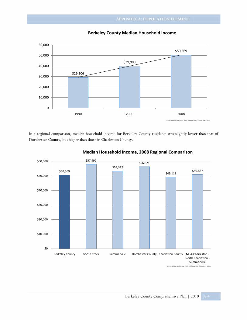
APPENDIX A: POPULATION ELEMENT
Berkeley County Comprehensive Plan | 2010 A-4
In a regional comparison, median household income for Berkeley County residents was slightly lower than that of Dorchester County, but higher than those in Charleston County.
$29,106
$39,908
$50,569
0
10,000
20,000
30,000
40,000
50,000
60,000
1990 2000 2008
Berkeley County Median Household Income
Source: US Census Bureau, 2006-2008 American Community Survey
$50,569
$57,992
$53,312$56,321
$49,118$50,887
$0
$10,000
$20,000
$30,000
$40,000
$50,000
$60,000
Berkeley County Goose Creek Summerville Dorchester County Charleston County MSA-Charleston -North Charleston -
Summerville
Median Household Income, 2008 Regional Comparison
Source: US Census Bureau, 2006-2008 American Community Survey

APPENDIX A: POPULATION ELEMENT
Berkeley County Comprehensive Plan | 2010 A-5
Demographic Characteristics
Berkeley County’s racial composition is depicted to the right. The County’s population is predominantly Caucasian, with a strong minority representation by African Americas. Other races represented in the County include Asian, Native Hawaiian and other Pacific Islander, American Indian and Alaskan Native. According to the 2008 Census, 3.9 percent of Berkeley County residents identified themselves as Hispanic or Latino (of any race).
In 2000 the median age for Berkeley County residents was 32 years, increasing in 2008 to 34.3 years. The State of South Carolina’s median age in 2008 was 37.3 years of age, showing Berkeley County as having a slightly younger median age when compared to the State.
19 and under30%
20-3421%
35-4415%
45-5414%
55-6411%
65 and over9%
Age, Berkeley County, 2008
Source: US Census Bureau, 2006-2008 American Community Survey
Caucasian , 68%
African American ,
27%
Other , 5%
Racial Composition, Berkeley County, 2008
Source: US Census Bureau, 2006-2008 American Community Survey
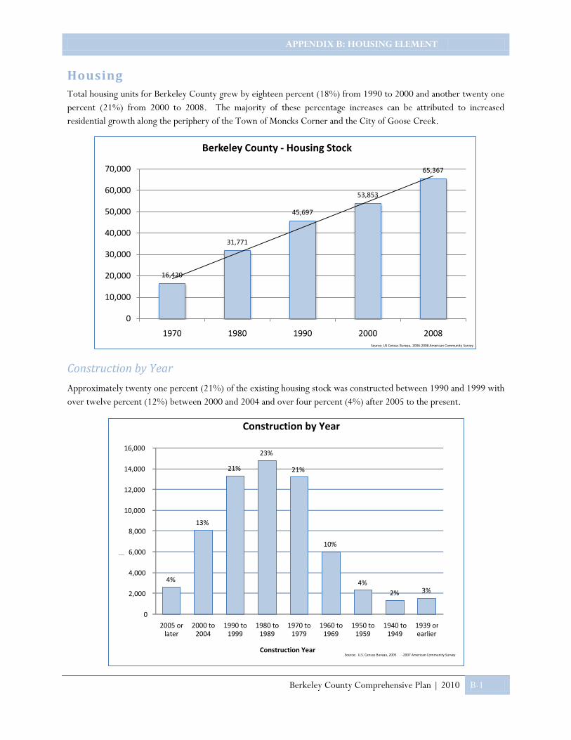
APPENDIX B: HOUSING ELEMENT
Berkeley County Comprehensive Plan | 2010 B-1
Housing Total housing units for Berkeley County grew by eighteen percent (18%) from 1990 to 2000 and another twenty one percent (21%) from 2000 to 2008. The majority of these percentage increases can be attributed to increased residential growth along the periphery of the Town of Moncks Corner and the City of Goose Creek.
Construction by Year
Approximately twenty one percent (21%) of the existing housing stock was constructed between 1990 and 1999 with over twelve percent (12%) between 2000 and 2004 and over four percent (4%) after 2005 to the present.
16,420
31,771
45,697
53,853
65,367
0
10,000
20,000
30,000
40,000
50,000
60,000
70,000
1970 1980 1990 2000 2008
Berkeley County - Housing Stock
Source: US Census Bureau, 2006-2008 American Community Survey
4%
13%
21%
23%
21%
10%
4% 2% 3%
0
2,000
4,000
6,000
8,000
10,000
12,000
14,000
16,000
2005 or later
2000 to 2004
1990 to 1999
1980 to 1989
1970 to 1979
1960 to 1969
1950 to 1959
1940 to 1949
1939 or earlier
Housing Stock
Construction Year
Construction by Year
Source: U.S. Census Bureau, 2005 - 2007 American Community Survey

APPENDIX B: HOUSING ELEMENT
Berkeley County Comprehensive Plan | 2010 B-2
Occupied86%
Vacant14%
Housing Occupancy, 2008
Source: US Census Bureau, 2006-2008 American Community Survey
38%
16%
34%
Renters
Owners w/out MortgageOwners w/ Mortgage
Housing Cost Burden, 2008
Source: US Census Bureau, 2006-2008 American Community Survey
Housing Affordability
The U.S. Department of Housing and Urban Development (HUD) considers homes affordable or within your means, when rental or mortgage expenses do not exceed thirty percent (30%) of the household’s combined annual income.
“Affordable Housing”, in the case of dwelling units for sale is housing where mortgage, amortization, taxes, insurance, and condominium or association fees, if any, constitute no more than twenty eight percent (28%) of the annual household income for a household earning no more than eighty percent (80%) of the area median income.
“Affordable Housing”, in the case of dwelling units for rent is housing for which the rent and utilities constitute no more than thirty percent (30%) of the annual household income for a household earning no more than eighty percent (80%) of the area median income.
The Housing Cost Burden chart identifies the housing occupants in Berkeley County with monthly housing expenses exceeding thirty percent (30%) or more of the total household income. The median monthly housing costs for mortgaged owners was $1,236, non-mortgaged owners $358, and renters $807.
Housing Occupancy
Berkeley County’s occupied housing units totaled 56,196 in 2008. Owner occupied units comprised seventy percent (70%) at 39,312 and renter occupied totaled the remaining thirty percent (30%) at 16,884.
13% 13%
24%21%
17%
8%
3%1%
0%
5%
10%
15%
20%
25%
30%Owner Occupied Home Values, 2008
Source: US Census Bureau, 2006-2008 American Community Survey

APPENDIX C: LAND USE ELEMENT
Berkeley County Comprehensive Plan | 2010 C-1
Existing Land Use The most important data set needed to begin planning future land use is “existing land use.” This is simply a report of the use of each piece of property in Berkeley County on a given date. Kimley-Horn Associates (KHA) performed such an inventory and analysis of existing land use for Berkeley County in the spring of 2008.
The analysis utilized several data sets, including most recently available aerial photography, Berkeley County property records, and spatial data received from Berkeley County Geographic Information Systems Department. Evaluation of the existing land use patterns and trends within Berkeley County led to the discovery of issues and opportunities which is discussed in the Statements and Goals Section of the Plan.
A map displaying existing land use in Berkeley County appears on the following page. The map, accompanying table and graphic, illustrates that the vast majority of subdivided acreage in Berkeley County – 84.2 percent – is undeveloped (i.e., conserved, vacant, or devoted to agriculture or forestry). Of the remaining 15.8 percent, about half is occupied by single-family homes on parcels up to almost 500 acres in size. Additional land in the county exists in transportation and drainage rights-of-way, of which Interstate Highway 26 and Lake Moultrie are examples, rather than in parcels of property.
Examples of existing land uses in Berkeley County: agricultural (left), industrial (above), residential (below).
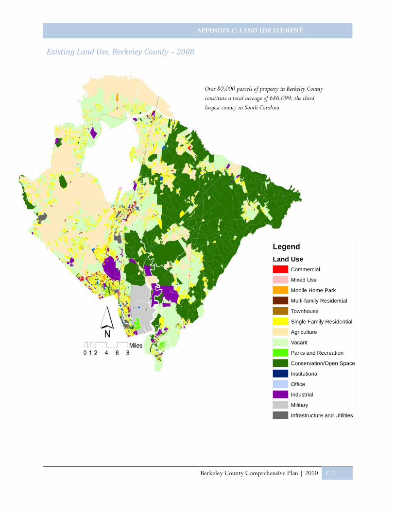
APPENDIX C: LAND USE ELEMENT
Berkeley County Comprehensive Plan | 2010 C-2
Existing Land Use, Berkeley County – 2008
Over 80,000 parcels of property in Berkeley County constitute a total acreage of 686,099; the third largest county in South Carolina
LegendLand Use
Commercial
Mixed Use
Mobile Home Park
Multi-family Residential
Townhouse
Single Family Residential
Agriculture
Vacant
Parks and Recreation
Conservation/Open Space
Institutional
Office
Industrial
Military
Infrastructure and Utilities

APPENDIX C: LAND USE ELEMENT
Berkeley County Comprehensive Plan | 2010 C-3
The following table accounts for existing land uses of various types and kinds, in both public and private ownership. Nearly 60,000 acres are currently dedicated to agricultural land uses. Single-family residences occupy over 47,000 parcels, totaling 56,299 acres.
Existing Land Development Patterns
Like much of South Carolina, Berkeley County originally developed around an agrarian economy, in which small centers of trade developed at crossroads, throughout the nineteenth century. These small centers benefited from a railroad running north and south through Berkeley County, connecting the port of Charleston to points north.
Function Land Use (as Mapped) Parcels Total Acreage Conservation/Open Space Conservation/Open Space 923 240,832 Vacant Land Vacant 21,146 167,058 Forestry Agriculture 184 110,210 Agriculture Agriculture 2,273 59,884 Single-family Residence Single-family Residential 47,681 56,299 Industry Industrial 524 19,032 Military Installation Military 5 16,178 Commercial Commercial 1,918 2,835 Public Facilities and Services Infrastructure and Utilities 96 2,590 Golf Course Parks and Recreation 17 1,819 Mobile Home Park Mobile Home Park 213 1,683 Railroad Infrastructure and Utilities 1 1,533 Educational Institution Institutional 49 1,385 Landfill Infrastructure and Utilities 1 953 Religious Institution Institutional 372 945 Multi-family Residence Multi-family Residential 581 471 Parks and Recreation Parks and Recreation 72 444 Office Office 284 424 Airport Infrastructure and Utilities 1 264 Agricultural Industry Industrial 12 227 Right-of-Way Infrastructure and Utilities 29 203 Mixed Use Mixed Use 4 176 Utility Infrastructure and Utilities 190 172 Townhouse Townhouse 1,436 157 Duplex Multi-family Residential 485 105 Condominium Multi-family Residential 1,503 88 Arena Institutional 4 46 Assisted Living Facility Institutional 9 41 Organization Hall Commercial 13 30 Hospital Institutional 3 14
Total Existing Land Uses 80,029 686,099

APPENDIX C: LAND USE ELEMENT
Berkeley County Comprehensive Plan | 2010 C-4
The twentieth century brought two significant changes to the County: military installations and public works reservoirs. Established in 1906, the Charleston Navy Base grew in prominence during World War II. The community of Hanahan was established as a result of this economic activity, along the existing railroad and near the Goose Creek Reservoir, which became the Charleston metropolitan area’s first modern source of potable water.
Charleston Water System’s water treatment plant stands on the banks of the reservoir to this day.
Work began on two much larger reservoirs, Lakes Marion and Moultrie, in the 1930s. These major public works initiatives brought reliable sources of potable water and hydroelectric power to much of Berkeley County, and Moncks Corner concurrently grew as an employment center thanks in part to Santee Cooper, the public agency responsible for the reservoirs. While additional sources of power have been constructed, the reservoirs continue to serve Berkeley County’s potable water needs. In addition, all three reservoirs are used for waterborne recreation and have attracted and shaped neighborhoods along their banks.
The United States military’s impact on Berkeley County expanded significantly with the addition of the Charleston Naval Weapons Station during and post WWII. The facility occupies about 22 square miles on the west bank of the Cooper River in the southern portion of Berkeley County. The facility displaced rural settlers and one notable antebellum plantation home was moved to public property on James Island. The Naval Weapons Station is now the largest employer in the county and is responsible for a significant amount of indirect economic impact that accounts for thousands more jobs.
Red Bank Road is the circulatory spine of the Naval Weapons Station and connects the facility to the city of Goose Creek and points westward. The seven-lane facility is lined with single-family and multi-family residential neighborhoods, commercial venues, offices, and institutions. Much of this development occurred over the past 50 years and is representative of the pattern and form of 20th century auto-dependent land development throughout much of lower Berkeley County.
Large, master-planned communities characterize more recently developed areas of Berkeley County. Residents identify with these communities more readily than with the Red Bank Road corridor and perhaps as frequently as with the county’s municipalities. Examples include Sangaree, Crowfield, Daniel Island, Tanner Plantation and Cane Bay. All are sited on what were previously large forested tracts of undeveloped land.
Most of the master-planned communities are residential with small commercial/service components and institutions. Daniel Island, however, includes office developments for large white-collar employers like Blackbaud and Benefit Focus, as well as two of the three professional sports venues in the Charleston metropolitan area: Blackbaud (soccer) Stadium and Family Circle (tennis) Stadium. These facilities help attract nonresident patrons to the restaurants and shops of Daniel Island’s retail center.
Views of Crowfield (above), Daniel Island (below), and Wando (next page).
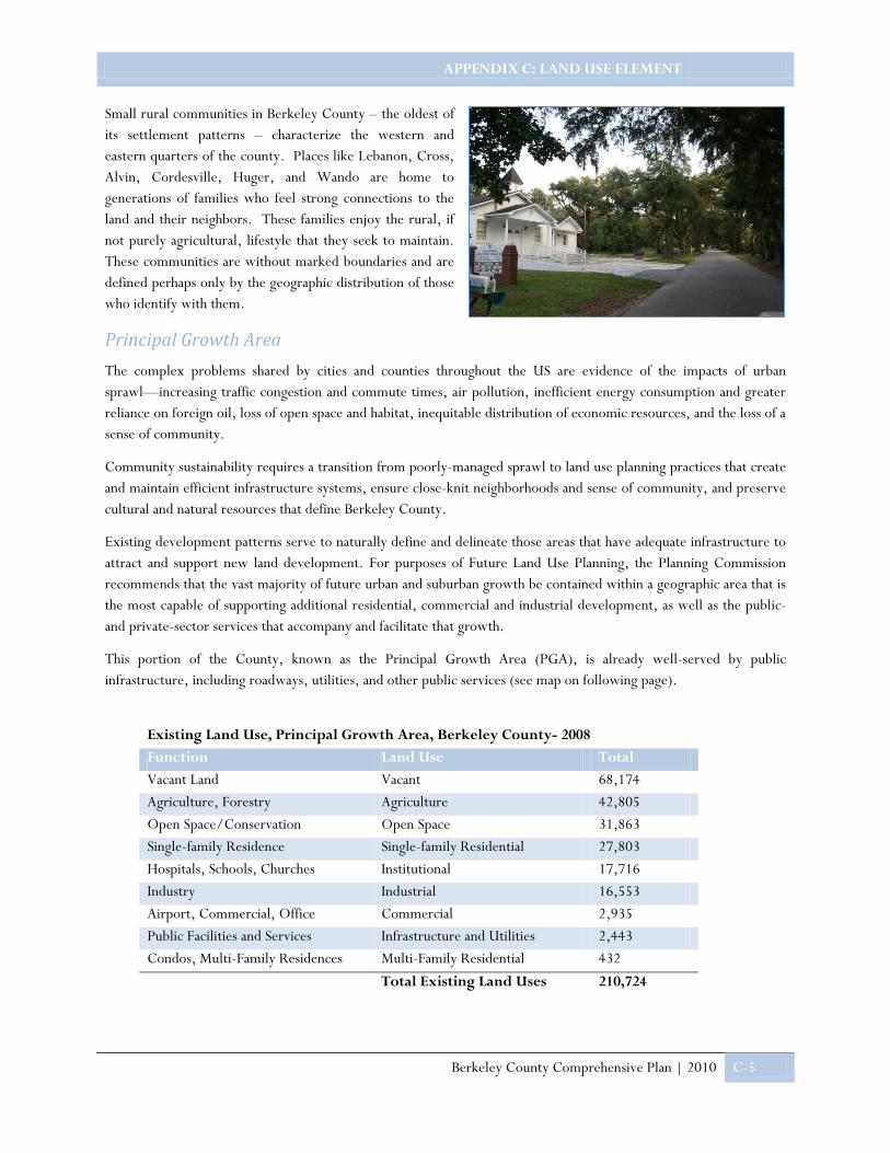
APPENDIX C: LAND USE ELEMENT
Berkeley County Comprehensive Plan | 2010 C-5
Small rural communities in Berkeley County – the oldest of its settlement patterns – characterize the western and eastern quarters of the county. Places like Lebanon, Cross, Alvin, Cordesville, Huger, and Wando are home to generations of families who feel strong connections to the land and their neighbors. These families enjoy the rural, if not purely agricultural, lifestyle that they seek to maintain. These communities are without marked boundaries and are defined perhaps only by the geographic distribution of those who identify with them.
Principal Growth Area The complex problems shared by cities and counties throughout the US are evidence of the impacts of urban sprawl—increasing traffic congestion and commute times, air pollution, inefficient energy consumption and greater reliance on foreign oil, loss of open space and habitat, inequitable distribution of economic resources, and the loss of a sense of community.
Community sustainability requires a transition from poorly-managed sprawl to land use planning practices that create and maintain efficient infrastructure systems, ensure close-knit neighborhoods and sense of community, and preserve cultural and natural resources that define Berkeley County.
Existing development patterns serve to naturally define and delineate those areas that have adequate infrastructure to attract and support new land development. For purposes of Future Land Use Planning, the Planning Commission recommends that the vast majority of future urban and suburban growth be contained within a geographic area that is the most capable of supporting additional residential, commercial and industrial development, as well as the public- and private-sector services that accompany and facilitate that growth.
This portion of the County, known as the Principal Growth Area (PGA), is already well-served by public infrastructure, including roadways, utilities, and other public services (see map on following page).
Existing Land Use, Principal Growth Area, Berkeley County- 2008
Function Land Use Total Vacant Land Vacant 68,174
Agriculture, Forestry Agriculture 42,805 Open Space/Conservation Open Space 31,863 Single-family Residence Single-family Residential 27,803 Hospitals, Schools, Churches Institutional 17,716 Industry Industrial 16,553 Airport, Commercial, Office Commercial 2,935 Public Facilities and Services Infrastructure and Utilities 2,443 Condos, Multi-Family Residences Multi-Family Residential 432
Total Existing Land Uses 210,724
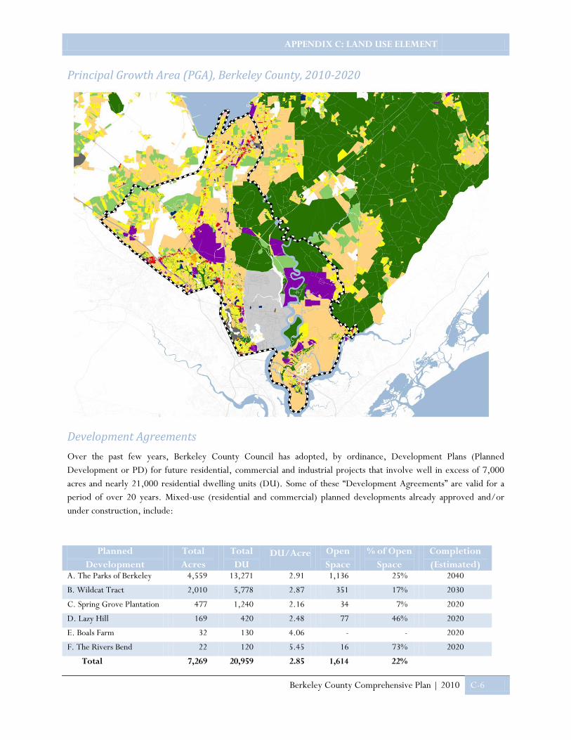
APPENDIX C: LAND USE ELEMENT
Berkeley County Comprehensive Plan | 2010 C-6
Principal Growth Area (PGA), Berkeley County, 2010-2020
Development Agreements Over the past few years, Berkeley County Council has adopted, by ordinance, Development Plans (Planned Development or PD) for future residential, commercial and industrial projects that involve well in excess of 7,000 acres and nearly 21,000 residential dwelling units (DU). Some of these “Development Agreements” are valid for a period of over 20 years. Mixed-use (residential and commercial) planned developments already approved and/or under construction, include:
Planned Development
Total Acres
Total DU
DU/Acre Open Space
% of Open Space
Completion (Estimated)
A. The Parks of Berkeley 4,559 13,271 2.91 1,136 25% 2040
B. Wildcat Tract 2,010 5,778 2.87 351 17% 2030
C. Spring Grove Plantation 477 1,240 2.16 34 7% 2020
D. Lazy Hill 169 420 2.48 77 46% 2020
E. Boals Farm 32 130 4.06 - - 2020
F. The Rivers Bend 22 120 5.45 16 73% 2020
Total 7,269 20,959 2.85 1,614 22%

APPENDIX C: LAND USE ELEMENT
Berkeley County Comprehensive Plan | 2010 C-7
In addition to these predominately residential developments, two (2) industrial Planned Developments, Berkeley Interstate Site (695 acres) and Omni Commerce Park (320 acres) have also been approved by Berkeley County Council for future construction. At build-out, Omni Commerce Park is expected to accommodate 775,000 square feet of GFA in new industrial development. No statistics are available for the Berkeley Interstate Site.
These proposed real estate development projects are in various stages of progress, with completion schedules subject to change based upon market conditions and other factors.
The State of South Carolina, Department of Commerce, has identified a “Mega Site” in Berkeley County; located outside the Principal Growth Area and adjacent to I-26. Owned by Mead Westvaco Corporation, the prospective 6,600-acre industrial site is capable of hosting major employers and significant new investment. However, until appropriate infrastructure improvements and land use approvals are in place, this tract will remain ineligible for consideration as an additional development site.
Heirs’ Property Heirs’ property is commonly encountered throughout the rural communities of Berkeley County. Heirs’ Property is the name given to real estate owned by family members who are descendants of the original purchaser. The deed to the land is registered in the name of a deceased family member. Usually, the property has been passed in this manner because the ancestor either did not have a will or no one probated the will. With each new generation, it is likely that additional family members may die without leaving wills stating who should inherit their share of the land.
Without a clear title or land survey, the development and financing of improvements located on Heirs’ property is extremely difficult. Special provisions, designed to alleviate the common hardships associated with Heirs’ Property, should be considered when drafting and amending County zoning, subdivision and land development regulations such that these lands can developed consistent with the proposed future land use plan for Berkeley.
Growth Management Berkeley County has an array of tools at its disposal to manage the development and use of land. These tools include incentives as well as regulations. Nevertheless, the best known growth management tools are zoning and land development ordinances. A zoning ordinance seeks to organize land uses into districts of land uses compatible with one another, serviceable by comparable public infrastructure, and appropriate to the landscape. A land development ordinance sets forth standards by which land will be subdivided and developed, including standards for the design and engineering of roads and drainage.
Berkeley County has administered zoning county-wide for fewer than twenty years. The majority of private land in the county is zoned “Flex,” which allows all but the most noxious land uses and sets a minimum lot size of 30,000 square feet. This lot size is the smallest on which a private well for potable water and an on-site (septic) disposal system can function.

APPENDIX C: LAND USE ELEMENT
Berkeley County Comprehensive Plan | 2010 C-8
Several zoning districts, delineating the county into segregated areas of land use, cover the urbanizing areas. Industrial districts align with significant transportation infrastructure along the Cooper River, and commercial areas line arterial roads. Most of the land between these areas is zoned for single-family homes on lots one-third acre in size or greater. With the zoning maximum for residential density at three units per acre, County land development standards are geared for single-family detached residential development.
The aforementioned large, master-planned developments are typically located in their own zoning districts, labeled “mixed-use planned developments” (PD-MU). These districts allow a developer greater flexibility to direct development of this property, including the right to mix uses. Few of these developments have actually integrated the land uses; rather, they follow the convention of existing zoning – lining the adjacent arterial road with commercial uses and reserving the remainder for residential uses. The developer typically seeks the designation from County Council so that he can arrange residential density at an average across the development, rather than creating all 1/3 acre lots. This allows developers to produce housing units in a mix of density and volumes that the market can bear.
Typical road standards require generous widths (11-foot wide lanes) and concrete curbs; on-street parking is discouraged if not prohibited. Stormwater must be managed in large ponds with deep building setbacks applied from their banks. Current Berkeley County zoning and land development standards therefore direct most growth to occur in the form of suburban development.
Neighborhoods of attached homes are often required to maintain their own streets and parking areas. These circulatory systems empty onto an arterial roadway, straining its functionality at that point. An opportunity to expand the road network and increase its capacity is thus lost by virtue of excluding streets with on-street parking. Additionally, residents must bear the cost of maintaining the private circulatory network, which puts this development type at a competitive disadvantage versus a neighborhood of detached houses.
Historically, commercial areas like Main Street in Moncks Corner have grown around important crossroads (SC Highway 6 and the Coastal Rail Line in this case). Main Street and East Railroad Avenue, as currently configured with on-street parking, cannot be replicated within unincorporated Berkeley County. These streets support commercial development by promoting efficient land use, through both compact design and shared parking. The commercial uses benefit from close proximity to one another as well as their central location to residents. Additionally, merchant’s capital and operating costs are lower because they do not need to construct or maintain private parking areas, which could cost $5,000 per parking space to construct and occupy otherwise leasable square footage.

APPENDIX C: LAND USE ELEMENT
Berkeley County Comprehensive Plan | 2010 C-9
Most modern commercial development in Berkeley County is required to construct its own parking and circulatory system, both by code and because important crossroads are designed to accommodate through traffic at the expense of adjacent land access and utilization. Just as in the neighborhood of attached homes, an opportunity to expand the road network is supplanted by congested access points to shopping centers along arterial roads designed primarily for through traffic.
Costs of Growth In 2001-2002, the Berkeley-Charleston-Dorchester Council of Governments developed a scenario planning tool, called Growth Options, to evaluate the costs of regional growth and land development. The purpose was to determine annual cost differences, if any, between disparate land development patterns over a 20-year period. Growth Options is a spreadsheet analysis that accounts for residential density and commercial land utilization, among other development characteristics, to derive dollar figures. Two categories of costs are considered: direct capital infrastructure (not including operating costs) and impacts to the natural environment. These costs are borne by all sectors in aggregate; including taxpayers, landowners, and developers.
With the rapid urbanization of land comes a loss of agricultural land and wetlands, which translate to incurred costs in terms of reduced agricultural productivity and increased need for engineered stormwater management. The Growth Options tool revealed several ways that the tri-county region can reduce costs of growth. Among the most significant findings of the scenario planning tool is a ten percent reduction in costs through more compact development patterns (i.e., higher residential development densities and higher commercial site utilization).
An empirical example of this cost difference is a comparison of two neighborhoods, one with half-acre lots and the other with lots averaging one-quarter acre. A half-acre lot occupies more street frontage than the quarter-acre lot. The streets in the first neighborhood are therefore longer and more expensive per housing unit. Similarly, all utility lines such as sanitary sewer lines are longer – and therefore more expensive – per residential unit.
Berkeley County’s suburban land development standards can also increase costs of land development in rural areas. Rural communities prefer grass swales to curbs and sometimes gravel or compacted dirt to asphalt roads. Swales in place of curbs reduce the need for stormwater retention, thus further reducing land development costs in addition to improving water quality. While gravel and dirt roads may require more frequent maintenance, those costs are lower than that for repaving. Berkeley County now requires roads that fit the character of a rural landscape to be privately maintained.
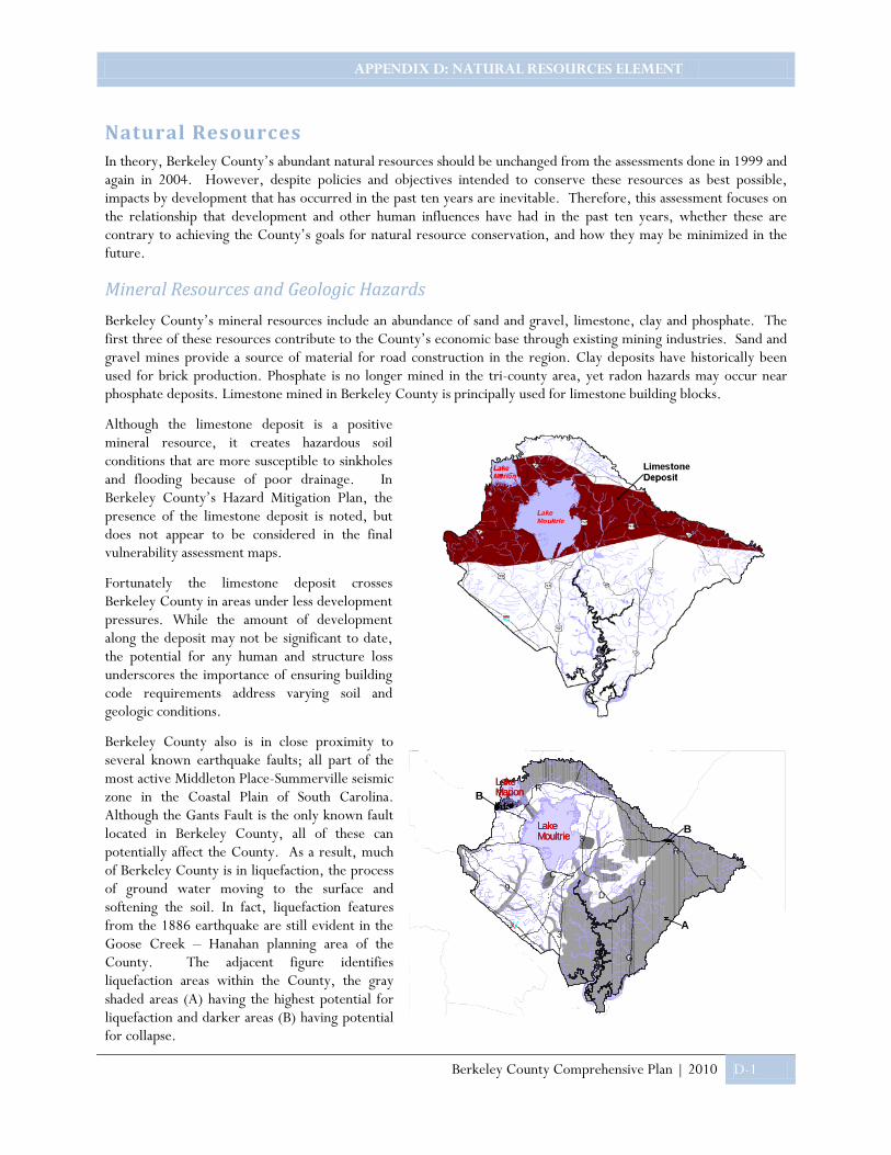
APPENDIX D: NATURAL RESOURCES ELEMENT
Berkeley County Comprehensive Plan | 2010 D-1
Lake MarionLake Marion
LakeMoultrieLakeMoultrie
YR
23YC
YC29
WXT
2:
23
2:
YG
YG
YR
YD
B
B
A
Natural Resources In theory, Berkeley County’s abundant natural resources should be unchanged from the assessments done in 1999 and again in 2004. However, despite policies and objectives intended to conserve these resources as best possible, impacts by development that has occurred in the past ten years are inevitable. Therefore, this assessment focuses on the relationship that development and other human influences have had in the past ten years, whether these are contrary to achieving the County’s goals for natural resource conservation, and how they may be minimized in the future.
Mineral Resources and Geologic Hazards
Berkeley County’s mineral resources include an abundance of sand and gravel, limestone, clay and phosphate. The first three of these resources contribute to the County’s economic base through existing mining industries. Sand and gravel mines provide a source of material for road construction in the region. Clay deposits have historically been used for brick production. Phosphate is no longer mined in the tri-county area, yet radon hazards may occur near phosphate deposits. Limestone mined in Berkeley County is principally used for limestone building blocks.
Although the limestone deposit is a positive mineral resource, it creates hazardous soil conditions that are more susceptible to sinkholes and flooding because of poor drainage. In Berkeley County’s Hazard Mitigation Plan, the presence of the limestone deposit is noted, but does not appear to be considered in the final vulnerability assessment maps.
Fortunately the limestone deposit crosses Berkeley County in areas under less development pressures. While the amount of development along the deposit may not be significant to date, the potential for any human and structure loss underscores the importance of ensuring building code requirements address varying soil and geologic conditions.
Berkeley County also is in close proximity to several known earthquake faults; all part of the most active Middleton Place-Summerville seismic zone in the Coastal Plain of South Carolina. Although the Gants Fault is the only known fault located in Berkeley County, all of these can potentially affect the County. As a result, much of Berkeley County is in liquefaction, the process of ground water moving to the surface and softening the soil. In fact, liquefaction features from the 1886 earthquake are still evident in the Goose Creek – Hanahan planning area of the County. The adjacent figure identifies liquefaction areas within the County, the gray shaded areas (A) having the highest potential for liquefaction and darker areas (B) having potential for collapse.

APPENDIX D: NATURAL RESOURCES ELEMENT
Berkeley County Comprehensive Plan | 2010 D-2
Several earthquake events have occurred since the 1999 comprehensive plan was completed. A map of identified epicenters, based on data from the USC Hazard Research Lab, included in the County’s Disaster Mitigation Plan shows a concentration of these in more developed areas adjacent to the County’s southwest edge, principally the Summerville/Goose Creek/Hanahan area. The Hazard Mitigation Plan states the County’s goal of minimizing damage to infrastructure and buildings through adoption of building codes that reduce the vulnerability of structures to this hazard.
Water Quality
Three major watersheds are contained within Berkeley County: the Ashley-Cooper Watershed, the Edisto Watershed and the Santee Watershed. Plans adopted by the SC Department of Natural Resources contain goals and policies for each of these watersheds. The success of those policies is directly related to supporting policies and implementation measures taken by the County and its municipalities.
Surface water, particularly storm water runoff is directly impacted by development. In November 2004, a steering committee of representatives from Berkeley County, the Berkeley Soil and Water Conservation District, National Oceanic and Atmospheric Administration and SC Department of Health and Environmental Control Office of Ocean and Coastal Resource Management completed a Natural Resource Management Plan for the Cooper River Corridor. Water quality impacts of development, including impairments by mercury, fecal coliform, and dissolved oxygen were assessed in this plan. In order to assess the potential for protecting habitats of the river, the Plan evaluated nonpoint source pollution policies and other development requirements. The goals outlined in the Cooper River Corridor SAMP should be incorporated and implemented through the County’s comprehensive plan and related codes. Comparable goals countywide would well serve the quality of the other two watersheds.
Wetland and flood hazard areas are abundant within Berkeley County. Wetland areas support vegetation that is typically adopted for saturated soil conditions, which in turn provide habitats for a number of wildlife species. Historically these areas have been regulated through requirements of SC Office of Ocean and Coastal Resources Management, the Army Corps of Engineers and the County’s administration of FEMA building requirements. SC-OCRM policies are more advisory in nature and work in concert with the Corps permitting process. FEMA requirements are more focused on mitigating possible impacts of flooding on structures. Therefore it is up to the County to adopt and implement policies and standards that address impacts of site development, including land disturbance, infrastructure and structures, on the quality of wetlands. Since each of these agencies have changed policies and implementation responsibilities over the past ten years, a thorough review of how current federal, state and county requirements work in concert with one another would be prudent at this time.
Likewise, an analysis of the proximity between new development and these areas will provide an idea as to whether local buffer requirements are needed to ensure long-term conservation of these resources. Approximately 98 acres of building footprints already exist within the County’s flood hazard areas, while another 23 acres of building footprints are within designated wetland areas.
Of the 2,135 buildings located within flood hazard areas, almost one-half are highly susceptible to flooding. Any new construction within these areas should be elevated above base flood elevation and structurally engineered to withstand significant or recurrent flooding. Adoption and enforcement of this standard directly affects the County’s rating for flood insurance. Although there is an increased awareness of the adverse impacts development near wetlands have on water quality and natural habitats, most local jurisdictions have been slow to adopt incentives or regulations to protect this resource. An additional 654 buildings in Berkeley County have footprints within designated wetland areas.
In recent years various agencies have conducted studies to determine minimum depths for wetland buffers to achieve certain water quality protection levels. Requirement of the recommended buffers would ensure protection of these resources in the future. Conservation easements likewise will provide protection of sensitive areas such as floodplain and wetlands. A number of large industries within Berkeley County, such as DuPont and Nucor, have placed conservation easements along private riparian buffers to protect water quality along the Cooper River.

APPENDIX D: NATURAL RESOURCES ELEMENT
Berkeley County Comprehensive Plan | 2010 D-3
Air Quality and Environmental Noise
As of the 2004 Comprehensive plan update, Berkeley County was in attainment with all air quality standards of the federal Clean Air Act and its amendments. Recent changes to attainment standards adopted by the Environmental Protection Agency for certain pollutants are being assessed in a regional air quality planning process currently under coordination by the BCD Council of Governments. Any recommended policies that are developed through this planning process should be incorporated into the County’s comprehensive plan when adopted. Air quality standards are typically enforced through industrial permitting processes. However, the County might consider evaluating whether noise standards for industries within proximity of residential developments should also be applied and enforced.
Wildlife Management and Endangered Species
In the 1999 Plan, Berkeley County was listed as providing habitats for six species listed as federally “endangered’ or “threatened” by the SC Department of Natural Resources, Heritage Trust Program. Within the next five (5) years, it was determined that another two endangered species make their home in Berkeley County. In addition two species were listed as “threatened”. Federally “Endangered” or “Threatened” species found in Berkeley include the: Shortnose Sturgeon, Flatwoods Salamander, Bald Eagle, Pondberry, Canby’s Dropwort, Red-cockaded Woodpecker, and Chaffseed. State listed “Endangered” or “Threatened” species include the: Least Tern, Gopher Frog, American Swallow-tailed Kite, Rafinesque’s Big-eared Bat, and Spotted Turtle. Protection of these species is linked to conservation of designated wildlife management areas. Recently the SC Department of Natural Resources released new data on endangered species. The proximity of habitats for these species to state or federal Wildlife Management Areas should be evaluated to ensure their protection.
As of 1999, over 200,000 acres were designated as Wildlife Management Areas, leased by state wildlife agencies from private landowners to allow public access for hunting and fishing. Within Berkeley County, the SC Department of Natural Resources owns or manages the following areas from the Dennis Wildlife Center in Bonneau:
Name Acreage Resources Species
Bonneau Ferry WMA (purchased from Mead Westvaco in 2004) 10,700
Access to ruins of Comingtee Plantation House, Rice Mill and Childsbury Heritage Preserve
White tailed deer, wild turkey, bobwhite quail, waterfowl, bald eagles and red-cockaded woodpeckers
Canal WMA (owned by U.S. Army Corps of Engineers)
2,491 Public dove fields, bank fishing Painted buntings, bald eagles and osprey.
Francis Marion National Forest (includes 5 WMAs: Santee, Hellhole, Northampton, Wambaw and Waterhorn)
258,816
Hunting, ATV riding, camping, target shooting and horseback riding
Hatchery WMA (owned by Santee Cooper) 2,400
Islands and shallow water habitats, public waterfowl hunting, boat landing
Moultrie Hunt Unit (includes 6 WMAs: Bluefield, Greenfield, Hall, North Dike, Porcher, and Sandy Beach)(owned by Santee Cooper)
9,480
Hunting for deer and small game, waterfowl
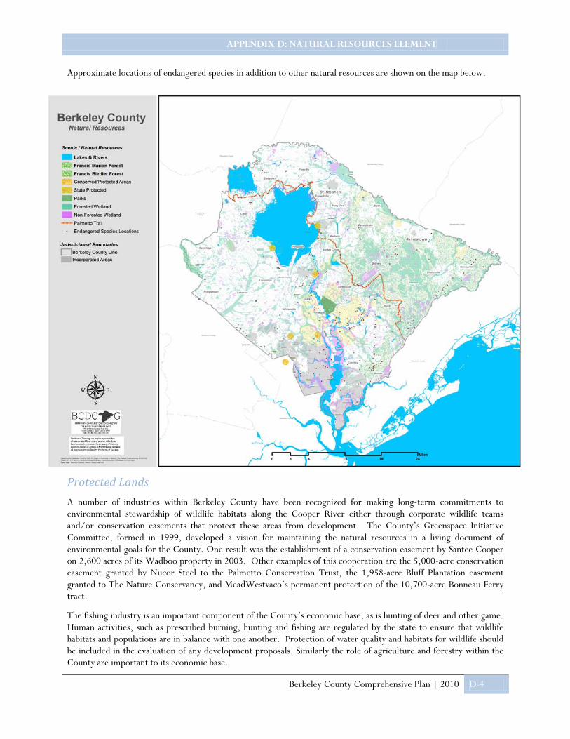
APPENDIX D: NATURAL RESOURCES ELEMENT
Berkeley County Comprehensive Plan | 2010 D-4
Approximate locations of endangered species in addition to other natural resources are shown on the map below.
Protected Lands
A number of industries within Berkeley County have been recognized for making long-term commitments to environmental stewardship of wildlife habitats along the Cooper River either through corporate wildlife teams and/or conservation easements that protect these areas from development. The County’s Greenspace Initiative Committee, formed in 1999, developed a vision for maintaining the natural resources in a living document of environmental goals for the County. One result was the establishment of a conservation easement by Santee Cooper on 2,600 acres of its Wadboo property in 2003. Other examples of this cooperation are the 5,000-acre conservation easement granted by Nucor Steel to the Palmetto Conservation Trust, the 1,958-acre Bluff Plantation easement granted to The Nature Conservancy, and MeadWestvaco’s permanent protection of the 10,700-acre Bonneau Ferry tract.
The fishing industry is an important component of the County’s economic base, as is hunting of deer and other game. Human activities, such as prescribed burning, hunting and fishing are regulated by the state to ensure that wildlife habitats and populations are in balance with one another. Protection of water quality and habitats for wildlife should be included in the evaluation of any development proposals. Similarly the role of agriculture and forestry within the County are important to its economic base.

APPENDIX D: NATURAL RESOURCES ELEMENT
Berkeley County Comprehensive Plan | 2010 D-5
A number of agencies, organizations and programs work to preserve the natural features and cultural remains that are quickly disappearing as the region’s population grows. Several notable sites within Berkeley County, such as the Bird Island Rookery, Stoney Landing and the Westvaco Eagle Nest, are protected through the state Heritage Trust Program. Other natural sites, such as Cypress Gardens, Francis Beidler Forest, Francis Marion Forest and the Santee Canal State Park, play an important role in conserving protected land areas.
The Nature Conservancy has mapped lands protected from development. A comparative analysis of current land area under the protection of all the various programs and organizations, in addition to assessment of agricultural and forest resource acreages, would be useful in determining whether the County has been successful in achieving its goal to protect these important resources.

APPENDIX E: CULTURAL RESOURCES ELEMENT
Berkeley County Comprehensive Plan | 2010 E-1
Cultural Resources Berkeley County possesses a number of cultural and scenic resources that greatly contribute to the quality of life for residents. These resources play an important role in the County’s economic base through tourism and by attracting new industries that consider the quality of life for employees when making location decisions. Thus it is important that these resources be protected and, where possible, shared with the greater community.
Historic Properties
A number of historic resource surveys have been conducted within Berkeley County, beginning with two inventories by the BCD Council of Governments in the 1970s. Following the listing of the Pinopolis and Cainhoy historic districts, an updated survey was conducted in the late 1980s, right before Hurricane Hugo. More than a decade later, a group of properties, within an intact rural area centering on the Cooper River’s East Branch, were listed on the National Register of Historic Places as the Cooper River Historic District. This particular district includes some of the oldest rural dwellings in the state along with archeological sites that contribute to an overall understanding of the region’s significance in state and national history.
National Register Historic Districts
Dozens of individual properties are also listed, or deemed eligible for listing, on the National Register of Historic Places. There are five (5) properties within Berkeley County that are designated as National Historic Landmarks, which is the highest level of designation for historic properties. These landmarks properties are: Mulberry Plantation, St. James' Church, St. Stephen's Episcopal Church, Pompion Hill Chapel, and Middleburg Plantation.
The following table lists all Berkeley County properties that are individually listed on the National Register of Historic Places:
District Name Location Listing Date
Total Properties/
Number Contributing
Cainhoy On Wando River off SC 41 3/11/82 12/9
Cooper River 33,000 acres along East and West branches 2/5/03 217/121
Pinopolis, North E side of the Pinopolis peninsula on Lake Moultrie 8/19/82 4/4
Pinopolis, South E side of Berkeley County Rd. 5 8/19/82 18/14
Pineville SC 45 just north of Lake Moultrie 2/10/91 11/7

APPENDIX E: CULTURAL RESOURCES ELEMENT
Berkeley County Comprehensive Plan | 2010 E-2
Property Name Approximate Location Listing Date
Mulberry Plantation (NHL) Off US 52 near Moncks Corner 10/9/60
St. James Church (NHL) Goose Creek 4/15/70
St. Stephen’s Episcopal Church (NHL) SC Hwy 45, St. Stephens 5/10/70
Pompion Hill Chapel (NHL) Near junction of SC 41 and 402, Huger 4/15/70
Middleburg Plantation (NHL) On Cooper River, Huger 4/15/70
Medway Off US 52 near Mount Holly 7/16/70
Strawberry Chapel and Childsbury Town Site SC road 44 near Mount Holly 4/26/72
Lewisfield Plantation US Hwy 52 near Moncks Corner 5/9/73
White Church (St. Thomas and St. Dennis Parish Episcopal Church; Brick Church)
SC Secondary Road 98 near Cainhoy 9/22/77
Loch Dhu Off SC 6 near Cross 9/22/77
Lawson’s Pond Plantation Off SC 6 near Cross 12/13/77
Biggin Church Ruins (St. John’s Parish Church) SC Hwy 402 near Moncks Corner 12/13/77
Taveau Church SC Secondary Road 44 near Cordesville 2/14/78
Otranto Plantation 18 Basilica Avenue, Hanahan 2/17/78
Keller Site Address Restricted, near St. Stephen vicinity 2/1/80
Richmond Plantation (Girl Scout Plantation) SC Secondary Road 402 near Cordesville 11/24/80
Santee Canal Moncks Corner to Pineville 5/5/82
William Robertson House SC Secondary Road 5 near Pinopolis 8/19/82
Quinby Plantation House-Halidon Hill Plantation Huger vicinity 10/10/83
Otranto Plantation Indigo Vats SC Secondary 503 near Goose Creek 12/21/89
Approximate locations of these historic properties in addition to other cultural sites are shown on the map below.
There are numerous benefits to protecting historic properties from adverse development impacts. First and foremost, the quality of life for County residents is preserved and improved by protecting and preserving familiar visual elements. Secondly, the protection of heritage resources promotes tourism, attracting visitors and thereby supporting local business and industry. Unfortunately National Register designation does little to protect these valuable resources unless there is potential impact by a project using federal funds.
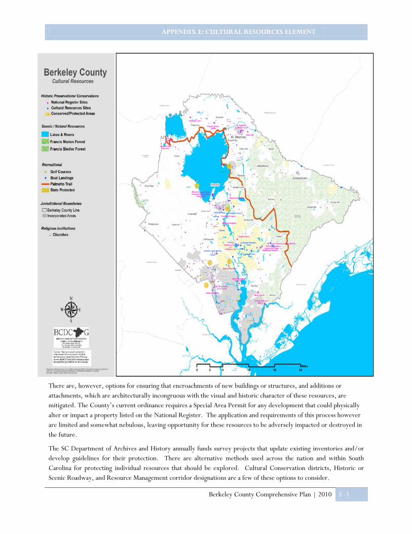
APPENDIX E: CULTURAL RESOURCES ELEMENT
Berkeley County Comprehensive Plan | 2010 E-3
There are, however, options for ensuring that encroachments of new buildings or structures, and additions or attachments, which are architecturally incongruous with the visual and historic character of these resources, are mitigated. The County’s current ordinance requires a Special Area Permit for any development that could physically alter or impact a property listed on the National Register. The application and requirements of this process however are limited and somewhat nebulous, leaving opportunity for these resources to be adversely impacted or destroyed in the future.
The SC Department of Archives and History annually funds survey projects that update existing inventories and/or develop guidelines for their protection. There are alternative methods used across the nation and within South Carolina for protecting individual resources that should be explored. Cultural Conservation districts, Historic or Scenic Roadway, and Resource Management corridor designations are a few of these options to consider.

APPENDIX E: CULTURAL RESOURCES ELEMENT
Berkeley County Comprehensive Plan | 2010 E-4
Archaeological Resources
Approximately 2,200 surveyed archaeological resource locations have been identified within Berkeley County. Such resources include Native American settlements and canoes, colonial ferries, plantation wharves, revolutionary gunboats, antebellum rice flats and post Civil War phosphate barges. Buried, and even submerged, archaeological resources are best protected through the limitation of land disturbance activities within their proximity.
Since the majority of these resources are generally located along the County’s waterways or historic properties, protective measures could be implemented in concert with those adopted to conserve historic resources and/or water quality.
Historic Settlements and Communities
Another cultural resource of significance is the historic settlement areas or communities within rural Berkeley County such as Pringletown, Cross, Lebanon and Honey Hill. These communities characterize the agricultural heritage of Berkeley County and have, until recently, been isolated from suburban development. However unprecedented growth of the region, particularly within Berkeley County, now threatens to infringe on the sense of place that these communities have and wish to maintain. While these communities may not include a concentration of historic properties, consideration should be given to how development of land adjacent to or surrounding them impacts their character. Opportunities exist to designate resource management corridors or to direct clustering of new development in such a way that the communities are not adversely impacted.
Scenic and Recreational Resources
The bulk of scenic resources within Berkeley County are the same natural resources discussed in another section of this Plan. As a major contributor to the quality of life for most residents, natural resources provide scenic value as well as cultural and recreational opportunities. From the Francis Marion National Forest to the Francis Beidler Forest preserve to Lakes Marion and Moultrie, fresh water swamps, rivers, and tidal marshes are attributes that define Berkeley County’s landscape. These resources provide abundant opportunities for recreational activities and natural habitats as well as clean drinking water for residents. A brief listing of these resources is provided below.

APPENDIX E: CULTURAL RESOURCES ELEMENT
Berkeley County Comprehensive Plan | 2010 E-5
Resource Scope Value
Francis Marion National Forest 250,000 acres of which 143,500 are within Berkeley County
Site of numerous historic battles.
Range of ecosystems from pine forests and swamps to special geological features that are home to rare plants and endangered wildlife species.
Non motorized trails for hiking, horse riding and other recreational activities such as camping, fishing areas, boat ramps and a rifle range.
Francis Beidler Forest 10,700 acres of which one-half are within Berkeley County, operated by the Audubon Society
Virgin stand of bald cypress and tupelos, wildlife habitats
Huckhole Swamp
(Hellhole Swamp
Four Holes Swamp)
70 acre tupelo gum and cypress preserve
Wildlife habitat for fish, freshwater fowl, wildlife and aquatic plant populations
Lakes Marion and Moultrie Recreational activities, wildlife habitats
Goose Creek Reservoir 600 acre natural drainage basin Drinking water and recreational activities, natural habitat for birds and vegetation.
Dennis Wildlife Reserve Deer reserve and location of state wildlife agency.
Santee, Cooper and Wando Rivers
Recreational activities, archaeological deposits
SC Palmetto Trail
Swamp Fox Passage
Hell Hole Outdoor Center
Statewide trail system that passes through the national forest, Dennis Wildlife Management area near St. Stephen
Recreational activities, four ecosystems
Old Santee Canal State Park 250 acre park Recreational activities, interpretive center
Listed on National Register of Historic Places
Wampee Private retreat center Facility for planning and learning
Cypress Gardens 163 acre black water swamp and gardens
Historic reserve of cypress swamp and rice plantation, living laboratory and learning center with interpretative center.

APPENDIX E: CULTURAL RESOURCES ELEMENT
Berkeley County Comprehensive Plan | 2010 E-6
An additional number of municipal and community park and recreation facilities take advantage of natural and scenic resources throughout the County. Public boat ramps, private fishing camps, and abundant golf courses also provide access to these resources. Yet a number of participants in countywide input meetings expressed concerns that there is limited access to these resources for the general public. A countywide recreation plan would be prudent in assessing the quality and accessibility of each of these resources and facilities as well as threats to their conservation and/or financial support. The County could then encourage linkages between these resources and its green space protection initiatives through application of conservation easements and recreation planning.
Educational Institutions
Educational institutions, whether public or private, are considered cultural resources as well as community facilities.
• Cypress Gardens is a regional cultural resource, for both its scenic and educational value. Formerly one of the area’s largest rice plantations, Cypress Gardens has a fascinating history dating back to when Berkeley County was established by the Lord's Proprietor's in the 1700's. The blackwater swamp has served as a scenic location for several major motion pictures, including The Patriot and The Notebook. The facility offers a number of educational programs for school and private groups, particularly hands-on learning both indoors and out in the swamp. The exhibit buildings provide a reliable view of the wildlife found here in a secure, educational environment. Berkeley County Council has approved a partnership between Cypress Gardens and its neighbor, DuPont, to construct new exhibits that feature archaeological resources dating back to the 1700’s. The exhibits would outline the history of, and feature many excavated relics which are believed to have belonged to, Dean Hall Plantation, which was once located on the grounds.
• The Berkeley County Museum, located on Stony Landing Road in Moncks Corner, is a significant cultural resource that provides public access to exhibits of the County’s history and its ties to natural resources. The 5,600 square foot state-of-the-art exhibit building traces the region’s history back 12,000 years.
• The County library system offers an array of special services and programs for residents that will continue to experience increasing demands as the county grows. The Moncks Corner library houses the South Carolina Collection of history and genealogy resources, including books, pamphlets, and government documents.
• Public school facilities, particularly structures constructed prior to 1940 and those originally constructed for the county’s black inhabitants, demonstrate the county’s heritage of providing educational opportunities for all residents. The County’s public school system also provides a number of special programs related to cultural enrichment and/or personal development.
Cypress Gardens
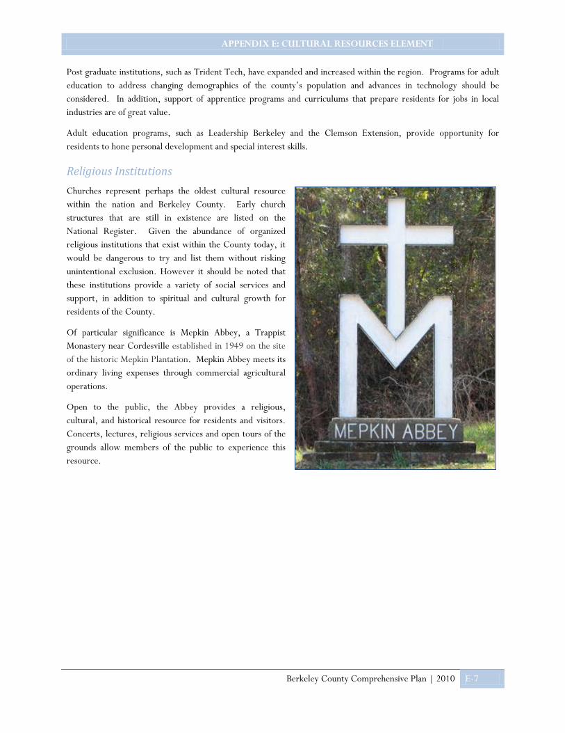
APPENDIX E: CULTURAL RESOURCES ELEMENT
Berkeley County Comprehensive Plan | 2010 E-7
Post graduate institutions, such as Trident Tech, have expanded and increased within the region. Programs for adult education to address changing demographics of the county’s population and advances in technology should be considered. In addition, support of apprentice programs and curriculums that prepare residents for jobs in local industries are of great value.
Adult education programs, such as Leadership Berkeley and the Clemson Extension, provide opportunity for residents to hone personal development and special interest skills.
Religious Institutions
Churches represent perhaps the oldest cultural resource within the nation and Berkeley County. Early church structures that are still in existence are listed on the National Register. Given the abundance of organized religious institutions that exist within the County today, it would be dangerous to try and list them without risking unintentional exclusion. However it should be noted that these institutions provide a variety of social services and support, in addition to spiritual and cultural growth for residents of the County.
Of particular significance is Mepkin Abbey, a Trappist Monastery near Cordesville established in 1949 on the site of the historic Mepkin Plantation. Mepkin Abbey meets its ordinary living expenses through commercial agricultural operations.
Open to the public, the Abbey provides a religious, cultural, and historical resource for residents and visitors. Concerts, lectures, religious services and open tours of the grounds allow members of the public to experience this resource.

APPENDIX F: ECONOMIC DEVELOPMENT
Berkeley County Comprehensive Plan | 2010 F-1
Economic Development The Economic Development Element of the comprehensive plan assesses Berkeley County’s workforce, economic and employment trends and characteristics, and additional factors contributing to the local economy.
Labor Force Characteristics
As illustrated in the chart below, sixty eight percent (68%) of Berkeley County residents sixteen years and older are in the labor force, while thirty two percent (32%) are not in the labor force. Berkeley County’s labor force grew twenty two percent (22%) in size from 2000 to 2008. Given the total labor force, unemployed workers increased one percent (1%) and percentage of employed workers grew by two percent (2%).
Employment by Industry
Employment by Industry statistics indicate the majority of Berkeley County’s employed workforce are employed within Educational, health care and social assistance (16%) industries, followed by Retail Trade (12%), Construction (12%) and Manufacturing (11%).
Agriculture, Forestry, etc.1%
Construction12%
Manufacturing11%
Wholesale Trade4%
Retail Trade12%
Transportation, Warehousing & Utilities
8%Information
2%
Finance, Insurance & Real estate
6%
Professional, Scientific &
Management10%
Educational Services, Healther Care & Social
Assistance16%
Hospitality9%
Other Services, except Public Administration
5%
Public Administration7%
Employment by Industry,Berkeley County, 2008
Source: US CensusBureau, 2006-2008 American Community Survey
68%
32%
Berkeley County Residents 16 + in the Labor Force, 2008
In Labor Force
Not in Labor Force
Source: US CensusBureau, 2006-2008 American Community Survey

APPENDIX F: ECONOMIC DEVELOPMENT
Berkeley County Comprehensive Plan | 2010 F-2
Industrial Growth
Berkeley County’s industry growth comparison chart illustrates percentages of the employed civilian workforce by industry sector. In 2008, greater than half of Berkeley County’s workforce was employed in the following fields: Education - health care - social assistance, Retail trade, Manufacturing and Construction.
Historic trends show a decline in employment within the professional, scientific and management sector in addition to manufacturing industry. Agriculture and forestry, in addition to the hospitality industry, have grown by seven and six percent, respectively. Transportation, warehousing and utilities sector have also experienced moderate growth from 1990 to 2008.
Employment by Occupation
The Employment by Occupation figure identifies the most common professions in Berkeley County. Management, professional & related occupations were most common with twenty nine percent (29%), followed by sales and office occupations with twenty six percent (26%). Ironically, none of the workforce is identified having farming, forestry or fisheries as an occupation.
1%
11%
21%
3%
19%
4%
4%
4%
16%
1%
3%
8%
7%
10%
15%
3%
12%
7%
2%
5%
7%
17%
7%
5%
7%
1%
12%
11%
3%
12%
8%
2%
6%
10%
16%
9%
5%
7%
0% 5% 10% 15% 20% 25%
Agriculture, Forestry, etc.
Construction
Manufacturing
Wholesale Trade
Retail Trade
Transportation, Warehousing & Utilities
Information
Finance, Insurance & Real estate
Professional, Scientific & Management
Educational Services, Healther Care & Social Assistance
Hospitality
Other Services, except Public Administration
Public Administration
Berkeley County - Industry Growth Comparison 1990, 2000 & 2008
2008 2000 1990Source: US CensusBureau, 2006-2008 American Community Survey
APPENDIX F: ECONOMIC DEVELOPMENT
Berkeley County Comprehensive Plan | 2010 F-3
Class of Worker
Seventy seven percent (77%) of employed workers are Private wage and salary workers with eighteen percent (18%) being Federal, state or local government workers and five percent (5%) of employed workers were Self-employed in non incorporated businesses.
Citizen Income & Benefits
U.S. Census Bureau 2008 estimates project South Carolina’s median household income to be $44,326 with Berkeley County’s at $50,569. Berkeley County’s Income & Benefit distribution in comparison to South Carolina’s indicates a higher percentage of Berkeley County citizens earning between $35,000 to $99,000 dollars per year. However, the percentage of Berkeley County residents earning below $25,000 fall below state averages.
Management, Professional & Related
Occupations29%
Service Occupations17%
Sales and Office Occupations
26%
Farming, Fishing & Forestry Occupations
0%
Construction, Extraction, Maintenance & Repair
Occupations13%
Production, Transportation & Material Moving
Occupations15%
Employment by Occupation, Berkeley County, 2008
Source: US CensusBureau, 2006-2008 American Community Survey
Private Wage and Salary Workers
77%
Government Workers
18%
Self-Employed Workers
5%
Class of Worker, Berkeley County, 2008
Source: US CensusBureau, 2006-2008 American Community Survey
APPENDIX F: ECONOMIC DEVELOPMENT
Berkeley County Comprehensive Plan | 2010 F-4
Regional comparisons demonstrate Berkeley County’s median household income and growth to be comparable to surrounding municipalities and local governments.
Commuter Characteristics
As illustrated in the chart below, eighty-three percent (83%) of Berkeley County residents who drove commuted alone to work, nine percent (9%) carpooled, one percent (1%) used public transportation, three percent (3%) worked from home, three percent (3%) walked and one percent (1%) used other means of transportation.
The percentage of workers driving alone to work increased four percent (4%) from 2000 to 2007, creating approximately 3,000 additional single driver car commuter trips. Carpoolers decreased by five percent (5%) from 2000 to 2008.
$50,569
$57,992
$53,312$56,321
$49,118
$39,908
$45,919$43,635 $43,316
$37,810
$0
$10,000
$20,000
$30,000
$40,000
$50,000
$60,000
$70,000
Berkeley County Goose Creek Summerville Dorchester County Charleston County
Regional Comparison - Median Household Income
2008
2000
Source: US CensusBureau, 2006-2008 American Community Survey
Car, Truck or Van - Drove Alone
83%
Car, Truck or Van - Carpooled
9%
Public Transportation
(excluding taxicab)
1%Walked
3%
Other Means1%
Worked at Home3%
Commuting to WorkBerkeley County, 2008
Source: US CensusBureau, 2006-2008 American Community Survey
APPENDIX F: ECONOMIC DEVELOPMENT
Berkeley County Comprehensive Plan | 2010 F-5
The average worker commute time from home to work was 25.7 minutes. One minute longer in comparison to the regional average and two minutes longer compared to the state average.
Economic Base Analysis
Location Quotients (LQ’s) are calculated by dividing local industry employment by the all industry total of local employment. Secondly, reference area industry employment is divided by the all industry total for the reference area. Finally, the local ratio is divided by the reference area ratio.
The LQ identified in the below figure provides individual comparisons of Berkeley County and South Carolina’s 2007 employment distribution by industry to 2007 United States totals.
For example, if the LQ is equal to 1, the industry has the same share of its area employment as the reference area (Unites States). LQ is greater than 1; the industry has a greater share of the local area employment in comparison to the reference area (United States). LQ is less than 1; the industry has a smaller share of the local area employment in comparison to the reference area (United States).
0.54
1.2 1.31
1.04
0.67
0.9 0.92
0.74
1.19
0.82
1.23
1.75 1.65
1.2 1.2
0.6 0.66
0.43
0.89 1.01
0
0.2
0.4
0.6
0.8
1
1.2
1.4
1.6
1.8
2
Location Quotie nt (LQ)
Employment by Industry
Industry Employment - Economic Base Analysis, 2007
South Carolina
Berkeley County
Source: US Department of Labor, Bureau of Labor Statistics

APPENDIX F: ECONOMIC DEVELOPMENT
Berkeley County Comprehensive Plan | 2010 F-6
Labor Force Unemployment
Not immune from effects of the national economy, Berkeley County’s rate of unemployed workers has more than doubled in one year from five percent (5%) in May of 2008 to eleven percent (11%) in May of 2009.
South Carolina unemployment rates have experienced a similar increase from just over six percent (6%) in May of 2008 to over twelve percent (12%) in May of 2009.
Berkeley County’s Top Ten Employers
Company Name
Number of Employees
1. US Naval Weapons Station 11,000
2. Berkeley County School District 3,650
3. Santee Cooper 1,750
4. Blackbaud Inc. 1,100
5. Nucor Steel 900
6. Berkeley County Government 850
7. Alcoa Mt. Holly 600
8. Wal-Mart 550
9. Caterpillar Remanufacturing Services 500
10. Suncom 500
0
2
4
6
8
10
12
14
2000 2001 2002 2003 2004 2005 2006 2007 2008 2009
Perc
ent o
f Lab
or F
orce
Unemployment Rates by Year, 2000 - 2009
South Carolina
Berkeley County
Source: US Department of Labor, Bureau ofLabor Statistics
APPENDIX G: COMMUNITY FACILITIES
Berkeley County Comprehensive Plan | 2010 G-1
Community Facilities Included under the broad heading community facilities are things such as adequate fire and police protection, access to health and emergency medical care, quality schools and recreational facilities. In many cases, it is based on the aforementioned facilities that individuals decide whether or not to locate or remain in a particular place. These elements therefore, are essential to the vitality of a given community.
The Community Facilities element of this plan explores existing conditions of the facilities available to the residents of Berkeley County. From this documentation, Planning Commissioners and County Council will be able to make informed decisions regarding the potential impact of proposed development on the County’s Community Facilities.
Educational Facilities
The Berkeley County School District prides itself on being dynamic and progressive in its approach to providing “Equal Opportunities for Quality Learning”. The District places an emphasis on quality facilities, effective leadership, staff development and accountability, and a focus on new technologies and instructional methodologies. In the 2007-2008 school year, the district employed over 2,200 teachers and almost 1,500 support staff/administrators. The ratio of pupils to professional staff has increased in recent years; from 15:1 in the 2003-2004 school year to 20.9:1 in the 2007-2008 school year.
The Berkeley County School District is subdivided into nine districts, represented by a nine member school board as well as one superintendent. School board members serve four year terms and are chosen by election by registered voters in the county.
Reflective of its population increase, Berkeley County schools have been steadily expanding in recent years. In the 2007-2008 school year, the County had approximately 28,753 students attending public school, an increase of nine percent (9%), and 2,450 students from the 2002-2003 school year. Growth in the County is being addressed by the construction of new schools as well as the renovation and/or expansion of existing school structures that have affected all schools in the district.
Private Institutions
Currently, there are fifteen educational facilities offering private education to students in Berkeley County. As an overall trend, enrollment as well as the percentage of students in private educational facilities is increasing in the County. Between the 2002-2003 and 2008-2009 school years, children attending private school increased from 1,978 to 2,655 students, approximately thirty four percent (34%).
Trident Technical College (TTC) is part of the state university system that was established in the early sixties. In exchange for support of economic development efforts, Trident Technical College receives funding for maintenance and operation of their facilities from the County budget. Remaining funding is provided by the state. TTC serves the community through three major initiatives: academic (college credit) programs, continuing education (non-credit) programs, and Special Schools training (designed for new and expanding businesses). Classes may be attended at three different campuses, at an off-campus location or via the Internet.
The Berkeley County School District provides adults and other community members with venues for continued education. The District operates two education centers, one in Moncks Corner and one in Hanahan, that offer English as a second language (ESL) and family literacy classes, the opportunity to obtain a General Equivalency Diploma (GED), and professional certifications, training, and testing.

APPENDIX G: COMMUNITY FACILITIES
Berkeley County Comprehensive Plan | 2010 G-2
Berkeley County Public Schools
Elementary Schools
Berkeley Elementary Howe Hall Elementary
Berkeley Intermediate J.K. Gourdin Elementary
Boulder Bluff Elementary Sangaree Elementary
College Park Elementary Sangaree Intermediate
Cross Elementary Sedgefield Intermediate
Devon Forest Elementary St. Stephen Elementary
Goose Creek Primary Westview Elementary
Hanahan Elementary Westview Primary
H.E. Bonner Elementary Whitesville Elementary
Middle Schools
Berkeley Middle College Park Middle
Cainhoy Elementary/Middle Daniel Island Middle
Hanahan Middle Macedonia Middle
Marrington Elementary/Middle Sangaree Middle
Sedgefield Middle St. Stephen Middle
Westview Middle
High Schools
Berkeley High Cane Bay High
Cross High Goose Creek High
Hanahan High Stratford High
Timberland High Berkeley Alternative School
Berkeley County Private Schools
Miracle Academy Oakley Christian Academy
Noah’s Ark Child Development Center Ridge Christian Academy
Tiny Tots Tech St. John’s Christian Academy
Crowfield Academy Trinity Christian Academy
Divine Redeemer School Bishop England High
Harbor Lake Christian Academy Christian Academy Charleston
Faith Christian Grace Family Christian Academy
New Life Christian Academy Trident Technical College

APPENDIX G: COMMUNITY FACILITIES
Berkeley County Comprehensive Plan | 2010 G-3
Library Resources
The Berkeley County Library System consists of six individual facilities. In addition to the library headquarters in Moncks Corner, branch libraries are located in Goose Creek, Hanahan, St. Stephen, Daniel Island and Sangaree. The libraries offer a full range of services and programs to Berkeley County residents, including story times for children; book discussions; Summer Reading Programs for children, teen and adults; special events to promote reading and literacy; and computer classes. Wireless technology was installed in the libraries in the spring of 2009.
Berkeley County Library System provides 199,920 books and periodicals; 11,520 DVD and VHS items, 4,804 audio books and 2,310 music CDs.
Staffing consists of 49 full-time employees, of whom 11 are fully accredited librarians, 6 part-time employees and several volunteers.
The system comprises one central library and 5 branch libraries. Annual expenditures on the library collection totaled approximately $340,000. Patrons made 496,913 visits in 2008, and checked out 590,175 materials.
The library provides 61 public use computers; 44 for adults and teens and 17 for children. Customers can access the Internet, library and state-funded DISCUS research databases, and Microsoft software applications. The children’s computers offer educational software; e-books and web based educational games.
The Moncks Corner library houses the South Carolina Collection, an extensive history and genealogy collection, which includes books, pamphlets, government documents and many other items. The majority of funding for the County library system is obtained from the County budget process.
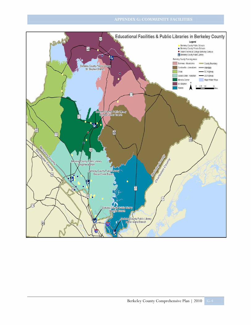
APPENDIX G: COMMUNITY FACILITIES
Berkeley County Comprehensive Plan | 2010 G-4

APPENDIX G: COMMUNITY FACILITIES
Berkeley County Comprehensive Plan | 2010 G-5
Public Water Systems
Public water supply is available to some Berkeley County residents through various agencies which include Berkeley County Water and Sanitation, Charleston Water System, the Town of Jamestown, the City of Goose Creek, and the Town of Moncks Corner. The service area jurisdictions for these providers can be seen in the map below.
The water lines present within Berkeley County may be seen in the map below. It can be assumed that areas within the County where no waterlines are present, mostly rural areas, obtain water resources from individual, on-site drilled or dug wells. Most residents relying on public water live within incorporated municipalities while those working on well water in unincorporated, rural areas of the County.
If installed and operated properly, wells provide residents with a safe and cost effective alternative to public water, however, areas of higher density may benefit from the extension of public or municipal water systems. As the County continues to expand and some areas become denser than others, residents may wish to consider the extension of these public systems to more dense areas of the County.
While wells remain a viable option in Berkeley County, groundwater contamination in the vicinity of functioning wells poses a health risk to residents. Those operating on a well should have their water tested regularly through the South Carolina Department of Natural Resources, Berkeley County Department of Water & Sanitation Authority or an outside contractor.

APPENDIX G: COMMUNITY FACILITIES
Berkeley County Comprehensive Plan | 2010 G-6
Public Wastewater Systems
Public Sewer service is available to some Berkeley County residents through one of the following agencies whose service areas are illustrated in the map to the right: Berkeley County Water & Sanitation Authority, Charleston Water System, the Town of Moncks Corner, and the Town of Summerville Commissioners of Public Works.
Similar to trends in water service, many residents in the more rural areas of the County, where sewer lines are not present, rely on private wastewater systems, primarily in the form of septic tanks or cesspools.
It is imperative that owners of private wastewater systems install and operate them correctly. If operated inappropriately, these systems can lead to groundwater contamination that is a great health risk to other residents.
The location of public sewer lines in the County will greatly dictate where and when development will occur and should be used as a tool for planning future growth. Existing lines within the County may be seen in the map above. As shown in the maps of water and sewer service provider jurisdictions, the major provider of both services for the County is Berkeley County Water and Sanitation.
Berkeley County Water and Sanitation
• BCWS is solely funded by rates and fees
• Employees: 237 • Annual Operating Budget:
$47.8 million • Current number of Capital
Projects: 25 • Total Assets: $350 million • Vehicles: 143 • Pump Stations: 130 • Miles of Pipe:
Approximately 1,350 • Capacity:
a. Waste water – 19 million gallons per day
b. Water- 40 million gallons per day
• Customers: Approximately 39,000

APPENDIX G: COMMUNITY FACILITIES
Berkeley County Comprehensive Plan | 2010 G-7
Solid Waste Management
There are several different types of landfills which accept varying types of waste. These include: industrial waste landfills, hazardous waste landfills, construction and demolition debris landfills, and municipal solid waste landfills. While Berkeley County residents have access to all of the above types of landfill, our primary focus is in municipal solid waste facilities, where household waste is collected. The only active municipal solid waste facility in Berkeley County is the Berkeley County Water and Sanitation Municipal Solid Waste Landfill, located at 555 Oakley Road, Moncks Corner. Because of the rural nature of Berkeley County, it is expensive and impractical to provide curb-side trash pick up to all County residents. Curb side pick-up is available within the Municipal limits of Summerville, Hanahan, Moncks Corner, and Goose Creek. Effective July 1st, 2008, the tipping fee for Berkeley County’s construction and demolition landfill increased from $21 a ton to $28.
Recycling is an important component of solid waste management. Berkeley County Water and Sanitation operates a recycling program at the Municipal Waste Landfill cited above and the County manages several drop-off facilities throughout the County. Only the portion of the Town of Summerville, located in Berkeley County, receives curb-side recycling service.
Berkeley County, along with private partnerships, is currently in the midst of creating an energy park at the site of its Municipal Landfill. Although funding and revenues for the project have yet to be determined, proposed initiatives include extracting gas, electricity and other energy sources from waste and creating electricity or natural gas from the methane emitted from mounds of decaying trash. Plans also call for wood waste to be used as fuel for a biomass burner that generates electricity. Another initiative would take used restaurant oils and create pellets that burn like coal.
Public Safety Services
Fire Protection
Each incorporated municipality has organized fire protection, either municipal or rural. The rural areas of the County are protected by contract or rural fire protection districts. Some such districts are the Goose Creek Rural Fire Protection District, Whitesville Rural Fire Department, Santee Circle Rural Fire Department and the Pimlico Rural Volunteer Fire Department.
Forty-two fire departments, listed in the following table, provide fire protection services to Berkeley County residents.
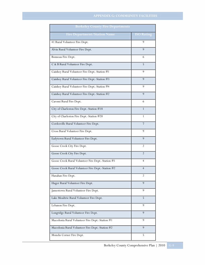
APPENDIX G: COMMUNITY FACILITIES
Berkeley County Comprehensive Plan | 2010 G-8
Berkeley County Fire Departments
Fire Department/Station Name ISO Rating
41 Rural Volunteer Fire Dept. 9
Alvin Rural Volunteer Fire Dept. 9
Bonneau Fire Dept. 6
C & B Rural Volunteer Fire Dept. 5
Cainhoy Rural Volunteer Fire Dept.-Station #1 9
Cainhoy Rural Volunteer Fire Dept.-Station #3 9
Cainhoy Rural Volunteer Fire Dept.-Station #4 9
Cainhoy Rural Volunteer Fire Dept.-Station #2 9
Caromi Rural Fire Dept. 6
City of Charleston Fire Dept.-Station #18 1
City of Charleston Fire Dept.-Station #20 1
Cordesville Rural Volunteer Fire Dept. 7
Cross Rural Volunteer Fire Dept. 9
Eadytown Rural Volunteer Fire Dept. 9
Goose Creek City Fire Dept. 2
Goose Creek City Fire Dept. 2
Goose Creek Rural Volunteer Fire Dept.-Station #1 4
Goose Creek Rural Volunteer Fire Dept.-Station #2 4
Hanahan Fire Dept. 2
Huger Rural Volunteer Fire Dept. 9
Jamestown Rural Volunteer Fire Dept. 9
Lake Moultrie Rural Volunteer Fire Dept. 5
Lebanon Fire Dept. 9
Longridge Rural Volunteer Fire Dept. 9
Macedonia Rural Volunteer Fire Dept.-Station #1 9
Macedonia Rural Volunteer Fire Dept.-Station #2 9
Moncks Corner Fire Dept. 5
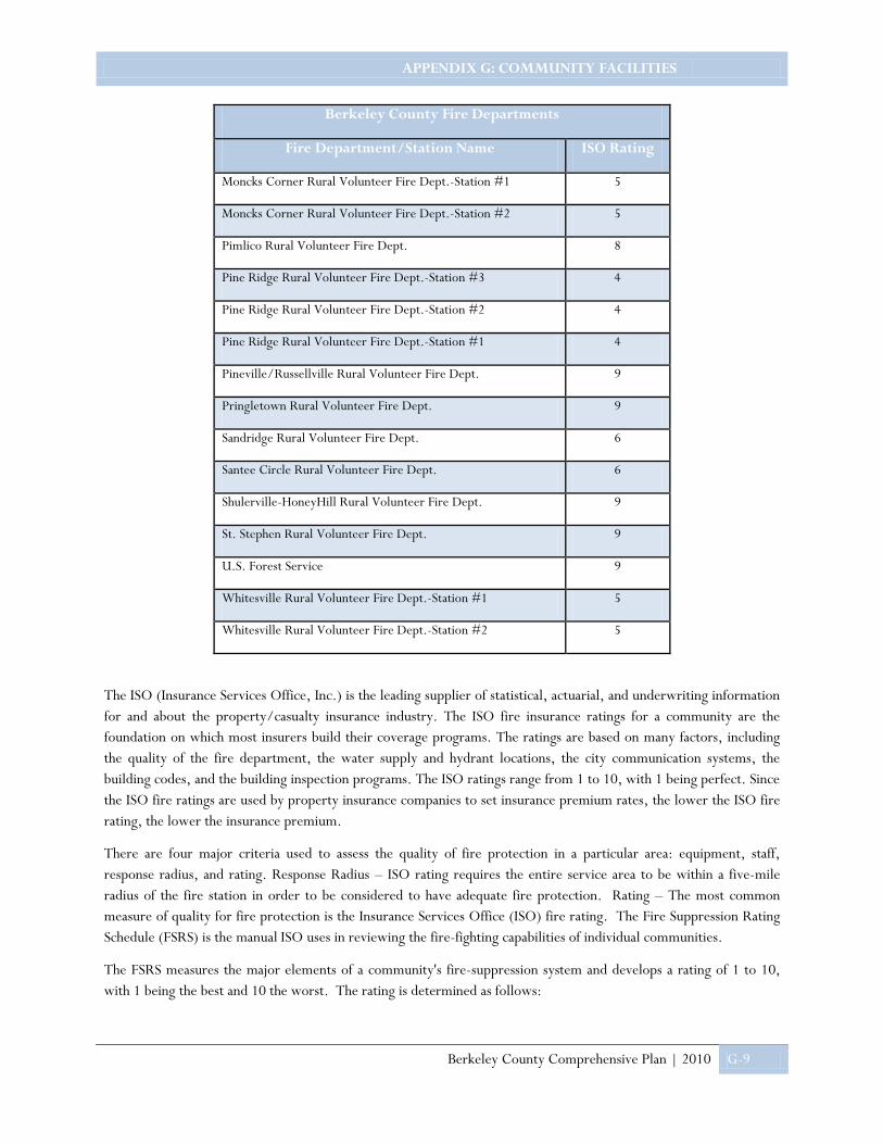
APPENDIX G: COMMUNITY FACILITIES
Berkeley County Comprehensive Plan | 2010 G-9
Berkeley County Fire Departments
Fire Department/Station Name ISO Rating
Moncks Corner Rural Volunteer Fire Dept.-Station #1 5
Moncks Corner Rural Volunteer Fire Dept.-Station #2 5
Pimlico Rural Volunteer Fire Dept. 8
Pine Ridge Rural Volunteer Fire Dept.-Station #3 4
Pine Ridge Rural Volunteer Fire Dept.-Station #2 4
Pine Ridge Rural Volunteer Fire Dept.-Station #1 4
Pineville/Russellville Rural Volunteer Fire Dept. 9
Pringletown Rural Volunteer Fire Dept. 9
Sandridge Rural Volunteer Fire Dept. 6
Santee Circle Rural Volunteer Fire Dept. 6
Shulerville-HoneyHill Rural Volunteer Fire Dept. 9
St. Stephen Rural Volunteer Fire Dept. 9
U.S. Forest Service 9
Whitesville Rural Volunteer Fire Dept.-Station #1 5
Whitesville Rural Volunteer Fire Dept.-Station #2 5
The ISO (Insurance Services Office, Inc.) is the leading supplier of statistical, actuarial, and underwriting information for and about the property/casualty insurance industry. The ISO fire insurance ratings for a community are the foundation on which most insurers build their coverage programs. The ratings are based on many factors, including the quality of the fire department, the water supply and hydrant locations, the city communication systems, the building codes, and the building inspection programs. The ISO ratings range from 1 to 10, with 1 being perfect. Since the ISO fire ratings are used by property insurance companies to set insurance premium rates, the lower the ISO fire rating, the lower the insurance premium.
There are four major criteria used to assess the quality of fire protection in a particular area: equipment, staff, response radius, and rating. Response Radius – ISO rating requires the entire service area to be within a five-mile radius of the fire station in order to be considered to have adequate fire protection. Rating – The most common measure of quality for fire protection is the Insurance Services Office (ISO) fire rating. The Fire Suppression Rating Schedule (FSRS) is the manual ISO uses in reviewing the fire-fighting capabilities of individual communities.
The FSRS measures the major elements of a community's fire-suppression system and develops a rating of 1 to 10, with 1 being the best and 10 the worst. The rating is determined as follows:
APPENDIX G: COMMUNITY FACILITIES
Berkeley County Comprehensive Plan | 2010 G-10
• Ten percent (10%) of the overall grading is based on how well the fire department receives fire alarms and dispatches its fire-fighting resources.
• Fifty percent (50%) of the overall grading is based on the number of engine companies and the amount of water a community needs to fight a fire. ISO also reviews the fire-company records to determine type and extent of training provided to fire-company personnel, number of people who participate in training, firefighter response to emergencies, and maintenance and testing of the fire department's equipment.
• Forty percent (40%) of the grading is based on the community's water supply. This part of the survey focuses on whether the community has sufficient water supply for fire suppression beyond daily maximum consumption.
Berkeley County Emergency Medical Services (EMS) is designed to meet the needs of the citizenry in times of medical crisis. Berkeley County EMS's rapid 24 hour a day services are a blend of disciplines designed to meet varying emergent needs that may arise no matter what the nature of the emergency. Average response time is 8 minutes.
The trained staff of Berkeley County’s Emergency Medical Services responds to approximately 14,000 medical emergencies each year.
The importance of skilled professional personnel, state of the art equipment, and reliable vehicles cannot be overstated. The annual budget of $3.8 million, a third of which comes from billing procedures, allows Berkeley County EMS to participate in rescue operations, establish routine procedures for children and adults, and plan for future growth. The County employs 120 Certified Medics. Emergency Medical Service Personnel per Berkeley County Citizen is 1 to 1,225.
Police Protection
Berkeley County residents are protected by the men and women of the Berkeley County Sheriff’s office. The Sheriff’s office is divided into seven departments and two offices in order to ensure that Berkeley County residents are provided with adequate police presence and protection. These departments and offices along with a brief description are as follows:
• The Patrol Division-consists of four squads of deputies who alternately patrol the entire county in twelve-hour shifts and respond to all calls dispatched by 911 operators.
• The Investigations Division is comprised of a team of highly trained detectives who investigate violent crimes and property crimes.
• School Resource Officers-these officers are placed in all Berkeley County high and middle schools. These specially trained deputies are available to resolve conflicts which arise within the school environment.
• The Narcotics Division-investigates drug activity and is available to receive information 24 hours a day.
• Selective Enforcement Team (SET) - team of deputies who patrol targeted areas in the County which have been identified as high crime areas, or areas which have unsafe traffic patterns.
• Special Response Team (SRT) - consists of highly trained deputies who respond to crisis situations such as manhunts, armed robberies, and hostage situations. They are activated by the Command Staff when the need arises. The team members are trained in special weapons use and in hostage negotiations.
• K-9 Unit-each patrol squad has a canine officer and trained canine. They are available to search for contraband, guns, evidence and missing persons.
• The Duty Office-duty Officers respond to non-emergency situations that require a report. Reports can be made by telephone or in person at the Sheriff's Office.

APPENDIX G: COMMUNITY FACILITIES
Berkeley County Comprehensive Plan | 2010 G-11
• The Records Office-located in the Sheriff's Office and will provide copies of incident reports when requested in person.
• The Training Office-located at the Berkeley County Training Center on Reid Hill Road. These new County facilities are used for training Berkeley County law enforcement officers, fire fighters and EMS personnel. Deputies receive training from in-house certified instructors as well as Academy training via satellite. This training is required in order to meet State certification requirements.
The Berkeley County Sherriff’s Office also operates some special services which include:
• Reserve Officers-Berkeley County has the largest contingent of Reserve Officers in the State. An average of 40 Reserve Officers are available to augment patrol squads. These officers are trained and certified by the State. Selection of new reserve officers is made in January of each year, with class graduation typically in the spring.
• Victims' Advocate-This is available to victims of violent crime including domestic violence. Referral to other agencies, legal assistance, and counseling are available to victims.
• Crime Watch-Encourages residents in a subdivision, neighborhood or rural area to be observant of activities and to report suspicious activities to the Sheriff's Office. A booklet is available from the Sheriff's Office which explains how to organize and conduct Crime Watch activities in your area.
• Traffic Escorts-Available for funerals, parades and other organized events
• Special Patrol-Requests may be made when citizens are out of town or away from their homes for an extended time.
• The Crime Analysis Unit-Records all criminal incidents in the County. Crime statistics are available to Crime Watch groups, homeowners and private businesses for their areas.
• Volunteers-The Sheriff's Office is fortunate to have committed volunteers who augment the full-time staff. Volunteers provide their services in the Detective Office, in Crime Analysis and in the Training Office.
Emergency Preparedness
Because of its location, Berkeley County is threatened by various natural, technological, societal and man-made hazards. These hazards endanger the health and safety of the population of the region, jeopardize the economic vitality, and imperil the quality of the environment. Because of the importance of mitigating the loss of life and property, the South Carolina Emergency Management Division requested that the BCD Council of Governments (BCDCOG) undertake a comprehensive planning process for both Berkeley and Dorchester Counties. In 2004, this request culminated in the publication of the document: “The Berkeley – Dorchester Hazard Mitigation Plan” (BDHMP). The BDHMP Plan addresses the tasking and responsibilities of individuals and agencies for various types and phases of disaster emergencies. Individual sections included within the Plan include direct response procedures for the emergency operation center, communications, public information, fire and rescue services, medical services, transportation and evacuation of residents. Each section includes an organization chart, notification list, list of facilities and communication networks for that particular response. The Plan also provides the process for bringing in emergency shelters on-line and staffing them in the event of a disaster.
APPENDIX G: COMMUNITY FACILITIES
Berkeley County Comprehensive Plan | 2010 G-12
In the plan, the County government assumes responsibility for direction of combined emergency operations in areas where municipal capability has broken down or does not exist. The County supports disaster operations of the local municipalities with County resources only after all local resources have been used or are inadequate to handle the situation. The projects and programs designed to reduce the impacts of future hazard events are referred to as “mitigation action plans” in the document. Mitigation action plans were developed by each jurisdiction for implementation whenever the resources to do so become available. As the mitigation action plans in this Plan are implemented, Berkeley will become a more “disaster-resistant” County.
Health Care Facilities
Health care facilities located in Berkeley County are listed below.
Although there appears to be an abundance of facilities in the County, a large percentage of these facilities provide in-home care, presumably for the elderly, or other services geared specifically to the elderly population. This information suggests a lack of health care facilities providing services for the general population in the County, a common problem in primarily rural communities.
Berkeley County Health Care Facilities
Facility Name
DeHay Community Residence Quality Care Residential Home II
Villa of Moncks Corner Active Day Center Antonio-Vause, Inc.
Ernest E. Kennedy Center, Inc. Oakview Boarding Home
Magnolia Manor-Moncks Corner Omoooo Community Care Home
Conifer I Community Residence S & W Community Care Home
Conifer II Community Residence Lake Moultrie Nursing Facility
Goose Creek Residential Care #2 Moncks Corner Adult Day Care
Goose Creek Residential Care #1 Rainbow Residential Home
Home Health Services, Inc. Heartland Health Care Center - Charleston

APPENDIX G: COMMUNITY FACILITIES
Berkeley County Comprehensive Plan | 2010 G-13
The County is fortunate enough to have a centrally located branch of Roper Hospital in Moncks Corner, The Roper Berkeley Ambulatory Surgery Center.
Government Facilities
Berkeley County Government functions take place centrally, in Moncks Corner. The County is governed by an eight member council, serving four year terms, and a chair and vice-chair, serving two year terms. Berkeley County Government is comprised of numerous departments that include but are not exclusive of administrative services, animal control, coroner, detention centers, permitting, court, abatement, tax collector, treasurer and the like. The County owns over sixty buildings and employees over 800 full-time employees.
Recreational Facilities
Berkeley County has abundant recreation resources, most commonly found in association with the area’s natural and cultural resources. Despite these recreation resources, the County does not have an excess of public recreation facilities, playgrounds or ballparks for community use, for example.
APPENDIX G: COMMUNITY FACILITIES
Berkeley County Comprehensive Plan | 2010 G-14
Since the last update of this plan was completed, Santee Cooper has opened the Richardson Landing in Berkeley County. The landing is a six-acre public boat-launching facility constructed at Bonneau Beach on Lake Moultrie. The amenities include a two-lane boat ramp, parking lot with spaces for 75 vehicles, fishing pier and dock.
A recreation site has also opened at Lions Beach. Lions Beach is located on the shore of Lake Moultrie and features a clean, sandy beach and a YMCA on site.
The State of South Carolina has taken a positive stance to ensure that the waterways of the state will always be available for public use. Because of its physical relation to the water, Berkeley County offers an excellent venue for kayaking as well as other water sports and the blueways in the area represent one of the County’s greatest assets in terms of recreational value. The Berkeley County Blueways paddling trail system identifies over 175 miles of total water course from 23 trails and is a result of the vision and efforts of many individuals and organizations working in partnership.
APPENDIX H: TRANSPORTATION ELEMENT
Berkeley County Comprehensive Plan |2010 H-1
Transportation Transportation decisions affect the character of the community and the county by influencing the accessibility of land for various urban and rural uses, the density of development, and the location of various commercial and industrial uses. By controlling the ease and speed of access to markets and resources, the transportation network exerts a strong influence on economic growth and productivity as well as residential growth.
Proposed land use policies for each planning area should therefore be evaluated in depth when determining whether future transportation improvement proposals should be approved in coordination. Conversely, the adequacy and future maintenance of existing roads and streets, and alternative modes of transportation should be considered in evaluating the impacts of proposed residential development. The interrelationship between transportation systems and land use policies will be further discussed in the Land Use element of this plan.
Transportation Systems As the population of Berkeley County continues to rise and new industries locate in new areas of the county, establishment and maintenance of an efficient transportation system becomes critical. The transportation network of Berkeley County is intimately connected with the regional transportation network. While the County has the ability to directly address issues related to the effectiveness of the transportation system within its boundaries, it also has a voice in regional transportation planning as a member of the Metropolitan Planning Organization, known as Charleston Area Transportation Study or CHATS.
Roads and buses are two primary modes of transportation which exist in Berkeley County, connecting residents of rural and urban neighborhoods with places where they work and play. Other functions of transportation, such as water-based and rail are available for the movement of goods rather than people. Each of these transportation networks or systems is managed by agencies outside the county system to a certain degree. The following discussion summarizes the existing networks, the agency responsible for them, what improvements are needed, and what improvements are currently planned.
Road Network
A road network is made up of a variety of different types of facilities with independent yet complimentary uses. The Federal Highway Administration (FHWA) has classified roads and highways into groups according to their function. These classifications are termed functional class definitions and those existing in the area are defined in the Figure Berkeley County Road Network.
Arterials
Collectors
Locals
Portion of Service Graph from the Highway Capacity Manual. Transportation Research Board. This figure portrays the intended relationship of functionally classified systems in service traffic mobility and land access.

APPENDIX H: TRANSPORTATION ELEMENT
Berkeley County Comprehensive Plan |2010 H-2
Within Berkeley County, there are roads owned and maintained by the South Carolina Department of Transportation (SCDOT), the county, private developers and individuals. The City of Charleston maintains streets on Daniel Island. In addition, numerous roads are the responsibility of the federal government and the US Forest Service. In the past, roads constructed by a developer eventually became a part of the state highway maintenance system under the Beltline Act. Recently the State Department of Transportation Commission capped the number of roads it would maintain and placed responsibility for all new roads to be accepted within the county system rather than the state system.
While public roads are maintained by the County and State, it is important to note that different agencies are responsible for planning and funding improvements of these roads. The US Forest Service is responsible for most of the roads within the Francis Marion National Forest and contracts with private firms for maintenance of these roads. The County participates in the maintenance of roads within the forest where pockets of private property exist. Currently these roads constitute 15 miles of primary maintenance responsibility for the County, but as traffic through the forest increases, the County will be asked to maintain additional miles of roadway. Funding for maintenance and/or improvement of these roads is included in the federal budget for the Forest Service.
Another principal party responsible for planning and funding operational improvements on existing roads is SCDOT. SCDOT adopts a six-year road plan (the Statewide Transportation Improvement Program - STIP) on an annual basis that lists proposed road improvements and applicable funding sources. Gas tax revenues collected by the state and federal tax dollars are used to fund SCDOT projects. Funding for major projects, such as 17A widening, is allocated through the BCDCOG Board of Directors and its subcommittee, the Rural Transportation Planning Committee. These funds are known as Rural Guideshare funds.
CHATS MPO 2030 Plan
• US 17 Alternate from Cypress Garden Road to SC 6 (proposed widening to five lanes) • College Park Road from Corporate Parkway to US Hwy. 17 A. • Enhancement: Construction of municipal center hiker/biker trail along US Highway 52. • Railroad Avenue extension from Eagle Landing Blvd. to Mabeline Rd. • Pedestrian / bicycle facility improvements to enhance safety around the school location at Boulder Bluff
Elementary School • Improvements to Jedburg Rd and Old Orangeburg Road to link with 61 Expressway begins in Berkeley
at I-26 • Murray Dr. @ Hanahan Rd. intersections improvement • SIB application projects • Commuter rail study – US 52 corridor • Regional Land use plan • 5310 Berkeley Citizens –purchase of service • Tri-County Link 5311 funding • Tri-County Link rural 5316/17 funding for express bus service • CARTA express bus vehicle acquisition

APPENDIX H: TRANSPORTATION ELEMENT
Berkeley County Comprehensive Plan |2010 H-3
Projects are to be included in the BCDCOG Rural Long-Range Transportation Plan and the BCDCOG Rural TIP. The BCDCOG Rural Guideshare allocation is currently $2.65 Million per year.
Other road improvements, planned by the County Transportation Committee (CTC), are funded with gas tax funds (2.66 cents per gallon) collected by the state and appropriated to each county based upon its land area, population, and road mileage.
Other roads planned in the metropolitan area are developed by the Charleston Area Transportation Study (CHATS), the Metropolitan Planning Organization for the BCD region, which is staffed by the BCD Council of Governments. Funding for CHATS improvements come from various sources
including the Federal transportation funding authorization, Safe, Accountable, Flexible, and Efficient Transportation Equity Act: A Legacy for Users (SAFETEA-LU). However, these programs mandate developing plans for more efficient use of existing facilities, multimodal planning, and funding for transportation enhancements. The CHATS Policy Committee provides a forum for local decision making concerning transportation policies and priorities in the entire Census-defined urbanized area. It is composed of elected officials from the governments within the study area, legislators, and representatives from various transportation fields. In Berkeley County, the CHATS study area includes the Goose Creek-Hanahan planning area and a significant portion of the Wando planning area.

APPENDIX H: TRANSPORTATION ELEMENT
Berkeley County Comprehensive Plan |2010 H-4
Tri-County Link (formally BCD RTMA) is the major provider of public transportation in the County. Tri-County Link aims to provide fixed-route, demand-response service funded by Medicaid, FTA Section 5310, and contract service to the rural areas of Berkeley, Charleston, and Dorchester counties. In addition to fixed stops along each route, Tri-County Link is a flag stop system, which means that riders can just stand at a safe location along the route; wave and the bus will stop to pick them up.
Tri-County Link has four routes that run through Berkeley County: B101 Moncks Corner – Cross – St. Stephen – Jamestown; B102 Moncks Corner – North Charleston – Hanahan; B104 St. Stephen – Bonneau – Moncks Corner; B105 Moncks Corner – Cainhoy – Mount Pleasant. The Commuter Solution Route, a non-stop express service focusing on daily commuters, runs from Moncks Corner to Rivers Avenue. Here commuters can connect to CARTA Express, which is currently a free transfer. A
second Commuter Solutions Route operates along US Highway 17 A between the Town of Summerville and the Town of Moncks Corner. Along the Commuter Solutions Route, there are four Park & Ride facilities. For the most up to date information regarding routes to and from these locations please visit the Tri-County Link website at www.ridetricountylink.com and the CARTA website at www.ridecarta.com.
BBeerrkkeelleeyy CCoouunnttyy PPuubblliicc TTrraannssiitt
APPENDIX H: TRANSPORTATION ELEMENT
Berkeley County Comprehensive Plan |2010 H-5
Airports The Berkeley County Airport is located off US 17A, south of Moncks Corner. The County built the airport in the mid-fifties. In the late sixties, early seventies, the runway was paved and the first terminal was constructed. The airport is still owned and operated by the County. The County took over the Fixed Based Operation (FBO) at the airport on July 1, 1999. Operating the FBO, guarantees Berkeley County the opportunity to provide exemplary service and to do so efficiently and effectively. A full-time staff operating 7 days per week, allows Berkeley County to develop the airport and support the increasing aviation needs of the community. The airport is primarily used as a base for individual private flights, other services include: aviation fuel, aviation oil, aeronautical chart sales, hanger rental, rental car coordination, aircraft tie down, aircraft hangar storage, courtesy car for pilots, supplies and a pilots’ lounge.
The Berkeley County Airport Layout Plan was last updated in 1991 by Wilbur-Smith and Associates. The plan is basically a strategic plan for staged development of the airport based on current inventory and operations and projecting those numbers into growth projections in stages of 5, 10, 15, and 20 years in the future.
The Charleston International Airport is located in Charleston County near the southwest urban area of Berkeley County. The airport is easily accessed off I-526, which crosses the tip of Berkeley County. Located adjacent to the Charleston Air Force Base, this airport provides commercial and military air service for the region. In 2006, a total of 943,305 passengers were enplaned on the scheduled, commuter and charter airlines serving the airport. Several of the major airlines provide direct commuter flights to, or connecting flights through, Atlanta and Charlotte, N.C.
Rail Network Railroads have historically played an important role in the economy of Berkeley County, beginning in the mid-19th century with construction of the railroad from Charleston to Moncks Corner, St. Stephen, and Florence. These railroads made it easier and quicker for mercantilists to bring goods down from the upstate. Later in the century, the same rail system made it possible for the timber industry to develop. A line of the Georgetown and Western Railroad began building a link into Berkeley County in 1913, crossing the Santee River at Jamestown on a steel truss bridge.
AIRPORT PROJECTS WEST APRON EXPANSION AND APRON REHABILITATION PROJECT The project was designed by The LPA Group, from Columbia, SC. The design phase was funded in FY 1998/1999 and the construction phase was funded in FY 2000/2001. Funding was provided by the Federal Aviation Administration 90%, State of South Carolina 5%, Berkeley County 5%, and Berkeley Electric Cooperative who contributed 5% for the design phase. The project consisted of constructing 7,033 square yards of new apron, 4,667 square yards of pavement overlay on existing apron, and complete reconstruction of 5,333 square yards of existing apron, bringing the total apron area to 17,033 square yards. Also included in the project were new perimeter lights on the apron, a new lighting vault and construction of an additional apron/taxiway connector. The previous apron was in some areas over 30 years old and other areas about 15 years old, all areas had severe cracking; there were 17 airplane tie-downs. Now there are 36 airplane tie-downs. PARALLEL TAXIWAY REHABILITATION AND EXTENSION PROJECT Currently the taxiway at the Berkeley County Airport is only 1900 feet in length, which only parallels half of the runway. This project will lengthen the taxiway to a full-length parallel and overlay the existing taxiway. Also included will be undercutting 2 runway/taxiway connectors and all associated taxiway lighting and signage. The project is funded 90% FAA, 5% State and 5% Local. RUNWAY EXTENSION AND WIDENING PROJECT This project is still in the preliminary stages and allows for incremental growth of the existing 3,800 feet X 75 feet runway to ultimately 5,500 feet X 100 feet. This will likely come in two
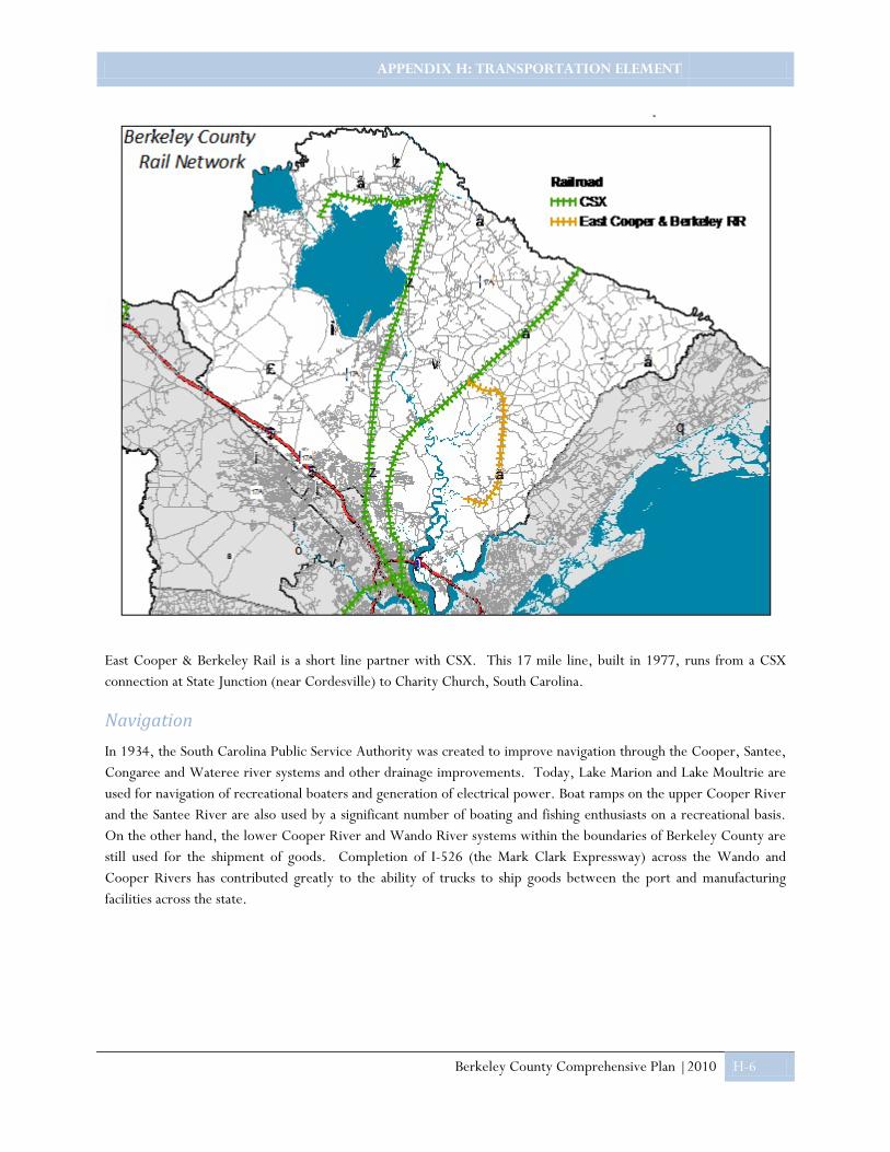
APPENDIX H: TRANSPORTATION ELEMENT
Berkeley County Comprehensive Plan |2010 H-6
East Cooper & Berkeley Rail is a short line partner with CSX. This 17 mile line, built in 1977, runs from a CSX connection at State Junction (near Cordesville) to Charity Church, South Carolina.
Navigation In 1934, the South Carolina Public Service Authority was created to improve navigation through the Cooper, Santee, Congaree and Wateree river systems and other drainage improvements. Today, Lake Marion and Lake Moultrie are used for navigation of recreational boaters and generation of electrical power. Boat ramps on the upper Cooper River and the Santee River are also used by a significant number of boating and fishing enthusiasts on a recreational basis. On the other hand, the lower Cooper River and Wando River systems within the boundaries of Berkeley County are still used for the shipment of goods. Completion of I-526 (the Mark Clark Expressway) across the Wando and Cooper Rivers has contributed greatly to the ability of trucks to ship goods between the port and manufacturing facilities across the state.

APPENDIX I: PRIORITY INVESTMENT ELEMENT
Berkeley County Comprehensive Plan | 2010 I-1
Priority Investment This Priority Investment Area Element examines opportunities for Berkeley County to expand infrastructure, improve services, establish market-based incentives, develop affordable and workforce housing, promote traditional neighborhoods, and provide planning commissions a context to guide further planning for their county and increase intergovernmental coordination.
Enabling Legislation
In 2007 the General Assembly passed the Priority Investment Act. The Act includes several amendments to the 1994 Comprehensive Planning Enabling Act, including the addition of a Priority Investment Element. The Act reads as follows:
“A priority investment element that analyzes the likely federal, state, and local funds available for public infrastructure and facilities during the next ten years, and recommends the projects for expenditure of those funds during the next ten years for needed public infrastructure and facilities such as water, sewer, roads, and schools. The recommendation of those projects for public expenditure must be done through coordination with adjacent and relevant jurisdictions and agencies. For the purposes of this item, ‘adjacent and relevant jurisdictions and agencies’ means those counties, municipalities, public service districts, school districts, public and private utilities, transportation agencies, and other public entities that are affected by or have planning authority over the public project. For the purposes of this item, ‘coordination’ means written notification by the local planning commission or its staff to adjacent and relevant jurisdictions and agencies of the proposed projects and the opportunity for adjacent and relevant jurisdictions and agencies to provide comment to the planning commission or its staff concerning the proposed projects. Failure of the planning commission or its staff to identify or notify an adjacent or relevant jurisdiction or agency does not invalidate the local comprehensive plan and does not give rise to a civil cause of action.”
Intent of the Act
According Ben A. Hagood, Jr., Esq., the principal author of the Priority Investment Act, “the intent of the Act is to preserve and enhance quality of life throughout South Carolina by better planning and coordination of public infrastructure decisions and by encouraging the development of affordable housing and traditional neighborhood design… By requiring better local government planning as well as encouraging the use of market-based incentives and the elimination of nonessential regulations, the Priority Investment Act will save taxpayer dollars on needed governmental infrastructure and enhance the vitality of our local communities.”
South Carolina Priority Investment Act: Implementation Guide for Local Governments produced by the Municipal Association of South Carolina is a valuable resource.
http://www.masc.sc/SiteCollectionDocuments/Land%20Use%20Planning/PIA.pdf

APPENDIX I: PRIORITY INVESTMENT ELEMENT
Berkeley County Comprehensive Plan | 2010 I-2
Priority Investment Areas
Capital Improvements Program and Scheduled Transportation Projects
Berkeley County is a member of the Charleston Area Transportation Study (CHATS) and took part in the composition of the CHATS Long-Range Transportation Plan (LRTP) for the Berkeley-Charleston-Dorchester Region. The LRTP identifies road construction and upgrade projects to be undertaken using a variety of funding sources, which include Guide-Share Funds, Sales Tax Funds, and Non-Guide-Share Funds that may employ innovative financing methods from both public and private sources. A road improvement project set on a path to construction must appear in the region’s Transportation Improvements Program (TIP). The TIP names committed funding sources and sets timelines for completion as accurately as possible.
Multiple projects in Berkeley County appear in the CHATS LRTP, including the widening of College Park Road from US 17 Alternate to Crowfield Boulevard, US 17 Alternate widening from US 176 to SC 6, improvements at Murray Drive at Hanahan Road, Clements Ferry Road from I 526 to Jack Primus Road, the Railroad Avenue extension, and the Henry Brown Boulevard extension. Goose Creek also continues to construct their hiker-biker trail network -transit routes in Berkeley County.
The Berkeley County Capital Improvements Program (CIP) currently identifies improvements to the following County public facilities:
• Land purchase and site improvements to Health & Human Services Campus;
• Expansion of Detention Center;
• New site for Hanahan Branch Library;
• Berkeley Senior Center Expansion;
• Public Works Compound improvements;
• New roof for Public Buildings Department Facility; and
• Addition to Maintenance Garage.
Also included in the CIP are the expense timelines and funding sources for these improvements.
Conservation Areas: “Where Not to Grow”
Citizens of Berkeley County have expressed their concerns over the loss of agricultural land in historic communities within rural Berkeley County, such as Lebanon and Honey Hill. While these communities have enjoyed relative isolation, unprecedented growth is beginning to threaten this isolation. Residents desire to conserve certain areas such as these throughout Berkeley County and consideration should be give as to how to preserve them through resource management corridors or the clustering of new development in such a way that these types of communities are not adversely impacted.
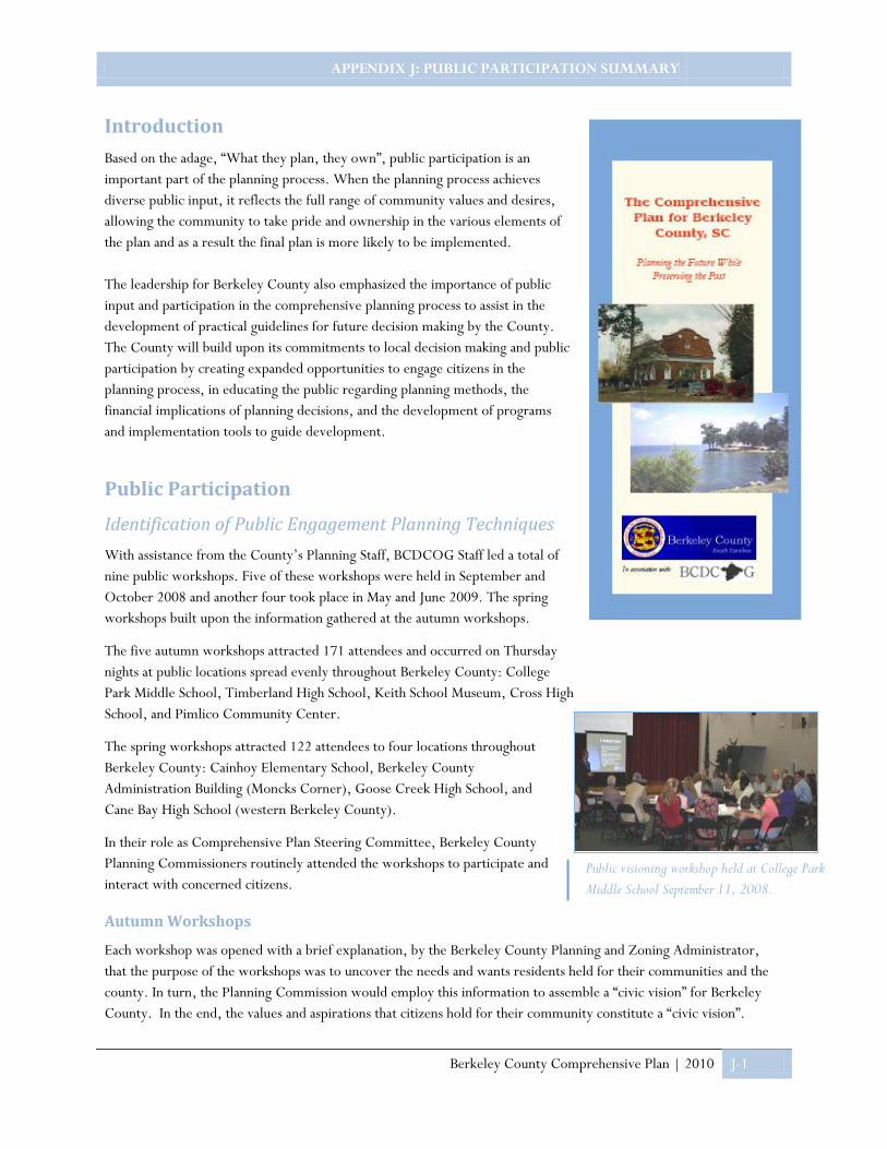
APPENDIX J: PUBLIC PARTICIPATION SUMMARY
Berkeley County Comprehensive Plan | 2010 J-1
Introduction Based on the adage, “What they plan, they own”, public participation is an important part of the planning process. When the planning process achieves diverse public input, it reflects the full range of community values and desires, allowing the community to take pride and ownership in the various elements of the plan and as a result the final plan is more likely to be implemented. The leadership for Berkeley County also emphasized the importance of public input and participation in the comprehensive planning process to assist in the development of practical guidelines for future decision making by the County. The County will build upon its commitments to local decision making and public participation by creating expanded opportunities to engage citizens in the planning process, in educating the public regarding planning methods, the financial implications of planning decisions, and the development of programs and implementation tools to guide development.
Public Participation
Identification of Public Engagement Planning Techniques With assistance from the County’s Planning Staff, BCDCOG Staff led a total of nine public workshops. Five of these workshops were held in September and October 2008 and another four took place in May and June 2009. The spring workshops built upon the information gathered at the autumn workshops.
The five autumn workshops attracted 171 attendees and occurred on Thursday nights at public locations spread evenly throughout Berkeley County: College Park Middle School, Timberland High School, Keith School Museum, Cross High School, and Pimlico Community Center.
The spring workshops attracted 122 attendees to four locations throughout Berkeley County: Cainhoy Elementary School, Berkeley County Administration Building (Moncks Corner), Goose Creek High School, and Cane Bay High School (western Berkeley County).
In their role as Comprehensive Plan Steering Committee, Berkeley County Planning Commissioners routinely attended the workshops to participate and interact with concerned citizens.
Autumn Workshops
Each workshop was opened with a brief explanation, by the Berkeley County Planning and Zoning Administrator, that the purpose of the workshops was to uncover the needs and wants residents held for their communities and the county. In turn, the Planning Commission would employ this information to assemble a “civic vision” for Berkeley County. In the end, the values and aspirations that citizens hold for their community constitute a “civic vision”.
Public visioning workshop held at College Park Middle School September 11, 2008.
APPENDIX J: PUBLIC PARTICIPATION SUMMARY
Berkeley County Comprehensive Plan | 2010 J-2
BCDCOG Planning Staff opened its presentation with the five guiding principles of the comprehensive plan, developed by the Planning Commission:
• Protect and promote distinctive, diverse communities;
• Manage infrastructure systems effectively and expand them efficiently;
• Respect and enhance historical and natural resources and expand their public accessibility;
• Make recreational opportunities – both active and passive – available county-wide; and
• Draft a clear, fair plan to be implemented through simplified costs and streamlined processes.
The audience was then briefed on Berkeley County growth trends and shown maps to help them visualize where this growth is occurring.
Next, participants organized themselves around tables into small discussion groups, facilitated by a BCDCOG or County planner. Participants took this opportunity to review photographs of various community components and indicate to planners which they felt were most and least appropriate for their communities. For instance, one of the most popular images was that of a child’s playset located in a pocket park in Goose Creek. Many participants responded that the playset would be a valuable addition to their community. A playset, therefore, would be part of the citizen’s “civic vision”.
The same process followed for 13 example neighborhoods, 12 commercial examples, and 14 images of roads. Based on these, citizens provided input regarding specific components for their communities and expressed their greatest hopes and concerns for the future of Berkeley County, which can be found at the end of this document titled Community Hopes and Concerns. The results of the autumn workshop can be found below in the Community Visioning Preferences.
Community Visioning Preferences
The autumn workshops focused on four topics: community facilities, workforce housing, places of commerce, and roads. All of these are integral components of a community. Citizens participated in an exit poll to identify appropriate community components in order to help formulate a civic vision for their community.
Equipped with eight dots in two colors, each participant was encouraged to find the most appropriate community facility and place a yellow dot on it and then place a blue dot on the least appropriate community facility. The participant would then go through the same process with workforce housing, commercial venues, and roads. Participants could opt, however, to place more than one dot on any given photograph if they felt strongly enough about its subject.
Most of the photographs shown at the workshops were taken in Berkeley County; however, a few examples are set elsewhere in the South Carolina Lowcountry.
Community Facilities Community facilities drew a significant portion of “votes” (i.e., dots) in the exit poll. Based on small group discussion notes, community facilities constitute the most current, relevant topic to the largest number of Berkeley County citizens in attendance. The average participant also could most easily incorporate a community facility into his civic vision.
Below are pictures of community facilities components that participants were shown and overwhelmingly indicated as appropriate for their communities.
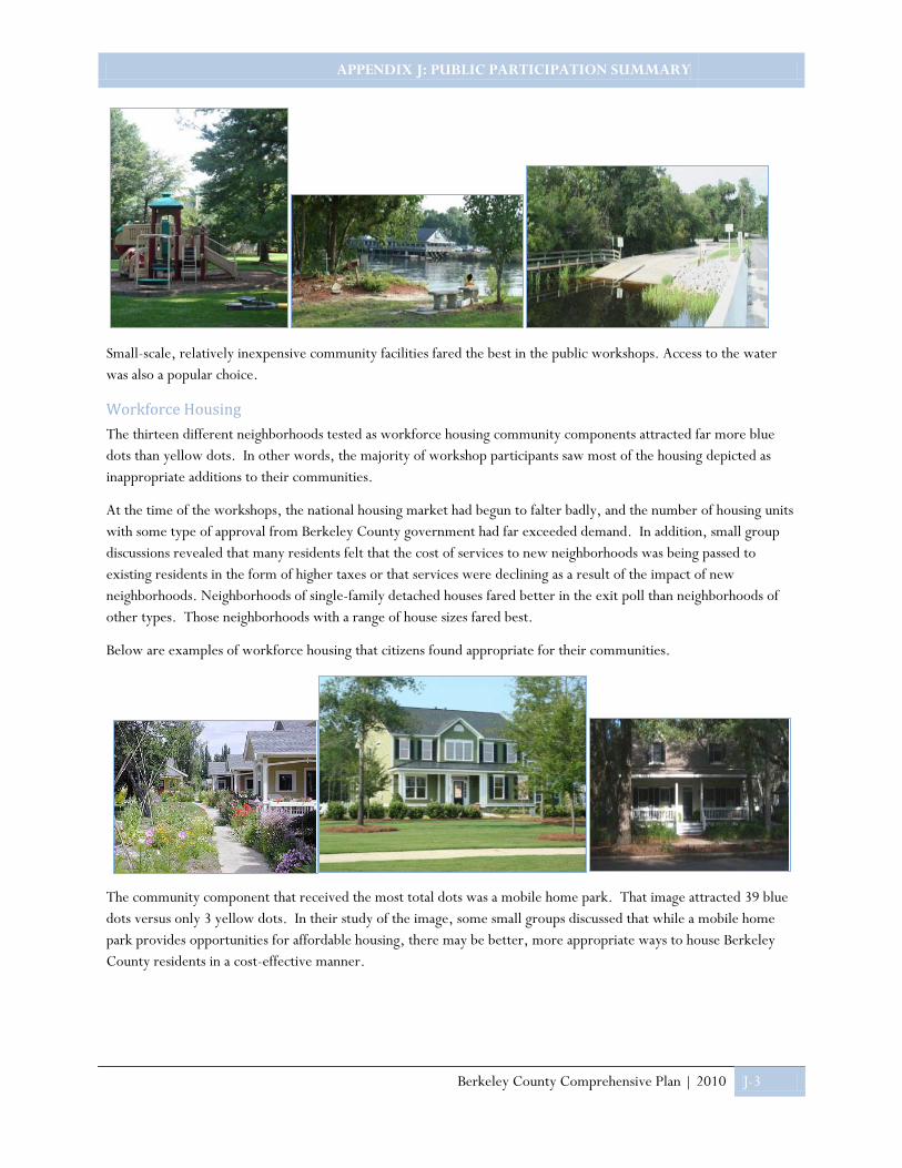
APPENDIX J: PUBLIC PARTICIPATION SUMMARY
Berkeley County Comprehensive Plan | 2010 J-3
Small-scale, relatively inexpensive community facilities fared the best in the public workshops. Access to the water was also a popular choice.
Workforce Housing The thirteen different neighborhoods tested as workforce housing community components attracted far more blue dots than yellow dots. In other words, the majority of workshop participants saw most of the housing depicted as inappropriate additions to their communities.
At the time of the workshops, the national housing market had begun to falter badly, and the number of housing units with some type of approval from Berkeley County government had far exceeded demand. In addition, small group discussions revealed that many residents felt that the cost of services to new neighborhoods was being passed to existing residents in the form of higher taxes or that services were declining as a result of the impact of new neighborhoods. Neighborhoods of single-family detached houses fared better in the exit poll than neighborhoods of other types. Those neighborhoods with a range of house sizes fared best.
Below are examples of workforce housing that citizens found appropriate for their communities.
The community component that received the most total dots was a mobile home park. That image attracted 39 blue dots versus only 3 yellow dots. In their study of the image, some small groups discussed that while a mobile home park provides opportunities for affordable housing, there may be better, more appropriate ways to house Berkeley County residents in a cost-effective manner.

APPENDIX J: PUBLIC PARTICIPATION SUMMARY
Berkeley County Comprehensive Plan | 2010 J-4
Commercial Venues Public workshop participants chose between twelve examples of commercial buildings, including offices, restaurants, and retail. Of these twelve buildings; five were located in urban settings, five were in suburban settings, and two in rural settings.
The exit poll of commercial venues showed no consistency between building settings. Furthermore, participants of the three workshops in rural areas did not consistently select rural commercial building types, nor did they consistently select urban or suburban types. The same was true of participants of workshops in suburban locations. No workshop occurred in an urban setting.
Below are examples of commercial venues participants found appropriate for their communities.
One consistency within the polling results was that basic commercial services attracted rural residents. The poll also indicated that participants were more favorable towards commercial venues with adequate sidewalks for accessibility.
Roads Roads constituted a highly relevant, current issue in that citizens voted to raise the local sales tax to fund improvements throughout the County in November 2008, despite the onset of the nationwide economic recession. Participants viewed 14 images of roads that exist throughout Berkeley County. The examples ranged from a narrow dirt road in the countryside to a heavily used five-lane highway.
Two-lane roads performed much better than four- or five-lane roads in the exit poll. Small group discussions indicated several reasons for this. First, the roads with higher capacity were associated with heavier traffic, which many workshop participants vilified. Second, participants indicated that the five-lane highway in particular was “ugly” or “industrial-looking.” Finally, wider roads, regardless of number of lanes, were generally identified as safety hazards.
It is interesting to note that the narrowest roads in the set performed poorly as well, with dirt roads like those in Bonneau and Railroad Avenue, the artery of downtown St. Stephen, seen as antiquated and associated with poorer economic conditions.
Below are examples of roads that participants found appropriate for their communities.

APPENDIX J: PUBLIC PARTICIPATION SUMMARY
Berkeley County Comprehensive Plan | 2010 J-5
Lack of lighting was a concern and a common source of negative votes across all examples, while slower speed limits, street trees, sidewalks separated from the roadway, and illumination were all identified as positive attributes that attracted positive responses.
The response to a commuter train image was more predictable in light of the fact that all votes in favor of commuter rail service occurred in suburban workshop locations while all negative votes (blue dots) appeared at workshops in rural locations. Most notably, citizens in the Wando-Huger area have a recent history of opposition to freight rail service.
Spring Workshops
The images that were most positively received by citizens during the autumn workshops were used to create “game pieces” for the exercise central to the spring workshops. Spring workshops began much like the earlier ones with introductions and a brief presentation on the purpose of comprehensive planning and the importance of public involvement throughout the process. BCDCOG Staff then gave a slideshow presentation which covered results and lessons learned from the previously held public input workshops. The presentation closed with instructions for the evenings exercise.
Community Planning Exercise
The community planning exercise involved a map and a set of “game pieces.” The map depicted a subarea of Berkeley County centered on each public meeting site. Most small groups worked with the subarea map specific to the workshop location, but a few opted for a county-wide map instead.
The first set of game pieces to place were blue dots. Participants placed blue dots on places or features in Berkeley County that should be incorporated into the Comprehensive Plan as an item to preserve or enhance. A participant had the option to indicate on the map what the dot placed demarcated.

APPENDIX J: PUBLIC PARTICIPATION SUMMARY
Berkeley County Comprehensive Plan | 2010 J-6
This information provided planners insight not only into what was identified, given the map’s scale, but also why. In other words, places and features marked with blue dots were those that had value to Berkeley County citizens. Participants were not constrained to any particular number of game pieces.
Community Planning Exercise – Workforce Housing
The second round of game pieces represented both workforce and executive housing. The workforce housing image depicted a small home from a neighborhood in Beaufort County renowned for its mix of housing sizes. In other words, homes there were available to families at a variety of price points, making that neighborhood a mixed-income community, a trait that appealed to autumn 2008 workshop attendees.
The other housing game piece represented executive housing. This image depicted had not appeared in the autumn 2008 workshops; however, a number of participants urged planners to consider housing specifically for higher income households. While the State of South Carolina mandates consideration of affordable housing in comprehensive plans, some Berkeley County residents felt that their plan should pay equal attention to the other end of the housing spectrum.
Executive housing, they expressed, is needed to attract doctors, lawyers, business executives, and other important contributors to the economic well-being and quality of life in Berkeley County. Below on the left is an example of executive housing, while on the right is an example of workforce housing.
Spring workshop participants frequently clustered executive housing and workforce housing game pieces on their maps. This reinforced the findings in the autumn 2008 workshops that Berkeley County residents desired mixed-income communities. Other executive housing pieces appeared near natural resources – the Cooper River, Lake Moultrie – that elevate land prices and attract residents looking for these amenities.
A large portion of the housing game pieces deployed was placed on lands where housing is already planned by the private sector: Cane Bay, the Parks at Berkeley, and Carnes. All of these developments are located in the western portion of the County, adjacent to US Highway 176. This finding suggests that residents believe this location is appropriate for extensive residential development or have resigned to accept it. No participants recorded negative comments about this housing, except to express concern over provision of public facilities and the potential cost to taxpayers of doing so.

APPENDIX J: PUBLIC PARTICIPATION SUMMARY
Berkeley County Comprehensive Plan | 2010 J-7
Community Planning Exercise – Commerce
The third of four steps on community planning exercise was to deploy game pieces representing neighborhood commercial services, expressed as images of supermarkets. This step served two purposes: (1) to learn where Berkeley County residents believed these services were needed and appropriate and (2) to provide a choice between urban, suburban, and rural development types.
Participants generally deployed commercial game pieces at intersections, consistent with real estate development practices. Five intersections stood out, collecting more than two game pieces each: (1) Carnes Crossroads, (2) Clements Ferry Road at SC-41, (3) the proposed Sheep Island Parkway at US-176, (4) Jedburg Road at US-176, and (5) Jedburg Road at I-26. The first of these, US-17A at US-176, is the site of a proposed Harris Teeter. The remainder may indicate the desire of currently rural communities to attract more services to meet their daily needs.
Urban- and suburban-type game pieces were deployed at Carnes Crossroads, perhaps reflecting the publicly unveiled design of the Harris Teeter proposed. All three types of game pieces appear in the Wando intersection (on SC-41). Workshop participants reported varying opinions on the future character of the Wando community.
Farther north on SC-41 and parallel Cainhoy Road, four of the five commercial game pieces deployed depicted the rural supermarket. In contrast, all four of the commercial game pieces appearing along US-52 depict the suburban supermarket, in keeping with this highway’s four-lane-divided cross-section.
Participants deployed urban-type game pieces along the Sheep Island Parkway, within large tracts proposed for development – the Whitfield tract, Parks at Berkeley, and Cane Bay. Game pieces depicting urban supermarkets also appeared near Moncks Corner and Macedonia, both on US Highway 17A.
All three types of commercial game pieces were deployed on US-176 near the proposed Sheep Island Parkway, again reflecting conflicting opinions about the future character of the surrounding community. Game pieces placed further north on this highway, approaching its intersection with Jedburg Road, were predominantly rural in type.
Community Planning Exercise – Community Facilities
The final step of the spring 2009 community planning exercise allowed participants to play the role of a Berkeley County parks and recreation department of sorts. With a canvas of valuable places, housing, and commercial services to build upon, participants deployed game pieces representing community recreation and access to the water.
The “community recreation” game piece depicted a neighborhood playground, the most popular community facility in the autumn 2008 meetings. Planners stressed in the presentation to participants that the game piece represents a variety of low-cost, low-impact recreation facilities, such as a basketball court, an image of which appeared on screen in the workshop.
Similarly, a boat launch proved the most popular form of access to the water in the first round of public workshops; yet, the game piece represented boat launches, community piers, and waterfront parks.
The greatest concentrations of game pieces were deployed in two rural areas on maps at the community planning workshops: Wando-Huger and New Hope-Longridge. These results were consistent with input received in the autumn 2008 public workshops, in which citizens expressed the need for these facilities in their communities.

APPENDIX J: PUBLIC PARTICIPATION SUMMARY
Berkeley County Comprehensive Plan | 2010 J-8
Participants also indicated that community facilities would be needed on large tracts anticipating suburban residential development by placing game pieces on their maps.
Additional community recreation game pieces appeared around Lake Moultrie, often near boat launches; on the west side of Moncks Corner, near existing public schools; and in or near the communities of Pringletown, Sangaree, Oakley, and Macedonia.
Participants expressed desire for access to water by placing game pieces on the southwest side of Lake Moultrie, the Goose Creek Reservoir, the upper reaches of the Cooper River, the Wando River, and Four Holes Swamp. Game pieces near the lake were tagged with comments expressing a need for upgrades to existing facilities as well. Below is a map showing all of the planning exercise results in aggregate.

APPENDIX J: PUBLIC PARTICIPATION SUMMARY
Berkeley County Comprehensive Plan | 2010 J-9
Top 5 concerns: 1) Growth and/or development density 2) Traffic 3) Road safety 4) Higher taxes 4) Loss of character or quality of life
Citizens participate in an exit poll during the autumn workshops.
Top 5 hopes: 1) Better planning 2) Preservation of character and quality of life 3) Better infrastructure 4) More/better jobs and commercial services 5) Infrastructure “concurrency
Community Hopes and Concerns As indicated earlier, roads and community facilities constituted the most current, relevant topic to the largest number of Berkeley County citizens in attendance. Because citizens’ hopes and concerns for their communities ranged beyond the four topics of the visioning exercise, the second exercise of the spring workshops asked each participant to put their greatest hope and biggest concern for their community in writing on their comment cards. “Better planning” was the most popular response (28 times) to the question, “What is your greatest hope for your community?” In the same spirit, 22 workshop participants expressed concern about growth or density of development in their communities. The topic of infrastructure arose frequently in the hopes and concerns of citizens, with better infrastructure the greatest hope of 19 for their communities. Twelve citizens, primarily at suburban locations, cited traffic as their chief concern, while eleven, mostly rural respondents, were concerned about road safety. Additionally, twelve citizens hoped for infrastructure “concurrency.” This means that the capacity and availability of roads, schools, and the like should keep pace with demand for service. First on the minds of 30 workshop participants was the character and quality of life of their communities. Nine cited the loss of these as their chief concern, while 21 saw the preservation of community character and quality of life as their greatest hope. The purpose of workshops was to enable community input into government. This principle was the greatest hope of eight workshop participants. In the same manner, seven participants identified governance as their chief concern. Taxes – going up or, preferably, down – constituted the most important subject in 13 citizens’ minds. Fourteen participants desired greater availability of employment and commercial services, especially in rural areas. Eight more desired better access to recreational opportunities, again especially in rural areas. Four identified a place of community assembly as their greatest hope. Four more, however, were concerned most about maintenance of community facilities.

APPENDIX J: PUBLIC PARTICIPATION SUMMARY
Berkeley County Comprehensive Plan | 2010 J-10
Several more issues identified as a greatest hope or biggest concerns appear below, with the number of occurrences on comment cards in parentheses.
• Property rights (7)
• Housing affordability (7)
• Education (6)
• Crime (5)
• Natural environment (4)
• Safe water, emergency services, health care, “resources for family living”, racial unity and taxicab service (1 each)
Conclusion One of the best ways to strengthen a community is to create opportunities for citizens to work collaboratively on the challenges that shape their community. A successful comprehensive plan begins with a process of thinking about and visualizing the future. It is about carrying on a dialogue with the community concerning its vision for evolving and growing. This public participation process was crafted with these principles in mind, with the overall goal of better decisions supported by the public. Through a multi-faceted participation process the County was able to properly identify and define its vision, goals, policies, priorities and implementation strategies.

Prepared by Berkeley Planning Commission with assistance of the
Berkeley-Charleston-Dorchester Council of Governments and
Berkeley County Planning and Zoning Department