2007 finger lakes research conference - hws
TRANSCRIPT

2008 Finger Lakes Region Research Conference AGENDA 8:30 AM Registration and Continental Breakfast 9:00
CAN OLDFIELD SUCCESSION IMPACT DEPRESSION STORAGE? Paul L. Richards, SUNY College at Brockport
9:20 SEASONAL WATER TABLE VARIATIONS IN THE ONONDAGA FORMATION, WESTERN, NY Tim Daniluk, SUNY College at Brockport
9:40 THERMAL DYNAMICS OF A FARM POND: A PROGRESS REPORT James Brownridge, Binghamton University
10:00 Break
10:20 DEVELOPING A GIS BASED HABITAT SUITABILITY MODEL FOR THE SPOTTED TURTLE, CLEMMYS GUTTATA Karl Korfmacher, Rochester Institute of Technology
10:40 DENDROCHEMISTRY: DOES THE CHEMISTRY OF TREE RINGS OFFER AN ARCHIVE OF THE CHEMICAL ENVIRONMENT? Isabel Olson, Hobart and William Smith Colleges
11:00 FOOD WEB EFFECTS AND THE DISAPEARANCE OF THE SPRING CLEAR WATER PHASE IN ONONDAGA LAKE FOLLOWING ENHANCEMENTS AT THE METROPOLITAN SYRACUSE WASTEWATER TREATMENT FACILITY Roland Wang, Cornell Biological Field Station
11:20 THE WATER QUALITY OF THE SOUTHERN SHELF OF CAYUGA LAKE AS FORCED BY UPWELLING AND TRIBUTARY FLOW EVENTS Seth Schweitzer, Cornell University
11:40 AN INTERACTIVE WEB TOOL TO FORECAST SPATIALLY DISTRIBUTED RUNOFF DYNAMIC IN THE FINGER LAKES Helen Dahlke, Cornell University
12:00 PM Lunch and Poster Viewing
1:20 COMPARATIVE LIMNOLOGY OF THE EASTERN FINGER LAKES: 2005-2008 John Halfman, Hobart and William Smith Colleges
1:40 WHAT ARE RESPONSIBLE FOR THE WORST WATER QUALITY IN HONEOYE LAKE?: AN
INVESTIGATION OF EXTERNAL NUTRIENT LOADING FROM EIGHT STREAMS Bin Zhu, Finger Lakes Institute
2:00 SOURCES FOR BOTTOM WATER PHOSPHATES AND SUSPENDED SEDIMENTS IN SOUTHERN CAYUGA LAKE, NEW YORK Pabighya Basnet, Hobart and William Smith Colleges
2:20 GREEN CHEMISTRY: REPLACING HAZARDOUS SOLVENTS WITH WATER Anne Sessler, Hobart and William Smith Colleges
2:40 Finger Lakes Institute Open House 601 S. Main Street

2
Poster Presentations Listed alphabetically by participant Participant Title Page
David Blersch SUNY College at Buffalo
A NEW INTERDISCIPLINARY DOCTORAL PROGRAM IN ECOSYSTEM RESTORATION AT THE UNIVERSITY AT BUFFALO
Dawn Dittman USGS Great Lakes Science Center
LAKE STURGEON DISTRIBUTION, POPULATION DYNAMICS, AND HABITAT USE IN THE OSWEGO RIVER BASIN
Patrick Eager SUNY College of Environmental Science and Forestry
INVESTIGATING PARASITOIDS OF THE INVASIVE SIREX NOCTILIO (HYMENOPTERA: SIRICIDAE) IN NEW YORK
Jill Libby SUNY College at Brockport
PHOSPHORUS DYNAMICS IN A KARSTIC GROUNDWATER-SURFACE WATER SYSTEM IN WESTERN NEW YORK
Eben Pendleton SUNY College of Environmental Science and Forestry
ASSESSMENT OF TEMPORAL VARIATION IN SEEPAGE FLUX IN SURFACE AND GROUNDWATER IN TWO SUBWATERSHEDS OF SKANEATELES LAKE
Peter Rockermann SUNY College of Environmental Science and Forestry
TREE COMPOSITION OF NEW YORK RIPARIAN FORESTS IN ADVANCE OF EMERALD ASH BORER
William Van Steen Hobart and William Smith Colleges THE SENECA LAKE BUOY PROJECT
Conference participants will be available by their posters during conference breaks and the designated time 12:00-1:20 pm.
THANK YOU FOR ATTENDING!

3
CAN OLDFIELD SUCCESSION IMPACT DEPRESSION STORAGE? Paul L. Richards Assistant Professor Department of Earth Sciences The College at Brockport 350 Newcampus Lane Brockport, NY 14420 [email protected] (585) 260-2988 Co-Authors: Mark Norris, Dept. of Environmental Science and Biology, The College at Brockport Brenda B. Lin, The Earth Institute, Columbia University, New York, NY 10025 Quantifying the effect of vegetation cover change on runoff is essential for watershed management. Previous studies have noted the importance of vegetation in controlling soil infiltration because of the effect of vegetation on soil surface variables. Here, we hypothesize that ecologic succession from mowed grassland to oldfield to forest will impact depression storage by changing the microtopography of the surface. We test this idea by measuring depression storage and leaf litter water retention rates in twelve sites across a successional gradient under a variety of slope conditions. Sites of similar slope and soil type were also evaluated against one another to better isolate the effect of both vegetation diversity and management on depression storage. Results averaged from Table 1 showed that average ideal depression storage was different for various eco-types with 5.8, 11.1, 14.3, 18.7 mm of storage for mowed grassland, old field, forest, and wetland respectively. This variation is attributed to changes in vegetation diversity and structure. Effective depression storage of unmanaged successional oldfield, shrubland, and forest was significantly higher than mowed grassland at all slopes, and mowed successional oldfield was not significantly different then mowed residential turf implying that management activities such as mowing retard the natural development of microtopography that occurs with natural vegetation succession (see figure below). Results of leaf litter water retention varied significantly among land covers, but were much lower in most cases than depression storage from microtopography. Maximum leaf litter water retention rates were only 0.002 mm per gram of litter after leaf fall implying seasonal changes contribute to a lower extent for on-plot water storage. These results imply there are tight linkages between vegetation succession and runoff; and that land use modifications and grassland management strategies can effect run-off and water retention. Understanding these characteristics are important for developing accurate hydrologic models and are not considered in watershed models parameterized strictly from soil properties.

4

5
SEASONAL WATER TABLE VARIATIONS IN THE ONONDAGA FORMATION, WESTERN, NY Tim Daniluk Undergraduate Student Department of Earth Sciences The College at Brockport 350 Newcampus Lane Brockport, NY 14420 [email protected] Co-Authors: Libby, J., Richards, P.L., and Noll, M.R. Craft, J.H. NYS Department of Environmental Conservation Avon, NY 14414 Karst watersheds are vulnerable to surface and groundwater contamination because of complex surfacewater/groundwater interactions. The Onondaga Formation is a known karst lithology in New York State that is heavily farmed and is an important aquifer for domestic water supplies. This formation has suffered several incidents of well contamination as a result of the application of fertilizer. Traditionally, the concern is water flowing down from the soil zone which carries with it pollutants derived from the surface. This process is assumed to be controlled by the transmissivity and vertical hydraulic gradient in the soil and bedrock. In parts of the Onondaga FM in western NY however, this process may also be controlled by the position of the seasonal piezometric surface. In this study we test the hypothesis that dynamic water table rises in the early spring are capable of inundating the base of the epikarst zone, where accumulated pollutants may then be washed into open fractures. To test this hypothesis, transducers have been installed in wells and sinkholes and karst-related flooding has been monitored. We have also been measuring discharge at sites along Oatka creek to determine where it gains and loses. The results suggest that much of the water in Oatka creek disappears into the Onondaga FM within a few kms of the southern contact of the unit after the onset of the growing season. Oatka creek gains some of this water back after it reaches the Silurian strata and flows east toward the Genesee River. The water table in the Onondaga FM between Leroy and Caledonia are very dynamic, with rises as rapid as 2 meters per day occurring in the early part of the spring. Total water level range is also large, with some sites having greater than 12 meters of annual variation. The timing of karst-related flooding events in swallets suggest that they are related to this regional, seasonal shift in water table. This study seeks to better understand the dynamics of water table movement in this region in order to map areas that are sensitive to groundwater pollution and to consider the implications in storm water management.
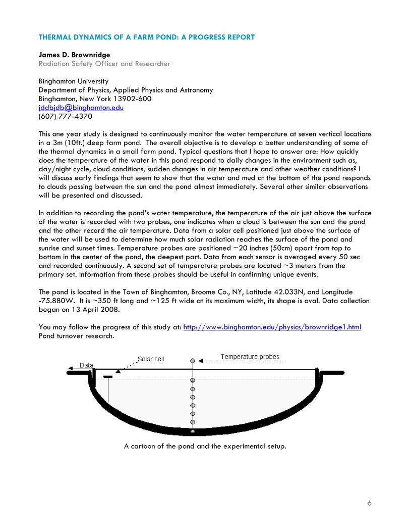
THERMAL DYNAMICS OF A FARM POND: A PROGRESS REPORT James D. Brownridge Radiation Safety Officer and Researcher Binghamton University Department of Physics, Applied Physics and Astronomy Binghamton, New York 13902-600 [email protected] (607) 777-4370 This one year study is designed to continuously monitor the water temperature at seven vertical locations in a 3m (10ft.) deep farm pond. The overall objective is to develop a better understanding of some of the thermal dynamics in a small farm pond. Typical questions that I hope to answer are: How quickly does the temperature of the water in this pond respond to daily changes in the environment such as, day/night cycle, cloud conditions, sudden changes in air temperature and other weather conditions? I will discuss early findings that seem to show that the water and mud at the bottom of the pond responds to clouds passing between the sun and the pond almost immediately. Several other similar observations will be presented and discussed. In addition to recording the pond’s water temperature, the temperature of the air just above the surface of the water is recorded with two probes, one indicates when a cloud is between the sun and the pond and the other record the air temperature. Data from a solar cell positioned just above the surface of the water will be used to determine how much solar radiation reaches the surface of the pond and sunrise and sunset times. Temperature probes are positioned ~20 inches (50cm) apart from top to bottom in the center of the pond, the deepest part. Data from each sensor is averaged every 50 sec and recorded continuously. A second set of temperature probes are located ~3 meters from the primary set. Information from these probes should be useful in confirming unique events. The pond is located in the Town of Binghamton, Broome Co., NY, Latitude 42.033N, and Longitude -75.880W. It is ~350 ft long and ~125 ft wide at its maximum width, its shape is oval. Data collection began on 13 April 2008. You may follow the progress of this study at: http://www.binghamton.edu/physics/brownridge1.html Pond turnover research.
A cartoon of the pond and the experimental setup.
6

7
8
DEVELOPING A GIS BASED HABITAT SUITABILITY MODEL FOR THE SPOTTED TURTLE, CLEMMYS GUTTATA Dr. Karl Korfmacher Associate Professor Department of Biological Sciences Environmental Science Program Rochester Institute of Technology 85 Lomb Memorial Drive Rochester, NY 14623-5603 585-475-5554 585-475-5000 (FAX) [email protected] The spotted turtle, Clemmys guttata, is a threatened species in the state of New York. As part of a reintroduction effort with the Seneca Park Zoo in Monroe County, NY, a habitat suitability model was developed to help prioritize areas for potential reintroduction of captive bred turtles. The model integrates parameters identified by literature review, such as soils, land cover, wetlands and hydrology, and human development, with parameter weights derived from expert survey responses, such as typical home ranges and optimal land cover composition. Areas identified by the model were compared to NY Department of Environmental Conservation records of historic turtle sightings for preliminary validation. Of the 30 historic sites identified by NYDEC, the model hit 13 within the nine county study area. Based on model parameters and constraints, 164-187 additional priority sites were identified by the model for further field investigations.

DENDROCHEMISTRY: DOES THE CHEMISTRY OF TREE RINGS OFFER AN ARCHIVE OF THE CHEMICAL ENVIRONMENT? Isabel A. Olson Undergraduate Student Department of Chemistry Hobart and William Smith Colleges Geneva, NY 14456 315-781-3608 [email protected] Dendrochemistry is a promising approach to understanding environmental history, especially in areas impacted by volcanic eruptions. Because each tree ring is grown in a specific year, the assumption is that the environment affects the chemistry of the wood. However, various authors have shown that the signature left by environmental events is not as easily understood as originally hoped. In this paper, the fundamental promise and problems of dendrochemistry are introduced. Cation binding capacities are an underutilized tool in dendrochemistry. We report measurements of the cation binding capacity of tree rings simultaneously with concentrations of cations in the wood. The dendrochemistry of wood from the Mt. St. Helens region is compared to that of wood that grew in the Finger Lakes Region.
0
0.01
0.02
0.03
0.04
0.05
0.06
1900 1910 1920 1930 1940 1950 1960 1970 1980 1990
Median Year of Sample +/- 2 Years
CB
C (m
mol
Ca2+
/ g)
DF1DF2MH3
9
10
FOOD WEB EFFECTS AND THE DISAPPEARANCE OF THE SPRING CLEAR WATER PHASE IN ONONDAGA LAKE FOLLOWING ENHANCEMENTS AT THE METROPOLITAN SYRACUSE WASTEWATER TREATMENT FACILITY Roland W. Wang
Undergraduate Student 1Department of Natural Resources and Cornell Biological Field Station 900 Shackelton Point Road Bridgeport, NY 13030 [email protected](607) 253-6088 Co-Authors: Lars G. Rudstam1, Thomas E. Brooking1, David J. Snyder2, Mark A. Arrigo3, Edward L. Mills1, Joseph J. Mastriano2
2Onondaga County Department of Water Environment Protection, 650 Hiawatha Boulevard, West Syracuse, NY 13204. 3EcoLogic LLC, Atwell Mill Annex Suite S-2, 132 1/2 Albany Street, Cazenovia, NY 13035. Onondaga County has improved the treatment of wastewater that discharges into Onondaga Lake through upgrades at the Metropolitan Syracuse Wastewater Treatment Facility to reduce nutrient loading into the lake in order to decrease the incidence of algae blooms and increase water clarity. But as the quality of the discharged wastewater improved, the spring clear water phase present since 1988 disappeared, due to changes in the food web. In September 2002, the abundance of large zooplankton (Daphnia) declined and were virtually absent between 2003 and 2007 while abundance of small zooplankton (Bosmina) increased. Catches of alewife (Alosa pseudoharengus) from electrofishing surveys conducted since 2000 increased beginning in 2003. Hydroacoustic estimates of open water fish abundance ranged from 1600 to 2300 fish/ha in the spring of 2005, 2006, and 2007, with alewife dominating catches in vertical gill nets. The alewife population in 2005 was dominated by the 2002 year class and additional year classes were present in 2006 and 2007 catches. The development of the strong 2002 year class coincides with the observed shift from Daphnia to Bosmina. Alewife diets consisted primarily of small zooplankton on June 6, 2007 as well as Daphnia sp. on July 18, 2007. We conclude that the strong 2002 alewife year class initiated a classic trophic cascade causing the decline and continuing low abundance of Daphnia in Onondaga Lake and the disappearance of the spring clear water phase. Evaluations of the response of lakes to improved waste water treatment can be complicated by changes in food web structure.

0
400
800
1200
1600
Mar
-00
Jun-
00
Sep-
00
Dec
-00
Mar
-01
Jun-
01
Sep-
01
Dec
-01
Mar
-02
Jun-
02
Sep-
02
Dec
-02
Mar
-03
Jun-
03
Sep-
03
Dec
-03
Mar
-04
Jun-
04
Sep-
04
Dec
-04
Mar
-05
Jun-
05
Sep-
05
Dec
-05
Mar
-06
Jun-
06
Sep-
06
Dec
-06
Mar
-07
Jun-
07
Sep-
07
Dec
-07
Tota
l bio
mas
s (µ
g/L)
Daphnia sp. Small cladocera Other cladocera Copepods
Alewife resurgence
11
12
THE WATER QUALITY OF THE SOUTHERN SHELF OF CAYUGA LAKE AS FORCED BU UWELLING AND TRIBUTARY FLOW EVENTS Seth Avram Schweitzer Graduate Student DeFrees Hydraulics Laboratory School of Civil & Environmental Engineering Cornell University 220 Hollister Hall Ithaca, NY 14853-3501, USA Tel.: +1-607-255-9237, Fax: +1-607-225-9004 [email protected] Co-Authors: E. A. Cowen, Associate Professor & Director DeFrees Hydraulics Laboratory [email protected] Cayuga Lake (Ithaca, NY, USA) is a long (60 km), narrow (4 km) lake with a shallow southern shelf. 40% of the total inflow to the lake is discharged onto the southern shelf via tributaries characterized by naturally occurring and anthropogenically intensified sediment loads, including agricultural and urban nutrient and pollutant inputs. Two municipal wastewater treatment plants and a utilities cooling project also discharge to the southern shelf of the lake. The residence time of the southern basin is established by a subtle balance of hydrodynamic processes but importantly, this balance is never in equilibrium and the mean residence time at a given location can be dominated by two types of events: tributary runoff and basin scale internal waves (upwelling events). Using a decade long water quality monitoring record augmented by hydrodynamic measurements we will demonstrate that the residence time and water quality of the shelf is characterized by event frequency and magnitude, analogously to the lake-embayment findings of Rueda and Cowen (2005). Hence interannual variability of water quality on the shelf is driven by the number of events that occur in a given year. We will also describe individual events, in particular upwelling and shoaling internal waves, and demonstrate that they lead to strong local-in-time nutrient, sediment, and organism fluxes that are important biologically, and which ultimately result in spatial variability in phytoplankton as measured by chlorophyll-a levels. Finally, we will comment on the viability of low frequency monitoring data for assessment of interannual variations in water quality.

13
AN INTERACTIVE WEB TOOL TO FORECAST SPATIALLY DISTRIBUTED RUNOFF DYNAMICS IN THE FINGER LAKES REGION
Helen E. Dahlke Graduate Student Department of Biological and Environmental Engineering, Cornell University Ithaca NY 14853, USA [email protected]+1 (607) 255-2463 (office) +1 (607) 255-4080 (fax) Co-Authors: Zachary M. Easton1, Daniel R. Fuka1, Nalini S. Rao2 and Tammo S. Steenhuis1
1Department of Biological and Environmental Engineering, Cornell University, Ithaca, NY 14853, USA. E-mail: [email protected] of Natural Resources, Cornell University, Ithaca, NY 14853, USA. To optimize NPS pollution reduction efficiency from BMPs, consideration should be given to the spatial distribution of areas that produce runoff in the watershed during the planning process of BMPs. In the Finger Lake region with shallow, permeable soils, underlain by a restricting layer, saturation excess runoff is the dominant mechanism of nutrient transport. In watersheds characterized by these conditions, runoff originates from areas in the landscape that expand and contract seasonally and are therefore often termed as variable source areas (VSAs). Various models have been developed that incorporate VSA hydrology and can effectively delineate saturated runoff source areas in the landscape. However, in practice these models often require extensive expertise and effort to be used on a routine basis for BMP planning. In order to simplify the BMP planning process, we developed an interactive web-based tool for Salmon Creek watershed that locates VSA and calculates their probability of saturation. The interactive web tool (Figure 1) incorporates hydrologic, geographic and land management information and presents the resulting VSA on maps that can be accessed online. The methodology behind this web application is based on long-term research on VSA hydrology and models developed for watersheds in the humid areas of the northeast. The surface runoff potential in Salmon Creek is calculated on a daily basis using a water balance model (Thornthwaite-Mather) and free precipitation and temperature data from the National Climatic Data Center and is distributed via a soil topographic index to capture VSA dynamics. In addition free web-provided weather forecasts are used to provide a one to two day prediction of the spatial extent of VSA in the web tool. The tool is designed to interactively assist planners and especially farmers in the BMP planning process. It can be used to locate fields with low runoff risk that could, potentially receive more liberal nutrient applications without increasing the risk of NPS pollution. In addition we will investigate its use as flood forecast model that can be employed by emergency personnel for real time predictions of areas that might have to be evacuated during large rainfall events. During the presentation we will discuss the background of the model, and if Internet is available, we will give a live demonstration of the tool.

Figure 1: The web tool for predicting variable source areas.
14

15
COMPARATIVE LIMNOLOGY OF THE EASTERN FINGER LAKES: 2005 – 2008 Halfman, John D. Professor of Geoscience and Environmental Studies Hobart and William Smith Colleges Geneva, New York, 14456 [email protected](315) 781-3918 Co-Authors: O’Neill, Kerry A., Basnet, Prabighya, Hoering, Katherine A., and Georgian, Samuel E., Hobart and William Smith Colleges, Geneva, New York, 14456. The seven eastern Finger Lakes, Honeoye, Canandaigua, Keuka, Seneca, Cayuga, Owasco, and Skaneateles, were sampled over the past four summer seasons (May – October, 2005-08) to investigate and compare the temporal and spatial limnological variability. Otisco was added to the survey this past season (2008). CTD casts, secchi disk depths, and water samples were collected and analyzed at a minimum of two deepwater sites on a monthly basis during the May – October field-season. Two lakes were investigated in more detail in 2008 with bi-monthly sampling of Cayuga at 8 sites, and weekly sampling of Seneca at 4 sites and its major tributaries. SeaBird CTDs (SBE-19 in 05&06, SBE-25 since) collected water-column profiles of conductivity (reported as specific conductance), temperature, depth, pH, dissolved oxygen, light transmission (SBE-19), PAR (SBE-25), fluorescence (SBE-25), and turbidity (SBE-25). Surface and bottom water samples were analyzed for total and dissolved phosphates, nitrates, dissolved silica, chlorophyll-a, total suspended solids, alkalinity, and major ions using standard limnological techniques. CTD Profiles: The temperature profiles were typical for any summer season, similar from one year to the next and reveal the typical development and decay of summer stratification in all but Honeoye. The Honeoye profiles were typically isothermal, reflecting the well mixed, shallow (<= 9 m) lake, except thermal stratification was detected on hot and calm days. Specific conductance ranged from 230 µS/cm in Honeoye up to 710 µS/cm in Seneca Lake. Conductivities were 10 to 30 µS/cm smaller in the epilimnion decreasing through the stratified season than the hypolimnion of Cayuga, Canandaigua, Owasco, Skaneateles, Otisco and Seneca. The largest change was consistently observed in Seneca with conductivities decreasing by 50 µS/cm in the epilimnion but remaining constant in the hypolimnion during each summer, and then decreasing through the entire water column by ~10 to 20 µS/cm during overturn. The variability and overall decline in the epilimnion probably reflected the input of dilute surface runoff. Dissolved oxygen was nearly saturated throughout the water column in Keuka and Skaneateles (orthograde profiles). Mid-summer hypolimnetic depletion, especially right below the thermocline was observed in Owasco, Seneca and Cayuga. Dissolved oxygen depleted to near anoxic conditions in Otisco and occasionally Honeoye during those warm and calm days. Photosynthetically Active Radiation (PAR) data revealed exponentially decreasing light levels to 1% Io by 10 to 30 meters, the lower depths correlating to lakes with smaller algal concentrations. Fluorescence data revealed uniform algal concentration in Honeoye and algal peaks up to 2 to 8 mg/m3 in the lower epilimnion and upper metalimnion of Cayuga, Seneca, and Owasco and in the upper hypolimnion of Canandaigua, Keuka, and Skaneateles. The largest fluorescence peak of 25 mg/m3, was observed in Otisco just below the thermocline on 8/25/08. In the other lakes, the largest algal concentrations were detected during early (Owasco, Keuka, Skaneateles), or mid-summer (Canandaigua, Cayuga, Seneca).

Benthic nepheloid layers were observed at least one site in Canandaigua, Cayuga, Owasco (for the first time) and Keuka, but not in Honeoye, Seneca, Skaneateles and Otisco. The nepheloid layers, when present, persisted through out the survey but their extent varied between lakes and sample dates. The nepheloid layers were best developed in Cayuga and Canandaigua, and more pronounced in 2008 than 2007 or 2006 with 2008 turbidity values starting to increase from background values of below 1 NTUs just below the thermocline up to 5 NTUs within a few meters above the lake floor. Nepheloid layers increased on sample dates just after major wind and/or precipitation events in Cayuga Lake, thus reflect the accumulation of both resuspended and runoff materials that are transported to the lake floor by density currents.
2005 - 2008 Mean Secchi Disk Depth
0123456789
10
Honeo
ye
Canan
daigu
a
Keuka
Senec
a
Cayug
a
Owasco
Skane
ateles
Otisco
Ave
age
Sec
chi D
epth
(m)
2005200620072008
Secchi Disk, Chlorophyll-a, TSS Data: Average secchi disk depths were deepest in Canandaigua (~7 m) and Skaneateles (~9 m), and shallowest in Owasco, Cayuga, Honeoye, Otisco and Seneca (~3 to 4 m). This trend mimicked variability in chlorophyll-a concentrations (summer surface lake mean concentrations from 0.6 to 5.1 µg/L) and a lesser extent TSS data. Chlorophyll-concentrations have steadily increased in Seneca and Cayuga Lakes over the past 4 years. Nutrient Data: Mean nitrate concentrations were largest in Cayuga, Owasco, Otisco and Skaneateles (0.3 to 0.7 mg/L), and smallest in Canandaigua, Keuka, Seneca and Honeoye (0 to 0.2 mg/L). N/P ratios indicate that phosphate is the limiting nutrient in all but Honeoye, and Keuka late in the season. Soluble reactive phosphate (SRP) concentrations were consistently largest in Honeoye Lake. The annual mean phosphate concentrations in the other lakes were below 2.0 µg/L. From year to year, concentrations were larger in 2006 compared to 2005, 2007 and 2008, perhaps reflecting greater runoff of phosphates in 2006. The largest hypolimetic SRP concentrations were detected in Cayuga (8 – 10 µg/L), and its source was linked to bacterial decay of resuspended and runoff derived organic matter. Mean total phosphate concentrations ranged from 4 µg/L in Skaneateles to 18 µg/L in Honeoye. Concentrations ranged between 6 and 13 µg/L in the other lakes. Surface water soluble reactive silica (SRSi) concentrations in 2005 were largest in Canandaigua (1100 µg/L), Honeoye (800 µg/L), and Owasco (600 µg/L), and smallest in Otisco (180 µg/L), Seneca (260 µg/L) and Skaneateles (270 µg/L). Bottom water silica concentrations were typically larger than the surface waters, with the largest increase with water depth in Owasco and Otisco (~700 µg/L).
16

Fours Years of Ranking
0
2
4
6
8
10
12
14
16
18
20
Honoey
e
Canand
iagua
Keuka
Senec
a
Cayug
a
Owasco
Skane
ateles
Otisco
Ran
k (2
9 M
ax)
2005200620072008
Water Quality Ranking: Previous abstracts reported on the water quality rank of these lakes during that year based on the measured parameters. Notable changes were also noted from year to year. The average annual water quality indicators for each lake in each year were ranked to assess the relative overall and year to year variability in water quality. Honeoye and Otisco revealed the worse water quality in 2008. Skaneateles, Canandaigua and Keuka revealed the best water quality. Seneca, Owasco and Cayuga were near or occasionally the worst, and water quality in Seneca has been getting progressively worse over time. A few lakes revealed an improvement in water quality in 2007, a dry year. At Owasco, reduced runoff and flux of nutrients from the watershed to the lake improved the water quality in the lake. An exception is Honeoye, which received a significant portion of its nutrient load from internal, sediments sources.
17

18
WHAT ARE RESPONSIBLE FOR THE WORST WATER QUALITY IN HONEOYE LAKE? - AN INVESTIGATION OF EXTERNAL NUTRIENT LOADINGS FROM EIGHT STREAMS Bin Zhu, Ph.D. Research Scientist Finger Lakes Institute Hobart and William Smith Colleges 601 S. Main Street Geneva, NY 14456 (315) 781-4384 [email protected] Honeoye Lake is the most eutrophic lake among the 11 Finger Lakes. It has been experiencing extensive weed growth and algal bloom. Weeds affect swimming, boating, and property values. Algal bloom causes dead zones at the bottom, thereby affecting benthic microinvertebrates and fish in the lake. Extensive weed growth and algal bloom and are likely due to nutrient enrichment from stream loading associated with land use activities since the lake is comparatively small (7.05 km2) and has the shortest retention time (0.8 yr). Therefore it is important to monitor the nutrient inputs from streams to the lake. Supported by the Honeoye Lake Watershed Task Force, I collected water samples from eight tributaries monthly and at six rain/snow events from June 2007 to July 2008. Total phosphorus, soluble reactive phosphorus, nitrate, total kjeldahl nitrogen, total nitrogen, total suspended solids, and water discharge were measured for each sampling. This presentation will report the nutrient loading from the regular and event samplings and summarize annual baseline data and annual nutrient loading. Additionally several segment analyses were conducted to search nutrient sources after comparing the eight streams and identifying potential problematic streams. In the end, several recommendations for abatement, mitigation, and future research will also be discussed.

SOURCES FOR BOTTOM WATER PHOSPHATES AND SUSPENDED SEDIMENTS IN SOUTHERN CAYUGA LAKE, NEW YORK Prabighya Basnet Undergraduate Student Environmental Studies Program Hobart and William Smith Colleges Geneva, NY, 14456 [email protected] Co-Authors: John D. Halfman, Department of Geoscience, Hobart and William Smith Colleges, Geneva, NY, 14456, 1-315-178-6371, [email protected]
Water quality monitoring of the seven largest Finger Lakes in central and western New York State since 2005 identified elevated phosphates (> 8 ppb) and suspended sediments (> 2 mg/L) in the hypolimnion of Cayuga Lake compared to the other large lakes in the survey (< 2 ppb and < 2 mg/L, respectively).
2005 - 2008 Mean Phosphate
0
2
4
6
8
10
12
Honeo
ye
Canan
daigu
aKeu
ka
Senec
a
Cayug
a
Owasco
Skane
ateles
OtiscoAv
erag
e Ph
osph
ate
(SR
P, u
g/L,
P)
2005 Surface2006 Surface2007 Surface2008 Surface2005 Bottom2006 Bottom2007 Bottom2008 Bottom
Dissolved Phosphate
0
2
4
6
8
10
12
1S
1M 1B 2S
2M 2B
B/S
B/M
B/B
D/S
D/M D/B
E/S
E/M
E/B
G/S
G/M
G/B
Sites
Phos
phat
e (S
RP, u
g/L)
Here, we report on the second year of a two year, detailed, study of Cayuga Lake that investigated the source of these elevated nutrient and sediment concentrations. Total suspended sediments (TSS), and total phosphates (TP) were detected at elevated concentrations a day or two after wind and/or rainfall events in Cayuga Lake than other dates in the survey. It strongly suggests that resuspension and runoff events are important to the delivery of organically bound phosphates attached to suspended sediments to the hypolimnion of the lake.
19

Surface, mid-depth (40m above the lake floor), and bottom water (within 2 m of the lake floor) samples were taken at six different sites in the southern half of the lake every two to three weeks from May through August of 2007 and again in 2008. The samples were filtered and then analyzed in the lab for total phosphorous, soluble reactive phosphate, dissolved silica, nitrates, chlorophyll-a, total suspended sediment, and major ion concentrations following standard limnological techniques. Secchi disk depths, plankton tows and CTD profiles were also collected at these six sites, and CTD casts at two additional sites located just offshore of two major streams (Taughannock and Salmon Creeks). Our SBE-25 SeaLogger CTD collects profiles of conductivity (SBE 4), temperature (SBE 3), depth (SBE 29), pH (SBE 18), dissolved oxygen (SBE 43), PAR (Biospherical QSP-2300) fluorescence and turbidity (WETLabs ECO-FL-NTU). Total suspended sediment concentrations in the hypolimnion were the highest at all the sites when there was both wind and rain a day or two before sampling, and lower when rainfall and wind events were absent before sampling. Total phosphate also followed this trend probably due to organic matter delivered with the winnowed and fluvial sediments and absorbed onto particles. Dissolved phosphate however was highest during the month of May and declined through the summer. We suggest that dissolved phosphates entered the lake during spring runoff and more importantly also enter the hypolimnion from the bacterial decomposition of the winnowed and fluvial organic material. The conclusions are consistent with abundant macrophyte and terrestrial plant matter observed at the lake’s surface, and occasionally sampled by the bottom niskin water sampler after wind and/or rain events. In summary, both internal (resuspension) and external (runoff) processes are critical for the elevated suspended sediments and phosphates in the hypolimnion of Cayuga Lake.
0 1 2 3 4 5 6 7 80
20
40
60
80
100
120
Depth (m
)
Fluorescence (mg/m 3)
5-28-07 S2
6-10-08 S2
6-24-08 S2
7-8-08 S2
7-19-08 S2
7-28-08 S2
8-26-08 S2
0 5 10 15 20 250
20
40
60
80
100
120
Depth (m
)
Temperature (C)
5-27-08 S2
6-10-08 S2
6-24-08 S2
7-8-08 S2
7-19-08 S2
7-28-08 S2
8-26-08 S2
0 1 2 3 4 5 6 7 8 9 1011120
20
40
60
80
100
120
Depth (m)
Turbidity (NTUs)
5-27-08 S2
6-10-08 S2
6-24-08 S2
7-8-08 S2
7-19-08 S2
7-28-08 S2
8-26-08 S2
20

GREEN CHEMISTRY: REPLACING HAZARDOUS SOLVENTS WITH WATER Anne M. Sessler Undergraduate Student Department of Chemistry Hobart and William Smith Colleges Geneva, NY 14456 (315) 781-3608 [email protected] “Green” chemistry is a movement whose goal is to develop more environmentally friendly methods for the chemical industry. This talk will review Green chemistry and introduce the governmental initiatives that encourage it. To specifically illustrate Green chemistry, the talk will describe a research project on-going at Hobart and William Smith Colleges that seeks to fundamentally understand a new Green reaction. Indium-mediated allylation is a powerful tool for the synthetic organic chemist. It is particularly interesting because this reaction proceeds in aqueous solutions while the widely-used alternative must be performed in ethers, which are flammable and toxic. A more fundamental understanding of the reaction will facilitate its acceptance by industry. The existence of a discrete organoindium intermediate in the reaction has been demonstrated, but the structure of the intermediate is controversial. We report results from a series of experiments designed to elucidate the intermediate structure. We demonstrate that as many as three different intermediates may exist simultaneously. Tri(allyl)indium is proposed as the major intermediate.
Br + In
+ R
O
H R
O-
Step 1
Step 2
In
In
21

22
Poster Presentations

23
A NEW INTERDISCIPLINARY DOCTORAL PROGRAM IN ECOSYSTEM RESTORATION AT THE UNIVERSITY AT BUFFALO David Blersch Director of ERIE IGERT Program Department of Civil, Structural, and Environmental Engineering State University of New York at Buffalo 202 Jarvis Hall Buffalo, NY 14260 (716) 645-2114 x2352 [email protected] Co-Authors: Alan Rabideau The restoration of impaired aquatic and terrestrial environments is a growing national priority and is of critical importance to upstate and western New York. Spanning hydrologic and political boundaries between the US, Canada, and Native Tribes, our region contains a unique variety of habitats that includes two Great Lakes, numerous smaller lakes, tributary rivers, and diverse associated ecotones with a spectrum of land uses and associated anthropogenic disturbances. The Ecosystem Restoration through Interdisciplinary Exchange (ERIE) program at the University at Buffalo (UB) is a collaborative and integrated doctoral program that will advance ecosystem restoration science and engineering and contribute to the ecological recovery of the Great Lakes and upstate NY. Collaborative partnerships in ERIE span across eight UB departments, research groups at Buffalo State College and Niagara University, and over 20 external partner organizations, including Native American tribes, local, state, and federal agencies, and corporate entities. Through the integration of natural and social science, engineering, and policy, ERIE addresses critical knowledge gaps in ecosystem restoration science by training students at the doctoral level for expertise in restoration science and engineering and understanding of the complex policy and cultural issues that influence restoration practice. Training will emphasize both professional development and location-based science education, fueled by knowledge gained through western NY restoration projects. Specific trainee activities include field-oriented short courses taught by nationally-recognized experts, leadership workshops in interdisciplinary team dynamics, professional internships with external partners, instruction and mentoring in case study methods, and development training for the dissemination of new K-16 educational materials. Generous and competitive funding is available for ERIE doctoral trainees through a National Science Foundation Integrative Graduate Education and Research Traineeship (IGERT) grant and a Research Experience for Undergraduates (REU) component. Through this comprehensive interdisciplinary environment, ERIE strives to train new leaders in the rapidly advancing field of ecosystem restoration.

LAKE STURGEON DISTRIBUTION, POPULATION DYNAMICS, AND HABITAT USE IN THE OSWEGO RIVER BASIN Dawn E. Dittman Research Ecologist USGS Great Lakes Science Center Tunison Laboratory of Aquatic Science 3075 Gracie Road Cortland NY 13045-9357 (607) 753-9391 x 23 Fax: (607) 753-0259 [email protected] Co-Authors: Kathleen E. McGrath, Research Associate, Department of Environmental & Forest Biology SUNY-ESF, 1 Forestry Drive, Syracuse, NY 13210, (315) 470-4814 (ph), (315) 470-6934 (fax), [email protected]; Marc Chalupnicki Biological Technician, USGS, Great Lakes Science Center
As part of an ongoing program to restore lake sturgeon (Acipenser fulvescens) in New York, hatchery-produced juveniles have been stocked into Oneida and Cayuga lakes since 1995. Migration of these fish into the Seneca, Oneida and Oswego Rivers (Oswego River system) has been documented and local populations appear to be accumulating in the system (Figure 1). The Oswego River system consists largely of the highly altered barge canal system, with homogenous habitat maintained by regular dredging, numerous lock and dam structures, and degraded water quality. The canal system offers a suite of habitat conditions unique within the lake sturgeon’s range. The potential effects of the degraded conditions of the Oswego River canal system on habitat use, movement patterns, and other fundamental aspects of this species’ life history are largely unknown. Ripe males from the 1995 stocking in the Oswego River system have been collected, and females may begin to reach maturity within the next several years. However, spawning has never been documented in any restored lake sturgeon population and spawning habitat availability and access by mature individuals in this system has yet to be evaluated. Beginning in spring, 2009, we will investigate multiple aspects of lake sturgeon population dynamics and habitat use in the Oswego River basin. Primary objectives are to document 1) population dynamics including abundance and growth rate, 2) distribution and movement within the system relative to factors such as habitat type, barriers, and the connectivity of essential habitats, 3) spawning habitat availability and spawning occurrence, 4) age-specific habitat use and availability of essential habitats, and 5) presence of other rare fish species in habitats used by lake sturgeon. Whether a restored population of lake sturgeon can be sustained in this system will ultimately depend on the quality, quantity, distribution, and availability of essential habitats in these rivers.
24

Figure 1. Recent catch locations of lake sturgeon in the Oswego River system.
25

26
INVESTIGATING PARASITOIDS OF THE INVASIVE SIREX NOCTILIO (HYMENOPTERA: SIRICIDAE) IN NEW YORK Patrick Eager Graduate Student SUNY-ESF 1 Forestry Drive 106 Illick Hall Syracuse, NY 13210 [email protected](315) 470-6768 Co-Authors: Doug Allen and Melissa Fierke, Environmental and Forest Biology, SUNY-ESF. Sirex noctilio F. (Hymenoptera: Siricidae) is an invasive wood-boring wasp detected in 2004 in Fulton, New York. It has since been reported in 25 counties in New York, primarily in central and western parts of the state. In its native range, S. noctilio is considered a minor pest, but in other countries where it has been inadvertently introduced it has proven extremely damaging and has been characterized as a very high risk pest. A suite of siricid parasitoids native to North America have been used in biological control strategies where S. noctilio has been introduced and it is likely these parasitoids will play a role in combating the spread of S.noctilio. To determine densities of S. noctilio and its associated parasitoids, 18 red and scotch pines, Pinus resinosa and P. sylvestris, were harvested from sites in northern, central and southern New York. Trees were dissected and parasitoid and siricid larvae located and recorded to quantify densities and within-tree distributions. We found 1,341 siricid wasp larvae, 274 Ibalia leucospoides (Hymenoptera: Ibaliidae) larvae, and 158 Megarhyssa or Rhyssa (Hymenoptera: Ichneumonidae) larvae. At this time there are no molecular or morphological characteristics differentiating larval siricids, however, all larvae have been placed in vials for evaluation and of 111 siricid larvae that have emerged as adults, all were S. noctilio. This may mean that S. noctilio makes up a majority of the larvae in these trees or that native siricids do not rear out well via the methods used. Knowing the extent of parasitism of S. noctilio by native parasitoids will elucidate how these invasive insects are integrating into pine forest communities of New York as well as the parasitoids potential to inhibit spread of this invasive insect to commercially valuable southern and western pine forests.

27
PHOSPHOROUS DYNAMICS IN A KARSTIC GROUNDWATER-SURFACE WATER SYSTEM IN WESTERN NEW YORK Jill L. Libby Undergraduate Student Department of Earth Sciences The College at Brockport 350 Newcampus Lane Brockport, NY 14420 [email protected] Co-Authors: Heather C., Daniluk, T., Noll, M.R., Richards, P.L. Craft, J.H. NYS Department of Environmental Conservation, Avon, NY 14414 The Onondaga limestone in parts of western New York forms a poorly developed karstic terrain with fracturedominated flow. Much of the land use in the area within Livingston and Genesee Counties and surrounding Oatka Creek is dominated by agriculture. Oatka Creek has experienced degraded water quality conditions due to excess nutrients, in particular phosphorus. In this study, we investigate trends in total P (TP) concentrations within a reach of Oatka Creek and the shallow groundwater system. Water samples were collected along a reach of Oakta Creek, from shallow regional water wells and from fractures within the Onondaga formation exposed in a gorge within the stream reach studied. Results show an increase in TP concentrations moving downstream through the Oatka Creek reach with values ranging from approximately 250 ug/L to 320 ug/L. The maximum increase from the upstream to downstream sampling stations observed to date is 55 ug/L over the approximately 3.6 km reach of stream. Groundwater samples in the region taken from the Onondaga formation show a wide range of values from approximately 60 ug/L to over 350 ug/L TP. Similar to the groundwater samples as expected, samples from the exposed fractures show TP values with a range similar to groundwater samples, and often at a higher concentration that the upstream surface water samples. In particular, high TP values are often seen during and immediately following rain events. These data suggest that the karst topography and fracture dominated flow in the water table aquifer impact local stream water quality rapidly and with little natural attenuation of P.

28
INVESTIGATION OF WATER FLUX IN STREAMS AND SHALLOW AQUIFERS USING SUBSURFACE TEMPERATURE AND PIEZOMETER LEVELS IN TWO SUB WATERSHEDS OF SKANEATELES LAKE Pendleton, Eben M. Graduate Student SUNY ESF 1 Forestry Drive Syracuse, NY 13210 [email protected] (603) 892-6682 Co-Authors: Pradhanang, Soni M., Briggs, Russell D. and Charles N. Kroll Water exchange between streams and shallow aquifers plays a key role in influencing the temperature of streamflow and the underlying sediments. Numerous studies have used temperature monitoring in the stream and underlying sediments in the identification of gaining and losing reaches. Hourly stream temperatures and weekly piezometer levels were recorded in two sub-watersheds of Skaneateles Lake in central NY over the past summer. Analyses of subsurface temperature patterns provides information about water fluxes through the streambed which improves our understanding of near stream hydrologic processes. These results will be correlated with the piezometer measurements to identify gaining and losing reaches to better understand water exchange at the two selected sites. Soni and I are graduate students that will be presenting a poster

29
TREE COMPOSITION OF NEW YORK RIPARIAN FORESTS IN ADVANCE OF EMERALD ASH BORER Peter J. Rockermann Graduate Student SUNY-ESF 1 Forestry Drive Syracuse, NY 13210 Email: [email protected]: (315) 470-6768 Co-authors: Catherine L. Landis and Melissa K. Fierke, SUNY-ESF Emerald ash borer (EAB) is an invasive wood-boring beetle originally discovered in Michigan in 2002. The insect’s fast expanding range is encroaching on New York State. Emerald ash borer specializes on ash (Fraxinus spp.) trees, resulting in 100% mortality. To date, tens of millions of trees have been killed in Michigan and Ohio. Vulnerability of New York forests to EAB is unknown, as the ash component of these forests has not been well documented. In particular, ash may be especially important in riparian corridors where riparian forest health affects not only the immediate terrestrial biota but is critical to aquatic dependent biota and water quality. This project provided the unique opportunity to study the pre-invasion composition of riparian forests and assess the degree of damage that EAB will have on New York’s watersheds. The main objective of this study was to quantify ash composition in riparian forests. These data will be useful in predicting riparian forest susceptibility and ensuing effects on water quality and ash dependent biota. This project surveyed forested riparian reaches across New York State during the summer of 2008. Twenty-five 50m x 30m fixed area vegetation plots were installed along five rivers, Cattaraugus Creek, Mohawk River, Oswegatchie River, Saranac River and Susquehanna River. Tree species and diameter of trees >10cm DBH were measured. In the 25 field plots 2,293 trees were encountered. There were 42 species, of which EAB vulnerable species included 3 white, 110 black and 388 green ash (F. americana, F. nigra and F. pennsylvanica, respectively). These data indicate that ash comprises 21.8% of riparian tree species in the rivers studied with a range of 6.5% to 47.9% by river. With 100% mortality of these trees, impacts are expected to be substantial for these unique and essential riparian habitats as well as ash dependent biota.

30
THE SENECA LAKE BUOY PROJECT William Van Steen Undergraduate Student Hobart and William Smith Colleges Geneva, NY 14456 [email protected] Co-Authors: Stina Bridgeman, Assistant Professor, Hobart and William Smith Colleges, Geneva, NY 14456, [email protected], (315) 781-3614 http://fli-data.hws.edu is a new website providing public access to near real-time water quality and meteorological data for Seneca Lake. The website offers information on current conditions, plots of recent and historical data, and the ability to retrieve and download the raw data. Data is currently being collected by a moored buoy platform located offshore of Clark's Point, in about 60m of water. Water column profiles are collected twice daily; water temperature, specific conductance, chlorophyll, turbidity, and depth are recorded. Meteorological observations (air temperature, barometric pressure, relative humidity, light intensity, wind speed and direction) are recorded hourly. Data is available for spring, summer, and fall each year, starting in 2006. The website provides several “prepackaged” views of the data as well as the ability to view and download raw data. Prepackaged views include current conditions (the most recent depth profile and meteorological data), plots showing depth profiles and hourly meteorological observations for the last seven days, and yearly summary plots for depth profiles, daily minimum/maximum/average meteorological observations, and wind speed and direction. Raw data can be selected by date range and parameters of interest, and either viewed in tabular form or downloaded as a CSV file suitable for importing into Excel or another data processing program. Future work includes expanding the data and visualization offerings of the website. An expanded instrument network will be deployed in Seneca Lake in spring 2009. The new equipment will provide data on water temperature, water circulation, sediments, and zooplankton at multiple locations in the lake, and will allow year-round deployment of the current buoy. This data will also be available through the website. In addition, the visualization features of the website will be expanded to allow custom selection of the data included in plots and to provide interactive data exploration capabilities.