2004 indian ocean earthquake and tsunami - wikipedia
TRANSCRIPT
pdfcrowd.comopen in browser PRO version Are you a developer? Try out the HTML to PDF API
2004 Indian Ocean earthquake and tsunami
2004 Indian Ocean earthquake
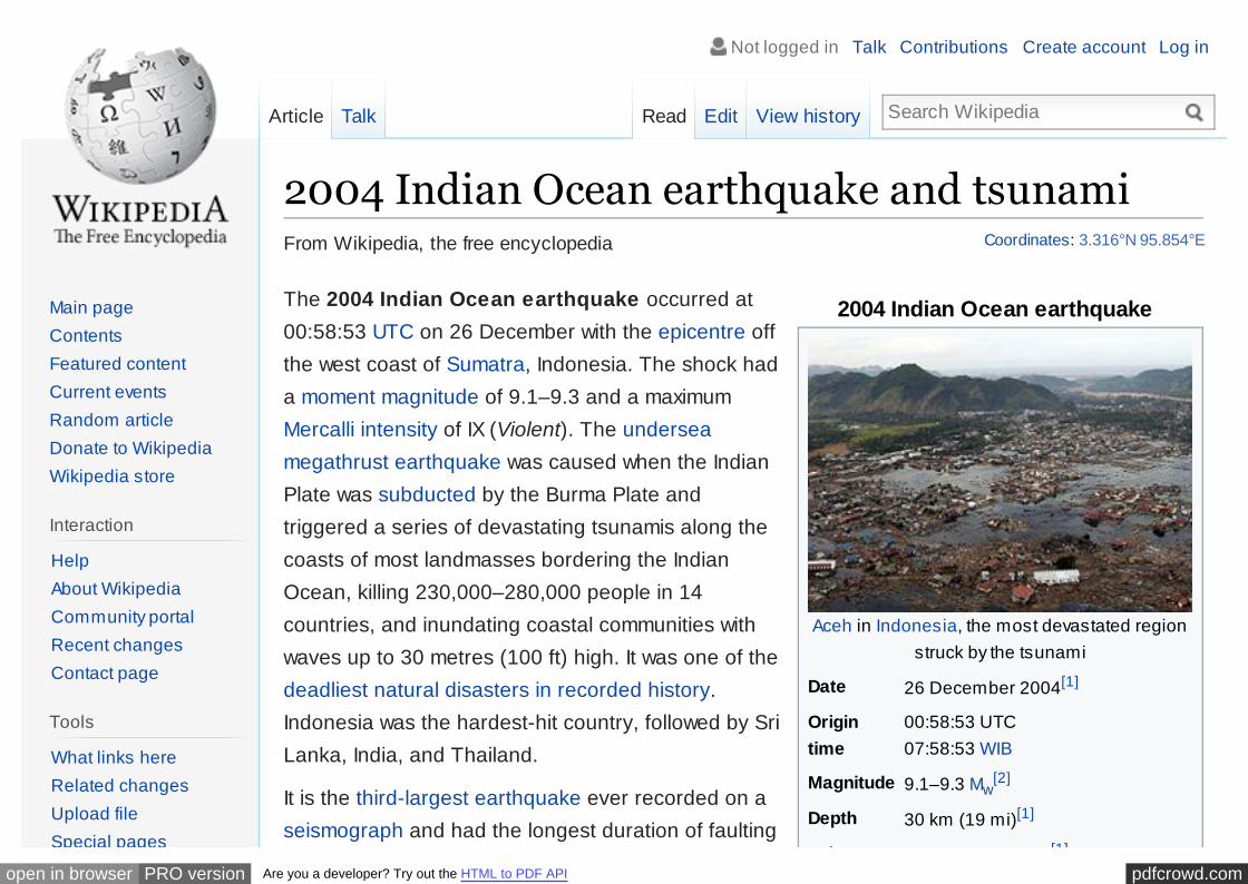
Aceh in Indonesia, the most devastated regionstruck by the tsunami
Date 26 December 2004[1]
Origintime
00:58:53 UTC07:58:53 WIB
Magnitude 9.1–9.3 Mw[2]
Depth 30 km (19 mi)[1]
Epicenter 3.316°N 95.854°E[1]
From Wikipedia, the free encyclopedia
The 2004 Indian Ocean earthquake occurred at00:58:53 UTC on 26 December with the epicentre offthe west coast of Sumatra, Indonesia. The shock hada moment magnitude of 9.1–9.3 and a maximumMercalli intensity of IX (Violent). The underseamegathrust earthquake was caused when the IndianPlate was subducted by the Burma Plate andtriggered a series of devastating tsunamis along thecoasts of most landmasses bordering the IndianOcean, killing 230,000–280,000 people in 14countries, and inundating coastal communities withwaves up to 30 metres (100 ft) high. It was one of thedeadliest natural disasters in recorded history.Indonesia was the hardest-hit country, followed by SriLanka, India, and Thailand.
It is the third-largest earthquake ever recorded on aseismograph and had the longest duration of faulting
Coordinates: 3.316°N 95.854°E
Article Talk Read Edit View history Search Wikipedia
Main pageContentsFeatured contentCurrent eventsRandom articleDonate to WikipediaWikipedia store
Interaction
HelpAbout WikipediaCommunity portalRecent changesContact page
Tools
What links hereRelated changesUpload fileSpecial pages
Not logged in Talk Contributions Create account Log in

pdfcrowd.comopen in browser PRO version Are you a developer? Try out the HTML to PDF API
Epicenter 3.316°N 95.854°E[1]
Type Megathrust
Areasaffected
IndonesiaSri LankaIndiaThailandMaldivesMalaysiaMadagascarSomaliaKenyaTanzaniaSouth Africa
Max.intensity
IX (Violent)[1]
Tsunami 15 to 30 metres (50 to 100 ft)[3][4]
with maximum runup of 51 m(167.3 ft) at Lhoknga.[5]
Casualties 230,000–280,000 dead and moremissing[6][7][8]
ever observed, between 8.3 and 10 minutes.[9] Itcaused the entire planet to vibrate as much as 1centimetre (0.4 inches)[10] and triggered otherearthquakes as far away as Alaska.[11] Its epicentrewas between Simeulue and mainland Indonesia.[12]
The plight of the affected people and countriesprompted a worldwide humanitarian response. In all,the worldwide community donated more than US$14billion (2004) in humanitarian aid.[13] The event isknown by the scientific community as the Sumatra–Andaman earthquake.[14][15] The resulting tsunamiwas given various names, including the 2004 IndianOcean tsunami, South Asian tsunami, Indonesiantsunami, the Christmas tsunami and the Boxing Daytsunami.
Contents
1 Earthquake characteristics1.1 Foreshock
1.2 Tectonic plates
1.3 Aftershocks and other earthquakes
1.4 Energy released
2 Tsunami2.1 Signs and warnings
2.2 Aceh province, Sumatra, Indonesia
2.3 Andaman and Nicobar Islands, India
Special pagesPermanent linkPage informationWikidata itemCite this page
Print/export
Create a bookDownload as PDFPrintable version
In other projects
Wikimedia Commons
Languages
AcèhالعربیةAzərbaycancaBân-lâm-gúБеларускаяБеларуская(тарашкевіца)БългарскиCatalàČeštinaCymraegDanskDeutschEestiΕλληνικάEspañol
pdfcrowd.comopen in browser PRO version Are you a developer? Try out the HTML to PDF API
2.4 Sri Lanka
2.5 Thailand
2.6 Mainland India
2.7 Maldives
2.8 Myanmar
2.9 Somalia
2.10 Elsewhere in the Indian Ocean
3 Death toll and casualties3.1 Countries affected
3.2 Event in historical context
4 Humanitarian response
5 Impact5.1 Economic impacts
5.2 Environmental impact
5.3 Other effects
6 In popular culture6.1 Apung 16.2 Films and television
6.3 Literature
6.4 Museum
6.5 Rediscovery of Mahabalipuram
7 See also
8 References
9 External links
Earthquake characteristics [edit]
EspañolEsperantoEuskaraفارسیFrançaisGalego한국어
HrvatskiBahasa IndonesiaÍslenskaItalianoעבריתBasa Jawaಕನಡ
LatviešuLietuviųMagyarമലയാളംमराठBahasa Melayu
Nederlands日本語
Norsk bokmålNorsk nynorskPolskiPortuguêsRomânăРусскийScots

pdfcrowd.comopen in browser PRO version Are you a developer? Try out the HTML to PDF API
2004 Indian Oceantsunami
Animation of tsunami caused by the earthquake show ing how itradiated from the entire length of the 1,600 km (990 mi) rupture
Events
Timeline
Countries affected:
Indonesia
Sri Lanka
India
more...
Response
Humanitarian
The tsunami was initially documented asmoment magnitude 8.8. In February 2005scientists revised the estimate of themagnitude to 9.0.[16] Although the PacificTsunami Warning Center has accepted thesenew numbers, the United States GeologicalSurvey has so far not changed its estimate of9.1. The most recent studies in 2006 haveobtained a magnitude of Mw 9.1–9.3. Dr.Hiroo Kanamori of the California Institute ofTechnology believes that Mw 9.2 is a goodrepresentative value for the size of this greatearthquake.[17]
The hypocentre of the main earthquake wasapproximately 160 km (100 mi) off thewestern coast of northern Sumatra, in theIndian Ocean just north of Simeulue island ata depth of 30 km (19 mi) below mean sealevel (initially reported as 10 km (6.2 mi)).The northern section of the Sundamegathrust ruptured over a length of1,300 km (810 mi).[12] The earthquake(followed by the tsunami) was felt inBangladesh, India, Malaysia, Myanmar,Thailand, Singapore and the Maldives.[18]
Edit links
Simple EnglishSlovenčinaSlovenščinaСрпски / srpskiSrpskohrvatski /српскохрватскиSuomi
SvenskaTagalogத
లుగుไทยTürkçeУкраїнськаاردوTiếng Việt吴语
粵語
Zeêuws中文

pdfcrowd.comopen in browser PRO version Are you a developer? Try out the HTML to PDF API
V · T · E ·
Humanitarian
See also
Warning System
Library damage
2005 Nias–Simeulue earthquake
The epicenter of the 2004 IndianOcean earthquake and associatedaftershocks in French.
Splay faults, or secondary "pop up faults",caused long, narrow parts of the sea floor topop up in seconds. This quickly elevated theheight and increased the speed of waves,causing the complete destruction of thenearby Indonesian town of Lhoknga.[19]
Indonesia lies between the Pacific Ring of Fire along thenorth-eastern islands adjacent to New Guinea, and theAlpide belt that runs along the south and west fromSumatra, Java, Bali, Flores to Timor.
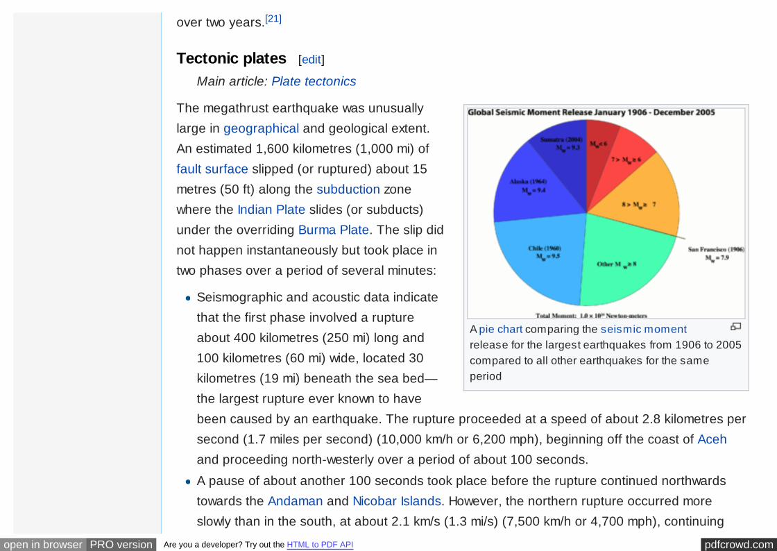
Great earthquakes such as the Sumatra-Andaman event,which are invariably associated with megathrust events insubduction zones, have seismic moments that can accountfor a significant fraction of the global earthquake momentacross century-scale time periods. Of all the seismicmoment released by earthquakes in the 100 years from1906 through 2005, roughly one-eighth was due to theSumatra-Andaman event. This quake, together with theGood Friday earthquake (Alaska, 1964) and the GreatChilean earthquake (1960), account for almost half of thetotal moment. The much smaller but still catastrophic 1906

pdfcrowd.comopen in browser PRO version Are you a developer? Try out the HTML to PDF API
The epicentre of the earthquake,just north of Simeulue Island.
total moment. The much smaller but still catastrophic 1906San Francisco earthquake is included in the diagram forperspective. Mw denotes the magnitude of an earthquakeon the moment magnitude scale.
Since 1900 the only earthquakes recorded with a greatermagnitude were the 1960 Great Chilean earthquake(magnitude 9.5) and the 1964 Good Friday earthquake inPrince William Sound (9.2). The only other recordedearthquakes of magnitude 9.0 or greater were offKamchatka, Russia, on 4 November 1952 (magnitude9.0)[20] and Tōhoku, Japan (magnitude 9.0) in March 2011.Each of these megathrust earthquakes also spawnedtsunamis in the Pacific Ocean. However, the death toll fromthese was significantly lower, primarily because of the lower population density along the coastsnear affected areas and the much greater distances to more populated coasts and also due to thesuperior infrastructure and warning systems in MEDCs (More Economically Developed Countries)such as Japan.
Other very large megathrust earthquakes occurred in 1868 (Peru, Nazca Plate and SouthAmerican Plate); 1827 (Colombia, Nazca Plate and South American Plate); 1812 (Venezuela,Caribbean Plate and South American Plate) and 1700 (western North America, Juan de Fuca Plateand North American Plate). All of them are believed to be greater than magnitude 9, but noaccurate measurements were available at the time.
Foreshock [edit]
The 2002 Sumatra earthquake is believed to have been a foreshock, predating the main event by
pdfcrowd.comopen in browser PRO version Are you a developer? Try out the HTML to PDF API
A pie chart comparing the seismic momentrelease for the largest earthquakes from 1906 to 2005compared to all other earthquakes for the sameperiod
over two years.[21]
Tectonic plates [edit]
Main article: Plate tectonics
The megathrust earthquake was unusuallylarge in geographical and geological extent.An estimated 1,600 kilometres (1,000 mi) offault surface slipped (or ruptured) about 15metres (50 ft) along the subduction zonewhere the Indian Plate slides (or subducts)under the overriding Burma Plate. The slip didnot happen instantaneously but took place intwo phases over a period of several minutes:
Seismographic and acoustic data indicatethat the first phase involved a ruptureabout 400 kilometres (250 mi) long and100 kilometres (60 mi) wide, located 30kilometres (19 mi) beneath the sea bed—the largest rupture ever known to havebeen caused by an earthquake. The rupture proceeded at a speed of about 2.8 kilometres persecond (1.7 miles per second) (10,000 km/h or 6,200 mph), beginning off the coast of Acehand proceeding north-westerly over a period of about 100 seconds.
A pause of about another 100 seconds took place before the rupture continued northwardstowards the Andaman and Nicobar Islands. However, the northern rupture occurred moreslowly than in the south, at about 2.1 km/s (1.3 mi/s) (7,500 km/h or 4,700 mph), continuing

pdfcrowd.comopen in browser PRO version Are you a developer? Try out the HTML to PDF API
north for another five minutes to a plate boundary where the fault type changes fromsubduction to strike-slip (the two plates slide past one another in opposite directions).
The Indian Plate is part of the great Indo-Australian Plate, which underlies the Indian Ocean andBay of Bengal, and is drifting north-east at an average of 6 centimetres per year (2.4 inches peryear). The India Plate meets the Burma Plate (which is considered a portion of the great EurasianPlate) at the Sunda Trench. At this point the India Plate subducts beneath the Burma Plate, whichcarries the Nicobar Islands, the Andaman Islands, and northern Sumatra. The India Plate sinksdeeper and deeper beneath the Burma Plate until the increasing temperature and pressure drivevolatiles out of the subducting plate. These volatiles rise into the overlying plate causing partialmelting and the formation of magma. The rising magma intrudes into the crust above and exits theEarth's crust through volcanoes in the form of a volcanic arc. The volcanic activity that results asthe Indo-Australian Plate subducts the Eurasian Plate has created the Sunda Arc.
As well as the sideways movement between the plates, the sea floor is estimated to have risen byseveral metres, displacing an estimated 30 cubic kilometres (7.2 cu mi) of water and triggeringdevastating tsunami waves. The waves did not originate from a point source, as was inaccuratelydepicted in some illustrations of their paths of travel, but rather radiated outwards along the entire1,600-kilometre (1,000 mi) length of the rupture (acting as a line source). This greatly increasedthe geographical area over which the waves were observed, reaching as far as Mexico, Chile, andthe Arctic. The raising of the sea floor significantly reduced the capacity of the Indian Ocean,producing a permanent rise in the global sea level by an estimated 0.1 millimetres (0.004 in).[22]
Aftershocks and other earthquakes [edit]
Numerous aftershocks were reported off the Andaman
pdfcrowd.comopen in browser PRO version Are you a developer? Try out the HTML to PDF API
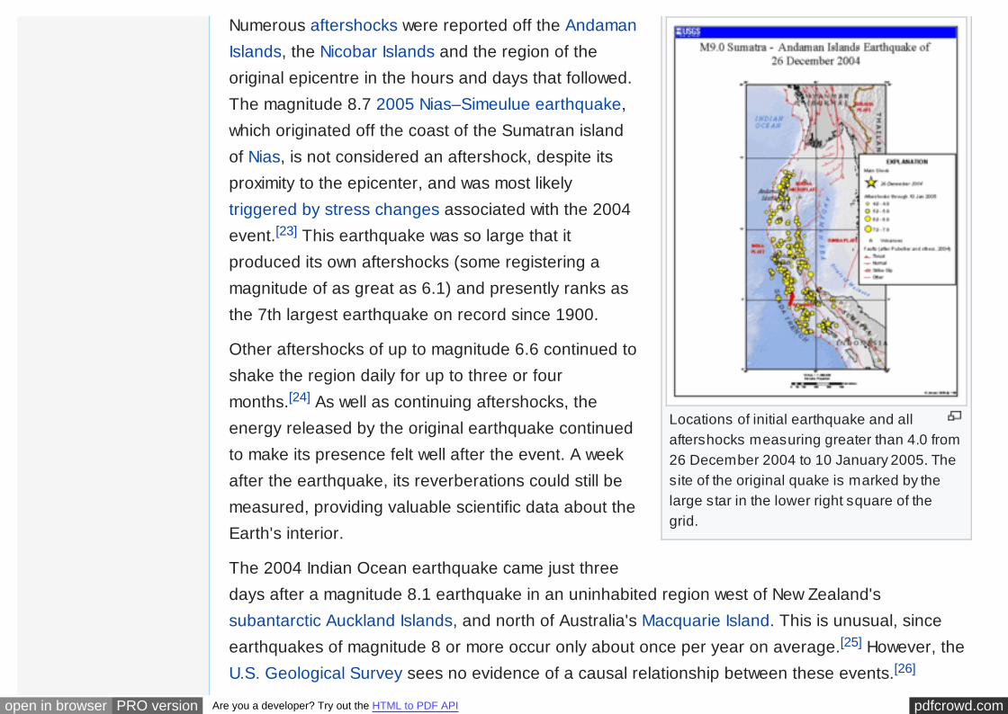
Locations of initial earthquake and allaftershocks measuring greater than 4.0 from26 December 2004 to 10 January 2005. Thesite of the original quake is marked by thelarge star in the lower right square of thegrid.
Numerous aftershocks were reported off the AndamanIslands, the Nicobar Islands and the region of theoriginal epicentre in the hours and days that followed.The magnitude 8.7 2005 Nias–Simeulue earthquake,which originated off the coast of the Sumatran islandof Nias, is not considered an aftershock, despite itsproximity to the epicenter, and was most likelytriggered by stress changes associated with the 2004event.[23] This earthquake was so large that itproduced its own aftershocks (some registering amagnitude of as great as 6.1) and presently ranks asthe 7th largest earthquake on record since 1900.
Other aftershocks of up to magnitude 6.6 continued toshake the region daily for up to three or fourmonths.[24] As well as continuing aftershocks, theenergy released by the original earthquake continuedto make its presence felt well after the event. A weekafter the earthquake, its reverberations could still bemeasured, providing valuable scientific data about theEarth's interior.
The 2004 Indian Ocean earthquake came just threedays after a magnitude 8.1 earthquake in an uninhabited region west of New Zealand'ssubantarctic Auckland Islands, and north of Australia's Macquarie Island. This is unusual, sinceearthquakes of magnitude 8 or more occur only about once per year on average.[25] However, theU.S. Geological Survey sees no evidence of a causal relationship between these events.[26]
pdfcrowd.comopen in browser PRO version Are you a developer? Try out the HTML to PDF API
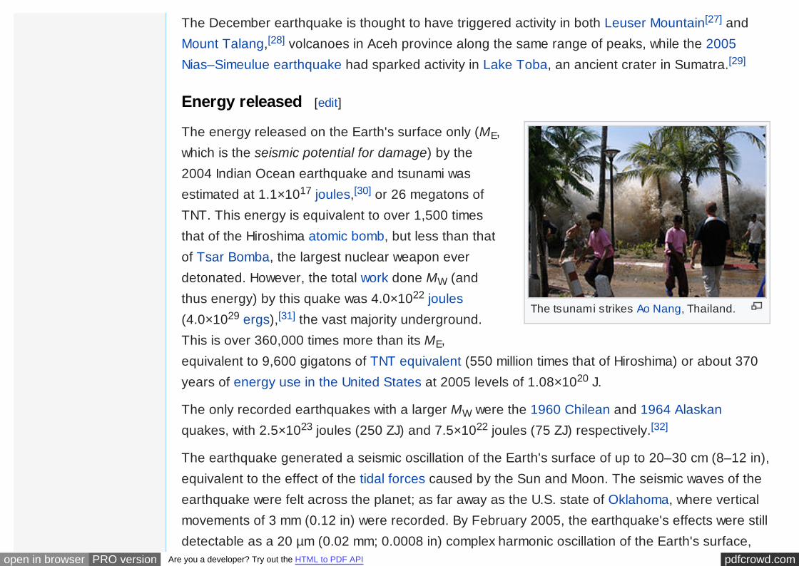
The tsunami strikes Ao Nang, Thailand.
The December earthquake is thought to have triggered activity in both Leuser Mountain[27] andMount Talang,[28] volcanoes in Aceh province along the same range of peaks, while the 2005Nias–Simeulue earthquake had sparked activity in Lake Toba, an ancient crater in Sumatra.[29]
Energy released [edit]
The energy released on the Earth's surface only (ME,which is the seismic potential for damage) by the2004 Indian Ocean earthquake and tsunami wasestimated at 1.1×10¹⁷ joules,[30] or 26 megatons ofTNT. This energy is equivalent to over 1,500 timesthat of the Hiroshima atomic bomb, but less than thatof Tsar Bomba, the largest nuclear weapon everdetonated. However, the total work done MW (andthus energy) by this quake was 4.0×10²² joules(4.0×1029 ergs),[31] the vast majority underground.This is over 360,000 times more than its ME,equivalent to 9,600 gigatons of TNT equivalent (550 million times that of Hiroshima) or about 370years of energy use in the United States at 2005 levels of 1.08×10²⁰ J.
The only recorded earthquakes with a larger MW were the 1960 Chilean and 1964 Alaskanquakes, with 2.5×10²³ joules (250 ZJ) and 7.5×10²² joules (75 ZJ) respectively.[32]
The earthquake generated a seismic oscillation of the Earth's surface of up to 20–30 cm (8–12 in),equivalent to the effect of the tidal forces caused by the Sun and Moon. The seismic waves of theearthquake were felt across the planet; as far away as the U.S. state of Oklahoma, where verticalmovements of 3 mm (0.12 in) were recorded. By February 2005, the earthquake's effects were stilldetectable as a 20 µm (0.02 mm; 0.0008 in) complex harmonic oscillation of the Earth's surface,
pdfcrowd.comopen in browser PRO version Are you a developer? Try out the HTML to PDF API
which gradually diminished and merged with the incessant free oscillation of the Earth more than 4months after the earthquake.[33]
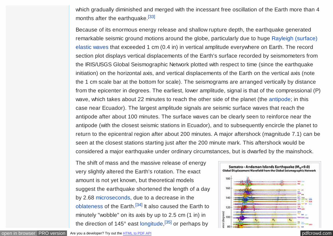
Because of its enormous energy release and shallow rupture depth, the earthquake generatedremarkable seismic ground motions around the globe, particularly due to huge Rayleigh (surface)elastic waves that exceeded 1 cm (0.4 in) in vertical amplitude everywhere on Earth. The recordsection plot displays vertical displacements of the Earth's surface recorded by seismometers fromthe IRIS/USGS Global Seismographic Network plotted with respect to time (since the earthquakeinitiation) on the horizontal axis, and vertical displacements of the Earth on the vertical axis (notethe 1 cm scale bar at the bottom for scale). The seismograms are arranged vertically by distancefrom the epicenter in degrees. The earliest, lower amplitude, signal is that of the compressional (P)wave, which takes about 22 minutes to reach the other side of the planet (the antipode; in thiscase near Ecuador). The largest amplitude signals are seismic surface waves that reach theantipode after about 100 minutes. The surface waves can be clearly seen to reinforce near theantipode (with the closest seismic stations in Ecuador), and to subsequently encircle the planet toreturn to the epicentral region after about 200 minutes. A major aftershock (magnitude 7.1) can beseen at the closest stations starting just after the 200 minute mark. This aftershock would beconsidered a major earthquake under ordinary circumstances, but is dwarfed by the mainshock.
The shift of mass and the massive release of energyvery slightly altered the Earth's rotation. The exactamount is not yet known, but theoretical modelssuggest the earthquake shortened the length of a dayby 2.68 microseconds, due to a decrease in theoblateness of the Earth.[34] It also caused the Earth tominutely "wobble" on its axis by up to 2.5 cm (1 in) inthe direction of 145° east longitude,[35] or perhaps by

pdfcrowd.comopen in browser PRO version Are you a developer? Try out the HTML to PDF API
Vertical-component ground motionsrecorded by the IRIS/USGS GlobalSeismographic Network.
up to 5 or 6 cm (2.0 or 2.4 in).[36] However, becauseof tidal effects of the Moon, the length of a dayincreases at an average of 15 µs per year, so anyrotational change due to the earthquake will be lostquickly. Similarly, the natural Chandler wobble of theEarth, which in some cases can be up to 15 m (50 ft),will eventually offset the minor wobble produced bythe earthquake.
More spectacularly, there was 10 m (33 ft) movementlaterally and 4–5 m (13–16 ft) vertically along the jadeline. Early speculation was that some of the smaller islands south-west of Sumatra, which is on theBurma Plate (the southern regions are on the Sunda Plate), might have moved south-west by upto 36 m (120 ft), but more accurate data released more than a month after the earthquake foundthe movement to be about 20 cm (8 in).[37] Since movement was vertical as well as lateral, somecoastal areas may have been moved to below sea level. The Andaman and Nicobar Islandsappear to have shifted south-west by around 1.25 m (4 ft 1 in) and to have sunk by 1 m (3 ft3 in).[38]
In February 2005, the Royal Navy vessel HMS Scott surveyed the seabed around the earthquakezone, which varies in depth between 1,000 and 5,000 m (550 and 2,730 fathoms; 3,300 and16,400 ft). The survey, conducted using a high-resolution, multi-beam sonar system, revealed thatthe earthquake had made a huge impact on the topography of the seabed. 1,500-metre-high(5,000 ft) thrust ridges created by previous geologic activity along the fault had collapsed,generating landslides several kilometres wide. One such landslide consisted of a single block ofrock some 100 m high and 2 km long (300 ft by 1.25 mi). The momentum of the water displaced bytectonic uplift had also dragged massive slabs of rock, each weighing millions of tons, as far as
pdfcrowd.comopen in browser PRO version Are you a developer? Try out the HTML to PDF API
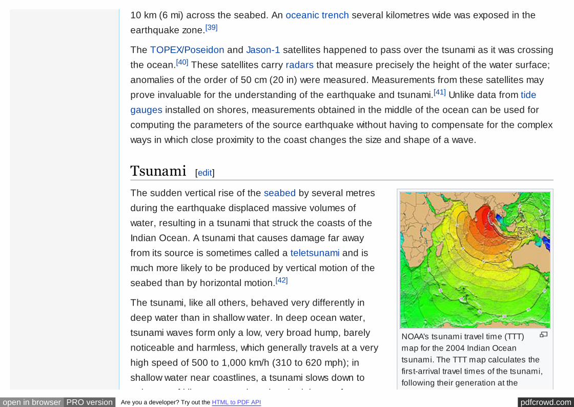
NOAA's tsunami travel time (TTT)map for the 2004 Indian Oceantsunami. The TTT map calculates thefirst-arrival travel times of the tsunami,following their generation at the
10 km (6 mi) across the seabed. An oceanic trench several kilometres wide was exposed in theearthquake zone.[39]
The TOPEX/Poseidon and Jason-1 satellites happened to pass over the tsunami as it was crossingthe ocean.[40] These satellites carry radars that measure precisely the height of the water surface;anomalies of the order of 50 cm (20 in) were measured. Measurements from these satellites mayprove invaluable for the understanding of the earthquake and tsunami.[41] Unlike data from tidegauges installed on shores, measurements obtained in the middle of the ocean can be used forcomputing the parameters of the source earthquake without having to compensate for the complexways in which close proximity to the coast changes the size and shape of a wave.
Tsunami [edit]
The sudden vertical rise of the seabed by several metresduring the earthquake displaced massive volumes ofwater, resulting in a tsunami that struck the coasts of theIndian Ocean. A tsunami that causes damage far awayfrom its source is sometimes called a teletsunami and ismuch more likely to be produced by vertical motion of theseabed than by horizontal motion.[42]
The tsunami, like all others, behaved very differently indeep water than in shallow water. In deep ocean water,tsunami waves form only a low, very broad hump, barelynoticeable and harmless, which generally travels at a veryhigh speed of 500 to 1,000 km/h (310 to 620 mph); inshallow water near coastlines, a tsunami slows down toonly tens of kilometres per hour but, in doing so, forms

pdfcrowd.comopen in browser PRO version Are you a developer? Try out the HTML to PDF API
earthquake epicenter. Note that themaps do not provide the height or thestrength of the wave, only the arrivaltimes. The number tags representhours after the initial event. Mapcontours represent 1-hour intervals.Red indicates 1- to 4-hour arrival times,Yellow indicates 5- to 6-hour arrivaltimes, Green indicates 7- to 14-hourarrival times, and Blue indicates 15- to21-hour arrival times. Maps weregenerated from earthquake epicentersin the NGDC Global Historical TsunamiDatabase using NGDC 2-MinuteGridded Global Relief Data bathymetry.The map was created through modelsbased on quality-controlled sourcedata, and an integration of many datasets together.
only tens of kilometres per hour but, in doing so, formslarge destructive waves. Scientists investigating thedamage in Aceh found evidence that the wave reached aheight of 24 metres (80 ft) when coming ashore alonglarge stretches of the coastline, rising to 30 metres (100 ft)in some areas when traveling inland.[4]
Radar satellites recorded the heights of tsunami waves indeep water: at two hours after the earthquake, themaximum height was 60 centimetres (2 ft). These are thefirst such observations ever made. These observationscould not be used to provide a warning, since the satelliteswere not built for that purpose and the data took hours toanalyze.[43][44]
According to Tad Murty, vice-president of the TsunamiSociety, the total energy of the tsunami waves wasequivalent to about five megatons of TNT (20 petajoules).This is more than twice the total explosive energy usedduring all of World War II (including the two atomic bombs)but still a couple of orders of magnitude less than theenergy released in the earthquake itself. In many placesthe waves reached as far as 2 km (1.2 mi) inland.[45]
Because the 1,600 km (1,000 mi) fault affected by theearthquake was in a nearly north-south orientation, thegreatest strength of the tsunami waves was in an east-westdirection. Bangladesh, which lies at the northern end of the

pdfcrowd.comopen in browser PRO version Are you a developer? Try out the HTML to PDF API
Scale showing the size of thetsunami waves that hit Indonesia
Tsunami wave field in the Bay of Bengalone hour after the M=9.2 earthquake. View tothe northwest.
Bay of Bengal, had very few casualties despite being alow-lying country relatively near the epicenter. It alsobenefited from the fact that the earthquake proceededmore slowly in the northern rupture zone, greatly reducingthe energy of the water displacements in that region.
Coasts that have a landmass between them and thetsunami's location of origin are usually safe; however,tsunami waves can sometimes diffract around suchlandmasses. Thus, the state of Kerala was hit by thetsunami despite being on the western coast of India, andthe western coast of Sri Lanka suffered substantialimpacts. Distance alone was no guarantee of safety,as Somalia was hit harder than Bangladesh despitebeing much farther away.
Because of the distances involved, the tsunami tookanywhere from fifteen minutes to seven hours toreach the coastlines.[46][47] The northern regions ofthe Indonesian island of Sumatra were hit very quickly,while Sri Lanka and the east coast of India were hitroughly 90 minutes to two hours later. Thailand wasstruck about two hours later despite being closer tothe epicentre, because the tsunami traveled moreslowly in the shallow Andaman Sea off its western coast.
The tsunami was noticed as far as Struisbaai in South Africa, some 8,500 km (5,300 mi) away,where a 1.5 m (5 ft) high tide surged on shore about 16 hours after the earthquake. It took a
Play media
pdfcrowd.comopen in browser PRO version Are you a developer? Try out the HTML to PDF API
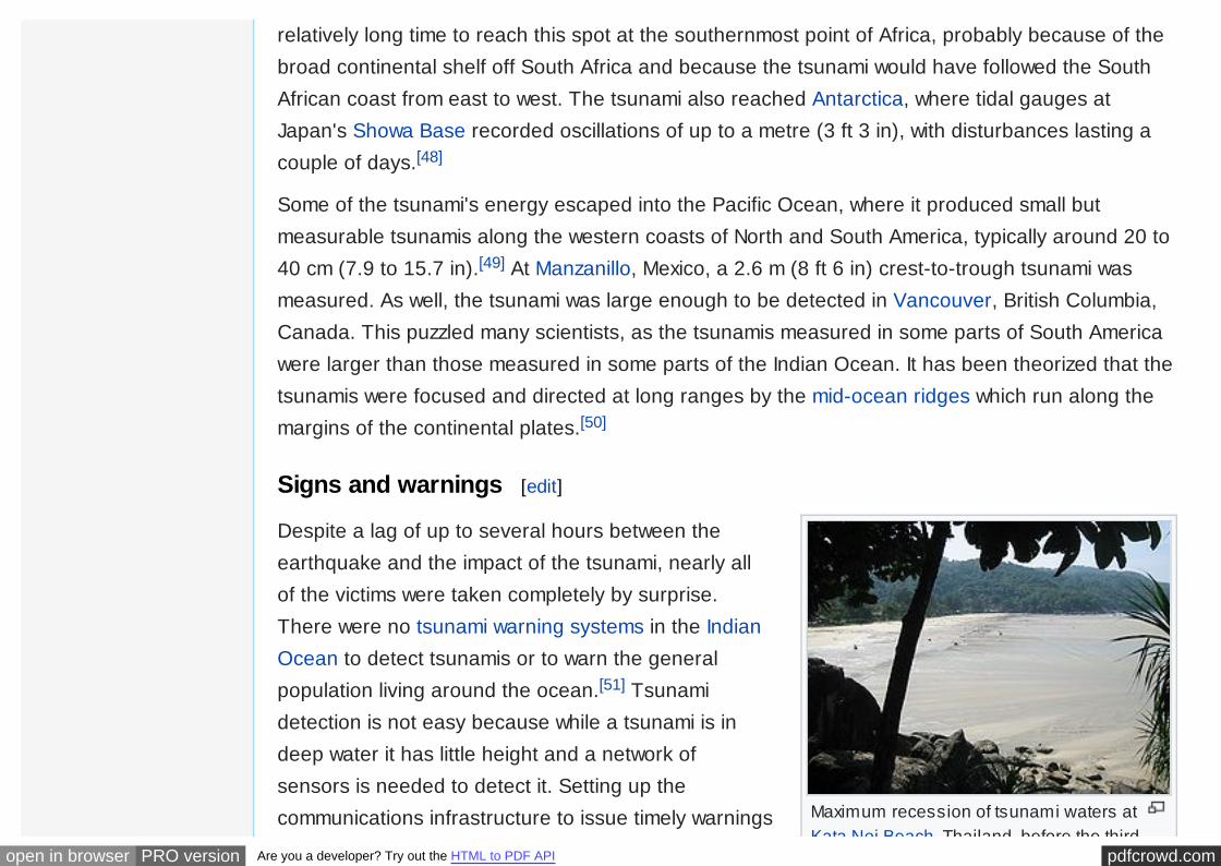
Maximum recession of tsunami waters atKata Noi Beach, Thailand, before the third,
relatively long time to reach this spot at the southernmost point of Africa, probably because of thebroad continental shelf off South Africa and because the tsunami would have followed the SouthAfrican coast from east to west. The tsunami also reached Antarctica, where tidal gauges atJapan's Showa Base recorded oscillations of up to a metre (3 ft 3 in), with disturbances lasting acouple of days.[48]
Some of the tsunami's energy escaped into the Pacific Ocean, where it produced small butmeasurable tsunamis along the western coasts of North and South America, typically around 20 to40 cm (7.9 to 15.7 in).[49] At Manzanillo, Mexico, a 2.6 m (8 ft 6 in) crest-to-trough tsunami wasmeasured. As well, the tsunami was large enough to be detected in Vancouver, British Columbia,Canada. This puzzled many scientists, as the tsunamis measured in some parts of South Americawere larger than those measured in some parts of the Indian Ocean. It has been theorized that thetsunamis were focused and directed at long ranges by the mid-ocean ridges which run along themargins of the continental plates.[50]
Signs and warnings [edit]
Despite a lag of up to several hours between theearthquake and the impact of the tsunami, nearly allof the victims were taken completely by surprise.There were no tsunami warning systems in the IndianOcean to detect tsunamis or to warn the generalpopulation living around the ocean.[51] Tsunamidetection is not easy because while a tsunami is indeep water it has little height and a network ofsensors is needed to detect it. Setting up thecommunications infrastructure to issue timely warnings

pdfcrowd.comopen in browser PRO version Are you a developer? Try out the HTML to PDF API
Kata Noi Beach, Thailand, before the third,and strongest, tsunami wave (sea visible inthe right corner, the beach is at the extremeleft), 10:25 am local time.
is an even bigger problem, particularly in a relativelypoor part of the world.
Tsunamis are much more frequent in the PacificOcean because of earthquakes in the "Ring of Fire",and an effective tsunami warning system has long been in place there. Although the extremewestern edge of the Ring of Fire extends into the Indian Ocean (the point where this earthquakestruck), no warning system exists in that ocean. Tsunamis there are relatively rare despiteearthquakes being relatively frequent in Indonesia. The last major tsunami was caused by theKrakatoa eruption of 1883. It should be noted that not every earthquake produces large tsunamis;on 28 March 2005, a magnitude 8.7 earthquake hit roughly the same area of the Indian Ocean butdid not result in a major tsunami.
The first warning sign of a possible tsunami is the earthquake itself. However, tsunamis can strikethousands of kilometres away where the earthquake is only felt weakly or not at all. Also, in theminutes preceding a tsunami strike, the sea often recedes temporarily from the coast. This wasobserved on the eastern side of the rupture zone of the earthquake such as around the coastlinesof Aceh province, Phuket island and Khao Lak area in Thailand, Penang island of Malaysia andthe Andaman and Nicobar islands. Around the Indian Ocean, this rare sight reportedly inducedpeople, especially children, to visit the coast to investigate and collect stranded fish on as much as2.5 km (1.6 mi) of exposed beach, with fatal results.[52] However, not all tsunamis cause this"disappearing sea" effect. In some cases, there are no warning signs at all: the sea will suddenlyswell without retreating, surprising many people and giving them little time to flee.
Reportedly, scuba divers near the abundant coral reefs in Thailand and the Maldives werereportedly caught off guard by violent, swirling underwater currents. The divers described theexperience like being in a 'washing machine'. Coral reef animals like fish were also absent as thetsunami passed by.[53]

pdfcrowd.comopen in browser PRO version Are you a developer? Try out the HTML to PDF API
One of the few coastal areas to evacuate ahead of the tsunami was on the Indonesian island ofSimeulue, very close to the epicentre. Island folklore recounted an earthquake and tsunami in1907, and the islanders fled to inland hills after the initial shaking and before the tsunami struck.These tales and oral folklore from previous generations may have helped the survival of theinhabitants.[54] On Maikhao beach in northern Phuket, Thailand, a 10-year-old British touristnamed Tilly Smith had studied tsunami in geography at school and recognised the warning signsof the receding ocean and frothing bubbles. She and her parents warned others on the beach,which was evacuated safely.[55] John Chroston, a biology teacher from Scotland, also recognisedthe signs at Kamala Bay north of Phuket, taking a busload of vacationers and locals to safety onhigher ground.
Anthropologists had initially expected the aboriginal population of the Andaman Islands to be badlyaffected by the tsunami and even feared the already depopulated Onge tribe could have beenwiped out.[56] Many of the aboriginal tribes evacuated and suffered fewer casualties.[57][58] Oraltraditions developed from previous earthquakes helped the aboriginal tribes escape the tsunami.For example, the folklore of the Onges talks of "huge shaking of ground followed by high wall ofwater". Almost all of the Onge people seemed to have survived the tsunami.[59]
Aceh province, Sumatra, Indonesia [edit]

pdfcrowd.comopen in browser PRO version Are you a developer? Try out the HTML to PDF API
A two story house damaged by thetsunami showing the tsunamiinundation height in downtown BandaAceh.
The tsunami first struck the west and north coasts ofnorthern Sumatra, Indonesia particularly in Aceh provincein the fresh morning. At Ulee Lheue in Banda Aceh, asurvivor described three waves, with the first wave risingonly to the foundation of the buildings. This was followedby a large withdrawal of the sea before the second andthird waves hit.[60] The tsunami reached shore 15–20minutes after the earthquake, and the second was biggerthan the first. This is the same as that in Khao Lak andPhuket Island in southern Thailand. A local resident livingat Banda Aceh states that the giant wave was 'higher thanmy house'.[61] Another resident living 2 km (1.2 mi) nearthe coast on the outskirt of the city informed that thetsunami was 'like a wall, very black' in colour and had a 'distinct sound' getting louder as it nearsthe coast.[62]
The maximum runup height of the tsunami was measured at a hill between Lhoknga and Leupung,located on the west coast of the northern tip of Sumatra, near Banda Aceh, and reached morethan 30 m (100 ft).[5]
The tsunami heights in Sumatra:[63]
• 15–30 m (49 ft-98 ft) on the west coast of Aceh.
• 6–12 m (19.7 ft-39.4 ft) on the Banda Aceh coast.
• 6 m (19.7 ft) on the Krueng Raya coast ( 3 oil tanks floated out)
• 5 m (16.4 ft) on the Sigli coast.
• 3–6 m (9.8 ft-19.7 ft) on the north coast of Weh Island directly facing the tsunami source.

pdfcrowd.comopen in browser PRO version Are you a developer? Try out the HTML to PDF API
• 3–6 m (9.8 ft-19.7 ft) on the north coast of Weh Island directly facing the tsunami source.
• 3 m (9.8 ft) on the opposite side of the coast of Weh Island facing the tsunami.
The tsunami height on the Banda Aceh coast is lower than half of that on the west coast. Evenwithin the Banda Aceh coast, the tsunami height was reduced by half from 12 m (39.4 ft) at UleeLheue to 6 m (19.7 ft) a further 8 km (4.97 miles) to the northeast. The inundation was observed tolie 3–4 km (1.86–2.49 miles) inland throughout the city. Flow depths over the ground wereobserved to be over 9 m (29.5 ft) in the seaside section of Ulee Lheue and tapered landward. Thelevel of destruction was more extreme on the northwestern flank of the city in the areasimmediately inland of the aquaculture ponds. The area toward the sea was wiped clean of nearlyevery structure, while closer to the river—dense construction in a commercial district showed theeffects of severe flooding. The flow depth was just at the level of the second floor, and there werelarge amounts of debris piled along the streets and in the ground-floor storefronts. One of thereasons seems to be that there is an archipelago between Lhoknga and Banda Aceh.Within 2–3 km (1.24–1.86 miles) from the shoreline, houses, except for strongly-built reinforced concreteones with brick walls, which seemed to have been partially damaged by the earthquake before thetsunami attack, were completely swept away or destroyed by the tsunami.[63][64]
Three small islands: Weh, Breuh, and Deudap, lie just north of the capital city. The tsunami effectson two of the islands Breuh and Deudap were extreme, with a runup of 10–20 m (33–66 ft) on thewest-facing shores. Coastal villages were completely destroyed by the tsunami waves. On PulauWeh, however, the island experienced strong surges in the port of Sabang, yet there was littledamage with a reported runup values of 3–5 m (9.8–16.4 ft), which was most likely shadowed fromthe direct tsunami attack by the islands to the southwest.[64]
In Lhoknga, a town in Aceh Besar Regency, Aceh Special Region, Indonesia, located on thewestern side of the island of Sumatra, 13 km (8.08 miles) southwest of Banda Aceh was completelyflattened and destroyed by the 2004 Boxing Day Tsunami, where its population dwindled from

pdfcrowd.comopen in browser PRO version Are you a developer? Try out the HTML to PDF API
7,500 to 400. The tsunami waves were almost 30 m (98.4 ft) high. Eyewitnesses reported 10 to 12waves, the second and third ones being the highest. The sea receded (drawback) 10 minutes afterthe earthquake and the first wave came rapidly landward as a turbulent flow (flood) with depthsranging from 0.5 to 2.5 m (1.64 ft-8.20 ft) high. The second and third waves was 15–30 m (49.2 ft-98.4 ft) high at the coast, described having an appearance to a surf wave (cobra-shaped) but'taller than the coconut trees' and was 'like a mountain'.[65] Consequently, the tsunami alsostranded cargo ships and barges and destroyed a cement factory near the Lampuukcoast.[5][66][67] Moreover, surveyed areas by scientists show runup heights over 20 m (65.6 ft) onthe northwest coast of Sumatra in the Aceh province with a maximum runup of 51 m (167.3 ft).[68]
In Meulaboh based on survivor testimonies, tsunami arrived after the sea receded about 500 m(0.31 miles), followed by an advancing small tsunami. The second and third destructive wavesarrived later, which exceeded the height of the coconut trees. The inundation distance is about5 km (3.1 miles).[69]
Such high and fast waves arising from the epicentre by a megathrust earthquake were later foundto be due to splay faults, secondary faults arising due to cracking of the sea floor to jut upwards inseconds, causing waves' speed and height to increase. A large slip of 30 m (98.4 ft) was estimatedon the subfault located off the west coast of Aceh province. Another factor is subsidence at BandaAceh (20–60 cm), Peukan Bada (>20 cm), Lhok Nga and Leupung (>1.5 m).[63]
Other towns on Aceh's west coast hit by the disasterincluded Leupung, Lhokruet, Lamno, Patek, Calang,Teunom, and the island of Simeulue. Affected or destroyedtowns on the region's north and east coast were PidieRegency, Samalanga, Panteraja and Lhokseumawe.
The very high fatality in the area is mainly due to the

pdfcrowd.comopen in browser PRO version Are you a developer? Try out the HTML to PDF API
An overturned cement carrier, theSinar Andalas caused by the tsunamiin Lhoknga.
unpreparedness of the population from such an event.Helicopter survey showed entire settlements virtuallydestroyed with destruction miles inland with only somemosques left standing, which provided refuge for thepeople from the tsunami.
Andaman and Nicobar Islands, India [edit]
The major islands affected by the tsunami were in the South, Middle, and North Andaman Islands.The tsunami arrived in the Andaman and Nicobar Islands minutes after the earthquake, and itcaused extensive devastation to the islands' environment. Specifically, the Andaman Islands weremoderately affected while the island of Little Andaman and the Nicobar Islands were severelyaffected by the tsunami. Waves nearly 3-storeys high, devastated the Indian Air Force base nearMalacca. The worst affected island in the Andaman & Nicobar chain is Katchall Island with 303people confirmed dead and 4,354 missing out of a total population of 5,312.[70][71][72]
Eyewitnesses at Port Blair recall that the water receded before the first wave, and the third wavewas the tallest and caused the most damage. However, at Hut Bay, Malacca and Campbell Bay —locations far south of Port Blair — it was reported that the water level rose by about 1–2 m (3.3 ft-6.6 ft) from the normal sea level and remained there before the first wave crashed ashore.
Reports of tsunami wave height:[73][74]
• 1.5 m (4.9 ft) at Diglipur and Rangat at North Andaman Island.
• 8 m (26.2 ft) high at Campbell Bay (in Great Nicobar Island),
• 10–12 m (32.8 ft-39.4 ft) high at Malacca (in Car Nicobar Island) and at Hut Bay (in LittleAndaman Island).
• 3 m (9.8 ft) high at Port Blair (in South Andaman Island).

pdfcrowd.comopen in browser PRO version Are you a developer? Try out the HTML to PDF API
The significant shielding of Port Blair and Campbell Bay by steep mountainous outcrops may havecontributed to the relatively low wave heights at these locations, whereas the open terrain alongthe eastern coast at Malacca and Hut Bay likely contributed to the great height of the tsunamiwaves [71][75]
Indeed, many infrastructures near the coasts and buildings were harshly damaged by thewaves.[72]
Sri Lanka [edit]
The tsunami first arrived on the eastern coast and subsequently refracted around the southernpoint of Sri Lanka (Dondra Head). The refracted tsunami waves inundated the southwestern partof Sri Lanka after some of its energy has been reflected from impact with the Maldives.[76] SriLanka is located 1,700 km (1056.33 miles) far from the epicenter and the tsunami source, so noone felt the ground shake and the tsunami hit the entire coastline of Sri Lanka around 2 hoursafter the earthquake.[77] It seems that the tsunami flooding consisted of three main waves, with thesecond being the largest and most destructive.[78] The first tsunami waves had initially caused asmall flood (positive wave) as it struck the Sri Lankan coastline. Moments later, the ocean floor wasexposed to as much as 1 km (0.62 miles) in places due to drawback (negative wave). This wasfollowed by a massive second tsunami wave, which is in the form of a flood. Certain locationsmanaged to reduce the power of the waves through construction of seawalls and breakwaters.
The largest run-up measured was at 12.5 m (41 ft) with inundation distance of 390 m to 1.5 km(0.242 miles-0.932 miles) in Yala.[79] In Hambantota, tsunami run-ups are measured at 11 m(36.1 ft) with the greatest inundation distance of 2 km (1.24 miles), and tsunami run-upmeasurements along the Sri Lankan coasts are at 2.4–11 m (7.87 ft-36.1 ft).[76][79] Tsunami wavesmeasured on the east coast ranged from 4.5 m-9 m (14.8 ft-29.5 ft) at Pottuvill to around

pdfcrowd.comopen in browser PRO version Are you a developer? Try out the HTML to PDF API
Fishermen's boat stranded inKallady, Batticaloa, Sri Lanka.
Batticaloa, 2.6 m- 5 m (8.53 ft-16.4 ft) in the northeast around Trincomalee and 4 m-5 m (13.1 ft-16.4 ft) in the west coast from Moratuwa to Ambalangoda.
Sri Lanka tsunami height survey:[77][78]
• 9 m (29.5 Ft) at Koggala.
• 6 m (19.7 ft) at Galle port.
• 4.8 m (15.7 ft) around the Galle coast.
• 8.71 m (28.6 ft) at Nonagama.
• 4.9 m (16.1 ft) at Weligama.
• 4 m (13.1 ft) at Dodundawa.
• 4.7 m (15.4 ft) at Ambalangoda.
• 4.7 m (15.4 ft) at Hikkaduwa Fishery Harbour.
• 10 m (33 ft) at Kahawa.
• 4.8 m (15.7 ft) at North Beach of Beruwala.
• 6 m (19.7 ft) at Paiyagala.
The Sumudra Devi, a passenger train out of Colombo, was derailed and overturned by thetsunami.[80] The tsunami caused the 2004 Sri Lanka tsunami-rail disaster which took at least 1,700lives, making it the largest single rail disaster in world history by death toll. Estimates based on thestate of the shoreline and a high-water mark on a nearby building place the tsunami 7.5–9 m(24.6 ft to 29.5 ft) above sea level and 2–3 m (6.6 ft to 9.8 ft) higher than the top of the train.[77]
In Sri Lanka, the civilian casualties were second only to those in Indonesia. Reports vary on thenumber of deaths since many people are still missing and the country lacks adequate

pdfcrowd.comopen in browser PRO version Are you a developer? Try out the HTML to PDF API
communications. The eastern shores of Sri Lanka faced the hardest impact since they were facingthe epicenter of the earthquake. The southwestern shores were hit later, but the death toll was justas severe. The southwestern shores are a hotspot for tourists as well as the fishing economy.Tourism and fishing industries created high population densities along the coast.[81]
The coastal lifestyle of people and degradation of the natural environment in Sri Lanka contributedto the high death tolls. In addition to the high number of fatalities, approximately 90,000 buildingswere destroyed. Houses were easily destroyed since they were built mostly from wood.[81]
Thailand [edit]
The tsunami hit the southwest coast of southern Thailand, which was about 500 km (310.69 miles)from the epicenter. The region is famous for its high quality resorts, pristine beaches, spectacularislands with warm Andaman blue waters and stunning scenery making it prominent with touristsinternationally. Since the tsunami hit around high tide, its damage was severe. Approximately5,400 people were killed and 3,100 people were reported missing in Thailand. The places wherethe tsunami attacked were Khao Lak, Phuket Island, the Phi Phi Islands, Koh Racha Yai, Koh LantaYai and Ao Nang of Krabi province, offshore archipelagos like the Surin Islands, the SimilanIslands, and coastal areas of Satun, Ranong, Phang Nga, Trang and Krabi provinces.
The country experienced the largest tsunami runup height of any location outside of Sumatra,which occurred at Khao Lak and the areas of Takua Pa district that are facing the AndamanSea.The tsunami heights recorded:[82][83]
• 6–10 m (19.7 ft-32.8 ft) in Khao Lak.
• 3–6 m (9.84 ft-19.7 ft) along the west coast of Phuket island.
• 3 m (9.84 ft) along the south coast of Phuket island.
• 2 m (6.56 ft) along the east coast of Phuket island.

pdfcrowd.comopen in browser PRO version Are you a developer? Try out the HTML to PDF API
• 4–6 m (13.12 ft-19.7 ft) on the Phi Phi Islands.
• 19.6 m (64.3 ft) at Ban Thung Dap.
• 5 m (16.4 ft) at Ramson.
• 6.8 m (22.3 ft) at Ban Thale Nok.
• 5 m (16.4 ft) at Hat Praphat (Ranong Coastal Resources Research Station).
• 6.3 m (20.7 ft) at Thai Muang district.
• 6.8 m (22.3 ft) at Rai Dan.
The province of Phang-Nga was the most heavily affected area in Thailand by the gigantictsunami. The northern part of Phang-Nga Province is a rural area with fishery and agriculturalvillages while the central part has several resort hotels. Khao Lak is located in the south of Phang-Nga Province with many luxurious hotels, popular to foreign tourists, especially from Europe. KhaoLak was hit by the gigantic tsunami after 10 AM and the death toll in Khao Lak was the largest inThailand.[84] Many local villagers and tourists lost their lives during the event. A maximuminundation of approximately 2 km (1.2 miles) and the inundated depths were 4–7 m (13.12 ft-23 ft)in Khao Lak. Surveys conducted show that the tsunami inundated the third floor of a resort hotel.The tsunami heights in Khao Lak were much higher than Phuket Island. The reason for thisdifference seems to have been caused by the local bathymetry off Khao Lak. According to someinterviews with local residents and affected tourists, the leading wave produced an initialdepression, called a tsunami drawback or 'disappearing sea' effect and the second wave waslargest.[82] The highest recorded tsunami runup measured was at 19.6 m (64.3 ft) at Ban ThungDap, located on the southwest tip of Ko Phra Thong Island and the second highest at 15.8 m(51.8 ft) at Ban Nam Kim.[83]
At Phuket island, many of its west coast beaches were

pdfcrowd.comopen in browser PRO version Are you a developer? Try out the HTML to PDF API
Thai navy boat 813 (police boat)stranded almost 2 km inland by theKhao Lak tsunami.
Tsunami wave striking Phuketcoast.
At Phuket island, many of its west coast beaches wereaffected. At Patong Beach – a tourist mecca – the tsunamiheights were 5–6 m (16.4 ft-19.7 ft) and the inundateddepth was about 2 m (6.6 ft). The tsunami heights becamelower from the west coast, the south coast to the eastcoast of the island. On Karon beach on the west coast, thecoastal road was built higher than the shore and it actedas a seawall, protecting a hotel which was behind it. On theeast coast of Phuket Island, which was not facing thetsunami source, the tsunami height was about 2 m (6.6 ft).In one river mouth, many boats were damaged. Thetsunami propagated anticlockwise around Phuket Island,as was the case at Okushiri Island in the 1993 Hokkaido earthquake. According to some interviewswith the people, the leading wave produced an initial depression and the second wave was thelargest.[82]
The Phi Phi Islands are a group of small islands that wereaffected by the tsunami. The north bay of Phi Phi DonIsland opens to the northwest, thus it faced in the directionthat the tsunami came from. The measured tsunami heighton this beach was 5.8 m (19.02 ft). According to someeyewitnesses accounts, the tsunami came from the northand south, and totally washed the central area away. Theground level here was about 2 m (6.6 ft) above sea level,but there were many cottages and hotels. Therefore, thetsunami waves from the north and south destroyed thearea, the south bay opens to the southeast. It faces in the
pdfcrowd.comopen in browser PRO version Are you a developer? Try out the HTML to PDF API
Tsunami destruction in Chennai,Tamil Nadu, India.
opposite direction to which the tsunami was propagated. Further, Phi Phi Le Island shields the portof Phi Phi Don Island. The measured tsunami height, however, was 4.6 m (15.1 ft) in this port. Itindicated that the tsunami propagated around the islands.[82]
Many amateur videos recorded by tourists and locals of the tsunami at Thailand were televisedpopularly in the media.
Mainland India [edit]
The tsunami arrived in the states of Andhra Pradesh and Tamil Nadu along the southeast coast ofthe Indian mainland shortly after 9:00 a.m. At least two hours later, it arrived in the state of Keralaalong the southwest coast. Tamil Nadu, the union territory of Pondicherry and Kerala wereextensively damaged, while Andhra Pradesh sustained moderate damage. There were two to fivewaves of varying height that coincided with the local high tide in some areas.[85][86][87][88]
The tsunami run-up was only 1.6 m (5.2 ft) in areas in thestate of Tamil Nadu that were shielded by the island of SriLanka, but was 4–5 m (13.1 ft-16.4 ft) in coastal districtssuch as Nagapattinam in Tamil Nadu that were directlyacross from Sumatra, which happen to be the highest onthe Indian mainland. On the western coast, the runupelevations were 4.5 m (14.8 ft) at Kanyakumari District inTamil Nadu, and 3.4 m (11.2 ft) each at Kollam andErnakulam Districts in Kerala. The duration between thewaves also varied from about 15 minutes to about 90minutes.[85][87][89] Additionally, the tsunami varies in heightwhen it struck the Indian coast, ranging from 2–10 m (6.6 ft-33 ft) on average based on survivor'saccounts.[88]

pdfcrowd.comopen in browser PRO version Are you a developer? Try out the HTML to PDF API
The tsunami runup height measured in mainland India by Ministry of Home Affairs:[88]
• 3.4 m (11.2 ft) at Kerala, inundation distance of 0.5–1.5 km (0.31–0.62 miles) with 250 km (155.3miles) of coastline affected.
• 4.5 m (14.8 ft) at southern coastline of Tamil Nadu, inundation distance of 0.2–2.0 km (0.12–1.24miles) with 100 km (62.1 miles) of coast affected.
• 5 m (16.4 ft) at eastern coastline of Tamil Nadu facing tsunami source, inundation distance of0.4–1.5 km (0.25–0.93 miles) with 800 km (497 miles) of coastline affected.
• 4 m (13.1 ft) at Pondicherry, inundation distance of 0.2–2.0 km (0.12–1.24 miles) with 25 km(15.5 miles) of coast affected.
• 2.2 m (7.22 ft) at Andhra Pradesh, inundation distance of 0.2–1.0 km (0.12–0.62 miles) with985 km (612 miles) of coast.
The tsunami traveled 2.5 km (1.55 miles) at its maximum inland at Karaikal city.[88] The inundationdistance varied between 100–500 m (0.062 miles-0.311 miles) in most areas, except at rivermouths, where it was more than 1 km (0.62 miles). The inundation distance varied with topologyand vegetation. Areas with dense coconut groves or mangroves had much smaller inundationdistances, and those with river mouths or backwaters saw much larger inundationdistances.[citation needed]Presence of seawalls at the Kerala coast and some of Tamil Nadu coasthelped to reduce the impact of the waves. However, when the seawalls were made of loose stones,the stones were displaced and carried a few metres inland.[85][87][89]
The state of Kerala experienced tsunami-related damage in three southern districts, Ernakulam,Alappuzha, and Kollam, which are densely populated with villagers, due to diffraction of the wavesaround Sri Lanka. The southernmost district of Thiruvananthpuram, however, escaped damage,possibly due to the wide turn of the diffracted waves at the peninsular tip. Major damage occurred
pdfcrowd.comopen in browser PRO version Are you a developer? Try out the HTML to PDF API
in two narrow strips of land bound on the west by the Arabian Sea and on the east by a network ofbackwaters – Kerala backwaters. The waves receded before the first tsunami with the highestfatality reported from the densely populated Alappad panchayat (including the villages of CheriyaAzhikkal and Azhikkal) at Kollam district, caused by a 4 m (13.1 ft) tsunami.[88]
The worst affected area in Tamil Nadu was Nagapattinam district, with a reported 6,051 fatalitiescaused by a 5 m (16.4 ft) tsunami, followed by Cuddalore district, with many villages destroyed.[88]
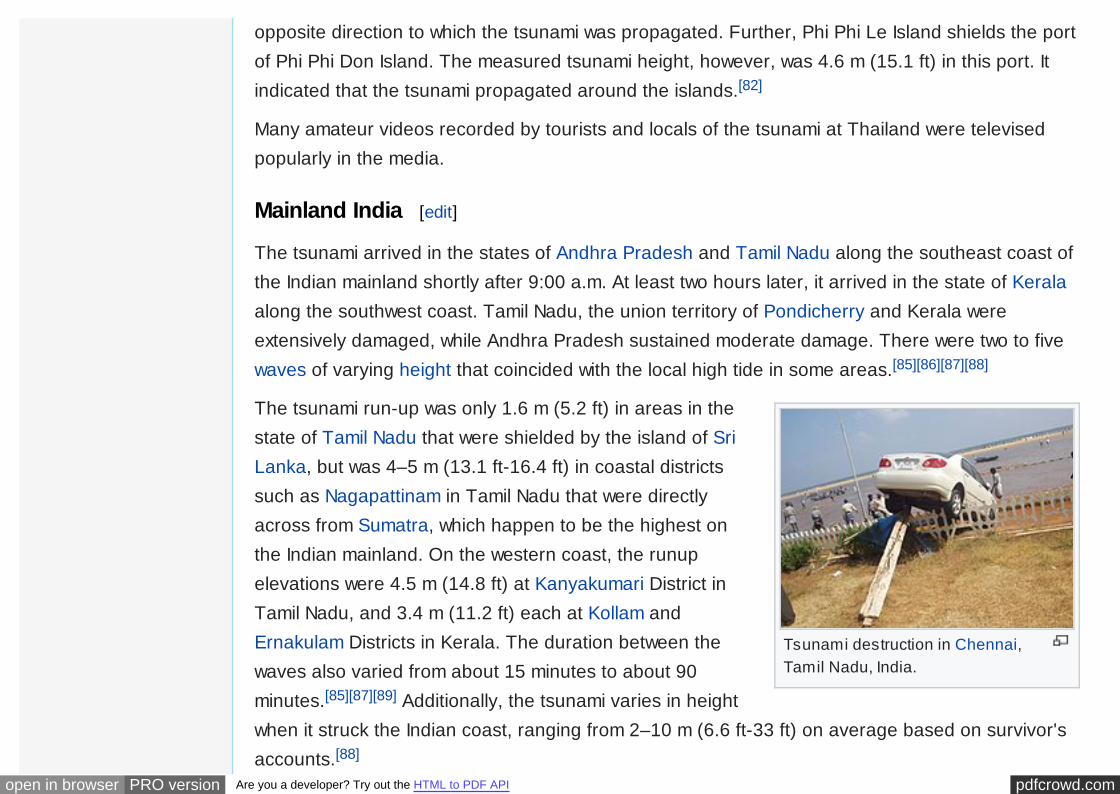
The 13 km (8.1 miles) Marina Beach in Chennai was battered by the tsunami which swept acrossthe beach taking morning walkers unaware. Besides that, a 10 m (33 ft) black muddy tsunamireportedly ravaged the city of Karaikal, where 492 lives were lost. The city of Pondicherry,protected by seawalls relatively escaped unscathed in comparison to other areas in the state.[88]
At the same time, many villages from many districts at the state of Andhra Pradesh weredestroyed. In the Krishna district, the tsunami created havoc in Manginapudi and onMachalipattanam Beach, which came like a running wall at the latter. The most affected wasPrakasham District, recording 35 deaths, with maximum damage at Singraikonda, a beautifulbeach hamlet.[88]
Given the enormous power of the tsunami, the fishing industry suffered the greatest. Moreover,the cost of damage in the transport sector was reported in the tens of thousands.[88] Manybuildings and infrastructures near the coast were obliterated.
Conclusively, the tsunami effects varied greatly across different parts of the coast according to thenumber of waves experienced, the inundation distance and height of waves, and the populationdensity of the area, as well as topological and geographical features that made some areas morevulnerable than others. Besides these factors, the number of lives lost was influenced by exposureto previous disasters and the local disaster management capability. Most of the people killed weremembers of the fishing community and, in some cases such as Marina Beach at Chennai and

pdfcrowd.comopen in browser PRO version Are you a developer? Try out the HTML to PDF API
Velankanni in Nagapattinam, they were visitors on the beach.[88]
Maldives [edit]
The tsunami of 26 December 2004 severely affected the Maldives at a distance of 2,500 km(1553.4 miles) from the epicenter of the magnitude 9.0 earthquake. The Maldives are anarchipelagic country known for its amazing natural beauty – pristine white beaches, crystal clearseawater – amidst its location in the middle of the blue open Indian Ocean, with many of its atollspopulated with luxurious tourist-oriented resorts.
Identically to Sri Lanka, survivors reported three waves with the second wave being the mostpowerful.[78] Being rich in coral reefs, the Maldives provides an opportunity for scientists to assessthe impact of a tsunami on coral atolls. The significantly lower tsunami impact on the Maldivescompared to Sri Lanka is largely due to the topography and bathymetry of the atoll chain withoffshore coral reefs, deep channels separating individual atolls and its arrival within low tide whichdecreased the power of the tsunami. After the tsunami, there were some concern that the countrymight be totally submerged and become uninhabitable. However, this was proven untrue.[90]
The largest tsunami wave measured was 4 m (13.1 ft) at Vilufushi Island (Thaa Atoll). The tsunamiarrived approximately 2 hours after the earthquake.The greatest tsunami inundation occurred atNorth Male Atoll, Male island at 250 m (0.155 miles) along the streets.[78]
The Maldives tsunami wave analysis:[78]
• 1.3 m-2.4 m (4.27 ft-7.87 ft) at North Male Atoll, Male Island.
• 2 m (6.56 ft) at North Male Atoll, Huhule Island.
• 1.7 m-2.8 m (5.58 ft-9.2 ft) at South Male Atoll, Embudhu Finothu.
• 2.5 m-3.3 m (8.2 ft-10.8 ft) at Laamu Atoll, Fonadhoo Island.

pdfcrowd.comopen in browser PRO version Are you a developer? Try out the HTML to PDF API
• 2.2 m-2.9 m (7.2 ft-9.51 ft) at Laamu Atoll, Gan Island.
• 2.3 m-3 m (7.5 ft-9.8 ft) at North Male Atoll, Dhiffushi Island.
• 2.2 m-2.4 m (7.2 ft-7.87 ft) at North Male Atoll, Huraa Island.
• more than 1.5 m (4.92 ft) at North Male Atoll, Kuda Huraa Island.
Myanmar [edit]
In Myanmar, the tsunami caused only moderate damage, which arrived between 2 and 5.5 hoursafter the earthquake. Although the country's western Andaman Sea coastline lies at the proximityof the rupture zone, there were smaller tsunamis than the neighboring Thai coast, probablybecause the main tsunami source did not extend to the Andaman Islands. Another factor is thatsome coasts of Taninthayi Division was protected by offshore islands of the Myeik Archipelago.Based on scientific surveys from Ayeyarwaddy Delta through Taninthayi Division, it is revealed thattsunami heights along the Myanmar coast were between 0.4–2.9 m (1.3–9.5 ft). Eyewitnessesoften compared the December tsunami heights with the “rainy season high tide”; although at mostlocations, the tsunami height was similar or smaller than the “rainy season high tide” level.[91]
Tsunami survey heights:
• 0.6 m-2.3 m (1.97 ft-7.54 ft) around the Ayeyarwady delta.
• 0.9 m-2.9 m (2.95 ft-9.5 ft) at Dawei area.
• 0.7 m-2.2 m (2.3 ft-7.2 ft) around Myeik.
• 0.4 m-2.6 m (1.3 ft-8.5 ft) around Kawthaung.
Interviews with local people indicate that they did not feel the earthquake in Taninthayi Division orin Ayeyarwaddy Delta. The 71 casualties can be attributed to poor housing infrastructure andadditionally, the fact that the coastal residents in the surveyed areas live on flat land along the

pdfcrowd.comopen in browser PRO version Are you a developer? Try out the HTML to PDF API
coast, especially in the Ayeyarwaddy Delta, and that there is no higher ground to evacuate. Thetsunami heights from the 2004 December earthquake were not more than 3 m (9.8 ft) along theMyanmar coast, the amplitudes are slightly large off the Ayeyarwaddy Delta, probably because theshallow delta cause a concentration in tsunami energy.[91]
Somalia [edit]
The tsunami spawned from the megathrust earthquake near Sumatra travelled 5000 km (3106.86miles) west across the open ocean and ravaged the East African country of Somalia. Around 289fatalities were reported in the Horn of Africa, drowned by four tsunami waves. The hardest hit wasa 650 km (403.9 miles) stretch of the Somalia coastline between Garacad (Mudug region) andXaafuun (Bari region), which forms part of the Puntland Province. Most of the victims were reportedalong the low-lying Xaafuun Peninsula.[92] The Puntland coast in northern Somalia was by far thearea hardest hit by the waves to the west of the Indian subcontinent. The waves arrived aroundnoon local time.[92]
Consequently, tsunami runup heights vary from 5 m (16.4 ft) to 9 m (29.5 ft) with inundationdistances varying from 44 m (0.027 miles) to 704 m (0.44 miles). The maximum runup height ofalmost 9 m (29.5 ft) was recorded in Bandarbeyla. An even higher runup point was measured on acliff near the town of Eyl, solely on an eyewitness account.
The highest death toll was in Xaafuun, also known as Hafun, with 19 bodies and 160 peoplepresumed missing out of its 5000 inhabitants, this amounts to the highest number of casualties in asingle African town and the largest tsunami death toll in a single town to the west of the Indiansubcontinent. In Xaafuun, small drawbacks were observed before the third and most powerfultsunami flood the town.[92]
Apart from lives and livelihood lost during the disaster, numerous fishing boats and buildings were
pdfcrowd.comopen in browser PRO version Are you a developer? Try out the HTML to PDF API
Tsunami flooding the streets ofTanjung Tokong, George Town,Penang.
devastated.
Elsewhere in the Indian Ocean [edit]
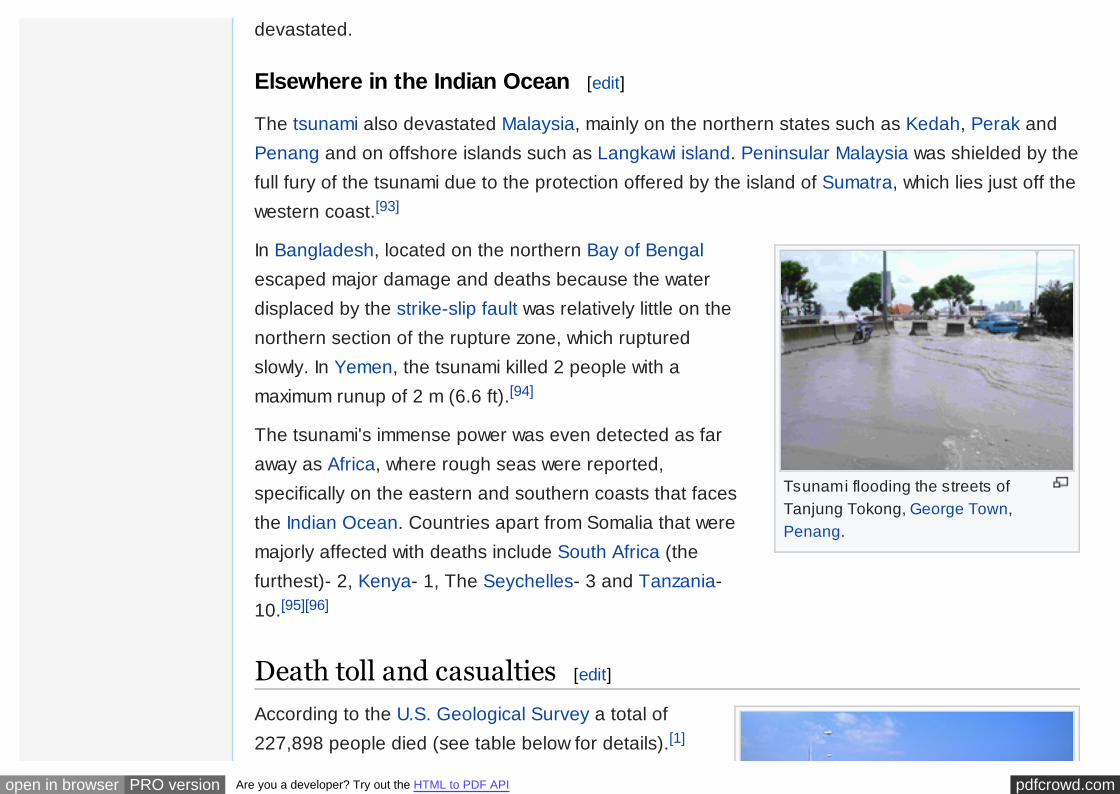
The tsunami also devastated Malaysia, mainly on the northern states such as Kedah, Perak andPenang and on offshore islands such as Langkawi island. Peninsular Malaysia was shielded by thefull fury of the tsunami due to the protection offered by the island of Sumatra, which lies just off thewestern coast.[93]
In Bangladesh, located on the northern Bay of Bengalescaped major damage and deaths because the waterdisplaced by the strike-slip fault was relatively little on thenorthern section of the rupture zone, which rupturedslowly. In Yemen, the tsunami killed 2 people with amaximum runup of 2 m (6.6 ft).[94]
The tsunami's immense power was even detected as faraway as Africa, where rough seas were reported,specifically on the eastern and southern coasts that facesthe Indian Ocean. Countries apart from Somalia that weremajorly affected with deaths include South Africa (thefurthest)- 2, Kenya- 1, The Seychelles- 3 and Tanzania-10.[95][96]
Death toll and casualties [edit]
According to the U.S. Geological Survey a total of227,898 people died (see table below for details).[1]

pdfcrowd.comopen in browser PRO version Are you a developer? Try out the HTML to PDF API
Chennai's Marina Beach after thetsunami.
Measured in lives lost, this is one of the ten worstearthquakes in recorded history, as well as the singleworst tsunami in history. Indonesia was the worstaffected area, with most death toll estimates at around170,000.[97] However, another report by Siti FadilahSupari, the Indonesian Minister of Health at the time,estimated the death total to be as high as 220,000 inIndonesia alone, giving a total of 280,000 fatalities.[7]
The tsunami caused serious damage and deaths asfar as the east coast of Africa, with the farthest recorded death due to the tsunami occurring atRooi Els in South Africa, 8,000 km (5,000 mi) away from the epicentre. In total, eight people inSouth Africa died due to abnormally high sea levels and waves.
Relief agencies reported that one-third of the dead appeared to be children. This was a result ofthe high proportion of children in the populations of many of the affected regions and becausechildren were the least able to resist being overcome by the surging waters. Oxfam went on toreport that as many as four times more women than men were killed in some regions because theywere waiting on the beach for the fishermen to return and looking after their children in thehouses.[98]
In addition to the large number of local residents, up to 9,000 foreign tourists (mostly Europeans)enjoying the peak holiday travel season were among the dead or missing, especially people fromthe Nordic countries. The European nation hardest hit may have been Sweden, whose death tollwas 543.
States of emergency were declared in Sri Lanka,Indonesia, and the Maldives. The United Nations
pdfcrowd.comopen in browser PRO version Are you a developer? Try out the HTML to PDF API
Patong Beach, Thailand, after thetsunami
estimated at the outset that the relief operation wouldbe the costliest in human history. Then-UN Secretary-General Kofi Annan stated that reconstruction wouldprobably take between five and ten years.Governments and non-governmental organisationsfeared that the final death toll might double as a resultof diseases, prompting a massive humanitarianresponse. In the end, this fear did not materialise.
For purposes of establishing timelines of local events,the time zones of affected areas are: UTC+3: (Kenya, Madagascar, Somalia, Tanzania); UTC+4:(Mauritius, Réunion, Seychelles); UTC+5: (Maldives); UTC+5:30: (India, Sri Lanka); UTC+6:(Bangladesh); UTC+6:30: (Cocos Islands, Myanmar); UTC+7: (Indonesia (western), Thailand);UTC+8: (Malaysia, Singapore). Since the earthquake occurred at 00:58:53 UTC, add the aboveoffsets to find the local time of the earthquake.
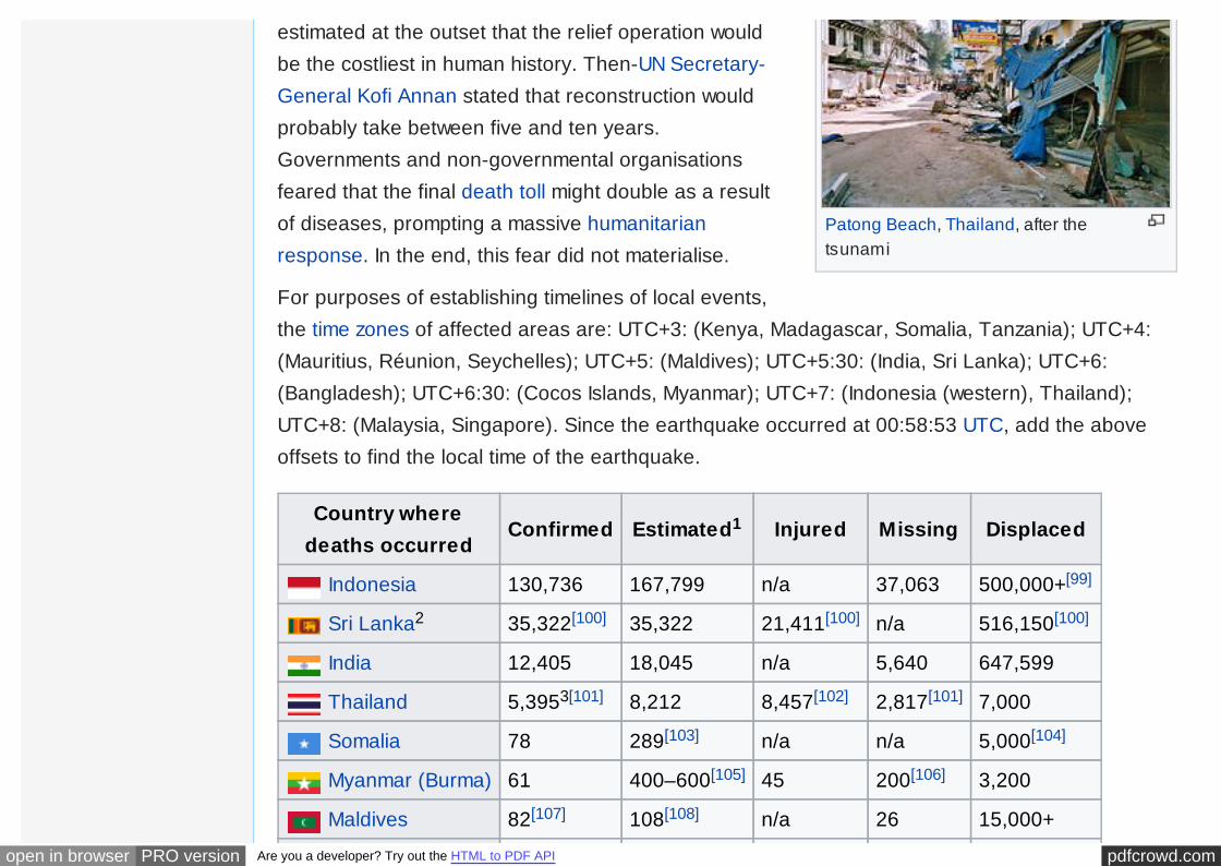
Country wheredeaths occurred
Confirmed Estimated1 Injured Missing Displaced
Indonesia 130,736 167,799 n/a 37,063 500,000+[99]
Sri Lanka2 35,322[100] 35,322 21,411[100] n/a 516,150[100]
India 12,405 18,045 n/a 5,640 647,599
Thailand 5,3953[101] 8,212 8,457[102] 2,817[101] 7,000
Somalia 78 289[103] n/a n/a 5,000[104]
Myanmar (Burma) 61 400–600[105] 45 200[106] 3,200
Maldives 82[107] 108[108] n/a 26 15,000+
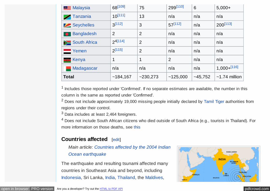
pdfcrowd.comopen in browser PRO version Are you a developer? Try out the HTML to PDF API
Malaysia 68[109] 75 299[110] 6 5,000+
Tanzania 10[111] 13 n/a n/a n/a
Seychelles 3[112] 3 57[112] n/a 200[113]
Bangladesh 2 2 n/a n/a n/a
South Africa 24[114] 2 n/a n/a n/a
Yemen 2[115] 2 n/a n/a n/a
Kenya 1 1 2 n/a n/a
Madagascar n/a n/a n/a n/a 1,000+[116]
Total ~184,167 ~230,273 ~125,000 ~45,752 ~1.74 million
1 Includes those reported under 'Confirmed'. If no separate estimates are available, the number in thiscolumn is the same as reported under 'Confirmed'.2 Does not include approximately 19,000 missing people initially declared by Tamil Tiger authorities fromregions under their control.3 Data includes at least 2,464 foreigners.4 Does not include South African citizens who died outside of South Africa (e.g., tourists in Thailand). Formore information on those deaths, see this
Countries affected [edit]
Main article: Countries affected by the 2004 IndianOcean earthquake
The earthquake and resulting tsunami affected manycountries in Southeast Asia and beyond, includingIndonesia, Sri Lanka, India, Thailand, the Maldives,

pdfcrowd.comopen in browser PRO version Are you a developer? Try out the HTML to PDF API
Countries most affected by the tsunami,with the earthquake's epicenter.
Somalia, Myanmar, Malaysia, Seychelles and others.Many other countries, especially Australia and thosein Europe, had large numbers of citizens traveling inthe region on holiday. Sweden lost 543 citizens in thedisaster, while Germany had 539 identified victims.
Event in historical context [edit]
See also: Library damage resulting from the 2004Indian Ocean earthquake
The last major tsunami in the Indian Ocean was about A.D. 1400.[117][118] In 2008, a team ofscientists working on Phra Thong, a barrier island along the hard-hit west coast of Thailand,reported evidence of at least three previous major tsunamis in the preceding 2,800 years, themost recent from about 700 years ago. A second team found similar evidence of previoustsunamis in Aceh, a province at the northern tip of Sumatra; radiocarbon dating of bark fragmentsin soil below the second sand layer led the scientists to estimate that the most recent predecessorto the 2004 tsunami probably occurred between A.D. 1300 and 1450.[119]
The 2004 earthquake and tsunami combined are the world's deadliest natural disaster since the1976 Tangshan earthquake. This earthquake was the third most powerful earthquake recordedsince 1900. The deadliest known earthquake in history occurred in 1556 in Shaanxi, China, with anestimated death toll of 830,000, though figures from this period may not be as reliable.[120]
The 2004 tsunami is the deadliest in recorded history. Prior to 2004, the tsunami created in bothIndian and Pacific Ocean waters by the 1883 eruption of Krakatoa, thought to have resulted inanywhere from 36,000 to 120,000 deaths, had probably been the deadliest in the region. In 1782about 40,000 people are thought to have been killed by a tsunami (or a cyclone) in the SouthChina Sea.[121] The most deadly tsunami prior to 2004 was Italy's 1908 Messina earthquake on the
pdfcrowd.comopen in browser PRO version Are you a developer? Try out the HTML to PDF API
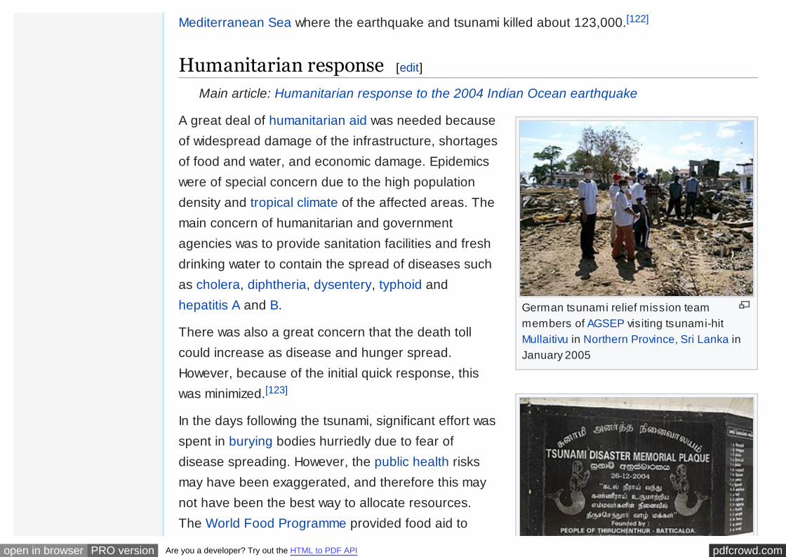
German tsunami relief mission teammembers of AGSEP visiting tsunami-hitMullaitivu in Northern Province, Sri Lanka inJanuary 2005
Mediterranean Sea where the earthquake and tsunami killed about 123,000.[122]
Humanitarian response [edit]
Main article: Humanitarian response to the 2004 Indian Ocean earthquake
A great deal of humanitarian aid was needed becauseof widespread damage of the infrastructure, shortagesof food and water, and economic damage. Epidemicswere of special concern due to the high populationdensity and tropical climate of the affected areas. Themain concern of humanitarian and governmentagencies was to provide sanitation facilities and freshdrinking water to contain the spread of diseases suchas cholera, diphtheria, dysentery, typhoid andhepatitis A and B.
There was also a great concern that the death tollcould increase as disease and hunger spread.However, because of the initial quick response, thiswas minimized.[123]
In the days following the tsunami, significant effort wasspent in burying bodies hurriedly due to fear ofdisease spreading. However, the public health risksmay have been exaggerated, and therefore this maynot have been the best way to allocate resources.The World Food Programme provided food aid to
pdfcrowd.comopen in browser PRO version Are you a developer? Try out the HTML to PDF API
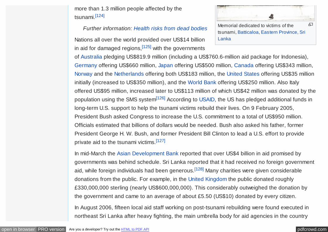
Memorial dedicated to victims of thetsunami, Batticaloa, Eastern Province, SriLanka
more than 1.3 million people affected by thetsunami.[124]
Further information: Health risks from dead bodies
Nations all over the world provided over US$14 billionin aid for damaged regions,[125] with the governmentsof Australia pledging US$819.9 million (including a US$760.6-million aid package for Indonesia),Germany offering US$660 million, Japan offering US$500 million, Canada offering US$343 million,Norway and the Netherlands offering both US$183 million, the United States offering US$35 millioninitially (increased to US$350 million), and the World Bank offering US$250 million. Also Italyoffered US$95 million, increased later to US$113 million of which US$42 million was donated by thepopulation using the SMS system[126] According to USAID, the US has pledged additional funds inlong-term U.S. support to help the tsunami victims rebuild their lives. On 9 February 2005,President Bush asked Congress to increase the U.S. commitment to a total of US$950 million.Officials estimated that billions of dollars would be needed. Bush also asked his father, formerPresident George H. W. Bush, and former President Bill Clinton to lead a U.S. effort to provideprivate aid to the tsunami victims.[127]
In mid-March the Asian Development Bank reported that over US$4 billion in aid promised bygovernments was behind schedule. Sri Lanka reported that it had received no foreign governmentaid, while foreign individuals had been generous.[128] Many charities were given considerabledonations from the public. For example, in the United Kingdom the public donated roughly£330,000,000 sterling (nearly US$600,000,000). This considerably outweighed the donation bythe government and came to an average of about £5.50 (US$10) donated by every citizen.
In August 2006, fifteen local aid staff working on post-tsunami rebuilding were found executed innortheast Sri Lanka after heavy fighting, the main umbrella body for aid agencies in the country

pdfcrowd.comopen in browser PRO version Are you a developer? Try out the HTML to PDF API
said. There had been reports and rumors that the local aid workers had been killed.
Impact [edit]
Economic impacts [edit]
The level of damage to the economy resulting from the tsunami depends on the scale examined.While local economies were devastated, the overall impact to the national economies was minor.The two main occupations affected by the tsunami were fishing and tourism.[129] The impact oncoastal fishing communities and the people living there, some of the poorest in the region, hasbeen devastating with high losses of income earners as well as boats and fishing gear.[130] In SriLanka artisanal fishery, where the use of fish baskets, fishing traps, and spears are commonlyused, is an important source of fish for local markets; industrial fishery is the major economicactivity, providing direct employment to about 250,000 people. In recent years the fishery industryhas emerged as a dynamic export-oriented sector, generating substantial foreign exchangeearnings. Preliminary estimates indicate that 66% of the fishing fleet and industrial infrastructure incoastal regions have been destroyed by the wave surges, which will have adverse economiceffects both at local and national levels.[131]
While the tsunami destroyed many of the boats vital to Sri Lanka's fishing industry, it also createddemand for fiberglass reinforced plastic catamarans in boatyards of Tamil Nadu. Since over51,000 vessels were lost to the tsunami, the industry boomed. However, the huge demand has ledto lower quality in the process, and some important materials were sacrificed to cut prices for thosewho were impoverished by the tsunami.[132]
But some economists believe that damage to the affected national economies will be minorbecause losses in the tourism and fishing industries are a relatively small percentage of the GDP.However, others caution that damage to infrastructure is an overriding factor. In some areas

pdfcrowd.comopen in browser PRO version Are you a developer? Try out the HTML to PDF API
drinking water supplies and farm fields may have been contaminated for years by salt water fromthe ocean.[133] Even though only coastal regions were directly affected by the waters of thetsunami, the indirect effects have spread to inland provinces as well. Since the media coverage ofthe event was so extensive, many tourists cancelled vacations and trips to that part of the world,even though their travel destinations may not have been affected. This ripple effect couldespecially be felt in the inland provinces of Thailand, such as Krabi, which acted like a startingpoint for many other tourist destinations in Thailand.[134]
Both the earthquake and the tsunami may have affected shipping in the Malacca Straits, whichseparate Malaysia and the Indonesian island of Sumatra, by changing the depth of the seabedand by disturbing navigational buoys and old shipwrecks. In one area of the Strait, water depthswere previously up to 4,000 feet (1,200 m), and are now only 100 feet (30 m) in some areas,making shipping impossible and dangerous. These problems also made the delivery of relief aidmore challenging. Compiling new navigational charts may take months or years. However, officialshope that piracy in the region will drop off as a result of the tsunami.[135]
Countries in the region appealed to tourists to return, pointing out that most tourist infrastructure isundamaged. However, tourists were reluctant to do so for psychological reasons. Even beachresorts in parts of Thailand which were completely untouched by the tsunami were hit bycancellations.[136]
Environmental impact [edit]

pdfcrowd.comopen in browser PRO version Are you a developer? Try out the HTML to PDF API
Tsunami inundation, Khao Lak,North of Phuket, Thailand ASTERImages and SRTM Elevation Model.
Beyond the heavy toll on human lives, the Indian Oceanearthquake has caused an enormous environmentalimpact that will affect the region for many years to come. Ithas been reported that severe damage has been inflictedon ecosystems such as mangroves, coral reefs, forests,coastal wetlands, vegetation, sand dunes and rockformations, animal and plant biodiversity and groundwater.In addition, the spread of solid and liquid waste andindustrial chemicals, water pollution and the destruction ofsewage collectors and treatment plants threaten theenvironment even further, in untold ways. Theenvironmental impact will take a long time and significantresources to assess.[137]
According to specialists, the main effect is being caused by poisoning of the freshwater suppliesand of the soil by saltwater infiltration and a deposit of a salt layer over arable land. It has beenreported that in the Maldives, 16 to 17 coral reef atolls that were overcome by sea waves arecompletely without fresh water and could be rendered uninhabitable for decades. Uncountablewells that served communities were invaded by sea, sand, and earth; and aquifers were invadedthrough porous rock. Salted-over soil becomes sterile, and it is difficult and costly to restore foragriculture. It also causes the death of plants and important soil micro-organisms. Thousands ofrice, mango, and banana plantations in Sri Lanka were destroyed almost entirely and will takeyears to recover. On the island's east coast, the tsunami contaminated wells on which manyvillagers relied for drinking water. The Colombo-based International Water Management Institutemonitored the effects of saltwater and concluded that the wells recovered to pre-tsunami drinkingwater quality one and a half years after the event.[138] IWMI developed protocols for cleaning wells

pdfcrowd.comopen in browser PRO version Are you a developer? Try out the HTML to PDF API
Tsunami aftermath in Aceh, Indonesia
contaminated by saltwater; these were subsequently officially endorsed by the World HealthOrganization as part of its series of Emergency Guidelines.[139]
The United Nations Environment Programme (UNEP) is working with governments of the region inorder to determine the severity of the ecological impact and how to address it.[needs update][140]
UNEP has decided to earmark a US$1,000,000 emergency fund and to establish a Task Force torespond to requests for technical assistance from countries affected by the tsunami.[141] Inresponse to a request from the Maldivian Government, the Australian Government sent ecologicalexperts to help restore marine environments and coral reefs—the lifeblood of Maldivian tourism.Much of the ecological expertise has been rendered from work with the Great Barrier Reef, inAustralia's northeastern waters.
Other effects [edit]
Psychological trauma
Many health professionals and aid workershave reported widespread psychologicaltrauma associated with the tsunami.Traditional beliefs in many of the affectedregions state that a relative of the family mustbury the body of the dead, and in manycases, no body remained to be buried.Women in Aceh required a special approachfrom foreign aid agencies, and continue tohave unique needs.
Conflicts and a cease-fire
pdfcrowd.comopen in browser PRO version Are you a developer? Try out the HTML to PDF API
The hardest hit area, Aceh, is considered to be a religiously conservative Islamic society and hashad no tourism nor any Western presence in recent years due to armed conflict between theIndonesian military and Acehnese separatists. Some believe that the tsunami was divinepunishment for lay Muslims shirking their daily prayers and/or following a materialistic lifestyle.Others have said that Allah was angry that there were Muslims killing other Muslims in an ongoingconflict.[142] Saudi cleric Muhammad Al-Munajjid attributed it to divine retribution against non-Muslim vacationers "who used to sprawl all over the beaches and in pubs overflowing with wine"during Christmas break.[143]
The widespread devastation caused by the tsunami led the main rebel group GAM to declare acease-fire on 28 December 2004 followed by the Indonesian government, and the two groupsresumed long-stalled peace talks, which resulted in a peace agreement signed 15 August 2005.The agreement explicitly cites the tsunami as a justification.[144]
Media coverage
In a poll conducted in 27 countries by GlobeScan for BBC World Service, 15 percent ofrespondents named the tsunami the most significant event of the year. Only the Iraq War wasnamed by as many respondents.[145] The extensive international media coverage of the tsunami,and the role of mass media and journalists in reconstruction, were discussed by editors ofnewspapers and broadcast media in tsunami-affected areas, in special video-conferences set upby the Asia Pacific Journalism Centre.[146]
Fraud, false alarms, and panic
The 26 December 2004 Asian tsunami left both the people and government of India in a state ofheightened alert. On 30 December 2004, four days after the tsunami, the Portland, Oregon-basedcompany Terra Research notified the India government that its sensors indicated there was apossibility of 7.9 to 8.1 magnitude tectonic shift in the next 12 hours between Sumatra and New

pdfcrowd.comopen in browser PRO version Are you a developer? Try out the HTML to PDF API
Zealand.[147] In response, the India Home Affairs minister announced that a fresh onslaught ofdeadly tsunami were likely along the India southern coast and Andaman and Nicobar Islands, evenas there was no sign of turbulence in the region.[147] The announcement generated panic in theIndian Ocean region and caused thousands to flee their homes, which resulted in jammedroads.[148] The announcement was a false alarm and the Home Affairs minister withdrew theirannouncement.[148] On further investigation, the India government learned that the consultingcompany Terra Research was run from the home of a self-described earthquake forecaster whohad no telephone listing and maintained a website where he sold copies of his detectionsystem.[149] Three days after the announcement, Indian National Congress president SoniaGandhi called Science & Technology minister Kapil Sibal to express her concern about Sibal's 30December public warning being "hogwash".[150]
Impact on Sweden
The tsunami had a severe humanitarian and political impact in Sweden. The hardest hit countryoutside Asia, 543 Swedish tourists, mainly in Thailand, died. With no single incident having killedmore Swedish people since the battle of Poltava in 1709, the cabinet of Göran Persson washeavily criticized for lack of action.
Tsunami warning system
Smith Dharmasaroja, a meteorologist who predicted the tsunami before it hit, was assigned thedevelopment of the Thai tsunami warning system. The Indian Ocean Tsunami warning system wasformed in early 2005 immediately after the tragedy of 26 December 2004 to provide an earlywarning of tsunamis for inhabitants around the Indian Ocean coasts.[151]
Effect on the Earth
The changes in the distribution of masses inside the Earth due to the earthquake had severalconsequences. It displaced the North Pole by 2.5 cm. It also changed slightly the shape of the

pdfcrowd.comopen in browser PRO version Are you a developer? Try out the HTML to PDF API
Earth, more specifically it decreased Earth's oblateness by about one part in 10 billion,consequentially increasing Earth's rotation a little and thus shortening the length of the day by2.68 microseconds.[152]
In popular culture [edit]
Apung 1 [edit]
Apung 1, a 2,600-ton ship, was flung some 2–3 km inland by the tsunami, and has become apopular tourist attraction in Banda Aceh
Films and television [edit]
Children of Tsunami: No More Tears (2005), a 24-minute documentary film.
"Hafalan Shalat Delisa, an Indonesian movie.
Tsunami: The Aftermath (2006), a two-part television miniseries about its after-effects.
The Impossible (2012), an English-language Spanish film based on the story of María Belónand her family.
Dasavathaaram (2008), a Tamil disaster film which culminates with 2004 tsunami.
Kayal (2014), a Tamil drama film which culminates with the 2004 tsunami.
The Wave That Shook The World (2005), a PBS NOVA educational television-seriesdocumentary about the 2004 tsunami.
Hereafter (2010), a main character's life is affected after surviving the tsunami while onvacation.
Tsunami: Caught on Camera (2009), a minute-by-minute account of the 2004 tsunami toldthrough amateur video footage of witnesses from Indonesia, Thailand and Sri Lanka.
Naked Science: Tsunami Warning (2009), an episode of an American documentary television

pdfcrowd.comopen in browser PRO version Are you a developer? Try out the HTML to PDF API
Disasters portal
Indonesia portal
series that premiered in 2004 on the National Geographic Channel with the episode dedicatedto the events of 26 December 2004 and implications of a worldwide tsunami warning system.
Literature [edit]
The Killing Sea, a 2006 novel by Richard Lewis, tells the story of two teenagers- a tourist and alocal- as they struggle to survive in the days after the tsunami.
Wave, a memoir by Sonali Daraniyagala, details the impact of the tsunami on Sri Lanka and theIndian subcontinent.
Museum [edit]
Aceh Tsunami Museum, located in Banda Aceh, Indonesia, was designed as a symbolicreminder of the 2004 Indian Ocean earthquake and tsunami disaster, as well as an educationalcenter and an emergency disaster shelter in case the area is ever hit by a tsunami again.
Rediscovery of Mahabalipuram [edit]
Another result of the tsunami, respective of Indian culture, was the water that washed awaycenturies of sand from some of the ruins of a 1,200-year-old lost city at Mahabalipuram on thesouth coast of India. The site, containing such notable structures as a half-buried granite lionnear a 7th-century Mahablipuram temple and a relic depicting an elephant, is part of whatarchaeologists believe to be an ancient port city that was swallowed by the sea hundreds ofyears ago.[153][154]
See also [edit]
2006 Pangandaran earthquake and tsunami
2006 Yogyakarta earthquake

pdfcrowd.comopen in browser PRO version Are you a developer? Try out the HTML to PDF API
Indonesia portal
India portal
Thailand portal
Sri Lanka portal
2000s portal
Aid Still Required
Indian Ocean Tsunami Warning System
List of earthquakes in 2004
List of earthquakes in Indonesia
Megatsunami
Pornthip Rojanasunand, a prominent Thai doctor who took charge ofidentifying the bodies
Seismotectonics
Tsunami Evaluation Coalition
References [edit]
1. ̂a b c d e "Magnitude 9.1 – OFF THE WEST COAST OF SUMATRA" . U.S. Geological Survey.Archived from the original on 17 August 2012. Retrieved 26 August 2012.
2. ^ Satake, K.; Atwater, B. (2007), "Long-Term Perspectives on Giant Earthquakes and Tsunamis atSubduction Zones" (PDF), Annual Review of Earth and Planetary Sciences, Annual Reviews, 35:351, doi:10.1146/annurev.earth.35.031306.140302
3. ^ "Astonishing Wave Heights Among the Findings of an International Tsunami Survey Team onSumatra" . U.S. Geological Survey. Retrieved 16 June 2016.
4. ̂a b Paris, R.; Lavigne F.; Wassimer P.; Sartohadi J. (2007). "Coastal sedimentation associatedwith the December 26, 2004 tsunami in Lhok Nga, west Banda Aceh (Sumatra, Indonesia)". MarineGeology. Elsevier. 238 (1–4): 93–106. doi:10.1016/j.margeo.2006.12.009 .
5. ̂a b c Paris, Raphaël; Cachão, Mário; Fournier, Jérôme; Voldoire, Olivier (1 April 2010). "Nannolithsabundance and distribution in tsunami deposits: example from the December 26, 2004 tsunami inLhok Nga (northwest Sumatra, Indonesia)" . Géomorphologie : relief, processus, environnement.16 (1): 109–118. doi:10.4000/geomorphologie.7865 .

pdfcrowd.comopen in browser PRO version Are you a developer? Try out the HTML to PDF API
6. ^ "Earthquakes with 50,000 or More Deaths" . U.S. Geological Survey. Archived from the originalon 5 June 2013.
7. ̂a b "Indonesia quake toll jumps again" . BBC News. 25 January 2005. Retrieved 24 December2012.
8. ^ "Indian Ocean tsunami anniversary: Memorial events held" . BBC News. 26 December 2014.Retrieved 15 December 2016.
9. ^ "Analysis of the Sumatra-Andaman Earthquake Reveals Longest Fault Rupture Ever" . NationalScience Foundation. 19 May 2005. Retrieved 15 December 2016.
10. ^ Walton, Marsha (20 May 2005). "Scientists: Sumatra quake longest ever recorded" . CNN.Retrieved 15 December 2016.
11. ^ West, Michael; Sanches, John J.; McNutt, Stephen R. (20 May 2005). "Periodically TriggeredSeismicity at Mount Wrangell, Alaska, After the Sumatra Earthquake" . Science. 308 (5725):1144–1146. doi:10.1126/science.1112462 .
12. ̂a b Nalbant, Suleyman S.; Steacy, Sandy; Sieh, Kerry; Natawidjaja, Danny; McCloskey, John (9June 2005). "Seismology: Earthquake risk on the Sunda trench" (PDF). Nature. 435 (7043): 756–757. doi:10.1038/nature435756a . Archived from the original (PDF) on 19 May 2009. Retrieved16 May 2009.
13. ^ Jayasuriya, Sisira; McCawley, Peter (2010). The Asian Tsunami: Aid and Reconstruction after aDisaster . Cheltenham UK and Northampton MA USA: Edward Elgar. ISBN 978-1-84844-692-2.
14. ^ Lay, T.; Kanamori, H.; Ammon, C.; Nettles, M.; Ward, S.; Aster, R.; Beck, S.; Bilek, S.;Brudzinski, M.; Butler, R.; DeShon, H.; Ekström, G.; Satake, K.; Sipkin, S. (20 May 2005). "TheGreat Sumatra-Andaman Earthquake of 26 December 2004". Science. 308 (5725): 1127–1133.doi:10.1126/science.1112250 .
15. ^ "Tsunamis and Earthquakes: Tsunami Generation from the 2004 Sumatra Earthquake — USGSWestern Coastal and Marine Geology" . Walrus.wr.usgs.gov. Retrieved 12 August 2010.
16. ^ McKee, Maggie (9 February 2005). "Power of tsunami earthquake heavily underestimated" . NewScientist. Archived from the original on 27 February 2005.
pdfcrowd.comopen in browser PRO version Are you a developer? Try out the HTML to PDF API
17. ^ EERI Publication 2006–06, page 14.
18. ^ Løvholt, F.; Bungum, H.; Harbitz, C. B.; Glimsdal, S.; Lindholm, C. D.; Pedersen, G. (30November 2006). "Earthquake related tsunami hazard along the western coast of Thailand" (PDF).Natural Hazards and Earth System Sciences. 6 (6): 979–997. doi:10.5194/nhess-6-979-2006 .Archived from the original (PDF) on 19 May 2009. Retrieved 16 May 2009.
19. ^ Sibuet, J.; Rangin, C.; Le Pichon, X.; Singh, S.; Cattaneo, A.; Graindorge, D.; Klingelhoefer, F.;Lin, J.; Malod, J.; Maury, T; Schneider, J.; Sultan, N.; Umber, M.; Yamaguchi, H.; "Sumatraaftershocks" team (15 November 2007). "26th December 2004 great Sumatra–Andaman earthquake:Co-seismic and post-seismic motions in northern Sumatra" (PDF). Earth and Planetary ScienceLetters. 263 (1–2): 88–103. doi:10.1016/j.epsl.2007.09.005 . Archived from the original (PDF) on19 May 2009. Retrieved 16 May 2009.
20. ^ ""Kamchatka Earthquake, 4 November 1952" . United States Geological Survey. Archived fromthe original on 12 October 2007.
21. ^ Vallée, M. (2007). "Rupture Properties of the Giant Sumatra Earthquake Imaged by EmpiricalGreen's Function Analysis" (PDF). Bulletin of the Seismological Society of America.Seismological Society of America. 97 (1A): S103–S114. Bibcode:2007BuSSA..97S.103V .doi:10.1785/0120050616 .
22. ^ Bilham, Roger (20 May 2005). "A Flying Start, Then a Slow Slip". Science. 308 (5725): 1126–1127. doi:10.1126/science.1113363 .
23. ^ USGS (22 July 2010). "Poster of the Northern Sumatra Earthquake of 28 March 2005 – Magnitude8.7" . Archived from the original on 14 May 2011. Retrieved 26 June 2011.
24. ^ "Sumatra shaken by new earthquake" . BBC News. 10 April 2005. Retrieved 24 December 2012.
25. ^ "USGS Earthquake Hazards Program: FAQ" . Earthquake.usgs.gov. 10 December 2012.Retrieved 24 December 2012.
26. ^ "Magnitude 9.1 Sumatra-Andaman Islands Earthquake FAQ" . USGS. 29 December 2014.Retrieved 6 January 2015.
27. ^ Rinaldo, Aditya (12 April 2005). "Thousands flee as Indonesian volcano spews into life" .Hindustan Times. Archived from the original on 17 February 2006.

pdfcrowd.comopen in browser PRO version Are you a developer? Try out the HTML to PDF API
28. ^ Johnston, Tim (13 April 2005). "Indonesian Volcanoes Erupt; Thousands Evacuated" . VOANews. Archived from the original on 21 April 2005. Retrieved 22 April 2006.
29. ^ "Volcano on Indonesia's Sumatra Erupts" . ABC News. 11 April 2005. Archived from theoriginal on 19 September 2005.
30. ^ "USGS Energy and Broadband Solution" . National Earthquake Information Center, USGeological Survey. Archived from the original on 4 April 2010. Retrieved 12 August 2010.
31. ^ "USGS, Harvard Moment Tensor Solution" . National Earthquake Information Center, USGeological Survey. 26 December 2004. Archived from the original on 17 January 2010. Retrieved12 August 2010.
32. ^ "USGS:Measuring the size of earthquakes" . Earthquake.usgs.gov. 27 October 2009. Archivedfrom the original on 1 September 2009. Retrieved 12 August 2010.
33. ^ Virtanen, Heikki (2006). Studies of earth dynamics with the superconducting gravimeter (PDF)
(Dissertation). University of Helsinki. Retrieved 21 September 2009.
34. ^ Cook-Anderson, Gretchen; Beasley, Dolores (10 January 2005). "NASA Details EarthquakeEffects on the Earth" (Press release). NASA. Retrieved 16 December 2016.
35. ^ Schechner, Sam. "Earthquakes vs. the Earth's Rotation ." Slate. 27 December 2004.
36. ^ "Italian scientists say Asian quakes cause Earth's axis shifted" . Xinhua. 29 December 2004.Archived from the original on 5 July 2009.
37. ^ Staff Writer (31 January 2005). "Quake moved Sumatra by only 20 centimeters: Danishscientists". Agence France-Presse.
38. ^ Bagla, Pallava (28 January 2005). "After the Earth Moved" . Science Now. Retrieved16 December 2016.
39. ^ Knight, Will (10 February 2005). "Asian tsunami seabed pictured with sonar" . New Scientist.Archived from the original on 27 February 2005.
40. ^ "NASA/French Satellite Data Reveal New Details of Tsunami" . Jet Propulsion Laboratory/NASA.11 January 2005. Archived from the original on 5 March 2016. Retrieved 16 December 2016.

pdfcrowd.comopen in browser PRO version Are you a developer? Try out the HTML to PDF API
41. ^ "TOPEX/Poseidon Satellite Data on 26 December 2004 tsunami in the Indian Ocean" . Aviso.Archived from the original on 24 June 2011.
42. ^ Lorca, Emilio; Recabarren, Margot (1997). Earthquakes and tsunamis: high school textbook(PDF). Retrieved 16 December 2016.
43. ^ Leslie, John (10 January 2005). "NOAA Scientists able to Measure Tsunami Height fromSpace" . NOAA Magazine. National Oceanic and Atmospheric Administration. Retrieved16 December 2016.
44. ^ McKee, Maggie (6 January 2005). "Radar satellites capture tsunami wave height" . NewScientist. Archived from the original on 24 September 2008.
45. ^ Pearce, Fred; Holmes, Bob (15 January 2005). "Tsunami: The impact will last for decades" . NewScientist. Archived from the original on 17 April 2008.
46. ^ "Tsunami time travel map" . Tsunami Laboratory, Novosibirsk, Russia. Archived from theoriginal on 3 April 2012. Retrieved 20 July 2012.
47. ^ "Time travel map: Active Fault Research Center: National Institute of Advanced Industrial Scienceand Technology, Japan" . Staff.aist.go.jp. Archived from the original on 17 July 2012. Retrieved24 December 2012.
48. ^ "Indian Ocean Tsunami" at Syowa Station, Antarctica" . Hydrographic and Oceanographic Dept.Japan Coast Guard. Retrieved 17 December 2016.
49. ^ "Indian Ocean Tsunami of 26 December 2004" . West Coast/Alaska Tsunami Warning Center(USGS). 31 December 2004. Archived from the original on 4 February 2012.
50. ^ Carey, Bjorn (25 August 2005). "Tsunami Waves Channeled Around the Globe in 2004Disaster" . LiveScience. Retrieved 17 December 2016.
51. ^ "The 2004 Boxing Day tsunami" . Australian Geographic. Retrieved 5 March 2015.
52. ^ Block, Melissa (27 December 2004). "Sri Lankans Seek Lost Relatives After Tsunami" . AllThings Considered. NPR. Retrieved 20 December 2016.
53. ^ Nadia Aly (5 April 2014). "Scuba Diving in a Tsunami" . Scuba Diver Life. Retrieved 20 December2016.
pdfcrowd.comopen in browser PRO version Are you a developer? Try out the HTML to PDF API
54. ^ Campbell, Matthew; Loveard, Keith; et al. "Tsunami disaster: Focus: Nature's timebomb ." TimesOnline. 2 January 2005.
55. ^ "Girl, 10, used geography lesson to save lives" . The Telegraph. London. 1 January 2005.Retrieved 20 December 2016.
56. ^ Subir Bhaumik (30 December 2004). "Andaman aborigines' fate unclear" . BBC News. Retrieved13 February 2010.
57. ^ Gupta, Manu; Sharma, Anshu (2006). "Compounded loss: the post tsunami recovery experience ofIndian island communities". Disaster Prevention and Management. 15 (1): 67–78.doi:10.1108/09653560610654248 .
58. ^ Math, Suresh Bada; Girimaji 1, Satish Chandra; Benegal, V; Uday Kumar, GS; Hamza, A;Nagaraja, D (2006). "Tsunami: Psychosocial aspects of Andaman and Nicobar islands.Assessments and intervention in the early phase". International Review of Psychiatry. 18 (3): 233–239. doi:10.1080/09540260600656001 . PMID 16753660 .
59. ^ Bhaumik, Subir (20 January 2005). "Tsunami folklore 'saved islanders' " . BBC News. Retrieved20 December 2016.
60. ^ Borrero, Jose C. (9 February 2005). "Field Survey northern Sumatra and Banda Aceh, Indonesiaand after the Tsunami and Earthquake of 26 December 2004" (PDF). Los Angeles: Department ofCivil Engineering, University of Southern California. Retrieved 20 December 2016.
61. ^ "YouTube" .
62. ^ red17khmer (30 November 2008). "Great Tsunami 12/26/04 @ Aceh, Sumatra, Indonesia 1 of 3"– via YouTube.
63. ̂a b c "Chapter 2 Earthquake, Tsunami and Damage in Banda Aceh and Northern Sumatra"(PDF). tsunami.civil.tohoku.ac.jp. Retrieved 20 December 2016.
64. ̂a b Borrero, Jose C.; Synolakis, Costas E.; Fritz, Hermann (June 2006). "Northern Sumatra FieldSurvey after the December 2004 Great Sumatra Earthquake and Indian Ocean Tsunami" (PDF).Earthquake Spectra. Earthquake Engineering Research Institute. 22 (S3): 93–104.doi:10.1193/1.2206793 .
pdfcrowd.comopen in browser PRO version Are you a developer? Try out the HTML to PDF API
65. ^ Kaget Mera (25 January 2016). "Seconds From Disaster S03E13 Asian Tsunami" – viaYouTube.
66. ^ red17khmer (30 November 2008). "Great Tsunami 12-26-04 at Banda Aceh, Sumatra, Indonesia 3of 3" – via YouTube.
67. ^ geoffmackley (19 November 2009). "Boxing Day Tsunami Banda Aceh 4 of 4" – via YouTube.
68. ^ "Tsunami Wave Run-ups: Indian Ocean – 2004" . Science on a Sphere. National Oceanic andAtmospheric Administration. Retrieved 20 December 2016.
69. ^ Yalciner, A.C.; Perincek, D.; Ersoy, S.; Presateya, G.; Hidayat, R.; McAdoo, B. (2005). "Reporton December 26, 2004, Indian Ocean Tsunami, Field Survey on Jan 21–31 at North of Sumatra"(PDF). ITST of UNESCO IOC. Retrieved 20 December 2016.
70. ^ Paul, D.K.; Singh, Yogendra; Dubey, R.N. "Damage to Andaman & Nicobar Islands due toEarthquake and Tsunami of Dec. 26, 2004" (PDF). Department of Earthquake Engineering, IITRoorkee. Retrieved 20 December 2016.
71. ̂a b "Tsunami in Andaman & Nicobar Islands" . Andamanconnections.com. Retrieved20 December 2016.
72. ̂a b Pomonis, Antonios; Rossetto, Tiziana; Peiris, Navin; Wilkinson, Sean; Del Re, Domenico; Koo,Raymond; Manlapig, Raul; Gallocher, Stewart (February 2006). The Indian Ocean Tsunami of 26December 2004: Mission Findings in Sri Lanka and Thailand (PDF). London: EarthquakeEngineering Field Investigation Team, Institution of Structural Engineers. ISBN 0-901297-41-0.
73. ^ "The Great Sumatra Earthquake and Indian Ocean Tsunami of December 26, 2004: The Effects inMainland India and in the Andaman-Nicobar Islands" (PDF). EERI Special Earthquake Report.April 2005. Retrieved 21 December 2016.
74. ^ Ramanamurthy, M. V.; Sundaramoorthy, S.; Pari, Y.; Rao, V. Ranga; Mishra, P.; Bhat, M.; Usha,Tune; Venkatesan, R.; Subramanian, B. R. (10 June 2005). "Inundation of sea water in Andaman andNicobar Islands and parts of Tamil Nadu coast during 2004 Sumatra tsunami" (PDF). CurrentScience. 88 (11): 1736–1740.
75. ^ "Quick Report on the Study of the 2004 Sumatra Earthquake and Tsunami Effects" (PDF).Department of Civil Engineering, Indian Institute of Technology Kanpur. Retrieved 21 December 2016.

pdfcrowd.comopen in browser PRO version Are you a developer? Try out the HTML to PDF API
76. ̂a b http://www.nzsee.org.nz/db/Bulletin/Archive/38(4)0235.pdf
77. ̂a b c http://www.tsunami.civil.tohoku.ac.jp/sumatra2004/C3.pdf
78. ̂a b c d e http://faculty.vassar.edu/brmcadoo/SriLankaPapadopetal.pdf
79. ̂a b Goff, James; Liu, Philip L-F.; Higman, Bretwood; Morton, Robert; Jaffe, Bruce E.; Fernando,Harindra; Lynett, Patrick; Fritz, Hermann; Synolakis, Costas; Fernando, Starin. "Sri Lanka FieldSurvey after the December 2004 Indian Ocean Tsunami" . 22 (S3): 155–172.doi:10.1193/1.2205897 .
80. ^ Liu, P. L.-F. (1 July 2005). "Observations by the International Tsunami Survey Team in SriLanka" . 308 (5728): 1595–1595. doi:10.1126/science.1110730 .
81. ̂a b "Tsunami – Tsunami Disaster in Sri Lanka" .
82. ̂a b c d http://www.tsunami.civil.tohoku.ac.jp/sumatra2004/C4.pdf
83. ̂a b
http://www.marine.tmd.go.th/Presentation/Alexandria/The%202004%20Indian%20tsunami%20in%20Thailand%20Surveyed%20runup%20heights%20and%20tide%20gauge%20records.pdf
84. ^ http://citeseerx.ist.psu.edu/viewdoc/download?doi=10.1.1.564.5976&rep=rep1&type=pdf
85. ̂a b c "Tsunami Affected Areas in India 2004" .
86. ^ http://academic.evergreen.edu/g/grossmaz/cramerbd/%3E
87. ̂a b c Jha, M. K. (20 July 2010). "Natural and Anthropogenic Disasters: Vulnerability, Preparednessand Mitigation" . Springer Science & Business Media – via Google Books.
88. ̂a b c d e f g h i j http://www.iitk.ac.in/nicee/RP/2006_Effect_EQSpectra.pdf
89. ̂a b "Tsunami – India" .
90. ^ http://faculty.vassar.edu/brmcadoo/EERI_Maldives_FzSyMcCa3.pdf
91. ̂a b https://www.terrapub.co.jp/journals/EPS/pdf/2006/5802/58020243.pdf
92. ̂a b c http://2004tsunami.ce.gatech.edu/publications/som_eqs_v22-iS3_106607eqs.pdf
93. ^ "Tsunami death toll passes 283,000 – Asia Tsunami – www.smh.com.au" .
94. ^ "International Tsunami Information Center – International Tsunami Information Center" .

pdfcrowd.comopen in browser PRO version Are you a developer? Try out the HTML to PDF API
95. ^ Fritz, Hermann M.; Borrero, Jose C.; Synolakis, Costas E.; Okal, Emile A. (1 January 2006)."FIELD SURVEYS OF 2004 INDIAN OCEAN TSUNAMI FROM SUMATRA TO EAST AFRICA" .
96. ^https://smartech.gatech.edu/bitstream/handle/1853/42307/103954_Unesco_Yemen_Tsunami_FzOk3.pdf?sequence=1
97. ^ "Home" . Islamic Relief USA. Archived from the original on 17 January 2011. Retrieved12 August 2010.
98. ^ "Most tsunami dead female – Oxfam" . BBC News. 26 March 2005. Retrieved 24 December2012.
99. ^ Meisl, C.S.; Safaie S.; Elwood K.J.; Gupta R.; Kowsari R. (2006). "Housing Reconstruction inNorthern Sumatra after the December 2004 Great Sumatra Earthquake and Tsunami" . EarthquakeSpectra. 22: S777. doi:10.1193/1.2201668 . Retrieved 26 June 2011.
100. ̂a b c "One year after the tsunami, Sri Lankan survivors still live in squalour" . World Socialist WebSite. 29 December 2005. Retrieved 24 December 2012.
101. ̂a b "TsunamiMemorial.or.th" . Web.archive.org. 28 September 2007. Archived from the originalon 28 September 2007. Retrieved 24 December 2012.
102. ^ Schwartz, D.; Goldberg A.; Ashenasi I.; Nakash G.; Leiba A.; Levei Y.; Bar-Dayan Y. (2006)."Prehospital care of tsunami victims in Thailand: description and analysis". Prehospital DisasterMedicine. 21 (3): 204–210. PMID 16892886 .
103. ^ Martin Plaut (26 December 2005). "Tsunami: Somalia's slow recovery" . BBC News. Retrieved24 December 2012.
104. ^ "India, Indonesia, Maldives, Myanmar, Somalia, Thailand: Earthquake and Tsunami OCHASituation Report No. 14" . Reliefweb.int. Retrieved 12 August 2010.
105. ^ "Myanmar is withholding true casualties figures, says Thai priest" . AsiaNews.it. 4 January 2005.Archived from the original on 9 October 2006. Retrieved 12 February 2011. "A missioner inRanong, a town on the border between Thailand and Myanmar, says locals talk about 600 victims.Burmese political dissidents say the same."
pdfcrowd.comopen in browser PRO version Are you a developer? Try out the HTML to PDF API
106. ^ "Asia-Pacific | 'Hundreds feared dead' in Burma" . BBC News. 4 January 2005. Retrieved24 December 2012.
107. ^ "TsunamiMaldives.mv" . Web.archive.org. 17 June 2009. Archived from the original on 17 June2009. Retrieved 24 December 2012.
108. ^ UNICEF (May 2006). "The 2004 Indian Ocean Tsunami Disaster: Evaluation of UNICEF's response(emergency and recovery phase). Maldives Report" (PDF). p. i. Retrieved 26 June 2011.
109. ^ [email protected] (13 January 2005). "Death toll in Asian tsunami disaster tops159,000" . People's Daily. Retrieved 12 August 2010.
110. ^ "Killer Waves" . Channelnewsasia.com. Archived from the original on 2012-10-23. Retrieved24 December 2012.
111. ^ "Asian tsunami death toll passes 144,000" . Australia: ABC. 3 January 2005. Archived from theoriginal on 17 June 2009. Retrieved 12 August 2010.
112. ̂a b "The Seychelles raises its voice" . Web.archive.org. Retrieved 12 August 2010.
113. ^ "Tsunami Evaluation Coalition: Initial Findings" (PDF). Archived from the original (PDF) on 24March 2006. Retrieved 12 August 2010.
114. ^ Okal, E.A.; Hartnady C.J. (2010). "The South Sandwich Islands earthquake of 27 June 1929:seismological study and inference on tsunami risk for the southern Atlantic" (PDF). South AfricanJournal of Geology. 112 (3–4): 359–370. doi:10.2113/gssajg.112.3-4.359 . Retrieved 26 June 2011.
115. ^ "YEMEN: Tsunami damage over US $1 million – UNEP assessment" . Irinnews.org. 22 February2005. Retrieved 24 December 2012.
116. ^ "Tsunami devastates Somali island" . BBC News. 29 December 2004. Retrieved 24 December2012.
117. ^ Palmer, Jason (29 October 2008). "Tsunami in 2004 'not the first' " . BBC News. Retrieved12 August 2010.
118. ^ "Researchers uncover 2004 tsunami predecessor" . ABC Radio Australia News. 30 October2008. Retrieved 13 April 2011.
pdfcrowd.comopen in browser PRO version Are you a developer? Try out the HTML to PDF API
119. ^ "Scientists Find Evidence of Tsunamis on Indian Ocean Shores Long Before 2004" .Newswise.com. 27 October 2008. Retrieved 24 December 2012.
120. ^ Most Destructive Known Earthquakes on Record in the World (Earthquakes with 50,000 or MoreDeaths) . United States Geological Survey. Archived 1 September 2009 at the WaybackMachine.
121. ^ http://www.nat-hazards-earth-syst-sci.net/10/1793/2010/nhess-10-1793-2010.pdf
122. ^ "The world's worst natural disasters" .
123. ^ "UN upbeat on tsunami hunger aid" . BBC News. 9 January 2005. Retrieved 24 December 2012.
124. ^ "United Nations: World Food Programme: Report on the Tsunami Crisis" . Reliefweb.int. 4November 2005. Retrieved 24 December 2012.
125. ^ Chapter 3, "The matter of money", in Jayasuriya, Sisira and Peter McCawley, "The AsianTsunami: Aid and Reconstruction after a Disaster" . Cheltenham UK and Northampton MA USA:Edward Elgar, 2010.
126. ^ Staff Writer (27 January 2005). "Tsunami aid: Who's giving what" . BBC News. Retrieved 22 April2006.
127. ^ Staff Writer. "Clinton, Bush: Tsunami Aid Helping ." The Early Show/CBS News. 21 February2005.
128. ^ Staff Writer. "Tsunami aid shortfall over $4bn ." BBC News. 18 March 2005.
129. ^ Gunatillake, Daya (2007). "The 2004 Tsunami in Sri Lanka: Destruction and recovery". Geography.92 (3): 285–293. JSTOR 40574342 .
130. ^ Staff Writer. "Indian Ocean Tsunamis Devastate Fisherfolk ." UK Agricultural BiodiversityCoalition. 26 December 2004.
131. ^ Staff Writer. "Food Supply and Food Security Situation in Countries Affected by the AsiaTsunami." Food and Agriculture Organization of the United Nations. 14 January 2005.
132. ^ "Demand for FRP boats rise after tsunami" (PDF). Archived (PDF) from the original on 1November 2010. Retrieved 12 August 2010.
pdfcrowd.comopen in browser PRO version Are you a developer? Try out the HTML to PDF API
133. ^ Pearce, Fred. "Tsunami's salt water may leave islands uninhabitable ." New Scientist. 5 January2005. Archived 22 April 2008 at the Wayback Machine.
134. ^ Rigg, Johnathan; Lisa Lawt; May Tan-Mullins; Carl Grundy-Warr (December 2005). "The IndianOcean Tsunami: Socio-Economic Impacts in Thailand.". The Geographic Journal. 171 (4): 374–379.doi:10.1111/j.1475-4959.2005.00175_3.x . JSTOR 3451210 .
135. ^ Staff Writer. "Tsunami redrew ship channels, ocean floor ." MSNBC/Associated Press. 5 January2005.
136. ^ Chapter 6, "Thailand", in Jayasuriya, Sisira and Peter McCawley, The Asian Tsunami: Aid andReconstruction after a Disaster . Cheltenham UK and Northampton MA USA: Edward Elgar, 2010.
137. ^ Staff Writer. "Impact of Tsunamis on Ecosystems ." UN Atlas of the Oceans. Retrieved 10 March2005.
138. ^ Helping restore the quality of drinking water after the tsunami. International Water ManagementInstitute, 2010. Downloaded 25 February 2011
139. ^ Water sanitation and health: WHO technical notes for emergencies. Page. Retrieved 25February 2011
140. ^ Falt, Eric. "Environmental Issues Emerging from Wreckage of Asian Tsunami ." United NationsEnvironment Programme.
141. ^ "United Nations Environment Programme; Environment for Development" . Archived from theoriginal on 19 April 2006. Retrieved 22 April 2006.
142. ^ Broadway, Bill. "Divining a Reason for Devastation ." The Washington Post. 8 January 2005.
143. ^ Associated Press – Tsunami survivors cling tightly to faith across ravaged region by BrianMurphy, January 2005
144. ^ "Memorandum of Understanding between Indonesian government and the Free AcehMovement" (PDF). BBC News. 15 August 2005. Retrieved 24 December 2012.
pdfcrowd.comopen in browser PRO version Are you a developer? Try out the HTML to PDF API
Find more about2004 Indian Ocean Earthquake
at Wikipedia's sister projects
Definitions from Wiktionary
Media from Commons
145. ^ "Most significant events of 2005" (PDF). BBC World Service. 30 December 2005. Retrieved26 September 2013., and "Iraq war and tsunami top BBC poll" . BBC World Service. 30 December2005. Retrieved 26 September 2013., see also Brighton, Paul; Foy, Dennis (2007). News Values.London: Sage. p. 44. ISBN 978-1412946001.
146. ^ "Asia Pacific Journalism Centre — Home Page" . Archived from the original on 13 October2007. Retrieved 24 October 2007.
147. ̂a b Press Trust of India (30 December 2004) "Alert scaled down, capping day long confusion."
148. ̂a b Tran, Tina. (30 December 2004) Associated Press "False tsunami alarm sparks panic in IndianOcean region. "
149. ^ Associated Press (31 December 2004) "Suspect quake forecast causes panic. "
150. ^ The Financial Express (2 January 2005) "Congress chief steps in as home, S&T ministers lockhorns. "
151. ^ "TWFP" .
152. ^ Cook-Anderson, Gretchen; Beasley, Dolores (January 10, 2005). "NASA Details EarthquakeEffects on the Earth" . National Aeronautics and Space Administration (press release).
153. ^ Staff Writer. "Tsunami waves exposed remnants of lost city ." New Scientist. 26 February 2005.Archived 8 October 2008 at the Wayback Machine.
154. ^ "India finds more 'tsunami gifts' " . BBC News. 27 February 2005. Retrieved 24 December 2012.
External links [edit]
M9.1 Sumatra-Andaman Earthquake & Tsunami,2004 – Amateur Seismic Centre (ASC)
The Sumatra-Andaman Islands Earthquake – IRISConsortium
Tsunami Surges on Dry Coastal Plains: Applicationof Dam Break Wave Equations , Coastal
pdfcrowd.comopen in browser PRO version Are you a developer? Try out the HTML to PDF API
V · T · E ·
V · T · E ·
News from Wikinews
Quotations from Wikiquote
Texts from Wikisource
Textbooks from Wikibooks
Learning resources fromWikiversity
Engineering Journal, 48 4: 355–370
The 26 December 2004 Tsunami: a HydraulicEngineering Phenomenon of InternationalSignificance. First Comments , Journal La HouilleBlanche, No. 2, pp. 25–32
The 2004 Indian Ocean Tsunami – ThomsonReuters & IFRC
2004 Indian Ocean earthquake and tsunami in theNewseum archive of front page images from 2004-12-27.
Satellite images of tsunami-affected areas – National University of Singapore
Asian Tsunami Anniversary – Thailand Tsunami Then and Now Comparison Series – ZoriahMiller
Recovering a future: Rebuilding lives after the tsunami – British Red Cross
The 26 December 2004, Sumatra Earthquake and Indian Ocean Tsunami: Field Perspectiveson the Impacts to the Peoples, Cultures, Politics, and Economies of One of the World's MostVibrant Regions , Speaker: Tom Casadevall, 26 September 2006. Sponsored by The Centerfor Global Studies and Center for Advanced Study , University of Illinois at Urbana-Champaign.
← Earthquakes in 2004 →Al Hoceima (6.3, Feb 24) † · Chūetsu (6.8, Oct 23) † · Les Saintes (6.3, Nov 21) · Nabire (7.1, Nov 26) † ·
Sumatra–Andaman(9.1–9.3, Dec 26) † ‡ ·
† indicates earthquake resulting in at least 30 deaths‡ indicates the deadliest earthquake of the year
Earthquakes in India
pdfcrowd.comopen in browser PRO version Are you a developer? Try out the HTML to PDF API
V · T · E ·
V · T · E ·
Historical 1505 Lo Mustang · 1819 Rann of Kutch · 1881 Nicobar Islands · 1897 Assam ·
20th century
1905 Kangra · 1930 Dhubri · 1934 Nepal–Bihar · 1935 Quetta · 1941 Andaman Islands ·1947 Assam · 1950 Assam–Tibet · 1956 Anjar · 1967 Koynanagar · 1975 Kinnaur ·1988 Nepal · 1991 Uttarkashi · 1993 Latur · 1997 Jabalpur · 1997 Chittagong · 1999 Chamoli·
21st century2001 Gujarat · 2004 Indian Ocean · 2005 Kashmir · 2009 Andaman Islands · 2011 Sikkim ·April 2015 Nepal · May 2015 · October 2015 Hindu Kush · 2016 Imphal · 2017 Tripura ·2017 Uttarakhand ·
Related topics Earthquake zones of India · Geology of the Himalaya ·
Earthquakes in Indonesia
Historical 1629 Banda Sea · 1797 Sumatra · 1833 Sumatra · 1861 Sumatra · 1899 Ceram ·
20th century
1917 Bali · 1931 Southwest Sumatra · 1935 Sumatra · 1938 Banda Sea ·1943 Alahan Panjang · 1943 Central Java · 1965 Ceram Sea · 1968 Sulawesi · 1976 Papua ·1976 Bali · 1977 Sumba · 1979 Bali · 1981 Irian Jaya · 1982 Flores · 1984 Northern Sumatra ·1989 West Papua · 1991 Kalabahi · 1992 Flores · 1994 Liwa · 1994 Java · 1996 Biak ·2000 Enggano ·
21st century
2002 Sumatra · 2004 Nabire · 2004 Indian Ocean · 2005 Nias–Simeulue · 2006 Banda Sea ·2006 Yogyakarta · 2006 Pangandaran · March 2007 Sumatra · September 2007 Sumatra ·2008 Sulawesi · 2009 Papua · 2009 Talaud Islands · August 2009 Sumatra · 2009 West Java· September 2009 Sumatra · April 2010 Sumatra · May 2010 Northern Sumatra · 2010 Papua ·2010 Mentawai · 2011 Aceh Singkil Regency · 2012 Indian Ocean · 2013 Aceh ·2016 Mentawai · 2016 Aceh ·
Related topics Sunda Trench · Great Sumatran fault · Sunda megathrust · Geology of the Sumatra Trench ·
Natural disasters in India
FaminesGreat Bengal famine of 1770 · Great Famine of 1876–78 · Indian famine of 1896–97 ·Indian famine of 1899–1900 · Bengal famine of 1943 ·
Floods andGohna Lake dam-burst · Ladakh floods · North Indian floods 2007 · North Indian floods 2013 ·

pdfcrowd.comopen in browser PRO version Are you a developer? Try out the HTML to PDF API
Privacy policy About Wikipedia Disclaimers Contact Wikipedia Developers Cookie statement Mobile view
This page w as last modif ied on 4 April 2017, at 12:57.
Text is available under the Creative Commons Attribution-ShareAlike License; additional terms may apply. By using this site, youagree to the Terms of Use and Privacy Policy. Wikipedia® is a registered trademark of the Wikimedia Foundation, Inc., a non-profitorganization.
Floods andflash floods
2014 India–Pakistan floods · June 2015 Gujarat flood · July 2015 Gujarat flood ·2015 South Indian floods ·
LandslidesAmarnath Yatra tragedy · Mumbai landslide · Karanjadi train crash · Malin landslide ·Malpa landslide · Vaibhavwadi train crash ·
Tsunamis 2004 Indian Ocean earthquake and tsunami (effect on India) ·
StormsGeneral North Indian Ocean tropical cyclone ·
Specific 1977 Andhra Pradesh cyclone · 2010 Eastern Indian storm ·
Others National Disaster Response Force · Effects of global warming on South Asia ·
Categories: 2004 Indian Ocean earthquake and tsunami 2004 disasters in India2004 earthquakes 2004 in Indonesia 2004 in Somalia 2004 in Sri Lanka2004 in Thailand 2004 in the Maldives 2004 tsunamis History of Southeast AsiaHistory of the Indian Ocean Megathrust earthquakes in SumatraMegathrust earthquakes in India Natural disasters in India Natural disasters in IndonesiaNatural disasters in Somalia Natural disasters in Sri Lanka Natural disasters in ThailandFilmed deaths December 2004 events