20-23 2017honorfrostfoundation.org/wp/wp-content/uploads/2018/03/under-the... · laina swiny and...
TRANSCRIPT
http://ucy.ac.cy/underthemediterranean Und
er th
e M
edite
rran
ean
Honor Frost FoundationUNDER THE MEDITERRANEAN
The Honor Frost Foundation Conference on Mediterranean Maritime Archaeology, to
commemorate the Anniversary of the Centenaryof Honor Frost's birth on Cyprus
(28 October 1917).
O c t o b e r2 0 - 2 3 2 0 1 7N i c o s i a


2
The Conference Under the Mediterranean is generously sponsored by the Honor Frost Foundation, to which we wish to extend our most sincere thanks.
We are also delighted to welcome the Honor Frost Foundation Trustees to this international conference and warmly invite them to learn about the many new discoveries and approaches to Mediterranean maritime archaeology.
The special opening event, on Thursday 19 October, was organised and partly sponsored by the Maritime Archaeological Research Laboratory (MARELab), Department of History and Archaeology, in collaboration with the Archaeology Students Club, University of Cyprus. Dr. Pietro Alagna (CANTINE PELLEGRINO, Sicily) and Makkas Winery Ltd Cyprus have generously offered their excellent wines.
The opening reception, on Saturday evening, was sponsored by the Rectorate of the University of Cyprus.
The closing reception, on Monday evening, was partly sponsored by Wiley, publisher of the International Journal of Nautical Archaeology for the Nautical Archaeology Society. The Department of Antiquities of Cyprus, kindly offered the House of Hadjigeorgakis Kornesios (Ethnological Museum, Nicosia) as the venue for this event.
We have invited a series of distinguished scholars to participate in the paper evaluation process and act as session chairs; their help was invaluable and their presence raised the conference profile: Martine Francis Allouche, Pascal Arnaud, Kalliopi Baika, David Blackman, Carlo Beltrame, Guilia Boetto, Elena Flavia Castagnino, Deborah Cvikel, Timmy Gambin, Jon Henderson, Bernard Knapp, Justin Leidwanger, Eleni Loizides, Sturt Manning, Nadine Panyot-Haroun, Cemal Pulak, Dorit Sivan, Dimitris Skarlatos, Laina Swiny, Athena Trakadas, Julian Whitewright.
We are also grateful to: the keynote speaker Patrice Pomey, as well as the guest lecturer Sophie Basch; to Laina Swiny and Jean-Yves Empereur for kindly offering to guide the participants of the trips to the Thalassa Museum and Amathus respectively; to the Kyrenia –Liberty Club for co-organising the sailing trip with Kyrenia- Liberty, the replica vessel of the Kyrenia ship.
We cannot thank enough Dr Agata Dobosz, Conference Secretary, and Irene Katsouri, MARELab Research Assistant, for their professionalism and devotion throughout the preparation and planning period of this conference. Andri Evripidou, Lina Bitsakaki, Chrystalla Loizou and Anna Demetriou, all postgraduate students at the University of Cyprus, also contributed significantly to finalising successfully numerous aspects of the conference logistics. Claire Calcagno did an excellent job in proof editing the abstracts. The live streaming and the smooth operation succeeded thanks to the technical support of Konstantinos Prastitis, staff member at the Archaeological Research Unit.
Special thanks are also owed to Gail Caddy and Neelam Seeboruth for their assistance with the, not always straightforward, traveling and financial logistics of this event.
Last but far from least, we are also indebted to the team of the University of Cyprus students who assisted with enthusiasm during the conference
The organisers, Lucy Blue and Stella Demesticha
Acknowledgements

3
The Honor Frost Foundation conference of ‘Mediterranean Maritime Archaeology’ to commemorate the Anniversary of the Centenary of Honor Frost’s Birth on the island of Cyprus (27 October 1917).
OrganisersDr Stella Demesticha University of CyprusDr Lucy Blue, University of Southampton / Honor Frost Foundation and the Honor Frost Foundation
The world of maritime archaeology has undoubtedly changed significantly since Honor Frost, one of the pioneers of Mediterranean maritime archaeology, wrote her seminal volume, Under the Mediterranean (1963). The development of maritime research is particularly noticeable in the Mediterranean, and was very much encouraged by the TROPIS International Symposium on Ship Construction in Antiquity conference series.
Honor Frost is sadly no longer with us. However, her legacy lives on not only in terms of the significant contributions she made to the field in terms of her research, but also inher creation of the another milestone in the history of the maritime archaeology, the Honor Frost Foundation (HFF). Since 2011, the Foundation has already made a dramatic difference to the growth of maritime archaeology particularly in the eastern Mediterranean region. http://honorfrostfoundation.org/about-hff/.
On 27 October 2017, 100 years will have passed since Honor Frost was born in Cyprus. To mark this event it was decided to celebrate the centenary of Honor Frost’s birth, and to honour her work and that of her Foundation, by organising an international conference on Cyprus. The conference is largely supported by the Honor Frost Foundation.
The Conference
Under the Mediterranean: 100 years on…
19:00 - Thursday, 19 October - Special Opening Lecture and ReceptionVenue: Archaeological Research Unit, Department of History and Archaeology, University of Cyprus
Opening Welcome: Professor Vassiliki Kassianidou,Director of the Archaeological Research Unit, University of Cyprus
Speech by Sophie Basch, University of Sorbonne.Honor Frost, true to herself. From art and ballet design to underwater archaeology: a single and singular fate
By invitation only
RECEPTION organised and offered by MARELab, in collaboration with the Archaeology Student Club of the University of Cyprus. Wine is generously provided by CANTINE PELLEGRINO, Marsala Sicily, and MAKKAS Winery LTD, Cyprus.

4
09:00-09:45 Registration
09:45-10:30 Welcome / Opening TalksConstantinos Constantinou: Vice-Rector for International Affairs, Finance and Administration, University of CyprusAlison Cathie: Honor Frost Foundation, ChairDespina Pilides: Curator of Antiquities, Department of AntiquitiesGeorge Papasavvas: Head of the Department of History and Archaeology, University of CyprusStella Demesticha: Director of MARELab, Department of History and Archaeology, University of CyprusLucy Blue: Maritime Archaeological Director, Honor Frost Foundation; Director Centre for Maritime Archaeology, University of Southampton
10:30-11:30 Keynote LectureHonor Frost Under the Mediterranean: From Maritime to Nautical ArchaeologyPatrice Pomey: Emeritus Research Director, Aix-Marseille University - CNRS.
11:50-13:10 In the Footsteps of Honor Frost 1 - Chair: Elena Flavia Castagnino Berlinghieri
11:50-12:10 1. Honoring the Lady of Byblos - Nicolas Grimal, Martine Francis-Allouche
12:10-12:30 2. Harbour Installations at Tyre North - Ibrahim Noureddine
12:30-12:50 3. The Impact of Honor Frost on Phoenician Port Studies in the Levant - Nicolas Carayon
12:50-13:10 4. Preserving the Landscape of Anfeh: From Nature to Culture - Nadine Panayot Haroun, Lucy Semaan
14:30-16:10 In the Footsteps of Honor Frost 2 - Chair: Martine Allouche
14:30-14:50 5. Honor Frost and the Alexandria Lighthouse - Jean-Yves Empereur
14:50-15:10 6. New Perspectives in Harbour Research - David J. Blackman
15:10-15:30 7. Building Upon Honor Frost’s Stone Anchor Foundations: Typology, Experimentation, Spatial Analysis and Prospects for Anchor Studies - Gregory F. Votruba, Osman Erkurt
15:30-15:50 8. 1985-2008: the TROPIS Symposia on Ship Construction in Antiquity - Harry E. Tzalas
15:50-16:10 9. Three Decades of Adventures with Honor Frost - Elpida Hadjidaki
16:30-17:50 In the Footsteps of Honor Frost 3 - Chair: Lucy Blue
16:30-16:50 10. The Archaeological Mission of the Punic Ship - Pietro Romano Alagna
16:50-17:10 11. The History of Marsala’s Shipwreck Exhibition from the Beginning to the Present - Rossella Giglio
17:10-17:30 12. The Second Life of a Phoenix: Honor Frost’s Unpublished Chronicles of a Punic Ship in Sicily Claire Calcagno, Elena Flavia Castagnino Berlinghieri
17:30-17:50 13. From One to Many: How Honor Frost’s Legacy Shapes Scholars - Crystal el Safadi, Naseem Raad, Ziad Morsy, Lucy Semaan, Dorothy Chakra
18:00-18:45 In the Footsteps of Honor Frost - Panel DiscussionChair: Lucy Blue
Friday, 20 October
Coffee Break11:30-11:50
Lunch13:10-14:30
VENUE Amphitheatre of the Univesrity of Cyprus Medical School (ΣΕΚΚΙ B115)
Coffee Break16:10-16:30
Break17:50-18:00

5
09:15-11:15 Maritime Cultural Landscape 1 Chair: Dorit Sivan
Maritime Archaeological Management Chairs: Athena Trakadas, Nadine Panayot Haroun
09:15-09:35 14. Late Pleistocene to Holocene Submerged Shorelines and Landscapes off Franchthi Cave, GreeceJulien Beck, Dimitris Sakellariou, Flavio S. Anselmetti, Despina Koutsoumba, Alexandra Zavitsanou, Morgan Surdez, Ioannis Panagiotopoulos, Ioannis Morfis
34. Long-term Retreat Rates of Israel’s Mediterranean Sea Cliffs Inferred from Reconstruction of Eroded Archaeological Sites - Ofra Barkai, Oded Katz, Amit Mushkin, Beverly N. Goodman Tchernov
09:35-09:55 15. Geoarchaeological Investigations on the Roman Harbour of Pollentia (Bay of Alcúdia, Mallorca, Spain)Matthieu Giaime, Christophe Morhange, Nick Marriner, Matteo Vacchi, Miguel Angel Cau, Joan J. Fornós
35. Ancient Shipwreck Sites in the Eastern Mediterranean: Revealing the Fragments of Their Biographies in the Present - Anna Demetriou
09:55-10:15 16. Exploring the Submerged Prehistoric Landscapes of the Inner Ionian Sea Archipelago, Greece - Nena Galanidou, Dimitris Sakellariou, Alexandra Zavitsanou, Grigoris Rousakis
36. Maritime Archaeological Management in Italy: Skeleton-first or Shell-first Construction? Massimiliano Secci
10:15-10:35 17. Geo-Archaeological Investigations at the Submerged Remains of Ancient Olous (Crete): Preliminary Results from 2015 - Theotokis Theodoulou, Nikos Papadopoulos, Kleanthis Simyrdanis, Gialuca Cantoro
37. A Strategic Protection Scheme for the Submerged Bronze Age Town at Pavlopetri - Barbara Euser
10:35-10:55 18. Anthropogenic Overprints on Natural Coastal Aeolian Sediments: A Case Study from the Periphery of Ancient Caesarea, Israel - Gilad Shtienberg, Justin Dix, Ruth Shahack-Gross, Assaf Yasur-Landau,Joel Roskin, Revital Bookman, Nicolas Waldmann,Sariel Shalev, Dorit Sivan, Moses Strauss
38. From Jus Naufragii and Lex Rhodia to UNESCO 2001 Convention - Katerina P. Dellaporta
10:55-11:15 19. Marine Geophysical Implications in the Ancient Harbour of Byblos, Lebanon - George Papatheodorou, Maria Geraga, Nikolaos Georgiou, Dimitrios Christodoulou, Xenophon Demas, Martine Francis-Allouche, Nicolas Grimal
11:45-13:25 Maritime Cultural Landscape 2 Chair: Lucy Blue
Conservation and Archaeological Science Chairs: Sturt Manning, Eleni Loizides
11:45-12:05 20. The Geoarchaeology of Natural Hazards in Ancient Harbours - Christophe Morhange, Nick Marriner, David Kaniewski, Matteo Vacchi, Alexandra Bivolaru, Matthieu Giaime, Soumaya Trabelsi
39. Understanding Life on the Pot: Marine Biofouling and Wreck-Site Formation Processes of the Kyrenia Shipwreck (Cyprus) - Carlos Jimenez, Katerina Achilleos, Louis Hadjioanou, Antonis Petrou
12:05-12:25 21. Cognitive Coastscapes in the Archaeological Context Mari Yamasaki
40. Studies on the Sedimentological Regime of the Mazotos Ancient Shipwreck, Offshore Cyprus Marios Konstantinos Vaziourakis, Angeliki Nikitidou, Maria Elissavet Thomadaki, Stella Demesticha, Chrysanthi Papadopoulou, Ioannis Iliopoulos, Spiros Sergiou, Pavlos Megalovasilis, George Papatheodorou, Maria Geraga
12:25-12:45 22. The Marsa Bagoush Research Project – MBRPEmad Khalil
41. Post-Depositional Underwater Processes in Ceramics Found in an Oxygenated Environment at the Byzantine Anchorage of Dor, Israel - Ruth Shahack-Gross, Isaac Ogloblin, Assaf Yasur-Landau
12:45-13:05 23. Coastline, River Changes and their Effects on Anchorages / Harbours and Habitation Patterns: Akko (Israel) as an Example - Michal Artzy, Christophe Morhange, Amani Abu-Hamid, Mathieu Giaime, Harry Jol, Paul Bauman, Ann Killebrew, Jamie Quartermaine, Gloria López
42. The Early Croatian Boats at Nin – Repair and Reconservation Begins - Marina Šimičić
13:05-13:25 24. Inundated Neolithic Villages on the Carmel Coast, Israel - Ehud Galili, Jonathan Benjamin, Deborah Cvikel, Danni Rosenberg
43. Dead vs. Med.: Characterization of Waterlogged Wood Finds from the Dead Sea and the Mediterranean Asaf Oron, Nili Liphschitz, Ehud Galili, Gideon Hadas, Benjamin Held, Raphael Linker, Robert Blanchette
Saturday, 21 October (morning)
Coffee Break11:15-11:45
Lunch13:25-14:30
VENUE University House A.G. Leventis, Amphitheatre B108 Common Teaching Facilities, CFT01-108
VENUE University House A.G. Leventis, Amphitheatre B108 Common Teaching Facilities, CFT01-108

6
Saturday, 21 October (afternoon)
14:30-16:30 Maritime Cultural Landscape 3Chair: Dorit Sivan
Shipwrecks 1Chair: Deborah Cvikel
14:30-14:50 25. Metohi: An Underwater Middle Helladic Site in the Pagasitikos Gulf, Central Greece – Interaction Examined Under the Notion of Maritime Cultural LandscapeElias Spondylis, Vasiliki Ivrou
44. Evidence of Ancient Trade from the Fourni Archipelago, Greece Peter B. Campbell, George Koutsouflakis
14:50-15:10 26. Locating Ancient Stryme in the Changing Palaeogeography of the Thracian Coast (North Aegean Sea, Greece) - Konstantinos Vouvalidis, Georgios Syrides, Olga Koukousioura, Katerina Kouli, Georgia Karadimou, Panagiotis Tsourlos, Eleni Aidona, Domna Terzopoulou, T. Nathan Arrington, Marina Tasaklaki, F. Thomas Tartaron, Christos Domakinis
45. The Arduous Voyage of Underwater Research during the Recovery of the LBA Shipwreck off the Islet of Modi - Christos Agouridis, Myrto Michalis
15:10-15:30 27. The Delos Underwater Survey Project (2014-2016)Mantha Zarmakoupi, Magdalini Athanasoula
46. Two Shipwrecks from the Islands of Leipsoi and Arkioi - Xanthie Argiris
15:30-15:50 28. Fishponds and Maritime Structures in the Roman villae maritimae: New Data from the Southern Latium Underwater Survey - Michele Stefanile
47. Ship 11 from Thonis-Heracleion, Egypt: Boat Sacri-fice in an Osirian Sacred Lake Damian Robinson, Franck Goddio
15:50-16:10 29. The Maritime Cultural Riverscape of Ports Along North Africa’s Atlantic Façade - Athena Trakadas
48. The Routes of the Marble: Transportation of White Marbles in the Mediterranean - Carlo Beltrame
16:10-16:30 49. Mixed Cargoes in the Western Mediterranean during Late Antiquity: The ‘Messina 1’ ShipwreckCristina Bazzano, Timmy Gambin, Roberto La Rocca
16:50-18:10 Maritimity: Between Land and SeaChair: Julian Whitewright
Shipwrecks 2Chair: Carlo Beltrame
16:50-17:10 30. An Embracing Seaport beyond the Pillars of Heracles: The Area of La Caleta (Cadiz, Spain) in Phoenician and Punic Times Aurora Higueras-Milena Castellano, Antonio Manuel Sáez Romero
50. The Mazotos Shipwreck, Cyprus: A Preliminary Analysis of the Cargo - Stella Demesticha
17:10-17:30 31. Up from the Sea: Mariner Cultural Worlds in the Late Bronze Age Eastern Mediterranean Linda Hulin, Senta German
51. A Wreck of Late Antiquity Discovered in a Bank of the Port Channel of Narbonne (France)Marie-Pierre Jézégou, Patrick Andersch Goodfellow, Jonathan Letuppe, Corinne Sanchez
17:30-17:50 32. The Kastro Coastal Rock-cut Site (Myrina, Island of Lemnos): Metaphorical, Representational and Tangible Maritime Aspects - Christina Marangou
52. A Moveable Feast... Beyond the Maritime: The Phoenician Shipwreck at Bajo de la Campana and Implications for the Orientalising Process on the Iberian Peninsula - Mark E. Polzer
17:50-18:10 33. The ploiaphasia/navigium isidis: A Possible Modern Continuation? - Shelley Wachsmann
53. The Maʻagan Mikhael B Shipwreck: Preliminary Report - Maayan Cohen
18:10-18:45 Poster Session
Coffee Break16:30-16:50
18:45-20:30
VENUE Common Teaching Facilities, CFT01-108 University House A.G. Leventis, Amphitheatre B108
VENUE Common Teaching Facilities, CFT01-108 University House A.G. Leventis, Amphitheatre B108
The Honor Frost Foundation will be hosting a MemoryBooth at the Conference.Conference participants are invited to share their recollections and memories of maritime
archaeology in the Mediterranean and of Honor Frost’s life and work, as part of the ‘Soundings: The Frost Interview Project’
(http://honorfrostfoundation.org/soundings-the-frost-interview-project/).
The video booth is open both Saturday and Sunday, 9.30-4.30pm.Please come and visit us – see Flyer for details
Welcome Reception - Kindly offerered to all participants by the University of Cyprus. Venue: University Campus, Aglantzia, Nicosia. University House A.G. Leventis

7
09:20-11:00 Connected by the Sea 1Chair: Timmy Gambin
09:20-09:40 54. The Maritime World of the Early Bronze Age Levant through Space and Time - Crystal el Safadi
09:40-10:00 55. Mariners, Maritime Connectivity and the ‘Ritual’ of Sea Travel in Early Neolithic Cyprus Duncan Howitt-Marshall
10:00-10:20 56. Reconnecting the Maritime Levant at the Dawn of the Middle Bronze Age - Ezra Marcus, Paula Waiman-Barak
10:20-10:40 57. Pre-Middle Bronze Age Maritime Exchange Networks between the Aegean and the Levant: An Anatolian Perspective - Michele Massa
10:40-11:00 58. Piracy in the Late Bronze Age Eastern Mediterranean? - A. Bernard Knapp
11:30-13:10 Connected by the Sea 2Chair: Bernard Knapp
Ship Construction in the Ancient Mediterranean: Methods, Driving Factors, and
Cross-Cultural Exchange 1Chair: Giulia Boetto
11:30-11:50 59. Levantine Connectivities Gil Gambash, Paula Rut Zadok
73. The Tonnage of the Syracusia. A Metrological Reconsideration - Emmanuel Nantet
11:50-12:10 60. Making Connectivity Visible: A Study in Maritime Interactions in the Eastern Mediterranean from the Late Bronze Age to the Archaic Period - Anja Krieger
74. Where to Situate the Abu Rawash Boat in the Corpus of Ancient Egyptian Boats - Mohamed Abd el-Maguid
12:10-12:30 61. Points of Intersection – ‘Emporia’ and Their Archaeological Remains - Aylin Güngör
75. A Study in Framing Development in the Mediterranean from the Ninth century BC through the Ninth Century AD - Kevin Melia-Teevan
12:30-12:50 62. Maritime Connectivity Network Analysis via a Case Study of the Metallic Assemblage from Rochelongue Shipwreck Site (eight-sixth century BC) West Languedoc, France - Enrique Aragón
76. The Development of the Roman Merchant Ship Sail-plan - Christopher John Davey
Sunday, 22 October (morning)
Coffee Break11:00- 11:30
Lunch12:50- 14:20
VENUE University House A.G. Leventis, Amphitheatre B108
VENUE Common Teaching Facilities, CFT01-108 University House A.G. Leventis, Amphitheatre B108
The Honor Frost Foundation will be hosting a MemoryBooth at the Conference.Conference participants are invited to share their recollections and memories of maritime
archaeology in the Mediterranean and of Honor Frost’s life and work, as part of the ‘Soundings: The Frost Interview Project’
(http://honorfrostfoundation.org/soundings-the-frost-interview-project/).
The video booth is open both Saturday and Sunday, 9.30-4.30pm.Please come and visit us – see Flyer for details

8
Sunday, 22 October (afternoon)
14:20-16:00 New Technologies and Maritime Archaeology 1Chair: Jon Henderson
Ship Construction in the Ancient Mediterranean: Methods, Driving Factors, and
Cross-Cultural Exchange 2Chair: Cemal Pulak
14:20-14:40 63. Virtual Reality and Virtual Dives among Sicilian Marble Cargos - Elisa Costa, Stefania Manfio, Sebastiano Tusa
77. The Akko Tower Wreck, Israel: hull-construction report - Deborah Cvikel
14:40-15:00 64. Enhancing Learning and Access to Underwater Cultural Heritage through Digital Technologies: The Case Study of Cala Minnola, Sicily - Fabio Bruno, Loris Barbieri, Antonio Lagudi, Maurizio Muzzupappa, Sebastiano Tusa, Alessandro Cozza, Raffaele Peluso, Gerardo Ritacco
78. A Preliminary Study of the Remains of Four Vessels Found in the Ancient Harbour of Naples, Italy Giulia Boetto, Chiara Zazzaro, Pierre Poveda
15:00-15:20 65. The Evolution of Survey Techniques on the Qaitbay Underwater Site at Alexandria, Egypt - Isabelle Hairy
79. The Construction of Ma’agan Mikhael II Avner Hillman, Deborah Cvikel
15:20-15:40 66. Experiences with Mobile Augmented Reality at Phalasarna. Combining the Present with the Past in situ Gunnar Liestøl, Elpida Hadjidaki
80. A Twelfth-Century Byzantine Shipwreck in the Port of Rhodes - George Koutsouflakis, Eric Rieth
15:40-16:00 67. Numerical Simulation of the Sinking Ship Scenario, Based on the Archaeological RecordsSmiljko Rudan, Irena Radić Rossi
81. The San Girolamo Shipwreck (1576): Preliminary Report on the Hull Design of a Sixteenth-Century Ragusan Nava - José L. Casabán, Irena Radić Rossi
16:20-18:00 New Technologies and Maritime Archaeology 2Chair: Dimitrios Skarlatos
Maritime CyprusChairs: Laina Swiny, Justin Leidwanger
16:20-16:40 68. ‘Dive’ in the Past of Ultra Shallow Marine Archaeological Sites in Eastern Mediterranean through Geoinformatics - Nikos Papadopoulos, Gianluca Cantoro, Theotokis Theodoulou, Nasos Argyriou, Julien Beck
82. The Hellenistic Port of Amathus, Cyprus: Archaeology, History and PublicationJean-Yves Empereur
16:40-17:00 69. The 3D Technologies for the Archaeology in the Deep Sea: the Danton French Battleship (Cagliari, Italy)Michel L’Hour, Daniela Peloso, Franca Cibecchini, Denis Degez, Vincent Creuze, Frédéric Osada, Christophe Leclerc
83. Investigations into the Ancient Port at Dreamer’s Bay and the Maritime Environment of the Akrotiri Peninsula, Cyprus - Simon James, Lucy Blue, Ferréol Salomon
17:00-17:20 70. The RAM3D Database Project: A Web Portal for the Study of Ancient Mediterranean Warships and RammingWilliam M. Murray
84. Coves, Carobs and Ancient Commerce: Evidence for the Enduring Maritime Landscape of Cyprus’ Northern Coasts - John Leonard
17:20-17:40 71. The University of Oxford, Research Laboratory for Archaeology Cape Andreas Expeditions 1969-1970, Working with Legacy Data - Jeremy Green, Patrick Baker
85. Cyprus and Mediterranean Trade in Copper Oxhide Ingots - James Muhly
17:40-18:00 72. Seeing is Believing: The Rhetoric of Photogrammetric 3D Digital Models of Underwater Archaeological Sites - Madeline McAllister
86. Paphos’ Harbours revisited: Results of Interdisciplinary Research of the Paphos Agora ProjectMichael Antonakis, Nikola Babucic, Sławomir Chwałek, Marcin Frączek, Tomasz Kalicki, Piotr Kusztal, Łukasz Miszk, Wojciech Ostrowski, Ewdoksia Papuci-Władyka, Martina Seifert, Weronika Winiarska
Coffee Break16:00-16:20
VENUE Common Teaching Facilities, CFT01-108 University House A.G. Leventis, Amphitheatre B108
VENUE Common Teaching Facilities, CFT01-108 University House A.G. Leventis, Amphitheatre B108

9
09:20-11:00 Ports, Harbours and Anchorages in the Ancient Mediterranean: New Discoveries and New Approaches 1Chair: Pascal Arnaud
09:20-09:40 87. Salamis Harbour Project, 2016-2017 - Yannos G. Lolos, Angeliki Simossi
09:40-10:00 88. Looking for the Harbour of Classical Torone: Underwater Exploration and Geophysical ProspectionTom Hillard, Lea Beness
10:00-10:20 89. New Surveys at the Patara Harbor: An Overview on the Harbor Defense Systems - Mustafa Koçak, Erkan Dündar
10:20-10:40 90. Underwater Excavations and Interdisciplinary Research in the Ancient and Medieval Harbour of Kyllene/Glarentza (NW Peloponnese, Greece): 2013-2015 Field Campaigns - Kalliopi Baika, Dionysis Evangelistis, Jari Pakkanen
10:40-11:00 91. The Harbour of Naukratis, The British Museum Fieldwork 2012-2017 - Ross Thomas, Alexandra Villing
11:30-13:30 Ports, Harbours and Anchorages in the Ancient Mediterranean: New Discoveries and New Approaches 2Chair: Kalliopi Baika
11:30-11:50 92. Underwater Excavations in the South Bay of Dor and the Development of Harbors in the Eastern MediterraneanAssaf Yasur-Landau, Ehud Arkin, Ayelet Gilboa, Ruth Shahack-Gross, Ilan Sharon
11:50-12:10 93. Ainos: A Harbour City and Hub in the Northern Aegean - Thomas Schmidts
12:10-12:30 94. Roman ports of Istria (Croatia) - Ida Koncani Uhač
12:30-12:50 95. The Submerged Monumental Complex of the Roman Harbour System of Fossae Marianae (Gulf of Fos, South of France) - Souen Fontaine, Mourad El-Amouri, Frédéric Marty, Corinne Rousse
12:50-13:10 96. The Two Ports Ishbiliyya (Islamic Seville) and their Islamic Shipsheds Carlos Cabrera-Tejedor, Fernando Amores Carredano
14:10-16:30 Ports, Harbours and Anchorages in the Ancient Mediterranean: New Discoveries and New Approaches 3Chair: David Blackman
14:10-14:30 97. Enhancing the Roman Imperial Maritime Infrastructure: Nero’s Deeds and Dreams - Robert L. Hohlfelder
14:30-14:50 98. Limen kleïstos: Fortified Ports and Their Evolution from the Peloponnesian War Down to the Age of AugustusPascal Arnaud
14:50-15:10 99. Port, Place or Complex System? Rethinking Roman Mediterranean Ports in the Light of the Portuslimen (RoMP) Project - Simon Keay, Pascal Arnaud
15:10-15:30 100. The Rock-Cut Shoreline Features of Dana Island and the Maritime Landscape of the Taşucu Gulf, Rough CiliciaMichael R. Jones
15:30-15:50 101. Fortified Crusader Harbours of the Syro-Lebanese-Palestinian Coast - Patricia Antaki-Masson
15:50-16:10 102. Crusader Mooring: A View from Arsur (Israel) - Dan Mirkin, Deborah Cvikel, Oren Tal
16:30-17:15 Closing Session
Closing Remarks, DiscussionChairs: Lucy Blue, Stella Demesticha
Monday, 23 October
Coffee Break11:00- 11:30
Lunch13:10- 14:10
VENUE Amphitheatre of the Univesrity of Cyprus Medical School (ΣΕΚΚΙ B115)
Coffee Break16:10- 16:30
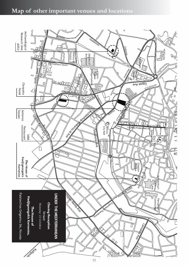
Closing ReceptionVenue: the House of Hadjigeorgakis Kornesios, Nicosia, kindly offered by the Department of Antiquities.The reception is partly sponsored by Wiley, publisher of the International Journal of Nautical Archaeology
for the Nautical Archaeology Society.
19:00
20:30 Conference DinnerVenue: 1888 Restaurant, Lefkonos 23, Nicosia

10
Map of the venue for 20 & 23 October

11
Map of venues for 21 & 22 October
12
Map of other important venues and locations
13
Keynote Lecture
Honor Frost Under the Mediterranean: From Maritime to Nautical Archaeology
Patrice Pomey - Emeritus Research Director, Aix-Marseille University – CNRS
In 1954, Honor Frost dives for the first time on an ancient Mediterranean shipwreck, the Chrétienne A, and discovers archaeology underwater. A few years later, in 1957, she participates in the excavations of the necropolis of Jericho. Synthesizing this dual experience, she is one of the first to realize that underwater archaeology opens the door to a new discipline: Maritime Archaeology.Her activity is tireless. She is interested in ancient ports of the Syro-Lebanese coast (Rouad, Arwad, Tyr, Sidon, Byblos), in the lighthouse of Alexandria and in the ancient anchors from Phoenicia (Byblos, Ugarit or Kition) and Egypt (Alexandria, Wadi Gawasis), without forgetting the shipwrecks. After having assessed the Cape Gelidonyia wreck with Peter Throckmorton, she participates in 1960 in the excavation directed by G. F. Bass, which was the first underwater excavation conducted by archaeological divers. Next, in 1967, the excavation of the Mellieha Bay shipwreck off the island of Malta, and from 1970, the excavation of the Marsala shipwrecks in Sicily.By bringing together in the same activity, the study of ports, anchors and shipwrecks with their cargoes and hulls remains, without neglecting neither iconographic data nor textual sources, encompassing the breadth of human activities on the sea, is the aim of her study. That is to say the definition of Maritime Archaeology, as it later became known.But the excavation of the Punic wrecks of Marsala, from the first campaign in 1970 to the final publication in 1976, remains the great enterprise of his life. Leading the search with method and meticulousness, she will highlight the construction marks in the Punic alphabet painted on the hull. From the letters, she will deduce with subtlety the process of the ship construction. This discovery, which remains unique to this day, is one of the main achievements of naval archaeological studies, and the excavation remains an exceptional model.Thus, after taking part in the birth of maritime archaeology, Honor Frost has also contributed to establishing nautical archaeology as a discipline in its own right.
In the Footsteps of Honor Frost
1. Honoring the Lady of Byblos
Nicolas Grimal, Martine Francis-Allouche Collège de France, Paris, France
Honor Frost, a pioneering figure in maritime archaeology for over 40 years, has left behind an outstanding legacy in the eastern Mediterranean for many generations to come. One of her most important projects was the research she conducted at Byblos, from the 1960s to shortly before her passing. Honor traveled regularly from London in her Volkswagen Beetle to explore the history of the Levantine coast. She resumed research first initiated by Antoine Poidebard, Jean Lauffray and René Mouterde in southern Lebanon at the harbour sites of Tyre and Sidon, until the civil war prevented fieldwork. In Byblos, prior to Honor’s research, archaeological investigations were exclusively land based; the sea front was terra incognita. In 1997 Honor started a long-term maritime archaeological survey of the site, primarily focused on identifying the ancient harbour of the city. Thereafter, Honor became the mentor and an inspiration to maritime archaeologist Martine Francis, who was given the opportunity to assist her research at Byblos.In 2011, a multi-disciplinary investigation program ‘Byblos & the Sea’ took up the reins of Frost’s research under the direction of Martine Francis and Egyptologist Nicolas Grimal. Funded by the Honor Frost Foundation, ‘Byblos & the Sea’ has to date conducted eight field investigations, with the objective of linking the city to its seafront, to understand the maritime approaches to Byblos, and to locate the ancient harbour. Building on previous research, the field study covers the entire coastal rocky strip of Byblos and its maritime approaches. Recently, the southern vicinity of the ancient city was reinvestigated, confirming the location of a harbour basin at the foot of the promontory, exactly where Honor had believed it to be at the launch of her investigation. Today, research on the harbour continues within the framework of ‘Byblos & the Sea’, in the legacy of Honor.
2. Harbour Installations at Tyre North
Ibrahim Noureddine - Department of Greek and Roman Studies, Carleton University, Ottowa ON, Cananda
The cultural landscape encompassing the island of Tyre suggests the area has had a long historical dependence on maritime activities. It was during the Early Iron Age, correlating to the early rise of Phoenician culture, that Tyre reached its height of prominence. The Phoenicians are recognized as skilled seafarers who established dominance in maritime commerce throughout the Mediterranean, and the port of Tyre is suggested to have been a major commercial centre during this period. As early as the late nineteenth century, investigations began seeking the identification of the two harbours of Tyre mentioned in historical texts – specifically the so-called ‘Egyptian’ harbour south, and the northern harbour complex. During the early 1960s Honor Frost initiated several investigations to identify and document the significant archaeological potential for harbour
Paper Abstracts
14
facilities on Tyre’s coasts. Later in 2001, Ms. Frost encouraged me to continue this research and provided mentorship to the first underwater investigations on Tyre’s harbour since her early works. During this work, my crew and I were able to identify the existence of a man-made structure within the northern harbour area at Tyre. Ms. Frost continued to advise on scientific and historic principles during subsequent investigations within the northern harbour at Tyre; based on subsequent research and underwater investigations in 2004 and 2005, this underwater structure was interpreted as representing a former harbour jetty installation dating to the Phoenician Iron Age. In this paper, I shed light on the 2001 project mentored by Honor Frost, the advice that she provided, along with subsequent work and suggestions to carry on the work and future planning.
3. The Impact of Honor Frost on Phoenician Port Studies in the Levant
Nicolas Carayon - Rome’s Mediterranean Ports Project, University of Southampton, Southampton, UK
From the 1960s onwards, Honor Frost wrote a series of papers focused on the underwater archaeology of the Levant. She focused of course on famous Phoenician city-ports such as Tyre, Sidon, Byblos and Arwad. She explored the sea bottom and analysed submerged harbour infrastructures. In addition, Frost correlated underwater remains of ancient ports with emerged structures in order to understand the relationship between land and sea. This double approach allowed her to raise the fundamental issues of relative sea-level changes and maritime palaeo-landscape 30 years before the development of harbour geoarchaeology. The tools used almost systematically today were not yet available to Frost at the time. Nevertheless as a pioneer she employed a truly interdisciplinary approach that remains the methodological process applied at recent and current projects on ancient ports in the Levant and beyond. This paper aims to place the impact she had on Phoenician port studies within the historiographical context of harbour geoarchaeology, and to focus on the relevance of the questions she raised.
4. Preserving the Landscape of Anfeh: From Nature to Culture
Nadine Panayot Haroun, Lucy Semaan Department of Archaeology and Museology, University of Balamand, Al-Koura, Lebanon
Honor Frost’s pioneering archaeological work in the Mediterranean is known to be almost exclusively focused on anchors, shipwrecks, and harbours. However, a closer examination of her work reveals an avid interest in maritime cultural landscapes, long before the term was coined by Christer Westerdahl in the 1980s. By putting coastal and underwater archaeology in context, at Lebanese sites such as Byblos, Sidon, and Tyre; by considering sea-level changes and their archaeological signatures, environmental dynamics, and site formation processes; and finally by appreciating the tangible
and intangible maritime material culture, Frost paved the way for local archaeologists to hermeneutically perceive the seamlessness of sea and land. This paper considers the maritime cultural landscape of Anfeh, an albeit understudied coastal site in North Lebanon. It seeks an appreciation of Anfeh’s maritime heritage, past and present. It will describe how an important site that played a role in the economy of the northern Levant from the Early Bronze Age to the Ottoman period site is being researched, surveyed and excavated. The multifaceted research project aims at reconstructing the history of Anfeh by combining archaeological data from surveys and excavations with an in-depth study of ancient epigraphic and literary sources, as well as ethnographic data collected from oral histories. Continuous research promises to locate the ancient city of Ampa [Anfeh] and to investigate its maritime activities with a focus on the anthropic experience of its maritime landscape.
5. Honor Frost and the Alexandria Lighthouse
Jean-Yves Empereur - Centre for Alexandrian Studies (CEAlex), Alexandria, Egypt; National Center for Scientific Research (CNRS)
In 1968, Honor undertook an appraisal mission in Alexandria on behalf of UNESCO in order to examine submerged ruins that had been reported by the pioneer of Egyptian underwater archaeology, Kamal Abou el-Sadat. As a result of her dives on the site, she drew up the first-ever topographic survey, which she published in 1975 in a famous IJNA article entitled ‘The Pharos site, Alexandria, Egypt’. In 1992, when the Egyptian authorities requested that I conduct salvage excavations at the foot of Qaitbay Fort in Alexandria, it was natural that I should turn to Honor, whom I had then known for some 15 years. Honor accepted my invitation and, in 1995, she dived along with us. Thanks to her remarkable memory, she was able to give us a precise description of the state of the site before the modern concrete blocks had been dropped in place. She was kind enough to return a couple of times thereafter, bringing with her previously unpublished documents that were crucial to our understanding of the underwater site of Alexandria’s Pharos lighthouse.
6. New Perspectives in Harbour Research
David J. Blackman - Centre for the Study of Ancient Documents, University of Oxford, Oxford, UK
Harbour studies are no longer the ‘poor relation’ in maritime archaeology. Apart from the obvious point of the stimulus provided by new discoveries, we can see a readiness to review existing evidence. The geoarchaeology of harbours has provided much new evidence, and also underlines the need for caution. So, too, has the application of new analytical and dating methods. Honor Frost’s work and interests encouraged this development. One should recall also the work of her great friend, Gerhard Kapitän: they did, sometimes, talk about other subjects than anchors! Working with Honor always contained the unexpected element: I will recall one experience.She always asked questions, which made one stop and think. I
In the Footsteps of Honor Frost
15
mention some of mine.For example, caution is needed in the application of network theory – not necessarily bedside reading for the ancient mariner. He may have been more worried about water supply or market conditions at the next port. We should continue to ask questions such as: can one always distinguish civil and military harbours? What were the standard methods of mooring? What was the standard quay height? What was the minimum depth needed at the foot of a slipway? How widespread were the light construction methods now shown at Naukratis and Myos Hormos? They would have been particularly suitable in deltaic contexts.In historical terms, can we fill in slowly the gap in the tradition of harbour engineering between Late Antiquity and the Renaissance?
7. Building Upon Honor Frost’s Stone Anchor Foundations: Typology, Experimentation, Spatial Analysis and Prospects for Anchor Studies Gregory F. Votruba - Research Center for Anatolian Civilizations (ANAMED), Istanbul, TurkeyOsman Erkurt - 360º Research Group, Urla/Izmir, Turkey Among Honor Frost’s pioneering contributions is her work illustrating the potential of the systematic study of anchors to inform about maritime culture and trade routes. Frost demonstrated that these nautical tools provide information on the nature of vessels, and that their find location patterns are commensurate with seafaring and long-distance interactions. Furthermore, concentrations near the shore may reflect the existence of anchorages, and terrestrial finds in proximity to temples likely hint at sacred dedications. After summarizing Frost and her colleagues’ conclusions regarding stone anchors, this paper reviews the current state of the field and discusses the benefits of reconstruction and experimentation. In addition, further prospects for the future of ‘anchorology’ are presented.Results of the stone anchor experimentation by the World Anchors Reconstruction and Experimentation Project (WAREP) are also introduced. As part of WAREP, full-scale anchors of various sizes and designs were tested on the seafloor through observation of casting and holding resistance measurements, both on sand and seagrass seabeds. Additionally, various hypotheses are put forward based on statistical analyses of a substantial database. These include changing patterns illuminating maritime trends along the Levantine coast, including Cyprus, into Egypt and the Red Sea. The purpose and nature of one- and three-holed anchors (in which two stakes are placed to increase resistance) are discussed. It is demonstrated that, far from declining with Honor Frost’s passing, we can expect maritime cultural insights to flourish through the investigation of anchors with the application of developing technologies.
8. 1985-2008: The TROPIS Symposia on Ship Construction in Antiquity
As with trade fairs, the success of symposia is measured by the volume of goods or information exchanged.Honor Frost, ‘Pyramidal Stone Anchors: an inquiry’TROPIS I (Piraeus 1985)Harry E. Tzalas - Hellenic Institute for the Preservation of Nautical Tradition, Athens, Greece
On the morning of June 22nd 1985 the full-scale replica of the ancient ship of Kyrenia, Kyrenia II, was launched in the presence of Melina Mercuri, the Greek minister of culture. Many European ministers and officials attended the ceremony, as the event was set within the framework of the ‘Athens Cultural Capital of Europe’ programme. I also proposed, and it was agreed, that a large exhibition, ‘Greece and the Sea’, with artifacts extending from the early Prehistoric attempts of navigation in Greek seas up to the modern super tankers, also be organized.During the four years required for the construction of the Kyrenia II I realized that although theoretically a lot was supposedly known on how ancient hulls were assembled, there were numerous practical problems that still had to be elucidated. Not only were there questions on the shell-first construction method, but much remained to be learned on the use of the ship’s equipment. Dick Steffy, world specialist in the field of ancient ship construction with whom we closely cooperated, had many questions, as did Michael and Susan Katzev, the excavators of the ancient wreck. So I also suggested to the Ministry of Culture that a conference be organized on ‘Ship Construction in Antiquity’, focused on the construction and navigation of ancient Mediterranean sea craft. The date was set for the 30th of August,1985: that is the date of birth of the TROPIS symposia. That three-day conference in Piraeus was organized by the Hellenic Institute for the Preservation of Nautical Tradition, which I had established in 1981 for the construction of Kyrenia II, and leading scholars in the field of nautical and underwater archeology were invited. 26 papers were presented, some by world pioneers in nautical and underwater archaeology including George Bass, Peter Throckmorton, Honor Frost, Lucien Basch, John Morrison, Gerhard Kapitän, Thomas Gillmer, Michael Katzev, François Salviat and Charalambos Kritzas. The success of this first encounter and the publication of the proceedings led to the continuation of the symposia for another 23 years. A total of 10 TROPIS symposia were held: at Delphi (1987), Athens (1989 and 1991), Nauplia (1993), Lamia (1996), Pylos (1999), Hydra (2002), Aghia Napa, Cyprus (2005) and again in Hydra (2008). Honor Frost contributed to all the TROPIS symposia and was a member of the Organizing Committee multiple times. The TROPIS conferences have always been open to the younger generation, and some of the students attending then are now leading scholars in the field. 66 papers were presented at the last encounter in 2008, after which the symposia had to be discontinued due to lack of State and municipal funds – a consequence of the severe financial crisis that Greece has recently been facing.
Paper Abstracts
16
9. Three Decades of Adventures with Honor Frost
Elpida Hadjidaki - Former Director of Underwater Antiquities, Athens, Greece
I met Honor Frost in the 1970s when I was a student in England, searching for what to make of my career. I knew it should combine history and the sea, but I had no models of what I could become until I met Honor Frost. She was a diver, travelled the world, made discoveries, and was fearless. She became the most important influence on my professional life. We often traveled together, visiting archaeological sites, diving, or attending conferences together, in the UK, France, Bulgaria, and Greece. I not only gained knowledge of diving archaeology from her, but I learned to share her life-long passion for ships and harbors. I made my first visit to Phalasarna with her, and excavating its ancient harbor has been the most long-lasting excavation of my life. She was the first to identify the throne of Phalasarna as Phoenician. She also visited other excavations I directed, such as the Classical shipwreck at Alonnesos that I started soon after becoming director of underwater antiquities in Greece.We began corresponding soon after we met, and our correspondence lasted until the end of her life. She could be a very close friend, although if anyone thought they could push her around because she was a woman, they soon learned otherwise. She will remain in history – and in my heart – as one of the world’s first diving archaeologists, as the first female diving archaeologist, for her comprehensive knowledge of marine antiquities, particularly anchors, and for inspiring the generation that has followed in her footsteps.
10. The Archaeological Mission of the Punic Ship
Pietro Romano Alagna - Cantine Pellegrino, Marsala, Italy
This paper intends to portray the ‘Mission of the Punic Ship,’ as recounted by Honor Frost’s friend and legal executor in Sicily, Pietro Alagna, beginning with the first exploratory underwater investigations near Marsala in 1969 and the Punic ship’s discovery. It will focus on the contextual history that provided almost 50 years of stimulating personal memories and exciting adventures that have enriched Dr. Alagna and his family, both culturally and personally. This paper highlights the importance of underwater archaeological research conducted by Honor Frost, as well as underlining her sincere and mutual friendship, deep respect and affection for the Alagna family and for all the team workers.
11. The History of Marsala’s Shipwreck Exhibition from the Beginning to the Present
Rossella Giglio - Soprintendenza per i beni culturali ed ambientali di Trapani, Regione Siciliana, Trapani, Italy
This paper seeks to provide some fundamental answers to questions concerning the Punic shipwreck of Marsala, from the first intervention on the wooden artifact (conceived to ensure its long-term survival) to its display, by sketching a history of its preservation and exhibition from the mid-1970s onwards.
My aim is to clarify some of the conceptual groundwork and explore the theoretical and methodological challenges undertaken by Honor Frost. In this respect, I will outline the key points for preservation and exhibition of the main material types recovered. Between 1975 and 1978, the hull timbers were stored in freshwater tanks and treated with polyethylene glycol (PEG), a water-soluble wax that prevents wood from collapsing during the drying process. The timbers were subsequently re-assembled within an iron frame and displayed in the main hall of the Baglio Anselmi structure, which was not yet a museum at the time. The wooden hull was protected by a plastic cover during the period that the building was being restored (since 1987). In my capacity as archaeological director at Trapani’s department of cultural and environmental heritage, I worked on the first exhibit of the wooden hull en plein air (1999), as well as for its protection and enhancement. Spurred by the recent successful recovery of several bronze rams found on the seabed off Levanzo Island (like the Punic hull, associated with the naval battle in the Aegadi Islands in 241 BC that ended the First Punic War), the museum display of Marsala’s shipwreck was renewed and enhanced in 2016. The newly conceived Baglio Anselmi Museum provides new technology and display facilities that include an elevated walkway around the hull (first conceived by Frost, and studied by Ole Crumlin Pedersen) and several new showcases for stoneware and other materials (such as ropes, nets, baskets, corks, nails and weapons).The constant presence of Honor Frost, and her detailed technical and professional choices undertaken with strength and determination in this field at Marsala, represents today a major asset for the future.
12. The Second Life of a Phoenix: Honor Frost’s Unpublished Chronicles of a Punic Ship in Sicily
Claire Calcagno - Independent Scholar, Medford MA, USAElena Flavia Castagnino Berlinghieri - Soprintendenza ai Beni Culturali e Ambientali di Siracusa, Regione Siciliana, Syracuse, Italy
In early 2013, while conducting archival research funded by the Honor Frost Foundation, the authors discovered fortuitously an unpublished manuscript written by Honor Frost about her experiences as director of the Punic ship excavation project in Sicily during the 1970s. The 50,000-word text, found among Honor’s papers in London, was titled ‘The Second Life of a Phoenix. Portrait of a Punic Ship Resurrected in a Sicilian Town.’ Frost’s first-hand account, addressed to a broad audience and intended by Honor for bilingual publication in English and in Italian, offers insights into the real import of this seminal and pioneering excavation and its significance to the history of archaeology. Frost was responsible for finding, excavating, treating and displaying the timbers of the Punic naval vessel that came to grief in the mid-third century BC off the western Sicilian coast near Marsala. Since the wreck-site’s discovery in 1971, Frost worked for a number of years with the essential help of the local community and with underwater archaeologists who shared their (often experimental) expertise in maritime excavation and conservation techniques. In addition to the difficulties of
In the Footsteps of Honor Frost

17
managing a complex archaeological project in a region with relatively modest amenities at the time, Frost also had to contend with an increasingly intractable combination of local and national bureaucratic hurdles, over the course of several decades.This paper presents work in progress, under the auspices of the Frost Foundation, to restore Honor’s manuscript to publishable form, honouring her original intentions as closely as possible while locating her book within its broader historical context. The resulting publication – partly autobiographical and partly biographical –will provide unique insights into Honor’s life and work, and bring her Sicilian chronicles to a wide audience.
13. From One to Many: How Honor Frost’s Legacy Shapes Scholars
Crystal el Safadi1, Naseem Raad1, Ziad Morsy1, Lucy Semaan2, Dorothy Chakra1
1. Centre for Maritime Archaeology, University of Southampton, Southampton, UK2. Department of Archaeology and Museology, University of Balamand, Al-Koura, Lebanon
Following the legacy of Honor Frost, one objective of the Honor Frost Foundation is to support researchers and scholars in the eastern Mediterranean. Whereas the support of maritime archaeological projects is vital for the region, sustainability can only be guaranteed with the presence of an active community of maritime archaeologists. Such a community requires members who are trained, experienced and motivated to carry maritime archaeological research forward. The HFF-driven initiative begun in 2012 regarding eastern Mediterranean scholars signals a process that will influence the development of the discipline in Honor Frost’s beloved countries for years to come. It represents an opportunity for archaeologists to further their academic studies and specialise in the field of maritime archaeology, while contributing to research in their respective regions. As HFF-funded scholars, we wish to share the experience of how this initiative has taken shape thus far. By putting forth our stories, we aim to illustrate the impact of this HFF initiative on individual, regional and eastern Mediterranean scales. The presentation outlines research conducted by HFF scholars in Lebanon and Egypt. Topics include maritime networks in the Early Bronze Age Levant, ethnographic studies of Nile boats, and Roman trade along the Near Eastern seaboard. The presenters outline their respective progress in their studies, and illustrate ways in which the HFF has helped not only with funding, but also in guiding research and connecting scholars to the wider communities.
Maritime Cultural Landscape
14. Late Pleistocene to Holocene Submerged Shorelines and Landscapes off Franchthi Cave, Greece
Julien Beck1, Dimitris Sakellariou2, Flavio S. Anselmetti3, Despina Koutsoumba4, Alexandra Zavitsanou2, Morgan Surdez5, Ioannis Panagiotopoulos2, Ioannis Morfis 2
1. Département des sciences de l’Antiquité, University of Geneva, Geneva, Switzerland2. Institute of Oceanography, Hellenic Centre for Marine Research, Anavyssos, Greece3. Institute of Geological Sciences and Oeschger Centre for Climate Change Research, University of Bern, Bern, Switzerland4. Ephorate of Underwater Antiquities, Hellenic Ministry of Culture and Sports, Athens, Greece5. Institute of Geological Sciences and Oeschger Centre for Climate Change Research, University of Bern, Bern, Switzerland
Franchthi Cave, on the northern shore of the Bay of Kiladha (Argolic Gulf, Greece), was occupied regularly, if not continuously, from the Upper Palaeolithic at least to the Neolithic, a time span which includes part of MIS3 and MIS2 (Last Glacial Maximum).As part of the Terra Submersa expedition, a systematic geological-geophysical survey was conducted in the summer of 2014 in the Bay of Kiladha and the Eastern Argolic Gulf. Two research vessels worked in parallel for two weeks and collected data using boomer (0.7-3 kHz) and chirp (2-7 kHz) sub-bottom profilers, side scan sonar (100/400 kHz) and swath bathymetry systems (200/400 kHz). The geophysical survey was followed in 2015 by targeted shallow drilling in the Bay of Kiladha.Processing, analysis and interpretation of the collected data revealed information on the nature and extent of the submerged prehistoric landscapes and on the location of palaeo-shorelines, as well as highlighting the interplay between tectonic movements and sea-level fluctuation during the Late Pleistocene and Holocene. The LGM shoreline (18 kyrs BP) was found at 116-127m depth. An older shoreline, probably associated with MIS 6 (140 kyrs BP), clusters at 159-173m depth. The differences in depth are the result of tectonic movements along newly discovered faults. Palaeo-shorelines shallower than 116m correspond to short still-stands during the post-LGM sea-level rise. The submerged landscape close to Franchthi Cave includes an erosional terrace at 11m depth, developed on the LGM terrestrial ground. It is covered by 1- to 3-meter-thick recent sediments and is incised by a meandering palaeo-river with maximum depth at 17-19m (7-9m deeper than the terrace).The new data enable a reconstruction of the Neolithic landscape in front of the cave, and may provide clues as to the drowning of the recently discovered Lambayanna Early Bronze Age settlement to the north.
Paper Abstracts
18
15. Geoarchaeological Investigations on the Roman Harbour of Pollentia (Bay of Alcúdia, Mallorca, Spain)
Matthieu Giaime1, Christophe Morhange1, Nick Marriner2, Matteo Vacchi3, Miguel Angel Cau4, Joan J. Fornós5
1. Aix-Marseille Université, UM 34 - CEREGE, Aix-en-Provence, France2. Université de Franche-Comté, UMR 6249 CNRS - Chrono-Environnement, Besançon, France3. Université Paul-Valéry Montpellier 3, UMR 5140, ASM - Archéologie des sociétés méditerranéennes, Montpellier, France4. Universitat de Barcelona, Departament de Prehistòria, Història Antiga i Arqueologia, Barcelona, Spain; Joukowsky Institute for Archaeology and the Ancient World, Brown University, Providence RI, USA5. Universitat de les Illes Balears, Departament Ciències de la Terra, Palma de Mallorca, Spain
The Roman city of Pollentia was founded on the north-eastern coast of Mallorca (Balearic archipelago) after the Roman conquest of the island in 123 BC. There is evidence that the city had two harbours: a small harbour located to the north, and the main harbour located to the south of Pollentia. Our study focuses on the southern harbour, on a coastal plain in proximity to the ancient city. Four sedimentary cores were taken and bio-sedimentological analysis was performed. Here, we describe the palaeogeographical changes in this area, evolving from an open lagoon environment between ca. 3200 and ca. 500 cal. years BC to a semi-enclosed lagoon during Roman times. Progressively, the lagoon became silted and was isolated from the sea by the development of a large sand spit, probably during the second half of the first millennium BC. We also discuss the water depth, linked to the palaeo sea-level, which is important in defining the possible ancient harbour location.
16. Exploring the Submerged Prehistoric Landscapes of the Inner Ionian Sea Archipelago, Greece
Nena Galanidou1, Dimitris Sakellariou2, Alexandra Zavitsanou2, Grigoris Rousakis2
1. Department of History and Archaeology, University of Crete, Rethymno, Crete, Greece2. Hellenic Centre for Marine Research, Anavyssos, Greece
This paper reports on the archaeological questions that prompted mapping the drowned landscapes of the Inner Ionian Sea Archipelago, the underwater work conducted, and the main findings of the study. Archaeological research on the islands of this inner and protected part of the central Ionian Sea has brought to light numerous Middle Palaeolithic sites in caves and in the open air. Neanderthal groups were well adapted to the area, which comprised coastal lowlands, rugged terrains of intermediate elevation and upland interiors. The work on land raised the need to reconstruct the palaeogeography of the seascape and to explore the inundated landscapes of the Pleistocene. A study of
the bathymetry suggested that during low sea-level stands of the Pleistocene many of the islands were joined together and to the mainland, whereas others remained insular, bringing into focus Palaeolithic sea crossings. The University of Crete commissioned the Institute of Oceanography of the Hellenic Centre for Marine Research (HCMR) to conduct a marine seismic survey and ground-truthing work in the Inner Ionian Sea Archipelago with the aim to reconstruct the now submerged, Late Quaternary terrestrial landscapes. More than 110km of boomer seismic profiles were acquired in the area between Meganisi, Lefkas, Kefallinia, Ithaka and Akarnania. Processing and interpretation of the seismic data included the recognition and mapping of palaeo-sea-level indicators, prograding prodelta clinoforms, submerged marine terraces and active faults. The results of the seismic stratigraphic analysis enable a fairly accurate definition of the palaeo-shorelines during the low sea-level stages MIS2 (20 kyr BP) and MIS6 (140 kyr BP) with implications on the insularity of the present islands and islets. Our underwater project marries Palaeolithic archaeology with marine geosciences and was funded by the Honor Frost Foundation. It is in line with recent developments in human evolution research that embrace marine archaeology. It has produced new palaeogeographic reconstructions on the northeast Mediterranean Sea. The linking thread is the Quaternary Sea, connecting or separating landscapes, fragmenting and then conjoining them.
17. Geo-Archaeological Investigations at the Submerged Remains of Ancient Olous (Crete): Preliminary Results from 2015
Theotokis Theodoulou1, Nikos Papadopoulos2, Kleanthis Simyrdanis2, Gialuca Cantoro2
1. Ephorate of Underwater Antiquities, Department of Crete, Heraklion, Crete, Greece2. Laboratory of Geophysical-Satellite Remote Sensing and Archaeoenvironment (GeoSat ReSeArch Lab), Institute for Mediterranean Studies - Foundation for Research and Technology Hellas (IMS-FORTH), Rethymno, Greece
The Ephorate of Underwater Antiquities (Ministry of Culture, Greece) and the Institute for Mediterranean Studies (Foundation for Research and Technology, Hellas) conducted a geo-archaeological investigation at the submerged remains of ancient Olous, on the isthmus of Poros Eloundas (Crete), from August fourth to seventh, 2015. The investigation included visual observation and initial mapping of the visible structures on the seabed as well as the implementation of geo-information technologies such as Global Positioning Systems (GPS), low altitude aerial imagery with remotely piloted aerial systems (drones) and geophysical prospection (electrical resistivity tomography, magnetometry).Most parts of the coast around the isthmus and a certain sector of the seabed were investigated with geo-information technologies that established the existence of buried structures under the coast and the seabed. In addition, several foundations and structures, feasibly belonging to public buildings based on
Maritime Cultural Landscape

19
their materials, dimensions and construction techniques, were located and roughly mapped. At the southern cove, large worked boulders forming a double row running from east to west have been interpreted as possible city wall foundations. The foundation disappears beneath a submerged mole at the west composed of rough stones. At the northern cove, two quadrilateral structures made of large ashlars may also belong to defensive towers. Moreover, paved street remnants were also located.The combination of mapped features, along with the general topography of the area and wall remains visible on land around the isthmus, gives a general picture of the urban plan of ancient Olous. In addition to presenting the above-mentioned research, the paper aims to illustrate the city’s presence in ancient records and to understand its role in Cretan history up to early Byzantine times, when the city was abandoned.
18. Anthropogenic Overprints on Natural Coastal Aeolian Sediments: A Case Study from the Periphery of Ancient Caesarea, Israel
Gilad Shtienberg1, Justin Dix2, Ruth Shahack-Gross3, Assaf Yasur-Landau3, Joel Roskin4, Revital Bookman5, Nicolas Waldmann5, Sariel Shalev6, Dorit Sivan3, Moses Strauss5
1. Department of Maritime Civilizations, L.H. Charney School of Marine Sciences, University of Haifa, Haifa, Israel2. The School of Ocean and Earth, University of Southampton, Southampton, UK3. Department of Maritime Civilizations, L.H. Charney School of Marine Sciences, University of Haifa, Haifa, Israel; The Recanati Institute for Maritime Studies, University of Haifa, Haifa, Israel4. The Recanati Institute for Maritime Studies, University of Haifa, Haifa, Israel; The School of Sciences, Achva Academic College, Arugot, Israel5. Department of Marine Geosciences, L.H. Charney School of Marine Sciences University of Haifa, Haifa, Israel6. Department of Maritime Civilizations, L.H. Charney School of Marine Sciences, University of Haifa, Haifa, Israel; Department of Archaeology, University of Haifa, Haifa, Israel
Since the rise to dominance of humans, mainly following the agricultural revolution, the earth’s soils and sediments have been affected by anthropogenic activities. In order to explore the effect of human settlement on the proximate environment, the current study focuses outside the settlement of ancient Caesarea, a well-known Roman to Early Islamic period urban centre in the central coastal plain of Israel. The investigation has been conducted by analysis of humanly induced macroscopic artefacts as well as microscopic remains found in buried sediments. Such anthropogenic markers are retrieved through boreholes, assessed by sedimentological analyses coupled with radiometric dating techniques and micro-archaeology, and integrated with archaeological and historical records. Two units were identified in the study area south of ancient Caesarea, based on their petro-sedimentological properties. The lowermost unit is a red-brown loam locally known as Hamra, while the uppermost covering unit is inferred as loose sand. The
sand unit, reaching thicknesses of up to 9m, is chronologically constrained between 6ka to the present, and consists of four facies. Out of these four facies the uppermost and lowermost lithologies were interpreted as natural beach and aeolian deposits that are interbedded with two grey-coloured anthropogenic sand facies that contain artefacts. One anthropogenic facies represents an urban garbage mound and the other is an agricultural pedo-sediment; both date to the Roman–Early Islamic periods. The pedo-sediment appears to be improved, in terms of soil fertility, and we therefore propose that it is the outcome of manuring enrichment for agricultural purposes. Taking advantage of the high coastal freshwater aquifer in the study area that facilitates capillary rise, we propose that this pedo-sediment represents buried agricultural plots. This study demonstrates the potential to further knowledge and understanding of human societies and their connection to and impact on the environment, and could be of relevance to other archaeological sites around the Mediterranean.
19. Marine Geophysical Implications in the Ancient Harbour of Byblos, Lebanon
George Papatheodorou1, Maria Geraga1, Nikolaos Georgiou1, Dimitrios Christodoulou1, Xenophon Demas1, Martine Francis-Allouche2, Nicolas Grimal2
1. Laboratory of Marine Geology and Physical Oceanography, Department of Geology, University of Patras, Patras, Greece2. Collège de France, Paris, France
Byblos (Jbeil; Lebanon), is known to be one of the world’s oldest continuously inhabited cities, as attested by the ruins of many successive civilizations since the Neolithic period. Byblos played a major role among Levantine harbour cities from which Phoenicians prevailed along Mediterranean sea routes, exporting Levantine goods and spreading the Phoenician alphabet. Archaeological investigations in Byblos, which revealed archaeological findings of utmost importance, were exclusively land based until after the Lebanese civil war. Its sea front, however, had remained terra incognita until Honor Frost’s underwater survey work searching for the antique harbour of the city. But it wasn’t until later that the exact location of the harbour basin was identified, within the framework of the ‘Byblos and the Sea’ research programme which built on Frost’s earlier studies. Since 2011 the ‘Byblos and the Sea’ team, funded by the Honor Frost Foundation, has conducted a multidisciplinary field investigation in collaboration with foreign specialists and the Directorate General of Antiquities of Lebanon. The main objectives of this investigation have been to link the ancient city to its shore, to understand the near-shore maritime approaches to the city, and finally to locate the well-attested Bronze Age harbour of Byblos, which was responsible for the economic growth of the city during antiquity. Since 2014, the evolution of coastal geomorphology has been the focus of several offshore geophysical campaigns conducted by the Geological Department of the University of Patras, under the scientific direction of George Papatheodorou, within the framework of ‘Byblos and the Sea’. These marine surveys
Paper Abstracts

20
collected bathymetric, sub-bottom profiling and side scan sonar data. Marine remote sensing techniques have been used systematically in underwater archaeological research, as these non-destructive tools are capable of detecting and mapping underwater archaeological features lying on the seafloor or buried beneath it, as well as evaluating the evolution of palaeogeography. During the upper Quaternary the sea level dramatically changed in response to climatic changes and tectonic activity, and caused migrations of the shoreline over time. In order to solve the equation of palaeogeography, current bathymetric data were correlated to available sea level change curves. The existence of three plateaus (‘flat surfaces’) at about 30m depth constituted a unique finding of palaeo-shoreline markers. Additionally, the presence of a small basin north of the islet of Jasmine could be of potential archaeological value linked to the ancient city of Byblos.
20. The Geoarchaeology of Natural Hazards in Ancient Harbours
Christophe Morhange1, Nick Marriner2, David Kaniewski3, Matteo Vacchi4, Alexandra Bivolaru1, Matthieu Giaime1, Soumaya Trabelsi 5
1. Aix-Marseilles University (AMU-CEREGE-UM 34), Aix-en-Provence, France2. CNRS (Chrono-Environnement-UMR 6249), Besançon, France3. IUF Toulouse 3 University (ECOLAB-UMR 5245), Toulouse, France4. Montpellier 3 University (UMR 5140, Archéologie des sociétés méditerranéennes), Montpellier, France5. Sousse University, Department of History, Sousse, Tunisia
This paper explores the relationships between Mediterranean archaeology and the geosciences, with particular emphasis on ancient harbour evolution. We review recent geoarchaeological research probing the palaeo-environmental evolution of ancient harbours. In particular, we attempt to elucidate the revival of catastrophism. Our lecture presents different natural hazards in harbour contexts: (1) rapid sedimentation versus dredging in Naples harbour (Italy) and the ancient anchorages of Akko (Israel); (2) relative sea-level changes in Naples (Italy) and Phalasarna (Greece); and (3) supposed ‘tsunami’ deposits in Lechaion (Greece) and Tipaza (Algeria).In particular, we demonstrate that sedimentary ‘tsunami’ data from the Mediterranean shows strong evidence for a 1500-year periodicity that presents robust statistical correlations with markers of climate cooling and deterioration in both the Mediterranean and North Atlantic. We suggest that up to 90% of ‘tsunami’ attributions of high-energy events in the Mediterranean’s coastal record should be reconsidered. Specifically, our findings invite closer and more robust scrutiny of ‘tsunami’ events, including greater proxy analysis, in future studies of coastal archives. We argue that there is an absence of rational grounding and over-emphasis on natural catastrophes. Research into the decline/collapse of ancient harbours is, in our view, over-simplistic. Caution is needed to ensure that neo-catastrophism does not alter the paradigm of geoarchaeology, e.g. the analysis of the
interactions between society and nature.
21. Cognitive Coastscapes in the Archaeological Context
Mari Yamasaki - Early Concepts of Man and Nature (Research Training Group), Johannes Gutenberg Universität Mainz, Mainz, Germany
At first glance, the notion of coastal landscape appears clearly identifiable as that strip of land located in proximity to a mass of water. How far from the water such a strip of land would stretch to, however, is subjective and ambiguous. There is no clear-cut limit as to how wide an area should be to be considered coastal. Yet, we find ourselves able to immediately identify a location as coastal or otherwise, regardless of how many kilometres we are from the shore. Maritime coastal landscapes, and Mediterranean coastal landscapes in particular, tend to evoke a specific set of images and characteristics commonly associated to them such as dietary customs, the existence of a sea-specific lexicon, familiarity with navigation and the presence of coastal landmarks. However, are these criteria also identifiable on an archaeological level? When is it possible to embed a community within a coastscape rather than a landscape close to the sea?In this respect, the conceptualization of landscape has little to do with geographical objectivity and much more with perception. This paper aims to present an attempt at identifying a series of archaeologically identifiable, objective parameters that can be used to recreate a cognitive geography of ancient coastal zones. More specifically, through a selection of case studies from the Eastern Mediterranean Bronze Age, this study proposes a method for estimating the perceived proximity to the sea in archaeological contexts, contributing to a holistic definition of this maritime character.
22. The Marsa Bagoush Research Project – MBRP
Emad Khalil - Alexandria Center for Maritime Archaeology and Underwater Culture Heritage (CMAUCH), Alexandria University, Alexandria, Egypt
The site of Marsa (anchorage) Bagoush (ancient Zygris – Ζυγρίς) was mentioned in the Roman navigation guidebook Stadiasmus Maris Magni of the third century AD which states that ‘From Leuce Acte to Zygris 90 stadia; there is an islet; put into the place with it on your left; there is water in the sand.’ In in 1861 Captain T. A. B. Spratt (1811-1888), commander of HMS Medina, surveyed the site of Marsa Bagoush as part of a hydrographic survey conducted by the British navy along the Egyptian northern coast. The map produced showed Marsa Bagoush as a confined bay bordered from the north by a series of protruding reefs, which allows only for few entrances into the bay. However, in the late nineties, the INA conducted a limited archaeological survey of the site, which resulted in the discovery of few amphorae. Yet, since 2015, with the kind support of the HFF, the site of Marsa Bagoush has been under investigation by
Maritime Cultural Landscape
21
the Alexandria University Centre for Maritime Archaeology & Underwater Cultural Heritage. The investigation resulted in the discovery of evidence for at least three shipwrecks, in addition to evident changes in the geomorphology of the coast line since antiquity. Hence this paper will present the MBRP and its most recent achievements and discoveries.
23. Coastline, River Changes and their Effects on Anchorages / Harbours and Habitation Patterns: Akko (Israel) as an Example
Michal Artzy1, Christophe Morhange2, Amani Abu-Hamid1, Mathieu Giaime2, Harry Jol3, Paul Bauman4, Ann Killebrew5, Jamie Quartermaine6, Gloria López7
1. Hatter Laboratory, Recanati Institute for Maritime Studies (RIMS), University of Haifa, Haifa, Israel2. Aix-Marseille Université, UM 34 - CEREGE, Aix-en-Provence, France3. Department of Geography, University of Wisconsin-Eau Claire, WI 5470, USA4. Worley Parsons, Calgary, Canada5. Department of Anthropology, Penn State University, Pennsylvania, USA6. Oxford Archaeology, University of Oxford, Oxford, UK7. Consorcio del Centro Nacional de Investigación de La Evolución Humana (CENIEH), Burgos, Spain
Changes in shoreline and river course dictate anchorage/harbour positions, which, in turn, influence the habitation patterns of a coastal settlement. A model case study is that of Tel Akko/Acre and its vicinity. Upon analysis of previously gathered data as well as the newer results obtained for the ‘Total Archaeology Project’, the establishment of localized areas of some of the settlement areas and thus, the patterns, was possible. Since the first archaeological excavations undertaken in the 1970s, Tel Akko is known to have been an important trade city from the early second millennium BC onwards. Maritime connections are in evidence at the site from the Middle Bronze IIa period (early second millennium BC), although the locations of its anchorages/proto-harbours or harbours and their facilities have yet to be established.The unusual banana/crescent shape of Tel Akko necessitated a renewed study of the foothills of the tell, especially its southern and south-western borders. A previous assumption that an inner anchorage based on the Na’aman River was checked, as was the area assumed to have been the river estuary.Studies such as ERT (electrical resistivity tomography) and GPR (ground-penetrating radar) were carried out in the past and contributed to our understanding of the area; however, only in a recent study was a reconstruction of the evolution of the tell’s coastline since the Bronze Age determined, as well as the possible location of the ancient anchorages. This research is based on the study of new sediment cores drilled at the base of the tell and in the Old City of Akko (Saint Jean d’Acre) 1500m west of the tell. We propose that the southern anchorage was situated in the outer marine-dominated estuary of the Na’aman River until the Early Persian period. This anchorage possibly shifted to the western open coast of the tell during the Late Persian period,
before its subsequent relocation to the Akko promontory (Saint-Jean-d’Acre) in late Hellenistic time. On the basis of this historical information, we attempted to locate the Hellenistic harbour of Akko by coring in the Old City, in proximity to the modern harbour. Here we found more than 4m of marine sands deposited in part during Hellenistic times. These results are being corroborated by the archaeological data gathered thus far. A salvage excavation carried out in 2010, as well as a probe in the summer season of 2016, further demonstrate the coastal and river changes, and possible anchorages, which, in turn, influenced the habitation pattern on the tell and the Akko/Acre area.
24. Inundated Neolithic Villages on the Carmel Coast, Israel
Ehud Galili1, Jonathan Benjamin2, Deborah Cvikel3, Danni Rosenberg1
1. The Zinman Institute of Archaeology, University of Haifa, Haifa, Israel2. Department of Archaeology, Flinders University, Adelaide, Australia3. The Leon Recanati Institute for Maritime Studies (RIMS), University of Haifa, Haifa, Israel
The Neolithic period witnessed a major revolution in human existence: the transition from a nomadic way of life (hunting and gathering), to a food-producing economy based on domestication of plants and animals, and residence in permanent settlements. Since the 1960s researchers in Israel have developed methods for identifying, excavating, documenting and researching submerged prehistoric settlements. Six inundated sites dated to the Neolithic period have been discovered along the Carmel coast. The Atlit-Yam site dates to the Pre-Pottery Neolithic (ca. 9200-8500 years BC), while several sites date to the Pottery Neolithic period (ca. 8000-6500 years BC). These settlements shed light on the economy, material culture and lifestyle of the coastal Neolithic inhabitance of the Eastern Mediterranean. They show how the ancient populations dealt with environmental changes, sea-level rise, the flooding of the coastal area, and how they reacted to sea-level rise. The research provided evidence on the invention and development of water wells, the extraction of olive oil and the evolution of the Mediterranean subsistence and diet. It also demonstrates the potential effects of future sea-level rise and flooding of coastal plains.Sea-level rise occurred during the Neolithic period, and may occur in the future due to global warming. A rise of more than one meter in the twenty-first century, as predicted by some specialists, will necessitate costly human adaptation and heavy investment in coastal protections, as in Venice and The Netherlands. At some point in the future, sea-level rise may cause an inevitable population transfer, abandonment of settlements and removal of valuable assets inland, as practiced by the Neolithic populations of the Carmel coast.
Paper Abstracts

22
25. Metohi: An Underwater Middle Helladic Site in the Pagasitikos Gulf, Central Greece – Interaction Examined Under the Notion of Maritime Cultural Landscape
Elias Spondylis, Vasiliki Ivrou Hellenic Institute for Marine Archaeology (HIMA), Athens, Greece
Interaction among communities of the Middle Helladic world has long been, and continues to be, an issue of central interest in the archaeology of the first half of the second millennium BC in the Aegean. This presentation is based on the investigation of materials (architecture and finds) from the 2009-2016 surveys conducted at the submerged site of Metohi in the Pagasitikos Gulf – the third submerged settlement of that era to be excavated. This project is part of an archaeological underwater survey conducted since 2000 by HIMA, under the direction of archaeologist Elias Spondylis, on the west coast of the southern Pagasitikos Gulf. The significance of Metohi, however, is not the fact that it constitutes one of the rare submerged settlements in MBA Greece, but that the extent of finds from underwater survey and trench excavations indicates a flourishing town situated on the crossroads of intra-extra Thessaly relations via the coast and the sea. This presentation adopts a maritime perspective, viewing the coastal littoral from the sea. It examines various parameters including natural processes on the coast and hinterland that were, and remain, vital to the connectivity of cultures through the sea during the Middle Bronze Age and thereafter. We will discuss the nature of the medium-sized town and try to place its existence within a regional and extra-regional route, drawing heavily on the concept of Maritime Cultural Landscape in this part of Pagasitikos Bay.
26. Locating Ancient Stryme in the Changing Palaeogeography of the Thracian Coast (North Aegean Sea, Greece)
Konstantinos Vouvalidis1, Georgios Syrides1, Olga Koukousioura1, Katerina Kouli2, Georgia Karadimou1, Panagiotis Tsourlos1, Eleni Aidona1, Domna Terzopoulou3, T. Nathan Arrington4, Marina Tasaklaki5, F. Thomas Tartaron6, Christos Domakinis1
1. School of Geology, Aristotle University of Thessaloniki, Thessaloniki, Greece2. Faculty of Geology and Geoenvironment, University of Athens, Athens, Greece3. Archaeological Museum of Thessaloniki, Thessaloniki, Greece4. Department of Art and Archaeology, Princeton University, Princeton NJ, USA5. Ephorate of Antiquities of Rhodope, Komotini, Rhodope, Greece6. Department of Classical Studies, University of Pennsylvania, Philadelphia PA, USA
The ruins of ancient Stryme are situated on the northern part of the Molyvoti Peninsula on the Thracian Sea, about 25km SW of the modern city of Komotini (N. Greece). Recent research has shown that this city was one of the largest Archaic–Classical settlements in the region. Stryme was also mentioned twice by Herodotus as one of the largest cities conquered by Persian king Xerxes during his campaign in ancient Greece.The geoarchaeological research on ancient Stryme aims to reconstruct the palaeogeography and ancient landscape of the Thracian coast in the vicinity of the Molyvoti Peninsula. This will contribute to the understanding of the geomorphological evolution of the coastal zone during the Upper Holocene, and to the geographical identification of the settlement that has been inconclusively identified as ancient Stryme. This research is part of the Molyvoti, Thrace, Archaeological Project (MTAP), in collaboration with the Ephorate of Antiquities of Rhodope and Princeton University.The research took place in the coastal zone and the deltaic plain of the Filiouris River east of the ancient settlement. To reconstruct the geomorphological changes, a detailed geomorphological survey in combination with stratigraphical and palaeontological techniques was applied. In addition, a drilling project of two vibracores was carried out. The chrono-stratigraphy of the cores was determined by 14C A.M.S. radiocarbon dating.The evaluation of the data allows the following time-scenario interpretation. The sea was present in the area before 5,500 to 6,000 years BC. Initially the sea transgression flooded the lower part of the Filiouris River valley 3.4 km further inland from the present coastline, close to the present Mitrikon Lake. Sea level rising, before 3,200 years, contributed to an environmental change in the inner part of the Filiouris Valley, when a brackish, lagoonal environment with fresh water inputs was formed. The geographical setting of the area during the habitation of the city is in good accordance with Herodotus’ description, proving the existence of a lake west of the main river.
27. The Delos Underwater Survey Project (2014-2016)
Mantha Zarmakoupi - Department of Classics, Ancient History and Archaeology, University of Birmingham, Birmingham, UKMagdalini Athanasoula - Ephorate of Underwater Antiquities, Hellenic Ministry of Culture and Sports, Athens, Greece
This paper presents the results of the three-year Delos Underwater Survey Project (2014-2016), a synergasia between the Ephorate of Underwater Antiquities of the Hellenic Ministry of Culture and Sports, and the Institute of Historical Research of the National Hellenic Research Foundation under the direction of the Head of the Ephorate of Underwater Antiquities, Dr. Aggeliki Simosi. The survey focused on the submerged areas of two Hellenistic neighbourhoods that were created at the height of Delos’ urbanization period, the Stadion District and the Skardana District. The Cyclades have seen a relative rise in sea level of about 2m over the last 2,000 years, engulfing many areas of the once heavily urbanized island. By examining the submerged areas of these two neighbourhoods the aim of the project was to define their use and role in the commercial activity of the island in the late Hellenistic period.
Maritime Cultural Landscape
23
Over the course of three seasons the survey project identified structures providing evidence for commercial activities in the submerged area of the Stadion District, changing the predominant assumption that this neighborhood did not have an instrumental role in the operation of the Delian emporion. The project also identified remains of harbour installations in the submerged area of the Skardana District, indicating that the bay of the Skardana was an anchorage. These finds are significant, as they clarify the function of the bays that were located next to the newly formed neighborhoods on the island. It seems that commercial harbours operated both in the bay of the Stadion District and in the bay of the Skardana District, complementing the activities of the central harbour. Whereas previous research had focused on the main harbour area, assuming that the emporion of Delos depended solely on a single harbour, the Delos Underwater Survey Project – the first underwater survey to be conducted around Delos – provides a different picture of the ways in which the port-city functioned. Although the mechanisms of trade were weighted towards direct preferential links between emporia ports, rather than towards random coastal tramping or cabotage, an emporion has several harbours, which could be used according to the weather conditions. The results of the survey project show that the bays of the Stadion District and the Skardana District served as anchorages around the island, allowing skippers to avoid crossings in difficult weather conditions, thus facilitating the busy emporion of Delos in the Late Hellenistic period. Finally, the project conducted a preliminary survey for shipwrecks during the 2016 fieldwork season. The six shipwrecks that were found around Delos, Rheneia and in the channel between Delos and Rheneia date to the Hellenistic through the late Roman periods. They point to the continuation of the activity of the harbour of Delos and the usage of the channel between Delos and Rheneia, which must have continued to operate as a main waterway of the Aegean through the late Roman period, connecting the Eastern and Western Mediterranean.
28. Fishponds and Maritime Structures in the Roman villae maritimae: New Data from the Southern Latium Underwater Survey
Michele Stefanile - Dipartimento Asia Africa Mediterraneo, Università degli Studi di Napoli ‘L’Orientale’, Naples, Italy
The villae maritimae along the Tyrrhenian coast of Italy are important testimonies of Roman architecture during the Late Republican and Imperial ages. Their analysis allows us to understand how the Romans were able to build directly on rocky coasts and jagged promontories, often deeply changing the natural landscape.Despite a long and fruitful tradition of studies on the subject, scholars have rarely worked on what now lies below the sea level, where a considerable part of the most remarkable structures is currently found. Maritime infrastructures such as fishponds, private harbours or impressive waterfronts, often submerged because of sea level rise, can offer important new data about Roman architecture and about the exploitation of marine resources.The Southern Latium Underwater Survey, established in cooperative agreement between the new Underwater Archaeology
Research Unit of the University of Naples ‘L’Orientale’ and the Soprintendenza Archeologica del Lazio, aims to reconsider the maritime villas of Southern Latium, and to increase our knowledge through data retrieved from underwater contexts. In September 2013, the first campaign of underwater surveys took place at Gianola, in the submerged part of a huge villa. Building techniques and decorative elements suggest a first phase during the second century BC. In a few days of work, a big fishpond was documented, with very interesting artefacts related to the tank closing system and the mixing of freshwater and saltwater for a more profitable fish breeding. New research conducted in 2014 and 2015 was concentrated on the waterfront of this villa and others in the same area. At the Tiberius villa in Sperlonga, underwater research resulted in the documentation of a complex system for the breeding of moray eels within a natural cave, and deep work on coastline changes.
29. The Maritime Cultural Riverscape of Ports Along North Africa’s Atlantic Façade
Athena Trakadas - Department of History, University of Southern Denmark, Esbjerg, Denmark
Over millennia, sea-going ships travelling along Africa’s north Atlantic façade have taken advantage of the large tidal rivers, such as the Oued Loukkos, Oued Sebou and Oued Bouregreg, using them as safe havens and ports. This diachronic pattern is evident in the presence of Phoenician, Punico-Mauretanian, Roman, Idrissid, Almoravid, Almohad, Marinid, Portuguese, and Spanish material culture within the fluvial landscape. Although the river remains the constant overall ‘port’, the specific location of activities within the river-scape appears to change over time. This presentation will discuss a new methodology examining the environmental (geo-morphological) factors for these movements, contextualized within the region’s socio-cultural dynamics.
Paper Abstracts

24
Maritimity: Between Land and Sea
30. An Embracing Seaport beyond the Pillars of Heracles: The Area of La Caleta (Cadiz, Spain) in Phoenician and Punic Times
Aurora Higueras-Milena Castellano - Instituto Andaluz de Patrimonio Histórico, Centro de Arqueología Subacuática de Andalucía, Cadiz, SpainAntonio Manuel Sáez Romero - Department of Prehistory and Archaeology, University of Seville, Seville, Spain
The Bay of Cadiz, bridge between the Mediterranean and the Atlantic and knuckle joint between Europe and Africa, constitutes a key point for the study of the relationship established between man and the ocean since Late Prehistoric times. The advantageous natural conditions offered as harbor area favored the foundation of the Phoenician settlement of Gadir (present-day Cadiz) three millennia ago. Those advantages included the existence of anchorages sheltered from different winds, a perfect location to store and deliver raw materials from the nearby islands and the sea (seasonal tuna fish, seafood, salt, foodstuffs from the farmlands, etc.) and a port connected to key maritime and fluvial routes. The coast of the archipelago of Gàdeira (as named by Greek Classical sources) constituted an area of continuous bustle, motivated by trade, worship activities, armed conflicts, etc. This intense maritime activity has left its reflection in the waters that still surround the islands, and it is in La Caleta where the concentration of underwater deposits is broader and more significant, revealing different chronologies, typologies and preservation status.The reefs and shallow waters that characterize the present-day beach of La Caleta and its surroundings, have a port channel framed by two rocky headlands called Santa Catalina-Punta del Nao (northern one, ancient island of Erytheia) and San Sebastián (island of Kotinoussa). It is still used as a secondary anchorage and shelter area for fishing and pleasure boats. Along with the chain of small islets that surround it to the north, they formed one of the main port areas of the ancient bay, and underwater evidence of this intense use has been attested from the nineteenth century. In addition, the zone had a marked religious character from Phoenician times due to the establishment of two sanctuaries in the far western bounds of the rocky headlands and the deposition of votive offerings around the ending capes, such as Punta del Nao.Given the interest of this ancient oceanic port, the Centro de Arqueología Subacuática de Andalucía (CAS) is developing, in collaboration with researchers from the University of Seville, an update of the available information on the underwater and geo-archaeological findings in the area of La Caleta. Recently the results of the most recent archaeological campaigns carried out in the area (2008-2010) have already been published, and that data have been combined with the study of the collections stored in the Provincial Museum of Cadiz. This work is a first a synthesis of these on-going investigations about the Phoenician and Punic port of La Caleta, together with some first data of the study of the significant items, resulted of isolated finds and of the previous archaeological campaigns developed throughout the twentieth century (mostly, terracottas and other votive pots).
31. Up from the Sea: Mariner Cultural Worlds in the Late Bronze Age Eastern Mediterranean
Linda Hulin - Oxford Centre for Maritime Archaeology, Institute of Archaeology, University of Oxford, UKSenta German - Department of Classics, Montclair University, USA
‘Up from the sea’ explores a neglected aspect of Late Bronze Age Aegean maritime life: time spent on land. Pauses between voyages, waiting for a fair wind, loading of cargo, political authorization or the completion of repairs, were an ever-present and often long-lasting feature of the life of ancient sailors and traders. Maritime activity on land has been largely confined to its economic aspects: harbour infrastructure and the distribution of traded goods. This project delineates the maritime cultural world on land, and identifies areas in coastal towns across the eastern Mediterranean where sailors would congregate to eat, sleep, share stories, effect repairs and acquire goods for personal trade.A methodology for the identification of sailors’ quarters, based upon the results of two seasons’ work in Crete and Cyprus, is presented. Our results not only shed light on specific behaviours on land, they hint at specialised sailing routes within the wider networks of the eastern Mediterranean. These subvert networks based upon regional distributions of traded goods, and bear witness to a truly maritime, rather than merchant, cultural world.
32. The Kastro Coastal Rock-cut Site (Myrina, Island of Lemnos): Metaphorical, Representational and Tangible Maritime Aspects
Christina Marangou - Independent Scholar, Athens, Greece
The Kastro rock-cut site, by the port of Myrina, on the western coast of Lemnos, displays an especially intricate setting. In several diachronically occupied sectors (Late Prehistory-Late Antiquity), the scenery consists of complexes of artificial rock constructions, integrated within the natural surroundings. Solutions to practical, utilitarian concerns may obviously have been sought for, by means of some structures and finds. However, functionalities and uses are not obvious in a number of cases, while a mise-en-scène may have been pursued and symbolic patterns and behaviours may be hinted at by material finds, as well as implied by non-understandable carved components. If the omnipresence of the sea and the involvement of the inhabitants with maritime matters are inferred in multiple, concrete ways, direct and indirect, in various sectors, nevertheless the modes of operation appear multidimensional and the manners used may sometimes suggest transcendental patterns. At the present stage of on-going research, in addition to- or intermingled with economic, trade, nautical and generally maritime connections, the interpretation hypotheses also include ritual practices or symbolic performances, potentially involving influences from liminal processes or stages. The latter are indeed to be expected in areas of transitions, such as land-and-sea boundaries.
Maritimity: Between Land and Sea
25
33. The ploiaphasia/navigium isidis: A Possible Modern Continuation?
Shelley Wachsmann - Institute of Nautical Archaeology at Texas A&M University, Texas, USA
Within the context of the Greek Orthodox Easter liturgy on the island of Hydra, the Epitaphios –a richly embroidered cloth, depicting Christ down from the cross – is carried from a church on a palanquin by youths into the sea in the nearby harbor ‘for the protection of seafarers’. In 2015, with the kind assistance of Mr. Harry Tzalas, I had the opportunity to document this custom, which is unique to Hydra in the Greek Orthodox world.Eastern Mediterranean seafaring in antiquity was a distinctly seasonal activity, carried out primarily between March and November. While sailing continued in the offseason, it remained minimal. L. R. Palmer elicited awareness to a spring time ‘opening’ of the sailing season already by the Bronze Age in Linear B tablet PY Tn 316. This begins with the month name po-ro-wi-jo, which Palmer translates as ‘sailing month’.The ploiaphasia (Latin: navigium isidis) likewise celebrated the opening of the sailing season. This festival honored Isis in her nautical manifestations as the patron deity of seafarers: Isis Pharia, but most commonly as Isis Pelagia. Within this context Isis appears in a variety of nautical themes, but primarily astride a ship’s bow as she spreads her veil as a sail. The activities of the ploiaphasia culminated in the launching on the sea of either a fully provisioned ship, or a large ship model.The ploiaphasia appears in the first century BC and continued into the mid-sixth century AD. Subsequently, the church absorbed a number of Isaic cult elements and Sir Arthur Evans notes that modern coastal sites named after Hagia Pelagia only vaguely conceal the name of Isis Pelagia.This presentation examines the ploiaphasia and the cases for, and against, the Hydra custom being a vague modern continuation of this festival.
Maritime Archaeological Management
34. Long-term Retreat Rates of Israel’s Mediterranean Sea Cliffs Inferred from Reconstruction of Eroded Archaeological Sites
Ofra Barkai1, Oded Katz2, Amit Mushkin2, Beverly N. Goodman Tchernov3
1. Geological Survey of Israel, Jerusalem, Israel; Department of Marine Geosciences, University of Haifa, Haifa, Israel; Strauss Department of Marine Geosciences, University of Haifa, Haifa, Israel2. Geological Survey of Israel, Jerusalem, Israel)3. Strauss Department of Marine Geosciences, University of Haifa, Haifa, Israel
The Israeli coastal cliff extends approximately 50km along the eastern Mediterranean and is comprised of late Quaternary eolianites (locally known as Kurkar) and paleosols (locally known as Hamra) that reach heights of up to 50m above current sea-level. Generally, these areas are currently undergoing erosion, which has raised concern with regard to protection of coastal heritage, as well as directing coastal planning and management. However, the retreat rates are unclear. Until now, the majority of retreat rate estimates has been based on aerial photos from the past century, and therefore do not provide multi-century estimates of retreat rates. Amongst the victims of this process are partially eroded structures from different time periods, which leave behind remnants that can be interpolated to determine their original dimensions. We studied Bronze Age to Crusader archeological sites (ca. 3700 years) located on Israel’s coastal cliff and used their spatial relation to the cliff to estimate the long-term centurial – millennial retreat rates of the cliff. The resulting retreat rates are significantly lower than those previously calculated using observations from around 100 years. The archeological data also display the periodicity of the cliff failure events. The research highlights both the issue of the loss of valuable archaeological cultural resources, and simultaneously the usefulness of eroding coastal archaeological features to resolve questions of modern significance.
35. Ancient Shipwreck Sites in the Eastern Mediterranean: Revealing the Fragments of Their Biographies in the Present
Anna Demetriou - Archaeological Research Unit, University of Cyprus, Nicosia, Cyprus
The Mediterranean seabed preserves an important number of shipwrecks, the most typical and thoroughly studied type of underwater archaeological remains. Since the first professionally directed ancient shipwreck excavation at Cape Gelidonya in 1967 (1200 BC, Turkey), shipwreck archaeology has developed from the ‘academic immaturity’ to the theorization of the field. Likewise, the management of ancient shipwreck sites has
Paper Abstracts
26
progressed from a legislative focus in the 1970s, to the adoption of several management solutions concerning their research (excavation, partial excavation, in situ preservation), as well as their public interpretation (in situ and ex situ). However, there is a noticeable gap between the prevalent approaches to shipwreck archaeological research and management, and the complex intermingling of meanings and connections developed within present-day society. The paper approaches ancient shipwreck sites as a distinct type of underwater antiquities, the particularities of which highlight diverse axes of interpretation and raise challenging issues regarding their research and management. Ancient shipwreck sites are discussed in view of the Cultural Biography of Objects, with an emphasis on their afterlife, which begins after their discovery. With focus on the Eastern Mediterranean sites, the paper will attempt an overview of the research and public interpretation methods adopted diachronically, within the general trajectory of the field. Using Cyprus as a case study, I will highlight how important it is during the interpretation process to take into consideration the itineraries shipwrecks follow after their discovery and the subsequent shifting in meanings.
36. Maritime Archaeological Management in Italy: Skeleton-first or Shell-first Construction?
Massimiliano Secci - Università IUAV di Venezia, Dipartimento di Architettura, Costruzione e Conservazione, Laboratorio di Fotogrammetria - Sistema dei Laboratori, Santa Croce 191 – Tolentini, Italy
Cultural heritage represents an extremely sensible cultural ‘resource’. It is sensible due to its intrinsic characteristics; it is fragile, under continuous threat due to the action of time, human neglect, and active destruction by man, either through building development or pillaging and illicit trafficking. It is also sensitive, as it connects with several human endeavors (identity formulation in particular) that have a role in the shaping of the world we live in and creating a conscious and aware public sphere. The management of the maritime cultural heritage has developed to confront each of these aspects. To do so, this paper argues that a thorough and effective maritime archaeological management cannot be achieved without a ‘skeleton first’ approach where the management structure is shaped, connected and correctly waterproofed before management activities can fully and fluidly develop their full potential. In Italy, this means mending legislative and administrative obstructions ¬– following the mandates of the UNESCO 2001 Convention on the Protection of the Underwater Cultural Heritage ¬– that prevent connections and collaborations between institutions and stakeholders variously involved in the cultural heritage sector. For effective management, it is therefore an essential pre-requisite to lay the foundations for a ‘skeleton’ of actors and procedures able to establish a sound management system: (1) governmental heritage bodies able to direct and oversee the management of a relevant cultural resource; (2) universities able to fully train maritime archaeologists, and to establish and maintain a research program, routinely collaborating with government institutions; and (3) territorial governments enabled to participate in these processes. It is therefore paramount to first create a ‘skeleton’ able
to actively support and enable various stakeholders to participate in the management of maritime archaeological heritage. In order to do so, a reformulation of the relations between public actors, and the involvement of public, private and NGOs (volunteers) need to be precisely defined by the legislator. Only following the clear shaping of a neat infrastructure a solid ‘skeleton’ would it be possible to add a shell, such as thorough and effective long-term research and monitoring programs, as well as systematic public outreach and public access programs.
37. A Strategic Protection Scheme for the Submerged Bronze Age Town at Pavlopetri
Barbara Euser - President, Greek Chapter of Alliance for the Restoration of Cultural Heritage (ARCH), Neapolis, Greece
The Bronze Age site of Pavlopetri is the oldest submerged town in the world, with indications also of earlier Neolithic occupation. At eight hectares it is the largest area of Bronze Age ruins on mainland Greece. The fragile ruins are threatened by pollution, rotting posidonia weed, sand movement, nearby tankers, tourist boats anchoring on the site and casual tourist pilfering. Since the first mapping in 1968, the ruins have been mapped again to modern standards during 2009-2012 using Total Station and AUVs. The condition of the ruins has been monitored continuously since 2008. The ruins are degrading more rapidly than expected.Since 2014, the Greek Chapter of the Alliance for the Restoration of Cultural Heritage (ARCH) has worked within the local community and up and down the political-bureaucratic spectrum to preserve and protect Pavlopetri, including work with UNESCO, EU, Greek government agencies, World Monuments Fund, Greek Coastguard, and local schools. We have made powerful contacts locally and at every level of academic and European and Greek politics. We effectively educated key players and used negotiation and diplomacy to gain support and advance our goal.Greek ARCH has developed a strategic program of protection. The site must be protected for future archaeological research, and for current public enjoyment and access. This paper describes the underwater work on site and the range of bodies that have to be engaged, permits and approvals required, maintaining local commitment and pride, as well as the pragmatic design of improved public access. Can any underwater damage to the ruins at the site be legitimately repaired? Can sponsors be found to fund protection? The necessary components of protection are not yet all in place and much work is still needed. The Pavlopetri campaign serves as a useful example for community engagement and activism to protect underwater cultural heritage sites elsewhere in the Mediterranean.
Maritime Archaeological Management

27
38. From Jus Naufragii and Lex Rhodia to UNESCO 2001 Convention
Katerina P. Dellaporta - Director of Antiquities, Ministry of Culture, Athens, Greece
The aim of this paper is to present a comparative historical analysis of national and international legal systems and models for the management of the underwater cultural heritage. It focuses mainly on crucially sensible managerial issues such as in situ preservation of shipwrecks and sites and underwater archaeological parks of submerged ancient settlements and remains. Secondly, this paper attempts an approach to the different or opposite managerial practices applied by the private sector for the commercial exploitation of shipwrecks and submerged archaeological sites compared to the philosophy of public good. Taking into consideration the importance of the underwater cultural heritage for economic, social and touristic growth, the paper attempts to look into a potential theoretical alternative synergy system, conciliating an opposite approach relative to the management of underwater cultural heritage that could be efficient and compatible in the frame of the existing International Law of the Sea and UNESCO 2001 Convention.Finally in view of the potential ratification of UNESCO 2001 Convention by Greece, the paper will attempt a critical comparison of advantages and disadvantages concerning the convention’s implementation in the Greek national legislative framework. This is due to the main issues regarding the protection and management of underwater cultural heritage that still remain internationally open and ambiguous due to different conceptual approaches.
Conservation and Archaeological Science
39. Understanding Life on the Pot: Marine Biofouling and Wreck-Site Formation Processes of the Kyrenia Shipwreck (Cyprus)
Carlos Jimenez1, Katerina Achilleos2, Louis Hadjioanou2, Antonis Petrou2
1. Enalia Physis Environmental Research Centre (ENALIA), Nicosia, Cyprus and Energy, Environment and Water Research Center (EEWRC) of the Cyprus Institute, Nicosia, Cyprus2. Enalia Physis Environmental Research Centre (ENALIA), Nicosia, Cyprus
The recruitment and colonization of the substrate by marine fouling organisms are complex processes. The transformation of bare substrate to complex and diverse communities, is one of the most challenging research topics in marine ecology. However, not everyone is that enthusiastic and the biofouling on archaeological artifacts is usually regarded as a nuisance that requires hours of work to remove. The potential of using biofouling as an interpretative tool to aid in understanding site formation processes was tested in the case of the Kyrenia shipwreck. The composition and development of biofouling on 61 amphorae was characterized based on selected groups of species. A blind experiment approach was used to reconstruct the artifacts’ original position in the amphora wreck mound. The history of growth of the biofouling community on one particular amphora was examined for information on the wreck’s early site formation. The results indicate that the amphora mound sustained well-developed fouling communities, which were similar to those found today in the areas close to the wreck site. Based on biofouling history and tell-tale patterns of growth, a scenario is suggested for the earliest phases of the wreck-site formation: several burial and exposure events, possibly seasonal-related, occurred within a few years until the lower layers of the wreck were permanently covered by seafloor sediments. This study illustrates the advantages of diversifying the approach to understanding site formation processes. Biological data, such as the ones derived from biofouling, can be used as interpretative tools which complement archaeological science.
Paper Abstracts

28
40. Studies on the Sedimentological Regime of the Mazotos Ancient Shipwreck, Offshore Cyprus
Marios Konstantinos Vaziourakis1, Angeliki Nikitidou1, Maria Elissavet Thomadaki1, Stella Demesticha2, Chrysanthi Papadopoulou2, Ioannis Iliopoulos1, Spiros Sergiou1, Pavlos Megalovasilis1, George Papatheodorou1, Maria Geraga1
1. Department of Geology, University of Patras, Patras, Greece2. Archaeological Research Unit, University of Cyprus, Nicosia, Cyprus
Since 2006, a systematic underwater archaeological survey has been taking place around the Mazotos ancient shipwreck, dated to the fourth century BC. As this is a rare case of a coherent shipwreck site under excavation, the study of its formation processes was set as one of the main objectives of the project. For this purpose seismic profiles and core sediments retrieved from the wreck area were studied. So far, three short cores of undisturbed sediments were collected from locations close to the wreck and one core was collected from sediments trapped in an amphora. The length of the recovered sediment cores ranges between 48 and 76cm. The sedimentological analysis focused on the determination of the grain size using a laser diffraction microgranulometer and the measurement of trace metal and mineral contents using ICPMS and X-ray diffraction techniques, respectively. The seismic profiles so far suggest that the seafloor is covered by a sedimentary layer increasing in thickness southwards from the wreck site. This suggests an initial regulation in the sedimentation regime in the area due to the wreck. In addition, the acoustic signature of this layer implies that these sediments present variation in the grain size. Based on the granulometric data this pattern is more pronounced at the upper part of the layer since homogeneity characterizes the lower sedimentological phases, implying sedimentological alternations after the wrecking. The measurements of the trace metals contents in the same sediments suggest that the metals tend to cluster in groups with these groups and variations perhaps linked to clastic and biogenic sources. A different sedimentological pattern was obtained in the trapped sediments of the amphora. There, the isolated environment caused the dominance of the fine grained sediments and the participation of the gypsum and halite in the mineralogical content, suggesting the development of hypoxic conditions at the base of the amphora.
41. Post-Depositional Underwater Processes in Ceramics Found in an Oxygenated Environment at the Byzantine Anchorage of Dor, Israel
Ruth Shahack-Gross, Isaac Ogloblin, Assaf Yasur-Landau Maritime Civilizations Department, University of Haifa, Haifa, Israel
The study of ceramic vessels and ballast stones from shipwrecks, anchorages and harbours is invaluable in understanding connectivity in the ancient world. Sourcing of ceramic vessels is routinely done through mineralogical compositions (e.g.
XRD, petrography) and elemental analyses (e.g. NAA, XRF). Previous research, in lagoonal environments in the northern Mediterranean, noted that complex reduction processes occur in ceramics deposited underwater which result in formation of certain minerals and loss of others. These studies also asserted that a change in the lagoonal environment caused future oxidation in pottery sherds, and argued that certain mineral species can serve as proxies for underwater environmental conditions. The paper presents the first study exploring post-depositional changes to pottery collected from the largely oxidizing coastal environment of the eastern Mediterranean. Thirty one sherds representing 10 different ceramic types were collected in an underwater survey conducted in the Byzantine anchorage at the north bay of Tel Dor. Two of these ceramic types occur on land and a representative sample of these served as reference. Despite deposition in a bay characterized by constant change of oxygenated water, stony and sandy (aerated) bottom deposits, all underwater ceramic types included the mineral pyrite which forms in reducing conditions. In addition, most sherds presented a pattern where pyrite was found internally, ca. 1-2mm from the sherd surfaces. This internal pyrite deposit was often surrounded by iron oxides out to the sherds’ surfaces. These surprising results could be attributed to one of the following primary mechanisms: (a) deposition occurred in a reducing environment before it changed into the current oxidizing environment; (b) deposition occurred in an oxidizing environment but reducing conditions developed in the internal parts of the sherds. Future research will test these two possible scenarios.The paper will also consider whether the findings affect the desalination process.
42. The Early Croatian Boats at Nin – Repair and Reconservation Begins
Marina Šimičić - International Centre for Underwater Archaeology in Zadar, Zadar, Croatia
Since the 1980s the exhibition hall of the Museum of Nin Antiquities has been home to two early Croatian Condura Croatica Boats. Years of exposure and inappropriate microclimatic conditions, in combination with the questionable aspects of the conservation procedures undertaken at the time, have led to the present degraded condition of the exhibits. These boats, the oldest representatives of traditional Croatian boat building, have slowly sailed towards their utter ruin. Aiming to change this course, conservation and restoration staff of the International Centre for Underwater Archaeology in Zadar began conservation and restoration work on the boats.In 2016 the first phase of conservation and restoration work was completed. This included studying and describing the previously conducted procedures, documenting the current condition of the boats and of the exhibition room, sampling for laboratory analysis and analysing the microclimate. A conservation and restoration report was drafted on the basis of the materials collected and the analysis results. Future interventions were identified in order to minimise and prevent further deterioration and to repair the existing damage to the wooden material.
Conservation and Archaeological Science

29
43. Dead vs. Med.: Characterization of Waterlogged Wood Finds from the Dead Sea and the Mediterranean
Asaf Oron1, Nili Liphschitz2, Ehud Galili3, Gideon Hadas4,Benjamin Held5, Raphael Linker6, Robert Blanchette5
1. Eretz Israel Museum Conservation Department, Tel Aviv; Conservation of Material Cultural Heritage Program, University of Haifa, Israel2. Institute of Archaeology – Botanical Laboratories, Tel Aviv University, Israel3. Israel Antiquities Authority; The Zinman Institute of Archaeology, University of Haifa, Haifa, Israel4. Dead Sea and Arava Science Centre, Tamar Regional Council, Israel5. Department of Plant Pathology, University of Minnesota, St. Paul MN, USA6. Faculty of Civil and Environmental Engineering, Technion-Israel Institute of Technology, Haifa, Israel
Archaeological field surveys along the Dead Sea shore have yielded an array of cultural heritage remains spanning some 2700 years of maritime activity on the lake.These finds have been exposed due to the drop in the Dead Sea water level in recent decades and the exposure of vast areas of its former lake bed. Of particular importance is a group of uniquely preserved composite anchors made of wood, stone and rope. Along with other finds, including cargo remains, shoreline sites and other types of evidence, they shed new light on the maritime history of the lake and its unique maritime cultural landscape. The technical analysis of the anchor finds from the Dead Sea was greatly assisted by the excellent state of preservation of their waterlogged organic components of wood and rope. This unusually high level of preservation contrasts with similar finds from other more common marine burial environments.An investigation into the state of preservation of the waterlogged wood finds from the Dead Sea was deemed necessary in order to better understand their actual condition and prepare for their conservation and long-term preservation. The study adopted a protocol commonly used for the assessment of archaeological waterlogged wood objects. It included micromorphological examination, physical tests, ash content and ATR-FTIR analyses. These analyses were applied both to archaeological waterlogged wood finds from the Dead Sea and to finds from the Tantura F wreck site located off the eastern Mediterranean Carmel coast. The results showed reduced degradation levels within the waterlogged wood finds from the Dead Sea, and established a direct link between their improved physical stability upon drying and their elevated mineral content. It was shown that Dead Sea minerals that migrated into the wood matrix during its prolonged submersion in the lake significantly reduced its shrinkage once exposed on the lake shores. The efficiency of this natural bulking process is expressed by the remarkable anti-shrinkage efficiency values (ASE) of over 90% measured within the Dead Sea sample group. Altogether the results suggest that a different conservation approach may be adopted for the recovery and immediate storage of archaeological waterlogged wood finds from the Dead Sea, as well as for their longer-term treatment strategies and display.
Shipwrecks
44. Evidence of Ancient Trade from the Fourni Archipelago, Greece
Peter B. Campbell - RPM Nautical Foundation, Key West, USAGeorge Koutsouflakis - Ephorate of Underwater Antiquities, Athens, Greece
The underwater archaeological survey at Fourni (2015-2018) aims to identify and document ancient, Medieval, and Post-Medieval shipwrecks. The archipelago comprises 13 islands and islets in the eastern Aegean, which ancient texts referred to as Korseai until it was renamed Fourni during the Medieval period. The survey is sponsored by the Honor Frost Foundation, and conducted by the Hellenic Ephorate of Underwater Antiquities, in cooperation with RPM Nautical Foundation.The 2015 and 2016 campaigns were conducted using traditional coastal survey methods to depths of 60m. They revealed remains of an unprecedented number of shipwrecks, unexpectedly highlighting Fourni-Korseai – a topos rarely mentioned in ancient literature – as an important navigational node and stepping stone for sea traffic in the eastern Aegean.Amphora cargoes dominate the long list of newly discovered shipwrecks. The amphora types span the Archaic to the Late Byzantine periods, with amphoras originating from workshops as far apart as the Roman North African provinces and the Black Sea.This paper presents new evidence of amphora transport based on the Fourni Underwater Survey, and compares it to the existing data from the Aegean Sea. It offers an interpretation of the ancient trade that connected the eastern Mediterranean via the Fourni archipelago.
45. The Arduous Voyage of Underwater Research during the Recovery of the LBA Shipwreck off the Islet of Modi
Christos Agouridis, Myrto MichalisHellenic Institute of Marine Archaeology (HIMA), Athens, Greece
This paper gives an overview of the ongoing underwater archaeological excavation of an LBA shipwreck off the islet of Modi (southeast of the island of Poros, Greece), conducted by the Hellenic Institute of Marine Archaeology for four field seasons. Excavation has revealed that the ship’s cargo consisted mainly of transport vessels of the same type and date – the Late Helladic III B-C period (thirteenth-twelfth centuries BC).This paper elaborates issues of fieldwork methodology, data acquisition, recording and conservation, imposed by the environment in which this underwater site has been preserved for over 3000 years. The rugged geomorphology of the seabed and the wreck site formation process demanded exceptional effort and time for the geophysical and archaeological research
Paper Abstracts

30
evoke, we suggest that Ship 11 was a temple vessel – most likely a votive offering – that was sacrificed to mark an important threshold in the sacred geography of Thonis-Heracleion, and became an object of continued veneration in its waterways.
48. The Routes of the Marble: Transportation of White Marbles in the Mediterranean
Carlo Beltrame - Department of Humanities, University of Ca’ Foscari Venezia, Venice, Italy
Recent surveys of cargoes of Roman marble sunk along the coasts of Calabria and Sicily, in Italy, supported by an Honor Frost Foundation grant, have allowed us to partially review the knowledge of the trade in white marble from the quarries of the eastern Mediterranean. Systematic mineralogical, petrographic and isotopic analyses by Lorenzo Lazzarini, with the collaboration of Thalia Percic (IUAV University of Venice) on the samples recovered by the team of Università Ca’ Foscari of Venice enabled us to reconstruct the route of Proconnesian marble and to improve the dating of the shipwrecks. Proconnesian marble was sometimes transported with a small secondary cargo of other white marbles. The single blocks show a great variety in shapes and dimensions, which in some cases suggest their destination (type of building and position in the building).3D documentation of the sites allowed us to reconstruct the scattered or partly scattered cargoes, to make a precise calculation of their weight, and to identify the main characteristics of the ships which transported these particular goods, even when little or nothing of the ship survived. Special attention is paid to the changes in the transportation system of white marble from the Greek to the Roman period, and from the Roman period to the Middle Ages.
49. Mixed Cargoes in the Western Mediterranean during Late Antiquity: The ‘Messina 1’ Shipwreck
Cristina Bazzano1, Timmy Gambin2, Roberto La Rocca1
1. Soprintendenza del Mare della Sicilia, Palermo, Italy2. Department of Classics and Archaeology, University of Malta, Msida, Malta
The ‘Atlantis 2010’ project, carried out by the Soprintendenza del Mare of Palermo, AURORA Trust, Oloturia Sub diving centre, Bimaris Edizioni and the Municipality of Messina, has investigated the seabed off the north-east coast of the district of Messina. The investigations consisted of mapping activities – both by remote sensing systems, such as side-scan sonar (SSS) and Remotely Operated Vehicle (ROV), and deep water surveys. The results of these investigations focused on the identification of three shipwrecks, designated Messina 1, 2 and 3.The recent research project Ar.Bio.Me. 2015 of the University of Messina identified the Messina 1 shipwreck at a depth of about 90m, and generated a representative record of the cargo, which is composed mainly of amphorae. Five complete amphorae were recovered, and testify to a connection between the North
of the site and its artefacts. Additionally, this paper attempts to provide insight into the ship’s trading framework. It sank at a critical period, when Mycenaean palaces and their centralized economies had collapsed, and when the rocky islet of Modi had been occupied for its geographical advantages as an important base on the maritime trade routes in the Argosaronic region and beyond.
46. Two Shipwrecks from the Islands of Leipsoi and Arkioi
Xanthie Argiris - Hellenic Institute of Marine Archaeology (HIMA), Athens, Greece
This paper presents the first results of a small-scale survey conducted off the islands of Leipsoi and Arkioi by the Ephorate of Underwater Antiquities in 2010. During the survey, two shipwrecks were discovered, documented and preliminarily recorded, one off Cape Armenistis in Leipsoi, and a second off Cape Koumaros in Arkioi. Both the Leipsoi and Arkioi island groups are situated on the maritime route from the Aegean and the coasts of Asia Minor to Constantinople and the Black Sea. They consist of a large number of smaller islands, islets and reefs, as well as many natural harbours that offer protection from the prevailing winds; all this forming a dynamic environment that favours the discovery of shipwrecks.The Leipsoi shipwreck is located at a depth of 39 to 44m, and its main cargo consists of at least 180 Knidian amphoras of the Hellenistic period (third-second centuries BC). The Arkioi shipwreck, located at a depth of 45 to 52m, carries a cargo of architectural elements, mainly columns. The wreck can be dated to the Late Roman–Early Byzantine period (third-fourth centuries AD). The two shipwrecks, when examined in their respective historical and archaeological contexts, can add to our understanding of different ancient cargoes, and help us to draw conclusions on seaborne trade and exchange.
47. Ship 11 from Thonis-Heracleion, Egypt: Boat Sacrifice in an Osirian Sacred Lake
Damian Robinson - Oxford Centre for Maritime Archaeology, Institute of Archaeology, University of Oxford, Oxford, UKFranck Goddio - L’Institut Européen d’Archéologie Sous-Marine, Paris, France
This paper analyses the scuttling of Ship 11 at the western end of the ‘Grand Canal’ in Thonis-Heracleion, Egypt. A small vessel – 10m long – Ship 11 was finely constructed of Ficus sycomorus, and had seen a lifetime of service before a plank from the keel was carefully removed, allowing it to be precisely deposited in a ritually significant location in the waterways of the port-city. Excavations of the context of the boat have revealed a range of different types of votive deposits surrounding it, many of which have clear resonance with the celebrations of the mysteries of the god Osiris, while others speak of more personal acts of devotion. Through examining the artefacts from within the depositional environment and considering the various ritual acts that they
Shipwrecks

31
African area and the Iberian Peninsula, which are the places of origin of the cargo. The aim of this paper is to obtain a deeper understanding of the origin and type of the ship’s cargo. The data acquired can shed light on ancient trade connections in the Mediterranean area, on the assembly of goods from different places in the same ship, and on the existence of harbours for the redistribution of goods around the Mediterranean.
50. The Mazotos Shipwreck, Cyprus: A Preliminary Analysis of the Cargo
Stella Demesticha - Archaeological Research Unit, University of Cyprus, Nicosia, Cyprus
Since 2007, the University of Cyprus, in collaboration with the Department of Antiquities, has conducted investigations on a fourth century BC shipwreck, located off the coast of Mazotos village, south of Cyprus, at a depth of 45m. A dense amphora concentration in the shape of a ship was already visible on the seabed before excavation. The shipwreck was almost undisturbed, and is one of the most coherent ancient shipwreck sites currently being excavated in the Mediterranean.During five excavation seasons since 2010, only part of the ship’s cargo has been investigated, but many details have already come to light, notably concerning the different types of amphora and their sizes, contents, and stowage. This paper presents an overview of the cargo as it is known thus far, and to discuss how the new documentation techniques enhance the potential of the excavation of amphora-wrecks for the study of ancient economy and trade mechanisms.
51. A Wreck of Late Antiquity Discovered in a Bank of the Port Channel of Narbonne (France) Marie-Pierre Jézégou1, Patrick Andersch Goodfellow2, Jonathan Letuppe3, Corinne Sanchez4
1. Underwater Archaeology Research Department (DRASSM), Marseilles, France2. Institut National de Recherches en Archéologie Préventive (INRAP), Nîmes, France3. Éveha, Clermont-Ferrand, France4. Archéologie des Sociétés Méditerranéennes, Unité Mixte de Recherche 5140, National Center for Scientific Research (CNRS), Montpellier, France
Archaeological excavations carried out in the Narbonne marshes since 2006 have uncovered a harbour channel nearly 2km long. It was first created in the second half of the first century AD, and extended and maintained without interruption until Late Antiquity. A channel repair project exposed the wreck of a harbour barge used to fill a breach in one of the banks which was damaged during a climatic event. The wreck has been dated by its cargo, comprising mainly Lusitanian and North African amphoras – Almagro 50 and 51 and Keay 25.2 (African III C) – from the end of the fourth or the beginning of the fifth century. There were also several Dressel 23 amphorae from Betic.
The remains of the ship measure 10 by 3.8m, and include 29 frames and 15 strakes to port, including a wale, and 12 strakes to starboard. The position of the mast step in the forward third of the hull rather than amidships is incompatible with the use of a square sail intended for maritime shipping. It supported either a cargo boom or a mast for a spritsail, or perhaps a lugsail. This vessel must therefore have operated exclusively within the harbour channel. This restricted navigational zone is confirmed by the frequency and the low quality of repairs, such as reused elements in the ceiling planking and the frames. The study of this vessel provides essential information about harbour craft. The development of underwater archaeology over the last 50 years has provided significant knowledge of ocean-going ships and coasting vessels, but the flat-bottomed boats used for offloading seagoing vessels remain less well known.
52. A Moveable Feast… Beyond the Maritime: The Phoenician Shipwreck at Bajo de la Campana and Implications for the Orientalising Process on the Iberian Peninsula
Mark E. Polzer - Maritime Archaeology Program, College of Humanities, Arts and Social Sciences, Flinders University, Adelaide, Australia
The evidentiary value of shipwrecks has been long espoused by maritime archaeologists, but interpretation of shipwreck evidence has focused almost exclusively on maritime matters: routes and trade, life aboard and technological aspects of ships and seafaring. However, with greater application of theoretical and interpretive frameworks, the inferential potential of shipwreck assemblages supports examination of myriad questions that go far beyond the ‘maritime’.This paper examines two principal cargo material groups – galena (lead ore) and prestige goods – recovered from the Phoenician shipwreck at Bajo de la Campana, Spain; and associated structural aspects of the Phoenician economy on the Iberian Peninsula during the so-called Orientalising period (eighth-sixth centuries BC).The lead ore is examined in the context of a recent provenance study of contemporary lead and silver objects found throughout the Iberian Peninsula. Lead and silver were often associated and extracted together, and the study hypothesised that Phoenician colonists maintained a sophisticated lead distribution network across the Peninsula that enabled them to control silver production, even though actual mining and refining operations were under indigenous control. The prestige goods are interpreted within a feasting framework, with implications for colonial commercial dealings, resource procurement, and labour mobilisation. Together, these two domains provide a clearer picture of Phoenician trade involvement with indigenous Iberian communities, and the mechanisms by which cross-cultural interactions were initiated and maintained, as well as a fuller explanation for the associated culture transmission and socio-economic impact known as the Orientalising phenomenon.
Paper Abstracts

32
53. The Maʻagan Mikhael B Shipwreck: Preliminary Report
Maayan Cohen - Leon Recanati Institute for Maritime Studies and the Department of Maritime Civilizations, University of Haifa, Haifa, Israel
The Maʻagan Mikhael B shipwreck was discovered in 2005 by two divers who reported framing timbers, ceramic sherds and stones. This information was verified in 2015 by a sub-bottom profiler, followed by a water-jetting survey, in which fragments of wood, rope and a pine cone were exposed.The shipwreck lies under 1.5m of water, buried under 1.5m of sand. The archaeological remains are in a good state of preservation, and are spread over an area of 10.5 x 4m, in an east-west direction. Preliminary wood species analysis indicated that the framing timbers were made of walnut (Juglans regia L.) and the hull planks of fir (Abies sp.). The various finds mainly comprised ceramic ware, including a complete LR2 amphora, and organic finds, such as ropes and food remains.Preliminary dating was corroborated by 14C AMS analyses of wood and organic samples to the seventh to ninth centuries AD, i.e. the Late Byzantine–Early Islamic period in the region. This dating of the Ma‘agan Mikhael B shipwreck is good reason to excavate the shipwreck to evaluate its significance in the period of transition of ship construction from ‘shell-first’ to ‘frame-first’. The research is revealing new information regarding the shipbuilding technique, leading to a better understanding of its building tradition and its place in the transition.
Connected by the Sea
54. The Maritime World of the Early Bronze Age Levant through Space and Time
Crystal el Safadi - Centre for Maritime Archaeology, University of Southampton, Southampton, UK
Maritime spaces partake in a dynamic assemblage of relations, grounded in material practices. These spaces emerge from processes characterised by rhythmical movements of wind, water, ships, people, etc. Yet they are not present in isolation. Land and sea seamlessly merge shaping waterfronts that are marked by human activities. Coastlines and their archaeological record are paramount for unravelling processes of human engagement with the sea. Our knowledge of human engagement with maritime spaces is growing, yet much still remains concealed. Through a consolidation of maritime-related material culture that equally brings to light small-scale and large-scale activities, and mapping maritime processes, we can reach a better understanding of lived maritime spaces. The Early Bronze Age (EBA) (ca. 3600-2000 BC) in the Levant conventionally marks the first urban period. The Levantine littoral played a major role during the mid-third millennium BC, when maritime connections, particularly with Egypt, became vital. Although archaeological narratives have attempted to explain maritime affairs and social complexity of the EBA Levant, most do not appraise the constitutive role of maritime activities and spaces, nor re-institute that region in its sea and land, land and sea narrative. This paper aims to discuss and analyse the coastal Levant during the EBA as a relational maritime space grounded in activities on land and on water. It builds on a rhythmical and a time-space analysis of the performance of seafaring in the Levantine basin, and of the EBA maritime archaeological record of the area, in order to move beyond the hegemony of tasks and events to rhythmical social processes, and to understand better human engagement with the sea during the EBA on the Levantine littoral.
55. Mariners, Maritime Connectivity and the ‘Ritual’ of Sea Travel in Early Neolithic Cyprus
Duncan Howitt-Marshall - Department of Archaeology, University of Cambridge, UK; British School at Athens, Athens, Greece
This paper provides an overview of the archaeological evidence for maritime connectivity and the lifeway of mariners and coastal communities on Cyprus in the PPNA (Pre-Pottery Neolithic A) and Early Aceramic Neolithic (EAN), ca. 9000-6800 BC. Throughout the Neolithic eastern Mediterranean, the movement and circulation of both functional and ‘prestigious’ goods, including cereals, legumes, marble and obsidian was controlled by small groups of seafaring specialists. On Cyprus, the transportation of people and raw materials, and the introduction of new wild and domestic animals from the mainland required advanced navigational skills and the use of large, sophisticated
Connected by the Sea

33
57. Pre-Middle Bronze Age Maritime Exchange Networks between the Aegean and the Levant: An Anatolian Perspective
Michele Massa - Department of Archaeology, Bilecik Şeyh Edebali University, Gülümbe Kampüsü, Bilecik, Turkey
The earliest direct contacts between the Aegean and the Levant have been dated traditionally to the late third millennium BC, in association with the introduction of sailing technology and with the consequent reduction of travel times and increased cargo capabilities. Among the reasons for this conceptual understanding are the scarcity of excavated Early Bronze Age sites along the southern Anatolian and northern Cypriot coasts, and the lack of synthetic studies of west-central Anatolian archaeological assemblages. The paper aims to provide the first coherent assessment of the archaeological evidence for pre-Middle Bronze Age maritime networks in the area, analysing a range of finished products, raw materials and technological know-how shared between Anatolia, the Aegean and the Levant. A detailed chronological assessment of the retrieval contexts enables re-dating of the earliest contacts to the late fourth millennium BC. An in-depth study of consumption contexts further shows that Levantine products and innovations are generally restricted to elite milieus and specialized metallurgical workshops, suggesting that access to the vast amount of Anatolian metal resources might have been an important rationale behind the establishment of such networks. This paper also suggests that the southern and western Anatolian seaboard acted not only as a mediator between the Aegean and the Levant, but also as a region where technologies and behaviours were intensely re-elaborated and absorbed into the fabric of the local communities before being transferred to groups farther west and east.
58. Piracy in the Late Bronze Age Eastern Mediterranean?
A. Bernard Knapp - Archaeology, Department of Humanities, University of Glasgow, Glasgow, Scotland
Piracy is likely as ancient as the emergence of sailing ships on the high seas, and some suggest that the Mediterranean was the birthplace of piracy. Later, historical examples indicate that piracy could have offered to certain mobile, seafaring peoples a way to enter the lucrative commerce of the eastern Mediterranean Late Bronze Age (LBA). The archaeological literature on ‘piracy’ during the Bronze Age, however, is in most cases limited in scope, controversial and often contradictory. And all this archaeological manoeuvring does little to instil confidence in our ability to establish the existence of pirates or piratical activity in the material record of the Bronze Age. Moreover, there is no mention in any LBA cuneiform or Linear B document of ‘piracy’ or ‘pirates’ per se – or of any words translated as such. Indeed, the Greek word that reflects ‘pirates’ – πειρατής, peiratis – is not attested until the fourth or third centuries BC. This paper considers a wide range of LBA textual and archaeological evidence from Cyprus, Egypt, Anatolia and the Levant and concludes that (1) there is no unequivocal association between the wide sweep of material
boats. Controlled voyages between Cyprus and the mainland imply that mariners had developed a deep understanding of maritime space and distance by the early Neolithic, which may have been accorded cosmological or ideological significance by coastal or island-dwelling communities. These skills were developed over many generations and arguably had their origins in the Palaeolithic. A survey of early Neolithic coastal sites on Cyprus suggests the existence of groups of specialised mariners, perhaps living separately from the main population centres, who were experienced in boatbuilding and navigating across the open sea. Their long-distance voyages became part of a much larger maritime interaction sphere that connected the island to the wider surrounding world. Knowledge of seafaring and the procurement of prestige goods from faraway places would have imbued mariners with a special status within early Neolithic society. As such, the study of sea travel provides important clues to social organisation and the creation of a new island identity on Cyprus. This paper affirms that the sea was as much a facilitator as a barrier to the people living either side of the maritime straits that separated the island from the mainland, and that, over time, seafaring may have assumed an ideological or ritualised/symbolic context.
56. Reconnecting the Maritime Levant at the Dawn of the Middle Bronze Age
Ezra Marcus - Recanati Institute for Maritime Studies, University of Haifa, Haifa, IsraelPaula Waiman-Barak - Department of Maritime Civilizations, University of Haifa, Haifa, Israel
The beginning of the Middle Bronze Age IIa (MB IIA; 1950-1750 BC) in the Levant is characterized by the resumption of maritime trade after a hiatus following the demise of the Egyptian Old Kingdom and southern Levantine urban culture. The resettlement of the MBA southern Levant was a lowland phenomenon, primarily in the coastal plain, where sites were arrayed along often navigable rivers and on the coastline, typically near natural anchorages. These latter sites could interface with the longshore maritime traffic, which had resumed at least by 1908 BC, when sea-borne expeditions to the northern Levant are attested in the Annals of Amenemhet II and whose importance is underscored by the evidence for a ‘cedar trade war’ between Middle Kingdom Egypt and Byblos during the reign of Senwosret III some decades later. Material remains for these and other long distance maritime connections can be found in Egypt, but evidence for the involvement of the southern Levant has long been sparse and limited to the latter part of the period. Study of remains from the MB IIA site of Tel Ifshar in the central coastal plain of Israel has revealed extensive evidence of ceramic imports from Egypt, the Lebanon and Syria, as well as the regular import of cedar wood, all occurring in the earliest phases of Tel Ifshar. The early appearance and quantity of these ceramic finds, which include both transport containers and fancy drinking wares, have the potential to shed light on the longshore relations between the southern and northern Levant and may be indicative of the much more profound connections between the cultures of this region. A petrographic analysis demonstrates the various material cultural provinces whence these finds originate and the potential for identifying networks of cabotage.
Paper Abstracts
34
culture that has been linked to LBA piracy and what has been termed a ‘culture of piracy’, and (2) there is little correlation between piratical activity (i.e. sea-based encounters) as known from any later period and the actions or representations called into evidence for the Late Bronze Age. Thus if we use such terms as ‘piracy’ or ‘pirates’ in prehistoric contexts, we should do so with more caution and less hyperbole.
59. Levantine Connectivities
Gil Gambash, Paula Rut Zadok Department of Maritime Civilizations, University of Haifa, Haifa, Israel
Current research recognizes a significant bias in our understanding of Mediterranean connectivity in antiquity, emanating from persistent scholarly focus on large artificial harbours, regular long-distance routes, and high-value goods, shipped on board big, sophisticated ships during a carefully observed sailing season. Left out of the picture are the small ships of cabotage, carrying a great variety of goods, and travelling throughout the year along short, mutable routes with frequent stops. These are Horden and Purcell’s ‘proletarians of the sea’, and their routine often involved small anchorages, natural or slightly modified. In the southern Levant, notorious for its unwelcoming coastline, it was the sites of Akko-Ptolemais during the Hellenistic period, and Caesarea Maritima during the Roman period, that detracted scholarly attention from numerous smaller coastal sites, undeveloped and unregulated by centralized control, and often scarcely documented. It is also for this reason that the area between Tyre and Gaza is still little represented in general discussions of Mediterranean connectivity, and is yet to be examined against prevailing paradigms, including that of ‘connectivities’, which aims to examine regional interactions in a holistic way, acknowledging the diversity of possible ways, extents and dimensions of connections within the Mediterranean. This paper focuses on the late Hellenistic and early Roman period. From a micro-regional perspective, it is not only along the coastline that greater importance should be accorded to the economic significance of smaller sites. To the extent that they too were ‘corrupted’ by the sea, the inland should also be incorporated into the examination of the southern Levant’s part within Mediterranean networks. Material culture is naturally the key for such an evaluation, and using such indicators as the circulation of ceramics, building materials and technological innovations, the southern Levant may be portrayed as a highly connected Mediterranean micro-region.
60. Making Connectivity Visible: A Study in Maritime Interactions in the Eastern Mediterranean from the Late Bronze Age to the Archaic Period
Anja Krieger - Department of Classics, Stanford University, Stanford, California, USA
The importance of the Mediterranean as a connecting force has already been analyzed in many past and present studies, among them highly influential ones such as Fernand Braudel’s The
Mediterranean and the Mediterranean World in the Age of Philip II (1949); Horden and Purcell’s The Corrupting Sea (2000) and Cyprian Broodbank’s The Making of the Middle Sea (2013). This paper seeks to shed light on a particular aspect of connectivity — namely, the dependency on a functional maritime network to sustain growing communities — by looking at the evidence from shipwrecks and building upon the works of the aforementioned authors. Is such a dependency visible in the archaeological record? What strategies might have been employed to sustain trade subsystems in a time of Mediterranean history that has seen important changes such as the rise of the classical polis? To answer such questions, shipwrecks serve as a particularly noteworthy category of evidence. Shipwrecks, through their synchronic value, remain a unique source of information about seaborne activities. They are homogeneous in terms of event, conditions and agents, albeit intrusive material can be found and organic material is less likely to survive. In Braudelian terms, a shipwreck belongs to the histoire événementielle and this ‘event’ can be used to interpret larger economic or cultural processes. They are an exceptionally valuable type of evidence for understanding the different economic and social systems in which exchange was undertaken. Their cargo was assembled intentionally, thus reflecting a specific behavior. Sailing patterns inform us about contact between regions and assess the structure and nature of maritime networks. Cargo composition gives evidence of demand and supply with each wreck being a node in a wider network.
61. Points of Intersection – ‘Emporia’ and Their Archaeological Remains
Aylin Güngör - Institute of Archaeology - Archaeology and Cultural History of the Ancient Mediterranean, Department of Cultural History and Cultural Studies, University of Hamburg, Hamburg, Germany
Improvements in ancient shipbuilding made ships faster and voyages safer. As soon as the Greeks adopted new innovations from the Phoenicians, their maritime expansion benefited from it. As a result, Greece’s trade in the ancient Mediterranean increased rapidly. A central element in the organisation of ancient trade and the exchange of goods in the Mediterranean was the development of the so-called ‘emporia’. This was certainly a first step towards a new era of mingling in the Mediterranean, emerging artificial harbour constructions and security strategies. Subsequently, the construction of artificial harbour installations played an important role in constituting a vibrant maritime trade and cross-cultural exchange. However, the phenomenon ‘emporion’ remains unclear in the current theoretical discourses and lacks a coherent definition. Therefore, a systematic study of the archaeological record not only offers a way out of the definitional dilemma regarding this type of harbour, but also analyses architectural, cultural and institutional aspects and the material culture of trade networks in the ancient Mediterranean. In order to understand the interdependencies of human impact and social networks, archaeological case studies will analyse socio-spatial and socio-economic dimensions of trade networks in ancient Greece and its colonies in Asia Minor and Magna Graecia.
Connected by the Sea

35
New Technologies and Maritime Archaeology
63. Virtual Reality and Virtual Dives among Sicilian Marble Cargos
Elisa Costa1, Stefania Manfio2, Sebastiano Tusa3
1. Laboratorio di Fotogrammetria, Iuav University, Venice, Italy2. Dipartimento di Studi Umanistici, Ca’ Foscari University, Venice, Italy3. Soprintendenza del Mare, Regione Siciliana, Palermo, Italy
Underwater environment, due to difficult accessibility to archaeological sites, represents a complicated and restricted context; technical limits about underwater diving along with protection and conservation issues pose various problems of usability by a wide public not able to dive.Nowadays, new optical approaches and technologies, as Virtual and Augmented Reality, support studies and documentation of archaeologists and researchers, in order to make available ancient shipwrecks and underwater cultural heritage. Immersive VR is based on the Real Time Render technology, thanks to which the user can immerse themselves in situations characterised by a simulated reality, with a strong sensation of immersion.These technologies have been applied on some Sicilian marble cargos, which have been investigated and documented in the last years, also thanks a HFF grant. The gained experience shows that the actual multi-image digital photogrammetry is an excellent solution to obtain a three-dimensional model of the underwater archaeological sites. In addition to the importance of a virtual artefact for scientific investigation, this kind of representation of archaeological sites has been used to create a polygonal texturized model. We have applied stereoscopic display system as virtual reality headset to the three-dimensional models of the cargos, promoting knowledge of underwater cultural heritage to a wide public.These technologies give a great potentiality of the interaction, with the possibility to create virtual tours where users can visualise the underwater site in its totality and in a realistic way. Selecting a virtual object, the users can interrogate and consult the historical or archaeological sources (images, photos, written texts, etc.) which describe that object. Immersive Virtual Reality is going to become a new concept of musealization, in which the museum will be considered an ICT, an information and communication technology, more than a simple container of objects and artefacts.
62. Maritime Connectivity Network Analysis via a Case Study of the Metallic Assemblage from Rochelongue Shipwreck Site (eight-sixth century BC) West Languedoc, France
Enrique Aragón - Department of Archaeology, Maritime Archaeology Program, Flinders University, Adelaide, South Australia, Australia
The analysis of material culture has proven to be essential in tracing cultural interactions and understanding socio-economic changes and processes in culture contacts and colonial settings. The research project discussed in this paper uses such an approach, based on cultural material distributions, to investigate the so-called Rochelongue (France) shipwreck, maritime networks within west Languedoc, and connectivity with the broader Mediterranean world. During the eighth to sixth centuries BC, Early Iron Age communities along the western Languedoc coast of France, part of a widespread continental cultural tradition, became increasingly entangled with Mediterranean peoples who were arriving by sea and, thus, experienced social and cultural transformations. The underwater site, excavated in the 1960s at Rochelongue, near Cap d’Agde, sits squarely within this milieu, both temporally and geographically. Artefacts represented at this underwater site have been found also in central Mediterranean and ‘oriental’ sanctuaries such as in Sicily and at Perachora in Corinth. The Rochelongue site yielded an assortment of mostly metallic objects of native and foreign cultural provenance that provides an opportunity to investigate connectivity in the western Mediterranean through the lens of regional and long-distance maritime trade networks, to be reconstructed from provenance studies and geographical and contextual distributions of similar material. Within the framework of this network model, this paper explores the repercussions of this connectivity in terms of cultural and technological influences, social dynamics and the cognitive consequences of such.
Paper Abstracts
36
65. The Evolution of Survey Techniques on the Qaitbay Underwater Site at Alexandria, Egypt
Isabelle Hairy - National Center for Scientific Research (CNRS), Paris, France; Centre for Alexandrian Studies (CEAlex), Alexandria, Egypt
The underwater site of Qaitbay is situated at the foot of a medieval fort on the eastern extremity of the ancient Island of Pharos where one has traditionally located the Pharos of Alexandria. The underwater site is open to the sea and is composed of more than 3000 ancient blocks spread over a surface area of roughly 1.3ha.The site has been studied by the CEAlex since 1994. The vast majority of the pieces have been catalogued and the fragments of architecture and of statuary of prime importance have been studied in detail, initially using traditional methods resulting in a 2D drawing. The study of the inscriptions and decoration is particularly challenging in an underwater context, and silicon mouldings have been taken of the texts and decor that are still under the sea. While this technique produces extremely accurate results, it only allows for the reproduction of a part of the block. In 2009, the CEAlex integrated certain transdisciplinary specialities, including digital humanities. Our motivation sprang from the difficulty of studying underwater the fragments of ancient monuments, given their size and weight, the problems of access and the poor lighting conditions. We needed to find a simple, lightweight, inexpensive, non-polluting method. Photogrammetry was quickly recognised as the solution.With the support of the Honor Frost Foundation, the CEAlex threw itself into photogrammetry in 2013, mastering the technique and inventing an innovative means of data acquisition in a situation where more modern methods such as side-scan sonar had failed.Our aim is to develop a methodological approach to submarine photogrammetry that will serve to create, on the one hand, digital doubles of the sunken artefacts, from the smallest object to large architectural blocks or statuary, and, on the other hand, a 3D digital model of the surface of the site.
66. Experiences with Mobile Augmented Reality at Phalasarna. Combining the Present with the Past in situ
Gunnar Liestøl - Department of Media and Communications, University of Oslo, Oslo, NorwayElpida Hadjidaki - Former Director of Underwater Antiquities, Athens, Greece
In this paper we discuss the application of augmented reality for use on mobile devices at the archaeological site of the port of Ancient Phalasarna on West Crete. Currently, traditional mixed reality experience on mobile devices has it obvious limitations in the context of Cultural Heritage mediation. The sensor fusion approach is not accurate enough to provide a graphical match between the live video feed and graphical layer augmenting the present environment, and pattern recognition by means of
64. Enhancing Learning and Access to Underwater Cultural Heritage through Digital Technologies: The Case Study of Cala Minnola, Sicily
Fabio Bruno1, Loris Barbieri1, Antonio Lagudi1, Maurizio Muzzupappa1, Sebastiano Tusa2, Alessandro Cozza3, Raffaele Pelus3, Gerardo Ritacco3
1. Università della Calabria, Department of Mechanical Energetic and Management Engineering, Calabria, Italy2. Regione Siciliana, Soprintendenza del Mare, Palermo, Italy3. 3D Research s.r.l., Rende, Italy
In the last years, optical and acoustic technologies have evolved fast in maritime archaeology and this evolution has enabled high-quality digital 3D reconstruction of large-scale and complex underwater scenarios. These digital reconstructions are often adopted for archaeological purposes and, in particular for documentation and monitoring activities. Even if these digital representations are already widely and efficiently exploited in the scientific and research field, they present an enormous and partially unexploited potential for the tourism sector in order to make the underwater cultural heritage more accessible and enjoyable for the general public. This potential has been investigated and leveraged in the VISAS (VIrtual and augmented exploitation of Submerged Archaeological Sites) project in order to improve the responsible and sustainable exploitation of the underwater cultural heritage. In particular, new digital technologies have been developed, on the one hand, to promote diving tourism by improving the divers’ experience in the underwater site and, on the other hand, to promote the induced tourist activity through the development of an innovative, educative and attractive virtual tour of the site.For several years now, the Soprintendenza del Mare of Sicily has been actively promoting the Sicilian underwater cultural heritage and, recently, has collaborated with the University of Calabria and the other VISAS partners, to experiment the technologies developed in the VISAS project on the underwater archaeological site of Cala Minnola at a depth of 25-30m. The site consists in the remains of a Roman republican wreck dated to the first century BC and containing wine amphorae (Dressel 1b).After a brief overview of the 3D reconstruction process, the paper details how 3D bathymetry has been elaborated in order to be enjoyed by the tourists through a virtual reality system that allows them to simulate a diving session. Moreover, the paper describes the tests realized with a tablet based system that guides scuba divers during their visit, showing them the location and a description of the archaeological and biological points of interest.
New Technologies and Maritime Archaeology
37
fiducial markers deployed on objects in the physical environment is not practical on large outdoors cultural heritage sites. The fundamental incompatibility between 2D live video and a dynamic 3D graphics layer also makes these short-lived solutions. While we are waiting for real time 3D capture and display on mobile (an eventually wearable) devices it is relevant to find transitional alternatives for these kinds of highly visual interfaces. Thus we have created a static (frozen) 3D version of the current environment, based on photogrammetry, in order to test how it may play a role as an intermediate level between the real present and the reconstructed past. We present the experiences we have gained so far, over several years of exploring different combinations on site, at the Hellenistic site of Phalasarna, from early prototypes to a published application. Finally, we will also present some ideas for how these experiences could be related more specifically to representations of underwater archaeological sites.
67. Numerical Simulation of the Sinking Ship Scenario, Based on the Archaeological Records
Smiljko Rudan - Faculty of Mechanical Engineering and Naval Architecture, University of Zagreb, CroatiaIrena Radić Rossi - Department of Archaeology, University of Zadar, Croatia
The common evidence of the ancient seafaring in the Eastern Adriatic consists in the amphorae cargos from the Greek and Roman period. Although relatively shallow, some of them are still well preserved, allowing the archaeologists to record the intact results of the unfortunate events. During past decade, the photogrammetric recording and virtual 3D modelling evolved in a standard practice in documenting the shipwreck sites. The sets of digital data of satisfying accuracy became a useful tool for studying the sunken ships, their equipment and cargos. Exploiting the same results, we can try to virtually reconstruct the dynamics of the accident that brought to the creation of the archaeological site. By applying the modern engineering tools, able to include multi-body physics of ship’s damaging, capsizing and/or sinking, we can model and analyse the various possible scenarios of the incident that happened to the ancient merchantman. Subsequently, we can establish a correlation between the characteristics of the actual shipwreck site, and the outcome of the numerical simulation of the presumed scenario. Besides the possibility to understand the real or most probable cause of the sinking of the ship, such a correlation analysis may also provide the clues about the ship’s structure (e. g. the presence of the deck), the organization of the cargo in the ship’s hold etc. The preliminary numerical analysis, presented in the talk, is performed as the basis for the study of the fourth century BC intact shipwreck site, recently discovered near the island of Žirje in Central Dalmatia.
68. ‘Dive’ in the Past of Ultra Shallow Marine Archaeological Sites in Eastern Mediterranean through Geoinformatics
Nikos Papadopoulos1, Gianluca Cantoro1, Theotokis Theodoulou2, Nasos Argyriou2, Julien Beck3
1. Laboratory of Geophysical-Satellite Remote Sensing and Archaeoenvironment, IMS-FORTH, Rethymno, Greece2. Ephorate of Underwater Antiquities, Heraklion, Greece3. Département des sciences de l’Antiquité, University of Geneva, Geneva, Switzerland
Geoinformatics, in terms of historical and low altitude (aided by drones) aerial imagery analysis, photogrammetric reconstruction, and geophysical prospection accompanied by RTK-GPS surveys, have been extensively used for the non-destructive mapping of onshore buried antiquities. Thus geoinformatic has a significant contribution on the understanding, management and promotion of cultural heritage. Despite the relatively frequent use of these imaging and mapping approaches in the recovery of archaeological relics from deep marine environments (e.g. shipwrecks), such technologies have only had a minimal contribution towards the understanding of past dynamics in littoral and ultra-shallow offshore environments (up to 3-5m depth). During the last three years, the GeoSat ReSeArch Lab, in close collaboration with the Greek Ephorate of Underwater Antiquities and foreign institutes, undertook the initiative to explore the resolving capabilities, spatial limitations, and actual applicability of these technologies in mapping submerged cultural assets in shallow depth marine environments where the visibility of the water doesn’t exceed 2m. A combined suite of these approaches was employed in coastal and submerged archaeological sites dating from prehistory to Hellenistic times in Crete (Agioi Theodoroi, ancient Olous, Istron), Peloponnese (Lambayana) and Pafos (harbour), in order to map the submerged built environment and facilities related to port installations.In all the tested cases, the analysis and integration of the geospatial data allowed us to integrate or unveil the picture of the submerged archaeological environment, and gave us an understanding of how the past landscape was used. Ground-truthing of the measurements, with reference to previous excavations, also helped in completing the palaeoenvironmental picture of the coastal archaeological sites. The results from these integrated surveys, which were systematically employed in Eastern Mediterranean for the first time, can form the basis for similar archaeological investigations in the littoral zone from diverse regions of the world and time periods, and therefore contribute to the best practice of shallow off-shore archaeology.
Paper Abstracts

38
69. The 3D Technologies for the Archaeology in the Deep Sea: the Danton French Battleship (Cagliari, Italy)
Michel L’Hour1, Daniela Peloso2, Franca Cibecchini1, Denis Degez1, Vincent Creuze3, Frédéric Osada1, Christophe Leclerc4
1. France’s Underwater Archaeology Research Department, Marseille, France2. Engineering and research society in oceanography and in underwater archaeology, Marseille, France3. The Montpellier Laboratory of Informatics, Robotics and Microelectronics LIRMM, Montpellier, France4. Light Dynamic Yachting, Monaco, France
On the occasion of the centennial commemoration of the First World War, UNESCO has wished to raise public awareness on the importance of its submerged cultural heritage in order to alert on its necessary protection and to promote peace between peoples. In France, studies carried out for many years by the DRASSM (Underwater Archaeology Research Department) made it possible to gradually remove the veil on the underwater heritage too often neglected, if not forgotten, of this great contemporary conflict. The study conducted on the French battleship Danton torpedoed on March 19, 1917 by the German submarine U-64 is emblematic of this work of memory. Its wreck was located on January 18, 2008, by more than 1000m of depth, in the south of Sardinia, during an electronic survey campaign programmed by the company Galsi, prior to the laying of a gas pipeline between Algeria and Italy. A first reconnaissance dive revealed that the site was so well preserved that it posed no threat to identification. Co-financed by the Dassault Foundation, the operation led by Drassm aimed to achieve a 3D restitution of the wreck. The project, which was supported by several research laboratories, including robotic labs, called for the design and development of specific lighting and underwater waterproof housing case capable of withstanding very high pressures and providing Images of very high quality. The photogrammetric coverage of the wreck made it possible to carry out a detailed reconstruction of the entire battleship. Useful to the study of the site, this 3D rendering will now allow the public to visit virtually the Danton.
70. The RAM3D Database Project: A Web Portal for the Study of Ancient Mediterranean Warships and Ramming
William M. Murray - University of South Florida, Tampa, FL, USA
Study of the physical properties associated with ancient warships of different class designations is challenging. This is primarily because we lack surviving remains from ancient galleys of known classification. As a result, scholars have relied on a mix of indicators comprised of textual (ancient descriptions of warships in action), epigraphical (inventory lists and dedications), iconographic (depictions of galleys) and archaeological evidence (authentic rams and proembolia) in order to develop their theories.
In recent years our knowledge has been increased substantially by the discovery and investigation of authentic rams (Athlit, Belgamel, Bremerhaven, Egadi 1-11, Acqualadroni), as well as a number of ‘virtual rams’ from Actium. In order to enable data sharing and communication between researchers working on these ancient artifacts, a web-based platform is being developed at the University of South Florida’s Center for Virtualization and Spatial Technologies (CVAST). This platform will be designed to allow for the display, comparison and sharing of 3D models in various formats, photographic images, and Greek and Latin textual evidence relevant to ramming warfare. This paper will introduce the new website, explain its usefulness in comparing data from different sites and of different types, in fostering the exchange of ideas, and in helping to standardize ram terminology in different languages. It is hoped that conference attendees will see the usefulness of placing their own and their students’ data on the RAM3D platform in order to advance our study of ancient Mediterranean warships and ramming. The Website is currently under development at this URL: https://cvast.usf.edu/projects/ram3d/
71. The University of Oxford, Research Laboratory for Archaeology Cape Andreas Expeditions 1969-1970, Working with Legacy Data
Jeremy Green, Patrick Baker Department of Maritime Archaeology, Western Australian Museum, Fremantle, Australia
In 1969 and 1970, the Research Laboratory for Archaeology conducted two underwater archaeological survey expeditions to Cape Andreas. The expeditions recorded underwater archaeological material including shipwreck sites and anchors. These sites were surveyed, photographed and recorded and were the subject of two publications (Green 1969 and Green 1973). At the time surveying was conducted with horizontal sextants and underwater recording with 35mm cameras. Since the expeditions, the material has lain dormant until the advent of a number of computer-related programs that have enabled a reassessment of this legacy data. The positions of the sites, although accurately recorded on topographical maps, did not have geographical coordinates, making it almost impossible to relocate them. Using the existing data, it has been possible with the use of Google Earth and the Esri ArcGIS program to precisely locate all the sites and attribute geographical coordinates (latitude and longitude) to them, ensuring the possibility of relocating them in the future. In addition, these two early expeditions were used to experiment with underwater photogrammetry, which at that time was in its infancy. The expeditions experimented with photomosaic and object recording using the relatively new underwater Nikonos 35mm camera. The photographic data has been reprocessed using PhotoScan and has resulted in some remarkable three-dimensional plans of the sites. This paper underlines the significance of legacy data as an important source of new information.
New Technologies and Maritime Archaeology

39
72. Seeing is Believing: The Rhetoric of Photogrammetric 3D Digital Models of Underwater Archaeological Sites
Madeline McAllister - Department of Archaeology, The University of Western Australia, Perth, Australia
If ‘seeing is believing’ and ‘a picture is worth a thousand words’, then what are the deeper impacts and influences of photogrammetric three-dimensional (3D) digital models for the recording and communication of archaeological data? In recent years affordable, user-friendly software programs enabled archaeologists to undertake complex computing and photogrammetry processes previously only done by skilled specialists. While this provides the opportunity to record underwater archaeological sites with a perceived high level of detail, it also opens the door to a myriad of visualisation approaches and theoretical issues. Visual media are convincing and effective tools for communicating ideas, arguments and theories. Within the discipline of archaeology, imagery and visual media are employed in almost every method of data recording or data production: encompassing journals, field logs, artefact illustrations, photography, site plans, maps, section drawings, reconstructions and the ever growing abilities of 3D digital models. Critical assessments of the relationship between images, the archaeological process and interpretation are appearing in the discipline of archaeology but, the impact of this discussion has not yet filtered down to photogrammetric 3D digital modelling. This paper seeks to spark discussion and debate over the deeper theoretical aspects of image-based 3D digital modelling of underwater archaeological sites, focusing on ocularcentrism and the rhetoric of imagery. These theoretical issues will further be developed and discussed through the analysis of the following themes: (1) purpose, (2) methodological rigour and transparency, (3) accuracy and authenticity, (4) legacy data, (5) complementarity, (6) sustainability and access and, (7) paradata. These themes are addressed using examples from the results of the authors’ own research of image-based 3D digital modelling of the two case study sites – James Matthews (1841) and Batavia (1629).
Ship Construction in the Ancient Mediterranean: Methods, Driving Factors, and Cross-Cultural Exchange
73. The Tonnage of the Syracusia. A Metrological Reconsideration
Emmanuel Nantet - University of Le Mans, Le Mans, France
The Syracusia is known as the largest merchantman ever built in ancient times. But how large was it exactly? Many scholars have focused on this giant ship in order to determine the maximum tonnage allowed by the construction techniques used in the Hellenistic period. Although the contents of the ship’s cargo are described precisely by Athenaeus, the weight of the cargo is rendered inestimable in terms of metrological considerations. Indeed, what sort of a metrological system was used in the account given by Athenaeus? Although Athenaeus does not mention any specific unit of measurement for the ship’s grain cargo, many scholars have argued that it should have been the Attic medimnos (52l), which results in a huge tonnage (4000 tonnes) for the ship. Lionel Casson noticed, however, that the account given by Athenaeus was first written by Moschion and thus he suggested that Athenaeus, who lived during the Roman period, may have substituted the modius (8.7l) for the medimnos. Calculating the tonnage using the modius results in an enormous decrease in the size of the grain cargo and thus in the overall tonnage (2000 tonnes) of the ship. Jean Rougé objected to this particular choice of weight unit as it would not have been in accordance with the fame of a ship renowned as a huge grain carrier. No one, however, has ever suggested that the unit of measurement mentioned by Athenaeus may have been the artaba, which was used in Egypt from the Persian to the Byzantine periods. Similarly, as the Syracusia was built in Sicily, the use of a Sicilian unit of measurement should also be considered. The reconsideration of the unit of measurement mentioned by Athenaeus allows us to suggest new estimates for the tonnage of Syracusia. This metrological exercise also links two locations in the Mediterranean, Sicily and Alexandria, both of which played a significant role in Honor Frost’s research.
74. Where to Situate the Abu Rawash Boat in the Corpus of Ancient Egyptian Boats
Mohamed Abd El-Maguid - Central Department for Underwater Antiquities, Alexandria, Egypt
In 2012, during a joint venture of the IFAO and Macquarie University, hull remains were discovered in a pit located in the archaic cemetery (M) at Abu Rawash, near Giza, on the northern side of the Mastaba no. M06. These remains, measuring 6.53m long and 1.30m wide, were consolidated in situ and then removed to the conservation center of the Grand Egyptian Museum. During the excavation and conservation processes, the boat was documented and recorded with traditional methods, a
Paper Abstracts

40
second century BC, and that its adoption on Roman-period shipping vessels made sailing to windward and tacking routine in most weather conditions. The addition of the bowsprit-sail also facilitated the development of merchant sailing ships larger than the largest merchant galleys. This expansion permitted the growth of a flourishing bulk commodity trade that under-pinned Roman maritime commerce.
77. The Akko Tower Wreck, Israel: hull-construction report
Deborah Cvikel - Leon Recanati Institute for Maritime Studies, University of Haifa, Haifa, Israel
During the eighteenth and nineteenth centuries, the city of Akko (St. Jean d’Acre) and its harbour were considered the key to the East and the centre of several important naval events. The Akko Tower Wreck was discovered in Akko harbour in 1966, and surveyed in 1975 and 1981. At that time, the researchers came to conflicting conclusions regarding the origin of the ship. To better understand the nature of the Akko Tower Wreck, four seasons of underwater excavation were conducted in 2012, 2013, 2015 and 2016.The shipwreck, 17.8m long and 6.4m wide, was found in 4.4m of water. The preserved hull remains include the ship’s keel, rising wood, keelson and sister keelsons, several planks, frame timbers, ceiling planking, and limber boards. The hull components are made of pine (Pinus sp.) and oak (Quercus sp.). Other excavated artifacts include rigging elements, wooden objects, bricks, ceramic tiles, and the ship’s anchor chain.Based on the construction features of the hull and artifacts associated with the wreck, it is suggested that the Akko Tower Wreck is the remains of a 25-m-long merchant brig from the first half of the nineteenth century. The ship’s design was probably influenced French shipbuilding traditions, the vessel built in a well-established shipyard, and sailed to Akko from a western Mediterranean port. The full story of the ship and its place in the maritime history of Akko, however, remains to be told.
78. A Preliminary Study of the Remains of Four Vessels Found in the Ancient Harbour of Naples, Italy
Giulia Boetto1, Chiara Zazzaro2, Pierre Poveda1
1. Aix Marseilles University, CNRS, Ministry of Culture and Communication, UMR 7299, CCJ, Aix-en-Provence, France2. University of Naples ‘L’Orientale’, Naples, Italy
The urban archaeological operation, undertaken in Naples for metro lines 1 and 6, provided a rare and unique opportunity to investigate the coastal landscape of the ancient city. Between 2004 and 2015, archaeologists, led by Daniela Giampaola of the Archaeological Superintendence of Campania, investigated a large portion of the port basin, which dates back to the Hellenistic and Roman periods, and is located in front of Castel Nuovo (Maschio Angioino) in Piazza Municipio. In addition to the port
2-D high-resolution scanner, and photogrammetry. Using this gathered documentation, it is possible to compare and contrast these remains to the corpus of known boats and hull remains in Egypt. This boat has characteristics similar to other Egyptian archaic boats but also some new and distinct features. This paper will discuss the possible functions of this boat as well as its construction method.
75. A Study in Framing Development in the Mediterranean from the Ninth century BC through the Ninth Century AD
Kevin Melia-Teevan - Nautical Archaeology Program, Texas A&M University, College Station, Texas, USA
This paper is a selective compendium of measurements and features relating to hull framing patterns from Mediterranean shipwrecks dating from the fourth century BC through the ninth century AD, with the goal of better understanding the transition from shell-based to frame-based ship construction. With a few notable exceptions, only limited and non-uniform measurements and analyses have been published regarding the framing patterns in ancient Mediterranean ships, a system that has been broadly and nondescriptly labeled as ‘floor timbers alternating with paired half-frames’. From its first appearance in the fourth century BC until the sixth century AD, the pattern of floor timbers alternating with paired half-frames remains in relative stasis with only a few notable developments. Framing continued to be a non-integrated and largely secondary form of hull rigidity until the eighth and ninth centuries AD when a new system of framing appeared – successive and alternating L-shaped floor timbers extended by non-fastened futtocks, or in-line framing. The introduction of in-line framing, along with the transitioning away from strong hull edge-joinery, prompted the obsolescence of the centuries-old arrangement of floor timbers alternating with paired half-frames. While framing systems in ancient Mediterranean ships have received limited focused attention in the past, it is clear that the incremental changes between the fourth century BC and the ninth century AD reveal larger patterns in ship construction.
76. The Development of the Roman Merchant Ship Sail-plan
Christopher John Davey - University of Melbourne, Melbourne, Australia
Drawing on the experience gained when sailing the Kyrenia II, this paper proposes a new translation of the Peripatetic authored Problem 7, included in the Aristotelian corpus Mekhanika (‘Mechanical Problems’), which highlights the difficulties associated with sailing to windward and going about. The common sail plan of post-Republic Roman merchant sailing ships, which included a bowsprit-sail (artemon), is depicted in modern publications with reference to iconography, literature, and shipwreck evidence. After briefly citing aerodynamic theory associated with the bowsprit sail, it is argued that the spritsail was devised independently of the foresail, probably during the
Ship Construction in the Ancient Mediterranean

41
infrastructures, the remains of seven vessels were discovered dating from the Hellenistic to the Roman Imperial era. This paper will present the preliminary study of the characteristics of the remains from the four vessels discovered between 2013 and 2015 (Napoli E, F, G, and H), and will advance hypotheses concerning their original function.
79. The Construction of Ma‘agan Mikhael II
Avner Hillman - Israel Antiquities Authority and Department of Maritime Civilizations, University of Haifa, Haifa, IsraelDeborah Cvikel - The Leon Recanati Institute for Maritime Studies (RIMS), University of Haifa, Haifa, Israel
The Ma‘agan Mikhael ship, dated to ca. 400 BC, was discovered off the coast of Israel in 1985, and excavated in 1988 and 1989 by the Leon Recanati Institute for Maritime Studies at the University of Haifa. The portion of the hull below the waterline was well preserved, including the keel, false keel, endposts, two knees, sections of 12 strakes to starboard and seven to port, 14 full frames, mast step, and several other internal components. Given the archaeological significance of the find, the remains were completely excavated, raised, conserved, and placed on display in the Hecht Museum at the University of Haifa.This merchant ship, as originally constructed, was 14.4m long, 4.24m in breadth, and with a depth of hold amidships of 2.6m. When fully laden, it could carry 15.9 tons of cargo and displaced 22.9 tons, with a maximum draught of 1.4m. The vessel was driven by a single square sail and the hydrostatic characteristics of the proposed rig design were tested by the Israel Administration of Shipping and Ports. As the final stage of a generation-long endeavor, a full-scale sailing replica of the ship was completed in November 2016. The design of the replica was based primarily on the archaeological remains of the Ma’agan Mikhael shipwreck, and iconography was used to supplement missing information. Research models were made to clarify details of the reconstruction and a complete set of ship’s lines were generated by computer-aided design and model-building. Comparisons were also made with the reconstructions of contemporary shipwrecks.The reconstruction team consisted of maritime archaeologists, naval architects, experienced craftsmen, and sailors. Building the replica using techniques of ancient shipwrights was a challenging task but necessary for providing essential information on ancient shipbuilding techniques.
80. A Twelfth-Century Byzantine Shipwreck in the Port of Rhodes
George Koutsouflakis - Ephorate of Underwater Antiquities, Hellenic Ministry of Culture and Sports, Athens, GreeceEric Rieth - National Center for Scientific Research (CNRS-LAMOP) National Maritime Museum, Paris, France
This paper presents the remains of Rhodes Shipwreck No. 4, excavated by the Hellenic Ephorate of Underwater Antiquities near the entrance of the modern Commercial Port of Rhodes, a port installation corresponding to the ancient Megas Limen,
mentioned by Diodorus. The archaeological work was conducted in the framework of the MERMAID Project, funded by the European Union and led by the Technological School of Athens. Documentation was supported by a team of nautical archaeologist and experts from Centre Camille Jullian–Laboratoire de Médiévistique Occidentale de Paris (CNRS).The shipwreck was discovered in 2008, half exposed at the northern end of the main dock at a depth of 12-13m, and subsequently excavated in November 2013. Dating to the second half of the twelfth century, the vessel was a merchantman laden with a cargo of Günsenin III type amphorae. The ship was destroyed by a fire that severely damaged both the ship and its cargo. The fire caused the amphorae to collapse into a condensed stratum of sherds. Although the upper-works of the ship itself was completely destroyed, the portion of the hull below the waterline was found to be in an excellent state preservation.Excavation efforts were limited to only the southern extremity of the wreck in an area of about 90m2 and exposed extensive portion of the ship’s frames, planking, ceiling, keel, keelson, stringers, and part of a bulkhead that formed a compartment at one end of the vessel. The main hold was lined with massive, transversally set floor-timbers, which separated the cargo from the bilge. As with most Mediterranean ships of that era, the vessel was built according to the ‘frame first’ technique with the hull planking fastened directly to predesigned frames.The hull remains from the Rhodes No. 4 shipwreck provides valuable information from a little known period in Byzantine shipbuilding, and spans the chronological gap between the eleventh century Serçe Limanı and Yenikapı shipwrecks, and the thirteenth century shipwreck in the Sea of Marmara.
81. The San Girolamo Shipwreck (1576): Preliminary Report on the Hull Design of a Sixteenth-Century Ragusan Nava
José L. Casabán - Texas A&M University, College Station, Texas, USAIrena Radić Rossi - University of Zadar, Zadar, Croatia
Between 1972 and 1974, the Maritime Museum of Dubrovnik (Ragusa), under the direction of Anica Kisić, carried out rescue excavations on the remains of a post-medieval ship that sunk at the entrance of the Bay of Sudjuradj, on the island of Šipan (Croatia). Archival research conducted in the National Archive of Dubrovnik identified the wreck as that of the nava San Girolamo, a vessel that belonged to the famous Ragusan merchant Jere Primojević (Hieronymus Primi) that sank in 1576. Following several archaeological surveys, a multi-year research project focusing on the hull remains was begun in 2014 within the framework of the Archaeology of Adriatic Shipbuilding and Seafaring (AdriaS) Project, supported by the Croatian Science Foundation. The main objectives of the project are to study the hull design of San Girolamo, its outfitting, and history. The initial portion of the study focuses on the systematic excavation and recording of the ship’s hull remains in order to determine the shipbuilding philosophy behind its design and construction. Moreover, examining contemporary shipbuilding treatises and archaeological parallels can help identify potential technology transfers between the Mediterranean and Atlantic shipbuilding
Paper Abstracts

42
traditions in the sixteenth century. The study of the hull remains, artifacts, and archival documentation related to this vessel will provide a better understanding of sixteenth century Ragusan seafaring, which encompassed the majority of the Mediterranean, extending from the Ottoman to the Spanish empire.This paper presents the preliminary results of the archaeological survey and excavation of the hull remains of San Girolamo conducted between 2014 and 2016. During the excavation it was possible to identify and record by traditional techniques and photogrammetry several components of the ship’s bow section, including the stem and frame timber, hull planking, lead sheathing, and various rigging elements such as chainplates.
Maritime Cyprus
82. The Hellenistic Port of Amathus, Cyprus: Archaeology, History and Publication
Jean-Yves Empereur - Centre for Alexandrian Studies (CEAlex), Alexandria, Egypt; National Center for Scientific Research (CNRS)
The submerged port of Amathus was excavated by a Franco-Cypriot team over three campaigns, from 1984-1986, with joint financing from the École Française d’Athènes and the Association for the Restoration of Ancient Port of Amathus (SALPA). The long moles made of local stone still break the surface of the sea. Some 20 underwater soundings led to an understanding of their dating and construction method, exploiting the nearby quarries. This naval port of the early Hellenistic era was never used. It was built around 315 BC by Demetrius Poliorcetes (as attested by coins and ceramics), and was abandoned under Ptolemy I, perhaps without ever having been put into service. The sea retreated from the harbour basin, as demonstrated by the presence of freshwater wells and a saqieh of the Roman period that were in use during the fourth century AD. The abandonment of these latter features can be dated by the fill (vases, noria jars, animal bones and coins) to the end of the sixth century AD and was caused by the sea level rising by about 2m.Several detailed reports were published at the time of initial examination and the definitive study of the excavations and material has been made possible by the financial support of the Honor Frost Foundation, which we would like to thank here. The volume is published by the École Française d’Athènes and includes testimonia on the port, a history of the excavations, descriptions of the soundings, the cutting of the blocks in the coastal quarries, the transport of these blocks and setting them in the moles, with a reconstitution of the transport and lifting machinery. Thereafter, we present studies of the ceramics from the fourth century BC and the sixth century AD, the metallic objects, the coins, animal remains, and the remains of wood used in construction. The volume closes with a summary of the history of the port.
83. Investigations into the Ancient Port at Dreamer’s Bay and the Maritime Environment of the Akrotiri Peninsula, Cyprus
Simon James1, Lucy Blue2, Ferréol Salomon3
1. School of Archaeology and Ancient History, Leicester University, Leicester, UK2. Centre for Maritime Archaeology, University of Southampton, Southampton, UK3. Archaeology, University of Southampton, Southampton, UK
At the southernmost tip of Cyprus, in Dreamer’s Bay on the seaward coast of the Akrotiri peninsula, lie submerged remains of an ancient harbour. These comprise a masonry breakwater possibly of Hellenistic date, and a scatter of ancient anchors
Maritime Cyprus
43
85. Cyprus and Mediterranean Trade in Copper Oxhide Ingots
James Muhly - Ancient Near Eastern Studies Department, University of Pennsylvania, Philadelphia, USA
We have been aware of the existence of copper oxhide ingots for over 100 years, thanks to their representation on the walls of the Rekhmire tomb in Egypt and the discovery of a hoard of 17 such ingots in 1903, at the Late Minoan IB site of Hagia Triada, in south-western Crete. The British Museum excavations at Enkomi, in eastern Cyprus, in 1898, had already produced several such ingots, one of which is in the Cyprus Museum in Nicosia and another in the British Museum in London. The modern study of such ingots goes back to an article by the late Hans Gunter Buchholz, dealing with what he called Keftiubarren, published in 1959. As fate would have it, the following two years saw the excavation of the first shipwreck carrying such ingots, off the southern coast of Turkey, at Cape Gelidonya, by George Bass and the University Museum in Philadelphia. Since Cape Gelidonya the number and the distribution of such ingots have steadily increased. We now have such ingots from Corsica, southern France and Spain, Germany and southeastern Turkey, as well as Greece, Crete and Cyprus. There are even claims for the pictorial representation of oxhide ingots from Scandinavia. For Cyprus the great breakthrough came with the research of Noel and Sophia-Stos Gale and their study of the traces of lead in these ingots, using a geological technique known as lead isotope analysis (or LIA). This research demonstrated that, in the period after ca. 1350 BC virtually all such ingots from the Mediterranean world were made of Cypriot copper. Such conclusions have been hotly contested, especially for Sardinia, but they can no longer be denied. The implications for LBA Cyprus are enormous.
and ceramic concentrations believed to attest wrecks. On the top of the cliffs overlooking the harbour are extensive stone quarries, and rock-cut cemeteries of Roman to Early Christian date. Immediately to the west of the bay, on the only area of low ground anywhere on the southern coast of the peninsula, the shoreline is dotted for 0.5km with the remains of masonry buildings exposed by winter wave action. Initially investigated in the 1990s, these were thought to be Late Roman warehouses. The port must bear some relationship to the settlement pattern of the peninsula, comprising several apparently Late Roman/Early Byzantine ‘village’ sites, including Katalymata ton Plakaton, where a major early Byzantine ecclesiastical centre is under excavation. It also likely relates to the major city of Kourion, ca. 13km to the northwest. Understanding these relationships is dependent on establishing the chronology of formation of the double tombolo beaches, which turned Akrotiri from island to peninsula. Currently collaborative research undertaken by the Universities of Leicester and Southampton is seeking to address these questions. The Leicester team is conducting excavations, to determine the nature, extent and chronology of the apparent harbour. Preliminary results of this work, expected to continue for two more years, will be presented.
84. Coves, Carobs and Ancient Commerce: Evidence for the Enduring Maritime Landscape of Cyprus’ Northern Coasts
John Leonard - Independent Researcher, Athens, Greece
At the time of the Kyrenia Ship’s sinking, most likely ca. 300-285 BC, the narrow strait between Cyprus and Anatolia represented a complex maritime world characterized by distinctive coastal geography and winds, a diverse range of small ports, and a volatile political and commercial environment, in which merchant vessels and other civilian craft regularly risked crossing paths with belligerent naval ships and marauding pirates. Cyprus’ coasts and territorial waters, a timeless eastern Mediterranean crossroads, were filled with local or foreign ships whose captains and crews exploited the island’s well-known shores for refuge, the replenishing of vital supplies and the profitable transport of goods and passengers. Age-old patterns of seaborne commerce and coastal land use in Cyprus can be traced back more than two millennia. Archaeological and ancient textual evidence, combined with comparative medieval and British colonial records concerning Cypriot agricultural exports, especially carobs, confirms that ancient Cyprus was indeed an insula portuosa, an island abounding in ports. Many of Cyprus’ major seaports or long-traditional minor ports are situated either on ancient harbour sites or lie close to coastal settlements that were likely involved in maritime trade. Presented here is a review of the diachronic evidence that indicates how Hellenistic Cyprus’ northern coasts were lined with small capes, coves and local export stations, through which moved an abundance of commercial products – valuable cargoes likely irresistible to hostile seafarers that preyed on coastal or cross-channel shipping and may have been responsible for the sinking of the Kyrenia Ship.
Paper Abstracts

44
86. Paphos’ Harbours revisited: Results of Interdisciplinary Research of the Paphos Agora Project
Michael Antonakis1, Nikola Babucic1, Sławomir Chwałek2, Marcin Frączek2, Tomasz Kalicki2, Piotr Kusztal2,Łukasz Miszk3, Wojciech Ostrowski4, Ewdoksia Papuci-Władyka3, Martina Seifert5, Weronika Winiarska3
1. Institute of Archaeology, Hamburg University, Hamburg, Germany2. Department of Geomorphology, Jan Kochanowski University in Kielce, Poland3. Department of Classical Archaeology, Jagiellonian University, Krakow, Poland4. Department of Photogrammetry, Remote Sensing and Spatial Information Systems, Warsaw University of Technology, Warsaw, Poland5. Institute of Archaeology, Hamburg University, Hamburg, Germany
Paphos, the Hellenistic-Roman capital of Cyprus, was one of the most important trade centres in the Eastern Mediterranean with an identified harbour located in its south-eastern part. After starting the research on the Agora of Paphos in 2011, scientific discussion turned back to the former hypothesis of an existing second harbour close to the north-western gate. In an attempt to verify this hypothesis, recent research was primarily based on the analysis of the spatial organization of the city, especially on the investigation of the urban layout with a special focus on city walls and gates. A broad spectrum of non-invasive methods was implemented to achieve a reconstruction of the north-western seascape. First, the area behind the north-western wall formed by an accumulation of sediments transported from the mouth of the Koskinas River along the seashore was examined by geoarchaeological research. An increasing alluviation rate after the deforestation of the basin would explain the absence of visible harbour infrastructure remains. In a next step, an orthophoto-plan and DTM of the Paphos Archaeological Park were created by using UAV. DTM allowed registering possible remains of the dock or shipyard outside the walls. The paleogeographical calculations based on the neotectonic uplift and sea level changes revealed a sea level presumably 2.5m higher than nowadays. In sum, the collected data seem to prove the existence of a north-western harbour. Ongoing geophysical and archaeological research aims to confirm these results and helps to reconstruct the seascape in this area.In this paper, the role of an integrated approach extending to the range of digital tools for modelling and reconstruction of ancient seascapes will be presented. In light of recent results, the research team would like to revive the discussion about Paphos’ ancient harbours.
Ports, Harbours and Anchorages in the Ancient Mediterranean: New Discoveries and New Approaches
87. Salamis Harbour Project, 2016-2017
Yannos G. Lolos - Department of History and Archaeology, University of Ioannina and Hellenic Institute of Marine Archaeology, Athens, GreeceAngeliki Simossi - Ephorate of Underwater Antiquities, Hellenic Ministry of Culture and Sports, Athens, Greece
The aim of this joint paper is to present and assess the results of the Salamis Harbour Project, initiated in 2016 and supported with a substantial grant from the Honor Frost Foundation.This is a three-year (2016-2018) project of systematic underwater survey and documentation by the Hellenic Institute of Marine Archaeology in collaboration with the Ephorate of Underwater Antiquities of the Hellenic Ministry of Culture and Sports, with the involvement of the Laboratory of Marine Geology and Physical Oceanography of the University of Patras under Prof. G. Papatheodorou, and having, for the first time, as main focus the Bay of Ambelaki and adjacent areas on the eastern coast of the island of Salamis in the Saronic Gulf (Greece), opposite Piraeus.This historic bay, with many submerged ancient installations in very polluted waters, is the commercial and military harbour of the Classical, Hellenistic and Roman town of Salamis (forming an unofficial Athenian deme), certainly one of the most important harbours, next to those of Piraeus, of the city-state of Athens in the Classical period, and the plausible point of assembly of the united Greek fleet on the eve of the naval battle of 480 BC; and also found in close proximity with some famous monuments to the great sea-battle, on the long promontory of Kynosoura and on the islet of Psyttaleia (that is, the tumulus/polyandreion and the trophies).This new underwater reconnaissance, in a seascape loaded with both traditional and modern harbour, ship-building and other industrial activities, was carried out in successive stages, in November-December 2016.Apart from traditional methods in underwater archaeological survey, current technologies in mapping, surveying, geophysical prospection and aerial photographic documentation and other fields were employed in collaboration with the team from the University of Patras.One of the main results of the 2016 campaign (to be supplemented with new data from the 2017 survey) has been the production of a detailed topographical plan of the survey-area showing all submerged antiquities (breakwaters, piers/moles, fortification works, buildings and other constructions) visible in the innermost part of the Bay of Ambelaki, in very shallow waters (with an ever-changing water-table). These remains have been identified on the north, west and south sides of the inner harbour of the ancient town of Salamis and surveyed with the use of aerial photography, photogrammetric documentation and architectural drawing.Of major interest is an ‘enclosed’ (fortified) area (of special
Ports, Harbours and Anchorages in the Ancient Mediterranean

45
89. New Surveys at the Patara Harbor: An Overview on the Harbor Defense Systems
Mustafa Koçak - Johannes Gutenberg-Universität Mainz, Mainz, GermanyErkan Dündar - Kahramammaraş Sütçü İmam Üniversitesi, Onikişubat/Kahramanmaraş, TurkeyThe Lycian city Patara is located at a strategically important maritime traffic point. The sea routes between east and west, as well as north and south, cross here. This situation has left many traces, mainly in written sources. Since the harbor of Patara was well suited as a naval base, it was a locus of contention from the fourth century BC onwards among the Mediterranean powers, including the Hecatomnids and the Ptolemaic Kings, who not only controlled the city in the third century BC, but also changed its name to Arsinoe. Patara harbor was the first contact point for the Alexandrian ships that reached Asia Minor. Patara’s great military significance was diminished during the Pax Romana, but it can still be observed in the late Antique and Byzantine periods.Scientific investigations of this now marshy harbor are relatively new. Primarily geoarchaeological and geophysical surveys are being carried out. Detailed documentation of the architectural remains accompanies these investigations. The field campaign in the summer of 2017 will focus in particular on the inner harbor, where a sea wall has been recorded over the past years along with the remains of a round building (tower?). The more than two-meter- high preserved sea wall, and the ‘tower’ of about 10m in diameter, raise new questions about the system of fortifications in the harbor. In the planned contribution, these questions will be discussed on the basis of the results of the survey and comparative examples.
90. Underwater Excavations and Interdisciplinary Research in the Ancient and Medieval Harbour of Kyllene/Glarentza (NW Peloponnese, Greece): 2013-2015 Field Campaigns
Kalliopi Baika1, Dionysis Evangelistis2, Jari Pakkanen3
1. Centre Camille Jullian, Centre national de la recherche scientifique, Aix-Marseille Université, Aix-en-Provence, France; Ephorate of Underwater Antiquities, Hellenic Ministry of Culture and Sports, Athens, Greece2. Ephorate of Underwater Antiquities, Hellenic Ministry of Culture and Sports, Athens, Greece3. Finnish Institute at Athens, Athens, Greece
The paper discusses the 2013-2015 field campaigns of on-going geoarchaeological investigations and underwater excavations conducted on the ancient harbour site and Crusaders’ port of Kyllene/Glarentza, NW Peloponnese, Greece.Ancient harbour-city of Kyllene was the major port of Elis and probably one of the ports that served the sanctuary of Olympia during the Olympic Games. It was also an important naval base of the Spartan fleet in the Ionian Sea in the fifth century BC during the Peloponnesian War. Centuries later, on the same location, developed the Medieval Crusaders’ port of the city of Glarentza built by the Franks in the thirteenth century. During the Crusader period, it evolved as one of the major transhipment
function), with various remains, on the north-western side of the inner bay. It is limited, on the south, by an impressive long wall (or jetty), 160m long by ca. 4m wide, ending in a strong well-built circular tower, with a diameter of ca. 7m, closely comparable to defensive towers in well-known fortified harbour-sites; and, on the east, by a modern mole (on ancient foundation?), 47m long, built with blocks originating from ancient structures. Immediately west of the latter, part of a unit of port architecture (or a segment of the foundation course of an important civic building?), 11.5m long, consisting of a fine row of large ashlar limestone blocks, on a North-South axis, was recognized and tentatively cleared in 2016, and certainly deserves further investigation.Included in the material recovered from intensive surface collections, in nine (9) sectors of the survey-area, are: a large quantity of pottery, mostly ranging from Classical to Late Roman and Medieval times; two loom-weights and other clay objects and a bronze coin of Corinth of the fourth century BC. Dominant in all groups, is the pottery (both plain and Attic Black-Glazed wares) of the Classical and Hellenistic periods, apparently associated with the harbour fortifications and other installations dating from the most flourishing phases of Athenian and Salaminian history.
88. Looking for the Harbour of Classical Torone: Underwater Exploration and Geophysical Prospection
Tom Hillard, Lea Beness Department of Ancient History, Macquarie University, New South Wales, Australia
Ancient Torone was a Bronze Age emporium and a celebrated port in the Classical, Hellenistic and Roman periods. With a privileged position at the southern tip of Sithonia in the Chalkidiki, it was frequently a point of violent contention – and remained so until 1659 when the Venetian Morosini took the Turkish fortress there. The underwater exploration of the suspected harbour area began in 1993, the ultimate result of which was the revelation of an extended part of the terrestrial site (now submerged) and the mapping of the ancient shoreline. Anchorage in the lee of the site’s distinctive promontory would have been possible (and it is almost certain that wharf facilities existed here) but was considerably more restricted than might have been imagined. In 1999, our attention shifted to the large floodplain immediately to the northeast of the Classical city and behind the modern beach-barrier. Hand-augering produced cores indicating a marine embayment in this area. ERT, undertaken in 2015 and 2016, indicates that this embayment may at one time have had a depth of around 30m in parts. Coring, proposed for 2017, will seek to reveal the chronology and the nature of the bay’s (or lagoon’s) infill.
Paper Abstracts

46
harbours in Western Greece connected with the ports of Genoa and Venice in the west. The Kyllene Harbour Project (2007-2017) is a joint project of the Finnish Institute at Athens and the Ephorate of Underwater Antiquities of the Greek Ministry of Culture; it is conducted in collaboration with the Universities of Patras, Mainz and Aix-Marseille. The interdisciplinary approach so far involves archaeological underwater and coastal topographical survey, marine geophysical investigations, coastal geomorphological prospections and underwater excavation.The remains of the harbour installations of the medieval port are very extensive, including an inner and an outer harbour basin. However, the original harbour configuration is today completely altered, being partly submerged and partly silted up. Therefore, the principal objective of the research is the study of the harbour’s layout and the diachronic geoarchaeological evolution of the site in order to reconstruct the maritime façade of the harbour-city from the Classical to the Medieval period. Since 2013, the underwater excavation has focused on deciphering the different construction phases of the harbour, as well as comprehending its layout and function during its long period of use.
91. The Harbour of Naukratis, The British Museum Fieldwork 2012-2017
Ross Thomas, Alexandra VillingDepartment of Greece and Rome, The British Museum, London, UK
Naukratis was the primary Mediterranean port of Egypt from its founding in ca. 630 BC until the construction of Alexandria by Kleomenes of Naukratis, on behalf of Alexander the Great. Long after the construction of Alexandria, Naukratis remained an important city, boasting the oldest Greek sanctuaries in Egypt and an impressive industrial centre and river port on the main transport route to Memphis from the Mediterranean, along the Canopic branch of the Nile. This paper will present results from the British Museum programme of survey, auger coring, geophysics and excavation undertaken at the site since 2012. The new fieldwork has substantially changed our understanding of the site, revealing a more extensive port city than previously assumed and traces of the religious, maritime and everyday activities of the diverse population of Naukratis.
92. Underwater Excavations in the South Bay of Dor and the Development of Harbors in the Eastern Mediterranean
Assaf Yasur-Landau1, Ehud Arkin1, Ayelet Gilboa2, Ruth Shahack-Gross1, Ilan Sharon3
1. Maritime Civilizations Department, University of Haifa, Haifa, Israel2. Department of Archaeology, University of Haifa, Haifa, Israel3. Department of Archaeology, Hebrew University of Jerusalem, Jerusalem, Israel
The study of the remains at Dor’s south bay may prove pivotal to the ongoing discussion on the development of harbors in the eastern Mediterranean. A recent paradigm (Marriner et al. 2014) – its foundation laid by the work of Raban (1995), Frost (1995) and others – recognizes three stages in the development of harbors: (1) Bronze Age proto-harbors, based on natural anchorages with minimal or no human modifications; (2) Iron Age harbors, defined as semi-artificial, with maritime installations appended to natural features; and (3) artificial harbors of the Classical to Byzantine periods, in which significant maritime structures were built. The direct archaeological evidence for built quays and moles in the Iron Age is scarce, with examples at Tabat el-Hammam in Syria and ‘Atlit in Israel. The massive coastal structures made of ashlar blocks at Dor, on the waterline and underwater, were also previously associated by Raban with maritime construction of the Iron Age.A successful season in 2016, aimed at examining the methodology of a joint land and sea excavation strategy, led to unexpected results regarding the understanding of known coastal and underwater structures at Dor and their relation to maritime activity in the bay, and discovered new underwater structures and features: massive shoreline Iron 1b–2 structures; earlier maritime construction of ashlar (Iron 1a or Late Bronze Age?); a possible mole, made of ashlar blocks of the type used in the Iron Age; and submerged deposits of clay with ceramics dating to the Middle Bronze Age and to the late Neolithic periods. This presentation will also include the results of a second underwater excavations season at Dor, planned for February 2017, which is co-funded by the Honor Frost Foundation.
93. Ainos: A Harbour City and Hub in the Northern Aegean
Thomas Schmidts - Römisch-Germanisches Zentralmuseum, Mainz, Germany
Ainos, today Enez (TR), is located at the mouth of the river Hebros (modern Evros or Meriç). This was an advantage for the development of this Northern Aegean harbour city because Ainos became a hub between maritime and inland navigation. The river Hebros and its tributaries were navigable for a long distance into the Thracian hinterland. According to Byzantine sources, larger vessels could go up to Hadrianopolis (Edirne) and smaller ones even up to Philippopolis (Plovdiv). Ainos was founded as a Greek colony. Literary and archaeological evidence attest the importance of the city especially in the Archaic and Classical periods. The Hellenistic and Roman Imperial eras were considered as times of decline in contrast to the Late Roman and Byzantine periods.The paper presents the results of an interdisciplinary research project, financed by the German Research Foundation, which investigates the topography and environment of the ancient and Byzantine harbour city. As the result of siltation and the advance of the Hebros delta, Ainos is today some kilometres inland. Field work has been carried out since 2012 by archaeologists, geoarchaeologists and geophysicists. The analysis of the data is not yet finished, but it is possible to define potential harbour sites and building structures which were previously unknown. As evidenced by geoarchaeological research, three most probable
Ports, Harbours and Anchorages in the Ancient Mediterranean

47
harbour sites could be identified which show sufficient water depths throughout the centuries of Ainos’ prime time: to the north-east of the city, near the so-called ‘Königstochter Basilica’ in the Taşaltı lagoon, and between the citadel of Ainos and the Hebros river. Therefore, Ainos was operating several harbours with advantages and disadvantages depending on the different winds and seasons. Additionally, the work on selected groups of find materials (marbles, pottery) prove commercial contacts with the Mediterranean world and the Thracian hinterland. The alleged decline in the Imperial period has to be rethought.
94. Roman ports of Istria (Croatia)
Ida Koncani Uhač - Archaeological Museum of Pula, Pula, Croatia
The territory of Roman period Istria had a port system that connected cities of the Adriatic Coast with the northern regions, through the city of Aquileia. An intense development of the coastal and hinterland agglomerations on the Istrian Peninsula started in the Late Republic period, with the founding of the colony cities, Pola and Parentium.The results of this process were a rapid economic growth and the foundation of a network of ports, in order to obtain that growth. Recent investigations in Pula have given new insights into the dating, morphology and function of one part of the Roman port. These excavations provided us with the systematically collected data that was used for the reconstruction of the depositional processes. One of the best preserved examples of a port related to a villa in Istria is located in Verige bay (Brijuni Islands). Two separate operative embankments with piers were located in the near vicinity of the residential, as well as a separate productive part of the villa. The size of the harbour itself indicates a strong economic importance, which probably surpassed the role of a vila port.A similar context can be seen in the Roman port at Savudrija. The investigations, carried out from 2011-2014, gave us indications of the significance of that port on the nautical route towards Aquileia.
95. The Submerged Monumental Complex of the Roman Harbour System of Fossae Marianae (Gulf of Fos, South of France)
Souen Fontaine1, Mourad El-Amouri2, Frédéric Marty3, Corinne Rousse4
1. Department of Underwater Archaeological Research, French Ministry of Culture and Communication, Marseille, France2. Ipso Facto, Marseille, France3. Aix-Marseille-Provence Métropole, France4. Centre Camille Jullian, National Center for Scientific Research (CNRS), Aix-Marseille Université, Aix-en-Provence, France
In the Gulf of Fos, on the south coast of France, lie the remains of a harbour system dating to the Late Roman Republican and
the Roman Imperial period. The harbour complex is situated at the extremity of the presumed river channel dug by the troops of Marius to bypass the dangerous mouth of the Rhone. Mentioned as Fossis Marianis on the map of Peutinger, this major harbour complex has been for centuries one of the main harbours of the north-western Mediterranean, ideally located as access point to the Rhone Valley. If the wealth, abundance and concentration of archaeological remains leave little doubt about the importance and the density of the port’s activity during the Early Empire, the layout of Fossae Marianae, the topography of the harbour zone and of the ancient settlement, the dating and the functionality of the port facilities are still not well defined. Paradoxically, the harbour zone has been very little studied if we take into account its archaeological and historical importance and its potential in comparative studies with contemporary large-scale harbour systems. The marine geophysical prospections undertaken since 2014 and the underwater archaeological excavations have revealed extensive port facilities preserved in situ. At present, the entire Gulf of Fos and the Fossae Marianae are being studied in the framework of a new large-scale research project, conducted by a multidisciplinary team, with as main objective the interconnected studies between the harbour zone, the coastal settlement and the Marius Channel.
96. The Roman Port of Hispalis (Seville)
Carlos Cabrera-Tejedor - Institute of Archaeology, University of Oxford, Oxford, UKFernando Amores Carredano - Department of Prehistory and Archaeology, University of Seville, Seville, Spain
A few discoveries of archaeological remains related to harbour installations were made in Seville during the twentieth century. Unfortunately, these were scarce, and many of them lacked proper archaeological methodology. Recent archaeological interventions, however, have increased our knowledge about the ancient port of Seville. The paper focuses on the history and development of the ancient port of Seville during the Islamic period. From a maritime archaeology perspective, it combines terrestrial and maritime archaeological evidence, literary and epigraphic material, as well as palaeo-geomorphological and palaeo-environmental studies. The chronicles from the Islamic period inform us about the development of a comprehensive naval policy during the rule of the Umayyad Emir of Córdoba Abd al-Rahman II (reign AD 822-852). This included the construction of a military fleet and harbour infrastructures including shipsheds, with the objective of providing maritime defences to the port of Ishbiliyya, after a dramatic Viking attack on the city in AD 844. During the twelfth century, new harbour infrastructures and a new dockyard with shipsheds were constructed by order of the Almohad Caliph Abu Ya’qub (reign AD 1163-1184). Little is known of the nature and layout of the harbour infrastructures of the port of Ishbiliyya, but we now have indications of the location of the shipsheds. During the Islamic period of Seville extreme changes occurred in the hydrography and geomorphology of the meander of the Guadalquivir River that not only transformed the ancient port but the entire city of medina Ishbiliyya. By understanding the extreme fluvial transformations that occurred in this epoch, the
Paper Abstracts

48
paper deciphers the process that led to the progressive siltation of the ancient channel of the river. The study of archaeological materials in combination with other proxies, allows a chronology to be proposed for the demise and subsequent disappearance of the ancient port of Seville.
97. Enhancing the Roman Imperial Maritime Infrastructure: Nero’s Deeds and Dreams
Robert L. Hohlfelder - History Department, University of Colorado, Boulder, USA
Any attempt to parse the life and times of the emperor Nero (b. 37 AD - d. 68 AD) requires a walk down a well-trodden and often uncomfortable path. His well-known eccentricities, depravities, and possible psychosis are not qualities that inspire commendation or redemptive efforts. His perverse historical image was fixed shortly after his death by writers like Cassius Dio, Suetonius, Tacitus, and others whose literary damnatio memoriae plunged Nero into an abyss of calumny where he remains today as a trope for autocratic madness and excess. In spite of this shroud of darkness that veils his reign, it is possible to peer into the Neronian looking glass and see occasional flashes of responsible cognizance beyond his phantasmagoria of overindulgence and irrationality. Perhaps some of his seemingly incomprehensible decisions served a purpose beyond what is often interpreted as madness or megalomaniacal expression. When seen from a perspective untainted by the bias of his ancient detractors, it is possible to see throughout his reign coherency and consistency of purpose in disparate actions relating to res maritimae that otherwise may seem unfathomable. In other words, one can see an ambitious, if not fully realized, maritime policy in play. This paper is not an effort to revise Neronian history or to present his entire reign in favorable terms, for neither the extant sources nor my inclinations permit such an effort. Rather its focus is on the emperor’s interest in the navy, harbours, canals, and maritime corridors to facilitate the accessibility of imports. When considered collectively, specific imperial actions suggest that the emperor did take steps to try to solve the perennial dilemmas of the logistics and imperial infrastructure relating to maritime commerce, particularly regarding the importation of grain – problems that had faced his predecessors and that would continue to vex his successors. Although we can never fully understand his motivations for actions taken in this regard, history should recognize his efforts to enhance Rome’s maritime infrastructure and, in so doing, strength the role of the Mediterranean as an important nexus of empire.
98. Limen kleïstos: Fortified Ports and Their Evolution from the Peloponnesian War Down to the Age of Augustus
Pascal Arnaud - Université Lumière Lyon 2; Institut Universitaire de France, Lyon, France
The development of ports has led their designers to imagine the right solutions for the coexistence of two contradictory exigencies: security and fluidity. This paper intends to examine
the evolution of port design and layout at the time-scale of half a millennium, through archaeological evidence, epigraphy and literary texts.It will first show that the first solution was that of two adjacent ports, a larger one – that could be a roadstead – and a smaller one, where the naval station was established for the protection of the main port. The larger one would be wide open, while the smaller one would be highly protected and would have limited and controlled access. The association of a larger open port and a smaller ‘closed’ port. This pattern prevailed down to the age of Alexander. By the mid-fourth century, a new pattern emerged, that prevailed down to the Roman Empire. A communication is now made between the two ports by means of a narrow, highly protected channel. The devices used for closing ports have changed through time as well. The earliest evidence mentions kleïthra or ‘closers’. These are usually interpreted as chains, but actually they were not. Epigraphic evidence and military treatises combined show that kleïthra were made of wood, partially immerged, partially emerged. They were probably a kind of a door or mobile fence. Evidence for doors is found in the mid-fourth century. There is no evidence for chains before the third century in the Punic world. Last, but not least, the development of personal power, at Halicarnassus, at Syracuse and later at Alexandria led to the close association of port and palace as part of a stronghold for the protection of the king or tyrant, not only against external foes but also against his own people.
99. Port, Place or Complex System? Rethinking Roman Mediterranean Ports in the Light of the Portuslimen (RoMP) Project
Simon Keay - Department of Archaeology, University of Southampton, Southampton, UK; British School at Rome, Rome, ItalyPascal Arnaud - Université Lumière Lyon 2, Lyon, France
One aim of the Portuslimen Project is to put ‘ports’ back into their proper context. We consider a ‘port’ to be a functional interface between land and sea, and understand them not so much as single large identifiable nodes, but more a spectrum of dispersed activity within permeable maritime ecosystems. These ecosystems comprised harbours, canals, settlements, rivers, beaches, private ports, villae maritimae, landscapes, roadsteads and seaside baths. While the built-up harbours and associated settlements might seem to be the best way of coping with maritime traffic, anchorages were arguably more efficient. While fixed ports played specific overlapping administrative, commercial and fiscal roles, they were complemented by other components of the ecosystem. Thus harbours and associated port infrastructures could be quite small even though impressive in monumental terms. This also helps us better to realize that lighters may have played a far more significant role in the trans-shipment of cargoes from larger sea-going ships at these peripheral sites than is usually assumed to be the case.This paper firstly considers the case of Carthage, where maritime infrastructure is rather less extensive than one might initially expect, with maritime functions focused upon nearby coastal
Ports, Harbours and Anchorages in the Ancient Mediterranean

49
sites, as well as at the port city itself. It then goes on to look at the historical and archaeological evidence for private ports close to the inner and outer harbours of Ephesos. It then looks at the port system of Imperial Rome, focusing upon connections between Portus, Ostia, Rome, and their connections to Centumcellae in the north and Puteoli to the south, as well as the role of minor ports and landing sites such as Astura. The paper concludes by thinking through some of the implications of the idea of ports as complex systems, for our understanding of the organization of Roman maritime shipping during the High Empire.
100. The Rock-Cut Shoreline Features of Dana Island and the Maritime Landscape of the Taşucu Gulf, Rough Cilicia
Michael R. Jones - Institute of Nautical Archaeology, Texas, USA
Dana Island, located 2.5km from the Turkish mainland and approximately 20km west of the modern city of Silifke at the eastern end of Rough Cilicia, is the largest island in the Taşucu Gulf. Known as Pityoussa in antiquity and Provensale in the Late Medieval period, Dana Island was the focus of research in August 2016 by the Boğsak Archaeological Survey (BOGA), directed by Günder Varinlioğlu of Mimar Sinan Fine Arts University (Istanbul). Architectural remains are preserved along most of the island’s north-western shore and on a peak at its southern end. The 2016 survey identified pre-Roman to Ottoman-period pottery and artifacts, with the majority of finds dating to the Roman and Byzantine periods. In 2016 the project’s maritime archaeologists investigated rock-cut features along the island’s north-western shore. Several types of features are preserved, including foundations for stone structures, cisterns, evidence of quarrying, and approximately one dozen sloped features which were initially investigated as possible slipways for ships. While these features are relatively large, they lack many of the characteristics of previously documented naval shipsheds and slipways from antiquity; they do, however, resemble rock cuttings that have been identified as quarries at other Mediterranean coastal sites. These features and the character of the site as a whole raise questions about the nature of the island’s economic and maritime links in antiquity. This paper compares evidence for economic and maritime activity on Dana Island with material from neighboring sites in the BOGA survey area (including rock-cut slipways opposite Boğsak Island) and the surrounding region. Preliminary research suggests that Cilicia’s Roman and Byzantine inhabitants utilized Dana Island as a port, quarry, and fortress, parts of an extensive maritime network along the southern coast of Asia Minor.
101. Fortified Crusader Harbours of the Syro-Lebanese-Palestinian Coast
Patricia Antaki-Masson - Centre d’Etudes Supérieures de Civilisation Médiévale, University of Poitiers, Poitiers, France
The Crusaders had in their possession along the Levantine coast several harbours necessary for the landing of goods, pilgrims, merchants and fleets. Of various sizes and capacities, these maritime structures offered different facilities according to their importance in terms of location and trade. Furthermore, some of these, the major ones, were fortified. Our communication will deal with these fortified places which were part of a larger network of coastal fortifications, along a coastal strip stretching from Lattakia in the north to Caesarea in the South passing through Jbeil, Beirut, Sidon, Tyre and Acre. We will consider the multiple defensive structures and protective measures set in place to counter possible enemy attacks. These include defensive walls, towers, fortresses, protected doors, entrance chains, outer harbours, the use of massive masonry sometimes built with metal cramps and with reused spolia. We will also pinpoint for each case whether these structures already existed since Antiquity or Islamic times and were thus reused or incorporated into Frankish maritime buildings or whether they were new constructions.Besides the several studies conducted on the topic, mainly monographs, our presentation will rely on the literary and iconographic documentation and primarily on the archaeological evidence that still survives in some places. The results of recent studies on fortified harbours such as the ones at Tyre will be highlighted.
102. Crusader Mooring: A View from Arsur (Israel)
Dan Mirkin1, Deborah Cvikel2, Oren Tal1
1. Jacob M. Alkow Department of Archaeology and Ancient Near East Cultures, Tel Aviv University, Tel Aviv, Israel2. Department of Maritime Civilizations, University of Haifa, Haifa, Israel
The maritime installation, sometimes called the ‘port’ or the ‘military harbour’ of Apollonia/Arsuf/Arsur, is located at the foot of the cliff on which the Crusader castle stands, about 37km south of Caesarea, Israel. Opinions have differed as to the true nature of the site.Was it a real port or harbour? Was it just a mooring basin for small craft? Or was it an installation designed to prevent an approach from the coast to the cliff on which the castle itself stood? In attempts to elucidate these questions we have carried out investigations over the last five years, within the ‘harbour’ itself, as well as outside.Our investigation began in October 2010, with an extensive survey of the installation and its surroundings with ground-penetrating radar (GPR) which identified anomalies. These were later investigated by water-jetting, which revealed objects under the seabed at various depths. An extensive underwater excavation of the maritime installation itself was carried out in November 2013. The results of our endeavours contributed substantially to the knowledge of the structure of the breakwaters surrounding the installation and the depth.We have also compared our findings with primary historical texts relating to the installation. This last investigation was generously supported by an HFF research grant.The lecture will summarize our investigations and results, and will try to provide an answer to this longstanding riddle.
Paper Abstracts

50
P1. Kalliopi Baika, Diamanto Rigakou, Garoufalia Metallinou, Andreas Vött, Peter Fischer, Claudia Finkler: Geoarchaeological Research in the Harbours of Ancient Korkyra (Corfu, Greece)P2. Alyssa Pietraszek, Beverly Goodman-Tchernov, Dani Nadel, Oded Katz: Erosional Notches, Pits, and Potholes Offshore: Signs of Past CoastlinesP3. Chelsea Wiseman: Defining the Levantine Maritime Neolithic: GIS Analysis of a Maritime Cultural LandscapeP4. Areti Chalkioti: Maritime Landscapes of the Northeast Aegean: Coastal Evolution and Changing BoundariesP5. Maria Geraga, George Papatheodorou, Christos Agouridis, Myrto Michalis, Heleni Kaberi, Margarita Iatrou, Dimitrios Christodoulou, Elias Fakiris, Michael Prevenios, Kordella Stavroula, George Ferentinos: Marine Geophysical Explorations in the Saronic Gulf, Greece: The Test Case of a LBA Wreck Site off Modi IsletP6. Alexandra Zavitsanou, Dimitrios Sakellariou: Submerged Prehistoric Landscapes in the Aegean SeaP7. Maja Čuka, Katarina Jerbić, Darko Komšo, Ida Koncani Uhač: Investigating Prehistory – A Multidimensional Approach to a Submerged Prehistoric Site in CroatiaP8. Adriana Fresina, Francesca Oliveri, Antonina Lo Porto: Havens of the Phoenicio-Punic Period in Western SicilyP9. Federica Mazza: A Roman Fishery at Ardenza (Livorno, Italy)P10. Alexandra Bivolaru, Valentin Bottez, Christophe Morhange: Istros (Black Sea coast, Romania) – A Geoarchaeological Perspective Regarding Harbor LocationsP11. Patrizia Petitti, Antonia Sciancalepore, Egidio Severi: The Underwater Settlement of Gran Carro (Lake Bolsena, Italy): New Research, 2012-2016P12. Menna-Allah Abo El-Atta: Ship Anchors in the Mediterranean from the Bronze Age to the Middle Ages: An Analytical and Experimental StudyP13. Karl Abi Karam: ArchaeotectureP14. Mai Tarek Ghanem: Maritime Museums and Their Role in Preserving Cultural HeritageP15. Massimiliano Secci: Underwater Archaeology and Legacy Photographic Data: Computer Vision Photogrammetry As a Means to Enable Archaeological Reinterpretation, Sustaining Archaeological Hermeneutics and Enabling the Enjoyment of Underwater Sites by the General PublicP16. Mohamed Ahmed Khedr: Treasure-Hunting and the Underwater Cultural HeritageP17. Colin Breen, Lucy Blue, Kieran Westley, Nicolas Carayon, Wes Forsythe, Marianne O’Connor, Ruth Plets: Benchmarking Maritime Cultural Resources in SyriaP18. Veronica Ford, Cassy Cutulle: The 2015-2017 Kyrenia Ship Conservation Project: Approaches to the Preservation of Objects Associated with the Kyrenia ShipwreckP19. Ivan Gorlov, Sergey Fazlullin: Attribution of Fragmented Archaeological Ceramics: A Geochemical ApproachP20. Elizabeth (Lisa) Briggs: DNA From the Wine-Dark Sea: Examining the Efficacy of Extracting Ancient DNA From the Ceramic Matrix of Pottery Vessels From Mediterranean Underwater ContextsP21. Isaac Ogloblin, Amanda Holdeman, Ruth Shahack-Gross, Assaf Yasur-Landau: Combining the Use of Fourier Transform Infrared Spectroscopy (FTIR) and Thin-section Analysis to Study Underwater Materials From the North Bay of Dor, IsraelP22. Amir Bar: Geo-Archaeological Study of Rocks and Bricks From the Ninteenth Century Akko Tower Wreck, IsraelP23. Elias Spondylis, Yannos G. Lolos, Christina Marabea: A New Minoan Shipwreck From the Era of the Thalassocracy at Koulenti, Off the Laconian Coast of Southern GreeceP24. Wendy van Duivenvoorde: Anchoring the Kyrenia Ship: An Experimental Project to Reconstruct the Ship’s AnchorP25. Katerina Velentza: The Transport of Sculptures in the Ancient MediterraneanP26. Cristina Bazzano, Roberto La Rocca: Underwater Archaeology in the Aeolian Islands: The ‘Panarea 1’ ShipwreckP27. Michelle Creisher: The Amphoras of the Maʻagan Mikhael B Shipwreck, IsraelP28. Katarina Batur: Maritime Transport Containers in the Late Renaissance: Barrels and Casks From the Gnalić Shipwreck
Posters: 21 & 22 October
POSTERSVenue: University House A.G. Leventis

51
P29. Eric Rieth, Franca Cibecchini, Hélène Botcazou: The Paragan Wreck: Preliminary Study of a Late Seventeenth/Early Eighteenth Century Ship From Corsica’s Coast (Bonifacio, France)P30. Omaima Ahmed Gamal El Bastawisy El Deeb: Amphoras and Maritime Trade in Egypt in AntiquityP31. Moshe Bram: Bending of Wooden Planks in Ancient ShipbuildingP32. Nathan Helfman: A Comparative Structural Analysis of Shell-first and Frame-based Ship Hulls of the First Millennium ADP33. Carlos Cabrera-Tejedor: Ship Construction Details of the Mazarrón 1 BoatP34. Alex Sabastia: The Mèdes 6 Shipwreck (France, First Century BC): An Example of Internal Stitching Technique in the Northwest MediterraneanP35. Alba Ferreira Dominguez, Giulia Boetto, Frédéric Guibal: Identification of Wood Used in the Construction of the Two Horeiae-Type Vessels Toulon 1 and 2 (First Century AD, France)P36. Gianni Caira: Frame-First and Framing-First Fishing Boats: A Phoenician Legacy?P37. Carrie Fulton, Andrew Viduka, Sturt Manning: A Photogrammetric Assessment of the Late Bronze Age Anchorage at Maroni-Tsaroukkas, CyprusP38. Foteini Vlachaki, Christos Agouridis, Eleni Diamanti, Giorgos Farazis: Towards Spatio-Temporal 3D Visualizations of an Underwater Archaeolοgical Excavation: The Case of the Late Bronze Age Shipwreck of ModiP39. Pere Ridao, Nuno Gracias, Irena Radić Rossi: The Methodology and Results of the AUV (Girona 500) Survey of the Present State of the Gnalić Shipwreck SiteP40. Marina Orts Ibañez: New Techniques For Container Studies: A 3D Reconstruction of the Amphora Cargo of the Heliopolis 2 Shipwreck (South France)P41. Antonio Manuel Sáez Romero, Ricardo Belizón Aragón: Amphora Capacities and Standardization in the Punic West: A First Approach to the Transport Vessels Produced in the Bay of Cadiz (Sixth-First Century BC)P42. Georgia Marina Andreou: Coastal Erosion: New Opportunities for Understanding the Cypriot CoastscapeP43. Magdalena Ausiayevich: The Maritime Landscape of Protaras-Paralimni (Cyprus) in Light of New Data From an Intensive Underwater Survey at Nissia CovesP44. Lefkothea Papakosta: An Anchorage Beyond Its Anchors: The Maritime Landscape of Petounda Anchorage, CyprusP45. Katerina Mavromichalou, Maria Michael: The Tradition of Fishing and Fishing Gear on the Island of CyprusP46. Constantinos Nicolaou: Wooden Shipbuilding in Cyprus From the Late Nineteenth to Middle Twentieth Century: Significance, Problems and ProtectionP47. Eugenia Loizou: Bronze Age Harbours in the Aegean: Towards a New ApproachP48. Vasiliki Ivrou: Late Bronze Age Harbours in Southwest Greece: Systems of Maritime Activity Through the Use of Maritime Cultural LandscapeP49. Ehud Galili, Baruch Rosen: Ancient Harbours, Anchorages and Marine Installations Along the Mediterranean Coast of Israel – Underwater and Coastal ResearchP50. Chiara Maria Mauro: About the Meaning of Limen Kleistos During the Archaic and Classical ErasP51. Hanna Hadler, Peter Fischer, Andreas Vött, Michael Heinzelmann: River Channel Palaeogeographies of the ‘Fiume Morto’ and the Ancient Harbours of Ostia (Italy)P52. Marko Uhač, Ida Koncani Uhač, Giulia Boetto: The Port of Colonia Iulia Pola (Pula, Croatia) – 2013 InvestigationsP53. Marta Bajtler, Karolina Trusz: Searching For the Harbour of Ancient Rhizon: Past Research and Future PerspectivesP54. Amani Abu Hamid, Michal Artzy: Mercenaries and Trade from the Aegean at Akko During the Persian PeriodP55. Hellenic Maritime Cultural Library: The Ancient Trireme: Description of the External Characteristics / Technical SpecificationsP56. Nautical Archaeological Society
Posters: 21 & 22 October

52
Posters
P1. Geoarchaeological Research in the Harbours of Ancient Korkyra (Corfu, Greece)
Kalliopi Baika1, Diamanto Rigakou2, Garoufalia Metallinou2, Andreas Vött3, Peter Fischer3, Claudia Finkler3
1. Aix-Marseilles University, National Center for Scientific Research (CNRS), Aix-en-Provence, France; Ephorate of Underwater Antiquities, Hellenic Ministry of Culture and Sports, Athens, Greece2. Ephorate of Antiquities of Corfu, Hellenic Ministry of Culture and Sports, Corfu, Greece3. Institute of Geography, Johannes Gutenberg-Universität Mainz, Mainz, Germany
The ancient harbour-city of Corfu at the entrance of the Adriatic Sea was a prominent Archaic thalassocracy and one of the first Greek city-states to acquire a substantial war fleet of triremes in the beginning of the fifth century BC. She was also strategically located for controlling the commercial sea-lanes that connected the Greek world with the Adriatic Sea and the west already since the Archaic period. Geo-strategical aspirations led to the development of substantial harbour infrastructure to support thriving commerce and naval supremacy at sea from early times. However, the evolution of the harbour system and in general the maritime façade of the ancient city is today obscure and altered due to significant geomorphological changes, severe human impact and heavy urbanism since antiquity, as well as during the Byzantine period and up to modern times. An interdisciplinary geoarchaeological approach was initiated in 2013 (continuing into 2017) in order to decipher this complicated harbour and coastal environment. The project is led by the Ephorate of the Antiquities of Corfu, in collaboration with the Institute of Geography (University of Mainz) in association with the Centre Camille-Jullian (CNRS/Aix-Marseilles University). The methodology combines the study of the archaeological stratigraphy in the harbour and coastal zones with geological investigations involving extended vibracoring campaigns, conducted in conjunction with electrical resistivity measurements and the development of other innovative methodologies. The ancient city developed on a fortified peninsula and was served by several harbour basins. Initial results demonstrate that these basins were gradually altered by a combination of geological changes (uplift, siltation, relative sea-level change, etc.) and human interventions (dredging), which resulted in being in part or completely concealed today under the urban tissue. Moreover, the high tectonic activity of the area and the manifold coastal dynamics make landscape reconstruction for different periods of time complicated. Nevertheless, this knowledge is essential for comprehending the layout of the first settlement and the gradual transformation of the urban space of this major Mediterranean harbour-city throughout the centuries. This presentation will focus on the preliminary results of the 2016 field campaign.
P2. Erosional Notches, Pits, and Potholes Offshore: Signs of Past Coastlines
Alyssa Pietraszek1, Beverly Goodman-Tchernov1, Dani Nadel2, Oded Katz3
1. Department of Marine Geosciences, University of Haifa, Haifa, Israel2. The Zinman Institute of Archaeology, University of Haifa, Haifa, Israel3. Geological Survey of Israel, Jerusalem, Israel
During the last glacial maximum, expansive areas that are now submerged were exposed aerially. Much of this territory would have been inhabitable, or at least utilized by people. Consequently, it is presumed, and well accepted, that a significant number of prehistoric sites are now under water. While efforts have been made to investigate and locate these sites, progress is slow due to the technical difficulties of finding and identifying the more inconspicuous archaeological remains, and the sheer scale of the endeavor. Site discoveries have often been the result of chance encounters or salvage excavations following storm exposures. One possible means to narrow the effort is to better determine the location of Late Pleistocene and Early Holocene coastlines during periods of stable sea level, when people might have had the opportunity to establish near-shore permanent villages or seasonal camps. Erosional notches, pits, and potholes have been useful as sea-level indicators across the Mediterranean. These markers form during periods of stable sea level and are submerged when sea level rises, becoming a potential indicator of past sea level. In Israel, such submerged features were recently recognized along the current coastline and parallel to it at approximately 2.5m water depth within eolianite bedrock, and in some cases are as large as 3m in diameter. Further offshore, there are continued sequences of exposed eolianite ridges at increasing depths. The study presented here aims to demonstrate that by investigating these deeper ridges and searching for notches, pits, and potholes, it may be possible to establish past areas of stabilized coastline and identify potential locations of submerged prehistoric sites.
P3. Defining the Levantine Maritime Neolithic: GIS Analysis of a Maritime Cultural Landscape
Chelsea Wiseman - Department of Archaeology, Flinders University, Adelaide, Australia
The Levantine Neolithic (9600-4500 BC) was a period of innovation and adaptation in human history, with extensive development of agriculture, as well as increased sedentary lifeways. Though a considerable amount of current archaeological knowledge is based upon the terrestrial Neolithic narrative, the maritime narrative of the Neolithic is now receiving increased attention. This study seeks to address questions such as whether a distinct maritime culture can be identified in the Levantine Neolithic, and what types of material culture can be considered indicators of a maritime society. To analyse the composition of a maritime society, GIS has been used to model the spatial
Poster Abstracts

53
relationships of known maritime Neolithic sites in the Levant. By establishing this overview, the concept of maritime cultural landscapes may be explored in order to contribute to discussion of the maritime Levantine Neolithic.
P4. Maritime Landscapes of the Northeast Aegean: Coastal Evolution and Changing Boundaries
Areti Chalkioti - Independent Scholar, N. Kallikrateia, Chalkidiki, Greece
The northeast Aegean has been a controversial area in the history of archaeological research. The quest for Troy and its harbors since the nineteenth century (and even earlier in travelers’ reports), the emergence of early urban centers, the hot debate regarding the opening of the straits and the connection of the Mediterranean with the Black Sea, and most recently the discovery of Epipalaeolithic sites on the islands of Lemnos and Imvros (Gökçeada) and a Middle Palaeolithic site on Ayios Efstratios, have kept a diachronic interest in the archaeological discussions. What is always apparent in the debate – although most of the times not in an explicit manner – is the maritime landscape, being as it is a place of interaction between man and the sea, covering a wide range of issues such as sea-level changes and costal evolution, the location of harbors, sea routes, and maritime trade.This paper addresses changes that the maritime landscape of the northeast Aegean Sea has undergone over the last 20ka years. It focuses on the implications of sea-level rise since the Last Glacial Maximum (LGM), and the diachronic evolution of the mainland coastline, the corridors, narrow channels and the islands that comprise this area. It also focuses on nodal points for coastal maritime voyaging during the Late Pleistocene-Middle Holocene period. Reconstructions of the coastal configuration of the northeast Aegean in different time periods based on the global sea-level trends and on sonar charts depicting the local High Definition (HD) bathymetry, are used as the baseline of the analysis. Key questions are: maritime crossings and the use of maritime space by early coastal foragers in this area, spanning the last millennia of the Palaeolithic till the beginning of the Neolithic period; Neolithic and Bronze Age seafaring; submerged landscapes and the identification of potential coastal settlements.
P5. Marine Geophysical Explorations in the Saronic Gulf, Greece: The Test Case of a LBA Wreck Site off Modi Islet
Maria Geraga1, George Papatheodorou1, Christos Agouridis2, Myrto Michalis2, Heleni Kaberi3, Margarita Iatrou1, Dimitrios Christodoulou1,Elias Fakiris1, Michael Prevenios1, Kordella Stavroula1, George Ferentinos1
1. Laboratory of Marine Geology and Physical Oceanography, Department of Geology, University of Patras, Patras, Greece2. Hellenic Institute of Marine Archaeology, Athens, Greece3. Institute of Oceanography, Hellenic Centre for Marine Research, Anavyssos, Greece
The Saronic Gulf in Greece has revealed to date rich archaeological evidence of human occupation, on land and under water, since the Palaeolithic era. Furthermore, the discovery and excavation of a Late Bronze Age (LBA) shipwreck off Modi islet, southeast of Poros, has added valuable archaeological evidence for ancient seafaring. Marine geophysical survey conducted offshore Modi and Poros islands aims to evaluate the coastal palaeogeographic evolution of the area and to map the wreck site. The assessment of the evolution of the palaeo-shoreline over the last 20 ka is based on the interpretation and analysis of data acquired from echo-sounding, sub-bottom profiling, side scan sonar systems and marine sediments. The proposed scenarios presented here take into consideration the rate of sediment accumulation, as well as the rate of relative sea-level changes in the area, based on existing data sets. The constructed maps show that the fluctuations of the sea level have caused drastic changes at the coastal zone and have revealed sites of potential archaeological interest. The detection and mapping of scarps on the seismic profiles show that they cluster within specific levels and are in agreement with the findings of previous studies conducted within the wider area of interest. The above suggests that the sea-level rise during the last glacial-interglacial cycle did not occur gradually, but is represented by intervals of standstills. At the site of the Late Bronze shipwreck, the texture of the seafloor is characterized by rocky substrate covered by coarse-grained sediments that have produced unfavorable conditions for the preservation of the shipwreck. The acquisition of high-resolution acoustic data has established a fundamental database valuable for the monitoring and further research of the site.
P6. Submerged Prehistoric Landscapes in the Aegean Sea
Alexandra Zavitsanou, Dimitrios SakellariouInstitute of Oceanography, Hellenic Centre for Marine Research, Anavyssos, Athens, Greece
Sea-level changes constitute an important parameter of the palaeo-environment within which early human beings have been evolving and interacting. Preferable living conditions have always concentrated along coastal regions. Since most of human history, sea levels have been lower than at present, and possible archaeological sites are now submerged. In addition, archaeological surface finds recovered from insular areas of low sea-level stands suggest potential early seafaring. To this end, reconstructions of the Pleistocene palaeogeography are crucial in locating prehistoric sites, studying hominin dispersals and understanding food and water resources of palaeo-landscapes. The prehistoric palaeogeography of the northeastern Mediterranean is a scientific objective of great matter for archaeologists trying to investigate hominin dispersals from Africa and Asia into Europe. It is considered a key study area especially for the Aegean because of its relevant geographical position between these three continents. Fairly accurate palaeogeographic reconstructions are based on the detection of reliable sea-level markers, including marine terraces and pro-delta sequences. These geological features are formed as a result of sea-level regression during glacial periods. However,
Poster Abstracts

54
during subsequent periods of marine transgression, many of these sea-level markers were inundated and covered by sediment due to sea-level rise. Additional vertical movements of the crust, including isostatic and tectonic movements, have caused relative sea-level changes and eventually displace sea-level markers off their expected position. For tectonically active regions such as the Aegean, submerged landscapes of different low sea-level stands (18ka, 140ka, 270ka, 370ka, etc.) may be found shifted within a wide range of a few meters (5-10m) for recent landscapes, and up to hundreds of meters (350-400m) for older landscapes. Detection and dating of well-preserved sea-level markers indicating the present position of palaeo-shorelines constitute the first step in understanding relative sea-level changes and eventually achieving a more realistic palaeogeographic reconstruction.
P7. Investigating Prehistory – A Multidimensional Approach to a Submerged Prehistoric Site in Croatia
Maja Čuka1, Katarina Jerbić2, Darko Komšo1, Ida Koncani Uhač1
1. Archaeological Museum of Istria, Pula, Croatia 2. Department of Archaeology, Flinders University, Adelaide, Australia
The poster focuses on the submerged prehistoric site in Zambratija Bay in Croatia. Its significance is multidimensional: the fact that it is a submerged pile-dwelling settlement represents a basis for undertaking interdisciplinary investigations regarding the reconstruction of settlement patterns and palaeo-landscapes. Combining comparative research on the found material culture recovered (pottery and lithics found in preliminary surveying) and geoarchaeological methods, as well as dendrochronological analysis, will yield a more holistic representation of prehistoric life in the area.The site is situated in a natural depression in an area covering approximately 10,000m2. So far more than 120 vertically placed wooden piles were marked, protruding from the seabed, indicating an architecturally complex and well-preserved site. A peat platform some 30m by 60m in size was found in the central part of what appears to be a settlement. The piles and peat were found at approximately 3m below MSL. The results of the first radiocarbon analysis of a wood sample revealed an age ranging between 4,230 and 3,980 cal BC (2 Sigma), which corresponds to the relative dating of some ceramics found at the site. The natural depression, as well as the presence of wooden piles and peat, imply that this is a pile-dwelling settlement similar to those found around Alpine lakes. Further investigations will be performed on the site with the intention to determine the relationship with the Nakovana Culture, a Copper Age phenomenon whose typical pottery was found at the site. Nakovana Culture pottery is found on the Adriatic coast across a large territory starting from Montenegro in the south to Trieste in the north, covering the entire Istrian pennisula. The pottery has been identified at many sites in Istria and in neighbouring areas along the Adriatic coast, which interestingly all represent different kinds of occupational sites.
P8. Havens of the Phoenicio-Punic Period in Western Sicily
Adriana Fresina, Francesca Oliveri, Antonina Lo PortoSoprintendenza del Mare, Regione Siciliana, Palermo, Italy
In western Sicily, in the same waters where Honor Frost conducted pioneering underwater archaeological research, many traces and remains of underwater structures testify to the evolution of harbours in the ancient Mediterranean. This poster presents recent work aiming to analyze these sites.The Phoenician colony of Motya was founded on an island situated at the far western end of Sicily, within a stretch of water known as the Stagnone Lagoon whose shallow water gave safe haven for ships in the best Phoenician tradition. The site includes a unique dock system represented by the so-called ‘submerged causeway’.The harbour system extension of nearby Lilybaeum (modern Marsala) has yet to be determined, although the location of its three ports is known through archaeolgocial evidence and ancient sources. Not too distant, the city of Selinus handled such a volume of maritime traffic that two ports were needed: one to the east and the other to the west of the acropolis. The port remains found so far consist of some architectural structures along the beach. The site of the modern port city of Mazara del Vallo, at the mouth of the Mazara river that borders the territory of Selinunte, was probably the seat of an ancient emporium of Phoenician origin, given its fairly important position on the coast.Finally, Eraclea Minoa was founded in the late fifth century BC by colonists from Selinunte. It was built on the left bank of the river Halycos near Capo Bianco, in the area where the river flows into the sea. The strategic importance of Eraclea Minoa’s harbour is made clear from ancient sources, and it must have had both military and commercial features.
P9. A Roman Fishery at Ardenza (Livorno, Italy)
Federica Mazza - Dipartimento di storia, scienze dell’uomo e della formazione, Sassari University, Sassari, Italy; Soprintendenza archeologia, belle arti e paesaggio per le province di Pisa e Livorno, Pisa, Italy
This work, which was conducted as thesis research at the Postgraduate School of Archaeological Heritage, University of Sassari, focused on the study of an archaeological site located at Tre Ponti, in the district of Ardenza, Livorno. It is possible to find numerous ancient shipwrecks in the stretch of sea off the mouth of the Rio Ardenza, primarily Roman-era wrecks dating to between the first century BC and third century AD, as well as transport amphoras, dolia and stone artefacts. The volume of findings has raised the hypothesis that a secondary anchorage was present in this area, likely forming part of the larger Portus Pisanus port system. It is important to underscore that we can only speak of hypotheses in the present state of knowledge, given the absence of scientific literature and ancient sources on the subject. The area of the mouth of the Rio Ardenza, the Tre Ponti and the Rotonda di Ardenza, as seen from satellite imagery, has been
Poster Abstracts

55
subjected to intense anthropogenic processes that have altered its original appearance. What remains still legible regarding ancient artifacts are the remains of a small fishery. In addition, beneath a concrete esplanade built illegally in the 1960s, there may be traces of a channel of about three meters wide carved into the bank culminating in a circular tank (?) with a small opening to the sea.The archaeological site is partially carved into the bank and partly built of blocks of stone and mortar. As a method of analysis, a literature review was conducted on the subject of Roman maritime installations and fishponds, while ancient sources were also analysed by searching for the toponyms ‘Ardenza’, ‘Ardensia’ or ‘Lardentia’. The presence of ancient human settlements in the area of interest was also studied up to the historical reconstruction of the area of Ardenza, Livorno. Evidence pointing to a large presence of settlements in Roman times includes the existence of a possible secondary harbour at the mouth of the Rio Ardenza, the presence of a fairly large Roman settlement located about 1km away as the crow flies, and the presence of a Roman kiln at the parking area of Tre Ponti (a short distance from the mouth of the rio).For the structural analysis, surveys were conducted at sea in the inner and outer parts of the fishery, yielding significant data. The land survey near the site was unsuccessful, given that the area is highly populated. During the cleaning of portions of the wall structures to remove marine fouling, using brushes and spatulas, traces of ceramics were discovered sealed within the wall cement. Measurements of the internal wall structures were taken, and some parts of them were further studied.
P10. Istros (Black Sea coast, Romania) – A Geoarchaeological Perspective Regarding Harbor Locations
Alexandra Bivolaru1, Valentin Bottez2, Christophe Morhange1
1. Centre Européen de Recherche et d’Enseignement des Géosciences de et de l’Environnement (CEREGE), Aix-Marseilles University, Aix-en-Provence, France2. Department of Ancient History, Archaeology and Art History, University of Bucharest, Bucharest, Romania
Istros/Histria is one of the oldest Milesian colonies in the Black Sea. It was founded during the second half of the seventh century BC and was inhabited without interruption until the first half of the seventh century AD. Even though the site excavation began in 1914 and continued almost uninterruptedly up to the present, the harbour location is still unknown. Considering that it is a Greek colony, the importance of the harbours cannot be underestimated, due to their influence on the city’s evolution (political, economical, cultural…) and urban fabric. The existence of these harbour(s) is documented by epigraphic sources and numismatic material. Furthermore, for the Hellenistic period, two epigraphic documents inform us about the existence of a Histrian fleet (ISM I 64, ISM I 112). The discovery of Istros’ ancient harbors has been hindered by the location of the city in the Danube delta. Istros represents the southernmost margin of the Danube delta and is located on a beach-ridge plain within the Razelm-Sinoe lagoonal system. Deltaic areas are dynamic in time and space, being subject to
dramatic morphological changes. Expressions of the relationship between nature and societies are diverse and have strongly impacted deltaic coasts, as we can see in many cases around the Mediterranean Sea. In this respect, a palaeo-environmental study was initiated at Istros in 2015 (A*MIDEX project) and continued this year (2017). Preliminary results of our interdisciplinary research offer new perspectives about landscape evolution and harbour location.
P11. The Underwater Settlement of Gran Carro (Lake Bolsena, Italy): New Research, 2012-2016
Patrizia Petitti1, Antonia Sciancalepore2, Egidio Severi2
1. Soprintendenza Archeologia Belle Arti e Paesaggio per l’Area Metropolitana di Roma, la provincia di Viterbo e l’Etruria Meridionale, Rome, Italy2. Centro Ricerche Scuola Sub Lago di Bolsena (VT), Italy
Lake Bolsena, one of the lakes of volcanic origin in central Italy, appears almost like an inland sea thanks to its size, depth and to the presence of two small islands, Bisentina and Martana. The first underwater archaeological finds located in the inland waters of central Italy were found in this lake in 1959 with the discovery of the proto-historic settlement of Gran Carro. Gran Carro is an extensive Villanovan settlement dating from the beginning of the Early Iron Age (ninth century BC). The site is situated near the eastern shores of the lake basin, only 100m from the present shore, at a depth of between four and five meters. It has been the subject of only modest studies over the years. Thus, knowledge of the whole context is based primarily on the analysis of surface data, and on topographical readings that have identified over four hundred poles (or piles) fixed into the lakebed in long rows, and also on the typological study of the large amount of material found. It has been possible to propose an initial reconstruction of the relationship between the water level of the lake and the settlement, which adopted pile-dwelling construction solutions during its last phase.Specifically, research conducted between 2012 and 2016 at the village of Gran Carro employed new survey recording techniques such as the foto-tecnigrafo (photo-technigraph) that allows a 3D reconstruction of the excavated layers. Furthermore, the excavations were undertaken to achieve a complete GIS topographical plan of the site. The results of these techniques have allowed us to reconstruct the settlement phases of the site, and many applications have permitted us to better study all the materials recovered during the excavations on the site.
Poster Abstracts

56
P12. Ship Anchors in the Mediterranean from the Bronze Age to the Middle Ages: An Analytical and Experimental Study
Menna-Allah Abo El-Atta - Alexandria Center for Maritime Archaeology and Underwater Culture Heritage, Alexandria University, El Shatby, Alexandria, Egypt
The study of anchors is important to nautical archaeology for several reasons, as anchors on the seabed represent the passing of a vessel. An anchor can be a wooden, stone, or metal object, and when found under the sea it can offer clues to the size and provenance of the vessel from which it was lost. Thus, if an anchor type can be assigned to a specific nationality, and a trail of that kind of anchor is found in the sea, it must signify a route used by ships of that nation. The poster presents aspects of an analytic study of anchors, ranging from primitive anchors, such as stones lashed with rope, to metal anchors and anchors with metal components. In addition, an experimental archaeological study comparing different shapes of stone anchors and their efficiency is also discussed. The anchor shapes considered include: (1) stone anchors with a single hole in the middle; (2) stone anchors with two holes; (3) stone anchors with three holes.All anchors in the study were of the same size and weight, and were tested in different weather conditions and types of seabed to determine their efficiency.Furthermore, the poster briefly reviews the symbolic value of anchors and different uses of anchors as religious symbols, such as votive anchors.
P13. Archaeotecture
Karl Abi Karam - Archaeological Heritage and Museums, University of Cambridge, Cambridge, UK
The multi-ethnic and multi-religious maritime city of Tyre in Lebanon, considered to be one of the most important harbours of the ancient world, continues to suffer from an uncontrollable urban expansion due to socio-political tensions. Arguably, the integrity of the archaeological sites located at Al-Bass and Al-Mina in Tyre is at risk due to physical and visual intrusions caused by chaotic urban sprawl. Without a collective urban memory to reconcile the fragmented city, an appreciation and merging of its maritime archaeological heritage and architecture through a design-based approach must be implemented to foster communal unity. While museums are born out of the sacralisation required by national legitimization, the city of Tyre instead must be subjected to alternative methods of preservation. Therefore, the design-based theory that I have set forth, termed ‘Archaeotecture’, proposes a discreet alternative to Tyre’s museumification through the convergence of the architectural and archaeological professions that explores the notion that the process of an archaeological excavation is a form of architectural space-making. It is an attempt to avoid drastically altering the ‘original’ aesthetics and ‘authenticity’ of an archaeological site without a visually intrusive, surface-based, ideologically driven, structural
imposition by applying what can be described as a reverse-palimpsest approach. As a result, it aims to reveal Tyre’s forgotten layers and its underwater ruins in-situ through a tunnelling-creation of subterranean spaces in the form of vaulted modular compartments. Therefore, the city’s maritime legacy can be directly interacted with and easily viewed in situ, fostering a stronger spatial relationship between contemporary Tyre and its submerged and forgotten layers. Archaeotecture’s visually unobtrusive nature avoids direct ideological impositions in order to reconcile the divided city whilst promoting archaeological activities that maintain its original context within a romanticized state of ruination, whether on land or under water. Consequently, the ability to view the underwater remains without its relocation aims to maintain the overall esoteric nature of Tyre’s archaeological sites.
P14. Maritime Museums and Their Role in Preserving Cultural Heritage
Mai Tarek Ghanem - Alexandria Center for Maritime Archaeology and Underwater Culture Heritage (CMAUCH), Alexandria University, Alexandria, Egypt
A maritime museum is a type of museum that appeared in relation to the recent appearance of the field of maritime archaeology as a sub-discipline of mainstream archaeology. The majority of maritime museums began as collections of objects retrieved from under water; objects were placed in glass cases or hung on walls with explanatory labels of varying length and academic value. More recently, many maritime museums have focused on presenting interpretative exhibitions to allow visitors to follow a particular narrative or story. Currently there are many types of maritime museums that exist around the world. They can take the shape of boats, warehouses, castles, cottages, or specially constructed buildings. There are specific museums dedicated to a single shipwreck or a group of wrecks from the same period, such as the VASA Museum in Sweden, the Mary Rose Museum in the UK and the Viking Museum in Denmark. There are also general museums of underwater cultural heritage, such as the Bodrum Museum in Turkey that houses the remains of many shipwrecks. Moreover, there are museums of maritime history such as the Museum of Marine History in Paris, and the National Maritime Museum in Greenwich. The poster looks at the development of maritime museums since the middle of the twentieth century, and the different methods of display and public presentation. It also examines the role that a maritime museum could play in the preservation and public presentation of Egypt’s maritime cultural heritage.
Poster Abstracts

57
P15. Underwater Archaeology and Legacy Photographic Data: Computer Vision Photogrammetry As a Means to Enable Archaeological Reinterpretation, Sustaining Archaeological Hermeneutics and Enabling the Enjoyment of Underwater Sites by the General Public
Massimiliano Secci - CIRCE Photogrammetry Lab, Department of Architecture, Construction and Conservation, IUAV University of Venezia, Venice, Italy
The relation between underwater archaeology and legacy data is one of routine. Most humanities sciences depend strictly on re-evaluation, re-analysis and reinterpretation of past data and information. Moreover, a cornerstone of the archaeological discipline is represented by the ability to use, re-evaluate and reinterpret archaeological data over time, according to new research questions and the availability of up-to-date technological devices and/or enquiring methods. From a strictly archaeological point of view, the ability to re-elaborate and reinterpret photographic data with photogrammetric tools could have the ability to empower and further inform the reinterpretation of archaeological sites. Photogrammetric models from either legacy or newly acquired data have the ability to empower archaeological interpretation as well as the protection and monitoring of underwater sites. The ability to recover and re-question legacy data obviously has enormous consequences on the ability to enable the archaeological hermeneutical process. Apart from this archaeological potential, legacy photogrammetric models could allow the general public to enjoy, at least virtually, underwater archaeological sites that are long gone due to full excavation or site deterioration. Clearly, for all this to happen–particularly for the archaeological part of the equation– the photogrammetric process must aim for the most accurate result, in order to enable further analysis, reinterpretation and/or reassessments. The present paper will discuss the experience with legacy data produced by the author on datasets deriving from the multi-campaign excavation of the Napoleonic brig Mercure, excavated between 2001 and 2011 by the Ca’ Foscari University of Venice.
P16. Treasure-Hunting and the Underwater Cultural Heritage
Mohamed Ahmed Khedr - Alexandria Center for Maritime Archaeology and Underwater Culture Heritage, Alexandria University, El Shatby, Alexandria, Egypt
Treasure salvage and professional archaeology have fundamentally opposing goals, methods and consequences. For archaeologists, the priority is to understand the site through interpretation and hypotheses based on the discoveries made. Following investigations, sites are physically and legally protected for future generations. For commercial salvors, time is money and valuable artifacts have to be found and sold as quickly as possible to provide sponsors with a return on their investment.The poster presents the term ‘treasure-hunting’ and considers how it differs from the term ‘looting.’ Factors that affect treasure-hunting (such as SCUBA diving, culture and commercial media) are discussed, along with case studies of shipwrecks that have
been looted or discovered by treasure hunters, and the role of international conventions and national legislation in protecting such shipwrecks. In addition, different methods of work for professional archaeologists and treasure hunters are also investigated.These aims are presented in several sections accompanied by a main diagram. In addition, a map chart illustrates the number of countries that have signed the UNESCO Convention on the Protection of the Underwater Cultural Heritage.The underwater cultural heritage is a non-renewable resource, and if it is not protected, it will soon disappear.
P17. Benchmarking Maritime Cultural Resources in Syria
Colin Breen1, Lucy Blue2, Kieran Westley1, Nicolas Carayon2, Wes Forsythe1, Marianne O’Connor1, Ruth Plets 1
1. School of Geography and Environmental Science, Ulster University, Coleraine, Northern Ireland, UK2. Department of Archaeology, Southampton University, Southampton, UK
A joint project between Ulster and Southampton Universities has been developed to conduct a detailed benchmarking exercise of maritime cultural resources in Syria. The project aims to develop an understanding of the nature of maritime archaeological resources in the study area of coastal Syria and assess the level of threat these resources are subject to, from both natural and anthropogenic sources. It includes a desk-based assessment of the physical and biological maritime environment of Syria and an evaluation of published and unpublished sources relating to Syria’s maritime heritage. Through the use of satellite remote sensing, a detailed assessment is being undertaken of the coastal built heritage resource across the country’s maritime zone. This poster reports on some of the project’s initial findings. The project is supported by the Honor Frost Foundation.
P18. The 2015-2017 Kyrenia Ship Conservation Project: Approaches to the Preservation of Objects Associated with the Kyrenia Shipwreck
Veronica Ford - Kyrenia Ship Conservation Project, Oxford, UKCassy Cutulle - Kyrenia Ship Conservation Project, Johnston RI, USA
In 2015, over 40 years after its excavation, many of the finds from the iconic and unique Kyrenia shipwreck were found to require urgent care to halt rapid deterioration and to ensure its long-term preservation. The personal effects of the ship’s crew, including the smaller ceramics and metals, were most in need of treatment. Thanks to financial support from the Honor Frost Foundation, under the umbrella of the bi-communal Technical Committee on Cultural Heritage and the overall coordination of the United Nations Development Programme (UNDP) in Cyprus, a conservator, Cassy Cutulle, was hired to undertake condition assessments of the collection and prioritise objects for
Poster Abstracts
58
treatment. An additional conservator, Veronica Ford, joined the project in early 2016. In the case of the ceramics, the remedial treatment involved the renewed removal of salts that had been absorbed under water and during the long storage in Kyrenia Castle, through immersion desalination, followed by the reconstruction and restoration of the best examples of the pottery. The primary focus of the metal treatment was on stabilisation and protection from the external environment, through immersion in benzotriazole and coating using an archival acrylic adhesive. At the same time, a preventive conservation programme was implemented, which included the monitoring of pests and the installation of long-term environmental monitoring devices at Kyrenia Castle to measure fluctuations in relative humidity and temperature. The final stage of the project was to re-house some of the sensitive objects in Kyrenia Castle including in particular the wood and metals. At its conclusion, this project achieved its essential aims: the remedial conservation of the small ceramic and metal finds, and the long-term preservation of the collection through preventive activities. In adherence to ethical conservation standards, collaboration and consultations were carried out with the original excavation team throughout the duration of the project.
P19. Attribution of Fragmented Archaeological Ceramics: A Geochemical Approach
Ivan Gorlov, Sergey Fazlullin Department of Museology, Russian State University for the Humanities, Moscow, Russia
One of the problems of modern archaeology is the establishment of trade and political relations between ancient states. Such information can be obtained through the study of archaeological ceramics. Significant amounts of it can be found on the seabed in areas of risky navigation in the territory of ancient ports and anchorages. Unfortunately, such ceramics in most cases are silent, because their attribution is difficult or impossible since they are often fragmented and rounded by waves.To date it has been shown repeatedly that ceramics from different production sites may be successfully distinguished from one another based on the results of chemical composition analysis. In addition, ceramics may be correlated with the region of production based on the comparison of the chemical composition of the ceramics and raw clays.Ceramic attribution by chemical composition requires several steps: Firstly: standardization of the methods used. Secondly: the detection of marker elements and their relationships for each group. Thirdly: the creation of geochemical passports for ceramic origin centers that characterize each center both spatially and chronologically. It has been shown that XRF (X-ray fluorescence) has greater sensitivity than NAA (neutron activation analysis) for some elements that characterize unique composition of clays.TXRF (total reflection X-ray fluorescence) and WDXRF (wavelength dispersive X-ray fluorescence) are among the most preferred types of analysis for the attribution of fragmented pottery, due to high sensitivity, the ability to distinguish most
elements that characterize unique chemical composition, productivity, and low cost.ICP-MS (inductively coupled plasma mass spectrometry) can be treated as an arbitration method for drawing up geochemical passports. Different types of statistical analysis are employed to interpret results of chemical composition analysis, including cluster analysis, factor analysis (principal component analysis), discriminant analysis, and MANOVA (multivariate analysis of variance). They do not explicitly separate marker elements and their relationships, but may be used to identify those based on the contribution of the original variables in the formation of the latent variables. Binary diagrams, which characterize the quantitative ratio of the elements, are another widely adopted method to render geochemical information from the results of chemical analysis. Using diagrams for elements with different geochemical behavior allows us to successfully characterize different pottery groups based on their chemical composition. This way of presenting data on the chemical singularity of pottery production center may be regarded as preferred. This form of data representation is much more informative, both qualitatively and quantitatively, as it effectively solves the problem of comparing the investigated sample with existing data.Using achievements in modern lithology and sedimentary rock geochemistry allows us to ascertain the provenance of ceramic sherds.Information on the geochemical passports of pottery production centers can be presented in the form of tabular data on the quantitative content of the studied elements, and in the form of binary diagrams that characterize the ratio of the marker elements.
P20. DNA From the Wine-Dark Sea: Examining the Efficacy of Extracting Ancient DNA From the Ceramic Matrix of Pottery Vessels From Mediterranean Underwater Contexts
Elizabeth (Lisa) BriggsOxford Centre for Maritime Archaeology, University of Oxford, Oxford, UK
There is tremendous potential for DNA studies to resolve long-standing questions in both terrestrial and underwater archaeology. For maritime studies of the ancient Mediterranean, finding a way to accurately characterise the contents of amphorae recovered from shipwreck sites would provide invaluable insight into cargo compositions and trade dynamics. Is DNA the answer? The research presented in this poster examines whether or not truly ancient DNA can be extracted from ceramic vessels that have been submerged for millennia, and if so, how this can inform our understanding of ancient trade, commodity exchange, and social transformations in the ancient Mediterranean.
Poster Abstracts
59
P21. Combining the Use of Fourier Transform Infrared Spectroscopy (FTIR) and Thin-section Analysis to Study Underwater Materials From the North Bay of Dor, Israel
Isaac Ogloblin, Amanda Holdeman, Ruth Shahack-Gross,Assaf Yasur-Landau Maritime Civilizations Department, University of Haifa, Haifa, Israel
Techniques applied to material studies in archaeology have been used to reveal information embedded in artefacts, beginning from their manufacture through their use, up to their discard and post-depositional changes. Our research presents two case studies in which such techniques have been applied to underwater archaeological artefacts. The laboratory methods, Fourier Transform Infrared Spectroscopy (FTIR) and thin-section petrography, were used to collect basic mineralogical information to facilitate understanding of diagenetic changes in waterlogged pottery and to identify origins of ballast stones. Prior to this study, the complementary use of these techniques had not been applied to the study of underwater archaeological materials in the eastern Mediterranean. In this poster, we illustrate advantages of the combination of these methods to investigate sunken artefacts. The materials used in this research were collected from the North Bay of Dor around a submerged pile of ashlar stones, ballast stones and ceramics. Thirty-one ceramics and 37 ballast stones were collected and analyzed using the combination of these laboratory methods. Minerals such as gypsum and dolomite proved difficult to distinguish using thin-sections of rocks and ceramics; however, they could be easily and quickly distinguished in FTIR spectra, then used to locate these minerals in the thin sections. Other minerals such as aragonite and opal were identified in the FTIR, but were unidentifiable in thin sections. Minerals within metamorphic and igneous rocks, as well as iron oxide in ceramics, were problematic to recognize using FTIR. In those cases, microscopic observations were essential and lend to the advancement of FTIR interpretation. The complementary nature of mineralogical identification via FTIR and petrography illustrates the advantage in their use to obtain higher certainty in mineral identification, and thus understanding pottery diagenesis and ballast stone origins.
P22. Geo-Archaeological Study of Rocks and Bricks From the Ninteenth Century Akko Tower Wreck, Israel
Amir Bar Department of Maritime Civilizations, University of Haifa, Haifa, Israel
The Akko Tower Wreck is the remains of a 25m-long merchant brig, dated to the first half of the ninteenth century and built under the influence of the French shipbuilding tradition. The ship’s remains were covered with a large pile of dark slate with white calcite veins. The rock pile was 6.5m wide, 10.5m long, and 1m high, including rock pieces that ranged from 70×25×10cm down to gravel. The estimated total weight of the rocks was
about 60 tons, which would have been an adequate ballast weight for a brig of these dimensions. As ballast in merchantmen may have been replaced between voyages, the analysis of these stones may not necessarily indicate the ship’s home port.Petrographic microscopy, XRD (X-ray diffraction) and SEM-EDS (scanning electron microscopy/energy dispersive X-ray spectroscopy) analyses of rock samples showed the presence of calcite, quartz and clay minerals (illite group and kaolinite-clinoclore group) in all samples, and dolomite in about half of them. The results confirm the homogeneity of the rock assemblage, which was not, however, of local eastern Mediterranean origin.In addition to the rocks, a heterogeneous assemblage of 30 brick and brick fragments with no manufacturers’ stamps was found in the shipwreck. INAA (instrumental neutron activation analysis) indicated heterogeneity in chemical composition: five bricks were chemical loners, and one was probably from Euboea. Two groups similar in chemical composition were detected, both from unknown regions (not local): one group including four yellow burnt bricks of similar dimensions, and the other a group of six red burnt bricks of different sizes. The bricks could have been in use as part of a stove in the ship’s galley.
P23. A New Minoan Shipwreck From the Era of the Thalassocracy at Koulenti, Off the Laconian Coast of Southern Greece
Elias Spondylis1, Yannos G. Lolos2, Christina Marabea3
1. Ephorate of Underwater Antiquities, Hellenic Ministry of Culture and Sports, Athens, Greece; Hellenic Institute of Marine Archaeology, Athens, Greece2. Department of History and Archaeology, University of Ioannina, Ioannina, Greece; Hellenic Institute of Marine Archaeology, Athens, Greece3. University of Ioannina Excavations in Salamis, Greece; Hellenic Institute of Marine Archaeology, Athens, Greece
The aim of this poster is to highlight the character and dimensions of a newly discovered shipwreck dating from the high time of the Minoan thalassocracy in the Aegean. The wrecksite, located in the area of Koulenti off the Laconian coast in the south part of the Peloponnesos, was identified and initially investigated in 2009 by a team of the Ephorate of Underwater Antiquities of the Hellenic Ministry of Culture under the direction of Elias Spondylis.This important new underwater find, surely the first distinctly Minoan shipwreck outside Crete, consists of a wrecked pottery cargo of the Middle Minoan III-Late Minoan I period. It was located on the rocky bottom of a steep reef at a depth of ca. 20m. The main concentration of pottery appears to have been looted, but more finds may survive on the nearby sandy bottom for future systematic excavation.The ceramic finds raised from the wrecksite include jugs with a cut-away spout, amphoras of different types, and fragments of other larger vases. As a group, the closest parallels can be made with the material from Deposit zeta of MM IIIB-LM IA date and also in pottery (of the same date) from Tomb D at Kastri on Kythera.
Poster Abstracts

60
Lying as it does on an important sea trade route linking Crete with Laconia, the wrecked cargo should be considered within the cultural context of its wider geographical area, and especially in relation to major coastal settlements, such as Kastri on Kythera, Pavlopetri, Old Monemvasia and Ayios Stephanos in Laconia.Its special importance also has to be assessed in conjunction with other wrecked cargos found in Aegean waters outside Crete, and attributable to the horizon of the thalassocracy: the copper cargo from the port of Kyme in Euboea; the ceramic cargo at Sheytan Deresi off the Carian coast; and possibly also the pottery cargo in the Marmaris Hisarӧnü Gulf in Turkey.
P24. Anchoring the Kyrenia Ship: An Experimental Project to Reconstruct the Ship’s Anchor
Wendy van Duivenvoorde - Department of Archaeology, Flinders University, Adelaide, Australia
Since its excavation in the late 1960s, the Kyrenia ship has become a seminal component of the corpus of archaeological evidence related to late Classical and early Hellenistic period seafaring in the Eastern Mediterranean. The excavation yielded pieces of a single, one-armed wooden hook anchor fitted with a short, lead-filled wooden stock. The remains include the heavy lead inserts of the stock, which provided the necessary weight to sink the anchor; the concretion formed around the anchor arm’s iron tip; and some small wood fragments. The original anchor had a central wooden shank, carved from a crooked-grown oak timber, that terminated in a hook, or arm. The stock of the anchor was set perpendicular to the arm, which ensured that, when deployed, the anchor would always fall with its arm down and dig itself into the seabed. This poster discusses the anchor’s hypothetical reconstruction and the archaeological experimentation with scale models and a full-scale replica. In order to study physical aspects of its manufacture and gain a better understanding of anchor-making in the ancient Mediterranean, the Kyrenia Ship Project built a full-scale reconstruction on Cyprus using authentic materials, tools, and methods. Following in-water testing with the scale models, the full-scale anchor was deployed from Kyrenia Liberty to experiment with its handling and stowage aboard the ship and to test its setting performance on the seabed. The reconstructed anchor was made by Kleanthis Moustakas and resides now on Kyrenia Liberty.
P25. The Transport of Sculptures in the Ancient Mediterranean
Katerina Velentza - Centre for Maritime Archaeology, University of Southampton, Southampton, UK
From the early nineteenth century onwards, ancient freestanding sculptures of various materials, types and sizes have been discovered in the Mediterranean Sea, from the context of shipwrecks or as isolated finds. The preservation of the underwater context of those artefacts, as well as the chronology and reasons for their maritime transport, vary a lot.
Despite the large number of sculptural artefacts with no associated underwater deposit, several case studies have been identified in the archaeological record that include a high preservation of shipwreck remains and contain features indicating the trade of sculptural material in different periods of antiquity. More specifically, several different types of trade have been recognised, such as the trade of terracotta figurines, the trade of bronze and marble statues of all sizes as luxury items, the trade of bronze sculpture fragments and figurines as scrap metal, and the trade of stone and mainly marble statues transported together with other stone artefacts. Some of the sculptures in these case studies have been studied before, mainly from an art historical perspective, while a large quantity of the non-sculptural shipwreck artefacts are still partially researched or remain unpublished.In the present research, the case studies of shipwrecks with indications of the trade of sculptural artefacts are revisited. The nature of the transport and trade of freestanding sculptures, as well as the naval and structural characteristics of the ships carrying them, are assessed by the author through the study of existing publications and reports and through the direct examination of archaeological material. Therefore, different patterns and distinct reasons for the transport of statuary in the Mediterranean during different periods of antiquity are detected.
P26. Underwater Archaeology in the Aeolian Islands: The ‘Panarea 1’ Shipwreck
Cristina Bazzano, Roberto La Rocca Underwater Archaeological Heritage, Department of Cultural Heritage of the Sicilian Region, Palermo, Italy
In July 2010 the first survey in the waters of Panarea (Aeolian Islands, Sicily), conducted by the Soprintendenza del Mare of Palermo in collaboration with the AURORA Trust Foundation, yielded evidence for four shipwrecks of Greek and Roman periods, based on a representative sampling of the cargoes. The ‘Archeorete Eolie 2010’ project included an extensive survey of the Aeolian seabeds by remote sensing systems. The shipwrecks, ranging in depth between ca. 85m and 135m, were designated as Panarea 1, 2, 3 and 4. The characteristics of the shipwrecks had been clearly determined from previous investigations using side scan sonar.The present contribution aims to understand the first of the aforementioned shipwrecks, Panarea 1, including its chronological and cultural identification. The amphora cargo mound measures 13m in length, 4m in width, and about 3m in height from the seabed. The assemblage of transport amphoras is homogeneous and composed of Late Republic / first Imperial age amphoras: Dressel 2-4, Dressel 6 and Dressel 1. The deposition of the cargo likely indicates the original position and direction of the ship. Indeed, it demonstrates that the condition of the sea played a key role in both the sinking of the ship and the disposition of the cargo, marking the course of the ship.
Poster Abstracts

61
P27. The Amphoras of the Maʻagan Mikhael B Shipwreck, Israel
Michelle Creisher - Department of Maritime Civilizations, University of Haifa, Haifa, Israel
The Maʻagan Mikhael B shipwreck lies at a depth of 1.5m, buried under 1.5m of sand just 70m off the Israeli shoreline. Dated to the seventh-ninth centuries AD by 14C analysis of wood and organic samples, the 21m-long shipwreck is one of the few and largest to be dated to this period. The shipwreck has yielded a number of amphoras of various types, ages and origins. Amphoras of the LRA 1, 4 and 5 types, as well as many fragments of bowls, jugs and large transport vessels, have been identified and documented in situ. Several of these amphoras are lined with resin and bear markings in red dipinto, and at least one is inscribed with Greek letters. Production centres for these types of amphoras have been found throughout the eastern Mediterranean, from the Roman provinces of Cilicia in the north to Egypt in the south.The significance of the amphoras relates specifically to trade during the Late Byzantine/Early Islamic period in the region, and the information that can be gained concerning active trade routes, production centres and commodities through typological, petrographic and residue analyses. The Maʻagan Mikhael B shipwreck, whose finds include a number of transport jars from various sources, may well shed significant new light on the trade systems of Late Antiquity in the region.
P28. Maritime Transport Containers in the Late Renaissance: Barrels and Casks From the Gnalić Shipwreck
Katarina Batur - Department of Archaeology, University of Zadar, Zadar, CroatiaThe Gnalić shipwreck is one of the most important post-medieval underwater sites in the Mediterranean. According to archival research, the ship Gagliana grossa headed from Venice to Constantinople in late 1583, loaded with cargo of various provenance. The merchant goods, intended for market in the Eastern Mediterranean, were packed in a wide range of barrels, casks, boxes and baskets; nowadays, this site is an important source of information on maritime transport containers in the Late Renaissance period. This unique archaeological site contains well-preserved wooden barrels and casks, filled with artificially produced coloring materials, such as cones of basic lead carbonate (lead white) and iron oxide (red ochre). Although these coloring materials were often used for paint production, they were also known as medicinal and cosmetic supplies. Additional coloring materials were identified at the site, including vermilion (mercury sulfide), stibnite (antimony sulfide), orpiment and realgar (two types of arsenic sulfide), lead oxide (minium), manganese oxide and elementary mercury, but their exact methods of packaging are not always clear. Since some of them were found in small amounts, it is possible that they were wrapped in textile. Stamps on the heads of the barrels filled with the conical lead white ingots, probably belonging to the color sellers from Venice called vendecolori, still await interpretation through research in the State Archives of
Venice. This paper gives an overview of the barrels and casks used for the packaging of coloring materials. By calculating their capacity it is possible to determine the amount of trading goods loaded in the ship, giving unique evidence about maritime trade of coloring materials in the period of the late sixteenth century. The study is part of doctoral research supported by the Croatian Science Foundation.
P29. The Paragan Wreck: Preliminary Study of a Late Seventeenth/Early Eighteenth Century Ship From Corsica’s Coast (Bonifacio, France)
Eric Rieth1, Franca Cibecchini2, Hélène Botcazou3
1. National Center for Scientific Research (CNRS [LAMOP]); National Marine Museum, Paris, France2. Underwater Archaeology Research Department (DRASSM), Marseilles, France3. LA3M Research Laboratory, National Center for Scientific Research (CNRS), Aix-Marseilles University; Ipso Facto, Centre for Research and Study in Underwater, Archaeology and Oceanography, Marseilles, France
In June 2015, a Corsican diver from Bonifacio, Jérôme Poggi, discovered a well-preserved hull, exposed at the surface at a depth of only 2.5m, along the coast of the little bay of Paragan. A team of experts was quickly organized in July 2015 by Franca Cibecchini, the official responsible for the Corsican region at the Underwater Archaeology Research Department (DRASSM, French Ministry of Culture). Several shards of Ligurian faience were found, dating the wreck between the end of the 17th century and the beginning of the eighteenth century.In April 2016 a field school was carried out on this wreck, organized within the International Master of Maritime and Coastal Archaeology programme (MoMArch) led by Aix-Marseilles University (AMU) and DRASSM. The excavation is co-directed by Franca Cibecchini (DRASSM) and Eric Rieth (CNRS). The wreck is orientated NE-SW and measures 4.5m at its widest point. The first hypothesis assumes the Paragan wreck was originally at least 18m long. The presumed stern was excavated in 2016. Several specific architectural signatures relate this wreck to a Mediterranean naval architecture. The ballast is mainly composed by serpentinite pebbles, which can be found both in Cape Corse and in Liguria. The main mast-step area, excavated in April-May 2017, is another clue of a Mediterranean architectural type. A survey was also opened in the area interpreted as the bow of the ship, which revealed many different and disorganized architectural wooden pieces; these are currently being analyzed. The main objective of the excavation is to identify the architectural principles and processes of the Mediterranean shipbuilding tradition, and to make hypothetical restitutions of the original ship and its nautical qualities, in order to provide new and interesting data on coastal shipping in the modern era. Another objective is to train MoMArch students in the methods and techniques of naval architecture in the field.
Poster Abstracts
62
P30. Amphoras and Maritime Trade in Egypt in Antiquity
Omaima Ahmed Gamal El Bastawisy El Deeb Department of Archaeology, Flinders University, Adelaide, Australia
Egypt played a remarkable role in ancient maritime trade that has left a rich archaeological record. The most significant artifact type found at various Egyptian sites is amphoras: the staple transport containers and storage jars of the ancient world. Amphoras used for agricultural products, such as wine and oil, and foodstuffs can be considered the most diagnostic archaeological feature visible on underwater archaeological sites, more so than on land as they were loaded aboard ships in large quantities. Plenty of amphoras in Egypt, both under water and on land, are found intact; they come in various sizes and different materials, and many feature stamps and inscriptions. The aim of this poster is to identify the connectivity between these artefacts by shedding light on some of the most important underwater and terrestrial archaeological sites in Egypt. Alexandria, for example, is situated on a huge field of amphoras; a large number of amphoras were recovered there and date to different historical eras. Qaitbay Fort is one of the most significant Alexandrian underwater sites, featuring a number of Greek and Roman merchant vessels that carried wine amphoras imported from Greece, northern Turkey, Italy, Spain, and North Africa. These wrecks date from the fourth century BC to the seventh century AD. This poster will highlight the connectivity and significance of amphoras in ancient Egyptian maritime history, outlining various types, shapes and sizes of amphoras located at and recovered from terrestrial and underwater archaeological sites along the Egyptian Mediterranean coastline.
P31. Bending of Wooden Planks in Ancient Shipbuilding
Moshe Bram - Department of Maritime Civilizations, University of Haifa, Haifa, Israel
When building an ancient wooden ship, the shipwright had to bend the planks to fit the desired shape of the hull. Various methods were used in order to reduce the bending effort, keep the planks bent while installing them in the ship, and keep the residual stress to a minimum.It is a well-known practice to soak wood in water and/or heat-treat it to make it pliable. This reduces the force required to impart bending strain to the wood, without damaging the basic structure of the wood material.In this work, two methods of wood preparation were examined:(1) soaking and boiling in water(2) open fire heatingSample beams were treated by both methods, then bent, dried and cooled, and then soaked in seawater. Mechanical properties – such as the amount of spring-back, modulus of elasticity, rupture strength, and the amount of bending to cause fracture – were measured using a force vs. motion testing machine.The most interesting result was the spring-back, which was found
to be in the range of 50-100%. Planks installed in a hull, and not allowed to spring back, were subjected to residual internal stresses. These internal stresses absorb a certain amount of the wood’s ability to resist load over the life of a ship. Unless the shipwright included a large safety margin, the hull structure could have failed on its first voyage.
P32. A Comparative Structural Analysis of Shell-first and Frame-based Ship Hulls of the First Millennium AD
Nathan Helfman - Department of Maritime Civilizations, University of Haifa, Haifa, Israel
The first millennium AD experienced a significant change in ship construction. A slow transition evolved during which ships built ‘shell-first’ were ultimately supplanted by ‘frame-based’ ships. Shell-first ships were constructed with strakes edge-jointed using pegged and later unpegged mortise-and-tenons, dowels or coaks, and at times, sewing, which resulted in a strong and rigid hull. The strakes were then fitted with transverse frames independent of the keel. Frame-based ships were characterized by transverse frames; most of the frames were fixed to the keel and reinforced by longitudinal components. The hull planks were later fastened to the pre-existing frames.The objective of this work is to focus and examine whether mechanical factors contributed to the transition in ship construction. An initial comparative linear static FEA (finite element analysis) global comparison analysis was conducted on CAD models reconstructed from archaeological shipwreck findings: Ma’agan Mikhael (400 BC) and Dor 2001/1 (sixth century BC). Both shipwrecks were found at shallow depths off the north-central shore of Israel. The Ma’agan Mikhael shipwreck, discovered in 1985, is representative of the shell-first technique. The Dor 2001/1 shipwreck, discovered in 2001, represents the frame-based technique. The application of standard global stillwater criteria revealed that both ships possessed high degrees of rigidity and low von Mises stress values. Further controlled analyses were performed on two symmetrically identical archetypal quarter hulls while varying load and construction parameters. In all the archetypal load scenarios, the shell-first samples exhibited higher rigidity and less extreme von Mises stress differences than the frame-based samples. Frame-based rigidity and stress levels were directly dependent on the number of frames added to the structure. More research is required to examine the extent to which the strength was compromised in favor of flexibility to achieve the transition from shell-first to frame-based.
P33. Ship Construction Details of the Mazarrón 1 Boat
Carlos Cabrera-Tejedor - Institute of Archaeology, University of Oxford, Oxford, UK
Two Iron Age shipwrecks, associated with abundant ceramics of Phoenician origin, were discovered at the Playa de la Isla in Mazarrón, Spain several decades ago. This paper will discuss the presence of mixed shipbuilding techniques and hitherto
Poster Abstracts
63
unknown boat-building features documented on the Mazarrón 1 hull remains. There is evidence to suggest that an indigenous shipwright from the Iberian peninsula built the Mazarrón 1 boat. The documented features suggest that although he had knowledge of shipbuilding innovations introduced by the Phoenicians (i.e., pegged mortise-and-tenon joints), he retained traces of his own shipbuilding traditions in the construction of the hull. Through a comparative study of analogous wrecks, the paper will further argue that the hull of Mazarrón 1 represents an important source of information for increasing our understanding of ancient shipbuilding and its development, during the Iron Age, in the Western Mediterranean.
P34. The Mèdes 6 Shipwreck (France, First Century BC): An Example of Internal Stitching Technique in the Northwest Mediterranean
Alex Sabastia - Aix-Marseilles University, Centre Camille Jullian (AMU, CNRS, MCC), Aix-en-Provence, France
The Mèdes 6 shipwreck lies at a depth of 44m at some 5.5 miles SE of Hyères, off the Mediterranean coast of France. Discovered in 2010 by a team of local divers, the wreck was excavated in 2013, 2014 and 2015. The cargo is mainly composed of Dressel 1C amphoras dated to the first century BC, with the exception of a single, partially preserved Lamboglia 2 amphora. The preserved part of the hull is composed of a fragment of the keel, the remains of four planks and 14 frames. The keel and planks are assembled by mortise-and-tenon joinery and according to the shell-first conception of the hull. The frames are connected to the planking by both simple treenails and internal stitching. Internal stitching has been highlighted in the construction of sixteen shipwrecks all located in the northwest Mediterranean and dated from the third century BC to the second century AD. These shipwrecks comprise ships and boats of different sizes and types, although most of them were small ships like the Mèdes 6 that averaged 10-12m in length. This poster presents the archaeological data associated with Mèdes 6, offers some comparisons with similar shipwrecks, and considers the possible origins of the internal stitching construction technique.
P35. Identification of Wood Used in the Construction of the Two Horeiae-Type Vessels Toulon 1 and 2 (First Century AD, France)
Alba Ferreira Dominguez1, Giulia Boetto1, Frédéric Guibal2
1. Aix-Marseilles University, National Center for Scientific Research (CNRS), Ministry of Culture and Communication, Centre Camille Jullian (CCJ), Aix-en-Provence, France2. Aix-Marseilles University, Avignon University, National Center for Scientific Research (CNRS), IRD, IMBE, Aix-en-Provence, France
During the archaeological excavation of the ancient harbour of Telo Martius (Toulon, France) in 1985-1988, the remains of five Roman vessels were uncovered. They were recovered and
conserved by impregnation with PEG and lyophilisation, and are now stored by the Regional Service for Archaeology in Aix-en-Provence. In 2010 the systematic study of the shipwreck collection began under the direction of Giulia Boetto within the framework of the final publication of the excavations. Two of the five wrecks, Toulon 1 and 2, correspond to small boats used as harbour lighters or for fishing. They were reused, after being filled with stones, to build a jetty at the end of the first century AD. These boats, characterised by a transom bow, belong to the horeiae-type vessels known from the Tunisian mosaic of Althiburus (second century AD). The other three shipwrecks, abandoned in the third century AD, correspond to larger sailing vessels. The poster presents the results of analyses of the wooden structures of the two horeiae-type vessels Toulon 1 and 2 in comparison with dendrological data from vessels of the same architectural and functional type found at Naples and Ostia in Italy.
P36. Frame-First and Framing-First Fishing Boats: A Phoenician Legacy?
Gianni Caira - Independent Scholar, Badolato (CZ), Italy
Traditional wooden fishing boats are ubiquitous along the Mediterranean coastline of Spain, southern Italy, Sicily and Sardinia. A visual examination reveals, without exception, a common method of construction: planks fitted around a pre-erected framework consisting of a keelson, stem post, floor timbers and futtocks. The same type of boat construction method is also apparent at Sozopol on the Black Sea coast of Bulgaria, as well as the Iberian Atlantic coast, and it thrives at Tangier in Morocco. It is a boat-building sequence that has been described as ‘frame first’ or ‘framing first.’This study examines and defines the construction of these fishing boats with respect to the sequence of their construction. Arguments are put forward that the same or very similar fishing boats and their methods of construction date back to the Phoenicians. Reasons for why these particular sequences of constructing a wooden hull could have persisted for almost three millennia will be discussed.Another outcome of this study is to demonstrate how the individual hull shape of each of the subject boats was evolved to suit its particular natural environment. Subtle adjustments can be made to the principal frame(s) and table of offsets in order to alter the hull shape in response to a changing natural environment. This can be considered in a Darwinian context.
Poster Abstracts

64
P37. A Photogrammetric Assessment of the Late Bronze Age Anchorage at Maroni-Tsaroukkas, Cyprus
Carrie Fulton1, Andrew Viduka2, Sturt Manning3
1. Department of Classics, University of Toronto, Toronto, Canada2. Department of Archaeology, Flinders University, Adelaide, Australia3. Department of Classics, Cornell University, Ithaca NY, USA
Just offshore from a complex of Late Cypriot coastal buildings at Maroni-Tsaroukkas in Cyprus (situated on the south-central coastline) is a Late Bronze Age (LBA) anchorage. An underwater survey conducted in this area in the 1990s yielded fifty stone anchors within 300m of the current coastline, in close proximity to Late Cypriot pottery. While a comprehensive survey was not possible then given the available technology, development in survey methodologies and technologies today permit a thorough and accurate investigation. We briefly returned to the anchorage in 2014 and again in 2017 to re-survey the anchorage. Due to the constant mechanical activity impacting the transport and deposition of sediment in this area, remnants of anchorages and maritime voyages are, in some cases, being buried in layers of sand and hidden from view or, in other cases, exposed through scouring and displaced from their original contexts. Because of these natural processes, several additional anchors were uncovered at Maroni-Tsaroukkas and the nearby region in this survey. In this paper, we identify the physical extent of the LBA anchorage at Maroni-Tsaroukkas, including a close analysis of large architectural blocks that are perhaps indicative of the export of stone from the area and evidence for the lading of ships. We also discuss the result of our developed methodology for implementing low-cost technologies in three-dimensional (3D) mapping by using high-resolution photography to rapidly conduct geo-referenced survey transects. This assemblage not only helps us understand LBA anchoring practices, but also informs us about the connection between maritime activity at Maroni-Tsaroukkas and the hinterland of Cyprus.
P38. Towards Spatio-Temporal 3D Visualizations of an Underwater Archaeological Excavation: The Case of the Late Bronze Age Shipwreck of Modi
Foteini Vlachaki, Christos Agouridis, Eleni Diamanti, Giorgos Farazis Hellenic Institute of Marine Archaeology (HIMA), Athens, Greece
The poster presents the surveying and documentation methods utilised during the ongoing underwater excavation of the Late Bronze Age shipwreck of Modi (Poros), carried out by HIMA under the archaeological direction of Christos Agouridis.Among the research interests of the documentation team was the examination of the potentials and limitations of image-based 3D modeling in the recording of an entire underwater excavation. One of the main objectives was integrating semantic, time-related
and descriptive information into 3D models, in order to create advanced spatio-temporal representations of the excavated site. The results suggest that image-based 3D modeling can be an excellent and suitable method for the recording, documentation and visualization of an underwater archaeological excavation. However, it also brings along new challenges, including a change in the workflow of the excavation and the post-excavation process. Photogrammetry was used on a daily basis to provide accurate and detailed 3D tracking of changes of the excavation trench. An image dataset was collected every day, and after its photogrammetric processing, a detailed textured 3D model was exported in 3D file format.After being imported into 3D modeling software, each geo-referenced mesh was edited, with regard to its geometry and texture, and stored–along with 3D models of artifacts and other elements–in a multimedia database, with dive-time reference.The last step involved the importation of the produced 3D models into a game engine in order to develop a 3D interactive environment, integrating semantic information of artifact numbers, excavation depths, layers, materials, and stratigraphy.The research team can use the spatio-temporal representations that are produced, both as a tool during excavation and as a means for the interpretation and planning of further excavation of the site.The final goal of this ongoing work is the visualisation and animation of the excavation phases in layers, as well as the multiple interpretation scenarios, and 3D recreations of how the ship might have sunk.
P39. The Methodology and Results of the AUV (Girona 500) Survey of the Present State of the Gnalić Shipwreck Site
Pere Ridao1, Nuno Gracias1, Irena Radić Rossi2
1. Computer Vision and Robotics Research Institute, University of Girona, Calatonia, Spain2. Department of Archaeology, University of Zadar, Zadar, Croatia
The poster presents the methodology used with the GIRONA 500 Autonomous Underwater Vehicle for the rapid high-resolution mapping of shipwrecks. The methodology was recently demonstrated on the Gnalić shipwreck, in collaboration with the University of Zadar, during the ‘Breaking the Surface 2016’ workshop held at Biograd de Moru (Croatia). The AUV was programmed to survey the shipwreck at multiple altitudes. The data collected were used to build 2D photo-mosaics and 3D optical reconstructions with 1mm per pixel resolution, as well as topological panoramic maps that were made available only three days after diving. After presenting the methodology and the results on the above-mentioned shipwreck, the poster briefly discusses the challenges that marine archaeology pose to underwater roboticists, as well as the contribution that this technology may bring to the archaeology community.
Poster Abstracts

65
P40. New Techniques For Container Studies: A 3D Reconstruction of the Amphora Cargo of the Heliopolis 2 Shipwreck (South France)
Marina Orts IbañezARKAEOS Association / MoMArch, Aix-Marseilles University, National Center for Scientific Research (CNRS), Ministry of Culture and Communication, Centre Camille Jullian (CCJ), Aix-en-Provence, France
Heliopolis 2 is a deep shipwreck found at -80m and dated to the beginning of the second century BC. Located on the SE Mediterranean coast of France, it was briefly surveyed during the 1980s. No remains of the wooden hull were discovered during the campaign, and only a few amphoras were sampled and brought up to the surface. Nevertheless, several research issues arise from the study of the composition of this shipwreck’s unique cargo. The cargo consisted of Graeco-Italic amphoras that present a wide range of shapes. Some were carrying pitch. From the very beginning, this led archaeologists to assume a cargo of recycled amphoras, an unusual type of freight and a commercial practice that it is not very well known or archaeologically attested for this period. Recently the cargo was reassessed through container analysis and amphora study. In this framework, a hypothetical 3D reconstruction of the amphora cargo was attempted. The main objective was to test this technique for the archaeological study of containers in general, in terms of saving time and acquiring more accurate data.Methodologically, a morphological and volumetric analysis of the Heliopolis 2 amphoras was carried out, allowing all the amphoras to be compared sand their morphological differences to be observed in detail.The 3D reconstruction effort provided new data about the containers’ characteristics, and has led us to hypothesise the existence of a new subtype division of Graeco-Italic amphoras. Overall, the archaeological reassessment of the Heliopolis 2 shipwreck has revealed new information about this unique cargo carrier and has allowed us to better define its historical context.
P41. Amphora Capacities and Standardization in the Punic West: A First Approach to the Transport Vessels Produced in the Bay of Cadiz (Sixth-First Century BC)
Antonio Manuel Sáez Romero - Department of Prehistory and Archaeology, University of Seville, Seville, SpainRicardo Belizón Aragón - Independent Scholar, Ibiza, Spain
To date, the identification of capacity patterns of transport amphoras produced in the Punic settlements of the western Mediterranean and the Atlantic areas has remained a secondary topic in historiography, particularly in comparison with the development of typological approaches or the study of overseas distribution. This pattern has resulted in a highly developed knowledge of the typological evolution of amphoras from key places such as the Bay of Cadiz (southern Spain). But at the same
time, it has resulted in insufficient data on the capacities of each type, or its relation with other traces of ancient local weight and measurement systems.However, in recent years this line of research has been gaining more traction in relation to the analysis of far-ranging economic changes, linked to the monetization of the Punic world, to technical changes in the patterns of production and maritime transport, to the influence of other Mediterranean manufacturing centers, etc. This poster presents the first results of the latest research carried out in the Bay of Cadiz aimed at filling this gap. To achieve this goal, information obtained from typological studies has been combined with measurements using real-scale reproductions and specialized 3D software. The joint use of these methodologies has made it possible to obtain data on all types manufactured in Punic ceramic workshops of the Cadiz area between the sixth and the first centuries BC, including some amphora series created and produced only under Roman rule. A synthesis of these results is presented, as well as some reflections about the meaning of variations in amphora metrology and their connection with other technological changes attested in the shape and architecture of local vessels and their workshops. Finally, data from Cadiz will be contextualized within a broader economic framework, comparing local patterns with the available information from other key transport-amphora-producing areas such as inland Turdetania, Ibiza and the Punic central Mediterranean.
P42. Coastal Erosion: New Opportunities for Understanding the Cypriot Coastscape
Georgia Marina Andreou - Department of Classics, Cornell University, Ithaca NY, USA
Coastal erosion is a familiar problem in cultural heritage management, especially in the Mediterranean region, an area that lends itself exceptionally well to studies of maritime trade and connectivity. In this context, the loss of coastal land to erosion presents a serious obstacle to our understanding of the archaeological coastscape, due to the unpredictable rate at which it exposes and damages archaeological features. The exposure and subsequent disappearance of material culture is seldom accompanied by systematic archaeological recording. Thus, a broad range of past human activities associated with the coast remain unrecorded, their context poorly understood and our understanding of past human interaction at local, regional and interregional scales impaired. As a result, coastal erosion is both a predicament of cultural heritage preservation and an epistemological problem.In 2014 the Cyprus Ancient Shoreline Project (funded by the Honor Frost Foundation) employed a series of integrated methodologies to understand, record and monitor the impact of coastal erosion on the cultural heritage of the south-central coast of the island. In this poster, I present some of the results of the remote sensing, lab- and field-based methodologies we implemented with the aim to quantify the loss of information and highlight new opportunities for understanding the Cypriot coastscape.
Poster Abstracts

66
P43. The Maritime Landscape of Protaras-Paralimni (Cyprus) in Light of New Data From an Intensive Underwater Survey at Nissia Coves
Magdalena Ausiayevich - Archaeological Research Unit, University of Cyprus, Nicosia, Cyprus
The region of Protaras-Paralimni on the eastern coast of Cyprus remains an almost blank spot on the archaeological map of Cyprus. Excavations of a coastal Neolithic settlement at Nissia showed not only early habitation of the region but also its maritime character from the beginning. In spite of the rushed touristic development of the area during the past 20 to 30 years many scattered areas of pottery are still visible on the coast and under water, proving an extensive and diachronical involvement of the region in maritime activities. So far only minimal research has been done on land, mostly rescue excavations and one non-intensive survey. Underwater research consists of two surveys and one ongoing excavation. A new, intensive underwater survey was undertaken by the author at Nissia Coves between October 2016 and February 2017. It covered an area of 6500m2 and revealed pottery remains dating from the Classical to the Late Ottoman period, showing a diachronical involvement of the area in maritime activities. The poster will present the results of this survey in comparison with data from previous archaeological projects in the region on land and under water, in order to provide a closer and detailed look into the poorly researched role of Protaras-Paralimni within the maritime landscape of Cyprus.
P44. An Anchorage Beyond Its Anchors: The Maritime Landscape of Petounda Anchorage, Cyprus
Lefkothea Papakosta - Archaeological Research Unit, University of Cyprus, Nicosia, Cyprus
This poster presents the results of the underwater and terrestrial survey that took place at Cape Petounda, Cyprus, in the summer of 2016. Based on the significant number of stone anchors found around the cape during this survey (over 50), it is believed that an ancient anchorage or harbor used to exist in the area. This work initially provides a classification and comparison of these anchors to similar findings on the island. Furthermore, it aims to understand the deeper relationship between this anchorage and the maritime landscape of the surrounding area as well as the maritime map of the southern coast of Cyprus.To overcome the limitations in dating stone anchors, the research project relied on pottery evidence and on the excavation of an Early Christian baptistery around the cape. Based on these findings, the historical framework for the activity in Petounda can be placed around Late Antiquity and Byzantine times. Trade in Cyprus flourished during these periods; therefore, a seafaring network of small-scale ports and anchorages would have been needed to facilitate the transfer of agricultural and mineral goods. This paper places the previously unexplored underwater area of Cape Petounda on Cyprus’s archaeological maritime map. It also identifies its anchorage as a potential link, along the trade route of the southern coast of Cyprus, that contributed to the economical and commercial growth of the island during that time.
P45. The Tradition of Fishing and Fishing Gear on the Island of Cyprus
Katerina Mavromichalou - Cyprus American Archaeological Institute (CAARI), Nicosia, CyprusMaria Michael - Independent Scholar, Nicosia, Cyprus
The research presented in this poster focuses on the study of fishing and fishing gear on the island of Cyprus during the eighteenth and nineteenth centuries. Cyprus is the third largest island in the eastern Mediterranean, which has a long-lived oceanographic tradition. Consequently, the relationship of its population with the sea must be very close. The sea has been explored and managed by communities for thousands of years. This is testified by various remains and finds, such as imported ceramics and other products, fish bones, fishing tools and representations in art, recovered during the course of archaeological excavations. Despite the fact that fishing equipment and related artefacts have been recovered from excavations and surveys for a long time, and that fishing still seems to be a part of daily Cypriot life, in general the study of fishing has attracted only limited attention from scholars. Consequently, the main aim of this research is to combine archaeological data with historical testimonies, oral tradition and the results of an ethnographical study in an attempt to acquire a better general understanding of the formative phases of fishing around the island during recent periods in its history. It also explores the development of fishing methods and technology, and considers how these activities influenced the daily life of the island communities.
P46. Wooden Shipbuilding in Cyprus From the Late Nineteenth to Middle Twentieth Century: Significance, Problems and Protection
Constantinos Nicolaou - Archaeological Research Unit, University of Cyprus, Nicosia, Cyprus
Wooden shipbuilding in Cyprus is a craft based on traditional, pre-industrial design and construction methods, and as such it preserves elements and processes that can help us understand ancient shipbuilding as well, through an ethno-archaeological approach. During the nineteenth and early twentieth centuries, wooden ships and shipbuilding on the island mainly related to trade and less to fishing or other activities. From the mid-twentieth century onwards, as large modern steel vessels replaced pre-industrial wooden vessels, wooden shipbuilding mostly dealt with small fishing boats.The craft of wooden shipbuilding has been almost abandoned in Cyprus for various reasons that have not been systematically studied, at least on a scholarly level. Important, direct information about wooden shipbuilding can be obtained from elderly boat builders and from the few surviving boats themselves. Thus, it is necessary now to save and protect the last examples of local traditional wooden shipbuilding and everything related to their construction and use.The principal research questions of this project are focused on three areas: the origins of modern wooden shipbuilding on the
Poster Abstracts

67
island; the identification and classification of the main types of vessels manufactured during the twentieth century; and a comparative analysis of vessel types from Cyprus, and vessel types from the eastern Mediterranean and the Aegean.
P47. Bronze Age Harbours in the Aegean: Towards a New Approach
Eugenia Loizou - Independent Scholar, Norderstedt, Germany
Located on the littoral, harbours are an important human creation. They are the nodal points where people and the marine environment diachronically meet. Prehistoric harbours, however, in contrast with ancient ones, leave scarce remains and have been less investigated. The poster introduces various types of evidence for Bronze Age Aegean harbours. Iconography, archaeological finds, geomorphological surveys, theoretical models and Homeric poems are briefly presented and discussed, in order to give a complete picture of the current study of Aegean harbours. The presentation also explores the old question on the necessity of their existence, and comments on the approaches that have so far been employed to detect a Bronze Age harbour. In light of the above, a new theoretical approach to the study of the Bronze Age Aegean harbours is attempted. It is suggested that Bronze Age harbours should be examined under the notion of the dynamic seascape and considered as active cultural landscapes with sociopolitical implications. These qualities can be found in the architectural and urban development of the settlement, and especially in the structures that are consistent with an Aegean harbour-town.
P48. Late Bronze Age Harbours in Southwest Greece: Systems of Maritime Activity Through the Use of Maritime Cultural Landscape
Vasiliki Ivrou - Hellenic Institute for Marine Archaeology, Athens, Greece
This poster considers the perception of maritime space during the Late Bronze Age in the SW Peloponnese-Kythera region and western Crete, analysing and linking issues of coastline morphology and harbour location. Drawing heavily on the concept of maritime cultural landscape, the presentation reviews the state of knowledge about the nature of coastal settlement during the Mycenaean period in the SW Peloponnese-Kythera region and West Crete and how the coastline has altered since antiquity due to geomorphological processes. The poster presents the results of a coastal and offshore (snorkelling) survey carried out along several stretches of coast in the designated area, with the aim of assessing the location of possible harbours/anchorages dating to the Late Bronze Age. These results are compared with those available for comparable harbour locations in the rest of the Aegean region dating to the Late Bronze Age period. The presentation adopts a maritime perspective, viewing the coastal littoral from the sea. It examines various parameters including natural processes on the coast and hinterland that were,
and remain, vital to the connectivity of cultures through the sea during the Late Bronze Age and thereafter. The intention is to contribute to a fuller understanding of seascapes and the maritime cultural landscape in LBA SW Peloponnese-Kythera and western Crete as seen through the evidence of potential harbours, and to gain insight into how maritime space may have impacted the issue of harbour installations of that period.
P49. Ancient Harbours, Anchorages and Marine Installations Along the Mediterranean Coast of Israel – Underwater and Coastal Research
Ehud Galili - Israel Antiquities Authority; The Zinman Institute of Archaeology, University of Haifa, Haifa, IsraelBaruch Rosen - The Zinman Institute of Archaeology, University of Haifa, Haifa, Israel
The Levant coast has been a busy sea route for at least five millennia. The Mediterranean coast of Israel is generally straight, with no natural shelters for watercraft. The sea conditions off this coast are hostile and did not favor seafaring in ancient times. The shortage of shelters and the heavy storms challenged mariners, who developed and adopted various solutions to such difficulties. Underwater and coastal archaeological investigations carried out during the last decades have yielded numerous coastal and underwater sites and artifacts that shed light on ancient maritime activities in the region. Based on these finds, this study offers a typology of underwater and coastal archaeological sites along the Israeli coast, including ancient harbours and anchorages. It describes and discusses key issues associated with the three main built harbours (Atlit, Akko and Caesarea), as well as proto-harbours, natural anchorages, and mooring facilities. It re-evaluates the nature of Bronze Age harbours, the use of river channels as inland harbours, and the destruction of the harbour of Caesarea. It also reports the discovery of new harbour facilities at Ashkelon and Atlit.
P50. About the Meaning of Limen Kleistos During the Archaic and Classical Eras
Chiara Maria Mauro Department of Historiographic Sciences and Techniques and Archaeology, Complutense University of Madrid, Madrid, Spain
Despite all the scientific publications regarding ancient Graeco-Roman harbour systems that mention the expression λιμήν κλειστός (limen kleistos), the meaning of this phrase remains obscure. Although several theories have been proposed over the years, the academic world still differs on the correct interpretation of this expression. The aim of this poster consists in the re-examination of the meaning of λιμήν κλειστός, focusing analysis specifically on the Archaic-Classical epoch. The study is based on written evidence and archaeological information available today. Every citation of the phrase λιμήν κλειστός found in the text of the Periplus of Pseudo-Scylax has been considered and studied, in order to demonstrate a new possible interpretation of its meaning.
Poster Abstracts

68
P51. River Channel Palaeogeographies of the ‘Fiume Morto’ and the Ancient Harbours of Ostia (Italy)
Hanna Hadler1, Peter Fischer1, Andreas Vött1, Michael Heinzelmann2
1. Institute of Geography, Johannes Gutenberg-University Mainz, Mainz, Germany2. Institute of Archaeology, University of Cologne, Cologne, Germany
Ostia, the harbour of ancient Rome (Italy), is situated in the coastal area of Latium at the banks of the Tiber River. Geoarchaeological investigations were carried out at two different sites that are both associated with the ancient harbour, in order to better understand the spatio-temporal evolution of the Tiber River environment at Ostia. To the west of the archaeological site, a local depression at the southern banks of the Tiber was found to represent a lagoonal harbour basin of Roman Republic times. To the north of ancient Ostia, an abandoned meander of the Tiber River –the so-called ‘fiume morto’ – served as a river harbour during the Roman Imperial period. Our study revealed different generations of harbour basins and river channel structures. We also found traces of repeated impact by high-energy wave events from the Tyrrhenian Sea. For the Fiume Morto area, we present a detailed geochronostratigraphy based on more than 60 radiocarbon ages, several age estimates of diagnostic ceramic fragments found in sediment cores, and archaeological evidence from excavations. Our results are well consistent with historical reports on the harbour history and Tiber channel evolution.
P52. The Port of Colonia Iulia Pola (Pula, Croatia) – 2013 Investigations
Marko Uhač1, Ida Koncani Uhač2, Giulia Boetto3
1. Department for the Protection of Cultural Heritage, Conservation Office, Ministry of Culture, Pula, Croatia2. Underwater Archaeology Collection, Archaeological Museum of Pula, Pula, Croatia3. Aix-Marseilles University, National Center for Scientific Research (CNRS), Ministry of Culture and Communication; Centre Camille Jullian, Aix-en-Provence, France
Colonia Iulia Pola was founded at the southern tip of the Istrian peninsula in the first century BC. The city was built on a hill at the end of a naturally protected bay offering a safe place for mooring ships. A freshwater spring was located on the northern part of this deep and protected bay. This is one of the reasons why this location was recognised and used as a mooring place since the prehistoric times.Due to its geographical position, Pola played a strategic role not only within the regional trade network but also in the trans-Adriatic transportation system towards Italy (Ravenna to the west, Ancona to the south and Aquileia to the north).Today, due to eustatic phenomena, hydrological features and
human impact, part of the harbour basin of Roman Pula is located approximately 160m from the current coastline.In 2013, during a rescue archaeological survey of urban works in the area of Flacius Street, a small portion of the ancient harbour basin and the remains of two Roman lashed vessels (Pula 1 and Pula 2) were discovered and investigated. A wide range of archaeological materials (organic and non-organic) was also collected. Ceramics and amphoras can give indications about the chronology of the harbour use and its abandonment. This material also offers a glimpse of the city’s involvement in inter-regional and trans-Adriatic maritime trade. Findings such as wooden and leather objects, ropes, and botanical specimens that were very well preserved in wet conditions, make it possible to better understand depositional processes of this part of the harbour and yield important information about the palaeo-environment surrounding the ancient city.
P53. Searching For the Harbour of Ancient Rhizon: Past Research and Future Perspectives
Marta Bajtler - Center for Research on the Antiquity of Southeastern Europe, University of Warsaw, Warsaw, PolandKarolina Trusz - Institute of Archaeology and Ethnology, Polish Academy of Sciences, Warsaw, PolandThe ancient settlement of Rhizon or Risinium is located at the end of the Bay of Kotor in modern Montenegro. Rhizon was an important centre, and gave its name to the entire bay: Sinus Rhizonicus. Residential units, storerooms filled with amphoras, and pottery from the Mediterranean world, were discovered by the Polish-Montenegrin team during their excavations that began in 2001. We have information from ancient written sources about Illyrian pirates stationed here who attacked Greek colonies and Italian merchants. Modern illustrations and nineteenth century travellers’ accounts provide information about remains of building structures still visible in the sea, and places where ships moored.These descriptions of submerged buildings provided a case study for several seasons of underwater survey. Only clusters of ceramics and single stone blocks were found. It is noteworthy that no remains were found at the beginning of the twenty first century. We know that this area was severely damaged by an earthquake in 1979. The walls visible one hundred years earlier could simply have fallen apart. Nevertheless, we believe we should have been able to find some ruins. It is therefore possible that techniques used in previous underwater sonar surveys conducted in 2003-2011 were inadequate, and that the findings described above, architecture or its remains, are at present hidden beneath bottom layers composed of light silt.
Poster Abstracts
69
P54. Mercenaries and Trade from the Aegean at Akko During the Persian Period
Amani Abu Hamid - Israel Antiquities Authority; Hatter Laboratory, Leon Recanati Institute of Maritime Studies (RIMS), University of Haifa, Haifa, IsraelMichal Artzy - Hatter Laboratory, Leon Recanati Institute of Maritime Studies (RIMS), University of Haifa, Haifa, Israel
Salvage excavations conducted ca. 450m north of Tel Akko have revealed makeshift construction, complete and fragmented ceramic vessels combined with field stones, as building material in the area named ‘Area R’. The largest percentage of ceramics belong to straight-shouldered Phoenician jars and Greek amphoras originating in northern or western Asia Minor. The architectural remains can be dated to between the fifth century BC and the first half of the fourth century BC.A review of archaeological data from various excavations that have taken place in the vicinity of Akko reveals that only habitation remains dating to the end of the Persian period have been found beyond the borders of Tel Akko. However, remains of the later Persian period are presently being found within a belt of a half-km breadth on the northern and eastern sides of the tell. In addition, an ancient, active seacoast was identified in ‘Area T’ during a salvage excavation directed by Amani Abu Hamid, below the tell at its southern edge.In excavations carried out during Moshe Dothan’s excavation project in the 1970s and 1980s, rich remains from the later Persian period, including many from the Aegean world were found, especially in ‘Area F’. This phenomenon has been corroborated by the current ‘Total Archaeology’ project directed by Ann Killebrew and Michal Artzy. Historical records describe Akko as one of the sites where the Persian army and mercenaries, especially Greeks from western Anatolia and the islands who were under Persian command. Akko was indeed a major hub in the Eastern Mediterranean trade network during that period. The archaeological, geo-archaeological and historical evidence indicates that, between the end of the fifth century BC and the first half of the fourth century BC, an active anchorage or harbour was located southwest of the tell, while an area north of the tell was utilized for habitation by Aegean, Phoenician and possibly Cypriote mercenaries, hired by the Persian army to deal with the Egyptian revolts.
P55. The Ancient Trireme: Description of the External Characteristics / Technical Specifications
Hellenic Maritime Cultural Library
P56. Nautical Archaeological Society
Poster Abstracts
70
Participant Contact Information
Mohamed Abd El-MaguidCentral Department for Underwater Antiquities,
Alexandria, [email protected]
Karl Abi KaramArchaeological Heritage and Museums,
University of Cambridge, Cambridge, [email protected]
Menna-Allah Abo El-AttaAlexandria Center for Maritime Archaeology and
Underwater Culture Heritage, Alexandria University, El Shatby, Alexandria, Egypt
Amani Abu HamidIsrael Antiquities Authority; Hatter Laboratory, Leon
Recanati Institute of Maritime Studies (RIMS), University of Haifa, Haifa, Israel
Katerina AchilleosEnalia Physis Environmental Research Centre (ENALIA),
Nicosia, [email protected]
Christos AgouridisHellenic Institute of Marine Archaeology (HIMA),
Athens, [email protected]
Eleni AidonaSchool of Geology, Aristotle University of Thessaloniki,
Thessaloniki, Greece
Pietro Romano AlagnaCantine Pellegrino, Marsala, Italy
Fernando Amores CarredanoDepartment of Prehistory and Archaeology,
University of Seville, Seville, [email protected]
Georgia Marina AndreouDepartment of Classics, Cornell University,
Ithaca NY, [email protected]
Flavio S. AnselmettiInstitute of Geological Sciences and Oeschger Centre for
Climate Change Research, University of Bern, Bern, Switzerland
Patricia Antaki-MassonCentre d’Etudes Supérieures de Civilisation Médiévale,
University of Poitiers, Poitiers, [email protected]
Michael AntonakisInstitute of Archaeology, Hamburg University,
Hamburg, Germany
Enrique AragónDepartment of Archaeology, Maritime Archaeology
Program, Flinders University, Adelaide, South Australia, Australia
Xanthie ArgirisHellenic Institute of Marine Archaeology (HIMA),
Athens, [email protected]
Nasos ArgyriouEphorate of Underwater Antiquities, Heraklion, Greece
Ehud ArkinMaritime Civilizations Department, University of Haifa,
Haifa, [email protected]
Pascal ArnaudUniversité Lumière Lyon 2; Institut Universitaire de France,
Lyon, [email protected]
Nathan T. ArringtonDepartment of Art and Archaeology, Princeton University,
Princeton NJ, USA
Michal ArtzyHatter Laboratory, Leon Recanati Institute of Maritime Studies (RIMS), University of Haifa,
Haifa, [email protected]
Magdalini AthanasoulaEphorate of Underwater Antiquities,
Hellenic Ministry of Culture and Sports, Athens, Greece
Magdalena AusiayevichArchaeological Research Unit,
University of Cyprus, Nicosia, [email protected]
Nikola BabucicInstitute of Archaeology, Hamburg University,
Hamburg, [email protected]
Kalliopi BaikaAix-Marseilles University, National Center for Scientific
Research (CNRS), Aix-en-Provence, France; Ephorate of Underwater Antiquities, Hellenic Ministry of
Culture and Sports, Athens, [email protected]

71
Participant Contact Information
Marta BajtlerCenter for Research on the Antiquity of Southeastern
Europe, University of Warsaw, Warsaw, [email protected]
Patrick BakerDepartment of Maritime Archaeology,
Western Australian Museum, Fremantle, [email protected]
Amir BarDepartment of Maritime Civilizations, University of Haifa,
Haifa, [email protected]
Loris BarbieriUniversità della Calabria, Department of Mechanical
Energetic and Management Engineering, Calabria, Italy
Ofra BarkaiGeological Survey of Israel, Jerusalem, Israel;
Department of Marine Geosciences, University of Haifa, Haifa, Israel;
Strauss Department of Marine Geosciences, University of Haifa, Haifa, Israel
Katarina BaturDepartment of Archaeology, University of Zadar,
Zadar, [email protected]
Paul BaumanWorley Parsons, Calgary, Canada
Cristina BazzanoUnderwater Archaeological Heritage,
Department of Cultural Heritage of the Sicilian Region, Palermo, Italy
Julien BeckDépartement des sciences de l’Antiquité,
University of Geneva, Geneva, [email protected]
Ricardo Belizón AragónIndependent Scholar, Ibiza, Spain
Carlo BeltrameDepartment of Humanities,
University of Ca’ Foscari Venezia, Venice, [email protected]
Lea BenessDepartment of Ancient History,
Macquarie University, New South Wales, [email protected]
Jonathan BenjaminDepartment of Archaeology,
Flinders University, Adelaide, Australia
Alexandra BivolaruCentre Européen de Recherche et d’Enseignement
des Géosciences de et de l’Environnement (CEREGE), Aix-Marseilles University, Aix-en-Provence, France
David J. BlackmanCentre for the Study of Ancient Documents,
University of Oxford, Oxford, [email protected]
Robert BlanchetteDepartment of Plant Pathology,
University of Minnesota, St. Paul MN, USA
Lucy BlueCentre for Maritime Archaeology,
University of Southampton, Southampton, [email protected]
Giulia BoettoAix-Marseilles University, National Center for Scientific Research (CNRS), Ministry of Culture and Communication,
Centre Camille Jullian (CCJ), Aix-en-Provence, [email protected]
Revital BookmanDepartment of Marine Geosciences, L.H.
Charney School of Marine Sciences University of Haifa, Haifa, Israel
Hélène BotcazouLA3M Research Laboratory, National Center for Scientific
Research (CNRS), Aix-Marseilles University; Ipso Facto, Centre for Research and Study in Underwater,
Archaeology and Oceanography, Marseilles, [email protected]
Valentin BottezDepartment of Ancient History, Archaeology and Art
History, University of Bucharest, Bucharest, [email protected]
Moshe BramDepartment of Maritime Civilizations,
University of Haifa, Haifa, [email protected]
Colin BreenSchool of Geography and Environmental Science, Ulster University, Coleraine, Northern Ireland, UK
72
Participant Contact Information
Elizabeth BriggsOxford Centre for Maritime Archaeology,
University of Oxford, Oxford, [email protected]
Fabio BrunoUniversità della Calabria, Department of Mechanical
Energetic and Management Engineering, Calabria, [email protected]
Carlos Cabrera-TejedorInstitute of Archaeology,
University of Oxford, Oxford, [email protected]
Gianni CairaIndependent Scholar, Badolato (CZ), Italy
Claire CalcagnoIndependent Scholar, Medford MA, USA
Peter B. CampbellRPM Nautical Foundation, Key West, USA
Gialuca CantoroLaboratory of Geophysical - Satellite Remote Sensing
and Archaeoenvironment (GeoSat ReSeArch Lab), Institute for Mediterranean Studies - Foundation for
Research and Technology Hellas (IMS-FORTH), Rethymno, Greece
Massimo CapulliDepartment of Humanities and Cultural Heritage,
University of Udine, Udine, [email protected]
Nicolas CarayonDepartment of Archaeology,
Southampton University, Southampton, [email protected]
José L. CasabánTexas A&M University, College Station, Texas, USA
Elena Flavia Castagnino BerlinghieriSoprintendenza ai Beni Culturali e Ambientali di Siracusa,
Regione Siciliana, Syracuse, [email protected]
Aurora Higueras-Milena CastellanoInstituto Andaluz de Patrimonio Histórico,
Centro de Arqueología Subacuática de Andalucía, Cadiz, Spain
Miguel Angel CauUniversitat de Barcelona, Departament de Prehistòria,
Història Antiga i Arqueologia, Barcelona, Spain; Joukowsky Institute for Archaeology and the Ancient World,
Brown University, Providence RI, USA
Dorothy ChakraDepartment of Archaeology and Museology, University of Balamand, Al-Koura, Lebanon
Areti ChalkiotiIndependent Scholar, N. Kallikrateia, Chalkidiki, Greece
Dimitrios ChristodoulouLaboratory of Marine Geology and Physical
Oceanography, Department of Geology, University of Patras, Patras, Greece
Sławomir ChwałekDepartment of Geomorphology,
Jan Kochanowski University in Kielce, [email protected]
Franca CibecchiniUnderwater Archaeology Research Department (DRASSM),
Marseilles, [email protected]
Maayan CohenLeon Recanati Institute for Maritime Studies and the
Department of Maritime Civilizations, University of Haifa, Haifa, Israel
Elisa CostaLaboratorio di Fotogrammetria,
Iuav University, Venice, [email protected]
Alessandro Cozza3D Research s.r.l., Rende, Italy
Michelle CreisherDepartment of Maritime Civilizations,
University of Haifa, Haifa, [email protected]
Vincent CreuzeThe Montpellier Laboratory of Informatics,
Robotics and Microelectronics LIRMM, Montpellier, France
Maja ČukaArchaeological Museum of Istria, Pula, Croatia

73
Participant Contact Information
Cassy CutulleKyrenia Ship Conservation Project, Johnston RI, USA
Deborah CvikelThe Leon Recanati Institute for Maritime Studies (RIMS),
University of Haifa, Haifa, [email protected]
Christopher John Davey
University of Melbourne, Melbourne, [email protected]
Denis DegezFrance’s Underwater Archaeology Research Department,
Marseille, France
Katerina P. DellaportaDirector of Antiquities, Ministry of Culture,
Athens, [email protected]
Xenophon DemasLaboratory of Marine Geology and Physical
Oceanography, Department of Geology, University of Patras, Patras, Greece
Stella DemestichaArchaeological Research Unit,
University of Cyprus, Nicosia, [email protected]
Anna DemetriouArchaeological Research Unit,
University of Cyprus, Nicosia, [email protected]
Eleni DiamantiHellenic Institute of Marine Archaeology (HIMA),
Athens, [email protected]
Justin DixThe School of Ocean and Earth,
University of Southampton, Southampton, UK
Christos DomakinisSchool of Geology,
Aristotle University of Thessaloniki, Thessaloniki, Greece
Erkan DündarKahramammaraş Sütçü İmam Üniversitesi,
Onikişubat/Kahramanmaraş, [email protected]
Omaima Ahmed Gamal El Bastawisy El DeebDepartment of Archaeology,
Flinders University, Adelaide, [email protected]
Mourad El-AmouriIpso Facto, Marseille, France
Jean-Yves EmpereurCentre for Alexandrian Studies (CEAlex),
Alexandria, Egypt; National Center for Scientific Research - CNRS L
Osman Erkurt360º Research Group, Urla/Izmir, Turkey
Barbara EuserPresident, Greek Chapter of Alliance for the Restoration of
Cultural Heritage (ARCH), Neapolis, [email protected]
Dionysis EvangelistisEphorate of Underwater Antiquities,
Hellenic Ministry of Culture and Sports, Athens, Greece
Elias FakirisLaboratory of Marine Geology and
Physical Oceanography, Department of Geology, University of Patras, Patras, Greece
Giorgos FarazisHellenic Institute of Marine Archaeology (HIMA),
Athens, [email protected]
Helen FarrUniversity of Southampton,
Southampton, [email protected]
Sergey FazlullinDepartment of Museology,
Russian State University for the Humanities, Moscow, Russia
George FerentinosLaboratory of Marine Geology and
Physical Oceanography, Department of Geology, University of Patras, Patras, Greece
Alba Ferreira DominguezAix-Marseilles University, National Center for
Scientific Research (CNRS), Ministry of Culture and Communication, Centre Camille Jullian (CCJ),
Aix-en-Provence, [email protected]
Claudia FinklerInstitute of Geography,
Johannes Gutenberg-Universität Mainz, Mainz, Germany

74
Participant Contact Information
Peter FischerInstitute of Geography,
Johannes Gutenberg-Universität Mainz, Mainz, Germany
Souen FontaineDepartment of Underwater Archaeological Research,
French Ministry of Culture and Communication, Marseille, France
Veronica FordKyrenia Ship Conservation Project, Oxford, UK
Joan J. FornósUniversitat de les Illes Balears,
Departament Ciències de la Terra, Palma de Mallorca, Spain
Wes ForsytheSchool of Geography and Environmental Science, Ulster University, Coleraine, Northern Ireland, UK
Marcin FrączekDepartment of Geomorphology,
Jan Kochanowski University in Kielce, Poland
Martine Francis-AlloucheCollège de France, Paris, France
Adriana FresinaSoprintendenza del Mare, Regione Siciliana, Palermo, Italy
Carrie FultonDepartment of Classics,
University of Toronto, Toronto, [email protected]
Nena GalanidouDepartment of History and Archaeology,
University of Crete, Rethymno, Crete, [email protected]
Ehud GaliliIsrael Antiquities Authority;
The Zinman Institute of Archaeology, University of Haifa, Haifa, Israel
Gil GambashDepartment of Maritime Civilizations,
University of Haifa, Haifa, [email protected]
Timmy GambinDepartment of Classics and Archaeology,
University of Malta, Msida, [email protected]
Nikolaos GeorgiouLaboratory of Marine Geology and Physical Oceanography,
Department of Geology, University of Patras, Patras, Greece
Maria GeragaLaboratory of Marine Geology and Physical Oceanography,
Department of Geology, University of Patras, Patras, Greece
Senta GermanDepartment of Classics, Montclair University, USA
Mai Tarek GhanemAlexandria Center for Maritime Archaeology and
Underwater Culture Heritage (CMAUCH), Alexandria University, Alexandria, Egypt
Matthieu GiaimeAix-Marseille Université, UM 34 - CEREGE,
Aix-en-Provence, [email protected]
Rossella GiglioSoprintendenza per i beni culturali ed ambientali di
Trapani, Regione Siciliana, Trapani, [email protected]
Ayelet GilboaDepartment of Archaeology,
University of Haifa, Haifa, [email protected]
Franck GoddioL’Institut Européen d’Archéologie Sous-Marine,
Paris, France
Patrick Andersch GoodfellowInstitut National de Recherches en Archéologie
Préventive (INRAP), Nîmes, France
Beverly N. Goodman TchernovStrauss Department of Marine Geosciences,
University of Haifa, Haifa, [email protected]
Ivan GorlovDepartment of Museology,
Russian State University for the Humanities, Moscow, Russia
Nuno GraciasComputer Vision and Robotics Research Institute,
University of Girona, Calatonia, Spain

75
Participant Contact Information
Jeremy GreenDepartment of Maritime Archaeology,
Western Australian Museum, Fremantle, [email protected]
Nicolas GrimalCollège de France, Paris, France
Frédéric GuibalAix-Marseilles University, Avignon University, National
Center for Scientific Research (CNRS), IRD, IMBE, Aix-en-Provence, [email protected]
Aylin GüngörInstitute of Archaeology – Archaeology and Cultural
History of the Ancient Mediterranean, Department of Cultural History and Cultural Studies,
University of Hamburg, Hamburg, [email protected]
Gideon HadasDead Sea and Arava Science Centre,
Tamar Regional Council, Israel
Elpida HadjidakiFormer Director of Underwater Antiquities,
Athens, [email protected]
Louis HadjioanouEnalia Physis Environmental Research Centre (ENALIA),
Nicosia, [email protected]
Hanna HadlerInstitute of Geography,
Johannes Gutenberg-University Mainz, Mainz, [email protected]
Isabelle HairyNational Center for Scientific Research (CNRS),
Paris, France; Centre for Alexandrian Studies (CEAlex), Alexandria, Egypt
Michael HeinzelmannInstitute of Archaeology,
University of Cologne, Cologne, Germany
Benjamin HeldDepartment of Plant Pathology,
University of Minnesota, St. Paul MN, USANathan Helfman
Department of Maritime Civilizations, University of Haifa, Haifa, Israel
Jon HendersonUniversity of Nottingham, UK
Tom HillardDepartment of Ancient History, Macquarie University,
New South Wales, [email protected]
Avner HillmanIsrael Antiquities Authority and Department of
Maritime Civilizations, University of Haifa, Haifa, Israel
Robert L. HohlfelderHistory Department,
University of Colorado, Boulder, [email protected]
Amanda HoldemanMaritime Civilizations Department,
University of Haifa, Haifa, Israel
Duncan Howitt-MarshallDepartment of Archaeology, University of Cambridge, UK;
British School at Athens, Athens, [email protected]
Linda HulinOxford Centre for Maritime Archaeology,
Institute of Archaeology, University of Oxford, [email protected]
Margarita IatrouLaboratory of Marine Geology and Physical Oceanography,
Department of Geology, University of Patras, Patras, Greece
Ioannis IliopoulosDepartment of Geology, University of Patras,
Patras, Greece
Vasiliki IvrouHellenic Institute for Marine Archaeology (HIMA),
Athens, [email protected]
Simon JamesSchool of Archaeology and Ancient History,
Leicester University, Leicester, [email protected]
Katarina JerbićDepartment of Archaeology, Flinders University,
Adelaide, [email protected]

76
Participant Contact Information
Marie-Pierre JézégouUnderwater Archaeology Research Department (DRASSM),
Marseilles, [email protected]
Carlos JimenezEnalia Physis Environmental Research Centre (ENALIA),
Nicosia, Cyprus and Energy, Environment and Water Research Center (EEWRC) of the Cyprus Institute,
Nicosia, [email protected]
Harry JolDepartment of Geography,
University of Wisconsin-Eau Claire, WI 5470, USA
Michael R. JonesInstitute of Nautical Archaeology, Texas, USA
Heleni KaberiInstitute of Oceanography, Hellenic Centre for Marine
Research, Anavyssos, Greece
Tomasz KalickiDepartment of Geomorphology,
Jan Kochanowski University in Kielce, Poland
David KaniewskiIUF Toulouse 3 University (ECOLAB-UMR 5245),
Toulouse, France
Georgia KaradimouSchool of Geology, Aristotle University of Thessaloniki,
Thessaloniki, Greece
Oded KatzGeological Survey of Israel, Jerusalem, Israel
Simon KeayDepartment of Archaeology,
University of Southampton, Southampton, UK; British School at Rome, Rome, Italy
Emad KhalilAlexandria Center for Maritime Archaeology and
Underwater Culture Heritage (CMAUCH), Alexandria University, Alexandria, Egypt, Alexandria University,
Alexandria, [email protected]
Mohamed Ahmed KhedrAlexandria Center for Maritime Archaeology and
Underwater Culture Heritage, Alexandria University, El Shatby, Alexandria, Egypt
Ann KillebrewDepartment of Anthropology,
Penn State University, Pennsylvania, [email protected]
A. Bernard KnappArchaeology, Department of Humanities, University of Glasgow, Glasgow, Scotland
Mustafa KoçakJohannes Gutenberg-Universität Mainz, Mainz, Germany
Darko KomšoArchaeological Museum of Istria, Pula, Croatia
Ida Koncani UhačUnderwater Archaeology Collection,
Archaeological Museum of Pula, Pula, [email protected]
Olga KoukousiouraSchool of Geology,
Aristotle University of Thessaloniki, Thessaloniki, [email protected]
Katerina KouliFaculty of Geology and Geoenvironment,
University of Athens, Athens, Greece
George KoutsouflakisEphorate of Underwater Antiquities, Athens, Greece
Despina KoutsoumbaEphorate of Underwater Antiquities,
Hellenic Ministry of Culture and Sports, Athens, Greece
Anja KriegerDepartment of Classics,
Stanford University, Stanford, California, [email protected]
Piotr KusztalDepartment of Geomorphology,
Jan Kochanowski University in Kielce, Poland
Michel L’HourFrance’s Underwater Archaeology Research Department,
Marseille, France
Roberto La RoccaSoprintendenza del Mare, Regione Siciliana, Palermo, Italy
Antonio LagudiUniversità della Calabria, Department of Mechanical
Energetic and Management Engineering, Calabria, Italy
77
Participant Contact Information
Christophe LeclercLight Dynamic Yachting, Monaco, France
Justin LeidwangerStanford University, California, USA
John LeonardIndependent Researcher, Athens, Greece
Jonathan LetuppeÉveha, Clermont-Ferrand, France
Gunnar LiestølDepartment of Media and Communications,
University of Oslo, Oslo, [email protected]
Raphael LinkerFaculty of Civil and Environmental Engineering,
Technion-Israel Institute of Technology, Haifa, Israel
Nili LiphschitzInstitute of Archaeology – Botanical Laboratories,
Tel Aviv University, [email protected]
Antonina Lo PortoSoprintendenza del Mare, Regione Siciliana, Palermo, Italy
Eleni LoizidesDepartment of Antiquities, Nicosia, Cyprus
Eugenia LoizouIndependent Scholar, Norderstedt, Germany
Yannos G. LolosDepartment of History and Archaeology, University of Ioannina, Ioannina, Greece;
Hellenic Institute of Marine Archaeology, Athens, [email protected]
Gloria LópezConsorcio del Centro Nacional de Investigación de La
Evolución Humana (CENIEH), Burgos, Spain
Stefania ManfioDipartimento di Studi Umanistici, Ca’ Foscari University,
Venice, [email protected]
Sturt ManningDepartment of Classics,
Cornell University, Ithaca NY, [email protected]
Christina MarabeaUniversity of Ioannina Excavations in Salamis, Greece;
Hellenic Institute of Marine Archaeology, Athens, [email protected]
Christina MarangouIndependent Scholar, Athens, Greece
Ezra MarcusRecanati Institute for Maritime Studies,
University of Haifa, Haifa, [email protected]
Nick MarrinerUniversité de Franche-Comté,
UMR 6249 CNRS - Chrono-Environnement, Besançon, France
Frédéric MartyAix-Marseille-Provence Métropole, France
Michele MassaDepartment of Archaeology, Bilecik Şeyh Edebali
University, Gülümbe Kampüsü, Bilecik, [email protected]
Chiara Maria MauroDepartment of Historiographic Sciences and Techniques and Archaeology, Complutense
University of Madrid, Madrid, [email protected]
Katerina MavromichalouCyprus American Archaeological Institute (CAARI),
Nicosia, [email protected]
Federica MazzaDipartimento di storia, scienze dell’uomo e della
formazione, Sassari University, Sassari, Italy; Soprintendenza archeologia, belle arti e paesaggio
per le province di Pisa e Livorno, Pisa, [email protected]
Madeline McAllisterDepartment of Archaeology,
The University of Western Australia, Perth, [email protected]
Pavlos MegalovasilisDepartment of Geology,
University of Patras, Patras, Greece
Kevin Melia-TeevanNautical Archaeology Program,
Texas A&M University, College Station, Texas, [email protected]

78
Emmanuel NantetUniversity of Le Mans, Le Mans, France
Constantinos NicolaouArchaeological Research Unit,
University of Cyprus, Nicosia, [email protected]
Angeliki NikitidouDepartment of Geology,
University of Patras, Patras, Greece
Ibrahim NoureddineDepartment of Greek and Roman Studies, Carleton University, Ottowa ON, Cananda
Marianne O’ConnorSchool of Geography and Environmental Science, Ulster University, Coleraine, Northern Ireland, UK
Isaac OgloblinMaritime Civilizations Department,
University of Haifa, Haifa, [email protected]
Francesca OliveriSoprintendenza del Mare, Regione Siciliana, Palermo, Italy
Asaf OronEretz Israel Museum Conservation Department, Tel Aviv;
Conservation of Material Cultural Heritage Program, University of Haifa, Israel
Marina Orts IbañezARKAEOS Association MoMArch,
Aix-Marseilles University, National Center for Scientific Research (CNRS), Ministry of Culture and
Communication, Centre Camille Jullian (CCJ), Aix-en-Provence, France
Frédéric OsadaFrance’s Underwater Archaeology Research Department,
Marseille, France
Wojciech OstrowskiDepartment of Photogrammetry, Remote Sensing and
Spatial Information Systems, Warsaw University of Technology, Warsaw, Poland
Jari PakkanenFinnish Institute at Athens, Athens, Greece
Participant Contact Information
Garoufalia MetallinouEphorate of Antiquities of Corfu,
Hellenic Ministry of Culture and Sports, Corfu, Greece
Maria MichaelIndependent Scholar, Nicosia, Cyprus
Myrto MichalisHellenic Institute of Marine Archaeology (HIMA),
Athens, [email protected]
Dan MirkinJacob M. Alkow Department of Archaeology and Ancient Near East Cultures, Tel Aviv University, Tel Aviv, Israel
Łukasz MiszkDepartment of Classical Archaeology,
Jagiellonian University, Krakow, [email protected]
Ioannis MorfisInstitute of Oceanography,
Hellenic Centre for Marine Research, Anavyssos, Greece
Christophe MorhangeCentre Européen de Recherche et d’Enseignement des
Géosciences de et de l’Environnement (CEREGE), Aix-Marseilles University, Aix-en-Provence, France
Ziad MorsyCentre for Maritime Archaeology,
University of Southampton, Southampton, [email protected]
James MuhlyAncient Near Eastern Studies Department,
University of Pennsylvania, Philadelphia, [email protected]
William M. MurrayUniversity of South Florida, Tampa, FL, USA
Amit MushkinGeological Survey of Israel, Jerusalem, Israel
Maurizio MuzzupappaUniversità della Calabria, Department of Mechanical
Energetic and Management Engineering, Calabria, Italy
Dani NadelThe Zinman Institute of Archaeology,
University of Haifa, Haifa, Israel

79
Ioannis PanagiotopoulosInstitute of Oceanography,
Hellenic Centre for Marine Research, Anavyssos, Greece
Nadine Panayot-HarounDepartment of Archaeology and Museology, University of Balamand, Al-Koura, Lebanon
Nikos PapadopoulosLaboratory of Geophysical-Satellite Remote Sensing and
Archaeoenvironment (GeoSat ReSeArch Lab), Institute for Mediterranean Studies - Foundation for
Research and Technology Hellas (IMS-FORTH), Rethymno, [email protected]
Chrysanthi PapadopoulouArchaeological Research Unit,
University of Cyprus, Nicosia, Cyprus
Lefkothea PapakostaArchaeological Research Unit,
University of Cyprus, Nicosia, [email protected]
George PapatheodorouLaboratory of Marine Geology and Physical
Oceanography, Department of Geology, University of Patras, Patras, Greece
Ewdoksia Papuci-WładykaDepartment of Classical Archaeology,
Jagiellonian University, Krakow, Poland
Daniela PelosoEngineering and research society in oceanography and in
underwater archaeology, Marseille, [email protected]
Raffaele Peluso3D Research s.r.l., Rende, Italy
Patrizia PetittiSoprintendenza Archeologia Belle Arti e Paesaggio per l’Area Metropolitana di Roma, la provincia di Viterbo e
l’Etruria Meridionale, Rome, [email protected]
Antonis PetrouEnalia Physis Environmental Research Centre (ENALIA),
Nicosia, [email protected]
Alyssa PietraszekDepartment of Marine Geosciences,
University of Haifa, Haifa, [email protected]
Ruth PletsSchool of Geography and Environmental Science, Ulster University, Coleraine, Northern Ireland, UK
Mark E. PolzerMaritime Archaeology Program, College of Humanities,
Arts and Social Sciences, Flinders University, Adelaide, Australia
Patrice PomeyEmeritus Research Director,
Aix-Marseille University – [email protected]
Pierre PovedaAix Marseilles University, CNRS, Ministry of Culture
and Communication, UMR 7299, CCJ, Aix-en-Provence, France
Michael PreveniosLaboratory of Marine Geology and Physical
Oceanography, Department of Geology, University of Patras, Patras, Greece
Cemal PulakINA, Texas A&M University
Jamie QuartermaineOxford Archaeology,
University of Oxford, Oxford, UK
Naseem RaadCentre for Maritime Archaeology,
University of Southampton, Southampton, [email protected]
Irena Radić RossiDepartment of Archaeology,
University of Zadar, Zadar, [email protected]
Pere RidaoComputer Vision and Robotics Research Institute,
University of Girona, Calatonia, Spain
Eric RiethNational Center for Scientific Research (CNRS
[LAMOP]); National Marine Museum, Paris, [email protected]
Diamanto RigakouEphorate of Antiquities of Corfu, Hellenic Ministry of
Culture and Sports, Corfu, Greece
Gerardo Ritacco3D Research s.r.l., Rende, Italy
Participant Contact Information

80
Corinne SanchezArchéologie des Sociétés Méditerranéennes,
Unité Mixte de Recherche 5140, National Center for Scientific Research (CNRS),
Montpellier, France
Thomas SchmidtsRömisch-Germanisches Zentralmuseum, Mainz, Germany
Antonia SciancaleporeCentro Ricerche Scuola Sub Lago di Bolsena (VT), Italy
Massimiliano SecciUniversità IUAV di Venezia, Dipartimento di
Architettura, Costruzione e Conservazione, Laboratorio di Fotogrammetria - Sistema dei Laboratori,
Santa Croce 191 – Tolentini, [email protected]
Martina SeifertInstitute of Archaeology, Hamburg University,
Hamburg, Germany
Lucy SemaanDepartment of Archaeology and Museology, University of Balamand, Al-Koura, Lebanon
Spiros SergiouDepartment of Geology,
University of Patras, Patras, Greece
Egidio SeveriCentro Ricerche Scuola Sub Lago di Bolsena (VT), Italy
Ruth Shahack-GrossDepartment of Maritime Civilizations, L.H. Charney
School of Marine Sciences, University of Haifa, Haifa, Israel; The Recanati Institute for Maritime Studies,
University of Haifa, Haifa, [email protected]
Sariel ShalevDepartment of Maritime Civilizations, L.H. Charney
School of Marine Sciences, University of Haifa, Haifa, Israel; Department of Archaeology, University of Haifa, Haifa, Israel
Ilan SharonDepartment of Archaeology,
Hebrew University of Jerusalem, Jerusalem, IsraelGilad Shtienberg
Department of Maritime Civilizations, L.H. Charney School of Marine Sciences,
University of Haifa, Haifa, [email protected]
Participant Contact Information
Damian RobinsonOxford Centre for Maritime Archaeology,
Institute of Archaeology, University of Oxford, Oxford, [email protected]
Roberto RoccaSoprintendenza del Mare della Sicilia, Palermo, Italy
Baruch RosenThe Zinman Institute of Archaeology,
University of Haifa, Haifa, Israel
Danni RosenbergThe Zinman Institute of Archaeology,
University of Haifa, Haifa, Israel
Joel RoskinThe Recanati Institute for Maritime Studies,
University of Haifa, Haifa, Israel; The School of Sciences, Achva Academic College,
Arugot, Israel
Grigoris RousakisHellenic Centre for Marine Research, Anavyssos, Greece
Corinne RousseCentre Camille Jullian, National Center for Scientific
Research (CNRS), Aix-Marseille Université, Aix-en-Provence, France
Smiljko RudanFaculty of Mechanical Engineering and
Naval Architecture, University of Zagreb, [email protected]
Alex SabastiaAix-Marseilles University, Centre Camille Jullian (AMU, CNRS, MCC), Aix-en-Provence, France
Antonio Manuel Sáez RomeroDepartment of Prehistory and Archaeology,
University of Seville, Seville, [email protected]
Crystal el SafadiCentre for Maritime Archaeology,
University of Southampton, Southampton, [email protected]
Dimitris SakellariouInstitute of Oceanography,
Hellenic Centre for Marine Research, Anavyssos, [email protected]
Ferréol SalomonArchaeology,
University of Southampton, Southampton, UK
81
Marina ŠimičićInternational Centre for Underwater Archaeology in Zadar,
Zadar, [email protected]
Angeliki SimossiEphorate of Underwater Antiquities,
Hellenic Ministry of Culture and Sports, Athens, Greece
Kleanthis SimyrdanisLaboratory of Geophysical-Satellite Remote Sensing and
Archaeoenvironment (GeoSat ReSeArch Lab), Institute for Mediterranean Studies - Foundation for
Research and Technology Hellas (IMS-FORTH), Rethymno, Greece
Dorit SivanDepartment of Maritime Civilizations, L.H. Charney
School of Marine Sciences, University of Haifa,Haifa, Israel;
The Recanati Institute for Maritime Studies, University of Haifa, Haifa, Israel
Dimitris SkarlatosCyprus University of Technology, Limassol, Cyprus
Elias SpondylisEphorate of Underwater Antiquities,
Hellenic Ministry of Culture and Sports, Athens, Greece; Hellenic Institute of Marine Archaeology, Athens, Greece
Kordella StavroulaLaboratory of Marine Geology and Physical
Oceanography, Department of Geology, University of Patras, Patras, Greece
Michele StefanileDipartimento Asia Africa Mediterraneo,
Università degli Studi di Napoli ‘L’Orientale’, Naples, [email protected]
Moses StraussDepartment of Marine Geosciences,
L.H. Charney School of Marine Sciences University of Haifa, Haifa, Israel
Morgan SurdezInstitute of Geological Sciences and
Oeschger Centre for Climate Change Research, University of Bern, Bern, Switzerland
Helena Wylde SwinySemitic Museum,
Harvard University, [email protected]
Georgios SyridesSchool of Geology,
Aristotle University of Thessaloniki, Thessaloniki, [email protected]
Oren TalJacob M. Alkow Department of Archaeology and Ancient Near East Cultures, Tel Aviv University,
Tel Aviv, [email protected]
Thomas F. TartaronDepartment of Classical Studies,
University of Pennsylvania, Philadelphia PA, USA
Marina TasaklakiEphorate of Antiquities of Rhodope,
Komotini, Rhodope, Greece
Domna TerzopoulouArchaeological Museum of Thessaloniki,
Thessaloniki, Greece
Theotokis TheodoulouEphorate of Underwater Antiquities,
Department of Crete, Heraklion, Crete, [email protected]
Maria Elissavet ThomadakiDepartment of Geology,
University of Patras, Patras, Greece
Ross ThomasDepartment of Greece and Rome, The British Museum, London, UK
Soumaya TrabelsiSousse University,
Department of History, Sousse, Tunisia
Athena TrakadasDepartment of History,
University of Southern Denmark, Esbjerg, [email protected]
Karolina TruszInstitute of Archaeology and Ethnology,
Polish Academy of Sciences, Warsaw, [email protected]
Panagiotis TsourlosSchool of Geology,
Aristotle University of Thessaloniki, Thessaloniki, Greece
Sebastiano TusaSoprintendenza del Mare, Regione Siciliana, Palermo, Italy
Participant Contact Information

82
Marko UhačDepartment for the Protection of Cultural Heritage,
Conservation Office, Ministry of Culture, Pula, [email protected]
Matteo VacchiUniversité Paul-Valéry Montpellier 3, UMR 5140, ASM -
Archéologie des sociétés méditerranéennes, Montpellier, France
Wendy van DuivenvoordeDepartment of Archaeology,
Flinders University, Adelaide, [email protected]
Marios Konstantinos VaziourakisDepartment of Geology,
University of Patras, Patras, Greece
Katerina VelentzaCentre for Maritime Archaeology,
University of Southampton, Southampton, [email protected]
Andrew VidukaDepartment of Archaeology,
Flinders University, Adelaide, Australia
Alexandra VillingDepartment of Greece and Rome, The British Museum,
London, UK
Foteini VlachakiHellenic Institute of Marine Archaeology (HIMA),
Athens, [email protected]
Gregory F. VotrubaResearch Center for Anatolian Civilizations (ANAMED),
Istanbul, Turkey
Andreas VöttInstitute of Geography,
Johannes Gutenberg-Universität Mainz, Mainz, [email protected]
Konstantinos VouvalidisSchool of Geology,
Aristotle University of Thessaloniki, Thessaloniki, [email protected]
Shelley WachsmannInstitute of Nautical Archaeology at Texas A&M University, Texas, USA
Paula Waiman-BarakDepartment of Maritime Civilizations,
University of Haifa, Haifa, [email protected]
Nicolas WaldmannDepartment of Marine Geosciences, L.H.
Charney School of Marine Sciences University of Haifa, Haifa, Israel
Kieran WestleySchool of Geography and Environmental Science, Ulster University, Coleraine, Northern Ireland, UK
Julian WhitewrightLeon Recanati Institute for Maritime Studies,
University of Haifa, Haifa, [email protected]
Weronika WiniarskaDepartment of Classical Archaeology,
Jagiellonian University, Krakow, Poland
Chelsea WisemanDepartment of Archaeology,
Flinders University, Adelaide, [email protected]
Mari YamasakiEarly Concepts of Man and Nature
(Research Training Group), Johannes Gutenberg Universität Mainz, Mainz, Germany
Assaf Yasur-LandauDepartment of Maritime Civilizations, L.H. Charney
School of Marine Sciences, University of Haifa, Haifa, Israel;
The Recanati Institute for Maritime Studies, University of Haifa, Haifa, Israel
Paula Rut ZadokDepartment of Maritime Civilizations,
University of Haifa, Haifa, [email protected]
Mantha ZarmakoupiDepartment of Classics, Ancient History and Archaeology,
University of Birmingham, Birmingham, [email protected]
Alexandra ZavitsanouInstitute of Oceanography,
Hellenic Centre for Marine Research, Anavyssos, Athens, Greece
Chiara ZazzaroUniversity of Naples ‘L’Orientale’, Naples, Italy