2. site 135 - deep sea drilling project · 2. site 135 the shipboard ... first reflector 0.40 sec...
TRANSCRIPT
2. SITE 135
The Shipboard Scientific Party1
ABSTRACT
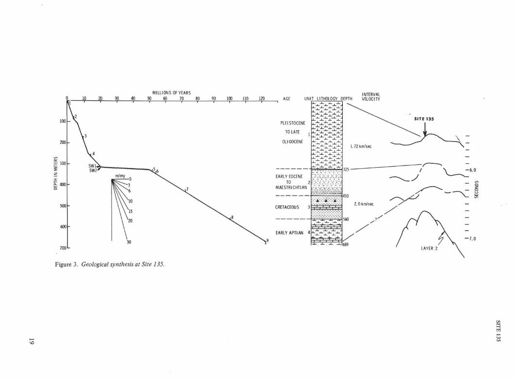
Site 135 lies about 35 km southeast of the southern edge ofthe Horseshoe Abyssal Plain on a topographic high 750 metersabove the abyssal plain. The top unit, 325 meters thick, iscomprised of nannoplankton chalk ooze of Pleistocene, Pliocene,and Miocene ages. Below this, there are 364 meters of mostlyterrigenous sediments with some silicified intervals and marl orlimestone at the base which range in age from Early Eocene toEarly Aptian. It is not possible to reasonably estimate thethickness of individual lithologic units within this lower interval.
A prominent reflecting horizon at ~0.4 second can be tracedfrom beneath the abyssal plain on to the topographic high. In thedrilled section this corresponds to a major unconformity whichmarks the abrupt change from terrigenous to pelagic sedimenta-tion that occurred following post-early Eocene and pre-lateOligocene uplift and faulting.
An estimated 350+ meters of sediment are present betweenthe lowest sample obtained and oceanic basement.
SITE DATA
Time: 0053 October 10, 19700146 October 14, 1970
Position: 35° 2O.8θ'N10° 25.46'W
Water Depth: 13,621 feet2,270 nominal fathoms4,152 meters
Total Penetration: 689 meters
Cores Taken: Nine cores and two sidewall samples in Hole135; one core (no recovery) in Hole 135A.
BACKGROUND AND OPERATIONS
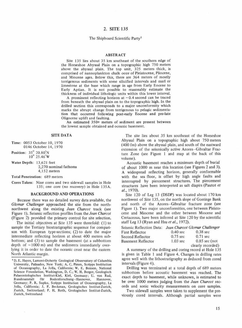
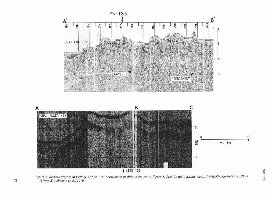
Because there was no detailed survey data available, theGlomar Challenger approached the site from the north-northwest along the existing Jean Charcot track (seeFigure 1). Seismic reflection profiles from the Jean Charcot(Figure 2) provided the primary control for site selection.
The initial objectives at Site 135 were threefold: ( l ) t osample the Tertiary biostratigraphic sequence for compari-son with European type-sections; (2) to date the majorintermediate reflecting horizon at about 400 meters sub-bottom; and (3) to sample the basement (at a subbottomdepth of ~ 1000 m) and the sediments immediately over-lying it in order to date the oceanic crust near the easternNorth Atlantic margin.
1 D. E. Hayes, Lamont-Doherty Geological Observatory of ColumbiaUniversity, Palisades, New York; A. C. Pimm, Scripps Institutionof Oceanography, La Jolla, California; W. E. Benson, NationalScience Foundation, Washington, D. C; W. H. Berger, GeologischPalaeontologisches Institut-Kiel, Kiel, Germany; U. von Rad,Bundesanstalt für Bodenforschung-Hannover, Hannover,Germany; P. R. Supko, Scripps Institution of Oceanography, LaJolla, California; J. P. Beckman, Geologisches Institut-Zurich,Zurich, Switzerland; P. H. Roth, Geologisches Institut-Zurich,Zurich, Switzerland
The site lies about 35 km southeast of the HorseshoeAbyssal Plain on a topographic high about 750 meters(400 fm) above the abyssal plain, and south of the eastwardextension of the seismically active Azores—Gibraltar Frac-ture Zone (see Figure 1 and map at the back of thisvolume).
Acoustic basement reaches a minimum depth of burialof about 1000 m near this location (see Figures 2 and 3).A widespread reflecting horizon, generally conformablewith the sea floor, is offset by high angle faults andinterrupted by piercement structures. The piercementstructures have been interpreted as salt diapirs (Pautot etal., 1970).
Site 120 of Leg 13 (DSDP) was located about 170 kmnorthwest of Site 135, on the north slope of Gorringe Bankand north of the Azores—Gibraltar fracture zone (seeFigure 1). Two major unconformities, one between Pleisto-cene and Miocene and the other between Miocene andCretaceous, have been inferred at Site 120 by the scientificstaff Leg 13 (Ryan and Hsu et al, 1972).
Seismic Reflection Data: Jean Charcot Glomar ChallengerFirst Reflector 0.40 sec 0.38 secSecond Reflector 0.75 sec 0.71 secBasement Reflector 1.03 sec 0.85 sec (not
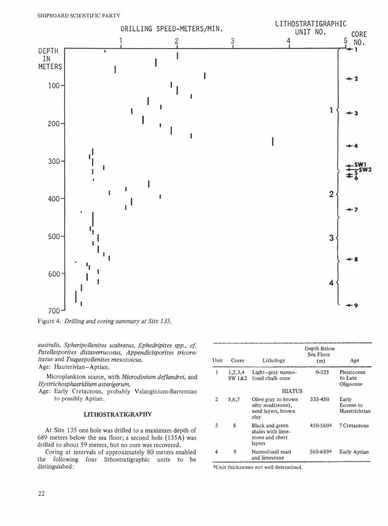
clearly recorded)A summary of the drilling and coring record at Hole 135
is given in Table 1 and Figure 4. Changes in drilling ratesagree well with the lithostratigraphy as deduced from coredintervals (Figure 4).
Drilling was terminated at a total depth of 689 meterssubbottom before acoustic basement was reached. Theexact depth to basement, while unknown, is estimated tobe over 1000 meters judging from the Jean Charcot rec-ords and sonic velocity measurements on core samples.
Two sidewall samples were taken to supplement the pre-viously cored intervals. Although partial samples were
15

SHIPBOARD SCIENTIFIC PARTY
12
37C
36'
34I2C I0 8C
Figure 1. Location map for Site 135. Contours are in nominal fathoms from unpublished maps of A. S. Laughton fpers.comm.). Letters key profiles in Figure 2. Site 120 was drilled on Leg 13, Deep Sea Drilling Project.
16
135
A'.c
Jl:AN
18h.
CH;
.c
\RCOT
-C
15h.
>
1 it
é
-
11 h
. 401 i. •&Z •JZ'"^
•' 'A'•
^ : r •
1 "480
*, 07
h.
490
B'
LAYER 2PIERCEMEI
-•ff—'8
km
50—i
4 SITE 135Figure 2. Seismic profiles in vicinity of Site 135. Location of profiles is shown on Figure 1. Jean Charcot seismic record (vertical exaggeration is 20:1)
is from X. LePichon et al., 1970.
SHIPBOARD SCIENTIFIC PARTY
TABLE 1Drilling and Coring Record for Site 135
Description
Core 1
Drül
Core 2
Drill
Core 3
Drill
Core 4
Drül
Core 5
Core 6
Drill
Core 7
Drill
Core 8
Drül
Core 9
Interval BelowSea Floor
(m)
0-4
4-88-27
27-4646-6565-80
80-89
89-104104-123123-132132-151151-161161-173
173-182
182-199199-209209-228228-237237-259
259-268
268-285285-294294-313313-323323-335
335-341
341-350
350-352352-361361-370370-379379-389389-399399-418418-431
431-435
435-437437-457457-476476-485485-495495-514514-524524-543543-552552-564
564-569
569-571571-580580-589589-599599-617617-627627-646646-656656-676676-685
685-689
Water Depth 4
Core Recovery(m)
4.0
8.5
2.5
2.1
0.7
0.1
3.8
1.0
1.8
,152 meters
Drilling Rate(m/min)
0.72.01.60.92.5
1.92.02.251.51.71.2
1.41.71.92.253.7
0.50.450.50.70.5
0.51.51.51.10.81.71.21.1
0.30.50.50.450.50.60.50.60.71.0
0.20.40.450.60.40.60.30.20.20.3
obtained, minor difficulties were encountered in recoveringthe corer. These problems were attributed to the failureof the sampler to open fully after passing through thedrill bit.
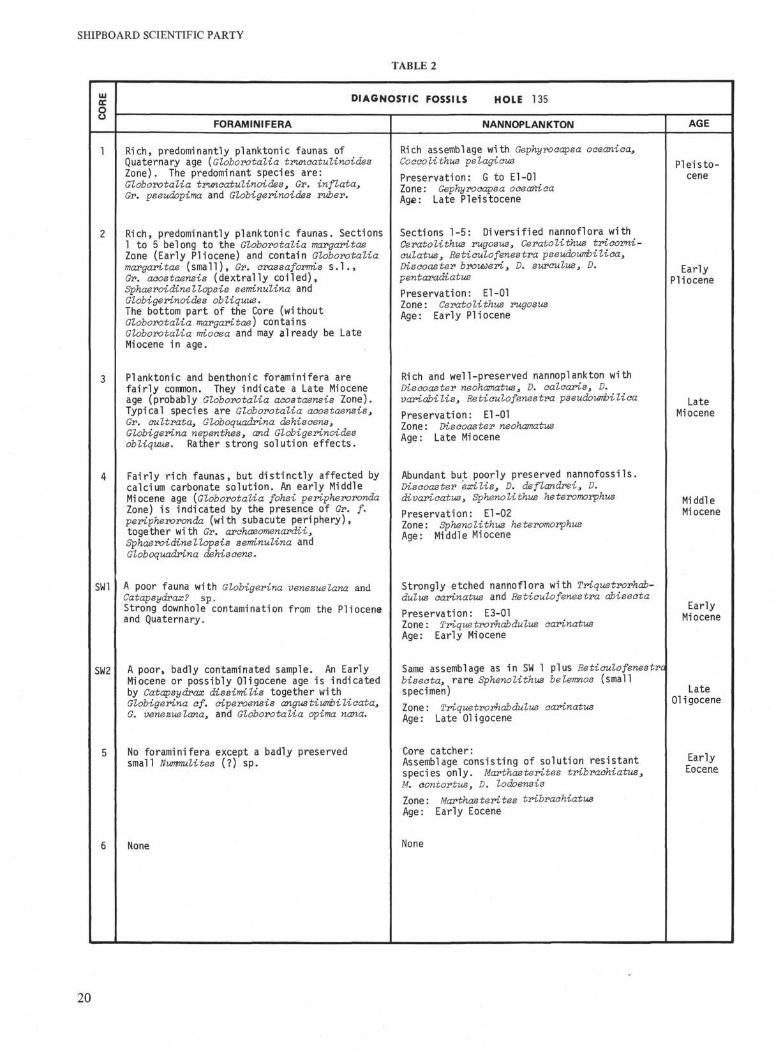
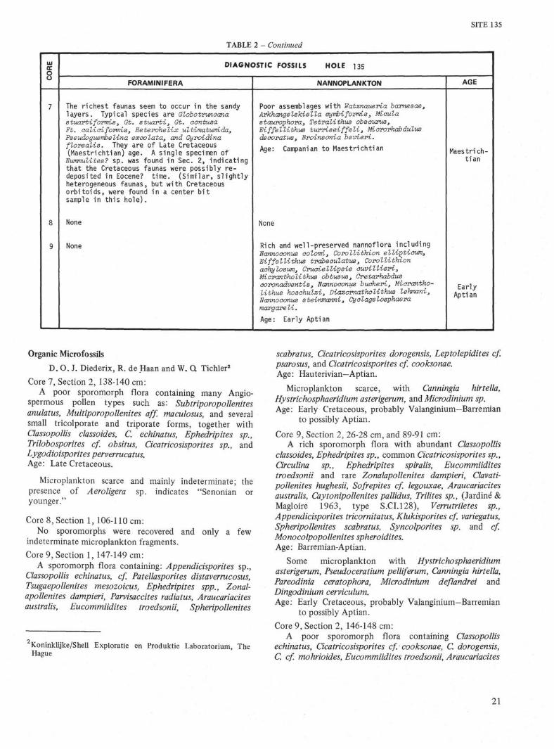
BIOSTRATIGRAPHY
GeneralFour widely spaced cores (14) indicate that the Quater-
nary to Late Oligocene section, in the upper 325 meters ofthis hole, consists of deep-water pelagic sediments withstrong evidence of calcium-carbonate solution, particularlyin the Miocene section. Within Core 2 there is a minorfaunal break which may correspond to the Miocene/Pliocene boundary. Below a possible hiatus at about 330meters and down to total depth of 689 meters, the rocksare mostly clayey sand, with generally poorly preserved-micro-fossils. These fossils indicate an Eocene to Cretaceousage but give little precise data on the sedimentary historyduring this time. It is possible that the relatively rich UpperCretaceous fossil assemblages of Core 7 and those obtainedfrom a center bit sample near Core 9 were redeposited inEocene time. The deepest samples at this Site (Core 9)contain a nannoflora of Early Aptian age. A poor sporo-morph flora and microplankton of Late Cretaceous age(Senonian or younger) occurs in Core 7. Sporomorphsand microplankton from Core 9 are of Valanginian toAptian age.
The age-diagnostic fossils from each core are shown inTable 2.
Foraminifera
Cores 1 to 4 contain normal pelagic deep-sea faunas con-sisting predominantly of planktonic foraminifera. Solutioneffects are visible throughout but are strongest in Cores 3and 4. Below Core 4, there is little conclusive informationthat can be drawn from the foraminifera except that some(if not all) of the Eocene and Late Cretaceous faunas areprobably transported and re-deposited. Core 5 contains asingle specimen of a (Eocene?) nummulite. Another speci-men of Nummulitesi was found associated with the rela-tively rich Globotruncana assemblage of Core 7. Similarly,the large center bit sample recovered near Core 9 contained,apart from Late Cretaceous Orbitoids, a few specimens(Nummulitesi, Operculina, Amphistegina) which are prob-ably of Eocene age. These larger foraminifera were derivedfrom a shallow-water environment since they are not nor-mally found in pelagic sediments.
Nannoplankton
Rich and diversified assemblages of calcareous nanno-plankton of Pleistocene to Late Miocene age were found inthe uppermost 3 cores. Core 4 contains a fairly stronglyetched Middle Miocene nannoflora. The two sidewall coresyielded fairly poorly preserved Upper Oligocene to LowerMiocene nannoplankton. Only the most solution resistantortholiths were preserved in the Early Eocene of Core 5.The Campanian to Maestrichtian nannoplankton in Core 7lack distinctive markers. Core 8 is barren of nannofossils.Core 9 contains a rich and well-preserved nannoflora ofEarly Aptian age.
18
0 10 20
100
200
300
400
500
600
700
MILLIONS OF YEARS30 40 50 60 70 80 90 100 110 120
m/my
INTERVALAGE UNIT LITHOLOGY DEPTH VELOCITY
PLEISTOCENE
TO LATE
OLIGOCENE
EARLY EOCENETO 2
MAESTRI CHTI AN
CRETACEOUS 3
EARLY APTIAN 4
SITE 135
A
- 7 . 0
Figure 3. Geological synthesis at Site 135.
SHIPBOARD SCIENTIFIC PARTY
TABLE 2
DIAGNOSTIC FOSSILS HOLE 135
FORAMINIFERA NANNOPLANKTON AGE
SW1
SW2
Rich, predominantly planktonic faunas ofQuaternary age [Globorotalia trunoatulinoidesZone). The predominant species are:Globorotalia trunoatulinoides, Gr. inflata,Gr. pseudopima and Globigerinoides riòer.
Rich, predominantly planktonic faunas. Sections1 to 5 belong to the Globorotalia margaritaeZone (Early Pliocene) and contain Globorotaliamargaritae (small), Gr. crassaformis s.l ,Gr. aoostaensis (dextrally coiled),Sphaeroidinellopsis seπtinulina andGlobigerinoides obliquus.The bottom part of the Core (withoutGloborotalia margaritae) containsGloborotalia miooea and may already be LateMiocene in age.
Planktonic and benthonic foraminifera arefairly common. They indicate a Late Mioceneage (probably Globorotalia aoostaensis Zone).Typical species are Globorotalia aoostaensis,Gr. oultrata, Glóboquadrina dehisoens,Globigerina nepenthes, and Globigerinoidesobliquus. Rather strong solution effects.
Fairly rich faunas, but distinctly affected bycalcium carbonate solution. An early MiddleMiocene age {Globorotalia fohsi peripherorondaZone) is indicated by the presence of Gr. f.peripheroronda (with subacute periphery),together with Gr. aróhaeomenardii,Sphaeroidinellopsis seminulina andGlóboquadrina dehisoens.
A poor fauna with Globigerina venezuelana andCatapsydrax? sp.Strong downhole contamination from the Plioceneand Quaternary.
A poor, badly contaminated sample. An EarlyMiocene or possibly Oligocene age is indicatedby Catapsydrax dissimilis together withGlobigerina cf. oiperoensis angustiumbilioata,G. venezuelana, and Globorotalia opima nana.
No foraminifera except a badly preservedsmall Nummulites (?) sp.
None
Rich assemblage with Gephyrooapsa ooeaniβa,Coooolithus pelagious
Preservation: G to El-01Zone: Gephyrooapsa ooeanioaAge: Late Pleistocene
Sections 1-5: Diversified nannoflora withCeratolithus rugosus, Ceratolithus trioorni-aulatus, Retioulofenestra pseudourribilioa,Disooaster brouweri, D. suroulus, D.pentaradiatus
Preservation: El-01Zone: Ceratolithus rugosusAge: Early Pliocene
Rich and well-preserved nannoplankton withDisooaster neohamatus, D. aaloaris, D.variabilis, Retioulofenestra pseudourribilica
Preservation: El-01Zone: Disooaster neohamatusAge: Late Miocene
Abundant but poorly preserved nannofossils.Disooaster exilis, D. deflandrei, D.divarioatus, Sphenolithus heteromorphus
Preservation: El-02Zone: Sphenolithus heteromorphusAge: Middle Miocene
Strongly etched nannoflora with Triquetrorhab-dulus carinatus and Retioulofenestra dbiseota
Preservation: E3-01Zone: Triquetrorhabdulus oarinatusAge: Early Miocene
Same assemblage as in SW 1 plus Retioulofenestrabiseota, rare Sphenolithus belemnos (smallspecimen)
Zone: Triquetrorhabdulus oarinatusAge: Late Oligocene
Core catcher:
Assemblage consisting of solution resistantspecies only. Marthasterites tribraohiatus,M. oontortus, D. lodoensis
Zone: Marthasterites tribraohiatusAge: Early Eocene
None
Pleisto-cene
EarlyPliocene
LateMiocene
Mi ddleMi ocene
EarlyMiocene
LateOligocene
EarlyEocene
20
SITE 135
OR
E
U
7
8
9
TABLE 2 - Continued
DIAGNOSTIC FOSSILS HOLE 135
FORAMINIFERA
The richest faunas seem to occur in the sandylayers. Typical species are Globotrunaanastuartiformis, Gt. stuarti, Gt. aontusaFt. σalieiformis, Heterohelix ultimatumida,Pseudoguerribelina exaolata, and Gyroidinaflorealis. They are of Late Cretaceous(Maestrichtian) age. A single specimen of
Nimmlites? sp. was found in Sec. 2, indicatingthat the Cretaceous faunas were possibly re-deposited in Eocene? time. (Similar, s l ightlyheterogeneous faunas, but with Cretaceousorbitoids, were found in a center b i tsample in this hole).
None
None
NANNOPLANKTON
Poor assemblages with Watznaueria barnesae,Arkhangelskiella σymbiformis, Miσulastawophora, Tetralithus obsaurus,Eiffellithus turriseiffeli} Miororhabdulusdeaoratus, Broinsonia beviex>i.Age: Campanian to Maestrichtian
None
Rich and well-preserved nannoflora includingNannoeonus eolorπi> Corollithion elliptiaum,Eiffellithus trabeoulatus, Corollithionaehylosurrij Cruaiellipsis ouvillieri,Micrantholithus óbtusus, Ci etarhabdus^ooronadventis3 Nannooonus budheri, Micrantho-lithus hosóhulziy Diazornatholithus lehwani,Nannoeonus steinmanni^ Cyclagelosphaeramargareli.
Age: Early Aptian
AGE
Maestrich-t i an
EarlyAptian
Organic Microfossils
D. O. J. Diederix, R. de Haan and W. Q Tichler2
Core 7, Section 2, 138-140 cm:A poor sporomorph flora containing many Angio-
spermous pollen types such as: Subtriporopollenitesanulatus, Multiporopollenites aff. maculosus, and severalsmall tricolporate and triporate forms, together withClassopollis classoides, C. echinatus, Ephedripites sp.,Trilobosporites cf obsitus, Cicatricosisporites sp., andLygodioisporites perverrucatus.Age: Late Cretaceous.
Microplankton scarce and mainly indeterminate; thepresence of Aeroligera sp. indicates "Senonian oryounger."
fewCore 8, Section 1, 106-110 cm:
No sporomorphs were recovered and only aindeterminate microplankton fragments.
Core 9, Section 1, 147-149 cm:A sporomorph flora containing: Appendicisporites sp.,
Classopollis echinatus, cf Patellasporites distaverrucosus,Tsugaepollenites mesozoicus, Ephedripites spp., Zonal-apollenites dampieri, Parvisaccites radiatus, Araucariacitesaustralis, Eucommiidites troedsonii, Spheripollenites
'Koninklijke/Shell Exploratie en Produktie Laboratorium, TheHague
scabratus, Cicatricosisporites dorogensis, Leptolepidites cfpsarosus, and Cicatricosisporites cf. cooksonae.Age: Hauterivian—Aptian.
Microplankton scarce, with Canningia hirtella,Hystrichosphaeridium asterigerum, and Microdinium sp.Age: Early Cretaceous, probably Valanginium—Barremian
to possibly Aptian.
Core 9, Section 2, 26-28 cm, and 89-91 cm:A rich sporomorph flora with abundant Classopollis
classoides, Ephedripites sp., common Cicatricosisporites sp.,Circulina sp., Ephedripites spiralis, Eucommiiditestroedsonii and rare Zonalapollenites dampieri, Clavati-pollenites hughesii, Sofrepites cf legouxae, Araucariacitesaustralis, Caytonipollenites pallidus, Trilites sp., (Jardiné &Magloire 1963, type S.CI.128), Verrutriletes sp.,Appendicisporites tricornitatus, Klukisporites cf variegatus,Spheripollenites scabratus, Syncolporites sp. and cf.Monocolpopollenites spheroidites.Age: Barremian-Aptian.
Some microplankton with Hystrichosphaeridiumasterigerum, Pseudoceratium pelliferum, Canningia hirtella,Pareodinia ceratophora, Microdinium deflandrei andDingodinium cerviculum.Age: Early Cretaceous, probably Valanginium—Barremian
to possibly Aptian.
Core 9, Section 2, 146-148 cm:A poor sporomorph flora containing Classopollis
echinatus, Cicatricosisporites cf cooksonae, C. dorogensis,C. cf mohrioides, Eucommiidites troedsonii, Araucariacites
21
SHIPBOARD SCIENTIFIC PARTY
DEPTHIN
METERS
TOOH
2OOH
300H
400 H
500H
600-1
DRILLING SPEED-METERS/MIN.
1 2
LITHOSTRATIGRAPHYUNIT NO. CORE
4 5 NO.
3
1
SW1" 5 S W 2
6
Figure 4. Drilling and coring summary at Site 135.
australis, Spheripollenites scabratus, Ephedripites spp., cf.Patellasporites distaverrucosus, Appendicisporites tricorn~itatus and Tsugaepollenites mesozoicus.Age: Hauterivian—Aptian.
Micro plankton scarce, with Microdinium deflandrei, andHystrichosphaeridium asterigerum.Age: Early Cretaceous, probably Valanginium-Barremian
to possibly Aptian.
LITHOSTRATIGRAPHY
At Site 135 one hole was drilled to a maximum depth of689 meters below the sea floor; a second hole (135A) wasdrilled to about 59 meters, but no core was recovered.
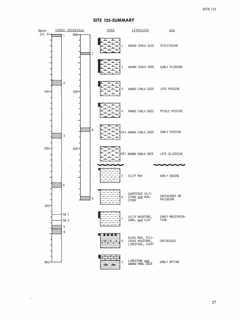
Coring at intervals of approximately 80 meters enabledthe following four lithostratigraphic units to bedistinguished:
Unit
1
2
3
4
Cores
1,2,3,4SW1&2
5,6,7
8
9
Lithology
Light—gray nanno-fossil chalk ooze
HIATUSOlive gray to brownsilty mud(stone),sand layers, brownclay
Black and greenshales with lime-stone and chertlayers
Nannofossil marland limestone
Depth BelowSea Floor
(m)
0-325
335-450
450-560*
560-689a
Age
Pleistoceneto LateOligocene
EarlyEocene toMaestrichtian
? Cretaceous
Early Aptian
aUnit thicknesses not well determined.
22

SITE 135
UNIT 1 - Light Gray Nannoplankton Chalk Ooze (Cores 1,2, 3 ,4 ) , SW land 2
This unit is about 325 meters thick and consists mainlyof pelagic carbonates deposited since the Late Oligocene.The chalk ooze is largely calcareous nannoplankton,usually with less than 5 per cent planktonic foraminifera.The foraminifera show excellent preservation near the topof the unit but increasing signs of dissolution downward.In the marl near the base, preservation is very poor.Silt-size quartz occurs in traces; the amount is somewhatgreater near both the top and base of the unit thanelsewhere. Drilling rates usually varied between 1 and 2.5m/min. Fast drilling near 250 meters suggests that sandylayers may be present. Below 270 meters, rates werereduced to about 0.5 m/min suggesting the presence offirm marls.
UNIT 2 - Olive Gray to Brown Mud (stone), Sand Layersand Brown Clay, Generally Quartz-rich (Cores 5, 6, 7)
This unit is between 115-235 meters thick (change indrilling rate suggests 120 m) and spans the time intervalfrom Maestrichtian to Early Eocene.
Core recovery was poor except in Core 7. Terrigenoussediments low in carbonate (<25%), but carbonate-cemented in places, exhibit various size-grades, colors, anddegrees of induration. Silty and clayey mud (stones),usually quartzose and with detrital calcareous grains, arethe chief components of the unit. Sand layers (3-25 cmthick) visibly graded in part, contain quartz grains up to0.3 mm in diameter. The sand layers commonly arealternating with pelagic brown clay. Arkosic sands withhighly altered feldspar grains are present. Iron oxide coatedquartz grains are also present.
Coarse sand (common size 1-2 mm) consisting mainlyof quartz and cert but having small amounts of mica,pyrite, limestone and other lithic fragments (but littlefeldspar) was recovered from the center bit followingrecovery of Core 9. Benthonic foraminifera are ofCretaceous age. This sand apparently belongs to eitherunit 2 or unit 3 (most probably unit 2) since the greaterdrilling rate suggests that much sand was penetrated).
The brown clay of this unit consists of 50-75 per centclay minerals and iron oxides, 10-35 per cent quartz, and10-20 per cent carbonate (some of it dolomite rhombs;the rest detrital). Alternating fast (1.5 m/min) and slow(0.8 m/min) drilling may indicate sand-rich and clay-richsections in the unit.
UNIT 3 - Black and Green Shale with Limestone and ChertLayers (Core 8)
The thickness of this unit is not known. Only 1 meterof core was recovered near the position where drillingslowed. The age is probably Late Cretaceous based ondates in Cores 7 and 9. The black shale and green siliceousmudstone contain only traces of carbonate; they are richin zeolite and contain pyrite and 5-10 per cent terrigenoussilt. A thin certy bed of silicified laminated silty mudstonecontains silica (75%), quartz (29%), clay minerals, andopaque and organic materials. Re crystallized spongespicules and radiolarians (?) were noted. A thin bed of
non-fossiliferous recrystallized limestone consists of large(1-2 mm diameter) fibrous calcite spherulites separated byclay. Drilling rates vary between 0.4 and 1 m/min.
UNIT 4 — Olive Gray and Black Nannofossil Marl andLimestone (Core 9)
The thickness of this unit is unknown; 1.8 meters wererecovered. The age is Early Cretaceous. The main facies isdark (sapropelitic ?) shale, laminated in part and rich incalcareous nannofossils; some pyrite and authigeniccarbonate is also present. In places, thin silty layerscontaining much quartz are intercalated with the shale. Aslightly quartzose limestone bed, partly micritic, partlysparry, and with 5 per cent nannofossils, was noted. Thecore catcher contained sand-size material consisting ofmuch quartz and detrital carbonate.
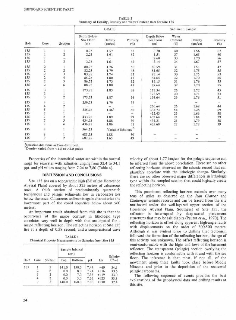
PHYSICAL AND CHEMICAL PROPERTIES
A few sediments recovered from Site 135 were disturbedduring coring so physical property measurements may beunreliable.
Penetrometer measurements (units of mm × 10 ) onthe chalk oozes showed a decrease from a mean value of 60near the surface to a value of 30 at about 175 meters;below this values were relatively constant. The terrigenoussediments (Early Tertiary and Cretaceous) in the lower partof the hole show a wide range of values (5 to 85) due tovariations in lithology, degree of induration, anddisturbance.
The bulk density (gm/cc) increases from 1.57 near thesurface to 1.87 near the bottom of the ooze at 325 meters.Below this level, the density values have a wide scatter withindividual readings correlating reasonably well with thedifferent lithologies. The normal range of bulk densities is1.5 to 1.8; in the less consolidated sands 1.6 to 1.8, and inthe indurated beds of silicified mudstone and sandylimestone 1.8 to 2.1. Porosity and water content showed aninverse correlation with bulk density, decreasing downwardthrough the ooze, with scattered values for the terrigenoussediments.
The porosity values determined from the GRAPE are, ingeneral, higher than those calculated from measurement ofthe water content; the density values obtained by the twomethods are in good agreement (Table 3).
Variations in the natural gamma radiation of the samplescorrelates closely with changes in lithology. Counts fromthe ooze are fairly uniform, averaging about 550. However,as is common in deep-sea sediments, counts in the top twometers of this ooze are relatively high (up to 1550 counts).Below the ooze, the terrigenous deposits have highercounts. The clays and silts range from about 1000 to 2500;the average being about 1500 counts. There was nosignificant difference between the black clays and the otherclays. The sands give counts of 500 to 1000 except for thearkosic beds in the lower part of Core 7 which have countsof about 1500. The highest counts (up to 3500) were fromthe zeolitic clay at the bottom of Core 8.
Sonic velocity measurements were made on four samplesof lithified sediment as follows: 135-8-1, 60 cm 3.28km/sec, 110 cm 2.11 km/sec, 135 cm 3.42 km/sec; and135-9-1,105 cm 3.47 km/sec.
23
SHIPBOARD SCIENTIFIC PARTY
TABLE 3Summary of Density, Porosity and Water Content Data for Site 135
Hole
135135135135
135135135135135135
135135135
135135135135135135135
135
135135
Core
1111
222222
333
4457777
8
99
Section
12—3
123456
112
1211234
1
12
Depth BelowSea Floor
(m)
0.752.25-3.75
80.7582.2583.7585.2586.7588.25
173.75-
175.25259.75
-335.75
-433.25434.75436.25564.75
685.75687.25
GRAPE
Density(gm/cc)
1.571.61—
1.61
1.761.791.741.801.731.80
1.85-
1.87
1.79—
1.46a
-1.891.881.86
Porosity(%)
6562-62
504851475247
36—34
37-50-293031
Variable lithology
1.881.65
3049
Depth BelowSea Floor
(m)
0.301.512.603.14
80.5981.6583.1484.6486.1587.64
173.54173.59174.64
-260.64335.73432.43432.64434.31435.60
-—
Sediment
WaterContent
(%)
40373334
313230323132
262029-265423212122
_-
Sample
Density(gm/cc)
1.561.651.701.67
1.511.751.751.701.761.70
1.721.711.76-
1.681.281.661.841.791.78
-
--
Porosity(%)
62605657
475553555555
453351
_446938393839
-
-
.Questionable value as Core disturbed.Density varied from <1.5 to >2.0 gm/cc
Properties of the interstitial water are within the normalrange for seawater with salinities ranging from 32.4 to 34.1ppt. and pH values ranging from 7.24 to 7.80 (Table 4).
DISCUSSION AND CONCLUSIONS
Site 135 lies on a topographic high (SE of the HorseshoeAbyssal Plain) covered by about 325 meters of calcareousooze. A thick section of predominantly quartz-richterrigenous and pelagic sediments low in carbonates liesbelow the ooze. Calcareous sediments again characterize thelowermost part of the cored sequence below about 560meters.
An important result obtained from this site is that theoccurrence of the major contrast in lithologic typecorrelates very well in depth with that anticipated for amajor reflecting horizon. The reflecting horizon at Site 135lies at a depth of 0.38 second, and a compressional wave
TABLE 4Chemical Property Measurements on Samples from Site 135
Hole
135
Core
12347
Section
26223
Sample Interval(cm)
Top
141.00.00.00.0
140.0
Bottom
150.08.07.05.0
150.0
pH
7.447.247.367.267.80
Eh
+69+116+119+123+130
Salinity(%o)
34.133.633.033.632.4
velocity of about 1.77 km/sec for the pelagic sequence canbe inferred from the above correlation. There are no otherreflecting horizons observed on the seismic record that canplausibly correlate with the lithologic change. Similarly,there are no other observed major differences in lithologictype within the sampled section that could logically createthe reflecting horizon.
This prominent reflecting horizon extends over manytens of miles as observed on the Jean Charcot andChallenger seismic records and can be traced from the sitenorthward under the well-layered upper section of theHorseshoe Abyssal Plain. Southeast of Site 135, thereflector is interrupted by deep-seated piercementstructures that may be salt diapirs (Pautot et al, 1970). Thereflecting horizon is offset along apparent high-angle faultswith displacements on the order of 300-500 meters.Although it was evident prior to drilling that tectonismfollowed the formation of the reflecting horizon, the age ofthis activity was unknown. The offset reflecting horizon issemi-conformable with the highs and lows of the basementreflector. The transparent (pelagic) section overlying thereflecting horizon is conformable with it and with the seafloor. The inference is that most, if not all, of themovement along these faults took place before MiddleMiocene and prior to the deposition of the recoveredpelagic carbonates.
The following sequence of events provides the bestexplanations of the geophysical data and drilling results atthis site.
24

SITE 135
From Late Cretaceous to Early Eocene time, the areawas a deep (though not so deep that all calcareous fossilswere dissolved) flat-lying oceanic environment. The areawas receiving olive and brown clays containing detritalcarbonates and intercalated with coarse terrigenoussediments. The area was, in essence, an abyssal plain. Theapparent sedimentation rate for this sequence is about5 m/my. If some allowance is made for rapidly emplacedsands and silts, the true sedimentation for the clays isprobably 2-3 m/my. Sediment reaching the area was varied:coarse sands (mostly quartz and chert and shallow-waterforaminifera) were transported along the sea floor; andmedium to fine sands were probably deposited by turbiditycurrents. Primary structures, such as crossbedding, indicatethe presence of near bottom currents. The sands containminerals that were derived from both granitic andmetamorphic terrains; highly rounded quartz grains withiron oxide coatings are probably of eolian origin ^Sahara-sand); and detrital carbonate sands (later crystallized tocoarse-grained limestones) occasionally reached the area.
During some intervals, this environment received littlesand, and shales with a high content of organic materialwere deposited. Some calcareous pelagic components alsoreached the sea floor at that time, but their netcontribution to the sequence was minor. The fertility of theupper waters possibly increased during the Late Cretaceousthus leading to the deposition of siliceous organisms(probably preserved as chert); calcareous organisms were,however, dissolved. An increasing influx of coarse-grainedterrigenous sediments (turbidites) in the latest part of theCretaceous may reflect uplift and erosion of the adjacentcontinent.
Following the Early Eocene, epeirogenic upliftaccompanied by faulting created the topographic highssouth of the Horseshoe Abyssal Plain, and the area of Site135 was made inaccessible to terrigenous sediments. Fromat least as early as Late Miocene, the area was a site of rapidpelagic carbonate sedimentation at first close to thecarbonate compensation depth (~4500 meters) andsubsequently well above it. Evidence for this is seen in thepoor preservation of calcareous fossils in the MiddleMiocene in contrast to the excellent preservation in thePleistocene.
The unconformity between Early Eocene terrigenoussediments and Late Oligocene pelagic sediments is not yetclearly understood. It is possible that following uplift, thearea remained for some time below the carbonatecompensation depth so that during this period the sitereceived neither terrigenous nor pelagic sediments.However, a similar stratigraphic hiatus is present at manyother sites and an explanation involving more regionalprocesses, such as deep sea erosion and slumpingaccompanying tectonism or a major change in the patternof oceanic circulation, is probably more reasonable.Tectonic activity along the east Azores Fraction Zonebeginning at least 45 million years ago has been inferred byKrause and Watkins (1970). The regional tectonism anddeformation exhibited by the reflecting horizon may relateto these changes in plate tectonic activiity. It should benoted that Site 135 lies only 70 km south of the inferredAzores Fracture Zone, and therefore, could be subject to
intense deformation associated along this boundary byinteraction between two major crustal plates. The EarlyTertiary also marked the initiation of the Alpine orogenicmovements in the sub-Betic Chain, 400 km to the northeastof this site.
The unusually high content of nannofossils in thechalk ooze of Unit 1 is unexplained. Differentialdissolution cannot be the main cause because theforaminifera in Core 1, although relatively rare, are quitewell preserved.
Sediments of Early Aptian age were the oldestmaterials recovered at Site 135 at a subbottom depth of689 meters. Although the seismic data from theChallenger are not definitive, records from the JeanCharcot indicate basement rocks (layer 2) lie an additional350 meters below the Aptian sediments. These Aptiansediments are well lithified limestones and marl, andpenetration by the drill slowed at this point. On both theChallenger (at 0.71 sec) and Charcot (0.75 sec) seismicreflection records, a second intermediate reflector couldbe correlated with this change in lithology.
Sedimentation rates below the unconformity are about5-8 m/my. Extrapolating these rates from the depth of theEarly Aptian sediments (~lOOm.y.) to the inferredbasement, the deduced age of the sediments directly abovebasement would be about 155-180 million years or Late toEarly Jurassic. Site 135 lies about 200 km landward fromthe eastern Atlantic magnetic quiet zone boundary whichhas been interpreted as an isochron (Heirtzler and Hayes,1967). At Site 105 of Leg 11 which lies close to thewestern Atlantic magnetic quiet zone boundary, sedimentsof Oxfordian—Callovian (early Late Jurrassic; —155 my)were recovered overlying an extrusive basalt (Hollister andEwing et al, 1972).
There is no evidence of salt or associated evaporitesediments in any of the 689 meters of section drilled andsampled. This is not inconsistent with the interpretation ofthe presence of salt diapirs nearby (Pautot, 1970) sinceseismic data indicates the source of the presumed salt to bemuch more deeply seated than the depth of the recoveredcores (see Figure 2).
REFERENCES
Heirtzler, J. and Hayes, D. E., 1967. Magnetic boundaries inthe North Atlantic Ocean. Science. 157, 185-187..
Hollister, C. D., Ewing, J. I., et al., 1972. Initial Reports ofthe Deep Sea Drilling Project, Volume XI, Washington(U. S. Government Printing Office).
Krause, D. C. and Watkins, N. D., 1970. North Atlanticcrustal genesis in the vicinity of the Azores. Geophys. J.Roy. Astr. Soc, 19, 261-283.
Le Pichon, X., Bonnin, J., Pautot, G., 1970. The Easternend of the Azores—Gibraltar plate boundary.Communication at the Upper Mantle Project Symposiumon Mechanical Properties and Processes of the UpperMantle, Flagstaff, Arizona.
Pautot, G., Auzende, J. M. and Le Pichon, X., 1970.Continuous deep sea salt layer along North Atlanticmargins related to early phase of rifting. Nature. 227,351-354.
Ryan, W. B. F., Hsu, K. J., et al, 1972. Initial Reports ofthe Deep Sea Drilling Project, Volume XIII, Washington(U. S. Government Printing Office), (in press).
25

SITE 135-SUMMARY
SITE 135
Depth CORED INTERVALS CORE LITHOLOGY
(m) O•
AGE
100H
200-
300-
400-
400-
500H
600H
W777λ
ηjL~
1_
1 NANNO CHALK OOZE PLEISTOCENE
2 NANNO CHALK OOZE EARLY PLIOCENE
3 NANNO CHALK OOZE LATE MIOCENE
4 NANNO CHALK OOZE MIDDLE MIOCENE
NANNO CHALK OOZE EARLY MIOCENE
SW2 NANNO CHALK OOZE LATE OLIGOCENE
SW 1
SW 2
5
6
5 SILTY MUD EARLY EOCENE
QUARTZOSE S I L T -6 STONE and MUD- CRETACEOUS OR
STONE PALEOCENE
_ SILTY MUDSTONE, EARLY MAESTRICH-1 SAND, and CLAY TIAN
BLACK MUD, SILI-8 CEOUS MUDSTONE, CRETACEOUS
LIMESTONE, CHERT
9 LIMESTONE and
E A R L Y APTIAN
NANNO MARL OOZE t H K L H r i i W I
27

SHIPBOARD SCIENTIFIC PARTY
SITE 135 CORE 1 DEPTH (m) 0-4
ZONE
LITHOLOGICSYMBOLS
LITHOLOGIC DESCRIPTION
NATURALGAMMA
RADIATION
COUNTS/7.6 cm/1.5 mil
1000 2000I I
26 GZ 4-21-75
CHALK OOZE
CaC03 38
1 -
Light gray (10YR 7/2) andgrayish brown (10YR 5/2)
Forams, mainly fragmentsQuartz silt, at top
at base down toClay
5-10%VI0%
1%5_10% CaC03 50
_96
135
65
GZ 7-20-73Some fine (̂ 1 mm) lamination, especiallyin Section 2
Coarse Fraction: C a C 03 62
Pelagic forams, moderately to wellpreserved
sec.2, 125 cm GZ 5-13-82 CaCO3 72GZ 2-13-85
GZ 1-18-814-
CC
28

SITE 135
•0 cm
— 25
50
75
100
125
150135-1-1 135-1-2 135-1-3
29
SHIPBOARD SCIENTIFIC PARTY
SITE 135 CORE 2 DEPTH (m) 80-89
LITHOLOGIC DESCRIPTION
NANNO CHALK OOZE C a C 03CaC03 75
White (1OYR 8/1) to l i g h t gray (5Y 7/1 to5Y 6 /1 ) ; dark specks and streaks l o c a l l y
60 cm GZ 3-22-75
Smear Slide Average:Nannos 85%Forams (mostly fragments) 2-10%Clay Tr.2%Quartz Tr.
30 cm GZ 2-22-76
Coarse Fraction:Pelagic forams, moderately well preserved
GZ 1-20-79 C a C ° 3 70
GZ 5-24-71 C a C ° 3 8 5
CaC03 71GZ 1-21-78
CaC03 80
GZ 4-22-74
SITE 135
0 cm
25
50
75
100
— 125
150135-2-1 135-2-2 135-2-3 135-2-4 135-2-5 135-2-6
31

SHIPBOARD SCIENTIFIC PARTY
SITE 135 CORE 3 DEPTH (m)173-182
ZONE
LITHOLOGICSYMBOLS
LITHOLOGIC DESCRIPTION
NATURALGAMMA
RADIATION
COUNTS/7.6 cm/1.5 min
1000 2000I I
VOID
H
2-
145
75
CC
CaC03 71CaC03 71
NANNO CHALK OOZE
Ligh t gray (5Y 6/1 t o 5Y 6 / 2 ,5Y 7/1 t o 5Y 7 / 2 , 10YR 8/1)
Smear S l i de Average:Nannos 95%Forams (most ly fragments) 1-2%Clay, quartz, pyr i te , Tr.ch lor i te , Fe oxide
Alternating bands (15-30 cm) of l ighter anddarker bands, composition the same. CaC03 85
Coarse Fraction:Pelagic forams, poorly preserved; also,benthonic forams, calcareous and arenaceous,fish debris, ostracods, spicules
s e e l , 60 cm GZ 0-33-67
s e e l , 65 cm GZ 0-28-72
sec.2, 30 cm GZ 1-28-71
SITE 135 CORE 4 DEPTH (m) 259-268
ZONE
LITHOLOGICSYMBOLS
LITHOLOGIC DESCRIPTION
NATURALGAMMA
RADIATION
COUNTS/7.6 cm/1.5 min
1000_ J
2000I
VOID
1 - 110_L2l139
_30
_60
100
CC
NANNO CHALK OOZE
Light gray (10YR 8/1) to light brownishgray (10YR 6/2), colors alternate,mottling intense
Smear Slide Average:Nannos 90%Carbonate flour 7%Clay 3%
GZ 1-30-69Coarse Fraction:
Pelagic forams, very poorly preserved,benthonic forams, spicules, fishdebris, quartz
CaC03 93
32
SITE 135
•0 cm
— 25
50
75
100
125
150135-3-1 135-3-2 135-4-1 135-4-2
33
SHIPBOARD SCIENTIFIC PARTY
<
;EN
E
<_>o>-α:<cLU
ZONE
3<QCOLU
o
<
05^ CO
+* 3?H ö
03 ü
-£:§
LJ
<
CC
zo1-
SEC
1
CC
wQCLU
h-LU
S-
-
-
1 -
-
LITHOLOGICSYMBOLS
VOID
._..—. — —._
— — — — —
LUQ
CO
QC
<
SM
E
94
Tθ2
142
SITE 135 CORE 5
LITHOLOGIC DESCRIPTION
GZ 2-57-41
SILTY MUD
R A Π H P H r n l o r c aç •Fπl 1 ΛU/ÇDdliUcU L U I U l b a J l u l l UWJ
69-78 cm, grayish yellow78-91 cm, o l i ve gray (5Y
. CaC03 9green (5GY 7/2);5/2);
91-95 cm, reddish brown (5YR 5 /3) ;95-101 cm n l i ve αrav (5Y3 sj \ \j i VH>I 11 g KJ i i v c y i J \ '
101-108 cm, reddish brownthen grayish yellow greengrading downward to darkat base
Smear Slide Average:ClayQuartzCarbonate rhombsBiot i te, muscovite
and chloriteFe oxides and pyrite
Smear Slide, 102 cm:(Quartzose layer)
QuartzClayFe oxide and pyriteBiotiteMuscoviteChloriteCarbonate rhombsCarbonate flourFeldsparHeavies
(Titanite, clinozoisite,amphibole, tourmaline)
Coarse Fraction:Flakes of indurated clay,occasional chert fragment
5/2):(5YR 5/2);(5GY 7/2)
gray (5Y 4/1)
75%10-15%
7-15%3—8%
3—5%
25%20%15%15%
5%3%7%5%1%3%
DEPTH (m) 335-341
NATURALGAMMA
RADIATION
COUNTS/7.6 cm/1.5 miπ
1OOO 2000
1 1
11
"1
J
34
0 cm
25
— 50
— 75
100
—125
150135-5-1
SITE 135
35
SHIPBOARD SCIENTIFIC PARTY
AGE
CRET
ACEO
US
OR
PAL
EOCE
NEZONE
FO
RA
M
ON
NV
N
RA
D
SE
CT
ION
1
CC
ME
TE
RS
-
LITHOLOGICSYMBOLS
*-
SM
EA
R S
LID
E
SITE 135 CORE 6
LITHOLOGIC DESCRIPTION
QUARTZOSE SILTSTONE AND MUDSTONE
Black (5Y 2 /2) , semi-consolidated
Smear Slide Average:Quartz 45%Clay 20%Bio t i t e and ch lo r i t e 5%Fe oxide and pyr i te 5%Feldspar 2%Carbonate rhombs 15%Carbonate f l ou r 5%Heavies 1%
(Hypersthene, c l i nozo is i te )
Coarse Fract ion:Flakes of indurated c lay ,polished quartz, (?) regrownquartz, mica, l i t h i c fragments(sch is t , sandstone), glauconite
* Not to scale, only 4 cm.recovered
DEPTH (m) 341-350
NATURALGAMMA
RADIATION
COUNTS/7.6 cm/1.5 min
1000 20001 I
36
SITE 135
•0 cm
25
50
—100
—125
150135-6-1
37
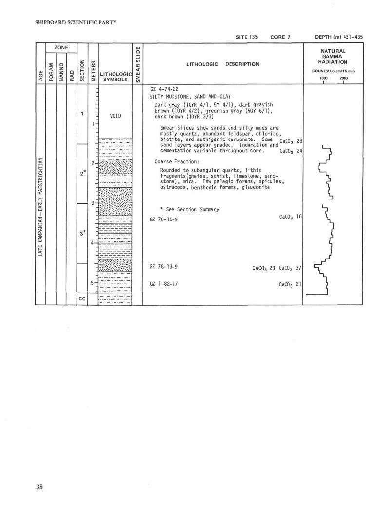
SHIPBOARD SCIENTIFIC PARTY
SITE 135 CORE 7 DEPTH (m) 431-435
ZONE
LITHOLOGICSYMBOLS
LITHOLOGIC DESCRIPTION
NATURALGAMMA
RADIATION
COUNTS/7.6 cm/1.5 min
1000 2000I I
VOIDl -
5 -
CC
GZ 4-74-22SILTY MUDSTONE, SAND AND CLAYDark gray (lOYR 4/1, 5Y 4/1), dark grayishbrown (10YR 4/2), greenish gray (5GY 6/1),dark brown (10YR 3/3)
Smear Slides show sands and silty muds aremostly quartz, abundant feldspar, chlorite,biotite, and authigenic carbonate. Some Q 3 Q Q Jsand layers appear graded. Induration andcementation variable throughout core. CaC03 24
Coarse Fraction:Rounded to subangular quartz, lithicfragments(gneiss, schist, limestone, sand-stone), mica. Few pelagic forams, spicules,ostracods, benthonic forams, glauconite
* See Section Summary
GZ 76-15-9 CaCO3 16
GZ 78-13-9
GZ 1-82-17
CaCO3 23 CaC03 37
CaC03 21
38
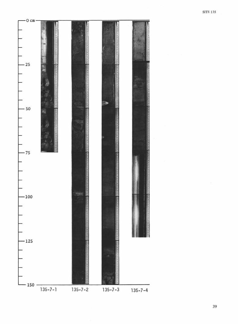
SITE 135
0 cm
— 25
50
—100
—125
150135-7-1 135-7-2 135-7-3 135-7-4
39
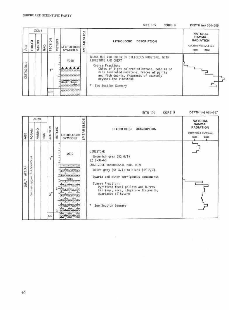
SHIPBOARD SCIENTIFIC PARTY
SITE 135 CORE 8 DEPTH (m) 564-569[A
GE
CRET
ACEO
US
ZONE1
FO
RA
M
1 N
AN
NO
RA
D
SE
CTI
ON
1*
CC
ME
TER
S
1 -
LITHOLOGICSYMBOLS
VOID
A A A A A
t
SM
EA
RS
LID
E]
LITHOLOGIC DESCRIPTION
BLACK MUD AND GREENISH SILICEOUS MUDSTONE, WITHLIMESTONE AND CHERT
Coarse Fract ion:Chips of l i g h t colored s i l t s t one , pebbles ofdark laminated mudstone, traces of pyr i teand f i s h debr is , fragments of coarselyc rys ta l l i ne limestone
* See Section Summary
NATURALGAMMA
RADIATION
COUNTS/7.6 cm/1.5 min
1OOO 2000
SITE 135 CORE 9 DEPTH (m) 685-687
ZONE
LITHOLOGICSYMBOLS
LITHOLOGIC DESCRIPTION
NATURALGAMMA
RADIATION
COUNTS/7.6 cm/1.5 min
1000I
2000I
VOID
I . I 11
VOID
LIMESTONEGreenish gray (5G 6/1)
GZ 1-34-65QUARTZOSE NANNOFOSSIL MARL OOZEOlive gray (5Y 4/1) to black (5Y 2/2)
Quartz and other terrigenous components
Coarse Fraction:Pyritized fecal pellets and burrowfillings, mica, claystone fragments,quartzose siltstone
* See Section Summary
cc
40
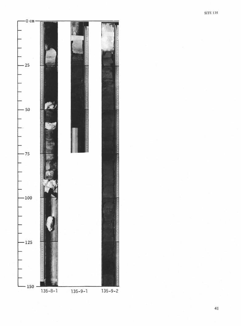
SITE 135
0 cm
— 25
— 50
— 75
100
—125
150135-8-1 135-9-1 135-9-2
41
SHIPBOARD SCIENTIFIC PARTY
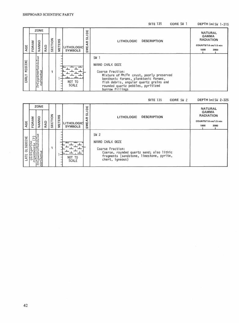
SITE 135 CORE SW 1 DEPTH (m)SW 1-315
ZONE
LITHOLOGICSYMBOLS
LITHOLOGIC DESCRIPTION
NATURALGAMMA
RADIATION
COUNTS/7.6 cm/1.5 min
1000I
2000I
NOT TOSCALE
SW 1
NANNO CHALK OOZE
Coarse Frac t ion :Mixture of Mn/Fe c r u s t , poorly preservedbenthonic forams, planktonic forams,f i s h debr i s , angular quartz grains androunded quartz pebbles, p y r i t i z e dburrow f i 11 ings
SITE 135 CORE SW 2 DEPTH (m)SW 2-325
ZONE
LITHOLOGICSYMBOLS
LITHOLOGIC DESCRIPTION
NATURALGAMMA
RADIATION
COUNTS/7.6 cm/1.5 min
1000 2000I I
i. NOT TOSCALE
SW 2
NANNO CHALK OOZE
Coarse Fraction:Coarse, rounded quartz sand; also lithicfragments (sandstone, limestone, pyrite,chert, igneous)
42
SITE 135
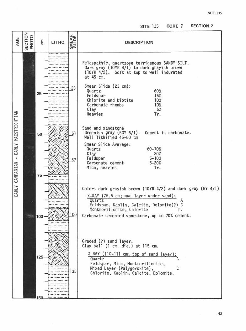
SITE 135 CORE 7 SECTION 2
AGE
EC
TIO
NH
OT
OS
25 —
ot—IDC
EARL
Y
D_
> -_JCC<CLU
50 —
75 —
100—<
125—
150
LITHO
SM
EA
RLI
DE
SL
23
J "1
JOO
J35
DESCRIPTION
Feldspathic, quartzose terrigenous SANDY SILTDark gray (10YR 4/1) to dark grayish brown(10YR 4/2). Soft at top to well induratedat 45 cm.
Smear Slide (23 cm):QuartzFeldsparChlorite and b io t i teCarbonate rhombsClayHeavies
Sand and sandstoneGreenish gray (5GY 6/1).Well l i t h i f i e d 45-60 cm
Smear Slide Average:QuartzClayFeldsparCarbonate cementMica, heavies
15%10%10%5%
Tr.
Cement is carbonate
60-70%20%
5-10%5-20%
Tr.
Colors dark grayish brown (10YR 4/2) and dark gray (5Y 4/1)
X-RAY (75.5 cm; mud layer under sand):Quartz AFeldspar, Kaolin, Calci te, Dolomite(?) CMontmorillonite, Chlorite tr.
Carbonate cemented sandstone, up to 70% cement.
Graded (?) sand layer.Clay bal l (1 cm. dia.) at 115 cm.
X-RAY (110-111 cm; top of sand layer):Quartz AFeldspar, Mica, Montmorilionite,Mixed Layer (Palygorskite), CChlori te, Kaolin, Calcite, Dolomite.
43
SHIPBOARD SCIENTIFIC PARTY
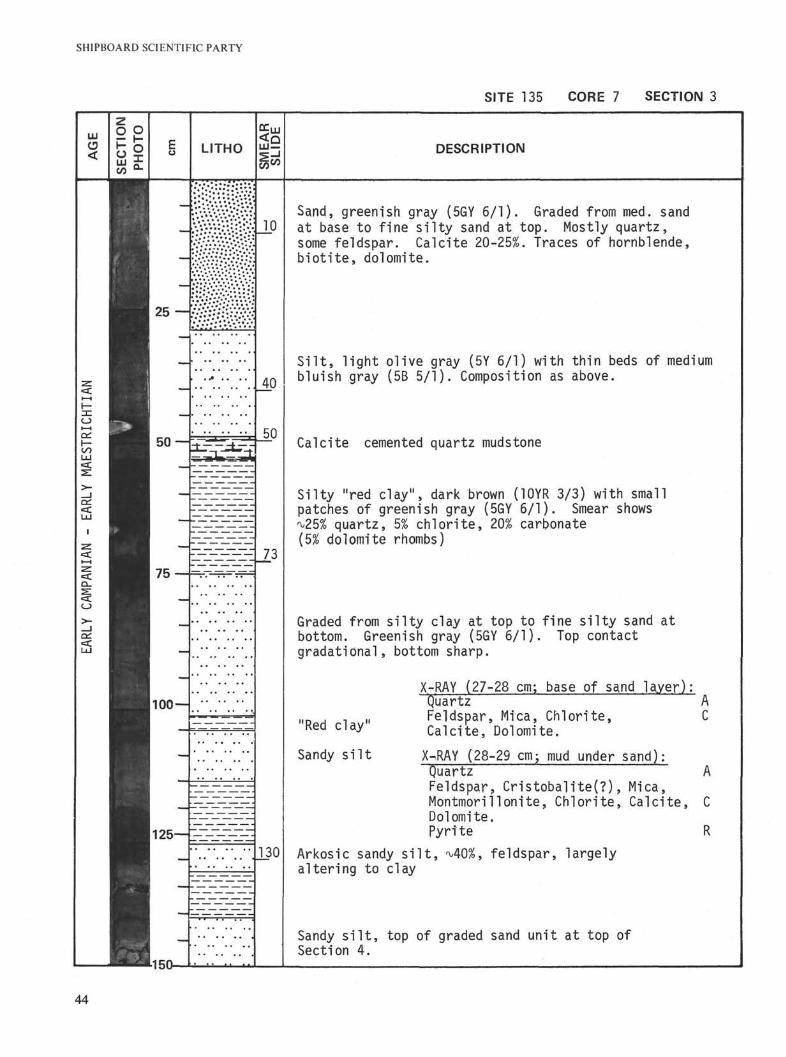
SITE 135 CORE 7 SECTION 3
LLI
<
25—:
oi—ial 50 —
75
100 —
125—
1-150-
LITHO <00
10
40
50
73
130
DESCRIPTION
Sand, greenish gray (5GY 6/1). Graded from med. sandat base to fine silty sand at top. Mostly quartz,some feldspar. Calcite 20-25%. Traces of hornblende,biotite, dolomite.
Silt, light olive gray (5Y 6/1) with thin beds of mediumbluish gray (5B 5/1). Composition as above.
Calcite cemented quartz mudstone
Silty "red clay", dark brown (10YR 3/3) with smallpatches of greenish gray (5GY 6/1). Smear shows^25% quartz, 5% chlorite, 20% carbonate(5% dolomite rhombs)
Graded from silty clay at top to fine silty sand atbottom. Greenish gray (5GY 6/1). Top contactgradational, bottom sharp.
"Red clay"
Sandy silt
X-RAY (27-28 cm; base of sand layer):Quartz AFeldspar, Mica, Chlorite, CCalcite, Dolomite.
X^RAY (28-29 cm; mud under sand);Quartz AFeldspar, Cristobalite(?), Mica,Montmorillonite, Chlorite, Calcite, CDolomite.Pyrite R
Arkosic sandy silt, ^40%, feldspar, largelyaltering to clay
Sandy silt, top of graded sand unit at top ofSection 4.
44
SITE 135
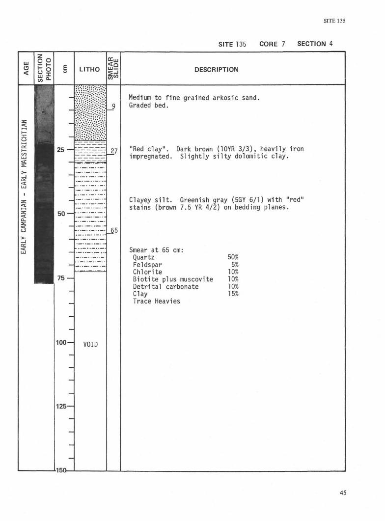
SITE 135 CORE 7 SECTION 4
AGE
:HT
IAN
1AES
TRI
>-
EARL
WA
N IA
N -
o>-
EARL
SE
CT
ION
PH
OTO
Iuü
—
25 —
_
50 —
75 —
100 —
125—
•150—
LITHO
• •* **• *•• *»*•** *
11
VOID
SM
EA
RS
LID
E_9
_65
DESCRIPTION
Medium to f ine grained arkosic sand.Graded bed.
"Red clay". Dark brown (10YR 3/3), heavily ironimpregnated. Sl ight ly s i l t y dolomitic clay.
Clayey s i l t . Greenish gray (5GY 6/1) with "red"stains (brown 7.5 YR 4/2) on bedding planes.
Smear at 65 cm:Quartz 50%Feldspar 5%Chlorite 10%Biot i te plus muscovite 10%Detr i tal carbonate 10%Clay 15%Trace Heavies
45
SHIPBOARD SCIENTIFIC PARTY
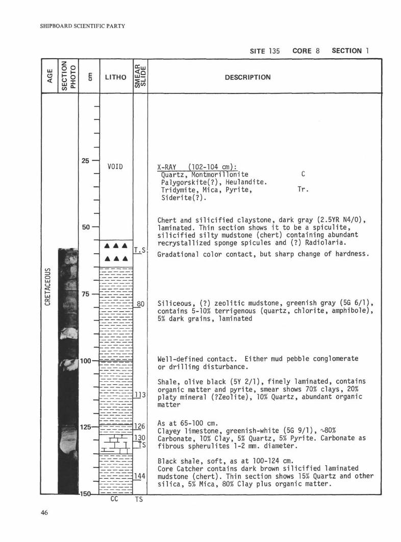
SITE 135 CORE 8 SECTION 1
LITHOCOCO
DESCRIPTION
25VOID
T.S
75 —80
100
125-
113
126
144
X-RAY (102-104 cm):Quartz, MontmorillonitePalygorskite(?), Heulandite.Tridymite, Mica, Pyr i te ,Sider i te(?) .
C
Tr
Chert and silicified claystone, dark gray (2.5YR N4/0),laminated. Thin section shows it to be a spiculite,silicified silty mudstone (chert) containing abundantrecrystallized sponge spicules and (?) Radio!aria.Gradational color contact, but sharp change of hardness
Siliceous, (?) zeolitic mudstone, greenish gray (5G 6/1),contains 5-10% terrigenous (quartz, chlorite, amphibole),5% dark grains, laminated
Well-defined contact. Either mud pebble conglomerateor drilling disturbance.
Shale, olive black (5Y 2/1), finely laminated, containsorganic matter and pyrite, smear shows 70% clays, 20%platy mineral (?Zeolite), 10% Quartz, abundant organicmatter
As at 65-100 cm.Clayey limestone, greenish-white (5G 9/1), ^80%Carbonate, 10% Clay, 5% Quartz, 5% Pyrite. Carbonate asfibrous spherulites 1-2 mm. diameter.
Black shale, soft, as at 100-124 cm.Core Catcher contains dark brown silicified laminatedmudstone (chert). Thin section shows 15% Quartz and othersilica, 5% Mica, 80% Clay plus organic matter.
L150-
46
SITE 135
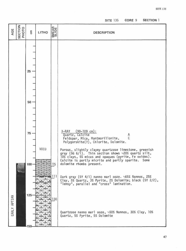
SITE 135 CORE 9 SECTION 1
LU
<
go"I LITHO
?ic/)DESCRIPTION
25 —
50 —
75
VOID
TS
X-RAY (99-109 cm):Quartz, Calcite AFeldspar, Mica, Montmorillonite, CPalygorskite(?), Chlorite, Dolomite.
Porous, slightly clayey quartzose limestone, greenishgray (5G 6/1). Thin section shows ^20% quartz silt,]Q% clays, 5% micas and opaques (pyrite, Fe oxides).Calcite is partly micrite and partly sparite. Somedolomite rhombs present.
Dark gray (5Y 4/1) nanno marl ooze. ^65% Nannos, 25%Clay, 5% Quartz, 3% Pyrite, 2% Dolomite; black (5Y 2/2),"lensy", parallel and "cross" lamination.
Quartzose nanno marl ooze, ^50% Nannos,Quartz, 5% Pyrite, 5% Dolomite
Clay, 10%
-150
47
SHIPBOARD SCIENTIFIC PARTY
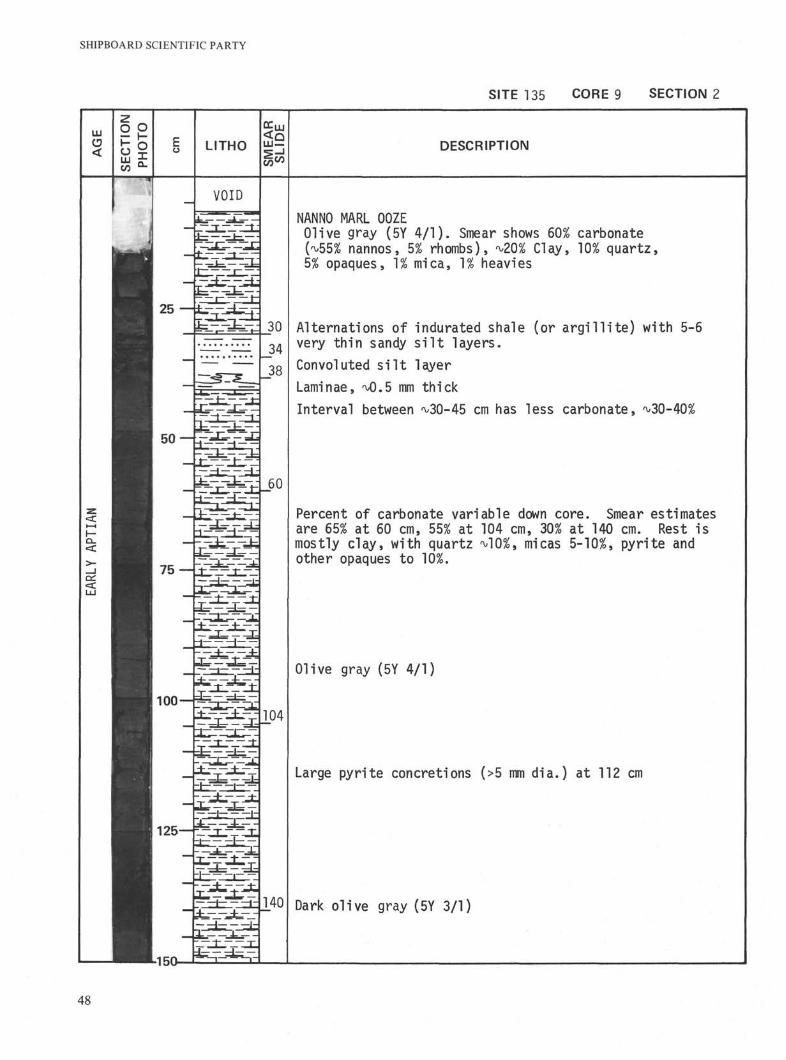
SITE 135 CORE 9 SECTION 2
LITHO LU —
^coDESCRIPTION
VOID
25
60
75 —
100
104
125-
^m 140
-150-
NANNO MARL OOZEOlive gray (5Y 4/1). Smear shows 60% carbonate(^55% nannos, 5% rhombs), ^20% Clay, 10% quartz,5% opaques, 1% mica, 1% heavies
Alternations of indurated shale (or argillite) with 5-6very thin sandy silt layers.
Convoluted silt layer
Laminae, 'vO.δ mm thick
Interval between ^30-45 cm has less carbonate, ^30-40%
Percent of carbonate variable down core. Smear estimatesare 65% at 60 cm, 55% at 104 cm, 30% at 140 cm. Rest ismostly clay, with quartz ^10%, micas 5-10%, pyrite andother opaques to
Olive gray (5Y 4/1)
Large pyrite concretions (>5 mm dia.) at 112 cm
Dark olive gray (5Y 3/1)
48