2 national significance final - erie canalway
TRANSCRIPT
National Signifi cance and Historical Context
2
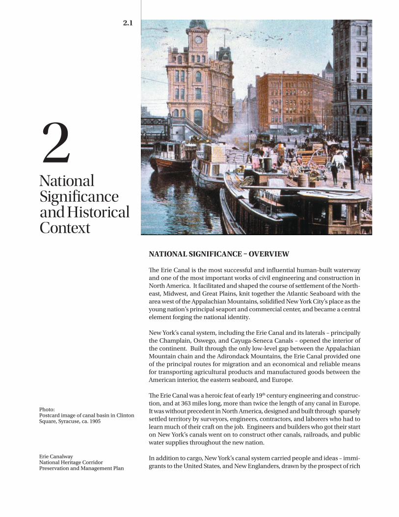
Photo:Postcard image of canal basin in Clinton Square, Syracuse, ca. 1905
Erie CanalwayNational Heritage Corridor Preservation and Management Plan
2.1
NATIONAL SIGNIFICANCE OVERVIEW
Th e Erie Canal is the most successful and infl uential human-built waterway and one of the most important works of civil engineering and construction in North America. It facilitated and shaped the course of settlement of the North-east, Midwest, and Great Plains, knit together the Atlantic Seaboard with the area west of the Appalachian Mountains, solidifi ed New York City’s place as the young nation’s principal seaport and commercial center, and became a central element forging the national identity.
New York’s canal system, including the Erie Canal and its laterals – principally the Champlain, Oswego, and Cayuga-Seneca Canals – opened the interior of the continent. Built through the only low-level gap between the Appalachian Mountain chain and the Adirondack Mountains, the Erie Canal provided one of the principal routes for migration and an economical and reliable means for transporting agricultural products and manufactured goods between the American interior, the eastern seaboard, and Europe.
Th e Erie Canal was a heroic feat of early 19th century engineering and construc-tion, and at 363 miles long, more than twice the length of any canal in Europe. It was without precedent in North America, designed and built through sparsely settled territory by surveyors, engineers, contractors, and laborers who had to learn much of their craft on the job. Engineers and builders who got their start on New York’s canals went on to construct other canals, railroads, and public water supplies throughout the new nation.
In addition to cargo, New York’s canal system carried people and ideas – immi-grants to the United States, and New Englanders, drawn by the prospect of rich
2.2 National Significance and Historical Context
farmland in upstate New York and beyond, along with innovators and manu-facturers who established businesses along the canal. The general prosperity and ease of communication along New York’s canal corridors created a cli-mate that fostered a number of nationally significant social reform and reli-gious movements. At the same time, completion of the canal system and its accompanying effects severely disrupted the pre-existing Native American cul-ture and settlements.
New York’s canal system has been in continuous operation since 1825, longer than any other constructed transportation system on the North American con-tinent. It can trace direct ancestry to short canals and navigation improvements to the Mohawk and Hudson Rivers built during the 1790s, and to the network of natural waterways that had been used for centuries for travel and commerce by members of the Iroquois Confederacy and other native peoples. Beyond the canal system’s role in facilitating and shaping the growth of the nation, it is the unbroken living tradition of the waterways, the communities that line their banks, and the people who live and work on and near the canals and related navigable lakes that make the Erie, Champlain, Oswego, and Cayuga-Seneca especially significant.
NATION BUILDING
Started just three and one-half decades after the end of the American Revo-lution and only three years after the end of the War of 1812, the Erie Canal helped establish the United States’ place in North American affairs. Politi-cians and engineers consciously selected an interior route from the Hudson directly to Lake Erie, rather than a shorter route to Lake Ontario at Oswego. The interior route helped ensure that Midwestern timber and produce would flow through New York State to market, discouraged U.S. products from being shipped down the St. Lawrence River through Canada, which was still part of the British Empire, and diminished the risk of invasion from the north. Although it was never tested after the War of 1812, the security of the northern border of the U.S. was ensured by the strategic position of the Erie and Champlain Canals.
De Witt Clinton was the Erie Canal’s most persistent and effective promoter. A former New York State legislator, U.S. Senator, Mayor of New York City, and a member of the commission that oversaw the initial surveys for a cross-state canal that started in 1810, Clinton spearheaded the political effort to bring the canal into being. After President Thomas Jefferson declined to support use of federal funds for a canal in New York and his successor James Madison vetoed a bill that would have provided federal money for canal and road projects, Clinton worked tirelessly to garner support for the canal from a deeply divided New York State legislature. His efforts paid off, and in 1817 the first canal authorization
1724
Cadwallader Colden proposes canal linking Lake Erie and Hudson River
1785
Christopher Colles publishes Proposals for the speedy settlement of the waste and unappropriated lands of the western frontiers of New York, and for the improvement of the inland navigation between Albany and Oswego. .
CANAL HISTORY TIMELINE
New York’s canal system has been in continuous operation since 1825, longer than any other constructed transportation system on the North American continent.

National Significance and Historical Context 2.3
bill passed by a narrow margin. Clinton was elected Governor later that year, just before construction of the Erie Canal started at Rome on July 4, 1817.
Thereafter, construction and operation of the Erie Canal was authorized, funded, and managed by New York State. Ironically, at a time when national leaders such as John C. Calhoun were arguing strongly for federal support of internal improvements “to bind the Republic together with a perfect system of roads and canals,” the Erie and most of the waterways that followed during Ameri-ca’s great canal era were built with state funds under state direction. “Clinton’s Ditch” and its imitators illustrated the powerful role of state governments in the new republic.
The Erie Canal ensured the status of New York City as America’s premiere sea-port, commercial center, and gateway to the interior – eclipsing New Orleans, Philadelphia, Boston, and Baltimore. It helped New York become the “Empire State” – the leader in population, industry, and economic strength. Together, these effects gave New York a remarkable degree of political influence on the national scene.
Even before it was built, promoters of the Erie Canal claimed that it would “bind the Union,” reinforcing connections between the eastern seaboard and the still largely unsettled but expanding territories to the west. Echoing those claims, many historians believe that the Erie Canal had a major impact on the outcome of the American Civil War, not only for its role in transporting food and mate-rial, but also because economic and social ties between the northeastern sea-board and the Midwest, established and maintained by 35 years of commerce and migration along the Erie Canal, meant that residents of Ohio, Illinois, Indi-ana, Michigan, Wisconsin, and Minnesota (a region historically called the “Old Northwest”) generally supported union rather than secession. If the Erie Canal had not been constructed, most of the commerce of the Midwest would have followed the Mississippi to and from New Orleans, and social, economic, and political sympathies might have taken a different form.
ECONOMIC DEVELOPMENT
The Erie Canal was the first effective route of interstate commerce between the Atlantic Coast and the interior of the country. The Erie not only carried settlers into upstate New York and the Midwest, it carried the products of their labor to the coastal and international marketplace. After the Erie Canal was completed, freight charges for shipping wheat from the Genesee Valley and Ohio to the port of New York dropped to a tenth of what it had previously cost to ship overland. As farmers received a greater portion of the selling price for their produce, agri-
1792
New York State Legislature passes “an act for establishing and opening lock navigation within the state” and charters the Western Inland Lock Navigation Company and Northern Inland Lock Navigation Company to improve the Mohawk River-Oneida Lake-Oswego River and Hudson River-Lake Champlain water routes.
RIVER IMPROVEMENT ERA 1792-1817
The Erie Canal helped New York become the “Empire State” – the leader in population, industry, and economic strength.

2.4 National Significance and Historical Context
culture and settlement expanded, becoming increasingly oriented toward, and dependent on, national and international markets. Although New York politi-cians and citizens who promoted and paid for construction of the canal saw it as a means to bring prosperity to their own state, by 1847 more cargo on the Erie Canal originated in western states than in New York. By 1850, a quarter of all the grain grown in the United States traveled to market by way of the Erie Canal.
New York’s canal system was the largest public works project in 19th century North America and was so successful that it inspired a nationwide canal build-ing boom that lasted for the next quarter-century. In the end, New York’s Erie, Champlain, and Oswego Canals, along with the Chesapeake & Delaware Canal in Delaware and the Delaware & Raritan Canal in New Jersey, were the only canals in the nation that generated toll revenues in excess of their construction and operating costs and could be considered commercial successes in their own right. Nonetheless, almost all of the canals inspired by the Erie prompted growth and development in the regions they served and these indirect benefits often exceeded direct financial returns to investors and state governments. In this sense America’s canals, and the Erie Canal in particular, typified the ben-efits of “internal improvements” promoted by Washington, Jefferson, Henry Clay, and other leaders of the new republic.
NATIONAL IDENTITY
The Erie Canal was considered one of the wonders of the new world and a source of intense pride to New York and the nation. It was more than twice as long as any canal in Europe and boasted heroic feats of engineering like the double five-rise locks and deep cut at Lockport and dramatic aqueducts at Rochester, Montezuma, Little Falls, Schoharie, Rexford and Crescent. Because it provided the most convenient route from New York City and the Hudson Val-ley to Niagara Falls, and passed scenic Mohawk River cataracts at Cohoes and Little Falls, the Erie Canal and the territory it ran through became both the route and the subject for dozens of foreign and American travelers, chroniclers, jour-nalists, essayists, diarists, artists, and illustrators.
The observations recorded by these early travelers and published widely in books, periodicals, popular prints, and on decorative objects like Staffordshire pottery say a lot about the developing American character – how others saw Americans, how Americans saw themselves, and how they wanted others to see them. By 1852, when Marco Paul’s Travels on the Erie Canal was published, the waterway had been incorporated into children’s literature. At the turn of the 20th century it was the central element in hundreds of penny postcard views of upstate communities. By 1905, when Tin Pan Alley songwriter Thomas Allen published “Low Bridge, Everybody Down,” the Erie Canal had long since been
1792-98
Wood Creek west of Rome straightened and deepened, a canal and locks constructed at Little Falls, and the Mohawk connected with Wood Creek and Oneida Lake near Rome.
1808
Secretary of State Albert Gallatin proposes to the U.S. Senate a national system of internal improvements including canals from the Hudson River to Lake Erie and Lake Champlain.
RIVER IMPROVEMENT ERA 1792-1817
New York’s canal system was the largest public works project in 19th century North America and was so successful that it inspired a nationwide canal building boom that lasted for the next quarter-century.

National Significance and Historical Context 2.5
eclipsed by railroads as a carrier of freight and passengers but remained deeply entrenched in the popular consciousness.
ENGINEERING
New York’s canal system was a nationally and internationally significant work of engineering. Although its builders borrowed and adapted ideas and tech-niques from earlier European canals, they applied them with audacity on an unprecedented scale through a region that was still largely wilderness. The initial construction of the Erie Canal between 1817 and 1825, and successive campaigns of improvements and enlargements throughout the 19th century, served as a training ground for many of America’s most active and productive engineers. Benjamin Wright, who gained experience with the Western Inland Lock Navigation Company during the 1790s, served as Chief Engineer of New York State Canals from 1817-28 and as consulting engineer on the Farmington, Blackstone, Chesapeake and Delaware, Chesapeake and Ohio, Delaware and Hudson, Welland, and St. Lawrence Ship Canals. Canvass White, Nathan Rob-erts, John B. Jervis, James Geddes, and others served apprenticeships on the Erie before going on to design and supervise construction of other important canal, railroad, bridge, and water supply projects throughout the country.
Started at a time when the military academy at West Point offered the only for-mal engineering instruction in North America, New York’s canal system pro-vided practical schooling to a generation of designers and builders. It also led to the founding of Rensselaer Polytechnic Institute (RPI) in Troy (1824) and the introduction of engineering at Union College in Schenectady (1845), the nation’s first civilian engineering schools. The sciences of hydrology, geology, and paleontology were dramatically influenced by experiences gained during construction of the Erie Canal.
Beyond their initial construction, operation of New York’s canals required administration and management of a complex technological system on an unprecedented scale. Control of water resources, maintenance, toll collec-tion, and administration of property, employees, contractors, and boaters on a network of more than 500 miles of artificial waterways (700 miles by the 1850s) required development of new procedures that would see later application in railroads, communication companies, public utilities, and government.
SOCIAL INNOVATION AND REFORM
In addition to people and products, the Erie Canal was a conduit for ideas. Several of the 19th century’s most influential social reform movements started and/or flourished along New York’s canal system, particularly in the central and
1808
James Geddes surveys two cross-state canal routes: an interior route later taken by the Erie Canal, and an alternate route utilizing Lake Ontario and Niagara River.
1810 – 11
State board of Canal Commissioners, led by DeWitt Clinton, examines routes, prepares estimates, and seeks funding for a cross-state canal. .
RIVER IMPROVEMENT ERA 1792-1817

2.6 National Significance and Historical Context
western portions of the state. Many upstate residents pushed for the abolition of slavery. Frederick Douglass lived and published for a time in Rochester as did Harriet Tubman, before she moved to Auburn. The canal towpath served as one of the routes of the “Underground Railroad,” used by escaped slaves attempting to reach sanctuary in Canada. The women’s rights movement traces its roots to Rochester and Seneca Falls.
Religious revivalism swept the Erie Canal corridor with such intensity during the “Second Great Awakening” of the 1820s and ‘30s that western New York came to be called the “Burned Over District.” Evangelical sects, millenialists, and new religious groups such as the Latter Day Saints (Mormons) and Seventh Day Adventists were started in canal communities and spread their message along the waterway. Perfectionist groups like the Oneida Community flour-ished near the canal.
While it can be difficult to establish direct causal links between waterways and specific reform, it is possible to say that the general prosperity and the cos-mopolitan nature of the Erie Canal corridor, which was experiencing dramatic growth and witnessing a flow of people from all over the Atlantic world, cre-ated a climate where social innovation and questioning of the established order could flourish.
NATIVE AMERICAN SIGNIFICANCE
New York’s canal building boom and the urban explosion that it triggered dra-matically accelerated the dispossession and disruption of traditional life ways of the region’s Native American inhabitants that had been initiated by the intro-duction of European trade, diseases, colonial wars, the American Revolution, and encroaching settlement by non-natives. Early years of the canal era coin-cided with a period of state and federal policies that promoted “Indian removal” from developing portions of New York and other eastern states to reservations in comparatively isolated portions of those states and outlying territories in the American Midwest.
At the time of initial European contact, the upper Hudson Valley, including both the confluence with the Mohawk River and the overland route to the Cham-plain Valley was occupied by Mahican (Mohican) people. The remainder of upstate New York from Albany to the Great Lakes was homeland to the five nations of the Iroquois Confederacy comprising the Mohawk, Oneida, Onon-daga, Cayuga, and Seneca peoples. Collectively, they referred to themselves as Haudenosaunee, the People of the Longhouse. By the mid-1600s the Haudeno-saunee controlled trade in the Hudson, Champlain, and upper Saint Lawrence
1812 – 14
War of 1812 reinforces desirability of constructing an interior canal route.
1817
New York State Legislature approves state funding for Erie and Champlain Canals. .
1817
DeWitt Clinton elected Governor of New York. .
RIVER IMPROVEMENT ERA 1792-1817

National Significance and Historical Context 2.7
River valleys, and to the west through what is now Ohio, most of Pennsylva-nia, and southern Ontario. The Mohawk River, Wood Creek, Oneida Lake and River, Oswego River, Seneca River, and Finger Lakes were heavily used routes for Haudenosaunee commerce, diplomacy, and warfare.
The river corridors, lakes, and carries between them also served as migration paths for early non-native settlers and invasion routes for colonial armies. Already pressed by European settlement and colonial wars between Britain, France, and Holland during the 17th and 18th centuries, the Haudenosaunee suf-fered large-scale dispossession during and after the American Revolution. The Mohawks, who had generally allied themselves with the British during earlier conflicts, were attacked by Americans in 1777 and most in the Mohawk Valley were driven north toward Montreal or west to the Niagara Frontier. In 1779, American forces under Generals Goose Van Schaick, John Sullivan, and James Clinton launched a three-pronged attack against the Onondaga, Cayuga, and Seneca, who George Washington and others regarded as British sympathizers. Almost all of the villages, crops, and stored food in central and western New York were burned. Left without food or shelter at the onset of winter, many of the former residents of those villages sought refuge in the vicinity of British Fort Niagara.
Although many Haudenosaunee returned to their traditional homelands after the Treaty of Paris ended the Revolution in 1783, substantial numbers remained in British Canada. The centuries-old Iroquois Confederacy suffered a perma-nent split.
A succession of treaties drawn up in the decades following the Revolution reduced once vast traditional tribal territories to about 16 tightly circumscribed and comparatively small reservations. Subsequent treaties and land deals fur-ther reduced the area and number of reservations.
In the years after the American Revolution, enormous portions of western and northern New York fell under the control of land speculators and land devel-opment companies as the idea of a cross-state canal took form. Although Iro-quois reservations comprised very small portions of their traditional holdings, several stood in the path of these New Yorkers’ expansionist ambitions. Oneida territory included the “Great Carry” or Oneida Carry between the Mohawk and Oneida/Oswego drainage basins, as essential to Philip Schuyler’s Western Inland Lock Navigation Company and its Erie Canal successor as it had been for thousands of years before. The Onondagas retained control of many of the salt springs around Onondaga Lake as well as the marshland that would soon become the city of Syracuse. The Cayuga Reservation included much of the Seneca River and the northern end of Cayuga Lake and thereby controlled all
1817
Erie Canal construction begins in Rome July 4. Minimum dimensions are to be 4 feet deep and 40 feet wide, with locks capable of passing boats up to 30 tons.
1822
180 miles of Erie Canal open between Rochester and Little Falls
CLINTON’S DITCH ERA: 1817-1835
1822
Champlain Canal completed between Whitehall and Cohoes – 66 miles long, 19 locks.

2.8 National Significance and Historical Context
1825
Erie Canal completed – 363 miles long, 83 locks. Governor Clinton rides the Seneca Chief from Buffalo to New York City for “Wedding of the Waters” ceremony in New York Harbor.
1825 – 29
State acquires Oswego Canal Company and constructs Oswego Canal between Syracuse and Lake Ontario – 38 miles, 18 locks. .
CLINTON’S DITCH ERA: 1817-1835
Map of Ho-de-no-sau-nee-ga, or the Territories of the People of the Longhouse in 1720
This map, published by Lewis Henry Morgan in his 1857 book League of the Ho-De-No-Sau-Nee or Iroquois, shows how the historical extent of Native American influence in New York State was understood during the time when the canals were at their peak. Although the straight lines on the map are somewhat artificial, they have been used by historians, anthropologists, and tribal representatives as a point of departure for discussions about Native American lands prior to European-American settlement.
National Significance and Historical Context 2.9
1829
Canada’s Welland Canal opens between Lake Erie and Lake Ontario, bypassing Niagara Falls. .
potential waterborne access to the Finger Lakes. The Seneca’s largest reserva-tion at Buffalo Creek occupied land that would later become a substantial por-tion of the city of Buffalo.
Not surprisingly, the principals of land companies were some of the most vocal and persistent promoters of both transportation improvements and the extin-guishment of American Indian title to lands in central and western parts of the state. In the decades between the Revolution and the beginning of canal con-struction, individual land speculators, land companies, and a number of state and federal officials shared common interests and worked hard to remove the Haudenosaunee from New York’s lowland corridors and open the way for non-Indian settlement. A succession of land transfers, sales, and treaties, some of questionable ethics and legality, further diminished Haudenosaunee holdings along canals and, later, turnpike and rail lines.
The aftermath of the War of 1812 added the imperative of national defense to the land speculators’ promotion of non-Indian settlement along the border with British Canada. During his term as Secretary of War, coincident with con-struction of the Erie Canal from 1817-1825, John C. Calhoun advocated road and canal construction to facilitate rapid settlement of the northern sections of the nation as well as removal of all American Indians to territories west of the Mississippi. The Indian Removal Act of 1830, passed during the administration of President Andrew Jackson and Vice President Martin Van Buren, was sup-ported by the Ogden Land Company and a number of prominent New York-ers who continued to press for relocation of all Iroquois to western territories. During the 1830s, nearly half of the members of the Oneida Nation were loaded onto Erie Canal boats and transported to Buffalo, where they boarded lake ves-sels bound for Green Bay, Wisconsin close to the site of their newly established western reservation. The Seneca were similarly pressed.
After the Erie Canal was completed, the Ogden Land Company and its politi-cal allies worked assiduously to secure title to the Buffalo Creek Reservation of the Seneca, which stretched inland from Buffalo Harbor, immediately south of the western terminus of the canal, and was a prime spot for growth of the new boom town. They also sought title to a number of culturally significant Seneca reservations in the prime agricultural land of the Genesee Valley. Eventually the land speculators prevailed, often through fraudulent means. The Seneca relinquished Buffalo Creek in 1847.
By the peak of New York’s canal boom in the 1840s and ‘50s, the Erie and Cham-plain Canals ran through portions of the Mohawk ancestral homeland. Oneida territory was crossed by the Erie running east-to-west across the Oneida (Great) Carry and by the Black River Canal running north, the Chenango running south,
1826 – 28
State acquires Seneca Lock Navigation Company and constructs Cayuga-Seneca Canal between Erie Canal and Cayuga and Seneca Lakes – 22 miles, 12 locks.
CLINTON’S DITCH ERA: 1817-1835

2.10 National Significance and Historical Context
1831
Mohawk and Hudson Railroad completed between Albany and Schenectady. The 16 mile route, far faster than the 28 mile, multi-lock canal passage, proved popular with passengers.
and a number of shorter waterways such as the Oneida Lake Canal. The Erie and Oswego Canals ran through Onondaga territory. The Erie and Cayuga-Sen-eca Canals ran through country once controlled by the Cayugas. The Erie and Genesee Valley Canals ran through the very heart of the Seneca Nation. The state condemned portions of the Seneca’s Oil Spring Reservation between 1858 and 1871 to build Cuba Lake, a storage reservoir for the Genesee Valley Canal.
The first boat to transit the full length of the Erie Canal, carrying Governor DeWitt Clinton and a party of dignitaries from Buffalo to New York Harbor for the “Wedding of the Waters” ceremony in the fall 1825, was called the Seneca Chief. The name of the vessel was only one of the ironies in the aquatic proces-sion. Clinton considered himself an authority on Iroquois; in an 1811 speech before the New York Historical Society, when Clinton was mayor of New York City and a newly appointed canal commissioner, he predicted that “before the passing away of the present generation, not a single Iroquois will be seen in this state.” In this case, Clinton was not prophetic. The land speculators, politicians, and government officials who worked to remove the Iroquois from New York never fully succeeded. There are more members of the Six Nations in the state today than at the end of the Revolution although those who reside on reserva-tions are often far from their ancestral homelands. While New York’s canal cor-ridors are lined with sites of ancient and historic Iroquois villages, many of the descendents of those communities now live in distant portions of New York, the Midwest, and Canada.
STATEWIDE SIGNIFICANCE
The canal system has special significance to New York. It is a major landscape feature across the state. It established and shaped patterns of settlement and growth that remain today – New York City as the seaport and commercial cen-ter; Albany, the eastern gateway to the system; Syracuse, a city that grew from a swamp at the center of the system; Rochester, the manufacturing city by the falls and America’s first inland boom town; and Buffalo, grain port and indus-trial colossus at the western gateway.
Evidence of New York’s canal age is visible in the buildings and streetscapes of large and small communities across the state. Not only do canal towns share similarities in layout and orientation to the waterway, in most cases their archi-tecture reflects the prosperity that characterized upstate New York’s lowland corridors from 1825 through the end of the 19th century.
1833 – 36
Chenango Canal built between Erie Canal at Utica and the Susquehanna River at Binghamton. .
CLINTON’S DITCH ERA: 1817-1835
The canal system established and shaped patterns of settlement and growth that remain today – New York City as the seaport and commercial center; Albany, the eastern gateway to the system; Syracuse, a city that grew from a swamp at the center of the system; Rochester, the manufacturing city by the falls and America’s first inland boom town; and Buffalo, grain port and industrial colossus at the western gateway.

National Significance and Historical Context 2.11
The canal system shaped patterns of upstate agriculture, opening access to mar-kets for Genesee wheat, cheese, butter, fruit and fruit products from central and western New York, as well as Adirondack timber and iron ore. During its first decade, most canal cargo came from central and western New York but that changed as the Erie opened the way for settlement and agriculture in the Great Lakes states. The shipment of Midwestern wheat and forest products caused canal tonnage arriving at Albany to quadruple between 1832 and 1836. While the volume of commerce from Western states grew by 500% between 1836 and 1856, the volume of traffic generated within New York grew by 80%. This ini-tiated a trend, later reinforced by railroads and motor trucks and still visible today, for New York farmers to specialize in higher value semi-perishable prod-ucts (dairy, fruit, and vegetables) rather than cereal grains.
The New York State Canal System was an enormous source of state revenue – the Erie, Champlain, and Oswego Canals paid for themselves in the first decade of operation. The system earned $121,461,871 in tolls between 1826 and 1883 when tolls were abolished by constitutional amendment. In addition to direct revenues, the Canal Fund provided an important reserve that secured the state’s financial status during periods of financial panic and depression throughout the 19th century when a number of other states were forced to default.
The immediate successes of the Erie, Champlain, and Oswego Canals inspired a boom in canal construction throughout upstate New York. While toll reve-nues of the Cayuga-Seneca, Crooked Lake, Oneida Lake, Chenango, Genesee Valley, and Black River never repaid the cost of their construction, these lateral waterways did prompt settlement, development, and economic growth in the regions that they reached and served to bind the state together in an era of dif-ficult overland transportation.
Although less visible and more ephemeral than locks, buildings, and streetscapes, canal lifeways are a significant element in New York’s heritage. During the 19th century, a significant portion of upstate New York’s residents worked on or next to the canal system. In addition to boat crews and families, the system provided employment for lock tenders, maintenance workers, construction contractors, boat builders, and engineers. Many storekeepers, blacksmiths, and feed deal-ers derived a significant portion of their business from boaters and other canal workers. Upstate farmers and manufacturers shipped by canal. The canals also inspired and supported their own lively folk tradition of songs and stories. In other words, at least during the 19th century, the canal system was an integral part of the mental as well as the physical landscape for many New Yorkers.
1835
NYS Legislature approves enlargement of Erie, Champlain, and Oswego Canals to 7 feet deep and 70 feet wide, with locks capable of passing boats up to 240 tons.
1842-46
Enlargement work halted due to State debt and “Stop and Tax Law.” .
1843
Albany and Buffalo connected by rail over routes operated by seven companies.
ENLARGED ERA: 1835-1917

2.12 National Significance and Historical Context
LOCAL SIGNIFICANCE
The Erie Canal is significant at many levels, but all of New York’s canals have special significance in the communities along their routes. Canals were the principal reason that many communities were established where they were and when they were. Community form, street pattern, and architecture usu-ally evolved in relation to the waterway. Access to canals was a reason why some communities prospered and grew more than their neighbors. Canals facilitated the growth of locally prominent manufacturers. They allowed many towns to call themselves “port,” even though they were hundreds of miles from the sea. Today, the vestigial influences of the 19th century canal system can been observed in the unusually wide streets (often called Erie Boulevard) that run through the centers of Schenectady, Utica, Rome, and Syracuse as well as doz-ens of Canal Streets, Lock Streets, and Towpath Roads in communities across upstate New York.
THE SYSTEM
Today, navigable portions of the New York State Canal System include the Erie Canal, which connects the Hudson River with Lake Erie, 338 miles to the west; the Champlain Canal, which connects the tidal portion of the Hudson River with Lake Champlain, 63 miles to the north; the Oswego Canal, which branches off from the Erie and follows the Oswego River to connect with Lake Ontario, 23 miles to the north; and the Cayuga-Seneca Canal, which follows the Seneca River to connect the Erie Canal with Cayuga and Seneca Lakes. The system is owned and operated by the New York State Canal Corporation, a subsidiary of the New York State Thruway Authority. Statewide efforts to revitalize the system through recreational improvements have been led by the Canal Recreationway Commission since 1995.
In their current form, these canals follow alignments and utilize structures that were placed in service between 1915 and 1918, but all four have direct ances-tors that opened to navigation in the 1820s. They all follow major rivers that native peoples used for thousands of years to transport goods and people. The trip west required an overland carry from Albany to Schenectady to avoid the Cohoes Falls; travel by canoe or bateau – thirty-foot flat-bottomed boats capa-ble of carrying up to one and one-half tons each – up the Mohawk River to Little Falls; a one-mile carry around the falls; a further push up the Mohawk to the ancient Oneida Carrying Place or “Great Carry” over the low drainage divide between the Mohawk River and Wood Creek at Fort Stanwix; and a final down-stream leg along the winding Wood Creek to Oneida Lake, across the lake to its outlet, and down the Oneida River to its confluence with the Seneca River.
1848
In Canada, canals connect Montreal to Lake Ontario along the St. Lawrence River.
1851
New York and Erie Railroad connects New York to Buffalo across state’s Southern Tier.
1853
New York Central Railroad consolidates route between NY, Albany & Buffalo.
1855
Black River Canal completed connecting Erie Canal with Black River.
ENLARGED ERA: 1835-1917

National Significance and Historical Context 2.13
From there, travelers could continue north, down the rapids of the Oswego River to Lake Ontario; or west, up the Seneca River through marshes to the heads of Seneca and Cayuga Lakes.
In 1792 the New York State Legislature chartered the Northern Inland Lock Navi-gation Company and the Western Inland Lock Navigation Company. Promoted by Philip Schuyler, these companies built short bypass channels and a handful of locks to improve navigation on the upper Hudson River and on the Mohawk River and Wood Creek between Schenectady and Oneida Lake. By 1798 the Western Inland Lock Navigation Company had completed canals and locks at Little Falls, Rome, and German Flatts near Herkimer, and had deepened and straightened Wood Creek to the point that sixty-foot Durham boats, capable of carrying up to ten tons each, could carry salt from the springs near Onondaga Lake and wheat from the Finger Lakes to Schenectady. Goods still had to be carried overland between Schenectady and Albany to bypass the great falls of the Mohawk at Cohoes. The Northern Company initiated work to improve navi-gation on the upper Hudson and connect it to Lake Champlain but the project was never completed.
Agitation for a cross-state canal that would connect the tidal Hudson River with the Great Lakes, without the need for carries, grew during the first decade of the 19th century. The New York State Legislature authorized surveys of routes between the Hudson and Lake Erie in 1808 and 1810. Construction of the Erie Canal started in 1817 and the waterway opened from Albany to Buffalo in 1825. The first iteration of the Erie Canal was 363 miles long and had 86 locks to make up the 571-foot difference in elevation between the Hudson River and Lake Erie. Locks were 90 feet long by 15 feet wide, the channel was a minimum of four feet deep and 40 feet wide at the surface, and boats built to fit the waterway could carry up to 30 tons. The Champlain Canal was also started in 1817 and opened in 1823. It was 66 miles long and had 19 locks of the same dimension as the Erie. Construction of the Oswego and Cayuga-Seneca Canals started in 1825 and both were completed by 1828. The Oswego Canal was 38 miles long and had 21 locks; the Cayuga-Seneca was 27 miles long and had 12 locks. Unlike the Erie and Champlain, which were designed as wholly independent chan-nels parallel to but independent of flood- and drought-prone natural rivers, the Oswego and Cayuga-Seneca Canals made use of dredged river channels with towing paths on the bank.
Work to enlarge the system was authorized in 1835, proceeded fitfully due to state budget limitations, and was declared complete in 1862, even though considerable work remained to be done. Locks on the Erie, Champlain, and Oswego Canals were substantially or completely rebuilt with new dimensions of 110 feet long by 18 feet wide. Channels were deepened to seven feet and
1857
Genesee Valley Canal completed connecting Erie Canal with Allegheny River.
1862
Canal enlargement declared complete (although much work remained to be done)
ENLARGED ERA: 1835-1917
The first iteration of the Erie Canal was 363 miles long and had 86 locks to make up the 571-foot difference in elevation between the Hudson River and Lake Erie ... the channel was a minimum of four feet deep and 40 feet wide at the surface...
1877 – 78
Chemung, Crooked Lake, Oneida Lake, Chenango, and Genesee Valley Canals abandoned. .

2.14 National Significance and Historical Context
widened to at least 70 feet. Locks on the Erie were “doubled” with two side-by-side chambers to facilitate simultaneous east and west bound traffic. All aque-ducts were replaced or substantially rebuilt to accommodate the new channel dimensions and to allow boats to pass. New aqueducts were built across the Seneca River at Montezuma and across the Schoharie at Fort Hunter, replac-ing troublesome slackwater crossings and guard locks. Boats built to the new maximum dimensions could carry up to 240 tons of cargo. Channel straight-ening and minor realignments reduced the length of the Erie Canal from 363 to 350 miles.
New York built a number of other lateral canals that connected to the Erie, including the Chemung (completed 1833), Crooked Lake (1833), Chenango (1836), Genesee Valley (partially opened 1841, completed 1857) and Black River (1855) Canals. The Delaware & Hudson, connecting the Hudson River at Kings-ton to the Delaware at Port Jervis and the anthracite coal fields of northern Pennsylvania, was constructed by a private company and opened to naviga-tion in 1828. All but the Black River and Delaware & Hudson were closed by the state in 1877-78. The D&H was abandoned 1899 but a portion was reopened for navigation from 1902 to 1912. The last boat descended the locks of the Black River Canal in 1924.
The Enlarged Erie Canal carried its peak tonnage in 1880. Although freight tapered off thereafter, there were continued cries to upgrade the system. Between 1884 and 1894 one of the two chambers at most of the Enlarged Erie’s locks between Cohoes and Lockport were lengthened to accommodate “dou-ble-headed” tows of two canal boats lashed end-to-end. Water turbine driven capstans were installed at lengthened locks to help pull boats in and out of the chambers (locks 3-18 at Cohoes, 36-39 at Little Falls, 57-59 at Newark, and the Lockport Flight were clustered too closely to be lengthened). Twelve of the 23 locks on the Oswego Canal were lengthened as part of the same program.
The New York State Legislature passed the “Nine Million Dollar Act” in 1895 to lengthen remaining locks and deepen the Enlarged Erie Canal channel from 7 to 9 feet. Construction of the “second enlargement” started immediately, even though initial estimates and bids indicated that it would cost $13.5 to $15 mil-lion to deepen the 350 mile long channel (or raise the banks) and modify 75 locks, 32 aqueducts, and most of the 642 bridges that crossed the canal between Albany and Buffalo. Work stopped on the partially completed project in 1898 amid allegations of mismanagement and misappropriation of funds.
The following year, newly elected Governor Theodore Roosevelt appointed a committee to investigate and report on the future of New York’s canal system. In 1903 the New York State Legislature passed the “Barge Canal Act,” based in
1882
Tolls abolished along state owned canals. .
1880
Peak tonnage year for Erie Canal. .
1895
Second enlargement approved to deepen channels to increase boat capacity to 450 tons. .
ENLARGED ERA: 1835-1917

National Significance and Historical Context 2.15
Map of New-York State Canals c. 1858
This map, designed under the direction of Van Rensselaer Richmond, State Engineer & Surveyor, to accompany his report for 1858, highlights the Erie, Champlain, Oswego, and Cayuga-Seneca Canals as well as the state-built laterals: the Chemung, Crooked Lake, Chenango, Genesee Valley, and Black River Canals, all eventually closed to navigation. Originally published in the Annual Report of the New York State Engineer and Surveyor (C. Van Benthuysen, Albany, 1860). The map has been modified to highlight the canals.
1899
Governor Theodore Roosevelt establishes Advisory Committee on Canals, which recommends further enlargement. .
ENLARGED ERA: 1835-1917
1901
Edward A. Bond submits Report on the Barge Canal from the Hudson River to the Great Lakes suggesting alternate canal routes across the state.

2.16 National Significance and Historical Context
large part on the recommendations of Roosevelt’s committee. The New York State Barge Canal System upgraded the Erie, Champlain, Oswego, and Cayuga-Seneca Canals with some significant differences in routing and fundamental technology. Clinton’s Ditch, the Enlarged Erie, and the 19th century laterals were towpath canals on which boats were pulled by mules or horses. Small steamboats and tugs started to operate on New York’s canals during the late 19th century but their use was not promoted because of traffic conflicts with animal drawn boats and bank erosion caused by their wakes. By contrast, the New York State Barge Canal System was designed expressly for motorized vessels.
The new system needed wider and deeper channels but no longer required a towpath, so state engineers canalized extended portions of the Hudson, Mohawk, Oneida, Oswego, Seneca, and Clyde Rivers as well as Oneida, Onon-daga, and Cross Lakes. In the western part of the state, the section of the Erie Canal along the Niagara River from Buffalo to Tonawanda was abandoned. From its new western terminus at Tonawanda, the Erie Barge Canal route fol-lowed most of the historic alignment to the Town of Greece, just west of Roch-ester, where it swung in a broad arc south of the city to avoid widespread demolition downtown. The Erie Barge Canal rejoined the route of the 19th cen-tury Erie near Pittsford and generally followed the historic alignment east to Lyons. From Lyons east, the Erie Barge Canal made use of river and lake beds and generally ran north of the earlier Erie Canal. Near Syracuse the 19th and 20th century routes were nearly ten miles apart. The Oswego and Cayuga-Sen-eca Barge Canals were canalized rivers. The large dams and locks built between 1905 and 1918 inundated many of their 19th century predecessors. The Cham-plain Barge Canal utilized the bed of the Hudson River from Troy north to Fort Edward. From Fort Edward to Whitehall its land cut closely paralleled its 19th predecessor but did not follow it exactly.
When it was completed in 1918 the New York State Barge Canal System was 12 feet deep. All locks were 300 feet long by 44.5 feet wide with lifts ranging between six and 40.5 feet, and could pass vessels of 3,000 ton capacity. Lock gates and valves were driven by electric motors and most lock sites had their own hydroelectric or gasoline driven power plants. The four interconnected canals of the current New York State Canal System include:• Erie: 348 miles, with 220 miles of canalized rivers and lakes and 128 miles of
land-cut channel; with 35 lift locks• Champlain: 60 miles, of which 37 miles are canalized river and 23 miles are
land-cut channel; with eleven lift locks• Oswego: 24 miles, entirely within the canalized Oswego River; with seven lift
locks
1903
Barge Canal Act authorizes construction of major enlargements and realignments of Erie, Champlain, Oswego, and Cayuga-Seneca Canals.. .
1905
Barge Canal construction begins. Minimum dimensions are 12 feet deep, with electrically operated locks 44.5 feet wide and 300 feet long. .
ENLARGED ERA: 1835-1917

National Significance and Historical Context 2.17
• Cayuga-Seneca: 92 miles, utilizing three miles of land-cut channel and 89 miles of canalized rivers and lakes, including Seneca Lake, Cayuga Lake and the Seneca River; with four lift locks
Portions of earlier canals were adapted and maintained to supply water to the Barge Canal system. The Rome summit level, between Locks 20 and 21 on the drainage divide between the Mohawk and Oneida River basins, is fed by the Dewitt-New London portion of the Enlarged Erie and the associated upland reservoirs in Madison County and the Black River Canal and Forestport Feeder in Oneida County. Northern sections of the Chenango Canal and associated reservoirs supplement flows of the upper Mohawk. The summit level of the Champlain Canal, between Locks 8 and 9 on the drainage divide between the Hudson River and Lake Champlain basins, is fed by the Glens Falls Feeder and a portion of the 19th century Champlain Canal.
HISTORICAL INTEGRITY
Examples of all four major phases of New York canal building can be found within the Erie Canalway National Heritage Corridor.
The New York State Barge Canal System, authorized in 1903 and completed in 1918, retains by far the highest level of integrity of location, design, setting, materials, workmanship, feeling, and association. The structures and channels of the Erie, Champlain, Oswego, and Cayuga-Seneca branches exist and oper-ate today largely as they did when the system went into operation. There have certainly been changes and replacements, some losses and removals, and a handful of somewhat incompatible additions, but the effect of these alterations on the whole is almost inconsequential. Although many have been relined and a few were subject to mechanical alterations during the 1970s, all 58 locks on the system operate today much as they have for more than 85 years. The two classes of structures that have been subject to more significant losses are ter-minal buildings and powerhouses.
Elements of three earlier phases of canal construction are visible across the state. One lock, and a portion of the channel first dug in 1792, by the West-ern Inland Lock Navigation Company are visible in Little Falls. Archeological remains of other locks and channel segments from that period have been dis-covered near Rome and German Flatts in the Mohawk Valley.
At least four of the 96 locks of the original Erie Canal (commonly known as Clinton’s Ditch) survive and are visible above grade. Others may be buried, but most were dismantled or substantially altered during the 1835-62 program of
1918
Entire Barge Canal system completed. .
1924
Black River Canal closed to navigation. .
BARGE CANAL ERA: 1918-PRESENT
1959
St. Lawrence Seaway is opened between Montreal and Lake Ontario. Minimum dimensions are 27 feet deep, with locks 860 feet long.
2.18 National Significance and Historical Context
enlargement. In some places the enlargement followed a slightly different route in order to bypass curves and landforms that had caused problems for the early canal. The net effect was to reduce the length of the route from Albany to Buf-falo from 363 to 350 miles and the number of locks required to make the 571-foot change in elevation between the Hudson and Lake Erie from 83 to 72. As a result of these slight changes in alignment, nearly 40 miles of Clinton’s Ditch prism (channel) survives in small segments scattered across the state.
More than half (46 of 72) of the locks built for the Enlarged Erie Canal and three quarters (24 of 32) of its aqueducts survive in some form and can be found in parks, fields, yards, and along highways between Albany and Buffalo. In 1983 it was estimated that as much as 143 miles of the original 350 miles of Enlarged Erie Canal prism survived and was visible on the landscape. Highway and sewer projects utilizing canal right-of-way have reduced the length of surviving prism over the past two decades, but a surprisingly large portion remains. While most of the remaining sections are dry or at best swampy, 32 miles of the Enlarged Erie, in Onondaga, Madison and Oneida Counties between Dewitt and New London on the outskirts of Rome, are maintained by the New York State Canal Corporation to supply water to the summit level of the 20th century Erie Barge Canal. This watered segment forms the spine of the 36 mile long Old Erie Canal State Park. Schoharie Crossing State Historic Site in Fort Hunter, Montgom-ery County includes about three miles of partially watered prism along with two Clinton’s Ditch locks, two Enlarged Erie locks and portions of a third, the remains of the 1837 aqueduct over Schoharie Creek, and a number of other canal structures. Other bypassed sections of the Enlarged Erie near Camillus in Onondaga County and Vischer’s Ferry in Saratoga County are watered and suggest the appearance of towpath canals during their years of operation.
A far greater portion of the structures on the lateral canals were demolished, flooded, or significantly altered than on the Erie during the construction of the Barge Canal system. At least seven of the 23 locks on the Enlarged Cham-plain Canal remain visible, along with several sections of prism. The Glens Falls Feeder Canal remains in service to supply water to the summit level of the Champlain Barge Canal. The feeder was never enlarged, so in addition to being watered, its fourteen surviving lock chambers are the largest group in the National Heritage Corridor that retain the smaller dimensions of Clinton’s Ditch. Four of the twenty-one locks of the Enlarged Oswego Canal are visible today.
1992
Barge Canal renamed “New York State Canal System” and management transferred to new NYS Canal Corporation, a subsidiary of the NYS Thruway Authority. .
1995
Canal Recreationway Plan completed; Canal Revitalization Program begins.
2000
Congress establishes Erie Canalway National Heritage Corridor.
BARGE CANAL ERA: 1918-PRESENT