#2- final-study area+physical setting-slw - trca.on.catrca.on.ca/dotasset/37784.pdf · 2-2...
TRANSCRIPT

RougeRougeRougeRouge RiverRiverRiverRiver State of the Watershed ReportState of the Watershed ReportState of the Watershed ReportState of the Watershed Report
Study AreaStudy AreaStudy AreaStudy Area and Physical Setting and Physical Setting and Physical Setting and Physical Setting

TABLE OF CONTENTSTABLE OF CONTENTSTABLE OF CONTENTSTABLE OF CONTENTS 2.0 STUDY AREA AND PHYSICAL SETTING........................................................................ 2-1 2.1 Location ....................................................................................................................... 2-1 2.2 Climate ......................................................................................................................... 2-3 2.3 Physiography, Topography and Soils......................................................................... 2-4 2.4 Geology, Surficial Geology and Hydrogeology.......................................................... 2-7 2.5 References ................................................................................................................. 2-14
LIST OF FIGURESLIST OF FIGURESLIST OF FIGURESLIST OF FIGURES Figure 2-1: Rouge River Watershed Study Area ........................................................................ 2-2 Figure 2-2: Physiographic Regions............................................................................................ 2-5 Figure 2-3: Stratigraphic Schematic........................................................................................... 2-7 Figure 2-4: Formation of the Oak Ridges Moraine From Eyles (2002) .................................... 2-9 Figure 2-5: Surficial Geology.................................................................................................... 2-12 Figure 2-6: Conceptual Model of Geology and Groundwater Flow ........................................ 2-13

2-1
CHAPTERCHAPTERCHAPTERCHAPTER
2222
STUDY AREA AND PHYSICAL STUDY AREA AND PHYSICAL STUDY AREA AND PHYSICAL STUDY AREA AND PHYSICAL SETTINGSETTINGSETTINGSETTING
2.02.02.02.0 STUDY AREA AND PHYSISTUDY AREA AND PHYSISTUDY AREA AND PHYSISTUDY AREA AND PHYSICAL SETTINGCAL SETTINGCAL SETTINGCAL SETTING 2.12.12.12.1 LocationLocationLocationLocation The Rouge River watershed comprises 336 km2 of the south-central portion of the Greater Toronto Area. Parts of the Regional Municipalities of York and Durham and the Towns of Markham, Richmond Hill and Whitchurch-Stouffville and Cities of Toronto and Pickering, fall within this watershed. Land use in the watershed is currently comprised of 40% rural and agricultural uses, 35% urban 24% natural (forest, wetland, meadow) and 1% watercourses and waterbodies (see Figure 2-1). Agricultural lands are predominantly found in the headwaters and mid reaches on the rolling slopes of the Oak Ridges Moraine (ORM) and fertile Peel Plain; urban and urbanizing lands are in the mid and lower reaches. There are only two relatively large areas of natural forest cover: one on the ORM in the upper Rouge River subwatershed and the other along the deeply incised and well vegetated lower valley systems of Rouge Park. Otherwise, natural cover patches are fragmented and found distributed throughout the watershed. The watershed planning study area includes the entire Rouge River watershed, from its main source in the ORM at the north boundary, south beyond its mouth to include the zone of influence in Lake Ontario. This zone is defined by the transport of discharge from the mouth of the river system which, with prevailing offshore currents, extends primarily west to East Point and to a lesser extent, east to the Pickering Nuclear Power Station (Shoreplan Engineering Ltd., 1998). The Rouge River watershed consists of two primary branches: the Rouge River and Little Rouge River which drain watersheds of 222 km2 and 114 km2 respectively. The five major subwatersheds of the Rouge River watershed are: Upper Rouge/Beaver Creek; Middle Rouge tributaries, including Berczy Creek, Bruce Creek, Eckardt Creek, Robinson Creek and the Middle Rouge River; Little Rouge River; Morningside Creek; and the Lower Rouge River and Rouge River Marsh. The headwaters of the Rouge River and its tributaries originate within the Town of Richmond Hill in the west, and in Markham and Whitchurch-Stouffville to the east and north. The smaller Morningside tributary joins the Rouge River well downstream in the City of Toronto and has its headwaters just north of Steeles Avenue and Highway 48 in Markham. The Little Rouge River flows along the eastern side of the watershed, from its headwaters in the moraine in Whitchurch-Stouffville to its confluence with the Rouge River just above Highway 2. It has relatively few tributaries compared to the Rouge River.

2-2
Neighbouring watersheds draining into Lake Ontario include the Duffins Creek and Petticoat Creek to the east and the Highland Creek, Don River and Humber River to the west. To the north, on the opposite side of the ORM, lies the East Holland River which drains to Lake Simcoe.
Figure Figure Figure Figure 2222----1111:::: Rouge Rouge Rouge Rouge River River River River Watershed Study AreaWatershed Study AreaWatershed Study AreaWatershed Study Area
2-3
The surficial Rouge River watershed boundary was recently updated using digital elevation model technology, causing some areas to the north and north-west that were previously within the boundary, to be excluded. Although the new boundary was used in this watershed study, many study components address linkages with neighbouring watersheds. Therefore, the areas that may not specifically be addressed in this or other Toronto and Region Conservation Authority (TRCA) watershed plans can still follow the strategic direction and information contained in this planning study. In addition TRCA completed a management plan for the Preston Lake area in 2004, and this area represents a large portion of the lands formerly considered to be within the surface watershed boundary of the Rouge River watershed. Crucial to a characterization of the Rouge River watershed, is a discussion of the basic processes that shaped it and influenced settlement patterns and present land uses: climate, geology, and related physiography and soils. 2.22.22.22.2 ClimateClimateClimateClimate The Rouge River watershed, like other portions of southern Ontario, experiences a continental climate, moderated by the Great Lakes. The watershed is influenced by warm, moist air masses from the south and cold, dry air masses from the north and experiences a wide range of weather conditions through the course of an average year. Within the Rouge River watershed area, there are two main zones of relatively contiguous and uniform climate known as the Lake Ontario Shore and the South Slope (named after the physiographic region). The Lake Ontario shore zone closely follows the north shore of Lake Ontario in a relatively narrow band and is under the moderating influence of the Lake. The South Slope is topographically higher and further from the Lake, and hence the influence of the Lake is diminished. The two zones are largely distinguished by differing temperature patterns. Lake Ontario can moderate temperatures up to five to 10 kilometres inland. The most noticeable impact, however, takes place within the first kilometre or so. Summer temperatures in this area may be as much as 10 degrees Celsius lower than in the northern portions of the watershed. By the autumn months, when the lake is warmer than the air, the advent of frost may be delayed by as much as a month. This allows for the growth of plant species, such as the Carolinian species present within the Rouge River watershed that could otherwise only be grown at lower latitudes. Near the shore of Lake Ontario the frost-free season is over 160 days, about 20 days longer than in the headwaters of the watershed within the ORM. Temperature Mean annual temperatures for the year are useful for broad, regional comparisons. The mean annual temperature for the portion of the Lake Ontario Shore zone within the Toronto and Region
Conservation Authority is approximately 8°C (degrees Celsius). Given its distance from the Lake,
the South Slope zone has a cooler mean daily temperature of about 7°C (Sanderson, 2004). Climate data for the Rouge River watershed are available through a number of Environment Canada monitoring stations, including Toronto Zoo and Stouffville meteorological stations. Temperatures recorded at these stations are typical for southern Ontario. Summer days are
2-4
characterized by high air temperatures that usually reach the mid to upper 20°C but typically
include several days that reach the low or mid 30°C. The highest air temperature recorded at both stations is 37°C, which occurred at the Toronto Zoo on July 8th, 1988 and in Stouffville on August 3rd, 1989 (Environment Canada, 2007).
Although summer nights are usually in the mid to upper teens, they may remain in the low 20°C when days are hot with high humidity. During the winter months, daytime highs normally fall just a
few degrees short of 0°C, while overnight lows are most often between -5°C and -10 °C. However, winter temperatures tend to be highly variable. An incursion of warm air from the south that
pushes a January day up over 10°C can easily be followed by an Arctic air mass and overnight
lows below -25°C. The coldest temperature yet recorded at the two stations is -36°C that occurred on January 4th, 1981. Precipitation Based on Environment Canada climate stations with at least 20 years of records, the average annual precipitation for this watershed during the period 1986 to 2006 ranged between 850 mm/year in the central and lower parts of the watershed and up to 885 mm/year in the north, in Whitchurch-Stouffville. January and February tend to be the driest months with <60 mm on average, while August and September are the wettest averaging >80 mm. Fifteen percent of the annual precipitation occurs as snow that falls between December and March. Precipitation tends to be somewhat greater in the northern, ORM portions of the watershed, likely because of condensation in the greater altitude. For example, maximum daily snowfalls of 45.5 cm and 25 cm were recorded at the Stouffville and Toronto Zoo stations, respectively. Likewise, maximum daily rainfalls at those stations were 86.4 mm and 69 mm, respectively (Environment Canada, 2007). Climate Change Prior to the industrial revolution, the climate of the Rouge River watershed and other parts of the globe remained relatively consistent as far back as the end of the last ice age. However, the increase in greenhouse gases discharged to our atmosphere since the industrial revolution has created conditions that are precipitating a change in our climate. This phenomena known as “climate change” has many significant ramifications to the weather system affecting the region, including Rouge River watershed. Climate change is discussed together with air quality in Chapter 10. 2.32.32.32.3 Physiography,Physiography,Physiography,Physiography, Topography and Soils Topography and Soils Topography and Soils Topography and Soils The landforms in the Rouge River watershed are primarily the result of the movement and deposition of material by glaciers and melt-water in the most recent period of glaciations. Four major, distinct physiographic regions are found in the Rouge River watershed (see Figure 2-2). They include the Oak Ridges, South Slope, Peel Plain and the Iroquois Plain (Chapman and Putnam, 1984). Each region’s characteristic topography and soils affect watershed hydrology and drainage patterns, as discussed further in Chapters 4 (Groundwater Quantity and Quality) and 5 (Surface Water Quantity).

2-5
Figure Figure Figure Figure 2222----2222: Physiographic Regions: Physiographic Regions: Physiographic Regions: Physiographic Regions
2-6
Oak Ridges The Oak Ridges physiographic region "stands out as one of the most distinctive physiographic regions of Southern Ontario" (Chapman and Putnam, 1984). It rises to a maximum elevation of about 450 m above sea level (masl) along the northern watershed divide and is the source area for many rivers and streams. Although the underlying geologic feature is a sand-rich glacial moraine, within the Rouge River watershed the soils in this physiographic region are mainly loam, with areas of clay loam and clay. This apparent contradiction is the result of a veneer of glacial till (a mixture of a range of different clast sizes ranging from clay to boulders that were deposited directly by glacial ice) that covers most of the land surface. Localized sandy loam soils are present in the western headwater areas where the till is absent. This region is characterized by "hummocky topography", with many closed depressions (i.e., kettle depressions) that are internally drained. These characteristics mean that the surface water collects on the land surface instead of running off into streams. This extensive ponding results in much higher recharge than would be otherwise expected for the fine grained soil types. South Slope The South Slope is a sloping plain that extends across the lower headwater areas in a band from an elevation of about 245 masl at the boundary with the Oak Ridges to about 220 m at the southern boundary with the Peel Plain. This region is present in a second band that extends from an elevation about 180 to 190 masl along the southern boundary of the Peel Plain to the Lake Iroquois shoreline at an elevation of 135 masl. This region represents the southern flank of the ORM and is underlain by glacial till. The resulting soil types are predominantly clay with some clay loam, and loam. Since the topography is not hummocky like the Oak Ridges, runoff is relatively high, and infiltration is correspondingly low. Peel Plain Overlying the central portion of the South Slope is a region of flatter topography called the Peel Plain where a thin veneer of silt and clay lacustrine deposits up to 5 m thick were deposited over the till. The soils are predominantly clay with localized clay loam and loam. Although the topography is relatively flat, which leads to some local ponding, infiltration is still quite low because of the presence of the lacustrine clay over the till. Iroquois Plain The northern edge of this physiographic region is delimited by the Lake Iroquois shoreline at an elevation of about 135 masl. This prominent ridge, located south of Finch Avenue in the Rouge River watershed, represents the former edge of a lake that existed approximately 10,000 years ago when water levels were about 60 m higher than the present. This high elevation was caused by damming of the outlet from Lake Ontario to the St. Lawrence River by glacial ice.
2-7
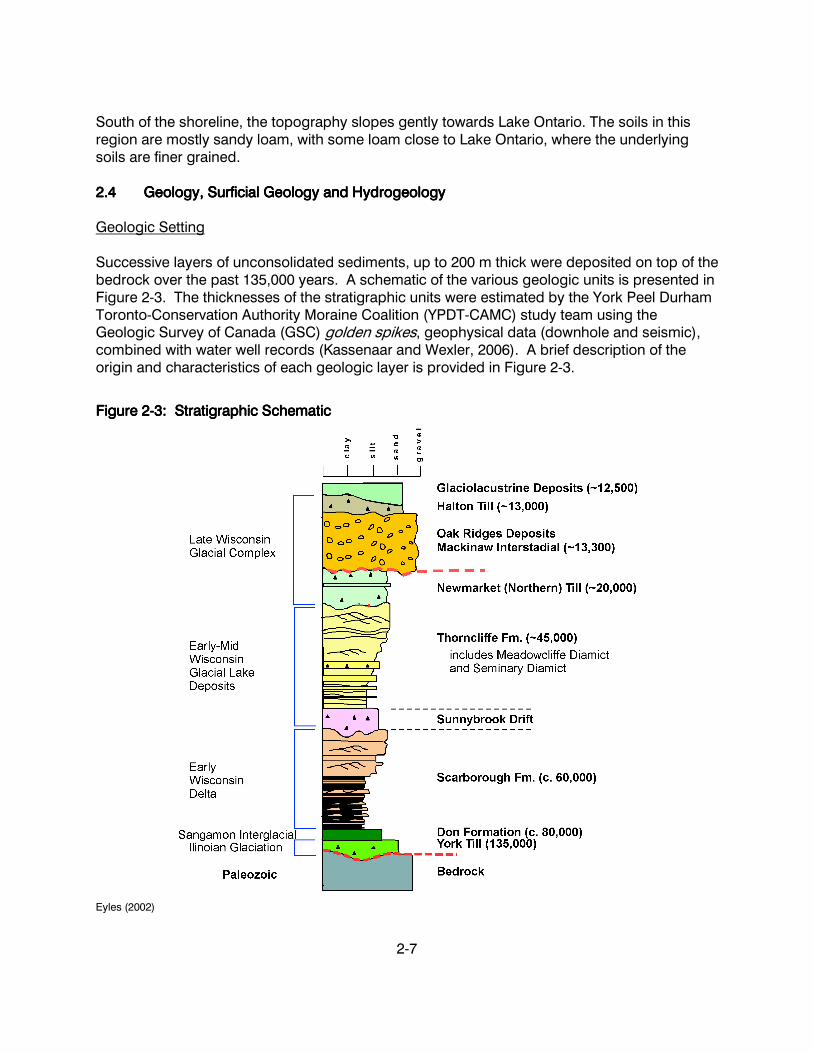
South of the shoreline, the topography slopes gently towards Lake Ontario. The soils in this region are mostly sandy loam, with some loam close to Lake Ontario, where the underlying soils are finer grained. 2.42.42.42.4 GeologyGeologyGeologyGeology, Surficial Geology and Hydrogeology, Surficial Geology and Hydrogeology, Surficial Geology and Hydrogeology, Surficial Geology and Hydrogeology Geologic Setting Successive layers of unconsolidated sediments, up to 200 m thick were deposited on top of the bedrock over the past 135,000 years. A schematic of the various geologic units is presented in Figure 2-3. The thicknesses of the stratigraphic units were estimated by the York Peel Durham Toronto-Conservation Authority Moraine Coalition (YPDT-CAMC) study team using the Geologic Survey of Canada (GSC) golden spikes, geophysical data (downhole and seismic), combined with water well records (Kassenaar and Wexler, 2006). A brief description of the origin and characteristics of each geologic layer is provided in Figure 2-3.
Figure Figure Figure Figure 2222----3333: Stratigraphic Schematic: Stratigraphic Schematic: Stratigraphic Schematic: Stratigraphic Schematic
Eyles (2002)

2-8
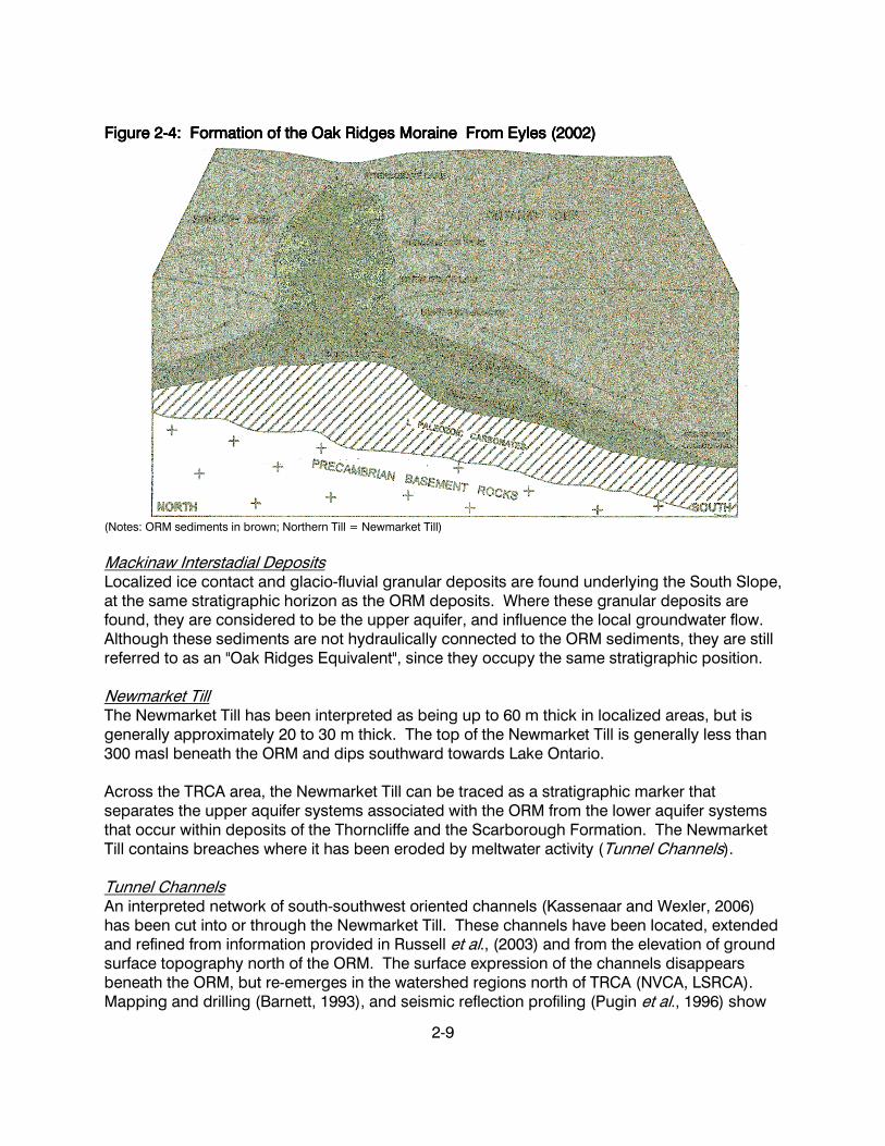
Bedrock The approximately 440 million year-old bedrock is comprised of Late Ordovician shales of the Whitby Formation. The bedrock surface declines southward from an elevation of approximately 180 masl beneath the ORM to approximately 40 masl at Lake Ontario. The shale bedrock is exposed in the lower branches of the Main Rouge and Little Rouge Rivers where the channels cut down through the bedrock surface. Surficial Glaciolacustrine Deposits The uppermost regionally significant surficial geologic unit consists of a sequence of thin glaciolacustrine deposits that form a veneer over the underlying Halton and Newmarket Tills. These deposits vary from nearshore sands and gravel beach deposits of the Lake Iroquois shoreline, to the fine sands, silts and clays of glaciolacustrine ponds that occur north of the Lake Iroquois shoreline. The deposits generally form a thin veneer over the underlying sediments, although locally they can be several metres thick. Halton Till The latest glacial ice advance over the southern part of the TRCA area occurred from the Lake Ontario Basin about 13,000 years ago, and resulted in the deposition of the Halton Till. Based on the analyses conducted as part of the YPDT-CAMC project, and recent mapping by the GSC, it has been concluded that the Halton Till forms the surficial till unit that extends southward to the Lake Iroquois shoreline. The Halton till is texturally variable, but is generally a sandy silt to clayey silt till interbedded with silt, clay, sand and gravel (Russell et al., 2002). In some areas, it is very clay-rich where the Halton Ice has overridden glaciolacustrine deposits. The Halton Till is typically 3 to 6 m thick, with a maximum thickness of 40 m in the Rouge River watershed. On the southern flanks of the ORM, the Halton Till has overridden the granular ORM deposits, extending as far north the Vandorf Sideroad near Stouffville. Oak Ridges Moraine (ORM) Deposits The ORM is an extensive, stratified, sediment complex measuring 160 km in length and 5 to 20 km in width, and arranged as four sediment wedges, each widening in the westward direction. The wedges are at the ends of large channels extending from Albion Hills, Uxbridge, Pontypool and Rice Lake (Sharpe et al., 1994; Barnett et al., 1998). The portion in the Rouge River watershed lies within the Uxbridge Sediment Wedge that contains a number of delta fan features, two associated sand plains (Goodwood and Ballantrae), as well as moraine features. The moraine extends beyond the ORM planning area in the subsurface and is estimated to reach a thickness of 150 m. The base of the ORM is underlain by the Newmarket Till. The deposits are interpreted as glaciofluvial, transitional to glaciolacustrine subaqueous fan, and delta sediments. They are believed to have been deposited in a glacial lake ponded between two glacial ice lobes (Simcoe and Ontario Lobes) and the Niagara Escarpment to the west approximately 12,000 to 13,000 years ago, during the Mackinaw Interstade (Eyles, 2002). The formation of the ORM between two ice lobes is shown in Figure 2-4.
2-9
Figure Figure Figure Figure 2222----4444: : : : Formation of tFormation of tFormation of tFormation of the Ohe Ohe Ohe Oak ak ak ak RRRRidges idges idges idges MMMMoraineoraineoraineoraine FromFromFromFrom Eyles Eyles Eyles Eyles ((((2002200220022002))))
(Notes: ORM sediments in brown; Northern Till = Newmarket Till)
Mackinaw Interstadial Deposits Localized ice contact and glacio-fluvial granular deposits are found underlying the South Slope, at the same stratigraphic horizon as the ORM deposits. Where these granular deposits are found, they are considered to be the upper aquifer, and influence the local groundwater flow. Although these sediments are not hydraulically connected to the ORM sediments, they are still referred to as an "Oak Ridges Equivalent", since they occupy the same stratigraphic position. Newmarket Till The Newmarket Till has been interpreted as being up to 60 m thick in localized areas, but is generally approximately 20 to 30 m thick. The top of the Newmarket Till is generally less than 300 masl beneath the ORM and dips southward towards Lake Ontario. Across the TRCA area, the Newmarket Till can be traced as a stratigraphic marker that separates the upper aquifer systems associated with the ORM from the lower aquifer systems that occur within deposits of the Thorncliffe and the Scarborough Formation. The Newmarket Till contains breaches where it has been eroded by meltwater activity (Tunnel Channels). Tunnel Channels An interpreted network of south-southwest oriented channels (Kassenaar and Wexler, 2006) has been cut into or through the Newmarket Till. These channels have been located, extended and refined from information provided in Russell et al., (2003) and from the elevation of ground surface topography north of the ORM. The surface expression of the channels disappears beneath the ORM, but re-emerges in the watershed regions north of TRCA (NVCA, LSRCA). Mapping and drilling (Barnett, 1993), and seismic reflection profiling (Pugin et al., 1996) show

2-10
that the tunnel channels continue beneath the ORM. The tunnel channels are, in places, confined within the Newmarket Till, but in others, have eroded through the till into the lower sediments. The channels are 1 to 4 km wide and up to 30 m deep. The channels mainly contain sandy sediments; however, some channels contain thick (10 to 15 m) cross-bedded gravels (Shaw and Gorrell, 1991; Pugin et al., 1999; Russell et al., 2002). The channel network is attributed to subglacial floods (e.g., Barnett, 1990; Shaw and Gilbert, 1990; and Russell et al., 2002). These channels may be hydrogeologically significant as high yield aquifers (Sharpe et al., 1996) or, depending on channel infill, will affect the amount of leakage between upper aquifers associated with the ORM and deeper aquifers situated within the Thorncliffe Formation and the Scarborough Formation. The most easterly channel in TRCA's jurisdiction is termed the Ballantrae Channel, and extends through the Mount Albert and Ballantrae areas, ending beneath the moraine within the headwaters of the Rouge River watershed. Thorncliffe Formation The Thorncliffe Formation deposits represent glaciofluvial deposition of sand, and silty sand in the low-lying areas of the underlying deposits. Further to the south, the formation comprises predominantly glaciolacustrine deposition of silt, sand, and pebbly silt and clay deposited by glacial meltwaters entering a deep, ice-dammed ancestral Lake Ontario. This unit was deposited approximately 45,000 years ago (30,000 to 50,000 years ago Barnett, 1992). Geotechnical investigations for trunk sewer projects, particularly along 16th Avenue near Markham, encountered considerable variation in grain size and thickness of sands within the Thorncliffe Formation. This is interpreted to represent coarser material deposited by fluvial or subaqueous processes in a north to south linear or fan-like fashion from a more northerly source (Sharpe et al., 2002), similar to that proposed for parts of the underlying Scarborough Formation (Kelley and Martini, 1986). The fine-grained sand and silty sand deposits represent deposition in a more distant position from the sediment source. The deposits of the Thorncliffe Formation are thickest beneath the ORM. Sunnybrook Drift The Sunnybrook Drift unit was deposited in close proximity to an ice sheet as it finally reached the TRCA area about 45,000 years ago. The Sunnybrook Drift is interpreted to be a clast-poor mud (silt and clay) deposited on the floor of a glacially dammed lake approximately 100 m deeper than the modern Lake Ontario (Eyles, 2002). Boulders and pebbles are rare and are interpreted to result from melting icebergs. The Sunnybrook Drift is generally less than 10 to 20 m thick but becomes thicker over low points in the underlying layers. Scarborough Formation The oldest exposed unit, the Scarborough Formation (< 80,000 years BP) comprises a mixture of coarse deltaic sands, silts and muds. Several channels up to 100 m deep and 1 km wide were cut into the delta top and subsequently infilled by pebbly mud (Sunnybrook Diamict). Evidence of groundwater discharge from the permeable Scarborough Formation appears in
2-11
the form of small cattail marshes, mixed swamps on relict terraces and White Cedar seepage slopes in the Rouge River Valley south of Twyn Rivers Drive and west of Meadowvale Road. The Scarborough Formation marks the beginning of the Wisconsinan glaciation, which started approximately 70 to 80,000 years ago. The Scarborough Formation deposits are interpreted as being a fluvial-deltaic system fed by large braided melt-water rivers draining from an ice sheet. These rivers deposited organic-rich (peat) sands over silts and clays (Karrow, 1967; Eyles, 1997). The lower silts and clays are up to 60 m thick at the Scarborough Bluffs along Lake Ontario. The upper sands are channelized in some locations, possibly as a result of fluvial erosion due to fluctuating lake levels. The Scarborough Formation deposits are believed to extend from the Lake Ontario shore northward towards Lake Simcoe (Fligg and Rodrigues, 1983; Eyles et al., 1985; Pugin et al., 1996; Sharpe et al., 1996). Although this formation is present throughout much of the Rouge River watershed, it is only found in appreciable thickness in the bedrock valleys. The Scarborough Formation rests on the Whitby shale bedrock. Surficial Geology The surficial expression of the uppermost geologic layers is shown as surficial geology (Figure 2-5) which influences the watershed’s physiography, topography and soils discussed in section 2.3. Hydrogeology Groundwater flow within the underlying geologic setting is generally from north in the ORM to south at Lake Ontario. A conceptual model of the interpreted groundwater flow system is shown in Figure 2-6. This cross-section highlights the arrangement and classification of the geologic deposits into aquifer and aquitard units. A shallow groundwater system occurs above the Newmarket Till within deposits of the Halton Till and Mackinaw Interstadial deposits. In addition to this shallow system, three main aquifer systems have been identified: 1. Oak Ridges Aquifer Complex – ORAC (Oak Ridges sediments, also known as the Upper Aquifer); 2. Thorncliffe Aquifer Complex – TAC (Thorncliffe Formation, also known as the Middle Aquifer); and 3. Scarborough Aquifer Complex – SAC (Scarborough Formation, also known as the Lower Aquifer).
It is important to note that not all aquifer and aquitard units are present throughout the study area. For instance, some of the deposits older than the Newmarket Till thin and pinch-out in the southern parts of the basin where there is less overburden in general. The Newmarket Till has also been eroded in various locations by glacial tunnel channels in the northern part of the watershed and recent fluvial processes in the southern portion of the watershed. Together, the surficial and subsurface geologic settings influence water movement within the watershed, including recharge and discharge rates and locations. These functions are discussed further in Chapter 4 (Groundwater Quantity and Quality).

2-12
Figure Figure Figure Figure 2222----5555: Surficial Geology: Surficial Geology: Surficial Geology: Surficial Geology

2-13
Figure Figure Figure Figure 2222----6666: : : : Conceptual Model of GeolConceptual Model of GeolConceptual Model of GeolConceptual Model of Geology and Groundwater Flowogy and Groundwater Flowogy and Groundwater Flowogy and Groundwater Flow
Note: Conceptual ground water flow model of the south slope of the Oak Ridges Moraine, adapted from Gerber and Howard 2002
ORACORACORACORAC
TACTACTACTAC
ORAC:ORAC:ORAC:ORAC: Upper AquiferUpper AquiferUpper AquiferUpper Aquifer TAC:TAC:TAC:TAC: Middle AquiferMiddle AquiferMiddle AquiferMiddle Aquifer SAC:SAC:SAC:SAC: Lower AquiferLower AquiferLower AquiferLower Aquifer
SACSACSACSAC

2-14
2.52.52.52.5 ReferencesReferencesReferencesReferences Barnett, P. J., D. R. Sharpe, H. A. J. Russell, T. A. Brennand, G. Gorrell, F. Kenny and A. Pugin.
1998. On the origins of the Oak Ridges Moraine. Canadian Journal of Earth Sciences. Vol. 35, pp. 1152 – 1167.
Barnett, P. J. 1993. Geological investigations in the Oak Ridges Moraine area, parts of Scugog, Manvers and Newcastle Township Municipalities and Oshawa Municipality, Ontario. In Summary of fieldwork and other activities 1993. Ontario Geological Survey, Miscellaneous Paper. Vol. 162, pp. 158-159.
Barnett, P. J. 1990. Tunnel valleys: evidence of catastrophic release of subglacial meltwater, central-southern Ontario, Canada. In Abstracts with Programs, Northeastern Section, Geological Society of America, Syracuse, New York. p. 3.
Chapman and Putnam. 1984. Physiography of Southern Ontario, 3rd Edition. Ontario Geological Survey, Special Vol. 2.
Environment Canada. 2007. Canadian Climate Normals 1971-2000. http://climate.weatheroffice.ec.gc.ca/climate-normals/
Eyles, N. 2002. Ontario Rocks: Three Billion Years of Environmental Change. Fitzhenry and Whiteside, Markham, Ontario.
Eyles, 1997. Environmental geology of a supercity: the Greater Toronto Area. In Eyles, N. (Ed), Environmental Geology of Urban Areas, Geological Association of Canada, Geotext #3, 7-80.
Eyles, N., B. M. Clark, B. G. Kaye, K. W. F. Howard and C. H. Eyles. 1985. The application of basin analysis techniques to glaciated terrains: an example from the Lake Ontario basin, Canada. Geoscience Canada, W. Vol. 12, pp. 22-32.
Fligg, K. and B. Rodrigues. 1983. Geophysical well log correlations between Barrie and the Oak Ridges Moraine. Water Resources Branch, Ontario Ministry of the Environment, Map 2273.
Gerber, R. E. and K. W. F. Howard. 2000. Recharge through a Regional Till Aquitard: Three-Dimensional Flow Model Water Balance Approach. Ground Water. Vol. 38(3), pp. 410-422.
Karrow, P. F. 1967. Pleistocene geology of the Scarborough area. Ontario Department of Mines, Geological Report 46.
Kassenaar, J. D. C. and Wexler, E. J. 2006. Groundwater Modelling of the Oak Ridges Moraine Area. CAMC-YPDT Technical Report #01-06.
Kelley, R. I. and I. P. Martini. 1986. Pleistocene glacio-lacustrine deltaic deposits of the Scarborough Formation, Ontario, Canada. Sedimentary Geology. Vol. 47, pp. 27-52.
2-15
Pugin, A., S. E. Pullan and D. R. Sharpe. 1999. Seismic facies and regional architecture of the Oak Ridges Moraine area, Southern Ontario. Canadian Journal of Earth Sciences, Vol. 36, pp. 409-432.
Pugin, A., S. E. Pullen and D. R. Sharpe. 1996. Observations of tunnel channels in glacial sediments with shallow land-based seismic reflection. Annals of Glaciology. Vol. 22, pp. 176-180.
Russell, H. A. J., D. R. Sharpe and C. Logan. 2003 (Draft). Tunnel Channels of the Oak Ridges Moraine and Greater Toronto Area, Southern Ontario. Geological Survey of Canada, Open File Scale 1:250,000.
Russell, H. A. J., R. W. C. Arnott and D. R. Sharpe. 2002. Evidence for rapid sedimentation in a tunnel channel, Oak Ridges Moraine, Southern Ontario, Canada. Sedimentary Geology. Vol. 3134, pp. 1-23.
Sanderson, M. 2004. The Impact of Climate Change on Water in the Grand River Basin, Ontario. Department of Geography Publication Series No. 40. University of Waterloo, Waterloo, Ontario.
Sharpe, D. R., M. J. Hinton, H. A. J. Russell and A. J. Desbarats. 2002. The Need for Basin Analysis in Regional Hydrogeological Studies: Oak Ridges Moraine, Southern Ontario. Geoscience Canada. Vol. 29(1), pp. 3-20.
Sharpe, D. R., L. D. Dyke, M. J. Hinton, S. E. Pullan, H. A. J. Russell, T. A. Brennand, P.J. Barnett and A. Pugin. 1996. Groundwater prospects in the Oak Ridges Moraine area, Southern Ontario: application of regional geological models. In Current Research 1996. Geological Survey of Canada, pp. 181-190.
Sharpe, D. R., L. D. Dyke and S. E. Pullan. 1994. Hydrogeology of the Oak Ridges Moraine: partners in geoscience. Geological Survey of Canada, Open File 2867.
Shaw, J. and G.A. Gorrell. 1991. Subglacially formed dunes with bimodal and graded gravel in the Trenton drumlin field, Ontario, Canada. Géographie physique et Quaternaire, Vol. 45, pp. 21-34.
Shoreplan Engineering Ltd. 1998. Port Union Shoreline Improvements Design Report. Prepared for Toronto and Region Conservation Authority.
TRCA. 2004. Preston Lake Management Plan. Toronto.