1981 inventory of pacific electric routes -...
TRANSCRIPT

1981 Inventory of
PACIFIC ELECTRICROUTES
red byANGELES - DISTRICT 7 - PUBLIC TRANSPORTATION BRANCH
I
J..,.I~ "
HE
rI 5428 .I58P37c.2
" ' archive

•
1981
INVENTORY
OF
PACIFIC ELECTRIC ROUTES
PREPARED BY
CALIFORNIA DEPARTMENT OF TRANSPORTATION
(CALTRANS)
DISTRICT 07
PUBLIC TRANSPORTATION BRANCH
FEBRUARY 1982
•
I.
II.
III.
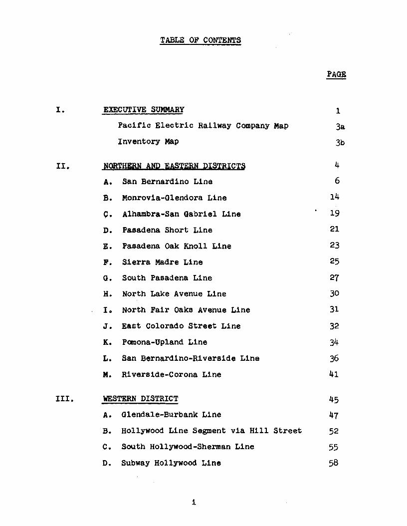
TABLE OF CONTENTS
EXECUTIVE SUMMARY
Pacific Electric Railway Company Map
Inventory Map
NQR'I'HIRN AND EASTERN DISTRICTS
A. San Bernardino Line
B. Monrovia-Glendora Line
C. Alhambra-San Gabriel Line
D. Pasadena Short Line
E. Pasadena Oak Knoll Line
F. Sierra Madre Line
G. South Pasadena Line
H. North Lake Avenue Line
10 North Fair Oaks Avenue Line
J. East Colorado Street Line
K. Pomona-Upland Line
L. San Bernardino-Riverside Line
M. Riverside-Corona Line
WESTERN DISTRICT
A. Glendale-Burbank Line
B. Hollywood Line Segment via Hill Street
C. South Hollywood-Sherman Line
D. Subway Hollywood Line
i
PAGE
1
3a
3b
4
6
14
19
21
23
25
27
30
31
32
34
36
41
45
47
52
55
58

TABLE OF CONTENTS(Contd. )
PAGE-III. WESTERN DISTRICT
(Conta. )
E. San Fernando valley Line 61
F. Hollywood-Venice Line 68
o. Venice Short Line 71
H. Santa Monica via Sawtelle Line 76
I. westgate Line 80
J. Santa Monica Air Line 84
K. Soldier's Home Branch Line 93
L. Redondo Beach-Del Rey Line 96
M. Inglewood Line 102
IV. SOUTHIRN DISTRICT 106
A. Long Beach Line 108
B. American Avenue-North Long Beach Line 116
c. Newport-Balboa Line 118
D. E1 Segundo Line 123
E. San Pedro via Dominguez Line 129
F. Whittier Line 133
G. Santa Ana-Huntington Beach Line 139
H. Santa Ana Line 143
I. Redondo via Gardena Line 147
J. San Pedro via Torrance Line 151
i1

"'i
v.
TABLE OF CONTENTS(Contd. )
MAJOR IMPLEMENTATION ISSUES
A. Northern and Eastern Districts
B. Western District
c. Southern District
111
PAGE-
156
156
159
162

I. EXECUTIVE SUMMARY
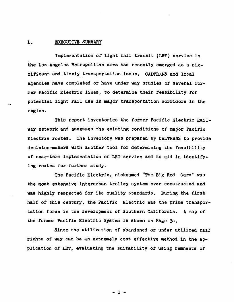
I. EXECUTIVE SUMMARY
Implementation of light rail transit (LRT) service in
the Los Angeles Metropolitan area has recently emerged as a sig
nificant and timely transportation issue. CALTRANS and local
agencies have completed or have under way studies of several for
mer Pacific Electric lines, to determine their feasibility for
potential light rail use in maJor transportation corridors in the
region.
This report inventories the former Pacific Electric Rail
way network and assesses the existing conditions of maJor Pacific
Electric routes. The inventory was prepared by CALTRANS to provide
decision-makers with another tool for determining the feasibility
of near-term implementation of LRT service and to aid in identify
ing routes for fUrther study.
The Pacific Electric, nicknamed t~he Big Red Cars" was
the most extensive interurban trolley system ever constructed and
was highly respected for its quality standards. During the first
half of this century, the Pacific Electric was the prime transpor
tation force in the development of Southern California. A map of
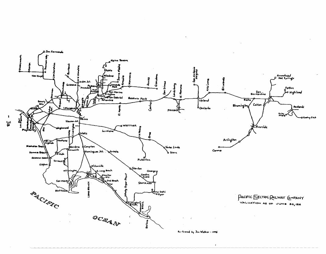
the former Pacific Electric System is shown on Page 3a.
Since the utilization of abandoned or under utilized rail
rights of way can be an extremely cost effective method in the ap
plication of LRT, evaluating the SUitability of using remnants of
- 1 -

the Pacific Electric System is a logical step towards future LRT
development.
The inventory covers approximately 440 miles of the for
mer Pacific Electric System. Historical investigation was followed
by a field review of all the lines. Review and inventory activities
included evaluating alignments in terms of the following factors:
•
•
•
Structural Obstructions
Surface Conditions
Neighborhood Environment
Adjacent Facilities
Existing Usage
The present day conditions of the lines were then cate
gorized under Several classifications of usage. A composite map
Showing the lines and their usage is included on Page 3b. A sum
mary of usages and mileages is prOVided in the following table:
EXISTING USAGE
EXISTING FREIGHT LINES
RIGHT OF WAY REMAINS,RAILS REMOVED
BOULEYABO MEDIAN
PAVED AS STREET/FREEWAY
BUILT UPON, OR USED FORANOTHER PURPOSE
- 2 -
MILEAGE
165
35
80
95
70
The final section of the report identifies major problems
and issues relative to each former Pacific Electric line that would
have to be addressed in order to implement light rail transit on the
line. Further analysis of these issues is needed to determine the
potential for developing light rail transit on specific lines.
This "Inventory of Pacific Electric Routes" is intended
to serve as a reference document in the overall development of rail
transit in the Los Angeles area. Much of the data included in this
inventory will aid in the identification and prioritization of lines
sUitable for "near-term" light rail implementation. Moreover, cer
tain sections of lines may prove appropriate as future links to
achieve regional connectivity or may prove desirable for use as a
local transit facility. It is hoped that the background information
provided herein will expedite the effective utilization of the valu
able transportation resource which the former Pacific Electric Sys
tem lines represent.
A special thanks is extended to INTERURBANS for permission
to use their maps trom Lines of the Paciflc Electric, Interurbans
Special 60~ Special 61.
- 3 -
fI
PACiFIC ~EC:TRIC.~ILWAY ~PANY
VAL.U~""'IO.... A.S O~ ,""UN. 30,ltl4

Legend- Existing Freight Lines•• R/W Remains, Rails Removed••• Boulevard Median11111111111111 Paved as Street/ FreewayAAA Built Upon, or Used for Another Purpose
//
;j'(i .1;,.- •..--./
. ~".~ ."~---~-f---'--;
I
:':-.;:~
;".:;:::.;:~.;

-3b-
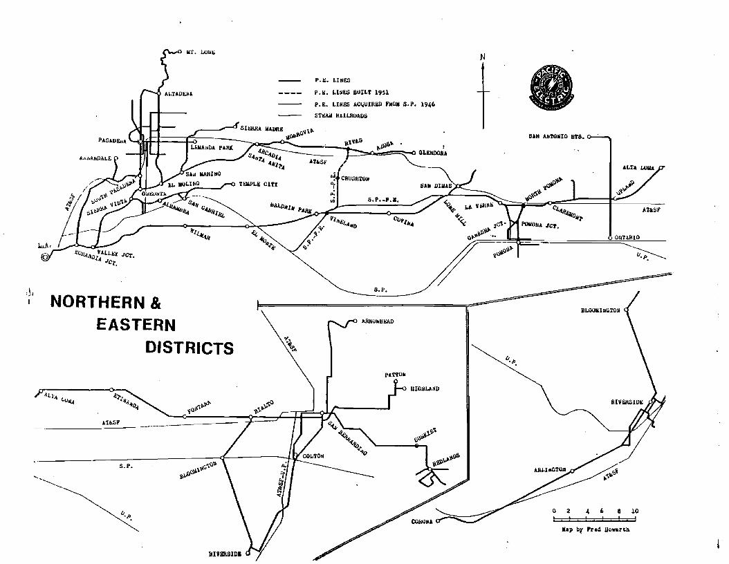
II. NORTHERN AND EASTERN DISTRICTS
-4-

I
8 10
ONTARIO
4 (,
Map b~ 'rad lIowarta
! . ! . ! ,! ! !o a
BLOOllhGTOH
lJ. J>.
SAN #.broIlIO 11'18.
•
1I. ".
N
~oV
rt-"~",0
~~ 1.1. VI1lNE ", AUS'4'<.; 04'1'
<;: 3C,'\' !'Ol/OU JC'l.
u~~~
UIlllIJ.IoND
PiotTO"
COJ-t...
.... \.';>'\~",,...-
S.P.
AJlROilUI::AD
,,
I'1"'£t."'_D
"!. CRUIlH'1'OIf"i
jl- 5.f,-'...,.
P.l>. LIliES
P.~. LINES BUILT 1951
P.E. LIUES AC~UIRED FHOM S.P. 1946
STr:AlI IlAlUlUADS
U'SF
"t~~.
T~LII: CITX
Jr./~
.......\\..1°"
0'J.1.\\t;,...0~~Vl
• -- \'.1" t.S J»S~'~ ~ - ..
1I. ".
5.1'.
AUSF
J::(.'iLA.1'I/J IIALLb;:t JCT.III JeT.
NORTHERN &EASTERN
DISTRICTS
iLlA,
(l
ALI·oj (.u~
--~~...............
:~II

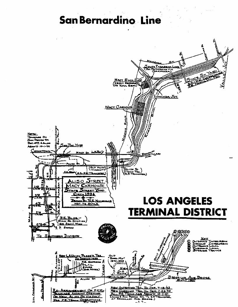
A. SAN BERNARDINO LINE
Original Route
Originating from the 6th and Main Street station in downtown
Los Angeles, the SAN BERNARDINO LINE exited to the east
via an elevated structure over downtown streets to reach
San Pedro Street at grade. The dual-tracks, running in the
pavement of the city streets, proceeded north on San Pedro
Street, east on Aliso Street (past its connection to Union
Station) to cross the Los Angeles River and Mission Road on the
Aliso Street Viaduct.
Directly east of Mission Road the tracks entered a private
way which ran easterly and then northerly under the Brooklyn
Avenue (Macy Street) Bridge. Paralleling Ramona Boulevard
(Since obliterated by construction of the I-lO Freeway), the
line continued northerly, past the Macy Carhouse, to Enchandia
Junction, where the SOUTH PASADENA LINE branched north. From
the junction, the tracks headed easterly, still paralleling
Ramona Boulevard on the right, through the State Street Yard
to Valley Junction, where the PASADENA and MONROVIA-GLENDORA
Lines also branched to the north.
From Valley Junction, (Soto Street & I-IO Freeway) the dual
tracks on private way continued east along Ramona Boulevard,
through city Terrace, Monterey Park, Alhambra, San Gabriel
and Rosemead to Baldwin Avenue in El Monte.
-6-
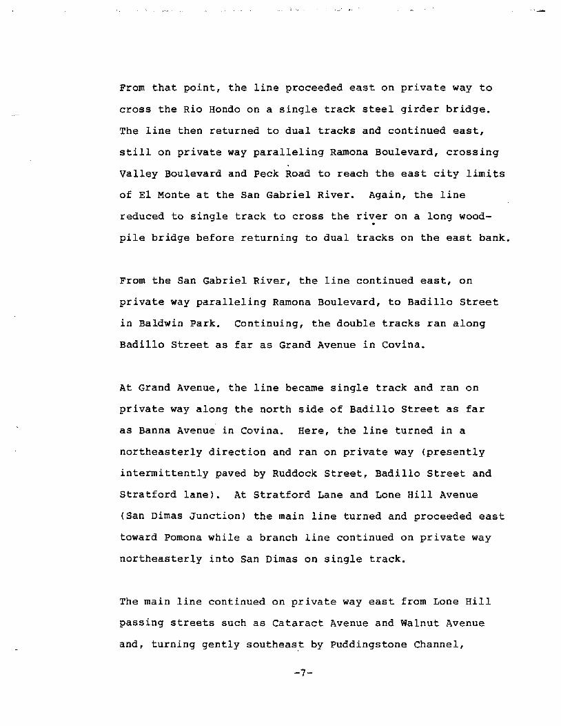
From that point, the line proceeded east on private way to
cross the Rio Hondo on a single track steel girder bridge.
The line then returned to dual tracks and continued east,
still on private way paralleling Ramona Boulevard, crossing
Valley Boulevard and Peck Road to reach the east city limits
of EI Monte at the San Gabriel River. Again, the line
reduced to single track to cross the river on a long wood
pile bridge before returning to dual tracks on the east bank.
From the San Gabriel River, the line continued east, on
private way paralleling Ramona Boulevard, to Badillo Street
in Baldwin Park. Continuing, the double tracks ran along
Badillo Street as far as Grand Avenue in Covina.
At Grand Avenue, the line became single track and ran on
private way along the north side of Badillo Street as far
as Banna Avenue in Covina. Here, the line turned in a
northeasterly direction and ran on private way (presently
intermittently paved by Ruddock Street, Badillo Street and
Stratford lane). At Stratford Lane and Lone Hill Avenue
(San Dimas Junction) the main line turned and proceeded east
toward Pomona while a branch line continued on private way
northeasterly into San Dimas on single track.
The main line continued on private way east from Lone Hill
passing streets such as Cataract Avenue and Walnut Avenue
and, turning gently southeas~ by Puddingstone Channel,
-7-
proceeded parallel to Oranqe street as far as E street in
Pomona. At E Street, a Pomona local branch line branched
south and continued on private way.
The SAN BERNARDINO LINE continued east, on sinqle track on
private way, para1lelinq the Santa Fe rails north of Arrow
Hiqhwav, and passinq Towne Avenue and Indian Hill Boulevard
in Claremont. Then turninq northeast1v the line proceeded
to Benson Avenue in Upland where it turned east aqain to run
between Arrow Hiqhwav and 9th street. At 13th Avenue, a
northeasterly course took the line to Alta Lorna, alonq private
way, as far as Grande street and Archibald Avenue.
proceedinq east from Alta Lorna in open country north of Base
line Road, the line passed Etiwanda Avenue and then turned
southeaster1v at East Etiwanda Creek into Fontana. It turned
east aqain at Citrus Avenue in Fontana and proceeded north of
Arrow Route Boulevard, parallelinq it throuqh Rialto toward
San Bernardino. The line entered San Bernardino in the
pavement of Rialto Avenue and proceeded east to a point
between "E" and "F" streets. Here, the SAN BERNARDINO LINE
turned north to follow a private way to its terminus at the
PE-SP station on 3rd Street.
Present Condition of Route
The former 6th and Main street Pacific Electric Station is
(now used partially as a SCRTD Bus Terminal, with the
-8-
remainder replaced by commercial businesses. The elevated
track structure between the station and San Pedro Street
has been removed and replaced by the expanded SeRTD bu~ld
ing and the Greyhound Bus Terminal and otherc;ommercial,( - ._--
development. Pavement has replaced tracks on San Pedro
Street between the former elevated tracks and Aliso Street.
/Pormer alignment of tracks on Aliso Street has been oblit
erated by construction of the Santa Ana Freeway east to the
LOB Angeles River. The Aliso Street Viaduct has been re
constructed to a freeway bridge and the tracks have been
removed.
(The existing tracks show up at Mission Road and parallel
Route 10 (San Bernardino) Freeway on the north side adja
cent to th~Busway until it crosses under the westbound
lanes of the Route 10 Freeway at the Route 7/10 Interchange
to occupy the median of the San Bernardino Freeway. Theof -lche 5 rrrc 5--tc-te 5t reet- ~.I r"<' hJS
single track~ ~been relocated on a well defined right
of way enclosed between concrete barrier walls and sepa
rated from automobile traffic. Reaching EI Monte, the
track exits under the westbound lanes of Route 10 and
crosses the Rio Hondo as it turns northward on an elevated
structure. The steel girder bridge over the Rio Hondo and
trackage were obliterated by the construction of the SCRTD
(El Monte Bus Facility. The private way has now been 'built
upon" by Santa Anita Boulevard, residential and commercial
sections from the bUB facility to the San Gabriel River.
Six remaining piers and abutments of the old San Gabriel
River Bridge are the only traces of the line that can be
found followed by a long stretch of former P E right of way
in Baldwin Park along Ramona Boulevard. Six condominiums
have been erected at Harlin Avenue on this right of way
and the remainder is vacant land into downtown Baldwin
Park. Through Baldwin Park to the junction at Badillo
I Street the former right of way has been replaced by parking
for downtown businesses. At the junction of Ramona Boulevard
and Badillo Street is the still standing red brick P E
substation. From the junction to Glendora Avenue, land
scaped median and paved city streets now replace the former
P E private way.
A trackless private way reemerges again east of Glendora
Street traversing in a north-easterly direction in form of
an empty land strip to Lone Hill Boulevard in the City of
San Dimas. The former SAN BERNARDINO LINE then turns east
ward on existing trackage which is now the SPTC Baldwin Park
Branch. Proceeding toward Pomona, some traces of 80 lb.
tracks in dilapidated state indicate the route, that once
served the city.
The line proceeds basically next to Arrow Highway in Pomona,
-La Verne, Claremont and Upland then crossing Rte. 66 north
easterly to Cucamonga, then turns south easterly in Fontana
and continues through Rialto to San Bernardino. This former
-10-
...

Pacific Electric line is now an industrial line serving
various enterprises along the route with some sidings
at those facilities.
The SPTC trackS consisting of fair ballast, and 90 lb.
rail continue almost to San Bernardino ending at the
SPTC Colton line connecting West Colton and Mojave.
It should be noted that Pacific Electric service between
Vineland (near Vineland Avenue in Baldwin Park) and Lone
Hill (near Lone Hill Avenue in San Dimas) was shifted
north to the acquired Southern Pacific Covina Branch on
November 4, 1946, at which time the old route along
Badillo Avenue was abaondoned. The new route on former
Southern Pacific tracks'was used until Pacific Electric
passenger service was discontinued on March 28, 1947.
The northern track still exists as part of the SPTC
Baldwin Park Branch.
- " -
San Bernardino Line
LOS ANGELESTERMINAL DISTRICT
NQ( OynsOUHp18& ;;;.. $_. 7-10:~
t1::[~i;J!~fd:__ - :s...""T'i S.P. s--....AT '-Yf'I _ ......_.)
_1 .,_
•
-- --.,
~,..••- .. ON.:s.....1>aD-.~Bta;.4'!!!, 4 .......~·D '0-1-'51
~"JPWtt

SAN BERNARDINO LINE
-13-

B. MONROVIA - GLENDORA LINE
Original Route
From the 6th and Main street Station in Los Angeles, the
MONROVIA-GLENDORA LINE ran on the SAN BERNARDINO LINE to
"Valley Junction" (near Marengo Street, west of Sota
Street) where the SAN BERNARDINO LINE continued east.
From "Valley Junction," the dual tracks continued on
private way, in a northeasterly direction, paralleling
Soto street on the west, crossing over Valley Boulevard
and the SPRR Mainline on a steel bridge and continuing
northerly to reach Indian village (in the vicinity of
Soto Street and Multnomah Street). Here, a four track
system began. A mile or so further north, the four tracks
crossed over Mission road on a concrete viaduct, and then
continued northwesterly on private way between the dual
roadways of Huntington Drive.
At Sierra Vista (Main street and Huntington Drive) the
ALHAMBRA-SAN GABRIEL LINE branched easterly from the four
track section and proceeded on Main Street, while the
MONROVIA-GLENDORA LINE continued north and then east still
between dual roadways on Huntington Drive, to "Oneonta
Junction" (Huntington Drive and Fair Oaks Avenue). Here,
the PASADENA SHORT LINE turned north on Fair Oaks Avenue.
The line then continued on a four track system as far as
"El Molino" (El Molino Street) where the system returned to
dual trackage. It continued northeasterly still between
-14-
the dual roadways of Huntington Drive, passed Oak Knoll
Avenue, (where the OAK KNOLL LINE proceeded north into
pasadena), and in a mile or so passed what is now known as
Sierra Madre Boulevard (where the local SIERRA MADRE LINE
turned north).
proceeding east, the MONROVIA-GLENDORA LINE passed Southerly
of Santa Anita Racetrack and continued northeasterly on
private way to st. Joseph Street in Arcadia. The line ran in
the pavement of St. Joseph Street from Santa Anita across the
ATSF Mainline to 2nd Avenue, where it went on private way, as
far as Olive Avenue at Monterey Avenue in Monrovia. The line
then continued in the pavement of Olive Avenue as far as
Shamrock Avenue.
From Shamrock Avenue, the dual tracks on private way, followed
along Olive Avenue and Royal Oaks Avenue to Las Lomas Road
where they then traversed open land to the San Gabriel River.
The river was crossed on a two track bridge, which was later
reduced to single track after 1938.
The line then continued across open land into Azusa and
entered city streets at 9th Street and Angelino Avenue. The
dual tracks reduced to single track on private way at 9th
Street and Pasadena Avenue. Thereafter, the line proceeded
east, north of Foothill Boulevard on private way to its
terminus in Glendora at Glendora Avenue.
-15-

Present Condition of Routeli 1')(01" f'a'-\( Spur
\ The only track remaining today is used as industrial spur~, --,-,.- ...-.,,/
near Marengo Street, west of Soto Street that runs adjacent
to Soto street to Mission Road. The remainder of the tracks
from Mission Road to Glendora Avenue in Glendora have been
removed.
The tracks have been replaced by paving and intermittent
variable width medians on Huntington Drive from Mission Road
to Santa Anita Avenue in Arcadia. The line on Huntington
Drive passed through Los Angeles, South Pasadena, San Marino,
Los Angeles County and Arcadia.
The former line has been "built upon" by res identia1 and
commercial buildings from Santa Anita Avenue to Fifth Avenue
in Monrovia. The private way remains today between Fifth
Avenue and Mayflower Avenue as an unimproved dirt strip with
the exception of a small park at Mayflower Avenue. From
Mayflower Avenue to Mountain Avenue in Monrovia the private
way has been "built upon" by residential and light commercial
buildings. The stretch from Mountain Avenue to Mount Olive
in Bradbury has been converted to a bicycle path. From Mount
Olive to the San Gabriel River, the private way has been
replaced by residential development.
Over the San Gabriel River, concrete piers with steel girders
and portions of concrete arch bridge are still visible today
where the former line ran.
-16-

The remainder of the line from the San Gabriel River to
Glendora has been obliterated by the Consolidated Rock
Quarries, Monrovia Nursery, Citrus College and various
residential development. The former depot site on
Glendora Avenue in Glendora has been replaced with a
shopping mall and the easterly extension for storage and
turnaround is a ballpark today.
- 17 -"

MONROVIA.GLENDORA LINE
- 10 -

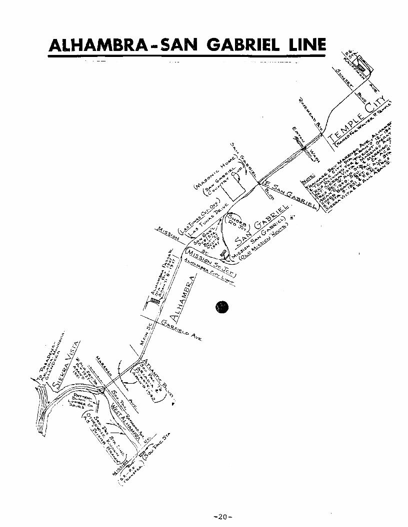
C. ALHAMBRA - SAN GABRIEL LINE
Originating Route
The ALHAMBRA-SAN GABRIEL LINE followed the same route as the
MONROVIA-GLENDORA LINE from the 6th and Main Street Station as
far as Sierra Vista (Huntington Drive and Main Street). From
this point, it diverged onto its own double-track line and ran
east and then southeasterly on private way in the center of
dual roadways of Main Street. At Raymond Avenue the dual road
way ended, and continued on double track in the center of
pavement of Main Street through the line Alhambra to Mission
Street in San Gabriel. Here, the double track ended and the
SAN GABRIEL LINE turned south in the center of Mission Street
to Mission San Gabriel. It then ran north via Junipero Sierra
Drive to the main line at Las Tunas Drive. Single track then
continued east through San Gabriel in the center of Las Tunas
Drive to a terminus in Temple City at Kaufman Avenue, where
"Temple City Park" now exists at the old location of the P E
station.
Present Condition of Route
There are no tracks remaining today along the entire route.
Main Street from Huntington Drive to Fremont Avenue in Alhambra
is an eight lane undivided paved city street. From Fremont
Avenue to Raymond Avenue there is a wide landscaped median with 6
lane paving. Continuing on Main Street from Raymond Avenue to
Del Mar Avenue the Street is a 6 lane undivided road.
In San Gabriel, Main Street becomes Las Tunas Drive. From Del
Mar Avenue in San Gabriel to Kaufman Avenue in Temple City/Las
Tunas nrive is a four lane undivided city street.
_ 1 Q _
ALHAMBRA - SAN GABRIEL LINE
-20-
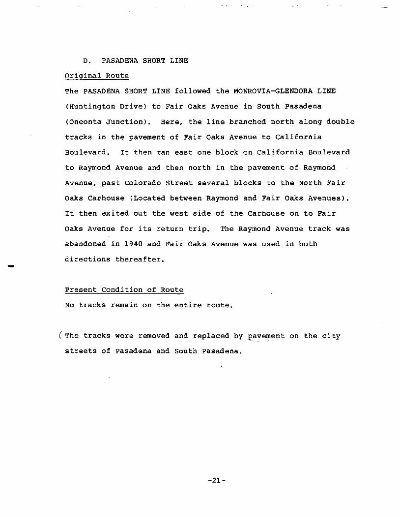
D. PASADENA SHORT LINE
Original Route
The PASADENA SHORT LINE followed the MONROVIA-GLENDORA LINE
(Huntington Drive) to Fair Oaks Avenue in South Pasadena
(Oneonta Junction). Here, the line branched north along double
tracks in the pavement of Fair Oaks Avenue to California
Boulevard. It then ran east one block on California Boulevard
to Raymond Avenue and then north in the pavement of Raymond
Avenue, past Colorado Street several blocks to the North Fair
Oaks Carhouse (Located between Raymond and Fair Oaks Avenues).
It then exited out the west side of the Carhouse on to Fair
Oaks Avenue for its return trip. The Raymond Avenue track was
abandoned in 1940 and Fair Oaks Avenue was used in both
directions thereafter.
Present Condition of Route
No tracks remain on the entire route.
(The tracks were removed and replaced by ~~vement on the city
streets of Pasadena and South Pasadena.
-21-

SV Best :,:,,1': 194613.664.061 r ••• pass.(J5~ SV, 6S~ Watts)
PSL a.st Year: 19L45,037,767 pa.seucers
PASADENA SHORT LINE
SiERRA VISTA LINE
"W".,... D't
So. FA'R 0/10.1(,$ X"!'.pI. 'P......
L.A. _ AI .us.gveQ;f! - 1....'TI!R.I:>.It.__e.c+ y,,_-~...__ Su.,A
... 't' .... ,
-22-
No. F"... g"MX C...1IliHoVlla. •
•••
"
.
-

E. PASADENA OAK KNOLL LINE,
Original Route
The line followed the MONROVIA-GLENDORA LINE to the end of the
four track system at El Molino Junction. From that point (at
Huntington Drive) two tracks, on private way, ran northerly on
what is presently Oak Knoll Avenue to the Huntington Hotel
(presently the Sheraton Huntington). At this point, the line
proceeded north in the pavement of city streets, running on
Oak Knoll Avenue and South Lake Avenue as far as Colorado
Street. It then turned west and ran on Colorado Street through
the Pasadena business district to Fair Oaks Avenue. Here, the
line turned north and ran on Fair Oaks Avenue several blocks to
the terminus of the route at the North Fair Oaks Carhouse.
Present Condition of Route
There are no existing tracks along the entire route.
Pavement has replaced the tracks on the city streets of San
Marino and Pasadena. The former private way, south of the
Huntington-Sheraton Hotel, is now Oak Knoll Avenue in San
Marino.
-23-

Ii><i
iii &,4 II II:.. 2 iiiQli. ~ .-6
.,.~c.
C! 4rJ.
~
Q Q J
~J~ -Ii ! ~% J.. l ! I
~ ;( ".. ..l:l :l
~.:.r: ., .;t.,:..J:>(
d J II~ :l Z ... .(
p:l~ <5 ~....>
Co... ToL........HDA.
'P-..:..
PASADENA OAK KNOLL
-24-
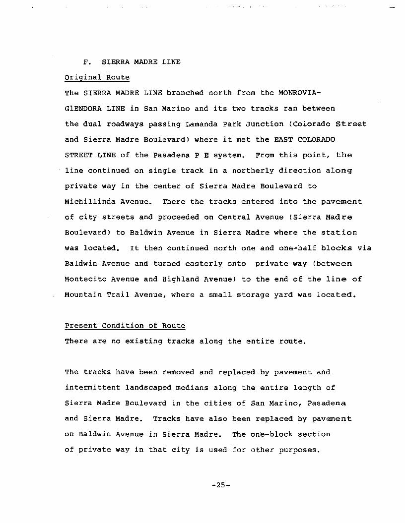
F. SIERRA MADRE LINE
Original Route
The SIERRA MADRE LINE branched north from the MONROVIA
GlENDORA LINE in San Marino and its two tracks ran between
the dual roadways passing Lamanda Park Junction (Colorado street
and Sierra Madre Boulevard) where it met the EAST COLORADO
STREET LINE of the Pasadena P E system. From this point, the
line continued on single track in a northerly direction along
private way in the center of Sierra Madre Boulevard to
Michillinda Avenue. There the tracks entered into the pavement
of city streets and proceeded on Central Avenue (Sierra Madre
Boulevard) to Baldwin Avenue in Sierra Madre where the station
was located. It then continued north one and one-half blocks via
Baldwin Avenue and turned easterly onto private way (between
Montecito Avenue and Highland Avenue) to the end of the line of
Mountain Trail Avenue, where a small storage yard was located.
Present Condition of Route
There are no existing tracks along the entire route.
The tracks have been removed and replaced by pavement and
intermittent landscaped medians along the entire length of
Sierra Madre Boulevard in the cities of San Marino, Pasadena
and Sierra Madre. Tracks have also been replaced by pavement
on Baldwin Avenue in Sierra Madre. The one-block section
of private way in that city is used for other purposes.
-25-

e:..\ R UOOI
D ~
f"'Nt:OO
--L.-...... Rar...... __
C O ....OR...~OSn
-26-

G. SOUTH PASADENA LINE
original Route
The SOUTH PASADENA LINE originated at the 6th & Main Street
Station in downtown Los Angeles. The dual track line exited
the station on to Main Street and ran in the pavement of city
streets: north on Main Street, east on 1st Street, north on
Los Angeles Street and east on Aliso street to the Los Angeles
River. The line crossed the river and Mission Road on the
Aliso Street Viaduct and ran east on private way (that has
been obliterated by construction of .the San Bernardino, 1-10
Freeway) to Echandia Junction. It then turned north, crossing
Mission Road and over the SPRR Mainline, and continued on
Then, turning east and proceeding
private way along the present route of the Golden State
Freeway (I-S) to Daly Street, where the line returned to
surface street travel. It then continued north on Daly Street
and Pasadena Avenue and then ran northeast on Figueroa Street
(
as far as York Boulevard.
on private way, (presently York Boulevard and Pasadena Avenue)
it crossed the Arroyo Seco on the Garvanza Viaduct and then
proceeded to Mission Street. The line continued east in the
pavement of Mission Street to reach its terminus at Fair Oaks
Avenue.
-27-
Present Condition of Route
(There are no existing tracks on the entire route.
Paving has replaced all the tracks from the former terminal
at 6th and Main street in Los Angeles on Main Street, First
Street, Los Angeles Street and Aliso Street.
(The tracks have been removed and the private way obliterated
by portions of the San Bernardino Freeway and the Golden
State Freeway to Daly Street.
The tracks have been removed and replaced by pavement on the
Pasadena Avenue, Figueroa street, and Mission street to
Fair Oaks Avenue in South pasadena.
-28-

SOUTH PASADENA LINE
-29-
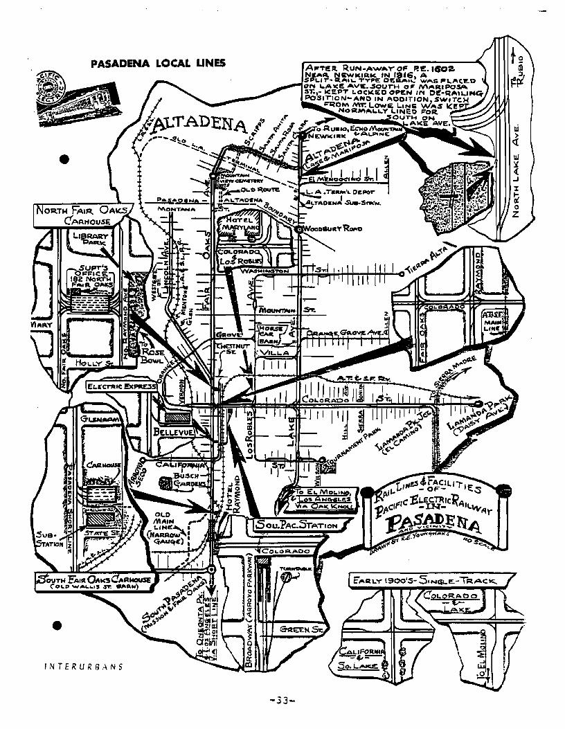
H. NORTH LAKE AVENUE LINE
Original Route
The NORTH LAKE AVENUE LINE was a local Pasadena line that
traveled on a double track system in pavement of Lake Avenue
from colorado Boulevard north to Woodbury Road. It then
proceeded north on a single track to El Mendocino Street
(Mendocino street) where it turned east to its terminus at Allen
Avenue.
Present Condition of Route
There are no existing tracks along the entire route.
Pavement has replaced the tracks on Lake Avenue and on
Mendocino street.
-30-

· ,...
1.- NORTH FAIR OAKS AVENUE LINE
Original Route
The NORTH FAIR OAKS AVENUE LINE was a local Pasadena Line that
ran in the pavement of Fair Oaks Avenue north from Colorado
Street along double tracks into Altadena. It turned into
private way (Mariposa Street) and proceeded east to its terminus
at Lake Avenue.
present Condition of Route
There are no existing tracks along the entire route.
Pavement has replaced the tracks on Fair Oaks Avenue and
Mariposa Street (former private way).
-31-

J. EAST COLORADO STREET LINE
original Route
The EAST COLORADO STREET LINE was a local Pasadena Line from
Fair Oaks Avenue to Daisy Avenue running in the pavement on
East Colorado Street (Colorado Boulevard). The Line was double
track from Fair Oaks to Lamanda Park Junction (Sierra Madre
Boulevard> and single track on the remainder of the line to
Lamanda Park (Daisy Avenue).
Present Condition of Route
There are no existing tracks along the entire route.
The tracks have been replaced by pavement on Colorado Boulevard
for the entire route.
-32-
PASADENA LOCAL UNE5
•
•INTERURBANS
-33-

K. POMONA - UPLAND LINE
Original Route
Originating from the Pomona Pacific Electric Station at Third
Street and Garey Avenue, the POMONA - UPLAND LINE proceeded
north on Garey Avenue, as far as Cadillac Drive. From there,
the line proceeded in a northeasterly direction on private way
until it joined the SAN BERNARDINO LINE, just east of Maple
Avenue. From there, the POMONA - UPLAND LINE ran on the SAN
BERNARDINO LINE to its terminus at College Avenue in Claremont.
Present Condition of Route
The tracks have been removed and replaced by pavement on Garey
Avenue to Cadillac Avenue. The former private way has been
"built upon" with homes to the former P E SAN BERNARDINO LINE
(SPTC Baldwin Park Branch).
-34-

POMONA • UPLAND LINE
Pomona Local Lines-35-
SAN ANTONIOfojEIGWTS
•

L. SAN BERNARDINO-RIVERSIDE LINE
original Route
The line originated at the SPW-PE Station on 3rd Street in
San Bernardino where connections were made to Los Angeles,
Redlands, and the SAN BERNARDINO LOCAL LINES.
The line was single track to Riverside and shared the private
way with a parallel SP LINE to Grand Terrace where the PE LINE
branched to the southest and continued to Riverside in its own
private way.
The line ran south from the 3rd Street Station west of and
parallel to E Street past the SAN BERNARDINO LINE junction to
Los Angeles at Rialto Avenue, then crossed the ATSF Redlands
District track at grade just south of Rialto Avenue. The line
then went past the PE shops and freight yard to cross Mill
Street. The line then turned southwesterly towards Colton
crossed Lytle Creek and ran north of Colton Avenue and then
crossed Mount Vernon Avenue at B street.
The line turned to the south at I Street (now Valley Boulevard>
and west of 9th Street, crossed SP Yuma to Los Angeles Main
Line, went past the SPTC west colton Passenger Station, and
crossed the SP West Colton Yards. The line continued to the
south through open land and then across the Santa Ana River on
a single-track through truss steel bridge to the west of the SP
Santa Ana River Bridge. In 1938, after PE discontinued
passenger service and due to flood damage PE and SP trains
shared the Santa Ana River Bridge.
-36-

After crossing the Santa Ana River the PE line branched south
westerly leaving the joint PE-SP private way and continued to
Riverside in its own private way. The line passed under the ATSF
Third District tracks, turned southerly and ran to Riverside west
of La Cadena Drive.
In Riverside, south of Spruce Street the line turned westerly
at Market Junction (La Cadena Drive, north of 1st Street). and
continued to Market Street.
Market Junction was the terminus of the SAN BERNARDINO-RIVERSIDE
LINE and was the transfer junction between PE, SP, and the UPRR.
From the Junction the RIVERSIDE-RIALTO LINE, ran to the northwest
operating on the UPRR tracks to Rialto,the RIVERSIDE-CORONA LINE
ran to the south to Corona, and the RIVERSIDE LOCAL LINES
connected to Market street.
In 1943, the PE line from the Santa Ana River to Market Junction
was abandoned and the PE operated on the SP tracks in private way
between the river and Market Junction. By this date the PE
operation was freight only. The joint use single track line went
south to Highgrove through the orange groves east of the ATSF
tracks. After crossing Columbia Avenue the line turned south
westerly, crossed the ATSF San Jacinto District tracks at-grade
south of Highgrove, crossed Massachusetts Avenue then turned to
the west. The line ran to the west, south of and parallel to
'Massachusetts Avenue, passed through Riverside Junction (west of
Kansas Avenue) then turned northwesterly, crossed over the ATSF
Third District tracks at-grade, then crossed La Cadena drive and
joined the PE tracks at Market Junction.
-37-
Present Condition of Route
The SP-PE Station on 3rd street in San Bernardino has been
removed. There is no sign of the private way between 3rd
Street and Rialto Avenue~ The single track line and private
way starts south of Rialto Avenue. This is now the SPTC San
Bernardino Branch to the south as far as Colton. The line in.
unimproved private way runs south between commercial buildings
to the west of and parallel to E Street. The line then crosses
Mill street and turns to the south west. The private way is
adjacent to the north edge of Inland Center Drive. The line
crosses over the Route I-IS E Freeway on a single-track plate
girder bridge. The private way remains adjacent to the street
until Lytle Creek and the Colton City limits are crossed and
the street name is changed to Colton Avenue.
At Western Avenue, the line in private way centers the unimproved
curbed median of Colton Avenue. At G Street and 10th Street the
curbed median ends and the single track line crosses G Street and
ends in the Lumber yard at G Street.
There is no sign of the line along 9th Street crossing Valley
Boulevard or passing under the San Bernardino Freeway to the
former SP West Colton Station (commercial usage). The line
no longer crosses the SPTC yard or Colton Subdivision Main Line.
The line starts again as a single track wye connection running
to the south from the West Colton Yards. The line is now the SPTC
Riverside Branch. The Branch is single track in private way the
entire length.
-38-
The private way is surfaced with cinder fill between the rails
as the line runs to the south east of and parallel to 9th street
to 0 street.
From 0 street the line runs across open country crossing the
Santa Ana River on the original single-track bridge to Grand
Terrace, passes under Barton Road then crosses over the Route
I-IS E Freeway on a plate girder bridge. The line then
crosses the Riverside County Line and Main Street in Highgrove.
The line runs to the south past houses and orange groves to
Columbia Street where the line turns southwesterly then crosses
the ATSF San Jacinto District tracks at-grade. The line then
crosses Spruce Street and passes under the Route I-IS E Freeway
at Chicago Street, then crosses Massachussets Avenue.
The line then turns to the west parallel to Massachusetts
Avenue, crosses Kansas Avenue then turns southwesterly from the
PE route to Third Street where the track ends.
The track on remainder of the line to Market Junction has been
removed. The unimproved private way remains. The trackless
railroad bridge over the Route I-IS E Freeway remains.
The section of PE route between the Santa Ana River and Market
Junction adjacent to La Cadena Drive that was abandoned in 1943,
has been replaced by the Route 1-15 E Freeway.
-39-

San Bernardino
.r
- Riverside
-40-
Line c
M. RIVERSIDE-CORONA LINE
Original Route
The line started at 6th and Main Streets in Riverside north of
the Mission Inn and ran south in the center lanes of Main Street
to 14th street where the line turned southwesterly to run in
the center of Magnolia Avenue. The line was double tracked on
Main Street between 1st Street and 14th Street. The remainder
of the line to Corona was single track with passing sidings.
The line went north on Main Street to 1st street where it
connected to the RIVERSIDE LOCAL LINES, to the RIVERSIDE-RIALTO
LINE and to Market Junction where it connected to the SAN
BERNARDINO'-RIVERSIDE LINE (all single track lines).
In 1936, service was transfered one block west to the MARKET
STREET LOCAL LINE and the Main Street rails were removed. Market
Street was a single track line in the pavement between 1st and
14th Streets and connected to Market Junction northeast of 1st
street and to the RIVERSIDE-RIALTO LINE north of 1st Street.
Market Street became Magnolia Avenue at 14th Street.
From 14th Street the single track line ran south in the center of
Magnolia Avenue, crossed the UPRR Second subdivision tracks, went
past Central Avenue to Magnolia Junction at Arlington Avenue.
At Arlington Avenue the line turned southwesterly and the track
entered the private way between the dual roadways of Magnolia
Avenue. The line ran southwesterly past Casa Blanca, then past
-41-
the Sherman Indian School to Arlington. The line continued
through Arlington to La Sierra, then crossed the ATSF Third
District tracks at grade (at May) at present Corona City
limits.
The line in private way on Magnolia Avenue continued to Porphyry
(Home Gardens) which was an interchange junction with the ATSF.
The line turned westerly and ran to the Corona Civic Center
where Magnolia Avenue ended. The line then left the private way
and turned southwesterly onto 3rd Street in Corona and ran down
the center of 3rd Street to the terminus at Merrill Avenue.
Present Condition of Route
The entire line has been abandoned and all the track has been
removed. The two steel plate girder bridges over Main Street
in Riverside remain in place. The private way east from Market
Street to the Route I-IS E Freeway remains. Pavement has
replaced the tracks on 1st, Main and Market Streets. Magnolia
Avenue is fully paved from 14th Street to Arlington Avenue with
some median islands at intersections.
From Arlington Avenue, the private way between the dual road
ways of Magnolia Avenue is now a narrow improved curbed median
of varing widths with power poles and trees to McKinzie Street
in Arlington. From McKinzie Street to Banbury Drive through
Arlington, the curbed improved median is narrow without the
utility poles. From Banbury Drive to La Sierra Avenue, the wide
-42-

curbed median is unimproved with utility poles and light poles
in the center.
From La Sierra Avenue passing under the Route 91 Freeway to
Pierce Street in La Sierra, the wide unimproved curbed median
has only pipe line warnings in it. From Pierce Street to the
ATSF crossing at May, the median is the full width of the
original private way and is curbed, unimproved, with utility
poles in the center.
After the ATSF crossing, the median is no longer curbed and the
( original track bed is visable. There are turn pockets in the
unimproved median at various street crossing until Magnolia
Avenue turns south to become 6th Street in Corona. There is
no sign of the private way to 3rd Street in Corona. The
remainder of the line on 3rd to Merrill Avenue has been replaced
by pavement.
-43-

RIVERSIDE - CORONA LINE
I
l";'\!l ~
101ll l''''--'1-1'1"'""- Qo"If'''''
IIUI n.t~-1t'""'"'""'" ~tY
IZU
131!!.

III. WESTERN DISTRICT
-45-
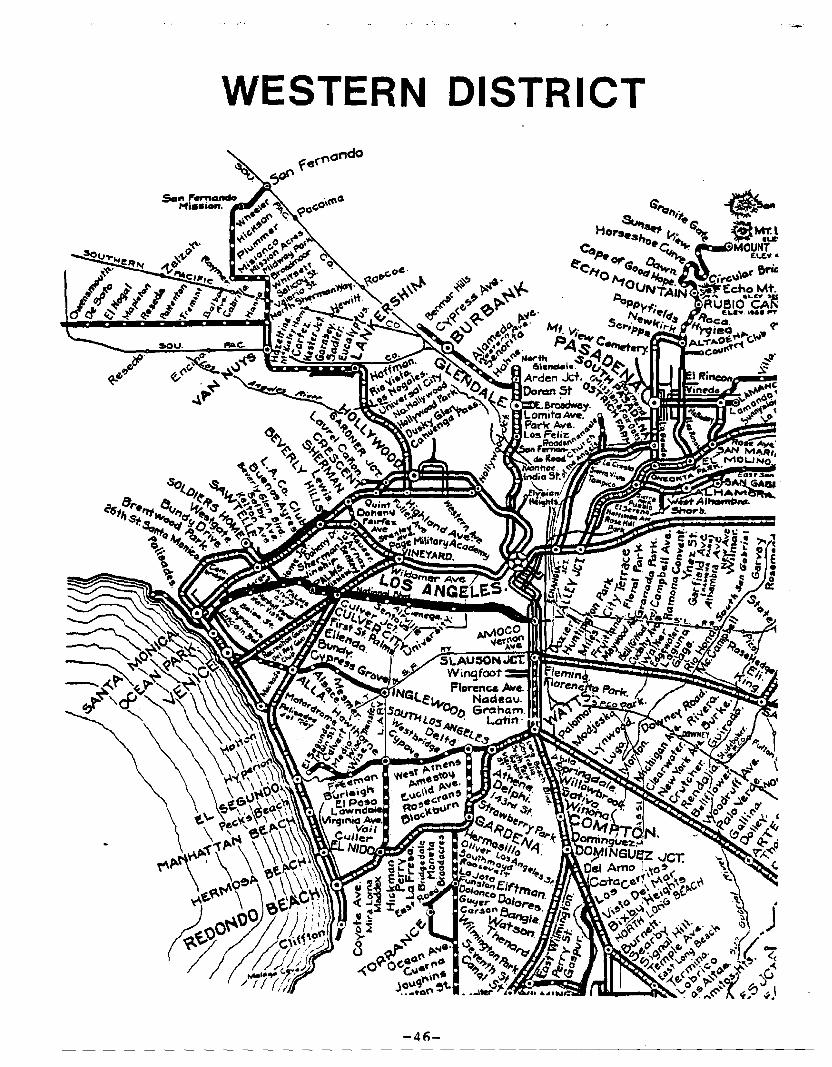
WESTERN DISTRICT
-4fl-
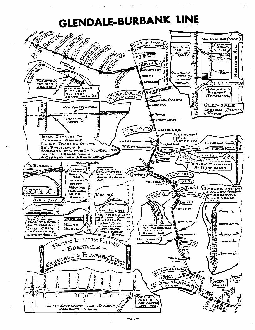
A. GLENDALE - BURBANK LINE
original Route
The route started at the Subway Terminal Building located in
Downtown Los Angeles on the west side of Hill Street just south
of 4th Street.
The Subway Terminal was completed in 1925 in order to bring the
rails northwesterly out of the congested downtown area, under
Bunker Hill, as far as the Toluca Yard and Substation. Once
out of the tunnel, dual tracks traversed the yard, crossed under
the Beverly Boulevard Viaduct into the center of Glendale
Boulevard where they ran northerly across Temple Street, and
in the 1950's under the Hollywood Freeway. Following in the
pavement of Glendale Boulevard, the tracks ran directly to the
west of Park Junction at intersection Park Avenue (one block south
of Sunset Boulevard). There was a connection up Park Avenue to
the HOLLYWOOD LINE on Sunset Boulevard.
The GLENDALE LINE, crossed under the Sunset Boulevard Bridge
where it entered a three-track private way which allowed passing
of the Glendale and Edendale cars. The three-track private way
extended north, in the center of Glendale Boulevard, past Montana
Street, Alvarado Street, and Berkeley Street as far as Effie
Street.
Double-track street operation was then resumed and ran to
Allesandro Street. Here, the dual tracks left Glendale Boulevard
-47-
to enter a private way through the Ivanhoe Hills, past Lakeview
Avenue and India Street to eventually run parallel to Riverside
Drive. A high wooden trestle and steel deck girder bridge carried
the dual tracks over Fletcher Drive with a clearance of 40 feet.
The line continued northwesterly, still along the edge of the
Hills, to Monte Santo, (Glendale Boulevard and Riverside Drive)
the terminus of the Edendale Line.
From Monte Santo, a series of three bridges carried the tracks _
northeasterly over Riverside Drive and Los Angeles River. The
line then traversed the Atwater district on private way in the
center of Glendale Boulevard to the Glendale City limit where the
line crossed Southern Pacific's coast line at grade (where
Glendale Boulevard becomes Brand Boulevard).
The dual rails then crossed San Fernando Road where the private
way ended and the line continued northerly in the pavement of
Brand Boulevard, crossing Los Feliz Boulevard, Chevy Chase
Boulevard, Colorado Boulevard, Broadway and Lexington Drive.
The main line continued north to Verdugo Wash where the line
became a single track.
At Arden Junction at Glenoaks Boulevard, the line branched. The
old main line continued north in the pavement of Brand Boulevard
to a terminus in North Glendale at Mountain Avenue. The BURBANK
LINE diverged westerly as a single-track line on private way in
the center of Glenoaks Boulevard, then continued westerly past
Central, Pacific, Highland, western, and Alameda Avenues to a

terminus in Burbank at Cypress Avenue. From 1925 to 1940 theJ
BURBANK LINE continued west, following Glenoaks Boulevard, on
private way to Ben Mar Hills (Eton Drive).
Present Condition of Route
No rails remain on the entire route.
The subway Terminal Building is no longer used as a transpor-
tation terminal, and the subway tunnel has been blocked off.
The Toluca Yard and Substation, located at the outbound end of
the tunnel, just south of the Beverly Boulevard Viaduct over
( Glendale Bouelevard, is abandoned. The viaduct is the same as it
was when the "Red Cars" passed underneath.
On Glendale Boulevard, from Beverly Boulevard, past Temple Street,
the Hollywood Freeway· and Echo Park, the tracks have been replaced
by pavement. Vertical clearance under the Hollywood Freeway and
Sunset Boulevard is approximately the same as when there were
tracks on Glendale Boulevard. North of Sunset Boulevard, Glendale
Boulevard is a divided roadway with a wide landscaped median,
(until it reaches Allesandro Street at the present southerly
terminus of the Glendale Freeway. From there north, through the
Ivanhoe Hills, near the Glendale-Golden state Freeways Inter-
change, part of the original roadbed has been replaced by the
Glendale Freeway. with the exception of some minor encroachments
the Allesandro cut private way is intact from the Glendale Freeway
to Fletcher Drive.
At Fletcher Drive, where the high bridge had been, all that
remains are its foundations. North of Fletcher Drive the
-49-
Rich1lnJ'ifl(l~oc,,1 R/W
trackless roadbed continues following the hills just southerly,
of the intersection of Glendale Boulevard and Riverside Drive.dV\C'lnt€Cmedr,lt-e}iil
I No traces remain of the series of three bridgesAovervthe LosRj\l~r.rdQ Dn"le,
Angeles River~Yld GleYlJole S',,)evard
Through Atwater, from the Memorial Bridge to just short of the
Southern Pacific main line, a landscaped median now replaces the
dual tracks in the center of Glendale Boulevard. At the end of
the landscaped median, Glendale Boulevard is now in an underpass"brLj"k nE"~r" Ie SP/Ar>'t,,,k ct:"di-Tor, I" GleYldj,l r
of the Southern Pacific main line tracks, where it becomes Brand
Boulevard.
Trackless Brand Boulevard crosses San Fernando Road, Chevy Chase
Drive, and Colorado Boulevard. In this section it is still the
very wide thoroughfare it was when it accommodated the Pacific5icr€t'+
Electric tracks. However, from Colorado Boulevard, across
Broadway, to Lexington Drive, Brand Boulevard has a decorative
landscaped median, including mid-block pedestrian crosswalks.
From Lexington Drive north to the Verdugo Wash and Glenoaks
Boulevard, rails have been replaced by pavement. On Brand
Boulevard north to Mountain Avenue, however, pavement has replaced
the rails.
Rails of the single-track BURBANK LINE, in the center of Glenoaks
Boulevard in the Cities of Glendale and Burbank have been removed.
In their place is a landscaped median continuing westerly from
Brand Boulevard past Central, Pacific, Highland, Western and
Alameda Avenues as far west as Providencia Avenue. The remainer
of the tracks, between Providencia and Cypress Avenue, centered
in Glenoaks Boulevard, have been replaced by pavement~
-50-
(
-
GLENDALE-BURBANK LINE
o
TR.C>C. C"'AN~IlS~'"BI,IR,aAH..... ACCOUNT
DOU8I.E- TR....CKING 0" L,,,,€SaT. -Pl'tOVIDENCIA (.BUR8ANw:. SorA. Y ..1II0.:r... Nov.-1)tc.,194 .9.TIIlI(, Bw::"r. ORANlire. G-"QV&~ CYPRESS THEN AeANOONCO• .J'.-:::::..-....
-51-
. ,I~
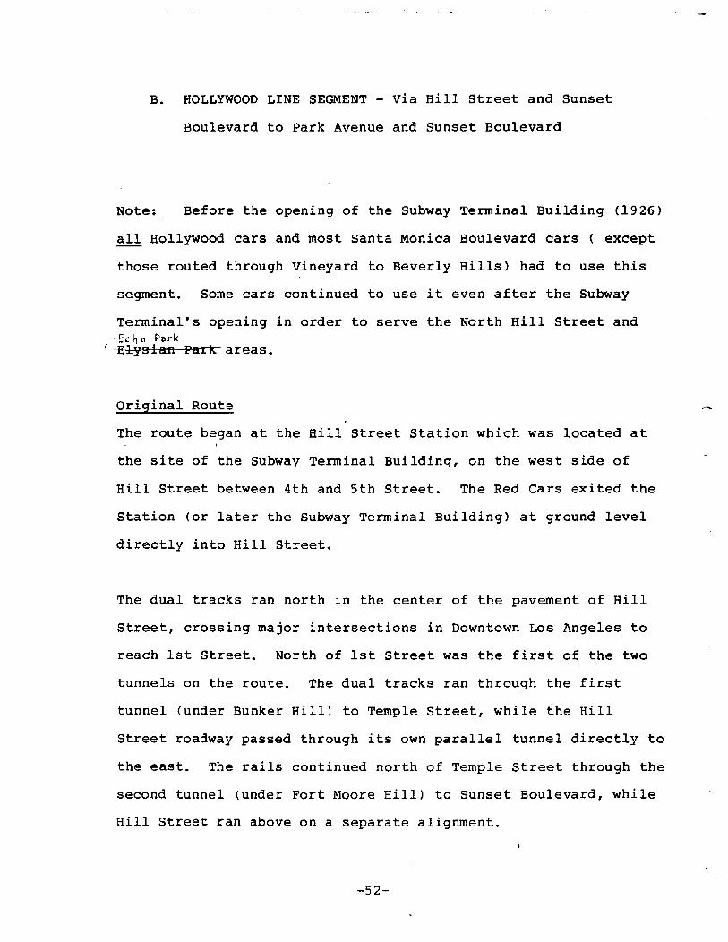
B. HOLLYWOOD LINE SEGMENT - Via Hill Street and Sunset
Boulevard to Park Avenue and Sunset Boulevard
Note: Before the opening of the Subway Terminal Building (1926)
all Hollywood cars and most Santa Monica Boulevard cars ( except
those routed through Vineyard to Beverly Hills) had to use this
segment. Some cars continued to use it even after the Subway
Terminal's opening in order to serve the North Hill Street and. fc h 0 Park
( Elysian Park- areas.
Original Route
The route began at the Hill Street Station which was located at
the site of the Subway Terminal Building, on the west side of
Hill Street between 4th and 5th Street. The Red Cars exited the
station (or later the Subway Terminal Building) at ground level
directly into Hill Street.
The dual tracks ran north in the center of the pavement of Hill
Street, crossing major intersections in Downtown Los Angeles to
reach 1st Street. North of 1st Street was the first of the two
tunnels on the route. The dual tracks ran through the first
tunnel (under Bunker Hill) to Temple Street, while the Hill
Street roadway passed through its own parallel tunnel directly to
the east. The rails continued north of Temple Street through the
second tunnel (under Fort Moore Hill) to Sunset Boulevard, while
HilI Street ran above on a separate alignment.
-52-

on Sunset Boulevard, dual tracks ran westerly in the center of
the pavement, crossing Grand Avenue, Figueroa Street, and over
the Pasadena Freeway. The rails continued in a general north
westerly direction, past Beaudry, Elysian Park and Echo Park
Avenues to arrive at Park Avenue, where cars routed through the
Subway Terminal turned west into Sunset Boulevard.
Present Condition of Route
No rails remain on the entire route.
The Hill Street Station (Subway Terminal Building) is no longer
used as a transportation terminal. The building has been bought
by private developers.
Tracks have been replaced by pavement on Hill Street between the
Hill Street Station and 1st Street.
The tunnels and rails between 1st Street and Sunset Boulevard
have been removed for the construction of the Santa Ana Freeway
and the revised Civic Center. The only exception is the blocked
end of the tunnel under Fort Moore Hill, which can still be seen
on the south side of Sunset Boulevard, just east of Grand Avenue.
On Sunset Boulevard, dual rails have been replaced by pavetnent
between the former end of the tunnel and Park Avenue near Echo
Park.
-53-
HOLLYWOOD LINE SEGMENT-VIA
HILL STREET
-5~-
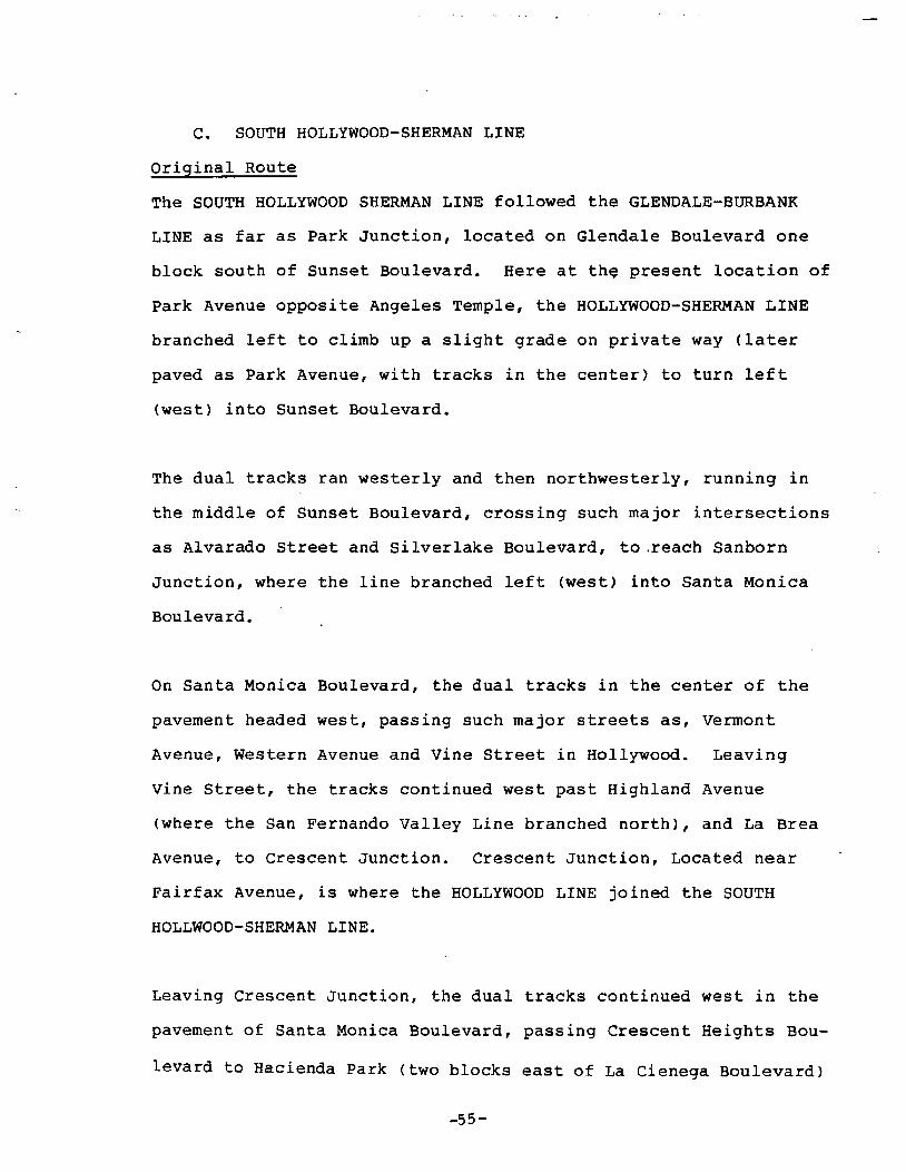
C. SOUTH HOLLYWOOD-SHERMAN LINE
Original Route
The SOUTH HOLLYWOOD SHERMAN LINE followed the GLENDALE-BURBANK
LINE as far as Park Junction, located on Glendale Boulevard one
block south of Sunset Boulevard. Here at th~ present location of
Park Avenue opposite Angeles Temple, the HOLLYWOOD-SHERMAN LINE
branched left to climb up a slight grade on private way (later
paved as Park Avenue, with tracks in the center) to turn left
(west) into Sunset Boulevard.
The dual tracks ran westerly and then northwesterly, running in
the middle of Sunset Boulevard, crossing such major intersections
as Alvarado Street and Silverlake Boulevard, to .reach Sanborn
Junction, where the line branched left (west) into Santa Monica
Boulevard.
On Santa Monica Boulevard, the dual tracks in the center of the
pavement headed west, passing such major streets as, Vermont
Avenue, Western Avenue and Vine street in Hollywood. Leaving
Vine Street, the tracks continued west past Highland Avenue
(where the San Fernando Valley Line branched north), and La Brea
Avenue, to Crescent Junction. Crescent Junction, Located near
Fairfax Avenue, is where the HOLLYWOOD LINE joined the SOUTH
HOLLWOOD-SHERMAN LINE.
Leaving Crescent Junction, the dual tracks continued west in the
pavement of Santa Monica Boulevard, passing Crescent Heights Bou-
levard to Hacienda Park (two blocks east of La Cienega Boulevard)
-55-

here, the tracks entered an unimproved private way between the
dual roadways of Santa Monica Boulevard, ran southwesterly
across La cienega Boulevard, and then four blocks farther to
the terminus of the route at Sherman (West Hollywood). The dual
rails turned southerly out of the private way into the West
Hollywood Carhouse and shops (located on the south side of Santa
Monica Boulevard between Huntley Drive and San Vicente Boulevard).
Present Condition of Route
No rails remain on the entire route.
On Park Avenue from Park Junction to Sunset Boulevard the dual
tracks have been replaced by pavement.
On Sunset Boulevard from Park Avenue to Sanborn Junction (Santa
Monica Boulevard) dual tracks have been removed and replaced by
pavement.
Dual tracks have been removed and replaced by pavement on Santa
Monica Boulevard from Sanborn Junction (Sunset Boulevard) to
Hacienda Park (two blocks east of La Cienega Boulevard near
Olive Drive).
On Santa Monica Boulevard from Olive Drive (Hacienda Park) to west
of Huntley Drive (Sherman), dual tracks have been removed and
the unimproved private way remains.
The west Hollywood Carhouse and shops have been demolished to
make way for commercial development and the SCRTD facilities.
-56-
·-. ~.~
SOUTH HOLlYWOOD·SHERMAN LINE
D. SUBWAY-HOLLYWOOD LINE
Original Route
The SUBWAY-HOLLYWOOD LINE followed the SOUTH HOLLYWOOD-SHERMAN
LINE as far as Sanborn Junction, at the intersection of Sunset
and Santa Monica Boulevard.
From Sanborn Junction, on Sunset Boulevard, the dual tracks ran
northwesterly, in the center of the pavement, crossing Fountain
Avenue to reach the common intersection of sunset Boulevard,
Virgil-Hillhurst Avenue and Hollywood Boulevard. Here, the dual
tracks leave Sunset Boulevard to run northwesterly in the center
of Hollywood Boulevard to the major intersection of Vermont
Avenue.
From Vermont Avenue the dual tracks, in the center of Hollywood
Boulevard, ran west, crossing such major intersections as
Normandie, Western, and Van Ness Avenues to reach the center of
Hollywood at Vine Street. From Vine Street, the line continued
west crossing the major intersection of cahuenga Boulevard, and
Highland Avenue before reaching La Brea Avenue.
On the west side of La Brea Avenue, the dual tracks entered an
unimproved private way and ran southwesterly approximately two
blocks to Hawthorne Avenue where the private way ended. The
tracks then ran west, in the center of Hawthorne Avenue, to near
the intersection of Martel Avenue, where another unimproved
private way opened to the southwest. The dual track followed in
the private way southwesterly approximately two blocks to Gardner
Junction (Gardner Street and Sunset Boulevard). From Gardner
-58-
r
Junction the dual tracks entered yet another unimproved private
way and then ran southwesterly crossing Fountain Avenue before
reaching the terminus of the line at Crescent Junction (Santa
Monica Boulevard and Fairfax Avenue.
Present Condition of Route
No rails remain on the entire route.
On Sunset Boulevard, from Sanborn Junction, Santa Monica Bou-
levard to the common intersection of Virgil-Hillhurst Avenue
and Hollywood Boulevard, dual tracks have been replaced by
pavement.
On Hollywood Boulevard, from the common intersection of Virgil-
Hillhurst Avenue and Sunset Boulevard to La Brea Avenue, dual
tracks have been replaced by pavement.
Rails have been removed from the private way between La Brea
(AVenUe and Hawthorne Avenue, and the secticn has been "built
',upon" wi th residential development.
Dual tracks have been replaced by pavement on Hawthorne Avenue.
Rails have also been removed from the two other sections of
private way; one between Hawthorne Avenue and Gardner Junction
(Sunset Boulevard and Gardner Street), and the other between
Gardner Junction and Crescent Junction (Santa Monica Boulevard and
,Fairfax Avenue). Both sections have been "built upon" with
residential development.
-59-

SUBWAY-HOLLYWOOD LINE
E. SAN FERNANDO VALLEY LINE
Original Route
The SAN FERNANDO LINE followed the SOUTH HOLLYWOOD-SHERMAN LINE
as far as the intersection of Santa Monica Boulevrd and Highland
Avenue. There the double tracks turned right into Highland Avenue
and proceeded north in the center of the pavement of Highland
Avenue using the tracks of the CAHUENGA AVENUE LINE, past Fountain
Avenue, Sunset Boulevard, Hollywood Boulevard, and Franklyn Avenue
to the mouth of Cahuenga Pass <approximately opposite the Hollywood
Bowl). It was here that the San Fernando Lines own trackage
commenced.
Originally, the line negotiated Cahuenga Pass via a double track
line located to the east of the State Highway. However ,when the
Hollywood Freeway was constructed through the Cahuenga Pass in
1938-39, the double tracks were relocated in a private way in the
freeway median.
Rails of this last routing of the line in the Cahuenga Pass
entered the median of the Hollywood Freeway from Highland Avenue
just opposite the Hollywood Bowl. Northbound Highland Avenue,
with the dual tracks, went under the inbound Hollywood Freeway
lanes allowing the dual tracks entrance to the private way in the
freeway median. The dual rails proceeded north in the freeway
median, under the Pilgrimage Bridge, Mulholland Drive and Barham
Boulevards, and over Lankershim Boulevard, to exit the median at
Vineland Avenue.
-61-
The exit was accomplished by the dual tracks passing under the
outbound lanes of the freeway and Vineland Avenue to follow an
unimproved private way north immediately adjacent to vineland
Avenue on the west. Continuing north approaching the Los Angeles·
River, the dual tracks converged to a single track to cross the
river on single track steel trestle; after which the dual tracks
continued north on unimproved private way in the center of
Vineland Avenue passing major intersections, such as, Riverside
Drive, Camarillo Street, Magnolia Boulevard and weddington Street.
The double tracks merged to a single track just short of the
Southern Pacific tracks at Chandler Boulevard. The single track
then turned west into private way between Chandler Boulevard and
the S P tracks, and ran several blocks west across Lankershim
Boulevard to the North Hollywood Station.
West of the North Hollywood Station, the single track P.E. line
joined the Southern Pacific Burbank Branch line, where P. E.,
under a lease agreement, shared the single track line west 2.26
miles as far as Kester Junction. In a common private way, between
the dual roadways of Chandler Boulevard, the line crossed Laurel
Canyon Boulevard and Coldwater Canyon Avenue to reach Kester
Junction, at Ethel Avenue.
From Kester Junction, the SPLine branched to the northwest to
leave the P.E. Line, once again in its own unimproved private way,
heading west between dual roadways of Chandler Boulevard. The
single track continued west, past Woodman and Hazeltine Avenues,
to turn northerly in a wide curve, following in the center of
Chandler Boulevard, into the center of Van Nuys Boulevard.
-62-

In the center of Van Nuys Boulevard, the line proceeded north,
crossing Burbank Boulevard and Oxnard Street and the SP BURBANK
BRANCH LINE to Calvert ~treet. Here, the single track branched to
two tracks for the run through Van Nuys. At Van Owen Street,
the Line was reduced again to a single track.
At Sherman Way, the line branched into two single track lines.
One branch turned west into the center of dual roadways, and on
unimproved private way, followed Sherman Way west across such
major intersections as Sepulveda Boulevard, Woodley Avenue, Balboa
Avenue, and White Oak Avenue, to Lindley Avenue in Reseda. The
line continued west, crossing other major intersections such as,
Wilber, Tampa, Winnetka, and De Soto Avenues, as well as the
SP BURBANK BRANCH LINE again near Canoga Avenue to reach its
terminus at Owensmouth, (Topanga Canyon Avenue) in Canoga Park.
The other branch continued north from Sherman Way on unimproved
private way, in the center of Van Nuys Boulevard, crossing the
SP Mainline Tracks and Roscoe Boulevard before turning westerly
in a wide curve into the center of Parthenia Street. Then the
single track, in private way, between dual roadways, followed
Parthenia Street west, crossed Pacoima Wash on a trestle before
turning northerly in another wide curve (on Parthenia Place) into
the center of Sepulveda Boulevard. Still in private way between
dual roadways, the single track followed Sepulveda Boulevard north
past such major intersections such as Nordoff, Lassen, Devonshire
and Chatsworth Streets before curving into the center of Brand Bou
levard. The single track on private way then followed the center
-63-
of Brand Boulevard in still another wide curve easterly and a
smaller curve northeasterly, across Laurel Canyon Boulevard
into the City of San Fernando as far as San Fernando Road.
There were 3 blocks of two track operation ending at San Fernando
Road. A connection was provided with the nearby Southern
Pacific's Coast Route mainline tracks after crossing San Fernando
Road adjacent to the SP San Fernando Station.
Present Condition of Route
On Highland Avenue, from Santa Monica Boulevard through Hollywood
to the area of the Hollywood Bowl, tracks have been replaced by
pavement. Highland Avenue, in the area of Hollywood Bowl and the
Hollywood Freeway, has been reconstructed without rails. Pavement
has replaced tracks in the center of the Hollywood Freeway between
Highland Avenue (Hollywood Bowl) and Vineland Avenue (part of the
construction contract was removal of rails south of the Los Angeles
River). The single track bridge over the river has been removed.
On Vineland Avenue, tracks have been removed from the mostly un
improved median (small portions have been landscaped) between the
Los Angeles River and Chandler Boulevard. In this connecton,
columns of the freeway bridges for the Hollywood and ventura
Freeways have been placed in the Median of Vineland Avenue. Rails
have been removed from the private way along Chandler Boulevard
from Vineland Avenue to the abandoned PE Station (west side of
Lankershim Boulevard).
The section from the abandoned PE Station, at Lankerhsim Boule
vard, 2.26 miles west to Kester Junction (at Ethel Avenue) is the
-64-
only portion of this former P E line with rails remaining.
It is now, and has always been, part of the SPTC BURBANK BRANCH
LINE. At Kester Junction, the single track SPTC line leaves the
former common line going northwesterly. Between Ethel Avenue
(Kester Junction) and Van Nuys Boulevard rails have been removed
and a landscaped median installed in the center of Chandler
Boulevard. Pavement has replaced rails on Van Nuys Boulevard
all the way north through Van Nuys to Sherman Way.
No rails remain on the branch that traveled west from Van Nuys
Boulevard in the center of Sherman Way. A landscaped median
has been installed from Van Nuys Boulevard to Variel Avenue (West
of De Soto Avenue) on Sherman Way. Exceptions to the landscaped
median are: Under San Diego Freeway, where there is a curbed,
paved, median containing center columns for the freeway bridge,
and in the tunnel under the Van Nuys Airport runways, where there
is a curbed median containing a tunnel structure under the run
ways. Rails have been replaced by pavement on the remainder of
the branch line, seven blocks up to Topanga Canyon Road.
On the former SAN FERNANDO LINE, pavement has replaced rails in the
center of Van Nuys Boulevard from Sherman Way to Roscoe Boulevard.
North of Roscoe Boulevard, rails have been replaced by a
combination of pavement and narrow paved traffic islands until
reaching the place where Van Nuys Boulevard curves westerly to
intersect Parthenia Street. A landscaped median replaces the track
on private way on Parthenia Street and Parthenia Place up to
Sepulveda Boulevard. This is also true for Sepulveda Boulevard as
far north as Chatsworth Street.-65-

North of Chatsworth Street on Sepulveda Boulevard, the single
track on private way has been replaced by a paved median with
bridge columns in the area under the Route 118 freeway bridge.
From the edge of the freeway area a landscaped median
continues north along Sepulveda and curves easterly along Brand
Boulevard replacing the single track on private way. With the
exception of a section under the Golden State Freew~y Bridge
(also paved median with bridge columns), the landscaped median
follows Brand Boulevard northeasterly into the City of San
Fernando as far as Hewitt St. On the remainder of the line
on Brand Boulevard in San Fernando, rails have been removed and
replaced by pavement.
-66-

SAN FERNANDO VALLEY LINE

F. HOLLYWOOD - VENICE LINE
Original Route
The HOLLYWOOD - VENICE LINE followed the SUBWAY - HOLLYWOOD
LINE as far as Crescent Junction, and then followed the SOUTH
HOLLYWOOD - SHERMAN LINE, on Santa Monica Boulevard, as far as
Sherman (West Hollywood).
On Santa Monica Boulevard, the dual tracks ran southwesterly
from Sherman (near Huntley Drive), on unimproved private way in
the center of twin roadways, three blocks to San Vicente
Boulevard. The dual tracks on private way continued south
westerly, crossing the major intersections of Robertson Boulevard,
Doheny Drive, and Beverly Boulevard to reach the Beverly Hills
Station near Beverly Drive. Here, the dual rails of the SANTA
MONICA VIA SAWTELLE LINE joined the HOLLYWOOD - VENICE LINE.
From Beverly Hills Station, dual rails of the HOLLYWOOD - VENICE
LINE continued southwesterly, on private way between twin road
ways of Santa Monica Boulevard, crossing such major intersections
as Wilshire, Beverly Glen (on a high Bridge), and Westwood
Boulevards to reach Sepulveda Boulevard. Here, the private way
ends and the dual tracks entered the Sawtelle business district in
the center of Santa Monica Boulevard. The tracks crossed Sawtelle
Boulevard, Federal Avenue, Bundy Drive and into the City of Santa
Monica at Centralia Avenue.
The dual tracks continued southwesterly, in the center of Santa
Monica Boulevard, crossing the various numbered streets of
-68-
,
Santa Monica until reaching Ocean, Avenue. Here the line turned
south on Ocean Avenue and ran one block to Broadway, the terminus
of the VENICE SHORT LINE. From Broadway to its terminus at
Windward Avenue in Venice, the route of the HOLLYWOOD - VENICE
LINE is identical with the VENICE SHORT LINE.
Present Condition of Route
Dual tracks have been removed from the unimproved private way(rof.t A\je~"eir1
(in the center of Santa Monica Boulevard betweenASherman (West
Hollywood) and near Arden Drive in Beverly Hills. On this section
of Santa Monica Boulevard, the unimproved private way remains.
In the unimproved way in the center of Santa Monica Boulevard
near Arden Drive in Beverly Hills to Sepulveda Boulevard, a
single track replaces the dual tracks. This section of rail is
the SPTC West Los Angeles Branch. The SPTC branch line runs
parallel to, and on the west side, of Sepulveda Boulevard.
Dual tracks have been replaced by pavement on Santa Monica
Boulevard from Sepulveda to Ocean Avenue in Santa Monica.
On Ocean Avenue, between Santa Monica Boulevard and Broadway,
tracks have been replaced by pavement.
-69-
HOlLYWOOD.VENICE LINE___L~_~ • __
-70-
G. VENICE SHORT LINE
Original Route
The line originated in Downtown Los Angeles at the Hill Street
Station (Subway Terminal Building) located between 4th and 5th
Streets on the west side of Hill Street. The Red Cars exited the
station at ground level directly on to Hill Street.
The dual tracks ran south in the middle of Hill Street crossing
major intersections such as 6th Street, Olympic Boulevard and
Pico Boulevard until the line turned west onto Venice Boulevard.
On Venice Boulevard the dual tracks located in the middle of
the paved street continued westerly passing major streets such
as Figueroa, Hoover and Vermont until the Berendo Street siding
track which allowed passing of other Red Cars. Upon leaving the
siding the tracks continued on the middle of Venice Boulevard
passing Normandie and Western until the line reached Arlington
Avenue. At Arlington the tracks then entered an unpaved private
way in the center of dual roadways which ended at Crenshaw
Boulevard. From Crenshaw Boulevard the dual tracks entered
another section of private way located on the north side of
venice Boulevard and continued on to Vineyard Avenue. It was
here that the SAWTELLE LINE branched northwesterly to Beverly
Hills. Westerly of Vineyard Avenue, Venice Boulevard became a
split roadway with the dual tracks located on private way between
the roadways. The VENICE SHORT LINE continued westerly crossing
over La Cienega Boulevard passing the Helms Bakery on its way to
Culver Junction which is westerly of Exposition Boulevard.
-71-
It is at the Junction that the REDONDO BEACH-DEL REY LINE
branched southwesterly and the SANTA MONICA AIR LINE crossed.
The dual tracks continued westerly from the Junction on unpaved
private way in the center of Venice Boulevard passing inter
sections such as Overland Avenue, Sepulveda Boulevard, Centinella
Avenue, Lincoln and Washington Boulevards. The line then crossed
the Grand Canal in Venice on a concrete arch bridge and turned
north onto Pacific Avenue.
The double tracks then ran on the pavement of Pacific Avenue
for five blocks before entering a wide private way known then
as the "Trolleyway". From windward Avenue in Venice the line
followed the "Trolleyway" north, past the Ocean Park Carhouse
and yard, through Ocean Park to pico Boulevard where the
"Trolleyway" ended and "street running" resumed directly into
Ocean Avenue. The tracks then followed Ocean Avenue north to the
terminus of the VENICE SHORT LINE at Broadway in Santa Monica.
Present condition of the Route
No rails remain on the entire route.
The Hill Street Station (Subway Terminal Building) is no longer
used as a transportation terminal. The building has been bought
by private developers.
The tracks have been removed and replaced by pavement on Hill
street from the former terminal to Venice Boulevard.
On Venice Boulevard from Hill Street to Arlington Street the
tracks have been replaced by pavement.
-72-
The rails have been removed from the center of venice Boulevard,
between Arlington Avenue and Crenshaw Boulevard and the former
private way has been paved as a city street. Rails have also been
removed from the north side of Venice Boulevard between Crenshaw
Boulevard and Vineyard Junction. The entire section has been
paved over as a city street with a very narrow curbed median.
West of Vineyard Junction, past Rimpau Boulevard, La Brea Avenue,
Redondo Boulevard, Hauser Boulevard, Carson Avenue, Genesee
Street, the dual tracks, on medium-to-high fills, have been
replaced by a narrow landscaped median at street grade. The
grade crossing viaduct and embankment over La Cienega Boulevard
was removed for the construction of the Santa Monica Freeway. The
freeway now crosses over Venice and La Cienega Boulevards just to
the north of their intersection. The narrow landscaped median
on Venice Boulevard continues at street grade, across Robertson
Boulevard, past the old Helms Bakery Building, (now an antique
furniture mart), to Culver Junction.
Venice Boulevard continues westerly through Palms and Culver City,
the former dual rails replaced by very narrow landscaped median,
past Overland Avenue and Sepulveda Boulevard, under the San Diego
Freeway into Mar Vista; past McLaughlin Avenue, Inglewood Boule
vard, and Venice High School to Lincoln Boulevard. Venice Boule
vard, all this way, is now a wide boulevard with a narrow land
scaped median. West of Lincoln Boulevard, the former private way
-73-
is now a trackless dirt median which is quite wide west of
washington Boulevard and is built on in some places. At the
Grand Canal, the ancient arch bridge remains, however, the
rails and ties are gone and it is in a dilapidated condition.
A short distance further west, the rails that had turned north
into Pacific Avenue in Venice for five blocks ending at Windward
Avenue, have been removed and replaced by pavement. From Wind
ward Avenue north, various portions of the former "Trolleyway"
have been "built upon" all the way to its end at Pico Boulevard
in Santa Monica. Ocean Avenue in Santa Monica, from Pico
Boulevard north to the terminus of the route at Broadway, has
had the track removed and replaced by pavement.
-74-

VENICE SHORT LINE
H. SANTA MONICA VIA SAWTELLE LINE
Original Route
The SANTA MONICA VIA SAWTELLE LINE followed the VENICE SHORT
LINE as far as Vineyard Junction.
At Vineyard Junction, the SANTA MONICA VIA SAWTELLE LINE branched
northwesterly from the VENICE SHORT LINE. Inside the Vineyard
grounds, dual tracks ramped up on fill to join a massive grade
separation structure that carried the tracks over Pico Boulevard
and down on to an unimproved private way ~n l,lle C~U\"~l· o.f the
twin roadways of San Vicente Boulevard.
Continuing northwesterly, 1n the center of San Vicente Boulevard
the dual tracks crossed the major intersections of La Brea,
Hauser, and Olympic Boulevards, Fairfax Avenue, as well as
Wilshire and La Clenega Boulevards. Then they continued one
block west of La Cienega to Sherman Junction (at Le Dolx Road),
where the Sherman cut-off branched north (in the middle of San
Vicente Boulevard) to Sherman (West Hollywood).
From Sherman Junction, the SANTA MONICA VIA SA\iTELLE LINE turned
west into private way, in the center of the twin roadways of
Burton Way. Running west, the dual tracks crossed Robertson
Boulevard, Doheny Drive, and some of the downtown Beverly Hills
Streets to reach the Beverly Hills Station (located adjacent to
Santa Monica Boulevard near Beverly Drive) ,.
At the Beverly Hills Station, the SAN'l'A MONICA VIA SAWTELLE LINE
Joined the HOLLYWOOD-VENICE LINE, and both lines were identl..::a.'"
from that location to their common terrninul:) at W~ndwaI'd i\vtmue i
Ver.l ::e .
- '(b -
Present Condition of Route
The Vineyard Junction yard area has been taken over by commercial
development. An exception is the strip provided through the
former yard to extend San Vicente Boulevard southeasterly from
Pico Boulevard to Venice Boulevard.
The grade separation structure across Pico Boulevard has been
removed.
Rails have been removed on San Vicente Boulevard, between Pico
Boulevard and Hauser Boulevard, and the private way has been re
placed with a medium to wide landscaped median.
On San Vicente Boulevard, between Hauser Boulevard and Olympic
Boulevard, rails have been removed and the private way has been
replaced with a narrow landscaped median.
Rails have been removed from San Vicente Boulevard, between
Olympic Boulevard and Wilshire Boulevard, and the private way has
been replaced with a wide landscaped median.
On San Vicente Boulevard, between Wilshire Boulevard and La
Cienega Boulevard, rails have been removed and the private way
has been replaced with a narrow landscaped median.
On San Vicente Boulevard between La Cienega Boulevard and former
Sherman Junction (one block), and on Burton Way, from former
Sherman Junction to Rexford Drive in Beverly Hills, rails have
been removed and the private way replaced with a very wide
landscaped median.
-77-
From Rexford Drive to the Beverly Hills Station, rails have
been removed and the private way has either been taken over
as part of Beverly Hills Civic Center, or paved as a city
Street. The Beverly Hills Station has been demolished and the
grounds have been "built upon lt with commercial development.
-78-

SANTA MONICA VIA SAWTELLE LINE
-i9-
I. THE WESTGATE LINE
Original Route
The WESTGATE LINE followed the SANTA MONICA VIA SAWTELL LINE
as far as Sawtelle.
From Sawtelle (Santa Monica Boulevard between Purdue and Butler
Avenues) the WESTGATE LINE branched northwesterly into an un
improved private way. Dual tracks ran in the center of the
private way, across Ohio Avenue, and then along the westerly
edge of the U. S. Government Soldier's Home property to a
location near Rochester and Butler Avenues. Here the dual rails
entered the grounds of the Soldier's Home and continued north
westerly on private way, across Wilshire Boulevard to enter
another section of unimproved private way in the center of San
Vicente Boulevard.
The dual tracks followed San Vicente Boulevard, between twin
roadways, in a sweeping curve to the west, crossing out of the
Soldier's Home property at Bringham Avenue. Continuing in the
center of San Vicente Boulevard, the rails ran west crossing
Barrington and Montana Avenues, and Bundy Drive to reach the
Santa Monica city limit at 26th Street.
Once into Santa Monica the dual tracks, still on private way
between twin roadways, ran approximately 2 miles southwesterly,
across the various numbered streets of Santa Monica, to Ocean
Avenue.
-80-
The dual tracks then ran southeasterly in the pavement of
Ocean Avenue, crossing the major intersections of Montana
Avenue, wilshire Boulevard and Santa Monica Boulevard to
reach the terminus of the line, one block farther south at
Broadway.
Present Condition Route
Rails have been removed from the private way between Santa
Monica Boulevard and Ohio Avenue, and the section has been
"built upon" with commercial and residential development.
Rails have been removed from the private way between Ohio
Avenue and the U. S. Government Soldier's Home property, and
it has been "built upon" with residential development.
The section of private way across the Soldier's Home property
between near Rochester Avenue and Wilshire Boulevard has been
abandoned and the rails have been removed.
Rails have been removed from the private way between Wilshire
Boulevard and the Soldier's Home Boundary at Bringham Avenue.
Both the private way and the twin roadways of San Vicente
Boulevard have been abandoned and their right ways taken over
by the U. S. Government for the Soldier' Home.
On San Vicente Boulevard, from the Soldiers Home boundary
(Bringham Avenue) to Ocean Avenue in Santa Monica, dual tracks
have been removed. The former unimproved private way has been
replaced with a very well developed landscaped median which
-81-

includes many large trees throughout the entire length of the
section.
Rails have been replaced by pavement on Ocean Avenue between
San Vicente Boulevard and Broadway in Santa Monica.
-82-

Continuing west after Crenshaw Boulevard still in private way
the track ran between the dual roadways of Exposition Boulevard
until the termination of the south roadway at Farmdale Avenue,
at Dorsey High School. From there, the single track ran west
directly south of Exposition Boulevard until crossing La Brea
Avenue. From that point the single track ran between Exposition
Boulevard (on the south) and Jefferson Boulevard (on the north)
west to the place Exposition Boulevard ends in a cul-de-sac.
From there, the rails followed the south side of Jefferson
Boulevard through the Sentous Yard and across La Cienega
Boulevard.
West of La Cienega Boulevard, the single track on private way
followed intermittent sections of Jefferson and National
Boulevards to a point just east of the intersection of Washington
and NationalBoulevards. Crossing over the National Boulevard,
the track continued for about a quarter of a mile on private way
to Culver Junction. Here, the SANTA MONICA AIR LINE crossed the
VENICE SHORT LINE just southeast of the intersection of Robertson
and Venice Boulevards.
Leaving Culver Junction, the single track on private way headed
through Palms following intermittent portions of Exposition
Boulevard while crossing Hughes and Motor Avenues. West of
Motor Avenue, the track ran northwesterly following the westerly
side of Northvale Road until it curved westerly and intersected
Overland Avenue.
-85-
"-
After crossing Overland Avenue, the single track in private
way ran west to westwood Boulevard where the private way
ran between dual roadways of Exposition Boulevard. East of
Sepulveda Boulevard, (about half mile from westwood Boulevard)
the line reached Home Junction, where the Soldier's Home Branch
joined from its run to the north along the west side of Sepulveda
Boulevard. West from Home Junction, the line ran on the north
side of Exposition Boulevard, crossing Sepulveda Boulevard and
then pico Boulevard at an extreme skew near the intersection of
Gateway Boulevard. From Pico Boulevard the track went west,
running on the north side of Exposition Boulevard, crossing
Federal and Barrington Avenues and-Bundy Drive to the Santa
Monica City limit at Centinella Avenue.
The single track on private way continued westerly, running
between Olympic Boulevard (on the north) and Exposition Boulevard
(on the south) to Stewart Avenue. At the terminus of Exposition
Boulevard at Stewart Avenue, the track continued westerly on the
southern side of Olympic Boulevard. Directly west of Cloverfield
Avenue , Olympic Boulevard turned southwesterly crossing the
SANTA MONICA AIR LINE, which continued westerly paralleling
Colorado Avenue on the south. The single track on private way
then ran westerly into Santa Monica , crossing the major numbered
streets to reach and cross Lincoln Boulevard. West of Lincoln
Boulevard, the track continued for another quarter of a mile
before curving southwesterly and southerly to reach Pica Boulevard
just west of Main Street. West of pico Boulevard, the single track
-86-

WESTGATE LINE
-83-

J. SANTA MONICA AIR LINE
Original Route
From the 6th and Main Street Station in Downtown Los Angeles
to Amoco Junction, the Santa Monica Air Line followed the
same route as the Long Beach Line.
At Amoco Junction (located on Long Beach Avenue south of 25th
Street) the Line entered private way on single track and ran
west, crossing Compton and Hooper Avenues to reach Central
Avenue.
west of Central Avenue, the single track on private way ran
between 30th and 31st Street to San Pedro Street, Just east
of San Pedro Street, it turned west to run diagonally across
the city grid, crossing Maple Avenue, Main Street (just south
of Jefferson Boulevard) Broadway, Hill street, and Grand
Avenue to arrive at Flower Street. Crossing Flower Street,
the single track ran on the south side of Exposition Boulevard
for one block to cross Figueroa Street.
west from Figueroa Street the line ran in the median of
Exposition Boulevard crossing Vermont, Normandie and Western
Avenues. Between Western Avenue and Arlington Avenue, the
single track ran between Exposition Boulevard (on the north)
and Rodeo Road (on the south), while from Arlington Avenue to
Crenshaw Boulevard, it followed directly south of Exposition
Boulevard.
-84-

ran in the median of Main Street pavement five blocks to
Hollister Avenue, where it entered into another private way.
The single track cotinued southerly in the private way
approximately one mile to the terminus of the SANTA MONICA
AIR LINE at the Ocean Park Car House in Santa Monica.
Present Condition of Route
Pacific Electric tracks and right-of-way between Amoco
Junction (Long Beach Avenue south of 25th Street) and a point
just west of 16th Street, in Santa Monica, are now part of
the SPTC SANTA MONICA BRANCo.
Basically, the line is single track with numerous spurs and
sidings, serving adjacent businesses and industries. Most sec~
tions of the track run in an exclusive railroad right-of-way
with frequent at-grade crossings~
-87-
From Amoco Junction, the single track runs westerly in un
improved private way serving the light industrial area be
tween Long Beach Avenue and Figueroa Street. In this area,
protective devices are provided at all at-grade crossings.
Type 9 crossing gates are provided at Hooper Avenue and 28th
Street, 29th Street and Naomi Avenue, Central Avenue and 27th
Street, 30th and San Pedro Streets, and Broadway and 35th
Street. The track bed is in need of reballasting, while
some sections of track need replacement.
From Figueroa Street to Vermont Avenue (U.S.C. area), the
single track runS in a landscaped private way between dual
roadways of Exposition Boulevard. Type 8 crossing devices
are provided at Figueroa Street and Vermont Avenue. The
rails are in a fair state of maintenance. From Vermont Ave
nue to just east of Arlington Avenue (Wilton Place), the re
mainder of the way (3 blocks) to Arlington Avenue is within
unimproved private wa:y'. This section is equipped with Type
8 crossing devices at the major street crossings. From
Arlington Avenue to Crenshaw Boulevard, the single track
runs on unimproved private way. From Seventh Avenue to
Crenshaw Boulevard, the line has numerous sidings to serve
the adjoining light industrial and commercial area.
From Crenshaw Boulevard to La Brea Avenue, the major character of
the line is the raised track bed on the unimproved private way.
rr'ype 8 crossing devices are provided at crossings at Crenshaw
- be -
-
Boulevard and Farmdale Avenue; however, the crossing at
La Brea Avenue is provided with Type 9 gates. There are
sidings just east of La Brea Avenue to serve the adjoining
businesses.
Alternate street-level and above-grade rail sections exist
from La Brea Avenue to past La cienega and the private way
is wider. The Sentous Yard still occupies a portion of the
right-of-way directly east of La Cienega, and spur tracks and
sidings exist directly west of La Cienega. A Type 8 crossing
device is provided at La Cienega Boulevard.
One quarter mile west of La Cienega, the single track crosses
Ballona Creek on a modern steel bridge, and on a wide unimproved
private way runs a half mile further to cross National Boulevard
and washington Boulevard, where Type 9 crossing gates are
provided.
The single track on private way runs sidings directly west of
Washington Boulevard, and crosses the former VENICE SHORT LINE
at Venice Boulevard (where rails have been removed). Another
small yard is then traversed, and the track then follows in a wide
private way between Exposition Boulevard (on the south) and the
Santa Monica Freeway (on the north), rising up in a bench along
side of the freeway to cross both National Boulevard and Motor
Avenue on steel structures. The entire section between Washington
Boulevard and Motor Avenue is on unimproved private way.
-89-
west of Motor Avenue, the single track runs northerly through
a tunnel under the Santa Monica Freeway, and then north and
northwesterly, on sparsely landscaped private way to intersect
and cross Overland Avenue, where Type 8 crossing devices are
provided. Between Overland Boulevard and Westwood Boulevard,
the single track runs in a minimal landscaped private way, and
between West Boulevard and Home Junction the private way is un
improved. Home Junction still exists as a connection to the
SPTC west Los Angeles Branch (former Soldier's Home Line).
Just east of Sepulveda Boulevard, fa section of the private way
approximately 300' x 20' has been paved with asphaltic concrete.
Type 8 crossing devices are provided at Sepulveda Boulevard
crossing.
West of Sepulveda Boulevard, the single track runs through a
small yard, then passes under the San Diego Freeway and crosses
Sawtell and pico Boulevard at-grade. Here, Type 8 devices are
provided. The single track on private way then runs through the
light industrial area of Sawtelle along the north side of
Exposition Boulevard and into the larger industrial district
south of Olympic Boulevard in Santa Monica, where some sidings
are provided for local industries. Crossings at Olympic
Boulevard and other major streets are provided with Type 8
crossings devices.
The remainder of the existing single track continues through Santa
Monica on unimproved private way to terminate at 16th street, just
south of Colorado Avenue. Type 8 crossing devices have been
provided at major streets.
-90-

Rails have been removed, and the former private way has been
abandoned and taken over for other uses on the section in Santa
Monica between 16th street and Lincoln Boulevard. No rails
remain on the section between Lincoln and pico Boulevard, where
the former private way has been obliterated by construction of
the santa Monica Freeway and Santa Monica Civic Center.
Rails have been replaced by pavement in the center of Main Street
from Pica Boulevard to Hollister Avenue. The single track has
been removed and the private way abandoned and taken for other
uses on the section from Hollister Avenue to the Ocean Park Car
House.
-91-


K. SOLDIERS' HOME BRANCH
Original Route
The branch left the SANTA MONICA AIR LINE at Home Junction
(Exposition Boulevard and Sawtelle Boulevard) crossed pico
Boulevard, and ran northerly in private way west of and adjacent
to Sepulveda Boulevard. The branch was single tracked and in
private way for its entire
length. The branch crossed the SANTA MONICA VIA SAWTELLE LINE at
Santa Monica Boulevard and proceeded northerly entering the
grounds of the Soldiers' Home at Ohio Avenue. The branch had a
return loop on the grounds of the Soldiers' Home at what is now
the location of the San Diego Freeway Interchange with Wilshire
Boulevard. Passenger service was discontinued in 1920 except for
. special movements.
Present Condition of Route
The SOLDIERS' HOME BRANCH is now the SPTC West Los Angeles
Branch. Home Junction is one leg of a wye formed on the SPTC
Santa Monica Branch with Talamantes as the other leg to the
east. Home Junction is located in private way east of Exposition
Boulevard and the San Diego Freeway. The single track line passes
through theConrock Plant and crosses pico Boulevard to join with
~he single track line from Talamantes in private way west of and
adjacent to Sepulveda Boulevard. The single track line is in
private way to Santa Monica Boulevard. Light industries front the
railroad right of way and have access across the track as well as
a narrow parking strip between the track and Sepulveda Boulevard.
-93-

The track for the Soldiers' Home Branch ends south of Santa
Monica Boulevard. At this point, the track curves to the right
crossing Sepulveda Boulevard to enter private way on Santa Monica
Boulevard. This was the original connection to the SANTA MONICA
VIA SAWTELLE LINE. The switch has been removed south of Santa
Monica Boulevard.
From the old switch location north to Santa Monica Boulevard the
track has been removed. The private way is now paved and used
as a parking lot. The private way is still owned by the SPTC.
The SPTC retains ownership of the original private way to Ohio
Avenue.
The private way is intact to Ohio Avenue. The track has been
removed to a point north of Massachusetts Avenue. Part of the
route has been paved with asphalt and is used by the Sawtelle
Lumber Company. From the Lumber Companies' north property fence
to Massachusets Avenue the route is covered with gravel and is
used for parking. The remainder of the private way has been
paved with asphalt to the top of and between the rails. The
private way is used by the adjacent businesses for parking and
for access to Sepulveda Boulevard.
North of Ohio Boulevard onto the grounds of the Soldiers' Home
the track has been removed and the route is used for other
purposes. The area is now a City of Los Angeles Little League
Afield, an Airport Flyaway Terminal, and the San Diego Freeway
. and its interchange with Wilshire Boulevard.
-94-
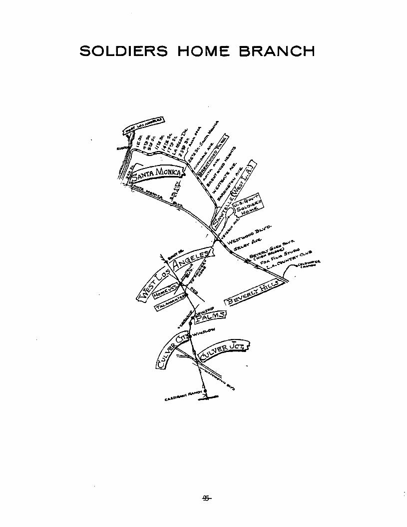
SOLDIERS HOME BRANCH

L. THE REDONDO BEACH-DEL REY LINE
Original Route
From the Hill Street Station (SUbway Terminal Building) to Culver
Junction, the THE REDONDO BEACH-DEL REY LINE followed the route
of the VENICE SHORT LINE.
From Culver Junction, dual tracks branched southwesterly from the
VENICE SHORT LINE in the center of the pavement of Culver
Boulevard, past Washington Boulevard to Madison Avenue. Here,
the dual tracks entered an unimproved private way on the northerly
side of Culver Boulevard, and ran past the MGM Studios, Overland
Avenue, Sepulveda Boulevard and Centinela Boulevard, to the Culver
city boundary.
The dual tracks in private way continued southeasterly along side
of Culver Boulevard approximately one-half mile before ramping
up on fill to cross over Lincoln Boulevard on a bridge immedi
ately north of the bridge for Culver Boulevard roadway. West of
Lincoln BOUlevard, the dual tracks converged to a single track
before crossing over Ballona Creek on a long steel bridge. The
single track then expanded again to two tracks in private way,
and continued the run, across open country roughly paralleling
Culver Boulevard, into Playa Del Rey. The rails had a short
stretch of "Street running" in Playa Del Rey. This was in
crossing Culver Boulevard and a small section on Vista Del Mar
Lane.
From Playa del Rey, the dual rails ran southerly, on unimproved
private way along the edge of the bluffs bordering the Ocean, past
-96-

•
torrr>er5P'rCA117l Bronch
the Hyperion Sewage Treatment Plant, and Imperial Highway into
the City of EI Segundo.
Still on unimproved private way bordering the Ocean, the dual
tracks continued southerly running by the Standard Oil Company
Refinery, the City of Manhattan Beach, and into the city of
Hermosa Beach.
In Hermosa Beach the dual rails entered another section of un-
improved private way in the center of Hermosa Avenue. The rails
followed this private way southerly through the business district
of Hermosa Beach into the City of Redondo Beach to the center of
the city at Diamond and Pacific Avenues. Here, the REDONDO VIA
GARDENA LINE terminated its run from the east.
From Downtown Redondo Beach, the dual tracks ran southerly, in
the pavement of Pacific Avenue as far as Torrance Boulevard, then
they ran in another unimproved private way in the center of
catalina Street south to Avenue I in the Clifton Beach Area. The
dual tracks then converged to a single track for the short cross
country run on private way to the terminus of the Line at Clifton-
by-the-Sea, located on the bluff overlooking the Ocean just north
of Malaga Cove.
Present condition of Route
(NO rails remain on the entire route.
Rails have been replaced by pavement and narrow paved median
"islands" on Culver Boulevard between Culver Junction and Madison
Avenue.
-97-
Rails have been removed from the private way on the northerly
side of Culver Boulevard between Madison Avenue and Overland
Boulevard. This strip has been taken over by MGM studios for
their use as a parking facility.
Between Overland Avenue and Sepulveda Boulevard, rails have been
removed from the private way adjacent to Culver Boulevard, and
an unimproved dirt strip remains. Just west of Sepulveda Boule-
vard, the San Diego Freeway crosses over Culver Boulevard, and
the trackless private way, with a clearance sufficient for rail-
road operation.
Between the San Diego Freeway and Centinela Boulevard, rails have
been removed from the private way adjacent to Culver Boulevard,
and a wide undeveloped dirt strip remains.
Rails have been removed from the private way, adjacent to Culver
Boulevard, between Centinela Boulevard and Lincoln Boulevard. In
this section, the private way remains mostly as an unimproved
dirt strip. However, in the vicinity of where the Marina Freeway
crosses at-grade (1/2 mile east of Lincoln Boulevard), there is
light commercial development (No st"ructures) in the strip.
The double track bridge over Lincoln Boulevard has been removed,.
however, the bridge abutments may still be seen immediately
adjacent to Culver Boulevard on the north. No trace remains of
the single track steel bridge over Ballona Creek.
Rails have been removed and the private way has been abandoned
between Lincoln Boulevard and Playa Del Rey, and little or nothing
-98-

of the former route is now visible in this swampy area.
Rails have been replaced by pavement in playa Del Rey, on Culver
Boulevard and vista Del Mar Lane. portions of private way paral
leling vista Del Mar have been condemned by the City of Los
Angeles for "Public Street Purposes.
Rails have been removed from private way which ran along the edge
of the bluffs from Playa Del Rey to Imperial Highway. This
private way was condemned in 1947 by the city of Los Angeles for
use "For Public playground and Recreational purposes", namely
Dockweiler State Beach.
Rails have been removed from the private way between Imperial
Highway and 35th Place (the Manhattan Beach - Hermosa Beach city
limits), and the private way has been taken over as public beach
and recreation areas.
Rails have been removed from the private way, in the center of
Hermosa Avenue, between 35th Place and the Hermosa Beach
,Redondo Beach city limit at Redondo street. The former private
way is now used as a combination of curbed landscaped median and
pay parking facilities.
In Redondo Beach, all evldence of the section of dual tracks on
private way from the Hermosa Beach city limit at Redondo Street
to the Diamond and Pacific Avenues has been obliterated by the
community redevelopment project of the late 1960's early 1970's.
-99-
This is also true of the section which formerly ran on Pacific
Avenue from Diamond Avenue to Torrance Boulevard.
Rails have been removed from the pavement of Catalina street
between Torrance Boulevard and Avenue I, and the private way
has been replaced with pavement.
No trace remains of the single track on private way "cross
county " from Avenue I to Clifton-by-the-Sea. This area, that
had been open county, is now completely given over to residential
development.
-100-

REDONDO BEACH.DEL REY LINE
-:101-
M. INGLEWOOD LINE
Original Route
The INGLEWOOD LINE was a single-track line in private line.
The line originated at the PE Inglewood Station and the ATSF
Junction at Ivy Avenue and Ballona Street in Inglewood.
From the station, the line ran westerly and northwesterly
following intermittent sections of Ballona Street, Hyde Park
Boulevard and Thorneburn Street while crossing La Cienega
Boulevard at-grade and passing under La Tijera Boulevard.
continuing northwesterly, the line ran approximately one-half
mile before parallelling Centinela Boulevard (on the south> and
crossing Sepuiveda Boulevard at-grade. Following Centinela
Boulevard, the single track line curved westerly and southwesterly
to run between Centinela Boulevard and the Hughes Airport The line
ran southwesterly between the runaways and Centinela-Jefferson
Boulevard. It then crossed Jefferson Boulevard to head north-
westerly and cross Ballona Creek.
The INGLEWOOD LINE continued northwesterly from Ballona Creek
crossing Culver Boulevard and the adjacent REDONDO BEACH DEL
REY LINE at-grade. Next, the track crossed Lincoln Boulevard
and ran northwesterly to follow intermittent sections of Oxford
Avenue while crossing~washington street and then washington~
Boulevard.
-102-
The line then crossed venice Boulevard (with the VENICE SHORT
LINE) and continued northwesterly following the west side of
Electic Avenue through Venice to cross Main Street and reach
the terminus of the line at the Ocean Park Carhouse (west of Main
Street between Paloma and Thornton Avenues in Venice).
present Condition of Route
No tracks remain on the entire route •
From Eucalyptus Avenue to La cienega Boulevard an unimproved
private way remains. An unimproved private way also remains
from La Cienega Boulevard to La Tijera Boulevard where the line
had run along the northerly side of the San Diego Freew~y.
From La Tijera Boulevard the unimproved private way continues
westerly along the northerly side of the San Diego Freeway until
just east of Sepulveda Boulevard where the freeway curves to the
north on a structure over the trackless roadbed. The unimproved
private way ends at Sepulveda Boulevard.
From Sepulveda Boulevard to approximately Mesmer Avenue, the
former private way is now a parking lot for nearby hotels.
westerly from that point in the vicinity of the Hughes Airport,
the former private way is used for mixed parking, storage and
light industrial development involving no permanent buildings.
From Jefferson Boulevard to Ballona Creek, in a well developed
industrial and commercial area, only an unimproved private way
-103-

remains along with several industrial spurs with track still
intact. The bridge over Ballona Creek has been removed and only
the concrete piers and abutments remain.
Northwesterly of Ballona Creek, an unimproved private way follows
the southerly side of the Marina Freeway, crossing Culver
Boulevard (and the former REDONDO BEACH-DEL REY LINE) to reach
Lincoln Boulevard.
An unimproved private way is also in evidence in the Marina del
Rey area from Lincoln Boulevard to just southeasterly of
washington Boulevard (Boone Avenue).
From Boone Avenue to the end of the route, the former private way
has been intensively built upon and used for other purposes.
The Former Ocean Park Carhouse site is now used as a storage and
maintenance facility by the Southern California Rapid Transit
District.
-104-

INGLEWOODLINE
-105-
IV. SOUTHERN DISTRICT
-106-

~ . ",
',: ~..~.~-:..',"}
--,
... ~. ~ ~ .~ :'~~~:~~y,. ::..
,
.1Ij
I1
\I1!Ii
=== ....._""*':"1-.-~ ---------.'
-107-
~ • • 40
..,-
t·,-:.- •••
: s····
L
A. THE LONG BEACH LINE
Original Route
The line originated at the 6th and Main street station in Los
Angeles and exited to the east via an elevated structure over
downtown streets to reach San Pedro street at grade. The dual
track line went south in the center lanes of the streets. The
line then turned east on Olympic Boulevard (East 9th Street)
street running to Hooper Street, then turned south and entered
the private way west of Long Beach Avenue. Two additional
tracks joined in the private way from PEls 8th Street Yard. This
was the start of the Four Track System to Watts.
The line was within private way from Olympic Boulevard to willow
street in Long Beach. The four track system went to Watts
Junction (103rd street). The remainder of the line was double
tracked to Ocean Avenue in Long Beach.
The four track line went south from Olympic Boulevard crossing
washington Boulevard where Long Beach Boulevard becomes twin
roadways on both side of the private way.
At Amoco Junction (25th Street), the SANTA MONICA AIR LINE
branched off to the west and a connection to the Butte street
Freight Yard (SPTC J Yard) went to the east. Continuing to the
south, the line crossed the ATSF Harbor District tracks at Slauson
Boulevard at grade. The WHITTIER LI~E branched to the east at
Slauson Junction just south of Slauson Boulevard. A four track
steel plate girder bridge carried the track over Firestone Boule
vard where the Braham Freight Yard paralleled the line to 9lst
street.
-108-

At Watts Junction (103rd Street) the four track system ended.
Here the SANTA ANA LINE branched to the east and the REDONDO,
TORRANCE and EL SEGUNDO LINES branched to the west.
The LONG BEACH LINE (on dual tracks) turned southeasterly from
Watts Junction and ran towards Compton between the twin road-
ways of Willowbrook Avenue. Crossing Rosecrans Boulevard, the
line turned to the south. Reaching Greenleaf Boulevard,
willowbrook Boulevard ended and the line proceeded to the south
crossing over Compton Creek on a 2 track steel Pratt truss bridge.
The line then turned southeasterly towards Signal Hill.
At Dominguez Junction the SAN PEDRO VIA DOMINGUEZ LINE branched
to the south on the west side of Alameda Street. The LONG BEACH
LINE crossed Alameda Street and the SPTC San Pedro Branch at
grade, and followed the west bank of Compton Creek towards the Los
Angeles River.
After the construction of the Long Beach Freeway, the line crossed
over the freeway on a two track plate girder bridge then crossed
the UPRR San Pedro Branch (Cota crossing) at grade. A long single
track deck girder bridge carried the line over the Los Angeles
River towards willow Street (North Long Beach). This was the only
single track section on the line.
At Willow Street (North Long Beach) the NEWPORT-BALBOA LINE
branched to the southeast and the LONG BEACH LINE ran south in the
center lane of American Avenue (Long Beach Boulevard) to Ocean
Avenue in Long Beach. The line turned onto Ocean Avenue and
followed the same route as the AMERICAN AVENUE-NORTH LONG BEACH
LINE.
-109-
Present Condition of Route
The former 6th and Main Street Pacific Electric Station is now
used partially as a SCRTD Bus Terminal, with the remainder re-
placed by commercial businesses. The elevated track structure
between the station and San Pedro Street has been removed and
replaced by the expanded SCRTD building and the Greyhound Bus
Terminal.
Pavement has replaced tracks on San Pedro Street and Olympic
Boulevard (East 9th Street). At Olympic Boulevard just east of
Hooper Street, one track from SPTC's Hooper (8th Street) yard
enters the former PE private way which is now the Wilmington
Branch of the SPTC.
The single track runs south in the private way on the west side
of Long Beach Avenue, passing various sidings, and running under
the Santa Monica Freeway near 15th street.
After crossing washington Boulevard the single track line
continues south in private way between the dual roadways of Long
Beach Avenue through a mixed industrial and commercial area. It
then crosses the SPTC's Santa Monica Branch (former PE AIR LINE)
south of 24th Street and proceeds south across the ATSF Harbor
District tracks at Slauson Boulevard to reach Slauson Junction.La Habra
(This is where the SPTC's Santa Ana Branch (former PE WHITTIER
LINE) diverges east into Huntington Park.
From Slauson Junction the single track line continues south in
private way on the east side of South Avenue through an area of
-110-

continuing industrial and commercial development to Florence
Avenue.
Crossing Florence Avenue, the line continues south following
intermittent sections of Graham Avenue on a variable width
private way to Firestone Boulevard.
The single track line crosses Firestone Boulevard (state route
42) on the still existing four track steel plate girder bridge.
From here south, the private way widens as the single track line
crosses 103rd Street and heads into Watts Junctions.
Watts Junction is the former southerly terminus of the PE four
track system. Here, the SPTC's El Segundo Branch diverges to the
west, and the SPTC's West Santa Ana Branch diverges to the east.
From the Watts Junction, the existing single-track SPTC
Willington Branch, running southeasterly on private way, follows
Willowbrook Avenue, crossing Imperial Highway, and the adopted
alignment of the 1-105 Century Freeway.
Ave~~e
(After crossing Rosecrans Boulevard, the line heads directly south
in a private way between the dual roadways of Willowbrook Avenue
to Compton Boulevard at the center of Compton's central business
district. Crossing Compton Boulevard, the private way reduces
and the single track passes directly east of the Compton Civic
Center.
The line continues south of A10ndra Boulevard in a private way
-111-
between the dual roadways of Willowbrook Avenue as far as
Greenleaf Boulevard, where Willowbrook Avenue ends.
South of Greenleaf Boulevard, the line runs south, in open
country a short distance before crossing Compton Creek on a
single-track steel truss bridge. The line then curves to the
southeast and crosses under Artesia Boulevard and the Artesia
Freeway in a mixed industrial and commercial area with various
sidings before heading into Dominguez Junction.
At Dominguez Junction, the SPTC Wilmington Branch turns
southwesterly to run towards Wilmington on the westerly side
of Alameda Street. There no longer is a direct connection to
Long Beach across Alameda Street and across the SPTC San Pedro
Branch as the crossing has been removed. There is a direct
connection across Alameda Street to run south on the San Pedro
Branch from the Wilmington Branch. North of this connection the
San Pedro Branch has a direct connection to the SPTC East Long
Beach Branch (former LONG BEACH LINE).
From the Junction the single track line crosses Santa Fe Avenue
and continues southerly within private way between Santa Fe Avenue
(on the west) and Compton Creek (on the east) until a short
distance north of Del Arno Boulevard. Here, the creek turns
easterly and Santa Fe Avenue turns westerly away from the line.
This leaves the single track to cross Del Arno Boulevard into a
developing heavy industrial area in the vicinity of the Long Beach
Freeway-Los Angeles River.
-112-
Continuing southeasterly the single track line in a private way,
crosses the Long Beach Freeway on two-track wide steel plate
girder bridge, and directly on the east side of the freeway
reaches Cota Crossing, where the UPRR San Pedro Branch is crossed
at-grade.
From Cota Crossing, the line continues southeasterly through a
heavy industrial area before crossing the Los Angeles River on a
single-track, steel deck girder bridge. The single track
continues into the City of Long Beach, on private way, following
the west side of Del Mar Avenue, to pass under the San Diego
Freeway on the east side of Pacific Place.
The single-track line continues southeasterly in private way
following intermittent sections of Del Mar AVenue, across Wardlow
Road and Spring Street to reach willow Street.
At north Long Beach the former PE LONG BEACH LINE branched to the
south, and the PE NEWPORT-BALBOA LINE branched to the southeast.
The single track SPTC East Long Beach Branch continues
southeasterly following the alignment of the former NEWPORT
BALBOA LINE.
-113-

A short section of track branches to the south from the SPTC
East Long Beach Branch and ends north of Willow street. This is
the last of the track on the LONG BEACH LINE. The present
condition of the remainder of the Route is addressed in the
section on the AMERICAN AVENUE-NORTH LONG BEACH LINE.
-114-

Courtesy of. Interurbans
LONG BEACH. LINE
"".........SlI;OLIVE.5l':
~~~
CAR~QNSIOI""4-
-115-
B. THE AMERICAN AVENUE - NORTH LONG BEACH LINE
original Route
This local line as of 1923 ran entirely on tracks of the inter
urban line to Los Angeles. Its downtown terminus was at PE
station at the terminus of Pacific Avenue at Ocean Avenue.
From this station, the line ran on dual tracks in the pavement
of Ocean Avenue six blocks to American Avenue (Long Beach
Boulevard). The dual tracks then ran north in the pavement of
American Avenue to a terminus in North Long Beach at the junction
of the NEWPORT - BALBOA LINE, a short distance north of Willow
Street.
Operation of this line was discontinued on June 1 1935: there
after the interurban trains of the LONG BEACH LINE made all
local stops. This continued until abandonment of the interurbans
on April 9, 1961.
Present Condition
The only remainder of this interurban track is a rail 'stub' which
extends for about 200 feet from the junction with the NEWPORT
BALBOA LINE to Willow Street.
Tracks have been removed from the center of Long Beach Boulevard
and replaced with landscaped median islands. Close to downtown,
between 6th and 3rd streets, the Long Beach Plaza is being
constructed. As a consequence, Long Beach Boulevard is in this
area presently (as of November 1981) being reconstructed to a dual
roadway with landscaped median islands.
-116-
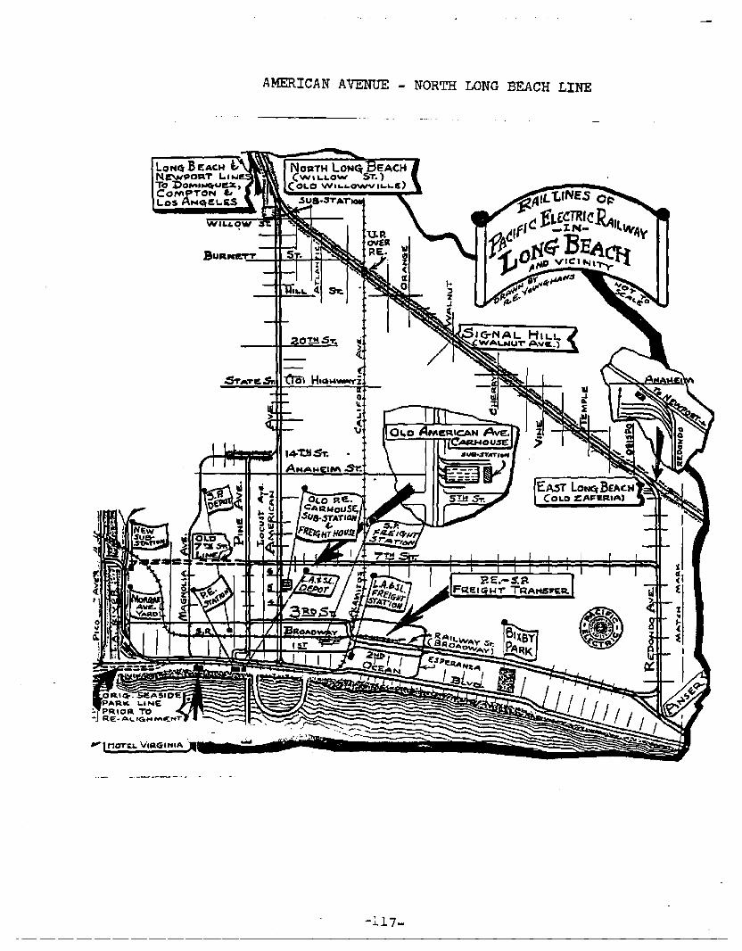
AMERICAN AVENUE - NORTH LONG BEACH LINE
;"J..17-
C. THE NEWPORT-BALBOA LINE
Original Route
The NEWPORT-BALBOA LINE followed the LONG BEACH LINE as far as
North Long Beach (Willow street). From that junction the line
branched southwesterly 'on dual tracks across American Avenue
(Long Beach Boulevard) to enter a private way which cut
diagonally across the city street grid of Long Beach and also
forms part of the boundary of Long Beach and the City of Signal
Hill.
The line was double track to Huntington Beach and single track
from there to Balboa.
The line crossed Atlantic Avenue at grade and passed under
orange Avenue. Continuing southeasterly the line crossed at
grade: Cherry Avenue Pacific Coast Highway, Temple Street,
Aneheim street, Redondo Avenue, Seventh street and Ximeno
Avenue.
The dual tracks on private way then skirted the Colorado Lagoon
and paralleled Apian Way (by the Marine Stadium) from Nieto
Avenue to the San Gabriel River in Long Beach, and used three
wooden trestles in crossing Alamitos Bay and the river.
East of the San Gabriel River the line entered Seal Beach in
private way in the center of Electric Avenue, and up to 1942,
crossed Anaheim Bay on a trestle to Surfside and Sunset Beach.
In 1942, construction of the U.S. Naval Ammunition and Net Depot
cause the line to be rerouted north from Electric Avenue on
-118-
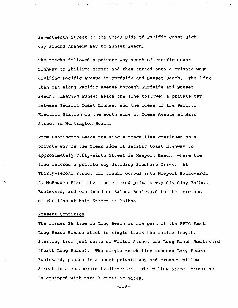
Seventeenth street to the Ocean Side of Pacific Coast High
way around Anaheim Bay to Sunset Beach.
The tracks followed a private way south of Pacific Coast
Highway to Phillips Street and then turned onto a private way
dividing Pacific Avenue in Surfside and Sunset Beach. The line
then ran along Pacific Avenue through Surfside and Sunset
Beach. Leaving Sunset Beach the line followed a private way
between Pacific Coast Highway and the ocean to the Pacific
Electric Station on the south side of Ocean Avenue at Main
Street in Huntington Beach.
From Huntington Beach the single track line continued on a
private way on the Ocean side of Pacific Coast Highway to
approximately Fifty-ninth Street in Newport Beach, where the
line entered a private way dividing Seashore Drive. At
Thirty-second Street the tracks curved into Newport Boulevard.
At McFadden Place the line entered private way dividing Balboa
Boulevard, and continued on Balboa Boulevard to the terminus
of the line at Main Street in Balboa.
Present Condition
The former PE line in Long Beach is now part of the SPTC East
Long Beach Branch which is single track the entire length.
Starting from just north of Willow Street and Long Beach Boulevard
(North Long Beach). The single track line crosses Long Beach
Boulevard, passes in a short private way and crosses Willow
Street in a southeasterly direction. The Willow Street crossing
is equipped with type 9 crossing gates.
-119-
: '."
continuing in the same direction, the line crosses the minor
streets while passing under California Avenue and Orange Avenue
before reaching Cherry Avenue. The Cherry Avenue crossing has a
"wig-way" signal. There are numerous sidings from California
Avenue with Signal Hill oil field area. From Cherry Avenue the
track crosses major street such as Pacific Coast Highway and
Temple Avenue to its present terminus. Except for sections where
the line crosses the local paved streets, the remainder of the
track runs in a private way.
The track terminates in an industrial spur west of and parallel
to Obispo Avenue just north of Anaheim Street. The entire
track length appears unused, parts of it silted and covered with
debris, through the entire rail length.
The track has been removed and replaced with commercial
( development between Obispo Avenue and Newport Avenue.
The track has been removed and the private way remains from
Newport Avenue to Park Avenue at the Colorado Lagoon. The private
way is owned by the City of Long Beach which has leased a part of
the route between Lorna Avenue and Termino Avenue to a Landscaped
Nursery. From Park Avenue the route is now part of the Lagoon
parking lot parallel to Appian Way. After Colorado Street the
route is a landscaped median from Appian Way to approximately 200
feet past 3rd Street where the route has been developed for
residential or Marina use in Long Beach.
-120-
The track has been removed from the rest of the route to
Balboa. Along Electric Avenue in Seal Beach the private way
is now a landscaped median. 17th Street and Pacific Coast
Highway are fully paved streets. The route along Pacific
Avenue in Sunset Beach is a landscaped median. After 3rd
Street the route becomes State Beach lands from Bolsa Chica
State Beach through Huntington State Beach. The route
through Newport Beach to Balboa Boulevard has been built up
and the final leg along Balboa Boulevard is a landscaped
median.
-121-
"-

NEWPORT· BALBOA LINEo.LON'taeAOf(W"...LOW'Sr~ATLANTIC AVL
BuRN&TTSEARSYW"'l-.NUTAv~.5IGN~ 1-11'.1-
CHIrRR.Y ,:we..5TATL~y,..... Avl!..
TEMP&.!: Ava:.Eo. LONCi a~If<ftNl\H.IM Sr..}
TCRMIWO
XIM£NO
LAS At.TAS (PAA~4VfJALANlIT~ H1'3.i..St!LMONT P....'"
(0<J L.8.MIIRINI! 5nl.DICIM
~'k ~ NAPL&S.Jcr. (OAtIt,)
~:?~ NApLES JC.T. eN.,.,)
5!!! Sr. ·SPa. 8cHoSEAL~-MAINS'r.
I l!!S1;NAWt:IM LANDINq.
E'AST SIOlEP~St.A
BRIOq.l!tPoIn".sURF.5IDIE COI.ONV
BAVVIEWZ,3BD5T.:SUNSET BBACH
9't11s'l':$~~
LOS PIllrO:J
S.". PAC. It....GAM£W£u..
PAC-GvN CLUeN...G,o
E... Mollo I
D. THE EL SEGUNDO LINE
Original Route
The EL SEGUNDO LINE operated passenger and freight service
between Los Angeles, watts and El Segundo. It also served to
connect the SAN PEDRO VIA TORRANCE LINES and the REDONDO VIA
GARDENA LINE to watts and Los Angeles as well as transfer points
to the.L A R Y LINES to west and central Los Angeles.
The line was within private right of way for the entire route.
The segment between watts Junction and South Los Angeles
(Broadway at l17th Street) was double track. The remainder of the
line to El Segundo was single track.
The line started at watts Junction on the 4-track line then went
west with two tracks to South Los Angeles (Broadway l17th
street) where the REDONDO VIA GARDENA LINE and the SAN PEDRO VIA
TORRANCE LINE branched off to the south between Broadway and
Figueroa with two tracks.
,The single track EL SEGUNDO LINE went west between l16th Street
and 117th Street past Figueroa Street where a transfer to the
L A R Y FIGUEROA LINE could be made to the north to Los Angeles.
Then on west to Delta (Vermont Ave.) where the Delta-Strawberry
Park Segment went south on Vermont to Gardena, Torrance and
Redondo and a transfer could be made to the L A R Y VERMONT LINE
to the north to Los Angeles.
The line continued westerly passing under Western Avenue
(Westbridge) then southwesterly to Crenshaw Boulevard (Cypave
Station) where the line turned to the west again. The line
-123-

continued to the west, north of and parallel to El Segundo
Boulevard where it crossed Hawthorne Boulevard.
At Hawthorne Boulevard (Hawthorne) the Hawthorne - El Nido
segment and the EL SEGUNDO-EL NIDO-REDONDO LINE went to the
south and a transfer to the LARY Line could be made to travel
north to Inglewood and west Los Angeles.
The line turned to the southwest and crossed El Segundo Boulevard
at La Cienega Boulevard continuing to Wise (Douglas Avenue at
Utah Avenue) where the track crossed the ATSF Harbor District
track at grade. Here, also was Wise Transfer where a car exchange
between the PE and the ATSF could be made.
A lead, the "Standard Oil Spur", extended westerly from Wise
through the Standard Oil Refinery to the Standard Oil Wharf and
the REDONDO-DEL REY LINE south of Hyperion.
The line turned northwesterly at Wise and passed through the oil
fields and turned westerly at Calvert (Pine Avenue and Center
Street) and continued to the end of the line at the El Segundo
Station (Eucalyptus Drive and Main Street).
Present Condition of Route
The EL SEGUNDO LINE is now the El Segundo Branch of SPTC.
The El Segundo Branch is single track throughout the route and
within private way for the entire 9.2 mile length of the Branch.
-124-

The Route begins at 92nd Street and .Graham Avenue on the
Wilmington Branch. The track moves to the right (west) at the
switch immediately south of 92nd Street and parallels the
Wilmington Branch as it goes to the south parallel to Graham
Avenue. The track passes 103rd street where the Branch officially
starts in the SPTC Time Tables at Watts Junction.
The track proceeds to the south and then at 106th Street curves
to the west parallel to and between 110th Street and 11lth Street.
After crossing Central Avenue the track crosses over Compton
Creek on a single track through plate girder bridge. The track
turns to the left (southwesterly) and parallels Lanzit Avenue,
crossing Imperial Highway at San Pedro Street. After crossing
Main Street, the paralleling city street is renamed l16th Place.
Crossing Broadway between ll6th Street and ll7th Street, the track
turns to the right (west) and proceeds westerly parallel to and
between l16th Street and l17th Street. The track crosses over the
Harbor Freeway (Rte. 11)on a single track through plate girder
bridge.
Between Broadway (just east of Rte. 11) and wilton Place (east of
Hawthorne Airport) the proposed 1-105 Freeway route is adjacent to
the Railroad R/W.
proceeding westerly between l16th Street and l17th Street the
track continues to Budlong Avenue where the track makes a slight
southwesterly jog (left), crosses Normandie Avenue, turns to the
west (right) and then passes in a cut on the south edge of South
west Los Angeles College.
-125-
The track then turns to the southwest and passes under Western
Avenue.
The track continues to the southwest across Van Ness Avenue,
north of EI Segundo Boulevard onto a single track width
embankment passing the south edge of a large open field owned
by Northrop Aircraft. The track then turns right to a westerly
direction and crosses the Dominguez Channel on a single track
deck girder bridge. There are private RR crossings on either
side of the channel for the L.A. County Flood Control District
and a private RR crossing for the Northrop Aircraft Corporation
to the east of the channel.
Proceeding westerly the track crosses Crenshaw Boulevard, parallel
to and south of Broadway in the City of Hawthorne. Between
Crenshaw Boulevard and Prairie Avenue, south of the Hawthorne
Municipal Airport there are many private RR crossings for the
Northrop Aircraft Corporation and a short storage siding which
serves as a short passing track.
Crossing Prairie Avenue, the track proceeds westerly to Hawthorne
Boulevard passing between the Hawthorne Plaza Shopping Mall and
the parking structure for the Mall. There is a pedestrian
crossing on grade with flashing lights for the Mall and a driveway
on grade between the parking structures. The driveway has Type 9
grade crossing protection.
Crossing Hawthorne Boulevard, the track continues west parallel to
and south of Broadway. Crossing Inglewood Avenue, the track
curves southwesterly (left) passing between the Hawthorne High
-126-

School campus and the athletic field. There is a private
pedestrian crossing between the campus and the athletic field.
Proceeding southwesterly the track crosses El Segundo Boulevard
at the Northbound Rte. 405 Freeway on and off ramps to eastbound
El Segundo Boulevard. The track crosses under the Rte. 405
Freeway centered in a two track tunnel structure. The track
continues southwesterly crossing Aviation Boulevard and then
crosses the ATSF. The crossing (WISE-SP, El Segundo-ATSF) is
a mandatory 4-way stop for all train movements.
The tracks crosses Douglas Avenue north of Utah Avenue and
proceeds southwesterly and turns northwesterly (right) crossing
Sepulveda Boulevard (State Rte.l) north of Rosecrans Avenue.
Crossing Sepulveda Boulevard, the track passes through a chain-
link gate into private property, the Standard Oil of California,
EI Segundo Refinery Complex. The track ends within the Refinery
property.
The track from Wise to the El Segundo station has been removed.
(The R/W has been covered by the construction of Industrial
.facili ties between Wise and Calbert Station at Pine Street. The
remainder of the line to the El Segundo Station site at
Eucalyptus and Main Street is unimproved R/W from Center street
to Sierra street. The City Park now replaces the former station
si teo
-127-,.

EL SEGUNDO LINE
-128-
'-
E. SAN PEDRO VIA DOMINGUEZ LINE
original Route
From the 6th and Main street Station in Los Angeles to Dominguez
Junction, the SAN PEDRO VIA DOMINGUEZ LINE followed the same Route
as the LONG BEACH LINE. It should be noted that from Dominguez
Junction to San Pedro, the line was entirely in private way.
From Dominguez Junction, the line branched southerly, on dual
tracks in private way, immediately on the west of Alameda Street.
The dual tracks ran south, crossing Del Arno Boulevard to reach
Dominguez Street. Here, the SOUTHERN PACIFIC SAN PEDRO BRANCH
LINE crossed over from the east side of Alameda Street to run
on the west side of Alameda Street, thereby placing the Pacific
Electric dual tracks immediately to the west of the SOUTHERN
PACIFIC LINE.
From Dominguez Street, the dual tracks on private way ran
southerly, just west of the SOUTHERN PACIFIC BRANCH LINE and
parallel to Alameda Street, crossing Carson Street, and Sepulveda
Boulevard to a point approximately one-half mile farther south.
At this location, the dual tracks on private way veered away
from the Southern Pacific Tracks (and Alameda Street) south-
westerly toward Wilmington, crossing a SANTA FE BRANCH LINE
and Pacific Coast Highway to reach Flint Junction, where the.
LONG BEACH-SAN PEDRO LINE joined from the east.
From Flint Junction, the dual tracks on private way continued
southwesterly into Wilmington, crossing Anaheim Street, where
the CATALINA "pier A" LINE branched off to the south. Next, the
-129-
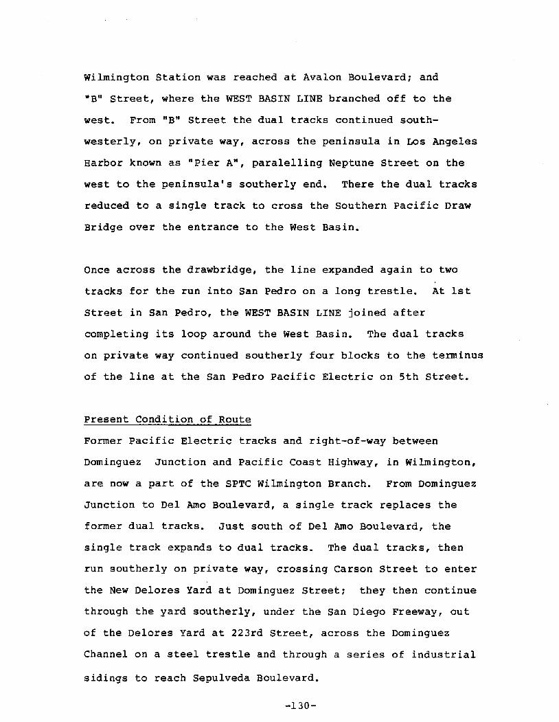
Wilmington Station was reached at Avalon Boulevard; and
"B" Street, where the WEST BASIN LINE branched off to the
west. From "B" Street the dual tracks continued south
westerly, on private way, across the peninsula in LOs Angeles
Harbor known as "Pier A", paralelling Neptune street on the
west to the peninsula's southerly end. There the dual tracks
reduced to a single track to cross the Southern Pacific Draw
Bridge over the entrance to the West Basin.
Once across the drawbridge, the line expanded again to two
tracks for the run into San Pedro on a long trestle. At 1st
Street in San Pedro, the WEST BASIN LINE joined after
completing its loop around the West Basin. The dual tracks
on private way continued southerly four blocks to the terminus
of the line at the San Pedro Pacific Electric on 5th Street.
Present Condition of Route
Former Pacific Electric tracks and right-of-way between
Dominguez Junction and Pacific Coast Highway, in Wilmington,
are now a part of the SPTC wilmington Branch. From Dominguez
Junction to Del Arno Boulevard, a single track replaces the
former dual tracks. Just south of Del Arno Boulevard, the
single track expands to dual tracks. The dual tracks, then
run southerly on private way, crossing Carson Street to enter
the New Delores Yard at Dominguez Street; they then continue
through the yard southerly, under the San Diego Freeway, out
of the Delores Yard at 223rd Street, across the Dominguez
Channel on a steel trestle and through a series of industrial
sidings to reach Sepulveda Boulevard.
-130-

Crossing Sepulveda Boulevard, the dual tracks continue
southerly on private way, through another series of
industrial sidings to a point opposite Lomita Boulevard.
Here, the former Pacific Electric dual tracks veer away from
the remainder of the SPTC tracks and Alameda Street to run
southwesterly as far as Pacific Coast Highway in Wilmington.
(The Rails have been removed from the !-!.!1!1ll1?.r~y.~c!.private way
between Pacific Coast Highway and the west side of Avalon
Boulevard, south of liD" Street. From that point, a single
track runs southwesterly crossing "e" and "B" Streets to
join the HARBOR BELT LINE tracks in the vicinity of Neptune
Avenue. From "B" Street southwesterly into San Pedro, the
original Pacific Electric tracks have been removed to make
way for further development of the Los Angeles Harbor. The
draw-bridge across the entrance to the West Basin has been
removed, as well as the San Pedro Pacific Electric Station
at 5th Street.
-131-
SAN PEDRO VIADOMINGUEZ Lll'JE
WEST BASIN LllolE.Z!i
(A\IJIlLOt4
WILMINQrTON 8LVD.
I"~
"f
&':11 "".
";u
l
~4A.. 7lt&"I\I"'b_''''~liIO P ~
./i.,'no.:J7 "'9~t');

F. WHITTIER LINE
Original Route
The WHITTIER LINE followed the LONG BEACH LINE from Los Angeles
south to Slauson Junction (south of Slauson Boulevard) where it
branched off in an easterly direction to Whittier and Yorba Linda •• t
The line to Yorba Linda was compr1sed of two PE Lines, the
WHITTIER LINE and the LA HABRA-YORBA LINDA LINE.
The WHITTIER LINE was originally double track in private way and
the LA HABRA-YORBA LINDA LINE was single track in private way.
From Slauson Junction, the double track WHITTIER LINE ran
easterly, in private way between dual roadways of Randolph
Street, through Huntington Park, Vernon, Bell and Maywood to
reach the Los Angeles River.
crossing the ~os Angeles River, the double track in private way
followed intermittent sections of Randolph Street through Bell
Gardens and Commerce, and crossed the Rio Hondo south of Slauson
Avenue.
The line continued easterly, south and parallel to, Slauson
Avenue. Across the Pico Rivera area and the San Gabriel River into
Los Nietos, where the line crossed the ATSF Third District main
line (Los Nietos) at Norwalk Boulevard then turned northerly
towards Whittier. The line in private way followed Allport Avenue
and Lynal~n Avenue then turned easterly crossing Whittier Boule
vard into Philadelphia Street to the PE station at Comstock
Avenue.
-133-

The single track LA HABRA~YORBA LINDA LINE branched easterly
in private way off the WHITTIER LINE at Los Nietos, crossed
Norwalk Boulevard and went through Whittier at the south edge of
the city limits. After crossing Mills Avenue the Track ran
adjacent to and north of Lambert Road until crossing 1st Street
where the line turned easterly through La Habra to Laon Junction
(3rd Avenue at college Street), where the single track FULLERTON
LINE branched to the south.
After crossing Harbor Boulevard the line turned southeasterly
still in private way crossed Puente Avenue in Brea, then turned
easterly to run through Brea north of Imperial Highway. The line
then turned southeasterly (where the Orange Freeway now crosses
over the track) and crossed Imperial Highway west of Valencia
Avenue and ran through Yorba Linda just south of and parallel
to Imperial Highway to the terminus at Yorba Linda Boulevard.
The remaining 5 miles of the original route to stern was
abandonded in 1941.
-134-
Present Condition of Route
This former PACIFIC ELECTRIC LINE originating at Slauson
Junction, running southeast at Brea and is now the SPTC La
Habra Branch.
Starting just south of Slauson Boulevard and Randolph Street the
single track line appears to be in good condition. The surroun
ding area ~s primarily light industrial with many at-grade
crossings. The line runs in a private way without fencing or
natural barriers. Through Huntington Park on its way to Maywood.
After crossing Boyle Avenue, in Huntington Park the track
continues to travel beside Randolph Street with the exception
of a fill section of approximately one mile. A spur exists
just before Maywood Avenue.
The adjacent areas become more residential as the single track
line traverses Maywood. From Lorna Vista Avenue in Huntington
Park to the Los Angeles River, sections of the private way are
landscaped, with shrubbery and trees acting as natural barriers.
Double track exists from Heliotrope street to Alamo Avenue in
Maywood. Fencing runs parallel to the track up to the Los Angeles
River, where the track crosses on a bridge over the river and the
Long Beach Freeway to the border of the Bell Gardens and Commerce.
In Bell Gardens, double track begins at Eastern Avenue and runs
for approximately one mile to Malt Street in Commerce, serving a
heavily industrial area. The single track resumes on private
-135-
way, through the City of Commerce, crossing under the Santa Ana
Freeway, to reach the city limits of Pico Rivera at the Rio Hondo.
Crossing the Rio Hondo, the single track on private way runs
through a mixed commercial-residential area in Pico Rivera to
leave the city after crossing the San Gabriel River. On the
east side of the river, it is joined by the SPTC's UPRR connection
to the UPPR, then in a short distance the line pass under the San
Gabriel River Freeway.
The single track on private way, continues into Santa Fe Springs
(Los Nietos), where it crosses the ATSF Third District Main Line
(Los Nietos Crossing) at grade and traverses some relatively open
country before entering the city of Whittier at Santa Fe Springs
Road.
Remaining at grade, the track crosses Greenleaf Avenue, Painter
Avenue, Calmade Avenue, Mills Avenue and Colima Road in whittier.
continuing easterly, the SPTC single track enters La Habra, an
area dominated by single family dwellings. Through La Habra the
line crosses streets such as Beach Boulevard, walnut Street
and Euclid Street.
The line then passes the former PE FULLERTON LINE which is now a
well maintained spur just east of Cypress Street.
-136-
The SPTC track running in private way runs into an industrial area
in Brea. Crossing Puente Street the track travels through the
older section of Brea and then into the civic center. The track
passes by Brea High School, as well as past stables and
recreational areas.
After intersecting College Boulevard and passing a large shopping
complex, the single track passes under the Orange Freeway (Route
57), heading through the Birch Rill's Golf Course. After
traversing the golf course, the track moves to the outer sections
of Brea, an area which is presently undergoing a large amount of
commercial development. The track finally ends as an industrial
spur after crossing Kraemer Avenue, south of Birch Avenue.
From Kraemer Avenue to Valencia Avenue there is no sign of the
original line as it is being converted to other uses. From
Valencia Avenue in Brea to Yorba Linda Boulevard in Yorba Linda
the line is intermittently built upon or is an unimproved dirt
strip adjacent to Imperial Highway. There is no sign of the line
to Stern as the route is built upon or is the Imperial Highway
south towards the Riverside Freeway.
-137-
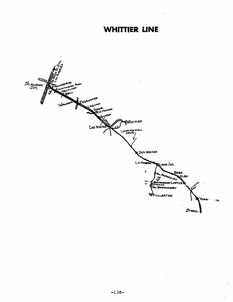
WHITTIER LINE
-138-

G. SANTA ANA-HUNTINGTON BEACH LINE
original Route
This line was built in 1907 by the Pacific Electric Land Company,
to draw patronage to Huntington Beach from Santa Ana via priv~te
way in open Country to New Delhi, Acelga, Talbert and Bushard.
As this line traversed a highly developed beet sugar area, two
spurs were built to serve the Holly Sugar and the Southern
California Sugar companies; these spurs were built in 1911 and
1908 respectively and added 4.41 miles to the original length of
13.31 miles.
In old sugar beet days, this was an excellent freight line, but
with the decline of that industry, the line fell into relative
obscurity.
The establishment of the Santa Ana Army Air Base in 1942 brought
about demand by the government for direct rail service. As a
result PE built a single-track line which was owned by the
government. No passenger service was provided; freight was
exchanged at Greenville.
This line was laid in conformity to PE standards of the time:
60 lb. T-rail, redwood ties, dirt ballast, all on private way.
Present Condition of Route
Former Pacific Electric tracks and right-of-way between First
Street, in Santa Ana and Sunflower Avenue, in Costa Mesa are now
-139-
a part of the SPTC Santa Ana Branch. From First street to Warner
Avenue, the single track runs southerly in private way between
Standard and Grand Avenues, crossing Chestnut, McFadden, Edinger
Avenues and St. Gertrude Place with grade crossings equipped
with automatic gates at each of these intersections. This whole
area is mainly residential with some light industry. The track
runs in back of the residential complexes. Fencing or natural
protection is not provided on either side of the track.
After the track crosses Warner Avenue it veers west where it con
tinues in a southwesterly direction through Evergreen, Halladay
Streets and Orange Avenue. The area is mainly light industrial.
The track heads southwesterly and after crossing Main Street, it
becomes double tracked for approximately a mile until it inter
sects Flower Street. This is a heavy industrial section of Santa
Ana. The line continues southwesterly, a single track on private
way, until just east of Bristol Street, where it then heads due
west crossing Bristol Street.
From Bristol Street, the track runs westerly paralleling Alton
Avenue and crossing Greenville, Fairview and Susan Streets. The
right-of-way is exclusive and wide. This section of the line is
mostly residential. There is a strawberry field on the southern
side of the track. Fencing is provided for this whole section
and a spur merges from the track going on Fairview Avenue serving
the strawberry field.
-140-

The track then continues west crossing Susan Street and veers
south intersecting Juniper and Sunflower Avenues. The right
of-way in this section is fairly wide. The track leaves the
City of Santa Ana and runs for approximately two more miles
south where it terminates about 200 yards north of the San Diego
Freeway in the City of Costa Mesa.
There are no traces of the remainder of the SANTA ANA-HUNTINGTON
BEACH LINE. It has been taken over for residential and commercial
uses.
-141-
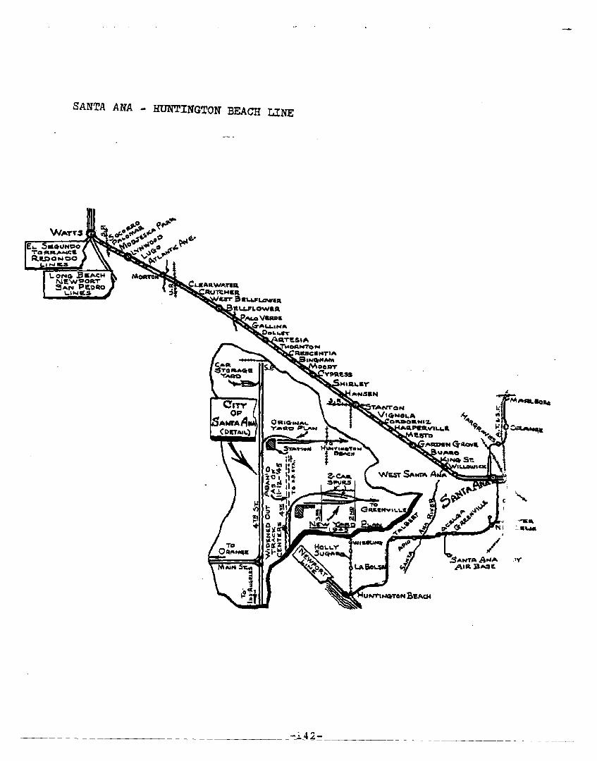
SANTA ANA - HUNTINGTON BEACH LINE
fLo Sa.uttgo"l"O ....,IWooICtlR,IU)O .... OO
t.. .... 11;$
-i42-
TANTO'"VI CirNOI.,..
O"DO"NI~
.~PIlctVIL.."
......_wa
.1'"
H. SANTA ANA LINE
Original Route
The SANTA ANA LINE followed the LONG BEACH LINE from Los Angeles
south to Watts Junction (103rd Street) where it branched off in
a southeasterly direction to Santa Ana.
The line was originally double track except for the single track
bridges. The line was reduced to single track after 1941.
The line was in private way from watts Junction to 4th Street
in Santa Ana where it ran in the center lanes of 4th Street to
the Santa Ana PE Station and then to the SP Santa Ana Station.
From Watts Junction the line ran southeasterly parallel to Santa
Ana Boulevard and crossed the SP San Pedro Branch at grade at
Alameda Street (Palomar) in Watts. From Alameda Street, Santa Ana
Boulevard became Fernwood Avenue and the line ran southeasterly
through Lynwood between the twin roadways of Fernwood Avenue and
then crossed over the Long Beach Freeway and the Los Angeles River
on a series of single track plate girder bridges. Running
diagonally across the street grid, the line crossed the UPRR San
Pedro Branch at grade (Clearwater) in Paramount southwest of the
intersection of Rosecrans Avenue and Paramount Boulevard.
The line ran through Bellflower and crossed over the San Gabriel
River on a single track bridge where the Artesia Freeway presently
crosses over both the track and the river. Continuing to the
southeast the line ran through Cerritos, Artesia, Cypress,
Anaheim, and Stanton.
-143-

The line crossed the SP Stanton Branch track at grade (Stanton)
at Beach Boulevard and Pacific Street then ran across Garden
Grove and entered Santa Ana after crossing Harbor Boulevard at
Westminster Avenue. The line ran southeasterly and crossed over
the Santa Ana River on a single track steel truss bridge then
crossed 5th Street and turned to run east to Santa Ana in private
way between 5th Street and 4th Street. The line then entered
4th Street and ran in the pavement to the PE Station then on to
the SP Station at Terminal Street.
Present Condition of Route
The SANTA ANA LINE is now the SPTC West santa Ana Branch which
has been reduced to a single track set within the fairly wide
private way. The connection to Watts Junction has been removed.
One rail has been removed from the track to Mona Boulevard. The
track is intact to Alameda street where the track has been removed
from the Street crossing and the rail crossing of the SPTC San
Pedro Branch.
From Alameda street the single track line in private way is in
place as far as Beach Boulevard in Stanton. This is low quality
trackage with missing spikes, displaced ties, pitted rails and
inadequate ballast.
At Long Beach Boulevard and Fernwood Avenue, the original Socorro
Station building still remains. The building has a sign on it
indicating that it is owned by the State of California.
Through Lynwood and Paramount the land adjacent to the track has
been cleared for the Interstate 105 Freeway.
-144-

At Beach Boulevard (Route 39) in Stanton, the SPTC west Santa
Ana Branch connects to the SPTC Stanton Branch. The remainder
of the line from Beach Boulevard through Garden Grove to Raitt
Street in Santa Ana is an unimproved private way with all the
track removed. The surrounding area has been developed into
business and commercial areas. From Raitt Street to 4th Street
( the line has been built upon or replaced by paved streets.
-145-

SANTA ANA LINE
-146-

I. REDONDO VIA GARDENA LINE
original Route
This line was one of two P E lines serving the City of
Redondo Beach; the other being the REDONDO BEACH-DEL REY
LINE. The line started at the 6th and Main street Station
in Los Angeles and shared the LONG BEACH LINE to Watts and
the EL SEGUNDO LINE to the South Los Angeles Station.
This line was originally double-tracked mostly within private
way on its entire length from Watts to Clifton (South of
Redondo Beach). The length of the line was 9.88 miles from
6th and Main to South Los Angeles Station and 12.38 miles from
South Los Angeles Station to the Southern Terminus (Clifton)
for a total length of 22.26 miles.
Starting from the South Los Angeles Station (Broadway at l17th
Street), the double track line ran ~outh on private way east
of and parallel to Figueroa Street. At l49th Street the
private way turned southwesterly and ran parallel to and south
of that street to Vermont Avenue and Compton Boulevard
(Strawberry Park Station).
From, Strawberry Park station, double track line turned south
(left) and went on private way centered in Vermont Avenue
south of Gardena Boulevard, the track curved to the west
(right) parallel to and south of l66th Street. At Hermosillo
Station (Norrnandie Avenue) the SAN PEDERO VIA TORRANCE LINE
branched south on private way along the west side of Normandie
Avenue.

The REDONDO VIA GARDENA LINE continued west as a single track
on private way parallel to l66th Street until reaching the
Bridgedale Station (Crenshaw Boulevard) where it turned Southwest
(left) and became double track.Crossing Prairie the line changed
to single track and turned west (right) parallel to and north of
l82nd street and continued within private way.
At El Nido Station (Kingsdale Avenue) the line joined the El
Segundo-El Nido Redondo segment from the north, turned southwest
and became double track once again.
The line crossed Prospect Avenue at Del Almo street, went
westerly along what is now Del Almo Street, then turned south
westerly and leaving private way went along the center of
Diamond street to Catalina Avenue where the single track
Catalina cut-off went south (left) along Catalina Avenue to
Pearl Street where it rejoined the REDONDO LINE.
The REDONDO LINE went one block further down Diamond street to
Pacific Avenue where it joined the REDONDO BEACH DEL REY LINE
at the Redondo Beach Station (Diamond & Pacific) across from
what is now Fisherman's Wharf.
On the remainder of the line, the REDONDO BEACH VIA GARDENA
LINE followed the Route of the REDONDO BEACH-DEL REY LINE to
its terminus at Clifton.
Present Condition of Route
The remaining (northerly) portion of the REDONDO BEACH VIA
GARDENA LINA is now part of the SPTC Torrance Branch.
-148-
This SPTC Branch is single track throughout and all within
private way.
From the SPTC El Segundo Branch at South Los Angeles (Broad
way at ll7th Street), the Torrance Branch runs south between
Broadway and Figueroa Street, crossing El Segundo Boulevard,
l35th Street and Rosecrans Avenue, before turning to the south
west to run parallel to 149th Street (on the south).
The line crosses Figueroa Street at-grade, then crosses over
the Harbor Freeway on a single track steel plate girder bridge
and continues southwesterly to turn south into the center of
Vermont Avenue in Gardena. The line then crosses Redondo
Beach Boulevard, l6lst Street (Alondra Boulevard) and Gardena
Boulevard at-grade.
South of Gardena Boulevard, the line curves to the west to run
between l66th and l67th Streets to Mariposa Avenue. Here, the
Torrance Branch curves south to the west of Normandie Avenue.
This is the original connection to the SAN PEDRO VIA TORRANCE
LINE.
From Mariposa Avenue, the present spur track jogs to the south,
to run just north of 168th Street, across Western Avenue at
grade to the end of the eXisting single track, at a location
just east of Gramercy Place.
There is little or no evidence of the remainder of the line
between Gramercy Place and Diamond and Pacific Streets in
Redondo Beach. The section of the line between Redondo Beach
and Clifton is discussed with the REDONDO BEACH-DEL REY LINE.

O'Y'OTE AVE.
CATALINA AVl!:.CI,/T-OF..
J. SAN PEDRO VIA TORRANCE LINE
Original Route
The line originated at the 6th and Main Street Station in Los
Angeles and followed the LONG BEACH LINE to Watts Junction, then
the REDONDO VIA GARDENA LINE To South Los Angeles and then the EL
SEGUNDO LINE to Delta (Vermont Avenue at 117th Street).
The line was entirely single track in private way from South Los
Angeles to San Pedro.
The line turned south at Delta into the private way between the
dual roadways of Vermont Avenue and ran to Strawberry Park (at
Compton Boulevard). From Strawberry Park the line followed the
double track REDONDO VIA GARDENA LINE south on Vermont Avenue,
then turned west adjacent to l16th Street to Hermosillo (at
Normandie Avenue).
From Hermosillo the SAN PEDRO VIA TORRANCE LINE turned south,
crossed Normandie Avenue and entered private way on the west
side of Normandie Avenue. The line ran south to Dolanco Junction
(Del AXmo Boulevard) where the Torrance loop line branched to the
southwest. The line continued south to Ocean Avenue (228th
Street) where the Torrance loop line rejoined the main line.
The line continued south, crossed Sepulveda Boulevard, Pacific
Coast Highway, and then turned to the southeast as it crossed the
intersection of Gaffy Street and Anaheim Street where Normandie
Avenue ended.

After crossing Anaheim Street, the line turned southerly and ran
on the east edge of Gaffey Street, then crossed Wilmington Road
and joined the SAN PEDRO VIA DOMINGUEZ LINE (West Basin Line)
to run to San Pedro.
Present Condition Route
For the condition of the route between Los Angeles and Delta refer
to the LONG BEACH LINE , the REDONDO VIA GARDENA LINE, and the
EL SEGUNDO LINE.
From Delta (Vermont Avenue at ll7th Street) to Strawberry Park
(Vermont Avenue at Compton Boulevard) the former private way is a
curbed, unimproved median on Vermont Avenue. Between Strawberry
Park and Hermosillo (Normandie Avenue at ll6th Street) the line
is part of the SPTC Torrance Branch, which is single track in
private way.
From Hermosillo south, the remaining track of the SAN PEDRO VIA
TORRANCE LINE is now the SPTC Torrance Branch. The single track
Branch line runs south in private way on the west edge of
Normandie Avenue to Dolanco (Del Arno Boulevard) where the SPTC
wilmington Branch track branches to the southwest towards Torrance
while the track on the former line runs south.
From Dolanco the line runs south in private way to 2l3th street
where the track ends. The trackless unimproved private way
continues past 226th Street where a Mini-Storage Company fills the
former private way to 228th Street.
-152-
At 228th street the track from the SPTC Torrance Branch rejoins
the line and crosses 228th Street into the unimproved private way
and runs south to Sepulveda Boulevard.
The track ends on the north side of Sepulveda Boulevard where a
Mobil Gas station has driveways across the track and the private
way. On the south side of Sepulveda Boulevard a small Restaurant
occupies the former private way.
From the Restaurant, the trackless unimproved private way runs
(South on the west edge of Normandie Avenue to a Mobil Horne Park
\ on the north side of Anaheim Street. There are some minor
encroachments on the private way by fences and the backs of
private garages.
(The Mobil Home Park covers the former private way to Anaheim
street. Normandie Avenue becomes Gaffey Street after crossing
Anaheim Street. The trackless private way starts again south
of Anaheim Street on the west side of Gaffey Street. The line
is now within the Union Oil Refinery grounds.
The trackless line follows Gaffey Street south through the
Refinery grounds to where track appears again within the south
end of the Refinery grounds. The line is now an industrial
(lead from the SPTC San Pedro Branch.
The track runs south, passes under the Harbor Freeway, then
crosses Joh~ Gibson Boulevard (Wilmington Road) and joins the
(SPTC San Pedro Branch at the West Basin.
-153-

At Del Arna Boulevard in Torrance (Dolanco Junction) the former
Torrance loop is now part of the SPTC Torrance Branch. The
single track line in private way runs southwesterly parallel to
Torrance Boulevard to 212th street where the line turns southerly
crossing Border Avenue to run south adjacent to the east edge of
Border Avenue. Passing through an industrial area to reach
washington Avenue,the track turns southeasterly reentering
private way and runs to Normandie Avenue where it rejoins the
former line at 228th Street.
-154-

SAN PEDRO VIA TORRANCE LINE

v. MAJOR IMPLEMENTATION ISSUES
This section identifies the major problems and issues re
lative to each former Pacific Electric line that would have to be
addressed 1n order to implement light rail transit on the line.
Further analysis of these issues is needed to determine the poten-
-tial tor developing light rail transit on specific lines.
All potential lines would require track work, signalization
and electr1fication.
A. Northern and Eastern Districts
1. San Bernardino Line
No Los Angeles Central Business District
access
Heavy daily freight movements on Southern
Pacific single track right of way between
El Monte Busway lanes
Commercial and residential sections have
replaced tracks from El Monte Station to
San Gabriel River
No San Gabriel River Bridge
Commercial and residential uses now oc
cupy the former right of way from the
San Gabriel River to Vineland in Bald
win Park
Shared use of the industrial Southern
Pacific single freight line from Vine
land to Rialto where track ends
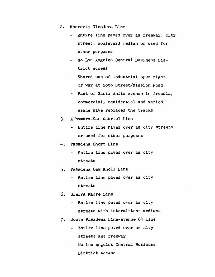
2. Monrovia-Glendora Line
Entire line paved over as freeway, city
street, boulevard median or used for
other purposes
No Los Angeles Central Business Dis
trict access
Shared use of industrial spur right
of way at Soto Street/Mission Road
East of Santa Anita Avenue in Arcadia,
commercial, residential and varied
usage have replaced the tracks
3. Alhambra-San Gabriel Line
Entire line paved over as city streets
or used for other purposes
4. Pasadena Short Line
Entire line paved over as city
streets
5. Pasadena Oak Knoll Line
Entire line paved over as city
streets
6. Sierra Madre Line
Entire line paved over as city
streets with intermittent medians
7. South Pasadena Line-Avenue 64 Line
Entire line paved over as city
streets and freeway
No Los Angeles Central Business
District access

8. North Lake Avenue Line
Entire line paved over as city streets
Connection is needed to a trunk line
unless viewed as an isolated shuttle
9. North Fair Oaks Avenue Line
Entire line paved over as city streets
Connection is needed to a trunk line
unless viewed as an isolated shuttle
10. East Colorado Street Line
Entire line paved over as city streets
Connection is needed to a trunk line
unless viewed as an isolated shuttle
11. Pomona-Upland Line
Line has been paved over as city streets
to Cadillac Avenue
Remainder of line now occupied by resi
dential uses
12. San Bernardino-Riverside Line
Portion of line to Colton is the SPTC
San Bernardino Branch
Shared single track freight usage to
Colton
Missing connection from Colton to West
Colton Yard
Would cross SPTC's Colton Main Line
Shared single track usage with SPTC's
Riverside Branch from west Colton yards
to Riverside
- 158 -
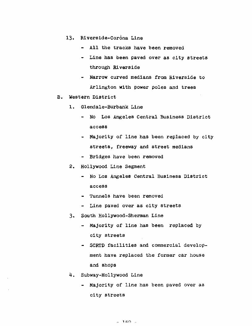
13. Riverside-Cor6na Line
All the tracks have been removed
Line has been paved over as city streets
through Riverside
Narrow curved medians from Riverside to
Arlington with power poles and trees
B. Western District
1. Glendale-Burbank Line
No Los Angeles Central Business District
access
Majority of line has been replaced by city
streets, freeway and street medians
Bridges have been removed
2. Hollywood Line Segment
No Los Angeles Central Business District
access
Tunnels have been removed
Line paved over as city streets
3. South Hollywood-Sherman Line
Majority of line has been replaced by
city streets
SeRTD facilities and commercial develop
ment have replaced the former car house
and shops
4. Subway-Hollywood Line
Majority of line has been paved over as
city streets

- Remaining portions have been replaced by
residential development
5. San Fernando Valley Line
Majority of line has been paved over as
city streets, freeway and medians
- Requires bridge over Los Angeles River
Shared use of SPTC's Burbank Branch Line
wi th freight
6. Hollywood-Venice Line
Portion of the l1ne has been paved over
as city streets
Shared use of SPTC's West Los Angeles
Branch with freight
Needs track replacement, signalization
and grade crossing devices
7. Venice Short Line
Subway ,Building bought by private devel
opers
No Los Angeles Central Business District
access
Majority of line paved over as city streets
and medians
Requires new bridge over Grand Canal
Section through Venice is '~ui1t on II
- 160 -
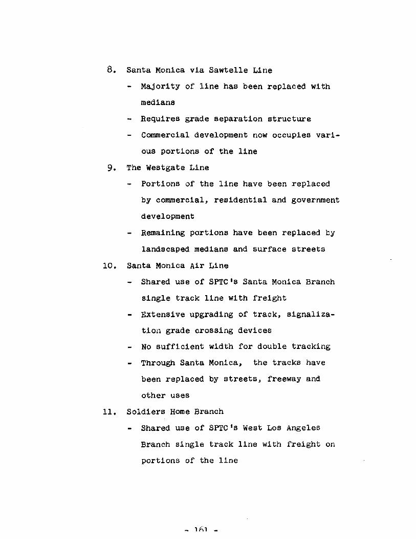
8. Santa Monica via Sawtelle Line
Majority of line has been replaced with
medians
Requires grade separation structure
Commercial development now occupies vari
ous portions of the line
9. The Westgate Line
Portions of the line have been replaced
by commercial, residential and government
development
Remaining portions have been replaced by
landscaped medians and surface streets
10. Santa Monica Air Line
Shared use of SPTC's Santa Monica Branch
single track line with freight
Extensive upgrading of track, signaliza
tion grade crossing devices
No sufficient width for double tracking
Through Santa Monica, the tracks have
been replaced by streets, freeway and
other uses
11. Soldiers Home Branch
Shared use of SPTC's West Los Angeles
Branch single track line with freight on
portions of the line
_ lfil _

On some portions, the track has been re
moved and the line used for parking, com
mercial access and other uses
12. The Redondo Beach-Del Rey Line
Entire route has been replaced or taken
over as city streets, medians, State
beach, city beach or private development
Bridge structures have been removed
13. Inglewood Line
Majority of route unimproved private way
Requires bridge over Ballona Creek
Portions of route used for parking, stor
age and "built on"
C. Southern District
1. Long Beach Line
No Los Angeles Central Business District
access
Shared use of SPTC's Wilmington and East
Long Beach Branches Single track freight
lines
Union Pacific, Southern Pacific and Santa
Fe Railroad crossings
No Long Beach Central Business District
access
Paved surface streets have replaced the
tracks through downtown Los Angeles
_ 1h? _
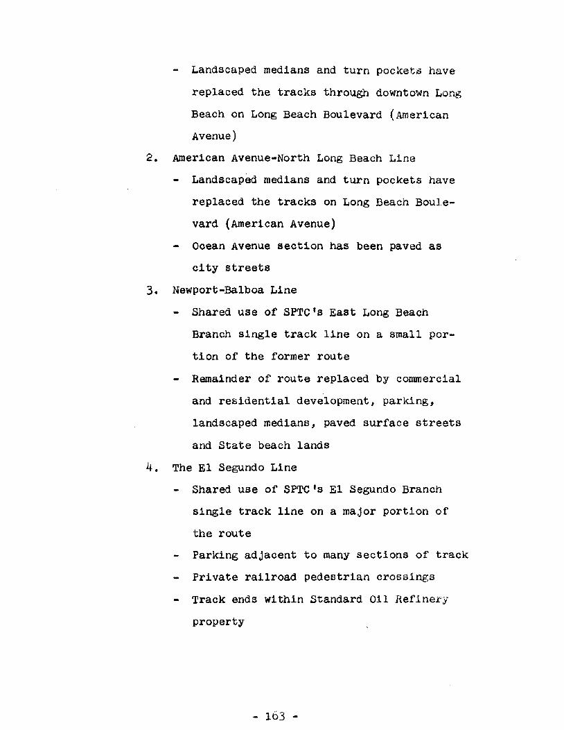
Landscaped medians and turn pockets have
replaced the tracks through downtown Long
Beach on Long Beach Boulevard (American
Avenue)
2. American Avenue-North Long Beach Line
Landscaped medians and turn pockets have
replaced the tracks on Long Beach Boule
vard (American Avenue)
Ooean Avenue seotion has been paved as
oity streets
3. Newport-Balboa Line
Shared use of SPTC's East Long Beach
Branch single track line on a small por
tion of the former route
Remainder of route replaced by commercial
and residential development, parking,
landscaped medians, paved surface streets
and State beach lands
4. The El Segundo Line
Shared use of SPTC's El Segundo Branch
single track line on a major portion of
the route
Parking adjacent to many sections of track
Private railroad pedestrian crossings
Track ends within Standard Oil Refinery
property
- 163 -

- 164 -
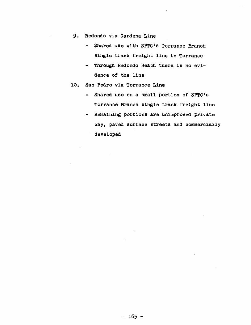
9. Redondo via Gardena Line
Shared use with SPTC's Torrance Branch
single track freight line to Torrance
Through Redondo Beach there is no evi
dence of the line
10. San Pedro via Torrance Line
Shared use on a small portion of SPTC's
Torrance Branch single track freight line
Remaining portions are unimproved private
way, paved surface streets and commercially
developed
- 165 -
