18-0886.03 land of clitheroe road-whalley gea rep 180913
TRANSCRIPT

Geo-Environmental Assessment Land off Clitheroe Road, Whalley Delta-Simons Project Number 18-0886.03
Environment | Health & Safety | Sustainability
Geo-Environmental Assessment Clitheroe Road, Whalley
Presented to Trafford Housing Trust Issued: 13th September 2018
Delta-Simons Project No. 18-0886.03

Geo-Environmental Assessment Land off Clitheroe Road, Whalley Delta-Simons Project Number 18-0886.03
Environment | Health & Safety | Sustainability
Report Details
Client Trafford Housing Trust
Report Title Geo-Environmental Assessment
Site Address Clitheroe Road, Whalley
Project No. 18-0886.03
Report Date 13th September 2018
Delta-Simons Contact Rachel Stringer ([email protected])
Quality Assurance
Issue No.
Status Issue Date Comments Author Technical
Review Authorised
02 Final 13th
September 2018
Updated following completion of
monitoring programme.
Mike O’Halloran
Associate
Rachel Stringer
Principal
Richard Lawless
Unit Director Simon Steele
Associate
About us
Delta-Simons is a trusted, multidisciplinary environmental consultancy, focused on delivering the best possible project outcomes for customers.
Specialising in Environment, Health & Safety and Sustainability, Delta-Simons provide support and advice within the property development, asset management, corporate and industrial markets. Operating from nine locations - Lincoln, Birmingham, Dublin, Durham, Leeds, London, Manchester, Norwich and Nottingham - we employ over 75 environmental professionals, bringing experience from across the private consultancy and public sector markets.
Delta-Simons is proud to be a founder member of the Inogen® Environmental Alliance, a global corporation providing multinational organisations with consistent, high quality and cost effective environmental, health, safety, energy and sustainability solutions. Inogen assists multinational clients by resolving liabilities from the past, addressing today's requirements and delivering solutions for the future. With more than 200 offices located on every continent, more than 6,430 staff worldwide, and projects completed in more than 120 countries, Inogen provides a single point of contact for diverse markets as Automotive, Chemical, Consumer Products & Retail, Financial, Food & Beverage, Healthcare, Insurance, Manufacturing, Non-Profit Organisations, Oil & Gas, Real Estate, Services Firms, Technology and Transportation, among others.

Geo-Environmental Assessment Land off Clitheroe Road, Whalley Delta-Simons Project Number 18-0886.03
Environment | Health & Safety | Sustainability
Executive Summary
Brief Delta-Simons Environmental Consultants Limited (“Delta-Simons”) was instructed by Trafford Housing Trust (the “Client”) to undertake a Site investigation and prepare a Geo-Environmental Assessment for land at Clitheroe Road, Whalley (the “Site”).
The aim of the investigation is to complete a Geo-Environmental Assessment of the Site which is proposed for development for a residential end use, comprising up to 188 units. The investigation will obtain information regarding ground conditions, from which risks to end-users, the environment and structures can be assessed, with mitigation measures outlined, if necessary.
The investigation will provide geotechnical information in order to comment on the preliminary design of foundations and infrastructure. The report will provide recommendations for further work based on the findings of the investigation, if required.
Site Setting The Site currently comprises an irregularly shaped, roughly vegetated plot of agricultural land, formerly used for sheep grazing. The below ground Haweswater Aqueduct cuts through the central part of the Site and a tree lined track runs parallel to provide access to the aqueduct, a United Utilities maintenance building and the adjacent fields.
The Site use appears to be predominantly agricultural from the earliest reviewed historical map dated 1848 until the present day. A reservoir is shown on this map in the centre of the Site; this was presumed to have been infilled and by 1970 there is no evidence on the mapping reviewed of the infilled reservoir.
Ground Conditions
The ground conditions comprises topsoil (to a maximum depth of 0.6 m bgl) underlain by Devensian Till. The Devensian Till typically comprises cohesive sandy and gravelly clay / silt underlain by granular clayey sand / gravel.
The Site investigation and subsequent monitoring data suggest there is a continuous groundwater table below the Site and it should be noted that the investigation and monitoring took place during a prolonged period of dry weather and therefore the groundwater table has the potential to rise once the weather conditions deteriorate. It is also understood that artesian groundwater conditions were encountered during the excavation of attenuation ponds in the central part of the Site, suggesting that the cohesive clay / silt is acting as an aquitard to the underlying granular clayey sand / gravel.
Land Contamination Summary
Human Health
No contaminants exceeded the relevant Generic Assessment Criteria in any of the samples analysed and no asbestos fibres were detected within the tested soil samples. No specific l remedial measures are required to facilitate the proposed development. It is considered that the topsoil may be suitable to be reused with the gardens, subject to further testing.
Controlled Waters
On the basis that the Site has remained largely undeveloped, and in the absence of sources of contamination within soils it is considered that the risk to Controlled Waters is negligible and therefore, no further action is required.
Built Environment
A preliminary review of the results indicates that a relevant pollutant linkage is unlikely to exist associated with organic contaminants and therefore polyethylene and/or polyvinyl chloride water supply pipes may be suitable for use on the development.
Geo-Environmental Assessment Land off Clitheroe Road, Whalley Delta-Simons Project Number 18-0886.03
Environment | Health & Safety | Sustainability
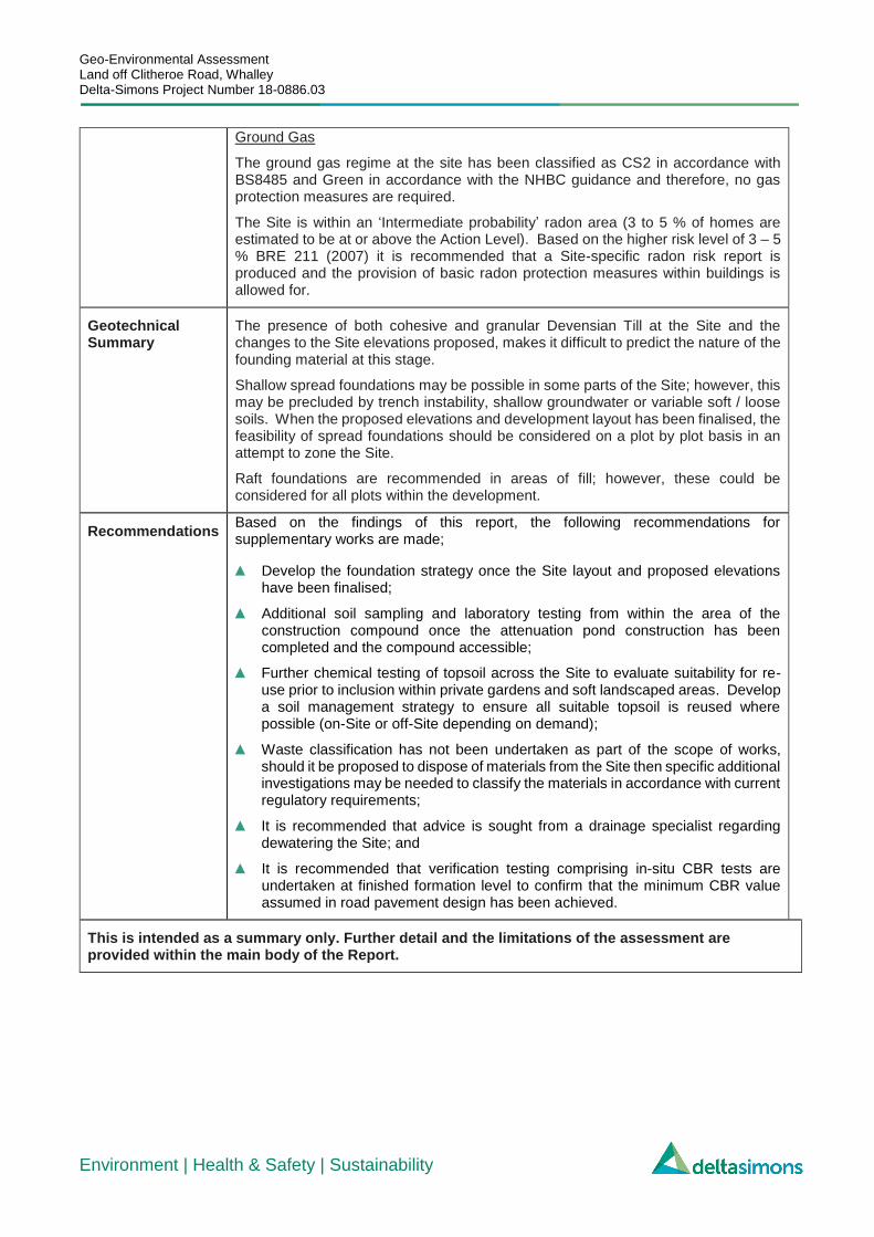
Ground Gas
The ground gas regime at the site has been classified as CS2 in accordance with BS8485 and Green in accordance with the NHBC guidance and therefore, no gas protection measures are required.
The Site is within an ‘Intermediate probability’ radon area (3 to 5 % of homes are estimated to be at or above the Action Level). Based on the higher risk level of 3 – 5 % BRE 211 (2007) it is recommended that a Site-specific radon risk report is produced and the provision of basic radon protection measures within buildings is allowed for.
Geotechnical Summary
The presence of both cohesive and granular Devensian Till at the Site and the changes to the Site elevations proposed, makes it difficult to predict the nature of the founding material at this stage.
Shallow spread foundations may be possible in some parts of the Site; however, this may be precluded by trench instability, shallow groundwater or variable soft / loose soils. When the proposed elevations and development layout has been finalised, the feasibility of spread foundations should be considered on a plot by plot basis in an attempt to zone the Site.
Raft foundations are recommended in areas of fill; however, these could be considered for all plots within the development.
Recommendations Based on the findings of this report, the following recommendations for supplementary works are made;
▲ Develop the foundation strategy once the Site layout and proposed elevations have been finalised;
▲ Additional soil sampling and laboratory testing from within the area of the construction compound once the attenuation pond construction has been completed and the compound accessible;
▲ Further chemical testing of topsoil across the Site to evaluate suitability for re-use prior to inclusion within private gardens and soft landscaped areas. Develop a soil management strategy to ensure all suitable topsoil is reused where possible (on-Site or off-Site depending on demand);
▲ Waste classification has not been undertaken as part of the scope of works, should it be proposed to dispose of materials from the Site then specific additional investigations may be needed to classify the materials in accordance with current regulatory requirements;
▲ It is recommended that advice is sought from a drainage specialist regarding dewatering the Site; and
▲ It is recommended that verification testing comprising in-situ CBR tests are undertaken at finished formation level to confirm that the minimum CBR value assumed in road pavement design has been achieved.
This is intended as a summary only. Further detail and the limitations of the assessment are provided within the main body of the Report.
Geo-Environmental Assessment Land off Clitheroe Road, Whalley Delta-Simons Project Number 18-0886.03
Environment | Health & Safety | Sustainability
Table of Contents
1.0 INTRODUCTION ............................................................................................................................................................... 1 1.1 Appointment ............................................................................................................................................ 1 1.2 Context & Purpose ................................................................................................................................. 1 1.3 Scope of Works ...................................................................................................................................... 1 1.4 Existing Information ................................................................................................................................ 1 1.5 Limitations ............................................................................................................................................... 2
2.0 SITE DETAILS ................................................................................................................................................................... 3 2.1 Site Setting ............................................................................................................................................. 3 2.2 Preliminary Conceptual Site Model ........................................................................................................ 4
3.0 SITE INVESTIGATION ..................................................................................................................................................... 6 3.1 Intrusive Investigation ............................................................................................................................. 6
3.1.1 Health & Safety Considerations ..................................................................................................... 6 3.2 Scope of Ground Investigation and Rationale ........................................................................................ 6
3.2.1 Scope ............................................................................................................................................. 6 3.2.2 Rationale ........................................................................................................................................ 6
3.3 Ground Investigation Factual Data ......................................................................................................... 6 3.4 In-Situ Testing and Sampling ................................................................................................................. 6 3.5 Geotechnical Laboratory Testing............................................................................................................ 7 3.6 Environmental Sampling, In-Situ Testing and Laboratory Analysis ....................................................... 7 3.7 Monitoring Programme ........................................................................................................................... 7
4.0 GROUND SUMMARY ...................................................................................................................................................... 8 4.1 Introduction ............................................................................................................................................. 8 4.2 Ground Model ......................................................................................................................................... 8 4.3 Visual and Olfactory Evidence of Contamination - Soils ........................................................................ 8 4.4 Groundwater ........................................................................................................................................... 8
4.4.1 Strikes During Investigations ......................................................................................................... 8 4.4.2 Levels During Monitoring Programme ........................................................................................... 9
4.5 Visual and Olfactory Evidence of Contamination - Groundwater ......................................................... 10 4.6 Material Properties ............................................................................................................................... 10 4.7 Geochemical Testing ............................................................................................................................ 11 4.8 Ground Gas Data.................................................................................................................................. 11
5.0 GEOTECHNICAL ASSESSMENT ............................................................................................................................... 12 5.1 Summary of Development Proposals ................................................................................................... 12 5.2 Earthworks ............................................................................................................................................ 12
5.2.1 Cut ............................................................................................................................................... 12 5.2.2 Fill ................................................................................................................................................ 12
5.3 Foundations .......................................................................................................................................... 12 5.3.1 Spread Foundations .................................................................................................................... 12 5.3.2 Volume Change Potential ............................................................................................................ 13
5.4 Roads and Pavements ......................................................................................................................... 13 5.5 Excavations & Obstructions .................................................................................................................. 13 5.6 Groundwater ......................................................................................................................................... 13 5.7 Slopes & Retaining Features ................................................................................................................ 14 5.8 Chemical Attack on Buried Concrete ................................................................................................... 14 5.9 Geotechnical Issues ............................................................................................................................. 14
6.0 GENERIC QUANTITATIVE RISK ASSESSMENT .................................................................................................... 15 6.1 Introduction ........................................................................................................................................... 15 6.2 Human Health GQRA ........................................................................................................................... 15
6.2.1 Risks from Soil Sources ............................................................................................................... 15 6.2.2 Risks from Non-Aqueous Phase Liquids (NAPL) ........................................................................ 15
6.3 Controlled Waters/Water Environment ................................................................................................. 15 6.4 Built Environment.................................................................................................................................. 15
6.4.1 Potable Water Supply Pipes ........................................................................................................ 15 6.4.2 Building Materials ........................................................................................................................ 16
6.5 Waste Classification ............................................................................................................................. 16 7.0 BULK GROUND GAS RISK ASSESSMENT ............................................................................................................. 17

Geo-Environmental Assessment Land off Clitheroe Road, Whalley Delta-Simons Project Number 18-0886.03
Environment | Health & Safety | Sustainability
7.1 Ground Gas Conceptual Site Model ..................................................................................................... 17 7.1.1 Sources ........................................................................................................................................ 17 7.1.2 Receptors ..................................................................................................................................... 17 7.1.3 Pathways ..................................................................................................................................... 17
7.2 Duration & Extent of Monitoring ............................................................................................................ 17 7.3 Ground Gas Risk Assessment ............................................................................................................. 17
7.3.1 Background .................................................................................................................................. 17 7.3.2 Gas Screening Value (GSV) ........................................................................................................ 18
7.4 Ground Gas Risk Mitigation .................................................................................................................. 18 7.5 Radon ................................................................................................................................................... 18 7.6 Organic Vapours ................................................................................................................................... 18
8.0 REVISED CONCEPTUAL SITE MODEL .................................................................................................................... 19 9.0 CONCLUSIONS & RECOMMENDATIONS ............................................................................................................... 20
9.1 Geotechnical Summary ........................................................................................................................ 20 9.2 Contamination Issues ........................................................................................................................... 20
9.2.1 Human Health .............................................................................................................................. 20 9.2.2 Controlled Waters ........................................................................................................................ 20
9.3 Recommendations for Supplementary Work ........................................................................................ 21
Figures
Figure 1 Site Location Map
Figure 2 Exploratory Hole Location and Proposed Development Plan
Figure 3 SPT N60 versus Depth Plot
Figure 4a – 4c Inferred Geological Cross Sections
Appendices
Appendix A Limitations
Appendix B Borehole and Trial Pit Logs, SPT Calibration Certificate
Appendix C Geotechnical Analysis Results
Appendix D Soil Chemical Analysis Results
Appendix E Groundwater Chemical Analysis Results
Appendix F Gas and Groundwater Monitoring Data
Appendix G Risk Definitions

Geo-Environmental Assessment Land off Clitheroe Road, Whalley Delta-Simons Project Number 18-0886.03 Page 1
Environment | Health & Safety | Sustainability
1.0 Introduction
1.1 Appointment
Delta-Simons Environmental Consultants Limited (“Delta-Simons”) was instructed by Trafford Housing Trust (the “Client”) to undertake a Site investigation and prepare a Geo-Environmental Assessment for land at Clitheroe Road, Whalley (the “Site”).
1.2 Context & Purpose
The aim of the investigation is to complete a Geo-Environmental Assessment of the Site which is proposed for development. The investigation will obtain information regarding ground conditions, from which risks to end-users, the environment and structures can be assessed, with mitigation measures outlined, if necessary.
The investigation will provide geotechnical information in order to comment on the preliminary design of foundations and infrastructure. The report will provide recommendations for further work based on the findings of the investigation, if required.
It is understood that the Site is to be developed for a residential end use, comprising up to 188 units. The Site has outline planning permission (Ref. 3/2013/0137) dated October 2013 and reserved matters approval (Ref. 3/2015/0489) dated January 2016; however, it is understood that the findings of this investigation will be used to support a fresh full planning application by Trafford Housing Trust (THT) to Ribble Valley Borough Council (RVBC).
1.3 Scope of Works
The scope of the investigation and layout of this report has been designed with consideration of CLR11 (Environment Agency, 2004a), BS 10175: 2013 Investigation of Potentially Contaminated Sites – Code of Practice (BSI, 2011), guidance on land contamination reports issued by the Environment Agency (EA) (2010a) and BS 5930: 2015 Code of practice for ground investigations.
The project was carried out to an agreed brief as set out in Delta-Simons’ proposal dated 26 July 2018 (Ref. 18-0886.03). The scope of works is detailed in Section 3.2.1.
Specific sections of this report may generally follow guidance set out in Eurocode 7 for a Ground Investigation Report (GIR), as defined in BS EN 1997-1:2004 and BS EN 1997-2:2007. Eurocode 7 includes specific guidance on the number and spacing of investigation positions, methods of investigation and sample quality to be achieved which may not have been met by this investigation. The report also includes information which may support a Geotechnical Design Report (GDR) as defined in BS EN 1997-1:2004; however, unless otherwise explicitly stated, the investigation has not been undertaken in accordance with Eurocode 7 and the preliminary geotechnical interpretation, assessments, risk register and recommendations presented within this report may not meet the full requirements of a GDR.
1.4 Existing Information
Delta-Simons have been provided with the following relevant reports;
▲ Preliminary Assessment of Ground Conditions, Land East of Clitheroe Road, Whalley for Commercial Estates Group, Report C4023 Rev 3, dated February 2013;
▲ Geoenvironmental Appraisal of land to the east of Clitheroe Road, Whalley for Commercial Estates Group, C4023A, dated January 2013; and
▲ Geotechnical Assessments of Ponds A and B – Various authors, 2014 – 2018.
In additional to the above Delta-Simons has produced a Preliminary Geo-Environmental Risk Assessment for the Site (Ref. 18-0886.01) dated 27th July 2018.

Geo-Environmental Assessment Land off Clitheroe Road, Whalley Delta-Simons Project Number 18-0886.03 Page 2
Environment | Health & Safety | Sustainability
1.5 Limitations
The assessment is limited to the issues agreed within the proposal for the works. Notes on limitations associated with this assessment are provided in Appendix A. In addition, there are the following Site-specific limitations that apply to this assessment:
▲ An area in the west of the Site was inaccessible during the Site investigation due to the construction of attenuation ponds for drainage purposes and the associated compound and working area;
▲ Dynamic Cone Penetrometers (DCPs) were omitted from the scope due to earthworks being proposed on-Site. It is recommended that these are undertaken at a later date to determine indicative CBR values at finished formation level;
▲ Due to the presence of a concrete slab in the north-east it was not possible to obtain soil samples from below the slab; however, this location is within an area proposed as public open space;
▲ The potential location of an infilled reservoir was within the attenuation pond construction area and was therefore inaccessible; and
▲ The Haweswater Aqueduct owned by United Utilities passes through the central part of the Site and no intrusive Site investigation was permitted on or within a specified easement of the underground infrastructure. This resulted in exploratory holes DS109, TP114 to TP117 and TP121 being repositioned or cancelled.

Geo-Environmental Assessment Land off Clitheroe Road, Whalley Delta-Simons Project Number 18-0886.03 Page 3
Environment | Health & Safety | Sustainability
2.0 Site Details
2.1 Site Setting
A summary of the current Site status, environmental setting and key historical features is presented below. This has been summarised from the existing reports listed in Section 1.4 which should be consulted for further detail.
Co-ordinates Centred at approximate National Grid Reference 373760,436440.
Elevation Variable
Area 10.34 ha
Site Location The Site is located to the west of (A671) on the eastern periphery of Whalley which is approximately 5 km south of Clitheroe. Please refer to Figure 1.
Current Site Use The Site currently comprises an irregularly shaped, roughly vegetated plot of agricultural land, formerly used for sheep grazing.
The buried Haweswater Aqueduct cuts through the central part of the Site and a tree lined track runs parallel to provide access to the aqueduct, a United Utilities maintenance building and the adjacent fields.
A gated access track provides access to the northern field from the A671. An area of vacant hardstanding is present in the north-east of the Site, with the exception of some discarded silage/haylage bales. Immediately west and south of the Site are residential properties including a new Redrow development and houses along Woodlands Park and Sydney Avenue.
The A671 and a small area of woodland forms the north-eastern Site boundary and immediately southeast of the Site is an undeveloped plot of roughly vegetated land. There is more roughly vegetated land to the north of the Site beyond which is Oakhill nursery and college.
Proposed Development
The proposed development comprises up to 188 residential units considered to be standard two / three storey dwellings with private gardens and associated areas of public open space. Please refer to Figure 2 for a Proposed Development Plan.
Identified human and built environment receptors (R) relevant to the proposed development comprise:
▲ Construction workers (R1);
▲ Third parties during construction (adjacent Site users and adjacent residents) (R2);
▲ Future Site users and maintenance workers (R3); and
▲ The Built Environment (new buildings and infrastructure / utilities) (R4).
Environmental Setting
British Geological Survey (BGS) data available online and from published BGS mapping (1:50,000 Sheet Number 68 Clitheroe) shows that the Site is underlain by superficial deposits comprising Devensian Till. The underlying bedrock comprises mudstones of the Bowland Shale Formation. Given the current Site conditions (agricultural land), topsoil is likely to be present overlying the Devensian Till.
The Devensian Till is designated by the Environment Agency as Unproductive Strata and the bedrock is designated as a Secondary (undifferentiated) Aquifer.
The following controlled water / environmental receptors have been identified:
▲ The unnamed stream along Brooke’s Lane (R5);
▲ The underlying aquifers (R6); and

Geo-Environmental Assessment Land off Clitheroe Road, Whalley Delta-Simons Project Number 18-0886.03 Page 4
Environment | Health & Safety | Sustainability
2.2 Preliminary Conceptual Site Model
A summary of the preliminary Conceptual Site Model (CSM) contained in the Delta-Simons Preliminary Geo-Environmental Risk Assessment, dated 27th July 2018, is presented below.
▲ The River Calder, circa 200 m to the south (R7).
Key Historical Features
The Site use appears to be predominantly agricultural from the earliest reviewed historical map dated 1848 until the present day. A reservoir is shown on this map in the centre of the Site although it is not explicitly identified as such until later mapping. Although not shown on historical mapping, it is understood that the Haweswater Aqueduct was constructed between 1935 to 1955. The 1968 map suggests that the reservoir has been drained and a depression is evident in this location (potentially infilling occurring). The 1992 map shows an access track from Brooke’s Lane through the centre of the Site and a second track is shown in the northern field from an area of hardstanding in the north-east heading west. By 1970 there is no evidence of the infilled reservoir and there are no other significant changes shown on maps from this time to the present day.
A former gasholder / gasworks approximately 75 m to the south of the Site is shown on historical maps from 1932 to sometime prior to 1989. The 1989 map shows the gasholder / gasworks has been redeveloped into residential housing.
Summary of Previous Reports
▲ Preliminary Assessment of Ground Conditions, Land East of Clitheroe Road, Whalley for Commercial Estates Group, Report C4023 Rev 3, dated February 2013.
The report identified the requirement for basic radon protection measures and further site investigation works to assess ground conditions. The aqueduct and existing footpath were considered as potential development constraints.
▲ Geoenvironmental Appraisal of land to the east of Clitheroe Road, Whalley for Commercial Estates Group, C4023A, dated January 2013.
This detailed a site investigation on a plot of land adjacent to the current subject site. The investigation comprised 19 trial pits to a maximum depth of 4.2 m below ground level (bgl) and six window sample boreholes to a maximum depth of 6.45 m bgl. The ground conditions comprised topsoil underlain by Glacial Till (firm to stiff gravelly clay) to the east of an unnamed brook, where traditional strip/pad foundations were considered suitable. An upper layer of very soft silt was identified in one area of the site which was also noted to be waterlogged. To the west of the brook, topsoil was underlain by very soft to soft clay and piles were recommended.
Marginally elevated concentrations of benzo(a)pyrene were detected within natural topsoil. This was considered likely attributable to fragments of coal within the sample. Further analysis of topsoil was considered necessary to inform its suitability for re-use.
Basic radon protection measures were recommended; however, no sources of ground gas were identified.
▲ Geotechnical Assessments of Ponds A and B – Various authors, 2014 – 2018.
BWB Consulting, Sirius Geotechnical and GRM Development have been involved in a Site investigation and the design of surface water attenuation ponds. Artesian groundwater was encountered within granular strata at circa. 8 m depth. The risk of settlement of the aqueduct as a result of dewatering during construction of the ponds was also considered and predicted settlement values were within acceptable limits.

Geo-Environmental Assessment Land off Clitheroe Road, Whalley Delta-Simons Project Number 18-0886.03 Page 5
Environment | Health & Safety | Sustainability
Source(s) Potential Contaminants of
Concern (CoC) Pathway(s) Receptor(s) Preliminary Risk Rating
S1 Possible Made Ground Asbestos, heavy metals, TPH, PAHs P1, P2, P4, P5 R1, R3, R4, R5, R6 Low Risk
S2 Construction Compound TPH P1, P2, P4, P5 R1, R3, R4, R5, R6 Low Risk
S3 Infilled Reservoir Asbestos, heavy metals, TPH, PAHs, ground gases
P1, P2, P3, P4, P5 R1, R2, R3, R5, R6 Low to Moderate Risk
S4 Off-Site Gasworks Spent oxides, cyanide, phenols, petroleum hydrocarbons, VOC, SVOC’s
P2, P3, P4, P5 R1, R3, R4, R5, R6 Low Risk
Pathways:
▲ P1 - Direct contact, ingestion or inhalation of soil bound contaminants / dust during or following redevelopment.
▲ P2 - Inhalation of organic vapours associated with contamination.
▲ P3 - Migration of ground gas / vapours into on-site buildings causing asphyxiation or risk of explosion.
▲ P4 - Leaching of contamination into groundwater followed by migration of groundwater to the wider groundwater environment or discharge to surface waters.
▲ P5 - Direct contact between aggressive ground conditions and new infrastructure.
Receptors:
▲ R1 - Construction workers;
▲ R2 - Third parties during construction (adjacent Site users and adjacent residents);
▲ R3 - Future Site users and maintenance workers;
▲ R4 – River Calder (200 m to the south);
▲ R5 - The underlying aquifers; and
▲ R6 - The Built Environment (new buildings and infrastructure / utilities) including Haweswater Aqueduct.
Risk ratings are based on the classifications given in Appendix G.

Geo-Environmental Assessment Land off Clitheroe Road, Whalley Delta-Simons Project Number 18-0886.03 Page 6
Environment | Health & Safety | Sustainability
3.0 Site Investigation
3.1 Intrusive Investigation
Delta-Simons carried out an intrusive investigation between the 9th to 13th July 2018 to obtain information regarding ground conditions, from which risks to end-users, the environment and structures can be assessed, with mitigation measures outlined, if necessary and provide geotechnical information in order to comment on the preliminary design of foundations and infrastructure.
3.1.1 Health & Safety Considerations
Service plans for the Site were provided by the Client and a utilities clearance specialist attended the Site on 9th and 10th July 2018 to carry out service avoidance works. No intrusive works were undertaken within a 13 m easement of the Haweswater Aqueduct.
An initial assessment of the Site identified a Low risk in relation to Unexploded Ordnance (UXO) and so no specific precautionary measures were required for the works. Future Contractors should undertake their own assessment of UXO risk in relation to their specific proposed scope of works.
3.2 Scope of Ground Investigation and Rationale
3.2.1 Scope
The Site investigation comprised the following items:
▲ Supervision of all works by Delta-Simons Geo-Environmental engineers. All intrusive locations were logged to BS 5930:2015 Code of practice for ground investigations;
▲ Excavation of 38 trial pits (TP101-TP113, TP118-TP120, and TP122-TP143) using a JCB 3CX to a maximum depth of 4.5 m bgl; and
▲ Drilling of 11 no. dynamic sampler boreholes (DS101-DS108, and DS110-DS112) to a maximum depth of 5.0 m bgl.
3.2.2 Rationale
All locations were placed for general coverage across the Site.
3.3 Ground Investigation Factual Data
The investigation locations were surveyed in by the appointed surveying contractor to an accuracy of approximately +/- 0.1 m. An Exploratory Hole Location Plan is included as Figure 2.
Delta-Simons’ engineer borehole and trial pit logs are presented as Appendix B together with the Standard Penetration Tests (SPT) Calibration Certificate, in accordance with BS EN ISO 22476-3:2005 (incorporating corrigendum No. 1 2007), Geotechnical investigation and testing - Field testing - Part 3: Standard penetration test for SPT trip hammers.
3.4 In-Situ Testing and Sampling
Standard Penetration Tests (SPTs) were undertaken in all boreholes at 1.0 m intervals to 5.0 m bgl where ground conditions allowed. The results of these tests are presented on the borehole logs included as Appendix B. Corrected SPT N60 values have been plotted against Depth and are shown in Figure 3.
Hand vane shear (HSV) tests were undertaken where possible in cohesive soils excavated out of the trial pits. The test results are shown on the trial pit logs presented in Appendix B.
Sampling comprised disturbed tub, jar and bulk bag samples as detailed on the logs.

Geo-Environmental Assessment Land off Clitheroe Road, Whalley Delta-Simons Project Number 18-0886.03 Page 7
Environment | Health & Safety | Sustainability
3.5 Geotechnical Laboratory Testing
A selection of soil samples were submitted to the UKAS accredited laboratory for a range of geotechnical testing, the results of which are included in Appendix C. A summary of the geotechnical tests undertaken is provided below.
Analysis No. Tested Rationale
Moisture content 10 To assess the classification properties of the soils encountered in order to inform preliminary geotechnical advice.
Plastic and liquid limits 10
Particle size distribution (wet / dry sieve) 8
Particle size distribution (sedimentation) 5
In addition to these tests soil samples were taken from two stockpiles of Devensian Till located within the attenuation pond (AP) construction compound. The samples were submitted to the laboratory for particle size distribution testing to determine if the soil classified as Acceptable Earthworks Materials in accordance with the Specification for Highways Works, and therefore could be re-used on-Site during the development.
3.6 Environmental Sampling, In-Situ Testing and Laboratory Analysis
Soils collected for laboratory analysis were placed in a variety of containers appropriate to the anticipated testing suite. Samples were stored in accordance with Delta-Simons’ quality procedures to maintain sample integrity and preservation and to minimise the chance of cross contamination. Records of the samples taken including their depth and location are shown on the exploratory hole logs in Appendix B.
Seven groundwater samples were collected (from DS101, DS102, DS103, DS107, DS110, DS111 and DS112) on 31st July 2018. The groundwater samples were collected using a dedicated disposable bailer and placed in chilled cool boxes on-Site before being transported to the laboratory upon completion of the sampling visit.
The rationale for chemical analysis is presented in the table below and the results of the chemical laboratory testing are included in Appendix D (soils) and Appendix E (groundwater).
Analytes
No. of Samples Tested
Rationale
Soil Groundwater
Asbestos 7 - Common potential contaminant - Analysed in samples of topsoil.
Metals (including As, B, Ba, Be Cd, Cu, Cr, Hg, Pb, Ni, Zn), speciated Polycyclic Aromatic Hydrocarbons (PAH)
13 3 Potential contaminants of concern, common to many Sites.
Total Petroleum Hydrocarbons, Criteria Working Group Method (TPHCWG), Benzene, Toluene, Ethylbenzene and Xylene (BTEX)
13 2 Potential contaminants of concern, common to many Sites.
pH, sulphate 10 7 To assess the potential for chemical attack on buried concrete.
3.7 Monitoring Programme
A total of six rounds of groundwater level and ground gas monitoring visits have been completed over a three-month period between 19th July 2018 and 11th September 2018 on installed borehole wells (DS101-DS108, and DS110-DS112). The depth to groundwater within the borehole wells was recorded using an electronic dip meter. The groundwater monitoring sheets are included as Appendix F.
To characterise the ground gas regime at the Site, an infrared gas meter was used to measure gas flow, concentrations of carbon dioxide (CO2), methane (CH4) and oxygen (O2) in percentage by volume. Initial and steady state concentrations were recorded. The atmospheric pressure before and during monitoring, together with the weather conditions, was recorded. All gas monitoring results obtained to date together with the temporal conditions are contained within Appendix F.
Geo-Environmental Assessment Land off Clitheroe Road, Whalley Delta-Simons Project Number 18-0886.03 Page 8
Environment | Health & Safety | Sustainability
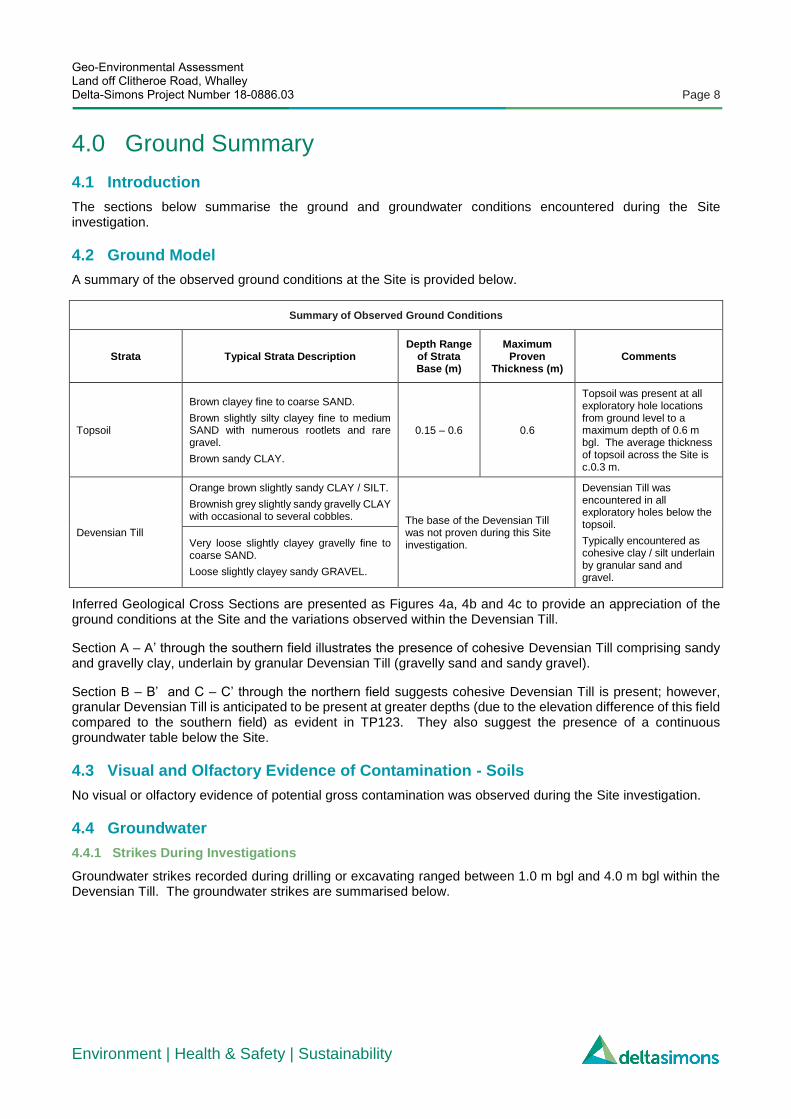
4.0 Ground Summary
4.1 Introduction
The sections below summarise the ground and groundwater conditions encountered during the Site investigation.
4.2 Ground Model
A summary of the observed ground conditions at the Site is provided below.
Summary of Observed Ground Conditions
Strata Typical Strata Description Depth Range
of Strata Base (m)
Maximum Proven
Thickness (m) Comments
Topsoil
Brown clayey fine to coarse SAND.
Brown slightly silty clayey fine to medium SAND with numerous rootlets and rare gravel.
Brown sandy CLAY.
0.15 – 0.6 0.6
Topsoil was present at all exploratory hole locations from ground level to a maximum depth of 0.6 m bgl. The average thickness of topsoil across the Site is c.0.3 m.
Devensian Till
Orange brown slightly sandy CLAY / SILT.
Brownish grey slightly sandy gravelly CLAY with occasional to several cobbles. The base of the Devensian Till
was not proven during this Site investigation.
Devensian Till was encountered in all exploratory holes below the topsoil.
Typically encountered as cohesive clay / silt underlain by granular sand and gravel.
Very loose slightly clayey gravelly fine to coarse SAND.
Loose slightly clayey sandy GRAVEL.
Inferred Geological Cross Sections are presented as Figures 4a, 4b and 4c to provide an appreciation of the ground conditions at the Site and the variations observed within the Devensian Till.
Section A – A’ through the southern field illustrates the presence of cohesive Devensian Till comprising sandy and gravelly clay, underlain by granular Devensian Till (gravelly sand and sandy gravel).
Section B – B’ and C – C’ through the northern field suggests cohesive Devensian Till is present; however, granular Devensian Till is anticipated to be present at greater depths (due to the elevation difference of this field compared to the southern field) as evident in TP123. They also suggest the presence of a continuous groundwater table below the Site.
4.3 Visual and Olfactory Evidence of Contamination - Soils
No visual or olfactory evidence of potential gross contamination was observed during the Site investigation.
4.4 Groundwater
4.4.1 Strikes During Investigations
Groundwater strikes recorded during drilling or excavating ranged between 1.0 m bgl and 4.0 m bgl within the Devensian Till. The groundwater strikes are summarised below.
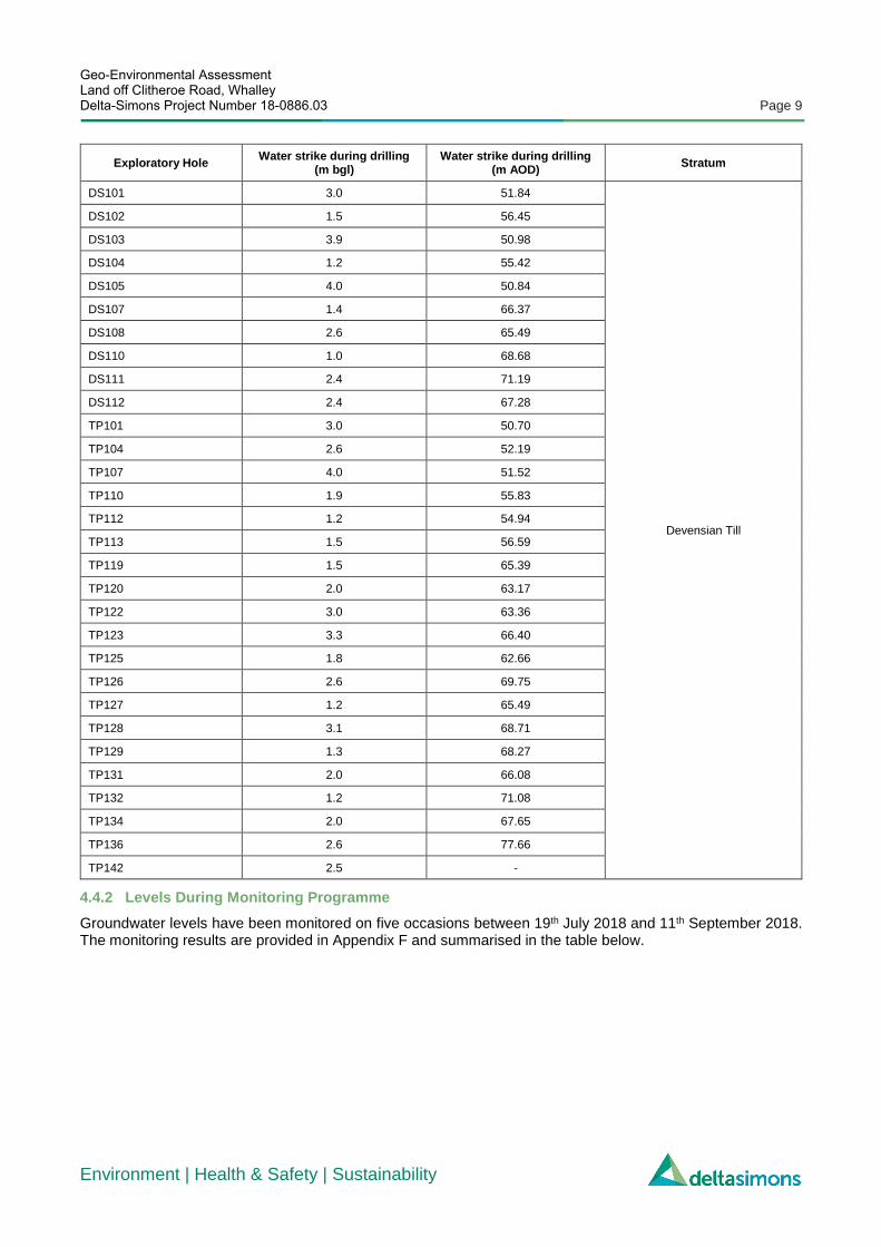
Geo-Environmental Assessment Land off Clitheroe Road, Whalley Delta-Simons Project Number 18-0886.03 Page 9
Environment | Health & Safety | Sustainability
Exploratory Hole Water strike during drilling
(m bgl) Water strike during drilling
(m AOD) Stratum
DS101 3.0 51.84
Devensian Till
DS102 1.5 56.45
DS103 3.9 50.98
DS104 1.2 55.42
DS105 4.0 50.84
DS107 1.4 66.37
DS108 2.6 65.49
DS110 1.0 68.68
DS111 2.4 71.19
DS112 2.4 67.28
TP101 3.0 50.70
TP104 2.6 52.19
TP107 4.0 51.52
TP110 1.9 55.83
TP112 1.2 54.94
TP113 1.5 56.59
TP119 1.5 65.39
TP120 2.0 63.17
TP122 3.0 63.36
TP123 3.3 66.40
TP125 1.8 62.66
TP126 2.6 69.75
TP127 1.2 65.49
TP128 3.1 68.71
TP129 1.3 68.27
TP131 2.0 66.08
TP132 1.2 71.08
TP134 2.0 67.65
TP136 2.6 77.66
TP142 2.5 -
4.4.2 Levels During Monitoring Programme
Groundwater levels have been monitored on five occasions between 19th July 2018 and 11th September 2018. The monitoring results are provided in Appendix F and summarised in the table below.

Geo-Environmental Assessment Land off Clitheroe Road, Whalley Delta-Simons Project Number 18-0886.03 Page 10
Environment | Health & Safety | Sustainability
Exploratory Hole
Response Zone Water level during Monitoring
Stratum Max to Min Range
m bgl
m bgl m
AOD m
AOD m bgl m AOD
DS101 1.00 4.00 53.84 50.84 3.41 4.04 50.80 51.43 Devensian Till
DS102 1.00 4.50 56.95 53.45 2.98 3.64 54.31 54.97 Devensian Till
DS103 1.00 4.00 53.88 50.88 3.73 3.75 51.13 51.15 Devensian Till
DS105 1.00 4.00 53.85 50.85 2.46 2.57 52.28 52.39 Devensian Till
DS106 1.00 4.50 64.81 61.31 4.19 4.41 61.40 61.62 Devensian Till
DS107 1.00 4.50 66.77 63.27 3.00 3.21 64.56 64.77 Devensian Till
DS110 1.00 4.50 68.68 65.18 2.23 3.75 65.93 67.45 Devensian Till
DS111 1.00 4.60 72.59 68.99 3.36 3.89 69.70 70.23 Devensian Till
DS112 1.00 4.90 68.68 64.78 3.01 4.19 65.49 66.67 Devensian Till
The groundwater strikes during the Site investigation combined with the monitoring data above suggest there is a continuous (and fluctuating due to weather conditions) groundwater table below the Site, at an elevation of approximately 70 m AOD in the far north-east and 51 m AOD in the far south-west (approximately 2.0 – 4.0 m below existing ground level).
Locally the groundwater flows appears to be to the south-west towards the adjacent un-named brook, regionally groundwater flow is likely to be to the south, towards the River Calder located approximately 280 m to the south of the Site.
It should be noted that the Site investigation and subsequent groundwater monitoring took place during a prolonged period of dry weather and therefore the groundwater table has the potential to rise once the weather conditions deteriorate and become wetter. It is also understood that artesian groundwater conditions were encountered during the excavation of attenuation ponds in the central part of the Site, suggesting that the cohesive Devensian Till is acting as an aquitard to the underlying granular (more permeable) Devensian Till.
4.5 Visual and Olfactory Evidence of Contamination - Groundwater
No visual or olfactory evidence of potential gross contamination was observed during the Site investigation.
4.6 Material Properties
The table below summarises the factual material properties based upon the results of in-situ and laboratory test data and where appropriate provides derived geotechnical parameters.
Parameter Devensian Till
Moisture Content - w 9 % - 33 %
Liquid Limit - wL 26 % - 69 %
Plastic Limit - wP 14 % - 30 %
Plasticity Index - IP 12 % - 39 %
Modified Plasticity Index - I’P 6 % - 37 %
Particle Density 2.64 Mg/m3 – 2.69 Mg/m3
Maximum Dry Density 1.78 Mg/m3 – 1.82 Mg/m3
Optimum Moisture Content 13 %
Corrected SPT N60 values have been plotted against depth and are included as Figure 3.

Geo-Environmental Assessment Land off Clitheroe Road, Whalley Delta-Simons Project Number 18-0886.03 Page 11
Environment | Health & Safety | Sustainability
4.7 Geochemical Testing
Geochemical analysis was undertaken on 10 soil samples and 7 groundwater samples in accordance with BRE Special Digest 1:2005 (3rd Edition), Concrete in aggressive ground. The results are summarised in the table below.
Tests No. of Tests
Minimum Maximum
Soil - pH 10 7.3 8.4
Water Soluble Sulphate (SO4) (2:1 Leachate Equivalent)
10 0.0075 g/l 0.18 g/l
Water – pH 7 6.3 7.2
Water – Sulphate as SO4 7 7.6 mg/l 33.5 mg/l
4.8 Ground Gas Data
Gas monitoring has been undertaken on six occasions in installed boreholes DS101-DS103, DS105-DS107 and DS110-DS112). The results are presented in Appendix F and are summarised in the table below.
Barometric pressures ranged from 1001 mBar and 1015 mBar during the six visits.
Exploratory Hole
Steady Gas Concentration (%v/v) Steady Flow Rate
(l/hr)
Response Zone (m bgl) Stratum Flooded? Methane
Carbon Dioxide
Oxygen
Min Max Min Max Min Max Min Max From To
DS101 <0.1 0.0 0.2 2.0 18.7 20.4 <0.1 <0.1 1.0 4.0 Devensian Till No
DS102 <0.1 0.0 1.8 4.2 18.2 19.4 <0.1 <0.1 1.0 4.5 Devensian Till No
DS103 <0.1 0.0 0.1 2.5 18.6 20.4 <0.1 <0.1 1.0 4.0 Devensian Till No
DS105 <0.1 0.0 1.3 2.5 16.8 19.8 <0.1 <0.1 1.0 4.0 Devensian Till No
DS106 <0.1 0.0 0.1 3.0 16.7 20.6 <0.1 <0.1 1.0 4.5 Devensian Till No
DS107 <0.1 0.0 1.3 2.4 18.2 19.4 <0.1 <0.1 1.0 4.5 Devensian Till No
DS110 <0.1 0.0 1.8 2.9 17.1 19.7 <0.1 <0.1 1.0 4.5 Devensian Till No
DS111 <0.1 0.0 0.2 2.0 18.8 20.4 <0.1 <0.1 1.0 4.6 Devensian Till No
DS112 <0.1 0.0 0.5 3.7 18.7 20.4 <0.1 <0.1 1.0 4.9 Devensian Till No

Geo-Environmental Assessment Land off Clitheroe Road, Whalley Delta-Simons Project Number 18-0886.03 Page 12
Environment | Health & Safety | Sustainability
5.0 Geotechnical Assessment
5.1 Summary of Development Proposals
The proposed development comprises 188 residential dwellings with private gardens, driveways and access roads. A Proposed Development Plan is included as Figure 2.
Earthworks are proposed at the Site and proposed levels have yet to be finalised. The geotechnical assessment provided below is based upon existing ground levels and this section should be revisited once the proposed levels are finalised.
5.2 Earthworks
Materials used as fill will need to be placed to a suitable engineering specification and the degree of compaction required will be dependent on end usage and serviceability criteria. For example, a lesser degree of compaction may be suitable for paved areas than for building platforms supporting foundations and ground bearing slabs.
It is understood that between 1 m and 3 m of fill may be required in some parts of the Site. Shallow earthworks are likely to encounter both cohesive and granular Devensian Till; however generally the cohesive material is underlain by the granular material and therefore it may be possible to separate out the materials during excavation.
Gradings have been undertaken on 6 samples of cohesive Devensian Till and 2 samples of granular Devensian Till. The cohesive material tested appear to classify as a Class 2 material (General Cohesive Fill) and the granular material tested appears to classify as a Class 1 material (General Granular Fill) in accordance with the Specification for Highways Works, Table 6/1 Acceptable Earthworks Materials and Table 6/2 Grading Requirements for Acceptable Earthworks Materials.
In addition to these tests soil samples were taken from two stockpiles of Devensian Till located within the attenuation pond (AP) construction compound. The gradings results appear to classify the material as a Class 2C (General Cohesive Fill – Stony Cohesive Material) and Class 2D (General Cohesive Fill – Silty Cohesive Material).
A specification for re-use of these soils will need to be prepared by a suitably qualified geotechnical engineer to ensure that the materials are placed and compacted to an engineering specification and that the subsequent platform is suitable for development incorporating raft foundations.
5.2.1 Cut
Depending on the nature of the material at formation level, localised over-excavation may be required to ensure that the formation meets the minimum geotechnical parameters required for founding upon. If over-excavation is required, the base of the excavation shall be thoroughly proof rolled and the replaced material shall be recompacted to an engineering specification.
5.2.2 Fill
Following a topsoil strip, it is recommended that any Made Ground, organic material or soft spots are removed and the formation thoroughly proof rolled. The fill placed below plots should be to an end-product specification produced by the structural / civil engineers.
5.3 Foundations
5.3.1 Spread Foundations
Depending on the proposed elevations and location on-Site, granular and / or cohesive Devensian Till or engineered fill may be present at founding level.
It may be possible to use shallow spread foundations in some parts of the Site, founding upon firm clay or medium dense sand; however, this may be precluded by trench instability, shallow groundwater or variable soft /loose soils. The actual ground conditions at founding level are difficult to predict at this stage. When the

Geo-Environmental Assessment Land off Clitheroe Road, Whalley Delta-Simons Project Number 18-0886.03 Page 13
Environment | Health & Safety | Sustainability
proposed elevations and development layout has been finalised, the feasibility of spread foundations should be considered on a plot by plot basis in an attempt to zone the Site.
Raft foundations are recommended in areas of fill; however, these could be considered for all plots within the development. Following a topsoil strip raft foundations are likely to be suitable and based on the findings of this Site investigation, a uniformly distributed load of 25 kPa is likely to be achievable (within acceptable settlement limits).
Made Ground or soft spots should be excavated and replaced with a well compacted granular fill and all foundation excavations should be inspected by a suitably qualified geotechnical engineer prior to casting to ensure the appropriate depth, founding medium and strength characteristics have been achieved.
5.3.2 Volume Change Potential
The volume change potential should be considered in any foundation schedule for structures and services located within the influence zone of trees or bushes (proposed, existing or to be removed) and appropriate precautions and/or founding depths should be designed accordingly. In cohesive soils, foundations will therefore need to be designed in accordance with NHBC Standard Chapter 4.2 ‘Building Near Trees’ (2016).
The A-Line Plots presented in the geotechnical analysis results in Appendix C suggest that the cohesive material varies from low to high plasticity. The modified plasticity index (I’P) results suggest that the cohesive material has a ‘medium’ volume change potential. Plots within the vicinity of existing or proposed tree’s / vegetation should be considered on a plot by plot basis to ensure the minimum founding depth (as stated in the above guidance) is achieved to mitigate against heave / subsidence caused by shrinking / swelling clay.
5.4 Roads and Pavements
It is recommended that a conservative California Bearing Ratio (CBR) value of 2 % should be adopted for preliminary road pavement design for external areas until verification testing comprising in-Situ CBR tests can be undertaken post earthworks, and at finished formation level.
5.5 Excavations & Obstructions
It is expected that conventional mechanical excavators will readily remove the Devensian Till likely to be encountered in shallow excavations, although a breaker may be required to remove the existing concrete hardstanding located in the far north-east of the Site.
All shallow foundation or services excavations at the Site should be considered unstable, therefore, temporary support of all excavations should be considered when excavating on-Site.
5.6 Groundwater
The groundwater strikes during the Site investigation combined with the monitoring data above suggest there is an established (and fluctuating due to climate conditions) groundwater table below the Site, at an elevation of approximately 70 m AOD in the far north-east and 51 m AOD in the far south-west (approximately 2.0 – 4.0 m below existing ground level).
It should be noted that the Site investigation and subsequent groundwater monitoring took place during a prolonged period of dry weather and therefore the groundwater table has the potential to rise once the weather conditions deteriorate and become wetter. It is also understood that artesian groundwater conditions were encountered during the excavation of the attenuation ponds in the central part of the Site, suggesting that the cohesive Devensian Till is acting as an aquitard to the underlying granular (more permeable) Devensian Till.
It is therefore recommended that advice is sought from a drainage specialist as a dewatering system (probably incorporating wellpoints or sumps) may need to be designed and implemented prior to earthworks starting on-Site to control groundwater.

Geo-Environmental Assessment Land off Clitheroe Road, Whalley Delta-Simons Project Number 18-0886.03 Page 14
Environment | Health & Safety | Sustainability
5.7 Slopes & Retaining Features
It is understood that some retaining walls may be required within the development and it is recommended that these are designed by a specialist geotechnical engineer. If existing slopes are remaining or slopes are proposed the gradient should be considered by a geotechnical engineer to ensure that the slopes remain stable and are constructed to safe angles.
5.8 Chemical Attack on Buried Concrete
In accordance with the recommendations of BRE Special Digest 1, ‘Concrete in Aggressive Ground’ 2005, the soils and groundwater at the Site would be classified as Design Sulphate Class DS-1 and ACEC Class AC-1, when considering the most appropriate type of concrete to be used at the Site in order to resist chemical attack from elevated sulphate present in the soils (assuming mobile groundwater in non-pyritic soils).
5.9 Geotechnical Issues
The main identified geohazards associated with the construction phase are as follows:-
▲ It may be possible to use shallow spread foundations in some parts of the Site, founding upon firm clay or medium dense sand; however, this may be precluded by trench instability, shallow groundwater or variable soft / loose soils;
▲ The cohesive Devensian Till has a medium volume change potential. Plots within the vicinity of existing or proposed tree’s / vegetation should be considered on a plot by plot basis to ensure the minimum founding depth as stated in the NHBC guidance (Chapter 4.2) is achieved; and
▲ The groundwater strikes during the Site investigation combined with the monitoring data above suggest there is an established groundwater table below the Site (at approximately 2.0 – 4.0 m bgl) with the potential to become shallower when the weather deteriorates and becomes wetter.

Geo-Environmental Assessment Land off Clitheroe Road, Whalley Delta-Simons Project Number 18-0886.03 Page 15
Environment | Health & Safety | Sustainability
6.0 Generic Quantitative Risk Assessment
6.1 Introduction
The presence of hazardous substances in or on a Site is generally only of concern if an actual or potential unacceptable risk exists. Legislation and guidance on the assessment of contaminated sites, consistent with UK best practice, acknowledges the need for a tiered risk-based approach. A preliminary Conceptual Site Model is presented in Section 2.2. This section represents a Generic Quantitative Risk Assessment (GQRA) being a comparison of Site contaminant levels against Generic Assessment Criteria.
6.2 Human Health GQRA
The assessment of risks in relation to human health has been undertaken using Generic Assessment Criteria.
6.2.1 Risks from Soil Sources
Soils have been assessed against a GAC suitable for a Residential with Plant Uptake end use and assuming 1% organic matter. None of the determinand concentrations reported in soil exceeded the relevant GAC. Therefore, soils on-Site are considered unlikely to represent a risk to human health. This is considered consistent with, and suitably supports the assessment of previous soils data from Site.
6.2.2 Risks from Non-Aqueous Phase Liquids (NAPL)
Soil and groundwater exposure models used in generating GAC do not account for the potential for NAPL to represent a source of risk to human health, principally due to the production of vapours. Whilst it is possible to calculate theoretical soil saturation limits, in reality, due to co-solubility effects, these are not an appropriate indicator of the presence of NAPL. In order to assess the presence of NAPL, for petroleum hydrocarbons, an assessment criterion of 5,000 mg/kg has been applied based on professional experience.
The following has been identified in relation to NAPL at the Site:
▲ No observations of NAPL were made within the soils observed during drilling;
▲ No concentrations of Total Petroleum Hydrocarbons in excess of 5000 mg/kg were recorded; and
▲ No observations of NAPL were made during groundwater monitoring works.
On this basis, there is no evidence of NAPL being present at the Site.
6.3 Controlled Waters/Water Environment
The Preliminary Geo-Environmental Risk Assessment did not identify a significant risk to controlled waters from historical and current land uses and therefore, it is considered that the risk to controlled waters is negligible based on the following rationale;
▲ The Site has remained largely undeveloped greenfield with no significant historical contamination sources;
▲ The Site is not located within a designated Source Protection Zone (SPZ) and there are no potable abstractions within 1 km;
▲ The underlying cohesive Devensian Till will reduce the migration of mobile contaminants from off-site sources;
▲ No visual evidence of contamination was observed during the Site investigation; and
▲ No elevated contaminant concentrations were recorded in soil or groundwater samples analysed.
6.4 Built Environment
6.4.1 Potable Water Supply Pipes
The investigation requirements for the selection of potable water pipe material are set out in UKWIR Report 10/WM/03/21. Guidance for the Selection of Water Supply Pipes to be used in Brownfield Sites (UKWIR, 2010).

Geo-Environmental Assessment Land off Clitheroe Road, Whalley Delta-Simons Project Number 18-0886.03 Page 16
Environment | Health & Safety | Sustainability
This report has very specific and onerous investigation requirements and as such the detailed investigation of each utility route was not within the scope of this investigation.
A preliminary review of the results indicates that a relevant linkage is unlikely to exist associated with organic contaminants and therefore pollutant polyethylene (PE) and/or polyvinyl chloride (PVC) water supply pipes may be suitable for use on the development.
It should be noted that at the time of this investigation the future routes of water supply pipes had not been established, hence the investigation and sampling strategy is not likely to be considered fully compliant with UKWIR recommendations. Consequently, a targeted investigation and specific sampling/analytical strategy may be required at a later date once the route(s) of the supply pipe(s) are known. In addition, it is recommended that the relevant water supply company be contacted at an early stage to confirm its requirements for assessment, which may not necessarily be the same as those recommended by UKWIR.
6.4.2 Building Materials
Risks to building materials associated with aggressive ground conditions is addressed in Section 5.0.
6.5 Waste Classification
This investigation was not undertaken to classify materials in terms of waste disposal. Where waste disposal then a specific and detailed investigation in accordance with Environment Agency Guidance WM3 would typically be required.
Should soils be required to be disposed of from Site, the results of the chemical analysis should be forwarded to the proposed receiving facility who will determine what criteria they will accept the waste from Site as. Further investigation in addition to specific waste acceptance criteria (WAC) analysis may be required.
Considering the nature of the materials encountered, more cost efficient and sustainable methods of removing the material should be considered prior to disposal at landfill (e.g. registering with the CL:AIRE Register of Materials) in an attempt to find a site with a requirement for import of materials.

Geo-Environmental Assessment Land off Clitheroe Road, Whalley Delta-Simons Project Number 18-0886.03 Page 17
Environment | Health & Safety | Sustainability
7.0 Bulk Ground Gas Risk Assessment
7.1 Ground Gas Conceptual Site Model
7.1.1 Sources
The only potential source identified is an infilled reservoir in the central part of the Site. At the time of the Site investigation the anticipated location of the infilled reservoir was within the attenuation pond construction area and therefore inaccessible; however, no development plots are proposed within approximately 30 m of the anticipated location.
7.1.2 Receptors
The principal receptors under consideration are future residents. Other receptors include adjacent site occupiers and future maintenance / construction workers.
7.1.3 Pathways
The underlying geology is likely to be of variable permeability with respect to ground gases. The Devensian Till is both granular and cohesive in nature and therefore lateral and vertical migration may be possible.
The most significant pathways with respect to future residents relate to the potential for gases to enter future dwellings. At present, no gas protections measures are assumed. Consequently, ingress into dwellings may be possible through voids in the floor including service entry points and cracks.
Future maintenance / construction workers may come into contact with hazardous ground gases via entry into below ground confined spaces such as excavations or service entries / inspection points.
7.2 Duration & Extent of Monitoring
Tables 5.5a and 5.5b within CIRIA C665 detail current recommended monitoring duration and frequency for Sites in the UK. Based on the identification of potential sources in the preceding section, the gas generation potential is considered to be very low, whilst the sensitivity of the proposed development is high. On this basis, CIRIA C665 recommends 6 visits over a minimum period of 3 months.
Gas monitoring has been carried out at the Site on six occasions. During the six monitoring periods, gas concentrations have been recorded in 9 monitoring positions. The locations of the monitoring wells are highlighted on Figure 2 and representative a good coverage across the whole Site area.
Barometric pressures during the gas monitoring period ranged from 1001 mBar to 1015 mBar.
7.3 Ground Gas Risk Assessment
7.3.1 Background
Based on the proposed residential end use, the following documents have been consulted when assessing the gas regime at the site:
▲ NHBC/RSK Group PLC (2007), Guidance on Evaluation of Development Proposals on Sites where Methane and Carbon Dioxide are Present, Report Edition No. 4.
▲ British Standards Institute (BSI, 2015): Code of practice for the design of protective measures for methane and carbon dioxide ground gases for new buildings, BS:8485.
The presence of a source of hazardous gas within the ground does not necessarily indicate a risk will be present. Consideration of recorded gas flows together with source concentrations can allow an initial assessment to be made of the potential both for generation and subsequent migration of gas. A Characteristic Situation (CS) is derived from an assessment of the ground gas data and forms the basis of determining mitigation measures.

Geo-Environmental Assessment Land off Clitheroe Road, Whalley Delta-Simons Project Number 18-0886.03 Page 18
Environment | Health & Safety | Sustainability
7.3.2 Gas Screening Value (GSV)
The Gas Screening Value (gas concentration as a fraction x maximum recorded flow) is used to provide an initial assessment of risks to future site users. The GSVs calculated for the monitoring wells are presented in the following table.
Location
Maximum Methane
(%v/v)
Maximum Carbon Dioxide (%v/v)
Maximum Flow Rate
(l/hr)
GSV / Characteristic Situation Flooded
well
(Frequency)
Methane Carbon Dioxide
GSV CS GSV CS
DS101 0.0 2.0 0.6 0.000 CS1 0.012 CS1 No
DS102 0.0 4.2 0.3 0.000 CS1 0.013 CS1 No
DS103 0.0 2.5 0.3 0.000 CS1 0.008 CS1 No
DS105 0.0 2.5 3.2 0.000 CS1 0.080 CS2 No
DS106 0.0 3.0 <0.0 0.000 CS1 0.000 CS1 No
DS107 0.0 2.4 <0.0 0.000 CS1 0.000 CS1 No
DS110 0.0 2.9 <0.0 0.000 CS1 0.000 CS1 No
DS111 0.0 2.0 <0.0 0.000 CS1 0.000 CS1 No
DS112 0.0 3.7 <0.0 0.000 CS1 0.000 CS1 No
The gas monitoring rounds have typically recorded no methane and low carbon dioxide concentrations. A carbon dioxide concentration of 4.2 %v/v was recorded on one occasion in DS202; however, this was associated with a flow rate below the equipment’s detection limit (0.1l/hr).
The preliminary data obtained by Delta-Simons indicates that the Site can be provisionally classified as CS2 (very low hazard potential) in accordance with BS 8485:2015 Table 2 and Green in accordance with NHBC Traffic Light classification for low rise housing.
7.4 Ground Gas Risk Mitigation
The ground gas regime at the site has been classified as CS2 in accordance with BS8485 and Green in accordance with the NHBC guidance and therefore, no gas protection measures are required.
The above assessment relates solely to future residential occupiers. Given the nature of the ground gas regime at the site, no further works are considered necessary to protect third-parties / surrounding occupiers. Entry to excavations / confined spaces should be restricted to personnel with relevant Confined Spaces training and with prior conformation of atmospheric conditions.
7.5 Radon
The Site is within an ‘Intermediate probability’ radon area (3 to 5 % of homes are estimated to be at or above the Action Level)
Based on the higher risk level of 3 – 5 % BRE 211 (2007) it is recommended that a Site-specific radon risk report is produced and the provision of basic radon protection measures within buildings is allowed for.
7.6 Organic Vapours
There are no identified sources of volatile organic vapours on-Site. No mitigation is expected to be necessary.

Geo-Environmental Assessment Land off Clitheroe Road, Whalley Delta-Simons Project Number 18-0886.03 Page 19
Environment | Health & Safety | Sustainability
8.0 Revised Conceptual Site Model A revised CSM is presented in the table below. It considers all of the available data from the Delta-Simons intrusive Site investigation, suitable for a Site with a proposed residential end-use with consumption of home grown produce.
Source(s) Pathway(s) Receptor(s) Confirmed
Risk? Mitigation / Comments
S1 Possible Made Ground
P1, P2, P3, P4, P5
R1, R2, R3, R4, R5, R6, R7
No
Made Ground was not encountered during the Site investigation. Although it was not possible to investigate the soils below the concrete slab in the north-east of the Site this area is not being developed into plots and is proposed as an area of Public Open Space. Upon removal of the concrete slab it may be prudent to obtain soil samples and analyse for common contaminants, to discount the presence of source of soil contamination in this location.
It is considered unlikely that there is a significant risk to controlled waters based on the analysis undertaken.
S2 Construction Compound
P1, P2, P3, P4, P5
R1, R2, R3, R4, R5, R6, R7
Unlikely Due to access restrictions soil samples could not be taken from within the construction compound. It is therefore recommended that once access is possible some shallow soil samples are recovered and tested for common contaminants, to discount the presence of contaminated soil in this location. However, if appropriate environmental controls are in place in accordance with current guidance and best practice, this area is considered unlikely to represent a significant source.
There has been no elevated gas concentrations recorded during the gas monitoring to date, suggesting that if the infilled reservoir exists and ground gas is being generated, it is not migrating significantly. In addition to this the central part of the Site is not proposed for development plots, due to the presence of the Haweswater Aqueduct and the soon to be completed attenuation ponds.
S3 Infilled Reservoir P3, P4 R3, R4, R5, R6, R7
No
S4 Off-Site Gasworks
P4 R3, R4, R5, R6, R7
No The soil and groundwater samples tested did not exceed the relevant GACs for a residential end use with consumption of home grown produce and therefore, it is considered that the Site is not being impacted from off-Site sources of contamination such as the gasworks.
Pathways:
▲ P1 - Direct contact, ingestion or inhalation of soil bound contaminants / dust during or following redevelopment;
▲ P2 - Inhalation of organic vapours associated with contamination;
▲ P3 - Migration of ground gas / vapours into on-site buildings causing asphyxiation or risk of explosion;
▲ P4 - Leaching of contamination into groundwater followed by migration of groundwater to the wider groundwater environment or discharge to surface waters; and
▲ P5 - Direct contact between aggressive ground conditions and new infrastructure. Receptors:
▲ R1 - Construction workers;
▲ R2 - Third parties during construction (adjacent Site users and adjacent residents);
▲ R3 - Future Site users and maintenance workers;
▲ R4 – The un-named brook adjacent to the Site;
▲ R5 – The River Calder (circa. 180 m south);
▲ R6 - The underlying aquifers; and
▲ R7 - The Built Environment (new buildings and infrastructure / utilities) including Haweswater Aqueduct.

Geo-Environmental Assessment Land off Clitheroe Road, Whalley Delta-Simons Project Number 18-0886.03 Page 20
Environment | Health & Safety | Sustainability
9.0 Conclusions & Recommendations
9.1 Geotechnical Summary
The presence of both cohesive and granular Devensian Till at the Site and the changes to the Site elevations proposed, makes it difficult to predict the nature of the founding material at this stage.
Shallow spread foundations may be possible in some parts of the Site; however, this may be precluded by trench instability, shallow groundwater or variable soft / loose soils. When the proposed elevations and development layout has been finalised, the feasibility of spread foundations should be considered on a plot by plot basis in an attempt to zone the Site.
Raft foundations are recommended in areas of fill; however, these could be considered for all plots within the development.
It is understood that between 1 m and 3 m of fill may be required in parts of the Site. Site won material is likely to be either granular or cohesive Devensian Till and grading results suggest that it is an Acceptable Earthworks Material, in accordance with the Specification for Highways Works. The fill placed below plots should be placed to an end-product specification produced by the structural / civil engineers. Verification testing comprising in-Situ CBR tests can be undertaken post earthworks and at finished formation.
The groundwater strikes during the Site investigation combined with the monitoring data above suggest there is a continuous groundwater table below the Site. The Site investigation and subsequent monitoring took place during a prolonged period of dry weather and therefore the groundwater table has the potential to rise once the weather conditions deteriorate and it becomes wetter. Artesian groundwater conditions were encountered during the excavation of the attenuation ponds in the central part of the Site, suggesting that the cohesive Devensian Till is possibly acting as an aquitard to the underlying granular (more permeable) Devensian Till.
It is therefore recommended that advice is sought from a drainage specialist as a dewatering system (probably incorporating wellpoints or sumps) may need to be designed and implemented prior to the earthworks starting on-Site.
9.2 Contamination Issues
The investigation has been carried out in order to provide information on the quality of the soil and groundwater beneath the Site in the context of land contamination and provide information on the ground gas regime beneath the Site for a residential end use. The assessment is being completed prior to the proposed development of the Site.
9.2.1 Human Health
The human health GQRA has demonstrated that none of the soil samples analysed for a range of contaminants have exceeded the relevant GACs for a residential end use with consumption of home grown produce and therefore, it is considered that no special remedial measures are required to facilitate the development of the Site.
It is considered that the topsoil material may be re-used for the gardens and soft landscaped areas on-Site, subject to further verification testing.
The preliminary data obtained by Delta-Simons indicates that the Site can be provisionally classified as CS2 (very low hazard potential) in accordance with BS 8485:2015 Table 2 and Green in accordance with NHBC Traffic Light classification for low rise housing. However, basic Radon protection measures will be required.
9.2.2 Controlled Waters
On the basis of the investigation completed it is considered that the risk to controlled waters is negligible and therefore, no further action is required.
Geo-Environmental Assessment Land off Clitheroe Road, Whalley Delta-Simons Project Number 18-0886.03 Page 21
Environment | Health & Safety | Sustainability
9.3 Recommendations for Supplementary Work
Based on the findings of this report, the following recommendations for supplementary works are made;
▲ Develop the foundation strategy once the Site layout and proposed elevations have been finalised;
▲ Additional soil sampling and laboratory testing from within the area of the construction compound once the attenuation pond construction has been completed and the compound accessible;
▲ Further chemical testing of topsoil across the Site to evaluate suitability for re-use prior to inclusion within private gardens and soft landscaped areas. Develop a soil management strategy to ensure all suitable topsoil is reused where possible (on-Site or off-Site depending on demand);
▲ Waste classification has not been undertaken as part of the scope of works, should it be proposed to dispose of materials from the Site then specific additional investigations may be needed to classify the materials in accordance with current regulatory requirements;
▲ It is recommended that advice is sought from a drainage specialist regarding dewatering the Site; and
▲ It is recommended that verification testing comprising in-situ CBR tests are undertaken at finished formation level to confirm that the minimum CBR value assumed in road pavement design has been achieved.
Environment | Health & Safety | Sustainability
Figure 1 – Site Location Map